The Lots at Shearwater. Port Aransas Private Marina 14,872 Sq.Ft. Nueces County, Texas
|
|
|
- Dominick Stanley
- 5 years ago
- Views:
Transcription


1 The Lots at Shearwater Port Aransas Private Marina 14,872 Sq.Ft. Nueces County, Texas
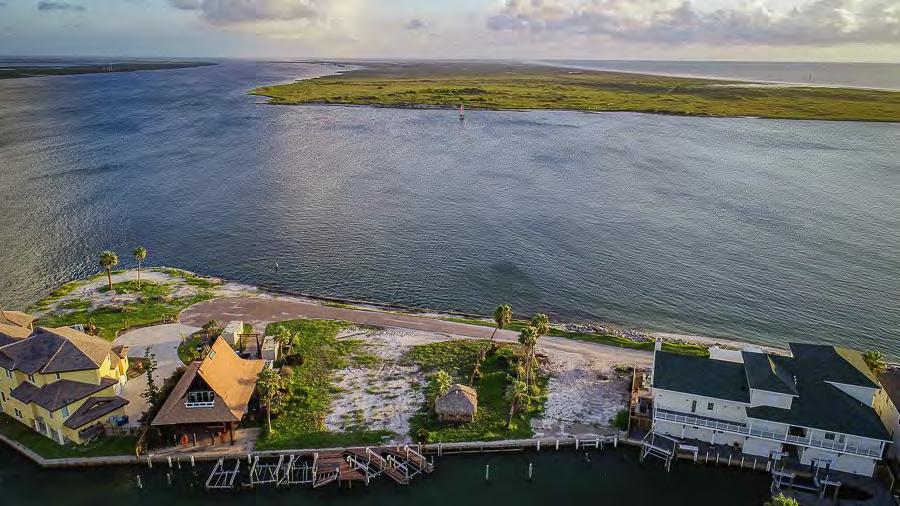
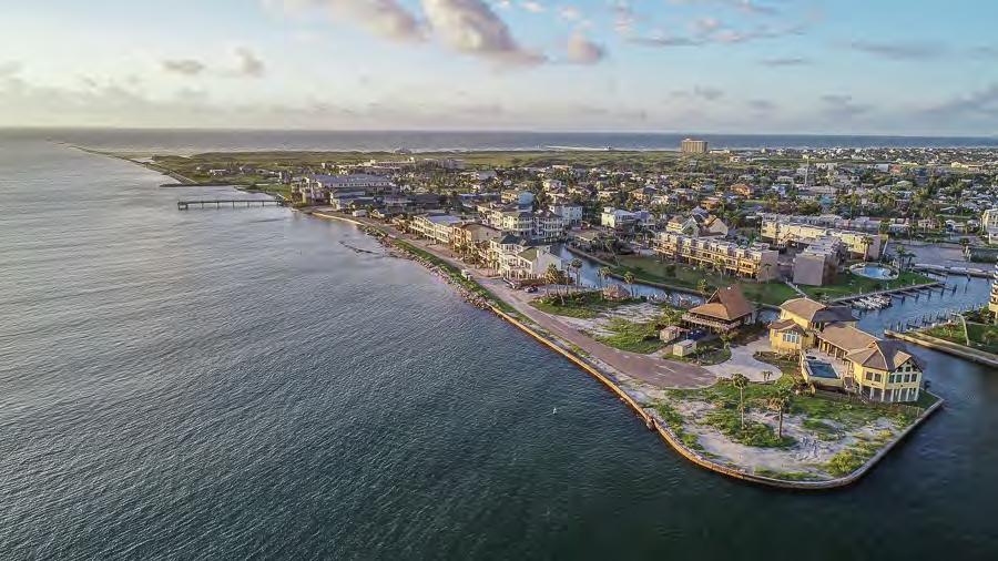
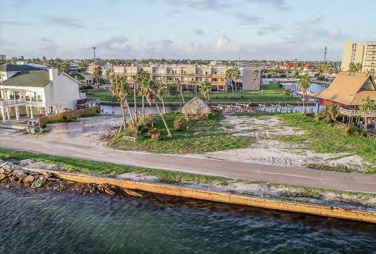
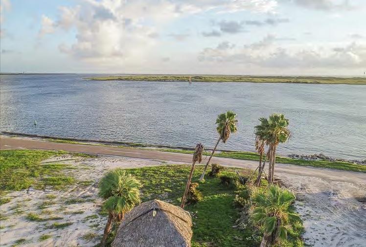
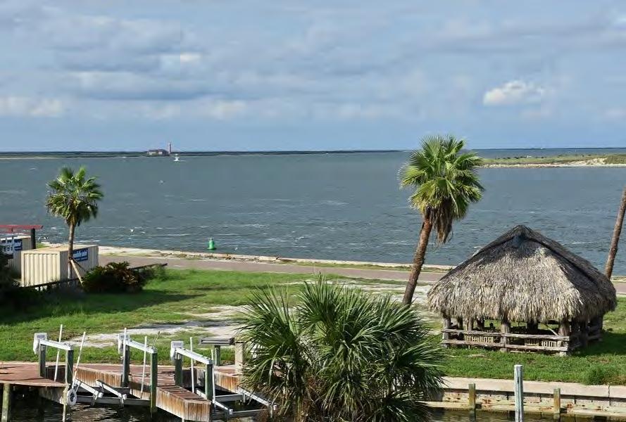
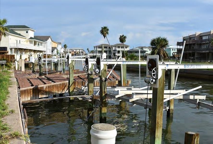
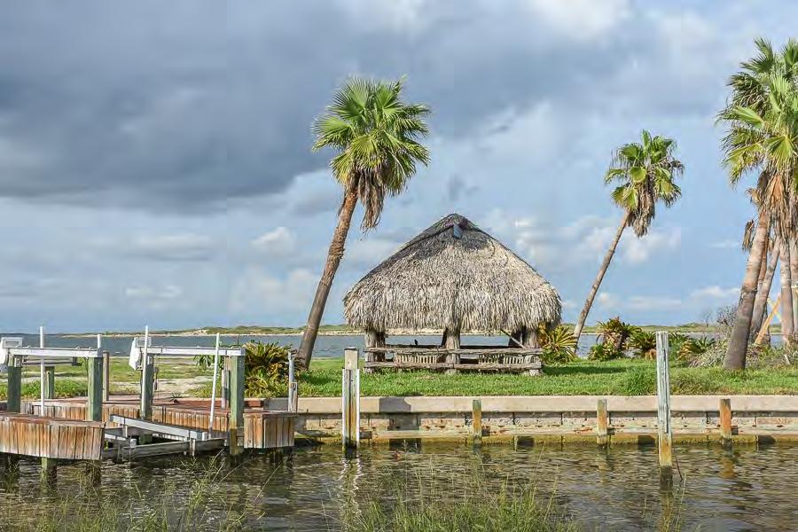
2 The Lots at Shearwater 2.5 Lots, 14,872 Sq.Ft. Private Marina-Front Row Port Aransas, Texas Tammy King, Broker Office Location The Lots at Shearwater, located on the coveted front row of the Port Aransas Private Marina, is some of the best coastal property in Texas. This is a rare opportunity to own two and a half lots on the Corpus Christi Ship Channel which have been family owned for generations by the Negley Family of South Texas. A marina canal lines the back of the property, offering easy boat access to the bay. The lot has an unobstructed view of St Joe, an undeveloped island across the Ship Channel which offers a backdrop of natural habitat behind the fascinating coming and going of boats, ships, birds, fish, and dolphins. The Port Aransas Private Marina is a gated community near the University of Texas Marine Science nstitute off Channel View Drive in Old Town Port Aransas, Texas. Lot Size 14,872 SqFt- Will divide property into two lots and sell individually with acceptable Price. Description Shearwater was a house built in the old Port A vernacular by the Negley Family in the 60 s that was recently removed after damage from Harvey. The home was used by family members for three generations, who enjoyed the unique location as a launch point for fishing, swimming, boating, duck hunting, birding, and just cruising the adjacent waters at sunset. The property is 100 feet deep and 132 feet wide creating a broad platform for future development of a new extraordinary home with multiple boat lifts, ample parking, landscaping, pool, and uninterrupted views of the mesmerizing waters. The property faces north, which allows for a cool shaded front porch in the afternoon and evening, putting you in tune with the dynamic coastal environment. Utilities Underground electricity, water and sewer. Property is part of The Port Aransas Private Marina, which is governed by the Port Aransas Marina Association, with access to the front beach and Clines Point for parties and enjoyment. Price Contact for Pricing Contact Tammy King, Broker King Land & Water, LLC Office Cell Tammy@KingLandWater.com Disclaimer This Lot offering is subject to prior sale, change in price, or removal from the market without notice. While the information above was provided by sources deemed reliable, it is in no way guaranteed by the broker or agent.

3 Lots at Shearwater Nueces County, Texas, AC +- Boundary Stream, ntermittent RiverCreek Water Body King Land & Water LLC P: (432) kinglandwater.com The information contained herein was obtained from sources deemed to be reliable. MapRight Services makes no warranties or guarantees as to the completeness or accuracy thereof.

4 Lots at Shearwater Nueces County, Texas, AC +- Boundary Stream, ntermittent RiverCreek Water Body King Land & Water LLC P: (432) kinglandwater.com The information contained herein was obtained from sources deemed to be reliable. MapRight Services makes no warranties or guarantees as to the completeness or accuracy thereof.

5 Lots at Shearwater Nueces County, Texas, AC +- Boundary Stream, ntermittent RiverCreek Water Body King Land & Water LLC P: (432) kinglandwater.com The information contained herein was obtained from sources deemed to be reliable. MapRight Services makes no warranties or guarantees as to the completeness or accuracy thereof.
6 LOT3 - SEl'lll' sewer -- Line SE1<t.R Sanitary Sewer Manhole ageo,p civernel t "f¾, "7>,, Water \SATT Line--- J' \'WEi - WAlc1 -w,m,-,., ; J Grass & Shell Dnv '' J J' ' --,.,,,,\',! -!ill,r s! - _,,a.- 1ltl-,.c_ 1ye,.l. # p.,o"a:',, ¾:,;i e, ---._., -, "" - ;:'.'-'-""t-:," cj c. nr\\l\1er0 - J' '- row, -".-; 0 = 41"5.1'40"" "';--.;(., _l ' 0' R...,o "',,,,,,,.,,,.. -,$',, l:in..., - ::::.-- R-1425' ----,,-.," 4'-,,,, "''-::::::- ti,, :::::--. - J' "' "' CH= ' ' flf",, "'" "1 '.. :--... '4\,..;;;;;,,,..,,,.. ";i;::'"' 4,,,,.,_,,_,.,.A= 10411' - -&, ',,, "'<lf:h':::::--- CB= N68"51'27"W - ' ' "'"s -., " 4-,,, e &i:::-\.._ T= 545'. o,, ¼=:::--,. "-- 9 '0,';, --" " 4',,., ::--:::., ur, 4,,;:, :----.:: &,, cfi,,,,,,--t-7-111, '-...: t.i ';: 4-4' -trr SET MARK ON 1, j.g;, _..,,.,- -- vi, ELECTRC PAO,;, _,,.,,, U. D. 518" & ", i ' ' N. & 0.8' w. OF,,J - '"1 -j::- ur, ----.::d -;ir-,.,.,:,,,-- :,rground Tele h ST L REBAR l., '-..._, FENCE CORNER l>.4'., '1 - ''" - e;irie '-,,,, 4?'-...:: v, '..yo ':) - - Pad Mounted -,,u - "" t,,, - Transformer 4-,0 );>,i "" 4 4"1,0.0 44c 9,, 1,, " , D t-i, VV :::----- '-- _ "' ": = pl..i i.,0-... '<.._ ---- un L TJ 4-i ' TEEL REBAR "'\ \ ' ACRE, 14,872 SQUARE FEET TOTAL,, -., -c,,,_ 1 ~ o f!''!toil-1 '."iferece -,Gas l -.;;j'" 'Meter "' "- '-. 99.!:i_Jac..f!..bie,.-;810 -::-U8, ' 1 < -4 : Cl) '1- Q '>,. "',, ;,. :.:::_-. \\' c;,"\ ' Fron Build'. "",Jr(, " l c!;,.(%"" _;::- ' : :'. n.:_ ---- il' i'\.. ""'4 \ 0o <? elephane Pedestal - - 'o s,. vo. :::: J,< Upstairs "i, c, - - Vil - _ , JJ "' 11:1 CF#987361, 0 P.R. N,C.T.,i :,_,-- -,, r,1 "L_ Lt"J_, l{,i ' i,,_j 0 & i...,. ll, 1 ), 1 1. i,,., r i; -:,,.,,,"' ' Up;!airs Covered 1 Woodorc h, "' _..,._ : '. 'f-...;r,, ' ,..,,, "' :,,,RTR;:.;iK,,i ffe,.,-- '"i' :---1 " , ';a-i =-1-,,.,.,'.,, <,,. ' Cl)!kio ND. 58' STEEL REBAR _, '-J _ T_ --=(..,..,: :_. - - : C.,,_ --l-'-j 242,_ - - -,,.,,,... --:::J _J - ll ----L - J_J_j J3---j_, SET 58" STEEL REBAR o ' -, -, 1----,l i 65 Fence R09.E.Oflica -'----,_ 312PRVAT ROAD"A" 1 - ] f.. l = 7 ii -ON TALLW DPLJNGS-. ':::" 33 -, J -, _ ---, J f" Ul -'= 1-=J=:j 1=ld=l_J " _ co.. srliriar l 11 = - --Ll--1_ -- iii. - _ :: e,-- : _ iii -, LOT 5,,, - - -,- = oa w OFFENCE, f,, i 1_2STORYFRA\fRESDENCE '- 7=-1,---J_j,. ;=1 l:j7 ljl l '; l l J J=' =l ;=J s -" LL - r o=i j'- --1,_ "' "'-, ----1, J "' a. li.-. : 1----, \.;... u N ' ;' 0, "E t- ' ',- 2 T 1 l1j ' _ a:: 0...-N,,,,,,,,, _ w 111.:io',:\ _, STiirAR,,., l!) l!)} --,-----,, r.j ri..: J ce1 11 i 12 LOT 6 1 1: g:,-: tn l,, ;,. ½i. 1,, f-- '. -.. l,. 86,., g,,: 5 '. "a. ua UE :.- - -, 242'.3 0.7'6 F 0 ENCE =1b z::_ -, : _..'c onc ;t e.. :. :...2L r aler Valve _J _ 0 - _4,- 1,- 0.17'W.OfL1ne ' z::::=-.. '' - 0', Raisbd Wood - -, a ,---'--r,..,. 1-1 :r:;:t:; --5-,. lu Q \ SET 518"STEEL REBAR. : ;, ; _ o::, : : -. _J,J UNOERWOOD FENCE, 1 <(,.; U = '....,.. -,_ 3,_ - -, - :.. ;.,.. _ :=- i:::::z : : :. : ;. wc))g o > (9 p ON.LNE Fence On Line 1, Wm, \\." 1 $;'.....,.,,.., l :S: i,'\ ':,.. ;,.,j '%,. :;:, '=, : Coc;,., ' ', ' ; > OJ LL f "... r"t"-.. ' '. -. Cl)' co...,_ ii -'m ""ua;-==...' ::--,,C- SU U "- Uf). ---:.,*...,,,,-.,.: --:,.. '.' 1.. ' '., '... J,-. "' lg z, Q. ", _ N Racil... - _ t :Z=:' ,srorvfd"-me RESDENCE - -=!=-.. _ ,'N -ON TALL'f... OooPLNGS -fl:'- LT.,L ;:r r :-::--:: 7 - =.,.,. f--r-l--bnckw Clean CoveredlBrick Gazebi?----L,:J -1 LNE, _..;...:= :::::8 =. - _ T,:Oo<T l '. g',. ' _,_ 1-==---,... j r1 :i;i. - y..j o ::Zo. '..L,- ' 1-' -.,, -, =,.. 1" -,-'-L., L ,-.., - S, ro1 : '._ r,_ i='.=, - -,- _ -'-- -.,,.. Concrete - r - 1: '. - ; - o -,.... r l,:l ' ;;- _ "ll '- " ', ' ',,..,.' '_ -j=l_:::=j ----,_, _c ' 0 Jl, -- J - - 5'.,. '.. 1:'l CO,-,::,,,,, lo,,,.-.,... " ;;;-, li :.. J z gj '" 1 00 FNO. DRLL HOLE N CONCRETE BULKHEAD 0.7'W. &0.6'S.OF END OF FENCE L 1YRearBuildin-- ".-_..: - _.--.-C-;vrs d C.? ncr t il :.. L r-r-;- -. _: : e ' "'.., " ,! l... : Line 2' ' Wida. Concrete Bulkhead.,. 1..,. l '' ' N CONCRETE BULKHEAD Wood Dock l, 1111 \ L.. l!l's '., Wood llod, ' 1 0 Extended,. - ock Comer. [10.04' DEED] S67' "E 'l " j,' ",'.:' H. 1. i f,,., 1. ",'.;',,,,,, ' W 1 Boat Lift 111 ' j\, L,;., L; [122.75'0EED) [986 'FELO], N CON RETE BULKHEAD,, , ll 1,f' ORLLSDLE FND. DRLL HOLE ON CONCRETE BULKHEAD r-0.7' S &0.1'E. OF END OF WOOD FENCE REMANDER OF E. 12 LOT 6 CF# VOL. 2166, PGS D.R.N.C.T. \ t l \ LEGAL DESCRPTON PLAT SHOWNG SURVEY ANO MPROVEMENTS ON ACRES OF LAND AND BENG COMPROSED OF A PORTON OF LOT 4, ALL OF LOT 5, AND A PORTON OF LOT 6, PORT ARANSAS MARNA, NUECES COUNTY. TEXAS, RECORDED N VOLUME 24, PAGE 27, MAP RECORDS OF NUECES COUNTY, TEXAS. Revised September 4, 2008 Scale: 1" = 10' July 30, 2008 CURRENT PARTY Prepared For: William Negley Paisano Partners COPYRGHT NOTCE This survey is being provided solely for the use of the current parties and that no license has been created, expressed or implied, to copy the survey except as is necessary in conjunction with original transaction which shall take place within six [ 6 ] months from the date of this survey. Copyright July 30, 2008 FLOOD DATA This is to certify that have consulted the Federal Flood Hazard Map Dated , and found that the property described herein is i [or] is not _ located in a "Special _ Flood Hazard Area." Zone AE Base Elevation 8.0' Panel No. 0004F Community No This information is based on scaling the location of this survey on the referenced F.E.MA map. This information is intended to be used to determine insurance rates only and not to identify specific flooding conditions. 1. Plat bearing used for directional control unless otherwise shown. 2. This survey in in violation of "Copyright Laws" if not accompanied by original seal and signature. 3. The recorded plat does not mathematically close. NOTES 4. Surveyor has made no investigation or independent search for easements of record, encumbrances, restrictive covenants or ownership of title evidence. Surveyor did not review exceptions in schedule "B" of the title commitment to determine whether they do or do not affect subject property. SURVEYOR CERTFCATON, J. L. Brundrett, Jr., a Registered Professional Land Surveyor in the State of Texas, do hereby certify that the plat correctly shows a survey on the ground of the foregoing property and that there are no visible easements, encroachments or protrusions (except as shown hereon.) s Ke.Pd e, O'< :J(lF,._<c_,,,,.,,J <' - - ; 1Slfrt ; { 4. "', ;,.\.. ;_, ': ( '.t!l. "' :9. \ j _,;"l ;,;,,;, :r :,," : \ - -, ,.. A., '9 ' 1,\ -t <l.. off;,,, ',i,d.. : ::'.. : ' <::-. - Sua\l'v 1 '--.,-.;;.. ; FRM NAME & ADDRESS 1111 Griffith & Brundrett 411 S. Pearl St., P.O. 13ox 2322 Rockport, Texas (": : (;>: jerryb@gbsurveyor.com,'ff;-: FLE NAME: DT4 "' _ Dock ( omer ww iil!jjj ,,,,, Artifical Extension Of 0.2 W. 0 Extnded - Property Line For Property Line llustration Purposes Only. CHANNEL, NOTE: 1) THE LOCATON OF UNDERGROUND WATER LNES AND SEWER FACLTES ON THE SUBJECT PROPERTY ARE NOT KNOWN AND COULD NOT BE PLOTTED. 2) SET BACK RESTRCTONS SHOWN ON SUBJECT PROPERTY ARE CTY OF PORT ARANSAS RESTRCTONS. 3) SUBDVSON SET BACK RESTRCTONS ARE NOT KNOWN BY SURVEYOR AND COULD NOT BE PLOTTED. "-,.

7
8

9

10

11

12

13
Palm Ave Hialeah Building Data Palm Avenue
 400-450 Palm Ave Hialeah Building Data Address 400-450 Palm Avenue City, State Hialeah, Florida County Miami Dade parcel # 04-3118-001-1950 and 1960 Zoning Retail Commercial - BU2 Land Size 13500 Type
2213 BUTLER PAD SITE NEAR NEW PARKLAND HOSPITAL. Butler Street at Redfield Dallas, Texas EDGE REALTY PARTNERS
 PAD SITE NEAR NEW PARKLAND HOSPITAL 2213 BUTLER Butler Street at Redfield Dallas, Texas EDGE REALTY PARTNERS 2213 BUTLER // Dallas, Texas LOCATION 2213 Butler Street Dallas, Texas 75235 SIZE 83,370 square
$ X,XXX,XXX Canal Road Orange Beach, AL. Approx. 3,500 SF Home /- Acres (Approx. 96,150 SF)
") $ X,XXX,XXX 26135 Canal Road Orange Beach, AL 36561 Approx. 3,500 SF Home 2.21 +/- Acres (Approx. 96,150 SF) 155 +/- on Wolf Bay Zoned MR: Marine Resort District Multifamily / Single Family Business /
$ X,XXX,XXX 26135 Canal Road Orange Beach, AL 36561 Approx. 3,500 SF Home 2.21 +/- Acres (Approx. 96,150 SF) 155 +/- on Wolf Bay Zoned MR: Marine Resort District Multifamily / Single Family Business /
COUNTY OF ADAMS, STATE OF COLORADO E. 40TH AVE. TOWER RD. E. 38TH AVE. SALIDA ST. HIGH LINE CANAL PROJECT LOCATION E. 32ND PKWY.
 LEGAL DESCRIPTION:, GATEWAY EAST AT TOWER SUBDIVISION FILING NO. 1, SAID PARCEL CONTAIN 598,154 SQUARE FEET OR MORE OR LESS GENERAL NOTES: 1. NOTICE: ACCORDING TO COLORADO LAW YOU MUST COMMENCE ANY LEGAL
FOR SALE ACRES UNDEVELOPED COMMERCIAL LAND DURHAM LAKES, CITY OF FAIRBURN, FULTON COUNTY, GA
 FOR SALE - 7.23 ACRES UNDEVELOPED COMMERCIAL LAND DURHAM LAKES, CITY OF FAIRBURN, FULTON COUNTY, GA COMMENTS This bank owned opportunity 7.23 acres of undeveloped commercial land located within the city
Memorandum September 13, 2018
 Memorandum September 13, 2018 TO: FROM: Planning and Zoning Commission Julie Couch, Town Manager Israel Roberts, AICP Planning Manager SUBJECT: FINAL PLAT FOR THE EBERSOHL ADDITION BACKGROUND: This is
2012 COMMUNITY INFORMATION
 2012 COMMUNITY INFORMATION THE HARPER S PRESERVE COMMUNITY ASSOCIATION INC. ( HOA ) HAS PREPARED THIS COURTESY NOTICE OFSUMMARY INFORMATION TO ENCOURAGE THOSE INTERESTED IN HARPER S PRESERVE TO START TO
SKETCH OF BOUNDARY SURVEY ALTA / ACSM LAND TITLE SURVEY
 SKETCH OF BOUNDARY SURVEY ALTA / ACSM LAND TITLE SURVEY SURVEYOR'S NOTES: All distances as shown hereon are based on the US Survey foot. Subject property lies inside the UBD (Urban Development Boundary),
CERTIFIED SURVEY MAP
 SCONSIN STATE PLANE N:389676.12 E:2130390.15 Center of Section 23 CERTIFIED SURVEY MAP 734.06' THE (PRITCHETTE) ORIGINAL PLAT OF ALL IN THE NW 1 4 OF THE SE 1 4 OF FRACTIONAL SECTION 23, T7N, R9E, IN THE
BOUNDARY LINE ADJUSTMENT/CERTIFICATE OF SURVEY DEFINITION AND INSTRUCTIONS
 BOUNDARY LINE ADJUSTMENT SURVEY (BLA) BOUNDARY LINE ADJUSTMENT/CERTIFICATE OF SURVEY DEFINITION AND INSTRUCTIONS DEFINITION: The adjustment of one (1) or more common boundaries between existing un-platted
East Main Street, Bellville 424 Cedar St., New Ulm
 Property Details http://txls.com/members/bjre/detail.asp?propid=102218 979-865-5969 979-992-2636 kzapalac@bjre.com 420 East Main Street, Bellville 424 Cedar St., New Ulm Price: $157,500 Type: Acreage Address:
CLARK 3925 E. US 377 COMMERCIAL $699,000 COMMERCIAL PAD SITE IN FRONT OF NEW KROGER. Granbury, Texas
 PAD SITE IN FRONT OF NEW KROGER $699,000 1.858 Acres Monument sign on 377 377 road frontage Platted Zoned Utilities to the site PROPERTY INFORMATION Property Information: Adjacent to recently opened Kroger
CONSTRUCTION PLANS for HALCYON A RESIDENTIAL SUBDIVISION 6100 MIDNIGHT PASS ROAD, SARASOTA, FL 34242
 CONSTRUCTION PLANS for HALCYON A RESIDENTIAL SUBDIVISION 6100 MIDNIGHT PASS ROAD, SARASOTA, FL 34242 SECTION 18, TOWNSHIP 37 SOUTH, RANGE 18 EAST SARASOTA COUNTY, FLORIDA PID: 0030001 A DEVELOPMENT BY
East Main Street, Bellville 424 Cedar St., New Ulm
 Property Details http://txls.com/members/bjre/detail.asp?propid=102239 979-865-5969 979-992-2636 kzapalac@bjre.com 420 East Main Street, Bellville 424 Cedar St., New Ulm Price: $365,250 Type: Acreage Address:
TOLEDO BLADE COMMERCIAL OUTPARCELS acres, City of North Port, FL Bank Owned
 Offering Memorandum TOLEDO BLADE COMMERCIAL OUTPARCELS 14.41 acres, City of North Port, FL Bank Owned www.yatesandcompany.net TOLEDO BLADE COMMERCIAL OUTPARCELS Disclaimer: While the information contained
WASCO COUNTY PRELIMINARY SUBDIVISION APPLICATION
 WASCO COUNTY PRELIMINARY SUBDIVISION APPLICATION DETAILED SPECIFIC WRITTEN REQUEST File Number: SDV- Number of Proposed Lots & their Dimensions: PRELIMINARY SUBDIVISION PLAN REQUIREMENTS The approval of
E. 140TH AVE. VICINITY MAP SCALE: 1"=600' LAND USE TABLE NET AREA 599,946 SQFT AC. GROSS AREA 741,420 SQFT AC.
 SHEET OF PURPOSE STATEMENT: THIS PLAT IS INTENDED TO SUBDIVIDE. ACRES INTO SINGLE FAMILY ATTACHED LOTS, TRACTS, DEDICATE AND GRANT EASEMENTS. LEGAL DESCRIPTION: THE UNDERSIGNED BEING THE OWNER(S) OF A
PRIME HIGHWAY LOCATION Multi - Family Land Acres Waxahachie, Texas
 PRIME HIGHAY LOCATION Multi - Family Land 6.525 Acres axahachie, Texas LOCATION: SIZE: The subject property is located on the south side of U.S. Highway 287 Bypass, approximately 1.5 miles west of I-35E
SECTION SITE SURVEYS
 PART 1 - GENERAL 1.1 DESCRIPTION SECTION 02 21 00 SPEC WRITER NOTES: 1. Use this section only for NCA projects. 2. Delete between //---// if not applicable to project. Also delete any other item or paragraph
SALE FOR 8,034 SQ. FT. FULLY LEASED MULTI TENANT MEDICAL BUILDING CONDITIONALLY SOLD! 8330 FAIRMOUNT DR SE CALGARY, AB
 FOR SALE 8,034 SQ. FT. FULLY LEASED MULTI TENANT MEDICAL BUILDING CONDITIONALLY SOLD! 8330 FAIRMOUNT DR SE CALGARY, AB For additional information contact: JIM EDWARDSON (403) 540-0238 EMAIL: jim@manchesterproperties.ca
City of Port St. Lucie PLANNING & ZONING DEPARTMENT
 City of Port St. Lucie PLANNING & ZONING DEPARTMENT EXEMPTION FROM PLATTING Section: 156.022 Process Fill out: Exemption From Platting Application Form. See Fee Schedule for fee. Submit to Planning & Zoning
LAND FOR SALE - ± ACRES
 LAND FOR SALE - ± 6.109 ACRES 14248 FM 2769 Leander, TX 78641 3 2 5 6 183 SITE LOOP 1 620 620 1 LOCATION: SIZE: FRONTAGE/ ACCESS: UTILITIES: ZONING: TOPOGRAPHY: Approximately 4.7 miles west of FM 620 and
an emergency generator to serve the Waste Water Treatment Plant and ongoing maintenance of
 Referred to Public Works 3/ 4/ 19 Committee RESOLUTION NO. 9061-19 BY: Anderson, Bullock, George, Lotten, O' Leary, O' Malley, Rader A RESOLUTION to take effect immediately provided it receives the vote
Februarv27, WHEREAS, the City of Dallas owns tracts of land which are used for Lake Ray. Hubbard; and
 WHEREAS, the City of Dallas owns tracts of land which are used for Lake Ray WHEREAS, the City of Rowlett has requested a wastewater easement with a temporary Hubbard; and Februarv27, 213 By: Assistant
PORT ST. LUCIE CITY COUNCIL
 PORT ST. LUCIE CITY COUNCIL AGENDA ITEM SUMMARY Meeting Date: November 27, 2017 PLACEMENT: First Reading of Ordinances ACTION REQUESTED: Motion / Vote Agenda Item #: 1 OB 11-27-1 7 AN ORDINANCE PROVIDING
City of Grand Forks Staff Report
 City of Grand Forks Staff Report Planning and Zoning Commission March 6, 2019 City Council March 18, 2019 Agenda Item: 4-1 (Preliminary) Preliminary approval of the plat of University Place First Resubdivision
Barons Spring Ranch. 12± Acres Gillespie County Texas. Texas Ranch Sales, LLC TexasRanchSalesLLC.
 Barons Spring Ranch 12± Acres Gillespie County Texas Texas Ranch Sales, LLC 830.741.8906 Info@TexasRanchSalesLLC.com TexasRanchSalesLLC.com Gillespie County 12± Acres Main Home and Two Guest Houses Located
BLACK DIAMOND RANCH MILAM COUNTY, TX. DRAKE HELLER Broker Associate REPUBLICRANCHES.COM
 BLACK DIAMOND RANCH MILAM COUNTY, TX DRAKE HELLER Broker Associate 281-546-7051 drake@republicranches.com REPUBLICRANCHES.COM BLACK DIAMOND RANCH Black Diamond Ranch is a great hunting property named for
FLYING L RANCH ACRES ANDERSON COUNTY, PALESTINE, TX
 FLYING L RANCH 233 + ACRES ANDERSON COUNTY, PALESTINE, TX BRYAN PICKENS Partner/Broker Associate 214-552-4417 bryan@republicranches.com REPUBLICRANCHES.COM FLYING L RANCH This outstanding East Texas ranch
Zoning Permit Application Cover Page
 Zoning Permit Application Cover Page The City of Belmont performs an initial site inspection prior to issuance of a zoning permit for new construction. Upon receipt of a full and complete application submittal
APPLICATION FOR FINAL PLAT APPROVAL
 APPLICATION FOR FINAL PLAT APPROVAL Section 1. General. The undersigned Applicant (Applicant is synonymous with owner) makes this Application for Final Plat Approval in accordance with Chapter 21, Port
RULES, REGULATIONS AND REQUIREMENTS RELATING TO THE APPROVAL AND ACCEPTANCE OF IMPROVEMENTS IN SUBDIVISIONS OR RE-SUBDIVISIONS
 GALVESTON COUNTY RULES, REGULATIONS AND REQUIREMENTS RELATING TO THE APPROVAL AND ACCEPTANCE OF IMPROVEMENTS IN SUBDIVISIONS OR RE-SUBDIVISIONS GALVESTON COUNTY ENGINEERING DEPARTMENT MARCH 3, 1997 Amendment
ORDINANCE NO. 463 NOW, THEREFORE, THE CITY COUNCIL OF THE CITY OF WOODINVILLE, WASHINGTON, DOES ORDAIN AS FOLLOWS:
 ORDNANCE NO. 463 AN ORDNANCE OF THE CTY OF WOODNVLLE, WASHNGTON, CORRECTNG ORDNANCE NO. 272 AND N PARTCULAR, THE LEGAL DESCRPTON OF THE PORTON OF 143RD PLACE N.E. BENG VACATED; PROVDNG FOR SEVERABLTY,
That we, Earl Galceran, Jack J. Valenti, William W. Sherrill, Jack E. Wilson and Welcome
 1 2 3 4 5 6 7 8 9 10 11 12 13 14 15 KNOW ALL MEN BY THESE PRESENTS: That we, Earl Galceran, Jack J. Valenti, William W. Sherrill, Jack E. Wilson and Welcome W. Wilson, owners of that certain property conveyed
Walton County Planning and Development Services
 Walton County Planning and Development Services 31 Coastal Centre Boulevard, Suite 100 47 N 6 th Street Santa Rosa Beach, Florida 32459 DeFuniak Springs, Florida 32433 Phone 850-267-1955 Phone 850-892-8157
RIVERDALE CITY PLANNING COMMISSION APPLICATION FOR RESIDENTIAL SUBDIVISION SITE PLAN APPROVAL
 Community Development 4600 So. Weber River Drive Riverdale, Utah 84405 RIVERDALE CITY PLANNING COMMISSION APPLICATION FOR RESIDENTIAL SUBDIVISION SITE PLAN APPROVAL CASE NO: DATE SUBMITTED: APPLICANT S
AIR ONE. 829 HULL ROAD Ormond Beach, Florida BENCHMARK #1 EL NAIL IN POWER POLE EASTERLY RIGHT-OF-WAY LINE TOMOKA AIRPORT ROAD (UR) HULL ROAD
 HULL ROAD") NORTH LINE LOT 2 SOUTH LINE LOT 1 S75 46'55"E 2 NORTH LINE LOT 3 SOUTH LINE LOT 2 N75 43'32"W(UR) S75 43'32"E(D) N75 43'32"W(URD) NORTH LINE LOT 1 SOUTH LINE LOT 12 225.15'(M)225'(UR) P.O.R. PARCELS II
NORTH LINE LOT 2 SOUTH LINE LOT 1 S75 46'55"E 2 NORTH LINE LOT 3 SOUTH LINE LOT 2 N75 43'32"W(UR) S75 43'32"E(D) N75 43'32"W(URD) NORTH LINE LOT 1 SOUTH LINE LOT 12 225.15'(M)225'(UR) P.O.R. PARCELS II
APPLICATION PROCEDURE
 ANTRIM PLANNING BOARD P. O. Box 517 Antrim, New Hampshire 03440 Phone: 603-588-6785 FAX: 603-588-2969 APPLICATION FORM AND CHECKLIST FOR MINOR OR MAJOR SITE PLAN REVIEW File Date Received By APPLICATION
Sunset Ranch. 117± Acres Medina County Texas. Texas Ranch Sales, LLC TexasRanchSalesLLC.
 Sunset Ranch 117± Acres Medina County Texas Texas Ranch Sales, LLC 830.741.8906 Info@TexasRanchSalesLLC.com TexasRanchSalesLLC.com Medina County 117± Acres Gated Community Convenient to Hondo, Texas Great
Land Uses, Maps, Illustrations and Locations
 2016 KINGS MILL COMMUNITY INFORMATION THE MONTGOMERY KINGS MILL HOMEOWNER S ASSOCIATION INC. ( HOA ) HAS PREPARED HIS COURTESY NOTICE OF SUMMARY INFORMATION TO ENCOURAGE THOSE INTERESTED IN KINGS MILL
Development Review Committee Application
 City of Coral Gables, Florida Level 2 Review Development Review Committee Application Address: 427 Biltmore Way, 2 nd Floor, Coral Gables, Florida 33134 Email: planning@coralgables.com Phone: 305.460.5211
WIESER LAW OFFICE, P.C. ATTORNEYS AT LAW WIESER PROFESSIONAL BUILDING 33 SOUTH WALNUT - SUITE 200 LA CRESCENT, MN 55947
 m WIESER LAW OFFICE, P.C. ATTORNEYS AT LAW WIESER PROFESSIONAL BUILDING 33 SOUTH WALNUT - SUITE 200 LA CRESCENT, MN 55947 AEC'OBY MBA 2 6 2015 KELLY M.JVERSON AL "SKIP" WIESER. Ill AL WIESER, JR. Emritus
HARLINGEN IRRIGATION DISTRICT REQUIREMENTS FOR SUBDIVISION PLAT APPROVAL
 HARLINGEN IRRIGATION DISTRICT REQUIREMENTS FOR SUBDIVISION PLAT APPROVAL Administrative Requirements 1. All assessments and outstanding invoices associated with the property to be subdivided must be current.
PART OF SECTION 9, TOWNSHIP 36 NORTH, RANGE 9 EAST OF THE THIRD PRINCIPAL MERIDIAN, NORTH OF THE INDIAN BOUNDRY LINE, IN WILL COUNTY, ILLINOIS.
 PART OF SECTION 9, TOWNSHIP 6, RANGE 9 EAST OF THE THIRD PRINCIPAL MERIDIAN, OF THE INDIAN BOUNY LINE, IN WILL COUNTY, ILLINOIS. ASSUMED THE LINE OF THE WEST / OF SECTION 9-6-9 TO BE: S89 5' 7"E 60 0 0
Conveyance of City Land at Intersection of Grady Avenue and Preston Avenue
 CITY OF CHARLOTTESVILLE, VIRGINIA CITY COUNCIL AGENDA Agenda Date: June 5, 2017 Action Required: Presenter: Staff Contacts: Title: Public Hearing and Adoption of Ordinance S. Craig Brown, City Attorney
ARTICLE 900 PLAT AND PLAN REQUIREMENTS
 ARTICLE 900 PLAT AND PLAN REQUIREMENTS SEC. 900.1 ITEMS TO BE SHOWN ON PLAT OR PLAN General (1) Property lines of all property owners adjacent to the exterior boundaries of the project shall be located
NE Dixie Hwy. Rio Town Center ±28.8 Acres Mixed Use Land with Two Marinas. Jensen Beach, FL Boyd G. Bradfield, JR., CCIM, SIOR LISTING AGENT
 FOR SALE Rio Town Center ±28.8 Acres Mixed Use Land with Two Marinas NE Dixie Hwy Jensen Beach, FL 34957 2055 Kanner Hwy +1 772 286 6292 www.naisouthcoast.com NO WARRANTY OR REPRESENTATION, EXPRESS OR
152-A 198 ACRE POTENTIAL COMMERCIAL/INDUSTRAIL PARK
 152-A 198 ACRE POTENTIAL COMMERCIAL/INDUSTRAIL PARK PROPOSED CITY LIMITS PARKWAY AIRPORT 198 ACRES RAIL SIDING Proposed exit from Hwy. 60 for the Central Polk Parkway 3,923 Ft. Frontage 4 Lane Hwy. 60
SITE TO BE DEMOLISHED
 STE TO BE DEMOLSHED City Hall/Moca 357' 2 7 3 Subject 97,400sf magery 2017 Google, Map data 2017 Google 200 ft -----------------,...j J2J_ t --... --F-Lj-\u:111-ii-1-1-1:f1-1-111-L/-t "l(pkgje1 '_-o 15(PK6)135'-0"
Grand Forks Growth Fund, A Jobs Development Authority Staff Report
 Grand Forks Growth Fund, A Jobs Development Authority Staff Report Growth Fund Committee March 20, 2017 JDA March 20, 2017 Agenda Item: Business Park Infrastructure Submitted by: Ryan Brooks, Deputy City
ACRE PROPERTY FOR COMMERCIAL DEVELOPMENT
 DE ZAVALA ROAD SAN ANTONIO, TEXAS 0.8972 ACRE PROPERTY FOR COMMERCIAL DEVELOPMENT All information furnished regarding this property is from sources deemed reliable; however, Harry G. Leeper, Jr., Broker,
DEED OF EASEMENT (RECLAIMED WATER,WATER AND SEWER) [AND DEED OF VACATION (RECLAIMED WATER, WATER AND SEWER)]
![DEED OF EASEMENT (RECLAIMED WATER,WATER AND SEWER) [AND DEED OF VACATION (RECLAIMED WATER, WATER AND SEWER)]](/thumbs/72/66569549.jpg "DEED OF EASEMENT (RECLAIMED WATER,WATER AND SEWER) [AND DEED OF VACATION (RECLAIMED WATER, WATER AND SEWER)]") Project Name: Loudoun Water Project Number: DEED OF EASEMENT (RECLAIMED WATER,WATER AND SEWER) [AND DEED OF VACATION (RECLAIMED WATER, WATER AND SEWER)] THIS DEED OF EASEMENT [AND VACATION] is made and
Project Name: Loudoun Water Project Number: DEED OF EASEMENT (RECLAIMED WATER,WATER AND SEWER) [AND DEED OF VACATION (RECLAIMED WATER, WATER AND SEWER)] THIS DEED OF EASEMENT [AND VACATION] is made and
8 AC ANDERMANN COMMERCIAL
 8 AC ANDERMANN COMMERCIAL For more information contact: 815-741-2226 mgoodwin@bigfarms.com County: Will Township: Wheatland Gross Land Area: 8.12 acres Property Type: Land with two homes and farm buildings
Tuesday, October 27, Hall Rd, Knoxville, TN Knox County, TN parcel#
 Property Report Tuesday, October 27, 2015 7905 Hall Rd, Knoxville, TN 37920 Knox County, TN parcel# 157 001 Property Report Location Property Address Subdivision County Current Owner Name Mailing Address
Honorable Mayor Bill Agan and members of the Richland Hills City Council. Final Plat Richland Hills, Lots 1 & 2, Block 1 Brumlow Addition
 2B - 1 Memorandum To: From: Date: Subject: Honorable Mayor Bill Agan and members of the Richland Hills City Council Jason Moore, Assistant City Manager January 17, 2017 Final Plat Richland Hills, Lots
SUBMITTAL REQUIREMENTS: The number indicates the number of copies for submittal (if applicable).
.") Office Use Only Preliminary Long Plat Long Subdivision Applicant Checklist PLANNING, COMMUNITY, & ECONOMIC DEVELOPMENT DEPARTMENT PRELIMINARY LONG PLAT LONG SUBDIVISION CHECKLIST Mailing Address: P.O.
Office Use Only Preliminary Long Plat Long Subdivision Applicant Checklist PLANNING, COMMUNITY, & ECONOMIC DEVELOPMENT DEPARTMENT PRELIMINARY LONG PLAT LONG SUBDIVISION CHECKLIST Mailing Address: P.O.
CODE OF PRACTICE FOR LAND SURVEYORS
 CODE OF PRACTICE FOR LAND SURVEYORS PREPARED BY DELAWARE-HUDSON PROFESSIONAL LAND SURVEYORS ASSOCIATION P.O. BOX 502 HIGHLAND MILLS, NY 10930 ADOPTED DECEMBER 9, 1987 REVISED FEBRUARY 9, 1988 Preamble
Subdivision Plat Signature Block Templates
 Subdivision Plat Signature Block Templates Please refer to the Subdivision Plat Checklist to determine which signature blocks are required for the plat you are preparing. All text must be at least 10 pt
BILL JOHNSON & ASSOCIATES REAL ESTATE COMPANY WILL CO-BROKER IF BUYER IS ACCOMPANIED BY HIS OR HER AGENT AT ALL PROPERTY SHOWINGS
 WITTE ROAD RANCH For more information: Bill Johnson & Associates Real Estate Company 420 East Main, Bellville, Texas 77418 979-865-5969 281-463-3791 979-992-2636 www.bjre.com This 36.7820 acres is conveniently
HARMONY & STRAUSS CABIN SUBDIVISION FILING NO. 1
 STATEMENT OF OWNERSHIP AND SUBDIVISION: KNOW ALL PERSONS BY THESE PRESENTS, THAT THE UNDERSIGNED OWNER(S) OF THE FOLLOWING DESCRIBED LAND: A PARCEL OF LAND BEING A PART OF THE WEST HALF OF SECTION 3, TOWNSHIP
Subdivision Plat Signature Block Templates
 Subdivision Plat Signature Block Templates Please refer to the Subdivision Plat Checklist to determine which signature blocks are required for the plat you are preparing. All text must be at least 10 pt
PLAT OF SURVEY VICINITY MAP (NOT TO SCALE) N N W E SITE BENCHMARK # 2 W E N&D ON BACK OF CURB NAVD 88 S S 0' 10' 20' 40' 60' 1" = 20' TOP=106.7
 N N W E SITE BENCHMARK # 2 W E N&D ON BACK OF CURB NAVD 88 S S 0' 10' 20' 40' 60' 1 = 20' TOP=106.7") PLAT OF SURVEY VICINITY MAP (NOT TO SCALE) N N W E SITE BENCHMARK # 2 W E N&D ON BACK OF CURB 106.21 NAVD 88 S S 0' 10' 20' 40' 60' 1" = 20' TOP=106.72 N INV PVC=99.27 S INV PVC=99.32 E INV CLAY=99.39
PLAT OF SURVEY VICINITY MAP (NOT TO SCALE) N N W E SITE BENCHMARK # 2 W E N&D ON BACK OF CURB 106.21 NAVD 88 S S 0' 10' 20' 40' 60' 1" = 20' TOP=106.72 N INV PVC=99.27 S INV PVC=99.32 E INV CLAY=99.39
DECLARATION OF CONDOMINIUM FOR ON THE SEAS DOCK CONDOMINIUM
 PREPARED BY AND TO BE RETURNED TO: Robert S. Freedman, Esquire CARLTON FIELDS, P.A. 4221 W. Boy Scout Boulevard, Suite 1000 Tampa, Florida 33607 (813) 223-7000 DECLARATION OF CONDOMINIUM FOR ON THE SEAS
TOWN OF NEW SHOREHAM ZONING BOARD OF REVIEW APPLICATION PROCEDURE
 TOWN OF NEW SHOREHAM ZONING BOARD OF REVIEW APPLICATION PROCEDURE 1. Please answer all questions on the application and please print clearly. If a question is not applicable, mark the space with a N/A.
Easement Preparation and Submittal Procedures and Checklist
 Platte Canyon Water and Sanitation District Easement Preparation and Submittal Procedures and Checklist These procedures have been prepared in order to provide general guidelines for the submittal of information
VICINITY MAP/AERIAL MAP SITE
 VICINITY MAP/AERIAL MAP SITE N ZONING MAP PA 9 PA 5 SITE Solterra West ODP PA 7 N , DATE, 2013, TIME, COUNTY OF JEFFERSON, STATE OF COLORADO, $ DEDICATION CERTIFICATE THE UNDERSIGNED, BEING THE OWNER(S)
FOR SALE By SC Department of Transportation
 UPCOMING BID SALE INFO FOR SALE By SC Department of Transportation Type Property: VACANT LAND Approximately 0.267 of an acre of land Address: Meeting St. & Sheppard St. Charleston, SC Tax Map Number: 459-05-04-213
Kimball County CRP. Kimball, Nebraska. Presented By: Creed James. Office: (307) Cell: (307)
 Cell: (307)") Presented By: Creed James Office: (307)326-3104 Cell: (307)399-7973 The Kimball County CRP is located approximately 9 miles northwest of. Comprised of 2,343.99 deeded acres +/-, there are 2,225.61 acres
Presented By: Creed James Office: (307)326-3104 Cell: (307)399-7973 The Kimball County CRP is located approximately 9 miles northwest of. Comprised of 2,343.99 deeded acres +/-, there are 2,225.61 acres
SUBMITTAL REQUIREMENTS: The number indicates the number of copies for submittal (if applicable).
.") Office Use Only Preliminary Long Plat Long Subdivision Applicant Checklist PLANNING, COMMUNITY, & ECONOMIC DEVELOPMENT DEPARTMENT FINAL LONG PLAT LONG SUBDIVISION CHECKLIST Mailing Address: P.O. Box 547,
Office Use Only Preliminary Long Plat Long Subdivision Applicant Checklist PLANNING, COMMUNITY, & ECONOMIC DEVELOPMENT DEPARTMENT FINAL LONG PLAT LONG SUBDIVISION CHECKLIST Mailing Address: P.O. Box 547,
Planning. the propertyy. Texas Local. Government. Code. size of 2,0000 RSF-2-PUD. Road within the Wharf at a. Citizen. 0 Letter of. 1.
 Planning & Zoning Commissionn Replat Phase I of the Wharf at Clear Lake, Dock 18, Slips 1 and 2 Planning & Development Department February 15, 20166 Request Replat approximately 0.0209 acres of a previouslyy
COMMERCIAL/ INDUSTRIAL PERMIT APPLICATION
 APPLICANT INFORMATION: COMMERCIAL/ INDUSTRIAL Permit No: Requested: Receipt No: Council District/At Large: Zoning District: Parcel No: Lot, Sq., Subdivision: Historic Dist. / Landmark: Yes / No Hearing
DECLARATION OF RESTRICITONS AFFECTING EWING PLACE SUBDIVISION SECTION 3
 DECLARATION OF RESTRICITONS AFFECTING EWING PLACE SUBDIVISION SECTION 3 WITNESSETH:-- THAT WHEREAS, KOSMAR, INCORPORATED, a Corporation, is the owner of the following described property located in Jefferson
FRANKFORT RT. 30 COMMERCIAL CORNER
 FRANKFORT RT. 30 COMMERCIAL CORNER For more information contact: 815-741-2226 mgoodwin@bigfarms.com County: Will Township: Frankfort Township Gross Land Area: 3.5 Acres Property Type: Vacant Development
FRANKFORT 22 ACRES INDUSTRIAL SITE
 *** 815-741-2226 FRANKFORT 22 ACRES INDUSTRIAL SITE For more information contact: 815-741-2226 mgoodwin@bigfarms.com County: Will Township: Frankfort Township Gross Land Area: 22 Acres Property Type: Vacant
5.39 AC ANDERMANN COMMERCIAL
 5.39 AC ANDERMANN COMMERCIAL For more information contact: 1-815-741-2226 mgoodwin@bigfarms.com Goodwin & Associates Real Estate, LLC is an AGENT of the SELLERS. County: Will Township: Wheatland Gross
FINAL PLAT CHECKLIST
 FINAL PLAT CHECKLIST Project Name: Tax ID #: Project Number: Date: _ Reviewed By: Telephone: Please address all items marked with an "X" Please return redline comments with corrected plan, original mylar,
MILLICAN CREEK RANCH BRAZO COUNTY, TX. DRAKE HELLER Broker Associate REPUBLICRANCHES.COM
 MILLICAN CREEK RANCH BRAZO COUNTY, TX DRAKE HELLER Broker Associate 281-546-7051 drake@republicranches.com REPUBLICRANCHES.COM MILLICAN CREEK RANCH The ranch is conveniently located just 9 miles south
PROPERTY INFORMATION PACKET
 PROPERTY INFORMATION PACKET THE DETAILS #39 2900 E. Evans St Wichita, KS 67216 AUCTION: Thursday, December 17 @ 6:00 PM 12041 E. 13th St. N., Wichita, KS, 67206 316.683.0612 800.544.4489 www.mccurdyauction.com
COVENANTS AND RESTRICTIONS ON AND FOR THE WOODS RESIDENTIAL SUBDIVISION
 COVENANTS AND RESTRICTIONS ON AND FOR THE WOODS RESIDENTIAL SUBDIVISION WHEREAS; The Woods Property Owners Association, Inc., hereinafter referred to as Association, is a non-profit entity incorporated
Town & Country. Town & Country. Available: Joanne V. Mirelez, CCIM Broker Associate
 Town & Country Town & Country 10350 Bandera Rd at Old Prue Rd. Shell and Finished Space Available Base Monthly Rent: Contact Broker NNN s: $6.15 (2018) Highly Visible Pylon Sign High Traffic Area Signalized
ARTICLE 900 PLAT AND PLAN REQUIREMENTS
 Final SEC. 900.01 ARTICLE 900 PLAT AND PLAN REQUIREMENTS General provisions. (a) Scale. The scale of all plats and plans shall be a minimum of 1 to 100 ft. (b) Size. The minimum page size for all plats
Final Plats for Major Residential and Commercial Subdivisions Checklist
 Project Name: : This form is a checklist of Zoning Ordinance requirements for major residential and commercial subdivision plats to assist the applicant in their submittal. It is not intended to be a comprehensive
PROTECTIVE COVENANTS
 PROTECTIVE COVENANTS BY ADOPTION OF THIS PLAT, LOWDER NEW HOMES, INC., AN ALABAMA CORPORATION; OWNER OF ALL THE LOTS EMBRACED HEREIN, HEREBY ADOPTS THE FOLLOWING PROTECTIVE COVENANTS AND IMPOSES THEM UPON
FINAL PLAT. Community Development Department 8101 Ralston Road Arvada, Colorado 80002
 FINAL PLAT Community Development Department 8101 Ralston Road Arvada, Colorado 80002 September 2015 FINAL SUBDIVISION PLAT Final Subdivision Plat Review Applications for a Final Plat shall be submitted
City of Melissa, Texas Plat Dedication Language
 City of Melissa, Texas Plat Dedication Language [INCLUDE THE FOLLOWING DEDICATION LANGUAGE FOR INDIVIDUALS (MODIFY APPROPRIATELY TO REFLECT EXACTLY AS SHOWN ON PROPERTY DEED)]: NOW THEREFORE, KNOW ALL
343 King St, Charleston, SC 29401
 Prime Retail on King Street, Suite: A 343 King St, Charleston, SC 29401 Listing ID: 30054864 Status: Active Property Type: Retail-Commercial For Lease Retail-Commercial Type: Street Retail Contiguous Space:
ALTA/NSPS LAND TITLE SURVEY
 ALTA/NSPS LAND TITLE SURVEY VICINITY MAP COMMITMENT FILE NO. 142792 PEAVEY ROAD COLUMBIA CT W COLUMBIA CT N Most northerly corner of Tract K, RLS No. 48 OWNER: CITY OF CHASKA, MINNEOSTA FND OPEN IP RLS
Vacant Corner Lot in Golden Gate
 FOR SALE $79,000 Property Details PRICE $79,000 PARCEL ID 37-38-41-007-032-00070-7 LAND SIZE 11,000 sf Great corner vacant lot in the Golden Gate area of Stuart. Site is comprised of 4 lots with the with
DECLARATION OF RESTRICITONS AFFECTING EWING PLACE SUBDIVISION SECTION 2
 DECLARATION OF RESTRICITONS AFFECTING EWING PLACE SUBDIVISION SECTION 2 WITNESSETH:-- THAT WHEREAS, KOSMAR, INCORPORATED, a Corporation, is the owner of the following described property located in Jefferson
10.23± Upland Acres Amelia Island
 St. Marys River Cumberland Island Pogy Place 325 POGY PLACE Ame l ia River 10.23± Upland Acres Amelia Island Atlantic Ocean Amelia River Pogy Place 325 Pogy Place,, FL 32034 Egans Creek PROPERTY FEATURES
COMMERCIAL PAD OPPORTUNITY SAN ANTONIO, TEXAS
 COMMERCIAL PAD OPPORTUNITY SAN ANTONIO, TEXAS LOCATION: SIZE: The site located on the west corner of Culebra Road and Lone Star Parkway. 0.595 Acres UTILITIES: Electric: City Public Service maps indicate
MINOR SUBDIVISION PLAT CHECKLIST
 MINOR SUBDIVISION PLAT CHECKLIST Project Name: Tax ID #: Project Number: Date: _ Reviewed By: Telephone: NOTES: All lots on septic systems must comply with the Fulton County Health Department requirements
9801 BLUE GRASS ROAD PHILADELPHIA, PENNSYLVANIA
 9801 BLUE GRASS ROAD PHILADELPHIA, PENNSYLVANIA DESCRIPTION: One-story industrial warehouse/distribution facility Plus 2 nd floor offices. BUILDING SIZE: Center space 100: 106,101 +/- SF Center space 101:
MINOR SUBDIVISION PLAT
 MINOR SUBDIVISION PLAT Community Development Department 8101 Ralston Road Arvada, Colorado 80002 MINOR SUBDIVISION PLAT Subdivisions consisting of five (5) or fewer lots are eligible for the minor subdivision
GARDEN HIGHWAY SPECIAL PLANNING AREA
 GARDEN HIGHWAY SPECIAL PLANNING AREA 501-250. INTENT. The land area between the Garden Highway and the Sacramento River possesses unique environmental amenities that require special treatment and regulation.
10.23± Upland Acres Amelia Island
 St. Marys River Cumberland Island Pogy Place 325 POGY PLACE Ame l ia River 10.23± Upland Acres Amelia Island Atlantic Ocean Amelia River Pogy Place 325 Pogy Place, Fernandina Beach, FL 32034 Egans Creek
MINOR SUBDIVISION PLAT
 MINOR SUBDIVISION PLAT Community Development Department 8101 Ralston Road Arvada, Colorado 80002 September 2015 MINOR SUBDIVISION PLAT Subdivisions consisting of five (5) or fewer lots are eligible for
Own your own "Commercial Island" at Branson Landing
 Own your own "Commercial Island" at Branson Landing Over an acre in size, floating on the water and located in the Bass Pro Shops parking lot Existing Operating Business: The Paddlewheel (Restaurant/Bar/Nightclub)
Location Map. Subject Site. Project Name: Boulder Lakes 4th Addn. Request: Preliminary Subdivision Case No.: 01-PS INVER GROVE HEIGHTS
 HOLIDAY LN LOUIS LANE INVER GROVE HEIGHTS AMES CROSSING RD STATE TRUNK HWY. NO. 55 CHAPEL LANE O'NEILL DR VIKINGS PARKWAY LONE OAK DRIVE C.S.A.H. NO. 26 (LONE OAK RD.) COURTHOUSE LN TRUNK HWY. NO. 55 JOYCE
PROPERTY DESCRIPTION: Property is located in: City Limits County(Outside City Limits) Site Address/Location:
 Site Address/Location:") Application for Lot-Tract Split/Combo or Property Line Adjustment CITY OF CENTERTON PLANNING DEPARTMENT 290 N. MAIN ST., P.O. BOX 208 CENTERTON, AR 72719 PHONE (479)795-2750 FAX (479)795-2545 Planning@centertonar.us
Application for Lot-Tract Split/Combo or Property Line Adjustment CITY OF CENTERTON PLANNING DEPARTMENT 290 N. MAIN ST., P.O. BOX 208 CENTERTON, AR 72719 PHONE (479)795-2750 FAX (479)795-2545 Planning@centertonar.us