BOUNDARY LINE ADJUSTMENT/CERTIFICATE OF SURVEY DEFINITION AND INSTRUCTIONS
|
|
|
- Rosalind Cain
- 5 years ago
- Views:
Transcription
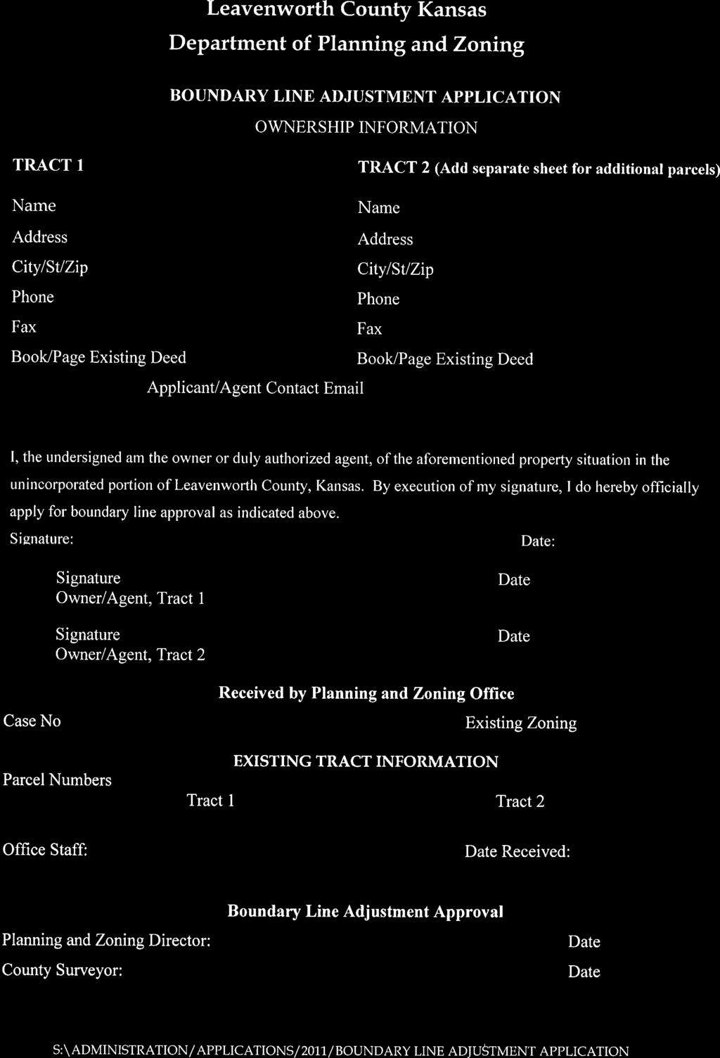
1 BOUNDARY LINE ADJUSTMENT SURVEY (BLA) BOUNDARY LINE ADJUSTMENT/CERTIFICATE OF SURVEY DEFINITION AND INSTRUCTIONS DEFINITION: The adjustment of one (1) or more common boundaries between existing un-platted tracts or parcels, which will not create additional tracts or parcels. A BLA shall only be granted for tracts or parcels that meet the requirements of the Zoning and Subdivision Regulations, Sanitary Code, and any other applicable regulations, and will not create a non-conforming (substandard) tract or parcel. (BOCC Resolution ; August 25, 2011). As stated in the definition, the BLA is to be used to adjust existing adjacent boundary lines of 2 or more parcels in to the same number of parcels that are still compliant with the Zoning and Subdivision Regulations. This practice may also be used to absorb parcels into fewer compliant parcel(s) if under the same ownership. Any adjustments to platted lots shall be done through the re-platting process, except for a single Lot Split. PROCEDURE: 1. It is recommended that a meeting be set up with Planning and Zoning and County Surveyor, to be sure the property qualifies and everyone is on the same page getting started. 2. All BLA surveys will now originate from the Leavenworth County Planning and Zoning Office. You will need to complete the BLA application form, (which is available online at the Surveyor and Planning and Zoning web pages. (A copy is attached.) 3. Submit your BLA survey along with the completed Application to the Leavenworth County Planning and Zoning office. PDF submittals are acceptable. pz@leavenworthcounty.org 4. Planning and Zoning will forward survey to the Surveyors office for review as per K.S.A , K.S.A , K.S. A , K.S.A and Kansas Minimum Standards for Boundary Surveys as well as Leavenworth County Subdivision Regulations. Once review is complete a letter will be sent to the surveyor with review comments or approval. 5. Planning and Zoning will review for compliance with the Leavenworth County Subdivision Regulations. Once review is complete a letter will be sent to the surveyor with review comments or approval. 6. Once approval has been authorized by Planning and Zoning and the County Surveyor, a finished survey signed and sealed by the surveyor, along with the original BLA application will be brought to the County Planning and Zoning Office for signature by the Planning Director. Survey will be sent to the County Surveyor for his signature on the face of the survey. Once those signatures are acquired, you are ready for recording the survey in the Register of Deeds office. (use same signature blocks for Planning Director and County Surveyor as used on Tract Splits) 7. The Director of Planning and Zoning Department & the County Surveyor will sign the original BLA application. SURVEY REQUIREMENTS: County Surveyor will review each survey as per K.S.A , K.S.A , K.S. A , K.S.A and Kansas Minimum Standards for Boundary Surveys as well as Leavenworth County Subdivision Regulations. The following are key items that must be on the BLA survey. (Note some items have changed or have been added). S:\Survey\Documents\Boundary Line Adjustment Survey Requirements.docx Page 1
2

3
4
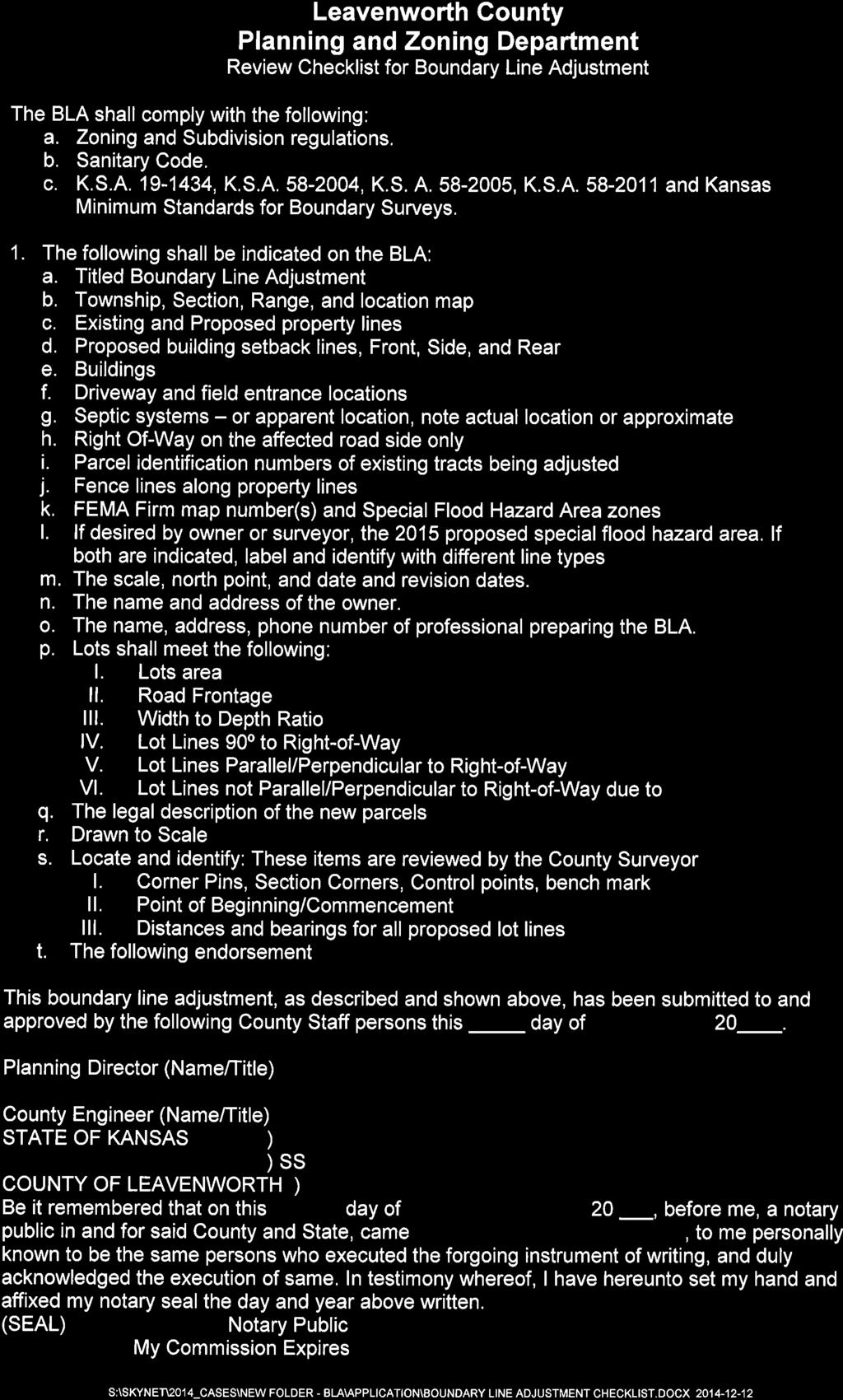
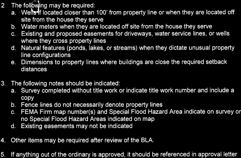
5 BOUNDARY LINE ADJUSTMENT/CERTIFICATE OF SURVEY DEFINITION AND INSTRUCTIONS 1. The parent legal descriptions of the properties being changed with a reference to the recorded book and page or document number. 2. The legal descriptions of the parcels that are being adjusted and transferred to the new owners. (This is the portion of the adjusted parcel that must be transferred prior to recording the completed new parcel). 3. The legal description of the whole completed adjusted parcel(s) that will be under the new ownership. 4. A drawing title of Boundary Line Adjustment 5. S-T-R location map. 6. Name and address of the owner. 7. Parcel Id # s 8. Buildings and building setback lines 9. Driveways and field entrances. 10. Septic systems or apparent location. (Note actual or approx. location) 11. Existing road right-of-way with reference. 12. Existing fence lines along exterior boundary and any proposed boundary.(with dimension to property line) 13. Existing and proposed easements for driveways, water lines etc. 14. FEMA Firm panel # s and Special Flood Hazard Area zones. (If desired, the 2015 proposed special flood hazard area. If both are indicated, label and identify with different linetypes. 15. Indicate if title work used for survey and not title commitment number issued. 16. Closure calculations for each description being created, this includes all adjust parcels and completed adjusted parcels. These calculations should include course and distance with precision and area (like AutoCAD Mapcheck). This can be placed on the face of the survey or submitted on a separate sheet of paper that can be submitted electronically. This type of calculation should be included on ALL surveys submitted for review by the county surveyor. 17. Submit Section Corner reports with the survey at the time you submit for review, this will enable the County Surveyor to check everything at the same time and allow all corrections to be made at the same time as well. 18. Other items that may be required when unusual property line alignments are used: a. Natural features ponds, lakes, streams etc. b. Fence lines c. Buildings with dimensions to property lines. d. Wells, water meters etc. CERTIFICATE OF SURVEY DEFINITION: A survey of a platted or un-platted tract or parcel with no changes to the existing boundary or deeded description. The adjustment of one (1) or more common boundaries between existing un-platted tracts or parcels, which will not create additional tracts or parcels and do not meet the requirements of the Zoning and Subdivision Regulations, Sanitary Code, and any other applicable regulations. S:\Survey\Documents\Boundary Line Adjustment Survey Requirements.docx Page 2
6 BOUNDARY LINE ADJUSTMENT/CERTIFICATE OF SURVEY DEFINITION AND INSTRUCTIONS PROCEDURE: 1. It is recommended that a meeting be set up with Planning and Zoning and County Surveyor, to be sure the property qualifies and everyone is on the same page getting started. 2. All Certificate of Surveys will originate from the Leavenworth County Surveyors Office. 3. The Surveyors office will review as per K.S.A , K.S.A , K.S. A , K.S.A and Kansas Minimum Standards for Boundary Surveys. Once review is complete a letter will be sent to the surveyor with review comments or approval. 4. The Certificate of Survey will not be reviewed by the Planning and Zoning Department. Once approval has been authorized by the County Surveyor, a finished survey signed and sealed by the surveyor will be brought to the County Surveyor for his signature on the face of the survey. Once that signature is acquired, you are ready for recording the survey in the Register of Deeds office. SURVEY REQUIREMENTS: County Surveyor will review each survey as per K.S.A , K.S.A , K.S. A , K.S.A and Kansas Minimum Standards for Boundary Surveys as well as Leavenworth County Subdivision Regulations. The following are key items that must be on the Certificate of Survey. (Note some items have changed or have been added). 1. The parent legal descriptions of the properties being changed with a reference to the recorded book and page or document number. 2. The legal descriptions of the parcels that are being adjusted and transferred to the new owners. (This is the portion of the adjusted parcel that must be transferred prior to recording the completed new parcel). 3. The legal description of the whole completed adjusted parcel that will be under the new ownership. 4. Closure calculations for each description being created, this includes all adjust parcels and completed adjusted parcels. These calculations should include course and distance with precision and area (like AutoCAD Mapcheck). This can be placed on the face of the survey or submitted on a separate sheet of paper that can be submitted electronically. This type of calculation should be included on ALL surveys submitted for review by the county surveyor. 5. A disclaimer of non-buildability shall be placed on the face of the survey. a. COUNTY SURVEYOR DISCLAIMER: This survey does not necessarily meet the Leavenworth County Planning and Zoning regulations for a conforming tract split and therefore may NOT be a buildable tract of land. Prospective purchasers should contact the County Planning and Zoning office of Leavenworth County to determine if any tract shown hereon is a buildable tract. 6. Submit Section Corner reports with the survey at the time you submit for review, this will enable the County Surveyor to check everything at the same time and allow all corrections to be made at the same time as well. S:\Survey\Documents\Boundary Line Adjustment Survey Requirements.docx Page 3
SUBMITTAL REQUIREMENTS: The number indicates the number of copies for submittal (if applicable).
.") Office Use Only Preliminary Long Plat Long Subdivision Applicant Checklist PLANNING, COMMUNITY, & ECONOMIC DEVELOPMENT DEPARTMENT FINAL LONG PLAT LONG SUBDIVISION CHECKLIST Mailing Address: P.O. Box 547,
Office Use Only Preliminary Long Plat Long Subdivision Applicant Checklist PLANNING, COMMUNITY, & ECONOMIC DEVELOPMENT DEPARTMENT FINAL LONG PLAT LONG SUBDIVISION CHECKLIST Mailing Address: P.O. Box 547,
Umatilla County Department of Land Use Planning
 Umatilla County Department of Land Use Planning 216 SE 4 th ST, Pendleton, OR 97801, (541) 278-6252 Property Line Adjustment, Type V Application & Information Packet PROCESSING THE APPLICATION The application
APPLICATION FOR EXEMPT SUBDIVISION: NON-LOT SPLIT
 APPLICATION FOR EXEMPT SUBDIVISION: NON-LOT SPLIT ELIGIBILITY Section 12.08.03.c of the Land Development Code provides for review and approval of exempt subdivisions, which shall include any of the following:
Plat Reviews. Richard Powell, P.L.S.
 Plat Reviews Richard Powell, P.L.S. 177.011 Purpose and scope of part I. This part shall be deemed to establish consistent minimum requirements, and to create such additional powers in local governing
Lot Split Application
 Lot Split Application Lemhi County Planning & Zoning Dept 200 Fulton Suite 204 Salmon, Idaho 83467 Phone: 208-756-2815 ext. 1703 Fax: 208-756-6915 www.lemhicountyidaho.org LOT SPLIT INSTRUCTIONS 1.) There
MASTER SUBDIVISION FINAL PLAT APPLICATION Town of Apex, North Carolina
 MASTER SUBDIVISION FINAL PLAT APPLICATION Town of Apex, North Carolina This document is a public record under the North Carolina Public Records Act and may be published to the Town s website or disclosed
City of Leavenworth DEPARTMENT OF DEVELOPMENT SERVICES MAJOR SUBDIVISION APPLICATION 1
 Proposed Name of Subdivision: City of Leavenworth DEPARTMENT OF DEVELOPMENT SERVICES MAJOR SUBDIVISION APPLICATION 1 FOR PRELIMINARY SUBDIVISION APPROVAL This application must be filled out legibly, in
Septic Tank / Drainfield / Holding Tank Permit Application
 Septic Tank / Drainfield / Holding Tank Permit Application : Permit # : PID #: Septic Fee $: Soil Verification Fee $: Investigative/Other Fee $: PLEASE PRINT CLEARLY Total Permit Fee $: The Applicant Is:
MINOR SUBDIVISION PLAT CHECKLIST
 MINOR SUBDIVISION PLAT CHECKLIST Project Name: Tax ID #: Project Number: Date: _ Reviewed By: Telephone: NOTES: All lots on septic systems must comply with the Fulton County Health Department requirements
APPLICATION FOR LOT SPLIT
 APPLICATION FOR LOT SPLIT ELIGIBILITY Section 12.09.01 of the Land Development Code provides for review and approval of lot split, which shall include any of the following: 1. The division of a single
Septic Tank / Drainfield / Holding Tank Permit Application
 Septic Tank / Drainfield / Holding Tank Permit Application : Permit # : PID #: Septic Fee $: Soil Verification Fee $: Investigative/Other Fee $: PLEASE PRINT CLEARLY Total Permit Fee $: The Applicant Is:
BOUNDARY LINE ADJUSTMENT APPLICATION PACKET
 BOUNDARY LINE ADJUSTMENT APPLICATION PACKET City of Sedro-Woolley Building, Planning & Engineering 325 Metcalf Street, Sedro-Woolley, WA 98284 Phone 360-855-0771 Fax 360-855-0733 City of Sedro-Woolley
REGULAR FINAL PLAT SUBDIVISION APPLICATION
 REGULAR FINAL PLAT SUBDIVISION APPLICATION Name of Subdivision (Subdivision Name must be approved by at 856-6216) ( )Cluster Subdivision ( )Lot-by-Lot Subdivision ( )Open Space Subdivision Name of Subdivision
APPLICATION PROCEDURE
 ANTRIM PLANNING BOARD P. O. Box 517 Antrim, New Hampshire 03440 Phone: 603-588-6785 FAX: 603-588-2969 APPLICATION FORM AND CHECKLIST FOR MINOR OR MAJOR SITE PLAN REVIEW File Date Received By APPLICATION
APPLICATION FOR FINAL PLAT APPROVAL (Major Subdivision)
") APPLICATION FOR FINAL PLAT APPROVAL (Major Subdivision) CITY OF HOSCHTON, GA PLANNING AND DEVELOPMENT 79 City Square Hoschton, GA 30548 706-654-3034 Applicant Information: Name: Address: City, State, Zip:
APPLICATION FOR FINAL PLAT APPROVAL (Major Subdivision) CITY OF HOSCHTON, GA PLANNING AND DEVELOPMENT 79 City Square Hoschton, GA 30548 706-654-3034 Applicant Information: Name: Address: City, State, Zip:
INSTRUCTIONS FINAL PLAT APPROVAL APPLICATION
 INSTRUCTIONS FINAL PLAT APPROVAL APPLICATION 1. The applicant/agent shall fill out the attached application. The attached application form must be completely filled in before it can be filed. Portions
SUBMITTAL REQUIREMENTS: The number indicates the number of copies for submittal (if applicable).
.") Office Use Only Preliminary Long Plat Long Subdivision Applicant Checklist PLANNING, COMMUNITY, & ECONOMIC DEVELOPMENT DEPARTMENT PRELIMINARY LONG PLAT LONG SUBDIVISION CHECKLIST Mailing Address: P.O.
Office Use Only Preliminary Long Plat Long Subdivision Applicant Checklist PLANNING, COMMUNITY, & ECONOMIC DEVELOPMENT DEPARTMENT PRELIMINARY LONG PLAT LONG SUBDIVISION CHECKLIST Mailing Address: P.O.
DEPARTMENT. A Current Contractor Listing: If the contractor is pulling the permit, they must be listed with the County
 REQUIRED MATERIALS FOR RESIDENTIAL BUILDING PERMITS The following materals shall be submitted and reviewed by the Johnson County Planning & Zoning Department PRIOR to the approval of a residential building
Final Plats for Major Residential and Commercial Subdivisions Checklist
 Project Name: : This form is a checklist of Zoning Ordinance requirements for major residential and commercial subdivision plats to assist the applicant in their submittal. It is not intended to be a comprehensive
City of Prior Lake APPLICATION FOR PRELIMINARY PLAT
 City of Prior Lake APPLICATION FOR PRELIMINARY PLAT Requested Action Brief description of proposed project (Please describe the proposed amendment, project, or variance request. Attach additional sheets
2018 EASEMENT DEDICATION PACKET
 2018 EASEMENT DEDICATION PACKET (INCLUDES PARCELS OF LAND, EASEMENTS, AND RIGHTS-OF-WAY FOR PUBLIC USE) Information Packet There are various situations in which easements, rights-of-way, and parcels of
Gates County Planning and Zoning
 Gates County Planning and Zoning PO Box 411, 200 Court Street, Gatesville, NC 27938 phone: 252-357-2411 fax: 252-357-0073 Application for Technical Review Committee For Staff Use Only: Date: Application
DAWSON COUNTY MINOR PLAT REVIEW CHECKLIST $50.00 FEE PER PLAT REVIEW, $5.00 FEE FOR SCAN & CD FOR RECORDING
 DAWSON COUNTY MINOR PLAT REVIEW CHECKLIST $50.00 FEE PER PLAT REVIEW, $5.00 FEE FOR SCAN & CD FOR RECORDING NAME ON PLAT: CONTACT/PHONE #: NAMED STREET/ADDRESS: LAND LOT: DISTRICT: SECTION: ZONING: SETBACKS:
Zoning Permit Application Cover Page
 Zoning Permit Application Cover Page The City of Belmont performs an initial site inspection prior to issuance of a zoning permit for new construction. Upon receipt of a full and complete application submittal
Waseca County Planning and Zoning Office
 Waseca County Planning and Zoning Office 300 North State Street Waseca, Minnesota 56093 Phone: 507-835-0650 Fax: 507-837-5310 Form no. PZ 081009 Web Site: www.co.waseca.mn.us FEES: 1) CUP FEE- $400.00
COUNTY OF LINCOLN, NORTH CAROLINA
 Page 1 COUNTY OF LINCOLN, NORTH CAROLINA 302 NORTH ACADEMY STREET, SUITE A, LINCOLNTON, NORTH CAROLINA 28092 BUILDING AND LAND DEVELOPMENT 704-736-8440 OFFICE 704-732-9010 FAX REQUIRED CERTIFICATES FOR
CITY OF FAYETTEVILLE, ARKANSAS PROPERTY LINE ADJUSTMENT
 CITY OF FAYETTEVILLE, ARKANSAS PROPERTY LINE ADJUSTMENT FOR STAFF USE ONLY FEE: $200.00 Date Application Submitted: Date Accepted as Complete: S-T-R: Project Number: PP#: Public Hearing Zone: Please fill
MINOR SUBDIVISION APPLICATION
 MINOR SUBDIVISION APPLICATION Complete with required information (write "n/a" if information is not applicable to proposal). Title of Plat Has any other plat been recorded for this site? ( ) Yes ( ) No
MINOR SUBDIVISION FINAL PLAT APPLICATION Town of Apex, North Carolina
 MINOR SUBDIVISION FINAL PLAT APPLICATION Town of Apex, North Carolina This document is a public record under the North Carolina Public Records Act and may be published on the Town s website or disclosed
Final Plat Approval of a Minor Subdivision Application Packet
 Final Plat Approval of a Minor Subdivision Application Packet 1. Application Packet. Be sure to complete and submit all the required materials that are a part of this Application Packet. Failure to do
PROPERTY DESCRIPTION: Property is located in: City Limits County(Outside City Limits) Site Address/Location:
 Site Address/Location:") Application for Lot-Tract Split/Combo or Property Line Adjustment CITY OF CENTERTON PLANNING DEPARTMENT 290 N. MAIN ST., P.O. BOX 208 CENTERTON, AR 72719 PHONE (479)795-2750 FAX (479)795-2545 Planning@centertonar.us
Application for Lot-Tract Split/Combo or Property Line Adjustment CITY OF CENTERTON PLANNING DEPARTMENT 290 N. MAIN ST., P.O. BOX 208 CENTERTON, AR 72719 PHONE (479)795-2750 FAX (479)795-2545 Planning@centertonar.us
CHECKLIST FOR DEVELOPMENT REVIEW
 CHECKLIST FOR DEVELOPMENT REVIEW Petitions and related documents and plans for land development or other proposals regulated by Title 16 of the Municipal Code (Development Ordinance) and Title 17 of the
FINAL PLAT CHECKLIST
 FINAL PLAT CHECKLIST Project Name: Tax ID #: Project Number: Date: _ Reviewed By: Telephone: Please address all items marked with an "X" Please return redline comments with corrected plan, original mylar,
Staff Report. Planning Commission. Case: SDF July 17, 2017 Meeting Date: August 1, 2017 REQUEST: Final Plat, Prairie Dunes II
 125 E Avenue B Hutchinson KS 67501 620.694.2639 Staff Report Planning Commission PC Agenda Item #: Planning & Development Department Case: SDF17-000005 July 17, 2017 Meeting Date: August 1, 2017 REQUEST:
Final Plat Approval of a Major Subdivision Application Packet
 Final Plat Approval of a Major Subdivision Application Packet 1. Application Packet. Be sure to complete and submit all the required materials that are a part of this Application Packet. Failure to do
DEVELOPMENT REVIEW COMMENTS EXEMPTION PLAT. Date Reviewed by. Project Name PLEASE ADDRESS ALL MARKED ITEMS I. PLAN STATUS
 GWINNETT COUNTY Department of Planning and Development One Justice Square 446 West Crogan Street Suite 150 1 st Floor Lawrenceville, GA 30046 Phone: 678.518.6000 Fax: 678.518.6240 www.gwinnettcounty.com
Residential Major Subdivision Review Checklist
 Residential Major Subdivision Review Checklist Plan Submittal Requirements: 2 full sets of stamped plans Electric submittal - all plans contained in a single PDF 3 full sets if commercial kitchen or dining
APPENDIX B. SUBMISSION REQUIREMENTS
 Master Major Site Minor Site Landscape Section B.1 Table of /Plat Requirements Proposed or approved name of development, project, subdivision, and/or phase. Location, including township, county, and state.
Plat Checklist PLAT TYPES AND DESCRIPTIONS
 Master Plan / Revision to Master Plan (For Platting Purposes Only) Preliminary/Final Plat Preliminary Plat Final Plat Minor Plat Replat Amended Plat Plat Checklist So that we may efficiently review your
The Filing Fee for a Minor Plat is $ PLUS $20.00 per lot created
 DEPARTMENT OF COMMUNITY DEVELOPMENT MINOR PLAT PROCEDURE The Filing Fee for a Minor Plat is $250.00 PLUS $20.00 per lot created Description: The purpose of a Minor Plat is to allow property to be platted
Re: Case # ZP Preplanning Application for 8 townhomes at 1526 Ingalls Street in Lakewood, CO.
 Planning Department Civic Center North 480 South Allison Parkway Lakewood, Colorado 80226-3127 303.987.7505 303.987.7057 TTY/TDD Lakewood.org/Planning February 27, 2017 Nathan Taylor 601 S Jason Street
APPLICATION PROCEDURE
 ANTRIM PLANNING BOARD P. O. Box 517 Antrim, New Hampshire 03440 Phone: 603-588-6785 FAX: 603-588-2969 APPLICATION FORM AND CHECKLIST FOR EARTH EXCAVATION AND RECLAMATION File # Date Received By APPLICATION
Nassau County Single Land Split Application
 NASSAU COUNTY DEPARTMENT OF PLANNING AND ECONOMIC OPPORTUNITY FLORIDA Nassau County Single Land Split Application Taco E. Pope, AICP, Director 96161 Nassau Place Yulee, Florida 32097 (904) 530-6300 APPLICATION
City of Prior Lake APPLICATION FOR COMBINED PRELIMINARY AND FINAL PLAT
 Case File No. Property Identification No. City of Prior Lake APPLICATION FOR COMBINED PRELIMINARY AND FINAL PLAT Requested Action Brief description of proposed project (Please describe the proposed amendment,
Application for a Deminimus Development
 Okeechobee County Community Development Department 1700 NW 9 th Avenue, Suite A Okeechobee, FL 34972 Phone (863) 763-5548 Fax (863) 763-5276 planning@co.okeechobee.fl.us A deminimus development is the
CITY OF SARALAND PRELIMINARY SUBDIVISION PLAT REVIEW
 PRELIMINARY SUBDIVISION PLAT REVIEW Application Number: Date Plat Submitted: Name of Subdivision: Name of Owner: Owner Address: (Street or P.O. Box) Telephone #: (City) (State) (Zip) E-mail: Name of Authorized
City of Calimesa 908 Park Avenue Calimesa, CA (909)
") City of Calimesa 908 Park Avenue Calimesa, CA -92320 (909)795-9801 www.cityofcalimesa.net APPLICATION FOR PARCEL MERGER Request is hereby made for approval of the proposed parcel merger as indicated below.
City of Calimesa 908 Park Avenue Calimesa, CA -92320 (909)795-9801 www.cityofcalimesa.net APPLICATION FOR PARCEL MERGER Request is hereby made for approval of the proposed parcel merger as indicated below.
LOT SPLITS & LOT LINE ADJUSTMENTS/COMBINATIONS APPLICATION
 Case No.: L- Application Fee: $ For Official Use Only For Official Use Only Case No.: LLA- For Official Use Only LOT SPLITS & LOT LINE ADJUSTMENTS/COMBINATIONS APPLICATION (Rev 5/05) The following information
APPLICATION FOR MAJOR SUBDIVISION APPROVAL (PRELIMINARY PLAT)
") 209 S. Main Street Marysville, Ohio 43040 Phone: (937) 645-7350 Fax: (937) 645-7351 www.marysvilleohio.org APPLICATION FOR MAJOR SUBDIVISION APPROVAL (PRELIMINARY PLAT) *** IMPORTANT INFORMATION ~ Please
209 S. Main Street Marysville, Ohio 43040 Phone: (937) 645-7350 Fax: (937) 645-7351 www.marysvilleohio.org APPLICATION FOR MAJOR SUBDIVISION APPROVAL (PRELIMINARY PLAT) *** IMPORTANT INFORMATION ~ Please
FINAL SITE PLAN PLAT APPLICATION Town of Apex, North Carolina
 FINAL SITE PLAN PLAT APPLICATION Town of Apex, North Carolina This document is a public record under the North Carolina Public Records Act and may be published on the Town s website or disclosed to third
MINOR LAND DIVISIONS APPLICATION
 APACHE COUNTY Planning and Zoning Department P.O. Box 238 St. Johns, AZ 85936 Phone: (928) 337-7527 Fax: (928) 337-7633 MINOR LAND DIVISIONS APPLICATION APPLICANT Name Mailing Address Contact Person Phone
Minor Subdivision Application
 FOR PLANNING USE ONLY Application # SD Application Fee $1,000.00 Receipt No. Filing Date Completeness Date Minor Subdivision Application A. PROJECT INFORMATION 1. Project Name: 2. Address of Subject Property:
Residential Minor Subdivision Review Checklist
 Residential Minor Subdivision Review Checklist Plan Submittal Requirements: 2 full sets of stamped plans Electric submittal - all plans contained in a single PDF 3 full sets if commercial kitchen or dining
APPLICATION PROCESSING STEPS
 LOT LINE ADJUSTMENT 1810 E. HAZELTON AVENUE, STOCKTON CA 95205 BUSINESS PHONE: (209) 468-3121 Business Hours: 8:00 a.m. to 5:00 p.m. (Monday through Friday) APPLICATION PROCESSING STEPS STEP 1 CHECK WITH
City of Clever Planning & Zoning Department P.O. Box 52 Clever, MO QUALIFICATIONS FOR MINOR SUBDIVISIONS
 QUALIFICATIONS FOR MINOR SUBDIVISIONS All subdivision of land not otherwise classified as a major subdivision shall be classified as a minor subdivision and shall be subject to the procedures adopted by
City of Yelm. Community Development Department BOUNDARY LINE ADJUSTMENT OR LARGE LOT SUBDIVISION
 City of Yelm Community Development Department BOUNDARY LINE ADJUSTMENT OR LARGE LOT SUBDIVISION Fee Date Received By File No. FEES: Boundary Line Adjustment $100.00 LARGE LOT SUBDIVISION $250.00, + $10.00/lot
APPLICATION PROCESSING. Seven (7) copies of a site plan (see attached). Seven (7) copies of the recorded deed(s) of the properties involved.
 copies of a site plan (see attached). Seven (7) copies of the recorded deed(s) of the properties involved.") REVERSION OF ACREAGE San Joaquin County Community Development Department 1810 East Hazelton Avenue, Stockton CA 95205 Telephone: (209) 468-3121 Business Hours: 8:00 a.m. to 5:00p.m. (Monday through Friday,
REVERSION OF ACREAGE San Joaquin County Community Development Department 1810 East Hazelton Avenue, Stockton CA 95205 Telephone: (209) 468-3121 Business Hours: 8:00 a.m. to 5:00p.m. (Monday through Friday,
Lake County Planning, Building and Development Department
 SUBMISSION CHECKLIST FOR SUBDIVISION FINAL PLAT Lake County Planning, Building and Development Department 500 W. Winchester Rd. Unit 101 Libertyville, Illinois 60048-1331 Telephone (847) 377-2600 E-mail:
Major Subdivision Application Packet. Revised June 2018
 Major Subdivision Application Packet Revised June 2018 Caroline County Department of Planning and Community Development 233 West Broaddus Avenue Bowling Green, VA 22427 www.co.caroline.va.us Phone: 804-633-4303
MAJOR RESIDENTIAL AND NONRESIDENTIAL SUBDIVISIONS
 MAJOR RESIDENTIAL AND NONRESIDENTIAL SUBDIVISIONS Final Plats The applicant shall schedule a Pre-Application meeting with Planning Staff at least seven (7) working days prior to submittal of the application.
BOUNDARY LINE ADJUSTMENT APPLICATION GUIDE
 BOUNDARY LINE ADJUSTMENT APPLICATION GUIDE SISKIYOU COUNTY PLANNING DIVISION 806 South Main Street, Yreka CA 96097 Phone: (530) 841-2100 / Fax: (530) 841-4076 WHAT IS A BOUNDARY LINE ADJUSTMENT? A Boundary
A lot line or terminology adjustment will be reviewed concurrently with any other development review application(s) that are required.
 that are required.") RELATED FACTS TO KNOW: Adams County Recording Requirements, Annexation, Common Wall Subdivision, Development Plan (PUD Development Permit), Fees, Helpful Contact Information, Neighborhood Meeting, Park
RELATED FACTS TO KNOW: Adams County Recording Requirements, Annexation, Common Wall Subdivision, Development Plan (PUD Development Permit), Fees, Helpful Contact Information, Neighborhood Meeting, Park
PLANNED UNIT DEVELOPMENT & SUBDIVISION STAFF REPORT Date: September 15, 2016
 # 10 SUB2016-00089 PLANNED UNIT DEVELOPMENT & SUBDIVISION STAFF REPORT Date: September 15, 2016 NAME SUBDIVISION NAME LOCATION Lot 12 Laughlin Industrial Park Subdivision Lot 12 Laughlin Industrial Park
APPLICATION FOR FARMSTEAD SPLIT
 APPLICATION FOR FARMSTEAD SPLIT Will County Land Use Department Development Review Division 58 E. Clinton St., Suite 500 Joliet, Illinois 60432 Telephone (815) 740-8140 Facsimile (815) 774-3386 Internet
PRELMINARY PLAT CHECKLIST
 PRELMINARY PLAT CHECKLIST A. All preliminary plat submitted for approval shall be prepared by a Registered Professional Land Surveyor. B. Preliminary plats must be drawn to a scale of XXX with such accuracy
LAND DIVISION APPLICATION
 LAND DIVISION APPLICATION Return or mail to: Saginaw Charter Township Attn: Mr. Steve King 4980 Shattuck Road Saginaw MI 48603 OFFICE FILE NUMBER TAX ROLL # PERMIT FEE: $50.00 CREDIT CARD: CASH: CHECK
Certified Survey Review Instructions
 DEARBORN COUNTY PLAN COMMISSION County Administration Building, 165 Mary St., Lawrenceburg, IN 47025 Phone (812) 537-8821 Fax (812) 532-2029 Website: www.dearborncounty.org/planning Certified Survey Review
PLANNING BOARD CITY OF CONCORD, NH MINOR SUBDIVISION CHECKLIST
 PLANNING BOARD CITY OF CONCORD, NH MINOR SUBDIVISION CHECKLIST Summary This checklist is intended to assist applicants and design professionals in the preparation of minor subdivision applications for
MINOR SUBDIVISION INFORMATION
 A. POINTS OF CONTACT: MINOR SUBDIVISION INFORMATION Surveyor: Address: Phone #: Fax # E-Mail Address: Representative (If different from applicant): Address: Phone #: Fax # E-Mail Address: B. GENERAL INFORMATION:
Class II, Type 11 Site Plan Conceptual/Preliminary Conceptual CITY: STATE: ZIP: TELEPHONE: ( ) 2. AUTHORIZED REPRESENTATIVE NAME: ADDRESS:
 2. AUTHORIZED REPRESENTATIVE NAME: ADDRESS:") GADSDEN COUNTY BUILDING & PLANNING & DEPARTMENT 1-B East Jefferson Street, Post Office Box 1799, Quincy, FL 32353-1799 Phone: (850) 875-8663 Fax: (850) 875-7280 E-mail: planning@gadsdencountyfl.gov Web
GADSDEN COUNTY BUILDING & PLANNING & DEPARTMENT 1-B East Jefferson Street, Post Office Box 1799, Quincy, FL 32353-1799 Phone: (850) 875-8663 Fax: (850) 875-7280 E-mail: planning@gadsdencountyfl.gov Web
Boundary Line Adjustment / Lot Combination General Instructions and Submittal Forms
 CITY OF TENINO PO BOX 4019 149 Hodgden Street South Tenino, WA 98589-4019 Phone (360) 264-2368 FAX (360) 264-5772 Boundary Line Adjustment / Lot Combination General Instructions and Submittal Forms The
COMMERCIAL PLAN REVIEW PACKET
 COMMERCIAL PLAN REVIEW PACKET P.O. Box 295 1609 E. Central Ave. Andover, KS 67002 Phone: (316)733-1303 ext. 422 Fax: (316)733-4634 INDEX Commercial Plan Review Application Supplemental Info & Checklist
SHORT PLAT Information
 Information This form provides information and an explanation of the procedures of a Short Plat. If you have any questions, contact the Planning and Development Services Department at (253) 566-5656. A
City of Prior Lake APPLICATION FOR REGISTERED LAND SURVEY
 Case File No. Property Identification No. City of Prior Lake APPLICATION FOR REGISTERED LAND SURVEY Requested Action Brief description of proposed project (Please describe the proposed amendment, project,
Walton County Planning and Development Services
 Walton County Planning and Development Services 31 Coastal Centre Boulevard, Suite 100 47 N 6 th Street Santa Rosa Beach, Florida 32459 DeFuniak Springs, Florida 32433 Phone 850-267-1955 Phone 850-892-8157
Application Instructions for: Property Line Adjustment Outside Urban Growth Boundary (UGB)
") WASHINGTON COUNTY Dept. of Land Use & Transportation Planning and Development Services Current Planning 155 N. 1 st Avenue, #350-13 Hillsboro, OR 97124 Ph. (503) 846-8761 Fax (503) 846-2908 http://www.co.washington.or.us
WASHINGTON COUNTY Dept. of Land Use & Transportation Planning and Development Services Current Planning 155 N. 1 st Avenue, #350-13 Hillsboro, OR 97124 Ph. (503) 846-8761 Fax (503) 846-2908 http://www.co.washington.or.us
COUNTY OF ALBEMARLE APPLICATION FOR RURAL SUBDIVISION
 Page 1 APPLICATION FOR RURAL SUBDIVISION The term rural subdivision means a type of subdivision that is located in the rural areas which results in two or more lots for the purpose of transfer of ownership
SUBDIVISION PLAT CHECKLIST. The following information shall be include on the plat:
 SUBDIVISION PLAT CHECKLIST Subdivision Name: Land Surveyor: Owner/Developer: Date Submitted: The following information shall be include on the plat: The plat shall be drawn at a scale of one inch equals
GENESEE VALLEY LAND SURVEYORS ASSOCIATION MINIMUM STANDARDS FOR A MAP OF A SURVEY. Effective Date: February 15, 2017
 GENESEE VALLEY LAND SURVEYORS ASSOCIATION MINIMUM STANDARDS FOR A MAP OF A SURVEY Effective Date: February 15, 2017 1. The Land Surveyor shall perform due diligence in their research, maintain proper documentation
RE: File No. LD 1516 Certified Survey Map Tradewinds Parkway (B-R Enterprises of Madison, LLC)
") Department of Planning & Community & Economic Development Planning Division Katherine Cornwell, Director Madison Municipal Building, Suite LL-100 215 Martin Luther King, Jr. Boulevard P.O. Box 2985 Madison,
Department of Planning & Community & Economic Development Planning Division Katherine Cornwell, Director Madison Municipal Building, Suite LL-100 215 Martin Luther King, Jr. Boulevard P.O. Box 2985 Madison,
LOT SPLIT APPLICATION
 Office Use Only LUR Number 320 SOUTH OAK STREET SAUK CENTRE, MN 56378 PH: (320) 352-2203 FAX: (320) 352-0121 LOT SPLIT APPLICATION Application Fee Paid Date Received Please Type or Print Neatly. Attach
APPLICATION FOR MAJOR SUBDIVISION APPROVAL (FINAL PLAT)
") 209 S. Main Street Marysville, Ohio 43040 Phone: (937) 645-7350 Fax: (937) 645-7351 www.marysvilleohio.org APPLICATION FOR MAJOR SUBDIVISION APPROVAL (FINAL PLAT) *** IMPORTANT INFORMATION ~ Please read
209 S. Main Street Marysville, Ohio 43040 Phone: (937) 645-7350 Fax: (937) 645-7351 www.marysvilleohio.org APPLICATION FOR MAJOR SUBDIVISION APPROVAL (FINAL PLAT) *** IMPORTANT INFORMATION ~ Please read
BOUNDARY LINE ADJUSTMENT
 DEPARTMENT OF COMMUNITY DEVELOPMENT 621 Sheridan Street, Port Townsend, WA 98368 Tel: 360.379.4450 Fax: 360.379.4451 Web: www.co.jefferson.wa.us/communitydevelopment E-mail: dcd@co.jefferson.wa.us BOUNDARY
TENTATIVE MAP APPLICATION GUIDE (BCC 20-1)( 20-2 to )( to 20-91)( to )
( 20-2 to )( to 20-91)( to )") Butte County Department of Development Services PERMIT CENTER 7 County Center Drive, Oroville, CA 95965 Planning Division Phone 530.552.3701 Fax 530.538.7785 Email dsplanning@buttecounty.net FORM NO PLG-05
Butte County Department of Development Services PERMIT CENTER 7 County Center Drive, Oroville, CA 95965 Planning Division Phone 530.552.3701 Fax 530.538.7785 Email dsplanning@buttecounty.net FORM NO PLG-05
Standards for All Instruments of Conveyance
 Standards for All Instruments of Conveyance Perry County, Ohio Effective Date: May 1, 1997 Effective Date of Revision: April 1, 2011 Page 2 of 12 Minimum Standards for all Instruments of Conveyance Perry
Operating Standards Attachment to Development Application
 Planning & Development Services 2255 W Berry Ave. Littleton, CO 80120 Phone: 303-795-3748 Mon-Fri: 8am-5pm www.littletongov.org Operating Standards Attachment to Development Application 1 PLANNED DEVELOPMENT
Richmond County Code of Ordinance. Chapter 20 APPENDIX B ENDORSMENTS AND CERTIFICATIONS FINAL PLAT REQUIRMENTS
 MINOR SUBDIVISION Certificate of Ownership Richmond County Code of Ordinance. Chapter 20 APPENDIX B ENDORSMENTS AND CERTIFICATIONS FINAL PLAT REQUIRMENTS I hereby certify that I am the owner of the property
ARTICLE 5 MINOR SUBDIVISION/LAND DEVELOPMENT
 ARTICLE 5 MINOR SUBDIVISION/LAND DEVELOPMENT SECTION 501 ONLY FINAL PLAN REQUIRED The classification of a proposed subdivision as a "Minor Subdivision" shall only require the submission, review and approval
Subdivision (Plat) Checklist
 Checklist") Subdivision (Plat) Checklist This Checklist is intended to assist you in preparing a complete application for submittal. Occasionally, additional items may be required to complete the review. Incomplete
Subdivision (Plat) Checklist This Checklist is intended to assist you in preparing a complete application for submittal. Occasionally, additional items may be required to complete the review. Incomplete
ARTICLE 13 CONDOMINIUM REGULATIONS
 ARTICLE 13 CONDOMINIUM REGULATIONS Section 13.01 Purpose. The purpose of this Article is to regulate projects that divide real property under a contractual arrangement known as a condominium. New and conversion
BOSSIER CITY PARISH METROPOLITAN PLANNING COMMISSION 620 Benton Rd. Bossier City, LA Phone: Fax: PRELIMINARY PLAT
 (OFFICE USE ONLY) Application Fee: Paid: Date: CASE # Project Information BOSSIER CITY PARISH METROPOLITAN PLANNING COMMISSION 620 Benton Rd. Bossier City, LA 71111 Phone: 318-741-8824 Fax: 318-741-8827
géãç Éy VtÇtÇwt zât 5440 Routes 5 & 20 West Canandaigua, NY Phone: (585) / Fax: (585)
 / Fax: (585)") géãç Éy VtÇtÇwt zât 5440 Routes 5 & 20 West Canandaigua, NY 14424 Phone: (585) 394-1120 / Fax: (585) 394-9476 APPLICATION FOR LOT-LINE ADJUSTMENT The applicant is responsible for the completeness of all
géãç Éy VtÇtÇwt zât 5440 Routes 5 & 20 West Canandaigua, NY 14424 Phone: (585) 394-1120 / Fax: (585) 394-9476 APPLICATION FOR LOT-LINE ADJUSTMENT The applicant is responsible for the completeness of all
SUBDIVISION APPLICATION: RECOMBINATION PLAT or EXEMPT PLAT
 SUBDIVISION APPLICATION: RECOMBINATION PLAT or EXEMPT PLAT Pursuant to Article 7, Section 155.706 of the Unified Development Code, an owner of land within the jurisdiction of the Town (or a duly authorized
BOUNDARY LINE ADJUSTMENT PROCEDURE
 Assessor s Department 108 8 th Street, Suite 207 Glenwood Springs, CO 81601 (970) 945-9134 www.garfield-county.com BOUNDARY LINE ADJUSTMENT PROCEDURE Pursuant to C.R.S. 38-44-112, any uncertain boundary
JOHNNY S RV PARK SUBDIVISION
 # 11 SUB2016-00001 JOHNNY S RV PARK SUBDIVISION Engineering Comments: The following comments should be addressed prior to submitting the FINAL PLAT for acceptance and signature by the City Engineer: A.
SITE DEVELOPMENT PLAN REQUIREMENTS CHECKLIST
 SITE DEVELOPMENT PLAN REQUIREMENTS CHECKLIST Completed DRC Application for Review Required for Application Process DRC Processing Fee 1 Commercial $2,500.00 Fire Department Review Fee 150.00 Total $2,650.00
Waterford Owners Association Construction Guidelines
 Waterford Owners Association Construction Guidelines 1. A $5,000.00 construction deposit on any new home will be required before clearing or construction can commence. These funds will be refunded, without
SUBDIVISION REGULATIONS OF THE CITY OF DERBY, KANSAS
 SUBDIVISION REGULATIONS OF THE CITY OF DERBY, KANSAS ARTICLE 1. TITLE, PURPOSE, AUTHORITY, JURISDICTION, APPLICABILITY AND EXEMPTIONS 100 TITLE. These regulations shall be known and may be cited as the
SUBJECT PARCEL(S) Property Owner(s) TMS Number Approximate Acreage Carolina Park Development, LLC
 Property Owner(s) TMS Number Approximate Acreage Carolina Park Development, LLC") Staff Report Special Planning Commission Meeting November 19, 2014 For reference, the Zoning Code and Land Development Regulations are available online. AGENDA ITEM 5c. SKETCH PLAN APPROVAL REQUEST: Request
Staff Report Special Planning Commission Meeting November 19, 2014 For reference, the Zoning Code and Land Development Regulations are available online. AGENDA ITEM 5c. SKETCH PLAN APPROVAL REQUEST: Request
A Final Plat will be reviewed concurrently with any other development review application(s) that is required.
 that is required.") RELATED FACTS TO KNOW: Adams County Recording Requirements, Annexation, Common Wall Subdivision, Development Plan (PUD Development Permit), Fees, Helpful Contact Information, Lot Line Adjustment, Neighborhood
RELATED FACTS TO KNOW: Adams County Recording Requirements, Annexation, Common Wall Subdivision, Development Plan (PUD Development Permit), Fees, Helpful Contact Information, Lot Line Adjustment, Neighborhood