Conveyance of City Land at Intersection of Grady Avenue and Preston Avenue
|
|
|
- Rolf Townsend
- 5 years ago
- Views:
Transcription

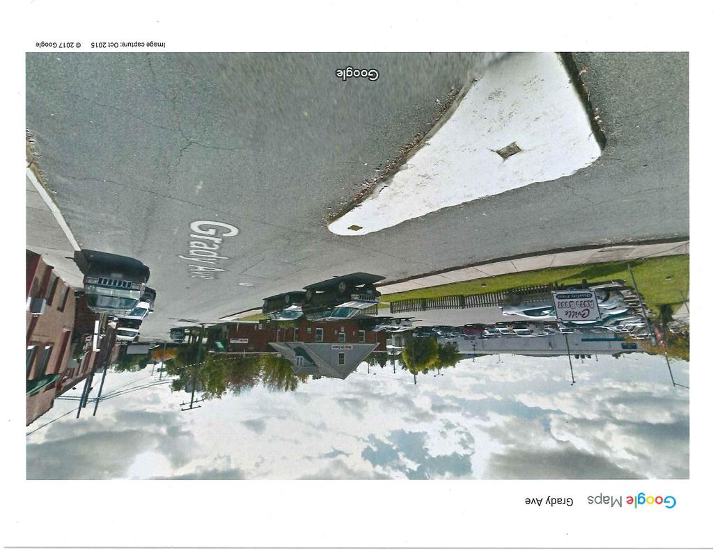
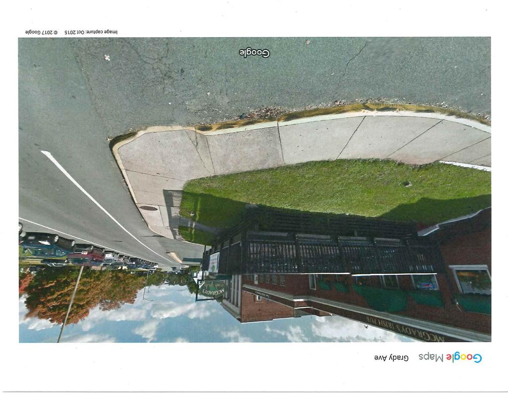
1 CITY OF CHARLOTTESVILLE, VIRGINIA CITY COUNCIL AGENDA Agenda Date: June 5, 2017 Action Required: Presenter: Staff Contacts: Title: Public Hearing and Adoption of Ordinance S. Craig Brown, City Attorney S. Craig Brown, City Attorney Brian Haluska, Principal Planner, NDS Conveyance of City Land at Intersection of Grady Avenue and Preston Avenue Background: Dairy Holdings, LLC, the owner of property on Grady Avenue commonly known as the Monticello Dairy site, recently discovered that a strip of land that appeared to be a part of their property at 946 Grady Avenue is at least partially owned by the City. This property (1,403 square feet in area) is partly existing unused right-of-way and partly residue land that VDOT acquired in 1974 for the Preston Avenue widening project and then quitclaimed to the City in Title to the unused right-of-way is not clear, but the residue land is City-owned (together the Subject Property ). The Subject Property is located at the entrance to the Monticello Dairy site, and technically blocks direct access to the private roadway entrance to their property. This roadway entrance was the former Wood Street, which was acquired by street closing ordinance in 1977 and combined with the Monticello Dairy site. The exact boundary line of the former Wood Street in 1977 at this point cannot be determined, so it is possible that the unused right-of-way portion of the Subject Property was also closed in 1977 and is not owned by the City. The area has been improved and maintained by Dairy Holdings, LLC as part of the access roadway for 946 Grady Avenue. Dairy Holdings, LLC is planning to redevelop their property (located on both sides of the Subject Property), and is asking the City to convey the property to them without compensation so that it can legally be combined with their existing parcel (City Tax Map Parcel ). Discussion: The property at 946 Grady Avenue is within the Central City Corridor zoning district and is a part of an entrance corridor overlay district. It is not currently being considered for any type of land use approval by the City; however, the applicant has had preliminary discussions with City staff about future development of the property. The property is designated as Commercial in the City s Comprehensive Plan. The addition of this land will not give the owner any substantial additional development rights.
2 This request was reviewed administratively by the Departments of Neighborhood Development Services, Public Works, Public Utilities, Parks and Recreation and the Real Estate Assessor. There are existing City utilities (natural gas line and sanitary sewer line) that would be protected with an easement to the City incorporated within the deed of quitclaim. There is a concrete median structure ( pork chop ) and sidewalk on the subject land that basically serves the Monticello Dairy site and will be addressed when the redevelopment plan is submitted. The City has no current or anticipated uses for this property, and no Department raised any concern or reservation regarding the requested conveyance. The Real Estate Assessor valued the property at $44,900, but also commented that this land has been shown for at least 10 years on the Tax Maps as part of the Monticello Dairy site, and taxed as part of that property. Alignment with City Council s Vision and Strategic Plan: N/A Community Engagement: The proposed conveyance has been advertised as a public hearing to allow the public an opportunity to comment on this request. Budgetary Impact: Dairy Holdings, LLC is requesting that the City land be conveyed to them without consideration. Because of its shape, location and small size, the property has no real value to anyone other than Dairy Holdings, LLC. If the City-owned land is conveyed and added to 946 Grady Avenue, the assessed value of that parcel will not increase for the reasons cited above. Recommendation: Approve the conveyance of the City-owned land to Dairy Holdings, LLC by quitclaim deed, reserving utility easements for the City utilities. Staff recommends that the Subject Property be conveyed without compensation since title to the majority of the Subject Property is unclear. Alternatives: Retain ownership of the property and deny the request for a conveyance, or offer to sell the property to Dairy Holdings, LLC for a specific amount. Attachments: Proposed Ordinance Survey Plat of Requested Property Photos of Area Wood Street Closing Ordinance (1977) 2
3 AN ORDINANCE AUTHORIZING THE CONVEYANCE OF CITY-OWNED RIGHT-OF-WAY AND LAND ADJACENT TO 946 GRADY AVENUE TO DAIRY HOLDINGS, LLC WHEREAS, Dairy Holdings, LLC, the owner of property designated as Parcel 60 on City Real Estate Tax Map 31 (946 Grady Avenue), wishes to acquire certain City right-of-way and Cityowned land acquired by the City from the Commonwealth of Virginia as residue land from the Preston Avenue widening project, said land and right-of-way being shown on the attached plat dated April 28, 2017; and WHEREAS, in accordance with Virginia Code Sec (B), a public hearing was held to give the public an opportunity to comment on the proposed conveyance of the City property as requested by Dairy Holdings, LLC; and WHEREAS, the City Assessor, and Departments of Neighborhood Development Services, Public Works, Public Utilities and Parks and Recreation, have reviewed the proposed conveyance and have no objection thereto, provided that the City retain easements for existing utility lines located within the land to be conveyed; NOW, THEREFORE, BE IT ORDAINED by the Council of the City of Charlottesville, Virginia that the Mayor is authorized to execute a deed of quitclaim, in form approved by the City Attorney, for certain City-owned land and right-of-way, approximately 1,403 square feet in area, adjacent to Parcel 60 on City Tax Map 31, being shown on the attached plat dated April 28, The deed of quitclaim shall reserve easements for existing utility lines in locations acceptable to the Director of Public Utilities. No compensation will be due to the City for the conveyance. The City Attorney is hereby authorized to take whatever steps are necessary to effect the closing of said property conveyance. 3
4 :\904\39075-Monticello_Dairy_Property\DWG\39075V-XPSURV_ROW_Vacation.dwg Plotted on 5/30/ :20 PM by Joe Medley Y OWNER'S APPROVAL: SURVEY NOTES: THE BOUNDARY LINE ADJUSTMENT DESCRIBED HEREIN IS WITH 1. PROPERTY & ZONING INFORMATION: THE FREE CONSENT AND IN ACCORDANCE WITH THE DESIRE TMP OF THE UNDERSIGNED OWNERS, PROPRIETORS, AND OWNER: DAIRY HOLDINGS, LLC TRUSTEES. ANY REFERENCE TO FUTURE POTENTIAL REFERENCE: INST. NO DEVELOPMENT IS TO BE DEEMED AS THEORETICAL ONLY. ALL PARCEL ID NUMBER: STATEMENTS AFFIXED TO THIS PLAT ARE TRUE AND CORRECT PROPERTY ADDRESS: 946 GRADY AVENUE TO THE BEST OF MY KNOWLEDGE AND BELIEF. (ORIGINAL) AREA AC. (189,664 SF) ZONED: CCH (OWNER) DAIRY HOLDINGS, LLC STATE OF: COUNTY OR CITY OF: DATE THE FOREGOING WAS ACKNOWLEDGED BEFORE ME ON THIS DAY OF, 2017, BY: 2. THE BOUNDARY SURVEY AND EXISTING CONDITIONS SHOWN HEREON ARE BASED ON FIELD SURVEY BY TIMMONS GROUP COMPLETED ON NOVEMBER 22, HORIZONTAL DATUM IS BASED ON NAD83 (NA2011), VIRGINIA STATE GRID, SOUTH ZONE. DATUM ESTABLISHED THROUGH LEICA SmartNET REFERENCING STATION LOY1, CHARLOTTESVILLE, VA. SURVEYOR'S CERTIFICATE : I CERTIFY THAT THIS RIGHT-OF-WAY VACATION & BOUNDARY LINE ADJUSTMENT PLAT, TO THE BEST OF MY PROFESSIONAL KNOWLEDGE AND BELIEF, IS CORRECT AND COMPLIES WITH THE MINIMUM PROCEDURES AND STANDARDS ESTABLISHED BY THE VIRGINIA STATE BOARD OF ARCHITECTS, PROFESSIONAL ENGINEERS, LAND SURVEYORS AND CERTIFIED LANDSCAPE ARCHITECTS. I ALSO CERTIFY THAT THE BOUNDARY SHOWN HEREON IS BASED ON A CURRENT FIELD SURVEY. GRADY AVE. DRAFT 10TH ST. NW SITE PRESTON AVE. 5. BASED ON FEMA FLOOD INSURANCE RATE MAP (FIRM), MAP NO C0286D, PANEL 286 OF 575 EFFECTIVE DATE FEBRUARY 4, 2005, THE PROPERTY SHOWN LIES IN UNSHADED ZONE X, AREAS DETERMINED TO BE OUTSIDE THE 0.2% ANNUAL CHANCE FLOODPLAIN. NOTARY PUBLIC 6. THIS PLAT WAS PREPARED WITH THE BENEFIT OF A TITLE REPORT, COMMITMENT NO FROM CHICAGO TITLE INSURANCE COMPANY, ISSUED / EFFECTIVE NOVEMBER 7, MY COMMISSION EXPIRES: VICINITY MAP 1" = 1000' 7. REGARDING EXISTING UTILITIES DEPICTED ON THE SUBJECT PROPERTY AND LYING IN THE CORRIDOR FORMERLY KNOWN AS WOOD STREET, THE CITY OF CHARLOTTESVILLE MAINTAINS ACITY APPROVALS: PERPETUAL EASEMENT FOR THE MAINTENANCE & ACCESS FOR/TO SANITARY, WATER, AND GAS SERVICES LOCATED (OWNER) CITY OF CHARLOTTESVILLE, VIRGINIA DATE THEREIN. SEE DEED BOOK 382, PAGE 298. SECRETARY OF THE PLANNING COMMISSION DATE 8. RIGHT-OF-WAY CONFIGURATION SHOWN HEREON FOR GRADY STATE OF: AVENUE BASED ON DEEDS AND PLATS OF RECORD AND STATE COUNTY OR CITY OF: HIGHWAY PLANS (STATE PROJ. NO ). ABANDONMENT OF WOOD STREET IMPLIES EXISTING CHAIRMAN OF THE PLANNING COMMISSION DATE THE FOREGOING WAS ACKNOWLEDGED BEFORE ME ONCONFIGURATION AS SHOWN BASED ON THE LOCATION OF EXISTING MONUMENTS AND AN ALTA/NSPS LAND TITLE SURVEY THIS DAY OF, 2017, PERFORMED BY THIS FIRM, DATED DEC. 7, BY: NOTARY PUBLIC MY COMMISSION EXPIRES: 9TH ST. NW WEST ST. ROSE HILL DR. US RTE. 250 FOREST ST. DALE AVE. 4TH ST. NW MCINTIRE RD. PLAT SHOWING BOUNDARY LINE ADJUSTMENT FOR DAIRY HOLDINGS, LLC TAX MAP PARCELS TH & PAGE AREA CHARLOTTESVILLE, VIRGINIA N Date: April 28, 2017 Scale: 1" = 30' Sheet: 1 of 2 J.N.: Drawn by: JCM Checked by: JCM YOUR VISION ACHIEVED THROUGH OURS. THIS DRAWING PREPARED AT THE STAUNTON OFFICE 28 Imperial Drive Staunton, Virginia TEL FAX
5
6
7
8
9
10 This page intentionally left blank.
Philip Garber, Chief Gas Engineer. Release of Portion of Gas Line Easement in Lochlyn Hills Subdivision
 CITY OF CHARLOTTESVILLE, VIRGINIA CITY COUNCIL AGENDA Agenda Date: September 15, 2014 Action Required: Presenter: Staff Contacts: Title: Approval of Ordinance (1 st reading) after Public Hearing Lauren
City of Grand Forks Staff Report
 City of Grand Forks Staff Report Planning and Zoning Commission March 6, 2019 City Council March 18, 2019 Agenda Item: 4-1 (Preliminary) Preliminary approval of the plat of University Place First Resubdivision
COUNTY OF ALBEMARLE APPLICATION FOR FAMILY DIVISION. Family Division = $742 (Provide 5 copies of plat)
") Page 1 APPLICATION FOR FAMILY DIVISION Family Division = $742 (Provide 5 copies of plat) Tier 2 Groundwater Review = $355 (Required for all plats showing lots less than 21 acres) Tier 3 Groundwater Review
Page 1 APPLICATION FOR FAMILY DIVISION Family Division = $742 (Provide 5 copies of plat) Tier 2 Groundwater Review = $355 (Required for all plats showing lots less than 21 acres) Tier 3 Groundwater Review
PART OF SECTION 9, TOWNSHIP 36 NORTH, RANGE 9 EAST OF THE THIRD PRINCIPAL MERIDIAN, NORTH OF THE INDIAN BOUNDRY LINE, IN WILL COUNTY, ILLINOIS.
 PART OF SECTION 9, TOWNSHIP 6, RANGE 9 EAST OF THE THIRD PRINCIPAL MERIDIAN, OF THE INDIAN BOUNY LINE, IN WILL COUNTY, ILLINOIS. ASSUMED THE LINE OF THE WEST / OF SECTION 9-6-9 TO BE: S89 5' 7"E 60 0 0
XIV. County of Hanover. Board Meeting: May 11, 2016
 XIV. Agenda Item County of Hanover Board Meeting: May 11, 2016 Subject: Public Hearing Department of Public Works Conveyance of Signal Easement to Virginia Department of Transportation Fleet Services Facility
COUNTY OF ALBEMARLE APPLICATION FOR RURAL SUBDIVISION
 Page 1 APPLICATION FOR RURAL SUBDIVISION The term rural subdivision means a type of subdivision that is located in the rural areas which results in two or more lots for the purpose of transfer of ownership
19. ARLINGTON COUNTY, VIRGINIA. County Board Agenda Item Meeting of May 19, DATE: May 11, 2018
 ARLINGTON COUNTY, VIRGINIA County Board Agenda Item Meeting of May 19, 2018 DATE: May 11, 2018 SUBJECT: Ordinance of Vacation to Vacate a Portion of a Sanitary Sewer Easement Running Over, Across and Through
ARLINGTON COUNTY, VIRGINIA. County Board Agenda Item Meeting of November 5, 2016
 ARLINGTON COUNTY, VIRGINIA County Board Agenda Item Meeting of November 5, 2016 DATE: October 25, 2016 SUBJECT: Vacation of a Portion of an Easement for Public Sidewalk and Utilities Purposes Along the
E. 140TH AVE. VICINITY MAP SCALE: 1"=600' LAND USE TABLE NET AREA 599,946 SQFT AC. GROSS AREA 741,420 SQFT AC.
 SHEET OF PURPOSE STATEMENT: THIS PLAT IS INTENDED TO SUBDIVIDE. ACRES INTO SINGLE FAMILY ATTACHED LOTS, TRACTS, DEDICATE AND GRANT EASEMENTS. LEGAL DESCRIPTION: THE UNDERSIGNED BEING THE OWNER(S) OF A
ARLINGTON COUNTY, VIRGINIA
 ARLINGTON COUNTY, VIRGINIA County Board Agenda Item Meeting of June 18, 2016 DATE: June 7, 2016 SUBJECT: Vacations Concerning a Project Known as 2400 Columbia Pike A. Vacation of a Portion of Columbia
ARLINGTON COUNTY, VIRGINIA. County Board Agenda Item Meeting of November 5, 2016
 ARLINGTON COUNTY, VIRGINIA County Board Agenda Item Meeting of November 5, 2016 DATE: October 28, 2016 SUBJECT: Resolution Petitioning the Commonwealth Transportation Board to Transfer Certain Sections
ARLINGTON COUNTY, VIRGINIA
 ARLINGTON COUNTY, VIRGINIA County Board Agenda Item Meeting of June 9, 2007 DATE: May 14, 2007 SUBJECT: Enactment of an Ordinance to Vacate a 5 Water Distribution Easement and a Portion of a 5 Sanitary
SUBDIVISION APPLICATION: RECOMBINATION PLAT or EXEMPT PLAT
 SUBDIVISION APPLICATION: RECOMBINATION PLAT or EXEMPT PLAT Pursuant to Article 7, Section 155.706 of the Unified Development Code, an owner of land within the jurisdiction of the Town (or a duly authorized
Preliminary Plat/Final Plat Application
 Melissa Municipal Center 3411 Barker Avenue Melissa, Texas 75454 Phone: (972) 838-2036 Applicant: Date: Address: Phone: Contact: Fax: E-mail: Propose Addition Name: Acres: Existing Zoning: Propose Zoning:
CITY OF LEE S SUMMIT MINOR PLAT PROCESS. Purpose of Minor Plats
 MINOR PLAT PROCESS Purpose of Minor Plats The City of Lee s Summit requires that all property be platted before a building permit is issued. Platting involves the subdivision of land into lots or tracts.
County of Loudoun. Department of Planning and Zoning MEMORANDUM
 County of Loudoun Department of Planning and Zoning MEMORANDUM DATE: November 10, 2015 TO: FROM: Joe Griffiths, Project Manager Land Use Review Kelly Williams, Planner III Community Planning SUBJECT: ZRTD
STANDARD LANGUAGE FORMAT GUIDE PLANNING SERVICES DIVISION
 A. OWNERSHIP CERTIFICATE The purpose of the ownership certificate is to identify the owner and provide the Volume and Page of Deed Records, verifying the ownership. When the property owner is a corporation,
Community Development Department Council Chambers, 7:30 PM, July 20, 2017
 STAFF REPORT 2017-25P: Subdivision Community Development Department Council Chambers, 7:30 PM, July 20, 2017 To: From: Re: Paul Luke, Chairman, Skokie Plan Commission Mike Voitik, Planning Technician 2017-25P:
INSTRUCTIONS FINAL PLAT APPROVAL APPLICATION
 INSTRUCTIONS FINAL PLAT APPROVAL APPLICATION 1. The applicant/agent shall fill out the attached application. The attached application form must be completely filled in before it can be filed. Portions
The Filing Fee for a Minor Plat is $ PLUS $20.00 per lot created
 DEPARTMENT OF COMMUNITY DEVELOPMENT MINOR PLAT PROCEDURE The Filing Fee for a Minor Plat is $250.00 PLUS $20.00 per lot created Description: The purpose of a Minor Plat is to allow property to be platted
ARLINGTON COUNTY, VIRGINIA. County Board Agenda Item Meeting of November 14, 2015
 ARLINGTON COUNTY, VIRGINIA County Board Agenda Item Meeting of November 14, 2015 DATE: November 10, 2015 SUBJECT: Ordinance of Vacation to vacate portions of an Easement and Right of Way (Street and Utilities
VACATING PLATS. The following documents are provided as required by the City of Conroe for use in the above titled platting submittals:
 Public Works - Engineering Division CITY OF CONROE VACATING PLATS The following documents are provided as required by the for use in the above titled platting submittals: Submittal Questionnaire (1-page).
APPLICATION PROCEDURES FOR A MAJOR SUBDIVISION PRELIMINARY PLAT
 APPLICATION PROCEDURES FOR A DEFINITION: The subdivision of a tract of land into at least three (3) residential, commercial, or industrial parcels, including the remainder of the original parcel, fronting
AGENDA ITEM G-2 Public Works
 AGENDA ITEM G-2 Public Works STAFF REPORT City Council Meeting Date: 2/23/2016 Staff Report Number: 16-035-CC Consent Calendar: Adopt a resolution accepting Easements and approving the abandonment of two
AMENDING PLAT REQUIREMENTS Revised
 City of University Park AMENDING PLAT REQUIREMENTS Revised 9-3-2014 1. The amending plat is prepared with the appropriate certificates printed on the document and three (3) 24 x 36 paper copies are submitted
AMENDING PLAT REQUIREMENTS Revised
 City of University Park AMENDING PLAT REQUIREMENTS Revised 10-2016 1. The amending plat is prepared with the appropriate certificates printed on the document and three (3) 24 x 36 paper copies are submitted
SUBDIVISION APPLICATION
 SUBDIVISION APPLICATION Preliminary Plat Minor Plat Final Plat Amended Plat Applicant Name: Owner (if different from applicant) Name: Company: Company: Address: Address: City, State, Zip City, State, Zip
City of Melbourne APPLICATION FOR PRELIMINARY PLAT
 City of Melbourne Community Development Department City Hall 900 E. Strawbridge Avenue, Melbourne, FL 32901 (321) 608-7500 Fax (321) 608-7519 E-Mail p&z@melbourneflorida.org APPLICATION FOR PRELIMINARY
ARLINGTON COUNTY, VIRGINIA. County Board Agenda Item Meeting of January 27, 2018
 ARLINGTON COUNTY, VIRGINIA County Board Agenda Item Meeting of January 27, 2018 DATE: January 22, 2018 SUBJECT: Deed of Easement for Public Sidewalk and Utilities Purposes on Property Located at the Corner
SUBJECT PARCEL(S) Property Owner(s) TMS Number Approximate Acreage Carolina Park Development, LLC
 Property Owner(s) TMS Number Approximate Acreage Carolina Park Development, LLC") Staff Report Special Planning Commission Meeting November 19, 2014 For reference, the Zoning Code and Land Development Regulations are available online. AGENDA ITEM 5c. SKETCH PLAN APPROVAL REQUEST: Request
Staff Report Special Planning Commission Meeting November 19, 2014 For reference, the Zoning Code and Land Development Regulations are available online. AGENDA ITEM 5c. SKETCH PLAN APPROVAL REQUEST: Request
BILL NO (Emergency Measure) ORDINANCE NO. 5072
 ORDINANCE NO. 5072") BILL NO. 5210 (Emergency Measure) ORDINANCE NO. 5072 AN ORDINANCE AUTHORIZING THE MAYOR TO EXECUTE WITH MICHELSON-HADLEY HEIGHTS DEVELOPMENT, LLC, A CONTRACT AND QUIT CLAIM DEED CONVEYING CERTAIN PROPERTIES
BILL NO. 5210 (Emergency Measure) ORDINANCE NO. 5072 AN ORDINANCE AUTHORIZING THE MAYOR TO EXECUTE WITH MICHELSON-HADLEY HEIGHTS DEVELOPMENT, LLC, A CONTRACT AND QUIT CLAIM DEED CONVEYING CERTAIN PROPERTIES
Honorable Mayor Bill Agan and members of the Richland Hills City Council. Final Plat Richland Hills, Lots 1 & 2, Block 1 Brumlow Addition
 2B - 1 Memorandum To: From: Date: Subject: Honorable Mayor Bill Agan and members of the Richland Hills City Council Jason Moore, Assistant City Manager January 17, 2017 Final Plat Richland Hills, Lots
APPLICATION PROCEDURES FOR A PLAT AMENDMENT OR REVISION
 APPLICATION PROCEDURES FOR A PLAT AMENDMENT OR REVISION DEFINITION: Any revision or amendment to an approved recorded or unrecorded final plat. A revision (not recorded) does not require a public hearing
Major Subdivision Application Packet. Revised June 2018
 Major Subdivision Application Packet Revised June 2018 Caroline County Department of Planning and Community Development 233 West Broaddus Avenue Bowling Green, VA 22427 www.co.caroline.va.us Phone: 804-633-4303
QUEBEC STREET EAST 130TH AVENUE ONEIDA STREET E. 130TH AVE. VALENTIA ST TAMARAC ST EAST 128TH AVENUE MONACO STREET BACHMAN DR. SITE QUINCE ST.
 SHEET OF CASE NO.: SUBA 0-0 PURPOSE STATEMENT: THIS PLAT IS INTENDED TO SUBDIVIDE. ACRES INTO 0 SINGLE FAMILY LOTS, AND TRACTS FOR PARKS, OPEN SPACE, DRAINAGE AND DETENTION, DEDICATE RIGHT-OF-WAY AND GRANT
65.00 Right-of-Way, Easements, Subordination Agreements and Licenses
 65.00 Subordination Agreements and Licenses Right-of-way, easements, subordination agreements and licenses are located as follows: Subject Name Page Number Single Lot Development... 65.00-1 Subdivision
SUBDIVISION APPLICATION
 SUBDIVISION APPLICATION City of Horn Lake Planning Department 3101 Goodman Road, W Horn Lake, MS 38637 662-342-3559 Fax: 662-342-3485 Applications due the 1st working day of the month. Submit application
RULES, REGULATIONS AND REQUIREMENTS RELATING TO THE APPROVAL AND ACCEPTANCE OF IMPROVEMENTS IN SUBDIVISIONS OR RE-SUBDIVISIONS
 GALVESTON COUNTY RULES, REGULATIONS AND REQUIREMENTS RELATING TO THE APPROVAL AND ACCEPTANCE OF IMPROVEMENTS IN SUBDIVISIONS OR RE-SUBDIVISIONS GALVESTON COUNTY ENGINEERING DEPARTMENT MARCH 3, 1997 Amendment
ADMINISTRATIVE HEARING STAFF REPORT Country Club Acres Second Amended Subdivision Amendment PLNSUB E Parkway Avenue December 12, 2013
 ADMINISTRATIVE HEARING STAFF REPORT Country Club Acres Second Amended Subdivision Amendment PLNSUB2013-00925 2167 E Parkway Avenue December 12, 2013 Planning Division Department of Community & Economic
PLANNING & ZONING DEPARTMENT 401 South Rogers Street Waxahachie, Texas (469)
") ZONING APPLICATION Select Application Type: Zoning Change Specific Use Permit (SUP) PD Concept Plan PD Detailed Plan PD Amendment Site Plan The following items shall be included in the application submittal:
ZONING APPLICATION Select Application Type: Zoning Change Specific Use Permit (SUP) PD Concept Plan PD Detailed Plan PD Amendment Site Plan The following items shall be included in the application submittal:
ARLINGTON COUNTY, VIRGINIA
 ARLINGTON COUNTY, VIRGINIA County Board Agenda Item Meeting of February 22, 2014 DATE: January 28, 2014 SUBJECT: Deed of Easement for a Department of Environmental Services Project Located on a Portion
Official Use Only (To be completed by Village Staff) Case Number: P&Z - - Date of Submission: Hearing Date: Plat Name/Address:
 Case Number: P&Z - - Date of Submission: Hearing Date: Plat Name/Address:") Plat Application Village of Mount Prospect Community Development Department 50 S. Emerson Street Mount Prospect, Illinois 60056 Phone: (847) 818-5328 Official Use Only (To be completed by Village Staff)
Plat Application Village of Mount Prospect Community Development Department 50 S. Emerson Street Mount Prospect, Illinois 60056 Phone: (847) 818-5328 Official Use Only (To be completed by Village Staff)
CERTIFIED SURVEY MAP
 SCONSIN STATE PLANE N:389676.12 E:2130390.15 Center of Section 23 CERTIFIED SURVEY MAP 734.06' THE (PRITCHETTE) ORIGINAL PLAT OF ALL IN THE NW 1 4 OF THE SE 1 4 OF FRACTIONAL SECTION 23, T7N, R9E, IN THE
NON-EXCLUSIVE TRAIL AND UTILITY EASEMENT
 After recording return to: Public Works Department City of Ellensburg 501 N Anderson St Ellensburg, WA 98926 DOCUMENT TITLE: GRANTOR: GRANTEE: TRAIL AND UTILITY EASEMENT Central Washington University City
PLANNING COMMISSION. Agenda Item # 8.
 PLANNING COMMISSION Agenda Item # 8. CASE SUMMARY Street Closure Planning Commission February 1, 2016 SC-1-217 Jeff Walton, 341-3260, jeff.walton@wilmingtonnc.gov Staff recommendation APPROVAL Planning
QUEBEC STREET EAST 130TH AVENUE ONEIDA STREET E. 130TH AVE. VALENTIA ST TAMARAC ST EAST 128TH AVENUE MOACO STREET BACHMAN DR. SITE QUINCE ST.
 SHEET OF CASE NO.: SUBA - PURPOSE STATEMENT: THIS PLAT IS INTENDED TO SUBDIVIDE. ACRES INTO SINGLE FAMILY LOTS, AND TRACTS FOR PARKS, OPEN SPACE, DRAINAGE AND DETENTION, DEDICATE RIGHT-OF-WAY AND GRANT
DEED OF DEDICATION, BOUNDARY LINE ADJUSTMENT, CONVEYANCE, VACATION, TRUST MODIFICATION AND RELEASE (Minor Adjustment of Property Lines)
") Prepared by/return to: Reed Smith LLP 7900 Tysons One Place, Suite 500 McLean, VA 22102-5979 Attn: Robert M. Diamond, Esq. Parcel ID Nos.: 58 2 10 01 001 58 2 10 01 002 58 2 10 01 003 58 2 10 01 004 58
Prepared by/return to: Reed Smith LLP 7900 Tysons One Place, Suite 500 McLean, VA 22102-5979 Attn: Robert M. Diamond, Esq. Parcel ID Nos.: 58 2 10 01 001 58 2 10 01 002 58 2 10 01 003 58 2 10 01 004 58
MINOR PLAT. The following documents are provided as required by the City of Conroe for use in the above titled platting submittals:
 Public Works - Engineering Division CITY OF CONROE MINOR PLAT The following documents are provided as required by the City of Conroe for use in the above titled platting submittals: Submittal Questionnaire
City of Leavenworth DEPARTMENT OF DEVELOPMENT SERVICES MAJOR SUBDIVISION APPLICATION 1
 Proposed Name of Subdivision: City of Leavenworth DEPARTMENT OF DEVELOPMENT SERVICES MAJOR SUBDIVISION APPLICATION 1 FOR PRELIMINARY SUBDIVISION APPROVAL This application must be filled out legibly, in
ARLINGTON COUNTY, VIRGINIA. County Board Agenda Item Meeting of June 17, 2017
 ARLINGTON COUNTY, VIRGINIA County Board Agenda Item Meeting of June 17, 2017 DATE: June 7, 2017 SUBJECT: Deed of Easement, Temporary Construction Easement and Construction Agreement For Parcel "A," Hurley's
Jim Tolbert, Director NDS; Patricia Carrington, NDS; Richard Hunt, NDS
 CITY OF CHARLOTTESVILLE, VIRGINIA CITY COUNCIL AGENDA Agenda Date: February, 05 Action Required: Presenter: Staff Contacts: Title: Approval of Ordinance Jim Tolbert Jim Tolbert, Director NDS; Patricia
Report to the Strategic Development Committee
 Report to the Strategic Development Committee Recommendation to Approve Loudoun County s Request for Easement across Washington Dulles International Property For Improvements to Carters School Road July
FINAL PLAT GUIDE TO SUBDIVIDING PROPERTY. Background
 FINAL PLAT GUIDE TO SUBDIVIDING PROPERTY Background A final plat is the second step in the process of subdividing land into separate parcels for future sale or lease. Once a preliminary plat has been approved
FINAL PLAT APPLICATION
 FINAL PLAT APPLICATION (Page 1 of 3) LEGAL OWNER(s): NAME: STREET ADDRESS OWNER(s): CITY, STATE, ZIP CODE: PHONE NUMBER: BILLING ADDRESS: NAME OF ENGINEER/SURVEYOR: Engineer/Surveyor Address, Phone: PROPERTY
PROFFER STATEMENT FAIRFAX MARBLE & GRANITE SUMMIT AT DULLES ZRTD
 PROFFER STATEMENT FAIRFAX MARBLE & GRANITE SUMMIT AT DULLES ZRTD 2016-0009 December 13, 2016 Dulles Summit LLC, the owner (hereinafter, the "Owner") of the parcel described as Loudoun County Tax Map Number
EXHIBIT 1. PRIVATE ROAD ACCESS EASEMENT and SHARED ROAD MAINTENANCE AGREEMENT for KENNEDY SHORES LANE. Auction Tracts 1-8
 EXHIBIT 1 PRIVATE ROAD ACCESS EASEMENT and SHARED ROAD MAINTENANCE AGREEMENT for KENNEDY SHORES LANE Auction Tracts 1-8 This Private Road Access Easement and Shared Road Maintenance Agreement for Kennedy
PLANNING & DEVELOPMENT SERVICES 1800 Continental Place Mount Vernon, WA Inspections Office Fax 360.
 PLANNING & DEVELOPMENT SERVICES 1800 Continental Place Mount Vernon, WA 98273 Inspections 360.416.1330 Office 360.416-1320 Fax 360.416-1340 Date Received: Administrative Setback Reduction Checklist Pursuant
CITY OF DECATUR, TEXAS
 Final Plat or Amending Plat / Replat Checklist A submittal of a complete application will facilitate a timely review. Failure of the applicant to provide required information or obtain a waiver from the
APPROVAL REQUIRED... A5 APPLICATION FOR APPROVAL OF PRELIMINARY PLAN... A6 APPLICATION FOR APPROVAL OF DEFINITIVE PLAN... A7
 APPENDIX FORM A. FORM A-2. FORM A-3. FORM B. FORM C. FORM C-1. FORM C-2. FORM D. FORM E. FORM F. FORM G. FORM H. FORM I. FORM J. FORM J-1. FORM K. FORM K-1 FORM L Form M. APPLICATION FOR A DETERMINATION
ARLINGTON COUNTY, VIRGINIA. County Board Agenda Item Meeting of January 28, 2017
 ARLINGTON COUNTY, VIRGINIA County Board Agenda Item Meeting of January 28, 2017 DATE: January 19, 2017 SUBJECT: Deed of Easements, Temporary Construction Easements and Construction Agreement and Deed of
REPLAT REQUIREMENTS Revised
 City of University Park REPLAT REQUIREMENTS Revised 02-2016 1. The replat is prepared with the appropriate certificates printed on the document and three (3) 24 x 36 paper copies are submitted with a completed
SKETCH OF BOUNDARY SURVEY ALTA / ACSM LAND TITLE SURVEY
 SKETCH OF BOUNDARY SURVEY ALTA / ACSM LAND TITLE SURVEY SURVEYOR'S NOTES: All distances as shown hereon are based on the US Survey foot. Subject property lies inside the UBD (Urban Development Boundary),
Environmental and Engineering Services EASEMENT INFORMATION AND EXAMPLE DOCUMENTS
 Environmental and Engineering Services Reddy Chitepu, P.E., Director EASEMENT INFORMATION AND EXAMPLE DOCUMENTS Please refer to the information below when compiling easement documents for submittal to
MINOR SUBDIVISION APPLICATION
 MINOR SUBDIVISION APPLICATION Complete with required information (write "n/a" if information is not applicable to proposal). Title of Plat Has any other plat been recorded for this site? ( ) Yes ( ) No
ARLINGTON COUNTY, VIRGINIA. County Board Agenda Item Meeting of July 15, 2017
 ARLINGTON COUNTY, VIRGINIA County Board Agenda Item Meeting of July 15, 2017 DATE: July 7, 2017 SUBJECT: Deed of Easement from Highland Holdings, LLC, to the County Board of Arlington County, Virginia
MINOR SUBDIVISION FINAL PLAT APPLICATION Town of Apex, North Carolina
 MINOR SUBDIVISION FINAL PLAT APPLICATION Town of Apex, North Carolina This document is a public record under the North Carolina Public Records Act and may be published on the Town s website or disclosed
MASTER SUBDIVISION FINAL PLAT APPLICATION Town of Apex, North Carolina
 MASTER SUBDIVISION FINAL PLAT APPLICATION Town of Apex, North Carolina This document is a public record under the North Carolina Public Records Act and may be published to the Town s website or disclosed
CITY OF FAYETTEVILLE, ARKANSAS FINAL PLAT FOR STAFF USE ONLY FINAL PLAT FEE: $ $ Date Application Submitted: Date Accepted as Complete:
 CITY OF FAYETTEVILLE, ARKANSAS FINAL PLAT FOR STAFF USE ONLY FINAL PLAT FEE: $200.00-$800.00 Date Application Submitted: Date Accepted as Complete: Project Number: Public Hearing S-T-R: PP#: Zone: Please
Community Development Department Council Chambers, 7:30 PM, December 1, 2016
 STAFF REPORT 2016-35P: Subdivision Community Development Department Council Chambers, 7:30 PM, December 1, 2016 To: From: Re: Paul Luke, Chairman, Skokie Plan Commission Mike Voitik, Planning Technician
AGENDA HAYDEN PLANNING COMMISSION
 AGENDA HAYDEN PLANNING COMMISSION THURSDAY, DECEMBER 14, 2017 7:00 P.M. HAYDEN TOWN HALL 178 WEST JEFFERSON AVENUE REGULAR MEETING 1. CALL TO ORDER, MOMENT OF SILENCE & PLEDGE OF ALLEGIANCE 2. ROLL CALL
FINAL PLAN CHECKLIST
 FINAL PLAN CHECKLIST Subdivision Name: Subdivision Number: Project Number: REVIEW CRITERIA Plans: A final plan shall be on a 24 x 36 sheet at a scale that is no smaller than 1 = 40 and shall contain all
SEARS BUILDING & LAND for SALE
 SALE LEASEBACK OPPORTUNITY/ REDEVELOPMENT POTENTIAL SEARS BUILDING & LAND for SALE 8235 Douglas Ave Suite 720 Dallas, Texas 75225 T 214.378.1212 venturedfw.com MALL OF ABILENE 4310 BUFFALO GAP RD ABILENE,
SUBMITTAL REQUIREMENTS: The number indicates the number of copies for submittal (if applicable).
.") Office Use Only Preliminary Long Plat Long Subdivision Applicant Checklist PLANNING, COMMUNITY, & ECONOMIC DEVELOPMENT DEPARTMENT FINAL LONG PLAT LONG SUBDIVISION CHECKLIST Mailing Address: P.O. Box 547,
Office Use Only Preliminary Long Plat Long Subdivision Applicant Checklist PLANNING, COMMUNITY, & ECONOMIC DEVELOPMENT DEPARTMENT FINAL LONG PLAT LONG SUBDIVISION CHECKLIST Mailing Address: P.O. Box 547,
VICINITY MAP/AERIAL MAP SITE
 VICINITY MAP/AERIAL MAP SITE N ZONING MAP PA 9 PA 5 SITE Solterra West ODP PA 7 N , DATE, 2013, TIME, COUNTY OF JEFFERSON, STATE OF COLORADO, $ DEDICATION CERTIFICATE THE UNDERSIGNED, BEING THE OWNER(S)
ELMORE COUNTY LAND USE & BUILDING DEPARTMENT 520 E 2 nd South Mountain Home, ID (208) Preliminary Plat Application
 Preliminary Plat Application") ELMORE COUNTY LAND USE & BUILDING DEPARTMENT 520 E 2 nd South Mountain Home, ID 83647 (208) 587-2142 www.elmorecounty.org Preliminary Plat Application We are unable to accept facsimile copies. (Subdivisions
ELMORE COUNTY LAND USE & BUILDING DEPARTMENT 520 E 2 nd South Mountain Home, ID 83647 (208) 587-2142 www.elmorecounty.org Preliminary Plat Application We are unable to accept facsimile copies. (Subdivisions
Community Development Department
 Community Development Department SUBJECT: Consideration of a Resolution for a Single-Lot Subdivision for the Skyler Park Subdivision at 626 Forest Road AGENDA ITEM: 9.b.v MEETING DATE: November 17, 2015
Scale 1" = 100' PLAT OF DEDICATION. Sheet 1 of 9 LEGAL DESCRIPTION. Areas of Dedication. Areas of Access Easement
 LEGAL DESCRIPTION PART OF LOTS 2, 4, 6 AND 7 IN GNAS MIXED USE RETAIL CENTER, BEING A SUBDIVISION OF PART OF THE WEST HALF OF SECTION 27, TOWNSHIP 42 NORTH, RANGE 12, EAST OF THE THIRD PRINCIPAL MERIDIAN,
SUBMITTAL REQUIREMENTS: The number indicates the number of copies for submittal (if applicable).
.") Office Use Only Preliminary Long Plat Long Subdivision Applicant Checklist PLANNING, COMMUNITY, & ECONOMIC DEVELOPMENT DEPARTMENT PRELIMINARY LONG PLAT LONG SUBDIVISION CHECKLIST Mailing Address: P.O.
Office Use Only Preliminary Long Plat Long Subdivision Applicant Checklist PLANNING, COMMUNITY, & ECONOMIC DEVELOPMENT DEPARTMENT PRELIMINARY LONG PLAT LONG SUBDIVISION CHECKLIST Mailing Address: P.O.
FINAL MAP PLAN CHECK
 Engineering Division 201 North Broadway, Escondido, CA 92025 (760) 839-4651, FAX (760) 839-4597 FINAL MAP PLAN CHECK To: Date: Project: Address: Check No: Attn: VIA: The attached FINAL MAP has been reviewed
CHAPTER FINAL AND PARCEL MAPS
 CHAPTER 19.48 FINAL AND PARCEL MAPS Section Page 19.48.010 General... IV-25 19.48.020 Phasing... IV-25 19.48.030 Survey Required... IV-26 19.49.040 Form... IV-26 19.48.050 Contents... IV-27 19.48.060 Preliminary
FINAL SITE PLAN PLAT APPLICATION Town of Apex, North Carolina
 FINAL SITE PLAN PLAT APPLICATION Town of Apex, North Carolina This document is a public record under the North Carolina Public Records Act and may be published on the Town s website or disclosed to third
MAJOR RESIDENTIAL AND NONRESIDENTIAL SUBDIVISIONS
 Lawrence-Douglas County MAJOR RESIDENTIAL AND NONRESIDENTIAL SUBDIVISIONS Preliminary Plats The applicant shall schedule a Pre-Application meeting with Planning Staff at least seven (7) working days prior
City of Clever Planning & Zoning Department P.O. Box 52 Clever, MO QUALIFICATIONS FOR MINOR SUBDIVISIONS
 QUALIFICATIONS FOR MINOR SUBDIVISIONS All subdivision of land not otherwise classified as a major subdivision shall be classified as a minor subdivision and shall be subject to the procedures adopted by
Department Planning. Meeting Date June 14, Staff Recommendation Authorize the execution of the IGA. Previous Commission Action N/A
 Planning Agenda Item R-8 Recommendation to Authorize the Execution of an IGA between the FPDDC and the County of DuPage for the Conveyance of an Easement for the Relocation of the Existing Path and Construction
DAUPHIN CREEK ESTATES SUBDIVISION
 # 12 SUB-000076-2017 DAUPHIN CREEK ESTATES SUBDIVISION Engineering Comments: FINAL PLAT COMMENTS (should be addressed prior to submitting the FINAL PLAT for review and/or signature by the City Engineer):
MINOR SUBDIVISION PLAT CHECKLIST
 MINOR SUBDIVISION PLAT CHECKLIST Project Name: Tax ID #: Project Number: Date: _ Reviewed By: Telephone: NOTES: All lots on septic systems must comply with the Fulton County Health Department requirements
BOSSIER CITY PARISH METROPOLITAN PLANNING COMMISSION 620 Benton Rd. Bossier City, LA Phone: Fax: PRELIMINARY PLAT
 (OFFICE USE ONLY) Application Fee: Paid: Date: CASE # Project Information BOSSIER CITY PARISH METROPOLITAN PLANNING COMMISSION 620 Benton Rd. Bossier City, LA 71111 Phone: 318-741-8824 Fax: 318-741-8827
DEED OF EASEMENT (RECLAIMED WATER,WATER AND SEWER) [AND DEED OF VACATION (RECLAIMED WATER, WATER AND SEWER)]
![DEED OF EASEMENT (RECLAIMED WATER,WATER AND SEWER) [AND DEED OF VACATION (RECLAIMED WATER, WATER AND SEWER)]](/thumbs/72/66569549.jpg "DEED OF EASEMENT (RECLAIMED WATER,WATER AND SEWER) [AND DEED OF VACATION (RECLAIMED WATER, WATER AND SEWER)]") Project Name: Loudoun Water Project Number: DEED OF EASEMENT (RECLAIMED WATER,WATER AND SEWER) [AND DEED OF VACATION (RECLAIMED WATER, WATER AND SEWER)] THIS DEED OF EASEMENT [AND VACATION] is made and
Project Name: Loudoun Water Project Number: DEED OF EASEMENT (RECLAIMED WATER,WATER AND SEWER) [AND DEED OF VACATION (RECLAIMED WATER, WATER AND SEWER)] THIS DEED OF EASEMENT [AND VACATION] is made and
Administrative Plat Submittal Checklist (Minor, Development)
") Planning & Community Development Department 550 Landa Street New Braunfels, Texas 78130 (830) 221-4050 www.nbtexas.org CC/Cash/Check No.: Amount Recd. $ Receipt No.: Case No.: Submittal date office use
Planning & Community Development Department 550 Landa Street New Braunfels, Texas 78130 (830) 221-4050 www.nbtexas.org CC/Cash/Check No.: Amount Recd. $ Receipt No.: Case No.: Submittal date office use
A Preliminary Plat is required in addition to a Final Plat or Replat if any of the following apply:
 DO YOU NEED A PLAT? City of Grapevine, Texas PLATTING INFORMATION Updated July 22, 2014 Public Works Department Engineering Division 200 South Main Street Grapevine, Texas 76051 Tele: 817.410.3136 Fax:
ARTICLE 900 PLAT AND PLAN REQUIREMENTS
 ARTICLE 900 PLAT AND PLAN REQUIREMENTS SEC. 900.1 ITEMS TO BE SHOWN ON PLAT OR PLAN General (1) Property lines of all property owners adjacent to the exterior boundaries of the project shall be located
ARLINGTON COUNTY, VIRGINIA. County Board Agenda Item Meeting of July 16, 2016
 ARLINGTON COUNTY, VIRGINIA County Board Agenda Item Meeting of July 16, 2016 DATE: July 8, 2016 SUBJECT: Deed of Partial Release of commercial office condominium of Arlington Partnership for Affordable
BOARD OF COUNTY COMMISSIONERS AGENDA ITEM SUMMARY PLACEMENT: CONSENT PRESET: TITLE: ACCEPTANCE OF A DRAINAGE EASEMENT FROM CASA PISCES, LLC (CASA)
") 4C1 BOARD OF COUNTY COMMISSIONERS AGENDA ITEM SUMMARY PLACEMENT: CONNT PRET: TITLE: ACCEPTANCE OF A DRAINAGE EAMENT FROM CASA PISCES, LLC (CASA) AGENDA ITEM DATES: MEETING DATE: 4/25/2017 COMPLETED DATE:
4C1 BOARD OF COUNTY COMMISSIONERS AGENDA ITEM SUMMARY PLACEMENT: CONNT PRET: TITLE: ACCEPTANCE OF A DRAINAGE EAMENT FROM CASA PISCES, LLC (CASA) AGENDA ITEM DATES: MEETING DATE: 4/25/2017 COMPLETED DATE:
APPENDIX C STANDARD FORMS OF LEGAL AGREEMENT
 APPENDIX C STANDARD FORMS OF LEGAL AGREEMENT TABLE OF CONTENTS PAGE # Certificate of Authenticity...C-4 Deed of Dedication, Subdivision and Easement...C-5 Deed of Easement...C-11 Deed of Dedication...C-14
Preliminary Plat Information & Application Packet
 Introduction Preliminary Plat Information & Application Packet This information packet was created to assist anyone who is considering applying for a preliminary plat of subdivision that is not a part
Certificates and Statements
 CITY OF NAPERVILLE Certificates and Statements Development Review Team Updated: 10/29/2015 Please use the decision matrix found in the Plat Review Checklist to determine which certificates and statements
ARLINGTON COUNTY, VIRGINIA. County Board Agenda Item Meeting of February 25, 2017
 ARLINGTON COUNTY, VIRGINIA County Board Agenda Item Meeting of February 25, 2017 DATE: February 17, 2017 SUBJECT: Ordinance of Vacation to vacate the southern one-half of a portion of a public alley abutting
COUNCIL ACTION FORM VACATION AND CONVEYANCE OF APPLE PLACE AND PEACH LANE RIGHT-OF-WAY TO THE OLD ORCHARD/CREEKSIDE MOBILE HOME PARK
 ITEM # 21&22 DATE: 03-27-18 COUNCIL ACTION FORM SUBJECT: VACATION AND CONVEYANCE OF APPLE PLACE AND PEACH LANE RIGHT-OF-WAY TO THE OLD ORCHARD/CREEKSIDE MOBILE HOME PARK BACKGROUND: City of Ames staff
SITE DEVELOPMENT PLAN APPLICATION PAHRUMP REGIONAL PLANNING DISTRICT
 SITE DEVELOPMENT PLAN APPLICATION PAHRUMP REGIONAL PLANNING DISTRICT AREA BETWEEN DOUBLE LINES FOR STAFF USE ONLY FOR SUBMITTAL REQUIREMENTS, PLEASE SEE REVERSE DATE FILED: APPLICATION NUMBER: SD COMMUNITY
SPECIAL SERVICE AREA DISCLOSURE
 SPECIAL SERVICE AREA DISCLOSURE All lots within this subdivision are included within the County of Will Special Service Area Number and are subject to an annual tax levy in accordance with the provisions