AERIAL PHOTOGRAPH 2015:
|
|
|
- Thomasina Hampton
- 5 years ago
- Views:
Transcription

1 LOCATION MAP:

2 AERIAL PHOTOGRAPH 2015:
3
, 36\" MIN. BURY. 4. INDIVIDUAL BLDG. 2\"Ø WATER SERVICE LINE, SCH. 40 PVC (10'), 36\" MIN. BURY 5. 6\"Ø CLEANOUT, F/L IN AT BLDG. = ±325.25' (MIN.) 6. BRANCH 'B', 130 L.F. OF 6\"Ø SDR 26 ASTM D3034 PVC PIPE @ -1.")
4 NUMERICAL LEGEND: 1. SITE BENCHMARK: ', TOP OF NUT, EXISTING FIRE HYDRANT 2. BLDG #3 AND #4, 2"Ø WATER SERVICE LINE, SCH. 40 PVC (243 LF), 36" MIN. BURY. 3. BLDG #1 AND #2, 2"Ø WATER SERVICE LINE, SCH. 40 PVC (160 LF), 36" MIN. BURY. 4. INDIVIDUAL BLDG. 2"Ø WATER SERVICE LINE, SCH. 40 PVC (10'), 36" MIN. BURY 5. 6"Ø CLEANOUT, F/L IN AT BLDG. = ±325.25' (MIN.) 6. BRANCH 'B', 130 L.F. OF 6"Ø SDR 26 ASTM D3034 PVC -1.3% 7. NEW MANHOLE #2 RIM ELEV. = ±326.25' F/L IN = ', F/L OUT = ' 8. NEW MANHOLE #1 RIM ELEV. = ±325.00' (MATCH PAVEMENT) F/L IN = ±321.60' F/L OUT = ±321.50' 9. BRANCH 'A', 53 L.F. OF 6"Ø SDR 26 ASTM D3034 PVC -0.5% 10. BRANCH 'C', 165 L.F. OF 6"Ø SDR 26 ASTM D3034 PVC -0.5% & CLEANOUTS 11. 6"Ø CLEANOUT, F/L IN AT BLDG = ±324.00' 12. 6"Ø CLEANOUT, F/L IN AT BLDG = ' 13. 6"Ø CLEANOUT, F/L IN AT BLDG = ' 14. DETENTION POND OUTFALL, F/L OUT = ' SEE SHEET C-3 FOR DETAILS "Ø RCP & PVC DRAIN PIPE, % SEE SHEET C STD. 5' WIDE CURB INLET BOX, TOP ELEV. = ', GUTTER F/L = ', SUMP ELEV. = ' 17. 5' WIDE, 9' LONG, 4" THICK CONCRETE DRAINAGE FLUME 3,000 psi CONCRETE, #3 BARS (GRADE 12" O.C.B.W. 18. UNDERGROUND ELECTRICAL CONDUIT (300') INSTALL DBL. 2"Ø CONDUIT PER BTU SPECS 19. 3' LANDSCAPE BLOCK WALL, TO BE DESIGNED BY OTHERS 20. WROUGHT IRON FENCE WITH BRICK COLUMNS SPACED AT 50', SEE DETAIL THIS PAGE 21. EXISTING WATER METER TO BE ABANDONED AT 12" WATER MAIN ACROSS STREET, REMOVE METER. 22. REMAINING PORTION OF THE EXISTING 6" SANITARY SEWER LINE IS TO BE REMOVED. 23. OFF-SITE EMERGENCY SPILLWAY, 6' WIDE CONCRETE DRAINAGE SWELL 4"Ø RESILIENT GATE VALVE DBL. WATER METER BANK SEE DETAIL THIS PAGE DEMO & REMOVE DRIVEWAY INSTALLL 6" CURB &GUTTER (35') STREET BORING (67 L.F.) 8"Ø STEEL CASING, SPACERS & CAPS INSTALLED PER CITY SPECS 4"Ø SADDLE TAP & VALVE ASSEMBLY EXISTING 12"Ø W.L. VERIFY LOCATION AND DEPTH EXISTING OVERHEAD ELECTRIC LINE 15' 0' OPPOSITE DRIVEWAY 39'-10" NEW 6' SIDEWALK 60' OPPOSITE DRIVEWAY ' ADJACENT DRIVEWAY 2 15' SETBACK 40' ADJACENT DRIVEWAY R-O-W LINE ' R-O-W EASEMENT 55'-6" VLH VLH ' 3 VLH 8 25' 6' SIDEWALK 5 6' SIDEWALK 18' (COMMON AREA) NEW MANHOLE #3 2 26' 24' 50' THROAT DEPTH PER TxDOT 8 24' P.A.E. NOTE #19 R25' 25' 18' 6 39'-10" R25' 5' BLDG. SETBACK SITE PLAN SCALE: 1" = 20' TRASH BIN 12' x 12' 15' FUTURE PRIVATE NON-ACTIVE SANITARY SEWER LINE (145') AND MANHOLE #3 (PLUGGED) SEE SHEET C-4 FOR INSTALLATION 47'-2" 8 7 5' SETBACK (COMMON AREA) (COMMON AREA) 6' SIDEWALK VLH VLH VLH VLH VLH VLH VLH VLH VLH VLH SPILL CURB & RAMP DETAIL ST1-04 RAD - 15' 4' CROSSWALK 7.5' SIDEWALK 4' S.W. 4' S.W. PROPERTY LINE 30' 5% " UNDISTURBED SUBGRADE WEAK OR "PUMPING" AREAS MUST BE REMOVED AND REPLACED WITH SELECT FILL COMPACTED TO 95% STD. PROCTOR (D 698) & WITHIN ±2% OF OPTIMUM MOISTURE 13 6' SIDEWALK 11 30' 5% (BLDG. #4 TO BE SPRINKLED) 6' SIDEWALK 3:1 SLOPE COMMON AREA (DETENTION AREA) (SHEET C-3) FIRE DEPARTMENT LAY OF HOSE (300') EXISTING 6"Ø SANITARY SEWER LINE LOCATION AND DEPTH TO BE VERIFIED FUTURE NON-ACTIVE PRIVATE 6"Ø SANITARY SEWER LINE (SHEET C-4) '-5" 7 24' ALLEY (6" CONCRETE PVMNT) INSTALL NEW MANHOLE #3 RIM ELEV. = ± ' (MATCH PAVEMENT) F/L IN = ', F/L OUT = ' (FUTURE) INSTALL 124 LINEAR FEET OF 6"Ø ASTM D3034 PVC -0.5%, STRUCTURAL FILL. TIE INTO NEW MANHOLE #1, F/L = ±321.40', PLUGGED VARIES 5' SETBACK NOTES: 1. 3,000 psi 28 DAY STRENGTH 2. REBAR SHALL BE 60ksi YIELD STRENGTH #4 16" O.C.B.W. TYPICAL REINFORCED CONCRETE PAVEMENT SECTION N.T.S. 19 6' SIDEWALK ' SQUARE, 5' TALL BRICK COLUMN 10' PRIVATE DRAINAGE EASEMENT TO BE DEDICATED BY SEPARATE INSTRUMENT 16 STORM PIPE (SHEET C-3) 6" THICK STABILIZED SUBGRADE SINCE THE TYPES OF SOILS VARY, THE RECOMMENDED PERCENTAGE OF LIME, FLY ASH AND/OR CEMENT TO BE ADMIXED WITH THE SUBGRADE SOILS SHOULD BE CONFIRMED BY SPECIFIC LABORATORY TESTS PERFORMED AT THE TIME OF CONSTRUCTION GENERAL NOTES: 1. BENCHMARK: ELEV. = ' ; TOP NUT OF EXISTING FIRE HYDRANT ADJACENT TO COLLEGE MAIN AND WATSON LANE INTERSECTION. 2. THE CONTRACTOR SHALL BE RESPONSIBLE FOR VERIFYING THE LOCATION OF ALL EXISTING UTILITIES. AT LEAST 48-HOURS PRIOR TO BEGINNING CONSTRUCTION, THE CONTRACTOR SHALL CONTACT DIG ALL CONSTRUCTION SHALL BE IN ACCORDANCE WITH CITY OF B/CS UNIFIED DESIGN GUIDELINES AND SPECIFICATIONS FOR WATER, SEWER, DRAINAGE AND STREET CONSTRUCTION. TESTING SHALL BE PERFORMED IN ACCORDANCE WITH THE CITY'S STANDARDS. ALL CONSTRUCTION SHALL BE COORDINATED WITH THE CITY ENGINEER'S OFFICE PRIOR TO START. 4. THE CONTRACTOR IS RESPONSIBLE FOR ALL CONSTRUCTION SAFETY. CONSTRUCTION DRAWINGS DO NOT INCLUDE NECESSARY COMPONENTS FOR CONSTRUCTION SAFETY. 5. LOCATION OF EXISTING BURIED UTILITIES, WHERE SHOWN, IS APPROXIMATED ONLY. OTHER UTILITIES MAY BE PRESENT THAT ARE NOT SHOWN ON THE CONSTRUCTION DRAWINGS. THE CONTRACTOR SHALL BE RESPONSIBLE FOR LOCATING AND PROTECTING OF ALL BURIED UTILITIES. 6. THE PROPOSED BUILDINGS AND ASSOCIATED DIMENSIONS SHOWN HEREIN WERE PROVIDED BY OWNER. 7. THIS PROJECT IS LOCATED IN THE SOUTH COLLEGE OVERLAY DISTRICT (SC-B) AND IS APPROVED OF CONDOMINIUM USE PER APPROVED CONDITIONAL USE PERMIT. 8. THE SUBJECT PROPERTY DOES NOT LIE WITHIN THE LIMITS OF THE 100-YEAR FLOOD HAZARD AREA AS ESTABLISHED BY THE FEDERAL EMERGENCY MANAGEMENT AGENCY: MAP NUMBER 48041C0215F, EFFECTIVE DATE APRIL 2, THE METES AND BOUNDS DESCRIPTION AND ALL SHOWN EASEMENTS HEREIN WERE PROVIDED BY PAUL WILLIAMS SURVEYING CO., DECEMBER ALL SIDEWALKS AND RAMPS SHALL BE CONSTRUCTED IN STRICT ACCORDANCE WITH A.D.A. (AMERICANS WITH DISABILITIES ACT) AND T.A.S. (TEXAS ACCESSIBILITY STANDARDS) REQUIREMENTS AND STANDARDS. 11. LANDSCAPE DESIGN AND ANALYSIS CAN BE FOUND ON SHEET L-1. IRRIGATION PLANS SHALL BE PROVIDED BY OTHERS. 12. ALL CURB RADII SHALL BE 2' FROM BACK OF CURB UNLESS NOTED OTHERWISE. 13. ALL DIMENSIONS SHOWN ARE MEASURED FROM BACK OF CURB UNLESS NOTED OTHERWISE. 14. CONTRACTOR SHALL HYDRO-MULCH SEED TO PROMOTE GRASS RE-GROWTH TO ALL AREAS THAT HAVE BEEN DISTURBED BY CONSTRUCTION. 15. ALL ROOF AND GROUND MOUNTED MECHANICAL EQUIPMENT SHALL BE SCREENED FROM VIEW OR ISOLATED SO AS NOT TO BE VISIBLE FROM ANY PUBLIC RIGHT OF WAY OR RESIDENTIAL DISTRICT WITH-IN 150' OF THE SUBJECT LOT, MEASURED FROM A POINT FIVE FEET ABOVE GRADE. SUCH SCREENING SHALL BE COORDINATED WITH BUILDING ARCHITECTURE AND SCALE TO MAINTAIN A UNIFIED APPEARANCE. 16. THIS PROJECT MUST BE APPROVED BY PLANNING AND ZONING COMMISSION FOR CONDITIONAL USE PERMIT PRIOR TO APPROVAL. 17. ALL MAINTENANCE AND UP-KEEP OF ALL COMMON AREAS WILL BE THE RESPONSIBILITY OF THE PROJECT OWNER. 18. CONDOMINIUM UNITS SHALL MEET CITY OF BRYAN ORDINANCE: WIDTH: 16' - 8" DEPTH: 40' UNIT AREA: 667 SQ FT. 19. EMPTY 20. IRRIGATION SYSTEM - POTABLE WATER SUPPLY MUST BE PROTECTED BY EITHER AN ATMOSPHERIC OR PRESSURE VACUUM BREAKER OR TESTABLE DOUBLE CHECK VALVE ASSEMBLY, AND INSTALLED AS PER CITY ORDINANCE. 21. POTABLE WATER PROTECTION - ALL DEVICES, APPURTENANCES, APPLIANCES AND APPARATUS INTENDED TO SERVE SOME SPECIAL FUNCTION AND THAT CONNECTS TO THE WATER SYSTEM, SHALL BE PROVIDED WITH PROTECTION AGAINST BACK FLOW AND CONTAMINATION OF THE WATER SUPPLY SYSTEM. FOUNDATION & BUILDING CONSTRUCTION: 1. SITE CLEARING AND GRADING: FOUNDATION AND BUILDING DESIGN AND CONSTRUCTION ARE TO BE PROVIDED BY OTHERS. AND ARE NOT INCLUDED IN THESE DOCUMENTS. SITE PREPARATION: CONTRACTOR SHALL CLEAR AND GRUB DESIGNATED AREAS OF ALL TOP SOIL AND ORGANIC MATERIAL. TOP SOIL SHALL BE STOCKPILED ON-SITE AT A LOCATION DESIGNATED BY OWNER. ALL AREAS THAT ARE FOUND TO BE 'PUMPING' OR 'SINK-HOLES' OR NOT TO BE IN ORIGINAL UN-EXCAVATED COMPACTED STATE, SHALL BE REMOVED AND REPLACED WITH SELECT FILL, COMPACTED PER PROJECT SPECIFICATIONS. PARKING ANALYSIS & PAVEMENT DESIGN NOTES: SOLID WASTE DISPOSAL: PARKING ANALYSIS & REQUIREMENTS: 4 ~ 2 BEDROOM CONDO UNITS PER BLDG. (4 BLDGS.) = 32 REQ'D PARKING SPOTS PARKING SPOTS PROVIDED PARKING LOT DESIGN: DRIVE AISLE: 5" THICK, #4 REBAR (GRADE 60) AT 18" O.C.B.W. PARKING AREAS: 5" THICK, #4 REBAR (GRADE 60) AT 18" O.C.B.W. TRASH DUMPSTER AREA: 8" THICK, #4 REBAR (GRADE 60) AT 18" O.C.B.W. CONCRETE SHALL BE 3,000 psi AT 28 DAY STRENGTH. CONTRACTOR IS RESPONSIBLE FOR MAINTAINING SLUMP DURING PLACEMENT. (5" SLUMP MAXIMUM) CONTRACTOR SHALL CONTACT ENGINEER PRIOR TO PLACEMENT CONTRACTOR SHALL HAVE 3 TEST CYLINDERS MADE AND TESTED FOR EVERY 100 YARDS OF CONCRETE PLACED PER DAY. PAVEMENT MARKINGS & STRIPING: DO NOT APPLY TRAFFIC AND LANE STRIPING UNTIL LAYOUT AND PLACEMENT HAS BEEN APPROVED BY ENGINEER. PAVEMENT SURFACE MUST BE SWEPT CLEAN AND FREE OF MATERIAL AND DUST. ALL PAVEMENT MARKINGS SHALL BE MECHANICALLY APPLIED TO PRODUCE UNIFORM STRAIGHT EDGES. ALL PAVEMENT STRIPINGS SHALL BE 4" WIDE. CONTRACTOR SHALL USE CHLORINATED-RUBBER BASED TRAFFIC PAINT - FACTORY MIXED, QUICK-DRYING, AND NON-BLEEDING. 2-12' x 12' CONTAINMENT AREA SHALL BE PROVIDED WITH 6' FENCED ENCLOSURE FOR STANDARD SIDE-LOAD CONTAINERS. TRASH BINS SHALL BE SHARED BY ALL TENANTS. CONTAINMENT DOORS MUST BE A MINIMUM OF 12' WIDE OPENING. DOORS MUST HAVE THE ABILITY TO LOCK IN THE OPEN AND CLOSED POSITIONS. DUMPSTER PADS SHALL BE 8" THICK REINFORCED CONCRETE WITH #5 REBARS AT 12" O.C.B.W. AND THE PAD SHALL EXTEND 10' IN FRONT OF DUMPSTER. DUMPSTER PADS SHALL BE LEVEL, NOT SLANTED. DEMOLITION / CONSTRUCTION WASTE: AE CONDITIONAL USE NOTES: S/F AE LOCATION MAP NOT TO SCALE LEGEND PROPERTY LINE INTERNAL LOT LINE EXISTING EASEMENT LINE BUILDING SETBACK LINE EXISTING CONTOURS PROPOSED CONTOURS EROSION CONTROL FENCE (SILT) EXISTING AERIAL ELECTRIC LINES EDGE OF CONCRETE / CURB SANITARY SEWER MANHOLE FIRE HYDRANT UTILITY POLE GUY WIRE ANCHOR WOOD FENCE CONCRETE 23' ACCESS EASEMENT 1. THIS CONCEPT PLAN IS FOR APPLICATION FOR A CONDITIONAL USE PERMIT FOR FOUR - 4 DWELLING UNIT CONDOMINIUM BUILDINGS IN THE SOUTH COLLEGE BUSINESS DISTRICT (SC-B) ZONING. 2. THE SOUTH COLLEGE CONDOS SHALL BE A HIGH END SINGLE FAMILY CONDOMINIUM DEVELOPMENT WITH ACCOMPANYING SIDEWALKS AND LANDSCAPING THAT WILL REPLACE THE PREVIOUSLY APPROVED COMMERCIAL DESIGNATION. 3. THE CONDOMINIUMS WILL BE 2 BEDROOM, 2 BATH, TWO STORY UNITS WITH THE FRONT FACING SOUTH COLLEGE AVENUE. SEE DIAGRAM THIS PAGE. 4. PROJECT IS LOCATED AT 3411 SOUTH COLLEGE AVENUE ON ACRES AND IS CURRENTLY VACANT. 5. THIS PROJECT SITE DOES NOT LIE WITHIN THE 100 YEAR FLOODPLAIN PER F.E.M.A. FIRM MAP #48041C215E DATED MAY 16, SITE DEVELOPMENT SHALL MEET CITY OF BRYAN DEVELOPMENT STANDARDS FOR WATER, SANITARY SEWER, STORM SEWER, PARKING AND STREET/PAVEMENT DESIGN. 7. CONDOMINIUM UNITS SHALL BE:MEET CITY OF BRYAN ORDINANCE: WIDTH: 16' - 8" DEPTH: 40' UNIT AREA: 667 SQ FT. 8. THIS PROPERTY IS LOCATED IN THE SOUTH COLLEGE OVERLAY DISTRICT. 9. THIS CONDOMINIUM DEVELOPMENT WILL MAINTAIN / PROVIDE A CROSS ACCESS DRIVE TO THE EXISTING NEIGHBOR TO THE REAR ' x 12' TRASH BIN ENCLOSURES ARE PROVIDED WITH LOCKING GATES. 11. PROPERTY METES AND BOUNDS DESCRIPTIONS SHOWN HEREIN WERE PROVIDED BY PWS SURVEYING COMPANY IN DECEMBER A 5' SIDEWALK WITH A 3' BUFFER WILL BE PROVIDED ALONG SOUTH COLLEGE AVE. 13. POTABLE WATER PROTECTION - ALL DEVICES, APPURTENANCES, APPLIANCES AND APPARATUS INTENDED TO SERVE SOME SPECIAL FUNCTION AND THAT CONNECTS TO THE WATER SUPPLY SYSTEM, SHALL BE PROVIDED WITH PROTECTION AGAINST BACK FLOW AND CONTAMINATION OF THE WATER SUPPLY SYSTEM. DWELLING UNITS SPECS: 4-2 BEDROOM CONDO UNITS PER BLDG. ~ 4 BLDGS. (1,041 SQ. FT. EACH) MAXIMUM BUILDING HEIGHTS ~ 25 FEET DWELLING UNIT DENSITY: 15 D.U. / ACRE (MAX 25) PARKING ANALYSIS: REQUIRED PARKING - 1 PARKING SPOT PER BEDROOM 4 ~ 2 BEDROOM CONDO UNITS PER BLDG. (4 BLDGS.) = 32 REQ'D PARKING SPOTS ** PARKING SPOTS PROVIDED: 37 PARKING SPOTS STORM WATER MITIGATION & DETENTION: EXISTING/PROPOSED TREE 3' SHRUB / BUSHES FOR SCREENING CURRENTLY, STORM WATER RUN-OFF SHEET FLOWS FROM THE FRONT OF THE LOT ADJOINING SOUTH COLLEGE AVENUE AND FLOWS TO THE REAR OF THE LOT TO THE EASTERN PROPERTY CORNER WHERE IT CROSSES THE ADJOINING PROPERTIES. PROPOSED STORM WATER RUN-OFF INCREASES FROM THIS PROJECT WILL BE DETAINED ON-SITE AND METER RELEASED EQUAL TO OR LESS THAN CURRENT STORM WATER FLOWS. CONTRACTOR SHALL PROVIDE CONTAINMENT FOR WASTE, PRIOR TO, AND DURING, DEMOLITION / CONSTRUCTION. SOLID WASTE ROLL-OFF BOXES / METAL DUMPSTERS SHALL BE SUPPLIED BY CITY OR CITY PERMITTED CONTRACTOR(S) ONLY. THE CONTRACTOR SHALL BE RESPONSIBLE FOR THE CONTAINMENT AND PROPER DISPOSAL OF ALL LIQUID AND SOLID WASTE ASSOCIATED WITH THIS PROJECT. THE CONTRACTOR SHALL USE ALL MEANS NECESSARY TO PREVENT THE OCCURRENCES OF WIND BLOWN LITTER FROM THE PROJECT. SITE ELECTRICAL NOTES: WATER & SANITARY SEWER LOADINGS: 1. DEVELOPER INSTALLS CONDUIT PER BTU SPECS AND DESIGN. B.T.U. WILL PROVIDE DRAWINGS FOR CONDUIT INSTALLATION. DEVELOPER TO INTERCEPT EXISTING CONDUIT AT DESIGNATED TRANSFORMERS AND EXTEND AS REQUIRED. IF CONDUIT DOES NOT EXIST AT DESIGNATED TRANSFORMER, DEVELOPER SHALL FURNISH AND INSTALL CONDUIT AS SHOWN ON ELECTRICAL LAYOUT. DEVELOPER WILL INSTALL METER/SERVICE LOCATION AS CLOSE AS POSSIBLE TO TRANSFORMER. WATER DEMAND AND SEWER PRODUCTION PER BLDG (50 WSFU PER BLDG.): CONDOMINIUM (4 BLDGS/ 4 UNITS PER BLDG) MINIMUM AVERAGE MAXIMUM WATER: 32 GPM 72 GPM 120 GPM SEWER: 1,600 GPD 3,200 GPD 14,000 GPD 06/16/2016 NOT APPROVED FOR BIDDING & CONSTRUCTION GATTISENGINEERING ENGINEERS CONSULTANTS FIRM # F Moses Creek Ct. * College Station, Tx * (979) INFO@GATTISENGINEERING.COM WROUGHT IRON FENCE BRICK COLUMN WITH WROUGHT IRON FENCE DETAIL DBL. 2" WATER METER BANK DETAIL N.T.S. DEVELOPER BK HOME DEVELOPMENT, INC. PO BOX 390 MOODY, TEXAS DRAWN BY: DATE: SCALE: PROJECT #: JOE G. MARCH 29, 2016 NOTED GE NOT TO SCALE
5
6 EXCERPT FROM PLANNING AND ZONING COMMISSION MEETING MINUTE RECORD OF MAY 5, 2016: 10. REQUESTS RELATED TO ACRES OF VACANT LAND ADJOINING THE EAST SIDE OF SOUTH COLLEGE AVENUE APPROXIMATELY 215 FEET TO 350 FEET SOUTH OF ITS INTERSECTION WITH SULPHUR SPRINGS ROAD, BEING LOTS 5 THROUGH 10 IN BLOCK 7 OF MARTIN S ADDITION AS WELL AS A ACRE UNNAMED PUBLIC RIGHT-OF-WAY WHICH HAS BEEN REQUESTED TO BE ABANDONED, IN BRYAN, BRAZOS COUNTY, TEXAS A PUBLIC HEARING WILL BE HELD FOR EACH ITEM (Commission has final approval; appeals to Conditional Use Permit approval may be directed to City Council). a. Conditional Use Permit CU16-01: J. C. Wall III A request to allow a multi-family residential development on property zoned South College Business District (SC-B). (M. Hilgemeier) Mr. Hilgemeier presented the staff report (on file in the Development Service Department). Staff recommends approval of the request, subject to the following conditions: 1. That the multi-family residential development shall generally conform to the site plan attached to this staff report. 2. That any off-site drainage or off-site utility easements necessary for this project to meet stormwater mitigation requirements and/or electrical service to this site be recorded and at the Brazos County Courthouse prior to the issuance of any construction permits. 3. That a landscape plan and analysis that conforms to all applicable City standards is submitted for the City for review and approval, before any building permits are issued. 4. That recording of a formal replat of the property into one new lot be required prior to the issuance of any building permits. Any such replat shall include a 25-foot wide private joint access easement parallel to southeastern property line of the new lot, to allow perpetual access to the neighboring property to the northeast. 5. Building Four must be constructed with a fire sprinkler system installed as required by the IRC 2009 Fire Code. 6. That 80% of the front and side façades visible from a public right-of-way consist of a variation of stone and masonry. 7. That the façade facing South College Avenue shall have changes in plane with a depth of at least 24 inches at intervals no less than 15 feet and no greater than 30 feet. 8. That a minimum of 2 windows are installed on the dwelling units that will have an outer side facade. 9. That no more than 50% of the roofline facing South College Avenue may be at the same elevation. 10. That a 3-foot tall wrought iron perimeter fence with masonry columns located at the property corners and every 50 feet shall be installed along the property line adjoining South College
7 Avenue. 11. That an 8-foot screening fence be installed along the northern and eastern property lines. In response to questions, Mr. Hilgemeier stated that: Citizens had contacted him requesting a 12-foot tall fence, but the highest fence without requiring a variance is 8 feet. There are no specific requirements for lighting in the South College corridor overlay district. The overlay in the area describes the property around South College as a corridor for development with a mix of uses. The public hearing was opened. Mr. Jim Luck, attorney, representing Mr. Keith Leonard, 113 Sulfur Springs Bryan, TX spoke in opposition to the request stating: The current development may not provide enough parking. Is concerned that the end of the access easement will become informal overflow parking. It would hurt Mr. Leonard s business if the gate and access were blocked. They do not intend to grant the required off-site drainage easement needed for this development to the applicant. Ms. Francis Kocman, 107 Sulfur Springs, Bryan, TX and Ms. Raabe, 109 Sulfur Springs, Bryan, TX spoke in opposition to the request. Cited concerns included: Privacy, safety and security issues Noise That they used to have a wooded area buffer that is no longer in place That they would like to have a 12-foot tall fence to solve some of these issues Mr. J.C. Wall III, 515 Cottingham Dr., Temple, TX, applicant, spoke in favor of the request citing that: His past developments across the street have been successful He has tried to work with the neighbors and wants to provide the highest fence he can He has tried to work with the neighboring property about the access easement and does not intend to block or deny access Believes the units will be filled with young professionals and young families as opposed to students Is working on the drainage issue and has hired an engineer In response to questions, Mr. Wall commented that he did not know the zoning of the property but was pretty sure and felt like the development would be supported by the City. Mr. Gattis, 2010 Moses Creek Ct., College Station, TX spoke as the engineer for this request and made himself available for questions. Mr. Gattis believes the development will solve some existing drainage problems. Commissioner Madison left the meeting at 7:17pm. Commissioner Madison re-entered the meeting at 7:20pm. The public hearing was closed.
8 Commissioner Gonzalez moved to deny Conditional Use CU16-01 for the reason that he believes retail would be a more appropriate use. Commissioner Incardona seconded the motion. Commissioners discussed that Mr. Wall s developments were very high quality but they do not believe it is the most appropriate use of the space with the overlay. The overlay is meant to bring traffic downtown and they believe business is the best use to do that. They believe the Comprehensive Plan suggests retail in this area. Commissioners in opposition of the motion also discussed that there are other spots available for retail and that they wished some kinks could have been worked out about this request but otherwise like the proposed development. The motion passed by a vote of 5 in favor and 2 in opposition with Commissioners Madison and Conlee casting the votes in opposition.


9 PLANNING AND ZONING COMMISSION STAFF REPORT May 5, 2016 Conditional Use Permit case no. CU16-01: J.C. Wall III CASE DESCRIPTION: LOCATION: ZONING: EXISTING LAND USE: APPLICANT(S): STAFF CONTACT: a request for approval of a Conditional Use Permit to allow a 16-unit multi-family development on property zoned South College-Business District (SC-B) acres of vacant land adjoining the east side of South College Avenue approximately 215 feet to 350 feet south of its intersection with Sulphur Springs Road, being Lots 5 through 10 in Block 7 of Martin s Addition as well as a acre unnamed public right-of-way which has been requested to be abandoned South College Business District (SC-B) vacant acreage JC Wall III Matthew Hilgemeier, AICP, Staff Planner SUMMARY RECOMMENDATION: Staff recommends approving this Conditional Use Permit request, subject to conditions (see Page 10). Page 1 of 11
 and includes a 0.196-acre unnamed public right-of-way has been requested to be abandoned (case no. RA16-01).")

10 BACKGROUND: The subject property lies approximately 215 feet to 350 feet south of the intersection of South College Avenue and Sulphur Springs Road. The subject property is comprised of acres of land zoned South College Business District (SC-B) and includes a acre unnamed public right-of-way has been requested to be abandoned (case no. RA16-01). During its regular meeting on April 7, 2016, the Planning and Zoning Commission recommended approving the aforementioned right-of-way abandonment request, subject to the following conditions: 1. that a formal replat encompassing all property which the applicant owns or will own after abandonment of this right-of-way is filed with the City for recording; and 2. that a 25-foot wide private shared access easement be dedicated with the replat covering the portion of right-of-way being abandoned to allow access to the neighboring property. The right-of-way abandonment case is currently pending City Council consideration. The perpetual access easement recommended with the latter condition described above is shown on a proposed replat (case no. RP16-07) which is also scheduled for consideration by the Planning and Zoning Commission during its regular meeting on May 5, The property is owned by HKH Group LLP., represented by JC Wall. The owners wish to develop a 16- unit multi-family residential project with 32 bedrooms on the subject property. The proposed project will consist of 16,656 square feet of total living space in four buildings. The proposed arrangement of buildings, driveways, and off-street parking areas is shown on the site plan that is attached to this staff report. Page 2 of 11
 and is still mostly covered in impervious paving from that business.")
11 The subject property is currently vacant and was most-recently developed with a self-serve ice vending machine. Prior to the vending machine use, the site was once developed as a nightclub (Blarney Stone) and is still mostly covered in impervious paving from that business. Existing land uses in the immediate area include a vacant acreage directly to the southeast of the subject property with a self-storage warehouse and commercial produce seller (Farm Patch) further to the southeast. To the west of the subject property there are 3 single-family residences and a restaurant (Martin s BBQ). An air conditioning repair/service business (R.M. Mullinix Air) is located to the northwest, directly adjacent to the subject property. Current Site Conditions (taken April 25, 2016) The SC-B District is intended to protect existing development and to promote future development while maintaining the unique character along the South College Avenue Corridor. More specifically, the SC-B District is established to provide locations for various types of general retail trade, business and service uses. The district allows uses which are generally compatible near or adjacent to, but not usually directly in residential neighborhoods. SC-B zoning potentially allows for multi-family residential developments, but only with prior approval of a Conditional Use Permit from the Planning and Zoning Commission. The purpose of the Conditional Use Permit process is to identify those uses which might be appropriate within a zoning district but, due to either their location, function, or operation, could have a potentially harmful impact on adjacent properties or the surrounding area; and to provide for a procedure whereby such uses might be permitted by further restricting or conditioning them so as to mitigate or eliminate such adverse impacts. Page 3 of 11
12 The applicants are requesting such a Conditional Use Permit to be able to build the proposed multi-family residential development, as shown on the site plan attached to this staff report. RELATION TO BRYAN S COMPREHENSIVE PLAN: The City of Bryan s current Comprehensive Plan includes policy recommendations related to the various physical development aspects of the community. These aspects are supported by a set of goals and objectives. The Planning and Zoning Commission shall consider the following when making a decision regarding this particular request: Citywide Land Use Policies All land uses should be located such that: appropriate buffers separate dissimilar uses. Buffers include, but may not be limited to transitional land uses, floodplain areas, parks, landscaping or natural and man-made features; Use-Specific Land Use Policies High Density Residential land will predominantly consist of housing types such as apartments but may consist of other housing types as long as densities are high, ranging from 9 to 24 dwelling units per acre. These uses should be located in areas that are: along collector or arterial streets at mid-block locations, where appropriate. Redevelopment and Infill Policies The City of Bryan will encourage and promote compatible infill and redevelopment in areas where these activities will benefit the city as a whole and the area specifically. Goals, Objectives and Action Statements The following goals, objectives and action statements were developed to address land use concerns facing Bryan in the next twenty years. GOAL #1: ACHIEVE A BALANCE OF LAND USES WITHIN THE CITY Objective A: Achieve a sustainable mix of land use types in suitable locations, densities and patterns. Action Statement 4: Limit the locations of large-scale multi-family developments to areas within an identified proximity to Blinn College and Texas A&M University. ANALYSIS: Approval of a Conditional Use Permit by the Planning and Zoning Commission shall be based upon the following criteria. 1. Whether the proposed conditional use conforms to applicable regulations and standards established by the Zoning Ordinance. Physical development of this property is proposed to comply with the standards and limitations Page 4 of 11
13 that generally apply to properties zoned South College-Business (SC-B) and developed as multifamily units including, but not limited to regulations concerning density, building height, lot coverage, access, screening, and landscaping. Staff believes that applying the same standards that generally apply to SC-B zoned properties in Bryan, is appropriate for the proposed multifamily residential development at this location. 2. Whether the proposed conditional use is compatible with existing or permitted uses on abutting sites, in terms of use, building height, bulk and scale, setbacks and open spaces, landscaping, drainage, or access and circulation features. Staff believes that the proposed 16-unit condominium development would be compatible with existing or permitted uses on abutting sites and appropriate within the environment within which it is proposed. While there are existing commercial uses located directly northwest, southeast, and west of the subject property, there are also three single-family residential uses located to the northwest along Sulphur Springs Road and other multi-family residential uses located further southeast of the subject property. Staff believes that the configuration of this proposed multi-family residential development may serve as a useful transition between more intense commercial uses located to the southeast, and lower-density single-family uses located to the northwest of the subject property. The South College Corridor Overlay District is intended to provide for greater control over the aesthetic and functional characteristics of development along South College Avenue where higher development standards can effectively enhance the City s image as a place to live, work and shop. As such, staff recommends that in order to meet the intent of the overlay district, any approval of this Conditional Use Permit request be made subject to the requirement that the 4 proposed multi-family residential structures have a minimum of 80% of the front and side facades of all buildings consisting of stone or masonry and that the front façade shall have changes in plane with a depth of at least 24-inches at intervals no less than 15 feet and no greater than 30 feet. Additionally, staff recommends that a minimum of 2 windows are installed on the dwelling units at that will have outer façade facing South College Avenue. The 4 buildings are proposed to be 2 stories tall with a maximum height of 25 feet, which appears to be similar in character to other structures in the surrounding neighborhood. However, in an effort to ensure that the buildings roofline provides visual interest, staff recommends that no more than 50% of the roofline facing South College Avenue, as well as to the rear of the project, should be at the same elevation. Staff further recommends that a 3-foot tall wrought iron perimeter fence with masonry columns located at the property corners and every 50 feet shall be shall be installed along the property line adjoining South College Avenue. Staff believes that these additional features will enhance the visual aesthetics of the proposed development along the South College Avenue corridor. 3. Whether and the extent to which the proposed conditional use potentially creates greater unfavorable effect or impacts on other existing or permitted uses on abutting sites than those which reasonably may result from the use of the site by a permitted use. Staff believes that approval of the requested Conditional Use Permit for a multi-family residential development would not cause a negative impact on existing and future development in the area. The subject property is located approximately 1.5 miles from Texas A&M University. Staff believes that if approved with the recommended conditions that are listed below, this multi-family development would not create any greater unfavorable effects or impacts on other existing or permitted uses on abutting sites. Staff also believes that this Page 5 of 11
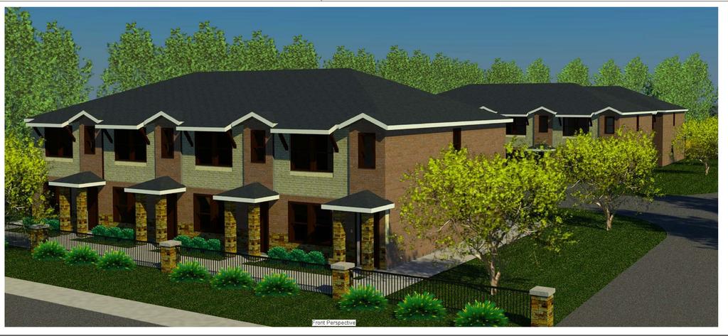
14 project, one of only a handful of new projects that have been proposed since the establishment of the South College Corridor Overlay District in 2004, many encourage more (re-)development along the South College corridor. 4. Whether and the extent to which the proposed conditional use affects the safety and convenience of vehicular and pedestrian circulation in the vicinity, including traffic reasonably expected to be generated by the proposed use and other uses reasonably anticipated in the area considering existing zoning and land uses in the area. Staff does not anticipate that an additional 16 residential unit (32 bedrooms) development at this location will generate any more traffic than what a commercial development could generate that would be allowed to locate here without Conditional Use Permit approval. Staff contends that the proposed multi-family residential use at this location should not have any adverse effects on vehicular and pedestrian traffic in this vicinity. 5. Whether and the extent to which the proposed conditional use would reasonably protect persons and property from erosion, flood or water damage, fire, noise, glare, and similar hazards or impacts. Any new development on this property, including the proposed multi-family residential use, will be required to meet City regulations concerning erosion, flood, fire and other hazards and impacts. No variations from existing standards are being requested and no portion of this property is located within the FEMA recognized floodplain. Upon development as proposed, the project will include a detention pond at the rear (northeast side) of the property to mitigate any stormwater runoff that will be generated from the development. Detained stormwater will then be channeled off the subject property through an off-site drainage easement through neighboring properties. This required detention pond and drainage channel is expected to improve an existing drainage issue for neighboring properties who experience flooding issues during heaver rain events. In order to construct an adequate detention and drainage facility the applicant is required to obtain an off-site drainage easement from two of the neighboring properties located northeast of the subject property to allow for stormwater runoff to be channeled away from the subject property to the City of Bryan stormwater system. As such, staff recommends that the necessary documents required to obtain an off-site drainage easement be recorded with the Brazos County Courthouse prior to the issuance of any construction permits for this site. Additionally, due to the configuration of the proposed building layout and the City s adopted 2009 International Fire Code s requirement that all points in and around a condominium building should be within 450-feet of a fire hydrant and accessible with an improved surface, building four (see Graphic 1 below) is proposed and required to be constructed with a fire sprinkler system. Staff recommends that this also be a required condition for approval of this request. Page 6 of 11
15 Graphic 1: Building Four 6. Whether and the extent to which the proposed conditional use adversely affects traffic control or adjacent properties by inappropriate location, lighting, or types of signs. Staff contends that if approved, the proposed multi-family residential use of this particular property will not have any adverse effects on traffic control or adjacent properties. A 25-foot wide perpetual access easement will be provided along the southeastern property line to provide the neighboring property owner to the northwest continued access, e.g., for solid waste pickup (See Graphic 2 and Picture 1 below). With this perpetual access easement, this multi-family residential development is not expected to adversely affect traffic control. Ordinary limitations on signage in the underlying SC-B zoning district will apply to the proposed development. Page 7 of 11
16 25-foot wide access easement to be dedicated with replat Graphic 2: proposed 25-foot wide access easement Page 8 of 11

17 Picture 1 existing condition of public right-of-way that has been requested to be abandoned and over which a perpetual access easement has been proposed 7. Whether and the extent to which the proposed conditional use provides adequate and convenient offstreet parking and loading facilities. For a multi-family residential development of this size (16 units, 32 bedrooms), Bryan s Code of Ordinances requires a minimum of 32 off-street parking spaces (1 parking space per bedroom). The attached site plan shows 37 proposed off-street parking spaces which is 15% more than the minimum number of required spaces. Staff therefore concludes that the amount of off-street parking proposed for this development is adequate. 8. Whether the proposed conditional use conforms to the objectives and the purpose of the zoning district in which the development is proposed. Multi-family residential dwellings are potentially allowed in SC-B Districts, with approval of a Conditional Use Permit, as they may be appropriate in some, but not all commercial zoning districts. Staff believes that, in this particular case, the proposed 16-unit multi-family development on the subject property will result in a balanced arrangement of land use intensities in this area, which is already developed with both commercial and residential uses. As mentioned above, the development of an apartment development in the scale proposed may provide as a useful transition from higher intensity commercial uses along South College Page 9 of 11
18 Avenue to less intense single-family residential uses on properties to the northwest. A multifamily residential project on this acre lot does not require a large amount of street frontage to attract potential customers, and therefore seems appropriate for this location. 9. Whether the proposed conditional use will be detrimental to the public health, safety, or welfare, or materially injurious to properties or improvements in the vicinity. Staff is unable to discern any potential detrimental issues that could arise from the development of the proposed 16-unit multi-family residential development that could not be mitigated through the application of adopted City standards and policies, or this Conditional Use Permit review. Staff acknowledges that any new development on the property will change the status quo on this currently vacant 1+ acre property and its vicinity. Staff contends, however, that this change will produce fewer unfavorable effects than if one of the several other permitted uses in this SC-B District were to develop on the property. 10. Whether the premises or structures are suitable for the proposed conditional use. The subject property has remained undeveloped for many years. Staff contends that the subject property, if developed in the manner proposed is suitable for the proposed conditional use and will be an attractive, modern apartment development that can help make the South College corridor area a successful place where people want to live, work, and play. RECOMMENDATION: Staff recommends approving the requested Conditional Use Permit to allow a multi-family residential development on the subject property, subject to the following conditions: 1. That the multi-family residential development shall generally conform to the site plan attached to this staff report. 2. That any off-site drainage or off-site utility easements necessary for this project to meet stormwater mitigation requirements and/or electrical service to this site be recorded and at the Brazos County Courthouse prior to the issuance of any construction permits. 3. That a landscape plan and analysis that conforms to all applicable City standards is submitted for the City for review and approval, before any building permits are issued. 4. That recording of a formal replat of the property into one new lot be required prior to the issuance of any building permits. Any such replat shall include a 25-foot wide private joint access easement parallel to southeastern property line of the new lot, to allow perpetual access to the neighboring property to the northeast. 5. Building Four must be constructed with a fire sprinkler system installed as required by the IRC 2009 Fire Code. 6. That 80% of the front and side façades visible from a public right-of-way consist of a variation of stone and masonry. 7. That the façade facing South College Avenue shall have changes in plane with a depth of at least 24 inches at intervals no less than 15 feet and no greater than 30 feet. Page 10 of 11
19 8. That a minimum of 2 windows are installed on the dwelling units that will have an outer side facade. 9. That no more than 50% of the roofline facing South College Avenue may be at the same elevation. 10. That a 3-foot tall wrought iron perimeter fence with masonry columns located at the property corners and every 50 feet shall be installed along the property line adjoining South College Avenue. 11. That an 8-foot screening fence be installed along the northern and eastern property lines. ATTACHMENTS: 1. site plan 2. elevation and floor plan illustrations 3. letters in opposition from nearby property owners Page 11 of 11
20
21
22
23
24
25
26
27
28
29
30
Conditional Use Permit case no. CU 14-06: Bristol Village Partners, LLC
 PLANNING AND ZONING COMMISSION STAFF REPORT August 7, 2014 Conditional Use Permit case no. CU 14-06: Bristol Village Partners, LLC CASE DESCRIPTION: LOCATION: LEGAL DESCRIPTION: EXISTING LAND USE: ZONING:
UPPER MOUNT BETHEL TOWNSHIP NORTHAMPTON COUNTY, PENNSYLVANIA
 UPPER MOUNT BETHEL TOWNSHIP NORTHAMPTON COUNTY, PENNSYLVANIA JOINDER DEED / LOT CONSOLIDATION TOWNSHIP REVIEW PROCESS When accepting proposed Joinder Deeds / Lot Consolidations, review the Joinder Deed
GENERAL PLAN, DEVELOPMENT CODE AND ZONING MAP AMENDMENT APPLICATION INFORMATION SHEET
 GENERAL PLAN, DEVELOPMENT CODE AND ZONING MAP AMENDMENT APPLICATION INFORMATION SHEET GENERAL INFORMATION This information sheet explains how an application requesting an amendment to the Truckee General
CONSTRUCTION PLANS for HALCYON A RESIDENTIAL SUBDIVISION 6100 MIDNIGHT PASS ROAD, SARASOTA, FL 34242
 CONSTRUCTION PLANS for HALCYON A RESIDENTIAL SUBDIVISION 6100 MIDNIGHT PASS ROAD, SARASOTA, FL 34242 SECTION 18, TOWNSHIP 37 SOUTH, RANGE 18 EAST SARASOTA COUNTY, FLORIDA PID: 0030001 A DEVELOPMENT BY
PLANNED UNIT DEVELOPMENT STAFF REPORT Date: October 19, 2017
 PLANNED UNIT DEVELOPMENT STAFF REPORT Date: October 19, 2017 DEVELOPMENT NAME LOCATION Custom Boat Storage 3975 Demetropolis Road (East side of Demetropolis Road, 0.2± miles South of Halls Mill Road.)
DIVISION 2 - CONSTRUCTION PLAN AND MISCELLANEOUS REQUIREMENTS
 DIVISION 2 - CONSTRUCTION PLAN AND MISCELLANEOUS REQUIREMENTS 2.1 Required Plan Sheets 2.2 Drawing Requirements 2.3 Graphic Standards 2.4 Easements 2.5 Utility Locations 2.6 Private Facility Locations
Airport Rd. Lot 6 Lot 2 Lot 1. 1 Mile: Population: 1,100 Median HH Income: $51, Mile: Population: 16,300 Median HH Income: $53,500
 Walmart Outparcels For Sale Godfrey, IL Store #4695 6660 Godfrey Road Airport Rd Lot 4 Lot 6 Lot 2 Lot 1 Godfrey Rd/ Hwy 67 For more information about this site, contact: Jim Rosen Pace Properties (314)
DETAILED GRADING PLAN CHECKLIST (TEARDOWN/REDEVELOPMENT)
") GENERAL DETAILED GRADING PLAN CHECKLIST (TEARDOWN/REDEVELOPMENT) ADDRESS: PERMIT #: DATE: 1. Plan is signed and sealed by an Illinois registered professional engineer including date signed and license
GENERAL DETAILED GRADING PLAN CHECKLIST (TEARDOWN/REDEVELOPMENT) ADDRESS: PERMIT #: DATE: 1. Plan is signed and sealed by an Illinois registered professional engineer including date signed and license
Walmart Outparcel For Sale
 Walmart Outparcel For Sale Texas City, TX Store # 8190 6614 GULF FREEWAY Emmett F Lowry Expy Lot 5 Gulf Fwy/ US I-45 1764 Road For more information about this site, contact: Lot 5: ±0.85 Acres - $500,000
DEVELOPMENT POLICY INFRASTRUCTURE GUIDELINES FOR NEW DEVELOPMENT
 CITY OF HAYS SUBJECT DEVELOPMENT POLICY INFRASTRUCTURE GUIDELINES FOR NEW DEVELOPMENT ISSUED BY LAST REVISION DATE POLICY MANUAL REVISION DATE City Commission 3-13-08 10-22-09 POLICY STATEMENT: The City
ACTION FORM BRYAN CITY COUNCIL
 ACTION FORM BRYAN CITY COUNCIL DATE OF COUNCIL MEETING: July 28, 2015 DATE SUBMITTED: June 24, 2015 DEPARTMENT OF ORIGIN: Development Services SUBMITTED BY: Matthew Hilgemeier MEETING TYPE: CLASSIFICATION:
Development Plan DP13-3 (Arlington Lofts) Planning and Zoning Meeting Date: Document Being Considered: Ordinance
 Planning and Zoning Meeting Date: Document Being Considered: Ordinance") Staff Report Development Plan DP13-3 (Arlington Lofts) Planning and Zoning Meeting Date: 6-19-13 Document Being Considered: Ordinance RECOMMENDATION Following the public hearing, consider Development Plan
Staff Report Development Plan DP13-3 (Arlington Lofts) Planning and Zoning Meeting Date: 6-19-13 Document Being Considered: Ordinance RECOMMENDATION Following the public hearing, consider Development Plan
Walmart Excess Land For Sale
 Walmart Excess Land For Sale San Antonio, TX Store # 5290 SWC S. Ellison Dr. & Marbach Rd. Excess Land FOR INFORMATION CONTACT: Excess Land (+ 6.41 AC)...Coming Soon Ryan Tinch Hollis Bloom (214) 265 1555
DETAILED GRADING PLAN CHECKLIST (TEARDOWN/REDEVELOPMENT) Updated: 12/12/2017
 Updated: 12/12/2017") DETAILED GRADING PLAN CHECKLIST (TEARDOWN/REDEVELOPMENT) Updated: 12/12/2017 ADDRESS: PERMIT #: DATE: Sat. Not GENERAL 1. A disposition of comments should be included in all subsequent submittals. 2. Plan
DETAILED GRADING PLAN CHECKLIST (TEARDOWN/REDEVELOPMENT) Updated: 12/12/2017 ADDRESS: PERMIT #: DATE: Sat. Not GENERAL 1. A disposition of comments should be included in all subsequent submittals. 2. Plan
Walmart Outparcel For Sale
 Walmart Outparcel For Sale Houston, TX Store # 3640 1118 Silber Road FOR INFORMATION CONTACT: Lot...Sale Pending Ryan Tinch Hollis Bloom (214) 265-1555 ryan@hollisbloom.com MORE INFORMATION AVAILABLE AT:
ARTICLE 900 PLAT AND PLAN REQUIREMENTS
 ARTICLE 900 PLAT AND PLAN REQUIREMENTS SEC. 900.1 ITEMS TO BE SHOWN ON PLAT OR PLAN General (1) Property lines of all property owners adjacent to the exterior boundaries of the project shall be located
PLANNED UNIT DEVELOPMENT & SUBDIVISION STAFF REPORT Date: November 17, 2016
 PLANNED UNIT DEVELOPMENT & SUBDIVISION STAFF REPORT Date: November 17, 2016 DEVELOPMENT NAME SUBDIVISION NAME LOCATION Autonation Ford of Mobile Autonation Ford of Mobile Subdivision 901, 909, and 925
SECTION 10.7 R-PUD (RESIDENTIAL PLANNED UNIT DEVELOPMENT) ZONE
 ZONE") Article X Zones 10-20 SECTION 10.7 R-PUD (RESIDENTIAL PLANNED UNIT DEVELOPMENT) ZONE A. PURPOSE AND INTENT: The R-PUD Residential PUD Zone is intended to provide alternative, voluntary zoning procedures
Article X Zones 10-20 SECTION 10.7 R-PUD (RESIDENTIAL PLANNED UNIT DEVELOPMENT) ZONE A. PURPOSE AND INTENT: The R-PUD Residential PUD Zone is intended to provide alternative, voluntary zoning procedures
COMMERCIAL SITE DEVELOPMENT GUIDE FOR UNINCORPORATED ST. CHARLES COUNTY
 COMMERCIAL SITE DEVELOPMENT GUIDE FOR UNINCORPORATED ST. CHARLES COUNTY GENERAL INFORMATION: This brochure is to be used as a guide and is not intended to amend or supersede the corresponding County ordinances
SUBDIVISION, PLANNED UNIT DEVELOPMENT, ZONING AMENDMENT, & SIDEWALK WAIVER STAFF REPORT Date: July 19, 2018
 SUBDIVISION, PLANNED UNIT DEVELOPMENT, ZONING AMENDMENT, & SIDEWALK WAIVER STAFF REPORT Date: July 19, 2018 NAME SUBDIVISION NAME LOCATION West Mobile Properties, LLC U.S. Machine Subdivision 556, 566,
ARTICLE 24 SITE PLAN REVIEW
 ARTICLE 24 SITE PLAN REVIEW 24.1 PURPOSE: The intent of these Ordinance provisions is to provide for consultation and cooperation between the land developer and the Township Planning Commission in order
FINAL SUBDIVISION AND LAND DEVELOPMENT PLAN CHECKLIST. Plan Name. Applicant's Name:
 TOWNSHIP OF UPPER ST. CLAIR FINAL SUBDIVISION AND LAND DEVELOPMENT PLAN CHECKLIST Date Filed Plan Name PLC Applicant's Name: Phone Filing Date for Final Application Final Plat 114.22. FINAL APPLICATION
DEVELOPMENT STANDARDS FOR RESIDENTIAL PROJECTS RESIDENTIAL BUILDING TYPES: APPROPRIATE ZONES AND DENSITIES 2-1
 2 DEVELOPMENT STANDARDS FOR RESIDENTIAL PROJECTS RESIDENTIAL BUILDING TYPES: APPROPRIATE ZONES AND DENSITIES 2-1 This Chapter presents the development standards for residential projects. Section 2.1 discusses
Glades County Staff Report and Recommendation Unified Staff Report for Small Scale Plan Amendment and Rezoning
 Glades County Staff Report and Recommendation Unified Staff Report for Small Scale Plan Amendment and Rezoning CASE NUMBERS: COMP17-02 and RZ17-02 DATE of STAFF REPORT: May 1, 2017 CASE TYPE: Application
PLANNING COMMISSION STAFF REPORT. Merrimac PLNSUB Planned Development 38 West Merrimac November 9, Request. Staff Recommendation
 PLANNING COMMISSION STAFF REPORT Merrimac PLNSUB2011-00374 Planned Development 38 West Merrimac November 9, 2011 Planning and Zoning Division Department of Community and Economic Development Applicant:
M E M O R A N D U M. Meeting Date: October 23, Item No. F-1. Planning and Zoning Commission. Daniel Turner, Planner I
 M E M O R A N D U M Meeting Date: October 23, 2017 Item No. F-1 To: From: Subject: Planning and Zoning Commission Daniel Turner, Planner I PUBLIC HEARING: Consider a recommendation of a of Planned Development
Cover Letter with Narrative Statement
 Cover Letter with Narrative Statement March 31, 2017 rev July 27, 2017 RE: Rushton Pointe Residential Planned Unit Development Application for Public Hearing for RPUD Rezone PL2015 000 0306 Mr. Eric Johnson,
(b) The location of principal and accessory buildings on the lot and the relationship of each structure to the other.
 The location of principal and accessory buildings on the lot and the relationship of each structure to the other.") ARTICLE XIX SITE PLAN Sec. 20-1900 Site Plan Review Procedure - Intent The site plan review procedures are instituted to provide an opportunity for the Township Planning Commission to review the proposed
ARTICLE XIX SITE PLAN Sec. 20-1900 Site Plan Review Procedure - Intent The site plan review procedures are instituted to provide an opportunity for the Township Planning Commission to review the proposed
Two Notch Road. 3 Mile: Popula on: 53,000 Median HH Income: $68, Mile: Popula on: 98,200 Median HH Income: $63,300
 Fashion Drive Sam s Club Excess For Sale Columbia, SC Store #4872 733 Fashion Dr. Excess Two tch Road For more informa on about this site, contact: Excess: 4.70 acres - $960,000 Michael Silverman The Shopping
Special Land Use. SLU Application & Review Standards
 review and approval is needed for certain uses of property that have the potential to impact adjacent properties and the neighborhood. The application and review procedure is intended to ensure that the
WESTMINSTER PARK SUBDIVISION
 WESTMINSTER PARK SUBDIVISION Engineering Comments: FINAL PLAT COMMENTS (should be addressed prior to submitting the FINAL PLAT for review and/or signature by the City Engineer): A. Provide all of the required
ZONING AMENDMENT & SUBDIVISION STAFF REPORT Date: July 9, 2015
 ZONING AMENDMENT & SUBDIVISION STAFF REPORT Date: July 9, 2015 APPLICANT NAME 2513 Dauphin Street, Inc. SUBDIVISION NAME Audubon Place Extension No. 3, Resubdivision of Lots 1-5 LOCATION 2513 Dauphin Street
SECTION 4: PRELIMINARY PLAT
 SECTION 4: PRELIMINARY PLAT After the completion of the sketch plan process, if submitted, the owner or developer shall file with the City an application for preliminary plat. The preliminary plat stage
ADMINISTRATIVE HEARING STAFF REPORT
 ADMINISTRATIVE HEARING STAFF REPORT Providence Place Apartments Utility Box No. 2 Conditional Use Petition PLNPCM2011-00426 309 East 100 South September 22, 2011 Planning and Zoning Division Department
ZONING AMENDMENT, PLANNED UNIT DEVELOPMENT & SUBDIVISION STAFF REPORT Date: August 8, 2013
 ZONING AMENDMENT, PLANNED UNIT DEVELOPMENT & SUBDIVISION STAFF REPORT Date: August 8, 2013 NAME SUBDIVISION NAME PV-Magnolia, LLC Twelve Trees Subdivision LOCATION 2860, 2862 and 2866 Pleasant Valley Road
Condominium Unit Requirements.
 ARTICLE 19 CONDOMINIUM REGULATIONS Section 19.01 Purpose. The purpose of this Article is to regulate projects that divide real property under a contractual arrangement known as a condominium. New and conversion
City of Midland Application for Site Plan Review
 City of Midland Application for Site Plan Review Submission Date: Property Owner: Mailing Address: Phone number: ( ) Cell phone: ( ) Email address: Fax: ( ) Owner s Signature: Applicant Name (if not owner):
4.2 RESIDENTIAL ZONING DISTRICTS
 4.2 RESIDENTIAL ZONING DISTRICTS A. Purpose: To define regulations and standards for each residential zoning district in the City. The following sections identify uses, regulations, and performance standards
FREQUENTLY USED PLANNING & ZONING TERMS
 City Of Mustang FREQUENTLY USED PLANNING & ZONING TERMS Abut: Having property lines, street lines, or zoning district lines in common. Accessory Structure: A structure of secondary importance or function
ZONING AMENDMENT & SUBDIVISION STAFF REPORT Date: November 3, 2016
 ZONING AMENDMENT & SUBDIVISION STAFF REPORT Date: November 3, 2016 APPLICANT NAME SUBDIVISION NAME David Shumer 5955 Airport Subdivision CITY COUNCIL DISTRICT District 6 5955 Airport Boulevard, 754 Linlen
Introduction. Background DEPARTMENT OF COMMUNITY DEVELOPMENT SERVICES. Planning Division. m e m o r a n d u m TO: The Urbana Zoning Board of Appeals
 DEPARTMENT OF COMMUNITY DEVELOPMENT SERVICES Planning Division m e m o r a n d u m TO: FROM: The Urbana Zoning Board of Appeals Christopher Marx, AICP, Planner I DATE: March 16, 218 SUBJECT: ZBA Case ZBA-218-C-2:
Department of Planning & Development Services
 Department of Planning & Development Services S T A F F R E P O R T February 9, 2015 CASE NO: PROJECT: EXECUTIVE SUMMARY: ZA14-154 Plat Revision for Lots 25R-1A, 25R-1B and 25R-1C, Block 1, Woodland Heights
PLANNED UNIT DEVELOPMENT & SUBDIVISION STAFF REPORT Date: April 18, 2019
 PLANNED UNIT DEVELOPMENT & SUBDIVISION STAFF REPORT Date: April 18, 2019 DEVELOPMENT NAME SUBDIVISION NAME Springhill Village Subdivision Springhill Village Subdivision LOCATION 4350, 4354, 4356, 4358,
DATE: February 28, Marilynn Lewis, Principal Planner
 DATE: February 28, 2007 TO: FROM: RE: Salt Lake City Planning Commission Marilynn Lewis, Principal Planner Planning Commission Hearing for Petition 400-06-41 Zoning Map Amendment to Rezone 6 Properties,
Waseca County Planning and Zoning Office
 Waseca County Planning and Zoning Office 300 North State Street Waseca, Minnesota 56093 Phone: 507-835-0650 Fax: 507-837-5310 Form no. PZ 081009 Web Site: www.co.waseca.mn.us FEES: 1) CUP FEE- $400.00
WESTMINSTER PARK PLACE SUBDIVISION
 WESTMINSTER PARK PLACE SUBDIVISION Engineering Comments: FINAL PLAT COMMENTS (should be addressed prior to submitting the FINAL PLAT for review and/or signature by the City Engineer): A. Provide all of
COMMERCIAL/INDUSTRIAL DEVELOPMENT GUIDELINES
 COMMERCIAL/INDUSTRIAL DEVELOPMENT GUIDELINES Planning Division Sections Chapter 17.16 Commercial, Industrial Development Standards 17.16.010 Lot Size 17.16.020 Setbacks 17.16.030 Fences, Hedges and Walls
PRELIMINARY PLATS. The following documents are provided as required by the City of Conroe for use in the above titled platting submittals:
 Public Works Engineering Division CITY OF CONROE PRELIMINARY PLATS The following documents are provided as required by the City of Conroe for use in the above titled platting submittals: Submittal Questionnaire
SUBJECT: Application for Planned Unit Development and Rezoning 1725 Winnetka Road
 TO: FROM: CHAIRMAN BILL VASELOPULOS AND MEMBERS OF THE PLAN & ZONING COMMISSION STEVE GUTIERREZ DIRECTOR OF COMMUNITY DEVELOPMENT MEETING DATE: September 5, 2017 SUBJECT: Application for Planned Unit Development
WASCO COUNTY PRELIMINARY SUBDIVISION APPLICATION
 WASCO COUNTY PRELIMINARY SUBDIVISION APPLICATION DETAILED SPECIFIC WRITTEN REQUEST File Number: SDV- Number of Proposed Lots & their Dimensions: PRELIMINARY SUBDIVISION PLAN REQUIREMENTS The approval of
Towne Center Boulevard William Penn Highway. Lot 2. 1 Mile Population: 3,600 Median HH Income: $36,800
 Walmart Outparcel For Sale Huntingdon, PA Store #5470 6716 Towne Center Blvd Towne Center Boulevard William Penn Highway Lot 2 Raystown Road For more information about this site, contact: Lot 2: ±1.72
Site Plan Application
 Site Plan Application City of St. Pete Beach Community Development Department 155 Corey Avenue St. Pete Beach, Florida 33706 (727) 367-2735 www.stpetebeach.org Case Number: PROPERTY OWNER: Name: Address:
CITY OF DERBY. MEETING OF THE PLANNING COMMISSION REGULAR MEETING June 19, :30 PM
 CITY OF DERBY MEETING OF THE PLANNING COMMISSION REGULAR MEETING June 19, 2014 6:30 PM CALL MEETING TO ORDER ROLL CALL CONSIDERATION OF MINUTES: Planning Commission Meeting of June 5, 2014. PUBLIC FORUM
DEVELOPMENT DEPARTMENT STAFF REPORT STAFF REPORT EASTSIDE CHAMBLEE LINK DCI
 DEVELOPMENT DEPARTMENT STAFF REPORT Public Hearing Date: April 12, 2018 Item #: PZ-2018-248 STAFF REPORT EASTSIDE CHAMBLEE LINK DCI Request: Development of Community Compact (DCI), ten concurrent variances,
Community Development
 Land Use Petition RZ-16-002 Date of Staff Recommendation Preparation: April 15, 2016 (CEL) Date of Planning Commission Recommendation: May 3, 2016 PROJECT LOCATION: DISTRICT/SECTION/LANDLOT(S): ACREAGE
CHAPTER 26 PLANNING AND ZONING ARTICLE VII. MOBILE HOMES AND RECREATIONAL VEHICLE (RV) PARKS. Recreational Vehicle (RV) Park Development Standards
 PARKS. Recreational Vehicle (RV) Park Development Standards") CHAPTER 26 PLANNING AND ZONING ARTICLE VII. MOBILE HOMES AND RECREATIONAL VEHICLE (RV) PARKS. Section 26-VII-1. Section 26-VII-2. Section 26-VII-3. Section 26-VII-4. Section 26-VII-5. Purpose Permitted
CHAPTER 26 PLANNING AND ZONING ARTICLE VII. MOBILE HOMES AND RECREATIONAL VEHICLE (RV) PARKS. Section 26-VII-1. Section 26-VII-2. Section 26-VII-3. Section 26-VII-4. Section 26-VII-5. Purpose Permitted
CITY OF OCOEE LAND DEVELOPMENT CODE SUFFICIENCY TABLE WITH NOTES
 CITY OF OCOEE LAND DEVELOPMENT CODE SUFFICIENCY TABLE WITH NOTES The Sufficiency Table is a checklist to help identify the types of information and documentation needed for various types of projects. The
ARTICLE 7: PLOT PLANS AND SITE PLAN REQUIREMENTS AND REVIEW
 ARTICLE 7: PLOT PLANS AND SITE PLAN REQUIREMENTS AND REVIEW Section 7.0 - Purpose The purpose of this article is to specify the documents and/or drawings required for a Site Plan Review or a Plot Plan
Division Development Impact Review.
 Division 51-4.800. Development Impact Review. SEC. 51-4.801. PURPOSE. The general objectives of this division are to promote and protect the health, safety, and general welfare of the public through the
THE AREA PLAN COMMISSION OF ST. JOSEPH COUNTY, IN AGENDA
 THE AREA PLAN COMMISSION OF ST. JOSEPH COUNTY, IN AGENDA Tuesday, January 17, 2017 Fourth-Floor Council Chambers 3:30 p.m. County-City Building, South Bend, IN EXECUTIVE SESSION: A. Election of Officers
ARTICLE XI MANUFACTURED AND MOBILE HOME PARKS
 ARTICLE XI MANUFACTURED AND MOBILE HOME PARKS 11.01 General Description Manufactured/Mobile Homes are becoming an increasingly popular form of housing. However, because of their limited size, relative
ORDINANCE NO The Town Council of the Town of Yucca Valley does ordain as follows:
 ORDINANCE NO. 141 AN ORDINANCE OF THE TOWN COUNCIL OF THE TOWN OF YUCCA VALLEY, CALIFORNIA, AMENDING TITLE 8, DIVISION 12, CHAPTER 1 RELATING TO DEFINITIONS AND TITLE 8, DIVISION 8, CHAPTER 3, RELATING
ARTICLE IX.1. PRIVATE STREETS
 ARTICLE IX.1 PRIVATE STREETS PAGE 43 ARTICLE IX.1. PRIVATE STREETS SECTION A. GATED COMMUNITIES. (Entire Article Established by Ord. 2524, 06/06/00) 1. Residential subdivisions may be developed with private
Soojian Dr. Hwy 9 Lot 1. Main Street. 1 Mile Popula on: 1,000 Median HH Income: $75, Mile: Popula on: 11,900 Median HH Income: $61,500
 Walmart Outparcels For Lease Leicester, MA Store #3409 20 Soojian Drive Soojian Dr Hwy 9 Lot 1 Main Street For more informa on about this site, contact: Lot 1: ±2.23 Acres - $50,000 per year Ground Lease
ACTION FORM BRYAN CITY COUNCIL
 ACTION FORM BRYAN CITY COUNCIL DATE OF COUNCIL MEETING: July 8, 2014 DATE SUBMITTED: June 17, 2014 DEPARTMENT OF ORIGIN: Development Services SUBMITTED BY: Maggie Dalton MEETING TYPE: CLASSIFICATION: ORDINANCE:
Medical Marijuana Special Exception Use Information
 Medical Marijuana Special Exception Use Information The Special Exception Use information below is a modified version of the Unified Development Code. It clarifies the current section 5:104 Special Exceptions
CITY OF PAPILLION PLANNING COMMISSION STAFF REPORT NOVEMBER 18, 2015 AGENDA BUCKY S CONVENIENCE STORES SPECIAL USE PERMIT SUP
 I. GENERAL INFORMATION A. APPLICANT: Jeffery Guyette 7315 Mercy Road Omaha, NE 68124 CITY OF PAPILLION PLANNING COMMISSION STAFF REPORT NOVEMBER 18, 2015 AGENDA BUCKY S CONVENIENCE STORES SPECIAL USE PERMIT
ARTICLE 6 PRELIMINARY PLAT
 ARTICLE 6 PRELIMINARY PLAT SECTION: 30-06-01: Preliminary Plat 30-06-02: Information Required for Preliminary Plat 30-06-03: Determination of Requirement for Environmental Review Documents 30-06-04: Additional
CITY PLAN COMMISSION STAFF REPORT
 CITY PLAN COMMISSION STAFF REPORT SUBJECT: Request for a Change of Zoning and Preliminary Development Plan FROM: Mara Perry, Director of Planning & Development MEETING DATE: November 6, 2017 PETITION:
ARTICLE 900 PLAT AND PLAN REQUIREMENTS
 Final SEC. 900.01 ARTICLE 900 PLAT AND PLAN REQUIREMENTS General provisions. (a) Scale. The scale of all plats and plans shall be a minimum of 1 to 100 ft. (b) Size. The minimum page size for all plats
MINOR PLAT. The following documents are provided as required by the City of Conroe for use in the above titled platting submittals:
 Public Works - Engineering Division CITY OF CONROE MINOR PLAT The following documents are provided as required by the City of Conroe for use in the above titled platting submittals: Submittal Questionnaire
CITY OF HOLLYWOOD. Technical Advisory Committee Submittal Checklist. Guide to TAC Submittal Checklist. General Requirements:
 CITY OF HOLLYWOOD Technical Advisory Committee Submittal Checklist Guide to TAC Submittal Checklist This document is an outline of site plan review procedures as listed in the Technical Advisory Committee
APPLICANT NAME SUBDIVISION NAME DEVELOPMENT NAME LOCATION. CITY COUNCIL DISTRICT Council District 4 PRESENT ZONING PROPOSED ZONING
 SUBDIVISION, PLANNED UNIT DEVELOPMENT, PLANNING APPROVAL, ZONING AMENDMENT, & SIDEWALK WAIVER REQUEST STAFF REPORT Date: February 17, 2010 APPLICANT NAME SUBDIVISION NAME DEVELOPMENT NAME LOCATION David
Composition of traditional residential corridors.
 Page 1 of 7 St. Petersburg, Florida, Code of Ordinances >> PART II - ST. PETERSBURG CITY CODE >> Chapter 16 - LAND DEVELOPMENT REGULATIONS >> SECTION 16.20.060. CORRIDOR RESIDENTIAL TRADITIONAL DISTRICTS
-MENDOCINO COUNTY PLANNING AND BUILDING SERVICES- DIVISION OF LAND REGULATIONS TITLE 17
 ARTICLE VI -- GENERAL REGULATIONS AND PROVISIONS Sec. 17-50. Sec. 17-51 General Plan. Sec. 17-52 Lot and Block Design and Configuration. Sec. 17-53 Lot Access. Sec. 17-54 Private Roads. Sec. 17-55 Water
ORDINANCE NO. Be it ordained by the City Council of the City of Abilene, Texas:
 ORDINANCE NO. An ordinance repealing Chapter 23, Subpart B of the Code of the City of Abilene, Texas, entitled Mobile Homes and Vacation Travel Trailers; stating the authority; setting forth the scope
Staff Report: Date: Applicant: Property Identification: Acreage of Request: Current Zoning of Requested Area: Requested Action: Attached:
 Staff Report: Completed by Jeff Palmer Director of Planning & Zoning Date: November 7, 2018, Updated November 20, 2018 Applicant: Greg Smith, Oberer Land Developer agent for Ronald Montgomery ET AL Property
SITE DEVELOPMENT PLAN REQUIREMENTS CHECKLIST
 SITE DEVELOPMENT PLAN REQUIREMENTS CHECKLIST Completed DRC Application for Review Required for Application Process DRC Processing Fee 1 Commercial $2,500.00 Fire Department Review Fee 150.00 Total $2,650.00
COMMERCIAL SITE PLAN & CONDITIONAL USE PERMIT REVIEW PROCESS & CHECKLIST
 Community Development 110 South Main Street Springville, UT 84663 COMMERCIAL SITE PLAN & CONDITIONAL USE PERMIT REVIEW PROCESS & CHECKLIST 801.491.7861 www.springville.org Prior to the issuance of a building
ARTICLE 15 - PLANNED UNIT DEVELOPMENT
 Section 15.1 - Intent. ARTICLE 15 - PLANNED UNIT DEVELOPMENT A PUD, or Planned Unit Development, is not a District per se, but rather a set of standards that may be applied to a development type. The Planned
SUBDIVISION & PLANNING APPROVAL STAFF REPORT Date: December 1, 2016
 SUBDIVISION & PLANNING APPROVAL STAFF REPORT Date: December 1, 2016 APPLICANT NAME SUBDIVISION NAME DEVELOPMENT NAME LOCATION Board of Water and Sewer Commissioners of the City of Mobile Halls Mill Road
ZONING AMENDMENT, PLANNED UNIT DEVELOPMENT & SUBDIVISION STAFF REPORT Date: September 15, 2011
 ZONING AMENDMENT, PLANNED UNIT DEVELOPMENT & SUBDIVISION STAFF REPORT Date: September 15, 2011 NAME SUBDIVISION NAME LOCATION Stratford, L.L.C. Grelot Office Park Subdivision North side of Grelot Road,
PREAMBLE. That the Gratiot County Zoning Ordinance be amended as follows:
 Amendment of Gratiot County Zoning Ordinance AN ORDINANCE TO AMEND THE GRATIOT COUNTY ZONING ORDINANCE REQUIREMENTS FOR SOLAR ENERGY SYSTEMS AND SOLAR FARMS FOR THE COUNTY-ZONED TOWNSHIPS OF ELBA, HAMILTON,
Marion County Board of County Commissioners
 Marion County Board of County Commissioners Date: 12/2/2015 P&Z: 11/30/2015 BCC: 12/16/2015 Item Number 151210SU Type of Application Special Use Permit Request To establish a Clay Electric Co-Operative
ARTICLE 7 UTILITIES AND EASEMENTS
 7.1 PLACEMENT OF UTILITIES ARTICLE 7 UTILITIES AND EASEMENTS 7.1.1 All authorized public underground utilities shall be located within the right-of-way of a public street or within an easement designated
Land Use, Transportation, and Infrastructure Committee of Denver City Council FROM: Scott Robinson, Senior City Planner DATE: December 6, 2018 RE:
 Community Planning and Development Planning Services 201 W. Colfax Ave., Dept. 205 Denver, CO 80202 p: 720.865.2915 f: 720.865.3052 www.denvergov.org/cpd TO: Land Use, Transportation, and Infrastructure
NORMAN, OKLAHOMA OWNER: RCB BANK APPLICATION FOR 2025 PLAN CHANGE PLANNED UNIT DEVELOPMENT PRELIMINARY PLAT. 12 December 2011 Revised 5 January 2012
 THE VILLAGE AT OAKHURST ADDITION NORMAN, OKLAHOMA OWNER: RCB BANK APPLICATION FOR 2025 PLAN CHANGE PLANNED UNIT DEVELOPMENT PRELIMINARY PLAT 12 December 2011 Revised 5 January 2012 PREPARED BY: THE RIEGER
ANDOVER CODE. Checklist #5 Preliminary Site Plan Conditional Use
 ANDOVER CODE Checklist #5 Preliminary Site Plan Conditional Use Applicant: Block Lot File No. This checklist is for general reference only. Further information may be required by the reviewing authority.
STAFF REPORT. To: Planning Commission Meeting date: January 11, 2017 Item: UN Prepared by: Marc Jordan. Schoolhouse Development, LLC
 STAFF REPORT # 9 ) UN-05-17 AMERICAN LEADERSHIP ACADEMY SPECIAL USE PERMIT CHARTER SCHOOL PUBLIC HEARING To: Planning Commission Meeting date: January 11, 2017 Item: UN-05-17 Prepared by: Marc Jordan GENERAL
DAUPHIN CREEK ESTATES SUBDIVISION
 # 12 SUB-000076-2017 DAUPHIN CREEK ESTATES SUBDIVISION Engineering Comments: FINAL PLAT COMMENTS (should be addressed prior to submitting the FINAL PLAT for review and/or signature by the City Engineer):
ARTICLE 14 PLANNED UNIT DEVELOPMENT (PUD) DISTRICT
 DISTRICT") ARTICLE 14 PLANNED UNIT DEVELOPMENT (PUD) DISTRICT Section 14.01 Intent. It is the intent of this Article to allow the use of the planned unit development (PUD) process, as authorized by the Michigan Zoning
ARTICLE 14 PLANNED UNIT DEVELOPMENT (PUD) DISTRICT Section 14.01 Intent. It is the intent of this Article to allow the use of the planned unit development (PUD) process, as authorized by the Michigan Zoning
Community Development Department
 Community Development Department SUBJECT: Reconsideration of Final Site Plan Review, Preliminary Subdivision, and Planned Development for Park Place Glenview at 1225 Waukegan Road MEETING DATE: March 28,
COMMUNITY DEVELOPMENT DEPARTMENT 333 Broadalbin Street SW, P.O. Box 490 Albany, OR 97321
 COMMUNITY DEVELOPMENT DEPARTMENT 333 Broadalbin Street SW, P.O. Box 490 Albany, OR 97321 Ph: 541-917-7550 Fax: 541-917-7598 www.cityofalbany.net STAFF REPORT Application for Site Plan Review SP-07-18 and
JEFFERSON COUNTY, ALABAMA
 JEFFERSON COUNTY, ALABAMA Major Development Checklist, Notes and Information A Major Development is any proposed new structure or addition to an existing structure which will cause a change in the topography
ARTICLE SINGLE FAMILY SITE CONDOMINIUM DEVELOPMENT STANDARDS
 ARTICLE 28.00 SINGLE FAMILY SITE CONDOMINIUM DEVELOPMENT STANDARDS Section 28.01 PURPOSE The purpose of this Article is to recognize that conventional single family developments, traditionally developed
PROPOSED AMENDMENTS TO THE DERBY ZONING REGULATIONS AUGUST 12, 2008
 ARTICLE II Definitions and word usage 195-7. Definitions and word usage. Modify the following: HOUSING FOR THE ELDERLY OLDER PERSONS Housing in accordance with and as defined in the United States Fair
PLANNED UNIT DEVELOPMENT (East), PLANNED UNIT DEVELOPMENT (West) STAFF REPORT Date: September 18, 2014
, PLANNED UNIT DEVELOPMENT (West) STAFF REPORT Date: September 18, 2014") PLANNED UNIT DEVELOPMENT (East), PLANNED UNIT DEVELOPMENT (West) STAFF REPORT Date: September 18, 2014 DEVELOPMENT NAME LOCATION McGowin Park, LLC PLANNED UNIT DEVELOPMENT (East) 1401 Satchel Paige Drive
PLANNED UNIT DEVELOPMENT (East), PLANNED UNIT DEVELOPMENT (West) STAFF REPORT Date: September 18, 2014 DEVELOPMENT NAME LOCATION McGowin Park, LLC PLANNED UNIT DEVELOPMENT (East) 1401 Satchel Paige Drive
1 Mile: Population: 14,200 Median HH Income: $62, Mile: Population: 71,100 Median HH Income: $68,600
 Walmart Outparcel For Sale Arlington (SW), TX Store # 3284 4800 Highway 287 US I-20 Lot 2 Hwy 287 Treepoint Dr Little Rd For more information about this site, contact: Lot 2: ±1.02 Acres - $850,000 Bank
Washington County, Minnesota Ordinances
 Washington County, Minnesota Ordinances Ordinance No. 153 Text Amendment to the Washington County Development Code - Chapter One, Section 2 and Chapter Two, Part 1, Part 2, Part 3, of the Development Code
Staff Report: Date: Applicant: Property Identification: Acreage of Request: Current Zoning of Requested Area: Requested Action: Attached:
 Staff Report: Completed by Jeff Palmer Director of Planning & Zoning Date: November 7, 2018 Applicant: Greg Smith, Oberer Land Developer agent for Ronald Montgomery ET AL Property Identification: Frontage