COMMUNITY DEVELOPMENT DEPARTMENT 333 Broadalbin Street SW, P.O. Box 490 Albany, OR 97321
|
|
|
- Colleen Holt
- 6 years ago
- Views:
Transcription

1 COMMUNITY DEVELOPMENT DEPARTMENT 333 Broadalbin Street SW, P.O. Box 490 Albany, OR Ph: Fax: STAFF REPORT Application for Site Plan Review SP and Floodplain Development Review FP Hickory Station Access Easement SUMMARY This staff report evaluates a Site Plan Review and Floodplain Review application for development of a thirty-foot-wide shared private access easement centered along the common property line of 633 and 655 North Albany Road NW. The applicant proposes to improve the easement with a 24-foot-wide paved accessway and five-foot-wide sidewalk from an existing driveway fronting North Albany Road to an existing private drive to the east of the subject site. The analysis in this report finds that the proposed development will satisfy the Site Plan Review criteria of Albany Development Code (ADC) and Floodplain Development review criteria of ADC and ADC with conditions of approval to ensure compliance. APPLICATION INFORMATION DATE OF REPORT: May 4, 2018 FILES: SP & FP TYPE OF APPLICATION: REVIEW BODY: APPLICANT: Site Plan Review and Floodplain Review to improve an existing 30-foot-wide private access easement located along the common property line of 633 and 655 North Albany Rd. NW Staff (Type I-L process) Hickory Station, LLC; Gary and Patty Davenport; P.O. Box 2744, Albany, OR 97321; ; pepandg@msn.com APPLICANT REP.: TKP Engineering, LLC; Troy Plum; P.O. Box 374, Corvallis, OR 97339; ; troy@tkpeng.net PROPERTY OWNER: North Albany MOB, LLC; 2870 Nansen Drive, Medford, OR PROPERTY OWNER: Jackson Food Stores, Inc.; 3450 E. Commercial Court, Meridian, ID ADDRESS/LOCATION: 633 & 655 NORTH ALBANY RD NW, ALBANY, OR MAP/TAX LOT: ZONING: PLAN DESIGNATION: OVERLAY TOTAL LAND AREA: EXISTING LAND USE: NEIGHBORHOOD: Benton Tax Assessor's Map No(s).: 11S04W01DA Tax Lot 400 & 11S04W01DA Tax Lot 700 Community Commercial (CC) Village Center /FP Approximately 6,900 square feet Partially improved shared driveway to 633 & 655 North Albany Road NW North Albany Staff Report, Files SP & FP-02-18, Page 1 of 13
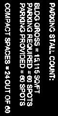
2 SURROUNDING ZONING: SURROUNDING USES: North: Community Commercial (CC) South: Community Commercial (CC) East: Community Commercial (CC) West: Mixed Use Commercial (MUC) North: Retail commercial establishments South: Retail commercial establishments East: Retail commercial establishments and self-serve storage West: Undeveloped, MUC-zoned property PRIOR HISTORY: PA-03-94: Partition to divide a 10.2-acre parcel into three parcels containing 1.24 acres (Parcel 1); 5.75 acres (Parcel 2); and 3.23 acres (Parcel 3). Approval was granted by the Planning Commission on September 1, Partition Plat No was recorded with Benton County on December 28, 1994 STAFF DECISION PA-15-97: Partition to divide a 5.75-acre parcel into two parcels containing 4.63 acres and 1.11 acres. Approval was granted by the Hearings Board on December 22, Partition Plat No was recorded with Benton County on March 13, SP-30-00: Site Plan Review for construction of a gas station, convenience store, carwash, and fast food restaurant. SP & FP-04-17: Site Plan Review and Floodplain Review of a 15,115-square-foot, two-story medical office building with related site improvements. The Site Plan Review and Floodplain Development applications referenced above are APPROVED with CONDITIONS as described in this staff report. NOTICE INFORMATION A Notice of Filing for this application was mailed on March 20, 2018, to owners of property located within 300 feet of the subject property. At the time the comment period ended on April 3, 2018, no comments had been received by the Planning Division. STAFF ANALYSIS The Albany Development Code (ADC) includes the following review criteria for site plan review and floodplain development which must be met for these applications to be approved. Code criteria are written in bold italics and are followed by findings and conclusions. SITE PLAN REVIEW CRITERIA (ADC 2.450) Criterion (1) Sanitary Sewer Public utilities can accommodate the proposed development. 1.1 City utility maps show an 8-inch public sanitary sewer in the private access easement that runs along the east boundaries of the subject parcels. Water 1.2 City utility maps show a 12-inch public water main that runs along the east boundaries of the subject parcels. Staff Report, Files SP & FP-02-18, Page 2 of 13
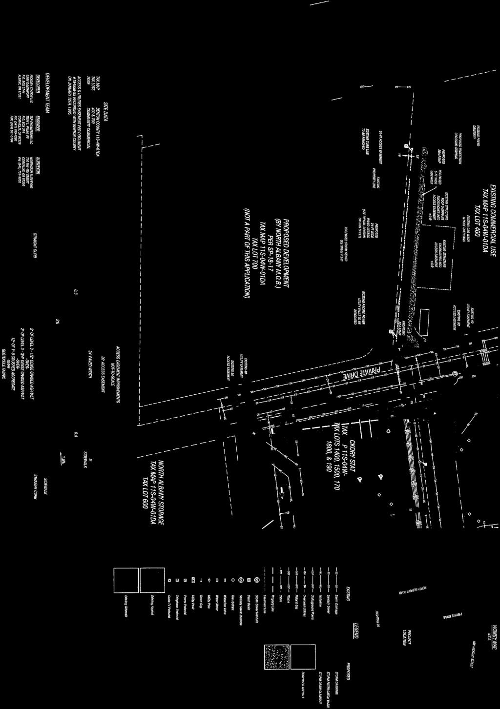
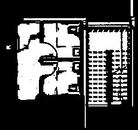
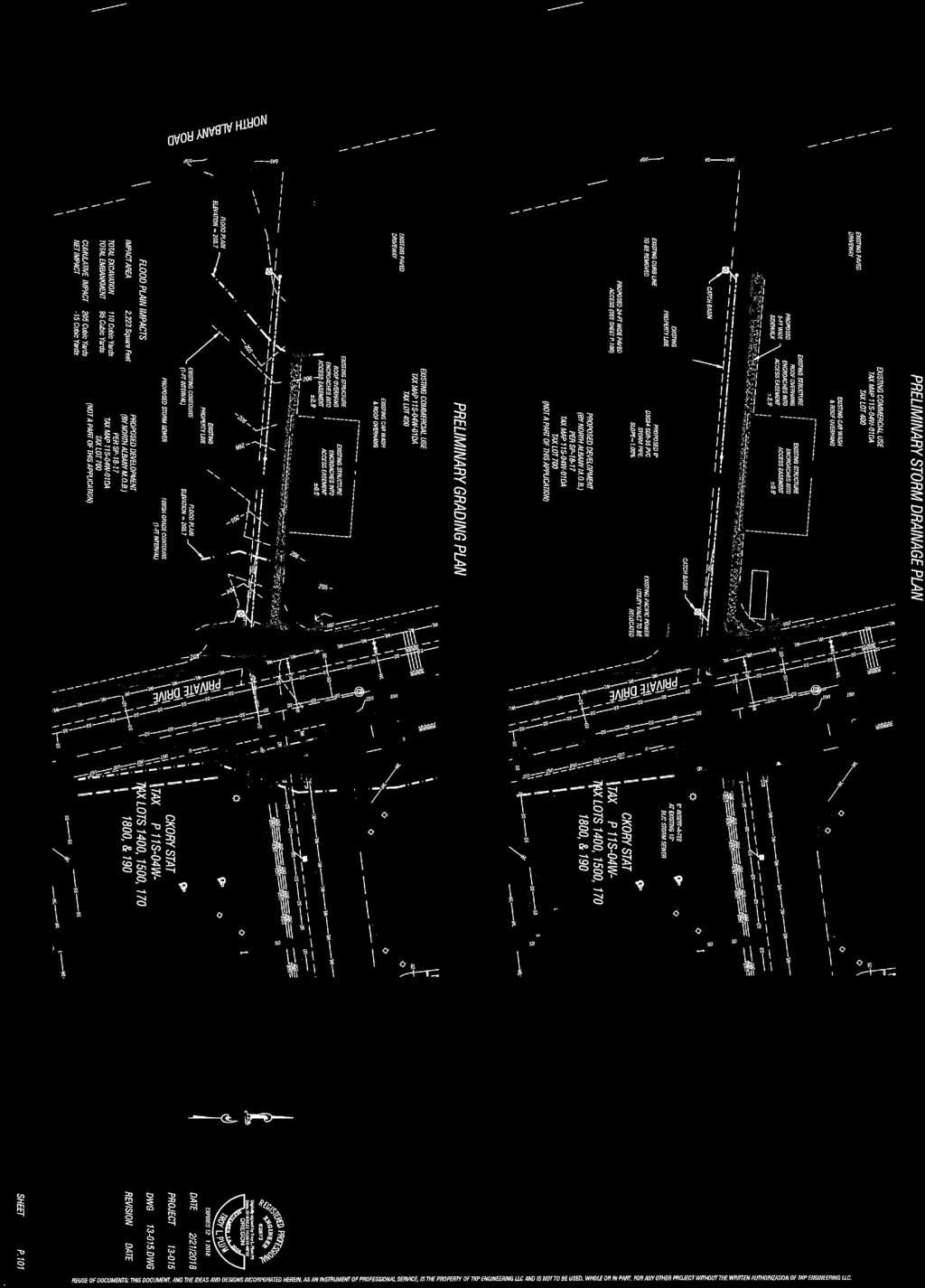
3 Storm Drainage 1.3 City utility maps show a 15-inch public storm drainage main that runs along the east boundaries of the subject parcels. 1.4 The applicant is proposing to construct a private storm water collection system within the new accessway. The catch basins must be located such that the maximum amount of runoff is collected within the access and not allowed to flow west across the public sidewalk into North Albany Road. 1.1 The proposal will have no impact on the public sanitary sewer or water systems. 1.2 The applicant must construct a private storm water collection system in the proposed private access easement. This system must be designed to collect as much runoff from the private access easement as possible without allowing runoff to flow to the west across the public sidewalk into North Albany Road. CONDITIONS Condition 1 Private Storm Water Collection System. The applicant must construct a private stormwater collection system in the proposed private access easement. The westernmost catch basin in this system must be located as far west as possible to collect as much runoff from the private access easement as possible without allowing runoff to flow to the west across the public sidewalk into North Albany Road. Criterion (2) The proposed post-construction stormwater quality facilities (private and/or public) can accommodate the proposed development, consistent with Title 12 of the Albany Municipal Code. 2.1 Section of the Albany Municipal Code states that a post-construction stormwater quality permit shall be obtained for all new development and/or redevelopment projects on a parcel(s) equal to or greater than one acre, including all phases of the development (Ord , 2014). 2.2 Section of the Albany Municipal Code states that development may be exempted from a post-construction stormwater quality permit if the development creates and/or replaces less than 8,100 square feet of impervious surface, cumulatively. 2.3 The proposed development will not create or replace 8,011 square feet of impervious surface or occur on a site that is an acre or larger. 2.1 The proposed development is exempt from the City s Storm Water Quality requirements. 2.2 This criterion is met without conditions. Criterion (3) The transportation system can safely and adequately accommodate the proposed development. 3.1 The development is located on the east side of North Albany Road and consists of a thirty-foot-wide shared private access easement centered along the common property line of 633 and 655 North Albany Road NW, as shown in Attachment A, Sheet P The applicant proposes to improve an existing easement with a 24-foot-wide paved accessway and five-foot-wide sidewalk, with a reduction to 4.5 feet wide along the carwash building encroachment (see Attachment A, Sheet P.100) from an existing driveway fronting North Albany Road to an existing private drive to the east of the subject site. Staff Report, Files SP & FP-02-18, Page 3 of 13
4 3.3 North Albany Road is classified as a minor arterial street and is constructed to city standards. Improvements along the frontage of the site include: curb, gutter, and sidewalk along both sides of the street; a north and southbound vehicle travel lane in each direction; a northbound right turn lane; and on street bike lanes. 3.4 The proposed development will not generate any additional trips. 3.1 Public streets adjoining the development are improved to city standards. 3.2 The proposed development will consist of improvements to an existing private access easement. 3.3 The proposed development will not generate any additional trips. 3.4 This criterion is met without conditions. Criterion (4) Parking areas and entrance-exit points are designed to facilitate traffic and pedestrian safety and avoid congestion. 4.1 The proposed development consists of a thirty-foot-wide shared private access easement centered along the common property line of 633 and 655 North Albany Road. Eight separate parcels are currently benefitted by the access easements. 4.2 The applicant proposes to improve an existing private access easement with a 24-foot-wide paved accessway and five-foot wide sidewalk, with a reduction to 4.5 feet wide along the carwash building encroachment (see Attachment A, Sheet P.100), from an existing driveway fronting North Albany Road to an existing private drive to the east of the subject site. 4.3 The shared access easement includes a shared driveway access at North Albany Road. The shared driveway improvements only extend about 40 feet into the subject site from North Albany Road. 4.4 The shared access easement along the subject site s east property line has been improved for its full length with the development of nearby parcels. 4.5 The access easements were created with a land partition approved by the Planning Commission and recorded in 1994 that involved this site as well as nearby parcels to the north and east. The access easements were not originally proposed by the property owners. They were added and included as a condition of the partition due to City concerns regarding the potential for creation of multiple access points to North Albany Road and Hickory street with development of individual parcels. Based on the easement language on the plat map any of the properties benefitted by the easements can initiate the process to construct and improve them. 4.6 Improvements to the existing access easement will not generate any required parking off-street parking spaces or parking areas; therefore, ADC are not applicable to this application. 4.1 The shared private access along the site s east boundary is improved between the subject parcels and Hickory Street. 4.2 The shared private access along the site s north boundary is only partially improved; improvements extend about 40 feet from North Albany Road. 4.3 The access easements were created with a land partition approved by the Planning Commission and recorded in That partition included the subject parcels as well as nearby parcels to the east and created several shared access easements. Based on the easement language on the plat map any of the properties benefitted by the easements can initiate the process to construct and improve them. 4.4 This criterion is met with the following condition. Staff Report, Files SP & FP-02-18, Page 4 of 13
5 CONDITIONS Condition 2 Private Access Improvements. The extension of the shared private access shall have curb on both sides, a minimum paved width of 24 feet, and a five-foot-wide sidewalk along the north side with a reduction to 4.5 feet wide along carwash building encroachment, in accordance with the approved site plan. The sidewalk shall extend to the private shared travel aisle along the site s east boundary as shown on the approved site plan. Criterion (5) The design and operating characteristics of the proposed development are reasonably compatible with surrounding development and land uses, and any negative impacts have been sufficiently minimized. 5.1 Surrounding Development. The site is surrounded by Community Commercial zoning to the north, east, and south, and Mixed-Use Commercial to the west. The subject parcels consist of a developed commercial retail establishment specifically gas station, convenience store/fast food restaurant, and self-service drivethrough car wash, and a medical office building that is under construction. North of the site, across Hickory Street are commercial retail establishments. Commercial retail establishments and self-serve storage units abut the site to the east. A carwash and vehicle service station abut the site to the south. West of the site, across North Albany Road, is a single-family dwelling. 5.2 Operating Characteristics. The proposal consists of improvements to an existing private access easement along the common property line of 633 and 655 North Albany Road. The existing development at 655 North Albany Road consists of a gas station, convenience store/fast food restaurant, and self-service drivethrough car wash. The existing development at 633 North Albany Road is currently under construction but will consist of a medical office building when complete. Access to both sites is via a shared driveway to North Albany Road and Hickory Street via an improved shared private access easement that runs along the east boundaries of the subject parcels. A condition of approval, regarding the medical office building (SP-18-17) includes the extension of the shared private access, including curb on both sides, a minimum paved width of 24 feet, and a five-foot wide walk along one side of the easement as shown on the approved site plan (see Attachment B, Sheet A100A). 5.3 Building and Parking Lot Setbacks. ADC 4.090, Table 1, provides that in the CC zoning district the minimum building setback from a front property line is 10 feet and there is no interior yard setback from property lines that do not abut a residential zoning district. Per ADC parking and loading spaces may not be located in a required front or interior yard setback. No structures or parking lots are proposed with this development. The developments at 633 and 655 North Albany Road meet applicable setback requirements, with only landscaping, driveways, and pedestrian connections located in the front yard setback. 5.4 Lot Coverage. Maximum lot coverage in the CC zone is 90 percent. Lot coverage includes all impervious surfaces, building footprints, eave overhangs, parking, access, and sidewalks. When the access easement along the north portion of 633 North Albany Road is development, the site will have 83 percent impervious and 17 percent pervious surface post-development (see Attachment C, Sheet C001). When the access easement along south portion of 655 North Albany Road is developed, the site will have approximately 80 percent impervious surface post-development (based on lot coverage calculations in SP-30-00). 5.5 Building Height. The maximum building height in the CC zoning district is 50 feet unless the Airport Approach Overlay restrictions dictate a lower height. No structures have been proposed with this development, this standard is not applicable. 5.6 Landscaping Required Non-Residential. ADC 9.140(2) requires that all required front and interior setbacks (exclusive of access ways and other permitted intrusions) must be landscaped or have landscaping guaranteed in accordance with ADC before an occupancy permit will be issued. There are no interior yard setbacks from property lines that do not abut a residential zoning district. The entire access width is proposed to be improved with no front yard setback area remaining. 5.7 Buffering and Screening. ADC and Table 9-4 contain buffering and screening provisions intended to reduce impacts on adjacent uses of a different type. Buffering and screening provisions Staff Report, Files SP & FP-02-18, Page 5 of 13
6 applicable to 633 and 655 North Albany Road have been applied in SP and SP Buffering and screening standards are not applicable to changes to site circulation and improvement of accessways. 5.8 Landscaping within Parking Lot. (ADC 9.150). The purpose of landscaping in parking lots is to provide shade, reduce stormwater runoff, and direct traffic. No new parking areas or parking lots have been proposed or are required with this development, the standards of ADC are not applicable. 5.9 Irrigation System. ADC requires that all required landscape areas be provided with a piped underground irrigation system unless a licensed landscape architect or certified nurseryman submits written verification that the proposed plant materials do not require irrigation. Irrigation standard of ADC regarding the subject parcels were reviewed in SP and SP No new landscape areas are proposed or required with this development Signs. Signage will be reviewed separately from this Site Plan Review application. The Planning Division will review applications for sign permits when they are submitted to the Building Division. See ADC for regulations regarding sign size and number allowances in the CC zoning district Screening of Refuse Containers. ADC states that any refuse container or disposal area that would otherwise be visible from a public street, customer or resident parking area, any public facility, or any residential area must be screened from view by placement of a sight obscuring fence, wall, or hedge at least six (6) feet tall. Refuse disposal areas may not be located in required setback areas or buffer yards and must be contained within the screened area. No new refuse containers are proposed or required with this development. Refuse containers associated with existing development were reviewed in SP and SP Fences. ADC lists the requirements for fences. No fences are proposed at this time Environmental Standards. ADC include environmental standards related to noise, visible emissions, vibrations, odors, glare, heat, insects, rodents, and hazardous waste. No adverse environmental impacts are expected from this development other than standard vehicle traffic noise. 5.1 The improvement to an existing access easement along the common property line of 633 and 655 North Albany Road is consistent with the operating characteristics of the subject parcels, as approved in SP and SP No adverse impacts have been identified in association with proposed development. 5.3 The proposed development will meet the standards for lot coverage, setbacks, and environmental standards. 5.4 No signage has been reviewed as part of the Site Plan Review request. Any proposed signage will be reviewed when sign permits are submitted. 5.5 No new refuse disposal containers are proposed or required with this development. 5.6 The design and operating characteristics of the proposed development will be reasonably compatible with surrounding development. 5.7 This criterion is met without conditions. Criterion (6) Activities and developments within special purpose districts must comply with the regulations described in Articles 4 (Airport Approach), 6 (Natural Resources), and 7 (Historic), as applicable. 6.1 Article 4 Airport Approach. The subject property is not located within the Airport Approach District. 6.2 Article 6 Steep Slopes. Comprehensive Plan, Plate 7: Slopes, does not show any steep slopes on this portion of property. 6.3 Article 6 Floodplains. Comprehensive Plan Plate 5: Floodplain: Based on the FEMA Flood Insurance Rate Map (FIRM# 41043C0213H, dated December 8, 2016), portions of the subject property are located within Zone AE of the Special Flood Hazard Area (SFHA), commonly referred to as the 100-year Staff Report, Files SP & FP-02-18, Page 6 of 13
7 floodplain. The site is in the flood-fringe and entirely outside of the floodway. Within the site area, the Base Flood Elevation (BFE) has been determined to be of feet, based on the North American Vertical Datum of 1988 (NAVD 88). Applicable review criteria for this land use review are ADC Site Improvement, Land Division, and Manufactured Home Park Standards and ADC Grading, Fill, Excavation, and Paving. Those criteria are addressed later in this report. Those findings and conclusions are included here by reference. 6.4 Article 6 Wetlands. Comprehensive Plan, Plate 6: Wetland Sites, does not show any wetlands on this property. The National Wetland Inventory does not show wetlands in this location. 6.5 Article 7 Historic Districts. Comprehensive Plan Plate 9: Historic Districts, shows the subject property is not in any historic district. There are no known archaeological sites on the property. 6.1 The subject property is not located within the Airport Approach District. 6.2 There are no areas of steep slopes on the subject property. 6.3 A portion of the subject property is located in the Floodplain Overlay district. Floodplain review criteria under ADC and ADC are addressed later in this report and incorporated here by reference. 6.4 No development is proposed within the significant wetland overlay (/SW) or the riparian corridor overlay (/RC). 6.5 The subject property is not in any historic district. 6.6 There are no known archaeological resources on the subject properties. 6.7 There are no other special purpose districts to consider on this site. 6.8 This criterion is satisfied without conditions. Criterion (7) The site is in compliance with prior land use approvals. FINDING OF FACT AND CONCLUSION: 7.1 Four prior land use approvals are associated with the property: 1) PA-03-94: Partition to divide a 10.2-acre parcel into three parcels containing 1.24 acres (Parcel 1); 5.75 acres (Parcel 2); and 3.23 acres (Parcel 3). Approval was granted by the Planning Commission on September 1, Partition Plat No (Attachment D) was recorded with Benton County on December 28, ) PA-15-97: Partition to divide a 5.75-acre parcel into two parcels containing 4.63 acres and 1.11 acres. Approval was granted by the Hearings Board on December 22, Partition Plat No (Attachment E) was recorded with Benton County on March 13, ) SP-30-00: Site Plan Review for construction of a gas station, convenience store, carwash, and fast food restaurant. 4) SP & FP-04-17: Site Plan Review and Floodplain Review of a 15,115-square-foot, two-story medical office building with related site improvements. 7.2 The access easements enjoyed by this site were created with a land partition approved by the Planning Commission and recorded in 1994 that involved this site as well as nearby parcels to the north and east. Based on the easement language on the plat map any of the properties benefitted by the easements can initiate the process to construct and improve them. 7.3 A condition of approval for SP states that prior to the issuance of a certificate of occupancy, an extension of the shared private access shall have curb on both sides, a minimum paved width of 24 feet, and a five-foot wide sidewalk along one side in accordance the approved site plan. The condition further stipulates that the sidewalk extends to the private shared travel aisle along the site s east boundary as shown Staff Report, Files SP & FP-02-18, Page 7 of 13
8 on the approved site plan. This development is currently under construction. This condition of approval will be verified at the prior to the issuance of a certificate of occupancy. 7.4 There are no other outstanding conditions of approval from previous land use approvals. CONCLUSION: 7.1 The site is in compliance with prior land use approvals. 7.2 This criterion is satisfied without additional conditions. Criterion (8) Sites that have lost their nonconforming status must be brought into compliance, and may be brought into compliance incrementally in accordance with Section FINDING OF FACT AND CONCLUSION: 8.1 The site does not have non-conforming status; therefore, this criterion is not applicable. Provisions for Flood Hazard Reduction- Development in the Floodplain (ADC 6.110) The Albany Development Code (ADC) Section includes the following review criteria for site improvements in the Special Flood Hazard Area. Code criteria are written in bold italics and are followed by findings, conclusions, and conditions of approval where conditions are necessary to meet the review criteria. Criterion (1) All proposed new development and land divisions shall be consistent with the need to minimize flood damage and ensure that building sites will be reasonably safe from flooding. 1.1 The project site is located along the shared property line of 633 North Albany Road and 655 North Albany Road on the east side of North Albany Road, between Hickory Street NW and Pacific Highway 99E. 1.2 Based on the FEMA Flood Insurance Rate Map (FIRM# 41043C0213H, dated December 8, 2016), portions of the subject property are located within Zone AE of the Special Flood Hazard Area (SFHA), commonly referred to as the 100-year floodplain. The site is in the flood-fringe and entirely outside of the floodway. Within the site area, the Base Flood Elevation (BFE) has been determined to be of feet, based on the North American Vertical Datum of 1988 (NAVD 88). 1.3 As shown on the storm sewer and grading plan (Attachment D, Sheet P.101), the proposed access easement easements include a 24-foot wide paved accessway and five-foot wide sidewalk, with a reduction to 4.5- feet along carwash building encroachment. 1.4 No structures or building sites are proposed as part of this project. There are no watercourses located within the boundaries of the subject property. 1.1 A small portion of the subject property is located within the flood-fringe of the SFHA, and entirely outside of the floodway. A BFE has been established at the building site at feet (NAVD 88) based on the FIRM Panel Number 41043C0213H, dated December 8, No structures or building sites are proposed as part of access easement improvements. 1.3 Based on the factors described above, the proposed new development will minimize the risk of flood damage and be reasonably safe from flooding. 1.4 This criterion is met without conditions. Staff Report, Files SP & FP-02-18, Page 8 of 13
9 Criterion (2) All new development and land division proposals shall have utilities and facilities such as sewer, gas, electrical, and water systems located and constructed to minimize flood damage. & 2.1 The applicant states that the existing Pacific Power utility vault will be relocated (Attachment D, Sheet P.101). 2.2 The proposed private storm water collection system is evaluated under Site Plan Review Criterion One (above); those findings and conclusions are included here by reference. 2.3 No other utilities are located within the site area. 2.4 Utilities located within the subject site have been designed to minimize flood damage. 2.5 This criterion is met without conditions. Criterion (3) On-site waste disposal systems shall be located and constructed to avoid functional impairment, or contamination from them, during flooding. FINDING OF FACT & CONCLUSION 3.1 No new on-site waste disposal systems are proposed for this development. 3.2 This criterion is not applicable. Criterion (4) All development proposals shall have adequate drainage provided to reduce exposure to flood damage. 4.1 City utility maps show a 15-inch diameter public storm drainage main along the east boundary of the subject property. 4.2 The applicant is proposing to construct a private storm water collection system within the new accessway. The catch basins must be located such that the maximum amount of runoff is collected within the access and not allowed to flow west across the public sidewalk into North Albany Road. 4.3 Storm water drainage is evaluated under Site Plan Review Criterion One (above); those findings and conclusions are included here by reference. 4.1 The City s Engineering staff has reviewed the applicant s preliminary stormwater plans and has determined that they are acceptable. 4.2 This criterion is met without conditions. Criterion (5) Any lot created for development purposes must have adequate area created outside of the floodway to maintain a buildable site area meeting the minimum requirements of this Article. FINDING OF FACT & CONCLUSION 5.1 The proposal does not create any new lots. 5.2 This criterion is not applicable. Criterion (6) Any new public or private street providing access to a residential development shall have a roadway crown elevation not lower than one foot below the 100-year flood elevation. FINDING OF FACT & CONCLUSION 6.1 The proposal does not create a new residential street. 6.2 This criterion is not applicable. Staff Report, Files SP & FP-02-18, Page 9 of 13
10 Criterion (7) All development proposals shall show the location of the 100-year flood contour line followed by the date the flood elevation was established. When elevation data is not available, either through the Flood Insurance Study or from another authoritative source, and the development is four or more acres or results in four or more lots or structures, the elevation shall be determined and certified by a registered engineer. In addition, a statement located on or attached to the recorded map or plat shall read as follows: Development of property within the Special Flood Hazard Area as most currently established by the Federal Emergency Management Agency or City of Albany may be restricted and subject to special regulations by the City. [Ord. 5338, 1/28/98] & CONCLUSION 7.1 The proposed grading plan (Attachment D, Sheet P.101).) shows the location of the 100-year flood contour line with a BFE of feet (NAVD 88). The floodplain boundary and BFE is based on FIRM Panel #41043C0213H, dated December 8, As this development is not a land division, and this site plan review is not required to be recorded. 7.4 This criterion is met without conditions. Criterion (8) In addition to the general review criteria applicable to manufactured home parks in Article 10, applications that propose actual development within a Special Flood Hazard Area shall include an evacuation plan indicating alternate vehicular access and escape routes. FINDING OF FACT & CONCLUSION 8.1 This is not an application to develop a manufactured home park. 8.2 This criterion is not applicable. GRADING, FILL, EXCAVATION AND PAVING IN THE FLOODPLAIN (ADC 6.111) Criterion 1 Provisions have been made to maintain adequate flood-carrying capacity of existing watercourses. 1.1 The proposed access easement improvements consist of a paved drive and pedestrian sidewalk partially within the 100-year flood plain as shown (Attachment D, Sheet P.101). 1.2 There are no watercourses located within the boundaries of the subject property. 1.3 The proposed finished grade of the subject access easement improvements will only change slightly and will ultimately increase the available flood storage area within the flood plain by 15 cubic yards. 1.1 The proposed access easement improvements would cause minimal disturbance to the existing natural elevations, and the flood storage capacity will be increased by the proposed development. 1.2 Flood-carrying capacity of existing watercourses will be maintained. Criterion 2 The proposal will be approved only where adequate provisions for stormwater runoff have been made that are consistent with the Public Works Engineering standards, or are otherwise approved by the City Engineer. 2.1 City utility maps show a 15-inch diameter public storm drainage main along the east boundary of the subject property. 2.2 The applicant is proposing to construct a private storm water collection system within the new accessway. The catch basins must be located such that the maximum amount of runoff is collected within the access and not allowed to flow west across the public sidewalk into North Albany Road. Staff Report, Files SP & FP-02-18, Page 10 of 13
11 2.3 Storm water drainage is evaluated under Site Plan Review Criterion One (above); those findings and conclusions are included here by reference. 2.1 The City s Engineering staff has reviewed the applicant s preliminary stormwater plans and has determined that they are acceptable. 2.2 This criterion is met without conditions. Criterion 3 The proposal will not increase the existing velocity of flood flows so as to exceed the erosive velocity limits of soils in the flood area. 3.1 The proposed development is located within an existing developed area, surrounded by commercial uses and the North Albany Road. 3.2 The proposed access easement improvements consist of a paved drive and pedestrian sidewalk that is partially located within the 100-year flood plain as shown (Attachment D, Sheet P.101). The finished grade of these improvements will only change slightly. 3.3 The proposal will have an insignificant effect on the velocity of flood flows because the total cumulative impact in the floodplain is 205 cubic yards, but the net impact will increase the available flood storage capacity by 15 cubic yards. 3.1 The proposed access easement improvements would cause minimal disturbance to the existing natural elevations, and the flood storage capacity will be increased by the proposed development. 3.2 The proposal will not increase the existing velocity of flood flows to exceed the erosive velocity limits of soils in the flood area. 3.3 This criterion is met without conditions. Criterion 4 No grading, fill, excavation, or paving will be permitted over an existing public storm drain, sanitary sewer. 4.1 Public utilities adjacent to this site consist of an eight-inch public sanitary sewer main, twelve-inch public water main, and fifteen-inch public storm drainage main in the private easement that runs along the east boundaries of the subject site. 4.2 No fill is proposed over these existing public utilities. 4.1 The proposed fill will not be placed over public utilities. 4.2 This criterion is met without conditions. Criterion 5 In areas where no floodway has been designated on the applicable FIRM, grading will not be permitted unless it is demonstrated by the applicant that the cumulative effect of the proposed grading, fill, excavation, or paving when combined with all other existing and planned development, will not increase the water surface elevation of the base flood more than a maximum of one foot (cumulative) at any point within the community. AND CONCLUSION 5.1 Portions of the subject site are located within Zone AE of the SFHA, where a BFE and a floodway have been established. 5.2 This review criterion is not applicable. Staff Report, Files SP & FP-02-18, Page 11 of 13
12 Criterion 6 The applicant shall notify the City of Albany, any adjacent community, and the Natural Hazards Mitigation Office of the Oregon Department of Land Conservation and Development of any proposed grading, fill, excavation, or paving activity that will result in alteration or relocation of a watercourse (See Section 6.101). AND CONCLUSION 6.1 No fill, alteration or relocation of a watercourse is proposed. 6.2 This review criterion is not applicable. Criterion 7 All drainage facilities shall be designed to carry waters to the nearest practicable watercourse approved by the designee as a safe place to deposit such waters. Erosion of ground in the area of discharge shall be prevented by installation of non-erosive down spouts and diffusers or other devices. 7.1 Collection of storm water runoff from the site during construction is reviewed and monitored through an Erosion Prevention Sediment Control (EPSC) permit. Consequently, the developer will have to conform to erosion and sediment control measures as specified in the City s Stormwater Management Engineering Standards. 7.2 The applicant states that drainage of surface stormwater will be directed towards a private storm water collection system that has been proposed to be constructed within the new accessway. 7.1 Drainage facilities are designed to carry waters to the nearest drainage facilities. 7.2 Stormwater runoff details are reviewed as part of the required EPSC permit. 7.3 This criterion is met without conditions. Criterion 8 Building pads shall have a drainage gradient of two percent toward approved drainage facilities, unless waived by the Building Official or designee. AND CONCLUSION 8.1 No structures or building pads are proposed as part of the subject access easement improvement. 8.2 This review criterion is not applicable. OVERALL FLOODPLAIN REVIEW CONCLUSION As proposed, the application for site improvements and placement of fill and grading in the floodplain satisfies the applicable review criteria for ADC and ADC OVERALL CONCLUSION As conditioned, the proposed development meets all applicable site plan review and floodplain review criteria with the following conditions of approval: CONDITIONS OF APPROVAL Condition 1 Condition 2 Private Storm Water Collection System. The applicant must construct a private storm water collection system in the proposed private access easement. The westernmost catch basin in this system must be located as far west as possible to collect as much runoff from the private access easement as possible without allowing runoff to flow to the west across the public sidewalk into North Albany Road. Private Access Improvements. The extension of the shared private access shall have curb on both sides, a minimum paved width of 24 feet, and a five-foot-wide sidewalk along the north side with a reduction to 4.5 feet wide along the carwash building encroachment, in accordance with the approved site plan. The sidewalk shall extend to the private shared travel aisle along the site s east boundary as shown on the approved site plan. Staff Report, Files SP & FP-02-18, Page 12 of 13
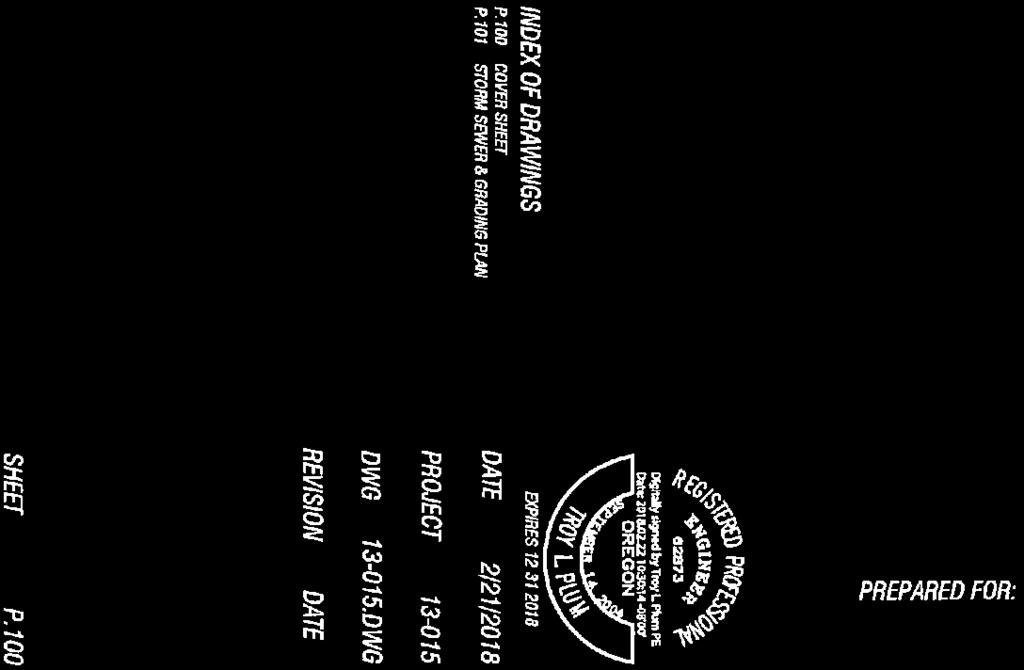
13 ATTACHMENTS A. Access Easement Improvements, Cover Sheet, Sheet P.100 B. Site Plan (SP-18-17), Sheet A100A C. Cover Sheet (SP-18-17). Sheet C001 D. Access Easement Improvements, Storm Sewer & Grading Plan, Sheet P.101 ACRONYMS ADC Albany Development Code AMC Albany Municipal Code BFE Base Flood Elevation CC Community Commercial FEMA Federal Emergency Management Agency FIRM Flood Insurance Rate Map FP Floodplain File Designator MUC Mixed Use Commercial Zoning District NAVD 1988 North American Vertical Datum of 1988* SFHA Special Flood Hazard Area SP Site Plan Review TSP City of Albany s Transportation System Plan *The conversion factor from NGVD 1929 to NAVD 1988 in Albany is feet. Staff Report, Files SP & FP-02-18, Page 13 of 13


14 ATTACHMENT A


15 ATTACHMENT B


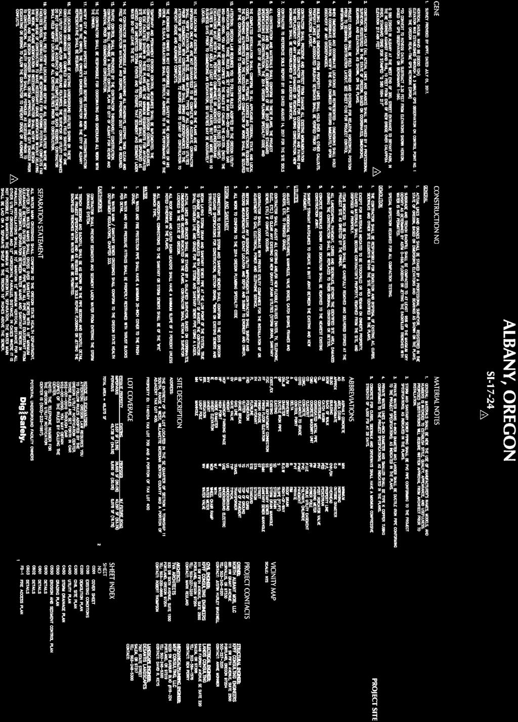

16 ATTACHMENT C


17 ATTACHMENT D
Floodplain Development Land Use Review
 PUBLIC WORKS - COMMUNITY DEVELOPMENT 333 Broadalbin Street SW, PO Box 490, Albany, Oregon 97321-0144 BUILDING 541-917-7553 PLANNING 541-917-7550 Floodplain Development Land Use Review Application Information
COMMUNITY DEVELOPMENT. Staff Report. Site Plan Review. SP June 19, 2018
 COMMUNITY DEVELOPMENT 333 Broadalbin Street SW, PO Box 490, Albany, Oregon 97321-0144 BUILDING 541-917-7553 PLANNING 541-917-7550 Staff Report Site Plan Review SP-18-18 June 19, 2018 Summary On May 1,
COMMUNITY DEVELOPMENT DEPARTMENT 333 Broadalbin Street SW, P.O. Box 490 Albany, OR 97321
 COMMUNITY DEVELOPMENT DEPARTMENT 333 Broadalbin Street SW, P.O. Box 490 Albany, OR 97321 STAFF REPORT Application for Site Plan Review (SP-02-18) Residential Accessory Building Ph: 541-917-7550 Fax: 541-917-7598
Community Development Department 333 Broadalbin Street SW, P.O. Box 490 Albany, OR 97321
 SUMMARY Community Development Department 333 Broadalbin Street SW, P.O. Box 490 Albany, OR 97321 STAFF REPORT Application for Tentative Partition Plat Review Planning File PA-06-17 Phone: 541-917-7550
PUBLIC WORKS - COMMUNITY DEVELOPMENT. Staff Report. Land Division (Tentative Partition Plat) PA October 23, 2018
 PA October 23, 2018") PUBLIC WORKS - COMMUNITY DEVELOPMENT 333 Broadalbin Street SW, PO Box 490, Albany, Oregon 97321-0144 BUILDING 541-917-7553 PLANNING 541-917-7550 Staff Report Land Division (Tentative Partition Plat) PA-08-18
PUBLIC WORKS - COMMUNITY DEVELOPMENT 333 Broadalbin Street SW, PO Box 490, Albany, Oregon 97321-0144 BUILDING 541-917-7553 PLANNING 541-917-7550 Staff Report Land Division (Tentative Partition Plat) PA-08-18
COMMUNITY DEVELOPMENT DEPARTMENT 333 Broadalbin Street SW, P.O. Box 490 Albany, OR 97321
 COMMUNITY DEVELOPMENT DEPARTMENT 333 Broadalbin Street SW, P.O. Box 490 Albany, OR 97321 NOTICE OF FILING Ph: 541-917-7550 Fax: 541-917-7598 www.cityofalbany.net DATE OF NOTICE: May 8, 2018 FILES: SP-20-18
COMMUNITY DEVELOPMENT DEPARTMENT 333 Broadalbin Street SW, P.O. Box 490 Albany, OR 97321
 COMMUNITY DEVELOPMENT DEPARTMENT 333 Broadalbin Street SW, P.O. Box 490 Albany, OR 97321 NOTICE OF FILING Ph: 541-917-7550 Fax: 541-917-7598 www.cityofalbany.net DATE OF NOTICE: April 4, 2016 FILE: TYPE
ARTICLE 24 SITE PLAN REVIEW
 ARTICLE 24 SITE PLAN REVIEW 24.1 PURPOSE: The intent of these Ordinance provisions is to provide for consultation and cooperation between the land developer and the Township Planning Commission in order
Chapter 100 Planned Unit Development in Corvallis Urban Fringe
 100.100 Scope and Purpose. Chapter 100 Planned Unit Development in Corvallis Urban Fringe (1) All applications for land divisions in the Urban Residential (UR) and Flood Plain Agriculture (FPA) zones within
MAJOR SUBDIVISION PRELIMINARY PLAT CHECKLIST
 TOWNSHIP OF EGG HARBOR PLANNING BOARD/ZONING BOARD OF ADJUSTMENT 3515 BARGAINTOWN ROAD EGG HARBOR TOWNSHIP, NJ 08234 MAJOR SUBDIVISION PRELIMINARY PLAT CHECKLIST The following checklist is designed to
PROPOSED AMENDMENTS TO THE DERBY ZONING REGULATIONS AUGUST 12, 2008
 ARTICLE II Definitions and word usage 195-7. Definitions and word usage. Modify the following: HOUSING FOR THE ELDERLY OLDER PERSONS Housing in accordance with and as defined in the United States Fair
Condominium Unit Requirements.
 ARTICLE 19 CONDOMINIUM REGULATIONS Section 19.01 Purpose. The purpose of this Article is to regulate projects that divide real property under a contractual arrangement known as a condominium. New and conversion
Moore Township Planning Commission 2491 Community Drive, Bath, Pennsylvania Telephone: FAX: Rev:12/23/2013
 2491 Community Drive, Bath, Pennsylvania Telephone: 610-759-9449 FAX: 610-759-9448 Rev:12/23/2013 APPLICATION FORM FOR A SITE PLAN PER MOORE TOWNSHIP ZONING ORDINANCE SECTION 200-58.1 NORTHAMPTON COUNTY,
Waseca County Planning and Zoning Office
 Waseca County Planning and Zoning Office 300 North State Street Waseca, Minnesota 56093 Phone: 507-835-0650 Fax: 507-837-5310 Form no. PZ 081009 Web Site: www.co.waseca.mn.us FEES: 1) CUP FEE- $400.00
WASCO COUNTY PRELIMINARY SUBDIVISION APPLICATION
 WASCO COUNTY PRELIMINARY SUBDIVISION APPLICATION DETAILED SPECIFIC WRITTEN REQUEST File Number: SDV- Number of Proposed Lots & their Dimensions: PRELIMINARY SUBDIVISION PLAN REQUIREMENTS The approval of
TOWNSHIP OF BORDENTOWN LAND DEVELOPMENT APPLICATION CHECKLIST. General Requirements for all Applications
 TOWNSHIP OF BORDENTOWN LAND DEVELOPMENT APPLICATION CHECKLIST This CHECKLIST has been adopted in accordance with Section 25:807 of the Land Development Ordinance of the Township of Bordentown and will
COMMUNITY DEVELOPMENT DEPARTMENT 333 Broadalbin Street SW, P.O. Box 490 Albany OR 97321
 COMMUNITY DEVELOPMENT DEPARTMENT 333 Broadalbin Street SW, P.O. Box 490 Albany OR 97321 NOTICE OF DECISION DATE OF NOTICE: August 16, 2016 FILE: TYPE OF APPLICATION: REVIEW BODY: SD-01-16 Ph: 541-917-7550
EXCERPTS FROM HALIFAX REGIONAL MUNICIPALITY CHARTER
 EXCERPTS FROM HALIFAX REGIONAL MUNICIPALITY CHARTER Municipal planning strategy 227 The Council may adopt a municipal planning strategy for all, or part, of the Municipality and there may be separate strategies
ANDOVER CODE. Checklist #5 Preliminary Site Plan Conditional Use
 ANDOVER CODE Checklist #5 Preliminary Site Plan Conditional Use Applicant: Block Lot File No. This checklist is for general reference only. Further information may be required by the reviewing authority.
Chapter Plat Design (LMC)
") Chapter 18.14 Plat Design (LMC) Sections: 18.14.010 Lot width 18.14.020 Right-of-way requirements 18.14.030 Pipe stem lots 18.14.040 Division resulting in minimum lot sizes 18.14.050 Flood prone and bad
Chapter 18.14 Plat Design (LMC) Sections: 18.14.010 Lot width 18.14.020 Right-of-way requirements 18.14.030 Pipe stem lots 18.14.040 Division resulting in minimum lot sizes 18.14.050 Flood prone and bad
ARTICLE 15 - PLANNED UNIT DEVELOPMENT
 Section 15.1 - Intent. ARTICLE 15 - PLANNED UNIT DEVELOPMENT A PUD, or Planned Unit Development, is not a District per se, but rather a set of standards that may be applied to a development type. The Planned
COMMERCIAL SITE DEVELOPMENT GUIDE FOR UNINCORPORATED ST. CHARLES COUNTY
 COMMERCIAL SITE DEVELOPMENT GUIDE FOR UNINCORPORATED ST. CHARLES COUNTY GENERAL INFORMATION: This brochure is to be used as a guide and is not intended to amend or supersede the corresponding County ordinances
SECTION 4: PRELIMINARY PLAT
 SECTION 4: PRELIMINARY PLAT After the completion of the sketch plan process, if submitted, the owner or developer shall file with the City an application for preliminary plat. The preliminary plat stage
UPPER MOUNT BETHEL TOWNSHIP NORTHAMPTON COUNTY, PENNSYLVANIA
 UPPER MOUNT BETHEL TOWNSHIP NORTHAMPTON COUNTY, PENNSYLVANIA JOINDER DEED / LOT CONSOLIDATION TOWNSHIP REVIEW PROCESS When accepting proposed Joinder Deeds / Lot Consolidations, review the Joinder Deed
(voice) (fax) (voice) (fax) Site Plan Review
 (fax) (voice) (fax) Site Plan Review") Town of South Boston PO Box 417 455 Ferry Street South Boston Virginia 24592 Planning Department Public Works Department (Engineering) 434.575.4241 (voice) 434.575.4275 (fax) 434.575.4260 (voice) 434.575.4275
Town of South Boston PO Box 417 455 Ferry Street South Boston Virginia 24592 Planning Department Public Works Department (Engineering) 434.575.4241 (voice) 434.575.4275 (fax) 434.575.4260 (voice) 434.575.4275
ARTICLE 13 CONDOMINIUM REGULATIONS
 ARTICLE 13 CONDOMINIUM REGULATIONS Section 13.01 Purpose. The purpose of this Article is to regulate projects that divide real property under a contractual arrangement known as a condominium. New and conversion
A. Maintenance. All legally established, nonconforming structures can be maintained (e.g., painting and repairs);
;") Chapter 24.50 NONCONFORMING USES, STRUCTURES AND LOTS Sections: 24.50.010 Nonconforming uses, structures, and lots Purpose. 24.50.020 Nonconforming uses, structures, and lots Alteration or expansion of
Chapter 24.50 NONCONFORMING USES, STRUCTURES AND LOTS Sections: 24.50.010 Nonconforming uses, structures, and lots Purpose. 24.50.020 Nonconforming uses, structures, and lots Alteration or expansion of
Residential Minor Subdivision Review Checklist
 Residential Minor Subdivision Review Checklist Plan Submittal Requirements: 2 full sets of stamped plans Electric submittal - all plans contained in a single PDF 3 full sets if commercial kitchen or dining
ARTICLE 7: PLOT PLANS AND SITE PLAN REQUIREMENTS AND REVIEW
 ARTICLE 7: PLOT PLANS AND SITE PLAN REQUIREMENTS AND REVIEW Section 7.0 - Purpose The purpose of this article is to specify the documents and/or drawings required for a Site Plan Review or a Plot Plan
(b) The location of principal and accessory buildings on the lot and the relationship of each structure to the other.
 The location of principal and accessory buildings on the lot and the relationship of each structure to the other.") ARTICLE XIX SITE PLAN Sec. 20-1900 Site Plan Review Procedure - Intent The site plan review procedures are instituted to provide an opportunity for the Township Planning Commission to review the proposed
ARTICLE XIX SITE PLAN Sec. 20-1900 Site Plan Review Procedure - Intent The site plan review procedures are instituted to provide an opportunity for the Township Planning Commission to review the proposed
Residential Major Subdivision Review Checklist
 Residential Major Subdivision Review Checklist Plan Submittal Requirements: 2 full sets of stamped plans Electric submittal - all plans contained in a single PDF 3 full sets if commercial kitchen or dining
Section 7.22: Multifamily Assisted Housing in AA-30 Residential Zone (MAHZ) [Note: an additional line will be added to the Table in Article 3, 3.1.
 [Note: an additional line will be added to the Table in Article 3, 3.1.") Section 7.22: Multifamily Assisted Housing in AA-30 Residential Zone (MAHZ) [Note: an additional line will be added to the Table in Article 3, 3.1.1A] 7.22.1 Purpose The purpose of this Special Regulation
Section 7.22: Multifamily Assisted Housing in AA-30 Residential Zone (MAHZ) [Note: an additional line will be added to the Table in Article 3, 3.1.1A] 7.22.1 Purpose The purpose of this Special Regulation
SITE PLAN REVIEW PROCEDURES SECTION DEVELOPMENTS REQUIRING SITE PLAN APPROVAL
 SECTION 22.01 PURPOSE ARTICLE XXII PROCEDURES The purpose of this Article is to establish uniform requirements of procedure for all developments in the Township. Certain specific types of minor development
Site Plan Application
 Site Plan Application City of St. Pete Beach Community Development Department 155 Corey Avenue St. Pete Beach, Florida 33706 (727) 367-2735 www.stpetebeach.org Case Number: PROPERTY OWNER: Name: Address:
610 LAND DIVISIONS AND PROPERTY LINE ADJUSTMENTS OUTSIDE A UGB
 ARTICLE VI: LAND DIVISIONS AND PROPERTY LINE ADJUSTMENTS VI-21 610 LAND DIVISIONS AND PROPERTY LINE ADJUSTMENTS OUTSIDE A UGB 610-1 Property Line Adjustments (Property Line Relocation) A property line
ARTICLE IV: DEVELOPMENT STANDARDS
 ARTICLE IV: DEVELOPMENT STANDARDS IV-53 409 PRIVATE STREETS A private street means any way that provides ingress to, or egress from, property by means of vehicles or other means, or that provides travel
Township of Little Egg Harbor Planning Board 665 Radio Road Little Egg Harbor, New Jersey Phone: ext. 221 Fax:
 BLOCK(S) LOT(S) Township of Little Egg Harbor Planning Board 665 Radio Road Little Egg Harbor, New Jersey 08087 Phone: 609-296-7241 ext. 221 Fax: 609-294-3040 Development Application Amended Development
ARTICLE 6 PRELIMINARY PLAT
 ARTICLE 6 PRELIMINARY PLAT SECTION: 30-06-01: Preliminary Plat 30-06-02: Information Required for Preliminary Plat 30-06-03: Determination of Requirement for Environmental Review Documents 30-06-04: Additional
MTC ALABAMA SUBDIVISION
 # 2 SUB-000370-2017 MTC ALABAMA SUBDIVISION Engineering Comments: FINAL PLAT COMMENTS (should be addressed prior to submitting the FINAL PLAT for review and/or signature by the City Engineer): A. Provide
13-2 SUBDIVISION PLANS AND PLATS REQUIRED EXCEPTIONS Subdivision Plats Required To be Recorded
 ARTICLE XIII SUBDIVISIONS 13-1 INTENT AND PURPOSE 13-1-1 Intent: It is the intent of the County Commission through the adoption of this Article to more fully avail itself of the power granted under 17-27-601
FINAL DRAFT 12/1/16, Rev. to 7/18/17
 FINAL DRAFT 12/1/16, Rev. to 7/18/17 (As Adopted 8/8/17 Effective 9/1/17) SHELTON PLANNING AND ZONING COMMISSION Proposed Amendments to Zoning Regulations I. Amend Section 23 PERMITTED USES by inserting
ZONING AMENDMENT, PLANNED UNIT DEVELOPMENT & SUBDIVISION STAFF REPORT Date: August 8, 2013
 ZONING AMENDMENT, PLANNED UNIT DEVELOPMENT & SUBDIVISION STAFF REPORT Date: August 8, 2013 NAME SUBDIVISION NAME PV-Magnolia, LLC Twelve Trees Subdivision LOCATION 2860, 2862 and 2866 Pleasant Valley Road
ARTICLE VII. NONCONFORMITIES. Section 700. Purpose.
 ARTICLE VII. NONCONFORMITIES. Section 700. Purpose. The purpose of this chapter is to regulate and limit the development and continued existence of legal uses, structures, lots, and signs established either
CHAPTER XVIII SITE PLAN REVIEW
 CHAPTER XVIII SITE PLAN REVIEW Section 18.1 Section 18.2 Description and Purpose. The purpose of this chapter is to provide standards and procedures under which applicants would submit, and the Township
LAND USE PLANNING TRANSPORTATION PLANNING PROJECT MANAGEMENT
 Memorandum LAND USE PLANNING TRANSPORTATION PLANNING PROJECT MANAGEMENT Date: November 2, 2016 To: From: cc: Re: Cindy Walbridge, Kevin Liburdy, and Jennifer Kaden, City of Hood River Cathy Corliss, AICP,
Larimer County Planning Dept. Procedural Guide for 1041 PERMITS
 - Larimer County Planning Dept. Procedural Guide for 1041 PERMITS PLEASE NOTE: A PRE-APPLICATION CONFERENCE IS REQUIRED PRIOR TO SUBMITTING THIS APPLICATION. PURPOSE: State Statutes allow local governments
PLANNED UNIT DEVELOPMENT & SUBDIVISION STAFF REPORT Date: November 17, 2016
 PLANNED UNIT DEVELOPMENT & SUBDIVISION STAFF REPORT Date: November 17, 2016 DEVELOPMENT NAME SUBDIVISION NAME LOCATION Autonation Ford of Mobile Autonation Ford of Mobile Subdivision 901, 909, and 925
PLANNED UNIT DEVELOPMENT & SUBDIVISION STAFF REPORT Date: September 15, 2016
 # 10 SUB2016-00089 PLANNED UNIT DEVELOPMENT & SUBDIVISION STAFF REPORT Date: September 15, 2016 NAME SUBDIVISION NAME LOCATION Lot 12 Laughlin Industrial Park Subdivision Lot 12 Laughlin Industrial Park
PERMITTED USES: Within the MX-1 Mixed Use Neighborhood District the following uses are permitted:
 6.25 MX-1 - MIXED USE NEIGHBORHOOD 6.25.1 INTENT: The purpose of the MX-1 Mixed Use Neighborhood District is to accommodate the development of a wide-range of residential and compatible non-residential
(Chapter Flood Damage Prevention)
") Chapter 13.10 Flood Damage Prevention Section: 13.10.010 Purpose and Policy 13.10.020 Definitions 13.10.030 Applicability and Areas of Special Flood Hazard 13.10.040 Administration 13.10.050 Provisions
Chapter 13.10 Flood Damage Prevention Section: 13.10.010 Purpose and Policy 13.10.020 Definitions 13.10.030 Applicability and Areas of Special Flood Hazard 13.10.040 Administration 13.10.050 Provisions
Section 3.0: RESIDENTIAL AND NON-RESIDENTIAL SUBDIVISION APPLICATION AND APPROVAL PROCESS
 Cherokee County Development Ordinance Adopted - January 15, 2002 3-1 Section 3.0: RESIDENTIAL AND NON-RESIDENTIAL SUBDIVISION APPLICATION AND APPROVAL PROCESS It shall be the policy of the Cherokee County
ARTICLE 5 MINOR SUBDIVISION/LAND DEVELOPMENT
 ARTICLE 5 MINOR SUBDIVISION/LAND DEVELOPMENT SECTION 501 ONLY FINAL PLAN REQUIRED The classification of a proposed subdivision as a "Minor Subdivision" shall only require the submission, review and approval
SUBDIVISION, PLANNED UNIT DEVELOPMENT, & PLANNING APPROVAL STAFF REPORT Date: February 1, 2007
 SUBDIVISION, PLANNED UNIT DEVELOPMENT, & PLANNING APPROVAL STAFF REPORT Date: February 1, 2007 DEVELOPMENT NAME SUBDIVISION NAME Pala Verde Mobile Home Park Subdivision Pala Verde Mobile Home Park Subdivision
SUBJECT: Application for Planned Unit Development and Rezoning 1725 Winnetka Road
 TO: FROM: CHAIRMAN BILL VASELOPULOS AND MEMBERS OF THE PLAN & ZONING COMMISSION STEVE GUTIERREZ DIRECTOR OF COMMUNITY DEVELOPMENT MEETING DATE: September 5, 2017 SUBJECT: Application for Planned Unit Development
Guide to Combined Preliminary and Final Plats
 Guide to Combined Preliminary and Final Plats Introduction The Douglas County is committed to providing open, transparent application processes to the public. This Guide is provided to assist anyone interested
PLANNING BOARD APPLICATION FORM TOWNSHIP OF BETHLEHEM 405 MINE ROAD ASBURY, NEW JERSEY Date of Application: Township Application Number:
 Township of Bethlehem Page 1 of 8 PLANNING BOARD APPLICATION FORM TOWNSHIP OF BETHLEHEM 405 MINE ROAD ASBURY, NEW JERSEY 08802 Date of Application: Township Application Number: Jurisdiction: Planning Board
** If your lot does not meet the requirements above, please read Sec below
 Sec. 13-1-60 Zoning District Dimensional Requirements. For the Zoning Dept To Issue a Land Use Permit The Following Dimensions are Required. Minimum Side and Rear Yards s Lakes Classification Minimum Class
BRIDGETON SUBDIVISION APPLICATION CHECKLIST
 APPLICATION NAME AND # CHECKLIST COMPLETED BY: DATE: Signature and printed name BRIDGETON SUBDIVISION APPLICATION CHECKLIST TO SUBDIVISION APPLICANTS: The attached checklist is to assist you in the submission
Initial Subdivision Applications Shall Include the Following:
 Initial Subdivision Applications Shall Include the Following: 1) Subdivision Application Form: completely filled out (12 copies) 2) Plat: The Plat must adhere to the requirements set forth in the Town
COMMUNITY DEVELOPMENT DEPARTMENT 333 Broadalbin Street SW, P.O. Box 490 Albany, OR 97321
 HEARING BODY COMMUNITY DEVELOPMENT DEPARTMENT 333 Broadalbin Street SW, P.O. Box 490 Albany, OR 97321 NOTICE OF PUBLIC HEARING Planning Commission HEARING DATE Monday, December 3, 2018 HEARING TIME HEARING
619. Planned Development District (PD)
") 619. Planned Development District (PD) Intent. The purpose of the Planned Development District (sometimes hereinafter referred to as PD) is to provide opportunities to create more desirable environments
619. Planned Development District (PD) Intent. The purpose of the Planned Development District (sometimes hereinafter referred to as PD) is to provide opportunities to create more desirable environments
APPLICATION PROCEDURE
 ANTRIM PLANNING BOARD P. O. Box 517 Antrim, New Hampshire 03440 Phone: 603-588-6785 FAX: 603-588-2969 APPLICATION FORM AND CHECKLIST FOR MINOR OR MAJOR SITE PLAN REVIEW File Date Received By APPLICATION
SUBDIVISION APPLICATION CHECKLIST SKETCH PLAN PRELIMINARY PLAT FINAL PLAT
 RECEIVED STAMP SUBDIVISION APPLICATION CHECKLIST SKETCH PLAN PRELIMINARY PLAT FINAL PLAT A checklist of background information and submission requirements for processing of a sketch plan, preliminary plat
City of Prior Lake APPLICATION FOR REGISTERED LAND SURVEY
 Case File No. Property Identification No. City of Prior Lake APPLICATION FOR REGISTERED LAND SURVEY Requested Action Brief description of proposed project (Please describe the proposed amendment, project,
Medical Marijuana Special Exception Use Information
 Medical Marijuana Special Exception Use Information The Special Exception Use information below is a modified version of the Unified Development Code. It clarifies the current section 5:104 Special Exceptions
I. Requirements for All Applications. C D W
 108-16.1. Application checklists. Checklist for Required Submissions to the Planning Board or Zoning Board of Adjustment of Monroe Township All required submissions are to be made to the Administrative
City of Prior Lake APPLICATION FOR COMBINED PRELIMINARY AND FINAL PLAT
 Case File No. Property Identification No. City of Prior Lake APPLICATION FOR COMBINED PRELIMINARY AND FINAL PLAT Requested Action Brief description of proposed project (Please describe the proposed amendment,
City of Prior Lake APPLICATION FOR PRELIMINARY PLAT
 City of Prior Lake APPLICATION FOR PRELIMINARY PLAT Requested Action Brief description of proposed project (Please describe the proposed amendment, project, or variance request. Attach additional sheets
Town of Alexandria. Floodplain Management Ordinance
 1 of 7 8/8/2009 4:56 PM Town of Alexandria Floodplain Management Ordinance SECTION 1 PURPOSE Certain areas of the Town of Alexandria, New Hampshire are subject to periodic flooding, causing serious damages
Financial Impact Statement There are no immediate financial impacts associated with the adoption of this report.
 STAFF REPORT Planning and Development Department Subject: Application by RYC Property to rezone a portion of lands on John Murray Dr. and Megan Lynn Dr. from R2 to R3 and to enter into a Development Agreement
WRIGHT TOWNSHIP Ottawa County 1565 Jackson Street, P.O. Box 255, Marne, Michigan 49435
 WRIGHT TOWNSHIP Ottawa County 1565 Jackson Street, P.O. Box 255, Marne, Michigan 49435 SITE PLAN REVIEW APPLICATION _ Instructions For an application to be considered complete, ALL information must be
ARTICLE IV DISTRICT REGULATIONS
 PART 1. RESIDENTIAL DISTRICTS 4-101. RS. Single-Family Residential Suburban District. The RS District is designed for single-family dwellings, and compatible uses, at a density no greater than one dwelling
ADMINISTRATIVE HEARING STAFF REPORT
 ADMINISTRATIVE HEARING STAFF REPORT Providence Place Apartments Utility Box No. 2 Conditional Use Petition PLNPCM2011-00426 309 East 100 South September 22, 2011 Planning and Zoning Division Department
(a) Commercial uses on Laurel Avenue, abutting the TRO District to the
 Commercial uses on Laurel Avenue, abutting the TRO District to the") 32X Zoning Code 150.36 TRANSITIONAL RESIDENTIAL OVERLAY DISTRICT. (A) Intent and purpose. (1) It is the intent of the Transitional Residential Overlay District (hereinafter referred to as the "TRO District")
32X Zoning Code 150.36 TRANSITIONAL RESIDENTIAL OVERLAY DISTRICT. (A) Intent and purpose. (1) It is the intent of the Transitional Residential Overlay District (hereinafter referred to as the "TRO District")
FINAL PLAT APPLICATION
 FINAL PLAT APPLICATION (Page 1 of 3) LEGAL OWNER(s): NAME: STREET ADDRESS OWNER(s): CITY, STATE, ZIP CODE: PHONE NUMBER: BILLING ADDRESS: NAME OF ENGINEER/SURVEYOR: Engineer/Surveyor Address, Phone: PROPERTY
ARTICLE 2 REVIEW CRITERIA
 ARTICLE 2 REVIEW CRITERIA 2.010 Overview. The Development Code provides nondiscretionary and discretionary standards for the City to use in evaluating how land use proposals comply with the use and development
ARTICLE 11 LAND DIVISIONS AND PLANNED DEVELOPMENTS
 ARTICLE 11 LAND DIVISIONS AND PLANNED DEVELOPMENTS 11.000 Overview. The most permanent feature of a community is the way land is divided into parcels. This article describes the process of converting raw
Town of Truckee. Contents. Article I - Development Code Enactment and Applicability. Chapter Purpose and Effect of Development Code...
 Town of Truckee TITLE 18 - DEVELOPMENT CODE Article I - Development Code Enactment and Applicability Chapter 18.01 - Purpose and Effect of Development Code... I-3 18.01.010 - Title... I-3 18.01.020 - Purposes
CHAPTER 10 Planned Unit Development Zoning Districts
 CHAPTER 10 Planned Unit Development Zoning Districts Section 10.1 Intent and Purpose The Planned Unit Development (PUD) districts are intended to offer design flexibility for projects that further the
géãç Éy VtÇtÇwt zât 5440 Routes 5 & 20 West Canandaigua, NY Phone: (585) / Fax: (585)
 / Fax: (585)") géãç Éy VtÇtÇwt zât 5440 Routes 5 & 20 West Canandaigua, NY 14424 Phone: (585) 394-1120 / Fax: (585) 394-9476 NOTICE TO ALL PLANNING BOARD APPLICANTS FOR PRELIMINARY SUBDIVISION PHASED PROJECTS The applicant
géãç Éy VtÇtÇwt zât 5440 Routes 5 & 20 West Canandaigua, NY 14424 Phone: (585) 394-1120 / Fax: (585) 394-9476 NOTICE TO ALL PLANNING BOARD APPLICANTS FOR PRELIMINARY SUBDIVISION PHASED PROJECTS The applicant
SITE DEVELOPMENT PLAN REQUIREMENTS CHECKLIST
 SITE DEVELOPMENT PLAN REQUIREMENTS CHECKLIST Completed DRC Application for Review Required for Application Process DRC Processing Fee 1 Commercial $2,500.00 Fire Department Review Fee 150.00 Total $2,650.00
CHAPTER 3 PRELIMINARY PLAT
 10-3-1 10-3-3 SECTION: CHAPTER 3 PRELIMINARY PLAT 10-3-1: Consultation 10-3-2: Filing 10-3-3: Requirements 10-3-4: Approval 10-3-5: Time Limitation 10-3-6: Grading Limitation 10-3-1: CONSULTATION: Each
PLANNING BOARD CITY OF CONCORD, NH MINOR SUBDIVISION CHECKLIST
 PLANNING BOARD CITY OF CONCORD, NH MINOR SUBDIVISION CHECKLIST Summary This checklist is intended to assist applicants and design professionals in the preparation of minor subdivision applications for
Cobb County Community Development Agency Zoning Division 1150 Powder Springs St. Marietta, Georgia 30064
 Cobb County Community Development Agency Zoning Division 1150 Powder Springs St. Marietta, Georgia 30064 Case # Z-63 Public Hearing Dates: PC: 11-06-18 BOC: 11-20-18 SITE BACKGROUND Applicant: Loyd Development
E L M E R B O R O U G H L A N D U S E B O A R D APPLICATION COVER SHEET (to be completed for all applications and appeals)
") E L M E R B O R O U G H L A N D U S E B O A R D APPLICATION COVER SHEET (to be completed for all applications and appeals) 1. Name(s): 2. Address: 3. Telephone Number(s): 4. E-mail: 5. Owner Name(s) (if
E L M E R B O R O U G H L A N D U S E B O A R D APPLICATION COVER SHEET (to be completed for all applications and appeals) 1. Name(s): 2. Address: 3. Telephone Number(s): 4. E-mail: 5. Owner Name(s) (if
4. facilitate the construction of streets, utilities and public services in a more economical and efficient manner;
 PVPC MODEL BYLAW BY-RIGHT CLUSTER ZONING BYLAW Prepared by Pioneer Valley Planning Commission Revised: October 2001 1.00 Development 1.01 Development Allowed By Right Development in accordance with this
Special Use Permit - Planned Unit Development Checklist. Property Address:
 Special Use Permit - Planned Unit Development Checklist Special Use Permit Number. Parcel Code/s #28-11- - - Property Address: Applicant: ARTICLE VIII Ordinance Reference - Section 8.1.2 Permit Procedures:
LABEL PLEASE NOTE: ALL APPLICATIONS AND SITE PLANS MUST BE COMPLETED IN BLACK OR BLUE INK ONLY Intake by:
 STAFF USE ONLY Thurston County Resource Stewardship 2000 Lakeridge Dr. S.W. Olympia, WA 98502 (360)786-5490 / (360)754-2939 (Fax) TDD Line (360) 754-2933 Email: permit@co.thurston.wa.us Supplemental Application
Washington County, Minnesota Ordinances
 Washington County, Minnesota Ordinances Ordinance No. 153 Text Amendment to the Washington County Development Code - Chapter One, Section 2 and Chapter Two, Part 1, Part 2, Part 3, of the Development Code
Guide to Minor Developments
 Guide to Minor Developments Introduction The Douglas County (DCD) is committed to providing open, transparent application processes to the public. This Guide is provided to assist anyone interested in
BEFORE THE LANCASTER TOWNSHIP BOARD OF SUPERVISORS BUTLER COUNTY, PENNSYLVANIA FINDINGS OF FACT, CONCLUSIONS OF LAW AND DECISION FINDINGS OF FACT
 BEFORE THE LANCASTER TOWNSHIP BOARD OF SUPERVISORS BUTLER COUNTY, PENNSYLVANIA IN RE: Conditional Use and Preliminary ) and Final Land Development Applications ) for Planned Unit Development by ) Arden
CITY OF OAK HARBOR Development Services Department
 CITY OF OAK HARBOR Development Services Department Shortt Subdiiviisiions Shorrtt Pllatt Reviiew Prrocess IIII What is a Short Plat, and when is it necessary? A short plat is a map that represents a short
SUBDIVISION & PLANNING APPROVAL STAFF REPORT Date: December 1, 2016
 SUBDIVISION & PLANNING APPROVAL STAFF REPORT Date: December 1, 2016 APPLICANT NAME SUBDIVISION NAME DEVELOPMENT NAME LOCATION Board of Water and Sewer Commissioners of the City of Mobile Halls Mill Road
SUBDIVISION, PLANNED UNIT DEVELOPMENT, ZONING AMENDMENT, & SIDEWALK WAIVER STAFF REPORT Date: July 19, 2018
 SUBDIVISION, PLANNED UNIT DEVELOPMENT, ZONING AMENDMENT, & SIDEWALK WAIVER STAFF REPORT Date: July 19, 2018 NAME SUBDIVISION NAME LOCATION West Mobile Properties, LLC U.S. Machine Subdivision 556, 566,
CONDOMINIUM REGULATIONS
 ARTICLE 37 CONDOMINIUM REGULATIONS SECTION 37.01. Purpose The purpose of this Article is to regulate projects that divide real property under a contractual arrangement known as a condominium. New and conversion
ZONING AMENDMENT & SUBDIVISION STAFF REPORT Date: November 3, 2016
 ZONING AMENDMENT & SUBDIVISION STAFF REPORT Date: November 3, 2016 APPLICANT NAME SUBDIVISION NAME David Shumer 5955 Airport Subdivision CITY COUNCIL DISTRICT District 6 5955 Airport Boulevard, 754 Linlen
CHAPTER34 PRUD - PLANNED RESIDENTIAL UNIT DEVELOPMENT
 CHAPTER34 PRUD - PLANNED RESIDENTIAL UNIT DEVELOPMENT 17-34-1 17-34-2 17-34-3 17-34-4 17-34-5 17-34-6 17-34-7 17-34-8 17-34-9 Purpose Planned Residential Unit Development Defined Planned Residential Unit
WRIGHT TOWNSHIP Ottawa County 1565 Jackson Street, P.O. Box 255, Marne, Michigan 49435
 WRIGHT TOWNSHIP Ottawa County 1565 Jackson Street, P.O. Box 255, Marne, Michigan 49435 SPECIAL USE PERMIT APPLICATION _ Instructions For an application to be considered complete, ALL information must be
BEFORE THE HEARING EXAMINER FOR CITY OF VANCOUVER
 BEFORE THE HEARING EXAMINER FOR CITY OF VANCOUVER In the Matter of the Application of ) NO. PRJ-151162/LUP-53608 ) ) Irina Leschuk, DL Design Group, Inc., ) 136th Avenue Subdivision On behalf of Omega
ARTICLE VI. SUBDIVISION STANDARDS, PUBLIC
 ARTICLE VI. SUBDIVISION STANDARDS, PUBLIC IMPROVEMENTS, AND DESIGN REQUIREMENTS ARTICLE VI. SUBDIVISION STANDARDS, PUBLIC IMPROVEMENTS, AND DESIGN REQUIREMENTS DIVISION 1. GENERAL PROVISIONS Sec. 21-6100.