Walmart Outparcel For Sale
|
|
|
- Belinda Wilcox
- 5 years ago
- Views:
Transcription
 265-1555 ryan@hollisbloom.com MORE INFORMATION AVAILABLE AT: www.walmartrealty.")

1 Walmart Outparcel For Sale Houston, TX Store # Silber Road FOR INFORMATION CONTACT: Lot...Sale Pending Ryan Tinch Hollis Bloom (214) ryan@hollisbloom.com MORE INFORMATION AVAILABLE AT: Property Summary 3 Mile Pop...120,239 Med HH $...$53,813 5 Mile Pop...434,581 Med HH $...$51,286 Houston The information above has been obtained from sources believed reliable. While we do not doubt its accuracy, we have not verified it and make no guarantee, warranty or representation about it. It is your responsibility to independently confirm its accuracy and completeness.


2


3
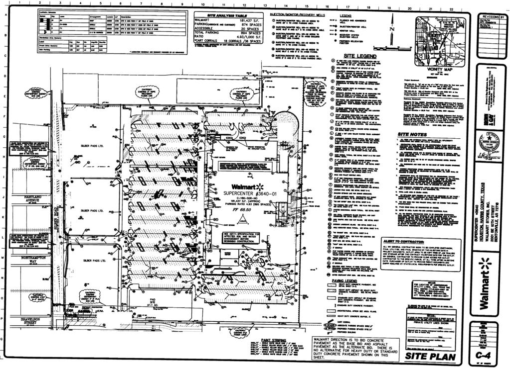
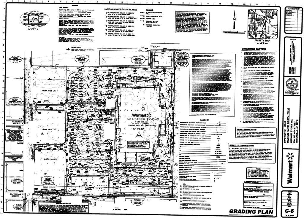
4 Brown & Gay Engineers, Inc Westheimer, Siute 400 Houston, TX E. Benton Schmaltz (281) (713) Location of Project: Store Type: Size of the Store: 1118 Silber Houston, Texas Supercenter 180 Proto Store #: 3640 Date of this Report: Friday, August 28, 2009 OUTLOT/EXCESS LAND SETBACKS ZONING Minimum building setbacks for each property Current zoning Size Square Lot # Front Left Side Right Side Back Zoning Lot (in Acres) footage Lot 1Lot AC 47,916 0' 0' 0' 0' ne ZONING 1. Is there an Overlay District, PUD, etc. that impacts the development of the outlot/excess land? 2. If yes, please describe: 3. What Jurisdiction is the property in? City of Houston 4. Is a restaurant permitted? 5. Is patio seating permitted? 6. Is there a restriction prohibiting a drive thru (restaurant, bank, etc.)? 7. Please add any additional information/comments that impact the outlot/excess land regarding zoning: PARKING REQUIREMENTS: 1. Wal-Mart's required parking ratio: Restaurant 15 / 1,000 Retail 5 / 1,000 Page 1 of 9
5 2. Is the City or County's parking requirement greater than Wal-Mart's If, what is the requirement? Restaurant Retail SIGNAGE: 1. What type of signage is allowed for the outlots per local codes and/or ordinances? 2. If other, please define: 3. What is the maximum height allowed for the signage? Single Business height - 24', Multi-tennant height - 30' Other all signs that meet sign COH requirements 4. What is the maximum square footage allowed for the signage? Single Business size Sq. Ft., Multi-tennant size Sq. Ft. 5. Explain how the square footage is calculated: The dimensions of the rectangle enclosing the sign board, excluding the supporting structure, shall be used. For signs of a double-faced, back to back, or V-type nature, each sign shall be considered a separate sign. 6. If Other or signage is permitted explain why and give options to change the signage regulations: 7. Is roof signage permitted? 8. What is the maximum size? The sign cannot exceed 8' above the roof level. 9. Are wall logo's and/or signs permitted? 10. Is Neon signage permitted? 11. How long is the variance process for outlot signage and what is required? 12. Describe all reviews, hearings, variances and general requirements known at this time: The application for a sign permit shall be submitted to the Sign Administrator and accompanied by drawings and descriptive data to verify compliance with the COH Sign Ordinance. Variance process unknown. Permit good for 3 years. Page 2 of 9
6 PLATTING 1. Is the property (including the outlots/excess land) required to be platted? 1a. If no please explain: 2. 1b. If yes, has the plat been recorded? 1c. What is the book, page or volume? FC , FC d. What was the date it was recorded? , , respectively If the property has not been platted, please describe the process including who is responsible for the platting and timeframe for completion. **te: If platting is not required, a metes and bounds legal description for each parcel should be forwarded to the respective Wal-Mart Land Development Manager as soon as possible. STREET/HIGHWAY ACCESS AND TRAFFIC STUDY: 1. Who has Jurisdiction on this site? 2. Will the Jurisdiction allow direct access and/or curbcuts to the main street or highway? 3. If there is a concrete median in front of the property, will the Jurisdiction allow it to be cut? City of Houston **te: Wal-Mart does not typically allow purchaser's direct access and/or curbcuts to the main street or highway. Access to the outlot/excess land is granted through the Wal-Mart access drive! 4. Are there any future highway/street improvements anticipated that would impact the outlot/excess land? 4a. If yes, please describe along with the timeframe and location: Plans are proposed for the construction of left turn lanes and a right turn lane in Silber. These improvements are proposed to be constructed during the construction of the supercenter. 5. Are sidewalks required on the outlot/excess land? 5a. If yes, what type and size: 6. Was a traffic study performed for the overall project? 6a. If yes, was the outlot(s)/excess land included? Select / 6b. What was the estimated traffic count, peak hour trips, total trips, proposed use, etc. for each parcel? Page 3 of 9
7 6c. Will an additional traffic study be required for each purchaser? 6d. If yes, please explain why and any requirements including applicable timeframes: 6e. Does the traffic study, trips, etc. have an expiration date? Select / 6f. If yes, please provide the expiration date and any other important information: UTILITIES: Water 1. Is water stubbed to the outlot(s)? 1a. If not, where is it located? 2. Is water stubbed to the excess land? 2a. If not, where is it located? 3. Who has Jurisdiction of the water line? City of Houston 4. What is the size of the water main? 12" 5. What is the normal pressure? 6. Is there a Tap Fee? COH Impact Fee paid at Permitting 7. Is there a Meter Fee? 8. Can the hose bibs & irrigation be on a separate meter? 9. What is the size of the line required? 10. Are backflow preventer valves required for fire sprinkler lines? 11. Is the water line located in an existing easement? 12. Is there a current moratorium or a chance for one in the future? 13. Please add any additional information/comments regarding water: Sanitary Sewer 1. Is sanitary sewer stubbed to the outlot(s)? 1a. If not, where is it located? 2. Is sanitary sewer stubbed to the excess land? 2a. If not, where is it located? 3. What is the size of the sewer line? 4. Who has the Jurisdiction of the sanitary sewer line? 12" City of Houston 5. Nearest manhole: Lot 1 Rim El. 66 Inv.El.Out Page 4 of 9
8 6. Is a grease trap required for a restaurant? 7. Is there a Tap Fee? COH Impact Fee paid at Permitting 8. Are tap fees based on water useage? 9. Is the tap to be made by the city or a local plumber? Plumber 10. Are there any special assessments? 11. Is there a current moratorium or a chance for one in the future? 12. Is the sanitary sewer line located in an existing easement? 13. If sanitary sewer is not available, can a septic system be used? N/A 13a. What type? N/A 13b. Additional Comments: N/A 14. Can the septic field be paved over? N/A 15. Has a percolation test been performed? N/A 15a. When? N/A 15b. What were the results? (1' in 30 minutes is required for a restaurant) N/A 15c. If the test did not meet the above requirements, what are the alternative solutions? N/A **te: Purchaser is responsible to perform their own percolation test on the outlot/excess land if a septic system is required. 16. Please add any additional information/comments regarding sanitary sewer: Storm Sewer: 1. Is storm sewer stubbed to the outlot? 2. Is storm sewer stubbed to the excess land? 3. If not, please explain how the storm sewer drainage will be addressed for each outlot/excess land: Page 5 of 9
9 4. Has Wal-Mart's detention facility been sized to accept the drainage? 5. Is the Wal-Mart detention pond encroaching on or included within the outlot/excess land property line? 6. Who has the Jurisdiction of the storm sewer? Harris County Flood Control District 7. What is the size of the storm sewer? 8'x4' Box Culvert 8. What is the depth? 6.49' 9. What is the tap fee? 10. Are catch basins required? 11. Is the storm sewer located in an existing easement? 12. Please add any additional information/comments regarding storm sewer: Box Culvert has been field verified by Brown & Gay Engineers, Inc. **te: Purchaser will have to comply fully with any federal, state or local laws, regulations, ordinances, permits or other authorizations or approvals or other requirements relating to storm water discharges or the control or erosion or sediment discharges from construction projects, including but not limited to the Clean Water Act, 33 U.S.C et seq., and the Storm Water General Permit for Discharges associated with Construction Activities (collectively the Storm Water Requirements ) including without limitation preparing a Storm Water Pollution Prevention Plan (if applicable) to avoid negatively impacting any erosion or sediment controls during earth-disturbing activities, if any. Electric 1. Is electric stubbed to the outlot? 1a. If not, where is it located? Power is located on south property line 2. Is electric stubbed to the excess land? 2a. If not, where is it located? In Silber ROW 3. Is it overhead or underground? Overhead 4. What is the voltage? Unknown 5. What is the phase? Unknown 6. What is the wire? Unknown 7. Who has Jurisdiction of the electricity? CenterPoint Energy 8. Is underground service required? 8a. If yes, will the power company bring conduit and wire to the transformer and/or building? For undergroung power, CenterPoint will only install the wire up to the transformer. The conduit for the underground portion will be constructed by the contractor. 8b. Is there a standard cost per LF for the installation? 8c. Transformer location: 8d. Can the outlot/excess land be serviced with either a pole mounted or pad mounted transformer Page 6 of 9 Behind building Pole Mounted 9. Is the primary service connected to the existing transformer? 9a. Are there any service charges or connection fees? Select One 9b. What is the cost?
10 10. Is the electric located in an existing easement? 11. Please add any additional information/comments regarding electric: Power for the project is located in Silber right-of-way and in an existing easement along the south property line. Gas 1. Is gas stubbed to the outlot? 1a. If not, where is it located? 2. Is gas stubbed to the excess land? 2a. If not, where is it located? 3. What is the maximum amount available? 4. Who has Jurisdiction of the gas line? CenterPoint Energy 5. What type of commitment will the gas company give? 6. Will the gas company bring the line to the building? 6a. What is the estimated cost to do so? 6b. What is the size of the gas line? 6c. What is the pressure of the gas line? 6d. What is the BTU/CF rating? 6e. What is the specific gravity? 6f. Is a meter fee required? 7. Is the gas located in an existing easement? 8. Please add any additional information/comments regarding gas: Telephone 1. Is telephone stubbed to the outlot? N/A 1a. If not, where is it located? 2. Is telephone stubbed to the excess land? 2a. If not, where is it located? 3. Is under ground service required? 4. Who is responsible for bringing telephone lines to the building? AT&T 5. Is the telephone located in an existing easement? 6. Please add any additional information/comments regarding telephone: Page 7 of 9
11 FEES: 1. Are there any unusually expensive fees or assessments relating to the future development of this property? 2. If yes, please describe in detail and attach a schedule if available: BUILDING CODES: 1. What are the building codes by which the architectural plans must comply with on the outlot/excess land? 2003 International Building Code 1a. What is the date they were adopted: Unknown 2. What is the building permit fee schedule? The cost is based on the value of proposed improvements for each application. 25% of the estimated fee has to be paid at the time of initial application. 3. Is the outlot/excess land located in a fire zone or district? 4. Are there any special fire department requirements in addition to standard plans? SITE / LANDSCAPING: 1. Is there a landscaping ordinance in place? 2. Is there any special lighting requirements? 2a. If yes, please describe: Walmart proto specifications 3. What type of solid waste disposal is permitted? 3a. Compaction: 3b. Bulk pick up: 3c. Front loader: 3d. Side loader: 3e. Rear loader: 3f. Who has the Jurisdiction of solid waste: 3g. Is this adequate for Jurisdiction? City of Houston 3h. Is a drain required in the trash area? 3i. Are hot and cold water hose bibs required in the trash area? **te: Wal-Mart requires a masonry trash enclosure for compactor, dumpster. Page 8 of 9
12 SOILS / ENVIRONMENTAL: 1. Was the outlot(s) rough graded? 2. Was it compacted to Wal-Mart standard specifications? 3. Was the excess land rough graded, if applicable? 4. Was it compacted to Wal-Mart's specs? 5. Did the Phase 1 Environmental report indicate contamination? 3a. Report prepared by: Raba Kistner Consultants, Inc. 3b. Dated: 3c. If yes, was the contamination located in close proximity to or within the outlot/excess land? 3d. If yes, was the contamination remediated as part of the overall project? 3e. Please provide any additional information/comments regarding the contamination: Raba Kistner has written and submitted a Specification for Affected Soil and Water Management for the site. The contractor is to adhere to specification with regard to impacted soils that may be found on site. 6. Is any portion of the outlot/excess land located in a flood plan and/or wetland area? 6a. If yes, please describe: TRAFFIC: 1. Average Daily Traffic: 12,000 12,000 Unknown v.p.d. (year) Civil Consultant: Please add any information and/or comments that you can think impact the development and/or title of the outlot/excess land: The purpose of this "Fact Sheet" is to provide general information regarding the subject property. It is the prospective purchaser's obligation to perform the necessary due diligence to insure that the property is capable of meeting the intended use. CONTACTS: The last page should be all local contacts (from your cover sheet) Page 9 of 9
Walmart Outparcel For Sale
 Walmart Outparcel For Sale Texas City, TX Store # 8190 6614 GULF FREEWAY Emmett F Lowry Expy Lot 5 Gulf Fwy/ US I-45 1764 Road For more information about this site, contact: Lot 5: ±0.85 Acres - $500,000
Walmart Excess Land For Sale
 Walmart Excess Land For Sale San Antonio, TX Store # 5290 SWC S. Ellison Dr. & Marbach Rd. Excess Land FOR INFORMATION CONTACT: Excess Land (+ 6.41 AC)...Coming Soon Ryan Tinch Hollis Bloom (214) 265 1555
Airport Rd. Lot 6 Lot 2 Lot 1. 1 Mile: Population: 1,100 Median HH Income: $51, Mile: Population: 16,300 Median HH Income: $53,500
 Walmart Outparcels For Sale Godfrey, IL Store #4695 6660 Godfrey Road Airport Rd Lot 4 Lot 6 Lot 2 Lot 1 Godfrey Rd/ Hwy 67 For more information about this site, contact: Jim Rosen Pace Properties (314)
Two Notch Road. 3 Mile: Popula on: 53,000 Median HH Income: $68, Mile: Popula on: 98,200 Median HH Income: $63,300
 Fashion Drive Sam s Club Excess For Sale Columbia, SC Store #4872 733 Fashion Dr. Excess Two tch Road For more informa on about this site, contact: Excess: 4.70 acres - $960,000 Michael Silverman The Shopping
Ft. Worth, TX. Walmart Outparcels For Sale. Store #2834 SEC Golden Triangle & Park Vista
 Ft. Worth, TX Walmart Outparcels For Sale Store #2834 SEC Golden Triangle & Park Vista Lot 2. lvd B le g rian T n e ld Go Lot 3 Lot 5 Lot 2: + 1.02 acres - Coming Soon Lot 3: + 1.06 acres - Coming Soon
Towne Center Boulevard William Penn Highway. Lot 2. 1 Mile Population: 3,600 Median HH Income: $36,800
 Walmart Outparcel For Sale Huntingdon, PA Store #5470 6716 Towne Center Blvd Towne Center Boulevard William Penn Highway Lot 2 Raystown Road For more information about this site, contact: Lot 2: ±1.72
1 Mile: Popula on: 9,400 Median HH Income: $65, Mile: Popula on: 113,000 Median HH Income: $59,600
 Walmart Outparcels For Sale Dallas, TX Store #2105 Midway Road and US I-635 US I 635 Lot 5 Lot 6 Lot 7 Midway Raod Lot 8 For more informa on about this site, contact: Ryan Tinch Hollis Bloom (214) 265-1555
1 Mile: Population: 14,200 Median HH Income: $62, Mile: Population: 71,100 Median HH Income: $68,600
 Walmart Outparcel For Sale Arlington (SW), TX Store # 3284 4800 Highway 287 US I-20 Lot 2 Hwy 287 Treepoint Dr Little Rd For more information about this site, contact: Lot 2: ±1.02 Acres - $850,000 Bank
Soojian Dr. Hwy 9 Lot 1. Main Street. 1 Mile Popula on: 1,000 Median HH Income: $75, Mile: Popula on: 11,900 Median HH Income: $61,500
 Walmart Outparcels For Lease Leicester, MA Store #3409 20 Soojian Drive Soojian Dr Hwy 9 Lot 1 Main Street For more informa on about this site, contact: Lot 1: ±2.23 Acres - $50,000 per year Ground Lease
Walmart Excess Land For Sale - Development Opportunity 7405 Debarr Road Anchorage, AK Store #4359 Patterson Street
 TRACT C E. 10th Avenue Walmart Excess Land For Sale - Development Opportunity 7405 Debarr Road Anchorage, AK Store #4359 Patterson Street TRACT A 20,245 ± ADT Creekside Center Drive Debarr Road 37,000
West Brownsville, Pennsylvania
 Store # 4501 West Brownsville, Pennsylvania Hwy 40 East & Wilson Road FOR MORE INFORMATION CONTACT: Lot 1-1.95 ± Acres (1.30± Acres usable) $360,000 Lot 2-2.05 ± Acres (1.26± Acres usable) $350,000 Brian
SITE DEVELOPMENT PLAN REQUIREMENTS CHECKLIST
 SITE DEVELOPMENT PLAN REQUIREMENTS CHECKLIST Completed DRC Application for Review Required for Application Process DRC Processing Fee 1 Commercial $2,500.00 Fire Department Review Fee 150.00 Total $2,650.00
PLANNED UNIT DEVELOPMENT & SUBDIVISION STAFF REPORT Date: November 17, 2016
 PLANNED UNIT DEVELOPMENT & SUBDIVISION STAFF REPORT Date: November 17, 2016 DEVELOPMENT NAME SUBDIVISION NAME LOCATION Autonation Ford of Mobile Autonation Ford of Mobile Subdivision 901, 909, and 925
ARTICLE 7 UTILITIES AND EASEMENTS
 7.1 PLACEMENT OF UTILITIES ARTICLE 7 UTILITIES AND EASEMENTS 7.1.1 All authorized public underground utilities shall be located within the right-of-way of a public street or within an easement designated
TOWNSHIP OF DOYLESTOWN APPLICATION FOR REVIEW OF SUBDIVISION OR LAND DEVELOPMENT PROPOSAL. Please PRINT; all information MUST be filled out completely
 TOWNSHIP OF DOYLESTOWN APPLICATION FOR REVIEW OF SUBDIVISION OR LAND DEVELOPMENT PROPOSAL Please PRINT; all information MUST be filled out completely Date: Name of Subdivision or Land Development: Location:
COMMERCIAL SITE DEVELOPMENT GUIDE FOR UNINCORPORATED ST. CHARLES COUNTY
 COMMERCIAL SITE DEVELOPMENT GUIDE FOR UNINCORPORATED ST. CHARLES COUNTY GENERAL INFORMATION: This brochure is to be used as a guide and is not intended to amend or supersede the corresponding County ordinances
Use permitted by: Right Special Exemption
 CENTER TOWNSHIP 150 Henricks Road Butler, PA 16001-8472 Phone (724) 282-7805 Fax (724) 282-6550 Application Number: FEE COLLECTED: Application for: Preliminary Final Land Development Location: Map and
Address Southeast Quadrant of U.S. Highway 41 and Sumter Boulevard City. North Port State. FL Zip Code County
 SUBJECT AERIAL LOCATION LAND AREA THREE-YEAR OWNERSHIP HISTORY OF SUBJECT Address Southeast Quadrant of U.S. Highway 41 and Sumter Boulevard City North Port State FL Zip Code 34287 County Sarasota Nearest
ARTICLE 900 PLAT AND PLAN REQUIREMENTS
 ARTICLE 900 PLAT AND PLAN REQUIREMENTS SEC. 900.1 ITEMS TO BE SHOWN ON PLAT OR PLAN General (1) Property lines of all property owners adjacent to the exterior boundaries of the project shall be located
SECTION 4: PRELIMINARY PLAT
 SECTION 4: PRELIMINARY PLAT After the completion of the sketch plan process, if submitted, the owner or developer shall file with the City an application for preliminary plat. The preliminary plat stage
City of Prior Lake APPLICATION FOR COMBINED PRELIMINARY AND FINAL PLAT
 Case File No. Property Identification No. City of Prior Lake APPLICATION FOR COMBINED PRELIMINARY AND FINAL PLAT Requested Action Brief description of proposed project (Please describe the proposed amendment,
ZONING AMENDMENT, PLANNED UNIT DEVELOPMENT & SUBDIVISION STAFF REPORT Date: September 15, 2011
 ZONING AMENDMENT, PLANNED UNIT DEVELOPMENT & SUBDIVISION STAFF REPORT Date: September 15, 2011 NAME SUBDIVISION NAME LOCATION Stratford, L.L.C. Grelot Office Park Subdivision North side of Grelot Road,
City of Prior Lake APPLICATION FOR PRELIMINARY PLAT
 City of Prior Lake APPLICATION FOR PRELIMINARY PLAT Requested Action Brief description of proposed project (Please describe the proposed amendment, project, or variance request. Attach additional sheets
SECTION SITE SURVEYS
 PART 1 - GENERAL 1.1 DESCRIPTION SECTION 02 21 00 SPEC WRITER NOTES: 1. Use this section only for NCA projects. 2. Delete between //---// if not applicable to project. Also delete any other item or paragraph
City of Prior Lake APPLICATION FOR REGISTERED LAND SURVEY
 Case File No. Property Identification No. City of Prior Lake APPLICATION FOR REGISTERED LAND SURVEY Requested Action Brief description of proposed project (Please describe the proposed amendment, project,
Residential Low Density Park Zone (RLP) Major Site Development Plan/Plan Amendment Application Packet
 Major Site Development Plan/Plan Amendment Application Packet") Residential Low Density Park Zone (RLP) Major Site Development Plan/Plan Amendment Application Packet 1. Application Packet. Be sure to complete and submit all the required materials that are a part of
Residential Low Density Park Zone (RLP) Major Site Development Plan/Plan Amendment Application Packet 1. Application Packet. Be sure to complete and submit all the required materials that are a part of
ARTICLE 900 PLAT AND PLAN REQUIREMENTS
 Final SEC. 900.01 ARTICLE 900 PLAT AND PLAN REQUIREMENTS General provisions. (a) Scale. The scale of all plats and plans shall be a minimum of 1 to 100 ft. (b) Size. The minimum page size for all plats
LINE EXTENSION APPLICATION AGREEMENT PROJECT: LINK#
 LINE EXTENSION APPLICATION AGREEMENT PROJECT: LINK# This LINE EXTENSION APPLICATION AGREEMENT (LEAA) is entered into as of, 20, (the "Effective Date"), by and between, hereinafter called "Customer/Developer",
PLANNING BOARD CITY OF CONCORD, NH MINOR SUBDIVISION CHECKLIST
 PLANNING BOARD CITY OF CONCORD, NH MINOR SUBDIVISION CHECKLIST Summary This checklist is intended to assist applicants and design professionals in the preparation of minor subdivision applications for
BRIDGETON SUBDIVISION APPLICATION CHECKLIST
 APPLICATION NAME AND # CHECKLIST COMPLETED BY: DATE: Signature and printed name BRIDGETON SUBDIVISION APPLICATION CHECKLIST TO SUBDIVISION APPLICANTS: The attached checklist is to assist you in the submission
Community Development Fees (as of March 2015)
") Community Development Fees (as of March 2015) Planning Page 2 Engineering Page 3 Building Page 5 Building Use Tax Page 6 Water and Sewer License/Tap Page 7 Additional Building Fees Page 9 Temporary Water/Sewer
Community Development Fees (as of March 2015) Planning Page 2 Engineering Page 3 Building Page 5 Building Use Tax Page 6 Water and Sewer License/Tap Page 7 Additional Building Fees Page 9 Temporary Water/Sewer
SUBDIVISION APPLICATION CHECKLIST SKETCH PLAN PRELIMINARY PLAT FINAL PLAT
 RECEIVED STAMP SUBDIVISION APPLICATION CHECKLIST SKETCH PLAN PRELIMINARY PLAT FINAL PLAT A checklist of background information and submission requirements for processing of a sketch plan, preliminary plat
COMMERCIAL SITE PLAN & CONDITIONAL USE PERMIT REVIEW PROCESS & CHECKLIST
 Community Development 110 South Main Street Springville, UT 84663 COMMERCIAL SITE PLAN & CONDITIONAL USE PERMIT REVIEW PROCESS & CHECKLIST 801.491.7861 www.springville.org Prior to the issuance of a building
ZONING AMENDMENT, PLANNED UNIT DEVELOPMENT & SUBDIVISION STAFF REPORT Date: August 8, 2013
 ZONING AMENDMENT, PLANNED UNIT DEVELOPMENT & SUBDIVISION STAFF REPORT Date: August 8, 2013 NAME SUBDIVISION NAME PV-Magnolia, LLC Twelve Trees Subdivision LOCATION 2860, 2862 and 2866 Pleasant Valley Road
ADMINISTRATIVE SITE PLAN REVIEW
 Page 1 of 6 Application Fee is $200.00 Plus Peer Review Costs Date Received: Application Fee PAID: $ This application and all accompanying submissions shall conform to the applicable provisions of the
PLYMOUTH PLANNING BOARD APPLICATION FOR A MINOR SUBDIVISION OR MAJOR SUBDIVISION
 CASE # PLYMOUTH PLANNING BOARD APPLICATION FOR A MINOR SUBDIVISION OR MAJOR SUBDIVISION The undersigned Applicant hereby submits to the Plymouth Planning Board a completed application for a proposed minor
CHARTER TOWNSHIP OF GRAND RAPIDS COUNTY OF KENT, MICHIGAN. At a regular meeting of the Township Board of the Charter Township of Grand Rapids, held
 For second reading by Township Board on 9/15/15 CHARTER TOWNSHIP OF GRAND RAPIDS COUNTY OF KENT, MICHIGAN At a regular meeting of the Township Board of the Charter Township of Grand Rapids, held in the
Development Related Fee Schedule Effective May 1, Plan Reviews. Remodeling, Alterations, Additions Residential and Commercial
 Plan Reviews Plan Review Payable at the time a permit application is submitted. Per hour fee for reviews exceeding standard review times payable prior to the issuance of a permit. Remodeling, Alterations,
MUDDY CREEK TOWNSHIP PO BOX 239 PORTERSVILLE, PA SUBDIVISION AND LAND DEVELOPMENT APPLICATION
 MUDDY CREEK TOWNSHIP PO BOX 239 PORTERSVILLE, PA 16051 724-368-3438 SUBDIVISION AND LAND DEVELOPMENT APPLICATION NOTE TO ALL APPLICANTS: This checklist must be completed in its entirety If an item is not
SOUTHERN INDUSTRIAL PARK SUBDIVISION, LOT A, RESUBDIVISION OF LOTS 7 & 8
 SOUTHERN INDUSTRIAL PARK SUBDIVISION, LOT A, RESUBDIVISION OF LOTS 7 & 8 Engineering Comments: Need to increase width of existing easement to include an area at least 20 from the top of the existing ditch,
Development Related Fee Schedule Effective May 1, Plan Reviews. Remodeling, Alterations, Additions Residential and Commercial
 Plan Reviews Plan Review Payable at the time a permit application is submitted. Per hour fee for reviews exceeding the standard review times are payable prior to the issuance of a permit. Remodeling, Alterations,
Township of Little Egg Harbor Planning Board 665 Radio Road Little Egg Harbor, New Jersey Phone: ext. 221 Fax:
 BLOCK(S) LOT(S) Township of Little Egg Harbor Planning Board 665 Radio Road Little Egg Harbor, New Jersey 08087 Phone: 609-296-7241 ext. 221 Fax: 609-294-3040 Development Application Amended Development
New Electronic Planning Commission Submittal Process
 New Electronic Planning Commission Submittal Process STANDARD OPERATING PROCEDURE Purpose: To outline the electronic submittal process for applications to the Planning Commission. Background: Procedure:
El Paso County Development Review System Adopted Fee Schedule (2005)
") Special Districts Special District 5 (multiple districts for the same project is one fee) D $6,300 Special District Amendment 5 D $3,950 Master Plans Master Plan, Master Plan Amendment D $11,900 Land Use
Special Districts Special District 5 (multiple districts for the same project is one fee) D $6,300 Special District Amendment 5 D $3,950 Master Plans Master Plan, Master Plan Amendment D $11,900 Land Use
ZONING BOARD OF APPEALS APPLICATION
 ZONING BOARD OF APPEALS APPLICATION Town of Westbrook ZBA Appeal No. Land Use Department Mulvey Municipal Center, 866 Boston Post Road, Connecticut 06498 (860)-399-3047 Fax (860)-399-2084 ZBA App. Fee
CHECKLIST FOR DEVELOPMENT REVIEW
 CHECKLIST FOR DEVELOPMENT REVIEW Petitions and related documents and plans for land development or other proposals regulated by Title 16 of the Municipal Code (Development Ordinance) and Title 17 of the
CHAPTER 26 PLANNING AND ZONING ARTICLE VII. MOBILE HOMES AND RECREATIONAL VEHICLE (RV) PARKS. Recreational Vehicle (RV) Park Development Standards
 PARKS. Recreational Vehicle (RV) Park Development Standards") CHAPTER 26 PLANNING AND ZONING ARTICLE VII. MOBILE HOMES AND RECREATIONAL VEHICLE (RV) PARKS. Section 26-VII-1. Section 26-VII-2. Section 26-VII-3. Section 26-VII-4. Section 26-VII-5. Purpose Permitted
CHAPTER 26 PLANNING AND ZONING ARTICLE VII. MOBILE HOMES AND RECREATIONAL VEHICLE (RV) PARKS. Section 26-VII-1. Section 26-VII-2. Section 26-VII-3. Section 26-VII-4. Section 26-VII-5. Purpose Permitted
APPLICATION PROCEDURE
 ANTRIM PLANNING BOARD P. O. Box 517 Antrim, New Hampshire 03440 Phone: 603-588-6785 FAX: 603-588-2969 APPLICATION FORM AND CHECKLIST FOR MINOR OR MAJOR SITE PLAN REVIEW File Date Received By APPLICATION
NEW SINGLE FAMILY RESIDENTIAL
 Community Development Building & Permitting Development 38 Hill Street, Suite G-30 Roswell, GA 30075 770-641-3780 www.roswellgov.com NEW SINGLE FAMILY RESIDENTIAL BUILDING PERMIT APPLICATION This packet
WASCO COUNTY PRELIMINARY SUBDIVISION APPLICATION
 WASCO COUNTY PRELIMINARY SUBDIVISION APPLICATION DETAILED SPECIFIC WRITTEN REQUEST File Number: SDV- Number of Proposed Lots & their Dimensions: PRELIMINARY SUBDIVISION PLAN REQUIREMENTS The approval of
City of Midland Application for Site Plan Review
 City of Midland Application for Site Plan Review Submission Date: Property Owner: Mailing Address: Phone number: ( ) Cell phone: ( ) Email address: Fax: ( ) Owner s Signature: Applicant Name (if not owner):
BUILDING PERMIT APPLICATION
 BUILDING PERMIT APPLICATION PERMIT NO. CODE ENFORCEMENT OFFICE 6 SOUTH PARK STREET CLYDE, NY 14433 PERMIT FEE: (315) 923-3971 (Village of Clyde) (315) 923-7259 (Town of Galen) INFORMATION NECESSARY FOR
PRELMINARY PLAT CHECKLIST
 PRELMINARY PLAT CHECKLIST A. All preliminary plat submitted for approval shall be prepared by a Registered Professional Land Surveyor. B. Preliminary plats must be drawn to a scale of XXX with such accuracy
Exhibit C - Shops 1 & 2
 Exhibit C - Shops 1 & 2 EXHIBIT "C" LANDLORD S WORK MOUNTAIN GROVE SHOPS (Revised 02/12/2013) Landlord agrees, at its sole cost and expense, to furnish and install the following "Landlord's Work", limited
TOWN OF RIB MOUNTAIN
 TOWN OF RIB MOUNTAIN Application for Site Plan or Special Use Review / Approval PETITIONER: MAILING ADDRESS: TELEPHONE NUMBER: SIGNATURE DATE PROPERTY OWNER: * MAILING ADDRESS: TELEPHONE NUMBER: SIGNATURE
ANDOVER CODE. Checklist #5 Preliminary Site Plan Conditional Use
 ANDOVER CODE Checklist #5 Preliminary Site Plan Conditional Use Applicant: Block Lot File No. This checklist is for general reference only. Further information may be required by the reviewing authority.
SUBDIVISION, PLANNING APPROVAL, & REZONING STAFF REPORT Date: June 4, 2015
 SUBDIVISION, PLANNING APPROVAL, & REZONING STAFF REPORT Date: June 4, 2015 APPLICANT NAME SUBDIVISION NAME DEVELOPMENT NAME LOCATION Board of Water & Sewer Commissioners of the City of Mobile MAWSS MLK
REAL ESTATE DUE DILIGENCE BEYOND THE CHECKLIST. Prepared by:
 REAL ESTATE DUE DILIGENCE BEYOND THE CHECKLIST Prepared by: Kendall D. Adair, Esq. Harris, Finley & Bogle, P.C. 777 Main Street, Suite 1800 Fort Worth, Texas 76102 817.870.8700 kadair@hfblaw.com for TEXAS
Town of Lisbon, Maine SUBDIVISION REVIEW APPLICATION
 Date Received: Fee Paid (amount): Applicant: Town of Lisbon, Maine SUBDIVISION REVIEW APPLICATION Subdivision Name/Title: This application must be received at the Town Office by close of business on the
Preliminary Subdivision Application (Major) (Four (4) lots or more)
 (Four (4) lots or more)") Gunnison City Offices www.gunnisoncity.org 38 West Center Gunnison, Utah 84634 (435) 528 7969 Date of Application: Preliminary Subdivision Application (Major) (Four (4) lots or more) APPLICANT INFORMATION
Gunnison City Offices www.gunnisoncity.org 38 West Center Gunnison, Utah 84634 (435) 528 7969 Date of Application: Preliminary Subdivision Application (Major) (Four (4) lots or more) APPLICANT INFORMATION
JOINT PLANNING BOARD APPLICATION FORM
 JOINT PLANNING BOARD APPLICATION FORM TOWNSHIP OF RIVER VALE 406 RIVERVALE ROAD RIVER VALE, NJ 07675 The application, with supporting documentation, must be filed with the Administrative Officer to the
CITY OF SARALAND FINAL SUBDIVISION PLAT REVIEW
 CITY OF SARALAND FINAL SUBDIVISION PLAT REVIEW Application Number: Date Plat Submitted: Name of Subdivision: Name of Owner: Owner Address: (Street or P.O. Box) Telephone #: (City) (State) (Zip) E-mail:
Development Related Fee Schedule Effective May 1, Plan Reviews. Remodeling, Alterations, Additions Residential and Commercial
 Plan Reviews Plan Review Payable at the time a permit application is submitted. Per hour fee for reviews exceeding the standard review times are payable prior to the issuance of a permit. Remodeling, Alterations,
A.3. ARTICLE 7 PLAN REQUIREMENTS FOR MINOR SUBDIVISION AND/OR LAND DEVELOPMENT
 700. 701.A.3. ARTICLE 7 PLAN REQUIREMENTS FOR MINOR SUBDIVISION AND/OR LAND DEVELOPMENT SECTION 700 PURPOSE The purpose of this Article is to set forth a streamlined set of Plan Requirements for minor
COUNTY OF TAZEWELL DEPARTMENT OF COMMUNITY DEVELOPMENT
 The following checklist is aid in a thorough submittal process and shall be submitted with a building permit application: Completed commercial building permit application to include a Site Plan of the
MCPC MONONGALIA COUNTY PLANNING COMMISSION 243 High Street, Rm 110, Morgantown, WV Phone Fax
 GENERAL APPLICATION FOR DEVELOPMENT OF SIGNIFICANT IMPACT This application shall be used for all Level III reviews of developments of significant impact (DSI) that have a broader impact. Such impacts would
McGowin Park, LLC. B-3, Community Business District
 # 10, 11, 12 SUB2014-00024 ZON2014-00500 ZON2014-00501 SUBDIVISION, PLANNED UNIT DEVELOPMENT (East), PLANNED UNIT DEVELOPMENT (West) STAFF REPORT Date: April 3, 2014 DEVELOPMENT NAME LOCATION McGowin Park,
ARTICLE 7: PLOT PLANS AND SITE PLAN REQUIREMENTS AND REVIEW
 ARTICLE 7: PLOT PLANS AND SITE PLAN REQUIREMENTS AND REVIEW Section 7.0 - Purpose The purpose of this article is to specify the documents and/or drawings required for a Site Plan Review or a Plot Plan
Initial Subdivision Applications Shall Include the Following:
 Initial Subdivision Applications Shall Include the Following: 1) Subdivision Application Form: completely filled out (12 copies) 2) Plat: The Plat must adhere to the requirements set forth in the Town
SITE PLAN REVIEW ADMINISTRATIVE REVIEW. Please Note: Once submitted to the County, all application materials become a matter of public record.
 200 W. Oak Street, 3rd Floor Fort Collins, CO 80521 (970) 498-7683 / larimer.org/planning SITE PLAN REVIEW ADMINISTRATIVE REVIEW The submittal requirements listed in this packet are intended to collect
PROTECTIVE COVENANTS DEED RESTRICTIONS SPENCER BUSINESS/INDUSTRIAL PARK August 11, 1999 Amended, March 3, 2014
 PROTECTIVE COVENANTS DEED RESTRICTIONS SPENCER BUSINESS/INDUSTRIAL PARK August 11, 1999 Amended, March 3, 2014 1. GENERAL PURPOSES and CONDITIONS The real property conveyed hereby, being part of the Spencer
SUPPLEMENTAL INFORMATION MAP SHEET NOTES
 SUPPLEMENTAL INFORMATION MAP SHEET NOTES REQUIRED NOTES ON ALL MAPS THE DATA SHOWN ON THIS SHEET IS FOR INFORMATIONAL PURPOSES, DESCRIBING CONDITIONS AS OF THE DATE OF FILING, AND IS NOT INTENDED TO AFFECT
E L M E R B O R O U G H L A N D U S E B O A R D APPLICATION COVER SHEET (to be completed for all applications and appeals)
") E L M E R B O R O U G H L A N D U S E B O A R D APPLICATION COVER SHEET (to be completed for all applications and appeals) 1. Name(s): 2. Address: 3. Telephone Number(s): 4. E-mail: 5. Owner Name(s) (if
E L M E R B O R O U G H L A N D U S E B O A R D APPLICATION COVER SHEET (to be completed for all applications and appeals) 1. Name(s): 2. Address: 3. Telephone Number(s): 4. E-mail: 5. Owner Name(s) (if
Zoning Permit Application Cover Page
 Zoning Permit Application Cover Page The City of Belmont performs an initial site inspection prior to issuance of a zoning permit for new construction. Upon receipt of a full and complete application submittal
Preliminary Subdivision Application (Minor) (Three (3) lots or less)
 (Three (3) lots or less)") Gunnison City Offices www.gunnisoncity.org 38 West Center Gunnison, Utah 84634 (435) 528 7969 Date of Application: Preliminary Subdivision Application (Minor) (Three (3) lots or less) APPLICANT INFORMATION
Gunnison City Offices www.gunnisoncity.org 38 West Center Gunnison, Utah 84634 (435) 528 7969 Date of Application: Preliminary Subdivision Application (Minor) (Three (3) lots or less) APPLICANT INFORMATION
Department of Planning & Development Services
 Department of Planning & Development Services S T A F F R E P O R T February 9, 2015 CASE NO: PROJECT: EXECUTIVE SUMMARY: ZA14-154 Plat Revision for Lots 25R-1A, 25R-1B and 25R-1C, Block 1, Woodland Heights
PLANNED UNIT DEVELOPMENT (East), PLANNED UNIT DEVELOPMENT (West) STAFF REPORT Date: September 18, 2014
, PLANNED UNIT DEVELOPMENT (West) STAFF REPORT Date: September 18, 2014") PLANNED UNIT DEVELOPMENT (East), PLANNED UNIT DEVELOPMENT (West) STAFF REPORT Date: September 18, 2014 DEVELOPMENT NAME LOCATION McGowin Park, LLC PLANNED UNIT DEVELOPMENT (East) 1401 Satchel Paige Drive
PLANNED UNIT DEVELOPMENT (East), PLANNED UNIT DEVELOPMENT (West) STAFF REPORT Date: September 18, 2014 DEVELOPMENT NAME LOCATION McGowin Park, LLC PLANNED UNIT DEVELOPMENT (East) 1401 Satchel Paige Drive
ROYAL VIEW DEVELOPMENT
 GRETNA BUILDING FOR LEASE ROYAL VIEW DEVELOPMENT PROPOSED RENDERING AVAILABLE FOR LEASE + + LEASE RATE AND AVAILABILITY MINIMUM SPACE: MAXIMUM SPACE: LEASE RATE: 1,162 SF 14,675 SF + + Retail building
THE CITY OF MOBILE, ALABAMA MOBILE Crry PLANNING COMMISSION
 THE CITY OF MOBILE, ALABAMA MOBILE Crry PLANNING COMMISSION LETTER OF DECISION MLK Avenue Redevelopment Corp. Attn: Michael Pierce P.O. Box 2204 Mobile, AL 36652 Re: Case #SUB2014-00040 (Subdivision) MLK
APPENDIX B. SUBMISSION REQUIREMENTS
 Master Major Site Minor Site Landscape Section B.1 Table of /Plat Requirements Proposed or approved name of development, project, subdivision, and/or phase. Location, including township, county, and state.
ARTICLE 5 MINOR SUBDIVISION/LAND DEVELOPMENT
 ARTICLE 5 MINOR SUBDIVISION/LAND DEVELOPMENT SECTION 501 ONLY FINAL PLAN REQUIRED The classification of a proposed subdivision as a "Minor Subdivision" shall only require the submission, review and approval
KRONER S MOBILE WEST COMMERCIAL BUSINESS PARK SUBDIVISION
 KRONER S MOBILE WEST COMMERCIAL BUSINESS PARK SUBDIVISION Engineering Comments: Must comply with the Mobile County Flood Damage Prevention Ordinance. Development shall be designed to comply with the storm
BETTA STOR-IT SUBDIVISION
 BETTA STOR-IT SUBDIVISION Engineering Comments: Must comply with all storm water and flood control ordinances. Any increase in impervious area in excess of 4,000 square feet will require detention. Any
Zoning/Building Permit Application
 Zoning/Building Permit Application Location Address: Zoning District: Parcel #: -0626 Subdivision Name: Lot Size: CONTACT INFORMATION: Applicant s Name Address _ Email Owner s Name Address _ Email Professional
N. Meridian Road, Kuna, Idaho 83634
 Kuna High School 8,000 ADT Hubbard Elementary 13,500 ADT SITE DATA: LAND AREA: 720,817 SQ. FEET BUILDING AREA: 145,250 SQ.FEET CONCRETE DELIVERY & DUMPSTER AREA SIDEWALK DISPLAY STORM WATER DETENTION AREA
Commercial Requirements Packet Sheridan, Indiana Hamilton County
 Commercial Requirements Packet Sheridan, Indiana Hamilton County Town of Sheridan 506 S. Main Street Sheridan, IN 46069 317 758 5293 FAX: 317 758 2505 Needed Information For All Commercial (Office, Retail,
REGULAR FINAL PLAT SUBDIVISION APPLICATION
 REGULAR FINAL PLAT SUBDIVISION APPLICATION Name of Subdivision (Subdivision Name must be approved by at 856-6216) ( )Cluster Subdivision ( )Lot-by-Lot Subdivision ( )Open Space Subdivision Name of Subdivision
CITY OF BUENA PARK FEE SCHEDULE
 A. ENGINEERING FEES 1. PLAN CHECKING FEES: a. Grading Plans $65 Per Hour (2 hr. Minimum) b. All other Improvement Plans $65 Per Hour (2 hr. Minimum) c. Final Parcel Map $300 Review of Tentative Parcel
FEE The staff will let you know the current cost of filing an application. Make checks payable to the San Joaquin County Treasurer.
 VARIANCE 1810 E. HAZELTON AVENUE, STOCKTON CA 95205 BUSINESS PHONE: (209) 468-3121 Business Hours: 8:00 a.m. to 5:00 p.m. (Monday through Friday) STEP 1 STEP 2 APPLICATION PROCESSING STEPS CHECK WITH STAFF
CITY OF SARALAND PRELIMINARY SUBDIVISION PLAT REVIEW
 PRELIMINARY SUBDIVISION PLAT REVIEW Application Number: Date Plat Submitted: Name of Subdivision: Name of Owner: Owner Address: (Street or P.O. Box) Telephone #: (City) (State) (Zip) E-mail: Name of Authorized
Waseca County Planning and Zoning Office
 Waseca County Planning and Zoning Office 300 North State Street Waseca, Minnesota 56093 Phone: 507-835-0650 Fax: 507-837-5310 Form no. PZ 081009 Web Site: www.co.waseca.mn.us FEES: 1) CUP FEE- $400.00
PLANNING BOARD APPLICATION FORM TOWNSHIP OF BETHLEHEM 405 MINE ROAD ASBURY, NEW JERSEY Date of Application: Township Application Number:
 Township of Bethlehem Page 1 of 8 PLANNING BOARD APPLICATION FORM TOWNSHIP OF BETHLEHEM 405 MINE ROAD ASBURY, NEW JERSEY 08802 Date of Application: Township Application Number: Jurisdiction: Planning Board
APPLICATION PACKET FOR RESIDENTIAL ADDITION COVER SHEET
 APPLICATION PACKET FOR RESIDENTIAL ADDITION COVER SHEET Project Address The following items must be completed and submitted as a packet: 1. Residential Addition permit application 2. Occupancy Residential
MINOR SUBDIVISION INFORMATION
 A. POINTS OF CONTACT: MINOR SUBDIVISION INFORMATION Surveyor: Address: Phone #: Fax # E-Mail Address: Representative (If different from applicant): Address: Phone #: Fax # E-Mail Address: B. GENERAL INFORMATION:
SUBDIVISION BACKBONE COVER LETTER
 SUBDIVISION BACKBONE COVER LETTER Dear Applicant: Thank you for contacting Kootenai Electric Cooperative and inquiring about a new subdivision backbone. We have provided the following checklist to assist
HARRIS COUNTY FRESH WATER SUPPLY DISTRICT NO. 51, OF HARRIS COUNTY, TEXAS. AMENDED RATE ORDER Effective: October 9, 2013
 SECTION 1: DEFINITIONS HARRIS COUNTY FRESH WATER SUPPLY DISTRICT NO. 51, OF HARRIS COUNTY, TEXAS AMENDED RATE ORDER Effective: October 9, 2013 A. "Single-Unit User" shall mean any user of the District's
Time Extension Staff Report
 Time Extension Staff Report Subdivision Name Lunara Subdivision File Number SUB07-00019 Approval Time Extension for Lead Agency Boise City Certification Signature of Boise City Engineer Annexation Date
PONDS. A. Definitions.
 A. Definitions. PONDS For purposes of this section, the following terms shall have the following meanings: 1. Application means all documents, forms and other information that the Department may require
CITY OF GROVER BEACH COMMUNITY DEVELOPMENT DEPARTMENT Tentative Map Checklist
 CITY OF GROVER BEACH COMMUNITY DEVELOPMENT DEPARTMENT Tentative Map Checklist The following list includes all of the items you must submit for a complete application. Some specific types of information
CONSTRUCTION PLANS for HALCYON A RESIDENTIAL SUBDIVISION 6100 MIDNIGHT PASS ROAD, SARASOTA, FL 34242
 CONSTRUCTION PLANS for HALCYON A RESIDENTIAL SUBDIVISION 6100 MIDNIGHT PASS ROAD, SARASOTA, FL 34242 SECTION 18, TOWNSHIP 37 SOUTH, RANGE 18 EAST SARASOTA COUNTY, FLORIDA PID: 0030001 A DEVELOPMENT BY