BASICS OF FLOODPLAIN MANAGEMENT & PLANNING IN NEW JERSEY
|
|
|
- Caitlin Owen
- 5 years ago
- Views:
Transcription
1 BASICS OF FLOODPLAIN MANAGEMENT & PLANNING IN NEW JERSEY STATE OF NEW JERSEY DEPARTMENT OF ENVIRONMENTAL PROTECTION VINCENT J. MAZZEI, JR., PE November 12, 2008
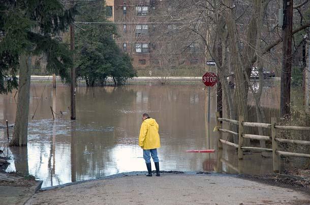
2 Flood Hazard Areas What is a 100-year flood? Better described as a 1% flood: a flood that has 1% percent probability of being equaled or exceeded in any one-year period
3 Flood Hazard Areas
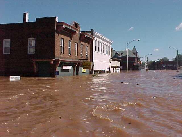
4 Flood Hazard Areas Approximately 35% of New Jersey lies in a flood hazard area
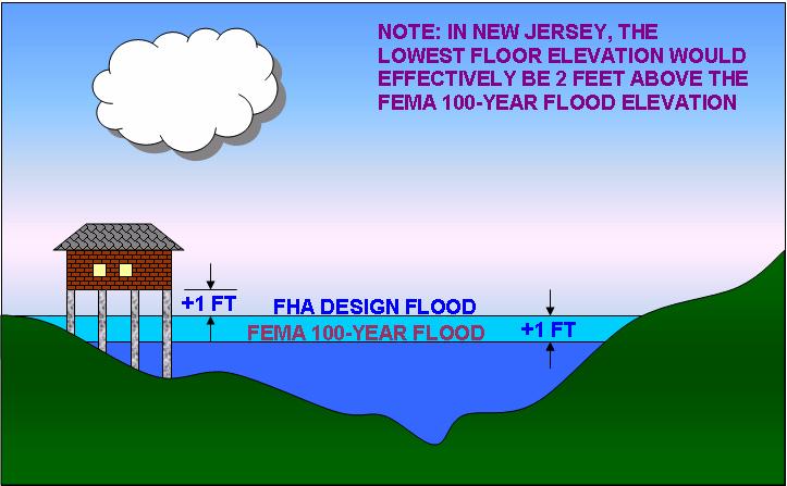
5 Flood Hazard Areas Area inundated by the flood hazard area design flood Under New Jersey laws: In tidal areas: equal to 100-yr (1%) flood In fluvial areas: equal to 100-yr (1%) flood plus a factor of safety
6 Flood Hazard Areas NJ laws add different factors of safety to the 100-year flood depending on the mapping resources available: NJ Studied add 25% additional flow FEMA Studied add 1 ft to the 100-year flood elevation (in fluvial areas) Applicant Studied add 25% additional flow

7 Flood Hazard Areas
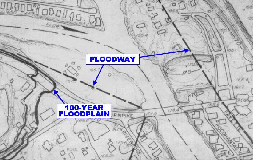
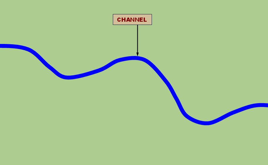
8 Flood Hazard Areas The flood hazard area is comprised of the floodway and the flood fringe
9 Floodway Conveys the majority of floodwater Structures & other materials can obstruct flow and increase flooding In New Jersey, it is calculated using a 0.2-ft rise in the 100-year flood elevation Outside NJ it is typically determined using a 1.0-ft rise, which is less stringent

10 Floodway
11 Floodway
12


13
14 Flood Fringe The portion of the flood hazard area outside the floodway Waters are less deep and move slower than in floodway Structures, fill and other material can displace flood storage volume and increase flooding
15
16
17
18
19
20
21
22 Flood Mapping Use the floodway limits exactly as shown on the maps Refer to the profile to find the design flood elevation, and determine the actual flood limit yourself
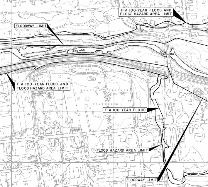
23
24
25 FEMA Mapping In New Jersey only used if no State mapping is available NJ Flood elevation equal to FEMA 100- year elevation in tidal areas NJ Flood elevation equal to 1 ft above FEMA 100-year elevation in fluvial areas
26
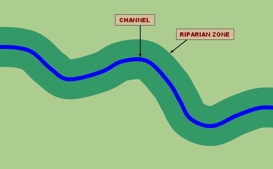
27

28

29

30
31 Theme of New Jersey s Law No Adverse Impact: Ensuring that the action of one property owner does not adversely impact the rights of other property owners, as measured by increased flood peaks, flood stage, flood velocity, and erosion and sedimentation (Association of State Floodplain Managers, NAI White Paper, April 29, 2004)
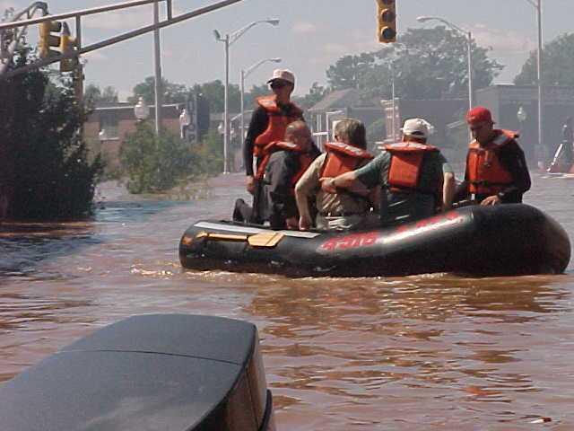
32 Goals Ensure flooding does not increase Preserve flood storage Prevent obstructions to flow Protect public safety Construct new buildings and roads above the flood hazard area elevation Provide healthy riparian corridors Preserve vegetation Protect habitat
33 Flood Hazard Area A flood hazard area exists along every regulated water that has a drainage area of 50 acres or more SEE N.J.A.C. 7:13-2.3(a)1
34 Riparian Zone A riparian zone exists along every regulated water, except there is no riparian zone along: The Atlantic Ocean Any manmade lagoon or stormwater management basin Any oceanfront barrier island, spit or peninsula Any piped section of an otherwise regulated water SEE N.J.A.C. 7:13-2.3(a)2
35 Regulated Activities 1. The alteration of topography through excavation, grading and/or placement of fill; 2. The clearing, cutting and/or removal of vegetation in a riparian zone; 3. The creation of impervious surface; 4. The storage of unsecured material; 5. The construction, reconstruction and/or enlargement of a structure; and 6. The conversion of a building into a private residence or a public building. SEE N.J.A.C. 7:13-2.4(a)
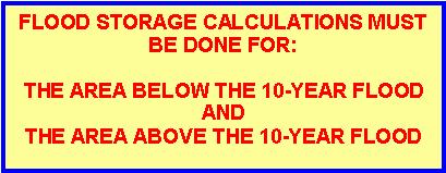
36 FLOOD STORAGE DISPLACEMENT 0% NET-FILL Most projects in New Jersey are not allowed to displace flood storage in a flood fringe All fill must be compensated for by creation of equal flood storage elsewhere nearby
37 FLOOD STORAGE DISPLACEMENT 0% NET-FILL APPLIES TO: The space between the flood hazard area design flood and the 10-year flood AND The space between the 10-year flood and the ground
38

39 Requirements for buildings
40 Requirements for buildings

41 Requirements for buildings

42 Requirements for buildings

43 Requirements for buildings
44
45
46
47
48

49 Riparian Zone Measures 50, 150 or 300 ft from a regulated water (previously 25 or 50 ft)
50
51
52

53
54
55 Any Questions? For more information contact: Vince Mazzei, PE NJDEP Division of Land Use Regulation PO Box 439 Trenton, NJ Phone: (609) Website:
Flood Hazard Area Control Act Rules
 An Overview of New Jersey s Flood Hazard Area Control Act Rules State of New Jersey Department of Environmental Protection Chingwah Liang Why Regulate NJ s Floodplains? 1. New Jersey endures enormous
Overview of Federal and State Floodplain Management Programs
 Overview of Federal and State Floodplain Management Programs Peter DeMeo, PE Supervising Environmental Engineer New Jersey Department of Environmental Protection Division of Land Use Regulation October
Regulatory Fee Schedule
 Regulatory Schedule STATE OF NEW JERSEY DEPARTMENT OF ENVIRONMENTAL PROTECTION DIVISION OF LAND USE REGULATION Website: www.state.nj.gov/dep/landuse Revised September 2017 All permit fees shall be paid
Chapter 5. Floodplain Management. 5.0 Introduction. 5.1 Floodplain Management and Regulation
 5.0 Introduction This chapter summarizes the Town s rules and regulations regarding floodplain management and development. The requirements presented in this chapter should be used by the design engineer
Chapter 5. Floodplain Management. 5.0 Introduction. 5.1 Douglas County Comprehensive Master Plan. 5.2 Floodplain Management and Regulation
 5.0 Introduction This chapter summarizes the County s rules and regulations regarding floodplain management and development. The requirements presented in this chapter should be used by the design engineer
Floodplain Development Land Use Review
 PUBLIC WORKS - COMMUNITY DEVELOPMENT 333 Broadalbin Street SW, PO Box 490, Albany, Oregon 97321-0144 BUILDING 541-917-7553 PLANNING 541-917-7550 Floodplain Development Land Use Review Application Information
Frequently Asked Questions for: Drainage, Watershed and Water Quality Property Owners Near Creeks Developers and Engineers and Definitions of Terms
 FREQUENTLY ASKED QUESTIONS Draft DEFINITIONS OF TERMS Last Revised July 2, 2008 Introduction: The following questions have been organized in the categories below. We have attempted to group the questions
(Chapter Flood Damage Prevention)
") Chapter 13.10 Flood Damage Prevention Section: 13.10.010 Purpose and Policy 13.10.020 Definitions 13.10.030 Applicability and Areas of Special Flood Hazard 13.10.040 Administration 13.10.050 Provisions
Chapter 13.10 Flood Damage Prevention Section: 13.10.010 Purpose and Policy 13.10.020 Definitions 13.10.030 Applicability and Areas of Special Flood Hazard 13.10.040 Administration 13.10.050 Provisions
PROJECT SCOPE OF WORK CITY OF TOWN AND COUNTRY STORMWATER PROGRAM
 PROJECT SCOPE OF WORK CITY OF TOWN AND COUNTRY STORMWATER PROGRAM Project ID Number: 2-2 Problem: The backyards at 962, 97, and 978 Delvin Drive are located in a low area of shallow ponding that takes
COMMUNITY DEVELOPMENT DEPARTMENT 333 Broadalbin Street SW, P.O. Box 490 Albany, OR 97321
 COMMUNITY DEVELOPMENT DEPARTMENT 333 Broadalbin Street SW, P.O. Box 490 Albany, OR 97321 Ph: 541-917-7550 Fax: 541-917-7598 www.cityofalbany.net STAFF REPORT Application for Site Plan Review SP-07-18 and
ORDINANCE NO (1123)
") ORDINANCE NO. 2013-08 (1123) ORDINANCE OF THE BOROUGH OF LAVALLLETTE, COUNTY OF OCEAN, STATE OF NEW JERSEY, AMENDING AND SUPPLEMENTING CHAPTER 31, ENTITLED FLOOD HAZARD AREAS, OF THE REVISED GENERAL ORDINANCES
ORDINANCE NO. 2013-08 (1123) ORDINANCE OF THE BOROUGH OF LAVALLLETTE, COUNTY OF OCEAN, STATE OF NEW JERSEY, AMENDING AND SUPPLEMENTING CHAPTER 31, ENTITLED FLOOD HAZARD AREAS, OF THE REVISED GENERAL ORDINANCES
ORDINANCE NO
 ORDINANCE NO. 14 126 Introduced by: Joseph M. Reda Date of introduction: TO AMEND CHAPTER 40 OF THE NEW CASTLE COUNTY CODE (ALSO KNOWN AS THE UNIFIED DEVELOPMENT CODE OR UDC ), ARTICLE 4 ( DISTRICT INTENSITY
MODEL FLOODPLAIN MANAGEMENT / FLOOD DAMAGE PREVENTION ORDINANCE
 MODEL FLOODPLAIN MANAGEMENT / FLOOD DAMAGE PREVENTION ORDINANCE Description: Floodplain management involves the designation of flood-prone areas and the managing of their uses. It is also aimed at minimizing
CITY OF AUSTELL DESIGN AND CONSTRUCTION STANDARDS LAND DEVELOPMENT ORDINANCES
 CITY OF AUSTELL DESIGN AND CONSTRUCTION STANDARDS LAND DEVELOPMENT ORDINANCES Land Development Ordinances Section 8 CITY OF AUSTELL DESIGN AND CONSTRUCTION STANDARDS LAND DEVELOPMENT ORDINANCES Article
A. Maintenance. All legally established, nonconforming structures can be maintained (e.g., painting and repairs);
;") Chapter 24.50 NONCONFORMING USES, STRUCTURES AND LOTS Sections: 24.50.010 Nonconforming uses, structures, and lots Purpose. 24.50.020 Nonconforming uses, structures, and lots Alteration or expansion of
Chapter 24.50 NONCONFORMING USES, STRUCTURES AND LOTS Sections: 24.50.010 Nonconforming uses, structures, and lots Purpose. 24.50.020 Nonconforming uses, structures, and lots Alteration or expansion of
CHAPTER XVII. REGULATION OF FLOOD PLAIN STATUTORY AUTHORIZATION, FINDINGS OF FACT, PURPOSE AND OBJECTIVES
 CHAPTER XVII. REGULATION OF FLOOD PLAIN ARTICLE 1.0 STATUTORY AUTHORIZATION, FINDINGS OF FACT, PURPOSE AND OBJECTIVES 17.0101 STATUTORY AUTHORIZATION The Legislature of the State of North Dakota has in
ORDINANCE NO TOWNSHIP OF EAST WINDSOR COUNTY OF MERCER
 ORDINANCE NO. 2016-07 TOWNSHIP OF EAST WINDSOR COUNTY OF MERCER AN ORDINANCE REPEALING SECTION 22-4: FLOOD DAMAGE PREVENTION CODE, OF THE REVISED GENERAL ORDINANCES OF THE TOWNSHIP OF EAST WINDSOR AND
SPECIAL PURPOSE FLOOD DAMAGE PREVENTION REGULATIONS for FAIRFIELD COUNTY
 SPECIAL PURPOSE FLOOD DAMAGE PREVENTION REGULATIONS for FAIRFIELD COUNTY Adopted September 7, 1995 Effective October 9, 1995 Flood Maps are available in the Fairfield County Regional Planning Commission
***** Subchapter A. GENERAL PROVISIONS ***** PERMIT APPLICATIONS
 105.11. Permit requirements. 105.12. Waiver of permit requirements. Title 25 Environmental Protection Part I. Department of Environmental Protection Subpart C. Protection of Natural Resources Article I.
ARTICLE 16. FLOODPLAIN MANAGEMENT, EROSION AND SEDIMENT CONTROL, AND STORMWATER MANAGEMENT
 ARTICLE 16. FLOODPLAIN MANAGEMENT, EROSION AND SEDIMENT CONTROL, AND STORMWATER MANAGEMENT Title 1. DEFINITIONS AND GENERAL PROVISIONS 2. FLOODPLAIN MANAGEMENT 3. EROSION AND SEDIMENT CONTROL 4. STORMWATER
BACKGROUND There are 23 flood control structures in the Upper Brushy Creek Water Control and Improvement District (District). See attached map.
. See attached map.") BACKGROUND There are 23 flood control structures in the Upper Brushy Creek Water Control and Improvement District (District). See attached map. The U.S Department of Agriculture - Natural Resources Conservation
BACKGROUND There are 23 flood control structures in the Upper Brushy Creek Water Control and Improvement District (District). See attached map. The U.S Department of Agriculture - Natural Resources Conservation
A Flood Mitigation Plan for the Non-Tidal, N.J. Section of the Delaware River Basin
 A Flood Mitigation Plan for the Non-Tidal, N.J. Section of the Delaware River Basin Laura Tessieri, P.E., CFM Delaware River Basin Commission July 16, 2008 Commission Meeting Overall Goal of Plan: To make
Drainage Maintenance Policy
 Drainage Maintenance Policy The purpose of this Drainage Maintenance Policy is to clarify how the City of McKinney may address various drainage and stormwater related concerns of residents. BACKGROUND
FREQUENTLY USED PLANNING & ZONING TERMS
 City Of Mustang FREQUENTLY USED PLANNING & ZONING TERMS Abut: Having property lines, street lines, or zoning district lines in common. Accessory Structure: A structure of secondary importance or function
Land Use Application
 Land Use Application Check all permits you are applying for in the boxes provided. Submit this application form, the applicable materials listed in the corresponding permit application packet(s) and application
Flood Hazard Development Permit Application & Permit Forms. For Communities with Coastal Velocity Zones [60.3(e)] CONTENTS
![Flood Hazard Development Permit Application & Permit Forms. For Communities with Coastal Velocity Zones [60.3(e)] CONTENTS](/thumbs/76/74346075.jpg "Flood Hazard Development Permit Application & Permit Forms. For Communities with Coastal Velocity Zones [60.3(e)] CONTENTS") Flood Hazard Development Permit Application & Permit Forms For Communities with Coastal Velocity Zones [60.3(e)] CONTENTS 1. Decision Tree 2. Flood Hazard Development Permit Application 3. Flood Hazard
Flood Hazard Development Permit Application & Permit Forms For Communities with Coastal Velocity Zones [60.3(e)] CONTENTS 1. Decision Tree 2. Flood Hazard Development Permit Application 3. Flood Hazard
GRANT OF CONSERVATION RESTRICTION (Wetland Mitigation/Riparian Zone Mitigation) WITNESSETH:
 WITNESSETH:") NJDEP File No.: Prepared by: GRANT OF CONSERVATION RESTRICTION (Wetland Mitigation/Riparian Zone Mitigation) THIS GRANT OF CONSERVATION RESTRICTION is made this day of 20, by, its heirs, successors and
NJDEP File No.: Prepared by: GRANT OF CONSERVATION RESTRICTION (Wetland Mitigation/Riparian Zone Mitigation) THIS GRANT OF CONSERVATION RESTRICTION is made this day of 20, by, its heirs, successors and
River Road - Civil Design Report. Appendix D. Flood Hazard Map. Beca //04 August // NZ // page 38
 River Road - Civil Design Report Appendix D Flood Hazard Map Beca //04 August 2016 3124460 // NZ1-12891696-39 0.39 // page 38 Regional scale flood hazard mapping Waikato Regional Council holds regional
Township of Little Egg Harbor Planning Board 665 Radio Road Little Egg Harbor, New Jersey Phone: ext. 221 Fax:
 BLOCK(S) LOT(S) Township of Little Egg Harbor Planning Board 665 Radio Road Little Egg Harbor, New Jersey 08087 Phone: 609-296-7241 ext. 221 Fax: 609-294-3040 Development Application Amended Development
State, County, or Municipal Agency or instrumentality thereof, applying for authorization
 Application for Project Authorization Under the New Jersey Register of Historic Places Act NJ Department of Environmental Protection Natural & Historic Resources Historic Preservation Office Date September
SPECIAL PURPOSE FLOOD DAMAGE PREVENTION ORDINANCE. Adopted: June 24th, 1998
 SPECIAL PURPOSE FLOOD DAMAGE PREVENTION ORDINANCE Adopted: June 24th, 1998 SECTION 1.0 STATUTORY AUTHORIZATION, FINDINGS OF FACT PURPOSE AND OBJECTIVES 1.1 STATUTORY AUTHORIZATION ARTICLE XVIII, Section
Prepared by and to be returned to Linn County Planning & Development nd Street S.W., Cedar Rapids, Iowa (319)
") Prepared by and to be returned to Linn County Planning & Development 935 2 nd Street S.W., Cedar Rapids, Iowa 52404-2161 (319) 892-5130 LINN COUNTY, IOWA ZONING BOARD OF ADJUSTMENT IN THE MATTER OF THE
Prepared by and to be returned to Linn County Planning & Development 935 2 nd Street S.W., Cedar Rapids, Iowa 52404-2161 (319) 892-5130 LINN COUNTY, IOWA ZONING BOARD OF ADJUSTMENT IN THE MATTER OF THE
ORDINANCE NO. 992 CITY OF OCEAN SHORES, WASHINGTON
 CITY OF OCEAN SHORES, WASHINGTON ORDINANCE NO. 992 AN EMERGENCY ORDINANCE OF THE CITY COUNCIL OF THE CITY OF OCEAN SHORES, WASHINGTON, AMENDING ORDINANCE NO. 990 AND OCEAN SHORES MUNICIPAL CODE CHAPTER
COMMERCIAL SITE DEVELOPMENT GUIDE FOR UNINCORPORATED ST. CHARLES COUNTY
 COMMERCIAL SITE DEVELOPMENT GUIDE FOR UNINCORPORATED ST. CHARLES COUNTY GENERAL INFORMATION: This brochure is to be used as a guide and is not intended to amend or supersede the corresponding County ordinances
ANDOVER CODE. Checklist #5 Preliminary Site Plan Conditional Use
 ANDOVER CODE Checklist #5 Preliminary Site Plan Conditional Use Applicant: Block Lot File No. This checklist is for general reference only. Further information may be required by the reviewing authority.
(Ord. No. 743, )
") CHAPTER 330. - FLOODPLAIN MANAGEMENT Section 330-1. - Purpose. (a) (b) (c) (d) It is hereby determined that the flood hazard areas of the City of Chamblee are subject to periodic inundation which may result
CHAPTER 330. - FLOODPLAIN MANAGEMENT Section 330-1. - Purpose. (a) (b) (c) (d) It is hereby determined that the flood hazard areas of the City of Chamblee are subject to periodic inundation which may result
MANSFIELD TOWNSHIP BURLINGTON COUNTY ORDINANCE
 MANSFIELD TOWNSHIP BURLINGTON COUNTY ORDINANCE 2017-15 AN ORDINANCE TO AMEND THE CODE OF THE TOWNSHIP OF MANSFIELD BY DELETING AND REPEALING CHAPTER 22 THEREOF, ENTITLED FLOOD DAMAGE PREVENTION, AND REPLACING
Watershed Planning Regulations Oklahoma Municipal City of Tulsa. Urban; Suburban City of Tulsa Watershed Development Regulations. Abstract.
 Topic: Resource Type: State: Jurisdiction Type: Municipality: Year (adopted, written, etc.): 1989 Community Type applicable to: Title: Watershed Planning Regulations Oklahoma Municipal City of Tulsa Document
ORDINANCE NO. 990 CITY OF OCEAN SHORES, WASHINGTON. NOW, THEREFORE, the City Council of the Ocean Shores does hereby ordain as follows:
 CITY OF OCEAN SHORES, WASHINGTON ORDINANCE NO. 990 AN ORDINANCE OF THE CITY COUNCIL OF THE CITY OF OCEAN SHORES, WASHINGTON, AMENDING OCEAN SHORES MUNICIPAL CODE CHAPTER 15.36 FLOOD DAMAGE PREVENTION WHEREAS,
THIS ARTICLE HAS BEEN COMPLETELY REWRITTEN. Chapter CRITICAL AREAS. Article XIX. Flood Hazard Areas. Article XIX. Flood Hazard Areas
 THIS ARTICLE HAS BEEN COMPLETELY REWRITTEN Chapter 18.55 CRITICAL AREAS Sections: Article XIX. Flood Hazard Areas 18.55.700 Purpose. 18.55.705 Definitions 18.55.707 Lands to which this article applies.
Chapter 136. SOIL EROSION
 1 of 8 12/19/2011 4:17 PM Township of Andover, NJ Monday, December 19, 2011 Chapter 136. SOIL EROSION [HISTORY: Adopted by the Township Committee of the Township of Andover by Ord. No. 77-11 (Ch. XVII
LINCOLN COUNTY FLOOD DAMAGE PREVENTION ORDINANCE
 LINCOLN COUNTY FLOOD DAMAGE PREVENTION ORDINANCE SECTION 1.0 STATUTORY AUTHORIZATION, FINDINGS OF FACT, PURPOSE AND OBJECTIVES SECTION 2 DEFINITIONS SECTION 3.0 GENERAL PROVISIONS SECTION 4.0 ADMINISTRATION
COUNTY OF SAN MATEO PLANNING AND BUILDING DEPARTMENT
 COUNTY OF SAN MATEO PLANNING AND BUILDING DEPARTMENT DATE: May 13, 2015 TO: FROM: Planning Commission Planning Staff SUBJECT: Consideration of amendments to the San Mateo County Zoning Regulations (Chapter
CITY OF CAMBRIDGE FLOODPLAIN MANAGEMENT CHAPTER 7 (GRADING, EROSION AND SEDIMENT CONTROL)
") CITY OF CAMBRIDGE FLOODPLAIN MANAGEMENT CHAPTER 7 (GRADING, EROSION AND SEDIMENT CONTROL) City of Cambridge, MD Floodplain Management Ordinance (Tidal): May, 2011 1 City of Cambridge, Maryland Floodplain
CITY OF CAMBRIDGE FLOODPLAIN MANAGEMENT CHAPTER 7 (GRADING, EROSION AND SEDIMENT CONTROL) City of Cambridge, MD Floodplain Management Ordinance (Tidal): May, 2011 1 City of Cambridge, Maryland Floodplain
ORDINANCE NO. 14 C2-) AN ORDINANCE OF THE COUNTY OF VENTURA REPEALING AND REENACTING THE VENTURA COUNTY FLOODPLAIN MANAGEMENT ORDINANCE SECTION 1
 AN ORDINANCE OF THE COUNTY OF VENTURA REPEALING AND REENACTING THE VENTURA COUNTY FLOODPLAIN MANAGEMENT ORDINANCE SECTION 1") ORDINANCE NO. 14 C2-) AN ORDINANCE OF THE COUNTY OF VENTURA REPEALING AND REENACTING THE VENTURA COUNTY FLOODPLAIN MANAGEMENT ORDINANCE The Board of Supervisors of the County of Ventura ordains as follows:
ORDINANCE NO. 14 C2-) AN ORDINANCE OF THE COUNTY OF VENTURA REPEALING AND REENACTING THE VENTURA COUNTY FLOODPLAIN MANAGEMENT ORDINANCE The Board of Supervisors of the County of Ventura ordains as follows:
YOLO COUNTY ZONING CODE TITLE 8 LAND DEVELOPMENT CHAPTER 4: FLOOD PROTECTION. Article 1: Findings of Fact, Purpose and Methods
 YOLO COUNTY ZONING CODE TITLE 8 LAND DEVELOPMENT CHAPTER 4: FLOOD PROTECTION Article 1: Findings of Fact, Purpose and Methods Sec. 8-4.101 Statutory authorization The Legislature of the State of California
SECTION A-1500 UNIFIED DEVELOPMENT ORDINANCE SECTION A-1600
 SECTION A-1500 UNIFIED DEVELOPMENT ORDINANCE SECTION A-1600 SECTION A-1600. s. A. General. All proposed plats submitted for approval under the provisions of the UDO shall allocate sufficient easement areas
TITLE 14 ZONING AND LAND USE CONTROL CHAPTER 1 MUNICIPAL PLANNING COMMISSION
 14-1 TITLE 14 ZONING AND LAND USE CONTROL CHAPTER 1. MUNICIPAL PLANNING COMMISSION. 2. ZONING ORDINANCE. 3. FLOOD DAMAGE PREVENTION ORDINANCE. CHAPTER 1 MUNICIPAL PLANNING COMMISSION SECTION 14-101. Creation
FLOODWAY DEVELOPMENT REGULATION
 Floodway Development Regulation Task Force Discussion Paper FLOODWAY DEVELOPMENT REGULATION Dated: August 20, 2014 Table of Contents 1. Introduction... 3 2. General Background... 3 3. List of Task Force
Title 15. Buildings, Construction, Addressing and Land Use
 Chapters: 15.05 Land Use Fees 15.10 Flood Damage Prevention 15.15 Building Numbering Title 15 Buildings, Construction, Addressing and Land Use 15-1 Lyons Municipal Code 15.05.040 Chapter 15.05 Land Use
CHAPTER 109 NATURAL RESOURCES AND ENVIRONMENTAL PROTECTION. ARTICLE I. Flood Damage Prevention In General
 Sec. 109-1. - Authorization. CHAPTER 109 NATURAL RESOURCES AND ENVIRONMENTAL PROTECTION ARTICLE I. Flood Damage Prevention In General Article IX, Section II of the Constitution of the State of Georgia
ZONING COMPLIANCE PERMIT APPLICATION
 Description of Work Property Contractor Owner Applicant Corporation of Harpers Ferry Listed on the National Registry of Historic Places 1000 Washington Street P.O. Box 217 Harpers Ferry, West Virginia
ARTICLE IV NATURAL FEATURES PROTECTION
 ARTICLE IV NATURAL FEATURES PROTECTION Section 400. STATEMENT OF INTENT The standards and requirements in this Part are intended to afford appropriate levels of protection to those natural features within
Public Access Rules Draft August 16, 2010
 NOTE: In the spirit of Governor Chris Christie's Executive Order No. 2, this document is provided as a DRAFT of a proposed rule. Comments will be accepted through Wednesday, September 1, 2010 (email Marybeth.Brenner@dep.state.nj.us).
Chapter 100 Planned Unit Development in Corvallis Urban Fringe
 100.100 Scope and Purpose. Chapter 100 Planned Unit Development in Corvallis Urban Fringe (1) All applications for land divisions in the Urban Residential (UR) and Flood Plain Agriculture (FPA) zones within
CHAPTER 47. FLOODPLAIN MANAGEMENT REGULATIONS. Article I. Statutory Authorization, Findings of Fact, Purpose and Methods. Article II. Definitions.
 CHAPTER 47. FLOODPLAIN MANAGEMENT REGULATIONS. Article I. Statutory Authorization, Findings of Fact, Purpose and Methods. Sec. 47 Sec. 47-1. Sec. 47-2. Sec. 47-3. Sec. 47-4. Statutory authorization. Findings
TOWNSHIP OF BASS RIVER Ordinance 2017-
 TOWNSHIP OF BASS RIVER Ordinance 2017- AN ORDINANCE OF THE TOWNSHIP OF BASS RIVER AMENDING CHAPTER 15.24 FLOOD HAZARD AREAS OF THE REVISED ORDINANCES OF BASS RIVER TOWNSHIP WHEREAS, the Bass River Township
Prepared by and to be returned to Linn County Planning & Development nd Street S.W., Cedar Rapids, Iowa (319)
") Prepared by and to be returned to Linn County Planning & Development 935 2 nd Street S.W., Cedar Rapids, Iowa 52404-2161 (319) 892-5130 LINN COUNTY, IOWA ZONING BOARD OF ADJUSTMENT In the matter of the
Prepared by and to be returned to Linn County Planning & Development 935 2 nd Street S.W., Cedar Rapids, Iowa 52404-2161 (319) 892-5130 LINN COUNTY, IOWA ZONING BOARD OF ADJUSTMENT In the matter of the
The Board of Supervisors of the County of Riverside ordains as follows:
 ORDINANCE NO. 458 (AS AMENDED THROUGH 458.13) AN ORDINANCE OF THE COUNTY OF RIVERSIDE AMENDING ORDINANCE NO. 458 REGULATING FLOOD HAZARD AREAS AND IMPLEMENTING THE NATIONAL FLOOD INSURANCE PROGRAM The
TOWN OF WILMINGTON FLOOD AND FLUVIAL EROSION HAZARD REGULATIONS
 Draft Wilmington Flood Hazard Regulation February 2019 TOWN OF WILMINGTON FLOOD AND FLUVIAL EROSION HAZARD REGULATIONS Contents 600. Statutory Authorization and Effect... 1 601. Statement of Purpose...
UNIFORM REGULATIONS FOR THE CONTROL OF DRAINAGE
 UNIFORM REGULATIONS FOR THE CONTROL OF DRAINAGE CLARK COUNTY CITY OF BOULDER CITY CITY OF HENDERSON CITY OF LAS VEGAS CITY OF MESQUITE CITY OF NORTH LAS VEGAS CLARK COUNTY REGIONAL FLOOD CONTROL DISTRICT
Oxford Floodplain Management Ordinance
 Table of Contents SECTION 1.0 GENERAL PROVISIONS...1 1.1 Findings...1 1.2 Statutory Authorization...1 1.3 Statement of Purpose...1 1.4 Areas to Which These Regulations Apply...2 1.5 Basis for Establishing
DIVISION 1. - GENERAL PROVISIONS
 Sec. 90-708. - Statutory authorization and purpose. Sec. 90-709. - Applicability. Sec. 90-710. - Compliance and liability. Sec. 90-711. - Records. Sec. 90-712. - Abrogation and greater restrictions. Sec.
Amendments to Chapter proposed by the Assembly Title 21 Committee
 Amendments to Chapter 21.04 proposed by the Assembly Title 21 Committee All page numbers refer to the S version. PZC recommended additions are underlined. PZC recommended deletions are in [BRACKETS AND
THE COUNTY BOARD OF SUPERVISORS OF THE COUNTY OF DOUGLAS DOES ORDAIN AS FOLLOWS:
 8.4 SHORELAND ZONING ORDINANCE THE COUNTY BOARD OF SUPERVISORS OF THE COUNTY OF DOUGLAS DOES ORDAIN AS FOLLOWS: SECTION I. STATUTORY AUTHORIZATION, FINDING OF FACT, STATEMENT OF PURPOSE, AND TITLE 1.1
Article 5. Environmentally Sensitive Areas
 Article 5. Environmentally Sensitive Areas This Article establishes standards and regulations governing environmental constraints. These regulations are intended to encourage preservation of lands designated
ENVIRONMENTAL AND RESOURCE PROTECTION
 CHAPTER THREE ENVIRONMENTAL AND RESOURCE PROTECTION Page 3.00.00 GENERALLY 3-3 3.00.01 Purpose and Intent 3-3 3.00.02 Applicability 3-3 3.01.00 ENVIRONMENTALLY SENSITIVE LANDS AND HABITATS 3-3 3.01.01
CHAPTER 13 WINCHESTER WETLANDS BYLAW
 CHAPTER 13 WINCHESTER WETLANDS BYLAW Section 1. PURPOSE The purpose of this by-law is to protect the wetlands, related water resources, and adjoining land areas in the town by prior review and control
CHAPTER 5 FLOOD DAMAGE PREVENTION. Statutory Authorization, Findings of Fact, Purpose, Methods, and Definitions
 CHAPTER 5 FLOOD DAMAGE PREVENTION Article A. Section 5.1 Section 5.2 Section 5.3 Section 5.4 Section 5.5 Article B. Statutory Authorization, Findings of Fact, Purpose, Methods, and Definitions Statutory
SUBDIVISION APPLICATION
 SUBDIVISION APPLICATION Community Planning and Economic Development Development Services Division 250 South 4 th Street, Room 300 Minneapolis MN 55415-1316 612-673-3000 This application packet is used
Dedicated program for municipal drainage management
 Dedicated program for municipal drainage management Street drainage evaluation and repairs Maintenance of pipes and drainage structures Mowing, debris and vegetation removal Erosion control and re-grading
ORDINANCE NO. 13-_2_2
 ORDINANCE NO. 13-_2_2 AN ORDINANCE BY THE BOARD OF COUNTY COMMISSIONERS AMENDING THE BAY COUNTY CODE OF ORDINANCES TO REPEAL CHAPTER 9 DRAINAGE, ARTICLE II, FLOODPLAINS; TO ADOPT A NEW CHAPTER 9 DRAINAGE,
MWRDGC s Flood Prone Property Acquisition Program
 MWRDGC s Flood Prone Property Acquisition Program IAFSM Conference March 9, 2017 Program History Legislative Authority in 2014 Program Initiated in 2015 Partnered in 5 Intergovernmental Agreements to acquire
4. facilitate the construction of streets, utilities and public services in a more economical and efficient manner;
 PVPC MODEL BYLAW BY-RIGHT CLUSTER ZONING BYLAW Prepared by Pioneer Valley Planning Commission Revised: October 2001 1.00 Development 1.01 Development Allowed By Right Development in accordance with this
An Ordinance of the City of Shady Cove, Oregon An Oregon Municipal Corporation
 An Ordinance of the City of Shady Cove, Oregon An Oregon Municipal Corporation ORDINANCE NO. 259 Establishing Regulations To Prevent Flood Damage Within The City Of Shady Cove, Oregon, Adopting Related
Finnerty, Shawn & Lori Water Front Setback
 BONNER COUNTY PLANNING DEPARTMENT BOARD OF COUNTY COMMISSIONERS STAFF REPORT FOR JANUARY 10, 2018 Project Name: Finnerty, Shawn & Lori Water Front Setback File Number, Type: FILE #V492-17, Variance Request
MINOR SUBDIVISION APPLICATION
 MINOR SUBDIVISION APPLICATION Complete with required information (write "n/a" if information is not applicable to proposal). Title of Plat Has any other plat been recorded for this site? ( ) Yes ( ) No
A. To prevent unwise development from increasing flood or drainage hazards to others.
 BOONE COUNTY FLOOD HAZARD AREA Ordinance No. 94 14 (September 19, 1994) Amended Ordinance No. 98 2 (April 6, 1998) Amended Ordinance No. 02 6 (June 3, 2002) SECTION 1 STATUTORY AUTHORIZATION The Indiana
Floodway and Flood Plain Districts
 Chapter 6 Floodway and Flood Plain Districts 6.010 - Purpose To establish land use regulations for properties situated in floodways and flood plain lands so as to: A. Minimize property damage from flood
COMMUNITY DEVELOPMENT DEPARTMENT 333 Broadalbin Street SW, P.O. Box 490 Albany, OR 97321
 COMMUNITY DEVELOPMENT DEPARTMENT 333 Broadalbin Street SW, P.O. Box 490 Albany, OR 97321 STAFF REPORT Application for Site Plan Review (SP-02-18) Residential Accessory Building Ph: 541-917-7550 Fax: 541-917-7598
NOTICE OF LAND USE DECISION BY THE COOS COUNTY PLANNING DIRECTOR
 NOTICE OF LAND USE DECISION BY THE COOS COUNTY PLANNING DIRECTOR Coos County Planning 225 N. Adams St. Coquille, OR 97423 http://www.co.coos.or.us/ Phone: 541-396-7770 Fax: 541-396-1022 This notice is
Finnerty, Shawn & Lori Water Front Setback
 BONNER COUNTY PLANNING DEPARTMENT PLANNING AND ZONING COMMISSION STAFF REPORT FOR NOVEMBER 2, 2017 Project Name: Finnerty, Shawn & Lori Water Front Setback File Number, Type: FILE #V492-17, Variance Request
PROTOCOL FOR ZONING PERMIT SUBMITTAL
 CALN TOWNSHIP Department of Code Enforcement Andrew F. Reczek, Director of Code Enforcement & Zoning Officer Raymond Stackhouse, Code Official &Fire Marshal Joseph Arvay, Property Main./Housing Inspector
Wood County Shoreland Zoning Ordinance For Wisconsin s Shoreland Protection Program
 Wood County Shoreland Zoning Ordinance For Wisconsin s Shoreland Protection Program October 1, 2014 Revised January 12, 2015 Revised September 16, 2015 (2015 Wisconsin Act 55) Revised March 2, 2016 (2015
VILLAGE OF ASHVILLE DEPARTMENT OF PUBLIC UTILITIES DIVISION OF STORMWATER MANAGEMENT STORMWATER MANAGEMENT PROGRAM STORMWATER CREDIT MANUAL
 VILLAGE OF ASHVILLE DEPARTMENT OF PUBLIC UTILITIES DIVISION OF STORMWATER MANAGEMENT STORMWATER MANAGEMENT PROGRAM STORMWATER CREDIT MANUAL SECTION I. OVERVIEW AND GENERAL INSTRUCTIONS INTRODUCTION A stormwater
Restrict or prohibit uses which are dangerous to health, safety and property due to water or erosion or in flood heights or velocities;
 CODE OF ORDINANCES, CITY OF BRISTOL, CONNECTICUT APPENDIX D, FLOOD DAMAGE PREVENTION (adopted on August 12, 2008) SECTION 1 - STATUTORY AUTHORIZATION, FINDING OF FACT, PURPOSE AND OBJECTIVES 1.1. Statutory
ORDINANCE # ARTICLE I STATUTORY AUTHORIZATION, FINDINGS OF FACT, PURPOSE AND METHODS
 60.3 (b) FLOOD DAMAGE PREVENTION ORDINANCE ORDINANCE #2009-07 ARTICLE I STATUTORY AUTHORIZATION, FINDINGS OF FACT, PURPOSE AND METHODS SECTION A. STATUTORY AUTHORIZATION The Legislature of the State of
Chapter FLOODPLAIN MANAGEMENT
 Chapter 16.20 FLOODPLAIN MANAGEMENT Sections: 16.20.010 Statutory authorization. 16.20.020 Findings of fact. 16.20.030 Statement of purpose. 16.20.035 Methods of reducing flood losses. 16.20.040 Definitions.
ORDINANCE NO. XX-16. WHEREAS, the City Commission of the City of Delray Beach adopts the findings in the Planning and Zoning Staff Report; and
 ORDINANCE NO. XX-16 AN ORDINANCE OF THE CITY COMMISSION OF THE CITY OF DELRAY BEACH, FLORIDA, AMENDING THE LAND DEVELOPMENT REGULATIONS OF THE CODE OF ORDINANCES, BY REPEALING SECTION 4.5.3, FLOOD DAMAGE
CITY OF OAK RIDGE KAUFMAN COUNTY, TEXAS ORDINANCE FLOODPLAIN MANAGEMENT
 CITY OF OAK RIDGE KAUFMAN COUNTY, TEXAS ORDINANCE 32-10 FLOODPLAIN MANAGEMENT ARTICLE I STATUTORY AUTHORIZATION, FINDINGS OF FACT, PURPOSE AND METHODS SECTION A. STATUTORY AUTHORIZATION The Legislature
2014 UPDATED YOLO COUNTY CODE. Title 8 LAND DEVELOPMENT CHAPTER 4: FLOOD PROTECTION. Article 1: Findings of Fact, Purpose and Methods
 2014 UPDATED YOLO COUNTY CODE Title 8 LAND DEVELOPMENT CHAPTER 4: FLOOD PROTECTION Article 1: Findings of Fact, Purpose and Methods Sec. 8-4.101 Findings of fact The special flood hazard areas of Yolo
FLOOD HAZARD (FH) ZONING DISTRICT OR FLOOD HAZARD OVERLAY ZONE (Ord A, 10/20/2009) 1.0 INTRODUCTION
 ZONING DISTRICT OR FLOOD HAZARD OVERLAY ZONE (Ord A, 10/20/2009) 1.0 INTRODUCTION") Page 1 of 27 SECTION 29.4 FLOOD HAZARD (FH) ZONING DISTRICT OR FLOOD HAZARD OVERLAY ZONE (Ord. 315-776A, 10/20/2009) 1.0 INTRODUCTION 1.1 STATUTORY AUTHORIZATION: The Legislature of the State of California
Page 1 of 27 SECTION 29.4 FLOOD HAZARD (FH) ZONING DISTRICT OR FLOOD HAZARD OVERLAY ZONE (Ord. 315-776A, 10/20/2009) 1.0 INTRODUCTION 1.1 STATUTORY AUTHORIZATION: The Legislature of the State of California
LEE COUNTY ORDINANCE NO
 LEE COUNTY ORDINANCE NO. 15-09 AN ORDINANCE AMENDING LEE COUNTY LAND DEVELOPMENT CODE CHAPTERS 6 AND 10 AND CERTAIN SECTIONS OF THE FLORIDA BUILDING CODE TO AUTHORIZE THE BOARD OF ADJUSTMENTS AND APPEALS
CHARLES CITY COUNTY SITE PLAN ORDINANCE. This Ordinance shall be known as the Charles City County Site Plan Ordinance.
 CHARLES CITY COUNTY SITE PLAN ORDINANCE Section 1. Title This Ordinance shall be known as the Charles City County Site Plan Ordinance. Section 2. Authority. This Ordinance is enacted pursuant to the authority
PERMIT APPLICATION FORM
 CVCA File #: P.O. Box 416, 70 Hughes Lane, Marmora, ON K0K 2M0 Tel: 613-472-3137 Fax: 613-472-5516 www.crowevalley.com PERMIT APPLICATION FORM FOR A DEVELOPMENT, INTERFERENCE WITH WETLANDS AND ALTERATIONS
Flood Plain Management
 Ordinance No. 40 AN ORDINANCE establishing Flood Plain Management regulations in the un-incorporated area of Monroe County. The Legislature of the State of Iowa has in Chapter 335 Code of Iowa, as amended,
APPLICATION PROCEDURE
 ANTRIM PLANNING BOARD P. O. Box 517 Antrim, New Hampshire 03440 Phone: 603-588-6785 FAX: 603-588-2969 APPLICATION FORM AND CHECKLIST FOR EARTH EXCAVATION AND RECLAMATION File # Date Received By APPLICATION
Published in 2018 by Order of the Zoning Administrator PREFACE MEEKER COUNTY LAND DEVELOPMENT ORDINANCES
 MEEKER COUNTY LAND DEVELOPMENT ORDINANCES Published in 2018 by Order of the Zoning Administrator PREFACE This book constitutes a publication of the Meeker County Land Development Ordinances. Source materials
ORDINANCE NO NOW, THEREFORE, BE IT ORDAINED by the Town Council of the Town of Indian
 ORDINANCE NO. 509 AN ORDINANCE BY THE TOWN OF INDIAN RIVER SHORES, FLORIDA AMENDING THE CODE OF ORDINANCES TO REPEAL CHAPTER 165 OF THE LAND DEVELOPMENT CODE; TO ADOPT A NEW CHAPTER 165 OF THE LAND DEVELOPMENT
ORDINANCE NO
 ORDINANCE NO. 22-2014 AN ORDINANCE BY THE CITY COUNCIL AMENDING THE CITY OF SEMINOLE CODE OF ORDINANCES TO REPEAL CHAPTER 62, ARTICLE IV. FLOODPLAINS, DIVISIONS 1 THROUGH 3, SECTION 62-251 THROUGH SECTION