State, County, or Municipal Agency or instrumentality thereof, applying for authorization
|
|
|
- Lorena Goodwin
- 5 years ago
- Views:
Transcription

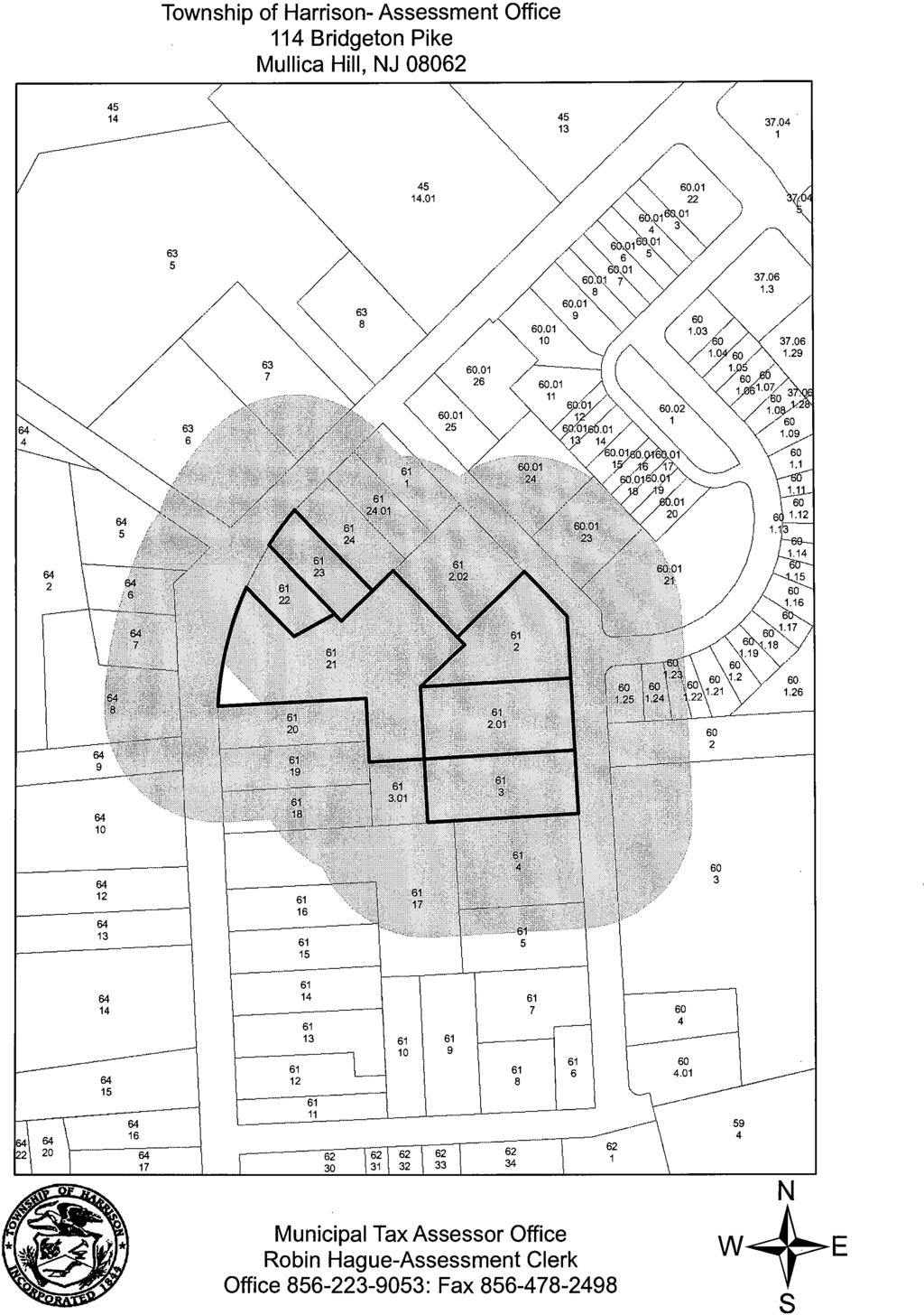
1 Application for Project Authorization Under the New Jersey Register of Historic Places Act NJ Department of Environmental Protection Natural & Historic Resources Historic Preservation Office Date September 22, 2009 Applicant Gloucester County State, County, or Municipal Agency or instrumentality thereof, applying for authorization Note: If an application is being submitted by an authorized representative on behalf of a public agency, written authorization from the public agency must be submitted with the application. Project Name Mullica Hill Bypass Contact Person(s) Vincent Voltaggio, PE, Gloucester Co. Engineer Address 1200 N. Delsea Drive, Clayton, NJ Telephone FAX vvoltaggio@co.gloucester.nj.us (FOR HPO USE ONLY) Technically and Professionally Complete Date New Jersey Register Listed Property Affected by Project Name of listed Property or Historic District Mullica Hill Historic District Address of listed property Several properties on North Main Street, and 26 Earlington Road Block # /Lot # : Block 64/ Lot 5, Block 64/ Lot 6, Block 64/ Lot 7, Block 61/Lot 21, Block 61/Lot 20 Municipality Harrison Township County Gloucester A. Required Documentation Please enclose the documentation listed below as required by N.J.A.C. 7:4-7.1 (d). The required documentation, taken with the project description, must be sufficient to completely describe the proposed undertaking. When using attachments, please label using the letters and numbers (e.g. A.1.c.) as listed herein. 1. Complete lists (include addresses) of: a. Local historical societies b. Local historic preservation commissions c. All public and private property owners of registered property directly affected by the project. N.J.A.C. 7:4-7.1(d) stipulates that this list shall be the lists of all private and public property owners (including right-of-way owners) named in the official municipal tax records and maps as of the date of the application s submission and shall be notarized by the appropriate municipal official. This list is not the list of property owners within 200 feet of the project; (although submission of that list would be acceptable) it is the list of owners of registered properties which are directly physically impacted by the project.
2 d. All affected local government units, any agencies or instrumentalities thereof concerned with historic preservation, and any statewide organization and local organization specifically concerned with historic preservation in the area of the undertaking s potential impact. Applications which do not include these four lists are not complete and cannot be reviewed until this information is received. 2. Maps 3. Photographs, both of the overall project area and of specific project work areas. Photographs should be labeled as to location and keyed to a plan sheet. (Although optional, slides may augment the application and facilitate the presentation to the Historic Sites Council of a project that is an encroachment.) Photographs should be labeled identifying site location and keyed to architectural or engineering plans. 4. Complete architectural or engineering plans-including a site plan (2 sets) 5. Specification (1 set) 6. Proposed agreements (easements, lease, deed, covenant etc.) applicable to the undertaking. 7. In the application proposes demolition of all or a substantial portion of a property, the application shall include a structural assessment and an evaluation of whether the property could be reasonably repaired, to be prepared by an architect or engineer with demonstrated experience with historic properties. 8. If the application proposes relocation of a New Jersey Register listed property, information and documentation required in N.J.A.C. 7:4-3.2(c) must also be submitted. B. Project Description Please describe the proposed undertaking in full detail. Where functional or programmatic constrains call for changes to historic configurations, those constrains should be explained very clearly. (Use lettered attachments when necessary.) Traffic congestion along North Main Street, which lies in a Historic District (District), has increase in the past 20 years to an unsafe and unmanageable level. Various local and County agencies feel that the heavy volumes of traffic through the District is contributing to the degradation of the historic resources. Gloucester County conducted a study to explore the available options to mitigate the traffic congestion and improve safety in Mullica Hill along North Main Street. The purpose of the study was to identify alternative improvement schemes that would result in a reduction of the congestion in the Historic District, while minimizing impact on historic properties. To minimize the effect of this project within the Historic District, improvements to North Main Street were ruled out, as they would negatively affect the historic properties within the district. The preferred alternative was determined to be a bypass roadway that circumvents the historic district and provides transient traffic with a new alignment outside the core area of the Historic District. This alignment has a minimal impact on certain historic properties at the northern periphery of the District.
3 C. Statement of Purpose Please state the need and/or purpose for the proposed undertaking. Address the public benefit of the proposed project. (Use lettered attachments when necessary) The purpose of the project is to alleviate congestion and improve safety along North Main Street and allow the Historic District area to be preserved and to flourish. The bypass will provide transient traffic with the option of travelling east-west, without traversing the District. D. Alternatives/Mitigation Please describe alternatives (or actions taken) that would avoid, reduce, or mitigate any encroachment of the project on the affected New Jersey Register listed property. Discuss feasibility and prudence of alternatives. (Use lettered attachments when necessary.) Several alternatives and mitigating measure were designed to minimize the project s encroachment: No roadway improvements are proposed along North Main Street, except for the intersection of North main with Swedesboro Road. The Bypass behind the District is depressed to minimize visual and other impacts. The cross section of the bypass behind the District includes decorative walls, a buffer area, and vegetation to further minimize any potential impact or encroachment. The bypass alignment was chosen very carefully to maximize avoidance of cultural resources. It should be noted that the Harrison Township Historic Preservation has concurred with the chosen alignment/alternative for this project. Their concurrence was expressed in a letter to the Harrison Township Planning Board dated August 14, A copy of this letter is attached. E. Project Funding Please list sources of funding, including federal funds. The project is funded by Gloucester County. F. Permits Please list permits needed for the proposed project, including any necessary federal permits, licenses or approvals. SHPO Project Authorization NJDEP Flood Hazard Verification Permit NJDEP Freshwater Wetland Letter of Interpretation NJDEP Flood Hazard Individual Permit NJDEP Freshwater Wetland Individual Permit Soil Erosion and Sediment Control Certification
4 Other Information The following information may also be needed depending on the nature of the project: Archaeology: Civil Engineering (particularly road & Bridge projects): Code: Economics: Engineering: If an archaeological survey or other pertinent survey has been undertaken for this project, it must be included with the application. In all cases, when a professional archaeological survey is not included with (or proposed in) the application and the project will included ground disturbance, the rationale for not conducting survey must be enclosed. This rationale for all areas of potential ground disturbance should include detailed documentation of known prior uses (both modern and historic) and prior disturbances. Areas of potential ground disturbance include construction staging areas, areas of grading, etc. on the New Jersey Register listed property. Data which informs the basis of the project s design such as: existing road limitations, traffic counts/studies, road classification, design speeds, design hourly volume, and predicted levels of service. Please provide specific references to the relevant AASHTO design tables. May include an Alternatives Analysis Report. Where a code requirement affects the treatment of historic features or spaces, please provide specific reference to the section of the code involved and indicate if flexible application of the code for historic buildings as allowed by the New Jersey Uniform Construction Code has been sought or granted. If economic factors affect an aspect of the project or the design of a project as a whole, a detailed and documented breakdown of the costs involved should be attached to the application. If engineering concerns such as structural stability or load bearing capacity, etc. affect the project s impact on the historic property, engineering reports, prepared by an engineer with demonstrated experience working with similar historic resources, should be attached to the application. List of all Documents Please provide a complete listing of all documents including title. In all cases, when a professional archaeological survey is not included with (or proposed in) the application and the project will include ground disturbance, the rationale for not conducting survey must be enclosed. 1. A complete set of design plans; SHPO Exhibit Plans; 2. Project Specifications; 3. Photograph Key Map as required in Section A above; Photo Log; 4. Phase 1 and Phase 2 Archaeological Survey; 5. Intensive Architectural Survey 6. Alternatives Analysis (revised 2/19/09) Alternatives Analysis-Appendix 7. FHA Individual Permit Engineer s Report (3/9/09 rev. 7/6/09) 8. FHA Individual Permit Supplemental Floodway & Fill Supplemental Report (7/6/09) 9. FHA Individual Permit Supplemental Photos (2/20/09) 10. FHA Verification Engineer s Report (12/12/08 rev. 5/5/09) 11. FHA Application Report (2/2009) 12. Environmental Report for FHA Permit Application (2/2009 rev. 7/2009) 13. Individual Freshwater Wetlands Permit Application Report (2/27/09) 14. Threatened and Endangered Species Report (1/2008)
5 Review Process Applications are submitted to the Historic Preservation Office (HPO). Within 30 days, the HPO will evaluate the application for technical and professional completeness. Faxed copies of applications do not formally initiate project review. Within 45 days of receipt of a technically complete application, HPO will determine if the project constitutes an encroachment and notify the applicant accordingly. If the HPO determines that a project does not constitute an encroachment (that the project is in conformance with the Secretary of the Interior s Standards for the Treatment of Historic Properties), the application is approved administratively by the HPO and does not require review before the Historic Sites Council. A project which constitutes an encroachment is scheduled for an upcoming Historic Sites Council meeting, and the applicant is so notified. The Historic Sites Council makes a recommendation in the form of a formal resolution to the Commissioner of the Department of Environmental Protection. The Commissioner must act within 120 days of receipt of a technically complete application. When the applicant has tight project schedules and deadlines to meet, the HPO strongly encourages early submission of applications. State of New Jersey Department of Environmental Protection Natural & Historic Resources Historic Preservation Office P.O. Box 404, Trenton, New Jersey TEL: (609) FAX: (609) This publication has been financed in part with federal funds from the National Park Service, U.S. Department of the Interior, and administered by the New Jersey Department of Environmental Protection, Natural & Historic Resources, Historic Preservation Office. The contents and opinions do not necessarily reflect the views or policies of the U.S. Department of the Interior. This program receives federal financial assistance for the identification and protection of historic properties. Under Title VI of the Civil Rights Act of 1964 and Section 504 of the Rehabilitation Act of 1973, the U.S. Department of the Interior prohibits discrimination on the basis of race, color, national origin, or handicap in its federally assisted programs. If you believe that you have been discriminated against in any program, activity, or facility described above, or if you desire further information, please write to: Office of Equal Opportunity, National Park Service, 1849 C. Street NW (NC200), Washington, D.C Revised 8/04
6 A. 1. a & b Local Preservation Societies and Commissions
7 LOCAL PRESERVATION SOCIETIES Harrison Township Historical Preservation Commission 114 Bridgeton Pike Mullica Hill, NJ Gloucester County Historical Society 17 Hunter Street Woodbury, NJ 08096
8
9
10 A. 1. c Property Owners List
11
12
13
14
15
16
17
18 07-05 LISTING OF PROPERTY ACQUISITIONS MULLICA HILL BY-PASS Parcel (Block/Lot) Type of Taking Status Block 33.01, Lot 1 Fee/ Total Take Acquired Block 57, Lot 1 Road Easement Strip Acquired Block 34, Lot 41 Road Easement Strip In Process Block 34, Lot 42 Road Easement Strip In Process Block 34, Lot 43 Fee / Partial Take Acquired Block 34, Lot 46 Fee / Total Take Acquired Block 34, Lot 47 Fee / Total Take Acquired Block 34, Lot 48 Fee / Total Take Acquired Block 37, Lot 4 Road Easement Strip In Process Block 37, Lot 6 Fee / Total Take Acquired Block 59, Lot 5 Fee / Partial Take Acquired Block 60, Lot 4 Fee / Partial Take In Process Block 60, Lot 1.26 Fee / Partial Take In Process Block 60, Lot 2 Fee / Total Take Acquired Block 60, Lot 1.25 Fee / Total Take Acquired Block 60, Lot 1.24 Fee / Total Take Acquired Block 60, Lot 1.23 Fee / Total Take Acquired Block 60, Lot 1.22 Fee / Total Take Acquired Block 60, Lot 1.21 Fee / Total Take Acquired Block 61, Lot 2.01 Fee / Total Take Acquired Block 61, Lot 3 Fee / Total Take Acquired Block 61, Lot 2 Road Easement Strip Acquired Block 61, Lot 21 Fee / Partial Take In Process Block 61, Lot 22 Fee / Partial Take Acquired Block 61, Lot 23 Fee / Partial Take Acquired Block 63, Lot 6 Road Easement Strip In Process Block 63, Lot 5 Road Easement Strip In Process Block 64, Lot 5 Road Easement Strip In Process Block 64, Lot 4 Road Easement Strip In Process V:\Projects\07-05\07-05 Listing of Property Acquisitions Mullica Hill By-Pass.doc
ALREADY SUBMITTED FOR HIGHLANDS COUNCIL PRE
 Highlands Preservation Area Approval Application Checklist Items Block 15901 Lot 1, West Milford See Highlands Council Review at: http://www.highlands.state.nj.us/njhighlands/projectreview/ **For advisory
MAJOR SUBDIVISION PRELIMINARY PLAT CHECKLIST
 TOWNSHIP OF EGG HARBOR PLANNING BOARD/ZONING BOARD OF ADJUSTMENT 3515 BARGAINTOWN ROAD EGG HARBOR TOWNSHIP, NJ 08234 MAJOR SUBDIVISION PRELIMINARY PLAT CHECKLIST The following checklist is designed to
WESTON COUNTY FINAL PLAT APPLICATION
 WESTON COUNTY FINAL PLAT APPLICATION Property Owner: Mailing Address of owner: Telephone Number(s) of owner: Property Owner: Mailing Address of owner: Telephone Number(s) of owner: (If subdivider/applicant
TOWNSHIP OF EGG HARBOR ZONING BOARD ADJUSTMENT CHECK LIST
 TOWNSHIP OF EGG HARBOR ZONING BOARD ADJUSTMENT CHECK LIST Schedule A - General Requirements 1. Where the application involves only a variance one (1) original and nineteen (19) copies of the appropriate
INFORMATIONAL HANDOUT
 OPEN HOUSE PUBLIC INVOLVEMENT MEETING ROOTSTOWN ELEMENTARY SCHOOL 4190 STATE ROUTE 44, ROOTSTOWN, OHIO Thursday, May 11, 2017 5:00 PM to 7:00 PM ODOT Project: POR-SR44-7.71; PID 102204 Rootstown Township,
MINOR BOUNDARY LINE ADJUSTMENT PROCESS GUIDE
 MINOR BOUNDARY LINE ADJUSTMENT PROCESS GUIDE Clear Creek County Planning Department P.O. Box 2000 Georgetown, Colorado 80444 (303) 679-2436 phone (303) 569-1103 fax 1 PURPOSE To establish criteria and
MAJOR BOUNDARY LINE ADJUSTMENT PROCESS GUIDE
 MAJOR BOUNDARY LINE ADJUSTMENT PROCESS GUIDE Clear Creek County Planning Department P.O. Box 2000 Georgetown, Colorado 80444 (303) 679-2436 - phone (303) 569-1103 - fax PURPOSE To establish criteria and
Chapter 136. SOIL EROSION
 1 of 8 12/19/2011 4:17 PM Township of Andover, NJ Monday, December 19, 2011 Chapter 136. SOIL EROSION [HISTORY: Adopted by the Township Committee of the Township of Andover by Ord. No. 77-11 (Ch. XVII
TOWNSHIP OF BORDENTOWN LAND DEVELOPMENT APPLICATION CHECKLIST. General Requirements for all Applications
 TOWNSHIP OF BORDENTOWN LAND DEVELOPMENT APPLICATION CHECKLIST This CHECKLIST has been adopted in accordance with Section 25:807 of the Land Development Ordinance of the Township of Bordentown and will
Guide to Preliminary Plans
 Guide to Preliminary Plans Introduction The Douglas County is committed to providing open, transparent application processes to the public. This Guide is provided to assist anyone interested in the procedures
Guide to Combined Preliminary and Final Plats
 Guide to Combined Preliminary and Final Plats Introduction The Douglas County is committed to providing open, transparent application processes to the public. This Guide is provided to assist anyone interested
FRESHWATER WETLANDS LETTER OF INTERPRETATION (LOI) APPLICATION CHECKLIST AND FEE TABLE (Updated March 2016)
 APPLICATION CHECKLIST AND FEE TABLE (Updated March 2016)") State of New Jersey Department of Environmental Protection Land Use Regulation Program Mail Code 501-02A PO Box 420 Trenton, NJ 08625-0420 Fax# (609)-777-3656 www.nj.gov/dep/landuse/ FRESHWATER WETLANDS
State of New Jersey Department of Environmental Protection Land Use Regulation Program Mail Code 501-02A PO Box 420 Trenton, NJ 08625-0420 Fax# (609)-777-3656 www.nj.gov/dep/landuse/ FRESHWATER WETLANDS
Guide to Minor Developments
 Guide to Minor Developments Introduction The Douglas County (DCD) is committed to providing open, transparent application processes to the public. This Guide is provided to assist anyone interested in
PLANNING BOARD APPLICATION FORM TOWNSHIP OF BETHLEHEM 405 MINE ROAD ASBURY, NEW JERSEY Date of Application: Township Application Number:
 Township of Bethlehem Page 1 of 8 PLANNING BOARD APPLICATION FORM TOWNSHIP OF BETHLEHEM 405 MINE ROAD ASBURY, NEW JERSEY 08802 Date of Application: Township Application Number: Jurisdiction: Planning Board
SUBDIVISION APPLICATION CHECKLIST SKETCH PLAN PRELIMINARY PLAT FINAL PLAT
 RECEIVED STAMP SUBDIVISION APPLICATION CHECKLIST SKETCH PLAN PRELIMINARY PLAT FINAL PLAT A checklist of background information and submission requirements for processing of a sketch plan, preliminary plat
APPLICATION FOR SUBDIVISION APPROVAL OF A SKETCH PLAN with checklist
 Prior to filing any application for SUBDIVISION approval, the applicant shall request in writing that the zoning administrator schedule a pre-submission conference. APPLICATION TO THE PLANNING BOARD TOWN
E L M E R B O R O U G H L A N D U S E B O A R D APPLICATION COVER SHEET (to be completed for all applications and appeals)
") E L M E R B O R O U G H L A N D U S E B O A R D APPLICATION COVER SHEET (to be completed for all applications and appeals) 1. Name(s): 2. Address: 3. Telephone Number(s): 4. E-mail: 5. Owner Name(s) (if
E L M E R B O R O U G H L A N D U S E B O A R D APPLICATION COVER SHEET (to be completed for all applications and appeals) 1. Name(s): 2. Address: 3. Telephone Number(s): 4. E-mail: 5. Owner Name(s) (if
I. Requirements for All Applications. C D W
 108-16.1. Application checklists. Checklist for Required Submissions to the Planning Board or Zoning Board of Adjustment of Monroe Township All required submissions are to be made to the Administrative
Guide to Replats. Step 1. Step 2. Step 3. Step 4. Step 5. Step 6. Step 7. Step 8. Step 9. Step 10
 Guide to Replats Introduction Douglas County is committed to providing open, transparent application processes to the public. This Guide is provided to assist anyone interested in the procedures and expectations
1.1 Purpose. The purpose of this chapter is to summarize guidance on those requirements generally applicable to grant programs.
 523 FW 1 Summary FWM#: 061 (new) Date: December 17, 1992 Series: State Grant Programs Part 523: Federal Aid Compliance Requirements Originating Office: Division of Federal Aid 1.1 Purpose. The purpose
Incorporated Village of Lattingtown 299 Lattingtown Road P.O. Box 488 Locust Valley, New York
 Incorporated Village of Lattingtown 299 Lattingtown Road P.O. Box 488 Locust Valley, New York 11560 516-676-6920 RULES AND REGULATIONS FOR THE BOARD OF ZONING APPEALS THE BOARD OF ZONING APPEALS CUSTOMARILY
Special Exception Application Packet
 Washington County Planning Office 1331 South Boulevard, Chipley FL 32428 Phone: (850) 415-5093 Email: scramer@washingtonfl.com Procedure 1. Pre-Application Review a. The applicant should consult early
NATIONAL REGISTER OF HISTORIC PLACES
 1501 (Rev. 07/2012) INFORMATION ON NOMINATING PROPERTIES TO THE NATIONAL REGISTER OF HISTORIC PLACES AND THE COLORADO STATE REGISTER of HISTORIC PROPERTIES National Register and State Register Programs
ANDOVER CODE. Checklist #5 Preliminary Site Plan Conditional Use
 ANDOVER CODE Checklist #5 Preliminary Site Plan Conditional Use Applicant: Block Lot File No. This checklist is for general reference only. Further information may be required by the reviewing authority.
IV. REVIEW PROCEDURES FOR MINOR SUBDIVISIONS
 IV. REVIEW PROCEDURES FOR MINOR SUBDIVISIONS IV-A. General Minor subdivisions create five or fewer lots from a tract of record, each lot of which has legal and physical access. If the tract of record proposed
LAND USE AND ZONING OVERVIEW
 OVERVIEW OF PLANNING POLICIES LAND USE AND ZONING OVERVIEW The Minneapolis Plan for Sustainable Growth and Other Adopted Plans Community Planning and Economic Development Development Services Division
DOUGLAS COUNTY SUBDIVISION RESOLUTION Article 4 Preliminary Plan 10/13/2015
 ARTICLE 4 PRELIMINARY PLAN 401 Intent An in-depth analysis of the proposed subdivision, including a review of the design considering the ability to obtain water and sanitation, identified geologic hazards,
APPENDIX 1 THRESHOLD CRITERIA. To be considered for financing resources, Applications must meet the Threshold requirements described below.
 APPENDIX 1 THRESHOLD CRITERIA To be considered for financing resources, Applications must meet the Threshold requirements described below. 1. Project Feasibility, Viability Analysis and Conformance Rent
SUBDIVISION & PLANNING APPROVAL STAFF REPORT Date: December 1, 2016
 SUBDIVISION & PLANNING APPROVAL STAFF REPORT Date: December 1, 2016 APPLICANT NAME SUBDIVISION NAME DEVELOPMENT NAME LOCATION Board of Water and Sewer Commissioners of the City of Mobile Halls Mill Road
TOWNSHIP OF FORKS NORTHAMPTON COUNTY, PENNSYLVANIA ORDINANCE NO.
 TOWNSHIP OF FORKS NORTHAMPTON COUNTY, PENNSYLVANIA ORDINANCE NO. AN ORDINANCE: AMENDING CHAPTER 200 ZONING OF THE CODE OF FORKS TOWNSHIP ADDING A NEW ARTICLE IVA SETTING FORTH HISTORIC RESOURCE AND ADAPTIVE
A. Maintenance. All legally established, nonconforming structures can be maintained (e.g., painting and repairs);
;") Chapter 24.50 NONCONFORMING USES, STRUCTURES AND LOTS Sections: 24.50.010 Nonconforming uses, structures, and lots Purpose. 24.50.020 Nonconforming uses, structures, and lots Alteration or expansion of
Chapter 24.50 NONCONFORMING USES, STRUCTURES AND LOTS Sections: 24.50.010 Nonconforming uses, structures, and lots Purpose. 24.50.020 Nonconforming uses, structures, and lots Alteration or expansion of
Land Use Application
 Land Use Application Check all permits you are applying for in the boxes provided. Submit this application form, the applicable materials listed in the corresponding permit application packet(s) and application
CHAPTER 3: IDENTIFYING SECTION 4(f) PROPERTIES
 PROPERTIES") CHAPTER 3: IDENTIFYING SECTION 4(f) PROPERTIES Section 4(f) and its provisions state that publicly owned parks, recreation areas, wildlife and waterfowl refuges, and publicly and privately owned historic
CHAPTER 3: IDENTIFYING SECTION 4(f) PROPERTIES Section 4(f) and its provisions state that publicly owned parks, recreation areas, wildlife and waterfowl refuges, and publicly and privately owned historic
APPLICATION PROCEDURE
 ANTRIM PLANNING BOARD P. O. Box 517 Antrim, New Hampshire 03440 Phone: 603-588-6785 FAX: 603-588-2969 APPLICATION FORM AND CHECKLIST FOR EARTH EXCAVATION AND RECLAMATION File # Date Received By APPLICATION
Mammoth Lakes Town Council Agenda Action Sheet. Council Meeting Date: August 17, 2016 Date Prepared: August 8, 2016
 Agenda Item# FileNo. Mammoth Lakes Town Council Agenda Action Sheet Council Meeting Date: August 17, 2016 Date Prepared: August 8, 2016 Prepared by: Title: Agenda: Ruth Traxier, Associate Planner Consider
CITY OF OCOEE LAND DEVELOPMENT CODE SUFFICIENCY TABLE WITH NOTES
 CITY OF OCOEE LAND DEVELOPMENT CODE SUFFICIENCY TABLE WITH NOTES The Sufficiency Table is a checklist to help identify the types of information and documentation needed for various types of projects. The
FINAL APPLICATION. N.J.A.C. 7: (Minor disposals or diversions of parkland)
") FINAL APPLICATION N.J.A.C. 7:36-26.6 (Minor disposals or diversions of parkland) PRIOR TO SUBMITTING THE FINAL APPLICATION: The pre-application must be reviewed by the and the applicant must be given permission
FINAL APPLICATION N.J.A.C. 7:36-26.6 (Minor disposals or diversions of parkland) PRIOR TO SUBMITTING THE FINAL APPLICATION: The pre-application must be reviewed by the and the applicant must be given permission
DEER RIVER COMMERCIAL PARK SUBDIVISION
 DEER RIVER COMMERCIAL PARK SUBDIVISION Engineering Comments: Must comply with the Mobile County Flood Damage Prevention Ordinance. Development shall be designed to comply with the storm water detention
SADC Guidance Document Farmland Preservation: Frequently Asked Questions
 SADC Guidance Document Farmland Preservation: Frequently Asked Questions Minimum Eligibility Criteria What Are the Minimum Criteria for State Farmland Preservation Funding? Land must be eligible for Farmland
DEVELOPMENT PERMIT APPLICATION REQUIREMENTS
 DEVELOPMENT PERMIT APPLICATION REQUIREMENTS Where a parcel is designated within a development permit area (DPA) by an official community plan and a proposed development is not exempt from the DPA guidelines,
DAUPHIN CREEK ESTATES SUBDIVISION
 # 12 SUB-000076-2017 DAUPHIN CREEK ESTATES SUBDIVISION Engineering Comments: FINAL PLAT COMMENTS (should be addressed prior to submitting the FINAL PLAT for review and/or signature by the City Engineer):
APPLICATION FOR APPROVAL OF A PLAN OF SUBDIVISION OR CONDOMINIUM DESCRIPTION Under Section 51 of the Planning Act
 APPLICATION FOR APPROVAL OF A PLAN OF SUBDIVISION OR CONDOMINIUM DESCRIPTION Under Section 51 of the Planning Act Name of Approval Authority: THE CORPORATION OF THE COUNTY OF RENFREW 9 International Drive,
Plat/Site Plan Application
 Instructions Plat/Site Plan Application For your application to be officially accepted for processing, you must complete this application in full. The owner/agent certification must be signed and notarized
Solar Act Subsection t. Application Form
 Application Form: Requirements, Instructions, Terms and Conditions The following application is intended only for entities associated with the development of solar electric power generation facilities
5. That the Owner shall agree that all development Blocks shown within the Draft Plan will be connected to full municipal services.
 Conditions Relating to Draft Plan of Subdivision Approval East Fonthill 26T 01014 (Draft Plan dated December 1, 2013, and revised August 28, 2014), the Town of Pelham 1. This approval applies to the Draft
SUBDIVISION, PLANNING APPROVAL, & REZONING STAFF REPORT Date: June 4, 2015
 SUBDIVISION, PLANNING APPROVAL, & REZONING STAFF REPORT Date: June 4, 2015 APPLICANT NAME SUBDIVISION NAME DEVELOPMENT NAME LOCATION Board of Water & Sewer Commissioners of the City of Mobile MAWSS MLK
BRIDGETON SUBDIVISION APPLICATION CHECKLIST
 APPLICATION NAME AND # CHECKLIST COMPLETED BY: DATE: Signature and printed name BRIDGETON SUBDIVISION APPLICATION CHECKLIST TO SUBDIVISION APPLICANTS: The attached checklist is to assist you in the submission
ZONING COMPLIANCE PERMIT APPLICATION
 Description of Work Property Contractor Owner Applicant Corporation of Harpers Ferry Listed on the National Registry of Historic Places 1000 Washington Street P.O. Box 217 Harpers Ferry, West Virginia
February 29, To: Sarah Absher Senior Planner Tillamook County Department of Community Development
 February 29, 2016 To: Sarah Absher Senior Planner Tillamook County Department of Community Development From: Richard Hook Chair, Neskowin Citizen Advisory Committee Subject: Application 851-15-000265-PLNG:
5: SUBDIVISION PLAN AND PLAT APPLICATION SUBMITTAL REQUIREMENTS
 5) SECTION 5: SUBDIVISION PLAN AND PLAT APPLICATION SUBMITTAL REQUIREMENTS A. Submittal. All applications and supplemental material shall be bound in sets ready for distribution. All copies of plats, other
Chapter 100 Planned Unit Development in Corvallis Urban Fringe
 100.100 Scope and Purpose. Chapter 100 Planned Unit Development in Corvallis Urban Fringe (1) All applications for land divisions in the Urban Residential (UR) and Flood Plain Agriculture (FPA) zones within
Charter Township of Garfield Grand Traverse County
 Charter Township of Garfield Grand Traverse County 3848 VETERANS DRIVE TRAVERSE CITY, MICHIGAN 49684 PH: (231) 941-1620 FAX: (231) 941-1588 GUIDE FOR THE SUBMISSION OF AN APPLICATION FOR SITE PLAN REVIEW
TRANSFERABLE DEVELOPMENT RIGHTS PROCESS GUIDE
 TRANSFERABLE DEVELOPMENT RIGHTS PROCESS GUIDE Clear Creek County Planning Department P.O. Box 2000 Georgetown, Colorado 80444 (303) 679-2436 - phone (303) 569-1103 - fax 1 PURPOSE: A Transfer of Development
ARTICLE XI - CONSERVATION SUBDIVISIONS
 ARTICLE XI - CONSERVATION SUBDIVISIONS Section 1101: Purpose and Intent. This Article is intended to provide for residential subdivisions that are designed based first and foremost on the preservation
PUBLIC HEARING FM 2499 Section 4
 PUBLIC HEARIG FM 2499 Section 4 From FM 47 to FM 2181 October 4, 2 University of orth Texas Coliseum 6 orth Texas Boulevard Denton, Texas Tonight s Agenda Purpose of Tonight s Hearing Welcome & Introduction
Waseca County Planning and Zoning Office
 Waseca County Planning and Zoning Office 300 North State Street Waseca, Minnesota 56093 Phone: 507-835-0650 Fax: 507-837-5310 Form no. PZ 081009 Web Site: www.co.waseca.mn.us FEES: 1) CUP FEE- $400.00
BASICS OF FLOODPLAIN MANAGEMENT & PLANNING IN NEW JERSEY
 BASICS OF FLOODPLAIN MANAGEMENT & PLANNING IN NEW JERSEY STATE OF NEW JERSEY DEPARTMENT OF ENVIRONMENTAL PROTECTION VINCENT J. MAZZEI, JR., PE November 12, 2008 Flood Hazard Areas What is a 100-year flood?
Operating Standards Attachment to Development Application
 Planning & Development Services 2255 W Berry Ave. Littleton, CO 80120 Phone: 303-795-3748 Mon-Fri: 8am-5pm www.littletongov.org Operating Standards Attachment to Development Application 1 PLANNED DEVELOPMENT
Flood Hazard Area Control Act Rules
 An Overview of New Jersey s Flood Hazard Area Control Act Rules State of New Jersey Department of Environmental Protection Chingwah Liang Why Regulate NJ s Floodplains? 1. New Jersey endures enormous
SPECIAL EXCEPTION APPLICATION LEVY COUNTY, FLORIDA. Fee: (see fee schedule) Validation No.
 Validation No.") Filing Date Petition No. SE Fee: (see fee schedule) Validation No. TO THE LEVY COUNTY PLANNING COMMISSION: Special exceptions are intended to provide for land uses and activities not permitted by right
Filing Date Petition No. SE Fee: (see fee schedule) Validation No. TO THE LEVY COUNTY PLANNING COMMISSION: Special exceptions are intended to provide for land uses and activities not permitted by right
ARTICLE XXI GENERAL SITE DEVELOPMENT PLAN REQUIREMENTS
 1 2 3 4 5 6 7 8 9 10 11 12 13 14 15 16 17 18 19 20 21 22 23 24 25 ARTICLE XXI GENERAL SITE DEVELOPMENT PLAN REQUIREMENTS Section 21.1 Purpose and Intent... 2 Section 21.2 Administrative Site Plan Review
MINOR SUBDIVISION INFORMATION
 A. POINTS OF CONTACT: MINOR SUBDIVISION INFORMATION Surveyor: Address: Phone #: Fax # E-Mail Address: Representative (If different from applicant): Address: Phone #: Fax # E-Mail Address: B. GENERAL INFORMATION:
Larimer County Planning Dept. Procedural Guide for 1041 PERMITS
 - Larimer County Planning Dept. Procedural Guide for 1041 PERMITS PLEASE NOTE: A PRE-APPLICATION CONFERENCE IS REQUIRED PRIOR TO SUBMITTING THIS APPLICATION. PURPOSE: State Statutes allow local governments
BOUNDARY LINE ADJUSTMENT
 DEPARTMENT OF COMMUNITY DEVELOPMENT 621 Sheridan Street, Port Townsend, WA 98368 Tel: 360.379.4450 Fax: 360.379.4451 Web: www.co.jefferson.wa.us/communitydevelopment E-mail: dcd@co.jefferson.wa.us BOUNDARY
TOWNSHIP OF GLOUCESTER CAMDEN COUNTY NEW JERSEY MANAGED SENIOR HOUSING
 TOWNSHIP OF GLOUCESTER CAMDEN COUNTY NEW JERSEY MANAGED SENIOR HOUSING REQUEST FOR REDEVELOPER/DEVELOPER QUALIFICATIONS/PROPOSALS FOR MANAGED SENIOR HOUSING AND PURCHASE OF PREMISES BLOCK 12301, PROPOSED
Overview of Federal and State Floodplain Management Programs
 Overview of Federal and State Floodplain Management Programs Peter DeMeo, PE Supervising Environmental Engineer New Jersey Department of Environmental Protection Division of Land Use Regulation October
THE CITY OF MOBILE, ALABAMA
 THE CITY OF MOBILE, ALABAMA LETTER OF DECISION March 9, 2018 Byrd Surveying, Inc. 2609 Halls Mill Road Mobile, AL 36606 Re: 4439 Rangeline Road (Northwest corner of Rangeline Road and Halls Mill Road).
DEVELOPMENT PLAN REVIEW CHECKLIST. To initiate the application, the applicant shall submit to the Administrative Officer:
 DEVELOPMENT PLAN REVIEW CHECKLIST To initiate the application, the applicant shall submit to the Administrative Officer: 1. Sixteen (16) copies of the Project Review Application Form, printed double-sided;
APPLICATION PROCEDURE
 ANTRIM PLANNING BOARD P. O. Box 517 Antrim, New Hampshire 03440 Phone: 603-588-6785 FAX: 603-588-2969 APPLICATION FORM AND CHECKLIST FOR MINOR OR MAJOR SITE PLAN REVIEW File Date Received By APPLICATION
ZONING AMENDMENT & SUBDIVISION STAFF REPORT Date: July 3, 2014
 ZONING AMENDMENT & SUBDIVISION STAFF REPORT Date: July 3, 2014 APPLICANT NAME SUBDIVISION NAME LOCATION Georgia Crown Distributing Subdivision Georgia Crown Distributing Subdivision Southwest corner of
DRAFT FOR PUBLIC HEARING (rev. March, 2016)
") Chapter 200. ZONING Article VI. Conservation/Cluster Subdivisions 200-45. Intent and Purpose These provisions are intended to: A. Guide the future growth and development of the community consistent with
Chapter 200. ZONING Article VI. Conservation/Cluster Subdivisions 200-45. Intent and Purpose These provisions are intended to: A. Guide the future growth and development of the community consistent with
Instructions to the Applicant
 CONDITIONAL USE PERMIT APPLICATION Lake of the Woods County Land and Water Planning Office 206 8 th Avenue Southeast, Suite #290 Baudette MN 56623-2867 www.co.lake-of-the-woods.mn.us Phone: (218) 634-1945
I. Intent and Purpose
 Interim Policies Governing Affordable Housing Development in the Meadowlands District Effective July 24, 2008 Revised October 2, 2008, October 21, 2008, January 28, 2009, May 27, 2009, August 18, 2010
DOWNTOWN FAÇADE IMPROVEMENT GRANT
 DOWNTOWN FAÇADE IMPROVEMENT GRANT The objective of the Facade Improvement Grant (FIG) Program is to improve the facades of downtown buildings so that after completion of work, citizens will notice a marked
CULTURAL RESOURCES CULTURAL PROPERTIES AND HISTORIC PRESERVATION REVIEW OF PROPOSED STATE UNDERTAKINGS THAT MAY AFFECT REGISTERED CULTURAL PROPERTIES
 TITLE 4 CHAPTER 10 PART 7 CULTURAL RESOURCES CULTURAL PROPERTIES AND HISTORIC PRESERVATION REVIEW OF PROPOSED STATE UNDERTAKINGS THAT MAY AFFECT REGISTERED CULTURAL PROPERTIES 4.10.7.1 ISSUING AGENCY:
ARTICLE 5 GENERAL REQUIREMENTS
 5.1 SUITABILITY OF THE LAND ARTICLE 5 GENERAL REQUIREMENTS 5.1.1 Land subject to flooding, improper drainage or erosion, and land deemed to be unsuitable for development due to steep slope, unsuitable
***** Subchapter A. GENERAL PROVISIONS ***** PERMIT APPLICATIONS
 105.11. Permit requirements. 105.12. Waiver of permit requirements. Title 25 Environmental Protection Part I. Department of Environmental Protection Subpart C. Protection of Natural Resources Article I.
ARTICLE 9 SPECIFICATIONS FOR DOCUMENTS TO BE SUBMITTED
 ARTICLE 9 SPECIFICATIONS FOR DOCUMENTS TO BE SUBMITTED SECTION 950 GENERALLY All applications shall be properly signed and filed by the owner or, with the owner s specific written consent, a contract purchaser
THE CITY OF MOBILE, ALABAMA
 THE CITY OF MOBILE, ALABAMA LE 'I IER OF DECISION Kimberly Clark Mobile Operations 200 Africatown Blvd. Prichard, AL 36610 Re: 100 & 200 Africatown Boulevard (Northeast corner of Bay Bridge Road and Paper
VIRGINIA POLYTECHNIC INSTITUTE AND STATE UNIVERSITY POLICY GOVERNING CAPITAL PROJECTS
 MANAGEMENT AGREEMENT BETWEEN THE COMMONWEALTH OF VIRGINIA AND VIRGINIA POLYTECHNIC INSTITUTE AND STATE UNIVERSITY PURSUANT TO THE RESTRUCTURED HIGHER EDUCATION FINANCIAL AND ADMINISTRATIVE OPERATIONS ACT
CONDITIONAL USE PERMIT Application Packet
 CONDITIONAL USE PERMIT Application Packet Community Development Department 1020 East Pioneer Road, Draper, UT 84020 (801) 576-6539 Fax (801) 576-6526 Dear Applicant, This application packet has been developed
PLANNED UNIT DEVELOPMENT (PUD)
") SECTION 38.01. ARTICLE 38 PLANNED UNIT DEVELOPMENT (PUD) Purpose The purpose of this Article is to implement the provisions of the Michigan Zoning Enabling Act, Public Act 110 of 2006, as amended, authorizing
SECTION 38.01. ARTICLE 38 PLANNED UNIT DEVELOPMENT (PUD) Purpose The purpose of this Article is to implement the provisions of the Michigan Zoning Enabling Act, Public Act 110 of 2006, as amended, authorizing
McGowin Park, LLC. B-3, Community Business District
 # 10, 11, 12 SUB2014-00024 ZON2014-00500 ZON2014-00501 SUBDIVISION, PLANNED UNIT DEVELOPMENT (East), PLANNED UNIT DEVELOPMENT (West) STAFF REPORT Date: April 3, 2014 DEVELOPMENT NAME LOCATION McGowin Park,
SUBDIVISION REGULATIONS
 CHAPTER 14 SUBDIVISION REGULATIONS 14-100 Provisions 14-200 Preliminary Plat 14-300 Final Plat 14-400 Replat 14-500 Minor Subdivision 14-600 Administrative Replat 14-700 Vacation of Roadways, Public Easements,
Mega SITE CLASSIFICATION STANDARDS & APPLICATION INSTRUCTIONS
 Mega SITE CLASSIFICATION STANDARDS & APPLICATION INSTRUCTIONS Application Checklist SUBMISSION Submit one hard copy in a three-ring binder. Submit one digital copy on a USB flash drive. Send the hard copy
STATE OF NEW MEXICO GENERAL MINING LEASE SALE
 Aubrey Dunn COMMISSIONER State of New Mexico Commissioner of Public Lands 310 OLD SANTA FE TRAIL P.O. BOX 1148 SANTA FE, NEW MEXICO 87504-1148 COMMISSIONER'S OFFICE Phone (505) 827-5760 Fax (505) 827-5766
MTC ALABAMA SUBDIVISION
 # 2 SUB-000370-2017 MTC ALABAMA SUBDIVISION Engineering Comments: FINAL PLAT COMMENTS (should be addressed prior to submitting the FINAL PLAT for review and/or signature by the City Engineer): A. Provide
SUBDIVISION APPLICATION (CHECK THE BOX THAT APPLIES)
") GARFIELD COUNTY Building & Planning Department 108 8 th Street, Suite 401 Glenwood Springs, Colorado 81601 Telephone: 970.945.8212 Facsimile: 970.384.3470 www.garfield-county.com SUBDIVISION APPLICATION
GARFIELD COUNTY Building & Planning Department 108 8 th Street, Suite 401 Glenwood Springs, Colorado 81601 Telephone: 970.945.8212 Facsimile: 970.384.3470 www.garfield-county.com SUBDIVISION APPLICATION
SITE DEVELOPMENT PLAN REQUIREMENTS CHECKLIST
 SITE DEVELOPMENT PLAN REQUIREMENTS CHECKLIST Completed DRC Application for Review Required for Application Process DRC Processing Fee 1 Commercial $2,500.00 Fire Department Review Fee 150.00 Total $2,650.00
To provide for the review of the final engineering plans, the subdivision improvement agreement, public dedications, and other legal agreements.
 ARTICLE 5 FINAL PLAT 501 Intent DOUGLAS COUNTY SUBDIVISION RESOLUTION To provide for the review of the final engineering plans, the subdivision improvement agreement, public dedications, and other legal
B. The proposed parcel(s) of land shall be in compliance with the current zoning requirements.
 of land shall be in compliance with the current zoning requirements.") SECTION 14-900 SUBDIVISION EXEMPTION 14-901 INTENT To establish criteria and a review process whereby the Board of County Commissioners may grant Exemptions from the definition of the terms subdivision
SECTION 14-900 SUBDIVISION EXEMPTION 14-901 INTENT To establish criteria and a review process whereby the Board of County Commissioners may grant Exemptions from the definition of the terms subdivision
DESIGN PUBLIC HEARING MAY 18, 2017 GROVELAND TOWN HALL GROVELAND, MASSACHUSETTS 7:00PM FOR THE PROPOSED
 DESIGN PUBLIC HEARING MAY 18, 2017 AT GROVELAND TOWN HALL GROVELAND, MASSACHUSETTS 7:00PM FOR THE PROPOSED GROVELAND COMMUNITY TRAIL PROJECT Roadway Project Management Section IN THE TOWN OF GROVELAND,
ARS Review of Agency Plans
 ARS 41-864 Review of Agency Plans The state historic preservation officer has thirty working days in which to review and comment on any plans of a state agency which involve property which is included
5.0 Permit Applications
 5.0 Permit Applications A primary objective of the Toronto and Region Conservation Authority () is to prevent the loss of life and property due to flooding and erosion. Accordingly, administers a natural
Township of Little Egg Harbor Planning Board 665 Radio Road Little Egg Harbor, New Jersey Phone: ext. 221 Fax:
 BLOCK(S) LOT(S) Township of Little Egg Harbor Planning Board 665 Radio Road Little Egg Harbor, New Jersey 08087 Phone: 609-296-7241 ext. 221 Fax: 609-294-3040 Development Application Amended Development
Down Payment and Closing Cost Assistance. Neighborhood Housing Services of Bedford Stuyvesant 1012 Gates Avenue Brooklyn, NY 11221
 NEW YORK STATE HOUSING TRUST FUND HOME PROGRAM PROGRAMMATIC ENVIRONMENTAL REVIEW RECORD FOR LOCAL PROGRAM ADMINISTRATOR (LPA) PROGRAMS PROGRAM NAME: Down Payment and Closing Cost Assistance SHARS NUMBER:
REZONING APPLICATION INSTRUCTIONS
 REZONING APPLICATION INSTRUCTIONS All required information, as stated on the Rezoning Application Checklist, must be included to qualify as a complete application. Upon receipt, staff will review the application
Public Notice U.S. ARMY CORPS OF ENGINEERS, GALVESTON DISTRICT AND TEXAS COMMISSION ON ENVIRONMENTAL QUALITY
 Public Notice U.S. Army Corps Permit Application No: SWG-2016-00384 Of Engineers Date Issued: 27 December 2018 Galveston District Comments Due: 29 January 2019 U.S. ARMY CORPS OF ENGINEERS, GALVESTON DISTRICT
TOWNSHIP OF MENDHAM Ord. No
 ORDINANCE SUPPLEMENTING THE LAND USE ORDINANCE OF THE TOWNSHIP OF MENDHAM BY A NEW CHAPTER XXIVA ESTABLISHING THE REQUIREMENT OF AN ENVIRONMENTAL PERMIT AND AMENDING AND SUPPLEMENTING SAID ORDINANCE WITH
FINDING OF NO SIGNIFICANT IMPACT TENNESSEE VALLEY AUTHORITY DISPOSAL FEE OWNERSHIP OF YELLOW CREEK INDUSTRIAL PARK PROPERTIES
 FINDING OF NO SIGNIFICANT IMPACT TENNESSEE VALLEY AUTHORITY DISPOSAL FEE OWNERSHIP OF YELLOW CREEK INDUSTRIAL PARK PROPERTIES In 1971, the Tennessee Valley Authority (TVA) partnered with the Mississippi