Middle Peninsula Conservation Corridor Plan
|
|
|
- Maude Ford
- 5 years ago
- Views:
Transcription


1 Middle Peninsula Conservation Corridor Plan Middle Peninsula Planning District Commission 2010 As population within the Middle Peninsula rises, conservation corridor planning provides an option for localities to maintain rural character and traditional ways of life. Therefore the identification of green infrastructure throughout the Middle Peninsula will support the development of conservation corridor public policy and planning. This project was funded in whole by the Virginia Coastal Zone Management Program at the Department of Environmental Quality rough Grant # NA09NOS Task and Task 95 of the U.S. Department of Commerce, National Oceanic and Atmospheric Administration, under the Coastal Zone Management Act of 1972, as amended. The views expressed are those of the author(s) and do not necessarily reflect the views of the U.S. Department of Commerce, NOAA, or any of its subagencies.
2 Table of Contents Executive Summary...1 Project Overview...2 Green Infrastructure Outreach and Inventory Development...2 Green Infrastructure Public Policy Endorsement...4 Conclusions...4 Next Steps...5 Appendix A Informational Worksheet...7 Appendix B Regional Maps...9 Appendix C First Meeting with Commission and the resolution passed to acknowledge the importance of blue and green infrastructure within the Middle Peninsula...13 Appendix D - Second Meeting with Commission Conservation Easements: Fiscal Impacts to localities in the Middle Peninsula...20 Appendix E - Conservation Easements - Fiscal Impacts to Localities in the Middle Peninsula REPORT...31
3 Executive Summary As population growth and development increases in Virginia's coastal zone, so do the changes to the rural landscape. The Middle Peninsula, embedded with a strong natural resource-based economy, has many high priority green corridors. Areas including and surrounding the Mattaponi River, the Pamunky and the Piankatank provide optimal wildlife habitat as well as rural vistas unique to the Commonwealth. However most recognized as a pristine green asset to the region is the Dragon Run Swamp. Middle Peninsula localities face the challenge of balancing development with protecting rural character. By identifying and prioritizing green infrastructure assets the development of conservation corridor public policy and planning in the future may be supported. Without such planning, much of the coastal zone's remaining conservation corridors will be lost as rural areas. During this project Middle Peninsula Planning District Commission (MPPDC) Staff worked to develop green conservation corridor maps of the region. GIS data gathered from the 2006 Department of Conservation and Recreation - Division of Natural Heritage s (DCR-DHN) Virginia Natural Landscape Assessment as well as Virginia Department of Game and Inland Fisheries (DGIF), DCR, and Virginia Commonwealth University Center for Environmental Studies s Priority Conservation Areas (PCA) study, was specifically used to develop these maps. Providing a visual overview of the region s green infrastructure, the maps supported Commissioners understanding of the green infrastructure planning and helped the Board pass a resolution supporting the management and importance of Blue and Green Infrastructure within the Middle Peninsula. Additionally MPPDC staff assessed issues of green infrastructure. In conjunction with FY2009 NA09NOS Task 95, the current fiscal impacts of conservation easements and land holdings by tax-exempt organizations for conservation purposes within the Middle Peninsula were assessed. Through working with the Commissioners of Revenue from each county it was found that conservation easements benefit the locality through the composite index by lowering the total land book value reported to the Virginia Department of Taxation. This means that the locality will receive more State aid for education. Overall, each Middle Peninsula County has a comprehensive plan that has a vision to preserve rural character through the preservation/conservation of open space, agricultural land, and forest land. Therefore conservation corridor planning provides an opportunity to the locality to benefit ecologically, socially, as well as economically. 1 P a g e
4 Project Overview As populations migrate toward the coast to enjoy the amenities of the region, Middle Peninsula localities will have to balance development pressures with protecting the rural character. To articulate the county vision, specific to growth and development, the County s Comprehensive Plan provides general, long-range, policy, and implementation guidelines for decisions related to land use. Within the Middle Peninsula, each county s comprehensive plan has seemingly similar visions to preserve rural character through the preservation/conservation of open space, agricultural land, and forest land. Hence conservation corridor planning will assist localities in achieving such preservation and conservation goals. The Middle Peninsula Planning District Commission, funded through the Virginia Coastal Zone Management Program, worked for the last year informing local elected officials about conservation corridor planning. Through a variety of tools, including an information worksheet (Appendix A), regional maps (Appendix B) and presentations (Appendix C and D), the Commission was able to understand the concept as well as visualize the green assets within the Middle Peninsula. In addition to providing general information and maps of green infrastructure, MPPDC staff assessed green infrastructure issues beyond the ecological benefit, and explored the economic impacts of conservation efforts. More specifically, in conjunction with FY2009 NA09NOS Task 95, MPPDC staff worked with the Commissioners of Revenue from each member locality to understand how conservation easements and land holding by tax-exempt entities and political subdivisions for conservation purposes fiscally impact localities (Appendix E). Green Infrastructure Outreach and Inventory Development Middle Peninsula Planning District Commission (MPPDC) staff began this project with a board research effort focused on understanding the concepts underlying green infrastructure conservation corridor planning, and gathered case studies of communities that have developed green infrastructure plans. The research then became the foundation for MPPDC staff to develop an information sheet (Appendix A) about green infrastructure conservation corridor planning, how it may be beneficial to the 2 P a g e
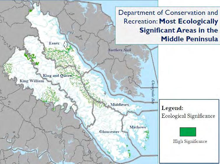
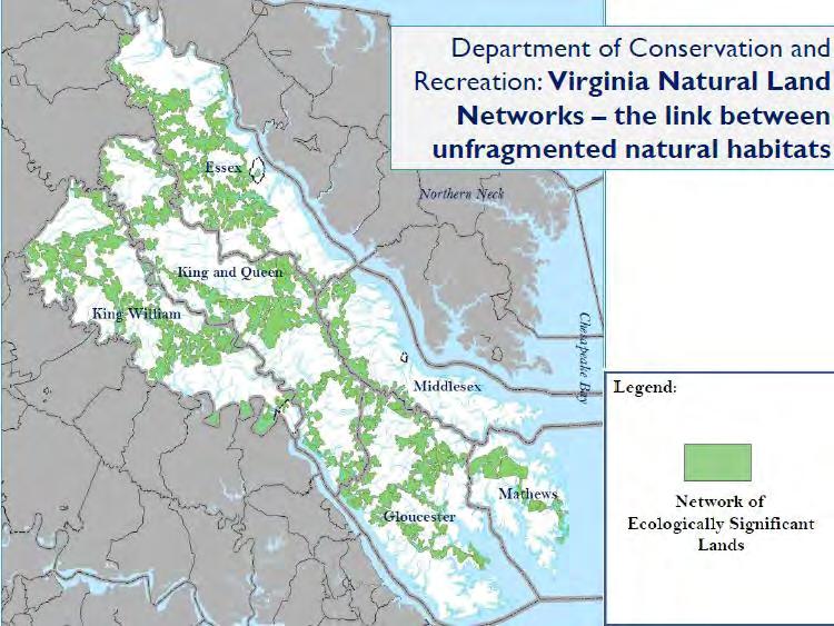
5 region, as well as green infrastructure planning initiatives within the Commonwealth of Virginia. Upon completion of information worksheet, MPPDC Staff worked to develop maps that provided visuals of green infrastructure within the region. Originally, MPPDC staff gathered GIS data from the 2006 Department of Conservation and Recreation Division of Natural Heritage (DCR-DHN) project, Virginia Natural Landscape Assessment, to develop maps of green infrastructure in the region. However through the course of the project, the Virginia Department of Games and Inland Fisheries (DGIF), DCR-DHN, and Virginia Commonwealth University Center for Environmental Studies, created Priority Conservation Area (PCA) data sets that included statewide green infrastructure updates. This PCA GIS data highlighted unfragmented habitat areas and potential links between contiguous patches of land, aquatic communities, wetlands, and identified habitat for rare species and special wildlife. Therefore, MPPDC staff utilized this data to develop a variety of regional maps (Appendix B) that depicted green infrastructure in the region that is considered of highest priority to conserve. In particular the maps included (1) a Composite of Ecologically Significant Areas in the Middle Peninsula (from DCR), (2) the most ecologically significant area in the Middle Peninsula, (3) Priority Conservation Areas and Currently Protected Areas within the Middle Peninsula (ie. Lands with conservation easements and managed lands through September 2010), and (4) Virginia Natural Land Networks the link between unfragmented natural habitats in the Middle Peninsula. To explore the economic impacts of conservation efforts, MPPDC staff assessed the unintended fiscal impacts to localities due to conservation easements and land holding by tax-exempt entities and political subdivisions for conservation purposes. MPPDC staff worked with Commissioners of Revenue from each member locality to understand county approaches to conservation easements, particularly as it relates to Virginia Tax Code requirements. Taking into consideration the differences between those counties that have adopted land use assessment and those localities that have not, MPPDC staff found that each county could improve current approaches in handling conservation easements within their county that could provide fiscal benefits through the Composite Index, and therefore aid State received for education. 3 P a g e
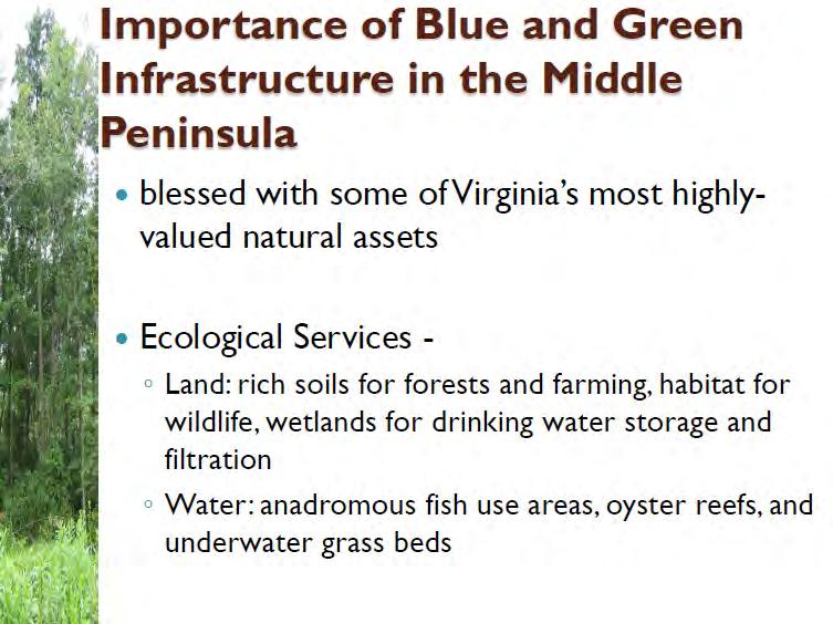
6 Green Infrastructure Public Policy Endorsement On two separate occasions, the Commission was presented with updates about this conservation corridor planning project. First, MPPDC staff explained that with approximately 888,000 acres of blue and green infrastructure within the Middle Peninsula, the region has some of the most highly valued natural assets in Virginia. The land is rich in soil for forests and farming, there s habitat for wildlife, and wetlands for drinking water storage and filtration. The waterways within the region are highly valuable for fish, oyster reefs, and underwater grass beds. To support this presentation MPPDC staff presents the completed information worksheet and regional maps to assisted the Commission in understanding the concept of conservation corridor planning and how it relates to the Middle Peninsula. Through some discussion and through a MPPDC staff recommendation, the MPPDC Board passed a resolution Acknowledging the Importance of Blue and Green Infrastructure within the Middle Peninsula (Appendix C). During the second meeting (Appendix D), MPPDC staff updated the Commission on the conservation easements assessment and the fiscal impacts to localities. MPPDC staff explained that Commissioners of Revenue (CoR) have been over-reporting the total land book value and by doing so the localities are being short-changed for state aid through the composite index. Conclusions Conservation corridor planning within the Middle Peninsula may provide an opportunity for the region to maintain their rural character, and support traditional economies (ie. silviculture and agriculture), while reaping ecologic, social and economic benefits. As a result of this project MPPDC localities formally support and acknowledge the importance of blue and green infrastructure within the Middle Peninsula. Also through MPPDC staff s assessment of conservation easements as well as land holdings by tax exempt entities and political subdivision for conservation purposes, it was found that CoR could improve current methodologies that could benefit the locality through the composite index. With CoR having no guidance on the recordation or valuation of easements and there is no standard administrative mechanism to capture the recordation 4 P a g e
7 of easements. The CoR of a locality that does not participate in a land use value program must determine the fair market value of the land as impacted by the easement while the CoR of a locality that does participate in a land use value program must determine the use value under the land use value program and shall assess the property at that value and tax as such. Through this assessment there were are four key findings: (a) easements lower land value and can help lower the composite index, (b) schools can receive more state aid funding because of easements, (c) Commissioners of Revenue are inconsistent when valuing conservation easements, and (d) Commissioners of Revenue have changed valuation practices because of this study. Full report and finding may be found in Appendix E. Project Outcomes: An information worksheet about conservation corridor planning was developed. Regional maps depicting high priority conservation areas were developed. On July 28, 2010 Middle Peninsula Planning District Commission passed a resolution to acknowledge the importance of blue and green infrastructure within the Middle Peninsula. An assessment of conservation easements and land holdings by tax-exempt entities for conservation purposes was complete. Four major findings from the report include (a) easements lower land value and can help lower the composite index, (b) schools can receive more state aid funding because of easements, (c) Commissioners of Revenue are inconsistent when valuing conservation easements, and (d) Next Steps In year two of this project, MPPDC stall continue to work localities in order to gain an understanding of how current zoning within each county will impact the future development as well as conservation efforts in the future. MPPC staff will utilize the regional maps and overlay these maps with private easement and zoning classifications that are intended to limit development and protect and preserve natural resources. Juxtaposing these three layers will assist in the assessment of two concepts: (1) are private easements and conservation zones located in areas that the Commonwealth considers to be ideal for conservation efforts and (2) are current land use policies (including local conservation zoning districts) consistent with county comprehensive 5 P a g e
8 plans (what s the relationship between protected lands, conservation zoning districts and PCA s). MPPDC staff will also facilitate stakeholder meeting to discuss the findings from this year s project and the implication of how localities may be able to approach offsetting the revenue losses due to conservation efforts. 6 P a g e

9 Appendix A: Informational Worksheet 7 P a g e
10 8 P a g e
11 Appendix B: Regional Maps 9 P a g e

12 10 P a g e

13 11 P a g e

14 12 P a g e


15 Appendix C: First Meeting with Commission and the resolution passed to acknowledge the importance of blue and green infrastructure within the Middle Peninsula 13 P a g e

16 14 P a g e

17 15 P a g e

18 16 P a g e

19 17 P a g e

20 18 P a g e

21 19 P a g e

22 Appendix D: Second Meeting with Commission Conservation Easements: fiscal Impacts to localities in the Middle Peninsula Please be aware that the numbers in the table on the last six slides may have changed through additional analysis 20 P a g e

23 21 P a g e

24 22 P a g e

25 23 P a g e

26 24 P a g e

27 25 P a g e

28 26 P a g e

29 27 P a g e

30 28 P a g e

31 29 P a g e

32 30 P a g e
33 Appendix E: Conservation Easements - Fiscal Impacts to Localities in the Middle Peninsula REPORT 31 P a g e
, and preservation of rural character, there are unintended")
34 Conservation Easements: Fiscal Impacts to Localities in the Middle Peninsula Middle Peninsula Planning District Commission 2010 While Conservation Easements and land holdings by tax-exempt entities and political subdivisions for conservation purposes support the protection of water quality, traditional uses (farming, forestry, etc), and preservation of rural character, there are unintended fiscal impacts to localities.
35 Conservation Easement Initiative: PROJECT SNAPSHOT Problems: How are properties with conservation easements assessed and taxed in the Middle Peninsula? How do conservation easements impact local tax revenues? How do fee simple acquisitions by political subdivisions and tax-exempt organizations impact local tax revenues? How does the cost of public services for eased lands compare to those that are developed (ie. residential, commercial)? What are the changes to land ownership patterns and what is their impact? Key Findings: 1. The tax revenue impact of conservation easements is less than about 0.5% of any given Middle Peninsula locality s annual budget. 2. Easements lower land value and help the composite index. 3. Schools receive more state aid funding because of easements. 4. Commissioners of Revenue are inconsistent when addressing conservation easements. 5. Commissioners of Revenue have changed reporting practices because of this work. ii
36 Table of Contents Conservation Easements Initiative: PROJECT SNAPSHOT... ii Table of Contents... iii Report Abbreviations... v I. Executive Summary... 1 II. Introduction... 2 III. Property Ownership and Conservation Easements... 4 Property Assessment and Land Book and Impact to the Composite Index... 5 IV. Land Use Counties vs. Non-land Use Counties... 8 Land Use Counties... 8 Non-Land Use Counties V. Analysis of Conservation Easements and Tax-exempt Land holdings in the Region A. Middlesex County Local Findings B. Gloucester County Local Findings C. Essex County Local Findings D. King William County Local Findings E. King & Queen County Local Findings F. Mathews County Local Findings VI. Regional Summary VII. Fiscal Impacts and Community Benefits of Conservation Efforts Social Benefits Environmental Benefits Economic Benefits Other Easements and Public Holdings VIII. Reported Needs Recommendations and Considerations IX. Conclusions Appendix 1- County Comprehensive Plan Language Relevant to land conservation and preservation iii
37 Appendix 2- Cumulative List of Conservation Easements and Tax-exempt Land Holdings within each Middle Peninsula County Appendix 3- Virginia Conservation Easement Act: Taxation Code Appendix 4- Tax-exempt Legislation Appendix 5- Middle Peninsula Chesapeake Bay Public Access Authority (MPCBPAA) Enabling Legislation: Tax Liability iv


38 Report Abbreviations: CBF Chesapeake Bay Foundation CoR Commissioner of Revenue DCR Virginia Department of Conservation Recreation DGIF Virginia Department of Game and Inland Fisheries DOF Virginia Department of Forestry FEMA Federal Emergency Management Agency FMV Fair Market Value FODR Friends of Dragon Run MPCBPAA Middle Peninsula Chesapeake Bay Public Access Authority MPLT Middle Peninsula Land Trust MPPDC Middle Peninsula Planning District Commission NOAA National Ocean and Atmospheric Association SLEAC State Land Evaluation and Advisory Council TNC The Nature Conservancy TVP True Value of Property TVLB Total Value of Land Book USFWS United States Fish and Wildlife Service VaTAX Virginia Department of Taxation VIMS Virginia Institute of Marine Sciences VDOE Virginia Department of Education VOF Virginia Outdoors Foundation This project was funded by the Virginia Coastal Zone Management Program at the Department of Environmental Quality through Grant FY2009 NA09NOS Task and Task 95 of the U.S. Department of Commerce, National Oceanic and Atmospheric Administration, under the Coastal Zone Management Act of 1972, as amended. The views expressed herein are those of the authors and do not necessarily reflect the views of the U.S. Department of Commerce, NOAA, or any of its sub-agencies. v
39 I. Executive Summary During the past several years the Dragon Run Steering Committee has recognized a conservation easement as a useful tool for private landowners to preserve rural character and promote natural resource-based economies, while protecting the natural resources that enable this way of life. As interest in conservation easements and conservation land holdings expanded in and around the Dragon Run Watershed, Middle Peninsula localities started to be concerned about intended tax revenue impacts and their effects on local economies. As a result, Commissioners of the Middle Peninsula Planning District Commission (MPPDC) initiated a two-pronged project (Grant #NA09NOS Task and Task 95) to address these issues. Officially kicking off the project in April 2010, Phase I of this project focused on gaining a quantitative understanding of the current fiscal impacts of conservation easements and conservation land holding by tax-exempt entities in Middle Peninsula localities. MPPDC staff met with the Commissioners of Revenue (CoR) from each County to discuss the methodology used to process conservation easements - from recordation of a conservation easement, to reducing the property s fair market value to reporting the total land book value the Virginia Department of Taxation (VaTAX). In particular, MPPDC staff worked to understand county approaches to conservation easements, particularly as it relates to Virginia Tax Code requirements. Taking into consideration the differences between those counties that have adopted land use assessment and those localities that have not, MPPDC staff found that each county could improve current approaches in handling conservation easements within their county that could provide fiscal benefits through the Composite Index, and therefore aid State received for education. Through the accounting of all conservation easements and the consistent devaluing of the conservation easements within their jurisdiction, each county has an opportunity to improve current practices. 1
40 II. Introduction Within the Middle Peninsula member localities pride themselves on their rural character and heritage, which has been fundamentally rooted in the region s open-space, agricultural lands and forests, as well as the region s waterways. However as populations migrate toward the coast to enjoy the amenities of a rural and coastal lifestyle, local governments begin to grapple with how to hold onto their rural character, while balancing growth, new public service costs, and therefore county budgets and revenues. To articulate the county vision, specific to growth and development, the County s Comprehensive Plan provides general, long-range, policy, and implementation guidelines for decisions related to land use. Within the Middle Peninsula, each county s comprehensive plan has seemingly similar visions to preserve rural character through the preservation/conservation of open space, agricultural land, and forest land (Appendix 1). In recent years, and in congruence with County Comprehensive Plans, non-profit organizations (i.e. The Nature Conservancy and local land trusts), as well as political subdivisions have focused conservation efforts within the Middle Peninsula. These entities have accomplished their conservation goals through the utilization conservation easements and fee simple land ownership as tools to protect and conserve the natural, scenic, and historic resources of the region. A conservation easement is a legal agreement made between a landowner (grantor) and a public body (grantee) that places restrictions on both the present and the future use Chapter Focal Points: All comprehensive plans of Counties in the Middle Peninsula focus on preservation of rural character through the conservation of open space, agricultural land and forest land, especially within the Dragon Run Watershed. Economic downturn has forced local budgets to tighten, therefore drawing attention to changes in land ownership patterns (ie. conservation easement and tax exempt land holdings) and their fiscal impacts. Conservation easements are a legally binding instrument to protect natural or open space, assuring its availability for agricultural, forestal, recreation, or open-space use Assessed value of a property is the taxed value. This is value is initially determined by a real estate assessor. Commissioner of Revenue s prime objective is to maintain a land book and generate a total land book value (TVLB). This value is ultimately used as a factor in the composite index. 2
41 of a property. While capturing the rural quality of the region in perpetuity, conservation easements also offer tax incentives to property owners. Conservation easements have been considered regional conservation successes and few questions arose with regard to the fiscal impacts of conservation easements. However, with the economic downturn in 2008, county budgets have tightened and fiscal resources have dwindled, while local government s responsibilities have remained the same or have expanded. Therefore, in February 2010 when The Nature Conservancy's (TNC) purchased 13,350 acres of forestland within the Dragon Run and Mattaponi watersheds and then immediately sold it to The Forestland Group subject to a permanent conservation easement on the property, local elected officials began to question the impacts of conservation easements to the county revenues. To address these concerns, MPPDC staff conducted extensive research and worked closely with Middle Peninsula Commissioners of Revenue to gain an understanding of the following: 1. The impact of conservation easements on local tax revenue. 2. The loss of local tax revenue due to fee simple conservation acquisitions by political subdivisions and tax-exempt organizations. 3. The cost of public services for eased lands compared to those that are developed (ie. residential, commercial) 4. The impact of changes to land ownership patterns. 3

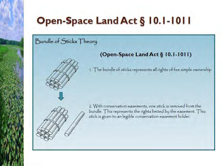
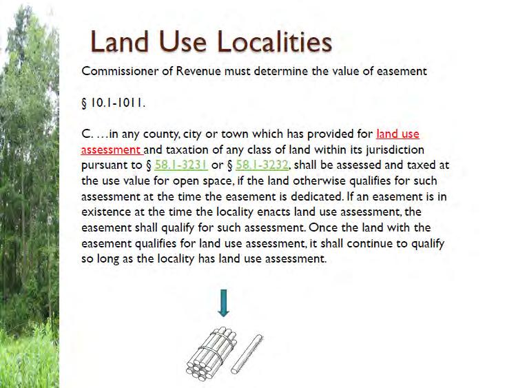
42 III. Property Ownership and Conservation Easements In general there are two categories of property, (1) real property and (2) personal property. However, for the purpose of this report real property will be the focus. Thus real property may be defined as land, including the surface, whatever is attached to the surface such as buildings or trees, and whatever is beneath the surface, such as minerals, and the area above the surface. Through ownership of real property, one gains a variety of inherent rights. To explain, ownership rights may be compared to a bundle of sticks (Figure 1). Each stick represents a distinct and separate right, which may be the Chapter Focal Points: Fee simple property owners have rights, including the ability to voluntarily limit or restrict interests of the property. Conservation easements perpetually protect and conserve land Property owners enjoy the tax exempt status of a conservation easement The rights restricted by the conservation easements are voluntarily sold or transferred to a qualified conservation easement holder. The assessed value is the value that is taxed. The CoR s main objective is to maintain a land book to generate a total value of land book to report to the VaTAX. right to sell, lease, subdivide, enter, or give away the property. If an individual or entity owns all rights to a parcel (ie. all the sticks) this is known as fee simple ownership. But with the discretion to choose to exercise more than one or none of these rights, a fee simple owner may voluntarily limit or restrict partial interests that are created by selling, leasing or transferring specific sticks from the bundle of rights. In the case of fee simple owners who have an interest in retaining The VaTAX sends the DOE a copy of the annual sales ratio study and the TVLB which will be used in calculating the composite index which reflects a county s ability to pay education costs. Conserved lands lower the composite index The lower the composite index the more state aid is received for education 4
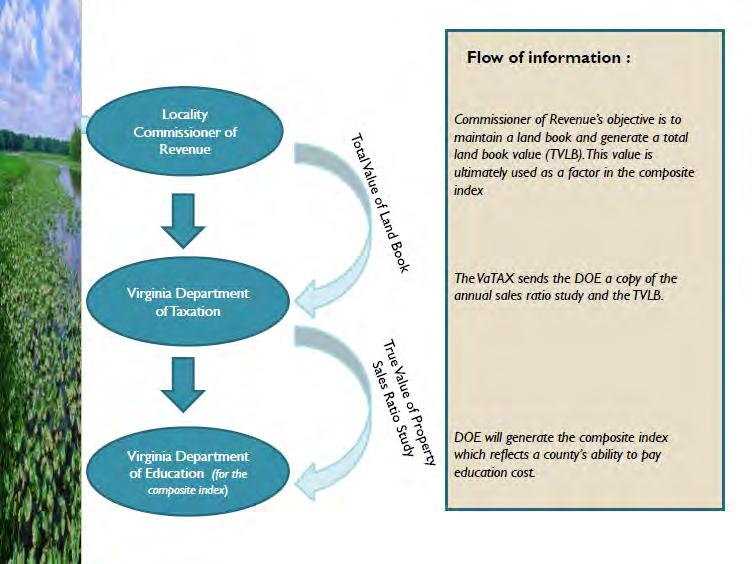
43 or protecting natural or open space values of real property, assuring its availability for agricultural, forestal, recreation, or open-space use, protecting natural resources, maintaining or enhancing air or water quality, or preserving historical architectural or archaeological aspects of real property (VA Code ), conservation easements may be used as a tool to conserve their land in perpetuity. When a property owner chooses to place his/her land in a conservation easement, one stick from the bundle, particularly the right to subdivide and/or develop, is voluntarily sold or transferred to a qualified conservation easement holder (ie. political subdivision or eligible non-profit organization). As a conservation easement places encumbrances on a property, how is the property s fair market value impacted? Property Assessment and Land Book and Impacts to the Composite Index Assessment of real property throughout the Commonwealth is calculated at 100% of the fair market value as required by the Constitution of Virginia. Real estate assessors are hired by the counties, with the exception of Gloucester County which has an in-house assessment office, to establish a fair market value/assessment value each property (ie. improvements or buildings and the land or site). This assessed value is then the value that the county applies the tax levy to in order generate local tax revenues. Real estate assessment values may increase or decrease due to a variety of reasons, including changes in economic conditions, structural changes or land rezoning as well as encumbrances on property, including those set by a conservation easement and a county s participation in the Virginia s Use Value Assessment Program. Yet, regardless of the factor contributing to the change in fair market/assessed value of the property, as a real estate record keeping tool and, in accordance with VA Code , the Commissioner of Revenue (CoR) from each county is to maintain a land book that documents all fair market values of properties within their jurisdiction. As the premier objective, each county s CoR will generate a total value of land book (TVLB), which is the total of fair market values of all parcels within the county. Once the TVLB is calculated a completed land book is sent to the County s Treasurers Department as well as the Virginia Department of Taxation (VaTAX). 5
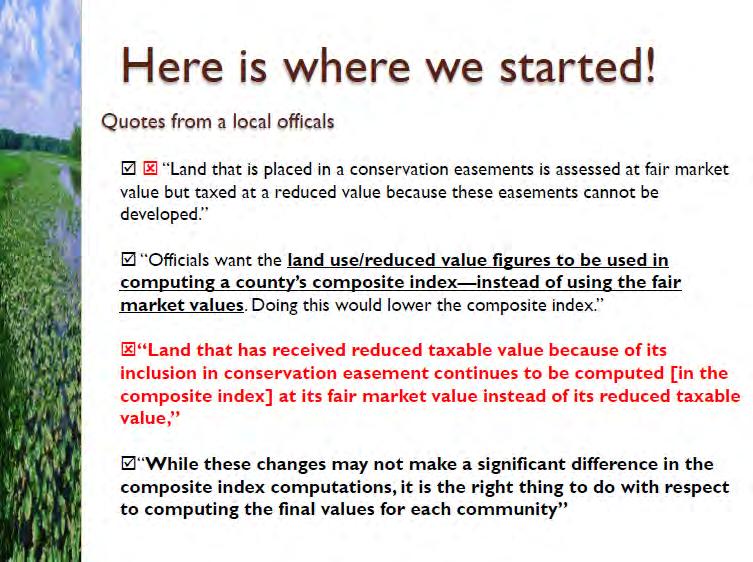
44 To fulfill agency missions, VaTAX will extract the TVLB value from each county s land book and send it to the Virginia Department of Education (VDOE) in conjunction with a copy of an annual sales ratio study. With this information VDOE will calculate the True Value of Property (TVP) that is needed to generate a composite index value for each county. The composite index determines a school division s ability to pay education costs based on the true value of property (weighted 50%), adjusted gross income (weighted 40%) and the taxable retail sales (weighted 10%) within the county. These three elements are computed per pupil and per capita for each school. The lower the composite index the more education State aid the county will receive. Table 1: Regional Relevance Composite index: What does this mean? Every two years a composite index value is calculated for each county. This value is ultimately the percentage that each county is expected to contribute to funding the cost of education within their county. Below are a list of the Middle Peninsula Counties and their associated composite index for County Composite Index Percentage that County is to spend of their education costs Essex % King William % King & Queen % Gloucester % Mathews % Middlesex % As the fair market values of properties within the Middle Peninsula are reduced due to conservation easements, the county s total land book value reported to the VaTAX is also reduced. This reduction will thereby decrease the composite index. To take advantage of the composite index benefits, the Commissioners of Revenue need to report the total fair market value of all properties, including the reduced assessed value of lands with conservation easements. If the CoR does not report the total land book value in a way that accounts for the reduced fair market value of lands with conservation easements, then this will not be beneficial to the composite index score; and therefore will ultimately decrease the amount of State aid for education. It is also important to mention that although Virginia Tax Code dictates that the 6
45 property under easement shall reflect a reduction in fair market value of the land that results from the inability of the owner to use the property for uses terminated by the easement, the market demand is ultimately what drives the value in the property In other words, although the value of the right(s) given up is reduced, the value of the parcel itself may decrease, stay the same, or increase depending on the demand of the market. 7
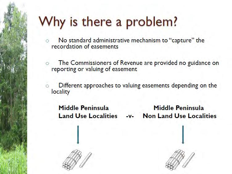
46 IV. Land Use Counties vs. Non-land Use Counties As a legally binding instrument that restricts the actions of present and future landowners, conservation easements may be considered an encumbrance on the property. Thus, in accordance with Virginia State Tax Code (Appendix 3), a property owner is to enjoy the tax-exempt status of a conservation easement. Consequently the property shall reflect a reduction in fair market value of the land that results from the inability of the owner to use the property for uses terminated by the easement. A county s participation within the Virginia Use Value Assessment Program will determine the approach to reducing in fair market value of properties under conservation easement. Land Use Counties Within the Commonwealth of Virginia each county has the option to adopt a land use program. This program supports the assessment and taxation of agriculture, horticulture, forest and /or open-space lands based on its use value, or the value for what the land produces, instead of the market value. To determine land use rates, the State Land Evaluation and Advisory Council (SLEAC) estimates the use value of eligible lands for each jurisdiction participating in the land use program. The SLEAC contracts annually with the Department of Agricultural and Applied Economics at Virginia Tech to develop an objective methodology for estimating the use value of land in agricultural and horticultural uses, with the Virginia Department of Forestry (DOF) for the use value of land in forestry, and with the Department of Conservation Chapter Focal Points: Virginia s Use Value Assessment Program is voluntary for counties to supports the assessment of agriculture, horticulture, forest and/or open space lands based on its use value, which is below the regular assessed value. Gloucester, Middlesex, King William and Essex Counties have adopted the land use program. According to the Virginia Use Value Assessment Program properties in the program will be taxed upon the use value, yet the CoR cannot report this reduced value in the land book. VA Tax Code requires that properties with conservation easements in land use counties are taxed and assessed with the county s land use value. However, because the easement is perpetual in nature, the CoR should report this reduced value as the value of the easement in the land book. Once a reduction in value is given to an eased property, the total value of land books in non-land use counties inherently reflect this reduction 8
47 and Recreation (DCR) for the use value of land in open space. Although the SLEAC values are distributed to each county, these values do not have be used by the county. Hence a county may consider the SLEAC values, but in accordance with VA Code , the CoR or duly appointed assessor shall ultimately determine the land use rates for the county (ie. agricultural, horticultural, forestal or open space). Counties within the Middle Peninsula that currently participate in the Land Use program include Essex, King William, Middlesex, and Gloucester. Of these counties only the Gloucester County CoR utilizes the SLEAC land use rates. In Essex and Middlesex County the CoRs use SLEAC numbers as guidance, but adjust values based on a neighborhood approach to calculate a county specific land use rate. On the contrary, King William utilizes a budget plug approach to generate land use rates. In other words, King William will close the county s budget gap by adjusting the land use rates as needed. Although the land use program allows agricultural, horticultural, forestal and/or open space to be taxed upon the land's use value, this value cannot be reported by the CoR in the land book. Since VaTAX considers the land use program as voluntary and revocable at any time, the CoR must report the full assessed value/fair market value of the property in the land book to generate the total land book value (TLBV) which is then sent to VaTAX (Figure 2- Scenario #1). In conjunction with being considered a voluntary and revocable program, the CoR from land use counties do not consider the reduction of the collected taxed revenues a loss, but rather a tax deferral. Within land use counties, and according to VA Code , land subject to a perpetual conservation or open-space easements shall be assessed and taxed at its open space use value in jurisdictions that have adopted the land use program. Therefore, since conservation easements are perpetual, not only is the land taxed at a reduced land use value, but the CoR is to report this reduced use value in the land book (Figure 1- Scenario #2). Consequently, by reporting a lower fair market value to the VaTAX for lands with conservation easements, the composite index should be lowered and the county should receive more State aid toward education. Furthermore, CoR will consider the reduced taxes due to the devaluation of the fair market value based on a conservation easement as a permanent loss to the county rather than a deferral. 9

48 Figure 2: Scenarios within land use counties that attribute to local taxation and conservation easements. Non-Land Use Counties Unlike land use counties, there is no legislation that prescribes how an eased property within a non-land use county should be devalued. Yet, according to Virginia State Tax Code (Appendix 3): Assessments of the fee interest in land that is subject to a perpetual conservation easement held pursuant to this chapter or the Open-Space Land Act shall reflect the reduction in the fair market value of the land that results from the inability of the owner of the fee to use such property for uses terminated by the easement. In other words the fair market value of the property will be reduced due to uses terminated by the easement. Thus, in non-land use counties the reduced value of a 10

. Due to the perpetual nature of a conservation easement the taxes lost due to this transaction will be a permament loss to the county.")
49 property with a conservation easement may be determined by a qualified assessor, who establishes a "before value & after value", while the 'remainder value' is the value usually accepted by the locale as the assessed value. If that does not occur, then the assessor, if there is one, would establish a fair market value as permitted and the CoR would then have the final word as to the fair market value (Figure 3: Scenario #2). Due to the perpetual nature of a conservation easement the taxes lost due to this transaction will be a permament loss to the county. However the reduced fair market value of the property due to the conservation easement will lower the county s TLBV and therefore the composite index. Figure 3: Scenarios within non land use counties that attribute to local taxation and conservation easements. 11
50 V. Analysis of Conservation Easements and Tax-exempt Land holdings in the Region In April 2010, MPPDC staff began to work closely with the Commissioners of Revenue from each county within the Middle Peninsula to understand the fiscal impacts of conservation easements as well as fee simple land holdings by tax-exempt entities in the counties. Specifically, the CoRs helped to generate a list of properties which are under conservation easement or owned by tax-exempt organizations for conservation purposes. In addition to the list of parcels provided by the CoR, MPPDC staff researched grantee public records to identify additional parcels that are held by eligible conservation easement holders, including The Nature Conservancy (TNC), Virginia Outdoors Foundation (VOF), Middle Peninsula Land Trust (MPLT), Friends of Dragon Run (FODR), Virginia Department of Forestry (DOF), Chesapeake Bay Foundation (CBF), Natural Resources Conservation Service (NRCS), Virginia Department of Game and Inland Fisheries (DGIF), as well as U.S. Fish and Wildlife Services (USFWS). Finally MPPDC staff consulted with conservation easement holders (ie. TNC and VOF) and Virginia Department of Conservation and Recreation (DCR) to obtain lists of land holdings to verify research and information gathered from each CoR. MPPDC staff also used public records to identify parcels owned by tax-exempt entities for conservation purposes. Within the Middle Peninsula, MPPDC staff focused on fee simple ownership by federal, state, and local political subdivisions (ie. USFWS, DOF, DCR, DGIF, Middle Peninsula Chesapeake Bay Public Access Authority), educational institutions (ie. VIMS), and non-profit organizations (ie. TNC). Tax-exempt legislation may be found in Appendix 4 &5. The remainder of this chapter will review how each county in the Middle Peninsula considers conservation easements. From recordation, to property devaluation, to the property value reported to the VaTAX, MPPDC staff will share information gathered from each county right, wrong, or indifferent this is the information that is known. 12
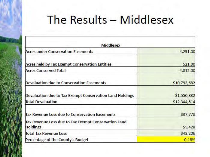
51 A. Middlesex County Upon recordation of a conservation easement in Middlesex County, an attorney or landowner will enter the clerk s office with prepared easement documents. The clerk will scan all documents provided into the County s computer database. The attorney/landowner will then pay a recordation fee, however tax-exempt entities (ie. political subdivisions, TNC, VIMS, etc) do not pay a recordation fee. Once the recordation fee is paid, then the attorney/ landowner will receive a receipt for the transaction. The information and documents scanned into the computer will appear on the monthly land transaction sheet generated by the clerk for the CoR to review. On the transaction sheet conservation easements are currently not flagged for special consideration by the CoR. However, along with the transaction sheet, the Middlesex CoR will receive copies of the deed and plat. According to the CoR, properties with conservation easements are automatically entered into the land use program and devalued based upon the land use program rates adopted by the County during the review of the transaction sheet. Yet, this reduced value and new tax liability will not become effective until the following January 1 st. However, the landowner is informed of this change in tax liability through a validation process. In other words, an application will be filled out with the available deed information and will be sent to the landowner to make appropriate changes. The landowner is then asked to sign the application and return the completed application to the CoR. Once all monthly land transactions are reviewed, the CoR will file the copies of the conservation easement records Chapter Focal Points: Middlesex is a land use county. CoR becomes aware of a conservation easement during the monthly review of the transaction sheet from the clerk. Devaluation of fair market value of properties with conservation easements has been inconsistent. Middlesex has approximately 4,291acres of land with conservation easements equivalent to $37,778 in total lost tax revenue. Middlesex can change the process by which they report the TVLB to increase the amount of state aid for education. Currently the CoR working to make appropriate adjustments. Middlesex has approximately 521 acres of parcels owned by tax exempt entities which equates to $5,428 in total lost tax revenue. Middlesex has a total of 4,812 acres of conserved lands which equates to a loss of approximately $43,206 in tax revenues. This represents 0.18% of the county s budget for
52 into a cabinet dedicated to land use. While Middlesex County has two databases for property records, following the review of a monthly transaction sheet the CoR will update one of the property databases with changes to the property value. Currently, the two databases are separate and are unable to be used together. Also the current databases do not have a query to identify conservation easements, however the CoR is planning to complete this task in the near future. Local Findings As a land use county, the Middlesex County CoR is to tax and assess eased lands based upon the use value of the property, as well as report the reduced value of land with the conservation easement to VaTax according to tax code. Currently, however, this is not the case. Though taxed at the reduced value, the CoR reports the total fair market value in the total value of landbook rather than the reduced value due to the conservation easement. Therefore it can be said that the CoR treats lands with conservation easements identical to properties in land use. As a result this directly increases the TVLB, the composite index, and ultimately reduces State aid for education to the County. In addition to reporting the improper value to the VaTAX, MPPDC staff also found that the approach to devaluing conservation easements in Middlesex County is inconsistent. The CoR is working to correct inconsistencies. Consequently it was found that Middlesex County has approximately 4,291 acres of land with conservation easements, and in using the current fair market value devaluation methods, Middlesex County is losing approximately $37,778 in tax revenue due to easements. In conjunction with assessing the fiscal impacts of conservation easements, MPPDC staff also considered the fiscal impacts of fee simple land ownership by taxexempt organizations for conservation purposes. With approximately 521 acres of land in the county owned by tax-exempt organizations, this equates to approximately $5,428 loss of tax revenue. 14
53 Therefore when conservation easements and lands owned by tax-exempt organization are looked at together, the county consists of approximately 4,812 acres of conserved lands which equates to a loss of approximately $43,206 in total tax revenues annually. This represents only 0.18% of the county s $24,183,505 budget for Quantitative Summary of results from Middlesex County This provides a summary of the county s recognition of conservation easements as well as taxexempt conservation land holdings and their fiscal impacts to the county. Acres under Conservation Easements 4, Acres held by Tax-exempt Conservation Entities Acres Conserved Total 4, Devaluation due to Conservation Easements $10,793,682 Devaluation due to Tax-exempt Conservation Land Holdings $1,550,832 Total Devaluation $12,344,514 Tax Revenue Loss due to Conservation Easements $37,778 Tax Revenue Loss due to Tax-exempt Conservation Land Holdings $5,428 Total Tax Revenue Loss $43,206 Percentage of the County's Budget 0.18% 15
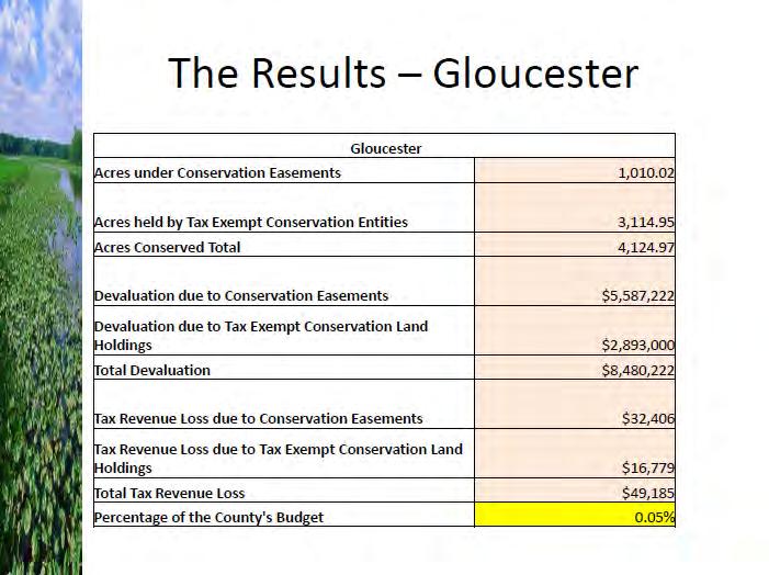
54 B. Gloucester County Upon recordation of a conservation easement within the Gloucester County, an attorney or the landowner will go to the clerk s office with prepared easement papers. The clerk will then scan all documents, including the easement and plat provided into the county s computer system. Once the documents are scanned, the easement documents will be stamped with an instrument number and the date of recordation. Once the recordation fee is paid (tax-exempt entities do not pay this fee), the attorney/landowner will receive a receipt for the transaction. This transaction will then appear on the monthly transaction sheet generated by the clerk s office which is sent to the CoR for further review. On the transaction sheet conservation easements are not flagged by the clerk for special consideration by the CoR. Through conversations with the Gloucester County CoR, to-date, conservation easements are not accounted for. They are treated as any other land. Also according to the Gloucester County s Real Estate Assessment Department properties with conservation easements are not assessed differently. Therefore to gather information with regards to conservation easements and fee simple land holding by taxexempt entities in Gloucester County, MPPDC staff utilized the County s records office as well as the Department of Conservation and Recreation (DCR) and other easement holder data. Chapter Focal Points: Gloucester is a land use county. CoR does not currently track or account for conservation easements within the county. Gloucester County Real Estate Assessment Department does not currently assess property with conservation easements differently. According to DCR there are approximately acres of conservation easements within the County. If accounted for the County may loss approximately $32,406 in tax revenues Gloucester has approximately 3, acres of land owned by tax exempt entities for the purposes of conservation. This equates to approximately $16,779 of lost tax revenue. Gloucester consists of approximately 4, acres of conserved lands which equates to a loss of $49,185 in total tax revenues annually. This represents % of the county s budget for Gloucester will benefit in composite index if the CoR/assessor devalues the fair market value of land s with conservation easements. 16
55 Local Findings It was found that Gloucester County has approximately 1, acres of land with conservation easements, and in using their current land use rates for lands, Gloucester County would lose approximately $32,406 in tax revenue due to easements. Keep in mind, that Gloucester County is not currently seeing fiscal impacts due to conservation easements since the fair market value of lands with conservation easements are not being reducing. This suggests that with a change Gloucester s approach to accounting for conservation easements within the County, and therefore becoming compliant with VaTAX code, Gloucester will see an increase in the total tax revenue loss, but will most likely benefit in the composite index due to a reduction of fair market value. In conjunction with assessing the fiscal impacts of conservation easements, MPPDC staff also considered the fiscal impacts of fee simple land ownership by tax-exempt organizations for conservation purposes. With approximately 3, acres of land in the county owned by tax-exempt organizations, this equates to approximately a $16,779 loss of tax revenue. Therefore when conservation easements and lands owned by tax-exempt organization are looked at together, the county consists of approximately 4, acres of conserved lands which equates to a loss of approximately $49,185 in total tax revenues annually. This represents only % of the county s $107,165,062 budget for Quantitative Summary of results from Gloucester County This provides a summary of the county s recognition of conservation easements as well as taxexempt conservation land holdings and their fiscal impacts to the county. Acres under Conservation Easements 1, Acres held by Tax-exempt Conservation Entities 3, Acres Conserved Total 4, Devaluation due to Conservation Easements $5,587,222 Devaluation due to Tax-exempt Conservation Land Holdings $2,893,000 Total Devaluation $8,480,222 Tax Revenue Loss due to Conservation Easements $32,406 Tax Revenue Loss due to Tax-exempt Conservation Land Holdings $16,779 Total Tax Revenue Loss $49,185 Percentage of the County's Budget % 17
56 C. Essex County Recordation of a conservation easement within Essex County begins when prepared easement papers are presented by an attorney or other interested party to the Clerk of the Circuit Court. The clerk then validates the document by stamping recording information (ie. date) and writing the instrument number on the original document. If applicable, a recordation fee and tax are paid, the clerk makes a copy of the original (which is kept for scanning), and the original and a receipt for the transaction are returned to the presenter. After the easement documents are scanned into the county s computer system, the transaction will appear on a monthly transfer sheet generated by the clerk and placed in the CoR s mailbox. In Essex, the clerk flags conservation easements on the monthly transfer sheet, which assists the CoR in pulling associated electronic files. In Essex County the CoR may become aware of a conservation easement prior to recordation through minutes from Virginia Outdoors Foundation meetings or through word of mouth from the County Administrator or other interested parties. Once the documents are recorded, the CoR reviews the transfer sheet and downloads complete copies of the easement to the local computer network. With the adoption of land use assessment and taxation in 2008, agricultural, horticultural, forest, and open space lands with conservation easements in Essex County are to be assessed using the land use values established during each reassessment year. The CoR received Chapter Focal Points: Essex is a land use county. The Clerk flags easements on the monthly transaction sheet given to the CoR. Essex CoR has made changes to his approach in devaluing conservation easements within the county. Such charges will lower the TVLB reported to the VaTAX and will therefore benefit through State aid for education. Essex County has approximately 12, acres under conservation easement. This equates to a $115,288 loss of tax revenue. Essex County has approximately 1, acres of land held by tax exempt entity for conservation purposes. This equates to approximately $14,790 in lost tax revenue. Essex consists of approximately 13,514 acres of conserved lands which equates to a loss of $130,078 in total tax revenues annually. This represents 0.44% of the county s budget for
57 guidance about devaluing fair market assessments for conservation easements through a certification course Land Use Taxation presented through the University of Virginia Weldon Cooper Center for Public Service and sponsored by the Commissioners of the Revenue Association of the Commonwealth of Virginia. The CoR also used other sources of information such as the International Association of Assessing Officers (IAAO), as well as the publication Appraising Easements Guidelines for Valuation of Land Conservation and Historic Preservation Easements, Third Edition, published by the Land Trust Alliance in cooperation with the National Trust for Historic Preservation. Local Findings Essex County s CoR has recently documented all open-space easements, including both conservation and historic easements, and has systematically lowered the fair market values of those properties using open space use values. Because the majority of these properties were already in the land use program, the annual tax loss does not change much it simply goes from being tax deferred to being a perpetual loss. Using the land use values significantly lowers the fair market values of perpetually eased property and has a direct influence on the total true value of the land book and hence the Composite Index. Therefore, conservation easements lower assessed values and ultimately increase the level of state aid for K-12 school funding to a locality. It was found that Essex County has approximately 12, acres of land with conservation easements, and in using their current land use rates for lands, Essex County would lose approximately $115,288 in tax revenue due to easements. In conjunction with assessing the fiscal impacts of conservation easements, MPPDC staff also considered the fiscal impacts of fee simple land ownership by tax-exempt organizations for conservation purposes. With approximately 1, acres of land in the county owned by tax-exempt organizations, this equates to approximately a $14,790 loss of tax revenue. Therefore when conservation easements and lands owned by tax-exempt organization are looked at together, the county consists of approximately 13,514 acres of 19
58 conserved lands which equates to a loss of approximately $130,078 in total tax revenues annually. This represents only 0.44% of the county s $29,289,038 budget for Quantitative Summary of results from Essex County This provides an overview of the county s recognition of conservation easements as well as taxexempt conservation land holdings and their fiscal impacts to the county. Acres under Conservation Easements 12, Acres held by Tax-exempt Conservation Entities 1, Acres Conserved Total 13, Devaluation due to Conservation Easements $18,594,806 Devaluation due to Tax-exempt Conservation Land Holdings $2,385,480 Total Devaluation $20,980,286 Tax Revenue Loss due to Conservation Easements $115,288 Tax Revenue Loss due to Tax-exempt Conservation Land Holdings $14,790 Total Tax Revenue Loss $130,078 Percentage of the County's Budget 0.44% 20
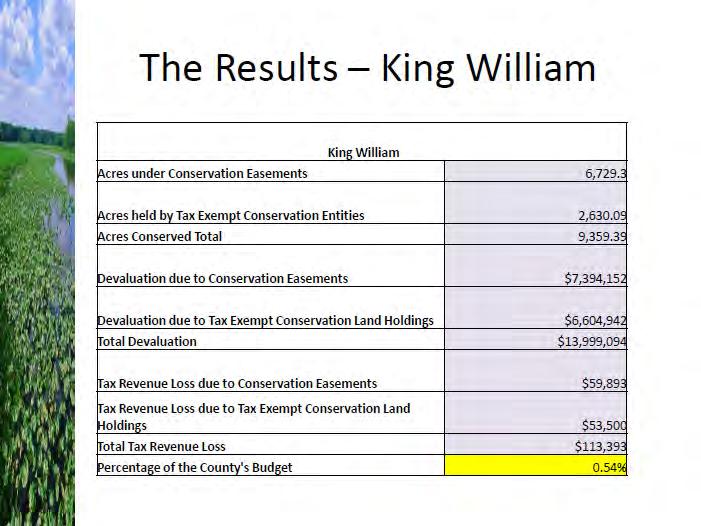
59 D. King William County Upon recordation of a conservation easement in King William County, an attorney or landowner will go to the clerk s office with prepared easement papers. The clerk will then enter and scan information into the county s computer system. Depending on how the easement papers are prepared, the clerk will label it accordingly (ie. Deed of Easement; Deed of Gift; Deed of Bargain Sale). The landowner/attorney will also provide a copy of the plat at the time of recordation which must be sign-off by the King William County Planning Department. Once signed, the plat will be recorded by the clerk. After recording, the plat is returned to the landowner but the landowner/attorney is then expected to provide one copy of the recorded plat to the planning department and another copy of the recorded plat to the CoR. The attorney/landowner will pay a recordation fee, if applicable. The clerk will then create a receipt for the attorney/landowner. The information scanned into the computer will appear on the monthly transaction sheet generated by the clerk and is then given to the CoR. Conservation easements are not flagged on this sheet. The CoR will review the monthly transaction sheet as well as a copy of the plat from the landowner/attorney. Reviewing the transaction sheet is typically the first time that the CoR will know that a property is going into a conservation easement and even then the transaction sheet did not give the CoR any indication of an easement. On rare occasions a landowner may call with questions Chapter Focal Points: King William is a land use county. King William requires a plat signed by the county s planning department with easement documents. The transaction sheet is the first time the CoR becomes aware of a conservation easement. Upon review of the transaction sheet the CoR will reduce the fair market value of the property and inform the landowner of changes. King William has approximately 6,729.3 acres of land with conservation easements, which equates to a tax revenue loss of $59,893 due to easements. King William has approximately 2, acres of land in the county owned by tax exempt organizations, this equates to approximately $53,500 loss of tax revenue. King William consists of approximately acres of conserved lands which equates to a total tax revenue loss of $113,393 annually. This represents 0.54% of the county s budget for
60 regarding tax benefits of conservation easement which provides some notification of a conservation easement prior to recordation. Local Findings The majority of lands currently under conservation easement were previously in the use program, so there is no change in the assessed value and therefore no change in tax liability. However, when a property is in the land use program the reduced land use value is considered a deferral of tax revenues, while with conservation easements this reduction is considered a permanent loss to the county due to its perpetual nature. As a land use county, King William reduces the fair market value of a property of the easement based on the land use rates of the county (Figure 4). The land use rates are based on the values established by SLEAC (State Land Evaluation and Advisory Council), however are adjusted through a Budget Plug Approach. In other words the county will generate land use values that will allow King William County to meet the budgetary needs for the fiscal year. 22
61 Fair Market Value Prior to Conservation Easement: 488 acres x $1,600 = $780,800 A 53% reduction is the amount that the uneased FMV needs to be reduced by in order to be equivalent to the land-use value for this land classification $780,800 x.53 = $413,824 (reduction) $780,800 - $413,824 = $366,976 (new FMV) Figure 4: Property Card for King William Parcel under conservation easement. The reduced fair market value of the land is documented on the card, however the original fair market value is not. In the blue box above a simple calculation may be complete to gather the original fair market value of the property. In this particular example there was a 53% reduction in FMV, however this percentage may vary between lands with conservation easements. The reduction in fair market value occurs upon notice of the conservation easement through the transaction sheet, while tax liabilities due to the changes become effective the following year. The only time a landowner is informed about the change in tax liability is during the reassessment period. To date, notices have not been sent to inform landowners with conservation easements of the change in tax liability since the Commissioner believed that all these lands are in the land use program therefore there are no changes made with regard to the reduction of fair market value. According to the CoR, she received guidance for devaluing the fair market value through a Land Use Class sponsored by the Commissioner of Revenue Association as well as from the VA Code. 23
62 Consequently it was found that King William County has approximately 6,729.3 acres of land with conservation easements, and in using the current fair market value devaluation methods, King William County is losing $59,893 in tax revenue due to easements. In conjunction with assessing the fiscal impacts of conservation easements, MPPDC staff also considered the fiscal impacts of fee simple land ownership by taxexempt organizations for conservation purposes. With approximately 2, acres of land in the county owned by tax-exempt organizations, this equates to approximately $53,500 loss of tax revenue. Therefore when conservation easements and lands owned by tax-exempt organization are looked at together, the county consists of approximately acres of conserved lands and a total tax revenue loss of approximately $113,393 in total tax revenues annually. This represents only 0.54% of the county s $20,851,240 budget for Quantitative Summary of results from King William County This provides a summary of the county s recognition of conservation easements as well as taxexempt conservation land holdings and their fiscal impacts to the county. Acres under Conservation Easements 6,729.3 Acres held by Tax-exempt Conservation Entities 2, Acres Conserved Total 9, Devaluation due to Conservation Easements $7,394,152 Devaluation due to Tax-exempt Conservation Land Holdings $6,604,942 Total Devaluation $13,999,094 Tax Revenue Loss due to Conservation Easements $59,893 Tax Revenue Loss due to Tax-exempt Conservation Land Holdings $53,500 Total Tax Revenue Loss $113,393 Percentage of the County's Budget 0.54% 24
63 King & Queen County Upon recordation of a conservation easement in King & Queen County, an attorney or landowner will go to the clerk s office with prepared easement papers. The clerk will then enter and scan easement documents into the computer. On occasion, a plat of the property being eased will supplement the conservation easement documents, but it is not required for recordation. The attorney/landowner will then pay a recordation fee, if applicable. Next the clerk will provide a receipt to the attorney/landowner for the transaction. The information scanned into the computer will appear on the monthly transaction sheet generated by the clerk. The clerk does not specifically flag conservation easements. The CoR will receive a copy of the transaction sheet along with a folder of deeds associated with the transactions that occurred that month. In addition to the deed of easement, a survey of the property in typically included. Currently, the Commissioner has a folder dedicated to conservation easements in her office. Although this folder is not accessible by the public, it is used specifically for her own records as well as the Board of Supervisors. The CoR reduces the fair market value of the property during the review of the transaction sheet each month. Once adjustments are made to the fair market value the CoR will send a letter to the landowner that explains the tax liability changes. To date there have been no contests. As a non-land use county, VA Code does not prescribe an approach to reducing the fair market value of land under Chapter Focal Points: King & Queen is a nonland use county. CoR becomes aware of an easement during her review of the monthly transaction sheet. CoR reduces the FMV of lands with conservation easements by 25%. However there are some inconsistencies. King & Queen County has approximately 14, acres of land with conservation easements, which equates to a $14,953 loss in tax revenue due to easements. King & Queen has approximately 12, acres of land in the county owned by tax exempt organizations, which equates to $64,161 loss of tax revenue. King & Queen consists of approximately 27,877.7 acres of conserved lands which equates to a loss of approximately $79,114 in total tax revenues annually. This represents 0.39% of the county s budget for
64 conservation easement. Therefore in King & Queen County CoR has chosen to consistently and equitably reduce the fair market value of lands under conservation easement 25%. This 25% reduction is clearly shown on the property card. The CoR explained that a 25% reduction is used since this was the approach utilized by the assessor during the last reassessment in King & Queen. Local Findings Consequently it was found that King & Queen County has approximately 14, acres of land with conservation easements, and in using the current fair market value devaluation methods, King & Queen County is losing $14,953 in tax revenue due to easements. In conjunction with assessing the fiscal impacts of conservation easements, MPPDC staff also considered the fiscal impacts of fee simple land ownership by tax-exempt organizations for conservation purposes. With approximately 12, acres of land in the county owned by tax-exempt organizations, this equates to approximately $64,161 loss of tax revenue. Therefore when conservation easements and lands owned by tax-exempt organization are looked at together, the county consists of approximately 27,877.7 acres of conserved lands which equates to a loss of approximately $79,114 in total tax revenues annually. This represents only 0.39% of the county s $20,194,124 budget for
65 Quantitative Summary of results from King & Queen County This provides a summary of the county s recognition of conservation easements as well as taxexempt conservation land holdings and their fiscal impacts to the county. Acres under Conservation Easements 14, Acres held by Tax-exempt Conservation Entities 12, Acres Conserved Total 27,877.7 Devaluation due to Conservation Easements $3,115,224 Devaluation due to Tax-exempt Conservation Land Holdings $13,334,709 Total Devaluation $16,449,933 Tax Revenue Loss due to Conservation Easements $14,953 Tax Revenue Loss due to Tax-exempt Conservation Land Holdings $64,161 Total Tax Revenue Loss $79,114 Percentage of the County's Budget 0.39% 27
66 E. Mathews County Upon recordation of a conservation easement in Mathews County, an attorney or landowner will go to the clerk s office with prepared easement papers. The clerk will then enter and scan information into the computer. The attorney/landowner would then pay a recordation fee, however never if the entity is tax-exempt a recordation fee is not paid. The clerk will then create a receipt for the attorney/landowner. Since a conservation easement is not a transfer of title, it does not appear on the monthly transaction sheet from the Clerk s office. Therefore Mathews County currently does not track right-of-ways and/or easements. Prior to recordation of the easement, appraisers typically come into the CoR s office to conduct property research and at that time the CoR becomes aware that a conservation easement is being prepared. However the CoR only truly becomes aware of a conservation easement if the landowner or representative informs the CoR of the recordation. Due to the small volume of conservation easements within the county, it is more economically feasible for taxpayer to provide information for an assessment adjustment rather than the CoR to take his time to reconcile the public record. Once CoR is informed of the recordation of a conservation easement he will look to see if a before and after appraisal was complete. He will then use this appraisal to make adjustments to the assessed value of the property. As a small community, the Mathews County CoR has a close relationship with most of the appraisers within the county Chapter Focal Points: Mathews is a non-land use county. According to the CoR, the impacts of conservation easements are negligible to Mathews. Monthly transaction sheet does not include conservation easements. Land owners with conservation easements must apply for tax incentives. This responsibility is placed on the landowner due to the small volume of easements within the county. CoR will inform the land owner of all changes to owner of the change to tax liability. Mathews County has approximately 341 acres of land with conservation easements, which equates to a $1,107 loss in tax revenue due to easements. Mathews has approximately acres of lands in the county owned by tax exempt organizations, this equates to an approximate $1,836 loss of tax revenue. The county consists of approximately acres of conserved lands which equates to a loss of $2,942 in total tax revenues annually. This represents 0.01% of the county s budget for
67 and in most cases he personally knows the appraiser. Thus he trusts the appraisals and considers them legitimate. If an appraisal comes in from unknown appraiser, outside of his knowledge base, the CoR will do some research to judge the validity of the appraisal. If the CoR does not have a copy of the appraisals he will call the easement holder/ land holder and ask for a copy of the appraisal if the landowner has requested a reduction in the tax liability. After the landowner requests a reduction in tax liability, the CoR will reduce the fair market value and will inform the landowner of the change to tax liability. To date there have been no contests. According to the CoR, he has received limited guidance for devaluing the fair market value of a property with a conservation easement, however the current methodology for reducing the fair market value is consistent and works for Mathews County; therefore it is supported by the VaTAX. Local Findings According to the CoR, the impacts of conservation easements are negligible to Mathews. Since most of the currently eased lands are wetlands this does not have a significant impact to county revenues. Eased lands may, however, have an impact on future revenues if the ability to develop marginal lands changes. Consequently it was found that Mathews County has approximately 341 acres of land with conservation easements, and in using the current devaluation methods, Mathews is losing approximately $1,107 in tax revenue due to easements. In conjunction with assessing the fiscal impacts of conservation easements, MPPDC staff also considered the fiscal impacts of fee simple land ownership by tax-exempt organizations for conservation purposes. With approximately acres of land in the county owned by tax-exempt organizations, this equates to an approximate $1,836 loss of tax revenue. Therefore when conservation easements and lands owned by tax-exempt organization are looked at together, the county consists of approximately acres of conserved lands which equates to a loss of approximately $2,942 in total tax revenues annually. This represents only 0.01% of the county s $22,206,678 budget for
68 Quantitative Summary of results from Mathews County This provides a summary of the county s recognition of conservation easements as well as taxexempt conservation land holdings and their fiscal impacts to the county. Acres under Conservation Easements Acres held by Tax-exempt Conservation Entities Acres Conserved Total Devaluation due to Conservation Easements $197,600 Devaluation due to Tax-exempt Conservation Land Holdings $327,800 Total Devaluation $525,400 Tax Revenue Loss due to Conservation Easements $1,107 Tax Revenue Loss due to Tax-exempt Conservation Land Holdings $1,836 Total Tax Revenue Loss $2,942 Percentage of the County's Budget 0.01% 30
69 VI. Regional Summary Overall, each county within the Middle Peninsula had a different approach to addressing conservation easements from recordation, to reducing the property s fair market value to reporting the total land book value to the VaTAX. In working with each CoR, MPPDC staff were able educate CoRs as to the implications of current practices and presented opportunities to fiscally benefit from conservation easements. Middle Peninsula localities that have adopted the land use program, including Gloucester, Middlesex, King William and Essex Counties, are prescribed by Va Code to assess and tax lands under conservation easements based on county land use rates. While non land use counties, including Mathews and King & Queen Counties have less guidance regarding the assessment of eased lands and seem to utilize practices that are applied consistently (eg. such as using land use value in an adjacent county with a land use program or using the value determined in the appraisal conducted during the easement process, or doing a flat 25% reduction). During the first phase of this project to understand how counties consider conservation easements, MPPDC staff found that each county could improve in two areas: 1. Accounting for all conservation easements within their jurisdiction, and 2. Consistently reduce the fair market value of conservation easements. Table 2 provides a comprehensive overview of conservation easements, tax-exempt land holdings for conservation purposes and their fiscal impacts to each county within the Middle Peninsula. In working with each CoR, each county has either made changes in the manner they address conservation easements, or are aware of the changes that need to be made that will benefit the county in the composite index and therefore State aid for education. 31
70 Table 2: This provides a summary of the all the Middle Peninsula counties recognition of conservation easements as well as tax-exempt conservation land holdings and their fiscal impacts to the county. Acres under Conservation Easements Acres held by Tax-exempt Conservation Entities Acres Conserved Total Devaluation due to Conservation Easements Devaluation due to Tax-exempt Conservation Land Holdings Total Devaluation Tax Revenue Loss due to Conservation Easements Tax Revenue Loss due to Tax-exempt Conservation Land Holdings Total Tax Revenue Loss Percentage of the County's Budget Middlesex 4, , $10,793,682 $1,550,832 $12,344,514 $37,778 $5,428 $43,206.18% Gloucester 1, , , $5,587,222 $2,893,000 $8,480,222 $32,406 $16,779 $49, % Essex 12, , , $18,594,806 $2,385,480 $20,980,286 $115,288 $14,790 $130,078.44% King William 6, , , $7,394,152 $6,604,942 $13,999,094 $59,893 $53,500 $113,393.54% King and Queen 14, , , $3,115,224 $13,334,709 $16,449,933 $14,953 $64,007 $78,960.39% Mathews $197,600 $327,800 $525,400 $1,107 $1,836 $2,942.01% Regional Total 38,872 20,665 59,537 $45,959,290 $27,096,763 $73,056,053 $262,974 $156,340 $419,313-32
71 VII. Fiscal Impacts and Community Benefits of Conservation Efforts Within the Middle Peninsula, each county s comprehensive plan has seemingly similar visions to preserve rural character through the preservation/conservation of open space, agricultural land, and forest land (Appendix 1). To promote this goal conservation easements and fee simple land acquisitions become a viable land management tool. Although such tools have fiscal impacts to localities, conservation efforts and preservation of rural character have social, economic and environmental benefits to the region. Social Benefits Historically the Middle Peninsula has had a rich natural resource based economy, focused on silviculture and agriculture. However through recent decades, as the region transitions from being rural to more suburban, development threatens agriculture fields and timber lots. Therefore conservation efforts have preserved regionally significant lands ideal to continue forestry and agriculture practices, thus supporting traditional natural resource based industries. In particular conservation easements, which provide landowners tax benefits, also afford farmers the opportunity to keep family farms within the family. Residents of the region may also enjoy the assets of conservation efforts, including scenic vistas and outdoor spaces, which have been known to contribute to the physical and mental well-being of individuals, and the development of social communities. Environmental Benefits In maintaining open space and conserving agriculture and forestry lands, the ecological integrity is preserved. Besides providing wildlife habitat, these lands are buffers to the waterways (ie. Dragon Run and the Chesapeake Bay) throughout the region, thereby acting as a best management practice in helping to promote water quality. Economic Benefits As previously discussed in this report, the amount of state aid for education that a locality receives is highly dependent upon the total fair market value of its real estate. 33
72 Commissioners of Revenue that begin to account and consistently reduce the fair market value of all lands under conservation easements within their jurisdictions will observe a reduction in the true value of land book (TVLB) reported to VaTAX which will directly impact and reduce the True Value of Property (TVP) for the Composite Index. Consequently with a reduction of the TVP the composite index will decrease which represents an increase in the amount of state aid received for education by the locality. Specifically when considering the Middle Peninsula localities have reduced their true value of land book due to comprehensively accounting and consistently reducing the total fair market value of land under conservation easements (Table 4). In conjunction with conservation easements impacting the true value of land book, Table 4 also shows that King and Queen County was able to reduce their true value of land book by an additional $645,359 upon the recognizing a reporting error. Table 4: Reductions in the Total Value of Land book (TVLB) due to conservation easements and tax-exempt land holdings, and the impact to True Value of Property for Middle Peninsula Localities. County TVLB Devaluation due to easements TVLB Devaluation of tax-exempt land holdings TVLB Total Devaluation VaTAX Sales Study Ratio 1 True Value of Property *NOTE: the VaTAX Sales Study Ratio is applied to the TVLB in order to generate the True Value of Property Essex $18,594,806 $0 $18,594, % $19,526,206 Gloucester $5,587,222 $0 $5,587, % $6,564,707 King and Queen $2,241,784 $645,359 $2,887, % $4,124,491 King William $4,747,218 $0 $4,747, % $5,281,142 Mathews $0 $0 $ % $0 Middlesex $10,520,755 $0 $10,520, % $13,228,662 1 In accordance with Section 207 of Title 58.1 of the Code of Virginia, the Virginia Department of Taxation conducts an annual real property assessment/sales ratio study covering every city and county in the Commonwealth. The study estimates the existing assessment/sales ratio for each locality by comparing assessed values to the selling prices of bona fide sales of real property. A locality's total fair market value of real estate, divided by its assessment/sales ratio, produces an estimate of the locality's total true value of real estate. The local true values developed in this study are used as a factor in Virginia's basic school aid distribution formula. 34
73 Local government may also receive "Payments in Lieu of Taxes" (or PILT) are Federal payments that help offset losses in property taxes due to nontaxable Federal lands within their jurisdiction. The payments are made annually for tax-exempt Federal lands administered by the BLM, the National Park Service, the U.S. Fish and Wildlife Service (all agencies of the Interior Department), the U.S. Forest service (part of the U.S. Department of Agriculture), and for Federal water projects and some military installations. PILT payments may be used for any governmental purpose relative to public safety, environment, housing, social series and transportation. According to the formula established by the PILT law, there are three categories of entitlement lands: Federal lands in the National Forest System and the National Park System, lands administered by BLM, lands in Federal water resource projects, dredge areas maintained by the U.S. Corps of Engineers, inactive and semi-active Army installations, and some lands donated to the Federal government (section 6902 payments) Federal lands acquired after December 30, 1970, as additions to lands in the National Park System or National Forest Wilderness Areas (section 6904 payments) Federal lands in the Redwood National Park or lands acquired in the Lake Tahoe Basin near Lake Tahoe under the Act of December 23, 1980, (Section 6904 or 6905 payments). For example Essex County receives approximately $7,000 annually in PILT from US Fish and Wildlife Services for the Rappahannock River Valley Natural Wildlife Refuge. In addition to the federal government, within the Commonwealth of Virginia the Virginia Department of Forestry (DOF) will make payments in lieu of taxes to counties. Every 10 years DOF inventories forests throughout the state and develops plans that establish harvest levels, which determine income. Twenty five percent of the gross income is returned to the county where the forest is located. More specifically in King & Queen County received $11, from DOF, while King William County received 35
74 $31, Now when taking into consideration the tax revenue losses accrued due to the fee-simple land ownership of lands by tax-exempt entities for conservation purposes, DOF revenues to the county reduces the overall loss of taxes due to conserved lands (Table 6). Table 6: Revenues received by King & Queen and King William County from DOF for timber sales (DOF, 2009). County Taxes lost due to fee Revenues Received from simple land ownership by DOF tax-exempt entities Net Tax Loss King & Queen $64,161 $11, $52, King William $53,500 $31, $22, Furthermore when considering a community s future land use, local elected official must weigh the social, fiscal and environmental implications of their choices that fit best into their community. Yet with each type of land use there is a price of public services that must be provided (Table 7). In 2006, the American Farmland Trust Conducted a study that focused on the cost of community services to three types of land uses: (1) residential including farm houses, (2) Commercial and Industrial, and (3) Working and open land. According to the study, While it is true that an acre of land with a new house generates more total revenue than an acre of hay or corn, this tells us little about a community s bottom line. In areas where agriculture or forestry are major industries, it is especially important to consider the real property tax contribution of privately owned working lands. Working and other open land may generate less revenue than residential, commercial or industrial properties, but they require little public infrastructure and few services. Overall working lands generate more public revenues over a 20 year period than they receive back in public services, whereas on average residential and land uses do not cover their costs, and must be subsidized by other community land uses. Therefore conserving farms and forest is one of the strategies a county can use to reduce the pressure on their budget and tax rate from the increasing costs of resident development. Table 7 presents average costs of services to residential (ie. farm houses), commercial and industrial, and 36
75 working and open land uses in Virginia. These numbers suggest that the cost of servicing residential land uses is 69% higher than servicing working and open land. Table 7: Revenue-to-Expenditure ratios in Dollars for average costs of services to residential, commercial and industrial, and working and open land uses in Virginia (American Farmland Trust, 2006). Residential including farm houses Commercial & Industrial Working & Open Land $1.00 : $1.19 $1.00 : $0.29 $1.00 : $0.37 For every dollar of revenue the county will spend x amount of money Other Easements and Public Holdings Beyond conservation easements localities may be fiscally impacted by a variety of other easements. Through the Virginia Historic Preservation Easement Program landowners have the option of utilizing historic easements to protect historic landmarks to enjoy long-term legal protection while remaining in private ownership. Private landowners that take advantage of this program are provided the same tax benefits as landowners with conservation easements. For instance, in King William County is one particular acre historic easement that had its fair market value reduced by 52%, which equates to a loss of $5,922 in tax revenue annually. Table 6 lists the total number of acres with historic easements in each Middle Peninsula County. Table 3: Total number of acres under historic easements within each Middle Peninsula County (Department of Historic Resources, 2010). County Acreage Gloucester Mathews.85 King & Queen.11 King William Middlesex Essex Total Acreage Another example of an easement that may impact the value of a property is a utility easement. Utility easements are strips of land used by utility companies to construct and maintain overhead electric, telephone and cable television lines and underground 37
76 electric, water, and sewer, telephone, and cable television lines. The type of use and frequency of this right-of-way use will determine the impact to property value, if at all. Additionally many of the tax-exempt entities that own lands for conservation purposes are external to the county, including DCR, TNC, DGIF, etc, each county has its fair share of exempt entities that ultimately have an impact on county revenues. For example county buildings, including the courthouses, schools, office buildings and post offices, are all exempt from taxes. Also churches and civic groups are tax-exempt. Additionally since much of the Tidewater, Virginia area is flat and borders the Chesapeake Bay, numerous rivers, inlets, marshes, and creeks as well as located in the floodplain. It is important to help provide protection from the flooding. Therefore the Federal Emergency Management Agency (FEMA) offer financial assistance to qualified local governments to acquire parcels of lands that will help mitigate local flooding. For instance in Gloucester County owns approximately acres of multiple parcels. As a political subdivision, Gloucester County is tax-exempt and therefore fiscally impacts the county. For a complete list of tax-exempt entities please refer to Article X. Sec, 2, Par. 6 of Virginia Constitution (Appendix 4). Within each county however, a community group/entity may also request tax-exempt status through the County s Board of Supervisors who has ability to grant tax exemption to a group they deem qualified. 38
77 VIII. Reported Needs Through phase I of this project, MPPDC staff were able to work with Middle Peninsula Commissioners of Revenue to develop recommendations that (1) promote consistency between counties regarding assessment of easements/land holdings by taxexempt organizations and (2) promote consistency between counties regarding easements/land holdings by a tax-exempt organization and their impact to the composite index. Consistent methodologies between counties present an equitable opportunity to receive appropriate state educational funding by accurately accounting for all land management tools (ie. conservation easements) and transactions utilized within their jurisdiction as well as their fiscal impacts. Additionally localities will gain a uniform understanding and knowledge base pertinent to address conservation easements and taxexempt land holdings for conservation in the future. Recommendations and Considerations: 1. To promote consistency between counties regarding assessment of easements/land holdings by a tax-exempt organization: When localities are hiring an assessment firm, a locality should require a provision within the assessment firm s contract that focuses on how easements will be addressed and valued during reassessment of the property. The Commissioners of Revenue recommend that continuing education classes to introduce and educate elected officials, county staff, and Commissioners of Revenues about Conservation Easements. Particularly, describe what are they, their fiscal impacts, relationship to State Funding for education (ie. composite index), and relative legislation; Commissioners of Revenue need information on various types of easements and associated encumbrances that will aid to streamline property assessment approaches across the region and/or throughout the Commonwealth; This report has provided a list of all easements through September 30, 2010, however there is a need to maintain and update this list in order to provide to county assessors. This list will inform the assessment of the encumbered property and aid in the consistent accountability and devaluation of lands with conservation easements. 39
78 Local conservation organizations should work closely the with Commissioners of Revenue to become aware of local conservation easement initiatives or fee simple acquisitions that have fiscal impacts. This will assist in future fiscal planning and budgeting for the locality. The Virginia State Supreme Court should consider adding Conservation Easements to the transaction category list for recording purposes that will improve accountability and searchability of easement documents throughout the Commonwealth; Clerk of the Circuit Court from localities should flag conservation easements on monthly transaction sheets to inform the Commissioner of Revenue of this transaction and to reduce the fair market value of the property due to the encumbrance. Once flagged the Commissioner and the Clerk of Court should develop and/or improve the tracking/labeling of digital records that clearly identifies easements to improve accountability and searchablilty of easement documents for county staff and constituents; 2. To promote consistency between counties regarding easements/ land holdings by a tax-exempt organization and their impact on the composite index: The Virginia Association of Assessing Officers should develop educational activities for Commissioner of Revenue to address the fiscal impacts of easements and land holdings by tax-exempt organizations. Particular with regards to the composite index; The Virginia Association of Assessing Officers should develop outreach material directed to Commissioners of Revenues and County Administrators that focus on how the total value of land book reported to the VaTAX impacts the Composite Index generated by Virginia Department of Education to provide consistent information. 40
79 IX. Conclusions As land conservation efforts, through the utilization of conservation easements and/or fee simple land acquisitions become more commonly used, localities need to refine approaches and methodologies in handling these land management/ownership changes. MPPDC staff continues to work with Middle Peninsula Commissioners of Revenue to improve current practices in approaching conservation easements from recordation of a conservation easement, to reducing the property s fair market value to reporting the total land book value the Virginia Department of Taxation. Finding of this project will become the foundation for phase II of this project. During phase II, which will begin in October 2010, MPPDC staff will focus on the generating dialog and facilitating discussion amongst a variety of stakeholders on the relationship between land conservation, land use policy, and fiscal impacts to the localities. The quantitative results generated during Phase 1 will supplement and support the discussions during Phase 2 with hopes of developing a matrix of policy options and recommendations to address land conservation and its local fiscal impact. PROJECT FINDINGS - The tax revenue impact of conservation easements is less than 0.54% of any given Middle Peninsula locality s annual budget. Easements lower land value and help the composite index. Schools receive more state aid funding because of easements. Localities receive revenues from timbered lands on state forests. Working and other open land may generate less revenue than residential, commercial or industrial properties, but they require little public infrastructure and few services. Rural character is preserved through the conservation of open space, forestal, and agricultural lands that also support the region s traditional natural resource based economy. Commissioners of Revenue are inconsistent when addressing conservation easements. Commissioners of Revenue have changed reporting practices because of this work. 41
80 Appendix 1 - County Comprehensive Plan Language Relevant to land conservation and preservation 42
 -The rural nature of the County, which combines watercourses, forests, and fields, provides ideal circumstances for quality wildlife habitats and biological diversity (pg.")

81 MIDDLESEX County County Wide: -The citizens will continue to place high priority on maintaining the rural nature of the territory while accommodating desirable new development. (pg. 17) -The rural nature of the County, which combines watercourses, forests, and fields, provides ideal circumstances for quality wildlife habitats and biological diversity (pg. 55) -to preserve agricultural/open space land or release it to unrestrained development. Agriculture is a land use activity which has supported Middlesex economically for generations. Furthermore, it may be even more important to recognize that agricultural lands are a major element of the open space which defines the rural nature of the County. This particularly visible component of the country scene contributes directly to the quality of life and satisfaction its residents enjoy.(pg.104) -First, highest priority must be placed on the preservation of the rural character of the County. As defined, the rural character includes natural and open spaces between concentrations of activities. (pg. 105) -the County should adopt and or promote additional methods of land conservation.(pg. 123) -Enhance the rural and environmental character of the County through the preservation of agricultural and forestall lands, wetlands, flood hazard areas, and Chesapeake Bay Resource Protection Areas (pg. 136) Within the Dragon Run Watershed: -Low intensity land uses that are consistent with the conservation of the area s natural resources should be the dominant land uses in the Watershed and new development should be compatible with surrounding rural areas as well as incorporate development standards and management practices that ensure protection of the area s natural resources (pg.111) - The County should consider implementation strategies that preserve existing land uses and protect the natural resources in the Watershed such as conservation zoning and subdivision approaches, additional stream buffers and setbacks, the purchase of development rights, donation of private easements, landowner compacts, and land use taxation (pg. 112) -The County should protect the key natural resources in the Watershed, including the ground and surface water quality, wetlands, and sensitive environmental features; native plant and animal species and their natural habitats; and the productive soils that support farming and forestry uses. (pg.112) 43
 -To project and enhance the environmental quality and the Chesapeake Bay for present and future residents (pg. 17) -To conserve and manage Gloucester s natural resources and community assets.")
 to update and revise local")
82 GLOUCESTER County -To protect the unique character and identity of Gloucester County careful management of the natural resources (pg. 17) -To project and enhance the environmental quality and the Chesapeake Bay for present and future residents (pg. 17) -To conserve and manage Gloucester s natural resources and community assets. Objectives: (3)to conserve prime agricultural and forested land sand guide residential, commercial and industrial development to areas suitable for urban growth, (4) to cooperate and actively work with local, regional, state, and federal environmental agencies to implement safe and effective programs and policies to protect Gloucester s natural resources and (5) to update and revise local ordinances as needed in order to protect and enhance the County s natural resources (pg.20) - To place high priority on selective acquisition, preservation, and recreational uses of areas with natural resources.(pg. 21) -special emphasis should be placed on the preservation of natural resources, sensitive natural areas, and waterfront areas (pg. 45) -To protect our wetlands and natural resources from unnecessary destruction due to increased drainage, filling or construction that would hamper vegetation, water storage, erosion control, or support for plant and wildlife (pg. 71) - balance population growth with the ability or capacity of the County to provide adequate public facilities and services while maintaining the rural nature and quality of the County. inherent to the quality of life in Gloucester county is its abundant natural environmental assets including an extensive shoreline, broad estuarine rives, forested areas, rural landscapes and waterfront vistas. (Appendix B- pg.3) -Protect open space and groundwater recharge areas through use of existing ordinances, development and implementation of an open space plan, consideration of conservation subdivisions and incentives for open space preservation through the land use tax assessment program. (Appendix B- pg. 69) -Use existing land use regulations and incentives to protect existing habitat for wildlife and preserve potential habitat areas for future use to preserve biodiversity in technologies and protect the County s recreation opportunities for hunting, fishing and wildlife observation. (Appendix B pg. 71) -Prepare a Countywide open space inventory and evaluation as baseline for an open space plan. The concept of the plan would be to evaluate as baseline for an open space plan. The concept of the plan would be to evaluate existing open space resources and provide the basis for to develop future County goals for preservation of environmentally sensitive lands and planning for the sustainable development use of the County s existing land resources consistent with the County s growth management goals. Preserve and protect open space resources as ground water recharge areas and to reduce non-point source pollution. (Appendix B pg. 71) 44
83 ESSEX County - Conserve farmland, forested areas, open space and rural character (pg.71) -Protect and enhance the natural resources and environmental quality of the County through measures which protect the County s natural resources and environmentally sensitive lands and waters (pg. 74): Conserve forest resources while supporting the timber harvesting industry as an important component of the County economy Protect the important natural function of floodplains within the County by limiting disturbances caused by development activity Protect important plan and wildlife habitats within the county Coordinate environmental quality protection efforts with future opportunities to establish public parks, natural recreation areas, and open spaces -Protect the land resources necessary to support the County s agricultural and timber harvesting industries and maintain and enhance its rural character (pg. 78): Preserve the land base of productive agricultural soils in rural areas for a farming Manage and maintaining forestland resources in the County Minimize the conflicts which can occur between farm activities and residential development. Establish provisions in the Zone Ordinance which support the farmers right to farm in the Agricultural Preservation and country-side plan districts Encourage the implementation of soil conservation and water quality management plans, nutrient management plans and integrated pest management on all farms in the county -Preserve and enhance the County s rich cultural and historic heritage (ie. significant and important historic sites, properties, and structures) (pg. 79) -Two guiding objectives of the Essex County Land Use Plan are the preservation of the County s rural character and protection of its natural resources. (pg. 87) -The County s natural environment, its wildlife, steep slopes, masses of forest cover, riverfront and tributaries all literally define the county. As such they reflect the character and culture of the County. (pg. 118) 45
 -To minimize the reduction of vegetative cover caused by development (pg. VIIi-4) -To preserve the large forested areas of the County (pg.")
84 KING WILLIAM County -The preservation and protection of the County s forests are of prime concern based on survey responses and comments made by citizens at public meetings. (pg. II-9) -To minimize the reduction of vegetative cover caused by development (pg. VIIi-4) -To preserve the large forested areas of the County (pg. VIII-5) -To maintain and preserve rural, agricultural, environmental and historic qualities of the County (pg. VIII-5) -To ensure that sound land use and development practices are employed and guide future development in an efficient and serviceable manner which is protective of King William County s predominantly rural and ecologically sensitive character. (pg. VIII-5) - To ensure the continuation of forestry as an industry and the preservation and establishment of woodlands for their aesthetic and ecological value. (pg. VIII-10) -Support programs and efforts to protect the County s prime agricultural lands from conversion to noncompatible land uses (pg. VIII-10) - Evaluate alternative tax structures such as land use taxation as tools to promote agricultural land preservation. (pg. VIII-11) - Support programs and efforts to promote woodlands as one of the best preventions of soil and pollutants from entering the Bay. (pg. VIII-11) -Support programs and efforts to preserve woodlands. (pg. VIII-11) -Establish incentives which encourage sensitive areas to be avoided while preserving the owner s development rights of the property. Some tools that may be pursued include cluster development, protective easements, and limited density transfers.(pg. VIII-23) -To protect natural wetlands and habitat areas and other environmentally-sensitive areas from loss or degradation as a result of development.(pg. VIII-27) -To ensure that critical and unique environmental areas are protected and preserved for the general welfare of King William County citizens and marine and wildlife populations, and the enjoyment of visitors (pg. VIII-27) -Study incentives to encourage conservation easements. (pg. VIII-28) 46

85 KING & QUEEN County Countywide: -Rural Atmosphere: It is the general policy of the County to maintain and preserve the rural atmosphere and scenic beauty of the County while allowing moderate and carefully managed growth. The preservation of existing agricultural and forest lands by protecting them from excessive fragmentation, development, and incompatible uses is essential, as is innovative and attractive design and thoughtful placement of both residential and commercial development. Cluster housing, village development, open space requirements, attractive landscaping, vegetative buffers, conservation easements, and effective outdoor lighting and sign policy are among the tools and concepts which can make this possible. Preservation of the rural atmosphere and beauty was a major theme of both the citizen survey responses and the citizen committee reports.(pg. 2) - Continuation of land uses customarily associated with farming and forestry is to be permitted and encouraged in these areas. (pg.3) - The use of conservation or similar easements to preserve open spaces and limit fragmentation is encouraged. Land use taxation or a program for purchase of development rights would be helpful in preserving farm and forest land if economically feasible, and should be investigated.(pg.3) - This [Cluster and Planned Unit Development] method of development enables the owner of a large tract of agricultural or woodland to use only part of the land for development as residential lots while preserving the majority of the land for agriculture, woodland, or conservation areas. (pg.6) Within the Dragon Run Watershed -Adoption of Dragon Run Special Area Management Plan (Appendix C) -The Mission of the Plan is to support and promote community-based efforts to preserve the cultural, historic and natural character of the Dragon Run, while preserving property rights and the traditional uses within the watershed (Appendix A pg. 13) -A variety of tools (ie. Conservation easements, PDR, Agricultural and Forestall Districts, etc) exist with which to preserve forest and farmland (Figure 3) and unique natural resources within the Dragon Run watershed. (Appendix C - pg. 18) 47
 -Increased conservation and management of large tract agriculture and forests (pg.")
86 MATHEWS County -Committed leadership to managing future growth and development in a way that balances development, jobs, revenues, and public services while sustaining the rural character and special natural features of Mathews County (pg. 2) -Increased conservation and management of large tract agriculture and forests (pg. 4) -Preserve and protect the natural environment and resources of Mathews County, which are fundamental to the community s quality of life and prosperity. (pg. 7) - Environmental conservation - wetlands, forests, water, soils, etc.; rising sea levels (pg. 14) -Encourage grouped development for new housing subdivisions to preserve open space and the environment. -Of particular importance worthy of greater conservation efforts are the maritime forests of Mathews County. These forests are important coastal habitats that are now challenged by climate change and rising sea levels (pg. 104) - Protect the environment by promoting and encouraging the use of best management practices and riparian buffers in agriculture and forestal operations. Promote environmental stewardship among landowners and operators by actively working with them in educational efforts and incentive or recognition programs. Tie reduced land use taxation to use of effective environmental practices. Encourage landowners to consider conservation easements for their properties. (pg. 144) -Where possible, conservation measures should be employed to protect natural communities and prevent investment losses in the future. (pg. 146) -In addition, Mathews County supports preservation of land through conservation or open-space easements (pg.151) -Rural Preservation/Conservation areas include public open space, natural preserves, and areas that should have carefully managed development or be conserved because of special ecosystems or natural conditions. (pg. 156) -Amend the County Zoning Ordinance to increase lot sizes for rural agriculture and forested lands. Consider using agricultural and forestal districts to preserve the lands for production. (pg. 208) 48
Conservation Easements: Fiscal Impacts to Localities in the Middle Peninsula. Middle Peninsula Planning District Commission Amended - December 1, 2010
 Conservation Easements: Fiscal Impacts to Localities in the Middle Peninsula Middle Peninsula Planning District Commission Amended - December 1, 2010 While Conservation Easements and land holdings by tax-exempt
EASEMENTS: Fiscal Impacts to Localities in the. Jackie Rickards Middle Peninsula Planning District Commission July 13, 2011
 CONSERVATION EASEMENTS: Fiscal Impacts to Localities in the Middle Peninsula Jackie Rickards Middle Peninsula Planning District Commission July 13, 2011 1 Location of the Middle Peninsula Middle Peninsula
Special Area Management Plan:
 Middle Peninsula Planning District Commission Special Area Management Plan: DRAGON RUN WATERSHED The Virginia Coastal Zone Management Program has funded a ten year endeavor through the Dragon Run Watershed
Year 2: Middle Peninsula Conservation Corridor Plan
 Middle Peninsula Planning District Commission Year 2: Middle Peninsula Conservation Corridor Plan MPPDC staff worked with regional Stakeholders to develop a memorandum of understanding as well as a public
About Conservation Easements
 Section Three: Farm Transfer Tools About Conservation Easements Editor s note: One question that our education collaborative has fielded consistently throughout the years is about conservation easements.
PROJECT SCORING GUIDANCE. Introduction: National Proiect Selection:
 FOREST LEGACY PROGRAM PROJECT SCORING GUIDANCE Introduction: This document provides guidance to the National Review Panel on how to score individual Forest Legacy Program (FLP) projects, including additional
Conservation Easement Stewardship
 Conservation Easements are effective tools to preserve significant natural, historical or cultural resources. Conservation Easement Stewardship Level of Service Standards March 2013 The mission of the
Chapter VIII. Conservation Easements: Valuing Property Subject to a Qualified Conservation Contribution
 A. Overview and Purpose Chap. VIII Conservation Easements: Valuing... Jacobson & Becker 91 Chapter VIII Conservation Easements: Valuing Property Subject to a Qualified Conservation Contribution Forest
UNOFFICIAL COPY OF HOUSE BILL 1272 A BILL ENTITLED
 UNOFFICIAL COPY OF HOUSE BILL 1272 M4 6lr0525 By: Delegates Smigiel, Kelley, Rosenberg, and Sossi Introduced and read first time: February 10, 2006 Assigned to: Environmental Matters 1 AN ACT concerning
Chapter XX Purchase of Development Rights Program
 Chapter XX Purchase of Development Rights Program Short Title. This ordinance is to be known and may be cited as the Purchase of Development Rights ( PDR ) Program. Purpose Pursuant to the authority granted
CONSERVATION EASEMENTS. Public Policy Considerations for PRIVATE Land Management Harriet M. Hageman Hageman & Brighton, P.C.
 CONSERVATION EASEMENTS Public Policy Considerations for PRIVATE Land Management Harriet M. Hageman Hageman & Brighton, P.C. Conservation Easements What are They? A legally-binding agreement b/w a property
Implementation Tools for Local Government
 Information Note #5: Implementation Tools for Local Government This Information Note is a guide only. It is not a substitute for the federal Fisheries Act, the provincial Riparian Areas Regulation, or
Please review the Draft PTF Grant Manual with the above background information in mind. AGC
 Board of Trustees Anna G. Chisholm, PTF Program Administrator 3.15.2017 Proposed Updates to the PTF Grant Manual The PTF Grant Manual was last updated in 2006 and many details of the easement process have
Kent Land Trust Strategic Reassessment Project Final Report
 Kent Land Trust Strategic Reassessment Project Final Report Prepared For: Connecticut Institute for Resilience and Climate Adaptation (CIRCA) Prepared by: Michael A. Benjamin, Land Steward, Kent Land Trust
Chapter 26. Open-Space and Conservation Easements, Land Use Valuation, and Other Laws Related to the Use of Land
 26-100 Introduction Chapter 26 Open-Space and Conservation Easements, Land Use Valuation, and Other Laws Related to the Use of Land A locality s comprehensive plan, zoning ordinance, and subdivision ordinance
LEGISLATIVE PURPOSES. 2. Provide sources of agricultural products within the state for the citizens of the state
 LEGISLATIVE PURPOSES 1. Assist in sustaining the farming community 2. Provide sources of agricultural products within the state for the citizens of the state 3. Control the urban expansion which is consuming
Central Pennsylvania Conservancy Project Selection Criteria Form
 Central Pennsylvania Conservancy Project Selection Criteria Form The following criteria guide the actions of the Central Pennsylvania Conservancy s Land Protection Committee and Board of Directors in selecting
Tools for Conservation: Land Trusts & Easements
 Tools for Conservation: Land Trusts & s CSS 235 Dr. Ed Krumpe 2 4 Basic Ways to Protect Land Acquisition the only permanent solution? Regulation Protect sensitive areas Control development patterns Address
IRS FORM 8283 SUPPLEMENTAL STATEMENT DONATION OF CONSERVATION EASEMENT
 Name(s) shown on income tax return Identifying Number Robert T. Landowner 021-34-1234 Susan B. Landowner 083-23-5555 IRS FORM 8283 SUPPLEMENTAL STATEMENT DONATION OF CONSERVATION EASEMENT On November 12,
Conservancy Mission. Leveraging GIS Technologies in Chesapeake Conservation and Restoration 10/17/2018
 Leveraging GIS Technologies in Chesapeake Conservation and Restoration Rachel Soobitsky Geospatial Project Manager Chesapeake Conservancy Conservation Innovation Center Kristin Kirkwood Executive Director
Georgia Conservation Tax Credit Program Frequently Asked Questions
 Georgia Conservation Tax Credit Program Frequently Asked Questions What are the minimum requirements for eligibility under the Georgia Conservation Tax Credit Program (GCTCP)? Individual and corporate
MITIGATION POLICY FOR DISTRICT-PROTECTED LANDS
 MITIGATION POLICY FOR DISTRICT-PROTECTED LANDS Approved by the District Board of Directors on July 18, 2017 The following Mitigation Policy is intended to inform the evaluation of environmental mitigation-related
February 2, 2012 BOARD MATTER C - 1 WYOMING LAND AND IMPROVEMENT COMPANY, PROPOSAL TO ACQUIRE REAL PROPERTY IN ALBANY COUNTY, WYOMING
 February 2, 2012 BOARD MATTER C - 1 ACTION: WYOMING LAND AND IMPROVEMENT COMPANY, PROPOSAL TO ACQUIRE REAL PROPERTY IN ALBANY COUNTY, WYOMING AUTHORITY: W.S. 9-4-715(k); Rules Chapter 26, Section 3 ALTERNATIVES:
OPEN SPACE PRESERVATION. Reflections on the Value of Acquiring Property for Preservation Purposes
 OPEN SPACE PRESERVATION Reflections on the Value of Acquiring Property for Preservation Purposes What is open space and what does it do? The Town Plan of Conservation and Development defines it as follows:
The following information is furnished in response to your request regarding the Agricultural Preserve Program: CALIFORNIA LAND CONSERVATION PROGRAM
 KERN COUNTY AGRICULTURAL PROPERTY OWNER Re: Agricultural Preserve Program The following information is furnished in response to your request regarding the Agricultural Preserve Program: CALIFORNIA LAND
APPENDIX B. Fee Simple v. Conservation Easement Acquisitions NTCOG Water Quality Greenprint - Training Workshops
 APPENDIX B Fee Simple v. Conservation Easement Acquisitions NTCOG Water Quality Greenprint - Training Workshops Lake Arlington Watershed and Lewisville Lake East Watershed June 21, 2011 Presenter Talking
Remains eligible for state or federal farm programs. Can use land as collateral for loans. Can reserve home lots for children
 December 2002 B-1132 Conservation Easements: An Introductory Review for Wyoming By Allison Perrigo and Jon Iversen, William D. Ruckelshaus Institute of Environment and Natural Resources William D. Ruckelshaus
Conservation Easement Assistance Program
 PENNSYLVANIA LAND TRUST ASSOCIATION Conservation Easement Assistance Program GUIDELINES last updated 3/12/2013 Introduction... 2 Qualify an Organization... 2 The Basics... 2 Open Application Period...
(Draft Glenville ordinance, June 2008) ARTICLE XXII Transfer of Development Rights
 ARTICLE XXII Transfer of Development Rights") (Draft Glenville ordinance, June 2008) ARTICLE XXII Transfer of Development Rights 270-161. Purpose. The primary purpose of establishing a transfer of development rights (TDR) program is to permanently
(Draft Glenville ordinance, June 2008) ARTICLE XXII Transfer of Development Rights 270-161. Purpose. The primary purpose of establishing a transfer of development rights (TDR) program is to permanently
TOWN OF WEST NEWBURY, MA PROCEDURE FOR CHAPTER 61, 61A, 61B RIGHT OF FIRST REFUSALS APPROVED ON FEBRUARY
 TOWN OF WEST NEWBURY, MA PROCEDURE FOR CHAPTER 61, 61A, 61B RIGHT OF FIRST REFUSALS APPROVED ON FEBRUARY 22, 2016 PURPOSE M.G.L. Chapters 61, 61A, and 61B provide tax relief for owners of forestland, farmland,
Implementation Guidance for The Sustainable Growth and Agricultural Preservation Act of 2012 Senate Bill 236
 Implementation Guidance for The Sustainable Growth and Agricultural Preservation Act of 2012 Senate Bill 236 May 22, 2012 Version 1.0 Table of Contents 1. Executive Summary... 1 1.1 Bill Highlights...
FARMLAND AMENITY PROTECTION. A Brief Guide To Conservation Easements
 FARMLAND AMENITY PROTECTION A Brief Guide To Conservation Easements The purpose of this guide is to help landowners access their land amenity value and to provide direction to be compensated for this value.
Walworth County Farmland Preservation Plan Update, Chapter 1 Plan Summary (Cover Document)
") Background Walworth County Farmland Preservation Plan Update, 2012 Chapter 1 Plan Summary (Cover Document) For over 30-years, the Wisconsin Farmland Preservation Program has served to preserve Walworth
Background Walworth County Farmland Preservation Plan Update, 2012 Chapter 1 Plan Summary (Cover Document) For over 30-years, the Wisconsin Farmland Preservation Program has served to preserve Walworth
City of Brandon Brownfield Strategy
 City of Brandon Brownfield Strategy 2017 Executive Summary A brownfield is a property, the expansion, redevelopment, or reuse of which may be complicated by the presence or potential presence of a hazardous
HIGHLANDS TRANSFER OF DEVELOPMENT RIGHTS PROGRAM DEED OF EASEMENT (For Non-Agricultural Property with Bonus Highlands Development Credit Allocation)
") SAMPLE DRAFT EASEMENT PREPARED BY Signature Typed or Printed Name HIGHLANDS TRANSFER OF DEVELOPMENT RIGHTS PROGRAM DEED OF EASEMENT (For Non-Agricultural Property with Bonus Highlands Development Credit
SAMPLE DRAFT EASEMENT PREPARED BY Signature Typed or Printed Name HIGHLANDS TRANSFER OF DEVELOPMENT RIGHTS PROGRAM DEED OF EASEMENT (For Non-Agricultural Property with Bonus Highlands Development Credit
CONSERVATION EASEMENTS
 CONSERVATION EASEMENTS Prepared for the Colorado Cattlemen's Agricultural Land Trust January 2007 By Lawrence R. Kueter, Esq. Isaacson, Rosenbaum, Woods & Levy, P.C. Suite 2200 633 17th Street Denver,
NC General Statutes - Chapter 106 Article 61 1
 Article 61. Agricultural Development and Preservation of Farmland. Part 1. General Provisions. 106-735. Short title, purpose, and administration. (a) This Article shall be known as "The Agricultural Development
CHAPTER 156: FARMLAND PRESERVATION. General Provisions. Qualifications and Certification of Farmland. Voluntary Agricultural Districts
 CHAPTER 156: FARMLAND PRESERVATION Section General Provisions 156.001 Definitions 156.002 Title 156.003 Authority 156.004 Purpose 156.005 Jurisdiction 156.020 Requirements 156.021 Certification Qualifications
Innovative Local Government Land Conservation Techniques
 Innovative Local Government Land Conservation Techniques Three new successful land conservation programs used in Maryland by Baltimore and Carroll Counties are worthy of further examination. Baltimore
CHAPTER Committee Substitute for Committee Substitute for Senate Bill No. 2188
 CHAPTER 2004-372 Committee Substitute for Committee Substitute for Senate Bill No. 2188 An act relating to land development; amending s. 197.502, F.S.; providing for the issuance of an escheatment tax
Purpose: Regulations:
 Administrative Procedures for the Designation and Refinement Of Chesapeake Bay Preservation Area Boundaries Guidance on the Chesapeake Bay Preservation Area Designation and Management Regulations September,
TRANSFER OF DEVELOPMENT RIGHTS
 STEPS IN ESTABLISHING A TDR PROGRAM Adopting TDR legislation is but one small piece of the effort required to put an effective TDR program in place. The success of a TDR program depends ultimately on the
The Honourable Peter Milczyn Minister of Housing/Minister Responsible for the Poverty Reduction Strategy College Park, 17th Floor
 February 2, 2018 Sent via e-mail: Bill.Mauro@ontario.ca Peter.Milczyn@ontario.ca The Honourable Bill Mauro Minister of Municipal Affairs College Park, 17th Floor 777 Bay Street Toronto, Ontario M5G 2E5
TRENDS IN QUALIFIED CONSERVATION EASEMENTS. By: Melinda M. Beck, Esq.
 TRENDS IN QUALIFIED CONSERVATION EASEMENTS By: Melinda M. Beck, Esq. What is a Conservation Easement? An easement interest granted by a landowner to a land trust or governmental entity that voluntarily
What Should a TDC Bylaw Include?
 What Should a TDC Bylaw Include? There is currently no requirement for a TDC Bylaw to be created by a municipality. However, based on Miistakis review of best practices around the continent, we have concluded
Crediting Conservation: Frequently Asked Questions
 Crediting Conservation: Frequently Asked Questions 1) How and who developed the Conservation Plus family of land use scenarios, also known as Land Policy Best Management Practices (BMPs)? The Conservation
2018 Highlands Region Land Preservation Status Report
 2018 Highlands Region Land Preservation Status Report Highlands Development Credit (HDC) properties (l to r): Tewksbury Township, Hunterdon County; Mount Olive, Morris County; Independence Township, Warren
Four American TDR Programs
 Four American TDR Programs In February of 2007, the Miistakis Institute had the opportunity to visit and review in depth the following four different successful Transfer of Development Rights (TDR) programs
04.08 SPECIAL VALUATIONS AND DEFERRALS
 04.08 SPECIAL VALUATIONS AND DEFERRALS Deferral programs recognize that market value of certain types of property may exceed the value that would be determined if the property were limited to its current
TOWN OF EASTOVER VOLUNTARY AGRICULTURAL DISTRICT ORDINANCE
 TOWN OF EASTOVER VOLUNTARY AGRICULTURAL DISTRICT ORDINANCE ARTICLE I AUTHORITY The articles and sections of this ordinance are adopted pursuant to authority conferred by N.C.G.S. Sections 106-735 through
Implementation Guidance. for. The Sustainable Growth and Agricultural Preservation Act of Senate Bill 236
 Implementation Guidance for The Sustainable Growth and Agricultural Preservation Act of 2012 Senate Bill 236 August 1, 2012 Version 2.0 Table of Contents 1. Executive Summary... 1 1.1 Bill Highlights...
A Discussion of Real-Life Tax Revenue Impact on Agricultural Counties
 The Conservation Use Value Assessment Program (CUVA) and Forest Land Protections Act (FLPA): A Discussion of Real-Life Tax Revenue Impact on Agricultural Counties Economic Factors Influence How Land Is
DOWNTOWN JANESVILLE. Business Improvement District Operating Plan
 DOWNTOWN JANESVILLE Business Improvement District Operating Plan 2019 TABLE OF CONTENTS Introduction..1 District Boundaries. 1 Proposed Operating Plan...1 Method of Assessment 4 Future Year Operating Plans...6
ALBEMARLE COUNTY CODE APPENDIX A.1 ACQUISITION OF CONSERVATION EASEMENTS PROGRAM
 APPENDIX A.1 ACQUISITION OF CONSERVATION EASEMENTS PROGRAM Sections: A.1-100 A.1-101 A.1-102 A.1-103 A.1-104 A.1-105 A.1-106 A.1-107 A.1-108 A.1-109 A.1-110 A.1-111 A.1-112 A.1-113 Short title. Purpose.
NATIONAL PLANNING AUTHORITY. The Role of Surveyors in Achieving Uganda Vision 2040
 NATIONAL PLANNING AUTHORITY The Role of Surveyors in Achieving Uganda Vision 2040 Key Note Address By Dr. Joseph Muvawala Executive Director National Planning Authority At the Annual General Meeting and
(Chapter 277, Laws of 2018; SSB 6175)
") MAP AND SURVEY PREPARATION GUIDELINES FOR CONDOMINIUMS, COOPERATIVES AND MISCELLANEOUS COMMUNITIES CREATED UNDER WASHINGTON UNIFORM COMMON INTEREST OWNERSHIP ACT WUCIOA (CH. 64.90 RCW) (Chapter 277, Laws
MAP AND SURVEY PREPARATION GUIDELINES FOR CONDOMINIUMS, COOPERATIVES AND MISCELLANEOUS COMMUNITIES CREATED UNDER WASHINGTON UNIFORM COMMON INTEREST OWNERSHIP ACT WUCIOA (CH. 64.90 RCW) (Chapter 277, Laws
Protecting what Matters: Prioritizing Lands for Protection in the North River Corridor
 Protecting what Matters: Prioritizing Lands for Protection in the North River Corridor Deborah Lenahan North & South Rivers Watershed Association P.O. Box 43 Norwell, MA 02061 April 22, 2004 Table of Contents
Instructions: Script:
 Before the course, select four of the 11 tool topics to insert into the presentation, including at least one tool from each of the three goal categories. Replace each tool placeholder slide with the slides
BROCHURE # 37 OPEN SPACE
 BROCHURE # 37 OPEN SPACE The information and instructions in this publication are to be used when applying for assessment on the basis of current use under the open space laws, chapter 84.34 RCW and chapter
STATE OF OHIO FINANCIAL REPORTING APPROACH GASB 34 IMPLEMENTATION ISSUES TRANSPORTATION INFRASTRUCTURE
 TRANSPORTATION INFRASTRUCTURE GASB 34 Reporting Requirements (Paragraphs 19 through 26) Paragraph 19 includes infrastructure assets in the definition of capital assets. Infrastructure assets are defined
New York Agricultural Land Trust
 New York Agricultural Land Trust P.O. Box 121 Preble, NY 13141 www.nyalt.org New York Agricultural Land Trust Agricultural Conservation Easements and Appraisals Introduction An agricultural conservation
Arlington County, Virginia. Internal Audit of the Real Estate Assessment Appeals Process Calendar Year Ended December 31, 2014
 Arlington County, Virginia Internal Audit of the Real Estate Assessment Appeals Process Calendar Year Ended December 31, 2014 Table of Contents Transmittal Letter... 1 Executive Summary... 2-9 Background...
Overview of Land Preservation Tools. Ted Feitshans Department of Agricultural & Resource Economics North Carolina State University ARE 309
 Overview of Land Preservation Tools Ted Feitshans Department of Agricultural & Resource Economics North Carolina State University ARE 309 1 Types of Land Farm land Forest land Open space Historic 2 Right-to-Farm
TRANSFER OF DEVELOPMENT RIGHTS CONSERVATION EASEMENT
 After Recording Return to: Kitsap County Department of Community Development TDR Program Manager 614 Division St., MS-36 Port Orchard, Washington 98366 TRANSFER OF DEVELOPMENT RIGHTS CONSERVATION EASEMENT
2011 AICP Review Course
 2011 AICP Review Course March 2011 Alex Dambach, AICP, PP Director of Policy, Planning, and Development City of East Orange Exam Content A. Strategic planning/visioning B. Goal setting C. Research methods
ORANGE COUNTY VOLUNTARY FARMLAND PRESERVATION PROGRAM ORDINANCE
 4/18/00 1 ORANGE COUNTY VOLUNTARY FARMLAND PRESERVATION PROGRAM ORDINANCE Section I - ENACTMENT Pursuant to the authority conferred by the Farmland Preservation Enabling Act, Article 61 of Chapter 106
Conservation Easements: Creating a Conservation Legacy for Private Property
 Conservation Easements: Creating a Conservation Legacy for Private Property What is a Conservation Easement? For landowners who want to conserve their land and yet keep it in private ownership and use,
CHAIRMAN WOLPERT AND MEMBERS OF THE HOUSE LOCAL AND MUNICIPAL GOVERNMENT AND URBAN REVITALIZATION COMMITTEE
 TO: FROM: SUBJECT: CHAIRMAN WOLPERT AND MEMBERS OF THE HOUSE LOCAL AND MUNICIPAL GOVERNMENT AND URBAN REVITALIZATION COMMITTEE LARRY LONG, EXECUTIVE DIRECTOR COUNTY COMMISSIONERS ASSOCIATION OF OHIO (CCAO)
Preserving Forested Lands
 Preserving Forested Lands Maryland Woodland Stewards October 3, 2014 Megan Benjamin, Western & Central Region Planner Forestlands in Maryland Forests cover 41% of the State 2.6 million acres Ownership
Contents Lists of Figures and Tables xi About the Author xiii Foreword xv Acknowledgments xvi Part I Introduction
 CHAPTER # Contents Lists of Figures and Tables... xi About the Author... xiii Foreword...xv Acknowledgments...xvi Part I Introduction... 1 1 Overview of Land Valuation Assignments and Adjustment Procedures...
IMPORTANT ANNOUNCEMENT: Our website is changing! Please click here for details.
 IMPORTANT ANNOUNCEMENT: Our website is changing! Please click here for details. Home Search Downloads Exemptions Agriculture Maps Tangible Links Contact Home Frequently Asked Questions (FAQ) Frequently
A Comparison of Swainson s Hawk Conservation Easements. County of Sacramento City of Elk Grove. Summary Report
 A Comparison of Swainson s Hawk Conservation Easements County of Sacramento City of Elk Grove Summary Report Shannon McClure Summer 2010 Purpose Sacramento County and its cities have implemented Swainson
State of Washington Project Luke Rogers, University of Washington March 2010
 State of Washington Project Luke Rogers, University of Washington March 2010 Rural Technology Initiative (RTI) developed an online tutorial on how to use the Washington State Parcel and Forestland Databases
Introduction to INRMP Implementation Options
 El Dorado County Integrated Natural Resources Management Plan Introduction to INRMP Implementation Options 1 Our approach to the options evaluation is based on the INRMP components as they are currently
INTER-JURISDICTIONAL COORDINATION AND STREAMLINING ELEMENT
 INTER-JURISDICTIONAL COORDINATION AND STREAMLINING ELEMENT Inter-jurisdictional Coordination Inter-jurisdictional coordination is an important issue for Mardela Springs. It is a valuable tool to help identify
CCC XXX Rural Neighborhood Conservation (NC)
") CCC 33.10.XXX Rural Neighborhood Conservation (NC) Purpose: Maintain low density rural residential areas and associated uses commonly found in rural areas consistent with the local character of the distinctive
CCC 33.10.XXX Rural Neighborhood Conservation (NC) Purpose: Maintain low density rural residential areas and associated uses commonly found in rural areas consistent with the local character of the distinctive
Present-Use Valuation Program. Tony Simpson NC DOR Property Tax Division
 Present-Use Valuation Program Tony Simpson NC DOR Property Tax Division Present-Use Value Generally, all property in North Carolina is valued at and taxed at its market value. Present-use value (PUV) is
Open Space Taxation Act
 Open Space Taxation Act WASHINGTON STATE DEPARTMENT OF REVENUE JUNE 2007 The information and instructions in this brochure are to be used when applying for assessment on the basis of current use under
Montgomery County Demographics
 Formula Based Easement Valuations An Alternative to Standard Appraisals Montgomery County s Agricultural Easement Program AEP Montgomery County Demographics 1 2 Farmland Protected by Easements as of June
Our Proposal. The Proposal
 Page 1 The Land Trust Alliance of BC and partners are promoting the establishment of a province-wide Conservation Tax Incentive Program (CTIP). This would be established through amendment of provincial
DESCRIPTION OF A LAND TRUST
 DESCRIPTION OF A LAND TRUST What is a land trust? Land trusts are non-profit organizations that work hand-in-hand with landowners to protect our valuable natural resources. Land trusts have become increasingly
2016 Highlands Region Land Preservation Status Report
 State of New Jersey Highlands Water Protection and Planning Council 100 North Road (Route 513) Chester, New Jersey 07930-2322 (908) 879-6737 (908) 879-4205 (fax) www.nj.gov/njhighlands 2016 Highlands Region
Texas Parks and Wildlife Foundation Buffer Lands Program Program Description and Application
 Texas Parks and Wildlife Foundation Texas Parks and Wildlife Foundation s mission is to provide private support to Texas Parks and Wildlife Department to manage and conserve the natural and cultural resources
Special Consideration Multiple jurisdictions is cumbersome
 Elements of Agricultural Land Preservation Hawaii Technique Comments Status in Hawaii Agriculture Zoning Most effective if it minimizes farmland conversion and prevents the intrusion of nonfarm uses into
Topics to be Covered
 CONSERVATION EASEMENTS Presented by Claire Fiegener, Greenbelt Land Trust Topics to be Covered What is a conservation easement? What is a land trust and how do they relate to conservation easements? What
Title 5: ADMINISTRATIVE PROCEDURES AND SERVICES
 Title 5: ADMINISTRATIVE PROCEDURES AND SERVICES Chapter 353: LAND FOR MAINE'S FUTURE Table of Contents Part 15-A. LAND FOR MAINE'S FUTURE... Section 6200. FINDINGS... 3 Section 6201. DEFINITIONS... 3 Section
Procedures Used to Calculate Property Taxes for Agricultural Land in Mississippi
 No. 1350 Information Sheet June 2018 Procedures Used to Calculate Property Taxes for Agricultural Land in Mississippi Stan R. Spurlock, Ian A. Munn, and James E. Henderson INTRODUCTION Agricultural land
A. General Information
 Important: When filling out forms on the computer, use only the tab key to move your cursor - do not use the return key. Massachusetts Department of Environmental Protection A. General Information 1. Project
DRAFT FOR PUBLIC HEARING (rev. March, 2016)
") Chapter 200. ZONING Article VI. Conservation/Cluster Subdivisions 200-45. Intent and Purpose These provisions are intended to: A. Guide the future growth and development of the community consistent with
Chapter 200. ZONING Article VI. Conservation/Cluster Subdivisions 200-45. Intent and Purpose These provisions are intended to: A. Guide the future growth and development of the community consistent with
ASC 842 (Leases)
") ASC 842 (Leases) On February 25, 2016 the Financial Accounting Standards Board of the United States (FASB) issued substantial new guidance on the treatment of leases for both lessees and lessors. The FASB
ASC 842 (Leases) On February 25, 2016 the Financial Accounting Standards Board of the United States (FASB) issued substantial new guidance on the treatment of leases for both lessees and lessors. The FASB
Public Access Authority Private Land Giving Program Development for Enhancement of Public Water Access on the Middle Peninsula
 Public Access Authority Private Land Giving Program Development for Enhancement of Public Water Access on the Middle Peninsula Public Access Authority Private Land Giving Program Development for Enhancement
UNIFORM RULE 5. Administration of Williamson Act Contracts
 UNIFORM RULE 5 Administration of Williamson Act Contracts I. PROCEDURE TO ESTABLISH AN AGRICULTURAL PRESERVE AND WILLIAMSON ACT CONTRACT See Appendices 1 and 2 for the following forms: Application Form
With increased media focus on
 Conservation easements, the IRS & charity By Robert W. Wood With increased media focus on global climate change, people are paying attention to the environment, and especially to its conservation and preservation.
Orange Avenue Corridor Study
 Focusing on Orange Avenue in Winter Park, this study identifies its composition, existing conditions, and examines highest and best use opportunities from a zoning and development perspective. Its aim
1. Future Land Use FLU6.6.8 Land uses within the Rural Service Area portion of the Wekiva Study Area shall be limited to very low and low intensity
 1. Future Land Use FLU6.6.8 Land uses within the Rural Service Area portion of the Wekiva Study Area shall be limited to very low and low intensity uses to the greatest extent possible. Existing land uses
Wildlife Habitat Conservation and Management Program
 EXHIBIT 1 PC-2015-4106 ODFW Guide Wildlife Habitat Conservation and Management Program Manual for Counties and Cities Oregon Department of Fish and Wildlife March 2006 Table of Contents 1. Introduction
Preserving the Avon Hills Landscape: Phase 2 Funding provided by the Minnesota Environment and Natural Resources Trust Fund
 Preserving the Avon Hills Landscape: Phase 2 Funding provided by the Minnesota Environment and Natural Resources Trust Fund In cooperation with: 2012-2016 Project Funded for $778,000 Preserving the Avon
Transfer of Development Rights
 Ordinance Transfer of Development Rights King County s (WA) 2008 ordinance establishes a transfer of development rights program. The ordinance: Sets eligibility criteria for sending and receiving sites
ORDINANCE NO The Board of Supervisors of the County of San Joaquin ordains as follows:
 ORDINANCE NO. 4308 AN ORDINANCE ADDING CHAPTER 9-1080 OF DIVISION 10 OF TITLE 9 OF THE ORDINANCE CODE OF SAN JOAQUIN COUNTY PERTAINING TO AGRICULTURAL MITIGATION. The Board of Supervisors of the County
CONSERVING TREASURED LANDSCAPES IN THE CHESAPEAKE Appendix FRIENDS OF THE JOHN SMITH CHESAPEAKE TRAIL REPORT
 CONSERVING TREASURED LANDSCAPES IN THE CHESAPEAKE Appendix FRIENDS OF THE JOHN SMITH CHESAPEAKE TRAIL REPORT Prepared by the Environmental Law Institute November 2009 Appendix: Program Descriptions Selected