New Lidl Supermarket Anchored Development Upper Providence,PA
|
|
|
- Poppy McBride
- 5 years ago
- Views:
Transcription


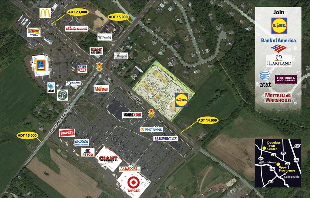
1 New Lidl Supermarket Anchored Development Upper Providence,PA Signalized intersection near Ridge Pk. & Townshipline Rd. For Lease 72,913 sf center with only 1,800 sf of space left! Location Signalized intersection located off Ridge Pike & Townshipline Road Development connects at main light to Giant, Target, Ross & Staples anchored center 23,000 ADT on Ridge Pike Strong household incomes Description ±72,913 sf development with 36,170 sf Lidl supermarket anchor: 3,000 sf of space remaining with frontage on Ridge Pike Current committed Tenants: Lidl Supermarket, Bank of America, Heartland Dental, Mattress Warehouse, AT&T, Eye to Eye Vision Center, Trattoria Italiana, Saku Sushi, Master Nail, and Premium Wine & Spirits Andrew R. Nemroff (856) Tyler Arsenault (856) Cell: (610) Cell: (609)
2

 & #61-00-04408-004 (BLOCK 1 UNIT 20). 6. ALL A.D.A. ACCESSIBLE PARKING SPACES, RAMPS, AND ACCESSIBLE ROUTES SHALL BE CONSTRUCTED TO MEET CURRENT A.D.A. REQUIREMENTS, AS AMENDED.")
 PER MAP ENTITLED \"NATIONAL FLOOD INSURANCE PROGRAM, FIRM, FLOOD INSURANCE")


 ZONING REQUIREMENTS: ZONING REQUIREMENTS PER THE CODE OF THE TOWNSHIP OF UPPER PROVIDENCE, ORD. NO. 180.")
, & RETAIL (PERMITTED BY RIGHT) - UNIFIED SHOPPING CENTER PER SECTION 182-87 PENNSYLVANIA LAW REQUIRES 3 WORKING DAYS NOTICE FOR CONSTRUCTION PHASE AND 10 WORKING")
3 3. ALL ELEVATIONS SHOWN ARE IN ACCORDANCE WITH THE REFERENCED SURVEYOR'S BENCHMARK AND MUST BE VERIFIED BY THE GENERAL CONTRACTOR PRIOR TO GROUNDBREAK. ELEVATIONS ARE BASED UPON NVGD 1929, REFERENCE BM. RM176 ELEV.=161.80'. 4. APPLICANT/EQUITABLE OWNER: HARTFORD PROPERTIES, LLC 1000 S. LENOLA HILL, BUILDING 2, SUITE 100 MAPLE SHADE, NJ ATTENTION: ROBERT HILL PARCEL DATA: TAX MAP PARCEL NOS.: APN # (BLOCK 1 UNIT 17) & # (BLOCK 1 UNIT 20). 6. ALL A.D.A. ACCESSIBLE PARKING SPACES, RAMPS, AND ACCESSIBLE ROUTES SHALL BE CONSTRUCTED TO MEET CURRENT A.D.A. REQUIREMENTS, AS AMENDED. 7. ALL FEATURES ARE EXISTING TO REMAIN UNLESS OTHERWISE NOTED. 8. FEATURES TO BE REMOVED ARE NOTED (TBR). 9. MEASUREMENTS ARE TAKEN FROM FACE OF CURB, WHERE APPLICABLE. 10. BY GRAPHIC PLOTTING ONLY PROPERTY IS LOCATED IN FLOOD HAZARD ZONE X (AREAS DETERMINED TO BE OUTSIDE THE 500-YEAR FLOOD PLAIN) PER MAP ENTITLED "NATIONAL FLOOD INSURANCE PROGRAM, FIRM, FLOOD INSURANCE RATE MAP, MONTGOMERY COUNTY, PENNSYLVANIA (ALL JURISDICTIONS), PANEL 228 OF 451", MAP NUMBER 42091C0228 E, MAP REVISED: DECEMBER 19, LOCATION MAP 1"=2,000' 1,000' 0 NORTHERN VIRGINIA CENTRAL VIRGINIA RALEIGH, NC CHARLOTTE, NC TAMPA, FL SOUTH FLORIDA REVISIONS 11. NO DEBRIS SHALL BE BURIED ON-SITE. 12. ALL PUBLIC UTILITIES, INCLUDING WATER AND SEWER ARE CURRENTLY AVAILABLE. SITE IS TO BE SERVICED BY PUBLIC WATER AND SEWER UTILITIES. CONTRACTOR IS RESPONSIBLE TO OBTAIN ALL SPECIFIC RESOURCES, TECHNICAL REPORTS, AND DESIGN DOCUMENTS RELATED TO THIS PROJECT AND FAMILIARIZE HIMSELF WITH SAME FOR APPLICATION BOTH PRIOR TO AND DURING CONSTRUCTION. PHILADELPHIA, PA LEHIGH VALLEY, PA SOUTHEASTERN, PA REHOBOTH BEACH, DE BALTIMORE, MD SOUTHERN MARYLAND 2. UPSTATE NEW YORK NEW ENGLAND BOSTON, MA NEW YORK METRO NEW YORK, NY NEW JERSEY THIS PLAN REFERENCES DOCUMENTS AND INFORMATION BY: A. CONTROL POINT ASSOCIATES, INC MANOR DRIVE, SUITE 100 CHALFONT, PA ENTITLED: "ALTA/ACSM LAND TITLE SURVEY" PREPARED FOR: HARTFORD PROPERTIES FILE NO.: CP15059 DATED: 06/10/2015 REVISED: 04/06/2016 TM 1. SITE CIVIL AND CONSULTING ENGINEERING PROGRAM MANAGEMENT LANDSCAPE ARCHITECTURE LAND SURVEYING SUSTAINABLE DESIGN PERMITTING SERVICES TRANSPORTATION SERVICES GENERAL NOTES 2,000' 13. NO WETLANDS EXIST EITHER ON THE PROJECT SITE OR WITHIN THE PROPOSED DEVELOPMENT AREA. 14. PARKING SPACES ARE 9'X18' AND/OR 10'X18' AS SPECIFIED ON THE PLANS. REV DATE 1 6/10/16 2 6/30/16 COMMENT REV. PER NPDES COMMENTS REV. PER REVIEW LTR COMMENTS BY JAB MSL 15. ELEVATIONS ARE BASED UPON NGVD 1929 DATUM, REFERENCE BM RM176 ELEV.= ' AS INDICATED ON THE HIGHLAND DEVELOPMENT GROUP, LTD PLAN. THE CONVERSION FROM NGVD 1929 DATUM TO NAVD 1988 DATUM IS -1.67' PER GPS OBSERVATION UTILIZING THE KEYSTONE VRS NETWORK (KEYNETGPS) ZONING REQUIREMENTS: ZONING REQUIREMENTS PER THE CODE OF THE TOWNSHIP OF UPPER PROVIDENCE, ORD. NO ZONED: NC - NEIGHBORHOOD CONVENIENCE COMMERCIAL EXISTING USE: BLOCK1 UNIT 20 - VACANT LOT; BLOCK 1 UNIT 17 - DINE-IN RESTAURANT AND VISION CENTER PROPOSED USE: BANK W/ DRIVE-THRU (CONDITIONAL USE), GROCERY STORE (PERMITTED BY RIGHT), & RETAIL (PERMITTED BY RIGHT) - UNIFIED SHOPPING CENTER PER SECTION PENNSYLVANIA LAW REQUIRES 3 WORKING DAYS NOTICE FOR CONSTRUCTION PHASE AND 10 WORKING DAYS IN DESIGN STAGE - STOP CALL PA1 POCS SERIAL NUMBER SYSTEM, INC NOT APPROVED FOR CONSTRUCTION * REAR YARD PARKING SETBACK 35 FEET ABUTTING A RESIDENTIAL ZONE TO INCLUDE A TYPE 3 BUFFER. **5% ADDITIONAL IMPERVIOUS ALLOWABLE WITH PROPOSED MUNICIPAL ACCESS ROAD = 70% + 5% = 75% (ENC) - EXISTING NON-CONFORMITY PROJECT No.: DRAWN BY: CHECKED BY: DATE: SCALE: CAD I.D.: PY MSL MEJ AS NOTED PY LANDDEV-2 OWNER'S CERTIFICATION PROJECT: STATE: COUNTY: ON THIS DAY OF, BEFORE ME, THE SUBSCRIBER, A NOTARY PUBLIC OF, RESIDING IN, PERSONALLY APPEARED, WHO ACKNOWLEDGED HIMSELF (THEMSELVES) TO BE THE OWNER(S) OF THE LAND SHOWN HEREON. ALL NECESSARY APPROVALS OF THIS PLAN HAVE BEEN OBTAINED AND IS ENDORSED THEREON AND I (WE) DESIRE THAT THIS PLAN BE DULY RECORDED. NOTARY PUBLIC PRELIMINARY/FINAL LAND DEVELOPMENT PLANS MY COMMISSION EXPIRES: I (WE) DO HEREBY CERTIFY THAT I AM (WE ARE) THE SOLE REGISTERED OWNER(S) OF THE LAND HEREIN SUBDIVIDED AND THAT THERE ARE NO SUITS PENDING AFFECTING THE TITLE OF THE SAME AND THAT I (WE) DO HEREBY ADOPT THIS PLAN AND DESIRE THE SAME TO BE RECORDED. I (WE) DO FURTHER SAVE THE TOWNSHIP HARMLESS AND INDEMNIFY THE TOWNSHIP OF UPPER PROVIDENCE AGAINST ANY LIABILITY OR LOSS RESULTING FROM THE SUBDIVISION OR DEVELOPMENT OF THIS PLAT, FOR WHATEVER REASON PRESENT OR FUTURE. OWNER OWNER CORPORATION CERTIFICATION STATE: COUNTY: ON THE DAY OF BEFORE ME, THE SUBSCRIBER, A NOTARY PUBLIC OF, RESIDING IN PERSONALLY APPEARED, WHO ACKNOWLEDGED HIMSELF TO BE THE OF, A CORPORATION, AND THAT AS SUCH BEING AUTHORIZED TO DO SO, HE EXECUTED THE FOREGOING PLAN BY SIGNING THE NAME OF SAID CORPORATION BY HIMSELF AS THAT SAID CORPORATION IS THE OWNER OF THE LAND SHOWN HEREON. ALL NECESSARY APPROVALS OF THIS PLAN HAVE BEEN OBTAINED AND IS ENDORSED THEREON AND SAID CORPORATION DESIRES THAT THIS PLAN BE DULY RECORDED. NOTARY PUBLIC MY COMMISSION EXPIRES: I,, ACKNOWLEDGE MYSELF TO BE THE OF, A CORPORATION, AND THAT AS SUCH BEING AUTHORIZED TO DO SO, HEREBY CERTIFY THAT THE CORPORATION IS THE SOLE REGISTERED OWNER OF THE LAND HEREIN SUBDIVIDED AND THAT THERE ARE NO SUITS PENDING AFFECTING THE TITLE OF THE SAME AND THAT I DO HEREBY ADOPT THIS PLAN AND DESIRE THE SAME TO BE RECORDED. I DO FURTHER SAVE THE TOWNSHIP HARMLESS AND INDEMNIFY THE TOWNSHIP OF UPPER PROVIDENCE AGAINST ANY LIABILITY OR LOSS RESULTING FROM THE SUBDIVISION OR DEVELOPMENT OF THIS PLAT FOR WHATEVER REASON PRESENT OR FUTURE. CORPORATE OFFICIAL OFFICE FOR THE SHOPPES AT UPPER PROVIDENCE HARTFORD PROPERTIES, LLC RIDGE PIKE MONTGOMERY COUNTY, PA 3701 CORPORATE PARKWAY, SUITE 200 CENTER VALLEY, PENNSYLVANIA Phone: Fax: ML R:\14\PY140827\_CAD\LANDDEV\REV-2\PY LANDDEV >LAYOUT: C-02 SITE PLAN SURVEYOR'S CERTIFICATION (610) (610) I HEREBY CERTIFY THAT THE PLAN SHOWN AND DESCRIBED HEREON, AS WELL AS ALL OTHER DRAWINGS WHICH ARE A PART OF THIS PLAN SET, ARE TRUE AND CORRECT TO THE ACCURACY REQUIRED BY THE UPPER PROVIDENCE TOWNSHIP SUBDIVISION AND LAND DEVELOPMENT ORDINANCE AND WERE PREPARED BY ME OR UNDER MY DIRECTION, FOR WHICH I ACCEPT FULL RESPONSIBILITY, AND REPRESENT A FIELD SURVEY PERFORMED BY ME OR UNDER MY DIRECTION. THE EXISTING PERIMETER MONUMENTS SHOWN HEREON HAVE BEEN LOCATED AS PART OF THE SURVEY AND ALL OTHER PROPOSED PERIMETER MONUMENTS SHALL BE SET.\-\-\-\-\-\-\ SURVEYOR DATE TOWNSHIP SUPERVISOR'S CERTIFICATION DRAWING LEGEND PROFESSIONAL ENGINEER THIS PLAN HAS BEEN APPROVED BY UPPER PROVIDENCE TOWNSHIP BOARD OF SUPERVISORS THIS DAY OF,. CHAIRMAN ATTESTED: TOWNSHIP MANAGER 40 SHEET TITLE: COUNTY RECORDING NOTE 1"= 40' RECORDED IN THE OFFICE OF THE RECORDER OF DEEDS IN NORRISTOWN, PENNSYLVANIA, IN PLAN BOOK, PAGE, ON THE DAY OF,. NOTE: PARKING REQUIREMENTS LOT 1 BUILDING GROSS FLOOR AREA (36,185 SF.) REQUIRED PARKING IS 4.5 PER 1,000 SF 36,185 / 1,000 = * 4.5 = 163 TOTAL PARKING REQUIRED LOT 1 = 163 SPACES (4.5 SPACES PER 1,000) TOTAL PARKING PROVIDED LOT 1 = 151 SPACES (4.2 SPACES PER 1,000) (DEFICIENT 12 PARKING SPACES) LOT 2 BUILDING GROSS FLOOR AREA (37,196 SF.) REQUIRED PARKING IS 4.5 PER 1,000 SF 37,196/ 1,000 = * 4.5 = 168 TOTAL PARKING REQUIRED LOT 2 = 168 SPACES (4.5 SPACES PER 1,000) TOTAL PARKING PROVIDED LOT 2 = 184 SPACES (4.9 SPACES PER 1,000) (SURPLUS 16 PARKING SPACES) TOTAL BUILDING GROSS FLOOR AREA (73,381 SF.) REQUIRED PARKING IS 4.5 PER 1,000 SF 73,381 / 1,000 = * 4.5 = 331 TOTAL PARKING REQUIRED = 331 SPACES (4.5 SPACES PER 1,000) TOTAL PARKING PROVIDED = 335 SPACES (4.6 SPACES PER 1,000) (SURPLUS 4 PARKING SPACES) THE PROPERTY OWNER SHALL HAVE THE RESPONSIBILITY FOR THE PERPETUAL MAINTENANCE OF THE PERMANENT WATER DETENTION BASIN, BASIN OUTLET STRUCTURES AND PIPES WHICH ARE LOCATED ON HIS PROPERTY. NO CHANGES SHALL BE MADE TO THE STRUCTURES, PIPES OR FINISH GRADING WITHOUT PRIOR WRITTEN APPROVAL FROM THE TOWNSHIP. THE TOWNSHIP HAS THE RIGHT TO ENTER THE LOT TO PERFORM ANY REQUIRED MAINTENANCE WHICH HAS NOT BEEN PROPERLY PERFORMED OR CARRIED OUT IN A TIMELY MANNER THE PROPERTY OWNER SHALL BE RESPONSIBLE FOR THE COST OF ANY MAINTENANCE WHICH IS PERFORMED BY THE TOWNSHIP. THE TOWNSHIP SHALL LIEN THE PROPERTY FOR SAID COSTS UNTIL THE TOWNSHIP HAS BEEN REIMBURSED IN FULL. THE DEVELOPER OR PROPERTY OWNER SHALL PAY TO THE TOWNSHIP AND TO THE AUTHORITY WHICH TREATS THE SEWAGE THE CURRENT FEES FOR THE TREATMENT AND COLLECTION OF SEWAGE WHEN SUCH FACILITIES ARE MADE AVAILABLE TO THE APPLICANT'S SITE. SITE PLAN SHEET NUMBER: C-2 2 OF 25 REVISION 2

4 Building A Future BoA Lidl Supermarket Building B Site Aerial Overall Elevation Upper Providence Retail Upper Providence Township, Montgomery County, PA March 29, 2016

5 Building A Elevation Upper Providence Retail Upper Providence Township, Montgomery County, PA March 29, 2016
6 Building B Elevation Upper Providence Retail Upper Providence Township, Montgomery County, PA March 29, 2016
SUBDIVISION APPLICATION: RECOMBINATION PLAT or EXEMPT PLAT
 SUBDIVISION APPLICATION: RECOMBINATION PLAT or EXEMPT PLAT Pursuant to Article 7, Section 155.706 of the Unified Development Code, an owner of land within the jurisdiction of the Town (or a duly authorized
FINAL PLAT CHECKLIST
 FINAL PLAT CHECKLIST Project Name: Tax ID #: Project Number: Date: _ Reviewed By: Telephone: Please address all items marked with an "X" Please return redline comments with corrected plan, original mylar,
MINOR SUBDIVISION FINAL PLAT APPLICATION Town of Apex, North Carolina
 MINOR SUBDIVISION FINAL PLAT APPLICATION Town of Apex, North Carolina This document is a public record under the North Carolina Public Records Act and may be published on the Town s website or disclosed
SUBMITTAL REQUIREMENTS: The number indicates the number of copies for submittal (if applicable).
.") Office Use Only Preliminary Long Plat Long Subdivision Applicant Checklist PLANNING, COMMUNITY, & ECONOMIC DEVELOPMENT DEPARTMENT PRELIMINARY LONG PLAT LONG SUBDIVISION CHECKLIST Mailing Address: P.O.
Office Use Only Preliminary Long Plat Long Subdivision Applicant Checklist PLANNING, COMMUNITY, & ECONOMIC DEVELOPMENT DEPARTMENT PRELIMINARY LONG PLAT LONG SUBDIVISION CHECKLIST Mailing Address: P.O.
ABBREVIATION LEGEND SITE INFORMATION:
 SITE INFORMATION: Current Zone: R-3 PUD, governed by Fox Hollow 2nd MDA Basis of Elevations: Northeast Corner of Section 13, T6S, R1W, S.L.B. & M Elevation: 4599.26 (Benchmark) ABBREVIATION LEGEND Owners:
MASTER SUBDIVISION FINAL PLAT APPLICATION Town of Apex, North Carolina
 MASTER SUBDIVISION FINAL PLAT APPLICATION Town of Apex, North Carolina This document is a public record under the North Carolina Public Records Act and may be published to the Town s website or disclosed
SUBMITTAL REQUIREMENTS: The number indicates the number of copies for submittal (if applicable).
.") Office Use Only Preliminary Long Plat Long Subdivision Applicant Checklist PLANNING, COMMUNITY, & ECONOMIC DEVELOPMENT DEPARTMENT FINAL LONG PLAT LONG SUBDIVISION CHECKLIST Mailing Address: P.O. Box 547,
Office Use Only Preliminary Long Plat Long Subdivision Applicant Checklist PLANNING, COMMUNITY, & ECONOMIC DEVELOPMENT DEPARTMENT FINAL LONG PLAT LONG SUBDIVISION CHECKLIST Mailing Address: P.O. Box 547,
FINAL SITE PLAN PLAT APPLICATION Town of Apex, North Carolina
 FINAL SITE PLAN PLAT APPLICATION Town of Apex, North Carolina This document is a public record under the North Carolina Public Records Act and may be published on the Town s website or disclosed to third
PLANNING COMMISSION BRIEFING ITEM. Land Development Applications July 24, 2018, Planning Commission Public Hearing
 Date of Meeting: July 12, 2018 PLANNING COMMISSION BRIEFING ITEM Land Development Applications July 24, 2018, Planning Commission Public Hearing ZCPA 2016 0014, ZRTD 2016 0006, SPEX 2016 0045, SPEX 2016
Community Development Department Council Chambers, 7:30 PM, December 1, 2016
 STAFF REPORT 2016-35P: Subdivision Community Development Department Council Chambers, 7:30 PM, December 1, 2016 To: From: Re: Paul Luke, Chairman, Skokie Plan Commission Mike Voitik, Planning Technician
MINOR SUBDIVISION PLAT CHECKLIST
 MINOR SUBDIVISION PLAT CHECKLIST Project Name: Tax ID #: Project Number: Date: _ Reviewed By: Telephone: NOTES: All lots on septic systems must comply with the Fulton County Health Department requirements
SUBDIVISION APPLICATION
 SUBDIVISION APPLICATION Preliminary Plat Minor Plat Final Plat Amended Plat Applicant Name: Owner (if different from applicant) Name: Company: Company: Address: Address: City, State, Zip City, State, Zip
MAJOR SUBDIVISION PRELIMINARY PLAT CHECKLIST
 TOWNSHIP OF EGG HARBOR PLANNING BOARD/ZONING BOARD OF ADJUSTMENT 3515 BARGAINTOWN ROAD EGG HARBOR TOWNSHIP, NJ 08234 MAJOR SUBDIVISION PRELIMINARY PLAT CHECKLIST The following checklist is designed to
SUBDIVISION APPLICATION
 SUBDIVISION APPLICATION City of Horn Lake Planning Department 3101 Goodman Road, W Horn Lake, MS 38637 662-342-3559 Fax: 662-342-3485 Applications due the 1st working day of the month. Submit application
MINOR PLAT. The following documents are provided as required by the City of Conroe for use in the above titled platting submittals:
 Public Works - Engineering Division CITY OF CONROE MINOR PLAT The following documents are provided as required by the City of Conroe for use in the above titled platting submittals: Submittal Questionnaire
Sheds, Fences, Decks (All Permitted Structures Except New and/or Expansion of Principal Buildings )
") Requirement for Zoning Permits: New Principal Building / Expansion of Principal Building / Commercial Buildings, etc. 1. Application Filled out and Signed. 2. Three (3) copies of a Plot Plan drawn to scale
Requirement for Zoning Permits: New Principal Building / Expansion of Principal Building / Commercial Buildings, etc. 1. Application Filled out and Signed. 2. Three (3) copies of a Plot Plan drawn to scale
Community Development Department Council Chambers, 7:30 PM, July 20, 2017
 STAFF REPORT 2017-25P: Subdivision Community Development Department Council Chambers, 7:30 PM, July 20, 2017 To: From: Re: Paul Luke, Chairman, Skokie Plan Commission Mike Voitik, Planning Technician 2017-25P:
BYRON TOWNSHIP ZONING APPLICATION
 BYRON TOWNSHIP ZONING APPLICATION Phone: (616) 878-9104 * Fax: (616) 878-3980 * Website: www.byrontownship.org This application will not be accepted if incomplete. APPLICATION FOR & REQUIRED COPIES Private
CITY OF DECATUR, TEXAS
 Final Plat or Amending Plat / Replat Checklist A submittal of a complete application will facilitate a timely review. Failure of the applicant to provide required information or obtain a waiver from the
MAJOR RESIDENTIAL AND NONRESIDENTIAL SUBDIVISIONS
 Lawrence-Douglas County MAJOR RESIDENTIAL AND NONRESIDENTIAL SUBDIVISIONS Preliminary Plats The applicant shall schedule a Pre-Application meeting with Planning Staff at least seven (7) working days prior
Subdivision Final Plat Application and Checklist for Approval
 Page 1 of 9 Subdivision Final Plat Application and Checklist for Approval CITY OF CENTERTON Planning Department Office (479) 795-2750 Fax (479)795-2545 planning@centertonar.us Project Title PROJECT NO.
SUBDIVISION & PLANNING APPROVAL STAFF REPORT Date: December 1, 2016
 SUBDIVISION & PLANNING APPROVAL STAFF REPORT Date: December 1, 2016 APPLICANT NAME SUBDIVISION NAME DEVELOPMENT NAME LOCATION Board of Water and Sewer Commissioners of the City of Mobile Halls Mill Road
THE CITY OF MOBILE, ALABAMA
 THE CITY OF MOBILE, ALABAMA LETTER OF DECISION March 9, 2018 Byrd Surveying, Inc. 2609 Halls Mill Road Mobile, AL 36606 Re: 4439 Rangeline Road (Northwest corner of Rangeline Road and Halls Mill Road).
Preliminary Plat/Final Plat Application
 Melissa Municipal Center 3411 Barker Avenue Melissa, Texas 75454 Phone: (972) 838-2036 Applicant: Date: Address: Phone: Contact: Fax: E-mail: Propose Addition Name: Acres: Existing Zoning: Propose Zoning:
Preliminary Subdivision Application (Minor) (Three (3) lots or less)
 (Three (3) lots or less)") Gunnison City Offices www.gunnisoncity.org 38 West Center Gunnison, Utah 84634 (435) 528 7969 Date of Application: Preliminary Subdivision Application (Minor) (Three (3) lots or less) APPLICANT INFORMATION
Gunnison City Offices www.gunnisoncity.org 38 West Center Gunnison, Utah 84634 (435) 528 7969 Date of Application: Preliminary Subdivision Application (Minor) (Three (3) lots or less) APPLICANT INFORMATION
A.3. ARTICLE 7 PLAN REQUIREMENTS FOR MINOR SUBDIVISION AND/OR LAND DEVELOPMENT
 700. 701.A.3. ARTICLE 7 PLAN REQUIREMENTS FOR MINOR SUBDIVISION AND/OR LAND DEVELOPMENT SECTION 700 PURPOSE The purpose of this Article is to set forth a streamlined set of Plan Requirements for minor
ZONING AMENDMENT & SUBDIVISION STAFF REPORT Date: July 9, 2015
 ZONING AMENDMENT & SUBDIVISION STAFF REPORT Date: July 9, 2015 APPLICANT NAME 2513 Dauphin Street, Inc. SUBDIVISION NAME Audubon Place Extension No. 3, Resubdivision of Lots 1-5 LOCATION 2513 Dauphin Street
Lower Gwynedd Township 1130 N. Bethlehem Pike, P.O. Box 625 Spring House, PA (215) phone (215) fax
 phone (215) fax") Lower Gwynedd Township 1130 N. Bethlehem Pike, P.O. Box 625 Spring House, PA 19477 (215)646-5302- phone (215)646-3357-fax www.lowergwynedd.org Subdivision and Land Development Application Procedures Requests
Lower Gwynedd Township 1130 N. Bethlehem Pike, P.O. Box 625 Spring House, PA 19477 (215)646-5302- phone (215)646-3357-fax www.lowergwynedd.org Subdivision and Land Development Application Procedures Requests
SUBDIVISION AND LAND DEVELOPMENT. 185 Attachment 20
 185 Attachment 20 APPENDIX S Plat No. Date of Submission Twp. Fee $ Dauphin Co. Fee $ TOWNSHIP OF DERRY SUBDIVISION OR LAND DEVELOPMENT PLAN SUBMISSION APPLICATION This block for Twp. use only 1. Title
ARTICLE V PRELIMINARY PLAN SUBMISSION
 ARTICLE V PRELIMINARY PLAN SUBMISSION 501. Plan Requirements a. On or before the 25 th day of the month prior to a regularly scheduled meeting of the Planning Commission, the applicant shall submit two
RECIPROCAL EASEMENT OPTION CONTRACT WITNESSETH:
 March 3, 2015 - FINAL Olney FSU - Adjoining Property RECIPROCAL EASEMENT OPTION CONTRACT THIS RECIPROCAL EASEMENT OPTION CONTRACT (the Contract ) is made as of this 8th day of April, 2015 (the Execution
SKETCH OF BOUNDARY SURVEY ALTA / ACSM LAND TITLE SURVEY
 SKETCH OF BOUNDARY SURVEY ALTA / ACSM LAND TITLE SURVEY SURVEYOR'S NOTES: All distances as shown hereon are based on the US Survey foot. Subject property lies inside the UBD (Urban Development Boundary),
Condominium Unit Requirements.
 ARTICLE 19 CONDOMINIUM REGULATIONS Section 19.01 Purpose. The purpose of this Article is to regulate projects that divide real property under a contractual arrangement known as a condominium. New and conversion
ARTICLE 900 PLAT AND PLAN REQUIREMENTS
 ARTICLE 900 PLAT AND PLAN REQUIREMENTS SEC. 900.1 ITEMS TO BE SHOWN ON PLAT OR PLAN General (1) Property lines of all property owners adjacent to the exterior boundaries of the project shall be located
UPPER MOUNT BETHEL TOWNSHIP, NORTHAMPTON COUNTY, PA MINOR SUBDIVISION FINAL PLAN CHECKLIST* YES** NO
 UPPER MOUNT BETHEL TOWNSHIP, NORTHAMPTON COUNTY, PA MINOR SUBDIVISION FINAL PLAN CHECKLIST* YES** NO GENERAL SUBMISSION ITEMS Does the submission include: 1. Seven (7) copies of completed Application Form?
DETAILED GRADING PLAN CHECKLIST (TEARDOWN/REDEVELOPMENT) Updated: 12/12/2017
 Updated: 12/12/2017") DETAILED GRADING PLAN CHECKLIST (TEARDOWN/REDEVELOPMENT) Updated: 12/12/2017 ADDRESS: PERMIT #: DATE: Sat. Not GENERAL 1. A disposition of comments should be included in all subsequent submittals. 2. Plan
DETAILED GRADING PLAN CHECKLIST (TEARDOWN/REDEVELOPMENT) Updated: 12/12/2017 ADDRESS: PERMIT #: DATE: Sat. Not GENERAL 1. A disposition of comments should be included in all subsequent submittals. 2. Plan
Township of Little Egg Harbor Planning Board 665 Radio Road Little Egg Harbor, New Jersey Phone: ext. 221 Fax:
 BLOCK(S) LOT(S) Township of Little Egg Harbor Planning Board 665 Radio Road Little Egg Harbor, New Jersey 08087 Phone: 609-296-7241 ext. 221 Fax: 609-294-3040 Development Application Amended Development
COUNTY OF ALBEMARLE APPLICATION FOR RURAL SUBDIVISION
 Page 1 APPLICATION FOR RURAL SUBDIVISION The term rural subdivision means a type of subdivision that is located in the rural areas which results in two or more lots for the purpose of transfer of ownership
Subdivision Plat Signature Block Templates
 Subdivision Plat Signature Block Templates Please refer to the Subdivision Plat Checklist to determine which signature blocks are required for the plat you are preparing. All text must be at least 10 pt
CERTIFIED SURVEY MAP
 SCONSIN STATE PLANE N:389676.12 E:2130390.15 Center of Section 23 CERTIFIED SURVEY MAP 734.06' THE (PRITCHETTE) ORIGINAL PLAT OF ALL IN THE NW 1 4 OF THE SE 1 4 OF FRACTIONAL SECTION 23, T7N, R9E, IN THE
PART OF SECTION 9, TOWNSHIP 36 NORTH, RANGE 9 EAST OF THE THIRD PRINCIPAL MERIDIAN, NORTH OF THE INDIAN BOUNDRY LINE, IN WILL COUNTY, ILLINOIS.
 PART OF SECTION 9, TOWNSHIP 6, RANGE 9 EAST OF THE THIRD PRINCIPAL MERIDIAN, OF THE INDIAN BOUNY LINE, IN WILL COUNTY, ILLINOIS. ASSUMED THE LINE OF THE WEST / OF SECTION 9-6-9 TO BE: S89 5' 7"E 60 0 0
Subdivision Plat Signature Block Templates
 Subdivision Plat Signature Block Templates Please refer to the Subdivision Plat Checklist to determine which signature blocks are required for the plat you are preparing. All text must be at least 10 pt
1 st Hearing: 2 nd Hearing: Publication Dates: Notices Mailed: Rezone, Special Exception and Variance APPLICANT INFORMATION PROPERTY INFORMATION
 City of Okeechobee General Services Department 55 S.E. 3 rd Avenue, Room 101 Okeechobee, Florida 34974-2903 Phone: (863) 763-3372, ext. 218 Fax: (863) 763-1686 1 Name of property owner(s): 2 Owner mailing
PREPARED BY PLANNING DEPARTMENT ORANGE COUNTY NORTH CAROLINA
 PREPARED BY PLANNING DEPARTMENT ORANGE COUNTY NORTH CAROLINA Return to: DONNA PUCKETT 1555 NC 56 SUITE 2 CREEDMOOR, NC 27522 DECLARATION OF DEVELOPMENT RESTRICTIONS AND REQUIREMENTS RECORDED CONCURRENTLY
Zoning Permit Application Cover Page
 Zoning Permit Application Cover Page The City of Belmont performs an initial site inspection prior to issuance of a zoning permit for new construction. Upon receipt of a full and complete application submittal
ARTICLE 13 CONDOMINIUM REGULATIONS
 ARTICLE 13 CONDOMINIUM REGULATIONS Section 13.01 Purpose. The purpose of this Article is to regulate projects that divide real property under a contractual arrangement known as a condominium. New and conversion
Conveyance of City Land at Intersection of Grady Avenue and Preston Avenue
 CITY OF CHARLOTTESVILLE, VIRGINIA CITY COUNCIL AGENDA Agenda Date: June 5, 2017 Action Required: Presenter: Staff Contacts: Title: Public Hearing and Adoption of Ordinance S. Craig Brown, City Attorney
ARLINGTON COUNTY, VIRGINIA. County Board Agenda Item Meeting of January 27, 2018
 ARLINGTON COUNTY, VIRGINIA County Board Agenda Item Meeting of January 27, 2018 DATE: January 19, 2018 SUBJECT: Amendment and Re-enactment of an Amended and Re-enacted Ordinance of Encroachment to Permit:
SCHUYLKILL TOWNSHIP SUBDIVISION APPLICATION FORM REVISED June 30, Name of Applicant: Address: Telephone No.: Contact: Fax:
 SCHUYLKILL TOWNSHIP SUBDIVISION APPLICATION FORM REVISED June 30, 2009 Plan Title FOR OFFICIAL USE ONLY FILE NUMBER Plan Date DATE RECEIVED Plan to be reviewed as: Preliminary Final Plan type: Land Development
City of Melissa, Texas Plat Dedication Language
 City of Melissa, Texas Plat Dedication Language [INCLUDE THE FOLLOWING DEDICATION LANGUAGE FOR INDIVIDUALS (MODIFY APPROPRIATELY TO REFLECT EXACTLY AS SHOWN ON PROPERTY DEED)]: NOW THEREFORE, KNOW ALL
LAND USE APPLICATION
 LAND USE APPLICATION File Name: File No(s).: Receipt No.: Receipt Date: Received By: Amount.: $ Instructions for Applicants Please read and follow all instructions on your application carefully. If you
Walton County Planning and Development Services
 Walton County Planning and Development Services 31 Coastal Centre Boulevard, Suite 100 47 N 6 th Street Santa Rosa Beach, Florida 32459 DeFuniak Springs, Florida 32433 Phone 850-267-1955 Phone 850-892-8157
E. 140TH AVE. VICINITY MAP SCALE: 1"=600' LAND USE TABLE NET AREA 599,946 SQFT AC. GROSS AREA 741,420 SQFT AC.
 SHEET OF PURPOSE STATEMENT: THIS PLAT IS INTENDED TO SUBDIVIDE. ACRES INTO SINGLE FAMILY ATTACHED LOTS, TRACTS, DEDICATE AND GRANT EASEMENTS. LEGAL DESCRIPTION: THE UNDERSIGNED BEING THE OWNER(S) OF A
Final Plat Mapping Requirements
 CURRENT PLANNING DIVISION 410 E. 5 th Street Loveland, CO 80537 970-962-2523 eplan-planning@cityofloveland.org cityofloveland.org/dc Final Plat Mapping Requirements All Final plats shall comply with the
Preliminary Subdivision Application (Major) (Four (4) lots or more)
 (Four (4) lots or more)") Gunnison City Offices www.gunnisoncity.org 38 West Center Gunnison, Utah 84634 (435) 528 7969 Date of Application: Preliminary Subdivision Application (Major) (Four (4) lots or more) APPLICANT INFORMATION
Gunnison City Offices www.gunnisoncity.org 38 West Center Gunnison, Utah 84634 (435) 528 7969 Date of Application: Preliminary Subdivision Application (Major) (Four (4) lots or more) APPLICANT INFORMATION
LYON COUNTY COMMUNITY DEVELOPMENT DEPARTMENT
 LYON COUNTY COMMUNITY DEVELOPMENT DEPARTMENT B UILDING D EVELOPMENT E NGINEERING P LANNING 27 S. MAIN S TREET Y ERINGTON, NEVADA 89447 (775) 463-6591 F AX: (775) 463-5305 34 LAKES B OULEVARD D AYTON, NEVADA
PRELMINARY PLAT CHECKLIST
 PRELMINARY PLAT CHECKLIST A. All preliminary plat submitted for approval shall be prepared by a Registered Professional Land Surveyor. B. Preliminary plats must be drawn to a scale of XXX with such accuracy
Site Plan Application
 Site Plan Application City of St. Pete Beach Community Development Department 155 Corey Avenue St. Pete Beach, Florida 33706 (727) 367-2735 www.stpetebeach.org Case Number: PROPERTY OWNER: Name: Address:
APPENDIX B. SUBMISSION REQUIREMENTS
 Master Major Site Minor Site Landscape Section B.1 Table of /Plat Requirements Proposed or approved name of development, project, subdivision, and/or phase. Location, including township, county, and state.
CONDOMINIUM REGULATIONS
 ARTICLE 37 CONDOMINIUM REGULATIONS SECTION 37.01. Purpose The purpose of this Article is to regulate projects that divide real property under a contractual arrangement known as a condominium. New and conversion
SUBDIVISION AND PLATTING STANDARDS Intent and Purpose
 CHAPTER 700. SUBDIVISION AND PLATTING STANDARDS 700.1. Intent and Purpose 700.2. General The intent and purpose of this chapter is to set forth the standards for subdividing and platting land. It is the
1. NAME OF SUBDIVISION : DATE SUBMITTED: LOCATION OF SUBDIVISION : DATE OF PRELIMINARY APPROVAL BY TOWNSHIP SUPERVISORS:
 1 RICHLAND TOWNSHIP PLANNING COMMISSION 322 SCHOOLHOUSE ROAD, SUITE 110 JOHNSTOWN, PA 15904 FINAL SUBDIVISION APPLICATION LAND DEVELOPMENT OR LAND MERGER OR MINOR SUBDIVISION THE UNDERSIGNED HEREBY APPLIES
COUNTY OF ALBEMARLE APPLICATION FOR FAMILY DIVISION. Family Division = $742 (Provide 5 copies of plat)
") Page 1 APPLICATION FOR FAMILY DIVISION Family Division = $742 (Provide 5 copies of plat) Tier 2 Groundwater Review = $355 (Required for all plats showing lots less than 21 acres) Tier 3 Groundwater Review
Page 1 APPLICATION FOR FAMILY DIVISION Family Division = $742 (Provide 5 copies of plat) Tier 2 Groundwater Review = $355 (Required for all plats showing lots less than 21 acres) Tier 3 Groundwater Review
CONCEPT PLAN APPLICATION Meeting with Staff Commercial Projects
 COMMUNITY DEVELOPMENT City of South Salt Lake Community Development Department 220 E. Morris Avenue South Salt Lake City, Utah 84115 Phone (801) 483-6011 Fax (801) 483-6060 CONCEPT PLAN APPLICATION Meeting
I. Requirements for All Applications. C D W
 108-16.1. Application checklists. Checklist for Required Submissions to the Planning Board or Zoning Board of Adjustment of Monroe Township All required submissions are to be made to the Administrative
CHAPTER 22 SUBDIVISION AND LAND DEVELOPMENT
 CHAPTER 22 SUBDIVISION AND LAND DEVELOPMENT 22-101. Title 22-102. Legislative Intent Part 1 General Provisions 22-201. Development Permits Part 2 Administration 22-301. Fee Schedule Part 3 Fee Schedule
Use permitted by: Right Special Exemption
 CENTER TOWNSHIP 150 Henricks Road Butler, PA 16001-8472 Phone (724) 282-7805 Fax (724) 282-6550 Application Number: FEE COLLECTED: Application for: Preliminary Final Land Development Location: Map and
ARTICLE III GENERAL PROCEDURES, MINOR PLANS AND FEE SCHEDULES
 ARTICLE III GENERAL PROCEDURES, MINOR PLANS AND FEE SCHEDULES 301. Prior to Submission a. Copies of this Ordinance shall be available on request, at cost, for the use of any person who desires information
FINAL SUBDIVISION AND LAND DEVELOPMENT PLAN CHECKLIST. Plan Name. Applicant's Name:
 TOWNSHIP OF UPPER ST. CLAIR FINAL SUBDIVISION AND LAND DEVELOPMENT PLAN CHECKLIST Date Filed Plan Name PLC Applicant's Name: Phone Filing Date for Final Application Final Plat 114.22. FINAL APPLICATION
1. Name of Property Owner Phone Address. 2. Name of Surveyor. Phone Address. 3. Lots, Block, Section. Subdivision
 MINOR LAND SUBDIVISION PLAN APPLICATION TO COMBINE ADJACENT LOTS WITHIN RECORDED SUBDIVISIONS COOLBAUGH TOWNSHIP 5550 MEMORIAL BOULEVARD TOBYHANNA, PA 18466 570-894-8490 ****************************************************************************************************
Explanation of Permanent Stormwater Management Facilities Maintenance Agreement
 Explanation of Permanent Stormwater Management Facilities Maintenance Agreement The Permanent Stormwater Management Facilities Maintenance Agreement for a site is comprised of the following elements: 1.
CERTIFICATION OF THE APPROVAL OF WATER AND SEWERAGE SYSTEMS
 ARTICLE 9 FORMS AND CHECK LISTS 9.100 On preliminary layout & final subdivision plat CERTIFICATION OF THE APPROVAL OF WATER AND SEWERAGE SYSTEMS I hereby certify that the (...type: private or pubic...)
APPENDIX C: PLAT SPECIFICATIONS AND CERTIFICATES
 APPENDIX C: PLAT SPECIFICATIONS AND CERTIFICATES A. Drawing. All plats for recording must be submitted on photographically reproducible and dimensionally stable polyester sheets such as Mylar, Cronar or
REGULAR FINAL PLAT SUBDIVISION APPLICATION
 REGULAR FINAL PLAT SUBDIVISION APPLICATION Name of Subdivision (Subdivision Name must be approved by at 856-6216) ( )Cluster Subdivision ( )Lot-by-Lot Subdivision ( )Open Space Subdivision Name of Subdivision
MINOR SUBDIVISION APPLICATION
 MINOR SUBDIVISION APPLICATION Complete with required information (write "n/a" if information is not applicable to proposal). Title of Plat Has any other plat been recorded for this site? ( ) Yes ( ) No
APPLICATION FOR LOT SPLIT
 APPLICATION FOR LOT SPLIT ELIGIBILITY Section 12.09.01 of the Land Development Code provides for review and approval of lot split, which shall include any of the following: 1. The division of a single
PROPERTY OVERVIEW 7 BRITAIN DRIVE DOYLESTOWN PENNSYLVANIA 18901
 PROPERTY OVERVIEW DOYLESTOWN PENNSYLVANIA 18901 PROPERTY DESCRIPTION TOTAL SQUARE FOOTAGE 10,310 SF AVAILABILITY DATE 2nd Quarter 2018 PARCEL SIZE 1 acre YEAR BUILT 1995 HVAC ZONING PARKING Office only;
DETAILED GRADING PLAN CHECKLIST (TEARDOWN/REDEVELOPMENT)
") GENERAL DETAILED GRADING PLAN CHECKLIST (TEARDOWN/REDEVELOPMENT) ADDRESS: PERMIT #: DATE: 1. Plan is signed and sealed by an Illinois registered professional engineer including date signed and license
GENERAL DETAILED GRADING PLAN CHECKLIST (TEARDOWN/REDEVELOPMENT) ADDRESS: PERMIT #: DATE: 1. Plan is signed and sealed by an Illinois registered professional engineer including date signed and license
HOLDING TANK AGREEMENT
 MUNII\9602(4)\020328\1\11 03-19-07 WITH FINANCIAL SECURITY Prepared By: Return To: Parcel ID # Morgan, Hallgren, Crosswell & Kane, P.C. 700 N. Duke St. P. O. Box 4686 Lancaster, PA 17604-4686 (717)-299-5251
Remember, PA One-Call before excavating. Simply dial 811 or
 LTL CONSULTANTS, LTD 610-987-9290 / Toll Free 888-987-8886 REQUIREMENTS FOR OBTAINING A BUILDING PERMIT $50.00 Application Fee payable to Colebrookdale Township due upon submission of this application
PLANNING & DEVELOPMENT SERVICES 1800 Continental Place Mount Vernon, WA Inspections Office Fax 360.
 PLANNING & DEVELOPMENT SERVICES 1800 Continental Place Mount Vernon, WA 98273 Inspections 360.416.1330 Office 360.416-1320 Fax 360.416-1340 Date Received: Administrative Setback Reduction Checklist Pursuant
SUBDIVISION AND LAND DEVELOPMENT ORDINANCE THE TOWNSHIP OF UPPER TULPEHOCKEN BERKS COUNTY, PENNSYLVANIA
 SUBDIVISION AND LAND DEVELOPMENT ORDINANCE OF THE TOWNSHIP OF UPPER TULPEHOCKEN BERKS COUNTY, PENNSYLVANIA JULY, 1975 As Amended SEPTEMBER 12, 1994 As Amended DECEMBER 13, 2005 TABLE OF CONTENTS ARTICLE
15 & 7 BRITAIN DRIVE DOYLESTOWN PENNSYLVANIA 18901
 PROPERTY OVERVIEW 15 & 7 BRITAIN DRIVE DOYLESTOWN PENNSYLVANIA 18901 15 BRITAIN DRIVE EXECUTIVE 15 BRITAIN SUMMARY DRIVE PROPERTY DESCRIPTION 15 BRITAIN DRIVE TOTAL SQUARE FOOTAGE 9,486 SF Warehouse: 8,443
SPECIAL SERVICE AREA DISCLOSURE
 SPECIAL SERVICE AREA DISCLOSURE All lots within this subdivision are included within the County of Will Special Service Area Number and are subject to an annual tax levy in accordance with the provisions
WILTON MANORS, Island City 2020 WILTON DRIVE, WILTON MANORS, FLORIDA 33305
 WILTON MANORS, Island City 2020 WILTON DRIVE, WILTON MANORS, FLORIDA 33305 COMMUNITY DEVELOPMENT SERVICES (954) 390-2180 FAX: (954) 567-6069 PLAT APPLICATION PACKAGE This package includes: General Submittal
ARTICLE XVI SUBDIVISION DEVELOPMENT
 ARTICLE XVI SUBDIVISION DEVELOPMENT 16.0 The division of land into 4 or more lots that will require the construction or extension of public streets, water or sanitary sewerage (other than the direct connection
Lake County Planning, Building and Development Department
 SUBMISSION CHECKLIST FOR SUBDIVISION FINAL PLAT Lake County Planning, Building and Development Department 500 W. Winchester Rd. Unit 101 Libertyville, Illinois 60048-1331 Telephone (847) 377-2600 E-mail:
VICINITY MAP/AERIAL MAP SITE
 VICINITY MAP/AERIAL MAP SITE N ZONING MAP PA 9 PA 5 SITE Solterra West ODP PA 7 N , DATE, 2013, TIME, COUNTY OF JEFFERSON, STATE OF COLORADO, $ DEDICATION CERTIFICATE THE UNDERSIGNED, BEING THE OWNER(S)
FINAL PLAT APPLICATION
 FINAL PLAT APPLICATION (Page 1 of 3) LEGAL OWNER(s): NAME: STREET ADDRESS OWNER(s): CITY, STATE, ZIP CODE: PHONE NUMBER: BILLING ADDRESS: NAME OF ENGINEER/SURVEYOR: Engineer/Surveyor Address, Phone: PROPERTY
UPPER MOUNT BETHEL TOWNSHIP NORTHAMPTON COUNTY, PENNSYLVANIA
 UPPER MOUNT BETHEL TOWNSHIP NORTHAMPTON COUNTY, PENNSYLVANIA JOINDER DEED / LOT CONSOLIDATION TOWNSHIP REVIEW PROCESS When accepting proposed Joinder Deeds / Lot Consolidations, review the Joinder Deed
Sketch Plan 2018 Bargersville Plan Commission Application Kit
 Sketch Plan 2018 Bargersville Plan Commission Application Kit For Commercial, Industrial, and Residential Developments At least 31 days prior to the intended filing of the Primary Plat or Development Plan
LOWER SAUCON TOWNSHIP PLANNING APPLICATION 3700 OLD PHILADELPHIA PIKE BETHLEHEM, PA
 rev. 02/08/06 rev. 01/03/13 File No. LOWER SAUCON TOWNSHIP PLANNING APPLICATION 3700 OLD PHILADELPHIA PIKE BETHLEHEM, PA 18015 (610) 865-3291 Type of Application: Date of Application CONDITIONAL USE REQUEST
RULES, REGULATIONS AND REQUIREMENTS RELATING TO THE APPROVAL AND ACCEPTANCE OF IMPROVEMENTS IN SUBDIVISIONS OR RE-SUBDIVISIONS
 GALVESTON COUNTY RULES, REGULATIONS AND REQUIREMENTS RELATING TO THE APPROVAL AND ACCEPTANCE OF IMPROVEMENTS IN SUBDIVISIONS OR RE-SUBDIVISIONS GALVESTON COUNTY ENGINEERING DEPARTMENT MARCH 3, 1997 Amendment
Township of Collier 2418 Hilltop Road Presto, PA 15142
 Township of Collier 2418 Hilltop Road Presto, PA 15142 Fees: Major: 2 checks $600 + $50 per lot & $1700 Escrow) APPLICATION FOR SUBDIVISION major FINAL only Plans must be folded Rolled plans will not be
BUILDING PERMIT APPLICATION
 BUILDING PERMIT APPLICATION READ APPLICATION COMPLETELY If item is marked with an *, you must have appropriate signature. If is marked, you should fill out. City of Jasper City of Jennings City of White
ARTICLE V. PRELIMINARY PLAT
 ARTICLE V. PRELIMINARY PLAT PAGE 13 SECTION A. PURPOSE. The purpose of the preliminary plat is to allow the Planning and Zoning Commission to review overall platting of the tract and street patterns within
TOWN OF EASTCHESTER BUILDING AND PLANNING DEPARTMENT PLANNING BOARD APPLICATION PACKAGE SUBDIVISIONS
 TOWN OF EASTCHESTER BUILDING AND PLANNING DEPARTMENT 40 Mill Road (914) 771-3317 building@eastchester.org Eastchester, NY 10709 (914) 771-3322 Fax www.eastchester.org TABLE OF CONTENTS PLANNING BOARD APPLICATION
PLANNING DIRECTOR. Approved by the Planning Director on this day of, A.D. 20. day of, A.D. 20. Approved by the Fire Chief on this
 Located in a portion of the West Half of Section 19, Township 5 South, Range 1 East, Salt Lake Base and Meridian. SURVEYOR'S CERTIFICATE I, the undersigned surveyor, do hereby certify that I am a registered
Amendments to Existing Planned Development Districts Application Explained
 Amendments to Existing Planned Development Districts Application Explained 1. Amendment Application Form: completely filled out. (3 copies) 2. Plat: Please follow the checklist attached to this application.
1827 FREEDOM ROAD SUITE 101 LANCASTER, PA 17601
 For Lease 717.293.4477 1827 FREEDOM ROAD SUITE 101 LANCASTER, PA 17601 Table of Contents 1827 Freedom Road, Suite 101 Property Information Sheet Property Photos Location Maps Aerial Photo/Tax Map Zoning