233 Wilshire Boulevard Suite 150 Santa Monica, CA phone fax
|
|
|
- Ruby Rose
- 5 years ago
- Views:
Transcription
1 233 Wilshire Boulevard Suite 150 Santa Monica, CA phone fax memorandum date November 29, 2017 to Steve Mizokami, Senior Planner Planning and Community Development City of Santa Monica from subject Margarita Jerabek, Ph.D., Director of Historic Resources Ashley Brown, M.A., Senior Architectural Historian Max Loder, M.A., Associate Architectural Historian Preliminary Historic Assessment th Street, Santa Monica, CA (APN ) As requested by City staff, ESA has conducted a site visit of th Street ( Residence ) and has reviewed archival data relevant to the subject property. ESA identified the subject property as developed with a two-story single-family residence in the Spanish Colonial Revival style built in The City s Historic Resources Inventory (HRI) did not identify the subject property as an individually eligible significant historical resource, but did identify the subject property as a contributor to the potential Gillette s Regent Square District and assigned it a 5D3 status code (appears to be a contributor to a district that appears eligible for local listing or designation through survey evaluation). The potential district contains a majority of period revival single-family residences built in the 1920s and 1930s. The HRI identified 146 Spanish Colonial Revival style residences within the potential District, 142 of which were given the 5D3 status, including the subject property. ESA conducted a site visit and confirmed that the subject property appears to retain a high level of integrity and a majority of its character-defining features. Furthermore, ESA identified several notable individuals that occupied the subject property. In summary, ESA agrees with the previous findings that the subject property appears to be a contributor to the potential Gillette s Regent Square district. Environmental Setting The subject property is located at th Street and was constructed in 1931in the Spanish Colonial Revival style (Figure 1). The single-family two-story residence ( Residence ) and detached garage ( Garage ) are situated on the east side of 17 th Street, between Georgina Avenue to the south, and San Vicente Boulevard, to the north. The subject property is located in the Gillette s Regent Square Tract ( Tract ), Block Z, on lot 17 (later renumbered to 19) (Figure 2). The Tract was subdivided on March 6, 1913 by King C. Gillette and the Alta Santa Monica Company. Prior to this subdivision and development, the Tract was part of Block 47 of the Santa Monica Land and Water Company Tract, in the Rancho San Vicente y Santa Monica (Miscellaneous Record Book 78, p.

. SOURCE: ESA 2017 Figure 1 Primary (west) elevation, view east.")
2 Preliminary Historic Assessment th Street, Santa Monica, CA (APN ) 44). The parcel measures approximately 60 linear feet by 149 linear feet. The Residence is centrally located within the lot, and the Garage is situated in the northeast corner of the lot (Figure 3). SOURCE: ESA 2017 Figure 1 Primary (west) elevation, view east. SOURCE: LA County Assessor Records (TR A) Figure 2 Block Z of the Gillette s Regent Square, subject property outline in red. 2
 to the north, 21 st Street (Place) to the east, Montana Avenue to the south, and 17 th Street to the west.")

3 Preliminary Historic Assessment th Street, Santa Monica, CA (APN ) SOURCE: EDR 2017 Figure Sanborn Map, Volume 1, Sheet 99 The Tract is bordered by San Vicente Boulevard (Road) to the north, 21 st Street (Place) to the east, Montana Avenue to the south, and 17 th Street to the west. Currently, the neighborhood consists primarily of one- and twostory single-family residences (Figure 4). When the Tract was laid out a majority of the lots measured 60 linear feet by 159 or 160 linear feet, except for lots along San Vicente Boulevard, which measured between 72 to 98 linear feet by 149 to 150 linear feet. SOURCE: Los Angeles County Office of the Assessor Figure th Street and its current setting, property outlined in red 3

4 Preliminary Historic Assessment th Street, Santa Monica, CA (APN ) Previous Evaluations The subject property has been identified and assessed under the City of Santa Monica s survey process in The 2010 Citywide Historic Resources Inventory identified the subject property as a contributor to the potential Gillette s Regent Square district under local criteria A.1, Contributes to a district that exemplifies, symbolizes, or manifests elements of the cultural, social, economic, political or architectural history of the City. 1 The inventory stated that the subject property represents a very good example of a Spanish Colonial Revival style dwelling with a high degree of integrity that contributes to a potential Gillette s Regent Square district in Santa Monica and denoted a 5D3 status code. 2 Architectural Description Located on the east side of 17 th Street, this two-story single-family residence was designed by architect H.M. Roth in the Spanish Colonial Revival style. Its primary elevation is oriented west toward 17 th Street. The subject property features two distinct and mature palm trees on the parkway between the sidewalk and the street, and a mature palm tree adjacent to the main entry area. A concrete driveway leads through a wrought iron gate between two stuccoed piers. The sidewalk extends from the driveway leading to the primary entrance of the Residence. The stucco-clad house has a combination gable and hipped roof, and a chimney at its southwest corner. It has an irregular floor plan (Figure 5). SOURCE: ESA 2017 Figure 5 Overview of th Street, view east The southernmost portion of the primary (west) elevation features a front gable with exposed rafter tails and a large, slightly pointed arch holding a one-lite window, framed by a decorative stucco border and set above a small tile pier. Adjacent to the window is a wrought-iron pedestrian entrance gate set into the façade and framed by two thick Doric pilasters. Tile steps lead to the gateway. Immediately to the north of this section of the primary 1 ICF International, Santa Monica Historic Resources Inventory Update Final Report, prepared for the City of Santa Monica, Ibid. 4

5 Preliminary Historic Assessment th Street, Santa Monica, CA (APN ) elevation is a courtyard wall leading to the previously mentioned wrought-iron driveway gate. As the primary elevation moves north, it becomes two stories. Here it features a corniced beneath the roofline and a multi-lite window, currently obscured by a screen, covered in a decorative vertical wood grille. Also present is a balcony with an ornate wrought-iron balustrade, covered by a cantilevered canopy. On the balcony are a pair of wood multi-lite French doors. Beneath the balcony are several receding layers of stucco, which form an inverted stepped pyramid, inset into a tiled recess above a ribbon of three wood windows. The northernmost portion of the primary elevation comprises a porte-cochere of rounded stucco arches beneath a clay tile balcony roof supported by several wood posts. The balcony itself features a wood balustrade identical to the aforementioned decorative wood grille elsewhere on the primary elevation, and three pairs of wood multi-lite French doors. A multi-lite wood window is also set into the balcony. (Figures 6-8). SOURCE: ESA 2017 Figure 6 Arched window and pedestrian gate on primary (west) elevation, view east 5


6 Preliminary Historic Assessment th Street, Santa Monica, CA (APN ) SOURCE: ESA 2017 Figure 7 Cornice, balcony, window with grills, and tile inset with windows on primary (west) elevation, view east SOURCE: ESA 2017 Figure 8 Porte-cochère and second-story porch on the north portion of the west elevation, view east The southermost portion of the north elevation features an arcade leading to a wooden door. The arcade is floored in the same red tile that leads to the pedestrian wrought-iron entrance. The next portion of the north elevation is two stories and features cornicing identical to that on the west elevation as well as several wood multi-lite windows, a round tower, and molded corbels framing more wood multi-lite windows (Figures 9 and 10). The 6
 elevations were also not visible from the public right-of-way.")
 is a square building with a hipped, clay tile roof. The only visible face is the west elevation with two wood-paneled garage doors.")
7 Preliminary Historic Assessment th Street, Santa Monica, CA (APN ) remainder of the north elevation, fronting the adjacent property, was not visible from the public right-of-way. The south and rear (east) elevations were also not visible from the public right-of-way. SOURCE: ESA 2017 Figure 9 Arcade on north elevation, view east SOURCE: ESA 2017 Figure 10 Windows, tower, and corbels on north elevation, view east The Garage (Figure 11) is a square building with a hipped, clay tile roof. The only visible face is the west elevation with two wood-paneled garage doors. It faces onto a scored poured concrete driveway. 7

8 Preliminary Historic Assessment th Street, Santa Monica, CA (APN ) SOURCE: ESA 2017 Figure 11 Garage, west elevation, view east Historical Background Santa Monica In 1875, the original town site of Santa Monica was surveyed, including all the land extending from Colorado Street on the south to Montana on the north, and from 26th Street on the east to the Pacific Ocean on the west. Between 1893 and the 1920s, the community operated as a tourist attraction that was visited primarily by wealthy patrons. Areas located just outside of the incorporated city limits were semi-rural in setting and populated with scattered residences. Following the widespread acceptance of the automobile in the 1920s, Santa Monica experienced a significant building boom, with numerous homes constructed in the tracts north of Montana Avenue for year-round residents. Gillette s Regent Square Tract Gillette s Regent Square, extending from 15th Street to 21st Place, was one of the many California real estate investments of King C. Gillette, inventor of the razor blade. Gillette left his company in 1910, and invested his fortune in real estate. The area consisted of open fields at the time of its purchase by Gillette, reputedly worth $1,000 per acre. Although subdivided in 1912, Gillette s Regent Square was not extensively populated until Marketed as good investments as well as rare homesites, the area was designed for the burgeoning middle class of Santa Monica in the 1920s. Advertisements also prominently described available transportation in efforts to attract commuters from Los Angeles. The neighborhood was served by the Westgate and Santa Monica streetcar lines, which ran along San Vicente Boulevard. A third line ran along Montana Avenue, to the south. During the Great Depression, Santa Monica struggled with a number of issues, including increased racial tensions, rampant gambling, a jump in illegal trade and activities, and high unemployment. Additionally, building 8
9 Preliminary Historic Assessment th Street, Santa Monica, CA (APN ) activity slowed dramatically in the late 1920s and early 1930s. During this time of hardship, Santa Monica actively attempted to attract investors to the area in an effort to improve the city s prospects. 3 Architecture Spanish Colonial Revival Style ( ) The Spanish Colonial Revival style is one of the Period Revival styles which were popular in Santa Monica in the 1920s and 1930s. Economic growth in the early twentieth-century led to an increase in population in Southern California in these decades. This, in turn, resulted in a high demand for commercial and residential properties. Tract 1566 appears to have been developed at the height of the population and real estate boom and also during a time in which Period Revival styles were immensely popular. By the 1920s, some of the new architecture in Southern California area was derived from European precedents. However, architects and designers also borrowed heavily from non-european and exotic sources that captured the public imagination. An architecture of fantasy then emerged from eclectic sources, and Southern California proved to be a fertile testing ground for these experiments. Period Revival styles were popular during the first forty years of the twentieth-century and patterned after buildings of various earlier periods. Styles included American Colonial Revival, Spanish Colonial Revival, and Pueblo Revival, among others. The beginnings of Spanish Colonial Revival style architecture date to 1915, when it was introduced at the Panama- California Exposition in San Diego. The period revival styles grew in popularity just after World War I, and were patterned after buildings of earlier historic periods. The most common style in the Southwest was the Spanish Colonial Revival style. Inspired by the Panama-California Exposition, many architects found Southern California the ideal setting for this architectural style. Numerous publications argued in favor of this period revival style for the Mediterranean environment of California, including W. Sexton's Spanish Influence on American Architecture and Decoration (1926) and Rexford Newcomb's The Spanish House for America Its Design, Furnishing, and Garden (1927). Architect Bertram Grosvenor Goodhue s comprehensive set of Spanish Colonial Revival structures for the Panama- California Exposition catalyzed a region-wide building trend whose Spanish and Moorish influences incorporated and even supplanted the previously popular Mission Revival style. The many Spanish Colonial Revival and Mediterranean Revival commercial, civic and residential structures became a key component in the forging of regional identity and quest for legitimacy, since the style helped perpetuate powerful myths about California s origins tied to New Spain. Decorative elements that were appropriated from indigenous American cultures (Native American, Mayan, Aztec) were sometimes incorporated into these eclectic designs to infuse exoticism, along with a certain brand of perceived cultural authenticity. The Spanish Colonial Revival style is characterized by a low-pitch roof with little or no eave overhang, the use of red tile roof covering, and one or more prominent arches placed above doors or principal windows or beneath a porch roof. The wall surface is typically stucco with an asymmetrical façade and massing. The form is frequently highly decorated with lesser examples using decorative elements sparingly. Many examples have a least one large focal window, commonly arched or held within an arched reveal. The use of a flat roof with a parapeted wall is one variation in the type, usually used on one or two-story buildings. Narrow tile-covered roofs 3 Paula A. Scott, Santa Monica: A History on the Edge (Charleston, SC: Arcadia Publishing, 2004),

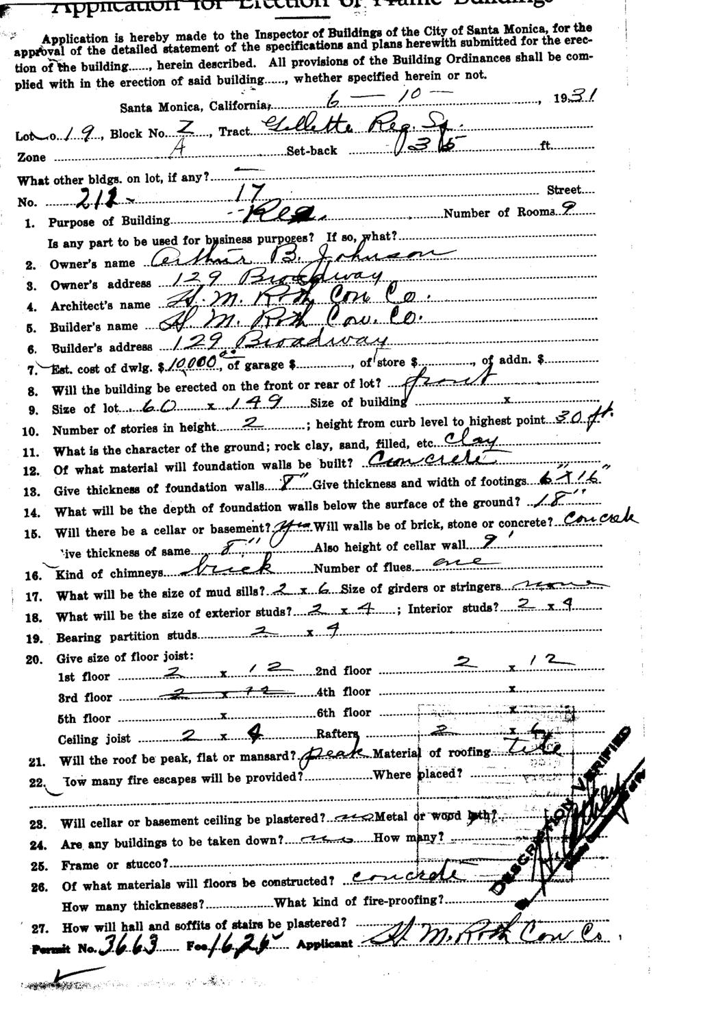
10 Preliminary Historic Assessment th Street, Santa Monica, CA (APN ) are typically added above entryways or projecting windows. 4 The application of costly elements and asymmetry was kept to a minimum on lesser houses in the style th Street Construction History Permit B3663 from 1931 is the original building permit for the subject property, indicating the construction of a two-story nine-room residence on a 60 x 149-foot lot. Owner, Arthur B. Johnson commissioned the Residence and hired H.M. Roth Construction Company as the architect and builder. One additional building permit was available, indicating a kitchen remodel in There are no building permits for the Garage, however according to available aerial imagery the Garage appears to be constructed between 1934 and Alterations The exterior of the Residence has integrity and few alterations detract from its historic appearance. A comparison of the Sanborn Map from 1950 with a current aerial view shows the footprint remains unchanged, with only one non-permanent addition of a pergola located at the rear of the Residence. (Figure 12). According to the building permits the Residence has had only minor alterations since its 1931 construction. These include the remodel of the kitchen in From street view, the Residence to appears to have a majority of its original windows, Spanish Colonial Revival style character defining features (porch, arches, tile work, tower, and detailed woodwork). Occupancy History SOURCE: Sanborn Map 1918 updated 1950 (left), Google Maps 2017 (right) Figure 12 Sanborn Map 1950, footprint identical to present condition in 2017 City of Santa Monica building permits, directory research provided by Environmental Data Resources (EDR), historical Santa Monica Telephone Directories, and other historical city directories were used to prepare an occupancy history for the subject property at th Street and are summarized in the table below. 4 Virginia McAlester, A Field Guide to American Houses (New York: Alfred A.Knopf, 2004), pg USCB Frame Finder, C-22555_15-15, 1954; and C-6630_16,
11 Preliminary Historic Assessment th Street, Santa Monica, CA (APN ) YEAR NAME(S) OCCUPATION SOURCE Arthur B. Johnson Clerk at Wholesale Hardware Los Angeles Directory Co. and City of Santa Monica Directory Francine L Johnson No occupancy found Los Angeles Directory Co. and City of Santa Monica Directory Don R. Norris Officer in the United States Army Los Angeles Directory Co., R.L. Polk Col, and Pacific Telephone 1940 Clara Fitzgerald Norris (mother of Don) No occupancy found 1940 United States Census Ruth Norris (sister of Don) No occupancy found Los Angeles Directory Co., R.L. Polk Col, and Pacific Telephone 1962 H.K. Stanfield Pacific Telephone 1965-c.1969 Zoltan Gross Doctor of Clinical Psychology Pacific Telephone Sara Gross (Sara Radin after 1969) Richard Gabriel (son of Gross) Pacific Telephone Personal Communication The original building permits from 1931 list Arthur B. Johnson as the owner of the property. Arthur B. Johnson was born in 1907 to his mother, Guadalupe Morales-Johnson in California. 6 He married Francine L. Roth and they had one child. They lived at the subject property from 1931 to approximately The 1940 U.S. Census indicates that he was working as a Clerk at a Wholesale Hardware Store. In 1940 the family moved in with Francine s father Nell S. Roth. 7 In the 1958 Santa Monica City Directory, Johnson and his wife are listed as living at th Street and he is working as a Foreman at Will Rogers State Park. 8 Johnson died in Santa Monica on April 16, 1992 and Francine L. Johnson died on May 14, The second owner of the subject property was Don Norris. Don was born September 10, 1888 in Michigan. In 1930, he was listed as living with his mother Clara and sister, Ruth in Los Angeles. 10 In 1938, Don was living at the subject property and was a Major in the United States Army. 11 As a Major, Don served as an Associate Professor (Military Instructor) of Military Science and Tactics at University of California at Los Angeles. 12 Don 6 Thirteenth Census of the United States, (NARA microfilm publication T624, 1,178 rolls). Records of the Bureau of the Census, Record Group 29. National Archives, Washington, D.C. 7 Sixteenth Census of the United States, (National Archives and Records Administration, T627, 4,643 rolls). Washington, D.C. 8 Ancestry.com. U.S. City Directories, [database on-line]. Provo, UT, USA: Ancestry.com Operations, Inc., Social Security Administration. Social Security Death Index, Master File. Social Security Administration. 10 Fifteenth Census of the United States, Washington, D.C.: National Archives and Records Administration, T626, 2,667 rolls. 11 Ancestry.com. U.S. City Directories, [database on-line]. Provo, UT, USA: Ancestry.com Operations, Inc., 2011; and Fifteenth Census of the United States, Washington, D.C.: National Archives and Records Administration, T626, 2,667 rolls. 12 University of California, Berkley, California. General Catalogue, (Berkeley: University of California, 1936),
12 Preliminary Historic Assessment th Street, Santa Monica, CA (APN ) passed away February 29, 1968 and is interred at Arlington National Cemetery. 13 Don s mother Clara also lived at the subject property in Clara was born in 1865 in Michigan and was a widow. No other information was found pertaining to Clara s life. Ruth Norris, the sister of Don, lived at the subject property until her death on November 25, Ruth was born on June 9, 1898 in Colorado and lived with her mother and brother her entire life. No information about H.K. Stanfield, the third owner, was found. The fourth owners were Zoltan and Sara Gross. Zoltan Gross was born in 1920 and became a diplomate in clinical psychology in Just prior to that he operated a private practice at 1359 Westwood Boulevard, according to the Westwood, Brentwood and Bel Air City Directory for In 1954 he married Sara Kleban, born in 1923, and in 1965 they moved to the subject property. 16 Zoltan was also an Adjunct and Assistant Professor in the Department of Psychiatry at the UCLA School of Medicine, California School of Professional Psychology and Antioch University. 17 He was also an advisor and consultant to the California Department of Motor Vehicles and the Los Angeles County Sheriff s Department. 18 Gross currently lives in Van Nuys and works for his son Richard Gabriel s company Decision Analysis, Inc., as a consultant. 19 Zoltan appears to have moved out of the subject property after divorcing Sara and marrying Sharon R. Lackman in Sara remarried to sales manager Harold E. Radin (born in 1911) and stayed with Richard, with Sara living at the subject property until Conclusion ESA identified the subject property as developed with a two-story single-family residence in the Spanish Colonial Revival style built in The City s Historic Resources Inventory (HRI) did not identify the subject property as an individually eligible significant historical resource, but did identify the subject property as a contributor to the potential Gillette s Regent Square District and assigned it a 5D3 status code (appears to be a contributor to a district that appears eligible for local listing or designation through survey evaluation). The potential district contains a majority of period revival single-family residences built in the 1920s and 1930s. The HRI identified 146 Spanish Colonial Revival style residences within the potential District, 142 of which were given the 5D3 status, including the subject property. ESA conducted a site visit and confirmed that the subject property appears to retain a high level of integrity and a majority of its character-defining features. The subject property also appears to be reflective of the settlement patterns in the Gillette s Regent Square Tract and preserves its integrity and historic setting. Furthermore, ESA identified several notable individuals that occupied the subject property including U.S. Army Major Don R. Norris, and clinical psychologist Dr. Zoltan Gross, however both of these individuals are noted for their work, which was most likely performed at UCLA. In summary, ESA agrees with the previous findings that the subject property appears to be a contributor to the potential Gillette s Regent Square district. 13 State of California. California Death Index, Sacramento, CA, USA: State of California Department of Health Services, Center for Health Statistics. 14 Zoltan Gross, Ph.D., Consultant on Clinical Psychology Applications, 15 Westwood, Brentwood and Bel Air City Directory, Gross, 1956, Ancestry.com. California, Marriage Index, [database on-line]. Provo, UT, USA: Ancestry.com Operations, Inc., Zoltan Gross, Ph.D., Consultant on Clinical Psychology Applications, 18 Ibid. 19 Ibid. 20 Ancestry.com. California, Marriage Index, [database on-line]. Provo, UT, USA: Ancestry.com Operations Inc., Personal Communication with Richard Gabriel. 12
13 Preliminary Historic Assessment th Street, Santa Monica, CA (APN ) Bibliography Basten, Fred E. Santa Monica Bay The First 100 Years. Los Angeles: Douglas-West Publishers, Santa Monica Bay: Paradise by the Sea. Santa Monica: Hennessey + Ingalls, City of Santa Monica. Citywide Historic Resources Inventory Update: Survey report prepared by Jones and Stokes Associates, Inc., Santa Monica Historical Resources Inventory, Phase I: Survey report prepared by Paul Gleye and Leslie Heumann, Santa Monica Historical Resources Inventory, Phase II: Survey report prepared by Johnson Heumann Research Associates, Historic Resources Inventory Update: North of Montana Area Survey report prepared by Historic Resources Group, March Historic Resources Inventory Update. Survey report prepared by Parkinson Field Associates, September City of Santa Monica Building and Safety Department. Building Permits. Gebhard, David and Robert Winter. Architecture in Los Angeles. Salt Lake City, Utah: GibbsSmith Books, ICF International. Santa Monica Historic Resources Inventory Update Final Report. Prepared for the City of Santa Monica, Inventory/Details/?id= Ingersoll, Luther A. Ingersoll s Century History: Santa Monica Bay Cities. Los Angeles: Luther A. Ingersoll, Los Angeles County Tax Assessor. Property Information Records. McAlester, Virginia and Lee McAlester. A Field Guide to American Houses. New York: Alfred A. Knopf, Polk. Polk s Santa Monica City Directory. Los Angeles, (various years). Sanborn Fire Insurance Maps, City of Santa Monica. Santa Monica Public Library, Santa Monica Index. Santa Monica Public Library Image Archives. Scott, Paula A. Santa Monica: A History on the Edge. Charleston, SC: Arcadia Publishing,
14 Preliminary Historic Assessment th Street, Santa Monica, CA (APN ) USCB Frame Finder. C-22555_15-15, 1954; and C-6630_ Warren, Charles S., ed. History of the Santa Monica Bay Region. Santa Monica: Cawston, Santa Monica Blue Book. Santa Monica: Cawston, Santa Monica Community Book. Santa Monica: Cawston, 1944 White, Col. Carl F. ed. Santa Monica Community Book. Fifth edition. Santa Monica: Cawston,
15 Preliminary Historic Assessment th Street, Santa Monica, CA (APN ) APPENDICES Sanborn Maps Gillette s Regent Square Tract Map, 1913 Construction Data and Building Permits Occupancy Data DPR Form 15
16 Sanborn Maps
17 Certified Sanborn Map AF84-4EB9-B Site Name: th St Address: th St City, ST, ZIP: Santa Monica, CA Client: ESA EDR Inquiry: Order Date: 11/22/2017 Certification # AF84-4EB9-B853 Copyright 1986 This Certified Sanborn Map combines the following sheets. Outlined areas indicate map sheets within the collection. 0 Feet Volume 1N, Sheet page 4

18 Certified Sanborn Map AF84-4EB9-B Site Name: th St Address: th St City, ST, ZIP: Santa Monica, CA Client: ESA EDR Inquiry: Order Date: 11/22/2017 Certification # AF84-4EB9-B853 Copyright 1950 This Certified Sanborn Map combines the following sheets. Outlined areas indicate map sheets within the collection. 0 Feet Volume 1, Sheet page 5
19 Gillette s Square Tract Map, 1913
20
21
22 Construction Data and Building Permits
23 TABLE 1 CONSTRUCTION HISTORY FOR TH STREET PERMIT NUMBER PERMIT DATE OWNER B3663 6/10/1931 Arthur B. Johnson B /9/1964 Dr. & Mrs. Zoltan Gross DA3513 3/8/1994 Mrs. Raydin ARCHITECT/ ENGINEER/ CONTRACTOR H.M. Roth Construction Company (architect and builder) VALUE/$ DESCRIPTION $10,000 2-story residence with 9 rooms. Concrete walls, brick chimney, concrete foundation, setback of 30 feet. Peak roof with tile. Owner (contractor) $3,000 Remodel kitchen (Existing buildings House and Garage) Rapid Evaluation Safety Assessment Form (1994 Northridge Earthquake). Cracks ext. one wall large crack by garage. Wall bulging int.
24
25
26
27
28
29
30 Occupancy Data
31 FINDINGS TARGET PROPERTY INFORMATION ADDRESS th St Santa Monica, CA FINDINGS DETAIL Target Property research detail. 17TH ST TH ST Year Uses Source 1970 GROSS SARA K Pacific Telephone 1965 GROSS SARA K Pacific Telephone GROSS ZOLTAN Pacific Telephone 1962 STANFIELD H K Pacific Telephone 1958 NORRIS DON R COL R Pacific Telephone NORRIS RUTH STEVENS MISS Pacific Telephone 1954 NORRIS DON R COL R R. L. Polk & Co. Norris Don R EX R. L. Polk & Co Norris D R Los Angeles Directory Co ll ANorris D H Los Angeles Directory Co JOHNSON A B (O) Los Angeles Directory Co Johnson A B o Los Angeles Directory Co Page 4
32 DPR Form

33 State of California -- The Resources Agency DEPARTMENT OF PARKS AND RECREATION PRIMARY RECORD Page of * Resource Name or #: P1. * P th St Other Listings Review Code Reviewer Primary # b. USGS 7.5' Quad Date T ; R ; 1/4 of 1/4 of Sec ; B.M. c. Address th St City SANTA MONICA CA Zip HR # Trinomial NRHP Status Code Other Identifier: Location: Not for Publication Unrestricted a. County Los Angeles d. UTM: (Give more than one for large and/or linear feature) Zone, me/ mn e. Other Locational Data: (e.g. parcel #, legal description, directions to resource, elevation, additional UTMs, etc. as appro APN(s): D3 Date * P3a. Description: (Describe resource and its major elements. Include design, materials, condition, alterations, size, setting, and boundaries.) Composed of a cross-gabled hipped roof two-story main section with a one-story front gable wing, this elaborate Spanish Colonial Revival style residence features tile on the roofs and smooth stucco siding. A large arched window defines the southern front wing while wood casement windows are utilized in the two story section. Some windows in the two story section are defined by wood grilles while a non-original tile surround embellishes the first floor window. The primary entrance is recessed under the extended eave of the front gable wing, which is supported by an arcaded wing wall. A room situated atop the port cochere features full length French doors leading out to a patio area, which is sheltered by a pent roof supported by thin wood columns with turned wood balustrade. A concrete driveway below leads to a two car garage at the rear of the property. Landscaping consists of a lawn, low hedges and several palm trees. In good condition, the house appears to retain a high level of physical integrity. * P3b. Resource Attributes: (List attributes and codes) HP02 Single Family Property * P4. Resources Present: P5a. Photograph or Drawing Building Structure Object Site District Element of District Other (Isolates, etc.) P5b. Description of Photo: (View, date, etc.) 12/01/2008 * P6. Date Constructed/Age and Sources: Prehistoric Historic Both 1931 * P7. Owner and Address: Radin,sara K Tr Radin Family Trust And th St Santa Monica Ca, * P8. Recorded by: (Name, affiliation, address) P. Moruzzi, M. Potter, K. Lain ICF International 811 W 7th Street, Suite 800 Los Angeles, CA * P9. Date Recorded: 12/15/2008 * P10. Survey Type: (Describe) Reconaissance-Level Survey * P11. Report Citation: (Cite survey report/other sources or "none") Santa Monica Citywide Historic Resources Inventory Update Final Report, prepared for City of Santa Monica by ICF Intl, 2010 * Attachments: NONE Location Map Archaeological Record District Record Photograph Record Other: (List) Sketch Map Linear Feature Record Continuation Sheet Building, Structure, and Object Record Milling Station Record Rock Art Record Artifact Record * Required Information DPR 523A (1/95)
34 211 17th St State of California -- The Resources Agency DEPARTMENT OF PARKS AND RECREATION Primary # Page 2 of 2 * NRHP Status Code 5D3 * Resource Name or #: th St B1. B2. B3. Historic Name: Common Name: Original Use: None None Single Family Residence B4. Present Use: Single Family Residence * B5. Architectural Style: Spanish Colonial Revival * B6. Construction History: (Construction date, alterations, and date of alterations.) 1931: Single-family residence for Arthur B. Johnson, H. M. Roth Architect, H. M. Roth Builder. Cost: $10,000 HR # BUILDING, STRUCTURE, AND OBJECT RECORD * B7. * B8. Moved? Related Features: No Yes Unknown Date: Original Location: B9a. * B10. Architect: H. M. Roth b. Builder: H. M. Roth Significance: Theme Area Period of Significance 1931 Property Type Applicable Criteria A.1 (Discuss importance in terms of historical or architectural context as defined by theme, period, and geographic scope. Also address integrity.) A.1 - Contributes to a district that exemplifies, symbolizes, or manifests elements of the cultural, social, economic, political or architectural history of the City. H. M. Roth is recorded as having built the resource. The architectural design is attributed to H. M. Roth. This represents a very good example of a Spanish Colonial Revival style dwelling with a high degree of integrity that contributes to a potential Gillette's Regent Square district in Santa Monica. The original building permit and city directories identify Arthur B. and Francine L. Johnson as the initial owners/occupants. No occupations were given. B11. * B12. Additional Resource Attributes: (List attributes and codes): References: HP02 Single Family Property (Sketch map with north arrow required) Basten, Fred. 'Santa Monica Bay: Paradise By the Sea'; Los Angeles County Tax Assessor Records; McAlester, Virginia and Lee. 'A Field Guide to American Houses;' Sanborn Maps. Santa Monica City Building Permits. Santa Monica Public Library Collections. B13. Remarks: * B14. Evaluator: P. Moruzzi, M. Potter, K. Lain ICF International Date of Evaluation: 12/15/2008 (This space reserved for official comments.)
Memorandum. Historic Resources Inventory Survey Form 315 Palisades Avenue, 1983.
 Memorandum TO: Roxanne Tanemori, City of Santa Monica DATE: August 30, 2007 CC: FROM: Jon L. Wilson, M.Arch., Architectural Historian RE: Preliminary Historic Assessment: 315 Palisades Avenue (APN 4293-015-015)
BRLYRLY. Cultural Heritage Commission Report. City. of Beverly. Hills Planning Division. Meeting Date: January 10, Subject:
 BRLYRLY City Hills Planning Division of Beverly 455 N. Rexford Drive Beverly Hills, CA 90210 TEL.(310)285-1141 FAX.(310)858-5966 Cultural Heritage Commission Report Meeting Date: Subject: 157 SOUTH CRESCENT
Primary # HRI # Trinomial. Review Code Reviewer Date
 PRIMARY RECORD Other Listings NRHP Status Code Review Code Reviewer Date Page 1 *Resource Name or # (Assigned by recorder): P1. Other identifier: *P2. Location: HP-88-01 Not for Publication Unrestricted
Memorandum. Overview. Background Information. To: Scott Albright, City of Santa Monica Date: 04/22/2013 Jan Ostashay, Principal OAC
 Memorandum P.O. Box 542 Long Beach, CA 562.500.9451 HISTORICS@AOL.COM To: Scott Albright, City of Santa Monica Date: 04/22/2013 From: Jan Ostashay, Principal OAC Re: PRELIMINARY HISTORICAL ASSESSMENT:
th Street Santa Monica, California City Landmark Assessment and Evaluation Report. Evaluation Report Parcel Map Sanborn Maps Photographs
 1047 9 th Street Santa Monica, California City Landmark Assessment and Evaluation Report Evaluation Report Parcel Map Sanborn Maps Photographs Prepared for: City of Santa Monica Planning Division October
State of California The Resources Agency DEPARTMENT OF PARKS AND RECREATION PRIMARY RECORD
 State of California The Resources Agency DEPARTMENT OF PARKS AND RECREATION PRIMARY RECORD Primary # HRI # Trinomial NRHP Status Code Other Listings Review Code Reviewer Date Page _1_ of _3_ *Resource
[iij ill. I IIII1ULI Iir. Cultural Heritage Commission Report. p..,
 City of Beverly Hills Planning Division 455 N. Rexford Drive Beverly Hills, CA 90210 TEL. (310) 285-1141 FAX. (310) 858-5966 Cultural Heritage Commission Report Meeting Date: Subject: Recommendation: July
315 Palisades Avenue Santa Monica, California City Landmark Assessment Report
 Santa Monica, California Prepared for: City of Santa Monica Planning Division Prepared by: PCR Services Corporation Santa Monica, California November 2007 Santa Monica, California BACKGROUND INFORMATION
CALIFORNIA. cfr. i l fi ERIC GARCETTI MAYOR
 DEPARTMENT OF CITY PLANNING 200 N. Spring Street, Room 272 LOS ANGELES, CA 90012-4801 CULTURAL HERITAGE COMMISSION RICHARD BARRON PRESIDENT GAILKENNARD VICE PRESIDENT PILAR BUELNA DIANE KANNER BARRY MILOFSKY
and (P2c, P2e, and P2b or P2d. Attach a Location Map as necessary.)
") State of California -- The Resources Agency PRIMARY RECORD Primary # HRI # NRHP Status Code Other Listings Review Code Reviewer Date Page 1 of 6 *Resource Name or #: (Assigned by Recorder) Casa Magnolia
State of California -- The Resources Agency PRIMARY RECORD Primary # HRI # NRHP Status Code Other Listings Review Code Reviewer Date Page 1 of 6 *Resource Name or #: (Assigned by Recorder) Casa Magnolia
Re: Preliminary Historical Assessment: 1430 Georgina Avenue (APN: )
") Memorandum To: (Name Withheld Upon Request) Re: Preliminary Historical Assessment: 1430 Georgina Avenue (APN: 4279-030-024) Date: May 9, 2014 Introduction At your request, Nelson White Preservation has
Memorandum To: (Name Withheld Upon Request) Re: Preliminary Historical Assessment: 1430 Georgina Avenue (APN: 4279-030-024) Date: May 9, 2014 Introduction At your request, Nelson White Preservation has
Steve Mizokami Senior Planner, City of Santa Monica. From: Christine Lazzaretto, Principal; Heather Goers, Architectural Historian Date: April 3, 2018
 To: Steve Mizokami Senior Planner, City of Santa Monica 1 From: Christine Lazzaretto, Principal; Heather Goers, Architectural Historian Date: April 3, 2018 INTRODUCTION Per your request, Historic Resources
Trinomial NRHP Status Code Other Listings Review Code Reviewer Date
 PRIMARY RECORD NRHP Status Code Other Listings Review Code Reviewer Date 2S2 age 1 of 5 *Resource Name or #: (Assigned by recorder) Fidelity Guaranty Building & Loan Assoc. P1. Other Identifier: Fidelity
Trinomial NRHP Status Code 3S Other Listings Review Code Reviewer Date
 PRIMARY RECORD Page 1 of 6 *Resource Name or #: (Assigned by recorder) F.D. Chase Building P1. Other Identifier: Opal Theater, Hotel Crail, Vernon Hotel, Hotel Alexander, California Terrace Inn *P2. Location:
M E M O R A N D U M PLANNING AND COMMUNITY DEVELOPMENT DEPARTMENT CITY OF SANTA MONICA PLANNING DIVISION
 M E M O R A N D U M 10-A PLANNING AND COMMUNITY DEVELOPMENT DEPARTMENT CITY OF SANTA MONICA PLANNING DIVISION DATE: May 14, 2018 TO: FROM: SUBJECT: The Honorable Landmarks Commission Planning Staff 1314
Memorandum. 233 Wilshire Boulevard, Suite 130, Santa Monica, CA INTERNET TEL FAX
 TO: Scott Albright, City of Santa Monica DATE: April 29, 2010 CC: FROM: PCR Services RE: PRELIMINARY HISTORIC ASSESSMENT: 2501 2ND TH STREET, APN As requested by City s staff, PCR Services Corporation
Trinomial NRHP Status Code Other Listings Review Code Reviewer Date
 PRIMARY RECORD NRHP Status Code Other Listings Review Code Reviewer Date Page 1 of 6 *Resource Name or #: (Assigned by recorder) Brooks Apartments P1. Other Identifier: Amherst Hotel, Lawson s Stationery,
2501 2nd Street Santa Monica, California City Landmark Assessment and Evaluation Report
 2501 2nd Street Evaluation Report Assessor s Parcel Map Sanborn Maps Photographs Prepared for: City of Santa Monica Planning Division July 27, 2010 2501 2nd Street Environmental Setting Improvements on
Trinomial NRHP Status Code 3S Other Listings Review Code Reviewer Date
 PRIMARY RECORD Page 1 of 6 *Resource Name or #: (Assigned by recorder) Heywood Building P1. Other Identifier: Singer Sewing Machine Company; Plachek Building *P2. Location: Not for Publication Unrestricted
233 Wilshire Boulevard Suite 150 Santa Monica, CA phone fax
 233 Wilshire Boulevard Suite 150 Santa Monica, CA 90401 310.451.4488 phone 310.451.5279 fax www.esassoc.com memorandum date June 28, 2017 to Steve Mizokami, Senior Planner Planning and Community Development
CITY LANDMARK ASSESSMENT REPORT 305 ALTA AVENUE, SANTA MONICA, CA
 CITY LANDMARK ASSESSMENT REPORT 305 ALTA AVENUE, SANTA MONICA, CA Preparedfor: CityofSantaMonica CityPlanningDivision 1685MainStreet,Room212 SantaMonica,CA90401 Preparedby: JanOstashayPrincipal Ostashay&AssociatesConsulting
HISTORIC RESOURCES INVENTORY
 ~tate or i~aiirorn,a i ne ~esources ~gency DEPARTMENT OF PARKS AND RECREATION HISTORIC RESOURCES INVENTORY Ser. No. HABS HAER NR 3 UTM: A Il~3f~scx-~r)~(?O B LJCd ~ U~ 0 SHL C 0. IDENTIFICATION 1. Common
Memorandum JOHN M. COOPER
 Memorandum TO: Roxanne Tanemori, City of Santa Monica DATE: JANUARY 8, 2008 CC: FROM: Peter Moruzzi, Architectural Historian RE: Supplemental Information: John M. Cooper, architect; Wilshire Theatre character
Residential Property 142 Hollister Avenue Santa Monica, California Structure of Merit Evaluation
 Residential Property Santa Monica, California Evaluation Report City Directory Research Photographs Sanborn Maps Prepared for: City of Santa Monica Prepared by: PCR Services Corporation Santa Monica, California
Historic Property Report
 Location Address: Geographic Areas: Information Number of stories: 1326 E Club Ct, Spokane, WA, 99203, USA Spokane Certified Local Government, Spokane County, T25R43E32, SPOKANE SW Quadrangle N/A Construction
CALIFORNIA S' '( * ERIC GARCETTI MAYOR
 DEPARTMENT OF CITY PLANNING 200 N. Spring Street, Room 532 Los Angeles, CA 90012-4801 CULTURAL HERITAGE COMMISSION RICHARD BARRON City of Los Angeles CALIFORNIA S' '( * PRESIDENT y* GAILKENNARD VICE PRESIDENT
Trinomial NRHP Status Code 3S Other Listings Review Code Reviewer Date
 PRIMARY RECORD NRHP Status Code 3S Other Listings Review Code Reviewer Date Page 1 of 5 *Resource Name or #: (Assigned by recorder) 48 Shattuck Square P1. Other Identifier: Palmer s Drugstore *P2. Location:
Zip Ownership is: Public Private
 State of California The Resources Agency DEPARTMENT OF PARKS AND RECREATION HISTORIC RESOURCES INVENTORY Ser.No. (~3_()OTV HABS HAER NR ~-3 SHL UTM: A ii3~i fl~~ft~.a(~fl B C D IDENTIFICATION 1. Common
IMPORTANT NOTICE. Architectural Inventory Form COLORADO CULTURAL RESOURCE SURVEY I. IDENTIFICATION. 519 West 19th Street 5PE.6460
 IMPORTANT NOTICE OAHP1403 Rev. 9/98 COLORADO CULTURAL RESOURCE SURVEY Architectural Inventory Form Page 1 This survey form represents an UNOFFICIAL COPY and is provided for informational purposes only.
6Z Other Listings Review Code Reviewer D a t e Resource Name or #: (Assigned by recorder)
") PRIMARY RECORD 1 o f 1 HRI # Trinomial 6Z Other Listings Review Code Reviewer D a t e Resource Name or #: (Assigned by recorder) 565 S B ST P1. Other Identifier: 561 S B St, 307 W 6th St P2. Location:
PRIMARY RECORD 1 o f 1 HRI # Trinomial 6Z Other Listings Review Code Reviewer D a t e Resource Name or #: (Assigned by recorder) 565 S B ST P1. Other Identifier: 561 S B St, 307 W 6th St P2. Location:
Historic Property Report
 Location Address: 1224 E ROCKWOOD PINES RD, SPOKANE, WA 99203 Tax No/Parcel No: 35294.0243 Plat/Block/Lot: ROCKWOOD PINES 2ND L15 Geographic Areas: Spokane County, SPOKANE NW Quadrangle, T25R43E29 Information
John Byers (Third) Residence 2034 La Mesa Drive Santa Monica, California City Landmark Assessment Report
 Residence 2034 La Mesa Drive Santa Monica, California City Landmark Assessment Report") John Byers (Third) Residence Santa Monica, California Evaluation Report Building Permit History City Directory Research Additional Photographs Tax Assessor Map Sanborn Map Prepared for: City of Santa Monica
John Byers (Third) Residence Santa Monica, California Evaluation Report Building Permit History City Directory Research Additional Photographs Tax Assessor Map Sanborn Map Prepared for: City of Santa Monica
IMPORTANT NOTICE. Architectural Inventory Form COLORADO CULTURAL RESOURCE SURVEY I. IDENTIFICATION North Grand Avenue 5PE.
 IMPORTANT NOTICE OAHP1403 Rev. 9/98 COLORADO CULTURAL RESOURCE SURVEY Architectural Inventory Form Page 1 This survey form represents an UNOFFICIAL COPY and is provided for informational purposes only.
CITY Santa Ana ZIP ORANGE COUNTY. YEAR BUILT LOCAL REGISTER CATEGORY: Landmark. USGS 7.5 Quad Date: T R ¼ of ¼ of Sec : B.M.
 NAME Dr. Howe-Waffle House REF. NO. 2 ADDRESS 120 West Civic Center Drive CITY Santa Ana ZIP 92701 ORANGE COUNTY YEAR BUILT 1887-1889 LOCAL REGISTER CATEGORY: Landmark HISTORIC DISTRICT Santa Ana Downtown
2009 La Mesa Drive Santa Monica, California City Landmark Assessment and Evaluation Report
 Evaluation Report Assessor s Parcel Map Sanborn Maps Photographs Prepared for: City of Santa Monica Planning Division October 20, 2010 Environmental Setting The subject property, 2009 La Mesa Drive, is
M E M O R A N D U M PLANNING AND COMMUNITY DEVELOPMENT DEPARTMENT CITY OF SANTA MONICA PLANNING DIVISION
 M E M O R A N D U M PLANNING AND COMMUNITY DEVELOPMENT DEPARTMENT CITY OF SANTA MONICA PLANNING DIVISION DATE: November 8, 2010 TO: FROM: The Honorable Landmarks Commission Planning Staff SUBJECT: 2009
Architectural Inventory Form
 COLORADO CULTURAL RESOURCE SURVEY Page 1 Official Eligibility Determination (OAHP use only) Date Initials Determined Eligible-National Register Determined Not Eligible - National Register Determined Eligible
435 Georgina Avenue, Santa Monica Historic Resource Assessment HISTORIC RESOURCES GROUP
 To: Steve Mizokami 1 Senior Planner, City of Santa Monica From: Christine Lazzaretto; Molly Iker-Johnson Date: March 23, 2018 RE: 435 Georgina Avenue Executive Summary We have evaluated the residence located
NEW HAMPSHIRE HISTORIC PROPERTY DOCUMENTATION DINARDO-DUPUIS HOUSE NH STATE NO Wight Street, Berlin, Coos County, New Hampshire
 NEW HAMPSHIRE HISTORIC PROPERTY DOCUMENTATION DINARDO-DUPUIS HOUSE NH STATE NO. 696 Location:, Berlin, Coos County, New Hampshire USGS Berlin Quadrangle UTM Coordinates: Z19 4926650N 325990E Present Owner:
Los Angeles Department of City Planning RECOMMENDATION REPORT
 Los Angeles Department of City Planning RECOMMENDATION REPORT CULTURAL HERITAGE COMMISSION HEARING DATE: June 16, 2011 TIME: 10:00 AM PLACE: City Hall, Room 1010 200 N. Spring Street Los Angeles, CA 90012
Wyman Historic District
 Wyman Historic District DISTRICT DESCRIPTION The Wyman Historic District is a large district that represents the many architectural styles in fashion between the late 1800s through 1955. With the establishment
Los Angeles Department of City Planning RECOMMENDATION REPORT
 Los Angeles Department of City Planning RECOMMENDATION REPORT CULTURAL HERITAGE COMMISSION DATE: September 4, 2008 TIME: 10:00 AM PLACE: City Hall, Room 1010 200 N. Spring Street Los Angeles, CA 90012
Submitted to Fire Station 8 Working Group and Arlington County Public Library HOUSE AT 2211 NORTH CULPEPER STREET
 Submitted to Fire Station 8 Working Group and Arlington County Public Library HOUSE AT 2211 NORTH CULPEPER STREET Location: 2211 North Culpeper Street, Arlington, Virginia. Significance: The house at 2211
Architectural Inventory Form
 COLORADO CULTURAL RESOURCE SURVEY Page 1 Official Eligibility Determination (OAHP use only) Date Initials Determined Eligible-National Register Determined Not Eligible - National Register Determined Eligible
To: Scott Albright, City of Santa Monica Date: 11/04/2015 From: Jan Ostashay, Principal OAC
 Ostashay & Associates consulting Memorandum P.O. Box 542 Long Beach, CA 562.500.9451 HISTORICS@AOL.COM To: Scott Albright, City of Santa Monica Date: 11/04/2015 From: Jan Ostashay, Principal OAC Re: PRELIMINARY
REASONS FOR LISTING: 306 AND 308 LONSDALE ROAD. #306 Lonsdale #308 Lonsdale. 306 and 308 Lonsdale Road Apartments
 REASONS FOR LISTING: 306 AND 308 LONSDALE ROAD ATTACHMENT 2A #306 Lonsdale #308 Lonsdale 306 and 308 Lonsdale Road Apartments Description The properties at 306 and 308 Lonsdale Road are worthy of inclusion
Trinomial NRHP Status Code Other Listings Review Code Reviewer Date
 PRIMARY RECORD Page 1 of 6 *Resource Name or #: (Assigned by recorder) Hinkel Block P1. Other Identifier: Hulbert Block /Havens Block / Edy s Creamery / KPFA Radio Station *P2. Location: Not for Publication
FORM A - AREA MASSACHUSETTS HISTORICAL COMMISSION MASSACHUSETTS ARCHIVES BUILDING 220 MORRISSEY BOULEVARD BOSTON, MASSACHUSETTS 02125
 FORM A - AREA MASSACHUSETTS HISTORICAL COMMISSION MASSACHUSETTS ARCHIVES BUILDING 220 MORRISSEY BOULEVARD BOSTON, MASSACHUSETTS 02125 Assessor s Sheets USGS Quad Area Letter Form Numbers in Area Town Northborough
Los Angeles Department of City Planning RECOMMENDATION REPORT
 Los Angeles Department of City Planning RECOMMENDATION REPORT CULTURAL HERITAGE COMMISSION HEARING DATE: November 6, 2008 TIME: 10:00 AM PLACE: City Hall, Room 1010 200 N. Spring Street Los Angeles, CA
Current Functions (Enter categories from instructions) Materials (Enter categories from instructions)
 Materials (Enter categories from instructions)") Site Inventory Form State Inventory No. 29-00089 New Supplemental State Historical Society of Iowa Part of a district with known boundaries (enter inventory no.) 29-03522 (November 2005) Relationship:
Site Inventory Form State Inventory No. 29-00089 New Supplemental State Historical Society of Iowa Part of a district with known boundaries (enter inventory no.) 29-03522 (November 2005) Relationship:
IMPORTANT NOTICE. Architectural Inventory Form COLORADO CULTURAL RESOURCE SURVEY I. IDENTIFICATION North Grand Avenue 5PE.
 IMPORTANT NOTICE OAHP1403 Rev. 9/98 COLORADO CULTURAL RESOURCE SURVEY Architectural Inventory Form Page 1 This survey form represents an UNOFFICIAL COPY and is provided for informational purposes only.
Gustaf L. Anderson Speculative House/Levi S. & Verne Eastman Residence Westminster Terrace San Diego, California 92116
 Historical Resources Board Nomination for Gustaf L. Anderson Speculative House/Levi S. & Verne Eastman Residence 4929 Westminster Terrace San Diego, California 92116 Report Prepared By: IS Architecture
Architectural Inventory Form
 COLORADO CULTURAL RESOURCE SURVEY Page 1 Official Eligibility Determination (OAHP use only) Date Initials Determined Eligible-National Register Determined Not Eligible - National Register Determined Eligible
Senior Planner, City of Santa Monica From: Christine Lazzaretto; Molly Iker Date: April 1, Gale Place
 To: Scott Albright 1 Senior Planner, City of Santa Monica From: Christine Lazzaretto; Molly Iker Date: April 1, 2015 RE: 15 Gale Place INTRODUCTION Historic Resources Group (HRG) has completed an evaluation
NEW HAMPSHIRE HISTORIC PROPERTY DOCUMENTATION LESSARD HOUSE NH STATE NO Second Avenue, Berlin, Coos County, New Hampshire
 NEW HAMPSHIRE HISTORIC PROPERTY DOCUMENTATION LESSARD HOUSE NH STATE NO. 695 Location:, Berlin, Coos County, New Hampshire USGS Berlin Quadrangle UTM Coordinates: Z19 4926222N 326139E Present Owner: Present
HISTORIC RESOURCES INVENTORY
 State of California The Resources Agency DEPARTMENT OF PARKS AND RECREATION HISTORIC RESOURCES INVENTORY Ser. No. ~ I ~ Q%4 U HABS HAER NR ~ SHL UTM: A it-~3~)~~o B -~ C D IDENTIFICATION 1. Common name:
The West ½ of Lot 4, block 4 South, Range 2 West, of the Original Plat of the Village of Jacksonburgh
 The Robert Lake House Jackson, Michigan 317 W. Wesley January 13, 2003 Legal description, 317 W. Wesley Jackson, Michigan Being a part of the West ½ of the Northeast ¼ of Section 3, T3S, R1W, City of Jackson,
Woodland Smythe Residence
 HISTORIC RESOURCES 2013 City of Medicine Hat Woodland Smythe Residence Date of Construction 1914 Address 234-1 (Esplanade) Street SE Original Owner Dr. George H. Woodland Architect McCoy & Levine Engineering
Loveland Historic Preservation Commission Staff Report
 COMMUNITY & STRATEGIC PLANNING Civic Center 500 East Third Street Loveland, Colorado 80537 (970) 962-2577 FAX (970) 962-2945 TDD (970) 962-2620 www.cityofloveland.org Loveland Historic Preservation Commission
Wilshire Historic Districts, Planning Districts and Multi-Property Resources 01/26/15
 Name: Oakhurst Drive Multi-Family Residential Historic District Description: The Oakhurst Drive Multi-Family Residential Historic District is a small multi-family historic district along the east side
Architectural Inventory Form
 COLORADO CULTURAL RESOURCE SURVEY Page 1 Official eligibility determination (OAHP use only) Date Initials Determined Eligible- NR Determined Not Eligible- NR Determined Eligible- SR Determined Not Eligible-
Architectural Inventory Form
 COLORADO CULTURAL RESOURCE SURVEY Page 1 Official Eligibility Determination (OAHP use only) Date Initials Determined Eligible-National Register Determined Not Eligible - National Register Determined Eligible
0 buildings sites structures 0 objects. 0 Total. Name of related multiple property listing: Historic and Architectural Resources of Nacogdoches, Texas
 NPS Form 10-900 (Rev. 8-86) United States Department of the Interior National Park Service NATIONAL REGISTER OF HISTORIC PLACES REGISTRATION FORM OMB No. 1024-0018 N -1 r-'.-, p ^ \ * i I ^ I i u \S If!
Los Angeles Department of City Planning RECOMMENDATION REPORT
 Los Angeles Department of City Planning RECOMMENDATION REPORT CULTURAL HERITAGE COMMISSION HEARING DATE: March 4, 2010 TIME: 10:00 AM PLACE: City Hall, Room 1010 200 N. Spring Street Los Angeles, CA CASE
642 Kensington Road Santa Monica, California City Landmark Assessment Report
 Santa Monica, California City Landmark Assessment Report Prepared for: City of Santa Monica Planning Division Prepared by: ICF International Los Angeles July 2012 , Santa Monica APN: 4287-004-011 City
405 Palisades Avenue Santa Monica, California City Landmark Assessment and Evaluation Report. Evaluation Report Parcel Map Sanborn Maps Photographs
 405 Palisades Avenue Santa Monica, California City Landmark Assessment and Evaluation Report Evaluation Report Parcel Map Sanborn Maps Photographs Prepared for: City of Santa Monica Planning Division Prepared
Architectural Inventory Form
 310 N Spruce St 5SM1775 Official Eligibility Determination OAHP1403 (OAHP use only) COLORADO CULTURAL RESOURCE SURVEY Rev. 9/98 Date Initials Determined Eligible National Register Determined Not Eligible
4.2.8 Westwood/VA Hospital Station Area
 4.2.8 Westwood/VA Hospital Station Area The Westwood/VA Hospital Station area is north of the VA Hospital and surrounded by large, open landscaped areas and several parking lots. I-405 is a prominent visual
CITY LANDMARK ASSESSMENT REPORT 1602 GEORGINA AVENUE, SANTA MONICA, CA
 CITY LANDMARK ASSESSMENT REPORT 1602 GEORGINA AVENUE, SANTA MONICA, CA Preparedfor: CityofSantaMonica CityPlanningDivision 1685MainStreet,Room212 SantaMonica,CA90401 Preparedby: JanOstashayPrincipal Ostashay&AssociatesConsulting
2. Historic name: Spalding: Caroline Residence. 3. Street or rural address: 1006 North Crescent Drive. Cftv Beverly Hills Zip County Los Angeles
 state or L~aIlTornIa I ne Hesources Agency Ser. No. ~ I ~ 1. ) ~5 DEPARTMENT OF PARKS AND RECREATION HABS HAER NR ~ SHL Loc_ UTM: A ll-3~41~) ~ B HISTORIC RESOURCES INVENTORY C D IDENTIFICATION 1. Common
IMPORTANT NOTICE. Architectural Inventory Form COLORADO CULTURAL RESOURCE SURVEY I. IDENTIFICATION. 210 West 20th Street 5PE.6616
 IMPORTANT NOTICE OAHP1403 Rev. 9/98 COLORADO CULTURAL RESOURCE SURVEY Architectural Inventory Form Page 1 This survey form represents an UNOFFICIAL COPY and is provided for informational purposes only.
Durant Ave., Berkeley
 Page 1 of 6 Attachment: 2121-2123 Durant Ave., Berkeley Proposed Project Analysis for New Construction Prepared for: Kahn Design Associates 1810 6 th Street Berkeley, CA. 94710 19 December 2014 Revised
MEMORANDUM REGARDING: DATE September 13, 2016 PROJECT NO Mill Creek Residential Trust 411 Borel Avenue, Suite #405 San Mateo, CA 94402
 MEMORANDUM DATE September 13, 2016 PROJECT NO. 16137 TO Dave Fiore PROJECT 2190 Shattuck Avenue OF Mill Creek Residential Trust 411 Borel Avenue, Suite #405 San Mateo, CA 94402 FROM Katherine Wallace,
Current Functions (Enter categories from instructions) 02D01: Commerce / financial / savings and loan 11D03: doctor office chiropractic
 02D01: Commerce / financial / savings and loan 11D03: doctor office chiropractic") Site Inventory Form State Inventory No. 92-00550 New Supplemental State Historical Society of Iowa Part of a district with known boundaries (enter inventory no.) 92-00349 (November 2005) Relationship:
Site Inventory Form State Inventory No. 92-00550 New Supplemental State Historical Society of Iowa Part of a district with known boundaries (enter inventory no.) 92-00349 (November 2005) Relationship:
\ Town. St,- F O R M B - BUILDING. Massachusetts Historical Commission 80 Boylston Street Boston, Massachusetts 02116
 F O R M B - BUILDING Massachusetts Historical Commission 80 Boylston Street Boston, Massachusetts 02116 Assessor's number USGSQuad 33/160-10 Boston South \ Town Br Area(s) Form Number BKL.616
Plymouth 163. Place (neighborhood or village)
") USGS Quad Area(s) Form Number Plymouth 163 Town Place (neighborhood or village) Address 2 Cross Street Historic Name Uses: Present residence Original residence Date of Construction c.1850 Source maps Style/Form
USGS Quad Area(s) Form Number Plymouth 163 Town Place (neighborhood or village) Address 2 Cross Street Historic Name Uses: Present residence Original residence Date of Construction c.1850 Source maps Style/Form
IMPORTANT NOTICE. Architectural Inventory Form COLORADO CULTURAL RESOURCE SURVEY I. IDENTIFICATION Court Street 5PE.6601
 IMPORTANT NOTICE OAHP1403 Rev. 9/98 COLORADO CULTURAL RESOURCE SURVEY Architectural Inventory Form Page 1 This survey form represents an UNOFFICIAL COPY and is provided for informational purposes only.
MIAMI WOMAN S CLUB 1737 N. BAYSHORE DRIVE. Designation Report. City of Miami
 MIAMI WOMAN S CLUB 1737 N. BAYSHORE DRIVE Designation Report City of Miami REPORT OF THE CITY OF MIAMI PLANNING DEPARTMENT TO THE HERITAGE CONSERVATION BOARD ON THE POTENTIAL DESIGNATION OF THE MIAMI WOMAN
1. Name of Property. historic name Coonradt, Ernest E. and Ruth G., House. other names/site number. 2. Location
 Site Inventory Form State Inventory No. 09-00875 New Supplemental State Historical Society of Iowa Part of a district with known boundaries (enter inventory no.) 09-00962 (November 2005) Relationship:
K Martin C. Nielsen ( ) Architectural Collection, ca. 1940s-1950s cubic feet
 Architectural Collection, ca. 1940s-1950s cubic feet") K Martin C. Nielsen (1875-1960) Architectural Collection, ca. 1940s-1950s 0415 3.13 cubic feet This collection is available at The State Historical Society of Missouri-Research Center, Kansas City. If
K Martin C. Nielsen (1875-1960) Architectural Collection, ca. 1940s-1950s 0415 3.13 cubic feet This collection is available at The State Historical Society of Missouri-Research Center, Kansas City. If
List of Landmarks. Below are the properties currently designated as Cary Historic Landmarks:
 Historic Landmarks Overview The Town of Cary designates Cary Historic Landmarks as a way to preserve buildings that are historically, architecturally, or culturally significant to Cary. The Town Council
HISTORICAL NOMINATION of the Edward and Emma Barrett / Ralph E. Hurlburt and Charles Tifal House 4156 Middlesex Drive - Kensington Heights
 HISTORICAL NOMINATION of the Edward and Emma Barrett / Ralph E. Hurlburt and Charles Tifal House 4156 Middlesex Drive - Kensington Heights Neighborhood San Diego, California Ronald V. May, RPA Kiley Wallace
Richardson s Bakery. Description of Historic Place. Heritage Value of Historic Place
 HISTORIC RESOURCES 2013 City of Medicine Hat Richardson s Bakery Date of Construction 1899 Address 720-4 (Montreal) Street SE Original Owner Henry McNeely Neighbourhood River Flats Legal 1491;24;11 Description
P RESERVATION C OMMISSION
 L A N D M A R K S P RESERVATION C OMMISSION S t a f f R e p o r t 2580 Bancroft Way The Bancroft Center REFERRAL NOVEMBER 2, 2017 Demolition Referral: Use Permit (#ZP2017-0083) to demolish an existing,
NEW HAMPSHIRE HISTORIC PROPERTY DOCUMENTATION BICKFORD RENTAL HOUSE NH STATE NO First Avenue, Berlin, Coos County, New Hampshire
 NEW HAMPSHIRE HISTORIC PROPERTY DOCUMENTATION BICKFORD RENTAL HOUSE NH STATE NO. 689 Location:, Berlin, Coos County, New Hampshire USGS Berlin Quadrangle UTM Coordinates: Z19 4926353N 326093E Present Owner:
IMPORTANT NOTICE. Architectural Inventory Form COLORADO CULTURAL RESOURCE SURVEY I. IDENTIFICATION Court Street 5PE.6598
 IMPORTANT NOTICE OAHP1403 Rev. 9/98 COLORADO CULTURAL RESOURCE SURVEY Architectural Inventory Form Page 1 This survey form represents an UNOFFICIAL COPY and is provided for informational purposes only.
Los Angeles Department of City Planning RECOMMENDATION REPORT
 Los Angeles Department of City Planning RECOMMENDATION REPORT CULTURAL HERITAGE COMMISSION HEARING DATE: April 2, 2009 TIME: 10:00 AM PLACE: City Hall, Room 1010 200 N. Spring Street Los Angeles, CA CASE
Zip Ownership is: Public Private
 State of alifornia The Resources Agency DEPARTMENT OF PARKS AND REREATION HISTORI RESOURES INVENTORY Ser. No. (J,-~? 3 fl~~-s HABS HAER NR ~ SHL UTM: All- ~OO-3~ThIL~OB D IDENTIFIATION 1. ommon name: None
Old City Hall retains a high level of historic integrity as it relates to the c.1910 façade.
 Page 1 SITE DESCRIPTION Old City Hall is located on Lot 5, Block 48 of LeClaire s 2nd Addition. The structure is sited on the west side of Brady Street; its façade faces east. Old City Hall is adjoined
Kerr-Wallace Residence
 88 HISTORIC RESOURCES 2013 City of Medicine Hat Kerr-Wallace Residence Date of Construction 1912 Address 360-1 (Esplanade) Street Original Owner Harvey J. Kerr Architect Harvey J. Kerr Contractors Christopher
HALISSEE HALL 1475 N.W. 12 AVENUE
 HALISSEE HALL 1475 N.W. 12 AVENUE Designation Report City of Miami REPORT OF THE CITY OF MIAMI PLANNING DEPARTMENT TO THE HERITAGE CONSERVATION BOARD ON THE POTENTIAL DESIGNATION OF THE HALISSEE HAL L
A GUIDE TO HOUSING ARCHITECTURE IN SOUTH CENTRAL WISCONSIN
 A GUIDE TO HOUSING ARCHITECTURE IN SOUTH CENTRAL WISCONSIN The purpose of this guide is to provide REALTORS with a common frame of reference in identifying housing architecture. In compiling the guide,
Architectural Inventory Form
 OAHP1403 Rev. 9/98 COLORADO CULTURAL RESOURCE SURVEY Architectural Inventory Form Official eligibility determination (OAHP use only) Date Initials Determined Eligible- NR Determined Not Eligible- NR Determined
This location map is for information purposes only. The exact boundaries of the property are not shown.
 LOCATION MAP AND PHOTOGRAPH: 73 ST. GEORGE ST ATTACHMENT NO. 13A This location map is for information purposes only. The exact boundaries of the property are not shown. View of the principal (west) façade
HISTORIC RESOURCE SURVEY FORM University of Oregon Cultural Resources Survey Eugene, Lane County, Oregon Summer 2006
 HISTORIC RESOURCE SURVEY FORM University of Oregon Cultural Resources Survey Eugene, Lane County, Oregon Summer 2006 RESOURCE IDENTIFICATION Current building name: Condon Hall Historic building name: Science
642 Kensington Road Santa Monica, California City Landmark Assessment Report
 Santa Monica, California City Landmark Assessment Report Prepared for: City of Santa Monica Planning Division Prepared by: ICF International November 2012 , Santa Monica APN: 4287-004-011 City Landmark
City of Loveland Community and Strategic Planning Civic Center 500 East 3 rd Street Loveland, Colorado Fax
 City of Loveland Community and Strategic Planning Civic Center 500 East 3 rd Street Loveland, Colorado 80537 970-962-2577 Fax 970-962-2900 Loveland City Council Staff Report From: Matt Robenalt, Community
Los Angeles Department of City Planning RECOMMENDATION REPORT
 Los Angeles Department of City Planning RECOMMENDATION REPORT CULTURAL HERITAGE COMMISSION HEARING DATE: April 15, 2010 TIME: 10:00 AM PLACE: City Hall, Room 1010 200 N. Spring Street Los Angeles, CA 90012
DESIGN INCENTIVE BONUS PROGRAM
 DESIGN INCENTIVE BONUS PROGRAM CITY OF SAFETY HARBOR COMMUNITY DEVELOPMENT DEPARTMENT City Hall 70 Main Street Safety Harbor, FL 3496 P: (727) 724-1 1 2 ABOUT THE DESIGN INCENTIVE BONUS PROGRAM On August
Attach Photo(s) Here 8. Construction date: 1926
 Here 8. Construction date: 1926") State of California The Resources Agency Ser. No. ~.~ ~ DEPARTMENT OF PARKS AND RECREATON HABS HAER NR 14 SHL Loc UTM:. A~ B HSTORC RESOURCES NVENTORY C D DENTFCATON 1. Common name: None 2. Historic name:
State of California The Resources Agency Ser. No. ~.~ ~ DEPARTMENT OF PARKS AND RECREATON HABS HAER NR 14 SHL Loc UTM:. A~ B HSTORC RESOURCES NVENTORY C D DENTFCATON 1. Common name: None 2. Historic name: