SUBMISSION ON BEHALF OF SURVEYORS PLACE (KEMBLA NO 16 P/L AND OWNERS CORPORATION SP032374Y)
|
|
|
- Veronica Joseph
- 5 years ago
- Views:
Transcription
 WITH RESPECT OF DRAFT AMENDMENT")

1 SUBMISSION ON BEHALF OF SURVEYORS PLACE (KEMBLA NO 16 P/L AND OWNERS CORPORATION SP032374Y) WITH RESPECT OF DRAFT AMENDMENT GC81 PORT PHILLIP AND MELBOURNE PLANNING SCHEMES IN PLANNING PANELS VICTORIA PLANNING AUTHORITY MINISTER FOR PLANNING DATE 30 APRIL 2018
2 INTRODUCTION 1. These combined submissions are made on behalf of Kembla No. 16 Pty Ltd and Owners Corporation SP032374Y (collectively, Surveyors Place). 2. Surveyors Place comprises 13 properties and associated common property. 3. Surveyors Place is located in the Montague precinct of the Fisherman s Bend Urban Renewal Area (FBURA) within the municipal boundary of the City of Port Phillip (CoPP). 4. These combined submissions relate to draft Amendment GC81 (Amendment) to the Melbourne and Port Phillip Planning Schemes (Scheme). 5. Surveyors Place broadly supports the urban renewal of the FBURA, greater certainty around future land use and development, and many aspects of the proposed framework. 6. Notwithstanding, Surveyors Place hold reservations with the proposed execution, namely with respect to the Core boundaries of Montague, building heights, overshadowing, and the functionality of the Floor Area Ratio model. SITE CONTEXT 7. Surveyors Place is within the Montague precinct, south of the No. 109 tram line. The location is depicted in Appendix A to these submissions. 8. Montague exhibits far greater existing infrastructure than other precincts within the FBURA. Surveyors Place is well located to capitalise on existing public transport and local amenities. 9. The Surveyors Place complex exhibits the following characteristics: a) Comprises a total area of approximately 7,200 square metres; b) Three (3) street frontages, namely Montague Park/Ferrars Street (to the west), Douglas Street (to the south) and Meaden Street (to the east); c) Abuts the No 109 tram line and Westgate Freeway to the north; d) Occupied by three (3) groups of buildings of various eras of construction. Some buildings exhibit identified heritage value; however, have been heavily modified in the intervening period; e) Car parking is provided within the common car park to the west (separately titled ancillary lots); f) Vehicle access to the common car park is gained via two (2) crossovers to Ferrars Street and one (1) to Meaden Street. A number of properties have private crossovers. 10. Surveyors Place already contributes to the mixed-use functionality of the area with the existing buildings occupied by a range of creative industries. 11. Surveyors Place benefits from immediate proximity to the existing public transport within the FBURA, namely both the No. 109 (Stop 125A) and No. 96 (Stop 126). 12. To the south is the Montague School (substantially complete). 13. To the west is Montague Park (under construction). 14. There are currently no planning permits issued to redevelop the land, nor any planning permit applications afoot. 1
3 PLANNING CONTROLS GC50 Controls 15. The following controls presently apply to Surveyors Place: a) Capital City Zone Schedule 1; b) Heritage Overlay (HO4 City Road Industrial Area); c) Design and Development Overlay Schedule 17 (Bridge Protection); d) Design and Development Overlay Schedule 30 (Fishermans Bend Urban Renewal Area); e) Development Contributions Plan Overlay Schedule 2; f) Parking Overlay Schedule 1; and g) Special Building Overlay (part). Proposed GC81 Controls 16. The Amendment seeks the following controls with respect of Surveyors Place: a) Amend the existing Municipal Strategic Statement with references to the FBURA (MSS); b) Introduce a new local policy at Clause 22.XX guiding the FBURA (Local Policy); c) Amendment of the Capital City Zone Schedule 1 (CCZ); d) Amendment of the Design and Development Overlay Schedule 30 (DDO); e) Amendment of the Parking Overlay Schedule 1 (PO); and f) Application of the Environmental Audit Overlay. 17. The draft CCZ and DDO nominate Surveyors Place in the Non-Core Area of Montague, with a discretionary building height of 8 storeys. 18. As exhibited, the Fishermans Bend Draft Vision Framework (Draft Framework) sets out the following key directions for Surveyors Place: a) Nomination of the site within a Core Area 1 ; b) No requirement for an active frontage (primary or secondary); c) No crossovers to be provided along the southern interface (Douglas Street); and d) An 8 storey discretionary building height. SUBMISSIONS 19. Surveyors Place broadly supports the intent of the Amendment of the Scheme in order to facilitate the renewal of the FBURA and bring much needed permanency to the planning controls. 20. Notwithstanding, there are key matters that need to be addressed to ensure appropriate implementation and functionality. 21. Fundamentally, it is recommended that: a) Surveyors Place be nominated within the Core Area of Montague; 1 This has not been reflected in the draft CCZ. 2
4 b) The building height for Surveyors Place be increased to 20 storeys (hybrid typology) to reflect the Core Area location; c) The overshadowing controls for Montague Park be amended to facilitate redevelopment of the area while still ensuring acceptable winter amenity; d) The Montague FAR be increased to reflect its physical and locational characteristics (and other matters); and e) The controls be retained as exhibited with respect to commercial floor space to facilitate job growth within the FBURA. Population Target 22. The Draft Framework sets a population target of 80,000 residents within the FBURA, comprising approximately 37,000 households. 23. The population target has been derived from a series of background documents and reports. Domestic and international examples have informed an overall density for the FBURA in conjunction with potential infrastructure delivery. 24. Plan Melbourne anticipates that a population of 7.9 million is to be accommodated within the metropolitan area by Household sizes are expected to decrease over this period. 25. During this period: a) An additional 1.6 million dwellings are required, of which 230,000 are to be delivered in the Inner Metro region; and b) An additional 1.5 million jobs are required, of which 233,000 are to be delivered in the Inner Metro region. 26. The targets of the Amendment will result in the FBURA accommodating just 16% of projected population growth and 17% of new jobs. 27. Further, the population forecasts in metropolitan strategies have repeatedly underestimated actual growth It is common ground that the FBURA presents a unique, generational opportunity. It is by any measure substantial, comprises significant land holdings and is generally devoid of sensitivities and constraints. 29. To under-deliver is at best poor planning, and at its highest, dismissal of the housing and population issues facing the city. 30. Surveyors Place accepts the need to balance capitalising on renewal against Melbourne s famed liveability; however, this is subjective (if not nebulous) and context dependent. To translate a population of 80,000 people to a liveable suburb is misguided. 31. Infrastructure delivery in the FBURA is not fully detailed. Importantly, this is a matter that is resolved through a combination of engineering and funding. It is not a reason to stagnate housing delivery on the doorstep of the inner city. 2 For example, in 2002 the Melbourne 2030 strategic document predicted a population of 4.53 million by This forecast was updated in 2012 to 5.41 million (VIF 2012) and again in 2016 to 5.94 million (VIF 2016). 3
5 Core/Non-core Designations 32. The central objection of Surveyors Place relates to the Core/Non-Core designations applied across the Montague precinct. 33. The exhibited version of the CCZ list Surveyors Place as being within a Non-Core Area while the Draft Framework contrarily nominates the same land as being within a Core Area. 34. It is submitted that Map 1 depicted in the aforementioned CCZ is patently incorrect With respect to Surveyors Place the following is submitted: a) The UDS identifies the respective precinct visions and public transport catchments 4 as key determinants in the extent of Core areas. The location of Surveyors Place is clearly consistent with both; b) Map 3 in the CCZ calls for no crossovers to be provided along Douglas Street. This serves as a logical extension to the Buckhurst Street spine and is consistent with the description of a 'primary active street' in the UDS; and c) Buckhurst, Douglas and Meaden streets are listed as a Strategic Cycling Route. 36. The Review Panel has had the benefit of Ms Hodyl s evidence which has acknowledged the written submission, prompted reassessment and lead to a recommendation to expand the boundary of the core area in Montague 5. Figure 2 of the Ms Hodyl s evidence includes Surveyors Place within the Core area. 37. Under cross-examination, Ms Hodyl acknowledged that she: a) had not been requested, nor was undertaking any further work with respect of the Core/Non-core boundaries beyond what is set out in her evidence; b) maintained Recommendation 4 of her evidence; and c) would be unsupportive of the Amendment if the exhibited/document 66 versions of the Core/Non-core boundaries for Montague were approved. 38. While not explicit, it appears the Minister supports the extension of the Montague Core 6. It would seem peculiar if the Minister for Planning were to advocate for the UDS; yet ignore additional recommendations provided by the same author. 39. CoPP has set out its preferred position and supports the inclusion of Surveyors Place in the Core Area. 40. It is submitted that Surveyors Place should appropriately be nominated in the Core area. It is common ground between the parties and witnesses; and no evidence or submissions have been provided to the contrary. Building Height 41. Surveyors Place has been nominated with a 29.4 metre (or 8 storey) discretionary height limit. 3 Surveyors Place is an evident anomaly in the Non-Core Area with all surrounding land being Core. No designation is assigned to land on the eastern side of Meaden Street. 4 The UDS and Draft Framework generally fail to recognise recently upgraded Stop 125A at the termination of Meaden Street beneath the Westgate Freeway. 5 Recommendation 4 (p.22) of Expert Urban Design Evidence (February 2018) prepared by Hodyl & Co. 6 Document 101 tabled 16 March 2018 lists the recommendation as 'under consideration'; however, Document 156a tabled 29 March 2018 adopts the revised resultant FAR. 4
6 42. The nominated building heights take their genesis from the UDS, in particular the range of building typologies 7. The building height will also shape the future character of the precincts. 43. Importantly, the built form character is already emerging (particularly in Montague) through existing construction and planning permits approved. Regardless of their desirability or otherwise, they do (or will) form part of the built form character and should be acknowledged The UDS states (emphasis added): In Montague South, height limits are set to maximise the amenity of the Buckhurst St local centres and to transition overall height limits towards the lower scale precincts of South Melbourne. Generally 8 storey height limit in the non-core areas is proposed, reducing to 4 storeys at the interface. 45. Under the UDS, 8 storeys equates to a low-mid-rise building typology. Various other typologies are advanced in the UDS, including: Mid-rise (Montague) to provide a greater intensity of development in the core area, while enabling an appropriate transition from the interface areas of Montague South. Hybrid developments - Towers with mid-rise infill development - to encourage smaller scale tower developments that support family-friendly living and higher levels of amenity within the public realm. 46. This is confirmed in the draft MSS which states (emphasis added) 9 : Encourage low to mid rise built form of up to 8 storeys is preferred, except in the core where a preferred maximum height of 12 or 20 storeys applies. Low rise, mandatory maximum 4 storeys at City Road and Boundary Street interfaces. 47. For reasons set out previously, it is common ground that Surveyors Place should correctly be nominated within the Core Area of Montague, and therefore the nominated 29.4 metre (8 storey) height limited is inappropriate and requires review. 48. Core Areas are repeatedly referred to as places of high intensity activity and must therefore be distinguishable from their Non-Core counterparts. 49. Surveyors Place does not interface with, nor is it proximate to a sensitive hinterland location which would require a transition in scale. 50. Ms Hodyl s evidence conveniently provides site modelling for Surveyors Place illustrating a 13 storey building 10. Further site modelling has also been undertaken confirming far greater capacity and is appended to these submissions (see Appendix B). 51. It would inappropriate to support the Amendment (with respect to building height) armed with the prior knowledge that a far higher building can reasonably, and is likely to, be accommodated. 7 UDS (pp ) 8 The UDS anticipates a 90% activation rate of existing permits. 9 Proposed Clause , Strategy Addenda 4 to Expert Urban Design Evidence (February 2018) prepared by Hodyl & Co. (Document 92). 5
7 52. In Athedim, the Tribunal noted 11 : The Tribunal must give effect to the DDO. Notwithstanding the fact that the preferred height within the subject DDO is a discretionary limit, the Tribunal must avoid decisions which in effect render the specification of a preferred height meaningless. 53. If the concern is overshadowing (or some other off-site impact), this should be managed through the other built form controls of the DDO. The UDS deliberately layers the built forms controls to function in such a manner. 54. In light of the foregoing, it is submitted that Surveyors Place should appropriately be nominated with a discretionary building height of 67.8 metres (20 storeys), consistent with other Core Area land of Montague (South). Overshadowing 55. The UDS states that one (1) park per precinct has been nominated for winter solstice protection. In the case of Montague, this is Montague Park. 56. Importantly, CoPP have recommended that a sports and recreation hub be created in Montague North. These submissions are supported. Further, if established it is submitted that this hub would be a more suitable candidate for winter solstice protection than Montague Park. 57. The DDO protects Montague Park from shadowing (above the street wall) between 22 June and 22 September. Despite the drafting, the controls are effectively a prohibition given that: a) The overshadowing between 22 June and 22 September is the same (but reversed) as between 22 March and 22 June; and b) The extent of overshadowing from March to September is greater than from September to March. 58. It is submitted that such an onerous test is unreasonable on an area slated for wholesale urban renewal. 59. While the availability of sunlight during winter is an important consideration, the methodology adopted is misguided as: a) It assumes future residents will not or are incapable of utilising open space either in an adjacent precinct, or outside of the FBURA; b) The nominated parks for winter solstice protection have been selected regardless of whether they provide for passive or active recreation; and c) The presence of some extent of overshadowing does not render the park inferior, nor unusable. 60. Unlike other publicly available parks that have been set aside for winter solstice protection, Montague Park is unencumbered to its north. That is, it will only be partially subject to potential overshadowing in the morning (from buildings to the east) and afternoon (by buildings from the west). 61. Preliminary shadow analysis indicates that approximately 6,185 square metres of the park will be afforded sunlight at 11.00am (see Appendix B). 62. If this were reduced by a factor of not more than 25%, some 4,640 square metres will be retained at 11.00am. 11 Athedim (Vic) Pty Ltd v Moonee Valley CC (No 2) [2010] VCAT 1091 at [12] 6
8 63. If the winter solstice is to be the test, and Montague Park retained as the protected area, this should allow for some extent (not more than 25%) of overshadowing. 64. This would provide a more acceptable balance between providing sunlight and shade; the urban design outcome advanced by the State Planning Policy Framework. 65. With respect to the MSS reference of overshadowing the school should be deleted. While it may be desirable, this level of protection is unprecedented and has not been articulated in the UDS, Draft Framework or any other draft control. Floor Area Ratios and the Floor Area Uplift 66. The Amendment proposes the use of a Floor Area Ratio (FAR) and Floor Area Uplift (FAU) model. 67. The fundamental difference with the Amendment (in contrast to other instances) is that it seeks to implement the FAR as a density or population control rather than a built form control. 68. In the case of the latter, there is a continuum of deemed acceptability up to and including the prescribed maximum FAR The Amendment seeks to achieve an absolute outcome with respect to population and job delivery with little flexibility. 70. In the case of the FBURA, under-delivering (in terms of population, jobs or both) is equally as problematic as over-delivering. Residential Floor Area 71. The residential floor area to be delivered across FBURA will seek to accommodate the predetermined 80,000 population target across 37,000 dwellings. 72. Given the locational and physical attributes of the FBURA and absence of any significant sensitivities, far greater residential floor space can, and ought to be accommodated. 73. Within the FBURA itself, Montague represents a unique opportunity given the existing infrastructure provision. Montague is far more capable of accommodating growth as of today than other precincts. 74. Surveyors Place in particular exhibits the physical and locational characteristics to contribute important housing and job-generating floor area in an integral part of the precinct. 75. The Urban Design Strategy (UDS) sets out the robust methodology for calculating the FAR, and demonstrates the complexity of the model at hand. 76. Land with existing planning permits have been excluded from the gross developable area calculations. In the event these approvals are not acted upon the residential floor area absorbed by the permit cannot be recouped. 77. Having reviewed the tabulated calculations from the UDS and evidence of Ms Hodyl, it is submitted that the residential FAR should be revised in response to the following: a) Montague should accommodate a population of 30,000 (13,274 dwellings) in lieu of the proposed population of 23,200 (10,311 dwellings); 12 Namely, Design and Development Overlay Schedule 2 of the Melbourne Planning Scheme. 7
9 b) The Montague School should be removed from the gross developable area calculation and its FAR redistributed across the Montague Core Area; c) The Arts and Community Hub (State School) on the western side of Montague Street removed from the gross developable area and its FAR redistributed across the Montague Core Area; and d) The floor area required should be updated to reflect the maximum rate specified under the proposed Parking Overlay Schedule 1, or at the very least the projected ownership for the precinct (0.71 spaces/dwelling for Montague). 78. Calculations of a revised FAR including the above modifications are provided at Appendix C. 79. It is respectfully put to the Review Panel that the revised FAR Minister s Part B submission 13 are mathematically incorrect. Commercial Floor Area 80. The delivery of commercial floor space is essential for job creation within the FBURA. The Core Area of each precinct is a fundamental component of this. 81. The location of Surveyors Place within the precinct means it is able to provide workers with convenient, existing public transport access and amenities. 82. The UDS recommends a minimum commercial FAR to mandate commercial floor space and combat residential heavy development applications. 83. The exhibited and Document 66 versions of the controls utilise a preferred minimum commercial FAR within the Local Policy. Under the CCZ, this FAR will not draw down on the base FAR. This approach is supported. 84. The Minister for Planning has provided revised controls which modify the commercial floor space model 14. This approach is resisted. 85. Since exhibition, commercial floor space within the FBURA was to be provided at a minimum threshold. Under the UDS this was recommended to be mandatory and a candidate for FAU. The draft local policy expressed the requirement as a discretionary, preferred quantum. 86. The revised controls are a significant departure from this approach with the FAR requirements redrafted to define an Accommodation FAR, with commercial space forming the differential up to a defined Total FAR. 87. This approach is clearly contrary to the UDS and will more than likely under-deliver jobs in the FBURA. 88. The revised controls contained in the CCZ and DDO schedules which are to be read in conjunction with the original local policy. The local policy already contains a preferred minimum commercial floor area ratio. 89. Assuming the Accommodation FAR is exhausted, the Amendment would contain a mandatory maximum on Commercial FAR (under the CCZ) and a discretionary minimum Commercial FAR (under the Local Policy) of the same amount. 13 Documents 151, 156a and 156b. 14 Ibid. 8
10 90. The revised controls for commercial floor space proposed by the Minister for Planning in Document 156a are flawed and should be given no weight by the Review Panel. Floor Area Uplift 91. The FAU model seeks to derive defined public benefits in exchange for additional residential floor area. 92. The public benefits sought are to be secured via agreements under Section 173 of the Planning and Environment Act It is assumed this will often (if not always) be returned through a condition on permit. 93. In the absence of clear metrics of the FAU to be gained, either: a) applicants will be unable to prepare an informed architectural scheme for lodgement. That is, the quantum of FAU will not be known until the time of decision; or b) the public benefit and FAU would need to be negotiated prior to lodgement. Such an approach would need to occur prior to assessment and without holistic consideration of a proposal. 94. It is submitted that suitable metrics are fundamental to the effective operation of the FAU (across all of the public benefits sought). This would allow future applicants to make informed decisions during the design development phase, ultimately leading to better resolved proposals. Other Matters Street Wall 95. The prescription of street wall heights (and setbacks above the street wall) is supported. Such a requirement is an important urban design consideration for the definition of the public realm. 96. For the controls to function appropriately, the following is recommended: a) Ms Hodyl s recommendation for street wall heights adjacent to parks be included 15 ; b) An exemption allowing the street wall height to increase in accordance with the freeboard requirements of a drainage authority where land is subject to inundation; and c) An exemption allowing the street wall height to increase by 1 metre if it serves as a balustrade to private open space above, noting the prescribed street wall heights are a result of assumed floor-to-floor heights 16. Side/Rear Setbacks and Walls on Boundaries 97. The walls on boundary and side/rear setback requirements of the DDO are expressed as mandatory. 98. It is submitted that these requirements are unnecessarily restrictive and fail to facilitate a context driven development response. 99. In some instances, it may be appropriate for a higher wall on boundary to be provided. Subject to the interface and site context, a higher wall on boundary may invite a reciprocal treatment from the neighbouring property, or development might turn its back to an undesirable outlook. 15 Recommendation 20 (p.45) of Expert Urban Design Evidence (February 2018) prepared by Hodyl & Co. 16 The 6 storey street wall is derived from a ground level floor-to-floor height of 4.0 metres and five levels with a floor-to-floor height of 3.8 metres. 9
11 100. The side and rear setback requirements appear to have no regard to the adjacent context While at sensitive interface locations a mandatory requirement may be required, for a majority of the FBURA a performance based approach is more appropriate If the concerns relate to equitable development, it is submitted that these matters are well addressed by relevant case law 17. If required, such principles could be incorporated into the Local Policy It is submitted that the side/rear setback requirements and wall on boundary requirements of the DDO should be discretionary. General Drafting 104. A series of drafting issues should be further explored to assist in future application of the controls. This includes (but not limited to): a) Use of individual Schedules for each of the precincts; b) Nomination of sub-precincts or areas on the planning scheme maps; c) Use of tables (as necessary) within the provisions; d) Use of storeys versus metres ; and e) General simplification of the controls including duplication with other VPP provisions Surveyors Place welcome the opportunity to expand on these matters in the drafting discussions scheduled for 23 May RECOMMENDATIONS 106. In the event the Amendment is conceptually supported by the Review Panel a series of changes to the Amendment documents are required As an overarching starting point, the residential population target should be increased to deliver a far greater proportion of the 230,000 dwellings required for the Inner Metro Region under Plan Melbourne; 108. Notwithstanding, the following recommendations are submitted to the Review Panel: a) Nominate Surveyors Place (and others) in the Core Area of the Montague Precinct; b) Apply the requirement for an active frontage along the western and southern boundaries of Surveyors Place; c) Increase the building height for Surveyors Place to a discretionary 67.8 metres (20 storeys) consistent with the adjacent Core Area land in Montague; d) Increase the FAR for Montague to 8.7:1 (Core) and 5.5:1 (Non-Core); e) Retain the exemption for non-dwelling (or non-accommodation) floor area from the FAR as per the exhibited/document 66 version of the CCZ; f) Amend the street wall requirements of the DDO to provide guidance for park abuttals, and exemptions for freeboard/overland flow and balustrades; g) Amend the wall on boundary and side/rear setback requirements of the DDO to be discretionary, with appropriate decision guidelines provided; 17 Among others, 52 Park Street Pty Ltd v Port Phillip CC [2013] VCAT
12 h) Remove reference to overshadowing of the Montague School in the MSS; i) Amend the overshadowing requirements of the DDO with respect to Montague Park to allow for up to a 25% reduction of sunlight above the street wall between 11.00am and 2.00pm at the winter solstice To this end, the following draft controls (based on Document 66 and including track changes) are contained in Appendix D: a) Draft Clause of the Port Phillip Planning Scheme; b) Draft Clause 22.XX of the Port Phillip Planning Scheme; c) Draft Schedule 1 to Clause of the Port Phillip Planning Scheme; d) Draft Schedule 30 to Clause of the Port Phillip Planning Scheme. e) Amended Map 1 (Core/Non-Core Areas) and Map 2 (Building Heights) on separate sheets. CONCLUSION 110. The timely renewal of the FBURA is overdue. It presents a unique opportunity to provide a significant contribution to Melbourne s strategic housing and job targets in an area of enviable locational attributes and minimal sensitivities and constraints Clarity of the planning controls for the area are encourage and appropriate permanent controls must be implemented to facilitate redevelopment From the foregoing, it is submitted that the draft controls have the correct intent; however, the Amendment has fallen short with respect of implementation and execution It is submitted that the Review Panel should provide detailed recommendations to proceed the Amendment, including those set out above. The scope of the changes may be such that parties should have an opportunity to review and provide further comment prior to a formal amendment process, in which case an interim decision may be appropriate. Craig Murphy Braemar Urban For and on behalf of Surveyors Place (Kembla No. 16 P/L and Owners Corporation SP032374Y) 11
13 APPENDIX A

14 DFO SOUTH WHARF 400 MELBOURNE CONVENTION AND EXHIBITION CENTRE 125 CROWN A MEADEN STREET GLADSTONE STREET MONTAGUE PARK DOUGLAS STREET FERRARS STREET PRIMARY SCHOOL MONTAGUE STREET BUCKHURST STREET THISTLETHWAITE STREET SOUTH MELBOURNE MARKET KEMBLA NO 16 P/L LAND SURVEYORS PLACE LAND TRAM (NO. 96 / 109) FBURA BOUNDARY N

15 MEADEN STREET FERRARS STREET MONTAGUE PARK DOUGLAS STREET PRIMARY SCHOOL KEMBLA NO 16 P/L LAND SURVEYORS PLACE LAND N


16 CORNER OF BUCKHURST STREET/FERRARS STREET LOOKING NORTH TRAM STOP 126 / RAILWAY PLACE LOOKING NORTH

 LOOKING")
17 MEADEN STREET/TRAM STOP 125A LOOKING SOUTH MONTAGUE PARK (SOUTH END) LOOKING NORTH


18 MONTAGUE PARK LOOKING SOUTH-EAST PRIMARY SCHOOL LOOKING NORTH
19 APPENDIX B

20 6 STOREY WALL HEIGHT 8 STOREY WALL HEIGHT STOREY WALL HEIGHT POSSIBLE MASSING ABOVE 8 STOREY DISCRESSIONRY LIMIT 6 STOREY BOUNDARY WALL SHADOW SOLSTICE 21/6 6 STOREY BOUNDARY WALL SHADOW EQUINOX 21/9 MONTAGUE PARK APPROX. USEABLE AREA:8140M² APPROXIMATE SHADOW AT 11AM SOLSTICE SHADOW 2000M² - 24% EQUINOX SHADOW 885MM² - 11% MONTAGUE PARK PERSPECTIVE VIEW - 6 STOREY SITE HEIGHT 11AM 21/6 (SOLSTICE) SOLSTICE VS EQUINOX SHADOW ANALYSIS ONLY (NO FAR CALCULATION) ILLUSTRATION OF SHADOWING FROM STREET WALL HEIGHT Surveyors Place, Ferrars St, Southbank HEIGHT / SHADOW DIAGRAM 01 Level 2 4 Douglas Street Southbank VIC 3006 t w e studio@peterharveyco.com.au
21 6 STOREY WALL HEIGHT 8 STOREY WALL HEIGHT STOREY WALL HEIGHT POSSIBLE MASSING ABOVE 8 STOREY DISCRESSIONRY LIMIT 6 STOREY BOUNDARY WALL SHADOW SOLSTICE 21/6 6 STOREY BOUNDARY WALL SHADOW EQUINOX 21/9 MONTAGUE PARK APPROX. USEABLE AREA:8140M² APPROXIMATE SHADOW AT 11AM SOLSTICE SHADOW 2000M² - 24% EQUINOX SHADOW 885MM² - 11% MONTAGUE PARK PERSPECTIVE VIEW STOREY MASSING 11AM 21/6 (SOLSTICE) SOLSTICE VS EQUINOX SHADOW ANALYSIS ONLY (NO FAR CALCULATION) NO ADDITIONAL SHADOWING OVER STREET WALL HEIGHT Surveyors Place, Ferrars St, Southbank HEIGHT / SHADOW DIAGRAM 02 Level 2 4 Douglas Street Southbank VIC 3006 t w e studio@peterharveyco.com.au
22 6 STOREY WALL HEIGHT 8 STOREY WALL HEIGHT STOREY WALL HEIGHT POSSIBLE MASSING ABOVE 8 STOREY DISCRESSIONRY LIMIT 6 STOREY BOUNDARY WALL SHADOW SOLSTICE 21/6 6 STOREY BOUNDARY WALL SHADOW EQUINOX 21/9 MONTAGUE PARK APPROX. USEABLE AREA:8140M² APPROXIMATE SHADOW AT 11AM SOLSTICE SHADOW 2000M² - 24% EQUINOX SHADOW 885MM² - 11% MONTAGUE PARK PERSPECTIVE VIEW STOREY MASSING 11AM 21/9 (EQUINOX) SOLSTICE VS EQUINOX SHADOW ANALYSIS ONLY (NO FAR CALCULATION) NO ADDITIONAL SHADOWING OVER STREET WALL HEIGHT Surveyors Place, Ferrars St, Southbank HEIGHT / SHADOW DIAGRAM 03 Level 2 4 Douglas Street Southbank VIC 3006 t w e studio@peterharveyco.com.au

23 6 STOREY WALL HEIGHT 8 STOREY WALL HEIGHT STOREY WALL HEIGHT PERSPECTIVE VIEW STOREY MASSING 11AM 21/6 (SOLSTICE) SOLSTICE VS EQUINOX SHADOW ANALYSIS ONLY (NO FAR CALCULATION) NO ADDITIONAL SHADOWING OVER STREET WALL HEIGHT Surveyors Place, Ferrars St, Southbank HEIGHT / SHADOW DIAGRAM 04 Level 2 4 Douglas Street Southbank VIC 3006 t w e studio@peterharveyco.com.au

24 6 STOREY WALL HEIGHT 8 STOREY WALL HEIGHT STOREY WALL HEIGHT PERSPECTIVE VIEW STOREY MASSING 11AM 21/6 (SOLSTICE) SOLSTICE VS EQUINOX SHADOW ANALYSIS ONLY (NO FAR CALCULATION) NO ADDITIONAL SHADOWING OVER STREET WALL HEIGHT Surveyors Place, Ferrars St, Southbank HEIGHT / SHADOW DIAGRAM 05 Level 2 4 Douglas Street Southbank VIC 3006 t w e studio@peterharveyco.com.au
25 APPENDIX C
26 POPULATION Demographic Study Urban Design Study Hodyl UD Evidence Population Households Population Households Population Households Montague Lorimer Sandridge Wirraway Total CAR PARKING Demographic Study Urban Design Study Hodyl UD Evidence Car Parking Overlay Cars Rate Cars Rate Cars Rate Cars Rate Montague Lorimer Sandridge Wirraway Total MONTAGUE (EXHIBITED AND EVIDENCE) Assumptions from Hodyl UD Evidence Dwellings Required Existing Permits delivery) 3762 Remaining Dwellings Required 6549 Dwelling GFA Required (sqm) Area Urban Design Study Core (65%) Non-Core (35%) Hodyl UD Evidence Core (75%) Non-Core (25%) GFA (sqm) Developable Area FAR (Part A) FAR (Part B) RECOMMENDATIONS (CAR PARKING ONLY) Area Residential GFA Car Parking GFA Developable Area FAR (Part A) Car Demograp Core (75%) Non-Core (25%) Car Overlay Core (75%) Non-Core (25%) RECOMMENDATIONS (DEVELOPABLE AREA ONLY) Area Residential GFA Car Parking GFA Developable Area FAR (Part A) Schools Removed Core (75%) Non-Core (25%) FAR (Part B) FAR (Part B) RECOMMENDATIONS (POPULATION ONLY) Area Residential GFA Car Parking GFA Developable Area FAR (Part A) FAR (Part B) Pop 30,000/Dw 13,274 Core (75%) Non-Core (25%) RECOMMENDATIONS (COMBINED) Area Residential GFA Car 0.71 Core (75%) Non-Core (25%) Car 1.0 (PO) Core (75%) Non-Core (25%) Car Parking GFA Developable Area FAR (Part A) FAR (Part B)

27 APPENDIX D
28 DOCUMENT 66 PART C PORT PHILLIP PLANNING SCHEME PORT PHILLIP MSS REVIEW PANEL DAY 1 VERSION EXHIBITED VERSION WITH UNCHANGED CLAUSES REMOVED NEIGHBOURHOODS 14/11/ Fishermans Bend Urban Renewal Area Proposed 14/11/2016 Proposed GC81 Key planning challenges Managing the transition of Fishermans Bend Urban Renewal Area from a principally industrial area towards a genuine mixed use environment which provides for colocation of jobs with new dwellings. Delivering non-residential uses that support economic growth and the establishment of jobs within each precinct. Ensuring the supply of housing keeps pace with population growth and demographic change. Ensuring development in each precinct; Montague, Sandridge and Wirraway responds to the preferred future precinct character as outlined in Table 1 to 4 below. Ensuring a variety of built form outcomes. Ensuring the creation of supply of adequate employment opportunities within the area, with a focus on the Sandridge Precinct as part of an expanded Central City with large format office, retail, education, health, entertainment, cultural activities and other complementary employment creating uses. Ensure a variety of build form typologies are delivered, including low, medium and high rise buildings at a range of densities. Managing the interface issues, relating principally to amenity and transport, between the different uses in Fishermans Bend and the wider Port of Melbourne area. Ensuring the environmental condition of industrial land is adequate to allow sensitive uses. Managing the existing use and future relocation of large scale heavy industries. Ensuring the transport network is accessible and adequately serves the community and that the new area is linked to the Principal Public Transport Network (PPTN). Recognise that residential amenity in the Fishermans Bend Urban Renewal Area is not comparable to that of residential zones, and residential use and development in these zones must not compromise the other purposes and functions of the Fishermans Bend Urban Renewal Area. Ensure new retail development supports the surrounding area s new function without material impacts on the operation of existing centres Ensuring place making and place activation occurs to enhance appeal to new enterprises and employees. Vision The State Planning Policy identifies Fishermans Bend as a priority urban renewal area. It is an unparalled renewal opportunity within Melbourne. It will provide for 80,000 jobs (40,000 within the mixed use precincts and 40,000 in the Employment Precinct) and a range of well-serviced, high density housing options for 80,000 people. Fishermans Bend is an innovative urban renewal project will promoteing a mix of residential, retail, commercial, entertainment and employment opportunities that MUNICIPAL STRATEGIC STATEMENT CLAUSE PAGE 30 OF 40
29 DOCUMENT 66 PART C PORT PHILLIP PLANNING SCHEME PORT PHILLIP MSS REVIEW PANEL DAY 1 VERSION EXHIBITED VERSION WITH UNCHANGED CLAUSES REMOVED complements the functions and built form of the Central City and Docklands. The area will provide opportunities for co-location of employment and housing, increasing productivity through decreased travel times for residents to their place of employment. The Fishermans Bend urban renewal project will provide excellent access for residents to services and employment, improved housing affordability and choice and a diversity of activities in this key area of Melbourne. The area will provide opportunities for colocation of employment and housing, increasing productivity through decreased travel times for residents and reducing the need for fringe development. Fishermans Bend urban renewal project is driven by the fundamental principles of economic prosperity, social equity and environmental quality that takes advantage of its close proximity to existing employment, residential and transport links in the Central City/ Southbank/ Docklands areas. Design excellence and environmental sustainability is fundamental to delivering a high quality, high amenity urban environment and realising the vision for a highly liveable urban renewal area. The Fishermans Bend Urban Renewal Area has an affordable housing target of 6% across the precincts. Delivering improved housing affordability, choice and diversity in this key area of Melbourne is a key objective. Each precinct: Montague, Sandridge and Wirraway (and Lorimer and the Employment Precinct within the City of Melbourne), in Fishermans has a distinct role in realising the vision for Fishermans Bend and will have its own distinct character and identity. This policy identifies key elements of the urban structure, a preferred future character and preferred built form typologies for the Montague, Sandridge and Wirraway Precincts: Montague: Mixed use development with shops and businesses providing active street edges and a high quality public realm throughout. Fine grain built form and laneways and through block links provide permeability and connectivity through street blocks. Heritage buildings are retained and integrated into development. The Route 109 tram line defines two distinctive neighbourhoods, Montague North and Montague South. Within Montague South, Buckhurst Street is the heart of the neighbourhood and the primary focus of commercial and civic amenity. Buckhurst Street is anchored by community hubs and creates a high amenity, linear green spine through the precinct, which accommodates the Bay Street to City bike connection. An Education and Community Hub and open space is located at Ferrars and Buckhurst Street as a primary anchor for the precinct. The network of laneways is enhanced and lower scale of development along City Road and Boundary Street creates a transition to neighbouring parts of South Melbourne and Port Melbourne Montague North has a high quality civic spine along Normanby Road with active frontages. Normanby Road is transformed into a landscaped, pedestrian friendly boulevard which provides a key cycling connection through the precinct. The new Montague North Park open space located at the intersection of Montague Street and Munro Street is addressed by active frontage development. A Sports and Recreation Hub (or part of cluster) is delivered as part of mixed use development, located within the investigation area north of Normanby Road. Sandridge: Sandridge is underpinned by a centrally located underground Metro Station with transport interchange and public square, connecting directly to the Central City and to Melbourne s West. A tram route along Fennell Street and Plummer Street provides a direct, high frequency public transport connection to Docklands and the Central City and services the new civic spine and commercial centre. New and upgraded bridges over the Freeway at Fennell Street, Ingles Street and Graham Street provide public transport, bike and pedestrian access. A network of MUNICIPAL STRATEGIC STATEMENT CLAUSE PAGE 31 OF 40
30 DOCUMENT 66 PART C PORT PHILLIP PLANNING SCHEME PORT PHILLIP MSS REVIEW PANEL DAY 1 VERSION EXHIBITED VERSION WITH UNCHANGED CLAUSES REMOVED new streets and laneways transform existing industrial scale blocks into a walkable neighbourhood. Strategic road closures and reductions add to the network of public open spaces and plazas. An Arts and Cultural Hub is delivered as an integrated part of mixed use development, located within the investigation area generally surrounding the tram route. A Sports and Recreation Hub is delivered as part of mixed use development, located within the investigation area at the eastern part of the precinct. North Port Oval (and historic grandstand) is integrated with expanded open space, creating a key anchor for community, civic and recreational uses. Education and Community Hub (primary) is delivered as part of mixed use development, located in close proximity to the expanded North Port Oval parkland. Wirraway: The heart of Wirraway is the intersection of Plummer Street and Salmon Street which is the focus of activity with an active and engaging pedestrian experience along Plummer Street Boulevard. Key public transport spine and interchange node created along Plummer Street with the extension of the Southern Tram Route, bus routes and potential for the underground metro rail station located at the junction with Salmon Street. These provide direct connections to Sandridge, the CBD, Docklands and the Fishermans Bend Employment Precinct (NEIC). JL Murphy Reserve is a focus for active recreation with organised sports during the day and night. New Open Space is created at Prohasky Reserve, and in Wirraway North and Wirraway East, linked by green linear parkway and a network of smaller open spaces. A network of new streets and laneways transform existing industrial scale blocks into a walkable neighbourhood. High quality walking and cycling links provide easy access to, from and within the neighbourhood. New and upgraded bridges over the Freeway at Rocklea Drive, Salmon Street, Thackray Street and Graham Street provide public transport, bike and pedestrian access to the Fishermans Bend Employment Precinct (NEIC). The largest Arts and Cultural Hub in Fishermans Bend is delivered as part of mixed use development, located in the proximity to the Southern Tram Route along Plummer Street. An Education and Community Hub (secondary) and an Education and Community Hub (primary) ae delivered as part of mixed use development. These are located in the investigation areas in close proximity to open space and the tram route. A Health and Well-Being Hub is delivered as part of mixed use development, located within the investigation area located centrally in the precinct. A Sports and Recreation Hub is delivered as part of mixed use development, located within the investigation area adjoining Williamstown Road. Local Strategies In addition to the objectives and strategies contained in 21.03, and 21.05, the following local strategies must be considered and where more specific detail is provided these objectives and strategies- take precedence: General Strategies for Fishermans Bend In the Fishermans Bend Urban Renewal Area development will respond to the Fishermans Bend Framework XX Ensure employment targets of 40,000 jobs is achieved to help meet the employment needs of the State Ensure residential targets of 80,000 residents is achieved to help meet the housing needs of the State. MUNICIPAL STRATEGIC STATEMENT CLAUSE PAGE 32 OF 40
31 DOCUMENT 66 PART C PORT PHILLIP PLANNING SCHEME PORT PHILLIP MSS REVIEW PANEL DAY 1 VERSION EXHIBITED VERSION WITH UNCHANGED CLAUSES REMOVED Promote a genuine mix of uses in the area that provides for residential, commercial, retail, industrial and community facilities and uses Support the relocation of industrial uses to enable the area to transition to a mixed use residential area Allow existing industry to function and potentially expand in the short to medium term Encourage the highest concentration and mix of uses in the defined activity core areas, located on public transport nodes and routes to increase public and active transport use, reduce car dependence and promote multi-purpose trips Develop a series of core and non-core areas to direct development to align densities with the provision of infrastructure Encourage the opportunity for significant levels of new residential dwellings to help meet the housing needs of the State Encourage the relocation of industrial uses to enable the area to transition to a mixed use residential area Allow existing industry to function and potentially expand in the short to medium term Support the development of new industrial uses which are employment intensive, clean and sustainable, including high technology uses, in a manner that reduces the amenity impacts Support the development of Fishermans Bend as the preferred location for clean, high profile, value added advanced manufacturing, research and development, and ancillary services Manage the interface of residential development in Fishermans Bend Urban Renewal Area with future development in Webb Dock and the future freight route Promote industry-leading sustainable design principles including the use of renewable energy. Waste recycling systems, co-generation and sharing, waste-to-energy facilities, green roofs/walls, stormwater capture and sustainable building materials. Through mandating of a 4 Star Green Star (or equivalent) rating Encourage a more visually pleasinghigh quality urban form with improvements tothat improves both the private and public realms. with the introduction of residential land uses Discourage big box retail development without adequate retail impact assessments In the Fishermans Bend Urban Renewal Area development will respond to the Fishermans Bend Strategic Framework Plan, July 2014 (amended September 2016) Encourage varied building heights within large sites capable of accommodating more than one building. and across the entirety of the Fishermans Bend Urban Renewal Area. Montague South Precinct (refer to Map 1: Sub-precincts within Fishermans Bend Urban Renewal Area) Montague South is distinguished by its laneways and adaptive reuse of heritage buildings, and fine grain built form character of development. The neighbourhood is established as a diverse and family friendly community. Live/work apartments (SOHO) opportunities are MUNICIPAL STRATEGIC STATEMENT CLAUSE PAGE 33 OF 40
32 DOCUMENT 66 PART C PORT PHILLIP PLANNING SCHEME PORT PHILLIP MSS REVIEW PANEL DAY 1 VERSION EXHIBITED VERSION WITH UNCHANGED CLAUSES REMOVED provided. Parks and community hubs, and high amenity streets provide high quality social spaces to gather, relax and connect. The area is characterised by a diverse range of smallmedium sized businesses, co-working spaces, small creative businesses and studios that contribute to the identity of the area Encourage infill, row/terrace and shoptop housing. Perimeter block, hybrid or podium/tower development is supported in core locations Encourage low to mid rise built form of up to 8 storeys is preferred, except in the core where a preferred maximum height of 12 or 20 storeys applies. Low rise, mandatory maximum 4 storeys at City Road and Boundary Street interfaces Encourage new laneways to complete missing links between primary and secondary active frontages/retail streets and provide rear/side lane access to buildings Encourage smaller building footprints to add to the fine grain character Encourage commercial/retail uses at ground level to activate streets/ Encourage continuation of built form to create defined street edges with upper level setbacks providing for outlook and internal amenity and protecting amenity of streets and laneways. Sub-precincts Montague South: Preferred character outcomes The following outlines the preferred character within each sub-precinct of Montague South (refer Map 1: sub-precincts within Fishermans Bend Urban Renewal Area). Table 1: Preferred future character Montague South Montague South Area M2 Area M3 Area M4 Area M5 Preferred character Generally a mid-rise scale of development with opportunities for additional upper levels that are visually recessive from the street. A range of mid-rise and tower buildings, including hybrid developments on larger sites which retain adequate solar access to the Montague Park. Hybrid developments of mid-rise perimeter blocks and tower developments. Adaptive reuse of heritage building elements. Activation of City Road through a diversity of finegrain street frontages nominally 6-10 metres wide. Generally a mid-rise scale of development with opportunities for additional upper levels that are visually recessive from the street and do not result in podiumtower forms. A variety of street wall heights between 4 and 8 storeys to contribute to architectural diversity within the street. Adaptive reuse of existing heritage and characterful buildings. A range of mid-rise and tower buildings, including hybrid developments on larger sites. Well-space, slender tower that provide sunlight access Craig Murphy 22/4/ :37 AM Comment [1]: Delete. Solar access protection to school not called for in the Draft Framework, UDS, draft controls (or any other documents). Craig Murphy 22/4/ :34 AM Deleted: and which protect solar access to the existing school site. Craig Murphy 22/4/ :49 AM Comment [2]: Recognises higher built form on the basis of extended Montague Core boundaries and consistent with strategy (above). Recognises overshadowing controls for Montague Park. MUNICIPAL STRATEGIC STATEMENT CLAUSE PAGE 34 OF 40
33 DOCUMENT 66 PART C PORT PHILLIP PLANNING SCHEME PORT PHILLIP MSS REVIEW PANEL DAY 1 VERSION EXHIBITED VERSION WITH UNCHANGED CLAUSES REMOVED to streets and neighbouring residences. Location and design of towers to minimise overshadowing of Buckhurst Street spine. Activation of new laneways. Area M6 Lower street wall heights on the north of Buckhurst Street spine Low-rise development that responds to the context and character of the adjacent low-rise neighbourhoods. Montague North Precinct (refer to Map 1: Sub-precincts within Fishermans Bend Urban Renewal Area) Montague North is a gateway to Fishermans Bend from the CBD, Southbank and Docklands. It establishes a relationship and transition to the eastern part of Sandridge, as well as Montague South, with excellent walking and cycling links to adjoining precincts. Commercial and some retail and community activities are located within podium and upper levels of mixed use buildings. Businesses are attracted in particular by proximity to nearby commercial and cultural activities, and high quality, high amenity public realm Encourage tower and hybrid development. Preferred maximum heights of 20 storeys. Towers are well spaces to provide for outlook and internal amenity with setbacks to protect amenity of streets and laneways Encourage buildings that are setback from the street boundary at ground level to create forecourts, courtyards and landscaping at building entrances. Podium street wall heights respond to street width Encourage heights, location and position of towers that allows for sunlight access to the southern side of Normanby Road at September equinox Encourage laneways and through block links to facilitate connection to the tram and neighbouring precincts. Sub-precincts Montague North: Preferred character outcomes The following outlines the preferred character within each sub-precinct within the Montague North precinct (refer Map 1: sub-precincts with Fishermans Bend Urban Renewal Area). Table 2: Preferred future character Montague North Montague North Area M1 Preferred character Hybrid developments of mid-rise developments, perimeter blocks and tower developments. Slender towers located to minimise overshadowing impacts on the Normanby Road boulevard. Provision of private and communal open space within development with good access to sunlight to provide high levels of amenity for residents and workers. Activation of the Normanby Road through a diversity of finegrain frontages, nominally 6-12 metres wide. Activation of new north-south connections that connect to Normanby Road boulevard through a diversity of fine-grain frontages, nominally 4-8 metres wide. Lower street wall heights along the north side of Normanby MUNICIPAL STRATEGIC STATEMENT CLAUSE PAGE 35 OF 40
34 DOCUMENT 66 PART C PORT PHILLIP PLANNING SCHEME PORT PHILLIP MSS REVIEW PANEL DAY 1 VERSION EXHIBITED VERSION WITH UNCHANGED CLAUSES REMOVED Road to maximise the amount of sunlight penetrating between tower elements to reach the southern side of the boulevard. Sandridge Precinct (refer to Map 1: Sub-precincts within Fishermans Bend Urban Renewal Area) Sandridge is one of Melbourne s premium office and commercial centres, balanced with diverse housing and retail. Sandridge will accommodate significant job growth and will take on the role of a significant commercial centre expanding the central city from the CBD and Docklands. Architecturally diverse towers extending Melbourne s skyline towards Port Phillip Bay. A high density mixed use activity centre will be established around the proposed Sandridge Metro Station and light rail interchange, including housing, retail, recreation, dining, community, entertainment, health and education services. It is an exemplar of sustainable and resilient mixed-use development, and the lynchpin for Fishermans Bends identify as a world class urban renewal area Support tower development within core areas, along with hybrid development, and produces a strong vertical form or landmarks Ensure core area heights are reduced in key locations to protect existing and proposed open spaces from being overshadowed Ensure active frontages are provided with commercial and/or retail uses within core at lower levels to define street edges of primary and secondary streets and interfaces with public open spaces Encourage hybrid development integrating community facilities or larger format commercial offices and retail (e.g. supermarket, department store) within core areas Encourage a mix of low to mid-rise (8-12 storeys) and tower (20 storeys) buildings including infill, shoptop, courtyard and perimeter block development within core areas to deliver a diversity of housing and create variety of character areas Reinforce low rise, mandatory maximum 4 storey heights at Williamstown Road interface, and encourage landscaped setbacks or landscaped courtyards orientated to the street along this interface Encourage low rise heights with defined, active frontages around the perimeter of the North Port Oval parkland. These buildings must be massed to avoid overshadowing the parkland. Sub-precincts Sandridge: Preferred character outcomes The following outlines the preferred character within each sub-precinct within the Sandridge precinct (refer Map 1: Sub-precincts within Fishermans Bend Urban Renewal Area). Table 3: Preferred future character Sandridge Sandridge Area S1 Preferred character Hybrid developments of mid-rise perimeter blocks and tower developments with potential for larger commercial uses, including campus style developments. Area S2 Hybrid developments of mid-rise perimeter blocks and tower developments. Activation of Plummer Street through a diversity of finegrain street frontages nominally metres wide. MUNICIPAL STRATEGIC STATEMENT CLAUSE PAGE 36 OF 40
35 DOCUMENT 66 PART C PORT PHILLIP PLANNING SCHEME PORT PHILLIP MSS REVIEW PANEL DAY 1 VERSION EXHIBITED VERSION WITH UNCHANGED CLAUSES REMOVED Area S3 A range of mid-rise and tower developments, including provision of towers with large floorplates to support significant scale of commercial development. Provision of urban courtyard spaces with laneways within new developments to provide a network of public and private open spaces to support the higher densities of activity. Activation of Fennell Street through a diversity of fine-grain street frontages nominally 4-10 metres wide. Activation of all other street through a diversity of fine-grain frontages nominally 6-15 metres wide. Activation of new north-south laneways through a diversity of fine-grain street frontages, nominally 4-8 metres wide. Area S4 Generally a low-mid rise scale of development with opportunities for additional upper levels that are visually recessive from the street and North Port Oval and do not result in podium-tower forms. A variety of street wall heights between 4 and 8 storeys to contribute to architectural diversity within the street and provide opportunities for portions of the street to receive greater levels of sunlight access throughout the day. Area S5 Hybrid developments of mid-rise perimeter blocks and tower developments. Slender towers located to minimise overshadowing impacts on streets and linear parks. Provision of private and communal open space with good access to sunlight to provide high levels of amenity for residents and workers. A variety of street wall heights between 4 and 8 storeys to contribute to architectural diversity within the street and provide opportunities for portions of the street to receive greater levels of sunlight access throughout the day. Wirraway Precinct (refer to Map 1: Sub-precincts within Fishermans Bend Urban Renewal Area) Wirraway is a family-friendly inner city neighbourhood close to the Bay and Westgate Park. Known for being leafy and green, with tree lined streets, small parks, plazas and playgrounds, with easy walking and cycling access to Westgate Park and Sandridge Beach. The neighbourhood centre supports local jobs, cafes, restaurants, local shops and businesses and a high degree of housing choice, including medium scaled apartment buildings with a focus on family friendly housing. It also accommodates Fishermans Bends largest Arts and Cultural Hub and is known for its thriving arts scene and as a place for innovation and creativity. Small galleries, art and design centres and cultural facilities attract visitors from across Melbourne and beyond Support the development of new industrial uses which are employment intensive, clean and sustainable, including high technology uses, in a manner that reduces the amenity impacts. MUNICIPAL STRATEGIC STATEMENT CLAUSE PAGE 37 OF 40
36 DOCUMENT 66 PART C PORT PHILLIP PLANNING SCHEME PORT PHILLIP MSS REVIEW PANEL DAY 1 VERSION EXHIBITED VERSION WITH UNCHANGED CLAUSES REMOVED Support the development of Fishermans bend as the preferred location for clean, high profile, value added advanced manufacturing, research and development, and ancillary services Encourage mid rise buildings of storeys in the core area. Tower forms are supported to define this centre, but must ensure that the southern side of Plummer Street is not overshadowed Encourage a mix of low to mid-rise (6 storeys) including infill, row, courtyard and perimeter block development is supported by a diversity of housing and create variety of character areas Encourage mid rise (6 storeys) with landscaped frontage around the perimeter of Wirraway North open space. Buildings must be massed to avoid overshadowing the parkland Ensure a mandatory maximum height of 4 storeys at Williamstown Road interface to respect the low scale interface with Garden City. Landscaped setbacks or landscaped courtyards orientated to the street are encouraged along this interface. Sub-precincts Wirraway: Preferred character outcomes The following outlines the preferred character within each sub-precinct within the Wirraway precinct (refer Map 1: Sub-precincts within Fishermans Bend Urban Renewal Area). Table 4: Preferred future character Wirraway Wirraway Area W1 Preferred character Generally mid-rise developments with potential for commercial uses, including campus style developments and smaller scale commercial spaces that support creative industries. Provision of private and communal open spaces within developments with good access to sunlight to provide high levels of amenity for residents and workers. Area W2 Slender towers located to minimise overshadowing impacts on Plummer Street. Provision of private and communal open space within developments with good access to sunlight to provide high levels of amenity for residents and workers. Activation of Plummer Street through a diversity of fine-grain street frontages nominally 4-10 metres wide. Activation of new north-south connections that connect to Plummer Street through a diversity of fine-grain frontages, nominally 4-8 metres wide. Lower street wall heights along the north side of Plummer Street to maximise the amount of sunlight penetrating between tower elements to reach the southern side of the street. Area W3 Generally a low-mid rise scale of development with opportunities for additional upper levels that are visually recessive from the streets and JL Murphy Reserve and do not result in podium-tower levels. A variety of street wall heights between 4 and 8 storeys to MUNICIPAL STRATEGIC STATEMENT CLAUSE PAGE 38 OF 40
37 DOCUMENT 66 PART C PORT PHILLIP PLANNING SCHEME PORT PHILLIP MSS REVIEW PANEL DAY 1 VERSION EXHIBITED VERSION WITH UNCHANGED CLAUSES REMOVED contribute to architectural diversity within the street and provide opportunities for portions of the street to receive greater levels of sunlight access throughout the day. Area W4 Generally a mid-rise scale of development with opportunities for additional upper levels that are visually recessive from the streets and JL Murphy Reserve and do not result in podiumtower forms. Provision of private and communal open space within developments with good access to sunlight to provide high levels of amenity for residents and workers. A variety of street wall heights between 4 and 8 storeys to contribute to architectural diversity within the street and provide opportunities for portions of the street to receive greater levels of sunlight access through out the day. Implementation The local strategies will be implemented by: Preparing Precinct Plans for each of the three precincts within Port Phillip. Preparing an employment strategy for Fishermans bend that sets out an employment and identify for the precinct, and identifies its economic role as part of the expanded Central City. Establishing a design review panel to review and provide design review comments on applications prior to a final decision being made. Applying Schedule 1 of the Capital City Zone to the Fishermans Bend Urban Renewal Area. and the Fishermans Bend Strategic Framework Plan, July 2014 (amended September 2016). Applying the Environmental Audit Overlay to the Fishermans Bend Urban Renewal Area toensuring Schedule 1 of the Capital City Zone requires environmental remediation where necessary, prior to the commencement of sensitive uses or buildings and works associated with a sensitive use.. Applying the Development Contribution Plan Overlay to the Fishermans Bend Urban Renewal Area to fund public transport and other infrastructure. Applying the Parking Overlay to the Fishermans Bend Urban Renewal Area to achieve sustainable transport outcomes. References Fishermans Bend Vision 2016 Fishermans Bend Framework 2018 Fishermans Bend Community Infrastructure Plan 2017 Fishermans Bend Urban Design Strategy 2017 Fishermans Bend Open Space Plan 2017 MUNICIPAL STRATEGIC STATEMENT CLAUSE PAGE 39 OF 40

38 DOCUMENT 66 PART C PORT PHILLIP PLANNING SCHEME PORT PHILLIP MSS REVIEW PANEL DAY 1 VERSION EXHIBITED VERSION WITH UNCHANGED CLAUSES REMOVED Map 1: Sub-precincts within Fishermans Bend Urban Renewal Area MUNICIPAL STRATEGIC STATEMENT CLAUSE PAGE 40 OF 40
39 DOCUMENT 66 PART D COMBINED LPP REVIEW PANEL CONSOLIDATED DAY 1 VERSION 22. XX FISHERMANS BEND URBAN RENEWAL AREA --/--/20-- Proposed GC81 22.XX-1 --/--/20-- Proposed GC81 22.XX-2 --/--/20-- Proposed GC81 22.XX-3 --/--/20-- Proposed GC81 This policy applies to use and development of all land within Fishermans Bend affected by the Capital City Zone Schedule 1[PPPS] 4[MPS] or Design and Development Overlay Schedule 30[PPPS] 67[MPS]. [LPP p1] To the extent of any inconsistency with another local policy, this local policy prevails. [LPP p2] Policy basis This policy implements the vision for Fishermans Bend, as set out in the Fishermans Bend Framework, XX 2018 as a thriving place that is a leading example for environmental sustainability, liveability, connectivity, diversity and innovation that will accommodate 80,000 residents, 40,000 jobs and be Australia s largest Green Star Community. [LPP-1 p1] Objectives To implement the Fishermans Bend Vision, September 2016 and Fishermans Bend Framework, XX [LPP-2 p1] To create a prosperous community that will support diverse employment opportunities across all precincts that build on proximity to the Central City and Port of Melbourne. [LPP- 2 p2] To promote employment generating floor space that supports growth in the knowledge, creative, design, innovation, engineering, and service sectors. [LPP-2 p3] To support the creation of a precinct of design excellence. [LPP-2 p4] To create thriving, lively mixed-use neighbourhoods that have distinct identity and character, which fosters social cohesion. [LPP-2 p5] To encourage the provision of community infrastructure, open space and housing diversity to support the creation of a diverse and inclusive community. [LPP-2 p6] Policy Providing for employment floor area It is policy to enable the creation of at least 40,000 jobs in the Fishermans Bend Capital City Zone precincts by: [LPP-3 p1] Locating the highest densities of employment opportunities close to existing and planned public transport. [LPP-3 p2] Encouraging all development [in the core areas[ppps]] to set aside non-residential floor area to provide floor area for employment generating uses. To enable this, Table 1 to this policy outlines the preferred minimum floor area ratio which should be set aside for a use other than Dwelling. [LPP-3 p3] Table 1 Minimum floor area ratio not used for Dwelling [MPS] Precinct Lorimer [MPS] Minimum floor area ratio not used for Dwelling 1.7:1 [MPS] LOCAL PLANNING POLICIES - CLAUSE 22 PAGE 1 OF 8
40 DOCUMENT 66 PART D COMBINED LPP REVIEW PANEL CONSOLIDATED DAY 1 VERSION Table 1 Minimum floor area ratio not used for Dwelling [PPPS] Precinct Wirraway [PPPS] Sandridge [PPPS] Montague [PPPS] Minimum floor area ratio not used for Dwelling (Core Areas) 1.9:1 [PPPS] 3.7:1 [PPPS] 1.6:1 [PPPS] Where development [in the core areas[ppps]] provides less than the minimum floor area ratio set out in Table 1 to this policy, consideration will be given to: [LPP-3 p4] Whether the built form envelope available on the site makes it impractical to provide the minimum floor area ratios. [LPP-3 p5] Whether the application is associated with the continued operation of expansion of an existing employment or residential use on site that is currently less than the minimum floor area ratio. [LPP-3 p6] Whether the building floor to floor heights, layout and design will facilitate future residential to commercial use or for car parking areas to be converted to alternate uses. [LPP-3 p7] Whether the development can demonstrate that it is contributing to the employment objectives of this policy while providing less than the minimum floor area ratio. [LPP-3 p8] Dwelling density It is policy to deliver dwelling densities that achieve the overall population targets for Fishermans Bend. Higher dwelling densities should be located in areas with a high provision of proposed public transport infrastructure. These densities have been set to deliver a range of housing opportunities across each precinct to support a diverse range of households and a diverse and vibrant community by: [LPP-3 p9] Ensuring densities are aligned with the preferred character of each precinct area. [LPP- 3 p10] Ensuring the available yield possible through a Floor Area Ratio is not delivered as large numbers of small dwellings that compromise the preferred dwelling diversity. [LPP-3 p11] Ensuring that densities do not create adverse outcomes within specific precinct areas. [LPP-3 p12] Encouraging a diversity of dwellings within each precinct and within development sites. [LPP-3 p13] The dwelling densities outlined at Table 2 to this policy apply to all development in order to deliver these outcomes. [LPP-3 p14] Table 2 Dwelling density Precinct Maximum Dwelling: density/ha Core area Maximum Dwelling: density/ha noncore area Lorimer 255 Wirraway Sandridge LOCAL PLANNING POLICIES - CLAUSE 22 PAGE 2 OF 8
41 DOCUMENT 66 PART D COMBINED LPP REVIEW PANEL CONSOLIDATED DAY 1 VERSION Montague Community and diversity It is policy to deliver a range of housing opportunities for a diverse community, including family friendly dwellings, developments that allow people to age in place, key worker housing, and affordable housing by: [LPP-3 p15] Supporting the provision of six per cent affordable housing across Fishermans Bend. [LPP-3 p16] Encourage any affordable housing provided to comprise a range of built form typologies. [LPP-3 p17] Encouraging proposals of more than 300 dwellings to provide the following percentage of 3 or more bedroom dwellings: [LPP-3 p18] [Lorimer: 20 per cent [MPS]] [LPP-3 p19] Commented [CM1]: Dwelling size should not be limited to 3 bedrooms, particularly ifthe dot point below if to be achieved. [Wirraway: 30 per cent [LPP-3 p20] Sandridge: 20 per cent [LPP-3 p21] Montague: 25 per cent [PPPS]] [LPP-3 p22] Encouraging design that delivers family friendly housing through: [LPP-3 p23] The development of mid-rise housing with access to private open space. [LPP-3 p24] Locating family friendly housing on the lower levels of development with direct visual access to communal play spaces. [LPP-3 p25] Living room sizes that exceed minimum requirements to enable multiple uses and/or areas. [LPP-3 p26] Access to outdoor communal green space on ground level, podium levels or roof tops. [LPP-3 p27] Providing children s communal active indoor play or recreation space as part of indoor communal spaces. [LPP-3 p28] Locating sufficient storage areas in areas with easy access to dwellings. [LPP-3 p29] Encouraging communal open spaces within residential development to create opportunities for social interaction and a sense of community. This includes facilities, garden and recreation areas, with consideration given to opportunities for a range of users. [LPP-3 p30] Commented [CM2]: Duplicates many Clause 58 requirements. Encouraging the early delivery of community infrastructure hubs. [LPP-3 p31] Design excellence It is policy to create a place of design [excellence [PPPS]] by: [LPP-3 p32] Encouraging built form typologies that align with the precinct character area as detailed in the Municipal Strategic Statement. [LPP-3 p33] Encouraging variation in the design of buildings and spaces, to create a unique city image and assist in way-finding. [LPP-3 p34] Encouraging large sites with multiple buildings, to incorporate a range of built form typologies. [LPP-3 p35] Encouraging large sites to create a fine grain, pedestrian scale environment. [LPP-3 p36] Ensuring the design of buildings contributes to a high quality public realm. [LPP-3 p37] Encouraging developments to deliver spaces, including open spaces for people to meet, gather, socialise, exercise and relax. [LPP-3 p38] LOCAL PLANNING POLICIES - CLAUSE 22 PAGE 3 OF 8
42 DOCUMENT 66 PART D COMBINED LPP REVIEW PANEL CONSOLIDATED DAY 1 VERSION Delivering variation in massing, building height, and roof forms and staggering or offsetting of tower footprints where there are multiple towers. [LPP-3 p39] Encouragingdesign to respond to non-aboriginal and aboriginal heritage and culture through interpretive design. [LPP-3 p40] Encouraging the design of buildings to respond to the existing industrial built form. [LPP-3 p41] Encouraging the retention or re-use of existing industrial building elements. [LPP-3 p42] Ensuring a materials palette and building finishes that respond to the industrial context and social history of the area. [LPP-3 p43] Achieving a climate adept, water sensitive, low carbon, low waste community [LPP-3 p44] It is policy to create a benchmark for sustainable and resilient urban transformation that supports the creation of a climate adept, water sensitive, low carbon, low waste community. This will be achieved through the following areas of sustainability. [LPP-3 p45] Energy Creating a low carbon community that provides energy efficient design will be achieved by encouraging: [LPP-3 p46] Developments to achieve a 20 per cent improvement on current National Construction Code energy efficiency standards. This includes energy efficiency standards for building envelopes and for lighting and building services. [LPP-3 p47] Residential developments to achieve an average 7 star NatHERS rating for each building. [LPP-3 p48] Development to incorporate renewable energy generation, on-site energy storage, and opportunities to connect to a future precinct-wide or locally distributed low-carbon energy supply. [LPP-3 p49] Urban heat island Creating a climate adept community that is resilient to extreme weather events will be achieved by encouraging: [LPP-3 p50] Non-glazed facades materials exposed to summer sun to have a low solar absorptance. [LPP-3 p51] At least 70 per cent of the total site area should comprise building or landscape elements that reduce the impact of the urban heat island effect including: [LPP-3 p52] Vegetation, green roofs and water bodies. [LPP-3 p53] Roof materials, shade structures or hard scaping materials with high solar reflectivity index, including solar panels. [LPP-3 p54] Building design to include provision for green roofs and green walls and deep planters for canopy trees to maximise shading. [LPP-3 p55] Sea level rise and water recycling and management Creating a water sensitive community where the design of developments accommodates sea level rise and storm events by ensuring: [LPP-3 p56] Any level changes required between street level and elevated ground floor levels are integrated into the design of buildings to maintain good physical and visual connection between the street and internal ground floor spaces. This may include use LOCAL PLANNING POLICIES - CLAUSE 22 PAGE 4 OF 8
43 DOCUMENT 66 PART D COMBINED LPP REVIEW PANEL CONSOLIDATED DAY 1 VERSION of footpath level building entries with internal level changes. Where development requires raised floor levels: [LPP-3 p57] Development uses stepped internal levels to maximise street engagement at ground floor. [LPP-3 p58] Finished floor levels, balconies or terraces are raised up to 1.2 metres allow street surveillance whilst maintaining privacy. [LPP-3 p59] Ramp structures are well designed, high quality and are located internal to buildings where possible. [LPP-3 p60] Exterior ramps are well integrated with the building and contribute to the quality and character of the public realm. [LPP-3 p61] The location of essential services, such as power connections, switchboards and other critical services anticipates and addresses potential flooding events. [LPP-3 p62] Buildings include installation of a third pipe for recycled water: [LPP-3 p63] To supply non-potable uses including toilet flushing to all properties and commercial spaces, irrigation and laundry, unless otherwise agreed by the relevant water authority. [LPP-3 p64] With an agreed building connection point designed in conjunction with the relevant water [supply[ppps]] authority to ensure readiness to connect to future precinct-scale recycled water supply. [LPP-3 p65] Rainwater is captured from 100 per cent of suitable roof harvesting areas and retained in a rainwater tank with a capacity of 0.5 cubic metres for every 10 square metres of catchment area. [LPP-3 p66] Rainwater tanks are fitted with a first flush device, meter, tank discharge control and water treatment with associated power and telecommunications equipment approved by the relevant water authority. [LPP-3 p67] Rainwater captured from suitable harvesting areas is re-used for toilet flushing, laundry and irrigation or, as a last option, controlled release. [LPP-3 p68] Development and public realm layout and design integrate best practice Water Sensitive Urban Design. [LPP-3 p69] Waste management Create a low waste community that is designed to provide best practice waste and resource recovery management, by ensuring: [LPP-3 p70] Development responds to any precinct waste management plan, if one exists. [LPP-3 p71] Where practicable, developments create opportunities to: [LPP-3 p72] Optimise waste storage and efficient collection methods. [LPP-3 p73] Combine commercial and residential waste storage. [LPP-3 p74] Share storage or collections with adjacent developments. [LPP-3 p75] Separate collection for recycling, hard waste, and food and green waste. [LPP-3 p76] Public and communal open spaces It is policy to create publicly accessible, private and communal open spaces within developments, by: [LPP-3 p77] Ensuring where public open space is provided on site: [LPP-3 p78] Open space is encouraged to be at least 500 square metres with a minimum dimension of 20 metres. [LPP-3 p79] LOCAL PLANNING POLICIES - CLAUSE 22 PAGE 5 OF 8
44 DOCUMENT 66 PART D COMBINED LPP REVIEW PANEL CONSOLIDATED DAY 1 VERSION Open space is designed to the satisfaction of the responsible authority. [LPP-3 p80] Encouraging development with an interface to existing or proposed open space to: [LPP-3 p81] Ensure no unreasonable amenity or microclimate impacts on the open space. [LPP- 3 p82] Ensure pedestrian and vehicle movement to or from the development does not unreasonably impact on the function, useability or amenity of the open space. [LPP-3 p83] Integrate any publicly accessible open space within the development with adjoining areas of open space. [LPP-3 p84] Ensuring any communal open space, including rooftop and podium spaces are designed to meet the needs of a range of users. [LPP-3 p85] Encouraging internal communal open spaces to connect to external communal open spaces and be designed as multifunctional, adaptable spaces. [LPP-3 p86] Encouraging the provision of additional public open space at ground level, and ensure the location, design and layout or proposed public open space which contributes to the creation of a network of passive, informal and informal recreational spaces: [LPP-3 p87] Has direct street access and where possible is co-located with other existing or proposed open spaces. [LPP-3 p88] Discourage the use of encumbered land as additional public open space. This space has an ancillary public open space function for active uses and biodiversity opportunities. [LPP-3 p89] New streets, laneways and pedestrian connections It is policy to create a connected, permeable and accessible community that prioritises walking, cycling, and public transport use, by: [LPP-3 p90] Ensuring new streets, laneways and pedestrian connections are: [LPP-3 p91] No more than 100 metres apart, and no more than 50 metres apart in core areas as shown on Map 1 to the Capital City Zone Schedule 1[PPPS] 4[MPS], or within 200 metres of public transport routes. [LPP-3 p92] Align with and connected to existing and proposed streets, laneways and paths. [LPP-3 p93] Provide direct access to existing or proposed public transport stations and routes. [LPP-3 p94] Ensuring any new shared streets or shared laneways are designed to prioritise pedestrian movement and safety and designed to: [LPP-3 p95] A maximum design speed of 10km/hr in accordance with the 9 metre road cross section. [LPP-3 p96] A maximum design speed of 5km/hr in accordance with the 6 metre road cross section. [LPP-3 p97] Encouraging on sites more than 3000 square metres, new streets, laneways or paths to be used to create mid-block through links and define and separate buildings. [LPP-3 p98] Encouraging on sites with a street frontage of less than 100 metres, new streets, laneways or paths to be located along a side boundary. [LPP-3 p99] Encouraging new streets and laneways to be designed to: [LPP-3 p100] Enable views straight through the street block. [LPP-3 p101] Have active frontages[, if the site is in a core area[ppps]]. [LPP-3 p102] Be open to the sky and allow for the planting of canopy trees. [LPP-3 p103] LOCAL PLANNING POLICIES - CLAUSE 22 PAGE 6 OF 8
45 DOCUMENT 66 PART D COMBINED LPP REVIEW PANEL CONSOLIDATED DAY 1 VERSION Smart cities It is policy to encourage developments to include smart city technology, by: [LPP-3 p104] Embedding smart technology and installing digital sensors and actuators into built form to collect digital data. [LPP-3 p105] Embedding opportunities for smart and responsive urban management and practices into the design and operation of infrastructure and buildings and services. [LPP-3 p106] Encouraging smart infrastructure to be installed on existing infrastructure. [LPP-3 p107] Integrating smart management and design of energy, water, and waste infrastructure that supports efficient use of resources. [LPP-3 p108] Ensuring developments provide provision for the delivery of high speed data networks. [LPP-3 p109] Ensuring that all technology and data systems comply with best practices. [LPP-3 p110] Sustainable transport It is policy to encourage developments to be designed to support 80 per cent of movements being made via active and public transport, by: [LPP-3 p111] Providing high levels of and easy access to bicycle parking facilities, including end of trip change rooms, showers and lockers. [LPP-3 p112] Facilitating the delivery of future public transport including new trams, train and bus routes. [LPP-3 p113] Designing internal connections to give priority to bicycle and pedestrian movements. [LPP-3 p114] Delivering new streets and laneways to provide easy walking and cycling permeability. [LPP-3 p115] Discouraging development from providing more than the maximum number of car spaces allowed and include provision for future conversion of car parking to alternative uses over time. [LPP-3 p116] Reducing impacts of new vehicle access points on pedestrian, public transport and bicycle priority routes. [LPP-3 p117] Providing information to residents and employees about local walking, cycling and public transport routes. [LPP-3 p118] Floor area uplift Commented [CM3]: Many of these requirements duplicate Clause and/or AS It is policy to ensure where a floor area uplift is sought that the responsible authority, in consultation with the receiving agency of the proposed public benefit(s) considers the following: [LPP-3 p119] Whether the public benefit(s) is consistent with state and local policy, strategic initiatives. [LPP-3 p120] Whether the quantity and value of the floor area uplift has been appropriately calculated. [LPP-3 p121] Whether the proposed public benefit(s) can be realistically delivered and secured by a suitable legal agreement, and [LPP-3 p122] Whether the proposed public benefit is supported by the proposed receiving agency and can be maintained. [LPP-3 p123] LOCAL PLANNING POLICIES - CLAUSE 22 PAGE 7 OF 8
46 DOCUMENT 66 PART D COMBINED LPP REVIEW PANEL CONSOLIDATED DAY 1 VERSION 22.XX-4 Definitions [LPP 4 p0] --/--/20-- Proposed GC81 22.XX -5 --/--/20-- Proposed GC81 The following definitions apply for the purposes of interpreting this policy: [LPP 4 p1] Dwelling densities per hectare (dw/ha) means the number of dwellings on the site divided by the gross developable area (hectares) of the site. [LPP 4 p2] Family-friendly housing means housing that supports the living arrangements of families, particularly with children. A visual relationship between the internal apartment areas and communal spaces provided for recreation and play are critical. [LPP 4 p3] Floor area ratio means the gross floor area divided by the gross developable area. [LPP 4 p4] Gross developable area means the area of the proposal land, including any proposed roads or laneways, new public open space and land for community infrastructure (public benefit). [LPP 4 p5] Gross floor area means the area above ground of all buildings on a site, including all enclosed areas, services, lifts, car stackers and covered balconies. Dedicated communal residential facilities and recreation spaces are excluded from the calculations of gross floor area. Voids associated with lifts, car stackers and similar service elements should be considered as multiple floors of the same height as adjacent floors or 3 metres if there is no adjacent floor. [LPP 4 p6] Reference documents Fishermans Bend Vision, September 2016 [LPP 5 p1] Fishermans Bend Framework, XX 2018 [LPP 5 p2] Fishermans Bend Community Infrastructure Plan 2017 [LPP 5 p3] Fishermans Bend Urban Design Strategy 2017 [LPP 5 p4] Fishermans Bend Waste and Resource Recovery Strategy 2017 [LPP 5 p5] How to calculate floor area uplift and public benefits in Fishermans Bend [LPP 5 p6] Commented [CM4]: Reads more like a policy objective rather than a definition. LOCAL PLANNING POLICIES - CLAUSE 22 PAGE 8 OF 8
47 DOCUMENT 66 PART E COMBINED CCZ REVIEW PANEL CONSOLIDATED DAY 1 VERSION --/--/20-- Proposed GC81 SCHEDULE 1[PPPS] 4[MPS] TO CLAUSE CAPITAL CITY ZONE Shown on the planning scheme map as CCZ1[PPPS] CCZ4[MPS]. FISHERMANS BEND URBAN RENEWAL AREA Purpose To implement the Fishermans Bend Vision, September 2016 and the Fishermans Bend Framework, XX [CCZ Objs p1] To create a world leading sustainable area that incorporates sustainable transport patterns and best practice sustainable design into all developments. [CCZ Objs p2] To create a highly liveable mixed-use area that prioritises employment uses over residential uses, [within core areas well serviced by public transport [PPPS]]. [CCZ Objs p3] To achieve the population targets, job growth and residential densities [within each precinct [PPPS]] of Fishermans Bend and enable a scaple of growth that is aligned with the provision of infrastructure. [CCZ Objs p4] To require a public benefit where the scale of growth exceeds planned infrastructure provision. [CCZ Objs p5] 1.0 Table of uses --/--/20-- Proposed GC81 Section 1 - Permit not required Use Accommodation (other than Dwelling, Corrective institution, Motel, Residential aged care facility, Residential hotel, Residential village and Retirement village) Condition Must meet the threshold distance from industrial and/or warehouse uses referred to in the table to Clause Art and craft centre Bank Child care centre Cinema based entertainment facility Department store Must be located [in a core area[ppps]] with frontage to a primary or secondary active frontage street. Must meet the threshold distance from industrial and/or warehouse uses referred to in the table to Clause Must be located [in a core area[ppps]] with frontage to a primary or secondary active frontage street. Must be located in a core area with frontage to a primary or secondary active frontage street. Display home [Dwelling [PPPS]] Education centre [Must be in a Non-Core area. In a Core Area, any frontage at ground level must not exceed 4 metres. Must meet the threshold distance from industrial and/or warehouse uses referred to in the table to Clause [PPPS]] Must meet the threshold distance from industrial or warehouse uses referred to in the table to Clause Home occupation Must meet requirements of Clause ZONES CLAUSE SCHEDULE 1[PPPS] 4[MPS] PAGE 1 OF 17
48 DOCUMENT 66 PART E COMBINED CCZ REVIEW PANEL CONSOLIDATED DAY 1 VERSION Use Condition Informal outdoor recreation Minor sports and recreation facility Office (other than Bank) Place of assembly (other than Amusement parlour, Function centre and Nightclub) Railway station Retail premises (other than Hotel, Shop and Tavern) Restricted retail premises Residential aged care facility Residential hotel Motel Must not exceed 1000 square metres gross leasable floor area, [and be located in a core area [PPPS]]. Must meet the threshold distance from industrial or warehouse uses referred to in the table to Clause Shop (other than Adult sex bookshop, Department store, Supermarket and Restricted retail premises) Supermarket Must be located [in a core area[ppps]] with frontage to a primary or secondary active frontage street. Tramway Any use listed in Clause Must meet the requirements of Clause Section 2 - Permit required Use Car park Condition Must not be an open lot car park. Dwelling Function centre Hotel Industry Leisure and recreation (other than Informal outdoor recreation, Minor sport and recreation facility, Motor racing track and Racecourse) Nightclub Residential village Retirement village Tavern Transport terminal (other than Airport and Railway station) Utility installation Warehouse Commented [CM1]: If it doesn t meet the Section 1 conditions, it is Section 2 by default. Any other use not in Section 1 or 3 ZONES CLAUSE SCHEDULE 1[PPPS] 4[MPS] PAGE 2 OF 17
49 DOCUMENT 66 PART E COMBINED CCZ REVIEW PANEL CONSOLIDATED DAY 1 VERSION Section 3 - Prohibited Use Airport Agriculture (other than Apiculture and Crop raising) Brothel Cemetery Corrective institution Motor racing track Racecourse Pleasure boat facility 2.0 Use of land --/--/20-- Proposed GC81 Application requirements The following application requirements apply to an application for a permit under Clause 37.04, in addition to those specified in Clause and elsewhere in the scheme and must accompany an application, as appropriate, to the satisfaction of the responsible authority: [CCZ 2.0p1] An application to use the land for a dwelling, residential village or retirement village must be accompanied by a report which addresses: [CCZ 2.0p2] How the proposal contributes to an activated frontage [CCZ 2.0p3] How the proposal achieves the dwelling density of the Fishermans Bend Urban Renewal Local Policy, including an assessment of the composition and size of dwellings proposed [CCZ 2.0p4] How the proposal contributes to the job growth targets and employment floor area set out in the Fishermans Bend Urban Renewal Area Local Policy. [CCZ 2.0p5] An application to use land for a dwelling, a residential village, retirement village, hostel, child care centre, education centre or informal outdoor recreation use which does not meet the threshold distance from industrial or warehouse uses referred to in the table to Clause 52.10, or that is within 300 metres of any existing warehouse or industrial use, must be accompanied by an Amenity Impact Plan which includes, as appropriate: [CCZ 2.0p6] A site plan that identifies the type and nature of the industrial/warehouse uses surrounding the site. [CCZ 2.0p7] An assessment of the impact of the proposed sensitive use on existing industry/warehouse uses [CCZ 2.0p8] An assessment of the amenity impact of nearby port operations, freight routes or major transport infrastructure on the proposed sensitive uses. [CCZ 2.0p9] Measures proposed to mitigate potential amenity impacts of existing industry/warehouse uses or port, freight,[ or[mps]] transport infrastructure on the proposed sensitive use, to within acceptable levels. [CCZ 2.0p10] An application to use land for an industry or warehouse must be accompanied by the following information, as appropriate: [CCZ 2.0p11] The purpose of the use and the types of processes to be utilised. [CCZ 2.0p12] The type and quantity of goods to be stored, processed or produced. [CCZ 2.0p13] How land not required for immediate use is to be maintained. [CCZ 2p.0p14] Whether a Works Approval or Waste Discharge Licence is required from the Environment Protection Authority. [CCZ 2.0p15] Whether a notification under the Occupational Health and Safety Regulations 2017 is required, a licence under the Dangerous Goods Act 1985 is required, or a ZONES CLAUSE SCHEDULE 1[PPPS] 4[MPS] PAGE 3 OF 17
50 DOCUMENT 66 PART E COMBINED CCZ REVIEW PANEL CONSOLIDATED DAY 1 VERSION fire protection quantity under the Dangerous Goods (Storage and Handling) Regulations 2012 is exceeded. [CCZ 2.0p16] The likely effects, if any, on the neighbourhood, including: [CCZ 2.0p17] Noise levels. [CCZ 2.0p18] Air-borne emissions. [CCZ 2.0p19] Emissions to land or water. [CCZ 2.0p20] Traffic, including the hours of delivery and despatch. [CCZ 2.0p21] Light spill or glare. [CCZ 2.0p22] Exemption from notice and review An application for the use of land is exempt from the notice requirements of Section 52(1)(a), (b) and (d), the decision requirements of Section 64(1), (2) and (3) and the review rights of Section 82(1) of the Act. [CCZ 2.0p23] This exemption does not apply to an application to use land for a nightclub, tavern, hotel or adult sex bookshop. [CCZ 2.0p24] Decision guidelines The following decision guidelines apply to an application for a permit under Clause 37.04, in addition to those specified in Clause and elsewhere in the scheme which must be considered, as appropriate, by the responsible authority: [CCZ 2.0p25] 3.0 Subdivision If a dwelling is proposed, whether the proposal: [CCZ 2.0p26] Delivers dwelling diversity and dwelling density that aligns with the population targets and provision of community infrastructure. [CCZ 2.0p27] Creates an activated ground floor[, particularly in core areas as per Map 1 of this schedule[ppps]]. [CCZ 2.0p28] Provides home-offices or communal facilities that support work from home or mobile employment. [CCZ 2.0p29] The impact the proposal has on the realisation of employment targets, ensuring that employment uses are maximised and safeguarded in [core [PPPS]]areas well serviced by public transport. [CCZ 2.0p30] Whether the use provides for employment uses in line with targets set out in the Fishermans Bend Urban Renewal Area Local Policy. [CCZ 2.0p31] Temporary uses of land not immediately required for the proposed use. [CCZ 2.0p32] If a dwelling is located within a buffer area to the Port of Melbourne, whether the intensity of use is appropriate to its location. [CCZ 2.0p33] Whether the proposal incorporates appropriate measures to mitigate against adverse amenity from existing uses. [CCZ 2.0p34] --/--/20-- Proposed GC81 Permit requirements The following requirements apply to subdivide land: The layout of the subdivision must make provision for any new streets, laneways[,[ppps]] or public open space generally in accordance with Map 2 and Map 3 of this schedule. [CCZ 3.0p2] Car parking areas are to be retained in a single or a consolidated title as common property, unless the responsible authority is satisfied that this requirement is not required. [CCZ 3.0p3] ZONES CLAUSE SCHEDULE 1[PPPS] 4[MPS] PAGE 4 OF 17
51 DOCUMENT 66 PART E COMBINED CCZ REVIEW PANEL CONSOLIDATED DAY 1 VERSION Application requirements [CCZ 3.0p4] The following application requirements apply to an application for a permit under Clause 37.04, in addition to those specified in Clause and elsewhere in the scheme and must accompany an application, as appropriate, to the satisfaction of the responsible authority: [CCZ 3.0p5] The location of abutting roads, services, infrastructure[,[ppps]] and street trees. [CCZ 3.0p6] Information which demonstrates how the subdivision makes provision for the streets, laneways[,[ppps]] and open spaces[,[ppps]] generally in accordance with Map 2 and Map 3 of this schedule. [CCZ 3.0p7] Information which demonstrates how the subdivision will allow for the transition of car parking spaces to alternate uses over time. [CCZ 3.0p8] A layout plan, drawn to scale and fully dimensioned showing: [CCZ 3.0p9] The location, shape and size of the site. [CCZ 3.0p10] The location of any existing buildings, car parking areas and private open space. [CCZ 3.0p11] The location, shape and size of the proposed lots to be created. [CCZ 3.0p12] The location of any easements on the subject land. [CCZ 3.0p13] Any abutting roads. [CCZ 3.0p14] Any proposed common property to be owned by a body corporate and the lots participating in the body corporate. [CCZ 3.0p15] A land budget showing the extent of land provided as a public benefit. [CCZ 3.0p16] Exemption from notice and review An application for the subdivision of land is exempt from the notice requirements of Section 52(1)(a), (b) and (d), the decision requirements of Section 64(1), (2) and (3) and the review rights of Section 82(1) of the Act. [CCZ 3.0p17] Decision guidelines The following decision guidelines apply to an application for a permit under Clause 37.04, in addition to those specified in Clause and elsewhere in the scheme which must be considered, as appropriate, by the responsible authority: [CCZ 3.0p18] Whether the layouts of streets, laneways and open space are consistent with those shown in Map 2 and Map 3 of this schedule. [CCZ 3.0p19] The contribution the proposed subdivision makes to a fine grain precinct, and pedestrian and bicycle permeability. [CCZ 3.0p20] Whether the proposed car parking areas are designed for future adaptation or repurposing of land in line with the future provision of public transport. [CCZ 3.0p21] Where the application to subdivide land provides for residential development, the objectives of Clause 56. [CCZ 3.0p22] Whether the subdivision provides for the necessary utilities infrastructure to service the development of the subdivided parcels, and allows for shared trenching. [CCZ 3.0p23] Whether any proposed staging of development is appropriate. [CCZ 3.0p24] Impacts the subdivision may have on landscape opportunities along street frontages, particularly for large canopy trees. [CCZ 3.0p25] Whether the subdivision can accommodate an appropriate building envelope. [CCZ 3.0p26] ZONES CLAUSE SCHEDULE 1[PPPS] 4[MPS] PAGE 5 OF 17
52 DOCUMENT 66 PART E COMBINED CCZ REVIEW PANEL CONSOLIDATED DAY 1 VERSION 4.0 Buildings and works --/--/ /--/20-- Proposed GC81 Permit requirement A permit must not be granted to construct a building or construct or carry out works where the provision for any new streets, laneways[, [PPPS]] or public open space generally in accordance with Map 2 and Map 3 is not provided. [CCZ 4.0p1] A permit must not be granted to construct a building or construct or carry out works where the vehicle access points and crossovers are located along roads designated as no cross overs permitted in Map 2 of this schedule, except where a new street or laneway is being created in accordance with that plan, or no other access is possible. [CCZ 4.0p2] A permit must not be granted or amended (unless the amendment does not increase the extent of non-compliance) to construct a building or construct or carry out works with a floor area ratio in excess of the floor area ratios in Table 1 unless: [CCZ 4.0p3] In a core area as defined on Map 1 of this schedule: [CCZ 4.0p4] The additional floor area that results from exceeding the floor area ratio is not used for Dwelling, or [CCZ 4.0p5] A public benefit and floor area uplift as calculated and specified in a manner agreed to and approved by the responsible authority is provided, and the permit includes a condition (or conditions) which requires the [provision of the [MPS]] public benefit to be secured via an agreement made under section 173 of the Planning and Environment Act 1987, or [CCZ 4.0p6] Commented [CM2]: Retain current exemption in lieu of Minister Part B recommendation (Document 151, 156a and 156b) A combination of the above. [CCZ 4.0p7] [In a non-core areas as defined on Map 1 of this schedule: [CCZ 4.0p8] a public benefit, as calculated and specified in a manner agreed to, and approved by, the responsible authority, is provided, and the permit includes a condition (or conditions) which requires the public benefit to be secured via an agreement made under section 173 of the Planning and Environment Act [PPPS]] [CCZ 4.0p9] Table 1 Floor area ratios Precinct Core area Non-core area [PPPS] Lorimer [MPS] 5.4:1 Wirraway [PPPS] 4.1:1 2.1:1 Sandridge [PPPS] 8.1:1 3.3:1 Montague [PPPS] : :1 Commented [CM3]: Refer Appendix for FAR recalculations. No permit required No permit is required to construct a building or construct or carry out works for the following: [CCZ 4.0p16] The construction or modification of a waste pipe, flue, vent, duct, exhaust fan, air conditioning plant, lift motor room, skylight, security camera, street heater or similar minor works. [CCZ 4.0p17] An addition or modification to a verandah, awning, sunblind or canopy of a building. [CCZ 4.0p18] External works to provide disabled access to a building or works that complies with legislative requirements. [CCZ 4.0p19] Building or works which rearrange, alter or renew a plant area if the area or height of the plant equipment is not increased. [CCZ 4.0p20] ZONES CLAUSE SCHEDULE 1[PPPS] 4[MPS] PAGE 6 OF 17
53 DOCUMENT 66 PART E COMBINED CCZ REVIEW PANEL CONSOLIDATED DAY 1 VERSION Bus and tram shelters required for public purposes by or on behalf of the Crown or a public authority. [CCZ 4.0p21] Conditions on permits For a permit granted to construct a building, other than alterations and additions to an existing building, conditions must be included to the effect that: [CCZ 4.0p22] Prior to the commencement of buildings and works, evidence must be submitted that demonstrates the project has been registered to seek a minimum 4 Star Green Star Design and As-Built rating (or equivalent) with the Green Building Council of Australia. [CCZ 4.0p23] Prior to the occupation of the building, evidence must be submitted that demonstrates the building can achieve a minimum 4 Star Green Star Design Review certification (or equivalent). [CCZ 4.0p24] Within 12 months of occupation of the building, certification must be submitted that demonstrates that the building has achieved a minimum 4 Star Green Star Design and As Built rating (or equivalent). [CCZ 4.0p25] Where a permit is granted to construct a building, other than alterations and additions to an existing building, where the building is within 50 metres of a potential future metro alignment shown on Map 2 of this schedule, a condition must be included to the effect that: [CCZ 4.0p26] Prior to the commencement of buildings and works, plans must be submitted to the satisfaction of the responsible authority in consultation with Transport for Victoria showing that the proposed building footings and foundations will not compromise delivery of the proposed future metro alignment. [CCZ 4.0p27] Demolition or removal of buildings requirements A permit is required to demolish or remove a building or works, except for: [CCZ 4.0p28] The demolition or removal of temporary structures. [CCZ 4.0p29] The demolition ordered or undertaken by the responsible authority in accordance with the relevant legislation and/or local law. [CCZ 4.0p30] Before deciding on an application to demolish or remove a building or works, the responsible authority must consider any need for a condition to enter an agreement pursuant to Section 173 of the Planning and Environment Act 1987 between the landowner and the responsible authority to the effect of requiring: [CCZ 4.0p31] Temporary buildings or works on the vacant site should it remain vacant for six months after completion of the demolition. [CCZ 4.0p32] Temporary buildings or works on the vacant site where demolition or construction activity has ceased for six months, or an aggregate of six months[, [PPPS]] after commencement of the construction. [CCZ 4.0p33] Temporary buildings or works may include: [CCZ 4.0p34] The construction of temporary buildings for short-term retail or commercial use. Such structures shall include the provision of an active street frontage. [CCZ 4.0p35] Landscaping of the site for the purpose of public recreation and open space. [CCZ 4.0p36] Application requirements The following application requirements apply to an application for a permit under Clause 37.04, in addition to those specified in Clause and elsewhere in the scheme and must accompany an application, as appropriate, to the satisfaction of the responsible authority: [CCZ 4.0p37] A written urban context report documenting the key planning influences on the development and how it relates to its surroundings. [CCZ 4.0p38] ZONES CLAUSE SCHEDULE 1[PPPS] 4[MPS] PAGE 7 OF 17
54 DOCUMENT 66 PART E COMBINED CCZ REVIEW PANEL CONSOLIDATED DAY 1 VERSION A design response, detailing how the proposal responds to the Fishermans Bend Urban Renewal Area Local Policy and how the design makes provision for the streets, laneways, and open spaces, generally in accordance with Map 2 and Map 3 of this schedule. [CCZ 4.0p39] A 3D digital model suitable for insertion into the responsible authority s interactive city model. [CCZ 4.0p40] An assessment and report of the proposed floor area ratio and if the proposed floor area ratio exceeds the floor area ratio in Table 1 of this schedule, details of the public benefit and/or, additional floor area not to be used for Dwelling to be provided. [CCZ 4.0p41] An application for buildings and works associated with accommodation, child care centre, education centre, or located within 100 metres of a freight alignment shown in the Fishermans Bend Framework, XX 2018 or located within 100 metres of the West Gate freeway, or located within 300 metres of an existing industry must be accompanied by the following information to show how the development is designed to protect future occupants from potential adverse amenity impacts, including: [CCZ 4.0p42] Incorporation of noise attenuation measures [internally and externally [PPPS]] in accordance with Australian Standard 2107 and SEPP N- 1. [CCZ 4.0p43] Measures to protect against the impacts of vibration, light pollution, and odours and poor air quality. [CCZ 4.0p44] Any technical or supporting information necessary, prepared by suitably qualified professionals, including: [CCZ 4.0p45] Environmentally Sustainable Design Statement addressing ESD, Waste and Water management [CCZ 4.0p46] Sustainable Transport Plan demonstrating how the development supports sustainable travel behaviour and promotes active transport modes [CCZ 4.0p47] Landscape Plan for all areas of open space, except private open space for dwellings, providing for biodiversity, canopy tree planting, water sensitive urban design [, [PPPS]]and microclimate management of buildings. [CCZ 4.0p48] A demolition plan, detailing the staging of demolition and any temporary works proposed. [CCZ 4.0p49] Exemption from notice and review An application to demolish or remove a building or to construct a building or construct or carry out works is exempt from the notice requirements of Section 52(1)(a), (b) and (d), the decision requirements of Section 64(1), (2) and (3) and the review rights of Section 82(1) of the Act. [CCZ 4.0p50] Decision guidelines The following decision guidelines apply to an application for a permit under Clause 37.04, in addition to those specified in Clause and elsewhere in the scheme which must be considered, as appropriate, by the responsible authority: [CCZ 4.0p51] Whether the layouts of streets, laneways and open space are consistent with those shown in Map 2 and Map 3 of this schedule. [CCZ 4.0p52] How the proposal contributes to establishing sustainable transport as the primary mode of transport through integrated walking, cycling and pedestrian links. [CCZ 4.0p53] Whether the development compromises the function, form and capacity of public spaces and public infrastructure. [CCZ 4.0p54] Whether the proposal delivers design excellence, and contributes to creating a range of built form typologies. [CCZ 4.0p55] ZONES CLAUSE SCHEDULE 1[PPPS] 4[MPS] PAGE 8 OF 17
55 DOCUMENT 66 PART E COMBINED CCZ REVIEW PANEL CONSOLIDATED DAY 1 VERSION Whether the building design at street level provides for active street frontages, pedestrian engagement and weather protection. [CCZ 4.0p56] Whether the proposal delivers a diversity of households and housing typologies, and provides the necessary community infrastructure and facilities. [CCZ 4.0p57] Any impacts to the future metro train alignment and potential future elevated freight alignment. [CCZ 4.0p58] Whether the proposal includes appropriate mitigation measures to protects against off-site amenity impacts [associated with existing uses[ppps]]. [CCZ 4.0p59] Whether the proposal is designed for all deliveries, servicing and waste management to occur on-site. [CCZ 4.0p60] Any constraints to vehicle access to the site, the impact of vehicle access on the provision of public transport, pedestrian and cyclist safety. [CCZ 4.0p61] The proposed 4 Star Green Star Design and As-Built rating (or equivalent). [CCZ 4.0p62] Whether appropriate sustainable water, waste and energy management is proposed. [CCZ 4.0p63] Where part of a site is developed, whether an agreement has been entered into to ensure that the floor area ratio across the site will not be exceeded and whether the development is sited so that adequate setbacks are maintained in the event that the site is subdivided or otherwise altered to create a separate future development site. [CCZ 4.0p64] If a public benefit is proposed: [CCZ 4.0p65] The appropriateness of the value of the public benefit(s) commensurate to the increase in floor area ratio sought. [CCZ 4.0p66] The management and maintenance of the public benefit(s). [CCZ 4.0p67] How the public benefit will be delivered in a complete and timely manner. [CCZ 4.0p68] The views of Transport for Victoria for any proposal to construct a building, other than alterations and additions to an existing buildings that are within 50 metres of a potential future elevated freight route shown in the Fishermans Bend Framework, XX 2018 to ensure the proposed building location and access points will not compromise construction of the future freight route. [CCZ 4.0p69] Whether residential development includes floor plate layouts and servicing strategies that demonstrate a future capacity to allow one and two bedroom dwellings to be combined and adapted into three or more bedroom dwellings. [CCZ 4.0p70] 5.0 Advertising signs --/--/20-- GC81 A permit is required to construct and display a sign except for: [CCZ 5.0p1] Advertising signs exempted by Clause [CCZ 5.0p2] Renewal or replacement of an existing internally illuminated business identification sign. [CCZ 5.0p3] A home occupation sign with an advertisement area not more than 0.2 square metres. [CCZ 5.0p4] A direction sign where there is only one to each premises. [CCZ 5.0p5] [In core areas as shown on Map 1 of this schedule, a [PPPS]] [A [MPS]] business identification sign, bed and breakfast sign, home occupation sign, or promotion sign, that have a combined total advertisement area to each premises not exceeding 8 square metres. [CCZ 5.0p6] [In core areas as shown on Map 1 of this schedule, an [PPPS]] [An [MPS]] internally illuminated sign of no greater than 1.5 square metres and the sign is not above a ZONES CLAUSE SCHEDULE 1[PPPS] 4[MPS] PAGE 9 OF 17

56 DOCUMENT 66 PART E COMBINED CCZ REVIEW PANEL CONSOLIDATED DAY 1 VERSION verandah or more than 3.7 metres above pavement level. The sign must [also [PPPS]] be more than 30 metres from a residential zone or pedestrian or traffic lights. [CCZ 5.0p7] [In core areas as shown on Map 1 of this schedule, a [PPPS]] [A [MPS]] non-illuminated sign provided no part of the sign protrudes the fascia of the building. [CCZ 5.0p8] Exemption from notice and review An application to construct and display a sign is exempt from the notice requirements of Section 52(1)(a), (b) and (d), the decision requirements of Section 64(1), (2) and (3) and the review rights of Section 82(1) of the Act. [CCZ 5.0p9] Map 1 Core areas and active street frontages [MPS] ZONES CLAUSE SCHEDULE 1[PPPS] 4[MPS] PAGE 10 OF 17
57 DOCUMENT 66 PART E COMBINED CCZ REVIEW PANEL CONSOLIDATED DAY 1 VERSION Map 1 core and non-core areas and active street frontages (Map 1 consists of the following two map parts) [PPPS] Commented [CM4]: Insert revised Map 1 reflecting Hodyl extended Montague Core boundaries. ZONES CLAUSE SCHEDULE 1[PPPS] 4[MPS] PAGE 11 OF 17
58 DOCUMENT 66 PART E COMBINED CCZ REVIEW PANEL CONSOLIDATED DAY 1 VERSION ZONES CLAUSE SCHEDULE 1[PPPS] 4[MPS] PAGE 12 OF 17

59 DOCUMENT 66 PART E COMBINED CCZ REVIEW PANEL CONSOLIDATED DAY 1 VERSION Map 2 Street and laneway layout [MPS] ZONES CLAUSE SCHEDULE 1[PPPS] 4[MPS] PAGE 13 OF 17

 [PPPS] ZONES CLAUSE 37.")
60 DOCUMENT 66 PART E COMBINED CCZ REVIEW PANEL CONSOLIDATED DAY 1 VERSION Map 2 Street and laneway layout (Map 2 consists of the following two map parts) [PPPS] ZONES CLAUSE SCHEDULE 1[PPPS] 4[MPS] PAGE 14 OF 17

61 DOCUMENT 66 PART E COMBINED CCZ REVIEW PANEL CONSOLIDATED DAY 1 VERSION Map 3 Open space layout [MPS] ZONES CLAUSE SCHEDULE 1[PPPS] 4[MPS] PAGE 15 OF 17


62 DOCUMENT 66 PART E COMBINED CCZ REVIEW PANEL CONSOLIDATED DAY 1 VERSION Map 3 Open space layout (Map 3 consists of the following two map parts) [PPPS] ZONES CLAUSE SCHEDULE 1[PPPS] 4[MPS] PAGE 16 OF 17
63 DOCUMENT 66 PART E COMBINED CCZ REVIEW PANEL CONSOLIDATED DAY 1 VERSION Definitions The following definitions apply for the purposes of interpreting this schedule: [CCZ Def.0p1] Active frontage street is a street shown as Primary active frontage or a Secondary active frontage on Map 1. [CCZ Def.0p2] Core land and non-core land is located as shown on Map 1. [CCZ Def.0p3] Floor area ratio means the gross floor area divided by the gross developable area. [CCZ Def.0p4] Gross developable area means the area of the proposal land, including any proposed streets or laneways, new public open space and land for community infrastructure (public benefit). [CCZ Def.0p5] Gross floor area means the area above ground of all buildings on a site, including all enclosed areas, services, lifts, car stackers and covered balconies. Dedicated communal residential facilities and recreation spaces are excluded from the calculations of gross floor area. Voids associated with lifts, car stackers and similar service elements should be considered as multiple floors of the same height as adjacent floors or 3.0 metres if there is no adjacent floor [CCZ Def.0p6] New public open space is land identified [in the Fishermans Bend Framework, XX 2018 and as shown [MPS]] in Map 3 and is to be provided for public recreation or public resort, or as parklands, or for use for active or passive public open space. [CCZ Def.0p7] ZONES CLAUSE SCHEDULE 1[PPPS] 4[MPS] PAGE 17 OF 17
64 DOCUMENT 66 PART F COMBINED DDO REVIEW PANEL CONSOLIDATED DAY 1 VERSION --/--/20-- Proposed GC81 SCHEDULE 30[PFPS] 67[MPS] TO CLAUSE DESIGN AND DEVELOPMENT OVERLAY Shown on the planning scheme map as DDO30[PPPS] DDO67 [MPS]. FISHERMANS BEND URBAN RENEWAL AREA 1.0 Design objectives --/--/20-- Proposed GC81 To implement the Fishermans Bend Vision, September 2016 and the Fishermans Bend Framework, XX [DDO 1.0p1] To encourage a diversity of architectural styles and building typologies, to create a place of architectural excellence, and an engaging and varied built form in response to the desired/preferred place and character. [DDO 1.0p2] To ensure the scale, height and setbacks of development protects internal amenity and delivers a high quality public realm with good access to daylight and sunlight and appropriate levels of street enclosure. [DDO 1.0p3] To encourage developments to create publicly accessible, private and communal open spaces. [DDO 1.0p4] To encourage buildings to be designed to be adaptable over time. [DDO 1.0p5] 2.0 Buildings and works --/--/20-- Proposed GC81 Buildings and works for which no permit is required A permit is not required to construct a building or construct or carry out works for: [DDO 2.0p1] The construction, or modification, of a waste pipe, flue, vent, duct, exhaust fan, air conditioning plant, lift motor room, skylight, security camera, street heater or similar minor works. [DDO 2.0p2] An addition or modification to a verandah, awning, sunblind or canopy of a building. [DDO 2.0p3] External works to provide disabled access to a building or works to comply with legislative requirements. [DDO 2.0p4] Building or works which rearrange, alter or renew a plant area if the area or height of the plant equipment is not increased. [DDO 2.0p5] Bus and tram shelters required for public purposes by or on behalf of the Crown or a public authority. [DDO 2.0p6] Requirements The following buildings and works requirements apply to an application to construct a building or construct or carry out works. [DDO 2.0p7] Construction and extension of one dwelling on a lot Buildings and works of four or less storeys must meet the requirements of Clause 54 if it proposes to construct or extend one dwelling on a lot of less than 300 square metres. [DDO 2.0p9] OVERLAYS - CLAUSE SCHEDULE 30 [PPPS] 67[MPS] PAGE 1 OF 18
65 DOCUMENT 66 PART F COMBINED DDO REVIEW PANEL CONSOLIDATED DAY 1 VERSION [Construction and extension of two or more dwellings on a lot, dwellings on common property and residential buildings [PPPS]] [Construction of more than one dwelling on a lot [MPS]] Buildings and works of four or less storeys must meet the requirements of [Clause 54 and [MPS]] Clause 55 if it proposes to: [DDO 2.0p10] Construct a dwelling if there is at least one dwelling existing on the lot. [DDO 2.0p11] Construct two or more dwellings on a lot. [DDO 2.0p12] Extend a dwelling if there are two or more dwellings on the lot. [DDO 2.0p13] Construct or extend a dwelling on common property. [DDO 2.0p14] Construct or extend a residential building. [DDO 2.0p15] Building height Buildings and works should not exceed the heights shown in Map 2 to this schedule, apart from where they are identified as 15.4 metres (mandatory). [DDO 2.0p16] Buildings and works in areas identified as 15.4 metres (mandatory) on Map 2 to this Schedule cannot be varied by a permit. [DDO 2.0p17] Building height means the vertical distance between the footpath or natural surface level at the centre of the site frontage and the highest point of the building, with the exception of: [DDO 2.0p18] Non-habitable architectural features not more than 3.0 metres in height. [DDO 2.0p19] Building services setback at least 3 metres behind the façade. [DDO 2.0p20] Rooftop landscaping or communal recreation facilities up to 4 metres [in height[ppps]]. [DDO 2.0p21] All buildings and works should also satisfy the following built form outcomes: [DDO 2.0p22] Respond to the preferred future precinct character and deliver built form diversity. [DDO 2.0p23] Contribute to a varied and architecturally interesting skyline. [DDO 2.0p24] Provide an appropriate transition and relationship to heritage buildings and existing lower-scale neighbourhoods of South Melbourne, Port Melbourne and Garden City. [DDO 2.0p25] [Limit impacts on the amenity of the public realm as a result of overshadowing.[mps]] [DDO 2.0p26] Street wall height Street wall means any part of the building constructed within 0.3 metres of a lot boundary fronting the street. [DDO 2.0p27] Street wall height means the vertical distance between the footpath or natural surface level at the centre of the site frontage and the highest point of the street wall, with the exception of non-habitable architectural features not more than 3 metres in height and building services setback at least 3 metres behind the street wall. [DDO 2.0p28] Laneway means a road reserve of 9 metres or less in width. [DDO 2.0p29] Street means a road reserve of greater than 9 metres in width. [DDO 2.0p30] On streets or laneways with a width of 12 metres or less, street wall heights must not exceed 15.4 metres. A permit cannot be granted to vary this requirement. [DDO 2.0p31] On streets with a width of greater than 12 metres, street wall heights must not exceed 23 metres. A permit cannot be granted to vary this requirement. [DDO 2.0p32] OVERLAYS - CLAUSE SCHEDULE 30 [PPPS] 67[MPS] PAGE 2 OF 18
66 DOCUMENT 66 PART F COMBINED DDO REVIEW PANEL CONSOLIDATED DAY 1 VERSION [On streets with a width of greater than 22 metres and an overall building height of 38 metres or less street wall heights must not exceed 30 metres. A permit cannot be granted to vary this requirement.[mps]] [DDO 2.0p33] [If the overall building height is 38 metres or less and a street width greater than 22 metres, street wall heights must not exceed 30 metres. A permit cannot be granted to vary this requirement.[ppps]] [DDO 2.0p34] On land abutting a new or existing park shown in Map 3 of this Schedule, street wall heights must not exceed 23 metres. A permit cannot be granted to vary this requirement. In the instance where two different street wall heights intersect at a corner, the higher street wall height prevails. [DDO 2.0p35] The street wall height(s) specified above may be increased in accordance with the following: The street wall height may be increased by no more than 1 metre where it serves as a balustrade for open space above; and/or In areas subject to inundation by overland flow, the street wall height may be increased by no more than the heights and requirements specified by the relevant floodplain management authority. All buildings should also satisfy the following built form outcomes: [DDO 2.0p36] Create a street wall that does not overwhelm the street and allow for views to sky. [DDO 2.0p37] Enable adequate daylight, sunlight and sky views in the street or laneway. [DDO 2.0p38] Provide an appropriate transition to existing heritage buildings. [DDO 2.0p39] Building wall heights on a side or rear boundary The following requirements apply to a building that is proposed to be built on a side or rear boundary. [DDO 2.0p40] Walls built on or within 200mm of a side or rear boundary must not exceed 23 metres. A permit cannot be granted to vary this requirement. [DDO 2.0p41] Where a 30 metres street wall height is proposed, a building may be built to 30 metres on a side or rear boundary. A permit cannot be granted to vary this requirement. [DDO 2.0p42] Setbacks above the street wall from new and existing streets and laneways Street wall setback is the shortest horizontal distance from a building façade, including projections such as balconies, building services and architectural features greater than 300mm, to the boundary. [DDO 2.0p44] Where a boundary adjoins a laneway, the setback is measured from the centreline of the laneway. [DDO 2.0p45] If overall building height is up to 30 metres, buildings should be setback 5 metres and no less than 3 metres above the street wall. A permit cannot be granted to vary this requirement. [DDO 2.0p46] If overall building height is between 30 metres and 68 metres, buildings should be setback 10 metres and no less than 5 metres above the street wall. A permit cannot be granted to vary this requirement. [DDO 2.0p47] If overall building height is above 68 metres, buildings must be setback 10 metres above the street wall. A permit cannot be granted to vary this requirement except where the side or rear boundary interfaces with the Westgate Freeway, Citylink overpasses, or existing Route 109 and 96 tram corridors, in which case buildings must be setback at least 5 metres above the street wall. [DDO 2.0p48] All buildings and works should also satisfy the following built form outcomes: [DDO 2.0p49] OVERLAYS - CLAUSE SCHEDULE 30 [PPPS] 67[MPS] PAGE 3 OF 18
67 DOCUMENT 66 PART F COMBINED DDO REVIEW PANEL CONSOLIDATED DAY 1 VERSION Create a distinct street wall effect and avoid dominating the view from the street. [DDO 2.0p50] Mitigate wind effects on the public realm. [DDO 2.0p51] Enable adequate daylight, sunlight and sky views in the street, laneway[, [PPPS]] or lower levels of development. [DDO 2.0p52] Ensure buildings do not compromise the heritage character of a heritage building on the site or adjoining site. [DDO 2.0p53] Ensure upper levels of mid-rise buildings are visually recessive. [DDO 2.0p54] Side and [PPPS] or [MPS] rear setbacks The following side or rear setbacks apply to a building not built on the boundary. A permit cannot be granted to vary these requirements. [DDO 2.0p56] A building up to 23 metres must be setback at least 6 metres. Where walls do not include windows to habitable room and/or balcony, the setback must be at least 3 metres. [DDO 2.0p57] A building above 23 metres and less than 30 metres must be setback at least 9 metres. Where walls do not include windows to habitable room and/or balcony, the setback must be at least 3 metres. [DDO 2.0p58] The following side or rear setbacks apply to any part of a building above 23 metres (built on the boundary or not). A permit cannot be granted to vary these requirements. [DDO 2.0p59] A building above 30 metres and below 68 metres, must be setback a minimum of 10 metres. Where walls do not include windows to habitable room and/or balcony, the setback must be at least 5 metres. [DDO 2.0p60] A building above 68 metres must be setback a minimum of 10 metres. [DDO 2.0p61] These requirements can be varied iif the side or rear boundary of the building, above the street wall, interfaces with the Westgate Freeway, Citylink overpasses, or existing Route 96 and 109 tram corridors, in which case a minimum 5 metre setback applies. [DDO 2.0p62] Building separation within a site If a development comprises two or more separate buildings or parts of buildings with an overall building height up to 23 metres in height buildings must be separated by a minimum of: [DDO 2.0p63] 12 metres if there are habitable room windows/balconies in both buildings fronting onto the separation distance. [DDO 2.0p64] 9 metres, if one of the buildings does not include any habitable room windows/balconies fronting onto the separation distance. [DDO 2.0p65] 6 metres if both buildings do not include any habitable room windows/balconies fronting onto the separation distance. [DDO 2.0p66] A permit cannot be granted to vary this requirement. [DDO 2.0p67] If a development comprises two or more separate buildings or parts of buildings with an overall building height greater than 23 metres and up to 30 metres, buildings must be separated by a minimum of: [DDO 2.0p68] 18 metres, if there are habitable room windows/balconies in both buildings fronting onto the separation distance. [DDO 2.0p69] 12 metres, if one of the buildings does not include any habitable room windows/balconies fronting onto the separation distance. [DDO 2.0p70] 6 metres if both buildings do not include any habitable room windows/balconies fronting onto the separation distance. [DDO 2.0p71] OVERLAYS - CLAUSE SCHEDULE 30 [PPPS] 67[MPS] PAGE 4 OF 18
68 DOCUMENT 66 PART F COMBINED DDO REVIEW PANEL CONSOLIDATED DAY 1 VERSION A permit cannot be granted to vary this requirement. [DDO 2.0p72] If a development comprises two or more separate buildings or parts of buildings with an overall building height greater than 30 metres, any part of a building up to 23 metres in height must be separated by a minimum of: [DDO 2.0p73] 12 metres from another building, if there are habitable room windows/balconies in both buildings fronting onto the separation distance. [DDO 2.0p74] 9 metres, if one of the buildings does not include any habitable room windows/balconies fronting onto the separation distance. [DDO 2.0p75] 6 metres, if one of the buildings does not include any habitable room windows/balconies fronting onto the separation distance. [DDO 2.0p76] A permit cannot be granted to vary this requirement. [DDO 2.0p77] If a development comprises two or more separate buildings or parts of buildings with an overall building height of 68 metres or less, any part of a building above 23 metres in height must be separated by a minimum of: [DDO 2.0p78] 20 metres from another building, if there are habitable room windows/balconies in both buildings fronting onto the separation distance. [DDO 2.0p79] 15 metres, if one of the buildings does not include any habitable room windows/balconies fronting onto the separation distance. [DDO 2.0p80] 10 metres, if one of the buildings does not include any habitable room windows/balconies fronting onto the separation distance. [DDO 2.0p81] A permit cannot be granted to vary this requirement. [DDO 2.0p82] If a development comprises two or more separate buildings or parts of buildings with an overall building height greater than 68 metres, any part of the building above 23 metres in height must be separated by a minimum of 20 metres. [DDO 2.0p83] A permit cannot be granted to vary this requirement. [DDO 2.0p84] Overshadowing of public open space requirements With the exception of minor works or minor changes to existing buildings within that defined space, a permit must not be granted to construct a building or construct or carry out works which would cast any additional shadow across existing and proposed parks/reserves listed in Table 1 and shown on Map 3 of this schedule, during the hours specified as listed in Table 1 of this schedule. [DDO 2.0p86] Table 1 Public open space hierarchy and overshadowing requirements Category Park/reserve Hours and dates District parks [PPPS] Precinct parks [MPS] Precinct parks [PPPS] Neighbourhood parks [MPS] JL Murphy Reserve (Wirraway), Wirraway East (Prohasky Street, Wirraway) North Port Oval (Williamstown Road, Sandridge) Lorimer Central (Ingles Street) Wirraway North (Woolboard Road, Wirraway) Parks with frontage to: Boundary Street, Ingles Street, Lorimer Street and new street north-west of Ingles and Turner Streets. 11:00am to 2:00pm 21 June to 22 September No additional shadows above the street wall height within the following dates and times: 1100am to 2:00pm 21 June to 22 September 11:00am to 2:00pm 21 June to 22 September 11:00am to 2:00pm 22 September OVERLAYS - CLAUSE SCHEDULE 30 [PPPS] 67[MPS] PAGE 5 OF 18
69 DOCUMENT 66 PART F COMBINED DDO REVIEW PANEL CONSOLIDATED DAY 1 VERSION Category Park/reserve Hours and dates [MPS] Neighbourhood parks [PPPS] Streets [PPPS] Existing Residential Zoned Land [PPPS] Turner Street (south side) shown as A in map 3 of this schedule Parks with frontage to: Buckhurst Street, Gladstone Street, Whiteman Street and Thistlethwaite Street (Montague) Fennell/Bertie Streets, Plummer Street (Southside), Boundary Street / Woodruff Street (extension), and new streets between Graham Street and Bertie Street, excluding Bridge St/Plummer (Northside) (Sandridge) Plummer Street (South side), new streets between Salmon and Smith Streets (Wirraway) Montague North (Montague Street, Montague) shown as A in map 3 of this schedule Woolboard Street (South side) (existing section of the street), Wirraway shown as B in map 3 of this schedule Woolboard Street South side (proposed extension) to Plummer Street, Wirraway shown as C in map 3 of this schedule Montague Park (Ferrars Street, Montague) shown as D in map 3 of this schedule Plummer Street (South side) first 6 metres north of property boundary South of Williamstown Road, and City Road and East of Montague Street 10.30am to 1.30pm 22 September 11:00am to 2:00pm 22 September No additional shadows above the street wall height within the following dates and times: 11:00am to 2:00pm 22 September 10:00am to 1:00pm 22 September 12:30pm to 3:30pm 22 September No additional sshadows above the street wall height must not reduce the available sunlight by more than 25% within the following dates and times: 11:00am to 2:00pm 22 June to 22 September 11:00am to 2:00pm 22 September 11:00am to 2:00pm 22 September Wind effects on the public realm requirements A permit must not be granted for buildings and works with a total building height in excess of 40 metres that would cause unsafe wind conditions in publicly accessible areas within a distance equal to half the longest width of the building above 40 metres in height measured from all façades, or half the total height of the building, whichever is greater as shown in Figure 1 of this schedule. [DDO 2.0p89] A permit should not be granted for buildings and works with a total building height in excess of 40 metres that do not achieve comfortable wind conditions in publicly accessible areas within a distance equal to half the longest width of the building above 40 metres in height measured from all façades, or half the total height of the building, whichever is greater as shown in Figure 1 of this schedule. [DDO 2.0p90] Unsafe wind conditions means the hourly maximum 3 second gust which exceeds 20 metres/second from any wind direction considering at least 16 wind directions with the corresponding probability of exceedance percentage. [DDO 2.0p91] OVERLAYS - CLAUSE SCHEDULE 30 [PPPS] 67[MPS] PAGE 6 OF 18

70 DOCUMENT 66 PART F COMBINED DDO REVIEW PANEL CONSOLIDATED DAY 1 VERSION Comfortable wind conditions means a mean wind speed from any wind direction with probability of exceedance less than 20 per cent of the time, equal to or less than: [DDO 2.0p92] 3 metres/second for sitting areas. [DDO 2.0p93] 4 metres/second for standing areas. [DDO 2.0p94] 5 metres/second for walking areas. [DDO 2.0p95] Mean wind speed means the maximum of: [DDO 2.0p96] Hourly mean wind speed, or [DDO 2.0p97] Gust equivalent mean speed (3 second gust wind speed divided by 1.85). [DDO 2.0p98] Figure 1 [Site coverage requirements[ppps] Buildings and works within the non-core areas of Sandridge and Wirraway as shown in Map 1 of this schedule, should not exceed 70 per cent site coverage and should provide for ground level outdoor or communal open space or landscaping that is equivalent to 30 per cent of site area. [PPPS] [DDO 2.0p100] Site coverage should only exceed 70 per cent where: [PPPS] [DDO 2.0p101] There is an existing building being retained that covers more than 70 per cent of the site. [PPPS] [DDO 2.0p102] The site has a gross developable area less than 1200 square metres. Gross developable area means the area of the proposal land, including any proposed roads or laneways, new public open space and land for community infrastructure (public benefit). [PPPS] [DDO 2.0p103] The responsible authority is satisfied that other site constraints warrant an increased site coverage.[ppps]] [DDO 2.0p104] Active street frontages On streets marked as primary active street on Map 1 to this schedule, buildings should provide: [DDO 2.0p105] At least 80 per cent visual permeability along the ground level of the building to a height of 2 metres. [DDO 2.0p106] OVERLAYS - CLAUSE SCHEDULE 30 [PPPS] 67[MPS] PAGE 7 OF 18
71 DOCUMENT 66 PART F COMBINED DDO REVIEW PANEL CONSOLIDATED DAY 1 VERSION Pedestrian entries at least every 15 metres. [DDO 2.0p107] On streets marked as secondary active streets on Map 1 to this schedule, buildings should provide: [DDO 2.0p108] At least 60 per cent visual permeability along the ground level of the building to a height of 2 metres. [DDO 2.0p109] Buildings with primary abutting[ppps] and[mps] secondary active streets should provide footpath canopies where retail uses are proposed to provide weather protection and define the streetscape. [DDO 2.0p110] Buildings on all streets should: [DDO 2.0p111] Address and define, existing or proposed streets or open space and provide direct pedestrian access from the street to ground floor uses. On a corner, buildings should address both street frontages. [DDO 2.0p112] Create activated building facades with windows, and doors. [DDO 2.0p113] Include openable windows and balconies on the first six levels along streets and laneways. [DDO 2.0p114] Consolidate services within sites and within buildings, and ensure any externally accessible services or substations are integrated into the façade design. [DDO 2.0p115] Provide entrances that are no deeper than one third of the width of the entrance. [DDO 2.0p116] Ensuring buildings that propose residential development at ground level: [DDO 2.0p117] Create a sense of address by providing direct individual street entries to dwellings and/or home offices. [DDO 2.0p118] Achieve a balance between privacy and activation using a [mix of [MPS]]low height, solid and transparent balustrade, terrace or fence elements, and incorporating vegetation where possible. [DDO 2.0p119] Adaptable buildings Car parking areas not within a basement should have level floors and a floor-to-floor height not less than 3.8 metres (except for ramps) and should make provision for future conversion of car parking areas to alternative uses over time. [DDO 2.0p121] Buildings should be designed with: [DDO 2.0p122] Minimum floor to floor heights at ground level of 4.0 metres and of 3.8 metres for lower levels up to the height of the street wall, that [can [PPPS]]accommodate employment uses and provide for future adaptation or conversion of use over time. [DDO 2.0p123] Flexible and adaptable internal layouts and floor plates with minimal load bearing walls that maximise flexibility for retail or commercial refits. [DDO 2.0p124] Floorplate layout for [residential floor area should be designed[ppps]] [Residential Floor Area[MPS]] with embedded flexibility to combine and adapt one and two bedroom dwellings into three or more bedroom dwellings. [DDO 2.0p125] [Whether [PPPS]]parking areas of a size and dimension that [they[mps]] can adapt to other uses over time. [DDO 2.0p126] Residential floor area means the gross floor area used for or associated with any accommodation use except for residential aged care facility (including nursing home), residential hotel and motel, or floor area used for affordable housing which are excluded from the residential floor area calculations. Floor areas of common areas shared by affordable housing and other accommodation uses should be calculated based on the proportion of accommodation use to affordable housing within the building. [DDO 2.0p127] OVERLAYS - CLAUSE SCHEDULE 30 [PPPS] 67[MPS] PAGE 8 OF 18
72 DOCUMENT 66 PART F COMBINED DDO REVIEW PANEL CONSOLIDATED DAY 1 VERSION Building finishes Building materials and finishes for buildings along main roads should not exceed 15 per cent perpendicular reflectivity, measured at 90 degrees to the façade surface. [DDO 2.0p128] Buildings should not create blank facades. [DDO 2.0p129] Building faces on shared boundaries that are visible from the public realm should be finished or treated to provide visual interest. [DDO 2.0p130] Landscaping Landscaping should be provided in all areas of open space including public open space, communal open space[, [PPPS]] and private open space (where appropriate) and should: [DDO 2.0p131] Contribute to the creation of a sense of place and identity and the preferred character sought for the precinct. [DDO 2.0p132] Support the creation of complex and biodiverse habitat which include native and indigenous flora and fauna. [DDO 2.0p133] Balance the provision of native and indigenous plants with exotic climate resilient plants that provide resources for biodiversity. [DDO 2.0p134] Through plant selection and design, support the creation of vegetation links within Fishermans Bend to surrounding areas of biodiversity. [DDO 2.0p135] Encourage vertical and roof top greening to contribute to biodiversity outcomes. [DDO 2.0p136] Include deep soil zones of at least 1.5 metres or planter pits to accommodate canopy trees. [DDO 2.0p137] Incorporate green facades, rooftop, podium or terrace planting that is located and designed to be sustainable, viable and resilient and appropriate to micro-climate conditions. [DDO 2.0p138] Incorporate opportunities for productive landscaping or community gardens [DDO 2.0p139] Interpret and celebrate both non-aboriginal and Aboriginal heritage and culture. [DDO 2.0p140] Incorporate innovative approaches to flood mitigation and stormwater runoff, and best practice water sensitive urban design. [DDO 2.0p141] Exemption from notice and review Commented [CM1]: More appropriately located in the Local Policy. An application for construction of a building or to construct or carry out works is exempt from the notice requirements of Section 52(1)(a), (b) and (d), the decision requirements of Section 64(1), (2) and (3) and the review rights of Section 82(1) of the Act. [DDO 2.0p143] 3.0 Subdivision --/--/20-- Proposed GC81 None specified. [DDO 3.0p1] Exemption from notice and review An application to subdivide land is exempt from the notice requirements of Section 52(1)(a), (b) and (d), the decision requirements of Section 64(1), (2) and (3) and the review rights of Section 82(1) of the Act. [DDO 3.0p3] OVERLAYS - CLAUSE SCHEDULE 30 [PPPS] 67[MPS] PAGE 9 OF 18
73 DOCUMENT 66 PART F COMBINED DDO REVIEW PANEL CONSOLIDATED DAY 1 VERSION 4.0 Advertising signs --/--/20-- Proposed GC81 None specified. [DDO 4.0p1] 5.0 Decision guidelines --/--/20-- Proposed GC81 The following decision guidelines apply to an application for a permit under Clause 43.02, in addition to those specified in Clause and elsewhere in the scheme which must be considered, as appropriate, by the responsible authority: [DDO 5.0p1] The key elements of the future urban structure of Fishermans Bend. [DDO 5.0p2] The preferred future character and building typologies defined in the Municipal Strategic Statement. [DDO 5.0p3] Whether the proposal delivers design excellence, and contributes to creating a range of built form typologies. [DDO 5.0p4] The impacts of built form and visual bulk on daylight, sunlight and sky views from within public open spaces, streets, laneways or on adjoining heritage places. [DDO 5.0p5] [The[PPPS]] internal amenity of the development and the amenity and equitable development opportunities of adjoining properties. [DDO 5.0p6] The impacts of wind on the amenity and useability of nearby public open spaces, streetscapes or the public realm. [DDO 5.0p7] OVERLAYS - CLAUSE SCHEDULE 30 [PPPS] 67[MPS] PAGE 10 OF 18
74 DOCUMENT 66 PART F COMBINED DDO REVIEW PANEL CONSOLIDATED DAY 1 VERSION Map 1 Core areas and active street frontages OVERLAYS - CLAUSE SCHEDULE 30 [PPPS] 67[MPS] PAGE 11 OF 18
75 DOCUMENT 66 PART F COMBINED DDO REVIEW PANEL CONSOLIDATED DAY 1 VERSION Map 1 Core and non-core areas and active street frontages (Map 1 consists of the following two map parts) Commented [CM2]: Insert revised Map 1 reflecting Hodyl extended Montague Core boundaries. OVERLAYS - CLAUSE SCHEDULE 30 [PPPS] 67[MPS] PAGE 12 OF 18

76 DOCUMENT 66 PART F COMBINED DDO REVIEW PANEL CONSOLIDATED DAY 1 VERSION OVERLAYS - CLAUSE SCHEDULE 30 [PPPS] 67[MPS] PAGE 13 OF 18

77 DOCUMENT 66 PART F COMBINED DDO REVIEW PANEL CONSOLIDATED DAY 1 VERSION Map 2 Building heights OVERLAYS - CLAUSE SCHEDULE 30 [PPPS] 67[MPS] PAGE 14 OF 18

78 DOCUMENT 66 PART F COMBINED DDO REVIEW PANEL CONSOLIDATED DAY 1 VERSION Map 2 Building heights (Map 2 consists of the following two map parts) Commented [CM3]: Insert new Map 3 with revised building heights for Montague Core. OVERLAYS - CLAUSE SCHEDULE 30 [PPPS] 67[MPS] PAGE 15 OF 18

79 DOCUMENT 66 PART F COMBINED DDO REVIEW PANEL CONSOLIDATED DAY 1 VERSION OVERLAYS - CLAUSE SCHEDULE 30 [PPPS] 67[MPS] PAGE 16 OF 18

80 DOCUMENT 66 PART F COMBINED DDO REVIEW PANEL CONSOLIDATED DAY 1 VERSION Map 3 Overshadowing OVERLAYS - CLAUSE SCHEDULE 30 [PPPS] 67[MPS] PAGE 17 OF 18


81 DOCUMENT 66 PART F COMBINED DDO REVIEW PANEL CONSOLIDATED DAY 1 VERSION Map 3 Overshadowing (Map 3 consists of the following two map parts) OVERLAYS - CLAUSE SCHEDULE 30 [PPPS] 67[MPS] PAGE 18 OF 18
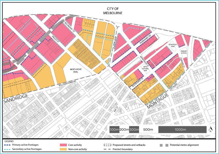
82
FISHERMANS BEND SUBMISSION NO. 136 PLANNING REVIEW PANEL 14 & 16 SALMON STREET, PORT MELBOURNE
 SUBMISSION NO. 136 FISHERMANS BEND PLANNING REVIEW PANEL 14 & 16 SALMON STREET, PORT MELBOURNE PRESENTED BY: ANDREA PAGLIARO ON BEHALF OF BELLAMIA NOMINEES PTY LTD & PCLC INVESTMENT PTY LTD INTRODUCTION
Amendment GC81 Expert Urban Design Evidence Wirraway. MARK SHEPPARD 9 May 2018
 Amendment GC81 Expert Urban Design Evidence Wirraway MARK SHEPPARD 9 May 2018 CONTENTS 1. Context 2. Urban structure 3. Open space 4. Density 5. Built form 6. Individual site analysis 7. Conclusion & recommendations
ADDENDA 6 Amendment GC81 Fishermans Bend Expert Urban Design Evidence: Response to expert witness reports
 ADDENDA 6 Amendment GC81 Fishermans Bend Expert Urban Design Evidence: Response to expert witness reports Prepared on behalf of DELWP 24 April 2018 Scope 1) This addenda has been prepared in accordance
Amendment GC81. Expert Urban Design Evidence. Fishermans Bend - Wirraway. Mark Sheppard March 2018
 Amendment GC81 Expert Urban Design Evidence Mark Sheppard March 2018 Instructed by Norton Rose Fulbright, Planning & Property Partners and Russell Kennedy On behalf of Various landowners Mark Sheppard
Amendment GC81 Fishermans Bend Expert Urban Design Evidence. Prepared on behalf of DELWP. February 2018
 Amendment GC81 Fishermans Bend Expert Urban Design Evidence Prepared on behalf of DELWP February 2018 This independent report has been prepared for DELWP. All due care has been taken in the preparation
SCHEDULE 31 TO CLAUSE DESIGN AND DEVELOPMENT OVERLAY
 --/--/20-- Proposed GC81 SCHEDULE 31 TO CLAUSE 43.02 DESIGN AND DEVELOPMENT OVERLAY Shown on the planning scheme map as DDO31. FISHERMANS BEND SANDRIDGE PRECINCT 1.0 Design objectives --/--/20-- Proposed
SCHEDULE 32 TO CLAUSE DESIGN AND DEVELOPMENT OVERLAY
 --/--/20-- Proposed GC81 SCHEDULE 32 TO CLAUSE 43.02 DESIGN AND DEVELOPMENT OVERLAY Shown on the planning scheme map as DDO32. FISHERMANS BEND WIRRAWAY PRECINCT 1.0 Design objectives --/--/20-- Proposed
Sandridge Precinct Urban Design Report. Fishermans Bend Planning Review Panel April 2018
 Sandridge Precinct Urban Design Report Fishermans Bend Planning Review Panel April 18 Published by: City of Port Phillip Private Bag No 3 PO St Kilda Victoria 3182 City of Port Phillip, March 18 All rights
SCHEDULE [NUMBER]31 TO CLAUSE DESIGN AND DEVELOPMENT OVERLAY
![SCHEDULE [NUMBER]31 TO CLAUSE DESIGN AND DEVELOPMENT OVERLAY](/thumbs/90/102232772.jpg "SCHEDULE [NUMBER]31 TO CLAUSE DESIGN AND DEVELOPMENT OVERLAY") --/--/20-- Proposed GC81 SCHEDULE [NUMBER]31 TO CLAUSE 43.02 DESIGN AND DEVELOPMENT OVERLAY Shown on the planning scheme map as DDO[number]31. FISHERMANS BEND SANDRIDGE PRECINCT 1.0 Design objectives --/--/20--
--/--/20-- Proposed GC81 SCHEDULE [NUMBER]31 TO CLAUSE 43.02 DESIGN AND DEVELOPMENT OVERLAY Shown on the planning scheme map as DDO[number]31. FISHERMANS BEND SANDRIDGE PRECINCT 1.0 Design objectives --/--/20--
SCHEDULE 1[PPPS] 4[MPS] TO CLAUSE CAPITAL CITY ZONE
![SCHEDULE 1[PPPS] 4[MPS] TO CLAUSE CAPITAL CITY ZONE](/thumbs/89/98875377.jpg "SCHEDULE 1[PPPS] 4[MPS] TO CLAUSE CAPITAL CITY ZONE") --/--/20-- Proposed GC81 SCHEDULE 1[PPPS] 4[MPS] TO CLAUSE 37.04 CAPITAL CITY ZONE Shown on the planning scheme map as CCZ1[PPPS] CCZ4[MPS]. FISHERMANS BEND URBAN RENEWAL AREA Purpose To implement the
--/--/20-- Proposed GC81 SCHEDULE 1[PPPS] 4[MPS] TO CLAUSE 37.04 CAPITAL CITY ZONE Shown on the planning scheme map as CCZ1[PPPS] CCZ4[MPS]. FISHERMANS BEND URBAN RENEWAL AREA Purpose To implement the
[2010] VSC (2004) 18 VPR 229
![[2010] VSC (2004) 18 VPR 229](/thumbs/74/70555400.jpg "[2010] VSC (2004) 18 VPR 229") MOOT COURT 2017 PREPARED BY TIM RETROT VICTORIAN CIVIL AND ADMINISTRATIVE TRIBUNAL PLANNING PERMIT APPLICATION NO. TP418/2016 OUTLINE OF SUBMISSIONS ON BEHALF OF LIONHEART HOMES 93-95 VICTORIA STREET,
MOOT COURT 2017 PREPARED BY TIM RETROT VICTORIAN CIVIL AND ADMINISTRATIVE TRIBUNAL PLANNING PERMIT APPLICATION NO. TP418/2016 OUTLINE OF SUBMISSIONS ON BEHALF OF LIONHEART HOMES 93-95 VICTORIA STREET,
Planning the Arden Precinct
 Planning the Arden Precinct Presentation to Melbourne Metro Environment Effects Statement IAC 13 September 2016 Kate Alder, Strategic Planning Manager Emily Mottram, Director Urban Renewal Introductory
Director, Community Planning, Toronto and East York District
 STAFF REPORT September 1, 2005 To: From: Subject: Toronto and East York Community Council Director, Community Planning, Toronto and East York District Further Report Applications to amend Official Plan
SCHEDULE 1[PPPS] 4[MPS] TO CLAUSE CAPITAL CITY ZONE
![SCHEDULE 1[PPPS] 4[MPS] TO CLAUSE CAPITAL CITY ZONE](/thumbs/89/98875364.jpg "SCHEDULE 1[PPPS] 4[MPS] TO CLAUSE CAPITAL CITY ZONE") --/--/20-- Proposed GC81 SCHEDULE 1[PPPS] 4[MPS] TO CLAUSE 37.04 CAPITAL CITY ZONE Shown on the planning scheme map as CCZ1[PPPS] CCZ4[MPS]. FISHERMANS BEND URBAN RENEWAL AREA Purpose To implement the
--/--/20-- Proposed GC81 SCHEDULE 1[PPPS] 4[MPS] TO CLAUSE 37.04 CAPITAL CITY ZONE Shown on the planning scheme map as CCZ1[PPPS] CCZ4[MPS]. FISHERMANS BEND URBAN RENEWAL AREA Purpose To implement the
DRAFT FOR DISCUSSION PURPOSES ONLY. Port Credit Local Area Plan Built Form Guidelines and Standards DRAFT For Discussion Purposes
 Port Credit Local Area Plan Built Form Guidelines and Standards DRAFT For Discussion Purposes 1 Local Area Plan - Project Alignment Overview Directions Report, October 2008 (General Summary Of Selected
CASEY PLANNING SCHEME AMENDMENT C219
 Who is the planning authority? Planning and Environment Act 1987 CASEY PLANNING SCHEME AMENDMENT C219 EXPLANATORY REPORT This amendment has been prepared by the, which is the planning authority for this
Flinders Avenue, Lara Planning Scheme Amendment Combined Application for Rezoning and Multi-Lot Subdivision Reference : Decembe
 143-179 Flinders Avenue, Lara Planning Scheme Amendment Combined Application for Rezoning and Multi-Lot Subdivision Reference: 14134-03 TGM Group Geelong Melbourne Ballarat 1/27-31 Myers Street (PO Box
Town Planning Evidence Statement Instructed by Best Hooper Lawyers on behalf of Southern Rural Water
 Town Planning Evidence Statement Instructed by Best Hooper Lawyers on behalf of Southern Rural Water Planning Panels Victoria Amendment C227 to the Wyndham Planning Scheme Statement prepared by John Glossop,
PLANNING SUBMISSION & CLAUSE 56 ASSESSMENT RESIDENTIAL SUBDIVISION OF LAND 1525 POUND ROAD, CLYDE NORTH (LOT 2 PS F, SIENNA PARK ESTATE)
") PLANNING SUBMISSION & CLAUSE 56 ASSESSMENT RESIDENTIAL SUBDIVISION OF LAND 1525 POUND ROAD, CLYDE NORTH (LOT 2 PS 327975F, SIENNA PARK ESTATE) DFC (PROJECT MANAGEMENT) PTY LTD (A DENNIS FAMILY CORPORATION
PLANNING SUBMISSION & CLAUSE 56 ASSESSMENT RESIDENTIAL SUBDIVISION OF LAND 1525 POUND ROAD, CLYDE NORTH (LOT 2 PS 327975F, SIENNA PARK ESTATE) DFC (PROJECT MANAGEMENT) PTY LTD (A DENNIS FAMILY CORPORATION
LITTLE MOUNTAIN ADJACENT AREA REZONING POLICY
 LITTLE MOUNTAIN ADJACENT AREA REZONING POLICY JANUARY 2013 CONTENTS 1.0 INTENT & PRINCIPLES...1 2.0 APPLICATION...2 3.0 HOUSING TYPES, HEIGHT & DENSITY POLICIES...3 3.1 LOW TO MID-RISE APARTMENT POLICIES...4
SCHEDULE 1[PPPS] 4[MPS] TO CLAUSE CAPITAL CITY ZONE
![SCHEDULE 1[PPPS] 4[MPS] TO CLAUSE CAPITAL CITY ZONE](/thumbs/90/102247784.jpg "SCHEDULE 1[PPPS] 4[MPS] TO CLAUSE CAPITAL CITY ZONE") --/--/20-- Proposed GC81 SCHEDULE 1[PPPS] 4[MPS] TO CLAUSE 37.04 CAPITAL CITY ZONE Shown on the planning scheme map as CCZ1[PPPS] CCZ4[MPS]. FISHERMANS BEND URBAN RENEWAL AREA Purpose To implement the
--/--/20-- Proposed GC81 SCHEDULE 1[PPPS] 4[MPS] TO CLAUSE 37.04 CAPITAL CITY ZONE Shown on the planning scheme map as CCZ1[PPPS] CCZ4[MPS]. FISHERMANS BEND URBAN RENEWAL AREA Purpose To implement the
New Residential Zones their application and implications. Elizabeth Lewis David Vorchheimer
 New Residential Zones their application and implications Presented by Paul Buxton Elizabeth Lewis David Vorchheimer 14 June 2013 Outline Background / context MAC recommendations, Minister s response, work
Bylaw No , being "Official Community Plan Bylaw, 2016" Schedule "A" DRAFT
 Bylaw No. 2600-2016, being "Official Community Plan Bylaw, 2016" Schedule "A" Urban Structure + Growth Plan Urban Structure Land use and growth management are among the most powerful policy tools at the
PORT PHILLIP PLANNING SCHEME. Condition
 SCHEDULE 1 TO THE CAPITAL CITY ZONE Shown on the planning scheme map as CCZ1. FISHERMANS BEND URBAN RENEWAL AREA Purpose To use and develop the Fishermans Bend Urban Renewal Area generally in accordance
3.1. OBJECTIVES FOR RESIDENTIAL LAND USE DESIGNATIONS GENERAL OBJECTIVES FOR ALL RESIDENTIAL DESIGNATIONS
 3. RESIDENTIAL LAND USE DESIGNATIONS INTRODUCTION The Residential land use designations provide for housing and other land uses that are integral to, and supportive of, a residential environment. Housing
STAFF REPORT. March 14, Toronto and East York Community Council. Director, Community Planning, South District
 STAFF REPORT March 14, 2005 To: From: Subject: Toronto and East York Community Council Director, Community Planning, South District Preliminary Report Official Plan Amendment and Rezoning Application 05
WYNYARD CENTRAL HOUSING POLICY
 WYNYARD CENTRAL HOUSING POLICY 1 Policy objectives 1.1 To clarify the approach that Waterfront Auckland (WA) will take to delivering a thriving residential community. 2 Scope 2.1 Covers the approach to
New Victorian Residential Zones 2013
 Clause 1 Planning Page 1 of 35 Clause 1 is a town planning consultancy. We specialise in assisting property developers, architects and building designers meet the increasingly complex requirements of State
Jasper 115 Street DC2 Urban Design Brief
 Jasper 115 Street DC2 Urban Design Brief Greenlong Construction Ltd. Stantec Consulting Ltd. 2017 Overview The proposed rezoning application supports the development of two mixed-use high-rise buildings
Representation re: Sullivans Cove Planning Scheme /2015 Amendments - Macquarie Point Site Development: Affordable housing
 General Manager, Hobart City Council, GPO Box 503, Tas 7001 16 November, 2015 Representation re: Sullivans Cove Planning Scheme 1997-2/2015 Amendments - Macquarie Point Site Development: Affordable housing
2.0 LAND USE FRAMEWORK
 Land Use Framework 2.0 LAND USE FRAMEWORK FOLSOM BOULEVARD 2.1 LAND USE OVERVIEW The proposed land uses for Easton Place offer local and regional employment, shopping, and entertainment, highlighting the
Richmond Street West - Zoning Amendment Application - Preliminary Report
 STAFF REPORT ACTION REQUIRED 457-457 Richmond Street West - Zoning Amendment Application - Preliminary Report Date: March 10, 2017 To: From: Wards: Reference Number: Toronto and East York Community Council
SCHEDULE 1[PPPS] TO CLAUSE CAPITAL CITY ZONE
![SCHEDULE 1[PPPS] TO CLAUSE CAPITAL CITY ZONE](/thumbs/96/126805642.jpg "SCHEDULE 1[PPPS] TO CLAUSE CAPITAL CITY ZONE") --/--/20-- Proposed GC81 SCHEDULE 1[PPPS] TO CLAUSE 37.04 CAPITAL CITY ZONE Shown on the planning scheme map as 1[PPPS] FISHERMANS BEND URBAN RENEWAL AREA Purpose To implement the Fishermans Bend Vision,
--/--/20-- Proposed GC81 SCHEDULE 1[PPPS] TO CLAUSE 37.04 CAPITAL CITY ZONE Shown on the planning scheme map as 1[PPPS] FISHERMANS BEND URBAN RENEWAL AREA Purpose To implement the Fishermans Bend Vision,
STAFF REPORT PLN September 11, 2017
 Page: 1 TO: SUBJECT: GENERAL COMMITTEE APPLICATIONS FOR OFFICIAL PLAN AMENDMENT AND ZONING BY-LAW AMENDMENT 37 JOHNSON STREET WARD: WARD 1 PREPARED BY AND KEY CONTACT: SUBMITTED BY: GENERAL MANAGER APPROVAL:
Peter Street and 357 Richmond Street West - Zoning Amendment Application - Preliminary Report
 STAFF REPORT ACTION REQUIRED 122-128 Peter Street and 357 Richmond Street West - Zoning Amendment Application - Preliminary Report Date: March 11, 2016 To: From: Wards: Reference Number: Toronto and East
I Harris. Melbourne. John Quirk, Member. Merits Review of Refusal
 VICTORIAN CIVIL AND ADMINISTRATIVE TRIBUNAL ADMINISTRATIVE DIVISION PLANNING AND ENVIRONMENT LIST VCAT REFERENCE NO. P382/2005 PERMIT APPLICATION NO. YR-2004/1272 CATCHWORDS 4 lot subdivision of large
Planning Rationale in Support of an Application for Plan of Subdivision and Zoning By-Law Amendment
 Planning Rationale in Support of an Application for Plan of Subdivision and Zoning By-Law Amendment The Kilmorie Development 21 Withrow Avenue City of Ottawa Prepared by: Holzman Consultants Inc. Land
apply sustainability principles to all residential developments in Ardee;
 3. Housing 3.1 Introduction Ardee is currently experiencing considerable pressure for residential development as improved road infrastructure, together with the availability of serviced land, makes the
Appendix A: Guide to Zoning Categories Prince George's County, Maryland
 Appendix A: Guide to Zoning Categories Prince George's County, Maryland RESIDENTIAL ZONES 1 Updated November 2010 R-O-S: Reserved Open Space - Provides for permanent maintenance of certain areas of land
New challenges for urban renewal... Patrick Fensham Principal SGS Economics and Planning
 New challenges for urban renewal... Patrick Fensham Principal SGS Economics and Planning 27 March 2013 Housing supply a problem... The housing shortfall (gap) increased by 28,000 dwellings over the year
STAFF REPORT. September 25, City Council. Chief Planner and Executive Director, City Planning Division
 STAFF REPORT September 25, 2006 To: From: Subject: City Council Chief Planner and Executive Director, City Planning Division Request for Directions Report Toronto & East York Community Council, Report
H6 Residential Terrace Housing and Apartment Buildings Zone
 H6. Residential Terrace Housing and Apartment Buildings Zone [CIV-2016-404-002333: Franco Belgiorno-Nettis]-Note: The properties affected by this appeal are identified on the Auckland Unitary Plan viewer.
Hutt River City Centre Upgrade Project Preliminary Integrated Design
 Report 2016.24 Date 5 February 2016 File N/03/18/22 Committee Author Hutt Valley Flood Management Subcommittee Daya Atapattu, Senior Project Engineer Hutt River City Centre Upgrade Project Preliminary
A mix of uses. Housing:
 7 Massing and uses Page 79 7:1. A mix of uses % Total Habitable Occ/ People Rooms HR Studio 6.8% 308 1 0.90 277 1 bed 32.0% 1442 2 0.90 2,595 2 bed 37.6% 1691 3 0.90 4,567 3 bed 21.2% 955 4 0.90 3,438
Appendix 5 - Track Changed Ordinance
 SCHEDULE 1 TO THE URBAN GROWTH ZONE Shown on the planning scheme map as UGZ1 1.0 The Plan Shepparton North East Plan 1 shows the future urban structure proposed in the Shepparton North East Precinct Structure
WELCOME TIMESCALES. Thank you for attending Anthology s final public exhibition on the emerging plans for Kennington Stage. ANTHOLOGY S COMMITMENTS
 WELCOME Thank you for attending Anthology s final public exhibition on the emerging plans for Kennington Stage. Since the second consultation in October 2018, which asked your views on the preferred approach,
REFORMED RESIDENTIAL ZONES IMPLEMENTATION REPORT. October 2013
 REFORMED RESIDENTIAL ZONES IMPLEMENTATION REPORT October 2013 Reformed Residential Zones Implementation Report October 2013 TABLE OF CONTENTS 1. INTRODUCTION... 1 2. EXISTING STRATEGIES AND POLICIES...
City of Port Phillip response to the draft 30-year Infrastructure Strategy for Victoria
 Enquiries: Claire Ferres Miles Telephone: (03) 9209 6300 File Ref: 58/04/144 28 October 2016 Michel Masson CEO Infrastructure Victoria Level 16, 530 Collins Street MELBOURNE VIC 3000 Dear Mr Masson City
50 and 52 Finch Avenue East - Official Plan and Zoning By-law Amendment Applications - Preliminary Report
 STAFF REPORT ACTION REQUIRED 50 and 52 Finch Avenue East - Official Plan and Zoning By-law Amendment Applications - Preliminary Report Date: August 16, 2016 To: From: Wards: Reference Number: North York
H5. Residential Mixed Housing Urban Zone
 H5. Residential Mixed Housing Urban Zone [ENV-2016-AKL-000197: Robert Adams] Addition sought H5.1. Zone description The Residential Mixed Housing Urban Zone is a reasonably high-intensity zone enabling
NORTH LEEDS MATTER 2. Response to Leeds Sites and Allocations DPD Examination Inspector s Questions. August 2017
 NORTH LEEDS MATTER 2 Response to Leeds Sites and Allocations DPD Examination Inspector s Questions August 2017 CLIENT: TAYLOR WIMPEY, ADEL REFERENCE NO: CONTENTS 1.0 INTRODUCTION 2.0 TEST OF SOUNDNESS
6040 Bathurst Street and 5 Fisherville Road Zoning Bylaw Amendment Application Preliminary Report
 STAFF REPORT ACTION REQUIRED 6040 Bathurst Street and 5 Fisherville Road Zoning Bylaw Amendment Application Preliminary Report Date: January 24, 2017 To: From: Wards: Reference Number: North York Community
PIA would be pleased to meet with the Department to outline any aspect of our submission. Please contact myself or John Brockhoff on
 31 January 2018 Deborah Brill Director, Housing and Infrastructure Policy Department of Planning and Environment PO Box 39 SYDNEY NSW 2001 Dear Deborah, PIA Submission: Affordable Housing SEPP 70 Amendments
Montreal Road District Secondary Plan [Amendment #127, October 9, 2013]
![Montreal Road District Secondary Plan [Amendment #127, October 9, 2013]](/thumbs/72/66783104.jpg "Montreal Road District Secondary Plan [Amendment #127, October 9, 2013]") [Amendment #127, October 9, 2013] 1.0 General The following policies are applicable to the Montreal Road District as set out in Schedule 1. 1.1 District Objectives The objective of this Plan is to guide
[Amendment #127, October 9, 2013] 1.0 General The following policies are applicable to the Montreal Road District as set out in Schedule 1. 1.1 District Objectives The objective of this Plan is to guide
FEASIBILITY REPORT. 1486, 1490 and 1494 Clementine. Prepared by: Lloyd Phillips & Associates Ltd. For: Ottawa Salus
 DRAFT FEASIBILITY REPORT 1486, 1490 and 1494 Clementine Prepared by: Lloyd Phillips & Associates Ltd. For: Ottawa Salus LPA File No. 1008 Lloyd Phillips & Associates June 9, 2010 Feasibility Report Page
355 King St W and 119 Blue Jays Way - OPA & Rezoning Applications - Preliminary Report
 STAFF REPORT ACTION REQUIRED 355 King St W and 119 Blue Jays Way - OPA & Rezoning Applications - Preliminary Report Date: May 27, 2008 To: From: Wards: Reference Number: Toronto and East York Community
PROVIDENCE (BOLLARD BULRUSH SOUTH) LOCAL DEVELOPMENT PLAN. 2263Rep146E
 LOCAL DEVELOPMENT PLAN. 2263Rep146E") 1 PROVIDENCE (BOLLARD BULRUSH SOUTH) Prepared by: PO Box 796 Subiaco WA 6904 t: 9382 1233 f: 9382 1127 www.cleplan.com.au October 2013 This Local Development Plan has been approved by Council under the
1 PROVIDENCE (BOLLARD BULRUSH SOUTH) Prepared by: PO Box 796 Subiaco WA 6904 t: 9382 1233 f: 9382 1127 www.cleplan.com.au October 2013 This Local Development Plan has been approved by Council under the
14 Strachan Ave and East Liberty St - Rezoning Application - Preliminary Report
 STAFF REPORT ACTION REQUIRED 14 Strachan Ave and 39-51 East Liberty St - Rezoning Application - Preliminary Report Date: August 19, 2009 To: From: Wards: Reference Number: Toronto and East York Community
Subject. Date: 2016/10/25. Originator s file: CD.06.AFF. Chair and Members of Planning and Development Committee
 Date: 2016/10/25 Originator s file: To: Chair and Members of Planning and Development Committee CD.06.AFF From: Edward R. Sajecki, Commissioner of Planning and Building Meeting date: 2016/11/14 Subject
General Manager of Planning, Urban Design, and Sustainability, in consultation with the Director of Legal Services
 POLICY REPORT DEVELOPMENT AND BUILDING Report Date: September 27, 2016 Contact: Anita Molaro Contact No.: 604.871.6479 RTS No.: 11685 VanRIMS No.: 08-2000-20 Meeting Date: October 18, 2016 TO: FROM: SUBJECT:
PARKVILLE 1. PROPOSED REZONING
 PARKVILLE 1. PROPOSED REZONING Parkville Gardens Estate and West Parkville North and South Parkville Summary table of proposed maximum building height and number of dwellings: Residential Growth Zone,
Promoting informed debate around infill housing in Australian cities
 Promoting informed debate around infill housing in Australian cities 1 SGS has long been interested in promoting infill housing in Australian cities. This support reflects the recognised net benefits infill
Town of Niagara-on-the-Lake Official Plan Review. Discussion Paper: Second Residential Units. Prepared for: The Town of Niagara-on-the-Lake
 Town of Niagara-on-the-Lake Official Plan Review Discussion Paper: Second Residential Units Prepared for: The Town of Niagara-on-the-Lake October 15, 2015 PLANSCAPE Inc. Building Community through Planning
SCHEDULE 1[PPPS] 4[MPS] TO CLAUSE CAPITAL CITY ZONE
![SCHEDULE 1[PPPS] 4[MPS] TO CLAUSE CAPITAL CITY ZONE](/thumbs/91/105208367.jpg "SCHEDULE 1[PPPS] 4[MPS] TO CLAUSE CAPITAL CITY ZONE") --/--/20-- Proposed GC81 SCHEDULE 1[PPPS] 4[MPS] TO CLAUSE 37.04 CAPITAL CITY ZONE Shown on the planning scheme map as CCZ1[PPPS] CCZ4[MPS]. FISHERMANS BEND URBAN RENEWAL AREA Purpose To implement the
--/--/20-- Proposed GC81 SCHEDULE 1[PPPS] 4[MPS] TO CLAUSE 37.04 CAPITAL CITY ZONE Shown on the planning scheme map as CCZ1[PPPS] CCZ4[MPS]. FISHERMANS BEND URBAN RENEWAL AREA Purpose To implement the
Cadzow Enterprises Pty Ltd & A Rosshandler Port Phillip City Council L Kenyon & J Ellis 38 Broadway, Elwood Melbourne Bill Sibonis, Member Hearing
 VICTORIAN CIVIL AND ADMINISTRATIVE TRIBUNAL ADMINISTRATIVE DIVISION PLANNING AND ENVIRONMENT LIST VCAT REFERENCE NO. P2100/2009 PERMIT APPLICATION NO. 57/2009 CATCHWORDS Section 82 Planning and Environment
C Secondary Suite Process Reform
 2018 March 12 Page 1 of 9 EXECUTIVE SUMMARY On 2017 December 11, through Notice of Motion C2017-1249 (Secondary Suite Process Reform) Council directed Administration to implement several items: 1. Land
6.0 DEVELOPMENT OPPORTUNITIES
 6.0 DEVELOPMENT OPPORTUNITIES Urban neighbourhoods are in a constant process of change and evolution. In successful cities, such as Ottawa, development pressures are a constant. To help direct this growth
Staff Report. October 19, 2016 Page 1 of 17. Meeting Date: October 19, 2016
 October 19, 2016 Page 1 of 17 Staff Report Report No.: PDSD-P-58-16 Meeting Date: October 19, 2016 Submitted by: Subject: Recommendation: Ben Puzanov, RPP, Senior Planner Application for Zoning By-law
density framework ILLUSTRATION 3: DENSITY (4:1 FSR) EXPRESSED THROUGH BUILT FORM Example 1
 EXPRESSED THROUGH BUILT FORM Example 1") density framework 4 ILLUSTRATION 3: DENSITY (4:1 FSR) EXPRESSED THROUGH BUILT FORM INTRODUCTION The Downtown Core Area contains a broad range of building forms within its relatively compact area. These
density framework 4 ILLUSTRATION 3: DENSITY (4:1 FSR) EXPRESSED THROUGH BUILT FORM INTRODUCTION The Downtown Core Area contains a broad range of building forms within its relatively compact area. These
RM-11 and RM-11N Districts Schedule
 Districts Schedule 1 Intent The intent of this Schedule is to permit medium density residential development primarily in the form of four-storey T -shaped apartments, and to foster compact, sustainable,
TASK 2 INITIAL REVIEW AND ANALYSIS U.S. 301/GALL BOULEVARD CORRIDOR FORM-BASED CODE
 TASK 2 INITIAL REVIEW AND ANALYSIS U.S. 301/GALL BOULEVARD CORRIDOR FORM-BASED CODE INTRODUCTION Using the framework established by the U.S. 301/Gall Boulevard Corridor Regulating Plan (Regulating Plan),
1417, , 1427 & 1429 Yonge Street - Official Plan Amendment and Zoning Amendment Applications - Preliminary Report
 STAFF REPORT ACTION REQUIRED 1417, 1421-1425, 1427 & 1429 Yonge Street - Official Plan Amendment and Zoning Amendment Applications - Preliminary Report Date: March 24, 2015 To: From: Wards: Reference Number:
4650 Eglinton Avenue West - Zoning By-law Amendment Application - Preliminary Report
 STAFF REPORT ACTION REQUIRED 4650 Eglinton Avenue West - Zoning By-law Amendment Application - Preliminary Report Date: August 14, 2015 To: From: Wards: Reference Number: Etobicoke York Community Council
PIP practice note 1 planning assumptions. How to use this practice note. Planning assumptions. What are planning assumptions? Type.
 PIP PRACTICE NOTE 1 How to use this practice note This practice note has been prepared to support in the preparation or amending of planning assumptions within a priority infrastructure plan (PIP). It
LAND USE AMENDMENT ITEM NO: 05
 REPORT TO CALGARY PLANNING COMMISSION LAND USE AMENDMENT ITEM NO: 05 FILE NO: LOC2012-0069 CPC DATE: 2013 February 14 COUNCIL DATE: BYLAW NO: HILLHURST (Ward 7 - Alderman Farrell) ISC: Protected Page 1
Rochford Core Strategy Schedule of Changes
 Rochford Core Strategy Schedule of Changes The changes below are expressed either in the conventional form of strikethrough for deletions and underlining for additions of text, or by specifying the change
M E M O R A N D U M. Origin
 PO Box 1749 Halifax, Nova Scotia B3J 3A5 Canada M E M O R A N D U M TO: Community Design Advisory Committee CC: Kelly Denty, Acting Director FROM: Carl Purvis, Acting Manager Urban Design, DATE: February
South African Council for Town and Regional Planners
 TARIFF OF FEES South African Council for Town and Regional Planners PLEASE NOTE : THE TARIFF OF FEES WAS APPROVED BY THE COUNCIL CHAPTER 10 : TARIFF OF FEES 10.1 INTRODUCTION 10.1.1 General This tariff
Community Housing Federation of Victoria Inclusionary Zoning Position and Capability Statement
 Community Housing Federation of Victoria Inclusionary Zoning Position and Capability Statement December 2015 Introduction The Community Housing Federation of Victoria (CHFV) strongly supports the development
CITY CLERK. Consolidated Clause in Policy and Finance Committee Report 7, which was considered by City Council on July 19, 20, 21 and 26, 2005.
 CITY CLERK Consolidated Clause in Report 7, which was considered by City Council on July 19, 20, 21 and 26, 2005. 3 Regent Park Revitalization - Financial Strategy (Ward 28) City Council on July 19, 20,
Draft London Plan Review
 Draft London Plan Review Briefing Note Date: 04/12/2017 Ref No: 283 Introduction On the 29th November the Mayor of London, Sadiq Khan, published his draft London Plan for consultation (Regulation 19).
Yonge Street, 5-9 St. Joseph Street and 11-19, 25 St. Nicholas Street Rezoning Application - Preliminary Report
 STAFF REPORT ACTION REQUIRED 606-618 Yonge Street, 5-9 St. Joseph Street and 11-19, 25 St. Nicholas Street Rezoning Application - Preliminary Report Date: December 11, 2008 To: From: Wards: Reference Number:
H5. Residential Mixed Housing Urban Zone
 H5. Residential Mixed Housing Urban Zone H5.1. Zone description The Residential Mixed Housing Urban Zone is a reasonably high-intensity zone enabling a greater intensity of development than previously
Richmond Street West Zoning Amendment Application - Preliminary Report
 STAFF REPORT ACTION REQUIRED 543-553 Richmond Street West Zoning Amendment Application - Preliminary Report Date: April 24, 2015 To: From: Wards: Reference Number: Toronto and East York Community Council
ADMINISTRATION RECOMMENDATION(S) 2017 May 04. That Calgary Planning Commission recommends APPROVAL of the proposed Land Use Amendment.
 2017 May 04. That Calgary Planning Commission recommends APPROVAL of the proposed Land Use Amendment.") Page 1 of 14 EXECUTIVE SUMMARY This proposed Land Use Amendment seeks to redesignate the subject parcel from Residential Contextual One/Two Dwelling (R-C2) District to a DC Direct Control District to accommodate
Page 1 of 14 EXECUTIVE SUMMARY This proposed Land Use Amendment seeks to redesignate the subject parcel from Residential Contextual One/Two Dwelling (R-C2) District to a DC Direct Control District to accommodate
1.0 INTRODUCTION PURPOSE OF THE CIP VISION LEGISLATIVE AUTHORITY Municipal Act Planning Act...
 April 2017 TABLE OF CONTENTS 1.0 INTRODUCTION... 1 2.0 PURPOSE OF THE CIP... 1 3.0 VISION... 1 4.0 COMMUNITY IMPROVEMENT PROJECT AREA..3 5.0 LEGISLATIVE AUTHORITY... 3 5.1 Municipal Act... 3 5.2 Planning
20 Edward Street Zoning Amendment Application - Preliminary Report
 STAFF REPORT ACTION REQUIRED 20 Edward Street Zoning Amendment Application - Preliminary Report Date: January 20, 2015 To: From: Wards: Reference Number: Toronto and East York Community Council Director,
25 Leonard Avenue - Official Plan Amendment and Zoning Amendment Applications - Preliminary Report
 STAFF REPORT ACTION REQUIRED 25 Leonard Avenue - Official Plan Amendment and Zoning Amendment Applications - Preliminary Report Date: March 8, 2017 To: From: Wards: Reference Number: Toronto and East York
 South Worcestershire Development Plan Examination Representation Form Additional Pages Consultation on Proposed Modifications to SWDP: 6 October 14 November 2014 South Worcestershire Councils Additional
5.0 Development Strategy 32
 5.0 Development Strategy 32 Objectives To ensure the long term future of the Bazaar Market building by giving it a higher order retail use, reflecting the development of retail on the Guy s site To ensure
Truganina Employment Precinct Development Contributions Plan
 Amendment C124 to the Wyndham Planning Scheme Truganina Employment Precinct Development Contributions Plan December 2009 SM 20091202 11:05 CONTENTS PURPOSE 3 REPORT STRUCTURE 3 1.0 STRATEGIC BASIS 5 1.1
ENABLING AFFORDABLE HOUSING IN LOCAL GOVERNMENT AREAS. Discussion Paper COMMONEQUITY.COM.AU
 ENABLING AFFORDABLE HOUSING IN LOCAL GOVERNMENT AREAS Discussion Paper COMMONEQUITY.COM.AU ENABLING AFFORDABLE HOUSING IN LOCAL GOVERNMENT AREAS Discussion Paper 42 Initiatives to facilitate affordable
Poughkeepsie City Center Revitalization Plan
 Purpose and Need Purpose Increase job and educational opportunities for all residents Maximize fiscal productivity of downtown land uses Diversify retail mix Eliminate surface and building vacancies Create
Kororoit Precinct Structure Plan Statement of Evidence Mark Woodland November 2016
 1 P a g e Contents 1.0 Introduction... 3 2.0 Expert Witness Statement... 4 3.0 Summary of Evidence... 6 4.0 Subject site and surrounding context... 9 4.1 Subject site... 9 4.3 Surrounding context... 9
9.3.5 Dual occupancy code
 9.3.5 Dual occupancy code 9.3.5.1 Application (1) This code applies to accepted development and assessable development identified as requiring assessment against the Dual occupancy 1 code by the tables
Division 8 General Urban (T4) Zone: Assessment Criteria and Assessment Tables
 Zone: Assessment Criteria and Assessment Tables") Division 8 General Urban (T4) Zone: Assessment Criteria and Assessment Tables 15.8.1 General Urban (T4) Zone The provisions in this division relate to the General Urban (T4) Zone as follows overall outcomes
Division 8 General Urban (T4) Zone: Assessment Criteria and Assessment Tables 15.8.1 General Urban (T4) Zone The provisions in this division relate to the General Urban (T4) Zone as follows overall outcomes
Miscellaneous Report No. M2/17
 Miscellaneous Report No. M2/17 Subject: Folder No: F2009/00315 Author: Introduction Impacts of the AHSEPP within suburbs of Randwick City Elena Sliogeris, Senior Environmental Planning Officer - Strategic
Proposed Variation to Stage 1 Proposed District Plan VISITOR ACCOMMODATION DRAFT
 Proposed Variation to Stage 1 Proposed District Plan VISITOR ACCOMMODATION Prepared by Ian Johnson, Mitchell Daysh Ltd For Bookabach Ltd Version 0.4 Residential Visitor Accommodation The Variation Alternative
MAKING THE MOST EFFECTIVE AND SUSTAINABLE USE OF LAND
 165 SOC146 To deliver places that are more sustainable, development will make the most effective and sustainable use of land, focusing on: Housing density Reusing previously developed land Bringing empty
Note on housing supply policies in draft London Plan Dec 2017 note by Duncan Bowie who agrees to it being published by Just Space
 Note on housing supply policies in draft London Plan Dec 2017 note by Duncan Bowie who agrees to it being published by Just Space 1 Housing density and sustainable residential quality. The draft has amended