Truganina Employment Precinct Development Contributions Plan
|
|
|
- Brice Bryant
- 5 years ago
- Views:
Transcription


1 Amendment C124 to the Wyndham Planning Scheme Truganina Employment Precinct Development Contributions Plan December 2009
2 SM :05
3 CONTENTS PURPOSE 3 REPORT STRUCTURE STRATEGIC BASIS PLANNING AND ENVIRONMENT ACT PRECINCT STRUCTURE PLAN FURTHER BIODIVERSITY AND TRANSPORT INVESTIGATIONS TO SUPPORT PRECINCT PLANNING THE AREA TO WHICH THE DCP APPLIES RELATED SECTION 173 AGREEMENTS AND DEVELOPMENT CONTRIBUTIONS PLANS INFRASTRUCTURE PROJECT JUSTIFICATION Introduction - What the DCP Provides For Items not included in the Development Contributions Plan INFRASTRUCTURE PROJECTS Project Timing CALCULATION OF CONTRIBUTIONS INTRODUCTION CALCULATION OF NET DEVELOPABLE AREA AND DEMAND UNITS PROJECT COSTS Valuation of Land Calculation of Construction Costs Pooling of Costs COST APPORTIONMENT CONTRIBUTIONS PAYABLE 13 MISMATCH OF FUNDS TO COSTS ADMINISTRATION AND IMPLEMENTATION ADMINISTRATION OF THE DCP Agreements and Making Development Contributions Credit for Over Provision Open Space Provision Funds Administration Construction and Land Value Costs and Indexation Development Contributions Plan Review Period Collecting Agency (Agency responsible for collecting development infrastructure levy) Development Agency (Agency responsible for works) Western Freight Line IMPLEMENTATION STRATEGY Rationale for the Implementation Strategy Items identified as suitable to be provided in kind OTHER INFORMATION GLOSSARY 19
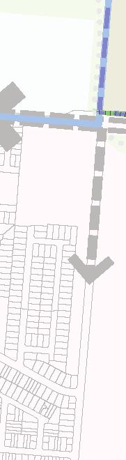
4 BOUNDARY ROAD DOHERTYS ROAD WOODS ROAD LEAKES ROAD PALMERS ROAD Scale: A3 A1 Date: 14 October 2009 Issue: A m SCALE 1: Section 1 - Introduction SAYERS ROAD Development Contributions Plan Area Truganina Employment Precinct Structure Plan Area Urban Growth Boundary Green Wedge Land Existing Urban Area Significant Open Space Existing Roads plan 1 development contributions projects plan area truganina employment precinct development contributions plan
5 INTRODUCTION PURPOSE Urban growth generates needs for a wide range of infrastructure. Development Contributions Plans [DCP s] provide a mechanism by which benefiting development is required to share the cost of providing some of that infrastructure. This DCP has that role for the Truganina Employment Precinct, mainly providing for arterial roads and paths. The Truganina employment Precinct Development Contributions Plan has been prepared by the Growth Areas Authority with the assistance of Wyndham City Council, Government agencies, service authorities and major stakeholders. The Development Contributions Plan has been developed to support the provision of works, services and facilities to be used by the future business community of the Truganina Employment which is generally covered by the Truganina Employment Precinct Structure Plan in the Wyndham Growth Area (refer Plan 1 for the area to which this Development Contributions Plan applies). The Development Contributions Plan outlines projects required to ensure that future business operators, visitors and workers within the Truganina Employment can be provided with timely access to services and transport necessary to support a quality, affordable business environment. REPORT STRUCTURE The Development Contributions Plan document comprises three parts. PART ONE Part 1 clearly explains the strategic basis for the Development Contributions Plan, which includes information about the Truganina Employment Precinct Structure Plan and justification for the various infrastructure projects included in the Development Contributions Plan. PART TWO Part 2 sets out how the development contributions are calculated and costs apportioned. PART THREE Finally, Part 3 focusses on administration and implementation of the Development Contributions Plan. It also details requirements that must be met by future land use and development and provides developers, investors and local businesses with certainty about development contribution requirements and how they will be administered. This Development Contributions Plan establishes a framework for development proponents to contribute a fair proportion towards the cost of works, services and facilities for the new employment area at Truganina. It ensures the cost of providing new infrastructure and services is shared equitably between various development proponents. Fairness requires costs to be apportioned according to the projected share of use of the required works, services and facilities items. Section 1 - Introduction 33


 Green Wedge Land Existing")

 Major Activity Centre (MAC)")


6 p To Bendigo RN FR E EWAY NG N RI Moonee Valley City Council R TE ES W 15km BURNSIDE SUNSHINE Shire of Melton 10km FOOTSCRAY Brimbank City Council 5km Maribyrnong City Council WEST GATE FRE City of Melbourne EWAY City of Po Phillip Wyndham City Council WILLIAMS LANDING MANOR LAKES WERRIBEE PLAZA Development Contributions Plan Area HOPPERS CROSSING BOARDWALK Hobsons Bay City Council Urban Growth Boundary UGB Investigation Area Major Industrial Employment Areas (west industrial node) Green Wedge Land Existing Urban Area Significant Open Space Port Phillip Prison WERRIBEE Port Phillip Bay Central Activities District (CAD) Principal Activity Centre (PAC) Major Activity Centre (MAC) Scale: A3 A1 Date: 14 October 2009 Issue: A km Rail Line Y E INC PR Freeway plan 2 metropolitan & regional context SCALE 1: Major Waterways Existing Major Road Network To Geelong 0 WA EE R SF 100 Introduction Part 1: Strategic Basis 200 truganina employment precinct development contributions plan
7 1.0 STRATEGIC BASIS 1.1 The strategic basis for this Development Contributions Plan is established by the State and Local Planning Policy Framework of the Wyndham Planning Scheme. Key documents are Melbourne 2030, the Growth Area Framework Plans, the Municipal Strategic Statement and the Truganina Employment Precinct Structure Plan (and supporting documents), which set out a broad, long term vision for the sustainable development of the Development Contributions Plan area. Plan 2 shows the metropolitan and regional context within which the area is located. The Growth Area Framework Plans have been incorporated into the Victoria Planning Provisions and illustrate the planned extent of residential, employment and other development as well as the location of larger activity centres for each growth area. They also show key elements of infrastructure and services including the regional open space network, the location of public transport networks, freeways and arterial roads. The Truganina Employment Precinct Structure Plan has been developed following a comprehensive planning process and provides a greater level of detail to guide planning within the Development Contributions Plan area. PLANNING AND ENVIRONMENT ACT 1987 This Development Contributions Plan has been prepared in accordance with Part 3B of the Planning and Environment Act 1987 (the Act) and has been developed in line with the State and Local Planning Policy Framework of the Wyndham Planning Scheme as well as Victorian Government Guidelines. The Development Contributions Plan provides for the charging of a development infrastructure levy pursuant to section 46J(a) of the Act towards works, services or facilities. It does not provide for the charging of a community infrastructure levy pursuant to section 46J(b) of the Act as no items included within the plan are classified as community infrastructure under the Act. This Development Contributions Plan forms part of the Wyndham Planning Scheme pursuant to section 46I of the Act and is an incorporated document under Clause 81 of the Wyndham Planning Scheme. 1.2 PRECINCT STRUCTURE PLAN The Truganina Employment Precinct Structure Plan is located to the north east of the Wyndham municipality. It forms part of the Western Industrial Node which is one of three major industrial areas of Melbourne and boarders the growth communities of Truganina, Tarneit and Laverton/Williams Landing. The Truganina Employment Precinct Structure Plan area and associated industrial land is expected to generate around 20,000 to 25,000 jobs as it is fully developed over time. The Precinct Structure Plan establishes the future urban structure of the new employment area which includes a range of networks such as transport and open space (Refer Plan 3). The need for infrastructure has been determined according to the anticipated development scenario for the area as described in the Truganina Employment Precinct Structure Plan. The Development Contributions Plan emanates from the Precinct Structure Plan, as the Precinct Structure Plan provides the rationale and justification for infrastructure items that have been included in the Development Contributions Plan. Accordingly, the Development Contributions Plan is an implementation based planning tool which identifies the infrastructure items required by the new community and apportions the cost of this infrastructure in an equitable manner across the plan area FURTHER BIODIVERSITY AND TRANSPORT INVESTIGATIONS TO SUPPORT PRECINCT PLANNING The Growth Areas Authority is currently completing biodiversity assessments for the Truganina Employment Precinct Structure Plan area. Once these assessments are complete, the Growth Areas Authority proposes to prepare a Truganina Employment Native Vegetation Precinct Plan in a manner that is consistent with the requirements of the Strategic Impact Assessment Report currently being finalised by the Victorian and Commonwealth Governments. Any changes to the Development Contributions Plan that are required as a consequence of that Native Vegetation Precinct Plan will be made by an Amendment to the Wyndham Planning Scheme. The Department of Transport is investigating the potential to locate a freight terminal and a new rail freight line to service the growing freight task in Melbourne s West. A description of the proposal which is being investigated is provided in the Truganina Employment Precinct Structure Plan. If the proposed freight facility proceeds the Growth Areas Authority will prepare consequent changes to the Precinct Structure Plan and Development Contributions Plan to ensure that the development proceeds within an appropriate planning framework. Any changes to the Precinct Structure Plan, Native Vegetation Precinct Structure Plan or the Development Contributions Plan that are required as a consequence of the freight proposal proceeding will be made by an Amendment to the Wyndham Planning Scheme. THE AREA TO WHICH THE DEVELOPMENT CONTRIBUTIONS PLAN APPLIES In accordance with section 46K(1)(a) of the Planning and Environment Act 1987 the Truganina Employment Development Contributions Plan applies to land shown in Plan 1. The area is also clearly indicated in the relevant Development Contributions Plan Overlay in the Wyndham Planning Scheme. The Precinct Structure Plan applies to approximately 771 net developable hectares of employment land as shown in Plan 1. Part 1: Strategic Basis 55
8 BOUNDARY ROAD FOUNDATION ROAD DOHERTYS ROAD PORT PHILLIP PRISON Development Contributions Plan Area Truganina Employment Precinct Structure Plan Area Urban Growth Boundary Significant Open Space Green Wedge LEAKES ROAD Existing Urban Area Industrial Park A Industrial Park B General Industrial A General Industrial B Heavy Industrial PALMERS ROAD Proposed Activity Centre (outside of PSP area) Port Phillip Prison Encumbered Open Space Proposed Tree Reserve (10m width) Arterial Road - VicRoads Declared Main Road Scale: A3 A1 Date: 14 October 2009 Issue: A m SAYERS ROAD Arterial Road - Council Road (future declared main road) Arterial Road - Council Road Connector Street - Industrial (potential bus route) Local Access Street - Level 2 Gateway Site Shared Path Off - Road Bicycle Path Federation Trail SCALE 1: Part 1: Strategic Basis plan 3 future urban structure plan truganina employment precinct development contributions plan
9 1.5 RELATED SECTION 173 AGREEMENTS AND DEVELOPMENT CONTRIBUTIONS PLANS This DCP area adjoins another municipality, 2 other DCP areas and a future urban growth area, and agreements have already been completed under Section 173 of the Planning and Environment Act for some sites within the DCP area. The DCP is therefore structured to ensure equitable sharing and avoidance of double funding: Along Boundary Road, contributions by developers on the north side, and declaration by VicRoads, minimise the costs charged to this DCP. Where, prior to the introduction of this Development Contributions Plan, Wyndham City Council entered into Section 173 agreements within this DCP area, the agreements have been drafted so that the contribution rate will be a maximum of $100,000 per net developable hectare (indexed from the June quarter of 2007). If the rate of the contribution in this Development Contributions Plan is lower, the rate in this Development Contributions Plan will apply to the development of the land subject to the Agreements. The Agreement wording ensures that if a Contribution is made pursuant to the Agreement, then a further contribution is not required under this Development Contributions Plan. Amendment C123 to the Wyndham Planning Scheme proposes to introduce the Truganina South Community Precinct Structure Plan and Development Contributions Plans into the Wyndham Planning Scheme. This affects land directly to the south of the precinct. Care has been taken to ensure that items funded in this Development Contributions Plan are not already funded in the Truganina South Community Development Contributions Plan. The two Development Contributions Plans have been prepared in an integrated and connected manner to ensure that contributions are appropriate. In 1999, Wyndham City Council prepared an overall Development Plan for the Wyndham Industrial Estate. This land has not been included in the Truganina Employment Precinct Structure Plan or this Development Contributions Plan. In 2007, a draft Wyndham Industrial Estate Development Contributions Plan was exhibited for the area bounded by Forsyth Road (a new proposed road), Palmers Road, Boundary Road and Doherty s Road, excluding the proposed cemetery site at the north-west corner of Dohertys and the proposed Forsyth Roads, included in the subject DCP area. Care has been taken to ensure that an item funded in the Werribee Industrial Estate Development Contributions Plan is not also funded by this Development Contributions Plan. To the west, only part of the cost of Forsyth Road is factored into this DCP, in anticipation of contributions from the potential urban areas in that locality. 1.6 INFRASTRUCTURE PROJECT JUSTIFICATION INTRODUCTION - WHAT THE DCP PROVIDES FOR The Truganina Employment DCP provides for the following transport infrastructure: arterial roads and their intersections; intersections of mid-block connector roads (mostly planned bus routes) with arterial roads, and crossings of such mid-block connectors over streams and floodways; pedestrian and cycle, or combined paths along arterial roads, and their connections to other paths, including paths on or across tree reserves; bus stops; and the land to provide or widen reserves for that infrastructure. The DCP does not provide for any other development or community infrastructure, but relies on tree and floodway reserves required under the PSP or other mechanisms, where appropriate. Planning for this DCP has followed the four principles outlined by the former Administrative Appeals Tribunal and contained in Section 46H of the Act ie. Need, Nexus, Equity and Accountability. The need for infrastructure has been determined according to the anticipated development scenario for the area as described in the Truganina Employment Precinct Structure Plan and its supporting documents. Items can be included in an employment area Development Contributions Plan if they will be used by the future business community of the area. New development does not have to trigger the need for new items in its own right. The development is charged in line with its projected share of use. An item can be included in a Development Contributions Plan regardless of whether it is within or outside the Development Contributions Plan area. Before inclusion in this Development Contributions Plan, all items have been assessed to ensure they have a relationship or nexus to proposed development in the Truganina Employment Precinct Structure Plan area. The cost apportionment methodology adopted in this Development Contributions Plan relies on the nexus principle. A new development is deemed to have a nexus with an item if it is expected to make use of that item. A summary of how each item relates to projected growth area development is set out below and individual item use catchments are identified in Table 1. The items that have been included in the Development Contributions Plan all have the following characteristics: they are essential to the health, safety and well-being of the business community; they will be used by a broad cross-section of the business community; they reflect the vision and strategic aspirations as expressed in the Truganina Employment Precinct Structure Plan; and they are not recurrent items. No subdivision, use or development shall commence until a Section 173 agreement has been agreed with the Collection Agency, or development infrastructure contributions are made in accordance with Section 3.1.1, below ITEMS NOT INCLUDED IN THE DEVELOPMENT CONTRIBUTIONS PLAN The following items are not included in the Development Contributions Plan, as they are addressed by other agencies, or not considered to be higher order items or items where cost should be shared, commonly because they are of types which normally provide most benefit to individual developments, unless the specific cases call for shared funding: All internal streets and connector streets, and associated traffic management measures. This includes any streets on the edge of the Truganina Employment Precinct Structure Plan. Flood mitigation works; Main drainage works, except where specified as Development Contributions Plan projects or in the Drainage Scheme; Local drainage systems; Intersections connecting the development to the arterial road network, except where specified as Development Contributions Plan projects; Bridges and other crossings over waterways on connector roads unless those bridges or crossings are specified as DCP projects because they provide required links; Water, sewerage, underground power, gas and telecommunications services; Local pathways and connections to the regional and/or district pathway network; Basic levelling, water tapping and landscaping of open space; and Bus stops. Table 1 Strategic Justification provides an explanation of all projects in the Development Contributions Plan, which are described below. Part 1: Strategic Basis 7
10 Table 1: Infrastructure Project Justification DCP Project No. Description Estimated Project Cost Land Construction Total Indicative Provision Trigger Strategic Justification 1 Boundary Road East of Palmers Road - Upgrade to Urban Road Standard - 931, ,013 Longer term due to other project priorities Completing road to urban standard in accordance with Council standards 2 Boundary Road East of Palmers Road - Upgrade to Include Off-Road Bike Path - 210, ,200 Medium term East-West Collector Road between Boundary Road and Dohertys Road West of Palmers Road Dohertys Creek Culvert Crossing East-West Collector Road between Boundary Road and Dohertys Road East of Palmers Road Laverton Creek Culvert Crossing Dohertys Road West of Palmers Road Construct Second Carriageway with Off-Road Bike Path - 455, ,555 As required to facilitate subdivision construction and/or development - 402, ,602 As required to facilitate subdivision construction and/or development - 4,125,060 4,125,060 6 Dohertys Road West of Palmers Road Culvert Crossing (Second Carriageway) - 276, ,800 Long term, when warranted by traffic volumes (15,000 to 20,000 vehicle movements per day) Long term, when warranted by traffic volumes (15,000 to 20,000 vehicle movements per day) 7 Dohertys Road West of Palmers Road North Side Land Acquisition (PSP 37) 472, ,950 As land is subdivided property by property 8 Dohertys Road West of Palmers Road South Side Land Acquisition 420, ,400 As land is subdivided 9 Dohertys Road West of Palmers Road Cemetery Site Land Acquisition 315, ,300 As land is subdivided property by property 10 Dohertys Road Intersection with Forsyth Road - 2,102,000 2,102,000 Expected to be constructed when Forsyth Road is constructed 11 Dohertys Road West of Palmers Road Mid Block Intersection - 722, ,384 As required to facilitate subdivision construction and/or development 12 Dohertys Road Intersection with Palmers Road - 2,102,000 2,102,000 Expected to be constructed when either road is duplicated Project required to ensure an integrated bike network, to implement Council's Bike Strategic principles To provide for an equitable approach to fund culverts which benefit the area beyond the property To provide for an equitable approach to fund culverts which benefit the area beyond the property 13 Dohertys Road East of Palmers Road - Upgrade to Urban Road Standard - 931, ,013 Longer Term due to other project priorities Completing road to urban standard in accordance with Council standards 14 Dohertys Road East of Palmers Road - Upgrade to Include Off-Road Bike Path - 210, ,200 Medium term 15 Dohertys Road East of Palmers Road - Construct Second Carriageway with Off-Road Bike Path - 4,125,060 4,125, Dohertys Road East of Palmers Road Culvert Crossing - 243, , Dohertys Road East of Foundation Road Pipe Crossing for both carriageways - 189, , Dohertys Road East of Palmers Road Power Line Relocation - 400, ,000 Long term, when warranted by traffic volumes (15,000 to 20,000 vehicle movements per day) Long term, when warranted by traffic volumes (15,000 to 20,000 vehicle movements per day) Long term, when warranted by traffic volumes (15,000 to 20,000 vehicle movements per day) Long term, when warranted by traffic volumes (15,000 to 20,000 vehicle movements per day) 19 Dohertys Road East of Palmers Road North Side Land Acquisition 1,681,600-1,681,600 As land is subdivided property by property 20 Dohertys Road East of Palmers Road Mid Block Intersection - 722, ,384 As required to facilitate subdivision construction and/or development 21 Dohertys Road - Intersection with Foundation Road - 2,102,000 2,102,000 Expected to be constructed when Foundation Road is constructed 22 Leakes Road West of Palmers Road - Construct Second Carriageway with Off-Road Bike Path - 4,125,060 4,125, Leakes Road West of Palmers Road Culvert Crossing (Second Carriageway) - 368, , Leakes Road West of Palmers Road Power Line Relocation North Side - 650, ,000 Long term, when warranted by traffic volumes (15,000 to 20,000 vehicle movements per day) Long term, when warranted by traffic volumes (15,000 to 20,000 vehicle movements per day) Long term, when warranted by traffic volumes (15,000 to 20,000 vehicle movements per day) 25 Leakes Road West of Palmers Road - North Side Land Acquisition 2,522,400-2,522,400 As land is subdivided property by property 26 Leakes Road Intersection with Forsyth Road - 829, ,467 Expected to be constructed when Forsyth Road is constructed 27 Leakes Road West of Palmers Road Mid Block Intersection - 722, ,384 As required to facilitate subdivision construction and/or development Project required to ensure an integrated bike network, to implement Council's Bike Strategic principles 28 Leakes Road East of Palmers Road - Upgrade to Urban Road Standard - 872, ,825 Longer Term due to other project priorities Completing road to urban standard in accordance with Council standards 29 Leakes Road East of Palmers Road - Upgrade to include Off-Road Bike Path - 210, ,200 Medium term 30 Leakes Road East of Palmers Road - Construct Second Carriageway with Off-Road Bike Path - 3,867,245 3,867, Leakes Road East of Palmers Road Power Line Relocation North Side - 475, ,000 Long term, when warranted by traffic volumes (15,000 to 20,000 vehicle movements per day) Long term, when warranted by traffic volumes (15,000 to 20,000 vehicle movements per day) 32 Leakes Road East of Palmers Road - North Side Land Acquisition A 1,182,375-1,182,375 As land is subdivided property by property 33 Leakes Road East of Palmers Road - North Side Land Acquisition B 788, ,250 As land is subdivided property by property Project required to ensure an integrated bike network, to implement Council's Bike Strategic principles 8 Part 1: Strategic Basis truganina employment precinct development contributions plan
11 Table 1: Infrastructure Project Justification (continued) DCP Project No. Description Estimated Project Cost Land Construction Total Indicative Provision Trigger 34 Leakes Road East of Palmers Road Mid Block Intersection - 722, ,384 As required to facilitate subdivision construction and/or development 35 Leakes Road Intersection with Foundation Road - 829, ,467 Expected to be constructed when Foundation Road is constructed 36 Forsyth Road between Boundary and Dohertys Road Mid Block Intersection - 722, ,384 As required to facilitate subdivision construction and/or development 37 Forsyth Road between Dohertys and Leakes Road Construct First Carriageway to Include Off-Road Bike Path - 4,202,406 4,202,406 As required to facilitate subdivision construction and/or development 38 Forsyth Road between Dohertys and Leakes Road Culvert Crossing - 365, ,650 As required to facilitate subdivision construction and/or development 39 Forsyth Road between Dohertys and Leakes Road Land Acquisition 840, ,800 As land is subdivided property by property 40 Forsyth Road between Dohertys and Leakes Road Land Acquisition 1,744,660-1,744,660 As land is subdivided property by property 41 Forsyth Road between Dohertys and Leakes Road Mid Block Intersection - 722, ,384 As required to facilitate subdivision construction and/or development Strategic Justification 42 Palmers Road Between Boundary and Dohertys Road Upgrade to Urban Road Standard - 931, ,013 Longer Term due to other project priorities Completing road to urban standard in accordance with Council standards Palmers Road Between Boundary and Dohertys Road - Upgrade to include Off-Road Bike Path Palmers Road Between Boundary and Dohertys Road West Side Land Acquisition (PSP 37) - 252, ,240 Medium term 840, ,800 As land is subdivided property by property 45 Palmers Road Between Boundary and Dohertys Road Mid Block Intersection - 460, ,468 As required to facilitate subdivision construction and/or development Project required to ensure an integrated bike network, to implement Council's Bike Strategic principles 46 Palmers Road Between Dohertys and Leakes Road Upgrade to Urban Road Standard - 931, ,013 Longer Term due to other project priorities Completing road to urban standard in accordance with Council standards 47 Palmers Road Between Dohertys and Leakes Road - Upgrade to include Off-Road Bike Path - 252, ,240 Medium term 48 Palmers Road Between Dohertys and Leakes Road West Side Land Acquisition 2,522,400-2,522,400 As land is subdivided property by property 49 Palmers Road Between Dohertys and Leakes Road Mid Block Intersection - 722, ,384 As required to facilitate subdivision construction and/or development Project required to ensure an integrated bike network, to implement Council's Bike Strategic principles 50 Palmers Road Between Leakes and Sayers Road Upgrade to Urban Road Standard - 698, ,260 Longer Term due to other project priorities Completing road to urban standard in accordance with Council standards 51 Palmers Road Between Leakes and Sayers Road - Upgrade to include Off-Road Bike Path - 256, ,970 Medium term 52 Palmers Road Between Leakes and Sayers Road Mid Block Intersection A - 722, ,384 As required to facilitate subdivision construction and/or development 53 Palmers Road Between Leakes and Sayers Road Mid Block Intersection B - 722, ,384 As required to facilitate subdivision construction and/or development North-South Collector Road between Boundary Road and Dohertys Road East of Palmers Road Culvert Crossing North-South Collector Road between Dohertys Road and Leakes Road East of Palmers Road Culvert Crossing Foundation Road for 800m south of Boundary Road Construction of First and Second Carriageway Foundation Road from 800m north of Dohertys Road to Leakes Road Construction of First and Second Carriageway Foundation Road for 800m south of Boundary Road Land Acquisition ($170,489/ha at June07) Foundation Road from 800m north of Dohertys Road, south to Leakes Road Land Acquisition - 251, ,626 As required to facilitate subdivision construction and/or development - 251, ,626 As required to facilitate subdivision construction and/or development - 2,856,784 2,856,784 Complete - 12,426,745 12,426,745 As required to facilitate subdivision construction and/or development 501, ,715 Complete 4,432,593-4,432,593 As land is subdivided property by property Project required to ensure an integrated bike network, to implement Council's Bike Strategic principles To provide for an equitable approach to fund culverts which benefit the area beyond the property To provide for an equitable approach to fund culverts which benefit the area beyond the property 60 Foundation Road intersection with Boundary Road - 406, ,152 Complete Project required to ensure an integrated road network 61 Foundation Road between Dohertys and Leakes Road Culvert Crossing A - 587, ,127 As required to facilitate subdivision construction and/or development 62 Foundation Road between Dohertys and Leakes Road Culvert Crossing B - 366, ,955 As required to facilitate subdivision construction and/or development 63 Foundation Road Between Boundary and Dohertys Road Mid Block Intersection - 367, ,850 As required to facilitate subdivision construction and/or development 64 Foundation Road Between Dohertys and Leakes Road Mid Block Intersection - 367, ,850 As required to facilitate subdivision construction and/or development TOTAL 18,266,243 63,768,365 82,034,608 To provide for an equitable approach to fund culverts which benefit the area beyond the property To provide for an equitable approach to fund culverts which benefit the area beyond the property Part 1: Strategic Basis 9
12 FORSYTH ROAD BOUNDARY ROAD 60 42, 43, , 58 FOUNDATION ROAD 1, , 7, 8, 9 37, 39, DOHERTYS ROAD 46, 47, , , 14, 15, 18, PORT PHILLIP PRISON , 24, LEAKES ROAD , 29, 30, 31, 32, , PALMERS ROAD 53 Development Contributions Plan Area Truganina Employment Precinct Structure Plan Area Urban Growth Boundary Significant Open Space Green Wedge Land Scale: A3 A1 Date: 14 October 2009 Issue: A 1 Existing Urban Area Encumbered Open Space Development Contributions Project Number m SAYERS ROAD Development Contributions Signalised Intersections Development Contributions Culverts SCALE 1: Part 1: Strategic Basis plan 4 development contributions plan projects truganina employment precinct development contributions plan
13 1.7 DCP Project No. INFRASTRUCTURE PROJECTS The projects in the Development Contributions Plan are based on the transport network depicted in Plan 3 which is based on transport planning undertaken by the Growth Areas Authority, Wyndham City Council, the Department of Transport and VicRoads. Plan 4 shows the location of each of the projects. The projects funded by the Development Contributions Plan include: Description 1 Boundary Road East of Palmers Road - Upgrade to Urban Road Standard 2 Boundary Road East of Palmers Road - Upgrade to Include Off-Road Bike Path East-West Collector Road between Boundary Road and Dohertys Road West of Palmers Road Dohertys Creek Culvert Crossing East-West Collector Road between Boundary Road and Dohertys Road East of Palmers Road Laverton Creek Culvert Crossing Dohertys Road West of Palmers Road Construct Second Carriageway with Off-Road Bike Path 6 Dohertys Road West of Palmers Road Culvert Crossing (Second Carriageway) 7 Dohertys Road West of Palmers Road North Side Land Acquisition (PSP 37) 8 Dohertys Road West of Palmers Road South Side Land Acquisition 9 Dohertys Road West of Palmers Road Cemetery Site Land Acquisition 10 Dohertys Road Intersection with Forsyth Road 11 Dohertys Road West of Palmers Road Mid Block Intersection 12 Dohertys Road Intersection with Palmers Road 13 Dohertys Road East of Palmers Road - Upgrade to Urban Road Standard 14 Dohertys Road East of Palmers Road - Upgrade to Include Off-Road Bike Path 15 Dohertys Road East of Palmers Road - Construct Second Carriageway with Off-Road Bike Path 16 Dohertys Road East of Palmers Road Culvert Crossing 17 Dohertys Road East of Foundation Road Pipe Crossing for both carriageways 18 Dohertys Road East of Palmers Road Power Line Relocation 19 Dohertys Road East of Palmers Road North Side Land Acquisition 20 Dohertys Road East of Palmers Road Mid Block Intersection 21 Dohertys Road - Intersection with Foundation Road 22 Leakes Road West of Palmers Road - Construct Second Carriageway with Off-Road Bike Path 23 Leakes Road West of Palmers Road Culvert Crossing (Second Carriageway) 24 Leakes Road West of Palmers Road Power Line Relocation North Side 25 Leakes Road West of Palmers Road - North Side Land Acquisition 26 Leakes Road Intersection with Forsyth Road 27 Leakes Road West of Palmers Road Mid Block Intersection 28 Leakes Road East of Palmers Road - Upgrade to Urban Road Standard 29 Leakes Road East of Palmers Road - Upgrade to include Off-Road Bike Path 30 Leakes Road East of Palmers Road - Construct Second Carriageway with Off-Road Bike Path 31 Leakes Road East of Palmers Road Power Line Relocation North Side 32 Leakes Road East of Palmers Road - North Side Land Acquisition A 33 Leakes Road East of Palmers Road - North Side Land Acquisition B 34 Leakes Road East of Palmers Road Mid Block Intersection DCP Project No. Description 35 Leakes Road Intersection with Foundation Road 36 Forsyth Road between Boundary and Dohertys Road Mid Block Intersection 37 Forsyth Road between Dohertys and Leakes Road Construct First Carriageway to Include Off-Road Bike Path 38 Forsyth Road between Dohertys and Leakes Road Culvert Crossing 39 Forsyth Road between Dohertys and Leakes Road Land Acquisition 40 Forsyth Road between Dohertys and Leakes Road Land Acquisition 41 Forsyth Road between Dohertys and Leakes Road Mid Block Intersection 42 Palmers Road Between Boundary and Dohertys Road Upgrade to Urban Road Standard Palmers Road Between Boundary and Dohertys Road - Upgrade to include Off-Road Bike Path Palmers Road Between Boundary and Dohertys Road West Side Land Acquisition (PSP 37) 45 Palmers Road Between Boundary and Dohertys Road Mid Block Intersection 46 Palmers Road Between Dohertys and Leakes Road Upgrade to Urban Road Standard 47 Palmers Road Between Dohertys and Leakes Road - Upgrade to include Off-Road Bike Path 48 Palmers Road Between Dohertys and Leakes Road West Side Land Acquisition 49 Palmers Road Between Dohertys and Leakes Road Mid Block Intersection 50 Palmers Road Between Leakes and Sayers Road Upgrade to Urban Road Standard 51 Palmers Road Between Leakes and Sayers Road - Upgrade to include Off-Road Bike Path 52 Palmers Road Between Leakes and Sayers Road Mid Block Intersection A 53 Palmers Road Between Leakes and Sayers Road Mid Block Intersection B North-South Collector Road between Boundary Road and Dohertys Road East of Palmers Road Culvert Crossing North-South Collector Road between Dohertys Road and Leakes Road East of Palmers Road Culvert Crossing Foundation Road for 800m south of Boundary Road Construction of First and Second Carriageway Foundation Road from 800m north of Dohertys Road to Leakes Road Construction of First and Second Carriageway Foundation Road for 800m south of Boundary Road Land Acquisition ($170,489/ha at June07) Foundation Road from 800m north of Dohertys Road, south to Leakes Road Land Acquisition 60 Foundation Road intersection with Boundary Road 61 Foundation Road between Dohertys and Leakes Road Culvert Crossing A 62 Foundation Road between Dohertys and Leakes Road Culvert Crossing B 63 Foundation Road Between Boundary and Dohertys Road Mid Block Intersection 64 Foundation Road Between Dohertys and Leakes Road Mid Block Intersection PROJECT TIMING The timing of projects to be funded under this DCP must be primarily driven by needs as they evolve, and by project costs, and the availability of pooled (and any other) funds. Each item in the Development Contributions Plan has an assumed indicative provision trigger specified in Table 1, that offers an early estimate of likely outcomes of the factors listed in the above paragraph. The early estimated timing of the provision of the items in this Development Contributions Plan is consistent with information available at the time that the Development Contributions Plan was prepared. The Development Agency will monitor and assess the required timing for individual items and may seek an amendment to the Wyndham Planning Scheme to adjust indicative provision triggers that appear to significantly differ from emerging needs, as part of the 5 year review or as required. While indicative provision triggers are estimated, these do not preclude the early provision of certain infrastructure to be constructed/provided by development proponents as works or land in-kind, if agreed by the Collecting Agency. (Refer also to Part 3 of this DCP.) Equally, they do not preclude a substantial change in priorities, without first amending the Wyndham Planning Scheme, if either: A significant impediment emerges to a priority project in Table 1, or An event, trend or need emerges that calls for a project to be delivered earlier than anticipated by Table 1. Part 1: Strategic Basis 11
14 2.0 CALCULATION OF CONTRIBUTIONS 2.1 INTRODUCTION Part 1 of this Development Contributions Plan sets out the strategic basis for this Development Contributions Plan and identifies infrastructure items to be included in the Development Contributions Plan. Part 2 focuses on the calculation of contributions and apportionment of costs. Tables 1 and 2 provide important information about the projects funded through the Development Contributions Plan, their justification and timing as well as showing how the charges per net developable hectare are calculated. The cost apportionment method adopted includes the following steps: Calculation of the net developable area (refer outline below); Calculating total project costs (refer Table 1); Addressing external demand (refer to Section 1.6.2); Cost apportionment method (Section 2.4); and Calculation of contributions payable [in this case the total assessed project costs divided by the net developable area, for all land], (Section 2.5) Other factors affecting the above process include: Strategic justification (refer Table 1); Indicative provision trigger (refer Table 1); Identification and allowance for external use from outside the Development Contributions Plan Area the contributions to individual projects are discounted for external use as required (refer Table 2); Identification of development types required to pay the development infrastructure levy (refer discussion below); Summary of costs payable by for each project (refer Table 2); and A charge per net developable hectare for the area (refer Table 2). 2.2 CALCULATION OF NET DEVELOPABLE AREA AND DEMAND UNITS A detailed land budget for every property within the Development Contributions Plan area has been prepared and is available from Wyndham City Council. The detailed land use budget for every property included within the Truganina Employment Area Precinct Structure Plan area is set out in the Precinct Structure Plan which is incorporated into the Scheme. In this Development Contributions Plan, all development infrastructure contributions are payable on the net developable land on any given development site. For the purposes of this Development Contributions Plan net developable area is defined as the total amount of land within the precinct that is made available for development of employment buildings, including lots, local and connector streets. Put simply, it is the total precinct area minus open space (in this case to be provided in the form of a tree reserve), encumbered drainage land and arterial roads. Any small local parks defined at the subdivision stage are included in net developable area. The net developable area for the Development Contributions Plan of hectares has been calculated by Wyndham City Council. This information is used to calculate the cost of infrastructure per net developable hectare. This final determination of the net developable area for each property to be developed will be confirmed by individual developers at the subdivision stage in consultation with the Collecting Agency. The Collecting Agency will make the final determination of the calculation for each subdivision and stage thereof. 2.3 PROJECT COSTS Each project has been assigned a land and/or construction cost. These costs are listed in Table 1 and also in Table 2. The costs are expressed in December 2008 dollars and will be indexed annually quarterly in accordance with the indexation method specified in Section VALUATION OF LAND The cost of land was determined by the Wyndham City Council and is estimated to be $500,000 (June 2007) per hectare, subject to the indexation method specified in section CALCULATION OF CONSTRUCTION COSTS All road, intersection and shared path construction costs have been estimated by Wyndham City Council. Detailed project cost information is available upon request from the Council POOLING OF COSTS All land and construction costs are tallied, and constitute the total cost base of the DCP. (See Section 1.6.2(a) and (b) on allowing for external demand, into and by the DCP area.) 12 Part 2: Calculation of Contributions truganina employment precinct development contributions plan
15 2.4 COST APPORTIONMENT 2.5 CONTRIBUTIONS PAYABLE 2.6 MISMATCH OF FUNDS TO COSTS This Development Contributions Plan apportions costs to new development according to its projected share of traffic generated in the DCP area. Since development contributions charges are levied up-front, a measure of actual use by individual development sites is not possible. Therefore costs must be shared in accordance with the estimated share of use, which this DCP bases on net developable area. This Development Contributions Plan cannot and does not require payment from existing or approved development. However, the share of use that existing development receives from these items is taken into account when calculating the contribution expected from new development. This means new development only pays its fair share of the estimated cost of new infrastructure and services (and does not pay for the use of existing development). This Development Contributions Plan calculates what each new development should pay towards provision of the identified infrastructure item. The strategic planning undertaken has determined an allowance for other use external to the Development Contributions Plan area for specific projects. The Truganina Employment Precinct Structure Plan identifies all land for employment/industrial use (refer Plan 3 the Future Urban Structure). Therefore the same charge is applied to each new developable hectare of land in the Development Contributions Plan area. The final column in Table 2 calculates the amount of contributions payable by each net developable hectare of employment land for each infrastructure project. Table 2 also sets out the summary of costs to be contributed by each net developable hectare of employment land towards each infrastructure project and shows the total amount of funds recoverable under the Development Contributions Plan. Development contributions are set years ahead of implementation, and cannot anticipate all issues that will arise in construction; nor can they anticipate changes (usually increases) in design and construction standards, or loss of contributing areas for various reasons. This DCP aims to fund the designated infrastructure as fully as practical, but shortfalls are likely. This reinforces the need to prioritise works according to needs, to provide the best possible transport network. Wyndham has also supplemented its development contributions from rate revenue, in past funding of infrastructure. No authority can guarantee such budgetary commitments years in advance, or that they will occur at all; but Council funding of lower priority or later requirements may become a necessity if significant shortfalls emerge. There is also a chance that contributions will exceed ultimate infrastructure costs. In this case, the Council may refund the excess, divided between contributors according to their share of the land area. Alternatively, the Council may apply to the Minister for permission to apply the surplus to other road infrastructure in the vicinity that would benefit the DCP area.. The Main Catchment Area (MCA) has been determined for each project. The MCA is the geographic area from which a given item of infrastructure will draw most of its use. The Development Contributions Plan MCA is a single area. This means that all development within the Development Contributions Plan area is required to pay the same rate of contributions. Table 2 quantifies the external demand (as a proportion) for each infrastructure project. Where external demand is present, a discount has been made to the dollar amount that will be recovered (refer to column 7, Table 2). The proportion of the relevant project cost which is attributable to external demand is not charged to development within the Truganina Employment Area. The balance of the cost of the items for which there is external demand and for which contributions will therefore not be collected under this Development Contributions Plan will be funded from alternative sources. Part 2: Calculation of Contributions 13
16 Table 2: Calculation of Costs DCP Project No. Description Estimated Project Cost ($) Estimated External Use % Total Cost Attributable to Main Catchment Area ($) Number of Net Developable Hectares in MCA Contribution per Net Developable Hectare ($) 1 Boundary Road East of Palmers Road - Upgrade to Urban Road Standard - 931, , , , Boundary Road East of Palmers Road - Upgrade to Include Off-Road Bike Path - 210, , , East-West Collector Road between Boundary Road and Dohertys Road West of Palmers Road Dohertys Creek Culvert Crossing - 455, ,555 75% 341, East-West Collector Road between Boundary Road and Dohertys Road East of Palmers Road Laverton Creek Culvert Crossing - 402, , , Dohertys Road West of Palmers Road Construct Second Carriageway with Off-Road Bike Path - 4,125,060 4,125,060-4,125, , Dohertys Road West of Palmers Road Culvert Crossing (Second Carriageway) - 276, , , Dohertys Road West of Palmers Road North Side Land Acquisition (PSP 37) 472, , , Dohertys Road West of Palmers Road South Side Land Acquisition 420, , , Dohertys Road West of Palmers Road Cemetery Site Land Acquisition 315, , , Dohertys Road Intersection with Forsyth Road - 2,102,000 2,102,000 50% 1,051, , Dohertys Road West of Palmers Road Mid Block Intersection - 722, ,384 50% 361, Dohertys Road Intersection with Palmers Road - 2,102,000 2,102,000 50% 1,051, , Dohertys Road East of Palmers Road - Upgrade to Urban Road Standard - 931, , , , Dohertys Road East of Palmers Road - Upgrade to Include Off-Road Bike Path - 210, , , Dohertys Road East of Palmers Road - Construct Second Carriageway with Off-Road Bike Path - 4,125,060 4,125,060-4,125, , Dohertys Road East of Palmers Road Culvert Crossing - 243, , , Dohertys Road East of Foundation Road Pipe Crossing for both carriageways - 189, , , Dohertys Road East of Palmers Road Power Line Relocation - 400, , , Dohertys Road East of Palmers Road North Side Land Acquisition 1,681,600-1,681,600-1,681, , Dohertys Road East of Palmers Road Mid Block Intersection - 722, , , Dohertys Road - Intersection with Foundation Road - 2,102,000 2,102,000-2,102, , Leakes Road West of Palmers Road - Construct Second Carriageway with Off-Road Bike Path - 4,125,060 4,125,060-4,125, , Leakes Road West of Palmers Road Culvert Crossing (Second Carriageway) - 368, , , Leakes Road West of Palmers Road Power Line Relocation North Side - 650, , , Leakes Road West of Palmers Road - North Side Land Acquisition 2,522,400-2,522,400-2,522, , Leakes Road Intersection with Forsyth Road - 829, ,467 50% 414, Leakes Road West of Palmers Road Mid Block Intersection - 722, ,384 50% 361, Leakes Road East of Palmers Road - Upgrade to Urban Road Standard - 872, , , , Leakes Road East of Palmers Road - Upgrade to include Off-Road Bike Path - 210, , , Leakes Road East of Palmers Road - Construct Second Carriageway with Off-Road Bike Path - 3,867,245 3,867,245-3,867, , Leakes Road East of Palmers Road Power Line Relocation North Side - 475, , , Leakes Road East of Palmers Road - North Side Land Acquisition A 1,182,375-1,182,375-1,182, , Leakes Road East of Palmers Road - North Side Land Acquisition B 788, , , , Leakes Road East of Palmers Road Mid Block Intersection - 722, , , Leakes Road Intersection with Foundation Road - 829, , , , Forsyth Road between Boundary and Dohertys Road Mid Block Intersection - 722, , % 288, Forsyth Road between Dohertys and Leakes Road Construct First Carriageway to Include Off-Road Bike Path - 4,202,406 4,202,406-4,202, , Forsyth Road between Dohertys and Leakes Road Culvert Crossing - 365, , , Forsyth Road between Dohertys and Leakes Road Land Acquisition 840, , , , Forsyth Road between Dohertys and Leakes Road Land Acquisition 1,744,660-1,744,660-1,744, , Forsyth Road between Dohertys and Leakes Road Mid Block Intersection - 722, ,384 50% 361, Palmers Road Between Boundary and Dohertys Road Upgrade to Urban Road Standard - 931, , , , Palmers Road Between Boundary and Dohertys Road - Upgrade to include Off-Road Bike Path - 252, , , Palmers Road Between Boundary and Dohertys Road West Side Land Acquisition (PSP 37) 840, , , , Palmers Road Between Boundary and Dohertys Road Mid Block Intersection - 460, , , Palmers Road Between Dohertys and Leakes Road Upgrade to Urban Road Standard - 931, , , , Palmers Road Between Dohertys and Leakes Road - Upgrade to include Off-Road Bike Path - 252, , , Palmers Road Between Dohertys and Leakes Road West Side Land Acquisition 2,522,400-2,522, ,522, , Part 2: Calculation of Contributions truganina employment precinct development contributions plan
SOMERTON ROAD BONDS LANE SECTION ROAD MICKLEHAM ROAD GREENVALE CENTRAL PROVIDENCE ROAD DEVELOPMENT CONTRIBUTIONS PLAN CARROLL LANE
 VALE TION VE SOMERTON ROAD BONDS LANE SECTION ROAD PROVIDENCE ROAD GREENVALE CENTRAL CARROLL LANE MICKLEHAM ROAD DEVELOPMENT CONTRIBUTIONS PLAN November 2013 PLANS Plan 1: Local context 4 Plan 2: Future
GREENVALE CENTRAL DEVELOPMENT CONTRIBUTIONS PLAN SOMERTON ROAD BONDS LANE SECTION ROAD MICKLEHAM ROAD OVIDENCE ROAD ROLL LANE
 SOMERTON ROAD BONDS LANE LE N SECTION ROAD OVIDENCE ROAD GREENVALE CENTRAL DEVELOPMENT CONTRIBUTIONS PLAN November 2013 (amended August 2017) ROLL LANE MICKLEHAM ROAD CONTENTS 1.0 INTRODUCTION 3 1.1 Purpose
Kelly Street. Rankin Street
 Spring Street Kelly Street State Primary School P-6 State Secondary School 7-12 POTE BEVER Hume Freeway Rankin Street Stewart Street Non Government School State Primary School LOCKERBIE NORTH DEVELOPMENT
HUME FREEWAY LOCKERBIE DEVELOPMENT CONTRIBUTIONS PLAN. State. Non Government. School. State Primary School P-6. Secondary. School.
 State Primary School P-6 Non Government School HUME FREEWAY State Primary School LOCKERBIE DEVELOPMENT CONTRIBUTIONS PLAN MAY 2012 (Amended June 2017) P-6 State Secondary School 7-12 POTENTIAL LOCKERBIE
Authors Matt Ainsaar Paul Shipp Jojo Chen
 Authors Matt Ainsaar Paul Shipp Jojo Chen Copyright, Urban Enterprise Pty Ltd, September 2011. This work is copyright. Apart from any use as permitted under Copyright Act 1963, no part may be reproduced
Lake Narracan. Development Contributions Plan. March 2015 (Amended June 2017)
") Lake Narracan Development Contributions Plan March 2015 (Amended June 2017) CONTENTS 1.0 INTRODUCTION 4 1.1 Report Structure 5 1.2 Strategic Basis 5 1.3 Planning & Environment Act 1987 5 1.4 Strategic
Lake Narracan Development Contributions Plan March 2015 (Amended June 2017) CONTENTS 1.0 INTRODUCTION 4 1.1 Report Structure 5 1.2 Strategic Basis 5 1.3 Planning & Environment Act 1987 5 1.4 Strategic
Greenvale North [R1] - Precinct Structure Plan DEVELOPMENT CONTRIBUTIONS PLAN
![Greenvale North [R1] - Precinct Structure Plan DEVELOPMENT CONTRIBUTIONS PLAN](/thumbs/89/97975288.jpg "Greenvale North [R1] - Precinct Structure Plan DEVELOPMENT CONTRIBUTIONS PLAN") Mount Aitken LYSTERFIELD DRIVE Kolbe College Neighbourhood Activity Centre Active Open Space 10.25 ha Greenvale North [R1] - Precinct Structure Plan DEVELOPMENT CONTRIBUTIONS PLAN JANUARY 2011 (Amended
Mount Aitken LYSTERFIELD DRIVE Kolbe College Neighbourhood Activity Centre Active Open Space 10.25 ha Greenvale North [R1] - Precinct Structure Plan DEVELOPMENT CONTRIBUTIONS PLAN JANUARY 2011 (Amended
Appendix 5 - Track Changed Ordinance
 SCHEDULE 1 TO THE URBAN GROWTH ZONE Shown on the planning scheme map as UGZ1 1.0 The Plan Shepparton North East Plan 1 shows the future urban structure proposed in the Shepparton North East Precinct Structure
Amendment C230 to the Greater Geelong Planning Scheme
 [5768061: 8147751_1] Amendment C230 to the Greater Geelong Planning Scheme Jetty Road Urban Growth Area Stage 1 Development Contributions Statement to the Planning Panel by Matt Ainsaar, Managing Director
Mooroopna West Growth Corridor Development Contribution Plan
 Mooroopna West Growth Corridor Development Contribution Plan Adopted at the July 7 2009 Ordinary Council Meeting Amended following approval of Amendment C160 and Amendment C167 to the Greater Shepparton
PLANNING SUBMISSION & CLAUSE 56 ASSESSMENT RESIDENTIAL SUBDIVISION OF LAND 1525 POUND ROAD, CLYDE NORTH (LOT 2 PS F, SIENNA PARK ESTATE)
") PLANNING SUBMISSION & CLAUSE 56 ASSESSMENT RESIDENTIAL SUBDIVISION OF LAND 1525 POUND ROAD, CLYDE NORTH (LOT 2 PS 327975F, SIENNA PARK ESTATE) DFC (PROJECT MANAGEMENT) PTY LTD (A DENNIS FAMILY CORPORATION
PLANNING SUBMISSION & CLAUSE 56 ASSESSMENT RESIDENTIAL SUBDIVISION OF LAND 1525 POUND ROAD, CLYDE NORTH (LOT 2 PS 327975F, SIENNA PARK ESTATE) DFC (PROJECT MANAGEMENT) PTY LTD (A DENNIS FAMILY CORPORATION
Flinders Avenue, Lara Planning Scheme Amendment Combined Application for Rezoning and Multi-Lot Subdivision Reference : Decembe
 143-179 Flinders Avenue, Lara Planning Scheme Amendment Combined Application for Rezoning and Multi-Lot Subdivision Reference: 14134-03 TGM Group Geelong Melbourne Ballarat 1/27-31 Myers Street (PO Box
CASEY PLANNING SCHEME AMENDMENT C219
 Who is the planning authority? Planning and Environment Act 1987 CASEY PLANNING SCHEME AMENDMENT C219 EXPLANATORY REPORT This amendment has been prepared by the, which is the planning authority for this
Armstrong Creek Horseshoe Bend Precinct DCP
 Armstrong Creek Horseshoe Bend Precinct DCP Expert Evidence Statement Matt Ainsaar, Managing Director, Urban Enterprise Pty Ltd CITY OF GREATER GEELONG AMENDMENT C259 URBAN ENTERPRISE 389 ST GEORGES RD
Annual breakfast meeting
 The Institute of Transportation Engineers Australian & NZ Section Inc/Engineers Australia (Victorian Transport Branch) Annual breakfast meeting Wednesday 22 February 2012 Edward O Donohue MLC Parliamentary
SCHEDULE 12 TO THE URBAN GROWTH ZONE. Shown on the planning scheme map as UGZ12. Kororoit Precinct Structure Plan
 SCHEDULE 12 TO THE URBAN GROWTH ZONE Shown on the planning scheme map as UGZ12. Kororoit Precinct Structure Plan 1.0 The plan Map 1 below shows the future urban structure proposed in the Kororoit Precinct
SCHEDULE 3 TO THE URBAN GROWTH ZONE. Shown on the planning scheme map as UGZ3 QUARRY HILLS PRECINCT STRUCTURE PLAN. 1.0 The Plan
 SCHEDULE 3 TO THE URBAN GROWTH ZONE 1.0 The Plan Shown on the planning scheme map as UGZ3 QUARRY HILLS PRECINCT STRUCTURE PLAN Map 1 to Schedule 3 to Clause 37.07 shows the Future Urban Structure for Quarry
A TRIBECA AREA FACT FILE
 03 A TRIBECA AREA FACT FILE SOUTH WEST MELBOURNE FOCUS AREA: TARNEIT AREA PROFILE AREA PROFILE: This report encompasses the South West Melbourne growth precinct of Wyndham. Specifically, the demographic
Administration and Calculation of Servicing Agreement Fees and Development Levies
 Administration and Calculation of Servicing Agreement Fees and Development Levies Policy Title: Applies to: Reference # Administration and Calculation of Servicing Agreement Fees and City of Regina ###-XXX-##
Hutt River City Centre Upgrade Project Preliminary Integrated Design
 Report 2016.24 Date 5 February 2016 File N/03/18/22 Committee Author Hutt Valley Flood Management Subcommittee Daya Atapattu, Senior Project Engineer Hutt River City Centre Upgrade Project Preliminary
I Harris. Melbourne. John Quirk, Member. Merits Review of Refusal
 VICTORIAN CIVIL AND ADMINISTRATIVE TRIBUNAL ADMINISTRATIVE DIVISION PLANNING AND ENVIRONMENT LIST VCAT REFERENCE NO. P382/2005 PERMIT APPLICATION NO. YR-2004/1272 CATCHWORDS 4 lot subdivision of large
South East Queensland Growth Management Program
 South East Queensland Growth Management Program Acknowledgements Office of Economic and Statistical Research, Demography and Planning Australian Bureau of Statistics Urban Land Development Authority Brisbane
Armstrong Creek Town Centre DCP
 Armstrong Creek Town Centre DCP Expert Evidence Statement Matt Ainsaar, Managing Director, Urban Enterprise Pty Ltd CITY OF GREATER GEELONG AMENDMENT C267 OCTOBER 2013 U R B AN EN T ER PR I S E 3 89 ST
Greening The Pipeline. Transforming the Main Outfall Sewer to improve Liveability in Melbourne s West
 Greening The Pipeline Transforming the Main Outfall Sewer to improve Liveability in Melbourne s West Overview Vision Urban growth pressure Enhancing life and liveability Partnership Stakeholder & community
Greater Broadmeadows. Draft Framework Plan April 2017
 Greater Broadmeadows Draft Framework Plan April 2017 Contents Executive Summary...1 Planning for Urban Renewal... 3 The Framework Plan... 5 Vision... 6 Key Principles... 7 Strategic Outcome Areas...9 1
Planning and Environment Regulations 2005 Form 9. Draft for exhibition only - v1. Permit no.: WYP6212/12
 PLANNING PERMIT GRANTED UNDER DIVISION 5 OF PART 4 OF THE PLANNING AND ENVIRONMENT ACT 1987 Permit no.: WYP6212/12 Planning scheme: Wyndham Planning Scheme Responsible : City of Wyndham ADDRESS OF THE
SECTION 7000 LAND DEVELOPMENT REQUIREMENTS
 SECTION 7000 LAND DEVELOPMENT REQUIREMENTS 7000 LAND DEVELOPMENT REQUIREMENTS... 1 7001 LEGISLATIVE AUTHORITY... 1 7001.1 LAND DEVELOPMENT... 1 7001.1.1 Title 40, Idaho Code... 1 7001.1.2 Idaho Code 40-1415
PLANNING PERMIT GRANTED UNDER DIVISION 5 OF PART 4 OF THE PLANNING AND ENVIRONMENT ACT 1987
 PLANNING PERMIT GRANTED UNDER DIVISION 5 OF PART 4 OF THE PLANNING AND ENVIRONMENT ACT 1987 Permit no.: WYP6211/12 Planning scheme: Wyndham Planning Scheme Responsible : City of Wyndham ADDRESS OF THE
Leeds City Region Statement of Common Ground. August 2018
 Leeds City Region Statement of Common Ground August 2018 1.0 Introduction 1.1 The Leeds City Region partner councils have prepared this Statement of Common Ground in response to the requirement as set
RYEDALE SITES LOCAL PLAN MATTER 3 PROPOSED HOUSING SITE OPTION REF. 116 LAND AT MIDDLETON ROAD, PICKERING BARRATT HOMES & DAVID WILSON HOMES
 RYEDALE SITES LOCAL PLAN MATTER 3 PROPOSED HOUSING SITE OPTION REF. 116 LAND AT MIDDLETON ROAD, PICKERING BARRATT HOMES & DAVID WILSON HOMES REPRESENTOR ID: 1064 INTRODUCTION 1.1 We write on behalf of
Gwydir Shire Council. Integrated Planning and Reporting. Attachment 3 Operational Plan
 Gwydir Shire Council Integrated Planning and Reporting Attachment 3 Operational Plan Statement of Revenue 2017-2018 THIS PAGE HAS BEEN LEFT BLANK 2 Gwydir Shire Council STATEMENT OF REVENUE POLICY _ Rates
Cork Planning Authorities Joint Housing Strategy. Managers Joint Report on the submissions received and issues raised.
 Joint Housing Strategy Managers Joint Report on the submissions received and issues raised. June 2013 Introduction This is a joint report which reviews the submissions received during the public consultation
Riverton Properties Ltd Proposed Special Housing Area
 Riverton Properties Ltd Proposed Special Housing Area Housing Accords and Special Housing Areas Act 2013 Expression of Interest 1 This Expression of Interest is made on behalf of Riverton Properties Ltd,
Strategic assessment scoping document - Solomon Heights, Vic
 About this document Strategic assessment scoping document - Solomon Heights, Vic Before a strategic assessment begins, it is recommended that a scoping exercise is carried out by the Department of the
National Rental Affordability Scheme. Image zone. Policy & Strategy Housing & Community Building 17 September 2010
 National Rental Affordability Scheme Image zone Policy & Strategy Housing & Community Building 17 September 2010 Policy Attracting New Private Investment Focusing on New Affordable Rental Supply Recurrent
RYEDALE SITES LOCAL PLAN MATTER 4 PROPOSED HOUSING SITE OPTION REF. 116 LAND AT MIDDLETON ROAD, PICKERING BARRATT HOMES & DAVID WILSON HOMES
 RYEDALE SITES LOCAL PLAN MATTER 4 PROPOSED HOUSING SITE OPTION REF. 116 LAND AT MIDDLETON ROAD, PICKERING BARRATT HOMES & DAVID WILSON HOMES REPRESENTOR ID: 1064 INTRODUCTION 1.1 We write on behalf of
LAND ASSESSMENT. Wyndham West Development Contributions Plan (DCP) Land Assessment
 Land Assessment") LAND ASSESSMENT. SOURCE - GAA Wyndham West Development Contributions Plan (DCP) Land Assessment Ballan Road Precinct Structure Plan (PSP) No. 40 Black Forest Road North PSP No. 42.1 Black Forest Road South
LAND ASSESSMENT. SOURCE - GAA Wyndham West Development Contributions Plan (DCP) Land Assessment Ballan Road Precinct Structure Plan (PSP) No. 40 Black Forest Road North PSP No. 42.1 Black Forest Road South
Planning the Arden Precinct
 Planning the Arden Precinct Presentation to Melbourne Metro Environment Effects Statement IAC 13 September 2016 Kate Alder, Strategic Planning Manager Emily Mottram, Director Urban Renewal Introductory
contributions plan sec94 No.5 s e c t i o n Parklea Release Area
 sec94 contributions plan No.5 s e c t i o n Parklea Release Area CONTENTS 1 INTRODUCTION AND ADMINISTRATION OF THE PLAN... 5 1.1 NAME OF THE PLAN... 5 1.2 PURPOSE OF PLAN... 5 1.3 COMMENCEMENT OF THIS
BYLAW C
 BYLAW C-7356-2014 7599-2016 THIS BEING WHEREAS AND WHEREAS AND WHEREAS AND WHEREAS AND WHEREAS a Bylaw of the Rocky View County in the Province of Alberta, to authorize an off-site transportation levy
MAKING THE MOST EFFECTIVE AND SUSTAINABLE USE OF LAND
 165 SOC146 To deliver places that are more sustainable, development will make the most effective and sustainable use of land, focusing on: Housing density Reusing previously developed land Bringing empty
Greater Shepparton Planning Scheme Amendment C188 Shepparton North Growth Area
 Planning and Environment Act 1987 Panel Report Greater Shepparton Planning Scheme Amendment C188 Shepparton North Growth Area Front page 22 March 2017 Planning and Environment Act 1987 Panel Report pursuant
The Corporation of the District of Central Saanich
 The Corporation of the District of Central Saanich COMMITTEE OF THE WHOLE REPORT For the Committee of the Whole meeting on November 28, 2016 To: Patrick Robins Chief Administrative Officer File: From:
INTRODUCTION This application is brought before committee as Councillor Howell has submitted a red card due to residents concerns.
 APPLICATION NO. APPLICATION TYPE SITE ADDRESS APP/15/00608/F Full 41 Green Road, Poole, BH15 1QH PROPOSALS Alterations and extensions to form a flat unit REGISTERED 13 May, 2015 APPLICANT DWP Housing Partnership
Valuation Report Land Assessment
 Valuation Report Land Assessment Brompton Lodge (PSP1209) Precinct Structure Plan Development Contributions Plan (DCP) Land Assessments As at 14 October 2015. Prepared for Metropolitan Planning Authority
DOWNTOWN BEAUMONT CENTRE-VILLE: PARKING MANAGEMENT REPORT
 DOWNTOWN BEAUMONT CENTRE-VILLE: PARKING MANAGEMENT REPORT Prepared for: Prepared by: Town of Beaumont Planning & Development Services WATT Consulting Group Our File: 3364.T01 Date: October 5, 2016 1.0
GOVERNMENT LAND STANDING ADVISORY COMMITTEE - TRANCHE 17 FORMER GASWORKS SITE 111 QUEENS PARADE & 433 SMITH STREET, FITZROY NORTH
 GOVERNMENT LAND STANDING ADVISORY COMMITTEE - TRANCHE 17 FORMER GASWORKS SITE 111 QUEENS PARADE & 433 SMITH STREET, FITZROY NORTH SUBMISSIONS ON BEHALF OF THE CITY OF YARRA INTRODUCTION 1. These submissions
EAST WERRIBEE EMPLOYMENT PRECINCT
 DERRIMUT ROA Mercy Hospital POINT COOK WEST PSP PRINCES HIGHWAY University of Melbourne Victoria University Local Town Centre Melbourne Water Pumping Station LAKESIDE AVENUE DUNNINGS ROAD Suzanne Cory
JOINT CORE STRATEGY FOR BROADLAND, NORWICH AND SOUTH NORFOLK EXAMINATION MATTER 3A GENERAL STRATEGY FOR THE GROWTH LOCATIONS
 Matter 3A General Strategy for the Growth Locations Representor No. 8826 JOINT CORE STRATEGY FOR BROADLAND, NORWICH AND SOUTH NORFOLK EXAMINATION MATTER 3A GENERAL STRATEGY FOR THE GROWTH LOCATIONS SUBMISSION
FISHERMANS BEND SUBMISSION NO. 136 PLANNING REVIEW PANEL 14 & 16 SALMON STREET, PORT MELBOURNE
 SUBMISSION NO. 136 FISHERMANS BEND PLANNING REVIEW PANEL 14 & 16 SALMON STREET, PORT MELBOURNE PRESENTED BY: ANDREA PAGLIARO ON BEHALF OF BELLAMIA NOMINEES PTY LTD & PCLC INVESTMENT PTY LTD INTRODUCTION
SCHEDULE 5 TO THE URBAN GROWTH ZONE Shown on the planning scheme map as UGZ5 WOLLERT PRECINCT STRUCTURE PLAN. 1.0 The plan
 SCHEDULE 5 TO THE URBAN GROWTH ZONE Shown on the planning scheme map as UGZ5 1.0 The plan WOLLERT PRECINCT STRUCTURE PLAN Map 1 below shows the future urban structure proposed in the Wollert Precinct Structure
VALUE CAPTURE OPTIONS, CHALLENGES AND OPPORTUNITIES FOR VICTORIA POLICY PAPER
 VALUE CAPTURE OPTIONS, CHALLENGES AND OPPORTUNITIES FOR VICTORIA POLICY PAPER October 2016 WHAT THIS PAPER IS ABOUT This paper outlines the options, challenges and opportunities for implementing value
PROPOSED ROAD STOPPING / LAND EXCHANGE 47 MANNERS STREET
 REGULATORY PROCESS COMMITTEE 5 DECEMBER 2013 REPORT 3 PROPOSED ROAD STOPPING / LAND EXCHANGE 47 MANNERS STREET 1. Purpose of Report The purpose of this report is to seek approval from the Council for the
2. Draft Settlement Boundaries Planning Policy and local principles
 Housing Information 1. Cornwall Local Plan policy position: Cornwall Local Plan sets down key targets for the provision of homes where they can best meet need and sustain the role and function of local
Chapter 10: Implementation
 Chapter 10: Introduction Once the Comprehensive Plan has been adopted by the City of Oakdale, the City can begin to implement the goals and strategies to make this vision a reality. This chapter will set
Biodiversity Planning Policy and Guidelines for (LEP) Rezoning Proposals
 Rezoning Proposals") Council Policy Biodiversity Planning Policy and Guidelines for (LEP) Rezoning Proposals Table of Contents Table of Contents... 1 Policy... 2 Policy Objectives... 2 Policy Statement... 2 Guidelines... 2
Council Policy Biodiversity Planning Policy and Guidelines for (LEP) Rezoning Proposals Table of Contents Table of Contents... 1 Policy... 2 Policy Objectives... 2 Policy Statement... 2 Guidelines... 2
density framework ILLUSTRATION 3: DENSITY (4:1 FSR) EXPRESSED THROUGH BUILT FORM Example 1
 EXPRESSED THROUGH BUILT FORM Example 1") density framework 4 ILLUSTRATION 3: DENSITY (4:1 FSR) EXPRESSED THROUGH BUILT FORM INTRODUCTION The Downtown Core Area contains a broad range of building forms within its relatively compact area. These
density framework 4 ILLUSTRATION 3: DENSITY (4:1 FSR) EXPRESSED THROUGH BUILT FORM INTRODUCTION The Downtown Core Area contains a broad range of building forms within its relatively compact area. These
LOT 30 TREEBY ROAD ANKETELL WA 6167
 FREMANTLE LOT 30 TREEBY ROAD ANKETELL WA 6167 COCKBURN CITY SHOPPING PERTH CBD AUBIN GROVE TRAIN STATION PROPOSED DISTRICT SHOPPING CENTRE SATTERLEY'S HONEYWOOD DEVELOPMENT LOT 30 TREEBY ROAD PROPOSED
Chapter 6: Council rates and charges
 Chapter 6: Council rates and charges Review of the Local Government Act 1989 - DISCUSSION PAPER 67 Chapter 6: Council rates and charges In this chapter: Council revenue source Councils capacity to raise
F.18. New Zealand. Railways Corporation STATEMENT OF CORPORATE INTENT
 New Zealand F.18 Railways Corporation STATEMENT OF CORPORATE INTENT 2017-2019 This Statement of Corporate Intent (Statement) is submitted by the Board of New Zealand Railways Corporation (the Corporation)
Housing Development Data Analysis September 2013
 Housing Development Data Analysis Prepared by the Department of Transport, Planning and Local Infrastructure for the City of Greater Dandenong Based on Housing Development Data 2004-2011 2 Contents 1.
BBOP-EU NNL WORKSHOP. Biodiversity offsets and the credit market Victoria, Australia. Michael Crowe. May 2013
 BBOP-EU NNL WORKSHOP Biodiversity offsets and the credit market Victoria, Australia Michael Crowe May 2013 Outline 1. Biodiversity offsetting in Victoria 2. Implementation of offsets the credit market
Angmering Parish Council and Current Planning matters
 Angmering Parish Council and Current Planning matters The Parish Council has been working hard over the last year in relation to the various planning issues. The councillors on the Parish Council have
THE LAND POOLING RULES OF THE KINGDOM OF BHUTAN 2009 ROYAL GOVERNMENT OF BHUTAN MINISTRY OF WORKS AND HUMAN SETTLEMENT
 THE LAND POOLING RULES OF THE KINGDOM OF BHUTAN 2009 ROYAL GOVERNMENT OF BHUTAN MINISTRY OF WORKS AND HUMAN SETTLEMENT July 2009 1 CONTENTS CHAPTER 1 PRELIMINARY... 3 Title, extent and commencement...
South African Council for Town and Regional Planners
 TARIFF OF FEES South African Council for Town and Regional Planners PLEASE NOTE : THE TARIFF OF FEES WAS APPROVED BY THE COUNCIL CHAPTER 10 : TARIFF OF FEES 10.1 INTRODUCTION 10.1.1 General This tariff
Eastern Corridor Planning Area Workshop No April 2016
 Eastern Corridor Planning Area Workshop No. 3 28 April 2016 Agenda 1. Visual Aids 2. Guiding Principles 3. Preferred Alternative Concept Plan 4. Fiscal Impact Analysis 5. Findings 6. Recommendations 7.
DUN LAOGHAIRE RATHDOWN COUNTY COUNCIL PLANNING AND DEVELOPMENT ACTS, SECTION 49 - SUPPLEMENTARY DEVELOPMENT CONTRIBUTION SCHEME.
 DUN LAOGHAIRE RATHDOWN COUNTY COUNCIL PLANNING AND DEVELOPMENT ACTS, 2000-2006 SECTION 49 - SUPPLEMENTARY DEVELOPMENT CONTRIBUTION SCHEME For GLENAMUCK DISTRICT DISTRIBUTOR ROAD SCHEME AND SURFACE WATER
Plumpton PSP & Kororoit PSP
 PSP 1078 & 1080 Plumpton PSP & Kororoit PSP Part B Submission - C146 & C147 Amendment to the Melton Planning Scheme 29 November 2016 Table of Contents 1. Introduction... 3 2. Part B Directions from Panel...
Acquiring & Disposing Of Land
 SECTION 5 Acquiring & Disposing Of Land 5.1 Acquiring Open Space It is intended that this Strategy be used to identify if, what, where and when future open spaces should be acquired and developed. The
CHICO/CARD AREA PARK FEE NEXUS STUDY
 REVISED FINAL REPORT CHICO/CARD AREA PARK FEE NEXUS STUDY Prepared for: City of Chico and Chico Area Recreation District (CARD) Prepared by: Economic & Planning Systems, Inc. December 2, 2003 EPS #12607
Development Program Report for the Alamo Area of Benefit
 Julia R. Bueren, Director Deputy Directors Brian M. Balbas, Chief Mike Carlson Stephen Kowalewski Carrie Ricci Joe Yee ADOPTED BY BOARD OF SUPERVISORS ON Development Program Report for the Alamo October,
Hinchinbrook Shire Adopted Infrastructure Charges Resolution CR1-2018
 Hinchinbrook Shire Adopted Infrastructure Charges Resolution CR1-2018 Part 4 ge 23 Hinchinbrook Shire COUNCIL CHARGES RESOLUTION No. 1-2018 Table of Contents 1.0 Introduction 3 1.1 Planning Act 2016 (PAct)
City of Grande Prairie Development Services Department
 City of Grande Prairie Development Services Department COUNTRYSIDE SOUTH OUTLINE PLAN Prepared by: GPEC Consulting Ltd. #202, 10712-100th Street Grande Prairie, AB Council Resolution of August 20, 2001
QUARTERPATH COMMUNITY DEVELOPMENT AUTHORITY CITY OF WILLIAMSBURG, VIRGINIA SPECIAL ASSESSMENT REPORT. Prepared By: MuniCap, Inc.
 QUARTERPATH COMMUNITY DEVELOPMENT AUTHORITY CITY OF WILLIAMSBURG, VIRGINIA SPECIAL ASSESSMENT REPORT Prepared By: MuniCap, Inc. October 25, 2011 QUARTERPATH COMMUNITY DEVELOPMENT AUTHORITY CITY OF WILLIAMSBURG,
Action P12: Develop a South West Priority Growth Area land use and infrastructure plan
 31 March 2017 Sheridan Dudley South West District Commissioner Greater Sydney Commission PO Box 257 Parramatta NSW 2124 Dear Sheridan, Re: SUBMISSION TO DRAFT SYDNEY SOUTH WEST DISTRICT PLAN MacroPlan
NSW Affordable Housing Guidelines. August 2012
 August 2012 NSW AFFORDABLE HOUSING GUIDELINES TABLE OF CONTENTS 1.0 INTRODUCTION... 1 2.0 DEFINITION OF KEY TERMS... 1 3.0 APPLICATION OF GUIDELINES... 2 4.0 PRINCIPLES... 2 4.1 Relationships and partnerships...
9.3.5 Dual occupancy code
 9.3.5 Dual occupancy code 9.3.5.1 Application (1) This code applies to accepted development and assessable development identified as requiring assessment against the Dual occupancy 1 code by the tables
RESIDENTIAL LAND SUPPLY MONITORING PROJECT
 RESIDENTIAL LAND SUPPLY MONITORING PROJECT G21 REGION (GEELONG) June 2015 Final Spatial Economics Principal Author: Dale Stokes Reviewed by: Peter Marshall (Director) 01/06/2015 Spatial Economics Pty Ltd
Community Infrastructure Levy & S106 Workshop
 Community Infrastructure Levy & S106 Workshop Introduction Changes to the planning system in both England and Wales over recent years. Means of securing planning contributions or infrastructure improvements
THE CIT Y OF GREATER GEELONG SETTLEMENT STRATEGY
 THE CIT Y OF GREATER GEELONG SETTLEMENT STRATEGY OCTOBER 2018 1 ACKNOWLEDGEMENTS The Greater Geelong municipality is located on the traditional lands of the Wadawurrung people. The land was created by
Direct Development Contributions Plan
 Direct Development Contributions Plan 2010-2030 Strathfield LGA Adoption 20 September 2016 Effective 27 September 2016 Header 3 Peter Andrews + Associates Pty Ltd paa.design. architecture. planning. urban
Landowner's rights. When the Crown requires your land for a public work. April 2010
 Landowner's rights When the Crown requires your land for a public work April 2010 Image Goes HERE Landowner's rights when the Crown requires your land for a public work Land Information New Zealand April
4.0 Implementation & Phasing Strategies
 VISION MANDATE: To ensure that the City Centre Area Plan (CCAP) develops in an orderly, sustainable and fi nancially sound manner: Build Community : Ensure that the necessary infrastructure and community
Historic Environment Scotland
 Historic Environment Scotland 1 of 14 Condition Monitoring System for properties in the care of Scottish Ministers and associated collections. September 2015 2 of 14 Purpose and Scope This document sets
Extending the Right to Buy
 Memorandum for the House of Commons Committee of Public Accounts Department for Communities and Local Government Extending the Right to Buy MARCH 2016 4 Key facts Extending the Right to Buy Key facts 1.8m
INVENTORY POLICY For Real Property
 INVENTORY POLICY For Real Property (Consolidated Revenue Fund Entities) Page 1-10 CONTENTS 1. TITLE... 3 2. OVERVIEW... 3 3. PURPOSE... 3 4. POLICY STATEMENT... 3 5. APPLICATION... 7 6. EVALUATION AND
Wigan Core Strategy Examination Additional Hearing Sessions
 Wigan Core Strategy Examination Additional Hearing Sessions Morris Homes & Persimmon Homes Session on Specific Proposals to Meet the Identified Shortfall in Housing Land Golborne & Lowton 6 th March 2013
The Affordable Housing Policy Statement replaces the Improved Housing Choices for Residents on Low Incomes (Affordable Housing) Policy Statement, 2011
 Policy Statement, 2011") April 2016 The Affordable Housing Policy Statement replaces the Improved Housing Choices for Residents on Low Incomes (Affordable Housing) Policy Statement, 2011 Acknowledgements This policy was compiled
April 2016 The Affordable Housing Policy Statement replaces the Improved Housing Choices for Residents on Low Incomes (Affordable Housing) Policy Statement, 2011 Acknowledgements This policy was compiled
Section Three, Part 9 - Subdivision
 PART 9 SUBDIVISION SUBDIVISION AND DEVELOPMENT OF LAND 9.1 INTRODUCTION This part of the District Plan sets out the provisions in respect of the subdivision and development of land in the urban part of
Fiscal Impact Analysis Evergreen Community
 Evergreen Community July 16, 2015 Evergreen Community Prepared for: Evergreen Community (Burlington) Ltd. Prepared by: 33 Yonge Street Toronto Ontario M5E 1G4 Phone: (416) 641-9500 Fax: (416) 641-9501
Corporate Services Planning and Economic Development. Memorandum
 Corporate Services Planning and Economic Development Memorandum TO: FROM: Committee of the Whole Paul Freeman, Chief Planner DATE: June 21, 2018 RE: York Region C omments on Draft Provinci al Guidance
New Residential Zones their application and implications. Elizabeth Lewis David Vorchheimer
 New Residential Zones their application and implications Presented by Paul Buxton Elizabeth Lewis David Vorchheimer 14 June 2013 Outline Background / context MAC recommendations, Minister s response, work
Council Policy. Council policy title: Lease and Licence Policy 2018
 Council Policy Council policy title: Lease and Licence Policy 2018 Council policy owner: Adopted by: 1. Policy intent Council is the custodian of land and building assets that support a wide range of community
Frequently Asked Questions
 Frequently Asked Questions Cambridge West Land Use Planning Matters January 10, 2018 Q1 What is proposed for the undeveloped lands within the Cambridge West area? A. Four separate landowners each own part
SOUTH DAVIS METRO FIRE AGENCY FIRE IMPACT FEE FACILITIES PLAN (IFFP) AND IMPACT FEE ANALYSIS (IFA)
 AND IMPACT FEE ANALYSIS (IFA)") SOUTH DAVIS METRO FIRE AGENCY FIRE IMPACT FEE FACILITIES PLAN (IFFP) AND IMPACT FEE ANALYSIS (IFA) JULY 2012 PREPARED BY LEWIS YOUNG ROBERTSON & BURNINGHAM, INC. IMPACT FEE FACILITIES PLAN AND IMPACT FEE
SOUTH DAVIS METRO FIRE AGENCY FIRE IMPACT FEE FACILITIES PLAN (IFFP) AND IMPACT FEE ANALYSIS (IFA) JULY 2012 PREPARED BY LEWIS YOUNG ROBERTSON & BURNINGHAM, INC. IMPACT FEE FACILITIES PLAN AND IMPACT FEE
Amendment Instrument. Made under the Sustainable Planning Act 2009, section 117 (Process for preparing, making or amending local planning instruments)
") Amendment Instrument Sunshine Coast Planning Scheme 2014 (Major Amendment - Palmview Structure Plan, Palmview Structure Plan Planning Scheme Policy and Consequential Amendments) No. [to be inserted] Made
Amendment Instrument Sunshine Coast Planning Scheme 2014 (Major Amendment - Palmview Structure Plan, Palmview Structure Plan Planning Scheme Policy and Consequential Amendments) No. [to be inserted] Made
INVENTORY POLICY For Real Property
 INVENTORY POLICY For Real Property (Broader Public Sector Entities) Page 1-12 CONTENTS 1. TITLE... 3 2. OVERVIEW... 3 3. PURPOSE... 3 4. POLICY STATEMENT... 3 5. APPLICATION... 7 6. EVALUATION AND REVIEW...
CORNER BARWON HEADS ROAD & BURVILLES ROAD, ARMSTRONG CREEK. Artist Impression
 CORNER BARWON HEADS ROAD & BURVILLES ROAD, ARMSTRONG CREEK Artist Impression 2 Artist Impression INTRODUCTION The Village Warralily will be the activity centre for the Armstrong Creek community, it will
Heathrow Expansion. Draft Land Acquisition and Compensation Policies. Agricultural Land and Property
 1 INTRODUCTION Heathrow Expansion Draft Land Acquisition and Compensation Policies Agricultural Land and Property 1.1 This document sets out the draft policy of Heathrow in relation to the acquisition
13 Sectional Map Amendment
 13 Sectional Map Amendment Introduction This chapter reviews land use and zoning policies and practices in Prince George s County and presents the proposed zoning in the sectional map amendment (SMA) to