Marketing Materials West Broadway 175 West Broadway 177 West Broadway
|
|
|
- Alicia Jacobs
- 5 years ago
- Views:
Transcription


 177 W.")
1 Marketing Materials West Broadway 175 West Broadway 177 West Broadway W. Broadway (Lot 13) 175 W. Broadway (Lot 14) 177 W. Broadway (Lot 16)
2 AS EXCLUSIVE SALES AGENTS WE ARE PLEASED TO PRESENT West Broadway, New York, NY West Broadway, New York, NY West Broadway, New York, NY FOR SALE FOR FURTHER INFORMATION PLEASE CONTACT EXCLUSIVE BROKER: NICK PETKOFF DIRECTOR OF SALES MASSEY KNAKAL REALTY SERVICES 275 Madison Avenue 3rd Floor New York, NY (P) (F)
3 Table of Contents I. MARKET DESCRIPTION A) Property Photo B) Property Info/Summary C) Zoning D) Neighborhood Character E) Transportation II. III. IV. SET-UP West Broadway, New York, NY C_O for W. Broadway and 177 W. Broadway VIOLATIONS REPORT TRIBECA SNAPSHOT


4 Add l Building Photos West Broadway, NY West Broadway, NY West Broadway 175 West Broadway, First Fl. & Lower Level)


5 Add l Building Photos West Broadway, NY West Broadway West Broadway - roof 175 West Broadway 175 West Broadway, roof)


6 Building Tax Map and Location West Broadway New York, NY Block 176 Lots 13, 14 and 16 The subject properties are located on West Broadway West Broadway is a corner building on the NE corner of Worth Street West Broadway

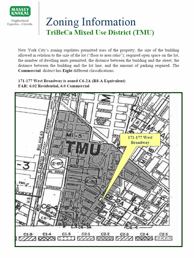
7 Zoning Information Excerpt From Department of City Planning

8 Zoning Information Excerpt From Department of City Planning

9 Zoning Information Excerpt From Department of City Planning
10 Zoning Information Excerpt From Department of City Planning
11 Zoning Information Excerpt From Department of City Planning
12 Zoning Information Excerpt From Department of City Planning
13

14 Tribeca Historic District Maps W. Broadway
15
16 Neighborhood Character New York City s Most Cosmopolitan Neighborhood TriBeCa includes the area bounded by Canal Street (north), Vesey Street (south), Lafayette Street (east) and the Hudson River (west). TriBeCa, an acronym for Triangle Below Canal Street, and was coined in the mid-1970 s as a result of City Planning studies and the adoption of the Special Lower Manhattan Mixed Use District (LMM). TriBeCa retains much of the Bohemian quality that once characterized the entire complex of cast-iron architecture between Houston and Vesey streets before it went upscale. Because this neighborhood overlaps the City Hall area, with its enormous daytime working population, it has been more successful in resisting the tide of fad enterprise. Art and commerce have, of course, transformed TriBeCa to a certain degree, but they have not overwhelmed it. TriBeCa today is the most sought after residential address in Manhattan. Many of the old historic warehouses and loft buildings have been converted to spectacular apartments. Many of New York City s finest restaurants, antique and craft stores are located in TriBeCa. With easy access to every corner of the island, it remains a sophisticated, cosmopolitan, and glamorous New York neighborhood. TriBeCa North Historic District: The TriBeCa North Historic District has a distinct and special character within the larger TriBeCa area. This distinction is due in large part to the variety of warehouse buildings constructed during the late nineteenth century. The TriBeCa North Historic District, which includes 67 buildings and three undeveloped lots, is located between Hubert & Watts Street and west of the intersection of Canal and Varick Streets. The warehouse buildings give the district its distinctive character, and dominate the block fronts in the area, and those on the cross streets of Hubert, Laight, and Vestry Streets. During the early nineteenth century, Trinity Church prompted the expansion of the city northward on its landholdings in the area. An elegant residential neighborhood developed around the perimeter of this private park during the 1820 s. Collister Street was initially an alley, which served stables at the rear of town houses facing the park. The Hudson River shoreline developed around this same time, as landfill extended the perimeter of lower Manhattan to West Street. The character of the district was altered during the twentieth century with the construction of the Holland Tunnel during the 1920 s and the demolition of the St. John s Freight Terminal in 1936, the site of which became the Holland Tunnel Exit Plaza. The increasing use of trucks for
17 Neighborhood Character transporting railroad shipments to and from Manhattan prompted the construction of several garages and small freight terminal buildings in the district; the proximity of the warehouses in the TriBeCa North Historic District to the Holland Tunnel has continued their usefulness as storage facilities. In the mid-nineteenth century, there were virtually no buildings in the United States that could be considered a fireproof warehouse of the same type as the brick and iron structures recently built in England. The five-story warehouses in England, built with cast-iron columns and rafters, and floors of iron joists spanned by brick arches were much admired. Soon, such buildings began to be developed in the major port cities of the United States. The emergence of the warehouse as a building type around 1870 is reflected in the district by the structures built for storage and industrial operations. These warehouses are at least fifty feet wide, and most are from five to seven stories in height. Their facades, of various shades of brick, are often given polychromatic and textural effects with the use of ornamental brick, terra cotta, and stone trim. The warehouses, as well as many of the store and loft buildings, incorporate distinctive use-generated features such as loading bays served by raised platforms, sheet metal awnings, and stepped vaults; segmentally-arched windows in the upper stories and corbelled brick cornices emphasize the structural quality of the construction. The influence of the German Rundbogenstil, Romanesque revival, and renaissance-inspired revival styles is evident in many of the warehouses, store and loft buildings. Granite slab sidewalks and Belgian block street pavers further the nineteenth-century commercial character of the district. The first decades of the twentieth century saw the more complete conversion of the TriBeCa area to a commercial district, as many of the early nineteenth century dwellings were replaced. In 1976, the City Planning Commission proposed a Special Lower Manhattan Mixed Use District, a zoning designation like that established in SoHo, which allowed for residential lofts and light manufacturing in the same area. This rezoning encouraged the conversion of commercial buildings to residential use during the late 1970 s and early 1980 s. After the recession of the early 1990 s, a strong demand for warehouse buildings with conversion potential began. With the strong possibility of rezoning the TriBeCa North Historic District from an M1-5 to a C6-2A, many developers have begun to purchase warehouse type buildings to convert into residential use. TriBeCa East Historic District: The TriBeCa East Historic District has a distinct and special character within the larger TriBeCa area defined by its many block fronts of ornate store and loft buildings that reflect the district s role as the center for dry goods and related businesses in New York City.
18 Neighborhood Character The history of the TriBeCa East Historic District is characterized by rapid development and redevelopment with commercial pressures displacing residential neighborhoods and pushing the city s urban limits northward. Progress in the American textile industry, especially in its product and distribution methods, combined with these pressures to mold the area into the leading district for dry goods and related businesses in New York City from the mid-nineteenth through the early twentieth century. While the development of this market was to a large extent empowered by the growth of the American textile mills outside the city, the business operations of the market located in New York City enabled the expansion and ultimate success of the industry as a whole. Throughout the seventeenth and most of the eighteenth centuries, the area of the TriBeCa East Historic District was open marshland. In 1646, Governor Kieft granted to Jan Jansen Damen forty-five acres of land that came to be known as the Calk Hook Farm. The property was divided among several individuals after Damen s death and later, between 1723 and 1725, was purchased and reassembled by Anthony Rutgers, a city Alderman and a member of the Colonial Assembly. The area became known as the Rutgers Farm. The Rutgers Farm was acquired by Leonard Lispenard in 1746 and was incorporated into the Lispenard Farm. After Canal Street was laid out, Lispenard s property within the district was dispersed by Through the eighteenth century, Manhattan s population was concentrated at the southern tip of the island, generally below Wall Street. As the city s population grew following the Revolutionary War, new residential neighborhoods developed on the northern outskirts of the city. By 1810, most of the streets within the present-day historic district had been laid out. The names of the district s streets recall the early history of the area. By the early nineteenth century, the first phase of urbanization in the district was underway with the construction of modest, two-and-one-half and three-and-one-half-story brick or brick and frame structures in the Federal Style. Following the fire of 1835, the Pearl Street merchants sought to re-establish their businesses in one concentrated commercial district. These businesses began to move northward into the district s residential neighborhoods. Beginning in the 1850 s, the dry goods merchants transformed the area from a residential one into a new commercial district. The first sign of change was the conversion of the first stories of many residences to commercial use. Additional alterations were made in association with the insertion of commercial storefronts. Raising a residence to four or five stories in height with a flat roof and adding a metal cornice at the top story was a typical renovation.
19 Neighborhood Character As more dry goods businesses moved into the vicinity, the area of TriBeCa East Historic District began to develop its present architectural character. The first sustained building campaign of structures erected specifically for commercial use as store and lofts in the area began in the 1850 s. On almost every block within the district boundaries there remains at least one store and loft building whose construction was begun in that decade. In the 1860 s, the area of the district was thoroughly transformed by the rapidly growing textile trade. The boom in construction of store and loft buildings in the area of the district during the 1860 s clearly demonstrates a peak in the growth of the American textile industry and the dry goods trade in New York. The decade of the 1860 s was clearly the commercial and architectural heyday in the area of the district. The store and loft was the most prevalent building type constructed within the district to accommodate the growing dry goods trade. Dry goods merchants commissioned many of these buildings for their own use. The typical store and loft building within the district is usually five stories high, and is designed with ornament reflecting current architectural styles or with more utilitarian appearance in keeping with its practical functions. Cast-iron bay framing at the ground floor level allows large openings for the loading and unloading of dry goods into the receiving and sales areas of the first floor. The upper stories and the basement were reserved for storage space. In many cases, individual buildings were occupied by more that one firm. In some cases, light manufacturing was conducted on the upper floors. During the 1880 s, architects occasionally integrated the neo-greco style with the delicate sunbursts, sunflowers, and attenuated colonnettes associated with the Queen Anne movement, an English revival of seventeenth and early-eighteenth-century architecture which was properly adopted by American architects, usually for domestic buildings, following the Centennial commemoration in Beginning in the 1890 s, other types of commercial structures were erected in the district; while relating to the store and loft type, these buildings illustrate the increasing role of office functions within retail and wholesale businesses. The last major phase of development in the district, begun in the late nineteenth century, involved the erection of tall buildings. With the growing use of the elevator, the benefits of the five-story commercial store and loft buildings were diminished and the taller office and loft buildings became a more economical and efficient commercial building type. As the twentieth century progressed, buildings constructed in the district tended to combine office space with other functions, such as stores, lofts, and factories.
20 Neighborhood Character The district retains an enormous amount of its nineteenth-century commercial architectural character, though some historic storefronts, storefront infill, window sash, and similar materials have been replaced or obscured. The survival of the dry goods industry helped to maintain the mercantile architecture in the neighborhood and the return of residential and entertainment uses has resulted in several alterations which enhance the mercantile ambience through the conservation of historic building fabric and the installation of new features which complement it. Also, throughout the district, granite slab sidewalks and street beds of granite pavers further contribute to its historic commercial architectural character. Beginning in the 1970 s, artists began to locate in vacated loft spaces in the district, continuing a trend begun by artists further north in the SoHo area. In 1976 the City Planning Commission proposed a Special Lower Manhattan Mixed Use District (LMM), a zoning designation, which allowed for residential lofts and light manufacturing in the same area. This was followed in the late 1970 s and early 1980 s by the conversion of store and loft buildings to residential cooperatives. Today, the buildings of the TriBeCa East Historic District contain a wide range of uses. In association with this sharp rise in residential use in the district, the ground stories of numerous store and loft buildings have been turned into retail and restaurant space, adding a new vibrancy to what was once New York s most important dry goods district. The TriBeCa West Historic District: The Tribeca West Historic District encompassing some 220 buildings, extends northward from James Bogardus Triangle to Hudson Square with Hudson Street serving as the spine of the district and Duane Park acting as a focal point. West Broadway and Varick Street, historically a major transportation route, form the eastern boundary. Greenwich Street forms a regular edge at the western boundary. Portions of Reade Street where the corner buildings intersect Hudson and Greenwich Streets form the southern boundary, while Hubert Street and Ericsson Place, fronting onto Hudson Square, form the northern boundaries. Early in the nineteenth century as the area was initially developed, it was a prime residential neighborhood concentrated around Duane Park and Hudson Square (renamed St. John s Park with the construction of St. John s Chapel on the eastside of Varick Street. By the mid-nineteenth century, with produce and other goods arriving at Washington Market, southwest of the historic district, the area began to develop its distinct architectural character. Buildings constructed to meet the changing needs of the district replaced houses. Today, the district is defined and dominated by commercial buildings of the store & loft, and the warehouse types.
21 Neighborhood Character The historical development of the TriBeCa West Historical District is characterized by a pattern of rapid development and redevelopment as commercial pressures displaced residential neighborhoods and pushed the city s urban limits northward. As a result the area became the leading district for food wholesaling and related businesses in New York City from the late nineteenth century to the mid-twentieth century. Throughout the seventeenth and most of the eighteenth centuries, the area of TriBeCa West was open land. Much of this land was held by Trinity Church to the west and Anthony Rutgers to the east. By the early nineteenth century, the first phase of urbanization in the district was underway. By the mid-nineteenth century, TriBeCa West began to develop its present architectural character. The most prevalent building type was the store & loft building. This type, usually four to seven stories high, had a mix of commercial and residential uses. The first sustained building campaign of the store & loft type building took place in the 1850 s. A major private developer in the district was the Protestant Episcopal Society. The City of New York constructed several public buildings in the district to support services necessary to support local businesses and residents. The last major phase of development in the district involved the erection of tall office buildings. Most are located on the major north-south thoroughfares. One of the earliest was the American Express Building at Hudson Street. Little changed in the area of the TriBeCa West Historic District between the Depression and the 1970 s. Beginning in the 1970 s, artists began to locate in vacated loft spaces in the district. In 1976 the City Planning Commission proposed a Special Lower Manhattan Mixed Use District (LMM) which allowed for residential lofts and light manufacturing in the same area. This was followed in the late 1970 s and early 1980 s by the conversion of store and loft buildings to residential cooperatives. In association with this sharp rise in residential use in the district, many of the ground stories of these buildings have been turned into retail and restaurant space, adding a new vibrancy to what was once New York s most important food commodity, produce, and dairy wholesaling. TriBeCa South Historic District: The TriBeCa South Historic District, Encompassing 70 buildings and two undeveloped lots, contains cohesive block fronts of the mid-nineteenth century store and loft buildings that extend between Broadway and West Broadway, from Chambers Street on the south to Duane and Thomas Streets on the north. West Broadway, historically a major transportation route, forms the western boundary. Chambers Street, the area s major east-west commercial street, linked Broadway, historically the preeminent mercantile thoroughfare, with West Broadway, the location of the Hudson River Railroad line and its depot which opened in 1851 at Chambers and Hudson Street.
22 Neighborhood Character The overwhelming majority of the structures in the TriBeCa South Historic District are store and loft buildings; the homogeneity of this predominant building type bestows a particular distinctiveness on the district. While the store and loft buildings in the district display an overall consistency in form and scale, their exteriors vary somewhat in design sophistication and ornamental quality. Some of the ornamental elements, such as sheet- metal cornices, were chosen from catalogs; almost every building was erected with some exposed cast-iron elements that were often selected from manufacturers stock. In general, the buildings in the district were consciously designed to be impressive advertisements for the businesses they housed. In the TriBeCa South Historic District, most of the store and loft buildings are typically five-story structures with facades composed of cast-iron-framed storefronts and upper walls faced in high quality materials: stone in over forty cases, brick in nearly twenty cases, or, more exceptionally, cast iron. Most of the store and loft buildings are in the Italianate style. The TriBeCa South Historic District was shaped by the growth of the transportation network in New York City and commercial pressures that pushed the urban center northward, displacing residential neighborhoods to accommodate New York s burgeoning wholesale dry goods trade. Throughout the seventeenth and eighteenth centuries, what is now the TriBeCa South Historic District was open land. The early history of the district is reflected in the names of most of the streets. In the blocks belonging to Trinity Church, the cross streets were named after prominent parishioners: James Duane, Joseph Reade, and John Chambers, while the streets paralleling Broadway were dubbed Church Street, in honor of Trinity Church, and Chapel Street, in honor of St. Paul s. Later, Chapel Street was widened to relieve congestion on Broadway and renamed West Broadway. Though the area of TriBeCa South Historic District had been mapped in the mid-eighteenth century, the first phase of urbanization in the district did not get underway until the late 1780 s with the construction of brick and frame workshops and two-and-one-half and three-and-one-half story dwellings. In the 1820 s and 1830 s, wealthy New Yorkers displaced by the expansion of banks and other financial institutions in the previously residential Wall Street area, began moving to Broadway and the side streets between Barclay and Chambers Streets, replacing the older houses in the area with Greek Revival town houses. In the 1850 s, the first store and loft buildings were erected, specifically for dry goods wholesalers, along the north side of Chambers Street between Broadway and Church Streets. Store and loft buildings soon began to appear on other blocks in the district. The area of the TriBeCa South Historic District was also home to H.B. Clafin & Co., the most successful wholesale dry goods firm in the country from the 1860 s through the 1880 s, and the largest in the world by the 1890 s.
23 Neighborhood Character In the first half of the twentieth century, the upper stories of the buildings in the district continued to be used by wholesale businesses, while ground floor stores were frequently converted to retail use. From 1904 to the 1920 s, no new construction took place in the district. However some of the earliest store and loft buildings in the district were refaced in brick. Beginning in the 1970 s, residential tenants began to locate in vacated loft spaces in the district, continuing a trend begun by artists further north in the SoHo area. In 1976 the City Planning Commission proposed a Special Lower Manhattan Mixed Use District (LMM), a zoning designation, which allowed for residential lofts and light manufacturing in the same area. This was followed in the late 1970 s and early 1980 s by the conversion of store and loft buildings to residential cooperatives. The area is now called the TriBeCa Mixed-Use District (TMU). Today, the TriBeCa South Historic District contains a wide range of uses, from traditional businesses, such as several shoe wholesalers on Duane Street, to retail stores and fashionable restaurants, and to a large residential population.

24 Bus Map West Broadway

25

26 Property Set Up, p. 1 of 2

27 Property Set Up, p. 2 of 2
28 Certificate of Occupancy, Lot 176 Bl. 13, from DOB site, page 1 of 2

29 Certificate of Occupancy, p.2 of 2
30 C_O Statement DOB 1/2009 for Block 176, Lot 14 p. 1 of 1
31 Certificate of Occupancy, Block 176, Lot 16 from DOB site p. 1 of 1
32 Violations Report As of June 2008 there are the following active violations for the buildings at 171 W. Broadway (Block 16, Lot 13), 175 W. Broadway (Block 16, lot 14) and 177 West Broadway (Block 176, Lot 16) listed on the DOB website: DOB Violations Block 176 Lot 13 Total Open Complaints 6 0 Violations-DOB Violations-ECB (DOB) 2 1 Block 176 Lot 14 Total Open Complaints 8 1 Violations-DOB 2 0 Violations-ECB (DOB) 1 0 Block 176 Lot 16 Total Open Complaints 4 0 Violations-DOB 0 0 Violations-ECB (DOB) 1 0

33 Community District One Information

34 Community District One Information Cont d
ASKING PRICE: $ 14,200,000
 02 The Opportunity 62 Thomas Street offers the opportunity to acquire a quality, income producing ground floor retail condominium in the sought after South Tribeca area. The current tenant (lease expiring
170 Hudson Street AKA 48 Laight Street
 Ground Floor Retail For Sale TriBeca 170 Hudson Street AKA 48 Laight Street Robert Burton Senior Vice President 212.660.7770 rburton@masseyknakal.com Will Suarez Director of Sales 212.660.7753 gosuarez@masseyknakal.com
Wyman Historic District
 Wyman Historic District DISTRICT DESCRIPTION The Wyman Historic District is a large district that represents the many architectural styles in fashion between the late 1800s through 1955. With the establishment
Administration Building YMCA Branch To Remain Intact
 Project Site BOSTON LANDMARKS COMMISSION The YMCA of Greater Boston, Inc. and Huntington Affordable Housing Limited Partnership (together, Building was originally comprised of three (3) separate buildings
Ch.16 SOUTH TEMPLE. Historic Districts - Apartment and Multi-family Development A HISTORY OF APARTMENT AND MULTI-FAMILY DEVELOPMENT
 Historic Districts - Apartment and Multi-family Development Ch.16 SOUTH TEMPLE A HISTORY OF APARTMENT AND MULTI-FAMILY DEVELOPMENT The following background on the historical development of apartment and
SOHO One-Story Building For Sale. 41 Mercer Street. Call For More Information
 SOHO One-Story Building For Sale 41 Mercer Street Call For More Information 02 The Opportunity 41 Mercer offers the opportunity to buy a one story retail building with a curb cut in the heart of SoHo.
Existing Land Use. Typical densities for single-family detached residential development in Cumberland County: 1
 Existing Land Use A description of existing land use in Cumberland County is fundamental to understanding the character of the County and its development related issues. Economic factors, development trends,
2014 Plan of Conservation and Development
 The Town of Hebron Section 1 2014 Plan of Conservation and Development Community Profile Introduction (Final: 8/29/13) The Community Profile section of the Plan of Conservation and Development is intended
III. Apartment HISTORIC DISTRICTS. & Multifamily Development
 III HISTORIC DISTRICTS Apartment & Multifamily Development PART III Historic Districts APARTMENT & MULTIFAMILY DEVELOPMENT CH. 13 THE AVENUES 13 : 1-6 CH. 14 CAPITOL HILL 14 : 1-6 CH. 15 CENTRAL CITY 15
A GUIDE TO HOUSING ARCHITECTURE IN SOUTH CENTRAL WISCONSIN
 A GUIDE TO HOUSING ARCHITECTURE IN SOUTH CENTRAL WISCONSIN The purpose of this guide is to provide REALTORS with a common frame of reference in identifying housing architecture. In compiling the guide,
List of Landmarks. Below are the properties currently designated as Cary Historic Landmarks:
 Historic Landmarks Overview The Town of Cary designates Cary Historic Landmarks as a way to preserve buildings that are historically, architecturally, or culturally significant to Cary. The Town Council
Ch. 14 CAPITOL HILL. Historic Districts - Apartment and Multi-family Development
 Historic Districts - Apartment and Multi-family Development Ch. 14 CAPITOL HILL A HISTORY OF APARTMENT AND MULTI-FAMILY DEVELOPMENT The following background on the historical development of apartment and
MUNICIPAL HERITAGE REGISTRY MACGREGOR/ALBERT HERITAGE CONSERVATION DISTRICT PART V ONTARIO HERITAGE ACT
 MUNICIPAL HERITAGE REGISTRY MACGREGOR/ALBERT HERITAGE CONSERVATION DISTRICT PART V ONTARIO HERITAGE ACT 40 Albert Street Designated Landmark 47 Albert Street Designated Landmark 06-097 85-5 06-097 99-107
Uptown Greenwood. A Century of Growth and Re-Development. Railroads and Early Development
 Uptown Greenwood A Century of Growth and Re-Development Uptown Greenwood is the geographical, cultural and historical center of the railroad and mill town in upstate South Carolina that had its greatest
History of Spruce Hill. The history of West Philadelphia s Spruce Hill neighborhood roughly bordered
 Lauren Pinsker October 11, 2005 Hist 204.402 / Urbs 227.402 History of Spruce Hill The history of West Philadelphia s Spruce Hill neighborhood roughly bordered by Walnut Street to the north, 41 st Street
CHAPTER 6 - NEIGHBORHOOD HISTORY
 CHAPTER 6 - NEIGHBORHOOD HISTORY CONTENTS 6.1 The Early History of Morningside Heights......... 6.2 6.2 A Neighborhood of Institutions.................. 6.4 6.3 The Rise of Residential Morningside Heights.......
A GUIDE TO HOUSING ARCHITECTURE IN SOUTH CENTRAL WISCONSIN
 A GUIDE TO HOUSING ARCHITECTURE IN SOUTH CENTRAL WISCONSIN The purpose of this guide is to provide REALTORS with a common frame of reference in identifying housing architecture. In compiling the guide,
M E M O R A N D U M PLANNING AND COMMUNITY DEVELOPMENT DEPARTMENT CITY OF SANTA MONICA PLANNING DIVISION
 M E M O R A N D U M 10-A PLANNING AND COMMUNITY DEVELOPMENT DEPARTMENT CITY OF SANTA MONICA PLANNING DIVISION DATE: May 14, 2018 TO: FROM: SUBJECT: The Honorable Landmarks Commission Planning Staff 1314
OWN IN THE HEART OF MIDTOWN
 OWN IN THE HEART OF MIDTOWN CONVENIENCE, PRESTIGE, EQUITY OVERVIEW The office condominiums at 20 West 33rd Street are located on 33rd Street between Fifth Avenue and Broadway in the heart of Midtown
1 The Alleys, St Mary s Road, Hemel Hempstead, Hertfordshire, HP2 5ZB
 Quaker Meeting House, Hemel Hempstead 1 The Alleys, St Mary s Road, Hemel Hempstead, Hertfordshire, HP2 5ZB National Grid Reference: TL 05672 07875 Statement of Significance An early eighteenth-century
98 Ralph avenue Brooklyn, NY Bedford stuyvesant
 98 Ralph avenue Brooklyn, NY Bedford stuyvesant fully renovated 4-story apartment building all free market UNITS Asking price: $4,000,0000 113 Richardson Street Brooklyn, NY Williamsburg Recently Constructed
Rock Island County Courthouse History & Significance
 1 Rock Island County Courthouse History & Significance HISTORY: The Rock Island County Courthouse was built in 1896 in downtown Rock Island. Rock Island County was established in 1833 and Stephenson, as
GFI REALTY SERVICES EXCLUSIVE OFFERING
 GFI REALTY SERVICES EXCLUSIVE OFFERING Brooklyn, NY 6 APTS & A COMMERCIAL UNIT Asking Price: $5,300,000 Projected CAP Rate: 5.88% Projected GRM: 15.7 x RR 140 Broadway, 41 41 st st Floor New York, NY NY
FOR SALE CONTINENTAL MILL REDEVELOPMENT
 FOR SALE CONTINENTAL MILL REDEVELOPMENT 2 CEDAR STREET - LEWISTON, MAINE CONTINENTIAL MILL HISTORIC MILL IN DOWNTOWN LEWISTON 560,000± SF REDEVELOPMENT OPPORTUNITY Picturesque Views of Androscoggin River
256 W 88th Street New York, NY
 256 W 88th Street New York, NY Vacant 5 Unit Mixed-Use Building Currently a Clean Shell Includes: proposed plans to convert to a single family townhouse Listing Price: $4,775,000 (PSF: $1,129) Annual Taxes:
SECURITY BUILDING 117 NE 1 ST AVENUE
 SECURITY BUILDING 117 NE 1 ST AVENUE Designation Report City of Miami REPORT OF THE CITY OF MIAMI PRESERVATION OFFICER TO THE HISTORIC AND ENVIRONMENTAL PRESERVATION BOARD ON THE POTENTIAL DESIGNATION
157 West 24th Street New York, New York
 New York, New York Confidentiality Agreement THIS IS A CONFIDENTIAL MEMORANDUM intended solely for your own limited use in considering whether to pursue negotiations to acquire an interest in, New York,
Planning Rationale. 224 Cooper Street
 Submitted by: Robertson Martin Architects Tel 613.567.1361 Fax 613.567.9462 216 Pretoria Ave, Ottawa, Ontario, K1S 1X2 Planning Rationale 224 Cooper Street Planning Rationale Application to City of Ottawa
Chapter 7 Riverfront District
 Chapter 7 Riverfront District Downtown Capital District Master Plan Trenton, New Jersey Riverfront District Trenton will reclaim its connection with the Delaware River to enhance the experience of living,
Infill & Other Residential Design Review
 Infill & Other Residential Design Review December 2018 Infill and Other Residential Design Review applies to projects that are located within the Infill Regulations District, on properties immediately
History of the Building and Architect
 Testimony of LANDMARK WEST! Certificate of Appropriateness Committee Before the Landmarks Preservation Commission 249 Central Park West September 11, 2007 LANDMARK WEST! is a not-for-profit community organization
TOOLSforTEACHING. High-School DBQ. high school. Objective. Documents. Standards met by proposed DBQ at the Commencement Level:
 High-School DBQ Objective Using the documents and knowledge of the American economy of the early 1900s, students will discuss the relationship between the development of New York City as a business center
Learning Places Spring 2016 SITE REPORT Vinegar Hill, Revisited. Gerard Jitechian INTRODUCTION PRE-VISIT REFLECTION
 Learning Places Spring 2016 SITE REPORT Vinegar Hill, Revisited 2 St. Anne s church, no longer standing Gerard Jitechian 04.05.2016 INTRODUCTION This site report will examine three buildings in the Vinegar
2.2.2 The Land Use Setting
 2-6 Planning Area pearance varies dramatically from season to season. The absence of significant topographic or man-made features within the District contributes to a very open visual character that allows
DHR Resource Number: AVON STREET
 DHR Resource Number: 104-5082-0089 309 AVON STREET 309 Avon Street Parcel ID: 580127000 DHR Resource Number: 104-5082-0089 Primary Resource: Store, Spudnuts (contributing) Date: 1960 Commercial Style Site
Windshield Survey of McLoud, Pottawatomie County. September 12, 2007 By Jim Gabbert Architectural Historian OK/SHPO
 Windshield Survey of McLoud, Pottawatomie County September 12, 2007 By Jim Gabbert Architectural Historian OK/SHPO Purpose and Methodology The purpose of this windshield survey is to identify, based on
Property Name Haxton-Griffin Farm Location Athens vic., Greene County, New York NATIONAL REGISTER OF HISTORIC PLACES CONTINUATION SHEET
 Section Number 7 Page 1 7. Narrative Description Location & Setting The Haxton-Griffin Farm is located on the west side of the Hudson River, about one-half mile from the river and less than two miles southwest
Richardson s Bakery. Description of Historic Place. Heritage Value of Historic Place
 HISTORIC RESOURCES 2013 City of Medicine Hat Richardson s Bakery Date of Construction 1899 Address 720-4 (Montreal) Street SE Original Owner Henry McNeely Neighbourhood River Flats Legal 1491;24;11 Description
74af ANTELOPE VALLEY REDEVELOPMENT PLAN
 74af T. Telegraph District Phase 2: Telegraph Flats & Telegraph Lofts East 1. Project Area Description Phase 2 will include two building subphase areas with connecting streetscape enhancements: The Telegraph
COMMERCIAL ELEMENT AND CODE ENFORCEMENT
 COMMERCIAL ELEMENT AND CODE ENFORCEMENT The Commercial Element identifies and describes the existing characteristics that are desired by the neighborhood. The existing conditions will determine appropriate
PATRICK J. SULLIVAN DIRECTOR
 City of New Bedford Department of Planning, Housing & Community Development 608 Pleasant St, New Bedford, Massachusetts 02740 Telephone: (508) 979.1500 Facsimile: (508) 979.1575 PATRICK J. SULLIVAN DIRECTOR
2015 Downtown Parking Study
 2015 Downtown Parking Study City of Linden Genesee County, Michigan November 2015 Prepared by: City of Linden Downtown Development Authority 132 E. Broad Street Linden, MI 48451 www.lindenmi.us Table of
MEMORANDUM. I1 District Industrial Living Overlay District 110,703 square feet / 2.54 acres
 Department of Community Planning & Economic Development 250 South 4th Street, Room 300 Minneapolis, MN 55415-1385 MEMORANDUM To: City Planning Commission, Committee of the Whole Prepared By: Peter Crandall,
8Land Use. The Land Use Plan consists of the following elements:
 8Land Use 1. Introduction The Land Use Plan consists of the following elements: 1. Introduction 2. Existing Conditions 3. Opportunities for Redevelopment 4. Land Use Projections 5. Future Land Use Policies
CHAPTER 2: Historical Setting
 CHAPTER 2: Historical Setting The Alexandria Monroe Township Historical Society was started in 1979 by John and Marsha Madden, Max and Nancy Draper, Curt and Rosemary Ellis, Jim Donahue and John Noffze.
State of Land Use and the Built Environment
 State of Land Use and the Built Environment The city approved more units for construction in 214 than in 213, but the level remained below that of the mid-2s. Meanwhile, city-initiated rezonings all but
VOLUME 25 NUMBER 20 OCTOBER-DECEMBER 1995 OFFICE BOSTON, MASSACHUSETTS PROJECT TYPE
 VOLUME 25 NUMBER 20 OCTOBER-DECEMBER 1995 OFFICE STATE STREET BANK BUILDING BOSTON, MASSACHUSETTS PROJECT TYPE Repositioning of a 31-year-old high-rise office building in the heart of Bostonís financial
Boutique Office Space for Lease
 Boutique Office Space for Lease in Downtown L.A. Historic Building Creative Office Spaces for Lease in Historic Downtown Los Angeles Building Permitted Basement Bar Space with Type 48 CUP Across From the
Renaissance to Georgian in The Low Countries and England Colonial and Federal America
 Oman College of Management & Technology COURSE NAME: HISTORY OF INTERIOR DESIGN PROPOSED BY: DR.MOHAMED ALNEJEM SEMESTER: FIRST 2015/2016 CHAPTER (6): -Renaissance to Georgian in The Low Countries and
31-35 ST. JAMES PLACE MADISON STREET. 4 Buildings, 21 Residential & 3 Commercial Units MAJOR PRICE REDUCTION! MADISON STREET
 3-35 ST. JAMES PLACE 27-35 MADISON STREET 4 Buildings, 2 Residential & 3 Commercial Units MAJOR PRICE REDUCTION! 3 33 35 29 27 27-35 MADISON STREET 27-35 MADISON STREET - PROPERTY PICTURES AERIAL PICTURE
A Guide to Historic New York City Neighborhoods. T r i b e c a
 A Guide to Historic New York City Neighborhoods T r i b e c a Manhattan The Historic Districts Council is New York s citywide advocate for historic buildings and neighborhoods. The Six to Celebrate program
Los Angeles Department of City Planning RECOMMENDATION REPORT
 Los Angeles Department of City Planning RECOMMENDATION REPORT CULTURAL HERITAGE COMMISSION HEARING DATE: January 24, 2008 TIME: 10:00 AM PLACE: City Hall, Room 1060 200 N. Spring Street Los Angeles, CA
BMR-Landmark at Eastview LLC ( BMR ) respectfully petitions the Town Board of the
 respectfully petitions the Town Board of the") TOWN BOARD OF THE TOWN OF MOUNT PLEASANT COUNTY OF WESTCHESTER: STATE OF NEW YORK ----------------------------------------------------------------------- X In the Matter of the Petition of BMR-LANDMARK
TOWN BOARD OF THE TOWN OF MOUNT PLEASANT COUNTY OF WESTCHESTER: STATE OF NEW YORK ----------------------------------------------------------------------- X In the Matter of the Petition of BMR-LANDMARK
Criteria Evaluation: Landmark staff found that the structure application meets History Criteria 1a, and Architecture Criterion 2a and 2b.
 To: Landmark Preservation Commission From: Kara Hahn, Principal Planner, Community Planning & Development (CPD) Date: October 9, 2018 RE: Landmark Designation for the Henderson House, 2600 Milwaukee Street
\ Town. St,- F O R M B - BUILDING. Massachusetts Historical Commission 80 Boylston Street Boston, Massachusetts 02116
 F O R M B - BUILDING Massachusetts Historical Commission 80 Boylston Street Boston, Massachusetts 02116 Assessor's number USGSQuad 33/160-10 Boston South \ Town Br Area(s) Form Number BKL.616
EASTERN CONSOLIDATED VIEW FROM THE STREET NEIGHBORHOOD OVERVIEW: MANHATTAN
 EASTERN CONSOLIDATED VIEW FROM THE NEIGHBORHOOD OVERVIEW: MANHATTAN NOVEMBER 2017 TABLE OF CONTENTS Overview 5 DOWNTOWN Financial District/Tribeca/Chinatown 10 SoHo/Nolita/Lower East Side 12 West Village/Greenwich
Enlightened Urbanism: A Model for Development of Vacant Buildings Downtown
 Enlightened Urbanism: A Model for Development of Vacant Buildings Downtown Amanda Phelps What is needed is not a new utopia... but rather a blueprint for a better reality. 1 O.M. Ungers San Antonio is
THE CHATHAM-KENT MUNICIPAL HERITAGE REGISTER. Listed Properties in the Community of Dover
 THE CHATHAM-KENT MUNICIPAL HERITAGE REGISTER Listed Properties in the 7119 Bay Line 1890 Historical Significance: This dwelling is one of the first structures one notices on their entrance into Mitchell
Mary J. Berg House 2517 Regent Street
 CITY OF BERKELEY Ordinance #4694 N.S. LANDMARK APPLICATION Mary J. Berg House 2517 Regent Street Additional Photographs Streetscape showing 2511, 2517 & 2521 Regent Street 2517 Regent Street front façade
BIJILDING, I8 1 I, STATE STREET, NEWBURYPORT
 DETAIL OF WINDOWS, BRICKWORK, AND CORNICE OF THE PHOENIX BIJILDING, I8 1 I, STATE STREET, NEWBURYPORT OLD-TIME NEW ENGLAND d Quarterly &Vagaxine Devoted to tiie dncient Buildings, Household Furnishings,
Los Angeles Department of City Planning RECOMMENDATION REPORT
 Los Angeles Department of City Planning RECOMMENDATION REPORT CULTURAL HERITAGE COMMISSION HEARING DATE: November 15, 2007 TIME: 10:00 AM PLACE: City Hall, Room 1010 200 N. Spring Street Los Angeles, CA
GFI REALTY services EXCLUSIVE OFFERING
 GFI REALTY services EXCLUSIVE OFFERING sunset park warehouse great redevelopment opportunity 0,000 sf of air rights available 40 nd Avenue Brooklyn, NY Askng Price: $0,500,000 40 nd Avenue brooklyn, NY
Church and Gloucester Properties Inclusion on Heritage Inventory
 STAFF REPORT ACTION REQUIRED Church and Gloucester Properties Inclusion on Heritage Inventory Date: April 17, 2009 To: From: Toronto Preservation Board Toronto and East York Community Council Director,
Durant Ave., Berkeley
 Page 1 of 6 Attachment: 2121-2123 Durant Ave., Berkeley Proposed Project Analysis for New Construction Prepared for: Kahn Design Associates 1810 6 th Street Berkeley, CA. 94710 19 December 2014 Revised
Styles. Allows you to specify what type of residence is being valued.
 RCTQuick Reference Styles Styles Allows you to specify what type of residence is being valued. Cape Cod A residence with two levels of living area, characterized by a steep roof fronts). Because of the
REASONS FOR LISTING: 306 AND 308 LONSDALE ROAD. #306 Lonsdale #308 Lonsdale. 306 and 308 Lonsdale Road Apartments
 REASONS FOR LISTING: 306 AND 308 LONSDALE ROAD ATTACHMENT 2A #306 Lonsdale #308 Lonsdale 306 and 308 Lonsdale Road Apartments Description The properties at 306 and 308 Lonsdale Road are worthy of inclusion
THE OPPORTUNITY HAM MILL, LONDON ROAD, THRUPP, STROUD, GL5 2BB. Artists impression
 2 HECTARE / 4.94 ACRE RIVERSIDE DEVELOPMENT SITE WITH DETAILED PLANNING PERMISSION PROPOSALS FOR A HIGH QUALITY RESIDENTIAL-LED, MIXED-USE DEVELOPMENT LOCATED WITHIN 2.5 MILES OF STROUD TOWN CENTRE 100
NOHO HISTORIC DISTRICT Designation Report
 NOHO HISTORIC DISTRICT Designation Report NYC Landmarks Preservation Commission June 29, 1999 NOHO HISTORIC DISTRICT Designation Report Report prepared by Donald G. Presa Architects' Appendix by Virginia
MIAMI WOMAN S CLUB 1737 N. BAYSHORE DRIVE. Designation Report. City of Miami
 MIAMI WOMAN S CLUB 1737 N. BAYSHORE DRIVE Designation Report City of Miami REPORT OF THE CITY OF MIAMI PLANNING DEPARTMENT TO THE HERITAGE CONSERVATION BOARD ON THE POTENTIAL DESIGNATION OF THE MIAMI WOMAN
10 IONIA NW PROJECT INTRODUCTION
 10 IONIA NW PROJECT INTRODUCTION The Hinman Company ( Hinman ) owns the 11,040 square-foot, triangle-shaped property commonly known as 10 Ionia Avenue NW, Grand Rapids, Michigan (the 10 Ionia property
291 Grand Street. Location Highlights. Prime Retail and Commercial Space for Lease in Manhattan s Lower East Side
 Prime Retail and Commercial Space for Lease in Manhattan s Lower East Side 291 Grand Street N e w y o r k, n e w y o r k 1 0 0 0 2 Location Highlights exceptional location on the corner of Grand and Eldridge
West 86 th Street Significance
 272-278 West 86 th Street Significance for West 80s Neighborhood Association Introduction This report is an evaluation of the significance of 272-278 West 86 th Street in relation to the proposed Riverside
THEREFORE the Council of The Corporation of the City of Kingston hereby enacts as follows:
 BY-LAW NO. 2009-XXX A BY-LAW TO AMEND BY-LAW NO. 84-650 A By-law to designate Certain Properties to be of Historic and/or Architectural Value or Interest, pursuant to Section 29 of the Ontario Heritagekt
29 East 129th Street New York, New York $2,650,000 Price: $2,650,000 Approx SQFT: 3,500 $ Per SQFT: $757 R.E Taxes: $679/monthly
 www.lesliegarfield.com 212.371.8200 info@lesliegarfield.com 29 East 129th Street $2,650,000 Price: $2,650,000 Approx SQFT: 3,500 $ Per SQFT: $757 R.E Taxes: $679/monthly Date Listed: 2/7/18 Days On Market:
Wilmington Harbor City Industrial Zone Properties Individual Resources December 2015
 1233 W 253RD ST 1227 W 253RD ST Year built: 1946, Utilitarian Context: Development, 1850-1980 Theme: Design and Engineering, 1887-1965 Quonset Hut C/3/3 Rare intact example of two Quonset huts, developed
AFI s redevelopment of the Times Square Building presents the opportunity for The Walt Disney Company to design the interior of, own and operate a
 Jerry Marlow, MBA Financial writer, real estate writer, marketing writer, speech writer, pitch books and presentations, proofreader, editor, writing coach Writing and design sample Assignment Persuade
COTTON MILLS DISTRICT REDEVELOPMENT - C.M.D.R. - - G E N E R A L -
 COTTON MILLS DISTRICT REDEVELOPMENT - C.M.D.R. - - G E N E R A L - 03-14-1 All structures and buildings erected, altered or used in a C.M.D.R. Zone shall conform to the regulations of this subsection.
Our Properties. Renaissance Lofts
 HOME BASE Property Management LLC HOME BASE Property Management LLC works with residential tenants to find reliable properties to live and and grow in. Our knowledgeable staff is here to help and guide
GREATER BETHEL A.M.E. CHURCH 245 N.W. 8 TH STREET
 GREATER BETHEL A.M.E. CHURCH 245 N.W. 8 TH STREET Designation Report City of Miami REPORT OF THE CITY OF MIAMI PLANNING DEPARTMENT TO THE HERITAGE CONSERVATION BOARD ON THE POTENTIAL DESIGNATION OF THE
Sherwood Forest (Trinity) Housing Corporation. Urban Design Brief
 Housing Corporation. Urban Design Brief") Sherwood Forest (Trinity) Housing Corporation Sherwood Place Affordable Housing Apartments Trinity Presbyterian Church Orchard Park Nursery School 590 Gainsborough Road, London Urban Design Brief REVISED
Sherwood Forest (Trinity) Housing Corporation Sherwood Place Affordable Housing Apartments Trinity Presbyterian Church Orchard Park Nursery School 590 Gainsborough Road, London Urban Design Brief REVISED
Manhattan New Dev. Market Report th Quarter mns.com
 Manhattan New Dev. Market Report 2017 4th Quarter TABLE OF CONTENTS TABLE OF CONTENTS 03 Introduction 04 Market Snapshot 09 Neighborhood Trends 09 Battery Park City 10 Chelsea 11 East Village 12 Financial
FOR SALE 248 North Main Street, Mount Airy, NC
 FOR SALE 248 North Main Street, Mount Airy, NC Existing Retail and Office Potential for: Condominiums, Apartments, Boutique Hotel and Special Events Facility $875,000 HISTORIC PROPERTY 248 North Main Street,
249 WEST 34TH STREET 249 WEST 34TH STREET
 249 WEST 34TH STREET 249 WEST 34TH STREET 249 West 34th Street is a commercial 7-story mid-rise building built in 1925. With boutique floorplates, the building offers loft-styled spaces in the midst of
2391 Bell Blvd. is located at a highly travelled 4 way intersection (Bell Blvd / 24 th Ave / Bay Terrace Shopping Center main entrance and exit):
:") SUPPLEMENTAL INFORMATION PACKAGE: 2391 BELL BLVD., BAY TERRACE, NY 2391 Bell Blvd. is located at a highly travelled 4 way intersection (Bell Blvd / 24 th Ave / Bay Terrace Shopping Center main entrance
SUPPLEMENTAL INFORMATION PACKAGE: 2391 BELL BLVD., BAY TERRACE, NY 2391 Bell Blvd. is located at a highly travelled 4 way intersection (Bell Blvd / 24 th Ave / Bay Terrace Shopping Center main entrance
STAFF DESIGN REVIEW RESIDENTIAL BUILDING APPLICATION SUPPLEMENT
 STAFF DESIGN REVIEW RESIDENTIAL BUILDING APPLICATION SUPPLEMENT OFFICIAL USE ONLY Case #: Received By: Master File #: Project Planner: Date: Related Cases: Single Family, including Townhomes (ln-fill housing
San Francisco Planning Department South Mission Historic Resources Survey Historic District Description
 Von Schroeder Welsh Block East side of Capp Street between 22 nd and 23 rd Streets. Boundaries: Block bounded by nue, Capp, 22 nd and 23 rd Streets Period of Significance: 1889 1895 Eligibility: California
NEW HAMPSHIRE HISTORIC PROPERTY DOCUMENTATION DINARDO-DUPUIS HOUSE NH STATE NO Wight Street, Berlin, Coos County, New Hampshire
 NEW HAMPSHIRE HISTORIC PROPERTY DOCUMENTATION DINARDO-DUPUIS HOUSE NH STATE NO. 696 Location:, Berlin, Coos County, New Hampshire USGS Berlin Quadrangle UTM Coordinates: Z19 4926650N 325990E Present Owner:
Venice Report Historic Districts, Planning Districts and Multi-Property Resources 04/02/15
 Districts Name: Lost Venice Canals Historic District Description: The Lost Venice Canals Historic District is a residential neighborhood located in the northwestern portion of Venice. The district contains
Toronto Preservation Board Toronto East York Community Council. Acting Director, Policy & Research, City Planning Division
 STAFF REPORT ACTION REQUIRED Alteration of a Heritage Property Designated under Part IV of the Ontario Heritage Act and Protected by a Heritage Easement Agreement 1046 Yonge Street Date: February 7, 2012
M A N H A T T A N 69 THE FURMAN CENTER FOR REAL ESTATE & URBAN POLICY. Financial District Greenwich Village/Soho
 M A N H A T T A N Page Financial District 301 72 Greenwich Village/Soho 302 73 Lower East Side/Chinatown 303 74 Clinton/Chelsea 304 75 69 THE FURMAN CENTER FOR REAL ESTATE & URBAN POLICY Midtown 305 76
Los Angeles Department of City Planning RECOMMENDATION REPORT
 Los Angeles Department of City Planning RECOMMENDATION REPORT CULTURAL HERITAGE COMMISSION HEARING DATE: February 7, 2013 TIME: 10:00 AM PLACE: City Hall, Room 1010 200 N. Spring Street Los Angeles, CA
These design guidelines were adopted by: Knoxville-Knox County Metropolitan Planning Commission on August 10, 2000 Knoxville Historic Zoning
 Fort Sanders Neighborhood Conservation District Design Guidelines These design guidelines were adopted by: Knoxville-Knox County Metropolitan Planning Commission on August 10, 2000 Knoxville Historic Zoning
Town of Cary, North Carolina Rezoning Staff Report 13-REZ-13 An Zou Property Town Council Meeting November 21, 2013
 Town of Cary, North Carolina Rezoning Staff Report 13-REZ-13 An Zou Property Town Council Meeting November 21, 2013 REQUEST To amend the Town of Cary Official Zoning Map by rezoning 0.63 acres located
South East CBD/ Paris End
 South East CBD/ Paris End Over the past 50 years, the eastern end of the CBD around Collins and Little Collins streets has lost many lanes and important heritage lanescapes due to large-scale office developments
CRAWFORD & STEARNS ARCHITECTS AND PRESERVATION PLANNERS
 CRAWFORD & STEARNS ARCHITECTS AND PRESERVATION PLANNERS March 28, 2007 Mr. Don Radke, Chairman Syracuse Landmarks Preservation Board City Hall Commons 201 East Washington Street Syracuse, New York 13202
COURTHOUSES THAT FOLLOW the dictates of Brutalism
 FIFTH IN A SERIES OF 5 The Detailed Beauty of Texas Courthouses COURTHOUSES THAT FOLLOW the dictates of Brutalism and Modernistic schools are often indistinguishable from contemporary office buildings.
Memorandum. Historic Resources Inventory Survey Form 315 Palisades Avenue, 1983.
 Memorandum TO: Roxanne Tanemori, City of Santa Monica DATE: August 30, 2007 CC: FROM: Jon L. Wilson, M.Arch., Architectural Historian RE: Preliminary Historic Assessment: 315 Palisades Avenue (APN 4293-015-015)
THE BURLINGTON ARCHITECTURAL SCAVENGER HUNT
 THE BURLINGTON ARCHITECTURAL SCAVENGER HUNT PRESENTED BY PRESERVATION BURLINGTON Thank you to everyone who participated in the 2011 Burlington Architectural Scavenger Hunt, or History Hunt! Between October
STATEMENT OF SIGNIFICANCE
 STATEMENT OF SIGNIFICANCE revised 4 November 2011 Revisions in italics BEACH TOWERS 1600 Beach Avenue & 1651 Harwood Street, Vancouver Note: this SOS is prepared for Beach Towers Investments Inc. and IBI/HB
BUILDINGS IN TALBOT YARD, YORKERSGATE, MALTON. Case UID: RECOMMENDATION. Recommended Grade: II
 ADDRESS BUILDINGS IN TALBOT YARD, YORKERSGATE, MALTON Parish MALTON District RYEDALE County NORTH YORKSHIRE Case UID: 169678 Date First Listed: 27-OCT-2010 Formerly Listed As: RECOMMENDATION Outcome: Yes,