CFPB Implementation of Parcels Provision in HMDA Under Dodd-Frank
|
|
|
- Elwin Bennett
- 5 years ago
- Views:
Transcription
1 CFPB Implementation of Parcels Provision in HMDA Under Dodd-Frank
2 Land ownership is the foundation of the financial, legal, and real estate systems in our society

3 Parcel Data vs. Census Data + Census data is inaccurate at the parcel level + Census level data is updated every ten years + Parcels change every day + Foreclosures happen per parcel + Parcels provide the true gauge of anything happening at a property level Decisions and policies should be made using the proper granularity of data


4 Parcel Data Street address Owner information Sales price Appraised value Land value Improvements value Lot size Land Use Deeded acreage Property type Mortgage information Etc.


5 Authoritative Source Local governments process real estate information on a daily basis from recorded documents, assessment data, and parcel maps + Most current information + Most accurate information + Baseline of value + Best indication of economic activity + Common denominator of land + It is the public record
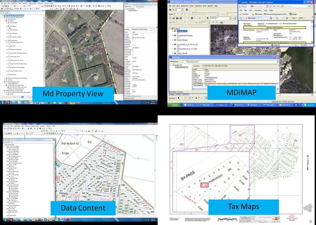
6 State of Maryland million parcels + Statewide Assessments and Taxation - State Department of Assessment & Taxation - assessments and billing - Maryland Department of Planning - map maintenance + Statewide parcel points (MDP) + Statewide raster versions of tax maps + MD Property View (from MDP) - Property, sales, CAMA, data extracts, and other layers - Licensed products (multiple tools and data products) - Funding supports maintenance + Statewide Web Map Service (MDiMAP) - Parcel boundaries w/link to SDAT datasheet + County vectorized parcel boundary datasets complete coverage - Variable content, design, timeliness, distribution policies + State and Counties working on Integrated Parcel Update Process
7


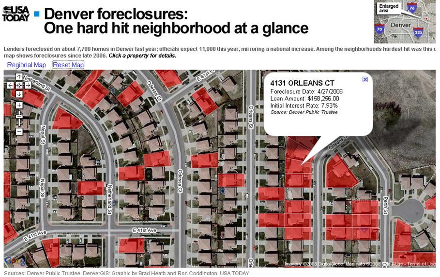
8 Using Parcels to Predict 2005 High Cost Loans + Analysis Set up national models and perform what if scenarios + Identify Easily identify what areas are likely to be affected next + Act Predictions lead to early action which leads to prevention + Visualization Like the weather, if you monitor it, you can learn to predict it 2006 Foreclosures
9

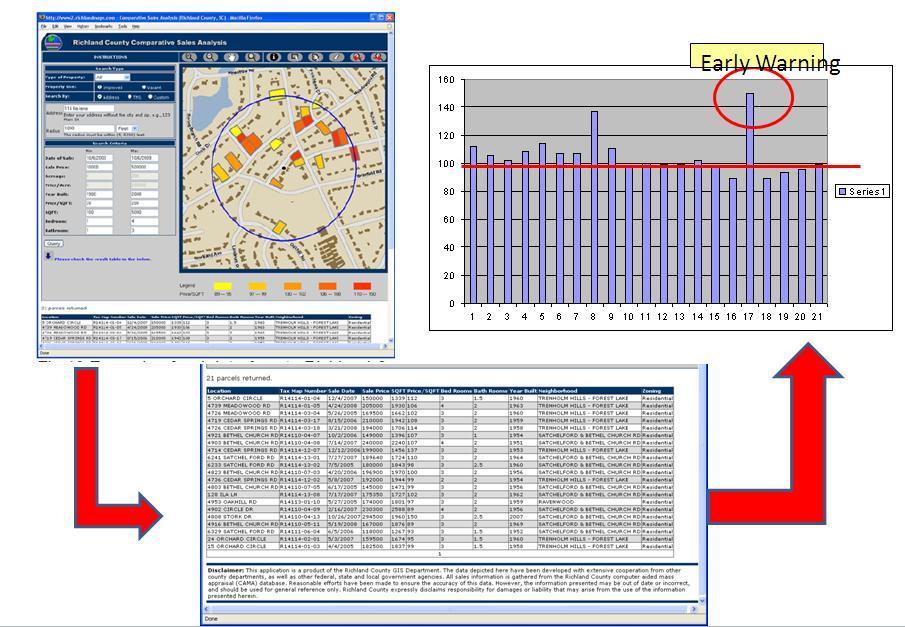
10 Using Parcels to Prevent If you are tracking and monitoring specific items and events you will have an early warning system to respond to clusters before they become national epidemics Possible Red Flags: + Changes in National Trend Lines + Home Values vs. GNP + Overlays with additional datasets + Mortgage resets, defaults, etc.
11
12 Question #1 Sufficiency or insufficiency of address. What is the value of parcel ID? + Address data alone is insufficient + Lack of standards + Many county assessors maintain owner address rather than situs address + Parcel ID is the best unique identifier for a parcel + Parcel ID is used to link to additional real property databases + The FIPS code could be used to create nationwide Parcel ID

13 Question #2 What is the burden of collecting parcel ID or address from originators? + Does not burden the originators because the Parcel ID is ALREADY included in the documentation used to process a mortgage + Just needs to be added to the HMDA Report to be useful
 + A database design and crosswalk")
14 Question #3 What are the existing standards? + There is a lack of nationwide standards + Approximately 20% - 25% of parcel are still not digital (mostly rural) + A database design and crosswalk would be developed to create a standard + Non-digital parcel would need to be converted to standard format

 + A standard data model and crosswalk takes")

15 Question #4 What are the existing databases? + A lot of various databases exist at a county level (i.e. ESRI, CAD, Access, AS400,etc..) + A standard data model and crosswalk takes care of the issue + There are several commercial national databases that cover most of the digital parcels

16 Question #5 How do different approaches deal with one to many and many to one relationships? + Non-graphic databases already account for these situations with each parcel and condo having a unique identifier + Graphic data can be handled different ways such as stacked parcels

17 Question #6 How do different approaches deal with latency issues? + Latency is certainly an issue when dealing with a dataset that changes daily + This is also an issue when dealing with commercial national datasets as the update cycle can be 2-3 years for many counties + A maintenance and update plan would need to be identified and the feasibility of that plan assessed

18 Question #7 What are the privacy concerns and implications? + Real Property data maintained by local governments is already public record and in many cases freely available online + The primary privacy issue is linking the parcel ID to loan information and credit score. + This could be addressed in a variety of ways such as the use of additional codes in the database
19 Next Steps + CFPB join FGDC + Hire a land records consultant + Identify states/counties for pilot projects + Review existing datasets and perform a gap analysis and cost analysis + Draft database design for a national dataset with appropriate attributes defined + Identify tasks and costs of data conversion for the remaining 25%
20
State of Washington Project Luke Rogers, University of Washington March 2010
 State of Washington Project Luke Rogers, University of Washington March 2010 Rural Technology Initiative (RTI) developed an online tutorial on how to use the Washington State Parcel and Forestland Databases
QUESTIONNAIRE. 1. Authorizing statute(s) citation West Virginia Code and 11-1C-4(d)
 citation West Virginia Code and 11-1C-4(d)") QUESTIONNAIRE (Please include a copy of this form with each filing of your rule: Notice of Public Hearing or Comment Period; Proposed Rule, and if needed, Emergency and Modified Rule.) DATE: 6/8/15 TO:
QUESTIONNAIRE (Please include a copy of this form with each filing of your rule: Notice of Public Hearing or Comment Period; Proposed Rule, and if needed, Emergency and Modified Rule.) DATE: 6/8/15 TO:
Spatial Data Warehouse Ltd. Cadastral Mapping INITIATIVE 1: CADASTRAL MAPPING. Version Spatial Data Warehouse Ltd. & AltaLIS Ltd.
 Spatial Data Warehouse Ltd. Initiative 1: Cadastral Mapping INITIATIVE 1: CADASTRAL MAPPING 29 P3 The SDW/AltaLIS Model Background The Government of Alberta started a mapping program, the Municipal Integrated
Functional system for cadastral plans
 , Republic of Macedonia Key words: Cadastre, Digital plans, Data, System SUMMARY The analysis shows that the real estate market in Republic of Macedonia grows daily. With the expansion of this market increases
Egyptian Nationwide Title Cadastre System
 Kholoud SAAD, Egypt Key words: Cadastre, Registration, Urban, Rural, National Cadastre, Automation, reengineering. SUMMARY With growing need for integrated information, Enterprise Solutions has become
FGDC Cadastral Data Subcommittee. December 2008
 FGDC Cadastral Data Subcommittee Annotated Bibliography: Foundational Documents for Building a Cadastral National Prepared by David Stage and Nancy von Meyer for the FGDC Cadastral Data Subcommittee Annotated
ASSESSOR'S OFFICE I. DEPARTMENT MISSION OR MANDATE OR GOAL
 ASSESSOR'S OFFICE I. DEPARTMENT MISSION OR MANDATE OR GOAL The purpose of the Assessor's Office is to produce a timely roll of all property subject to local assessment; administer legally permissible exemptions;
Town of Gilford, New Hampshire
 Town of Gilford, New Hampshire Technical Report: Build-Out Analysis Prepared by: Lakes Region Planning Commission 3 Main Street, Suite 3 Meredith, NH 03253 August 2003 Funding for this report was provided,
The United States Mortgage Crisis and Cadastral Data. Donald Buhler, Bureau of Land Management. David Cowen, University of South Carolina
 The United States Mortgage Crisis and Cadastral Data Donald Buhler, Bureau of Land Management David Cowen, University of South Carolina What Have Americans Paid (and Maybe the Rest of the World) for Not
Modernizing Land Administration Systems
 Presented at the FIG Congress 2018, May 6-11, 2018 in Istanbul, Turkey Modernizing Land Administration Systems B r e n t J o n e s P E, PLS E s r i Land Administration Systems GIS is the Technology Platform
City of. Hood River. Housing and. Income Metrics. Report. Prepared by: Decisions Decisions
 City of Prepared by: Decisions Decisions Hood River Housing and Income Metrics Project Manager: Allison Handler, Associate 503-249-0000 allison@decision2.com Report December 14, 2009 1001 SE Water Avenue,
Using GIS To Manage Surface Ownership and Right-Of-Way
 Using GIS To Manage Surface Ownership and Right-Of-Way Jeff Bute - Sr. Land Maintenance Rep. / GIS Analyst Jeff was formerly a Property Tax Right of Way and Claims field agent for the company. Now he uses
Capturing the Geographic Value of Living in 3-D3. Boulder County Assessor s s Office
 Capturing the Geographic Value of Living in 3-D3 Boulder County Assessor s s Office Introduction 2 In the city of Boulder, 25 of 37 plats in 2007 were for condos Condominiums are popping up all over Boulder
Revised Tax Map Rules
 Revised Tax Map Rules PVC Subcommittee Committee Report October 3, 2013 Prepared by: Kurt Donaldson Manager WV GIS Technical Center West Virginia University Phone: (304) 293-9467 kdonalds@wvu.edu Contents
What s Next for Commercial Real Estate Leveraging Technology and Local Analytics to Grow Your Commercial Real Estate Business
 What s Next for Commercial Real Estate Leveraging Technology and Local Analytics to Grow Your Commercial Real Estate Business - A PUBLICATION OF GROWTH MAPS- TABLE OF CONTENTS Intro 1 2 What Does Local
Collateral Underwriter Overview. National Association of REALTORS January 23, 2015
 Collateral Underwriter Overview National Association of REALTORS January 23, 2015 2014 Fannie Mae. Trademarks of Fannie Mae. Introduction to Collateral Underwriter I January 2015 What Is Collateral Underwriter?
Integrating SAS and Geographic Information Systems for Regional Land Use Planning
 Integrating SAS and Geographic Information Systems for Regional Land Use Planning ABSTRACT Bill Bass, Houston-Galveston Area Council, Houston, Tx The Houston-Galveston Area Council (H-GAC) provides regional
GOVERNMENT. Case Study Ville de Trois Rivières streamlines property assessment
 GOVERNMENT Case Study Ville de Trois Rivières streamlines property assessment GIS-generated parcel basemap provides powerful visualization & analysis capabilities With a population of just over 130,000,
We look forward to working with you to build on our collaboration and enhance our partnership on behalf of all Minnesotans.
 Date: February 27, 2017 To: County Assessors, Auditors, and Treasurers From: Cynthia Rowley, Director Property Tax Division Subject: Property Tax Services Report The Property Tax Division of the Minnesota
A Vision for a Fully Digital Cadastral Survey System
 A Vision for a Fully Digital Cadastral Survey System Anselm HAANEN, Trent GULLIVER, New Zealand Key words: cadastral survey system, digital cadastre, survey plans SUMMARY Surveyors have traditionally prepared
TROUBLESHOOTING YOUR CAMA DATA WITH GIS
 Chad Rupert Office of Information Technology Outreach Services (ITOS) University of Georgia Athens, GA 30602-5418 Ph: 706-542-5308 Email: rupert@itos.uga.edu Jimmy Nolan Office of Information Technology
PROPERTY TAX IS A PRINCIPAL REVENUE SOURCE
 TAXABLE PROPERTY VALUES: EXPLORING THE FEASIBILITY OF DATA COLLECTION METHODS Brian Zamperini, Jennifer Charles, and Peter Schilling U.S. Census Bureau* INTRODUCTION PROPERTY TAX IS A PRINCIPAL REVENUE
Designing for transparency and participation in the Hellenic Cadastral Project
 Designing for transparency and participation in the Hellenic Cadastral Project Dr. Dimitris Rokos Director of Planning and Investments, Hellenic National Cadastre and Mapping Agency S.A. Table of Contents
ParcelMap BC Compiling a Parcel Fabric for the Province of British Columbia. Presented by: Ellen Styner (General Manager) and Wendy Amy (GIS Manager)
 and Wendy Amy (GIS Manager)") ParcelMap BC Compiling a Parcel Fabric for the Province of British Columbia Presented by: Ellen Styner (General Manager) and Wendy Amy (GIS Manager) Who is MNC? MNC is a geomatics engineering firm with
ParcelMap BC Compiling a Parcel Fabric for the Province of British Columbia Presented by: Ellen Styner (General Manager) and Wendy Amy (GIS Manager) Who is MNC? MNC is a geomatics engineering firm with
RESIDENTIAL SALES DATA METHODOLOGY CY2009 (Prepared November 2010)
") A. Source of Data RESIDENTIAL SALES DATA METHODOLOGY CY2009 (Prepared November 2010) The Sales data for calendar year (CY) 2009 are derived from the MdProperty View 1 Sales Databases created for Maryland
A. Source of Data RESIDENTIAL SALES DATA METHODOLOGY CY2009 (Prepared November 2010) The Sales data for calendar year (CY) 2009 are derived from the MdProperty View 1 Sales Databases created for Maryland
Chesapeake Bay Program Indicator Analysis and Methods Document Protected Lands Updated September 2016 (Data current through 2015_16)
") 1 Chesapeake Bay Program Indicator Analysis and Methods Document Protected Lands Updated September 2016 (Data current through 2015_16) Indicator Title: Protected Lands Relevant Outcome(s): Protected Lands
1 Chesapeake Bay Program Indicator Analysis and Methods Document Protected Lands Updated September 2016 (Data current through 2015_16) Indicator Title: Protected Lands Relevant Outcome(s): Protected Lands
Cadastral PLSS Stewardship December 2010 Updated December 2013
 Cadastral PLSS Stewardship December 2010 Updated December 2013 Compiled by Bob Ader, Ben Knott, and Nancy von Meyer for the FGDC Cadastral Subcommittee Table of Contents 1. Overview... 2 2. Underlying
Future Land Use Allocation Model (FLUAM) Methodology
 Methodology") Future Land Use Allocation Model (FLUAM) Methodology For: Lake/Sumter MPO By: Data Transfer Solutions (DTS) 3680 Avalon Park Blvd E, Suite 200 Orlando, FL 32828 Phone: 407-382 382-5222 Fax: 407-382 382-5420
Future Land Use Allocation Model (FLUAM) Methodology For: Lake/Sumter MPO By: Data Transfer Solutions (DTS) 3680 Avalon Park Blvd E, Suite 200 Orlando, FL 32828 Phone: 407-382 382-5222 Fax: 407-382 382-5420
Demonstrate knowledge of, and extract, cadastral data from Landonline
 Page 1 of 5 Demonstrate knowledge of, and extract, cadastral data from Landonline Level 3 Credits 5 Purpose This unit standard is for people who are working in the surveying industry in jobs which involve
Moorestown, NJ 08057
 ( 467-2 N D S NEIGHBORHOOD REPORT Moorestown, NJ P r e s e n t e d b y Ricardo Silva REALTOR F a x : 215 ) 2892 R E / M A X O n e R e a l t y 513 S. T P h i l a d e l p h i a, P A 19147 Neighborhood: Housing
CHAPTER 2 VACANT AND REDEVELOPABLE LAND INVENTORY
 CHAPTER 2 VACANT AND REDEVELOPABLE LAND INVENTORY CHAPTER 2: VACANT AND REDEVELOPABLE LAND INVENTORY INTRODUCTION One of the initial tasks of the Regional Land Use Study was to evaluate whether there is
MOD-IV database tables available for New Jersey counties
 MOD-IV database tables available for New Jersey counties MOD-IV "Tax List Search Plus" database tables are available from the NJ Information Warehouse. They are downloadable in Personal Geodatabase 10.0
2018 Assessment Roll Edit Guide for Parcel-Level Geographical Information System (GIS) Information
 Information") 2018 Assessment Roll Edit Guide for Parcel-Level Geographical Information System (GIS) Information Florida Department of Revenue Property Tax Oversight January 2, 2018 Intended Users This edit guide is
2018 Assessment Roll Edit Guide for Parcel-Level Geographical Information System (GIS) Information Florida Department of Revenue Property Tax Oversight January 2, 2018 Intended Users This edit guide is
New Models for Property Data Verification and Valuation
 New Models for Property Data Verification and Valuation for 2006 IAAO Councils and Sections Joint Seminar May 9-11, 2006 Charleston, South Carolina Presented by George Donatello, CMS Principal Consultant
University of Nairobi LAND INFORMATION SYSTEM FOR LAND MANAGEMENT IN KENYA. CASE STUDY: NAIROBI COUNTY, BURUBURU PHASE I ESTATE
 University of Nairobi LAND INFORMATION SYSTEM FOR LAND MANAGEMENT IN KENYA. CASE STUDY: NAIROBI COUNTY, BURUBURU PHASE I ESTATE BY Justus Amdavi F56/69371/2013 Supervisor: Mr Jasper Mwenda CONTENTS Introduction
Orange Avenue Corridor Study
 Focusing on Orange Avenue in Winter Park, this study identifies its composition, existing conditions, and examines highest and best use opportunities from a zoning and development perspective. Its aim
Parcel Identifiers for Cadastral Core Data: Concepts and Issues
 Parcel Identifiers for Cadastral Core Data: Concepts and Issues Nancy von Meyer, Bob Ader, Zsolt Nagy, David Stage, Bill Ferguson, Katie Benson, Bob Johnson, Stu Kirkpatrick, Robert Stevens, Dan Mates
Cadastral Information System of Sofia
 Alexander LAZAROV and Hristo DECHEV, Bulgaria Key words: ABSTRACT A new Cadastre and Property Register Act (CPRA) was passed in April 2000, setting up rules for the maintenance of these two registers.
Cook County Assessor s Office: 2019 North Triad Assessment. Evanston Residential Assessment Narrative Updated: April 8 th, 2019
 Cook County Assessor s Office: 2019 North Triad Assessment Evanston Residential Assessment Narrative Updated: April 8 th, 2019 1 Updates to this report A previous version of this report was rendered in
The What, Why and How of Project Work Breakdown Structures (WBS)
") PM TUTORIAL The What, Why and How of Project Work Breakdown Structures (WBS) Purpose This document is a guide for understanding, preparing and using a Work Breakdown Structure (WBS) as a part of planning
PM TUTORIAL The What, Why and How of Project Work Breakdown Structures (WBS) Purpose This document is a guide for understanding, preparing and using a Work Breakdown Structure (WBS) as a part of planning
APPRAISAL MANAGEMENT COMPANY
 APPRAISAL MANAGEMENT COMPANY STANDARDS OF GOOD PRACTICE IN APPRAISAL MANAGEMENT JANUARY 6, 2010 POST OFFICE BOX 1196 WEXFORD, PA 15090 (P) 724-934-1420 (F) 724-934-0057 (W) WWW.TAVMA.ORG APPRAISAL MANAGEMENT
Miami Beach, FL 33141
 NEIGHBORHOOD REPORT Miami Beach, FL Prepared for Prospective Customer Presented by Christopher Lazaro Florida Real Estate License: BK3252123 Please call me with any questions or requests. I can produce
Methodology for Mapping Gentrifying Neighborhoods in Austin and Neighborhood Drilldowns
 APPENDIX 3 Methodology for Mapping Gentrifying Neighborhoods in Austin and Neighborhood Drilldowns Appendix 3: Methodology for Mapping Gentrifying Neighborhoods in Austin and Neighborhood Drilldowns 133
ParcelMap BC. Compiling a Parcel Fabric for the Province of British Columbia. WENDY AMY and ELLEN STYNER
 ParcelMap BC Compiling a Parcel Fabric for the Province of British Columbia WENDY AMY and ELLEN STYNER Who is MNC? Established in 1997, MNC is a geomatics engineering firm located in Calgary, Alberta.
Demonstration Properties for the TAUREAN Residential Valuation System
 Demonstration Properties for the TAUREAN Residential Valuation System Taurean has provided a set of four sample subject properties to demonstrate many of the valuation system s features and capabilities.
Connecting Address and Property Data To Evaluate Housing-Related Policy
 Connecting Address and Property Data To Evaluate Housing-Related Policy Alyssa J. Sylvaria The Providence Plan Jessica Cigna HousingWorks RI Rebecca Lee The Providence Plan Abstract Housing conditions
CITY OF JACKSONVILLE, FLORIDA
 PROPERTY APPRAISER DEPARTMENT VISION: To earn the public s trust. DEPARTMENT MISSION: We will: Produce a fair, equitable and accurate tax roll as required by law. Focus on our customers the taxpayers.
CadastralparcelsforINSPIRE. Jiří Poláček
 CadastralparcelsforINSPIRE Jiří Poláček What sto come Digitization of cadastral maps in the Czech republic Workflow Description of services Challenges to be solved Implementation topics to be addressed
A Review and Perspective on Parcel Data Models for Urban Planning
 A Review and Perspective on Parcel Data Models for Urban Planning Yiqiang Ouyang Prof. Dr. Ilir Bejleri Department of Urban and Regional Planning University of Florida June 19-21, 2010 1 Content 1. Introduction
housing future for our a stronger community, region, and state
 housing for our future a stronger community, region, and state Outline Existing conditions Where does Hanover fit in and how does it compare? Working towards solutions Who is MHP? MISSION: Use private
Past & Present Adjustments & Parcel Count Section... 13
 Assessment 2017 Report This report includes specific information regarding the 2017 assessment as well as general information about both the appeals and assessment processes. Contents Introduction... 3
TRANSFER OF DEVELOPMENT RIGHTS
 STEPS IN ESTABLISHING A TDR PROGRAM Adopting TDR legislation is but one small piece of the effort required to put an effective TDR program in place. The success of a TDR program depends ultimately on the
Arlington County, Virginia. Internal Audit of the Real Estate Assessment Appeals Process Calendar Year Ended December 31, 2014
 Arlington County, Virginia Internal Audit of the Real Estate Assessment Appeals Process Calendar Year Ended December 31, 2014 Table of Contents Transmittal Letter... 1 Executive Summary... 2-9 Background...
Introduction. Bruce Munneke, S.A.M.A. Washington County Assessor. 3 P a g e
 Assessment 2016 Report This report includes specific information regarding the 2016 assessment as well as general information about both the appeals and assessment processes. Contents Introduction... 3
Employing a GIS-based Approach to Developing. Student Generation Rates
 Employing a GIS-based Approach to Developing Presented by: Elisabeth Schuck, AICP Tindale-Oliver & Associates, Inc. Overview of Presentation 1 2 3 Demand Component Overview Traditional SGR Approach GIS
Presented by: Stewart Information International, Inc. Jack McKenna
 Presented by: Stewart Information International, Inc. Jack McKenna Held at the: 2007 ESRI Survey & Engineering GIS Summit San Diego Convention Center San Diego, California June 16-19, 2007 Integrating
435 Civic Center Dr, Augusta, ME 04330
 SELLER'S REPORT P r e s e n t e d b y John Conley REALTOR J o h n C o n l e y P A @ g m a i l. c o m Legend: Subject Property Public Record Your Comp Analysis $500,000 Last Edited: 5/18/2018 $117 Price
Using Geographical Information Systems to Enhance Public Finance Analyses
 Using Geographical Information Systems to Enhance Public Finance Analyses Presented by: Bob Wallace, P.E., AICP November 5, 2009 Presentation Overview 1 2 3 4 Introduction 2008 Recap New Application: GIS
Release: 1. CPPDSM4011A List property for lease
 Release: 1 CPPDSM4011A List property for lease CPPDSM4011A List property for lease Modification History Not Applicable Unit Descriptor Unit descriptor This unit of competency specifies the outcomes required
Cadastral and Right of Way Data Sharing
 Cadastral and Right of Way Data Sharing May 2010 TRS 1006 This Transportation Research Synthesis (TRS) provides summaries of recent research and implementation efforts on a topic of current interest. Online
Directorate of Survey and Mapping NAMIBIA. Cadastral Information System. Vehupisa Kasuko Tjatindi Surveyor Directorate of Survey and Mapping NAMIBIA
 Vehupisa Kasuko Tjatindi Directorate of Survey and Mapping NAMIBIA Tel: +64 61 965000 Directorate of Survey and Mapping NAMIBIA Cadastral Information System Introduction Over the past few decades cadastral
Appraiser II or Appraiser III / Tax Assessor's Office
 UNIFIED GOVERNMENT OF ATHENS-CLARKE COUNTY invites applications for the position of: Appraiser II or Appraiser III / Tax Assessor's Office SALARY: $38,348.00 - $55,813.00 Annually OPENING DATE: 09/21/18
5. PROPERTY VALUES. In this section, we focus on the economic impact that AMDimpaired
 5. PROPERTY VALUES In this section, we focus on the economic impact that AMDimpaired streams have on residential property prices. AMD lends itself particularly well to property value analysis because its
Cadastral services and virtual office in e-cadastre
 Cadastral services and virtual office in e-cadastre Priit Kuus Estonian Land Board October 26, 2016 Coimbra Scope of data Cadastral parcels (as of September 2016) 674 383 cadastral parcels, i.e. 97,7 %
PREPARING SURVEY TENDER GIS DATABASE OUTCOMES
 PREPARING SURVEY TENDER SPECIFICATIONS FOR PROJECT GIS DATABASE OUTCOMES Presentation by Ian Harper GEODATA AUSTRALIA ESRI User Conference 2009 24 st July 2009 BACKGROUND GIS databases now provide a more
2017 Reappraisal. March 10, 2017
 2017 Reappraisal March 10, 2017 Today s Presenters Cheyenne Johnson, Assessor Charles Blow, CAE Robert Trouy, TMA David Baker, Certified General Appraiser Joshua Forbes Shawn Lynch, JD Together, as professional
ArcCadastre Implementations within the Middle East
 ArcCadastre Implementations within the Middle East Kholoud Saad SALAMA, Egypt Key words: Cadastre, GIS, Survey, Data Conversion, Workflow SUMMARY In recent years, cadastre systems have developed from manual
Collateral Risk Network. The Language of Data. April Elizabeth Green
 Collateral Risk Network April 2012 www.rel-e-vant.com The Language of Data Elizabeth Green 1 2 CRN April 2012 Appraisal Prose? I came to explore the wreck. The words are purposes. The words are maps. I
Lessons for federated countries that have state land registries the Australian experience
 Lessons for federated countries that have state land registries the Australian experience Ian Williamson Centre for SDI and Land Administration Department Infrastructure Engineering University of Melbourne
PROPER VALUATION OF ENERGY EFFICIENT HOMES THROUGH DATA CENTRALIZATION AND SHARING. October 13, 2016
 PROPER VALUATION OF ENERGY EFFICIENT HOMES THROUGH DATA CENTRALIZATION AND SHARING October 13, 2016 Today s Focus 1) How can we use data collected through participation in EE programs to thoroughly document
Route 6 Corridor Study Bristol Planning Commission Meeting #1. May 25, 2016 FITZGERALD & HALLIDAY, INC. Innovative Planning, Better Communities
 Route 6 Corridor Study Bristol Planning Commission Meeting #1 May 25, 2016 FITZGERALD & HALLIDAY, INC. Innovative Planning, Better Communities Today s Agenda 1. Introductions 2. Study overview Scope Schedule
Massive Collection of Cadastral Data in Greece Using Web-enabled GIS Technologies
 Massive Collection of Cadastral Data in Greece Using Web-enabled GIS Technologies Lefteris LYKOUROPOULOS and George MOURAFETIS, Greece Key words: Cadastre, Web services, applications, GIS, data collection
Chesapeake Bay Program s Current Zoning and Conservation Plus Scenarios
 Chesapeake Bay Program s Current Zoning and Conservation Plus Scenarios Peter Claggett, Research Geographer U.S. Geological Survey Land Use Workgroup Call November 8, 2017 U.S. Department of the Interior
GAUSSCAD A WEBGIS APPLICATION FOR COLLECTING CADASTRAL DATA
 M.M. Moise GaussCAD a WebGIS Application for Collecting Cadastral Data GAUSSCAD A WEBGIS APPLICATION FOR COLLECTING CADASTRAL DATA Mihai-Mircea MOISE, S.C. GAUSS S.R.L., mihai.moise@gauss.ro Abstract:
Questions and Answers For Recorders About Land Records And GIS Integration
 2501 Aerial Center Parkway, Suite 103, Morrisville, NC 27560 877.997.7742 Questions and Answers For Recorders About Land Records And GIS Integration Adopted by the PRIA Board on March 15, 2011 http://www.pria.us
Target Neighborhood: Fort Lupton 2 Neighborhood ID:
 Target Neighborhood: Fort Lupton 2 Neighborhood ID: 7000183 Neighborhood ID: 7000183 NSP3 Planning Data Grantee ID: 0812300C Grantee State: CO Grantee Name: WELD COUNTY Grantee Address: P.O. Box 130 Greeley
CA-A Uniform Mortgage Questionnaire. A) General Information
 General Information") Uniform Mortgage Questionnaire PLEASE NOTE: This Uniform Mortgage Questionnaire has been developed by FirstService Residential, the largest manager of private residential communities in North America,
Uniform Mortgage Questionnaire PLEASE NOTE: This Uniform Mortgage Questionnaire has been developed by FirstService Residential, the largest manager of private residential communities in North America,
Esri Middle East and Africa User Conference. December Abu Dhabi, UAE. Land Administration. Mark Baker
 Esri Middle East and Africa User Conference December 10 12 Abu Dhabi, UAE Land Administration Mark Baker Our Agenda 0900 0930 Welcome Mark Baker, Esri 0930 1030 New Directions The New Addressing System
Systematic Land Information Management (SLIM)
") Systematic Land Information Management (SLIM) By Mr. Jukka Nieminen Jaakko Pöyry Infra Soil and Water Ltd. Expert Group Meeting on Secure Land Tenure: New Legal Frameworks and Tools Nairobi 12 November
Systematic Land Information Management (SLIM) By Mr. Jukka Nieminen Jaakko Pöyry Infra Soil and Water Ltd. Expert Group Meeting on Secure Land Tenure: New Legal Frameworks and Tools Nairobi 12 November
Will County GIS Product Distribution Policy January, 2008
 Will County GIS Product Distribution Policy January, 2008 Background: The goal of this policy is to provide GIS products to users in a reasonable manner and to ensure that products released are of sufficient
Cadastral NSDI Reference Document
 Cadastral NSDI Reference Document Version 12 October 2012 FGDC Subcommittee for Cadastral Data Cadastral NSDI Reference Document Table of Contents 1. Purpose... 1 2. Business Applications... 1 3. Terminology
Detroit Inclusionary Housing Plan & Market Study Preliminary Inclusionary Housing Feasibility Study Executive Summary August, 2016
 Detroit Inclusionary Housing Plan & Market Study Preliminary Inclusionary Housing Feasibility Study Executive Summary August, 2016 Inclusionary Housing Plan & Market Study Objectives 1 Evaluate the citywide
EXECUTIVE SUMMARY...3 INTRODUCTION...6 PURPOSE OF THE STUDY...6 PARCEL DATA IN HISTORICAL CONTEXT...7 DEFINITION(S) OF PARCEL DATA...
 OF PARCEL DATA...") Table of Contents EXECUTIVE SUMMARY...3 INTRODUCTION...6 PURPOSE OF THE STUDY...6 PARCEL DATA IN HISTORICAL CONTEXT...7 DEFINITION(S) OF PARCEL DATA...8 STAKEHOLDERS...11 USES OF PARCEL DATA...12 VALUE
Table of Contents EXECUTIVE SUMMARY...3 INTRODUCTION...6 PURPOSE OF THE STUDY...6 PARCEL DATA IN HISTORICAL CONTEXT...7 DEFINITION(S) OF PARCEL DATA...8 STAKEHOLDERS...11 USES OF PARCEL DATA...12 VALUE
Mississauga Residential Multiple Unit Directory
 Dec 2010 Mississauga Residential Multiple Unit Directory December 2010 Introduction The Mississauga Residential Multiple Unit Directory, December 2010, includes information on development that is built,
Figure 1. The chart showing how the effort and cost of the design changes are affected as the project progresses (Anon.) Simulation tools are a key co
 Simulation tools are a key co") Survey for the Development of an Early Design Tool for Architects H.Rallapalli 1*, V.Garg 1, and R.Rawal 3 1 Centre for IT in Building Science, International Institute of Information Technology, Hyderabad,
Survey for the Development of an Early Design Tool for Architects H.Rallapalli 1*, V.Garg 1, and R.Rawal 3 1 Centre for IT in Building Science, International Institute of Information Technology, Hyderabad,
MANUFACTURED HOUSING GENERAL ISSUES, CLASSIFICATION & VALUATION VAAO 58 TH EDUCATION SEMINAR JOINT SESSION JULY 19, :00 AM 12:00 NOON
 MANUFACTURED HOUSING GENERAL ISSUES, CLASSIFICATION & VALUATION VAAO 58 TH EDUCATION SEMINAR JOINT SESSION JULY 19, 2013 9:00 AM 12:00 NOON Panel Members Hon. Ellen Murphy Commissioner of the Revenue Frederick
GIS Based Tools for County Road Management Right-of-Way Land Value Analysis. January 12, 2012
 GIS Based Tools for County Road Management Right-of-Way Land Value Analysis January 12, 2012 Reasons for Needing Accurate Land Values Asset Management 1999 GASB Statement 34 Corridor Studies Scoping Studies
A M A S T E R S P O L I C Y R E P O R T An Analysis of an Ordinance to Assure the Maintenance, Rehabilitation, Registration, and Monitoring of
 A M A S T E R S P O L I C Y R E P O R T An Analysis of an Ordinance to Assure the Maintenance, Rehabilitation, Registration, and Monitoring of Vacant, Foreclosed Residential Properties By Drennen Shelton
Land Details. Bridging the Gap between Assessor Acres and GIS Acres
 Land Details Bridging the Gap between Assessor Acres and GIS Acres What are Assessor Acres? It is a legally agreed upon approximation of size Applies to larger parcels Has deep historical roots. Thomas
TREASURER S DEPARTMENT
 TREASURER S DEPARTMENT ORGANIZATIONAL CHART COUNTY TREASURER ADMINISTRATION SERVICE TO PUBLIC SERVICE TO COUNTY DEPARTMENTS SERVICE TO COUNTY GOV T DEPARTMENT DESCRIPTION The Treasurer s Office is a mandated
The High Performance Appraisal Process Unveiled By Sandra K. Adomatis, SRA, LEED Green Associate
 The High Performance Appraisal Process Unveiled By Sandra K. Adomatis, SRA, LEED Green Associate Email: Adomatis@Hotmail.com Twitter: https://twitter.com/sadomatis Web: www.adomatisappraisalservice.com
Metro MLS Orientation
 Don t know where to begin? Getting started can be tough and overwhelming. Reviewing the orientation packet will not only show you how to log in and get started but will also highlight all the services
Development and Updates of Protected Lands Databases in the US (PAD-US, NCED, CARL)
") Development and Updates of Protected Lands Databases in the US (PAD-US, NCED, CARL) Robb Macleod, National GIS Coordinator at Ducks Unlimited rmacleod@ducks.org 734-623-2004 Overview 1. What is the NCED,
Development and Updates of Protected Lands Databases in the US (PAD-US, NCED, CARL) Robb Macleod, National GIS Coordinator at Ducks Unlimited rmacleod@ducks.org 734-623-2004 Overview 1. What is the NCED,
Crediting Conservation: Frequently Asked Questions
 Crediting Conservation: Frequently Asked Questions 1) How and who developed the Conservation Plus family of land use scenarios, also known as Land Policy Best Management Practices (BMPs)? The Conservation
TREASURER S DEPARTMENT
 TREASURER S DEPARTMENT ORGANIZATIONAL CHART COUNTY TREASURER ADMINISTRATION SERVICE TO PUBLIC SERVICE TO COUNTY DEPARTMENTS SERVICE TO COUNTY GOV T DEPARTMENT DESCRIPTION The Treasurer s Office is a mandated
Easement Program Conservation Easement Monitoring Guidelines
 A. Purpose of Monitoring Easement Program Conservation Easement Monitoring Guidelines The following guideline establishes the standards and practices associated with routine monitoring of WAC easements
APPRAISALS AUCTIONS CONSULTING PRIVATE REMARKETING EQUIPMENT ACQUISITIONS
 APPRAISALS AUCTIONS CONSULTING PRIVATE REMARKETING EQUIPMENT ACQUISITIONS Taylor & Martin, Inc. has been in the Auction business for over 75 years and dedicated to the Trucking Industry for more than 50
How to use home valuations to connect with prospects and build your business
 How to use home valuations to connect with prospects and build your business Using Homes.com Home Values to make connections and build business By Charles Warnock, Homes Media Solutions In recent years,
Buyers Guide for the Data Service Syndicated Contract
 Buyers Guide for the Data Service Syndicated Contract Date: March 2017 CONTENTS Why use this syndicated contract? 3 Benefits 3 The strategic case 3 About the Lead Agency 4 About the Supplier 4 Roles and
A Zoning Ordinance Comprehensive Update Zoning Ordinance Study Group Meeting August 20, 2012
 A Zoning Ordinance Comprehensive Update Zoning Ordinance Study Group Meeting August 20, 2012 Sioux Falls Zoning Ordinance Study Group How long will this take? How do I participate? What is the goal of