QUESTIONNAIRE. 1. Authorizing statute(s) citation West Virginia Code and 11-1C-4(d)
|
|
|
- Evan Joshua Harrington
- 6 years ago
- Views:
Transcription
1
2 QUESTIONNAIRE (Please include a copy of this form with each filing of your rule: Notice of Public Hearing or Comment Period; Proposed Rule, and if needed, Emergency and Modified Rule.) DATE: 6/8/15 TO: LEGISLATIVE RULE-MAKING REVIEW COMMITTEE FROM: (Agency Name, Address & Phone No.) State Tax Department, Legal Division, 1001 Lee Street, East, Charleston, WV (304) LEGISLATIVE RULE TITLE: Tax Map Sales 1. Authorizing statute(s) citation West Virginia Code and 11-1C-4(d) 2. a. Date filed in State Register with Notice of Hearing or Public Comment Period: June 11, 2015 b. What other notice, including advertising, did you give of the hearing? None c. Date of Public Hearing(s) or Public Comment Period ended: July 13, 2015 d. Attach list of persons who appeared at hearing, comments received, amendments, reasons for amendments. Attached No comments received e. Date you filed in State Register the agency approved proposed Legislative Rule following public hearing: (be exact) f. Name, title, address and phone/fax/ numbers of agency person(s) to receive all written correspondence regarding this rule: (Please type) Mark S. Morton, General Counsel for Revenue Operations State Tax Department - Legal Division, P.O. Box 1005, Charleston, WV 25324
3 (tel) (fax) g. IF DIFFERENT FROM ITEM 'f', please give Name, title, address and phone number(s) of agency person(s) who wrote and/or has responsibility for the contents of this rule: (Please type) 3. If the statute under which you promulgated the submitted rules requires certain findings and determinations to be made as a condition precedent to their promulgation: a. Give the date upon which you filed in the State Register a notice of the time and place of a hearing for the taking of evidence and a general description of the issues to be decided. N/A b. Date of hearing or comment period: N/A c. On what date did you file in the State Register the findings and determinations required together with the reasons therefor? N/A d. Attach findings and determinations and reasons: Attached N/A
4 TITLE 189 LEGISLATIVE RULE PROPERTY VALUATION TRAINING AND PROCEDURES COMMISSION SERIES 5 TAX MAP SALES STATEMENT OF CIRCUMSTANCES With the changes in technology, there has been an increase in the request for Digital Parcel Files. The previous version of this Rule, which was promulgated in 1992, did not address this new technology and, therefore, clarification is needed as to how these forms of technology are treated when they are requested. This Rule would repeal and replace the 1992 version of this Rule.
5 TITLE 189 LEGISLATIVE RULE PROPERTY VALUATION TRAINING AND PROCEDURES COMMISSION SERIES 5 TAX MAP SALES SUMMARY This Rule permits the sale of paper and electronic Finished Tax Maps and Digital Parcel Files by county assessors and permits the Property Tax Division of the West Virginia Tax Division of the Department of Revenue, as an agent for all counties for the purpose of tax map sales, to also sell paper and electronic Finished Tax Maps and Digital Parcel Files. This Rule defines certain terms, such as Finished Tax Maps and Digital Parcel Files, sets forth a price schedule for the various types of maps, establishes ordering procedures, and prohibits the reproduction of the Tax Maps and Digital Parcel Files without permission of the county assessor.
6
7
8 189CSR5 TITLE 189 LEGISLATIVE RULE PROPERTY VALUATION TRAINING AND PROCEDURES COMMISSION SERIES 5 TAX MAP SALES General Scope. -- This regulation establishes the prices, procedures and locations for the purchase of surface tax maps and digital parcel files prepared by the assessors of the State Authority. -- W.Va. Code and 11-1C-4(d) Filing Date Effective Date Repeal of Former Rule. -- This legislative rule repeals and replaces WV 189CSR5 Tax Map Sales filed April 15, 1992 and effective April 15, Definitions Finished Tax Maps or Tax Maps. -- Finished surface tax maps show the property and lot lines, set forth dimensions or areas, and other cadastral and cultural features that assessors are required by state law to maintain and publish for the public. These scaled tax maps are created by either manual or automated methods and in accordance with the cartographic design, map content and layout specifications mandated by the Property Valuation Training and Procedures Commission and set forth in WV 189CSR3 Statewide Procedures for the Maintenance and Publishing of Surface Tax Maps. Finished Tax Maps may be purchased in a paper or digital format. 2.1.a. A digital Finished Tax Map is a scanned image of the paper Finished Tax Map. A digital Finished Tax Map is saved and stored as an image file Geographic Information Systems (GIS) A collection of computer hardware and software tools used to enter, store, manipulate and display geographically referenced information. It integrates a wide variety of raster (image) and vector (point, line, and polygon) data and allows for sophisticated overlay and proximity analysis. 2.3 Digital Parcel Files Digital Parcel Files are electronic files of surface parcel boundaries or parcel centroids that are typically created, edited and maintained using geographic information systems (GIS). These files are typically geo-referenced, edge-matched and topologically validated. Digital Parcel Files are saved in a file format that that allows them to be merged with other layers of data and be displayed on a single map using GIS or similar computer software. Their file format also allows Digital Parcel Files to be linkable to other data, including data from the Integrate Assessment System. Digital Parcel Files include file formats such as Esri Shapefiles as well as Autodesk Drawing, Microstation or other computer aided design (CAD) files. 1
9 189CSR5 2.3.a. Digital Parcel Files do not include mineral files. Mineral files are confidential under section fourteen, article one-c, chapter eleven of the West Virginia Code. 2.4 Integrated Assessment System (IAS). -- The CAMA system for West Virginia. It is an Oracle relational database maintained by the State Department of Tax and Revenue which centrally stores the statewide property tax appraisal and equity evaluation information. 2.5 Computer Assisted Mass Appraisal (CAMA). -- The process of using a computer to assist in property tax appraisal and equity evaluation. A CAMA system will include one or more relational databases and may also have a GIS component. The CAMA system for West Virginia is called the Integrated Assessment System (IAS) General Pricing Guidelines Cost Recovery from Tax Map Sales. -- Tax map sales help to cover costs for consumables like paper and ink, but typically sales will not generate enough revenue to pay salaries of full-time employees Surcharge for Courthouse Facilities Improvement Fund. -- The charges herein provided shall be in addition to surcharges required by W.Va. Code 11-1c-7(e) for the use of the Courthouse Facilities Improvement Fund. Tax maps distributed at no fee are not subject to the courthouse facilities surcharge Authority to Set Fees. -- The Property Valuation Training and Procedures Commission sets the fees for tax map sales with sales subject to the Courthouse Facilities Improvement Fund surcharges in accordance with paragraph 3.2 of this rule. 3.3.a. Non-Cadastral Map Data. -- Fees associated with aerial photography, addresses, road centerlines, elevation contours, digital elevation models, and other mapping layers acquired by county or local governments are outside the purview of the Property Valuation Training and Procedures Commission. 3.3.b. Customized Maps. -- If the public requests services to create customized maps that are over and above the normal mapping requirements of the assessor s office, then in addition to the charges required herein, the assessor is authorized to charge for the employees time at a reasonable base rate as well as the cost of consumables like paper and ink. The assessor may refuse or postpone any map project that would interfere with the statutory duties of the assessor. An example of a customized map includes combining tax map information with aerial photography Map Sales by the West Virginia Tax Division of the Department of Revenue. -- The Tax Map Sales Office of the West Virginia Tax Division of the Department of Revenue will charge the same fees set forth in the price schedules for map products that it is authorized to sell Property Tax Division. -- The Property Tax Division, of the West Virginia Tax Division of the Department of Revenue, will not be charged any fees by assessors for county tax maps or related mapping files; the Property Tax Division requires the tax maps and Digital Parcel Files for monitoring the county assessor offices on behalf of the Property Valuation Training and Procedures Commission and for the Mineral Lands Mapping and Managed Timberland Programs. Likewise, the Property Tax Division will ensure all county assessors have access to the mineral parcels for their county at no cost Tax Maps on the Internet. -- Generally, assessors charge the public a nominal amount for map services that require human involvement to print or distribute the maps. Assessors may choose not to 2
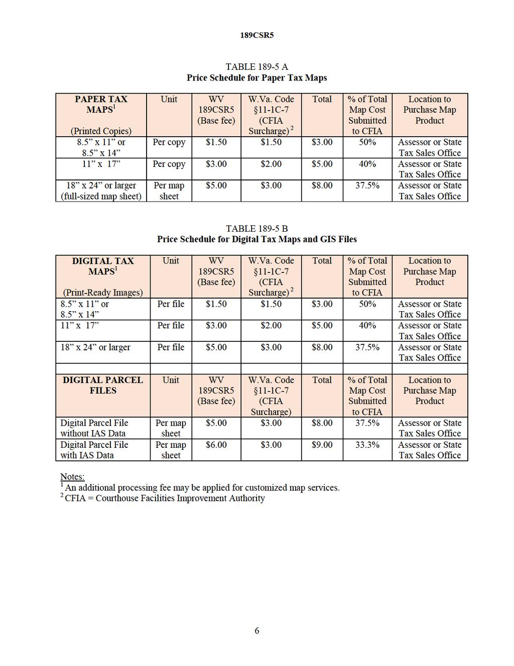
10 189CSR5 charge for tax maps displayed on the Internet that allow the public to view parcel maps remotely and which require no interaction of office staff in the printing and distribution of tax maps. In addition, assessors may permit the public to download their digital Finished Tax Maps via their county website or designated agent at no cost Digital Parcel Web Map Services on the Internet. -- Assessors may authorize agents to allow their parcels to be displayed as web map services which typically allow viewing only of parcels Cooperative Agreements. -- An assessor may choose not to charge tax map sales for other governmental agencies, economic development projects, or for other uses that benefit the public in accordance with non-disclosure agreements set forth in paragraph 7.1.a Price Schedule for Paper or Printed Tax Maps (Table A) Paper Maps 8 1/2" x 11" or 8 1/2 x Reproductions or printed tax maps on 8 1/2" x 11" Letter Size or 8 1/2" x 14" Legal Size paper shall be one dollar and fifty cents ($1.50) per copy Paper Maps 11 x Reproductions or printed tax maps on 11 x 17 Ledger/Tabloid Size paper shall be three dollars ($3.00) per copy Full-Sized Paper Map Sheet. -- A fee of five dollars ($5.00) per sheet shall apply to full-sized (18 x 24 or larger) tax maps These fees will be charged in addition to the Courthouse Facilities Improvement Authority surcharge Price Schedule for Digital Tax Map Files (Table B) Digital Tax Maps. -- Print-ready digital images or electronic files shall be sold for the same fee as paper maps. 5.1.a. Digital Maps 8 1/2" x 11" or 8 1/2 x A portion of a full-sized tax map and designed to be printed to 8 1/2" x 11" Letter Size or 8 1/2" x 14" Legal Size paper shall be one dollar and fifty cents ($1.50) per file. 5.1.b. Digital Maps 11 x A portion of a full-sized tax map and designed to be printed to 11 x 17 Ledger/Tabloid Size shall be three dollars ($3.00) per file. 5.1.c. Full-Sized Digital Maps. -- A fee of five dollars ($5.00) per file shall apply to digital tax maps designed to be printed to 18 x 24 or larger paper Digital Parcel Files. -- If the county assessor wants to sell Digital Parcel Files for a portion of the county or the entire county, then calculate the fee for the buyer based on the total number of tax map sheets at five dollars ($5.00) per map sheet that covers the area of interest. For example, 400 individual map sheets would compute to two-thousand dollars ($2,000) for the sale of digital parcel polygons. 5.2.a. Minimum Attributes. -- At a minimum the digital parcel files will include the District, Map, and Parcel identifiers. 5.2.b. IAS Data. -- County assessors may charge one dollar ($1.00) per map sheet for digital 3
11 189CSR5 parcel mapping files that include attributes from the Integrated Assessment System (IAS) database These fees will be charged in addition to the Courthouse Facilities Improvement Authority surcharge Ordering Procedures, Authority for Sales, and Purchasing Locations Ordering Procedures. -- All requests for tax maps must include the county name, district or corporation name, and map number Authority for Sale of Tax Maps. -- Tax maps may be copied, reproduced, distributed, sold, or lease only by the assessors of the fifty-five (55) counties of the State and by their agents. 6.2.a. Agents. A county assessor may contract an agent to copy, reproduce, distribute, sell, or lease tax maps at the prescribed price. The Property Tax Division of the West Virginia Tax Division of the Department of Revenue is hereby designated as an agent for all counties for the purpose of sale, reproduction and distribution of tax maps. 6.2.a.1. Bonding. -- The counties' agents shall be sufficiently bonded. 6.2.a.2. Property Tax Division. -- The Division may sell paper or digital Finished Tax Maps and Digital Parcel Files to the public. It is not the responsibility of the Property Tax Division to provide tax maps to authorized county agents. The Property Tax Division may withhold an amount for each paper or digital Finished Tax Map or Digital Parcel File, which shall cover the cost of materials, overhead, administration, personnel, sales tax and postage. The amount remaining after the deducting the cost of materials, overhead, administration, personnel, sales tax and postage shall on a semi-annual basis be remitted to the county whose tax map is sold. 6.2.b. Accounting Records. -- The county assessors and their agents shall maintain proper accounting procedures and practices. 6.2.c. Inspection Audit. -- The tax map accounting records of the county assessors or their agents shall be available for inspection at any time. 6.2.d. Deposits. -- Any funds received by the county assessors, or their agents, as a result of such reproductions shall be deposited on a monthly basis to the assessors re-valuation fund Purchasing Locations. -- Tax maps may be purchased at the following locations: 6.3.a. County Assessors. -- Tax maps may be purchased in person at each of the fifty-five (55) county assessor s offices throughout the State located in the courthouse at each of the county seats (town or cities). 6.3.b. West Virginia Tax Division of the Department of Revenue. -- Tax maps may be purchased in person ( Walk-in ) or by prepaid mail orders from West Virginia Tax Division of the Department of Revenue. 6.3.b.1. Mailing Address if Purchased by Mail Order: Tax Division of the Department of Revenue Property Tax Division, Tax Map Sales 4
12 189CSR5 124 Smith St., P. O. Box Charleston, West Virginia b.2. Physical Street Address if Purchased at State Tax Map Sales Office: Tax Division of the Department of Revenue Property Tax Division, Tax Map Sales Albert T. Summers Center 1124 Smith St., P. O. Box 2389 Charleston, WV Phone: (304) Fax: (304) Prohibiting Reproduction of Tax Maps and Prescribing Penalty for Violation 7.1. Reproduction of Tax Maps and Digital Parcel Files Prohibited. -- No person shall reproduce, copy, distribute or sell copies of paper/electronic tax maps or digital parcel files prepared by the counties without having first obtained the permission of the county assessor. 7.1.a. Non-Disclosure Agreements. -- Assessors may use a non-disclosure agreement as a legal contract between at least two parties to outline confidential material or information that the parties wish to share with one another for cadastral purposes, but wish to restrict access to or by third parties Penalties. -- Any person who, without the written permission of the county assessor, reproduces tax maps in any form, in an electronic retrieval system or otherwise, shall be refused permission by the county assessor or assessor's agent to purchase tax maps in the future The requirements and penalties set forth in this section do not apply to the West Virginia Tax Division of the Department of Revenue Map Disclaimer and Scope of Surveying Practice 8.1. Map Disclaimer. -- The following map disclaimer shall accompany all tax maps and digital parcel files sold: This product was developed for taxation purposes and is therefore not suitable for legal, engineering, or surveying purposes. Users of this information should review or consult the primary data and information sources to ascertain the appropriate usage of the information Scope of Surveying Practice. -- Tax maps and digital parcel files (GIS files) are not to be included as activities within the practice of surveying in accordance with the "Inclusions and Exclusions of Surveying Practice" cited in W.Va. Code 30-13A-10. 5
13
Revised Tax Map Rules
 Revised Tax Map Rules PVC Subcommittee Committee Report October 3, 2013 Prepared by: Kurt Donaldson Manager WV GIS Technical Center West Virginia University Phone: (304) 293-9467 kdonalds@wvu.edu Contents
1. A portion of the cost to the public body for obtaining the original or copies of the documents, printouts or photographs.
 39-121.03. Request for copies, printouts or photographs; statement of purpose; commercial purpose as abuse of public record; determination by governor; civil penalty; definition A. When a person requests
Will County GIS Product Distribution Policy January, 2008
 Will County GIS Product Distribution Policy January, 2008 Background: The goal of this policy is to provide GIS products to users in a reasonable manner and to ensure that products released are of sufficient
Cadastral Framework Standards
 Cadastral Framework Standards The goal of the Data Standards and Recommendations Committee is to provide recommendations and guidelines to Indiana GIS user communities to facilitate the collection, maintenance
Assessor. Mission Statement: Functions: Long Term Goals: Page 1 of 6
 Assessor Mission Statement: The mission of the Assessor s Office is to create accurate, equitable, and timely property tax assessments to fund public services; and to be a source of current, accurate property
Request for Proposals For Village Assessment Services
 Request for Proposals For Village Assessment Services INQUIRIES AND PROPOSALS SHOULD BE DIRECTED TO: Jesse Thyes Village Administrator 860 Badger Circle Grafton, WI 53024 Introduction The Village of Grafton
New Models for Property Data Verification and Valuation
 New Models for Property Data Verification and Valuation for 2006 IAAO Councils and Sections Joint Seminar May 9-11, 2006 Charleston, South Carolina Presented by George Donatello, CMS Principal Consultant
A CADASTRAL GEODATA BASE FOR LAND ADMINISTRATION USING ARCGIS CADASTRAL FABRIC MODEL A CASE STUDY OF UWANI ENUGU, ENUGU STATE, NIGERIA
 A CADASTRAL GEODATA BASE FOR LAND ADMINISTRATION USING ARCGIS CADASTRAL FABRIC MODEL A CASE STUDY OF UWANI ENUGU, ENUGU STATE, NIGERIA BY Ndukwu, Raphael. Ike Department of Geoinformatics & Surveying University
Standard on Professional Development
 Standard on Professional Development Approved January 2013 International Association of Assessing Officers This standard replaces the December 2000 Standard on Professional Development. IAAO assessment
Directorate of Survey and Mapping NAMIBIA. Cadastral Information System. Vehupisa Kasuko Tjatindi Surveyor Directorate of Survey and Mapping NAMIBIA
 Vehupisa Kasuko Tjatindi Directorate of Survey and Mapping NAMIBIA Tel: +64 61 965000 Directorate of Survey and Mapping NAMIBIA Cadastral Information System Introduction Over the past few decades cadastral
2018 Assessment Roll Edit Guide for Parcel-Level Geographical Information System (GIS) Information
 Information") 2018 Assessment Roll Edit Guide for Parcel-Level Geographical Information System (GIS) Information Florida Department of Revenue Property Tax Oversight January 2, 2018 Intended Users This edit guide is
2018 Assessment Roll Edit Guide for Parcel-Level Geographical Information System (GIS) Information Florida Department of Revenue Property Tax Oversight January 2, 2018 Intended Users This edit guide is
DATA DISTRIBUTION FACILITY (DDF ) POLICY AND RULES
 POLICY AND RULES") DATA DISTRIBUTION FACILITY (DDF ) POLICY AND RULES DATA DISTRIBUTION FACILITY (DDF ) POLICY Data Distribution Facility (DDF ) Overview CREA has created a Data Distribution Facility (DDF ) to enable CREA
DATA DISTRIBUTION FACILITY (DDF ) POLICY AND RULES DATA DISTRIBUTION FACILITY (DDF ) POLICY Data Distribution Facility (DDF ) Overview CREA has created a Data Distribution Facility (DDF ) to enable CREA
Cadastral services and virtual office in e-cadastre
 Cadastral services and virtual office in e-cadastre Priit Kuus Estonian Land Board October 26, 2016 Coimbra Scope of data Cadastral parcels (as of September 2016) 674 383 cadastral parcels, i.e. 97,7 %
ENVIRONMENT CANTERBURY S WEB-BASED CONTAMINATED LAND INFORMATION TRANSFER SYSTEM
 ENVIRONMENT CANTERBURY S WEB-BASED CONTAMINATED LAND INFORMATION TRANSFER SYSTEM Davina McNickel 1, Helen Davies 2, Vincent Salomon 2 1 Environment Canterbury, PO Box 345, Christchurch. Telephone: 03 365
The URBAN DEFENCE Web Site is comprised of various Web pages operated by URBAN DEFENCE.
 Condizioni AGREEMENT BETWEEN USER AND URBAN DEFENCE The URBAN DEFENCE Web Site is comprised of various Web pages operated by URBAN DEFENCE. The URBAN DEFENCE Web Site is offered to you condituioned on
MnDOT Contract No Exhibit B. Scope of Work. Scope of Work
 MnDOT Contract No. 1032993 Contract General Description The purpose of this contract is to provide the State with the survey accurate re-establishment of designated Public Land Survey section boundaries
City of Surrey s Digital Plan Submission Process
 City of Surrey s Digital Plan Submission Process Cadastral Update Karen Stewart, B.Tech. (GIS) Spatial Information Manager Peter Mueller, B.C.L.S., C.L.S. Survey Manager City of Surrey, British Columbia,
Demonstrate knowledge of, and extract, cadastral data from Landonline
 Page 1 of 5 Demonstrate knowledge of, and extract, cadastral data from Landonline Level 3 Credits 5 Purpose This unit standard is for people who are working in the surveying industry in jobs which involve
WYOMING DEPARTMENT OF REVENUE CHAPTER 13 PROPERTY TAX APPRAISER EDUCATION AND CERTIFICATION
 CHAPTER 13 PROPERTY TAX APPRAISER EDUCATION AND CERTIFICATION Section 1. Authority. These rules are promulgated by the Wyoming Department of Revenue under authority of W.S. 18-3-201, W.S. 18-3-204, and
GIS and Land Records Integration A PRIA White Paper
 110 Horizon Drive, Suite 210, Raleigh, NC 27615 919.459.2081 GIS and Land Records Integration A PRIA White Paper Adopted by the PRIA Board on December 20, 2017 www.pria.us/ GIS and Land Records Integration
PROPERTY ASSESSMENT KNOWLEDGE
 A P E N DE UM NOUN A COLLECTION OF CONCISE BUT DETAILED INFORMATION ABOUT APPRAISAL AND APPRAISAL MANAGEMENT, ESPECIALLY IN THE PROPERTY ASSESSMENT INDUSTRY. PROPERTY ASSESSMENT KNOWLEDGE KNOWLEDGE AREAS
Presented by: Stewart Information International, Inc. Jack McKenna
 Presented by: Stewart Information International, Inc. Jack McKenna Held at the: 2007 ESRI Survey & Engineering GIS Summit San Diego Convention Center San Diego, California June 16-19, 2007 Integrating
ERER Pilot Measurements County & Trusted Submitter
 ERER Pilot Measurements County & Trusted Submitter ERER Task Force Consideration 1. Cost / Benefit - Consider studying existing system configurations, hardware types, outsourcing practices, and vendor
NEW DEVELOPMENTS IN THE REAL PROPERTY REGISTER AND CADASTRE IN LITHUANIA
 NEW DEVELOPMENTS IN THE REAL PROPERTY REGISTER AND CADASTRE IN LITHUANIA Jaunius Grigas E-mail: jaunius.grigas@registrucentras.lt Verona, 2008 FUNCTIONS OF STATE ENTERPRISE CENTRE OF REGISTERS Registration
Intangible Assets Web Site Costs
 SIC Interpretation 32 Intangible Assets Web Site Costs In March 2002 the International Accounting Standards Board issued SIC-32 Intangible Assets Web Site Costs, which had originally been developed by
Cadastral and Right of Way Data Sharing
 Cadastral and Right of Way Data Sharing May 2010 TRS 1006 This Transportation Research Synthesis (TRS) provides summaries of recent research and implementation efforts on a topic of current interest. Online
78th OREGON LEGISLATIVE ASSEMBLY Regular Session. Enrolled. Senate Bill 297
 78th OREGON LEGISLATIVE ASSEMBLY--2015 Regular Session Enrolled Senate Bill 297 Printed pursuant to Senate Interim Rule 213.28 by order of the President of the Senate in conformance with presession filing
CITY OF JACKSONVILLE, FLORIDA
 PROPERTY APPRAISER DEPARTMENT VISION: To earn the public s trust. DEPARTMENT MISSION: We will: Produce a fair, equitable and accurate tax roll as required by law. Focus on our customers the taxpayers.
Intangible Assets Web Site Costs
 HK(SIC)-Int 32 Revised May 2014 September 2018 Effective for annual periods beginning on or after 1 January 2005 Hong Kong (SIC) Interpretation 32 Intangible Assets Web Site Costs COPYRIGHT Copyright 2018
Senate Bill 297 Ordered by the Senate March 2 Including Senate Amendments dated March 2
 th OREGON LEGISLATIVE ASSEMBLY-- Regular Session A-Engrossed Senate Bill Ordered by the Senate March Including Senate Amendments dated March Printed pursuant to Senate Interim Rule. by order of the President
ASSESSMENT COORDINATION DEPARTMENT STATE OF ARKANSAS RULES AND REGULATIONS
 ASSESSMENT COORDINATION DEPARTMENT STATE OF ARKANSAS RULES AND REGULATIONS Effective November 13, 2005 Chapter 1: General Provisions 1 1.01 Statutory Authority Creating Assessment Coordination Department
Request for Proposals (RFP) Assessment Services
 Assessment Services") 156 East First Street New Richmond, WI 54017 Ph 715-246-4268 Fax 715-246-7129 www.newrichmondwi.gov Request for Proposals (RFP) Assessment Services SUMMARY The City of New Richmond is seeking proposals
156 East First Street New Richmond, WI 54017 Ph 715-246-4268 Fax 715-246-7129 www.newrichmondwi.gov Request for Proposals (RFP) Assessment Services SUMMARY The City of New Richmond is seeking proposals
South Carolina General Assembly 119th Session,
 South Carolina General Assembly 1th Session, - S. STATUS INFORMATION General Bill Sponsors: Senator Jackson Document Path: l:\s-res\dj\00home.kmm.dj.docx Introduced in the Senate on January, Currently
CONSOLIDATION INCENTIVE AID
 CONSOLIDATION INCENTIVE AID Objective: State assistance funds for NYS cities or towns or constituent municipalities of a consolidated assessing unit for efficiencies in Real Property Tax Administration.
LEASING OF POTASSIUM, SULPHUR, SODIUM, PHOSPHORUS, AND SIMILAR MINERALS, AND THEIR SALTS AND COMPOUNDS EXCEPT SODIUM CHLORIDE
 TITLE 19 CHAPTER 2 PART 3 NATURAL RESOURCES AND WILDLIFE STATE TRUST LANDS LEASING OF POTASSIUM, SULPHUR, SODIUM, PHOSPHORUS, AND SIMILAR MINERALS, AND THEIR SALTS AND COMPOUNDS EXCEPT SODIUM CHLORIDE
ACCESS AGREEMENT FOR BROKER RECIPROCITY DATA FEED RECITALS DEFINITIONS
 ACCESS AGREEMENT FOR BROKER RECIPROCITY DATA FEED 1. This AGREEMENT is made and entered into by and among Multiple Listing Service of Long Island, Inc. ( MLSLI ), and the real estate firm and the MLSLI
CFPB Implementation of Parcels Provision in HMDA Under Dodd-Frank
 CFPB Implementation of Parcels Provision in HMDA Under Dodd-Frank Land ownership is the foundation of the financial, legal, and real estate systems in our society Parcel Data vs. Census Data + Census data
GOVERNMENT. Case Study Ville de Trois Rivières streamlines property assessment
 GOVERNMENT Case Study Ville de Trois Rivières streamlines property assessment GIS-generated parcel basemap provides powerful visualization & analysis capabilities With a population of just over 130,000,
ASSESSOR'S OFFICE I. DEPARTMENT MISSION OR MANDATE OR GOAL
 ASSESSOR'S OFFICE I. DEPARTMENT MISSION OR MANDATE OR GOAL The purpose of the Assessor's Office is to produce a timely roll of all property subject to local assessment; administer legally permissible exemptions;
Property Tax Fairness and the Future of Further Reform
 Property Tax Fairness and the Future of Further Reform Ryan Kamrowski, Director of Tax Equalization, Ward County Senator Dwight Cook, Mandan (Dist. 34) Donnell Preskey Hushka, Government Affairs Specialist,
MOUNTAIN LAKES BOARD OF REALTORS PO BOX 818 * MURPHY, NC (828) * (828)
 * (828)") MOUNTAIN LAKES BOARD OF REALTORS PO BOX 818 * MURPHY, NC 28906 (828) 837-5297 * (828) 837-1852 RULES AND REGULATIONS FOR MOUNTAIN LAKES BOARD OF REALTORS MULTIPLE LISTING SERVICE INTERNET DATA EXCHANGE
MOUNTAIN LAKES BOARD OF REALTORS PO BOX 818 * MURPHY, NC 28906 (828) 837-5297 * (828) 837-1852 RULES AND REGULATIONS FOR MOUNTAIN LAKES BOARD OF REALTORS MULTIPLE LISTING SERVICE INTERNET DATA EXCHANGE
Internet Data Exchange (IDX)
") Internet Data Exchange (IDX) Section 18 IDX Defined IDX affords MLS participants ability to authorize limited electronic display and delivery of their listings by other participants via the following authorized
Internet Data Exchange (IDX) Section 18 IDX Defined IDX affords MLS participants ability to authorize limited electronic display and delivery of their listings by other participants via the following authorized
PINELLAS COUNTY, FLORIDA FINAL SURFACE WATER RATE RESOLUTION
 PINELLAS COUNTY, FLORIDA FINAL SURFACE WATER RATE RESOLUTION ADOPTED SEPTEMBER 10, 2013 TABLE OF CONTENTS Page SECTION 1. AUTHORITY.... 2 SECTION 2. DEFINITIONS.... 3 SECTION 3. CONFIRMATION OF INITIAL
SUBSCRIBER AGREEMENT. 1.1 MLSOK is a multiple listing service company as it is defined in its Rules and Regulations.
 SUBSCRIBER AGREEMENT This Subscriber Agreement (the Agreement ) is made and entered into and is effective as of the date the last party executes this Agreement, is between MLSOK, Inc. ( MLSOK ), an Oklahoma
Amendments/Revisions to MLS Rules & Regulations Effective July 1, 2018
 Amendments/Revisions to MLS Rules & Regulations Effective Section 1.12 JURISDICTIONSERVICE AREA: Underline= insertion/strikethrough=deletion JURISDICTIONSERVICE AREA: The jurisdiction service area of the
Massive Collection of Cadastral Data in Greece Using Web-enabled GIS Technologies
 Massive Collection of Cadastral Data in Greece Using Web-enabled GIS Technologies Lefteris LYKOUROPOULOS and George MOURAFETIS, Greece Key words: Cadastre, Web services, applications, GIS, data collection
LISTING OF RESIDENTIAL VACANT LAND EXCLUSIVE RIGHT AND AUTHORITY TO SELL CONTRACT
 LISTING OF RESIDENTIAL VACANT LAND EXCLUSIVE RIGHT AND AUTHORITY TO SELL CONTRACT 1 2 3 4 5 6 7 8 9 10 11 12 13 14 15 16 17 18 19 20 21 22 23 24 25 26 27 28 29 30 31 32 33 34 THIS LISTING OF RESIDENTIAL
The Duties of the Iowa Assessor (ISAC New County Officers School)
") The Duties of the Iowa Assessor (ISAC New County Officers School) Wayne Schwickerath Story County Assessor January 19, 2017 Purpose of Presentation (Iowa Code Chapter 441) Assessment & Valuation of Property)
The Duties of the Iowa Assessor (ISAC New County Officers School) Wayne Schwickerath Story County Assessor January 19, 2017 Purpose of Presentation (Iowa Code Chapter 441) Assessment & Valuation of Property)
MOD-IV database tables available for New Jersey counties
 MOD-IV database tables available for New Jersey counties MOD-IV "Tax List Search Plus" database tables are available from the NJ Information Warehouse. They are downloadable in Personal Geodatabase 10.0
PART 2.7 DEPARTMENT OF GOVERNMENT SERVICES REAL ESTATE REGULATION
 PART 2.7 DEPARTMENT OF GOVERNMENT SERVICES REAL ESTATE REGULATION Executive Summary The Financial Services Regulation Division (the Division) within the Consumer and Commercial Affairs Branch of the Department
How to Petition for a Review of Your Property Taxes: County Board of Equalization
 How to Petition for a Review of Your Property Taxes: County Board of Equalization Talk with the Assessor There are several reasons why you may want to petition for a review of your property taxes. Whatever
HICENTRAL MLS, LTD. IDX USER AGREEMENT
 HICENTRAL MLS, LTD. IDX USER AGREEMENT Note: This form is a legally binding contract between you and HiCentral MLS, Ltd. This form/contract must be filled out completely and signed by the MLS Participant
Estonian e-cadastre as basis for efficient land management
 Estonian e-cadastre as basis for efficient land management Priit Kuus Estonian Land Board November 14, 2017 Tallinn Scope of data Cadastral parcels (as of October 2017) 693 026 cadastral parcels, i.e.
II. Policies Applicable to Principal Broker Subscribers VOWs.
 MRIS Policy governing use of MRIS Listing Content in connection with Internet brokerage services offered by MRIS Subscribers operating a VOW (Virtual Office Website) I. Definitions and Scope of Policy.
Longleaf Pine REALTORS, Inc. RETS FEED or VOW FEED Order Form
 Longleaf Pine REALTORS, Inc. RETS FEED or VOW FEED Order Form Please Give Us A Call At 910-323-1421 Should You Have Any Questions Or Need Further Assistance. Your Information - All Fields Are Required
ACCOUNTING STANDARDS BOARD INTERPRETATION OF THE STANDARDS OF GENERALLY RECOGNISED ACCOUNTING PRACTICE
 ACCOUNTING STANDARDS BOARD INTERPRETATION OF THE STANDARDS OF GENERALLY RECOGNISED ACCOUNTING PRACTICE INTANGIBLE ASSETS WEBSITE COSTS (IGRAP 16) Issued by the Accounting Standards Board March 2012 Acknowledgment
PUBLIC NOTICE. PROPOSED ORDINANCE No. PREDICTABLE FEE SCHEDULE FOR RECORDING STANDARD DOCUMENTS
 PUBLIC NOTICE PROPOSED ORDINANCE No. PREDICTABLE FEE SCHEDULE FOR RECORDING STANDARD DOCUMENTS WHEREAS, the Illinois General Assembly has enacted Public Act 100-0271, effective August 22, 2017, which requires
CTAS e-li. Published on e-li (https://ctas-eli.ctas.tennessee.edu) April 07, 2018 Recording, Filing and Indexing
 April 07, 2018 Recording, Filing and Indexing") Published on e-li (https://ctas-eli.ctas.tennessee.edu) April 07, 2018 Recording, Filing and Indexing Dear Reader: The following document was created from the CTAS electronic library known as e-li. This
Published on e-li (https://ctas-eli.ctas.tennessee.edu) April 07, 2018 Recording, Filing and Indexing Dear Reader: The following document was created from the CTAS electronic library known as e-li. This
ORDINANCE NO AN ORDINANCE ESTABLISHING A UNIFORM SYSTEM FOR STREET ADDRESSING IN EMERY COUNTY
 ORDINANCE NO. 21505 AN ORDINANCE ESTABLISHING A UNIFORM SYSTEM FOR STREET ADDRESSING IN EMERY COUNTY The County Commission of the County of Emery, State of Utah, being the Legislative Body of said county,
Current State of Property. Taxation in the Netherlands. Council for Real Estate Assessment (English) Waarderingskamer (Dutch)
 Waarderingskamer (Dutch)") Current State of Property WAARDERINGSKAMER Taxation in the Netherlands Council for Real Estate Assessment (English) Waarderingskamer (Dutch) Council for real estate assessment Main task: quality control
Current State of Property WAARDERINGSKAMER Taxation in the Netherlands Council for Real Estate Assessment (English) Waarderingskamer (Dutch) Council for real estate assessment Main task: quality control
LEON COUNTY TAX COLLECTOR
 LEON COUNTY TAX COLLECTOR TAX ADMINISTRATION 1276 Metropolitan Blvd., Suite 401 Tallahassee, Florida 32312 (850) 606-4723 May 21, 2014 INVITATION TO NEGOTIATE REQUEST FOR SEALED BIDS ITEM: Leon County
State Department of Assessments and Taxation
 Audit Report State Department of Assessments and Taxation December 2013 OFFICE OF LEGISLATIVE AUDITS DEPARTMENT OF LEGISLATIVE SERVICES MARYLAND GENERAL ASSEMBLY This report and any related follow-up correspondence
User Manual. Section 2: Implementation and Industry Translations. Created: October Copyright PropertyBoss Solutions, LLC. All Rights Reserved.
 User Manual Section 2: Implementation and Industry Translations Created: October 2010 Copyright PropertyBoss Solutions, LLC. All Rights Reserved. PropertyBoss Manual Section 2 - Implementation and Industry
GeoWarehouse Land Registry. Teranet Enterprises Inc.
 GeoWarehouse Land Registry Teranet Enterprises Inc. TABLE OF CONTENTS Neighoubourhood Sales... 1 Overview... 1 Find Neighbourhood Sales... 1 Neighbourhood Sales and Map... 6 Map Neighbourhood Sales...
NEBRASKA INVESTMENT FINANCE AUTHORITY LOW INCOME HOUSING TAX CREDIT PROGRAM COST CERTIFICATION PROCEDURES MANUAL
 NEBRASKA INVESTMENT FINANCE AUTHORITY LOW INCOME HOUSING TAX CREDIT PROGRAM COST CERTIFICATION PROCEDURES MANUAL Nebraska Investment Finance Authority ( NIFA ) Low Income Housing Tax Credit ( LIHTC ) Cost
TREASURER S DEPARTMENT
 TREASURER S DEPARTMENT ORGANIZATIONAL CHART COUNTY TREASURER ADMINISTRATION SERVICE TO PUBLIC SERVICE TO COUNTY DEPARTMENTS SERVICE TO COUNTY GOV T DEPARTMENT DESCRIPTION The Treasurer s Office is a mandated
PURSUANT TO AB 1484 AND AS DESCRIBED IN SECTION TO THE CALIFORNIA HEALTH AND SAFETY CODE
 CITY OF SAN JOSE INDEPENDENT ACCOUNTANTS' REPORT ON APPLYING AGREED-UPON PROCEDURES ON THE LOW AND MODERATE INCOME HOUSING FUND OF THE FORMER REDEVELOPMENT AGENCY OF THE CITY OF SAN JOSE, CALIFORNIA PURSUANT
NC General Statutes - Chapter 161 Article 1 1
 Chapter 161. Register of Deeds. Article 1. The Office. 161-1. Election and term of office. In each county there shall be elected biennially by the qualified voters thereof, as provided for the election
HICENTRAL MLS, LTD. IDX USER AGREEMENT
 HICENTRAL MLS, LTD. IDX USER AGREEMENT Note: This form is a legally binding contract between you and HiCentral MLS, Ltd. This form/contract must be filled out completely and signed by the MLS Participant
IDX Paperwork Cover Sheet
 IDX Paperwork Cover Sheet IMPORTANT This cover sheet MUST be filled out and returned via Email or Fax with your IDX paperwork. If this cover sheet is not included your IDX may not be approved and set-up
Real Estate Recording Legislation Includes URPERA
 For further information please contact: Real Estate Recording Legislation Includes URPERA Paul Hodnefield Associate General Counsel Phone: (651) 494-1730 Toll Free: (800) 927-9801, Ext 61730 Email: paul.hodnefield@cscglobal.com
The enclosed packet contains information regarding the 2016 tax sale and our tax sale procedures.
 To: Re: Prospective Tax Sale Certificate Purchasers 2016 Hardin County Tax Sale The enclosed packet contains information regarding the 2016 tax sale and our tax sale procedures. The 2016 tax sale will
ASSESSMENT METHODOLOGY
 2018 ASSESSMENT METHODOLOGY COST APPROACH A summary of the methods used by the City of Edmonton in determining the value of residential and non-residential properties valued using the cost approach in
Spatial Data Warehouse Ltd. Cadastral Mapping INITIATIVE 1: CADASTRAL MAPPING. Version Spatial Data Warehouse Ltd. & AltaLIS Ltd.
 Spatial Data Warehouse Ltd. Initiative 1: Cadastral Mapping INITIATIVE 1: CADASTRAL MAPPING 29 P3 The SDW/AltaLIS Model Background The Government of Alberta started a mapping program, the Municipal Integrated
Chapter 11: Conservation Easements
 Chapter 11: Conservation Easements An * in the left margin indicates a change in the statute, rule, or text since the last publication of the manual. I. Introduction In 2008, Colorado s appraiser statutes
STATE TAX DEPARTMENT PROPERTY TAX DIVISION TAX YEAR 2005 COUNTY MONITORING PLAN
 STATE TAX DEPARTMENT PROPERTY TAX DIVISION TAX YEAR 2005 COUNTY MONITORING PLAN WEST VIRGINIA DEPARTMENT OF TAX AND REVENUE TAX YEAR 2005 COUNTY MONITORING PLAN I. All assessors will be mailed a copy of
VIRGINIA ASSOCIATION OF REALTORS EXCLUSIVE AUTHORIZATION TO SELL
 VIRGINIA ASSOCIATION OF REALTORS EXCLUSIVE AUTHORIZATION TO SELL OWNER AUTHORIZATION REGARDING INTERNET Internet advertising is one of the ways information concerning real property offered for sale is
IC Chapter 15. Public Safety Communications Systems and Computer Facilities Districts
 IC 36-8-15 Chapter 15. Public Safety Communications Systems and Computer Facilities Districts IC 36-8-15-1 Application of chapter Sec. 1. This chapter applies to the following counties: (1) A county having
Internal Audit Report
 Internal Audit Report TxDOT Internal Audit Division Objective To determine if objectives are being met and are in compliance with current regulations. Opinion Based on the audit scope areas reviewed, control
CITY OF VERONA. Request for Proposals (RFP) Assessment Services For the Assessment Years
 Assessment Services For the Assessment Years") CITY OF VERONA Request for Proposals (RFP) Assessment Services For the Assessment Years 2019-2022 Due Date: December 28, 2018 by 4:30 p.m. Table of Contents DOCUMENT PAGE Background Information... 2 Specific
CITY OF VERONA Request for Proposals (RFP) Assessment Services For the Assessment Years 2019-2022 Due Date: December 28, 2018 by 4:30 p.m. Table of Contents DOCUMENT PAGE Background Information... 2 Specific
Egyptian Nationwide Title Cadastre System
 Kholoud SAAD, Egypt Key words: Cadastre, Registration, Urban, Rural, National Cadastre, Automation, reengineering. SUMMARY With growing need for integrated information, Enterprise Solutions has become
 Apostolos Arvanitis, Associate Professor Asterios Asteriadis, Rural - Surveying Engineer Thomai Sotireli, Rural - Surveying Engineer Aristotle University School of Rular and Surveying Engineering Department
The Development of the Austrian Cadastre from Documentation to an Integrated Planning and Decision Support System
 The Development of the Austrian Cadastre from Documentation to an Integrated Planning and Decision Support System WPLA - Working Party on Land Administration 15-17 October 2014, Vienna, Austria Wernher
Unclaimed Property I. Coverage II. Requirements
 Unclaimed Property The Uniform Disposition of Unclaimed Property Act was created as a consumer protection law in order to safeguard the owner s property and provide a means for reuniting the owner with
A Vision for a Fully Digital Cadastral Survey System
 A Vision for a Fully Digital Cadastral Survey System Anselm HAANEN, Trent GULLIVER, New Zealand Key words: cadastral survey system, digital cadastre, survey plans SUMMARY Surveyors have traditionally prepared
IDX Paperwork Cover Sheet
 IDX Paperwork Cover Sheet IMPORTANT This cover sheet MUST be filled out and returned via Email or Fax with your IDX paperwork. If this cover sheet is not included your IDX may not be approved and set-up
Functional system for cadastral plans
 , Republic of Macedonia Key words: Cadastre, Digital plans, Data, System SUMMARY The analysis shows that the real estate market in Republic of Macedonia grows daily. With the expansion of this market increases
DALLAS CENTRAL APPRAISAL DISTRICT DCAD VALUATION PROCESSES
 DALLAS CENTRAL APPRAISAL DISTRICT DCAD VALUATION PROCESSES DALLAS CENTRAL APPRAISAL DISTRICT DCAD DCAD appraisers appraise a large universe of properties by developing appraisal models DCAD appraisers
VOBILE AGREEMENT. Page 1 of 5
 VOBILE AGREEMENT This AGREEMENT is between Vobile, Inc., its successors and assigns ( Vobile, we or us ), and ( Retailer or you ). All pre-recorded video programming, whether or not available from Vobile
ADDENDUM #2_RFP # Computer Mass Appraisal (CAMA) Software for HC Assessor Department
 Software for HC Assessor Department") Horry County Government PROCUREMENT DEPARTMENT www.horrycounty.org Horry County Office of Procurement 3230 Hwy. 319 E. Conway, South Carolina 29526 Phone 843.915.5380 Fax 843.365.9861 TO: FROM: ALL INTERESTED
Horry County Government PROCUREMENT DEPARTMENT www.horrycounty.org Horry County Office of Procurement 3230 Hwy. 319 E. Conway, South Carolina 29526 Phone 843.915.5380 Fax 843.365.9861 TO: FROM: ALL INTERESTED
EXCLUSIVE AUTHORIZATION AND RIGHT TO SELL, EXCHANGE OR LEASE BROKERAGE LISTING AGREEMENT (ER)
") 1 2 3 4 5 6 7 8 9 10 11 12 13 14 15 16 17 18 19 20 21 22 23 24 25 26 27 28 29 30 31 32 33 34 35 36 37 38 39 40 41 42 EXCLUSIVE AUTHORIZATION AND RIGHT TO SELL, EXCHANGE OR LEASE BROKERAGE LISTING AGREEMENT
1 2 3 4 5 6 7 8 9 10 11 12 13 14 15 16 17 18 19 20 21 22 23 24 25 26 27 28 29 30 31 32 33 34 35 36 37 38 39 40 41 42 EXCLUSIVE AUTHORIZATION AND RIGHT TO SELL, EXCHANGE OR LEASE BROKERAGE LISTING AGREEMENT
002 - Assessor GENERAL GOVERNMENT SERVICES ASSESSOR Assessor. At a Glance:
 GENERAL GOVERNMENT SERVICES 002 - ASSESSOR Operational Summary Mission: To serve the citizens of Orange County by valuing all legally assessable property with uniformity and impartiality, producing property
WYOMING DEPARTMENT OF REVENUE CHAPTER 7 PROPERTY TAX VALUATION METHODOLOGY AND ASSESSMENT (DEPARTMENT ASSESSMENTS)
") CHAPTER 7 PROPERTY TAX VALUATION METHODOLOGY AND ASSESSMENT (DEPARTMENT ASSESSMENTS) Section 1. Authority. These Rules are promulgated under the authority of W.S. 39-11-102(b). Section 2. Purpose of Rules.
CHAPTER 7 PROPERTY TAX VALUATION METHODOLOGY AND ASSESSMENT (DEPARTMENT ASSESSMENTS) Section 1. Authority. These Rules are promulgated under the authority of W.S. 39-11-102(b). Section 2. Purpose of Rules.
Real Estate Transaction Method And System
 ( 1 of 1 ) United States Patent Application 20060282378 Kind Code A1 Gotfried; Bradley L. December 14, 2006 Real Estate Transaction Method And System Abstract A method and system for brokering real estate
PROJECT INFORMATION DOCUMENT (PID) CONCEPT STAGE Report No.: AB3229 Project Name. Land Registry and Cadastre Modernization Project Region
 CONCEPT STAGE Report No.: AB3229 Project Name. Land Registry and Cadastre Modernization Project Region") PROJECT INFORMATION DOCUMENT (PID) CONCEPT STAGE Report No.: AB3229 Project Name Land Registry and Cadastre Modernization Project Region EUROPE AND CENTRAL ASIA Sector Central government administration
PROJECT INFORMATION DOCUMENT (PID) CONCEPT STAGE Report No.: AB3229 Project Name Land Registry and Cadastre Modernization Project Region EUROPE AND CENTRAL ASIA Sector Central government administration
IDX Paperwork Cover Sheet
 IDX Paperwork Cover Sheet IMPORTANT This cover sheet MUST be filled out and returned via Email or Fax with your IDX paperwork. If this cover sheet is not included your IDX may not be approved and set-up
Filing a property assessment complaint and preparing for your hearing. Alberta Municipal Affairs
 Filing a property assessment complaint and preparing for your hearing Alberta Municipal Affairs Alberta s Municipal Government Act, the 2018 Matters Relating to Assessment Complaints Regulation, and the
CPPDSM4003A Appraise property
 CPPDSM4003A Appraise property Unit descriptor Employability skills Prerequisite units Application of the unit Competency field Unit sector This unit of competency specifies the outcomes required to appraise
General Terms and Conditions
 General Terms and Conditions 1 Scope 1.1 The following license terms shall apply to all deliveries by XTENTO GmbH & Co. KG, Erlanger Str. 66a, 91096 Möhrendorf, Germany ( Seller ) to Buyer for the supply
Systematic Land Information Management (SLIM)
") Systematic Land Information Management (SLIM) By Mr. Jukka Nieminen Jaakko Pöyry Infra Soil and Water Ltd. Expert Group Meeting on Secure Land Tenure: New Legal Frameworks and Tools Nairobi 12 November
Systematic Land Information Management (SLIM) By Mr. Jukka Nieminen Jaakko Pöyry Infra Soil and Water Ltd. Expert Group Meeting on Secure Land Tenure: New Legal Frameworks and Tools Nairobi 12 November