CITY PLANNING COMMISSION AGENDA ITEM NOS: 15,16,17,18,19 STAFF: PATRICIA PARISH
|
|
|
- Dorcas Nash
- 6 years ago
- Views:
Transcription
1 Page 185 CITY PLANNING COMMISSION AGENDA ITEM NOS: 15,16,17,18,19 STAFF: PATRICIA PARISH FILE NOS: CPC A LEGISLATIVE CPC ZC LEGISLATIVE CPC ZC LEGISLATIVE CPC CP QUASI-JUDICIAL CPC PP QUASI-JUDICIAL PROJECT: APPLICANT: OWNERS: NORTHGATE ESTATES ANNEXATION BRIAN BAHR, CHALLENGER HOMES, INC. SANDRA HOLLIS, CHARLOTTE GARRETT, KARLHEINZ SCHOENBERGER, LORI SCHOENBERGER AND BAHR HOLDINGS, LLC. PROJECT DESCRIPTION: This is a request for an annexation, establishing zone district Single-Family Residential with condition of record (R1-6000/cr) for approximately acres, establishing zone district Office Complex with condition of record (OC/cr) for approximately 3.38 acres, a Concept Plan and a Preliminary Plat for property located north of North Gate Boulevard, one-half mile east of Voyager Parkway (FIGURE 1). STAFF'S RECOMMENDATION: ITEM NO.:15 CPC A ANNEXATION Approve the Northgate Estates annexation (FIGURE 2) because it is in compliance with the Annexation Plan, the Comprehensive Plan and Subdivision Code criteria. ITEM NO.: 16 CPC ZC ZONE CHANGE Approve the establishment of the R1-6000/cr (Single Family Residential with condition of record) zone (FIGURE 3) based upon the findings that the Change of Zoning request complies with the three (3) criteria for granting of zone changes as set forth in Chapter 7, Article 5, Section 603.B. in the City Zoning Code with one condition of record: No final plat shall be approved prior to a second access being obtained by the applicant and dedicated to the City of Colorado Springs for purposes of public right-of-way. ITEM NO: 17 CPC ZC ZONE CHANGE Approve the establishment of the OC/cr (Office Complex with condition of record) zone (FIGURE 4) based upon the findings that the Change of Zoning request complies with the three (3) criteria for granting of zone changes as set forth in Chapter 7, Article 5, Section 603.B. in the City Zoning Code with one condition of record: No final plat shall be approved prior to a second access being obtained by the applicant and dedicated to the City of Colorado Springs for purposes of public right-of-way.
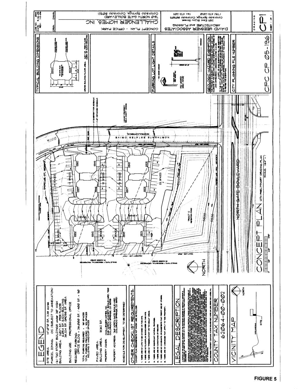
2 Page 186 ITEM NO: 18 CPC CP CONCEPT PLAN Approve Northgate Estates Concept Plan (Refer to Figure 5) for the office park, based upon the findings that the Concept Plan meets the review criteria for concept plans as set forth in Chapter 7, Article 5, Section 501.C. of the City Zoning Code. This recommendation for approval is subject to compliance with changes to the Northgate Estates Concept Plan as set forth in the Technical and Informational Modifications to the Concept Plan portion (page 192) of the CPC agenda. ITEM NO: 19 CPC PP PRELIMINARY PLAT Approve the Preliminary Plat for Northgate Estates (Refer to Figure 6), based upon the finding that the preliminary plat complies with the purpose and intent of the Subdivision Regulations as set forth in Chapter 7, Article 7, Section 102.A-F. of the City Zoning Code. This recommendation for approval is subject to compliance with the changes to Preliminary Plat for Northgate Estates as set forth in the Technical and Informational Modifications to the Preliminary Plat portion (page 192) of the CPC agenda. SUMMARY: The annexation of this vacant property is in conformance with City policies and meets all criteria for approval. The two zone changes are in conformance with the criteria in the Zoning Code, as well as with the 2020 Comprehensive Plan and Annexation Plan. The two zones requested (R /cr and OC/cr) will allow the development of residential building lots and office buildings. The Concept Plan, showing six office buildings, is in substantial compliance with the approval criteria. The Northgate Estates Preliminary Plat proposes 74 singlefamily residential lots and a tract, which will have a subsequent development plan submittal showing the details of the office complex. Other tracts shown are for drainage, signage and common open space. Minor modifications shall be required prior to final approval, which are listed in the Technical and Informational Modifications sections. The three-quarter intersection at North Gate Boulevard and Northgate Estates Road is already built. The access to the north, connecting Northgate Estates Road and Voyager Park will need to be obtained by the applicant by purchasing Tract A of Northgate Highlands Filing 1B from the Northgate Highlands Homeowner s Association (HOA) and dedicating it to the City of Colorado Springs as public right-of-way. Tract A was shown as Future Right-of-Way on the Final Plat and Development Plan but owned and maintained by the Northgate Highlands HOA. The Final Plats are being reviewed administratively and will be completed after this Planning Commission hearing. BACKGROUND: Existing Zoning/Land Use - RR-3/ rural single-family residential Surrounding Zoning/Land Use - North - R DF/ single-family residential South - PBC and PUD/ commercial and single-family residential East - County RR-3 / single-family residential/church West - R DF/single-family residential Subdivision Unplatted. Physical Characteristics Large lot, single-family residential horse property. The property generally slopes down to the southwest with a major drainage, Monument B of Monument Creek. Most of the site consists of grassland, yuccas and some scattered scrub oak. Ponderosa pines are also found in several locations. Some significant features such as deep drainage crevices and small hills exist throughout the property. DEPARTMENTAL REPORTS: See staff review letters of October 11, December 27 and 28, 2005 (FIGURES 7-9) and applicant s first letter of December 5, 2005 (FIGURE 10). A revised concept plan and preliminary plat were provided and additional comments from the departments consist of the following: 1. Scott Logan, Traffic Engineering (FIGURES 11 AND 12). 2. Steve Smith, Fire Department (FIGURE 13) 3. All Other Reporting Departments: Standard or no comment.
3 Page 187 PETITIONER'S JUSTIFICATION: (FIGURES 14-16) STAKEHOLDER PROCESS: The public process involved with the review of these applications included posting of the site, and sending of letters on two separate occasions to all property owners within a 500 ft. radius of the property. There have been two general public meetings. Discussion centered around impact of the new residences on the Northgate Highlands Subdivisions, impact on the property owners surrounding Tract A, traffic issues associated with the acquisition of Tract A and the three quarter movement on North Gate Boulevard. Staff feels that these issues were discussed at length with the Homeowner s Association, neighboring property owners and have been resolved to the best conclusion possible at this juncture. The applicant is currently in negotiations with the HOA for acquisition of the Tract A. ANALYSIS OF MAJOR ISSUES: ANNEXATION The subject property is an approximately 25 acre parcel bounded by North Gate Boulevard on the south, Northgate Highlands Subdivision on the north and west and County rural residential on the east. The discrepancy in acreage is due to a small strip of land surrounding the subject property that is already within the City limits. It has historically been used as horse ranchettes. The applicant wishes to annex it to the City of Colorado Springs and develop it as a single-family residential and neighborhood office community. They filed an annexation petition and plat with the City Clerk in December of 2004, and submitted the required annexation application, two zone changes, a concept plan, preliminary plat and two final plats to City Planning in August of An Annexation Impact Report was filed with the Clerk of the Board of County Commissioners on January 6, Several City documents govern the review of new annexations to the City. They include the Comprehensive Plan, the Annexation Plan (adopted in September 2002), and the Zoning and Subdivision codes in addition to the regulations of the State of Colorado. The City s Annexation Plan identifies several categories of land in its Potential Annexation Areas map. (FIGURE 17) Area #4 is in the second highest category: Recommended For Annexation and in the Potential Urban Growth Area. Comprehensive Plan Policies Although there are many criteria related to annexations in the various documents, the primary basis for analysis is found in Comprehensive Plan Strategy CIS 202a. Discussion of this strategy follows. Strategy CIS 202a: Evaluate Annexations to Determine if They Will Benefit the City Evaluate an annexation s benefit to the City based on the following criteria: The short and long-term fiscal impact of extending City services; The impact a development area may have upon the City if it is not annexed; Any necessary capital improvements and anticipated revenues generated by the proposed development; Employment opportunity; Consistency with the Colorado Springs Utilities Water Resources Plan; Improved stormwater management including stormwater quality controls; Improved public transportation; Diversification of the economic base; The City s ability to accommodate projected population increases; The efficiencies of adding the annexation to the City; Effect on air quality; and Impact on environmental quality.
4 Page 188 Analysis of Criteria The short and long-term fiscal impact of extending City services; Any necessary capital improvements and anticipated revenues generated by the proposed development; A Fiscal Impact Analysis (FIGURE 18) has been provided by Lisa Bigelow from the City Finance Office. The Fiscal Impact Analysis represents a positive impact for the following reasons: 1. Office use is included with the proposed residential use. 2. The applicant has agreed to pay a $9457/acre Transportation Improvement Fee. 3. The applicant has agreed to pay a $630/acre Fire Reimbursement Fee. The conclusion drawn is the proposed annexation does not demonstrate an adverse fiscal impact upon the general community. The impact a development area may have upon the City if it is not annexed; The efficiencies of adding the annexation to the City; The prevailing land use is rural residential with an average density of one dwelling unit per five acres. A limited number of larger parcels also exist in the vicinity. Some properties have small hobby farms with horses, llamas, and other domesticated animals. Urban density residential and office complexes are beginning to be developed within the boundaries of the City of Colorado Springs in the Northgate area. This type of development could be expected to continue and possibly intensify in the future. The Tri-Lakes Plan and the Black Forest Plan also recognize what was the existing but then undeveloped portion of the Northgate property, which is located west and north of the subject property. The 2000 Tri-Lakes Comprehensive Plan recognized the potential for this area to be subdivided, and this has occurred within Northgate. The current zoning for these parcels is RR-3 (rural residential) with a minimum lot size of 5 acres. Clearly, it would be more difficult for the applicant to develop their property absent the urban services (especially utilities), which can be provided by the City. Nevertheless, near-urban density development does occur in many areas of the County adjacent to the City despite the lack of City infrastructure. Objective LU 1 urges coordination between the governments to avoid haphazard patterns of development, greater increases in traffic congestion, duplication of services, fiscal inequalities, and uneven standards for infrastructure and services. If the property is annexed to the City, we are better able to regulate its development to avoid these problems and prevent adverse impacts. Annexing to the logical boundary of Northgate Highlands Subdivisions will improve efficiency of City services by consolidating utility, public works, police and fire operations into a more cohesive area. Employment opportunity; Diversification of the economic base; Employment opportunities are present in the proposed concept plan. The neighborhood office use will create long-term employment in addition to the many construction jobs for the single-family homes and office buildings required to develop the community. Consistency with the Colorado Springs Utilities Water Resources Plan; Improved stormwater management including stormwater quality controls; Colorado Springs Utilities is on record as stating that they expect to have adequate water to service this new development. Preliminary stormwater drainage plans have met the approval of City Engineering. Improved public transportation; The access to the north through Tract A of Northgate Highlands has been a major factor in the review of this project. Planning, City Engineering, Traffic Engineering, Fire Department and Police Department all agreed that a second access would be necessary for this project to go forward with these types of urban densities and office use. Tract A was reserved as future right-of-way on the Final Plat and Development Plan for Northgate Highlands Filing 1B. As part of the annexation agreement, the applicant will acquire and dedicate a second access to the subdivision at no cost to the City. The actual dedication and construction of the road is the responsibility of the applicant. The second access must be submitted, reviewed and approved by the City prior to approval of the concept plan, preliminary plat or two final plats.
5 Page 189 The City s ability to accommodate projected population increases; The Preliminary Plat for the Northgate Estates annexation anticipates a 74 residential lots consistent with the density in a property zoned R directly adjacent. Effect on air quality; and Impact on environmental quality. Neither staff nor the applicant has identified any projected impacts upon air quality. The property is currently large lot single family residential. The property is available for development and will experience some degradation of its environmental quality regardless of whether it is annexed or not. The impact on environmental quality will be similar to that of any other minor development. Currently, the land has deep cuts due to erosion and lack of stabilization. It will be mitigated to some extent by the City policies for management of stormwater runoff. Other Comprehensive Plan policies are also relevant to consideration of the annexation request. Policy CIS 204: Avoid Creating Enclaves and Eliminate Existing Enclaves Avoid annexations that create enclaves, and begin the sequential process of annexing existing enclaves. Strategy CIS 204a: Avoid Enclaves Work with property owners requesting annexations to avoid creating enclaves. Annexations that create enclaves will not be approved. There are no enclaves created by annexation of the property. On the contrary, the annexation creates contiguity with the property to the north and west and creates a pattern of development for the property to the east, which is currently in the County. Policy CIS 201: Annexations Will Occur in Accordance with State Law Annexation of territory to the City will be in accordance with Section 30 (Right to Vote or Petition on Annexation) of Article II of the Colorado Constitution and the Municipal Annexation Act of 1965 (C.R.S. Sec , as amended). Strategy CIS 201a: Ensure that Annexation Requests are in Compliance with State Law Review annexation requests to meet all statutory requirements for annexations according to the laws of the State of Colorado. If requests are not in compliance with state statutes, work with those requesting annexation to correct any deficiencies. All regulations of the State of Colorado have been and will continue to be followed in the review of this annexation request. Documentation and public notice requirements have been adhered to. The required Annexation Impact Report was filed with the El Paso County Board of Commissioners. Section of City Subdivision Code provides additional criteria. The area proposed to be annexed must be a logical extension of the City s boundaries. This is in agreement with the Annexation Plan. Most of the other criteria describe utility availability and extension. These provisions are also met or will be with the construction of the project. Annexation Agreement The draft annexation agreement is included as FIGURE 19. Very few details remain to be resolved and it is subject to review, clarification and revision by the City Council and the applicant. It follows the standard City format but adds many provisions to make it consistent with these Comprehensive Plan elements: Strategy T 101a: Identify Long-term Needs Identify the major facilities and rights-of-way needed to meet the long-term needs of the City and region. Strategy T 102e: Infrastructure and Service Provision Provide all transportation facilities and services within a reasonable time frame of development. Strategy T 102f: Right-of-way Reservation and Dedication Require advance right-of-way reservation and dedication for transportation and utilities facilities through the land development process.
6 Page 190 Impact Fees: Charges that are assessed on new development to help pay for the capital facilities needed by new development. Impact fees are based upon a standard formula and predetermined fee schedule. Essentially, impact fees require that each new residential or commercial project pay its prorata share of the cost of new facilities required to serve that development. Policy CIS 101: Coordinate New Development with Long Range Infrastructure and Service Plans. Ensure that new development occurs in a manner consistent with the Strategic Network of Long Range Plans identifying infrastructure and service needs for public works, parks, police and fire services. Policy CIS 103: New Development Will Pay its Fair Share of the Cost of Additional Infrastructure and Services Ensure that new development pays its proportional fair share of the costs of new infrastructure and services required to serve the new development. Strategy CIS 103a: Determine Costs of New Infrastructure and Services Determine the proportional fair share of the costs for new infrastructure and services required for new development. Strategy CIS 103b: Assess Impact Fees on New Development Develop and charge impact fees to new development. Impact fees will be based upon a standard formula that requires each new development project to pay the calculated share of the cost of the new infrastructure and facilities. Strategy CIS 103c: Utilize the Strategic Network of Long-range Plans for Ongoing Requirements Funding mechanisms developed through strategic planning efforts will support maintenance and service requirements for existing and new infrastructure. Changes to the standard annexation agreement have been made in order to meet the goals listed above. Essentially, the intent is to make new development pay for itself to the extent possible. As usual, the developers are responsible for providing the entire infrastructure required to improve their property. In this fiscally restrained economic climate, the developers are also being required to provide many of the infrastructure needs that were formerly provided by the City. The City s capital improvement budget is no longer able to accommodate the need for new community facilities in a timely manner. To meet the goals above, the annexation agreement has been crafted to provide for the following items: The applicant will make the road improvements, right-of-way dedication and financial contributions for offsite road impacts as discussed in the transportation section above. The applicant will contribute financially toward the construction of a new fire station in the Northgate master plan. This financial contribution is in compliance with the language of the earlier Northgate annexation agreement. The annexation agreement is the result of many meetings and discussion within the City administration and negotiations with the applicant. Staff believes that it meets the goals of providing for associated infrastructure needs in a fiscally responsible manner while giving the applicant adequate assurance that the property can be developed according to their plans. Staff recommends approval of the annexation. ZONE CHANGE ZONE CHANGE REVIEW CRITERIA B Northgate Estates is currently zoned RR-3 (Rural Residential District) by El Paso County. City Code requires a property to be zoned in conjunction with annexation. The applicant is currently asking for establishment of two zones; an R1-6000/cr (Single Family Residential with condition of record) zone district for the 74 single-family lots and an OC/cr (Office Complex with condition of record) zone district for the office buildings located along North Gate Boulevard. Staff believes that the two properties, although different uses, are in compliance with the review criteria for a zone change.
7 Page 191 The criteria for approval of a zone change are as follows: 1. The action will not be detrimental to the public interest, health, safety, convenience or general welfare. Staff finds the zone change proposal will not be detrimental to the public interest or existing neighborhood. 2. The proposal is consistent with the goals and policies of the City Comprehensive Plan. Staff finds the proposal conforms to the goals and policies of the City Comprehensive Plan. Policy LUM 202: Utilize the General Residential designation for the vast majority of existing and future residential areas. This designation includes a wide variety of residential uses, as well as uses that serve and support individual neighborhoods. Strategy LUM 202c: Include supporting uses as neighborhood centers with pedestrian-oriented, low-impact shops and services, parks and recreation areas, religious institutions, and schools. 3. The proposal is consistent with the master plan for the area, in which the parcel is located, unless the master plan is deemed implemented. A Master Plan has not been approved for this property. CONCEPT PLAN CONCEPT PLAN REVIEW CRITERIA C The Northgate Estates Concept Plan shows six (6) office buildings, with associated parking, setbacks and accesses and a retention basin within Tract C. A concept plan shall be reviewed using the criteria listed below: 1. Will the proposed development have a detrimental effect upon the general health, welfare and safety or convenience of persons residing or working in the neighborhood of the proposed development? Staff finds that, with the changes proposed in the Technical and Informational Modifications to the Concept Plan, this proposal complies with the above-mentioned criteria. 2. Will the proposed density, types of land uses and range of square footages permit adequate light and air both on and off the site? Staff finds that the layout of the buildings provides adequate light and air on and off the site. 3. Are permitted uses, bulk requirements and required landscaping appropriate to the type of development, the neighborhood and the community? Staff finds that the uses permitted in the proposed zones are compatible and appropriate to the area. The six buildings will be a maximum of 6,054 square feet divided equally between the two stories and a maximum of 30 in height. The property totals 3.38 acres and is situated along North Gate Boulevard. A 15 landscape buffer will buffer the residential properties to the north and west. 4. Are the proposed ingress/egress points, traffic circulation, parking areas, loading and service areas and pedestrian areas designated to promote safety, convenience and ease of traffic flow and pedestrian movement both on and off the site? With the changes proposed in the Technical and Informational Modifications to the Concept Plan, staff finds that this proposal complies with the above-mentioned criteria. Pedestrians will be provided with a safe and convenient movement through the property on sidewalks, striped walkways through the parking drive aisles and raised landscaped islands. More detail will be provided with the submittal of the development plan at a later date. 5. Will the proposed development overburden the capacities of existing streets, utilities, parks, schools and other public facilities? The development s approval will be based on proving that it not overburden public facilities. The Traffic Impact Report suggests certain traffic counts that are compatible with the neighboring streets and utilities. Utilities comments indicated sufficient access and capacity to facilities for this development. The Parks Department commented that fees will be required at platting in lieu of land dedication and the School District will also require fees in lieu of land dedication.
8 Page Does the proposed development promote the stabilization and preservation of the existing properties in adjacent areas and surrounding residential neighborhoods? The development s consistency with the Comprehensive Plan promotes the stabilization of the adjacent areas. The office development will add an employment center and a buffer for the existing residential units to the north and west, within Northgate Highlands Subdivision. 7. Does the concept plan show how any potentially detrimental use to use relationships (e.g. commercial use adjacent to single-family homes) will be mitigated? Does the development provide a gradual transition between uses of differing intensities? At Development Plan stage, the use to use mitigation will be addressed in detail. Currently the 25 setback and a 15 landscape buffer are proposed and will provide buffering and mitigation. 8. Is the proposed concept plan in conformance with all requirements of this Zoning Code, the Subdivision Code and all applicable elements of the Comprehensive Plan? Staff finds that the concept plan is in conformance with these requirements. Technical and Informational Modifications to the Concept Plan: 1. Please label North Gate Boulevard as a Principal Arterial. 2. Ensure internal sidewalks connect to public sidewalks to include handicap ramps. 3. A right-decel lane shall be constructed as part of this development. Please show the decel lane on the plan and provide plan and profile prior to building permit approval. 4. Please show a 55 right-of-way for Northgate Estates Drive and label as a Industrial/Collector. PRELIMINARY PLAT Since the review criteria for the Preliminary Plat is virtually identical to the Final Plat, this will be addressed within the Final Plat review below. SUBDIVISION PLAT REVIEW CRITERIA: In accordance with City Subdivision Code Chapter 7, Article 7, Section 102 of the City Subdivision Code Chapter 7, a subdivision plat shall be reviewed using the standards found in said section. Specifically, to promote the health, safety, convenience, and general welfare of the citizens of the City; to set forth appropriate standards for subdivision design; to set forth appropriate standards for utilities and services; to assure the provision of adequate and safe circulation; to assure adequate public facilities can be provided; and that the development conforms to the goals and policies of City Comprehensive Plan. It is the finding of the Planning Staff that the Preliminary Plat for Northgate Estates will be in substantial compliance with the standards found in City Subdivision Code Chapter 7, Article 7, and Section 102 if modified as follows: Technical and Informational Modifications to the Preliminary Plat for Northgate Estates: 1. The knuckles for the residential streets need to be shown with the 65 centerline radius and a 25 minimum setback for the lot inside radius to maintain safe line of sights. 2. Ensure sidewalks are included along all roads. 3. Please label North Gate Boulevard as a Principal Arterial. 4. Please show existing structures and whether they will remain or be removed. 5. Please indicate face of curb to face of curb dimensions for all roadways on your plans. 6. Please show a 55 right-of-way for Northgate Estates Drive and label as an Industrial/Collector. 7. Confirm with Enumerations acceptable street names. Ten (10) plan check copies of Preliminary Plat for Northgate Estates shall be submitted to the Planning Department prior to final approval.
9 Page 193
10 Page 194
11 Page 195
12 Page 196
13 Page 197
14 Page 198
15 Page 199
16 Page 200
17 Page 201
18 Page 202
19 Page 203
20 - - Page 204
21 Page 205
22 Page 206
23 Page 207
24 Page 208
25 Page 209
26 Page 210
27 Page 211
28 Page 212
29 Page 213
30 Page 214
31 Page 215
32 Page 216
33 Page 217
34 Page 218
35 Page 219
36 Page 220
37 Page 221
38 Page 222
39 Page 223
40 Page 224
41 Page 225
42 Page 226
43 Page 227
44 Page 228
45 Page 229
46 Page 230
47 Page 231
CITY PLANNING COMMISSION AGENDA ITEMS: J & K STAFF: NATALIE BECKER FILE NOS: CPC ZC QUASI-JUDICIAL CPC DP QUASI-JUDICIAL
 Page 92 CITY PLANNING COMMISSION AGENDA ITEMS: J & K STAFF: NATALIE BECKER FILE NOS: CPC ZC 05-00151 - QUASI-JUDICIAL CPC DP 05-00152 - QUASI-JUDICIAL PROJECT: APPLICANT: OWNER: MERCURY CAR WASH SCOTT
CITY PLANNING COMMISSION AGENDA ITEM NOS: B.1-B.3 STAFF: MEGGAN HERINGTON
 Page 17 CITY PLANNING COMMISSION AGENDA ITEM NOS: B.1-B.3 STAFF: MEGGAN HERINGTON FILE NO(S): CPC MP 87-00381-A13MN14 QUASI-JUDICIAL CPC PUZ 14-00101 QUASI-JUDICIAL CPC PUP 05-00139-A1MJ14 QUASI-JUDICIAL
Letter of Intent May 2017 (Revised November 2017)
") THE BEACH AT WOODMOOR LETTER OF INTENT MAY 2017 (REVISED NOVEMBER 2017) OWNER/APPLICANT: CONSULTANT: Lake Woodmoor Holdings LLC N.E.S. Inc. 1755 Telstar Drive, Suite 211 619 North Cascade Avenue Colorado
THE BEACH AT WOODMOOR LETTER OF INTENT MAY 2017 (REVISED NOVEMBER 2017) OWNER/APPLICANT: CONSULTANT: Lake Woodmoor Holdings LLC N.E.S. Inc. 1755 Telstar Drive, Suite 211 619 North Cascade Avenue Colorado
CITY PLANNING COMMISSION AGENDA ITEM NO: G.1-G.3 STAFF: JAMES MAYERL
 Page 70 CITY PLANNING COMMISSION AGENDA ITEM NO: G.1-G.3 STAFF: JAMES MAYERL FILE NO(S): 1. - CPC NV 08-00048 QUASI-JUDICIAL 2. - CPC CU 08-00046 QUASI-JUDICIAL 3. - CPC FP 08-00047 QUASI-JUDICIAL PROJECT:
610 LAND DIVISIONS AND PROPERTY LINE ADJUSTMENTS OUTSIDE A UGB
 ARTICLE VI: LAND DIVISIONS AND PROPERTY LINE ADJUSTMENTS VI-21 610 LAND DIVISIONS AND PROPERTY LINE ADJUSTMENTS OUTSIDE A UGB 610-1 Property Line Adjustments (Property Line Relocation) A property line
CITY PLANNING COMMISSION AGENDA
 Page 77 CITY PLANNING COMMISSION AGENDA ITEM NO: 6 STAFF: LONNA THELEN FILE NO(S): AR PFP 08-00473(AP) QUASI-JUDICIAL PROJECT: DUBLIN BUSINESS PARK SUBDIVISION FILING NO. 1 APPELLANT: OWNER: COLLETTE DIVINE
CONSENT CITY PLANNING COMMISSION AGENDA ITEM: A STAFF: STEVE TUCK FILE NO.: CPC CU QUASI-JUDICIAL
 Page 11 CONSENT CITY PLANNING COMMISSION AGENDA ITEM: A STAFF: STEVE TUCK FILE NO.: CPC CU 07-00231 QUASI-JUDICIAL PROJECT: APPLICANT: OWNER: PAUL MITCHELL STUDIO COSMETOLOGY SCHOOL LGA STUDIOS LOUDEN
SUBDIVISION DESIGN PRINCIPLES AND STANDARDS
 SECTION 15-200 SUBDIVISION DESIGN PRINCIPLES AND STANDARDS 15-201 STREET DESIGN PRINCIPLES 15-201.01 Streets shall generally conform to the collector and major street plan adopted by the Planning Commission
ITEM NO(S): B.1 B.3 STAFF: SHARON ROBINSON FILE NO(S): CPC CU QUASI-JUDICIAL CPC UV QUASI_JUDICIAL CPC NV QUASI-JUDICIAL
: B.1 B.3 STAFF: SHARON ROBINSON FILE NO(S): CPC CU QUASI-JUDICIAL CPC UV QUASI_JUDICIAL CPC NV QUASI-JUDICIAL") Page 16 CITY PLANNING COMMISSION ITEM NO(S): B.1 B.3 STAFF: SHARON ROBINSON FILE NO(S): CPC CU 09-00042 QUASI-JUDICIAL CPC UV 09-00130 QUASI_JUDICIAL CPC NV 09-00128 QUASI-JUDICIAL PROJECT: APPLICANT:
Page 16 CITY PLANNING COMMISSION ITEM NO(S): B.1 B.3 STAFF: SHARON ROBINSON FILE NO(S): CPC CU 09-00042 QUASI-JUDICIAL CPC UV 09-00130 QUASI_JUDICIAL CPC NV 09-00128 QUASI-JUDICIAL PROJECT: APPLICANT:
DAUPHIN CREEK ESTATES SUBDIVISION
 # 12 SUB-000076-2017 DAUPHIN CREEK ESTATES SUBDIVISION Engineering Comments: FINAL PLAT COMMENTS (should be addressed prior to submitting the FINAL PLAT for review and/or signature by the City Engineer):
CITY PLANNING COMMISSION AGENDA
 Page 60 CITY PLANNING COMMISSION AGENDA ITEM NO: C STAFF: MICHAEL SCHULTZ FILE NO: CPC UV 14-00023 QUASI-JUDICIAL PROJECT: APPLICANT: OWNER: 1534 & 1536 W. CHEYENNE ROAD JOHN DWORAK ESTATES OF ELAINE DWORAK
ARTICLE 14 PLANNED UNIT DEVELOPMENT (PUD) DISTRICT
 DISTRICT") ARTICLE 14 PLANNED UNIT DEVELOPMENT (PUD) DISTRICT Section 14.01 Intent. It is the intent of this Article to allow the use of the planned unit development (PUD) process, as authorized by the Michigan Zoning
ARTICLE 14 PLANNED UNIT DEVELOPMENT (PUD) DISTRICT Section 14.01 Intent. It is the intent of this Article to allow the use of the planned unit development (PUD) process, as authorized by the Michigan Zoning
THE AREA PLAN COMMISSION OF ST. JOSEPH COUNTY, IN AGENDA
 THE AREA PLAN COMMISSION OF ST. JOSEPH COUNTY, IN AGENDA Tuesday, June 20, 2017 Fourth-Floor Council Chambers 3:30 p.m. County-City Building, South Bend, IN PUBLIC HEARINGS: 1. Rezonings: A. A combined
Conditional Use Permit case no. CU 14-06: Bristol Village Partners, LLC
 PLANNING AND ZONING COMMISSION STAFF REPORT August 7, 2014 Conditional Use Permit case no. CU 14-06: Bristol Village Partners, LLC CASE DESCRIPTION: LOCATION: LEGAL DESCRIPTION: EXISTING LAND USE: ZONING:
INDIAN RIVER COUNTY, FLORIDA. The Honorable Members of the Planning and Zoning Commission DEPARTMENT HEAD CONCURRENCE
 Public Hearing Legislative INDIAN RIVER COUNTY, FLORIDA M E M O R A N D U M TO: The Honorable Members of the Planning and Zoning Commission DEPARTMENT HEAD CONCURRENCE Robert M. Keating, AICP; Community
ARTICLE IV: DEVELOPMENT STANDARDS
 ARTICLE IV: DEVELOPMENT STANDARDS IV-53 409 PRIVATE STREETS A private street means any way that provides ingress to, or egress from, property by means of vehicles or other means, or that provides travel
CITY PLANNING COMMISSION COMPREHENSIVE PLAN AND REVIEW CRITERIA
 Page 3 CITY PLANNING COMMISSION COMPREHENSIVE PLAN AND REVIEW CRITERIA COMPREHENSIVE PLAN: The City Planning Commission uses the Comprehensive Plan as a guide in all land use matters. The Plan is available
PLANNED UNIT DEVELOPMENT & SUBDIVISION STAFF REPORT August 18, 2016
 PLANNED UNIT DEVELOPMENT & SUBDIVISION STAFF REPORT August 18, 2016 DEVELOPMENT NAME SUBDIVISION NAME Mullinax Ford Subdivision Mullinax Ford Subdivision LOCATION CITY COUNCIL DISTRICT District 6 Southeast
Project File #: SF Project Name: Jackson Ranch Filing No. 4 Parcel Nos.: , and
 COMMISSIONERS: DARRYL GLENN (PRESIDENT) MARK WALLER (PRESIDENT PRO TEMPORE) STAN VANDERWERF LONGINOS GONZALEZ PEGGY LITTLETON PLANNING AND COMMUNITY DEVELOPMENT DEPARTMENT CRAIG DOSSEY, EXECUTIVE DIRECTOR
STAFF: RACHEL TEIXEIRA
 Page 7 CONSENT CALENDAR ITEM: A STAFF: RACHEL TEIXEIRA FILE NO: CPC CU 14-00036 QUASI-JUDICIAL PROJECT: APPLICANT: OWNER: AUTOMOTIVE SALES: 3511 3513 NORTH EL PASO STREET CLINT SCRUGGS, PATRIOT MOTORS
ARTICLE 15 - PLANNED UNIT DEVELOPMENT
 Section 15.1 - Intent. ARTICLE 15 - PLANNED UNIT DEVELOPMENT A PUD, or Planned Unit Development, is not a District per se, but rather a set of standards that may be applied to a development type. The Planned
PLANNED UNIT DEVELOPMENT (PUD) AREA PLAN/REZONING REVIEW PROCEDURE
 AREA PLAN/REZONING REVIEW PROCEDURE") PLANNED UNIT DEVELOPMENT (PUD) AREA PLAN/REZONING REVIEW PROCEDURE Professional inquiries will be made to our Township Planning Consultant, Township Engineer, and Township Attorney to get their opinions
PLANNED UNIT DEVELOPMENT (PUD) AREA PLAN/REZONING REVIEW PROCEDURE Professional inquiries will be made to our Township Planning Consultant, Township Engineer, and Township Attorney to get their opinions
Appendix J - Planned Unit Development (PUD)
") Appendix J - Planned Unit Development (PUD) Intent and Purpose The purpose of the PUD is: 1. To provide development that is consistent with the Comprehensive Land Use Plan and promote the goals and objectives
Appendix J - Planned Unit Development (PUD) Intent and Purpose The purpose of the PUD is: 1. To provide development that is consistent with the Comprehensive Land Use Plan and promote the goals and objectives
Medical Marijuana Special Exception Use Information
 Medical Marijuana Special Exception Use Information The Special Exception Use information below is a modified version of the Unified Development Code. It clarifies the current section 5:104 Special Exceptions
PLANNING AND ZONING DEPARTMENT
 Town of Minturn Development Review Process: Guide To Planned Unit Developments (Concept Plan) This guide describes the Planned Unit Development Process. This guide should be utilized in conjunction with
II. What Type of Development Requires Site Plan Review? There are five situations where a site plan review is required:
 I. What is a Site Plan Review? Site Plan Review is a process where the construction of new buildings, new additions, and certain types of canopies and/or tax-exempt institutions are reviewed by the City
Article 6: Planned Unit Developments
 LUDC 2013 GARFIELD COUNTY, COLORADO Article 6: Planned Unit Developments ARTICLE 6 PLANNED UNIT DEVELOPMENTS TABLE OF CONTENTS DIVISION 1. GENERAL.... 1 6-101. GENERAL PROVISIONS.... 1 A. Purpose....
CITY OF COLORADO SPRINGS 2006 ANNEXATION PLAN CHAPTER 4 ENCLAVES
 CITY OF COLORADO SPRINGS 2006 ANNEXATION PLAN CHAPTER 4 ENCLAVES As the City has expanded, enclaves, remnants of land that are surrounded by the City, have remained within the jurisdiction of El Paso County.
9. REZONING NO Vicinity of the northwest corner of 143 rd Street and Metcalf Avenue
 9. REZONING NO. 2002-15 Vicinity of the northwest corner of 143 rd Street and Metcalf Avenue 1. APPLICANT: Andrew Schlagel is the applicant for this request. 2. REQUESTED ACTION: The applicant is requesting
VILLAGE OF DOWNERS GROVE REPORT FOR THE VILLAGE COUNCIL MEETING OCTOBER 21, 2014 AGENDA
 ITEM ORD 00-05732 VILLAGE OF DOWNERS GROVE REPORT FOR THE VILLAGE COUNCIL MEETING OCTOBER 21, 2014 AGENDA SUBJECT: TYPE: SUBMITTED BY: Special Use for a Funeral Services Business at 1628 Ogden Avenue Resolution
MIDWAY CITY Municipal Code
 MIDWAY CITY Municipal Code TITLE 9 ANNEXATION CHAPTER 9.01 PURPOSE CHAPTER 9.02 GENERAL REQUIREMENTS CHAPTER 9.03 PROPERTY OWNER INITIATION OF ANNEXATION CHAPTER 9.04 PROCEDURES FOR CONSIDERATION OF PETITION
SUBDIVISION REGULATIONS
 CHAPTER 14 SUBDIVISION REGULATIONS 14-100 Provisions 14-200 Preliminary Plat 14-300 Final Plat 14-400 Replat 14-500 Minor Subdivision 14-600 Administrative Replat 14-700 Vacation of Roadways, Public Easements,
Waseca County Planning and Zoning Office
 Waseca County Planning and Zoning Office 300 North State Street Waseca, Minnesota 56093 Phone: 507-835-0650 Fax: 507-837-5310 Form no. PZ 081009 Web Site: www.co.waseca.mn.us FEES: 1) CUP FEE- $400.00
O-I (Office-Institutional) and AG-1(Agricultural)
 and AG-1(Agricultural)") PROPERTY INFORMATION ADDRESS 3503 and 3505 Bethany Bend DISTRICT, LAND LOTS 2/1 973 and 974 OVERLAY DISTRICT State Route 9 PETITION NUMBERS EXISTING ZONING O-I (Office-Institutional) and AG-1(Agricultural)
PROPERTY INFORMATION ADDRESS 3503 and 3505 Bethany Bend DISTRICT, LAND LOTS 2/1 973 and 974 OVERLAY DISTRICT State Route 9 PETITION NUMBERS EXISTING ZONING O-I (Office-Institutional) and AG-1(Agricultural)
STAFF REPORT FOR ANNEXATION AND ZONING. CASE NAME: Taylor Annexation and Zoning PC DATE: August 7, 2013
 STAFF REPORT FOR ANNEATION AND ZONING ANNEATION CASE NO: A-13-001 ZONING CASE NO: RZ-13-002 REPORT DATE: July 30, 2013 CASE NAME: Taylor Annexation and Zoning PC DATE: August 7, 2013 ADDRESS OF PROPOSAL:
Planned Unit Development (PUD). Sections:
. Sections:") Chapter 19.07. Planned Unit Development (PUD). Sections: 19.07.01. Purpose. 19.07.02. PUD Definition and Design Compatibility. 19.07.03. General PUD Standards. 19.07.04. Underlying Zones. 19.07.05. Permitted
Chapter 19.07. Planned Unit Development (PUD). Sections: 19.07.01. Purpose. 19.07.02. PUD Definition and Design Compatibility. 19.07.03. General PUD Standards. 19.07.04. Underlying Zones. 19.07.05. Permitted
PLANNED UNIT DEVELOPMENT & SUBDIVISION STAFF REPORT Date: April 18, 2019
 PLANNED UNIT DEVELOPMENT & SUBDIVISION STAFF REPORT Date: April 18, 2019 DEVELOPMENT NAME SUBDIVISION NAME Springhill Village Subdivision Springhill Village Subdivision LOCATION 4350, 4354, 4356, 4358,
SUBJECT: Application for Planned Unit Development and Rezoning 1725 Winnetka Road
 TO: FROM: CHAIRMAN BILL VASELOPULOS AND MEMBERS OF THE PLAN & ZONING COMMISSION STEVE GUTIERREZ DIRECTOR OF COMMUNITY DEVELOPMENT MEETING DATE: September 5, 2017 SUBJECT: Application for Planned Unit Development
Special Use Permit - Planned Unit Development Checklist. Property Address:
 Special Use Permit - Planned Unit Development Checklist Special Use Permit Number. Parcel Code/s #28-11- - - Property Address: Applicant: ARTICLE VIII Ordinance Reference - Section 8.1.2 Permit Procedures:
Community Development
 Land Use Petition RZ-16-002 Date of Staff Recommendation Preparation: April 15, 2016 (CEL) Date of Planning Commission Recommendation: May 3, 2016 PROJECT LOCATION: DISTRICT/SECTION/LANDLOT(S): ACREAGE
Guide to Preliminary Plans
 Guide to Preliminary Plans Introduction The Douglas County is committed to providing open, transparent application processes to the public. This Guide is provided to assist anyone interested in the procedures
PLANNING COMMISSION REPORT REGULAR AGENDA
 PP-4-4-11 Item No. 9-1 PLANNING COMMISSION REPORT REGULAR AGENDA PC Staff Report 06/22/11 ITEM NO 9: PRELIMINARY PLAT; KASOLD WATER TOWER ADDITION; SE OF TAM O SHANTER & KASOLD DR (MKM) PP-4-4-11: Consider
Guide to Replats. Step 1. Step 2. Step 3. Step 4. Step 5. Step 6. Step 7. Step 8. Step 9. Step 10
 Guide to Replats Introduction Douglas County is committed to providing open, transparent application processes to the public. This Guide is provided to assist anyone interested in the procedures and expectations
ZONING AMENDMENT, PLANNED UNIT DEVELOPMENT & SUBDIVISION STAFF REPORT Date: August 8, 2013
 ZONING AMENDMENT, PLANNED UNIT DEVELOPMENT & SUBDIVISION STAFF REPORT Date: August 8, 2013 NAME SUBDIVISION NAME PV-Magnolia, LLC Twelve Trees Subdivision LOCATION 2860, 2862 and 2866 Pleasant Valley Road
PLANNED UNIT DEVELOPMENTS (Ordinance No.: 3036, 12/3/07; Repealed & Replaced by Ordinance No.: 4166, 10/15/12)
") 159.62 PLANNED UNIT DEVELOPMENTS (Ordinance No.: 3036, 12/3/07; Repealed & Replaced by Ordinance No.: 4166, 10/15/12) A. PURPOSE 1. General. The Planned Unit Development (PUD) approach provides the flexibility
159.62 PLANNED UNIT DEVELOPMENTS (Ordinance No.: 3036, 12/3/07; Repealed & Replaced by Ordinance No.: 4166, 10/15/12) A. PURPOSE 1. General. The Planned Unit Development (PUD) approach provides the flexibility
Urban Planning and Land Use
 Urban Planning and Land Use 701 North 7 th Street, Room 423 Phone: (913) 573-5750 Kansas City, Kansas 66101 Fax: (913) 573-5796 Email: planninginfo@wycokck.org www.wycokck.org/planning To: From: City Planning
CITY OF SANTA ROSA COMMUNITY DEVELOPMENT DEPARTMENT STAFF REPORT FOR PLANNING COMMISSION SEPTEMBER 10, 2015 APPLICANT FILE NUMBER MJP
 ITEM NO. 9 CITY OF SANTA ROSA COMMUNITY DEVELOPMENT DEPARTMENT STAFF REPORT FOR PLANNING COMMISSION SEPTEMBER 10, 2015 PROJECT TITLE Yogurt Time Center ADDRESS/LOCATION 3093 Marlow Road ASSESSOR S PARCEL
DRAFT Subject to Modifications
 TREASURE COAST REGIONAL PLANNING COUNCIL M E M O R A N D U M DRAFT Subject to Modifications To: Council Members AGENDA ITEM 5L From: Date: Subject: Staff September 17, 2010 Council Meeting Local Government
DEPARTMENT OF PLANNING JEFFERSON PARISH, LOUISIANA
 DEPARTMENT OF PLANNING JEFFERSON PARISH, LOUISIANA SUBDIVISION REPORT DOCKET NO: ES-89-15-PF SUMMARY NO: COUNCIL DISTRICT 2 Paul D. Johnston COUNCIL AT LARGE: A Chris Roberts B Elton M. Lagasse ADVERTISING
PALM BEACH COUNTY PLANNING, ZONING AND BUILDING DEPARTMENT ZONING DIVISION
 PALM BEACH COUNTY PLANNING, ZONING AND BUILDING DEPARTMENT ZONING DIVISION Application No.: DOA-2014-01111 Application Name: World Class Academy Control No.: 1998-00052 Applicant: World Class Academy Inc
Guide to Minor Developments
 Guide to Minor Developments Introduction The Douglas County (DCD) is committed to providing open, transparent application processes to the public. This Guide is provided to assist anyone interested in
Chapter 100 Planned Unit Development in Corvallis Urban Fringe
 100.100 Scope and Purpose. Chapter 100 Planned Unit Development in Corvallis Urban Fringe (1) All applications for land divisions in the Urban Residential (UR) and Flood Plain Agriculture (FPA) zones within
Town of Cary, North Carolina Rezoning Staff Report 14-REZ-31 Cary Park PDD Amendment (Waterford II) Town Council Meeting January 15, 2015
 Town Council Meeting January 15, 2015") Town of Cary, North Carolina Rezoning Staff Report 14-REZ-31 Cary Park PDD Amendment (Waterford II) Town Council Meeting January 15, 2015 REQUEST To amend the Town of Cary Official Zoning Map by amending
Town of Cary, North Carolina Rezoning Staff Report 14-REZ-31 Cary Park PDD Amendment (Waterford II) Town Council Meeting January 15, 2015 REQUEST To amend the Town of Cary Official Zoning Map by amending
AN ORDINANCE TO AMEND SECTION OF THE RAPID CITY MUNICIPAL CODE TO ALLOW FOR ADMINISTRATIVE DISSOLUTION OF PLANNED DEVELOPMENTS
 Ordinance No. 6231 AN ORDINANCE TO AMEND SECTION 17.50.050 OF THE RAPID CITY MUNICIPAL CODE TO ALLOW FOR ADMINISTRATIVE DISSOLUTION OF PLANNED DEVELOPMENTS WHEREAS, the City of Rapid City has adopted a
Draft Model Access Management Overlay Ordinance
 Draft Model Access Management Overlay Ordinance This model was developed using the City of Hutchinson and the Trunk Highway 7 corridor. The basic provisions of this model may be adopted by any jurisdiction
Planning Department Oconee County, Georgia
 Planning Department Oconee County, Georgia STAFF REPORT REZONE CASE #: 6985 DATE: October 31, 2016 STAFF REPORT BY: Andrew C. Stern, Planner APPLICANT NAME: Williams & Associates, Land Planners PC PROPERTY
Guide to Combined Preliminary and Final Plats
 Guide to Combined Preliminary and Final Plats Introduction The Douglas County is committed to providing open, transparent application processes to the public. This Guide is provided to assist anyone interested
MAJOR SUBDIVISION PRELIMINARY PLAT CHECKLIST
 TOWNSHIP OF EGG HARBOR PLANNING BOARD/ZONING BOARD OF ADJUSTMENT 3515 BARGAINTOWN ROAD EGG HARBOR TOWNSHIP, NJ 08234 MAJOR SUBDIVISION PRELIMINARY PLAT CHECKLIST The following checklist is designed to
(if more than one, give square footage for each) ANNEXATION LOT LINE Adjustments PRE/FINAL PLAT SPECIAL USE PERMIT
 ANNEXATION LOT LINE Adjustments PRE/FINAL PLAT SPECIAL USE PERMIT") Planning Commission Application Building & development office 915 Third ST. Rawlins WY ph. 307-328-4599 fax. 307-328-4590 PROJECT REVIEW: GENERAL INFORMATION Project name: OFFICE USE ONLY Site address
Planning Commission Application Building & development office 915 Third ST. Rawlins WY ph. 307-328-4599 fax. 307-328-4590 PROJECT REVIEW: GENERAL INFORMATION Project name: OFFICE USE ONLY Site address
Cover Letter with Narrative Statement
 Cover Letter with Narrative Statement March 31, 2017 rev July 27, 2017 RE: Rushton Pointe Residential Planned Unit Development Application for Public Hearing for RPUD Rezone PL2015 000 0306 Mr. Eric Johnson,
Special Exception Use Order Application
 Development Services Department Planning Division CITY OF OVIEDO 400 Alexandria Boulevard Oviedo, Florida 32765 Application No. Date Received Pre-application Meeting Date Phone: (407) 971-5775 (407)971-5819
Special Use Permit Application to Allow Short Term Rental
 Planning & Community Development Department Planning Division 550 Landa St. New Braunfels, Tx 78130 (830) 221-4050 www.nbtexas.org CC/Cash/Check No.: Amount Recd. $ Receipt No.: Case No.: Submittal date
WRITTEN DECISION OF THE HAYDEN CITY COUNCIL REGARDING MAPLE GROVE PRELIMINARY SUBDIVISION APPLICATION (SUB-0013) HAYDEN SIGNATURE, LLC
 HAYDEN SIGNATURE, LLC") WRITTEN DECISION OF THE HAYDEN CITY COUNCIL REGARDING MAPLE GROVE PRELIMINARY SUBDIVISION APPLICATION (SUB-0013) HAYDEN SIGNATURE, LLC Application of Hayden Signature, LLC, an Idaho limited liability company,
WRITTEN DECISION OF THE HAYDEN CITY COUNCIL REGARDING MAPLE GROVE PRELIMINARY SUBDIVISION APPLICATION (SUB-0013) HAYDEN SIGNATURE, LLC Application of Hayden Signature, LLC, an Idaho limited liability company,
Chapter SPECIAL USE ZONING DISTRICTS
 Chapter 20.20 Sections: 20.20.010 Urban Transition (U-T) Zoning District 20.20.020 Planned Development (P-D) Zoning Districts 20.20.010 Urban Transition (U-T) Zoning District A. Purpose. The purpose of
PLANNING AND ZONING COMMISSION AGENDA MEMORANDUM
 City and County of Broomfield, Colorado PLANNING AND ZONING COMMISSION AGENDA MEMORANDUM To: Planning and Zoning Commission From: John Hilgers, Planning Director Anna Bertanzetti, Principal Planner Meeting
BEFORE THE HEARING EXAMINER FOR THURSTON COUNTY
 COUNTY COMMISSIONERS Cathy Wolfe District One Diane Oberquell District Two Robert N. Macleod District Three HEARING EXAMINER BEFORE THE HEARING EXAMINER FOR THURSTON COUNTY In the Matter of the Application
PLANNED DEVELOPMENT DISTRICT STANDARDS. Cadence Site
 PLANNED DEVELOPMENT DISTRICT STANDARDS Cadence Site A Planned Development District 1. Statement of General Facts, Conditions and Objectives Property Size: Approximately 57.51 Acres York County Tax Map
CITY OF PALM BEACH GARDENS CITY COUNCIL Agenda Cover Memorandum Meeting Date: November 1, 2018 Ordinance 24, 2018 / *Ordinance 25, 2018
 CITY OF PALM BEACH GARDENS CITY COUNCIL Agenda Cover Memorandum Meeting Date: November 1, 2018 Subject/Agenda Item: 11940 U.S. Highway One Small-Scale Comprehensive Plan Future Land Use Map Amendment and
SUBJECT PARCEL(S) Property Owner(s) TMS Number Approximate Acreage Carolina Park Development, LLC
 Property Owner(s) TMS Number Approximate Acreage Carolina Park Development, LLC") Staff Report Special Planning Commission Meeting November 19, 2014 For reference, the Zoning Code and Land Development Regulations are available online. AGENDA ITEM 5c. SKETCH PLAN APPROVAL REQUEST: Request
Staff Report Special Planning Commission Meeting November 19, 2014 For reference, the Zoning Code and Land Development Regulations are available online. AGENDA ITEM 5c. SKETCH PLAN APPROVAL REQUEST: Request
ZONING AMENDMENT & SUBDIVISION STAFF REPORT Date: November 3, 2016
 ZONING AMENDMENT & SUBDIVISION STAFF REPORT Date: November 3, 2016 APPLICANT NAME SUBDIVISION NAME David Shumer 5955 Airport Subdivision CITY COUNCIL DISTRICT District 6 5955 Airport Boulevard, 754 Linlen
Glades County Staff Report and Recommendation REZONING
 Glades County Staff Report and Recommendation REZONING CASE NUMBER: RZ15-01 DATE: October 2, 2015 CASE TYPE: Application for Rezoning REQUEST: J.J. Wiggins Memorial Trust is requesting a rezoning of 22.1±
PALM BEACH COUNTY PLANNING, ZONING AND BUILDING DEPARTMENT ZONING DIVISION
 PALM BEACH COUNTY PLANNING, ZONING AND BUILDING DEPARTMENT ZONING DIVISION Application No.: CA-2012-00688 Control No.: 2011-00552 Applicant: Garry Bernardo Owners: Garry Bernardo Agent: Frogner Consulting,
STAFF REPORT FOR MAJOR SUBDIVISION
 STAFF REPORT FOR MAJOR SUBDIVISION FINAL PLAT CASE NO. FA-13-001 HEARING DATE: November 6, 2013 CASE NAME: Solterra Subdivision Filing No. 14 PROCEDURE: Planning Commission ADDRESS OF MAJOR SUBDIVISION
Initial Project Review
 Pierce County Department of Planning and Land Services, 2401 South 35th Street, Tacoma, WA (253) 798-7037 Initial Project Review Major Amendment to Preliminary Plat: Hawks Ridge Division 1 Application
Staff Report: Date: Applicant: Property Identification: Acreage of Request: Current Zoning of Requested Area: Requested Action: Attached:
 Staff Report: Completed by Jeff Palmer Director of Planning & Zoning Date: November 7, 2018, Updated November 20, 2018 Applicant: Greg Smith, Oberer Land Developer agent for Ronald Montgomery ET AL Property
Glades County Staff Report and Recommendation Unified Staff Report for Small Scale Plan Amendment and Rezoning
 Glades County Staff Report and Recommendation Unified Staff Report for Small Scale Plan Amendment and Rezoning CASE NUMBERS: COMP17-02 and RZ17-02 DATE of STAFF REPORT: May 1, 2017 CASE TYPE: Application
WOODLAND AREA GENERAL PLAN URBAN DEVELOPMENT POLICY
 APPENDIX A WOODLAND AREA GENERAL PLAN URBAN DEVELOPMENT POLICY The following text indicates proposed amendments to the Woodland Area General Plan Urban Development Policy currently adopted and included
WESTMINSTER PARK SUBDIVISION
 WESTMINSTER PARK SUBDIVISION Engineering Comments: FINAL PLAT COMMENTS (should be addressed prior to submitting the FINAL PLAT for review and/or signature by the City Engineer): A. Provide all of the required
1. Roll Call. 2. Minutes a. September 24, 2018 Special Joint Meeting with Clay County Planning Commission. 3. Adoption of the Agenda
 1. Roll Call City of Vermillion Planning Commission Agenda 5:30 p.m. Regular Meeting Tuesday, October 9, 2018 City Council Chambers 2 nd Floor City Hall 25 Center Street Vermillion, SD 57069 2. Minutes
SANDOVAL COUNTY PLANNING AND ZONING COMMISSION DECEMBER 10, 2015 PUBLIC HEARING
 SANDOVAL COUNTY PLANNING AND ZONING COMMISSION DECEMBER 10, 2015 PUBLIC HEARING To: Sandoval County Planning and Zoning Commission From: Sandoval County Planning and Zoning Division Staff Date: December
LARAMIE COUNTY PLANNING & DEVELOPMENT DEPARTMENT
 LARAMIE COUNTY PLANNING & DEVELOPMENT DEPARTMENT Planning Building MEMORANDUM TO: FROM: Laramie County Planning Commission Brett Walker, Planner DATE: January 25, 2018 TITLE: Review and action of a Subdivision
Planning Commission Review ZONING ANNEXATION SUBDIVISION STREET NAMING
 Planning Commission Review ZONING ANNEXATION SUBDIVISION STREET NAMING I. Requested Action Zoning Change Annexation Street Naming/Renaming Preliminary Subdivision Approval General Subdivision Approval
MINOR SUBDIVISION FINAL PLAT APPLICATION Town of Apex, North Carolina
 MINOR SUBDIVISION FINAL PLAT APPLICATION Town of Apex, North Carolina This document is a public record under the North Carolina Public Records Act and may be published on the Town s website or disclosed
Condominium Unit Requirements.
 ARTICLE 19 CONDOMINIUM REGULATIONS Section 19.01 Purpose. The purpose of this Article is to regulate projects that divide real property under a contractual arrangement known as a condominium. New and conversion
ARTICLE 8: SPECIAL LAND USES
 ARTICLE 8: SPECIAL LAND USES Section 8.0 - Purpose Special Land Use permits are required for proposed activities which are essentially compatible with other uses, or activities permitted in a zoning district,
STAFF REPORT FOR MAJOR SUBDIVISION
 STAFF REPORT FOR MAJOR SUBDIVISION FINAL PLAT CASE NO. FA-14-001 HEARING DATE: January 6, 2016 CASE NAME: Solterra Subdivision Filing No. 16 PROCEDURE: Planning Commission ADDRESS OF MAJOR SUBDIVISION
Clearcreek Township Zoning Staff Report Soraya Farms Section 6 Stage 3 Review Page 1 of 8
 Staff Report: Completed by Jeff Palmer Director of Planning & Zoning Report Date: September 10, 2018 Meeting Date: October 1, 2018 Applicant: Shery Oakes, agent for Soraya Farms Requested Action: Soraya
Planning and Zoning Commission STAFF REPORT
 TO: FROM: Planning and Zoning Commission STAFF REPORT CASA GRANDE PLANNING AND ZONING COMMISSION James Gagliardi, AICP, City Planner MEETING DATE: September 1, 2016 REQUEST AGENDA # Request by Marshall
Initial Subdivision Applications Shall Include the Following:
 Initial Subdivision Applications Shall Include the Following: 1) Subdivision Application Form: completely filled out (12 copies) 2) Plat: The Plat must adhere to the requirements set forth in the Town
SUBDIVISION APPLICATION CHECKLIST SKETCH PLAN PRELIMINARY PLAT FINAL PLAT
 RECEIVED STAMP SUBDIVISION APPLICATION CHECKLIST SKETCH PLAN PRELIMINARY PLAT FINAL PLAT A checklist of background information and submission requirements for processing of a sketch plan, preliminary plat
Subdivision and Land Development Regulations. Jefferson County, West Virginia
 Subdivision and Land Development Regulations Jefferson County, West Virginia Adopted October 9, 2008 Amended September 29, 2016 Amendment Reference This document contains additions and amendments approved
ARTICLE B ZONING DISTRICTS
 ARTICLE B ZONING DISTRICTS Sec. 8-3021 Established. In order to protect the character of existing neighborhoods; to prevent excessive density of population in areas which are not adequately served with
PLANNING COMMISSION STAFF REPORT
 PLANNING COMMISSION STAFF REPORT West Capitol Hill Zoning Map Amendment Petition No. PLNPCM2011-00665 Located approximately at 548 W 300 North Street, 543 W 400 North Street, and 375 N 500 West Street
ARTICLE 3: Zone Districts
 ARTICLE 3: Zone Districts... 3-1 17.3.1: General...3-1 17.3.1.1: Purpose and Intent... 3-1 17.3.2: Districts and Maps...3-1 17.3.2.1: Applicability... 3-1 17.3.2.2: Creation of Districts... 3-1 17.3.2.3:
TREASURE COAST REGIONAL PLANNING COUNCIL M E M O R A N D U M
 TREASURE COAST REGIONAL PLANNING COUNCIL M E M O R A N D U M To: Council Members AGENDA ITEM 6A From: Date: Subject: Staff May 20, 2011 Council Meeting Local Government Comprehensive Plan Review Draft
CONDOMINIUM REGULATIONS
 ARTICLE 37 CONDOMINIUM REGULATIONS SECTION 37.01. Purpose The purpose of this Article is to regulate projects that divide real property under a contractual arrangement known as a condominium. New and conversion
PLANNING COMMISSION STAFF REPORT
 PLANNING COMMISSION STAFF REPORT ZONING MAP AMENDMENT PLNPCM2011-00091- Zoning Map Amendment PLNSUB2011-00090 Subdivision Amendment Approximately 700 North Columbus Court August 10, 2011 Planning and Zoning
PLANNING COMMISSION REPORT REGULAR AGENDA. PC Staff Report 08/25/10 ITEM NO 6: PRELIMINARY PLAT; HALLMARK ADDITION; ACRES; 151 MCDONALD DR (MKM)
") PP-6-6-10 Item No. 6-1 PLANNING COMMISSION REPORT REGULAR AGENDA PC Staff Report 08/25/10 ITEM NO 6: PRELIMINARY PLAT; HALLMARK ADDITION; 5.252 ACRES; 151 MCDONALD DR (MKM) PP-6-6-10: Consider a Preliminary
PP-6-6-10 Item No. 6-1 PLANNING COMMISSION REPORT REGULAR AGENDA PC Staff Report 08/25/10 ITEM NO 6: PRELIMINARY PLAT; HALLMARK ADDITION; 5.252 ACRES; 151 MCDONALD DR (MKM) PP-6-6-10: Consider a Preliminary
RESIDENTIAL / HILLSIDE PLANNED DEVELOPMENT or MAJOR MODIFICATION TO ABOVE APPLICATION SUBMITTAL INSTRUCTIONS
 RESIDENTIAL / HILLSIDE PLANNED DEVELOPMENT or MAJOR MODIFICATION TO ABOVE APPLICATION SUBMITTAL INSTRUCTIONS This application package is to be submitted in person at the Community Development Department
Planning Commission Hearing Date: 3/6/2018 Board of County Commissioners Hearing Date 3/27/2018
 COMMISSIONERS: DARRYL GLENN (PRESIDENT) MARK WALLER (PRESIDENT PRO TEMPORE) STAN VANDERWERF LONGINOS GONZALEZ PEGGY LITTLETON PLANNING AND COMMUNITY DEVELOPMENT DEPARTMENT CRAIG DOSSEY, EXECUTIVE DIRECTOR