3. Administrative a. Determination of Alternate Voting (if necessary)
|
|
|
- Georgina Knight
- 5 years ago
- Views:
Transcription

1 Town of Timnath Planning Commission Regular eeting Tuesday, August 8th, 0 at :00 p.m. Regular eeting will be held at the Timnath Administration Building, 800 Goodman treet, Timnath, Colorado. Regular eeting Call to Order a. Roll Call Chairperson Vice Chairperson Commissioner Commissioner Commissioner Alternate Alternate Philip Goldstein Kristen eidel Donald Risden cott Roys Dick eiderspon Kristie Raymond Vacant. Amendments to the Agenda. Administrative a. Determination of Alternate Voting (if necessary). Public Comments a. Public Comment is a time for the Public to address the Planning Commission on any item that is not on the agenda as a public hearing.. Consent Agenda a. Approval of the August, 0 Planning Commission eeting inutes. Business and Discussion Items a. Public Hearing ildwing Preliminary Planned Development Overlay b. Public Hearing ildwing Preliminary Plat c. Public eeting Fisher Property ketch Plan 7. Reports (if available) a. Commissioner Reports b. Town anager c. Town Planner d. Town Engineer 8. Adjournment
2 Town of Timnath Planning Commission Regular eeting Tuesday, August th, 0 at :00 p.m. Regular eeting will be held at the Timnath Administration Building, 800 Goodman treet, Timnath, Colorado. Regular eeting Call to Order Chair Goldstein called to order the meeting of the Planning Commission on Tuesday, August th, 0 at :0 p.m. Present Chairperson Philip Goldstein Vice Chairperson Kristen eidel Commissioner Donald Risden Commissioner cott Roys Commissioner Dick eiderspon Alternate Kristie Raymond Others in attendance att Blakely, Town Planner Brian illiamson, Town Planner Kevin Koelbel, Town Planner April Getchius, Town anager teve hittall, 0 th Ave Aubrey Carson, Carson Design Del iller, 000 Kern t Nancy & Ed Crawford, 07 & 0 th Ave. Amendments to the Agenda. Administrative a. Determination of Alternate Voting (if necessary) i. Alternate Kristie Raymond will vote in place of Commissioner Don Risden. (Commissioner Risden arrived after this agenda item.). Public Comments a. Public Comment is a time for the Public to address the Planning Commission on any item that is not on the agenda as a public hearing. i. None. Consent Agenda a. Approval of the July, 0 Planning Commission eeting inutes i. Vice Chair eidel would like to see the conditions on item be updated with the amended motion ii. Chairperson Goldstein seeks a motion to approve the consent agenda iii. Vice Chair eidel motions for approval of the Amended inutes iv. Commissioner eiderspon seconds the motion v. otion passes unanimously (-0) by voice vote. Business and Discussion Items
3 a. Public Hearing keebo inor ubdivision for 0 Kern t. i. r. Blakely introduces the project as a minor subdivision of one lot of 7,8 sq ft to be divided into lots. There is a foot access easement between lots and to provide access to lot from Kern t and there is also alley access to lot. The conditions of approval for the subdivision are that there are proper utility connections to all lots before development can occur. Lot is currently serviced by the Fort Collins Loveland ater District. The Town is currently undergoing infrastructure improvements that would connect lot to a sewer system from the outh Fort Collins anitation District. There are fire requirements on lot from access points as the fire authority will not use the alley as the access and lot is outside the 0 feet access point, so any development on that lot will be required to have fire sprinklers. Depending on the intensity of the development there may need to be a fire hydrant installed within 00 feet of the parcel. The subdivision meets the review criteria and the comprehensive plan. The property was recently rezoned to business which allows for the current lot sizes presented while the R- zoning which it previously was would not have allowed the lot sizes being presented. The Comprehensive Plan has the property within the Downtown Core designation which is more of an urban mixed use and higher density intent. The town received a public that is in opposition of the development. ii. teve hittall, 0 th Ave. spoke about that the end use for the property, which would be to keep the existing structure on one of the lots and build a bungalow on a different lot. The spirit is to keep Kern t a residential frontage while changing the lot that fronts the alley to be a development inline with what th Ave. becomes in the future. iii. Del iller, 000 Kern t. has concerns about the traffic congestion and parking when the property becomes more developed and becomes a business location. It may be more beneficial to have lots instead of in terms of enough parking and traffic. iv. Vice Chair eidel asks about what happens when it does develop as business who would be responsible for the parking and when that would be v. r. Blakely responds that only residential uses are allowed to go straight to building permit, while business or multi-family uses would need to go through a site plan approval which does have parking requirements. vi. Chairperson Goldstein is a bit confused with the Poudre Fire Authority regulations for lot. vii. r. Blakely responds that for lot if it developed as multi-family or business it would have certain fire criteria it would need to meet. If it was single family residential and it had a sprinkler system in place it would most likely suffice, but not be determined until it was reviewed at building permit. Lot and lot can go ahead and be developed with single family residential. viii. Vice Chair eidel is curious about the proposal being in conformance with the business since all of this development is going to be proposed in a tiny pocket of Business zoning. ix. teve hittal mentions that his goal for now is to just bring the lot into conformance with the Comprehensive Plan so that when the th Ave area develops he is able to develop the property with the design and intent that the th Ave area will become. x. Del iller is still concerned with the amount of parking and traffic that will come to Kern t once the parcels develop to business since there isn t much room to work with on Kern in the first place.
4 xi. Commissioner Roys mentions that there is sensitivity to the buffering between commercial and residential will always be there, and within the code there are criteria for buffering between residential and commercial. xii. r. Blakely mentions that the higher intensity use will have to buffer to the lower intensity use when that would occur. xiii. Chairperson Goldstein seeks a motion to approve the keebo inor ubdivision for 0 Kern t. xiv. Vice Chair eidel makes a motion to approve xv. Commissioner eiderspon seconds the motion xvi. The motion passes unanimously (-0) by voice vote b. Public Hearing Bella inor ubdivision for 0 th Ave. i. r. Blakely introduces the proposal as dividing lot of, sq. ft. into different lots. The current zoning is Business and there are currently two structures on the lot, one being a house and the other being a garage. The conditions of approval for the subdivision are that there are proper utility connections to both lots before development can occur. Lot currently does not have proper utility connections and there is a deed restriction on the lot until the proper utilities are installed. The lot meets the Comprehensive Plan and the Zoning. The town received a public that is in opposition of the development. ii. teve hittall, 0 th Ave. mentions that this minor subdivision is an attempt to revitalize ain t. into a Downtown Artisan Village. His desire is to renovate the garage and make it a single family residence for the time being, but the long term view for the property would be to have a café to help jump start the businesses along ain t. iii. Nancy Crawford, 07 & 0 th Ave, is opposed to the minor subdivision because the Old Town quiet feeling should be kept in tact and that there should not be over building in Old Town because there is the history and the small feel of it. he also is curious as to who the owner of the property is since it says Laura Olive but it has been talked about that teve hittall is the owner. iv. r. Blakely mentions that Laura Olive is the property owner, but teve hittall is representing her in the process. v. Chairperson Goldstein asks if teve representing Laura will present any issues in the long term. vi. r. Blakely mentions that Laura Olive will be signing the Plat, but teve hittall is just representing her. vii. Vice Chair is curious to the exact location of the property. viii. r. Blakely mentions that it is on the corner of th and ain t. and it is addressed off of th because the original house had access off of th. ix. Chairperson Goldstein asks if this property is subject to the same scrutiny and conditions for future development as the keebo ubdivision was. x. r. Blakely mentions that any other use being proposed other than single-family would be required to go to site plan and would have to abide by the parking requirements and any other requirements from the code. xi. Chairperson Goldstein seeks a motion for approval of the Bella inor ubdivision for 0 th Ave. xii. Vice Chair eidel makes a motion for approval xiii. Commissioner eiderspon seconds the motion xiv. The motion passes unanimously (-0) by voice vote 7. Reports (if available) a. Commissioner Reports
5 i. Chairperson Goldstein mentions that the interviews for the open Alternate position are ongoing and the appointment will be coming soon. b. Town anager c. Town Planner i. r. Blakely mentions that he has added staff reports that are typically given to Town Council which gives details about the departments in Town the current news from them. d. Town Engineer 8. Adjournment Chairperson Goldstein seeks a motion to adjourn. Commissioner moved to adjourn the meeting. Commissioner eiderspon seconded the motion. otion passed unanimously (-0) by voice vote. Chairperson Goldstein adjourned the August th, 0, Planning Commission meeting at : p.m. TON OF TINATH PLANNING COIION Philip Goldstein, Chair ATTET: Brian illiamson
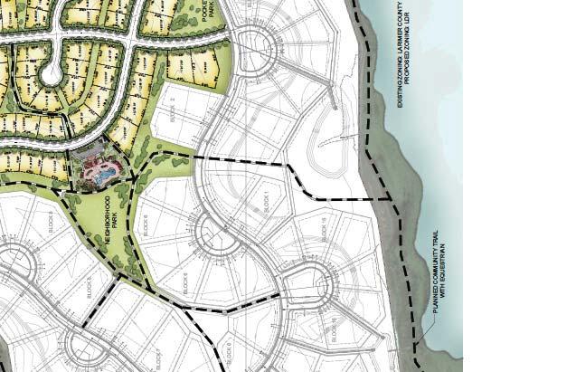
6 PLANNING COIION COUNICATION eeting Date: August 8, 0 Item: ildwing Preliminary Planned Development Overlay District for the ildwing ubdivision Presented by: att Blakely Town Planner EXECUTIVE UARY: The Preliminary PD Development Plan is the fsecond step in creating a Planned Development Overlay District. This district will contain the entire ildwing ubdivision (excluding the first filing), and seeks to modify some of the standards of the underlying zoning districts. These modifications are detailed on Page of the Project Narrative submitted by the applicant and are listed in this staff report. There are is an additional step in the PD Overlay process, the Final PD Overlay. This will be brought back to the Planning Commission and Town Council with the Final Plats. The Preliminary PD Overlay is 00% in compliance with the ketch PD Overlay. Planning Commission Decision: The ketch PD Overlay was approved by Planning Commission at its regularly scheduled meeting on 7//0 by -0 vote. Town Council Decision: The ketch Planned Development Overlay was approved by Town Council at its regularly scheduled meeting on 7/8/0 by -0 vote. KEY POINT/UPPORTING INFORATION: Owner: Gary Hoover, Development, LLC Applicant: Gary Hoover, Development, LLC Application Type: Rezoning Case Number: RZ-0-00 Legal Description/Address: Parcel(s) of land located at the southwest corner of ildwing Drive and Latham Parkway (LCR) in the ildwing ubdivision. ketch Plan Process chedule Task Description Date Preliminary PD Overlay 7/9/0 Application Application Certification 7/0/0 Notice to Public and Posting of Property Planning Commission Public Hearing Town Council Public Hearing 8/7/0 8/8/0 8//0
7 Parcel ize (Acres): 8.8 +/- total acres Number of Lots: Approximately -0 Dwelling Units Existing Zoning: R- Proposed Zoning: R- with PD Overlay Existing Land Use: Vacant Proposed Land Use: ingle-family Residential Comprehensive Plan Designation: Low Density Residential ERVICE: ater: ewer: Fire: pecial Districts: North eld ater District Boxelder anitation District Poudre Fire Authority ildwing etro District Adjacent Zoning/Land Uses: Direction Zoning Land Use North FA-, Unincorporated Larimer Farming County outh R-; ingle Family Residential Residential est FA-, Unincorporated Larimer Farming County East Unincorporated eld County AG-A DENITY AND DIENIONAL TANDARD EXCEPTION:. odify the R- / FD Density and dimensional standards Table -B for the Phase lots only as follows: a. Reduce inimum lot area per dwelling (sf) from,000 to,00. b. Reduce the inimum side yard setback (feet) from 7 to. REVIE CRITERIA: From ection...n.8.b of the Land Use Code: Preliminary PD Development Plan Review Criteria. In addition to all of the review criteria for a sketch PD development plan, the following review criteria will be used by the Town taff and Board to evaluate all PD applications at the time of preliminary PD plan/preliminary plat: i. The preliminary PD development plan is substantially consistent with the sketch development plan as approved. Response: The Preliminary PD Development plan is 00% in compliance with the approved ketch PD Development Plan
8 ii. All sketch PD development plan conditions of approval have been adequately addressed on the preliminary PD development plan. Response: All the ketch PD Development plan conditions have been met and are addressed on the Preliminary PD Development plan. Referral Comments: Not Returned: AT&T Communications, Poudre chool District, Poudre River Public Library District, CenturyLink, Timnath Finance, Timnath Public orks, Xcel Energy, Larimer County Department of Natural Resources, Timnath Town AttorneyTimnath Post Office,, Comcast, Geological urvey, North eld County ater District, Boxelder anitation, Larimer County Department of Health Returned with no comments: afebuilt, Timnath Police Department, Poudre Fire Authority, Timnath Engineering, Returned with comments: Timnath Community Development RECOENDED OTION: I move to recommend approval of the ildwing Preliminary Planned Development Overlay District to the Timnath Town Council, with the following conditions: a. Allow staff to continue to work with applicant to address all unresolved non-substantive technical comments to the satisfaction of Town taff and Referral Agencies ATTACHENT:. ildwing ketch Plan. ildwing Planned PD Overlay ap
9

10


11


12
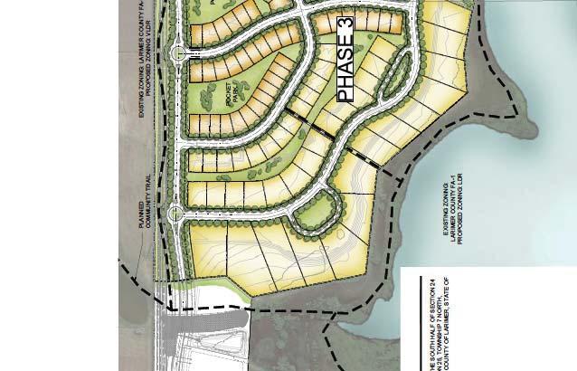
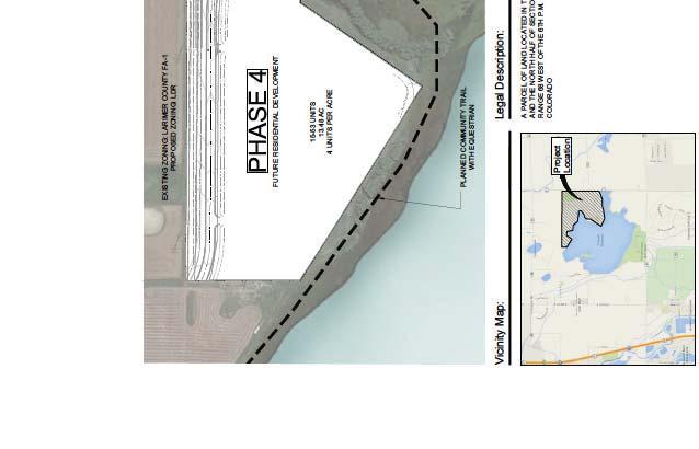
13 PLANNING COIION COUNICATION eeting Date: 8/8/0 Item: ildwing Preliminary Plat Presented by: att Blakely Town Planner EXECUTIVE UARY: Preliminary Plat proposal for approximately single family lots located in Phases,, and of the ildwing ubdivision. The density in these areas will be roughly.7 D.U./AC. with a diversity of housing types including single family homes and patio homes. Phase will have single family homes with lots ranging from 8,00 sq. ft. to,000 sq. ft. Phase will also have single family homes with lots ranging in size from,000 sq. ft. to,00 sq. ft. and Patio homes with lots ranging from,00 sq. ft. to 8,00 sq. ft. The patio homes in Black will have lots ranging from 0, sq. ft. to,8 sq. ft. There is a future development phase, Phases which is. acres. There is a proposed pool that will be in Phase and is adjacent to the neighborhood park and will contain a pool,,00 sq. ft. bath house, off street parking and other amenities. The pool site will require a separate ite Plan approval process. This proposed plan will have approximately 9% open space that will include a trail connection to the rest of the ildwing subdivision, the reservoir and connect to regional trails per the prost plan. KEY POINT/UPPORTING INFORATION: Owner: Gary Hoover, Development, LLC Applicant: Gary Hoover, Development, LLC Application Type: Preliminary Plat Case Number: P-0-00 Preliminary Plat Process chedule Task Description Date Pre Application Conference 0/9/0 Preliminary Plat Application //0 Application Certification //0 nd ubmittal 7//0 rd ubmittal 8/7/0 Notice to Public and Posting of Property 8/7/0 Planning Commission Public Hearing 8/8/0 Town Council Action 8//0
14 Legal Description/Address: Parcel(s) of land located at the southwest corner of ildwing Drive and Latham Parkway (LCR) in the ildwing ubdivision Parcel ize (Acres): 8 +/- total acres Number of Lots: Approximately residential lots in Filing Existing Zoning: R- Proposed Zoning: Unchanged Existing Land Use: Vacant Proposed Land Use: ingle-family Residential Comprehensive Plan Designation: Low Density Residential ERVICE: ater: ewer: Fire: pecial Districts: eld County ater District Boxelder anitation District Poudre Fire Authority ildwing etro District Adjacent Zoning/Land Uses: Direction Zoning Land Use North FA-, Unincorporated Larimer County Farming outh R-; ingle Family Residential Residential (Filing ) est R-; ingle Family Residential ingle Family; Residential Patio Homes (Filing ) East Unincorporated eld County AG-A This Property will also undergo the following processes: Preliminary PD Overlay Currently processing Final Plat Under review Final PD Overlay ubmittal Pending Reference Timnath Land Use Code ection...c Preliminary Plat for details on the Preliminary Plat Process. C. Preliminary Plat Review Criteria. In addition to all provisions of this Code, the Town shall use the following criteria to evaluate the applicant s request:. The preliminary plat represents a functional system of land use and is consistent with the rationale and criteria set forth in this Code and the Comprehensive Plan. Response: The preliminary plat as presented meets this criterion. It is in compliance with the R- zoning requirements and dimensional standards with the modifications identified in the PD Overlay. It meets the Low Density Residential designation on the Comprehensive Plan. The preliminary Plat as proposed extends the street network of the previous filing, and is compatible with the current densities and lot sizes.. The application is consistent with the approved sketch plan and incorporates the Planning Commission s recommendations and conditions of approval.
15 Response: The preliminary plat is in conformance with the sketch plan that was approved by Planning Commission and Town Council.. The land use mix within the project conforms to Timnath s Zoning District ap and Land Use ap and furthers the goals and policies of the Comprehensive Plan including: a. The proposed development promotes the Town s small town, rural character; Response: This development is a continuation of the existing neighborhood and has been envisioned as single-family dwellings. b. Proposed residential development adds diversity to the Town s housing supply; Response: This development adds multiple lot sizes and housing types ranging from estate lots to patio homes. This is a logical location and continuation of the existing development and there continues to be demand for these products c. Proposed commercial development will benefit the Town s economic base; Response: N/A d. Parks, open space and trails are incorporated into the site design; Response: This development will incorporate many pocket parks along with a neighborhood park and pool site that will serve the entire area. There is also a regional trail connection along CR- that will then tie into the neighborhood trail system for easy access. e. The proposed project protects the Town s environmental quality; and Response: There is a limited impact to the environment by this development. Phase has no environmental impacts. Areas of Phase are adjacent to wetland and natural areas. The impacts will be reviewed at Final Plat of that phase. f. The development enhances cultural, historical, educational and/or human service opportunities. Response:N/A. The utility and transportation design is adequate, given existing and planned capacities of those systems. Response: The preliminary plat as presented meets this criterion. The property has gone through a Transportation Impact tudy that has projected the increase in traffic and the road system is designed to hold that new capacity per LCUA tandards. The utility infrastructure will be extended and has been designed to accommodate the additional users. These will be reviewed in more detail at Final Plat.. Negative impacts on adjacent land uses have been identified and satisfactorily mitigated. Response: The preliminary plat as presented meets this criterion. The Preliminary Plat negative impacts that have been identified include increased traffic and density. This will be mitigated by the construction of roads that will hold the new capacity per LCUA standards. The increase in density has been mitigated by transitioning the lot size adjacent to the Filing residents.. There is a need or desirability within the community for the applicant s development and the development will help achieve a balance of land use and/or housing types within Timnath. Response: The preliminary plat as presented extends the existing housing supply with single
16 family estate lots, single-family lots, and larger patio home lots that will bring a more diverse housing product to the neighborhood. Referral Comments: Not Returned: AT&T Communications, Poudre chool District, Poudre River Public Library District, CenturyLink, Timnath Finance, Timnath Public orks, Xcel Energy, Larimer County Department of Natural Resources, Timnath Town AttorneyTimnath Post Office, North eld County ater District, Larimer County Department of Health Returned with no comments: afebuilt, Timnath Police Department, Boxelder, Lake Canal Returned with comments: Poudre Fire Authority, Timnath Engineering, Colorado Geological urvey, Colorado Division of Natural Resources, Comcast, taff Recommendation: Finding that a complete application was submitted and reviewed in accordance with all applicable Town regulations, the application conforms with the mission and goals of the Timnath Comprehensive Plan, and all criteria outlined in ection...c. of the Timnath unicipal Code have been met, I move to recommend approval of the ildwing Preliminary Plat to the Timnath Town Council, with the following conditions: a. Allow staff to work with the owner and applicant to address minor, non-substantive modifications prior to final signatures. ATTACHENT:. Preliminary Plat. Narrative
17 KING URVEYOR 0 E. Garden Drive indsor, Colorado 800 phone: (970) info@kingurveyors.com VICINITY AP ituate in the outh Half of ection, Township 7 North, Range 8 est of the th P.., Town of Timnath, County of Larimer, tate of Colorado Patio Home ingle Family Tracts Phase Phase 7 Phase 0 0 Total 9 8 LAND UE TABLE LOT ().9 ACRE.% TRACT (8) 0.7 ACRE.% RIGHT OF AY 0. ACRE.% ACRE 00.0% ONER: ENGINEER: TON OF TINATH GALLOAY 800 GOODAN TREET 70 E. TH TREET, UITE 0 TINATH, CO 807 LOVELAND, CO 808 TB GROUP UBDIVIION PLAT EQUENCE TABLE ONER: OUNTAIN AVENUE BERTHOUD, CO 80 DEVELOPENT LLC ildwing Final Plat Filing No. Rec. No //07 8. AH TREET, UITE A ildwing Final Plat Filing No. Amendment No. Rec. No /0/07 INDOR, CO 800 ildwing Final Plat Filing No. Amendment No. Rec. No //08 URVEYOR: Land Use Table Addendum Rec. No //08 Land Use Table Addendum Rec. No //08 LIENHOLDER: KING URVEYOR INC ildwing ubdivision Replat A Rec. No /0/ 0 GARDEN DRIVE ildwing ubdivision Replat B Rec. No /7/ BANK OF COLORADO INDOR, CO E. HARONY ROAD ildwing ubdivision Replat A - Corrected Rec. No // FORT COLLIN, CO 80 ildwing ubdivision Replat C Rec. No /9/ ildwing ubdivision Replat D Rec. No /7/ ildwing ubdivision Replat E Rec. No // O:\009\DG\009UB-PRELI.dwg, 8//0 :: P
18 RR R R R R R R R R R R R R R 8' '' R R R R R R R R R R R R R R R R R R R R R R R R R TRACT A TRACT A 98, sq. ft. 9,7 sq. ft.,8 sq. ft., sq. ft. BLOCK 0,0 sq. ft.,0 sq. ft.,79 sq. ft. TRACT B, sq. ft. 7, sq. ft.,00 sq. ft., sq. ft.,700 sq. ft.,700 sq. ft. 8,0 sq. ft. BLOCK 8, sq. ft. BLOCK,07 sq. ft. 8,7 sq. ft.,9 sq. ft., sq. ft. 7, sq. ft.,0 sq. ft., sq. ft.,9 sq. ft. TRACT C,0 sq. ft. 8, sq. ft., sq. ft.,79 sq. ft. 8, sq. ft.,00 sq. ft.,0 sq. ft.,0 sq. ft. BLOCK 7,89 sq. ft.,89 sq. ft. 7,909 sq. ft.,9 sq. ft. 7,7 sq. ft. 0, sq. ft.,0 sq. ft. TRACT E 7,8 sq. ft. POCKET,0 sq. ft. PARK,00 sq. ft.,0 sq. ft. 7,9,0 sq. ft. BLOCK 8,00 sq. ft. 0,7 sq,00 sq. ft.,00 sq. ft.,9,00 sq. ft. 7,7 sq. ft. 7,9 sq. ft. 8,99 sq. ft. BLOCK 8,9 sq. ft.,9 sq. ft.,8 sq. ft. BLOCK TRACT F,8 sq. ft.,00 sq. ft.,0 sq. ft.,90 sq. ft. 99,,990,7 sq. ft.,0 sq. ft.,7 sq. ft. 7, sq. ft.,80 sq. ft. 9,88 sq. ft. BLOCK 9,8 sq. ft. 0,7 sq KING URVEYOR 0 E. Garden Drive indsor, Colorado 800 phone: (970) info@kingurveyors.com O:\009\DG\009UB-PRELI.dwg, 8//0 :: P
19 O:\009\DG\009UB-PRELI.dwg, 8//0 ::9 P TRACT E R 0 R R R R '' R R 8 7, sq. ft. 7, sq. ft.,09 sq. ft.,09 sq. ft.,9 sq. ft. 9 R 98,7 sq. ft. POCKET PARK 8 R R '' R R 9,8 sq. ft. TRACT D R R,8 sq. ft., sq. ft. 8,97 sq. ft., sq. ft. R 9,089 sq. ft. R 7,9 sq. ft. R,9 sq. ft. R 8, sq. ft.,0 sq. ft.,00 sq. ft.,0 sq. ft. 8 BLOCK 7, sq. ft.,9 sq. ft. TRACT C R,7 sq. ft. R 8,0 sq. ft.,90 sq. ft. BLOCK 9, sq. ft. 7,70 sq. ft. 9 0,7 sq. ft. R,90 sq. ft.,00 sq. ft. 7 R,0 sq. ft.,00 sq. ft.,00 sq. ft. R BLOCK 0 POCKET PARK TRACT D 8, sq. ft.,8 sq. ft. 8, sq. ft., sq. ft., sq. ft. BLOCK, sq. ft., sq. ft. 7, sq. ft.,0 sq. ft. 8,8 sq. ft., sq. ft. 7, sq. ft.,00 sq. ft. BLOCK 9,9 sq. ft.,7 sq. ft.,97 sq. ft. 7,90 sq. ft. 0,7 sq. ft. 7, sq. ft.,7 sq. ft. 8,9 sq. ft. TRACT F,8 sq. ft.,90 sq. ft. BLOCK R BLOCK 8 9,8 sq. ft.,00 sq. ft. BLOCK R,0 sq. ft. 8,99 sq. ft. ' ' R,00 sq. ft. 7,0 sq. ft.,7 sq. ft.,0 sq. ft. 9,88 sq. ft. BLOCK,00 sq. ft. R,00 sq. ft. 7,9 sq. ft. '',00 sq. ft. 9 7,7 sq. ft. t. 00 sq. ft. 8 POCKET PARK 7,8 sq. ft.,0 sq. ft. 8 R 9,0 sq. ft.,990 sq. ft. R R, sq. ft. R R R R R R R R R R R R 8 9 R 0 9,08 sq. ft. 8, sq. ft. 0,9 sq. ft. '' R 8,7 sq. ft. BLOCK 0,88 sq. ft. R,89 sq. ft.,7 sq. ft. 8,0 sq. ft., sq. ft. BLOCK 8 9, sq. ft. 8,7 sq. ft., sq. ft. 8,7 sq. ft. TRACT E BLOCK 9,90 sq. ft. 9, sq. ft.,8 sq. ft. 9,088 sq. ft. BLOCK 0 8,7 sq. ft. BLOCK 9,08 sq. ft.,7 sq. ft. POCKET PARK,87 sq. ft.,9 sq. ft. 8,9 sq. ft. 7,7 sq. ft. 8, sq. ft.,7 sq. ft. TRACT C, sq. ft. 8, sq. ft. 0,8 sq. ft. 0,9 sq. ft. 7, sq. ft. BLOCK 9 9, sq. ft. 8 7, sq. ft.,8 sq. ft. 8,79 sq. ft. 0,7 sq. ft. 8, sq. ft. 8,77 sq. ft. 8, sq. ft. 8, sq. ft. 8, sq. ft. BLOCK 8 B 8, sq. ft. 0,8 sq. ft. BLOCK 8 R,0 sq. ft. 7 TRACT,70 sq. ft. 8, sq. ft. 9,87 sq. ft. TRACT A 8,0 sq. ft.,77 sq. ft. R R '',0 sq. ft. 9,97 sq. ft.,87 sq. ft. 9,0 sq. ft. 9,0 sq. ft. R BLOCK 8,8 sq. ft. 8,0 sq. ft. BLOCK 7,0 sq. ft.,877 sq. ft. R 8,0 sq. ft. 8,0 sq. ft. BLOCK TON OF TINATH COUNITY PARK R,8 sq. ft. 0,78 sq. ft. 0, sq. ft. 7 0,000 sq. ft. 8,7 sq. ft. 8,0 sq. ft. 9,07 sq. ft. BLOCK 0,78 sq. ft. 9,800 sq. ft. 0,78 sq. ft. R,99 sq. ft. R 0 7 9,8 sq. ft. 9,89 sq. ft. BLOCK,0 sq. ft. 0,97 sq. ft. 9,8 sq. ft. R 9,8 sq. ft. R R 0 '' R R R R 99, R sq. ft. R R '' R R R '' R 7,7 sq. ft. '' R R '' '' '' '' '' '' '' '' '' R '' TRACT G '' 8' ' R '' '' 8' ' ' '' 8' '' ' '' '' 8' '' '' '' R R R '' R KING URVEYOR 0 E. Garden Drive indsor, Colorado 800 phone: (970) info@kingurveyors.com
20 '' '' '' '' '' '' '' 8 8 '' '' '' O:\009\DG\009UB-PRELI.dwg, 8//0 ::9 P '' '' 8 '' '' '' '' '' 8 '' '' '' '' '' 9,7 sq. ft. TRACT G 8 '' '' '' '' 0,87 sq. ft. TRACT H,0 sq. ft.,70 sq. ft. BLOCK, sq. ft. BLOCK,7 sq. ft.,0 sq. ft. BLOCK,08 sq. ft.,7 sq. ft. '' 8 '' '' 8,8 sq. ft. BLOCK '',7 sq. ft.,9 sq. ft.,9 sq. ft. '' R, sq. ft. '' 8 '' '' 8 '' 8 9 '' 8 7,0 sq. ft. TRACT J 7, sq. ft. TRACT I 7,9 sq. ft. 7,9 sq. ft. 7 0,000 sq. ft. BLOCK 9,800 sq. ft. TRACT F 9,8 sq. ft., sq. ft.,09 sq. ft. 8,80 sq. ft.,0 sq. ft. 8,88 sq. ft.,0 sq. ft. 9,08 sq. ft. R '',9 sq. ft. 0 8,0 sq. ft. 9,0 sq. ft.,70 sq. ft.,778 sq. ft. 8, sq. ft. 9,00 sq. ft. 8,0 sq. ft. R '' BLOCK 8,8 sq. ft. BLOCK,9 sq. ft. 8, sq. ft. 0,987 sq. ft. BLOCK 7 BLOCK 8,0 sq. ft. 0,909 sq. ft. POCKET PARK 9,9 sq. ft. R BLOCK,8 sq. ft.,9 sq. ft.,0 sq. ft., sq. ft. 98,8 sq. ft.,7 sq. ft. BLOCK R 8,7 sq. ft. BLOCK 0,88 sq. ft. 8,7 sq. ft.,9 sq. ft. BLOCK,9 sq. ft. 7,97 sq. ft.,87 sq. ft. 0, sq. ft. 9,9 sq. ft. '',8 sq. ft.,79 sq. ft. BLOCK 8 BLOCK 9,7 sq. ft.,7 sq. ft.,8 sq. ft.,88 sq. ft.,09 sq. ft., sq. ft. 0, sq. ft. BLOCK 0 7,7 sq. ft. TRACT D,7 sq. ft. BLOCK 0,9 sq. ft.,89 sq. ft. BLOCK BLOCK,89 sq. ft. 9,08 sq. ft. BLOCK BLOCK 7, sq. ft.,0 sq. ft. 7,8 sq. ft., sq. ft. 0,87 sq. ft. R,99 sq. ft. '' R R R R '' '' '' '' '' '' '' '' R '' R '' R '' '' '' '' '' 8 8 R '' '' '' '' '' R R 8 R ' R R R 8' R R 8' ' R R '' R R R R R '' '' 8 '' '' 8 '' 8 '' '' '' '' '' '' '' '' '' '' KING URVEYOR 0 E. Garden Drive indsor, Colorado 800 phone: (970) info@kingurveyors.com
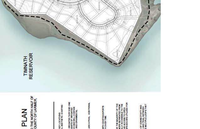
21 June, 0 ildwing II Preliminary Plat General Development Information This request is for a preliminary subdivision plat for approximately 80 acres known as the ildwing II Preliminary Plat. This area was originally platted for 9 lots. The intent is to amend the plat to create new lots. The area currently known as Block I within the Filing boundary originally had 0 single-family lots, ranging in size from,7 sq. ft. to 0,709 sq. ft. The intent of the replat is to create 8 patio home lots ranging from 8,9 sq. ft. to,8 sq. ft. Overall gross density is. dwelling units per acre. The area currently known as Future Filings within the Final Plat Filing No. Amendment No. boundary was originally designated as Blocks,, 9, 0,, and and was platted for lots, ranging in size from,000 sq. ft. to,000 sq. ft. The intent is to amend the plat to create 00 single family lots ranging in size form 7,8 sq. ft. to,09 sq. ft. Overall gross density is.7 dwelling units per acre. The area currently known as Future Filings within the Final Plat Filing No., Amendment No. boundary was originally designated as Blocks 7, 8, 9, 0,, and was platted for 9 lots, ranging in size from,000 sq. ft. to,000 sq. ft. The intent is to amend the patio home portion of the plat to create 0 single family lots. The lots will range in size from,00 sq. ft. to,00 sq. ft. The estate lots along the lake frontage will remain as originally platted. Overall gross density is. dwelling units per acre. A portion of this area is designated as a future residential development tract and consists of single family detached lots. The ubdivision is consistent with the following sections of Chapter. of the Land Use Code, with the exception of some lots that are below,000 sq. ft. that don t meet the dimensional standards... Vision and intent The ildwing II Plat embodies most all of the statements in this section. The proposed replat will be a positive contribution to the area. Notably, the project is walkable and pedestrian oriented. The project provides connections to the existing 8 walking path. This off-road trail system will provide links to the future planned community park, open space areas, future PROT trails and the community pool. The project will also provide an orderly street pattern with tree-lined streets, one and two story buildings, and a safe friendly community. The subdivision is in an appropriate location and is similar in density with the existing surrounding residential developments. The development will contain lots overlooking Timnath Reservoir and views of Long s Peak, which makes the development unique.
22 ..7. Lots and blocks The lot and block layout of the subdivision is consistent with this section. The lengths of the blocks are appropriate and meet LCUA standards. here blocks are longer in length, breaks occur between the lots with trail connections provided...8. treets The street pattern in the subdivision consists of local streets in a modified grid pattern, providing connections within the development and to the adjacent existing streets. All of the streets have detached sidewalks, street trees and a greenway, which creates a safe, efficient and attractive experience for both vehicles and pedestrians...0 idewalks, multi-use pathways and trails foot wide on-street sidewalks are provided throughout the subdivision providing linkages within the subdivision and to the surrounding neighborhoods. There is an existing 8 wide multi-use trail within the project providing a links to the pocket parks, community Park and neighborhood Park and to other areas of the ildwing development. This off-road trail system will provide links to the future planned community park, open space areas, future PROT trails and the community pool. There is a future PROT planned community walking path along the Latham Drive frontage... Parks and open space The subdivision will provide required new pocket parks and a neighborhood park. The parks are further described below: Pocket Park Location Amenities outh of ildwing Drive Irrigated turf, picnic table outh of ildwing Drive Irrigated turf, 0 x 0 shelter with picnic tables Timnath Reservoir Neighborhood beach North of Block, Lot Irrigated turf, picnic table, soft surface trail North of ildshore Drive Irrigated turf, picnic table, soft surface trail The subdivision will also provide a community pool and bathhouse. In addition there is an existing neighborhood park in Phase with a playground within walking distance of all of the areas in the subdivision. Lastly, the future Town s community park is within walking distance from all of the homes in ildwing... Landscape design The landscape design provides tree lawns with irrigated turf and one tree per 0 linear feet along all internal street frontages. Landscape for common open space consists of non-irrigated native foothills
23 grass mix. High visibility areas will contain clusters of trees. Entries to the subdivision will be enhanced with shrubs, perennials and ornamental grasses and signage...8 Residential architecture The architecture for each home will be controlled by the existing covenants already in place for the ildwing development. The builder will follow the model and block diversity as required by the Code... Density and dimensional standards ost of the lots will meet or exceed the specifications outlined in the R- zone in Table -B. The exception is patio home lots that do not comply with the 7 side yard setback regulation and the minimum lot size. A PD Overlay is being requested for the above-mentioned lots... anitary sewer This property will be served by Boxelder anitation District. Existing mains are located in the adjacent streets. This main was to service the subdivision and will continue to be utilized for service of this replat. ervices and short main extensions may be necessary for service... Potable water The development is currently served by North eld County ater District. Existing mains are located in the adjacent streets. This main was to service the subdivision and will continue to be utilized for service of this replat. ervices and short main extensions may be necessary for service.. Non-potable water The ildwing development has an existing internal non-potable irrigation system. This system includes existing mains adjacent to the subdivision that will be utilized for irrigation... Fire Hydrants Fire hydrants will be spaced as appropriate per Poudre Fire Authority s regulations.
24 PLANNING COIION COUNICATION eeting Date: 08/8/0 Presented by: att Blakely Town Planner Item: FIHER PROPERTY KETCH PLAN Public eeting EXECUTIVE UARY: The Fisher property is a.9 acre site located north of Old Town Timnath on the west side of CR and is currently within Larimer County. The property is also eligible for annexation which is currently being evaluated by staff. The ketch Plan is consistent with the Town s Comprehensive Plan and PROT Plan KEY POINT/UPPORTING INFORATION: Owner: The Landhuis Company Applicant: Jeff ark, The Landhuis Company Application Type: ketch Plan Case Number: P-0-00 Legal Description/Address: Parcel(s) of land located west of CR and south of CR E ketch Plan Process chedule Task Description Date Pre Application Conference 0//0 ketch Plan Application 07//0 Notice to Neighboring Property Owners Planning Commission Public eeting Planning Commission Review Town Council Action Parcel ize (Acres): +/- Total Acres Number of Lots: Approximately 70 units 08/07/0 0/0/0 Existing Zoning: FA- Larimer County Proposed Zoning: R- and -U Existing Land Use: Vacant / Farming Proposed Land Use: ingle-family Residential, ulti-family, ixed-use, Open pace, Trails, Parks TBD TBD ERVICE: ater: ewer: Fire: pecial Districts: ELCO ater District Boxelder anitation District Poudre Fire Authority None at this time
25 Adjacent Zoning/Land Uses: Direction Zoning Land Use North FA- Unincorporated Larimer Vacant/Farming County; CR E outh FA- Unincorporated Larimer County Vacant/Farming est FA- Unincorporated Larimer County Vacant/Farming East FA- Unincorporated Larimer County; CR Vacant/Farming This Property will be required to undergo the following processes: Annexation Application - Currently under review Annexation Petition - ubmittal Pending Zoning - ubmittal Pending Preliminary Plat - Future ubmittal Final Plat - Future ubmittal Reference Timnath Land Use Code ection...b. ketch Plan for details on the ketch Plan Process taff Recommendation:. No action needed. Land Use Code, ection...b. This is intended to be a collaborative meeting among the Planning Commission, the public and the applicant to ensure that all new development is consistent with the community s goals and that important issues are identified early in the development process. Topics that may be addressed in this meeting include: a. How the proposed project is consistent with the Town Comprehensive Plan and this Code. b. The applicant s goals and vision for the project. c. How the proposed development will incorporate variety in the type, design and siting of buildings. d. How the proposed subdivision will be connected to and integrated with surrounding natural and developed areas. e. How the project will impact neighboring properties (i.e., water drainage, traffic circulation, environmental impacts, view corridors). f. How the design is cost-effective and environmentally responsive to site features and constraints and how potential impacts to natural systems will be mitigated. g. How the design capitalizes on natural and cultural assets on and around the site to build a positive and distinctive identity. h. How the proposal promotes the efficient use of land and public streets, utilities and governmental services. i. Applicants should bring the following items to the meeting: i. Context/Vicinity ap which shows the proposed development in relation to the surrounding area. ii. Base ap which shows the site features (such as topography, ditches, drainageways, wildlife habitat, trees and view corridors).
26 . ketch Plan Application ubmittal. Prior to preparing the multiple copies of documents required in a ketch Plan submittal, applicants are encouraged to meet with Town staff to review a single set of application materials for completeness. Incomplete applications will not be accepted for processing. The applicant shall submit the complete sketch plan application package to the Town Clerk. The application must be submitted a reasonable length of time prior to the Planning Commission meeting at which the application will be reviewed. The sketch plan application package shall include the following items: a. Land Use Application Form, including certification of ownership. b. ubdivisions - Technical Criteria Form. c. Application Fee. d. Neighboring Property Owner Envelopes. Provide the Town Clerk with one () set of stamped, addressed No. 0 envelopes. The envelopes shall have the Town s address as the return address and the envelopes shall be addressed to the surrounding property owners within five hundred (00) feet of the property. e. Context/Vicinity ap. Twenty (0) copies, properly folded. The context/vicinity map shall show the proposed subdivision in relation to the surrounding area (one [] mile radius around the property). The map shall be twenty-four () inches high by thirtysix () inches wide and provide the following information: i. Title of project. ii. North arrow, scale (not greater than " =,000') and date of preparation. iii. Boundary of proposed project. iv. Existing (for developed land) or proposed (for vacant/agricultural land) land uses for the properties shown on the map (i.e. residential, commercial, industrial, park, etc.) -- label land use and whether it is existing or proposed. v. ajor streets (show and label street names). vi. Existing public water and sewer lines and proposed connections. vii. Regional open space/trail networks per the Town Comprehensive Plan. viii. ajor ditches, rivers and bodies of water. ix. Adjacent properties identified by subdivision name or zoning district. ATTACHENT:. Project Narrative/Annexation Assessment Report. ketch Plan

27 KETCH PLAN FIHER PROPERTY KETCH PLAN A PARCEL OF LAND LOCATED IN THE OUTHEAT QUARTER OF ECTION, THE EAT HALF OF THE NORTHEAT QUARTER OF ECTION 7, AND A PORTION OF THE NORTHET QUARTER OF THE NORTHEAT QUARTER OF ECTION 7, TONHIP 7 NORTH, RANGE 8 ET OF THE TH PRINCIPAL ERIDIAN, COUNTY OF LARIER, TATE OF COLORADO VICINITY AP PLANNER: ENGINEER:. nd Ave. Denver, CO DEVELOPER: The Landhuis Company N. ahsatch Ave. uite 0 Colorado prings, CO DATE: 07/0/0 HEET TITLE: COLORADO HIGHAY LARIER COUNTY ROAD E ITE COVER HEET HEET NUBER: OF TINATH REERVO LARIER COUNTY ROAD INTERTATE LARIER COUNTY ROAD 8 / HARONY ROAD ALO HON: 0' UG CONTOUR CHECKED BY: B DRAN BY: DT FIHER PROPERTY LARIER COUNTY, COLORADO PLANNING COIION CERTIFICATE LEGAL DECRIPTION FIHER PROPERTY ANNEXATION TO TINATH CITY OF GREELEY REVIEED BY: ATER/EER DECTOR DATE: REVIE DOE NOT CONTITUTE "APPROVAL" OF PLAN. PERITTEE I REPONIBLE FOR ACCURACY AND COPLETENE OF PLAN. APPROVED THI DAY OF, 0, BY THE TON PLANNING COIION, TINATH, COLORADO. BY: A PARCEL OF LAND LOCATED IN THE OUTHEAT QUARTER OF ECTION, THE EAT HALF OF THE NORTHEAT QUARTER OF ECTION 7, AND A PORTION OF THE NORTHET QUARTER OF THE NORTHEAT QUARTER OF ECTION 7, TONHIP 7 NORTH, RANGE 8 ET OF THE TH PRINCIPAL ERIDIAN, COUNTY OF LARIER, TATE OF COLORADO, ORE PARTICULARLY DECRIBED A FOLLO: TON COUNCIL CERTIFICATE APPROVED THI DAY OF, 0, BY THE TON PLANNING COIION, TINATH, COLORADO. TINATH AYOR TINATH TON CLERK BAI OF BEARING: BEARING HON HEREON ARE BAED ON THE NORTH LINE OF THE OUTHEAT QUARTER OF ECTION, T7N, R8 OF THE TH P.., HICH A AUED TO BEAR NORTH 89 '" EAT. BEGINNING AT THE CENTER QUARTER CORNER OF AID OUTHEAT QUARTER OF ECTION ; THENCE NORTH 89 '" EAT ALONG THE NORTHERLY LINE OF AID OUTHEAT QUARTER OF ECTION A DITANCE OF,. FEET TO THE ETERLY RIGHT-OF-AY LINE OF COUNTY ROAD AND A POINT ON THE TON LIIT OF THE TON OF TINATH; THENCE OUTH 00 0'" EAT ALONG THE EATERLY LINE OF AID OUTHEAT QUARTER OF ECTION AND ALONG AID TON LIIT A DITANCE OF,7.77 FEET TO THE OUTHERLY LINE OF AID NORTHEAT QUARTER OF ECTION 7; THENCE OUTH 89 '" ET ALONG THE OUTHERLY LINE OF AID OUTHEAT QUARTER OF AID ECTION AND ALONG AID TON LIIT A DITANCE OF 0.00 FEET TO A POINT ON THE ETERLY RIGHT-OF-AY LINE OF AID COUNTY ROAD ; THENCE OUTH 00 08'" EAT ALONG AID ETERLY RIGHT-OF-AY LINE AND CONTINUING ALONG AID TON LIIT A DITANCE OF 998. FEET; THENCE OUTH 89 '" ET A DITANCE OF 8.00 FEET; THENCE OUTH 00 08'" EAT A DITANCE OF 7.00 FEET; THENCE NORTH 89 '" EAT A DITANCE OF 8.00 FEET TO AID ETERLY RIGHT-OF-AY LINE AND AID TON LIIT; THENCE OUTH 00 08'" EAT ALONG AID ETERLY RIGHT-OF-AY LINE AND CONTINUING ALONG AID TON LIIT A DITANCE OF,0. FEET; THENCE NORTH 89 '0" ET A DITANCE OF,8.0 FEET; THENCE NORTH 00 0'8" ET A DITANCE OF,9. FEET; THENCE NORTH 8 '" ET A DITANCE OF FEET TO A POINT ON THE OUTHERLY LINE OF AID OUTHEAT QUARTER OF ECTION ; THENCE OUTH 89 '" ET ALONG THE OUTHERLY LINE OF AID OUTHEAT QUARTER OF ECTION A DITANCE OF 97.8 FEET TO A POINT ON THE ETERLY LINE OF AID OUTHEAT QUARTER; THENCE NORTH 00 0'" ET ALONG THE ETERLY LINE OF AID OUTHEAT QUARTER OF ECTION A DITANCE OF,9.79 FEET TO THE POINT OF BEGINNING. BAI OF BEARING 0,000' 8,000' NORTH CALE: " = 8,000' HEET INDEX COVER HEET CONTEXT AP KETCH PLAN EXHIBIT CONCEPTUAL LANDCAPE AND OPEN PACE PLAN AID PARCEL CONTAIN A CALCULATED AREA OF 0,7,877 QUARE FEET, OR.9 ACRE, ORE OR LE. REVIED:
28 KETCH PLAN FIHER PROPERTY KETCH PLAN A PARCEL OF LAND LOCATED IN THE OUTHEAT QUARTER OF ECTION, THE EAT HALF OF THE NORTHEAT QUARTER OF ECTION 7, AND A PORTION OF THE NORTHET QUARTER OF THE NORTHEAT QUARTER OF ECTION 7, TONHIP 7 NORTH, RANGE 8 ET OF THE TH PRINCIPAL ERIDIAN, COUNTY OF LARIER, TATE OF COLORADO CONTEXT AP LEGEND TINATH REERVO. COUNTY ROAD BOXELDER DRAINAGE INTERTATE CONTEXT AP OF PROPECT ROAD COUNTY ROAD E COUNTY ROAD 0 COUNTY ROAD EXITING ATER LINE CACHE LA POUDRE RIVER claughlin LANE EXITING EER LINE CACHE LA POUDRE RIVER FIHER PROPERTY REGIONAL TRAIL NETORK (PER COPREHENIVE PLAN) POCKET PARK (PER COPREHENIVE PLAN) NEIGHBORHOOD PARK (PER COPREHENIVE PLAN) COUNITY PARK (PER COPREHENIVE PLAN) PLANNER: ENGINEER:. nd Ave. Denver, CO DEVELOPER: The Landhuis Company N. ahsatch Ave. uite 0 Colorado prings, CO DATE: 07/0/0 HEET TITLE: HEET NUBER: CHECKED BY: B DRAN BY: DT FIHER PROPERTY LARIER COUNTY, COLORADO 0,000',000' NORTH CALE: " =,000' CITY OF GREELEY REVIEED BY: ATER/EER DECTOR DATE: REVIE DOE NOT CONTITUTE "APPROVAL" OF PLAN. PERITTEE I REPONIBLE FOR ACCURACY AND COPLETENE OF PLAN. REVIED:
29 ONER: ALLION ETATE LLC PARCEL NUBER: 8700 ZONING: FA- FARING ONER: ALLION ETATE LLC PARCEL NUBER: 8700 ZONING: FA- FARING 0.0' TO CENTERLINE ONER: ARTINDALE, JAON A PARCEL NUBER: 8700 ZONING: FA- FARING ONER: GHEEN, KENNETH AND DEBORAH F PARCEL NUBER: ZONING: FA- FARING COUNTY ROAD ONER: BLU, ANDRE AND JUDI R PARCEL NUBER: ZONING: FA- FARING COUNTY ROAD ONER: PARADIE RANCH LLC PARCEL NUBER: ZONING: FA- FARING PUBLIC ERVICE COPANY OF COLORADO ELECTRICITY & COUNICATION EAEENT (NO IDTH GIVEN) BOOK, PAGE 90 ONER: DILLAN, GERALD G AND VGINIA E PARCEL NUBER: ZONING: FA- FARING PROPOED EXPANDED ARTERIAL RO A. AC R COUNTY ROAD E ONER: BRENT RANCH LIITED LIABILITY COPANY PARCEL NUBER: ZONING: FA- FARING B ONER: BRENT RANCH LIITED LIABILITY COPANY PARCEL NUBER: ZONING: FA- FARING CENTERLINE OF CITY OF GREELEY ATER PIPE LINE EAEENT "OF UFFICIENT IDTH FOR A PREENT BOXELDER RIGHT-OF-AY FOR N UNDERGROUND ATER PIPE LINE" DRAINAGE FLOODAY BOOK, PAGE 0 PROPOED COLLECTOR RO A ONER: TRIONFERA, LOUI AND ARY E PARCEL NUBER: ZONING: FA- FARING ONER: ILLI BETTY FAILY LIITED PARTNERHIP PARCEL NUBER: ZONING: FA- FARING,900' ONER: ILLI BETTY FAILY LIITED PARTNERHIP PARCEL NUBER: ZONING: FA- FARING,890' ONER: VILLARD, ARTHUR L AND CHRITINE L PARCEL NUBER: ZONING: E- ETATE KETCH PLAN FIHER PROPERTY KETCH PLAN A PARCEL OF LAND LOCATED IN THE OUTHEAT QUARTER OF ECTION, THE EAT HALF OF THE NORTHEAT QUARTER OF ECTION 7, AND A PORTION OF THE NORTHET QUARTER OF THE NORTHEAT QUARTER OF ECTION 7, TONHIP 7 NORTH, RANGE 8 ET OF THE TH PRINCIPAL ERIDIAN, COUNTY OF LARIER, TATE OF COLORADO PUBLIC ERVICE COPANY OF COLORADO ELECTRICITY & COUNICATION EAEENT (NO IDTH GIVEN) BOOK, PAGE ' 0' BOXELDER ANITATION DITRICT ANITARY EER EAEENT REC. NO & 0.0' ' ATER LINE EAEENT REC. NO & REC. NO PUBLIC ERVICE COPANY OF COLORADO EAEENT REC. NO. 800 EXITING DT ROAD 70.7 AC U 0' UBDRAIN EAEENT TO ALLION ETATE, LLC REC. NO & 0' ATER PIPELINE EAEENT TO EAT LARIER COUNTY ATER DITRICT REC. NO APPROXIATE LOCATION OF CITY OF GREELEY ATER LINE ' ATER LINE EAEENT REC. NO & REC. NO & REC. NO A PREENT BOXELDER DRAINAGE FLOODPLAIN OURCE: FEA FLOOD AP 0809C0F, REVIED DECEBER 9, 00 PREENT BOXELDER DRAINAGE FLOODAY APPROXIATE LOCATION OF CITY OF GREELEY ATER LINE ' ATER LINE EAEENT REC. NO & REC. NO & REC. NO ' ' BOXELDER ANITATION DITRICT ANITARY EER EAEENT REC. NO & ' UBDRAIN EAEENT TO ALLION ETATE, LLC REC. NO & ' ATER PIPELINE EAEENT TO EAT LARIER COUNTY ATER DITRICT REC. NO ONER: PHILLIP, H R AND NEVA J PARCEL NUBER: ZONING: FA- FARING ONER: VAN DYK/VO LLC PARCEL NUBER: ZONING: FA- FARING ' ATER LINE EAEENT REC. NO & REC. NO & REC. NO ' BOXELDER ANITATION DITRICT ANITARY EER EAEENT REC. NO ONER: VAN DYK/VO LLC PARCEL NUBER: ZONING: FA- FARING PLANNER: ENGINEER:. nd Ave. Denver, CO DEVELOPER: The Landhuis Company N. ahsatch Ave. uite 0 Colorado prings, CO DATE: 07/0/0 HEET TITLE: KETCH PLAN EXHIBIT HEET NUBER: OF CHECKED BY: B DRAN BY: DT FIHER PROPERTY LARIER COUNTY, COLORADO CITY OF GREELEY 0 00' 00' REVIEED BY: ATER/EER DECTOR DATE: NORTH CALE: " = 00' REVIE DOE NOT CONTITUTE "APPROVAL" OF PLAN. PERITTEE I REPONIBLE FOR ACCURACY AND COPLETENE OF PLAN. REVIED:
30 0.0' TO CENTERLINE COUNTY ROAD COUNTY ROAD 0.0' PROPOED EXPANDED ARTERIAL RO 0.0' A. AC R COUNTY ROAD E B,900',890' KETCH PLAN FIHER PROPERTY KETCH PLAN A PARCEL OF LAND LOCATED IN THE OUTHEAT QUARTER OF ECTION, THE EAT HALF OF THE NORTHEAT QUARTER OF ECTION 7, AND A PORTION OF THE NORTHET QUARTER OF THE NORTHEAT QUARTER OF ECTION 7, TONHIP 7 NORTH, RANGE 8 ET OF THE TH PRINCIPAL ERIDIAN, COUNTY OF LARIER, TATE OF COLORADO EXITING DT ROAD 70.7 AC U A 0.0' PROPOED COLLECTOR RO A PLANNER: ENGINEER:. nd Ave. Denver, CO DEVELOPER: The Landhuis Company N. ahsatch Ave. uite 0 Colorado prings, CO DATE: 07/0/0 HEET TITLE: CONCEPTUAL LANDCAPE AND OPEN PACE PLAN HEET NUBER: OF CHECKED BY: B DRAN BY: DT FIHER PROPERTY LARIER COUNTY, COLORADO POIBLE ROADIDE TRAIL ALIGNENT (PER PROT PLAN ) POIBLE INTERI ROADIDE TRAIL ALIGNENT POIBLE ROADIDE TRAIL ALIGNENT POIBLE COUNITY TRAIL ALIGNENT (PER PROT PLAN ) POIBLE NEIGHBORHOOD TRAIL ALIGNENT POIBLE NEIGHBORHOOD TRAIL ALIGNENT 0 00' 00' NORTH CALE: " = 00' POIBLE COUNITY TRAIL ALIGNENT (PER PROT PLAN ) CITY OF GREELEY REVIEED BY: ATER/EER DECTOR DATE: REVIE DOE NOT CONTITUTE "APPROVAL" OF PLAN. PERITTEE I REPONIBLE FOR ACCURACY AND COPLETENE OF PLAN. REVIED:
ARTICLE 15 - PLANNED UNIT DEVELOPMENT
 Section 15.1 - Intent. ARTICLE 15 - PLANNED UNIT DEVELOPMENT A PUD, or Planned Unit Development, is not a District per se, but rather a set of standards that may be applied to a development type. The Planned
SKETCH PLAN REVIEW SPECIAL EXCEPTION, SPECIAL REVIEW,
 www.larimer.org Planning Department 200 W. Oak Street 3 rd Floor Fort Collins, CO 80521 970-498-7683 SKETCH PLAN REVIEW SKETCH PLAN REVIEW for Conservation Developments, Planned Land Divisions, Subdivisions,
PLANNING AND ZONING DEPARTMENT
 Town of Minturn Development Review Process: Guide To Planned Unit Developments (Concept Plan) This guide describes the Planned Unit Development Process. This guide should be utilized in conjunction with
PLANNING COMMISSION COMMUNICATION
 PLANNING COMMISSION COMMUNICATION Meeting Date: September 17 th, 2013 Presented by: Matt Blakely Owner: Applicant: Jamie and Brandon Bohn Jamie Bohn Item: Conditional Use Permit for a Family Child Care
PUD Ordinance - Cascade Lakes Plat #10 of 1995
 PUD Ordinance - Cascade Lakes Plat #10 of 1995 CASCADE CHARTER TOWNSHIP Ordinance #10 of 1995 AN ORDINANCE TO AMEND THE CASCADE CHARTER TOWNSHIP ZONING ORDINANCE AND ZONING MAP TO ESTABLISH THE CASCADE
Chapter 100 Planned Unit Development in Corvallis Urban Fringe
 100.100 Scope and Purpose. Chapter 100 Planned Unit Development in Corvallis Urban Fringe (1) All applications for land divisions in the Urban Residential (UR) and Flood Plain Agriculture (FPA) zones within
Guide to Combined Preliminary and Final Plats
 Guide to Combined Preliminary and Final Plats Introduction The Douglas County is committed to providing open, transparent application processes to the public. This Guide is provided to assist anyone interested
Letter of Intent May 2017 (Revised November 2017)
") THE BEACH AT WOODMOOR LETTER OF INTENT MAY 2017 (REVISED NOVEMBER 2017) OWNER/APPLICANT: CONSULTANT: Lake Woodmoor Holdings LLC N.E.S. Inc. 1755 Telstar Drive, Suite 211 619 North Cascade Avenue Colorado
THE BEACH AT WOODMOOR LETTER OF INTENT MAY 2017 (REVISED NOVEMBER 2017) OWNER/APPLICANT: CONSULTANT: Lake Woodmoor Holdings LLC N.E.S. Inc. 1755 Telstar Drive, Suite 211 619 North Cascade Avenue Colorado
COMMUNICATION ISSUE / BACKGROUND. Application Type: Final Plat Case Number: FP Process Schedule Task Description Date
 COMMUNICATION TO: Chairperson and Members of the Planning Commission FROM: Matt Blakely, Town Planner SUBJECT: Final Plat of Harmony Subdivision - Third Filing DATE: Wednesday, May 8, 2013 ISSUE / BACKGROUND
TOWN OF ORO VALLEY PLANNING & ZONING COMMISSION MEETING DATE: December 6, 2011
 PLANNING & ZONING COMMISSION MEETING DATE: December 6, 2011 TO: FROM: SUBJECT: PLANNING & ZONING COMMISSION Matt Michels, Senior Planner mmichels@orovalleyaz.gov; tel. 229-4822 Public Hearing: Rancho de
CHAPTER 26 PLANNING AND ZONING ARTICLE VII. MOBILE HOMES AND RECREATIONAL VEHICLE (RV) PARKS. Recreational Vehicle (RV) Park Development Standards
 PARKS. Recreational Vehicle (RV) Park Development Standards") CHAPTER 26 PLANNING AND ZONING ARTICLE VII. MOBILE HOMES AND RECREATIONAL VEHICLE (RV) PARKS. Section 26-VII-1. Section 26-VII-2. Section 26-VII-3. Section 26-VII-4. Section 26-VII-5. Purpose Permitted
CHAPTER 26 PLANNING AND ZONING ARTICLE VII. MOBILE HOMES AND RECREATIONAL VEHICLE (RV) PARKS. Section 26-VII-1. Section 26-VII-2. Section 26-VII-3. Section 26-VII-4. Section 26-VII-5. Purpose Permitted
ZONING VARIANCES - ADMINISTRATIVE
 Planning Department 200 W. Oak Street 3 rd Floor Fort Collins, CO 80521 970-498-7683 www.larimer.org/planning ZONING VARIANCES - ADMINISTRATIVE The submittal requirements listed in this packet are intended
42-Acre Parcel Rezoning and Master Plan Amendment. Danny Cagle and Patrick Stanley 6301 Duckweed Rd. Lake Worth, FL 33449
 STAFF REPORT CITY OF PARKLAND DEVELOPMENT SERVICES DEPARTMENT Date Prepared: May 2, 2014 I. Petition Description Petition No.: Project Name: Owners: RZ14-001; MPA14-002 42-Acre Parcel Rezoning and Master
Guide to Minor Developments
 Guide to Minor Developments Introduction The Douglas County (DCD) is committed to providing open, transparent application processes to the public. This Guide is provided to assist anyone interested in
STAFF REPORT FOR ANNEXATION AND ZONING. CASE NAME: Taylor Annexation and Zoning PC DATE: August 7, 2013
 STAFF REPORT FOR ANNEATION AND ZONING ANNEATION CASE NO: A-13-001 ZONING CASE NO: RZ-13-002 REPORT DATE: July 30, 2013 CASE NAME: Taylor Annexation and Zoning PC DATE: August 7, 2013 ADDRESS OF PROPOSAL:
Article 6: Planned Unit Developments
 LUDC 2013 GARFIELD COUNTY, COLORADO Article 6: Planned Unit Developments ARTICLE 6 PLANNED UNIT DEVELOPMENTS TABLE OF CONTENTS DIVISION 1. GENERAL.... 1 6-101. GENERAL PROVISIONS.... 1 A. Purpose....
PRELIMINARY PLAT CHECK LIST
 PRELIMINARY PLAT CHECK LIST Name of Proposed Subdivision: The following items must be included with the initial submittal of a Preliminary Plat: Application, filled out completely Project Narrative Pre-application
Guide to Preliminary Plans
 Guide to Preliminary Plans Introduction The Douglas County is committed to providing open, transparent application processes to the public. This Guide is provided to assist anyone interested in the procedures
PLANNED DEVELOPMENT DISTRICT STANDARDS. Cadence Site
 PLANNED DEVELOPMENT DISTRICT STANDARDS Cadence Site A Planned Development District 1. Statement of General Facts, Conditions and Objectives Property Size: Approximately 57.51 Acres York County Tax Map
Attachment 4. Planning Commission Staff Report. June 26, 2017
 Planning Commission Staff Report June 26, 2017 Agenda #: Regular Agenda - 2 Title: Applicant: Request: Location: Existing Zoning: Proposed Use: Staff Planner: The Brands and The Brands West Eagle Crossing
Larimer County Planning Dept. Procedural Guide for 1041 PERMITS
 - Larimer County Planning Dept. Procedural Guide for 1041 PERMITS PLEASE NOTE: A PRE-APPLICATION CONFERENCE IS REQUIRED PRIOR TO SUBMITTING THIS APPLICATION. PURPOSE: State Statutes allow local governments
Planned Unit Development (PUD). Sections:
. Sections:") Chapter 19.07. Planned Unit Development (PUD). Sections: 19.07.01. Purpose. 19.07.02. PUD Definition and Design Compatibility. 19.07.03. General PUD Standards. 19.07.04. Underlying Zones. 19.07.05. Permitted
Chapter 19.07. Planned Unit Development (PUD). Sections: 19.07.01. Purpose. 19.07.02. PUD Definition and Design Compatibility. 19.07.03. General PUD Standards. 19.07.04. Underlying Zones. 19.07.05. Permitted
WASCO COUNTY PRELIMINARY SUBDIVISION APPLICATION
 WASCO COUNTY PRELIMINARY SUBDIVISION APPLICATION DETAILED SPECIFIC WRITTEN REQUEST File Number: SDV- Number of Proposed Lots & their Dimensions: PRELIMINARY SUBDIVISION PLAN REQUIREMENTS The approval of
MAJOR RESIDENTIAL AND NONRESIDENTIAL SUBDIVISIONS
 Lawrence-Douglas County MAJOR RESIDENTIAL AND NONRESIDENTIAL SUBDIVISIONS Preliminary Plats The applicant shall schedule a Pre-Application meeting with Planning Staff at least seven (7) working days prior
SITE PLAN REVIEW ADMINISTRATIVE REVIEW. Please Note: Once submitted to the County, all application materials become a matter of public record.
 200 W. Oak Street, 3rd Floor Fort Collins, CO 80521 (970) 498-7683 / larimer.org/planning SITE PLAN REVIEW ADMINISTRATIVE REVIEW The submittal requirements listed in this packet are intended to collect
Staff Report: Date: Applicant: Property Identification: Acreage of Request: Current Zoning of Requested Area: Requested Action: Attached:
 Staff Report: Completed by Jeff Palmer Director of Planning & Zoning Date: November 7, 2018, Updated November 20, 2018 Applicant: Greg Smith, Oberer Land Developer agent for Ronald Montgomery ET AL Property
Guide to Replats. Step 1. Step 2. Step 3. Step 4. Step 5. Step 6. Step 7. Step 8. Step 9. Step 10
 Guide to Replats Introduction Douglas County is committed to providing open, transparent application processes to the public. This Guide is provided to assist anyone interested in the procedures and expectations
COUNCIL COMMUNICATION
 Meeting Date: October 24, 2017 COUNCIL COMMUNICATION Agenda Item: Agenda Location: Public Hearings Work Plan # Legal Review: X 1 st Reading 2 nd Reading Subject: A public hearing regarding Zoning and a
ORDINANCE NO LOCATED AT ROAD AND PROPERPT SOUTH TO 1-70 BETWEEN 23 ROAD AND BOOKCLIFF RANCHES SUBDIVISION
 RECEPTIONS 2859566 10/29/18 1:52:59 PM,1 of 11 Recording: $63.00, Sheila Reiner, Mesa County, CO. CITY OF GRAND JUNCTION, COLORADO CUERKAND RECORDER ORDINANCE NO. 4822 AN ORDINANCE AMENDING THE COMPREHENSIVE
MINUTES JOINT MEETING LINCOLN COUNTY and SIOUX FALLS PLANNING COMMISSIONS 7:00 pm July 14, 2010
 MINUTES JOINT MEETING LINCOLN COUNTY and SIOUX FALLS PLANNING COMMISSIONS 7:00 pm July 14, 2010 Commissioners Room - Lincoln County Court House A joint meeting of Lincoln County and Sioux Falls Planning
FINAL PLAT APPLICATION
 FINAL PLAT APPLICATION (Page 1 of 3) LEGAL OWNER(s): NAME: STREET ADDRESS OWNER(s): CITY, STATE, ZIP CODE: PHONE NUMBER: BILLING ADDRESS: NAME OF ENGINEER/SURVEYOR: Engineer/Surveyor Address, Phone: PROPERTY
CHAPTER 32 SUBDIVISIONS SECTION TITLE PAGE NO.
 Page 1 of 46 CHAPTER 32 SUBDIVISIONS SECTION TITLE PAGE NO. SECTION 32-1 Purpose of Ordinance 3 SECTION 32-2 Definitions 3 SECTION 32-3 Staff Sketch Review 4 SECTION 32-4 Subdivision and PUD Plats Required
In order to permit maximum applicability of the PUD District, PUD-1 and PUD-2 Districts are hereby created.
 ARTICLE III. PUD ned Unit Development Overlay District 205-128. Purpose. The PUD ned Unit Development Overlay District is intended to provide flexibility in the design of planned projects; to encourage
ZONING VARIANCES ADMINISTRATIVE
 200 W. Oak Street, 3rd Floor Fort Collins, CO 80521 (970) 498-7683 / larimer.org/planning ZONING VARIANCES ADMINISTRATIVE The submittal requirements listed in this packet are intended to collect all of
SECTION 2 - PROJECT DESCRIPTION
 ECTION 2 - PROJECT DECRIPTION 2.0.0 Prior Approvals The property that is the subject of this application is owned by DDR Orlando, LLC and is described as Lot 1, LEE VITA CENTER 436 EAT, PHAE 1, PLAT 38
SUBDIVISION APPLICATION (CHECK THE BOX THAT APPLIES)
") GARFIELD COUNTY Building & Planning Department 108 8 th Street, Suite 401 Glenwood Springs, Colorado 81601 Telephone: 970.945.8212 Facsimile: 970.384.3470 www.garfield-county.com SUBDIVISION APPLICATION
GARFIELD COUNTY Building & Planning Department 108 8 th Street, Suite 401 Glenwood Springs, Colorado 81601 Telephone: 970.945.8212 Facsimile: 970.384.3470 www.garfield-county.com SUBDIVISION APPLICATION
City and County of Broomfield, Colorado
 City and County of Broomfield, Colorado CITY COUNCIL AGENDA MEMORANDUM To: From: Mayor and City Council George Di Ciero, City and County Manager Teri Malies, Principal Planner Terrance Ware, Planning Director
STONE COUNTY PRELIMINARY PLAT CHECKLIST. Note: Applications need to be in the office by 2 p.m. on the cutoff day.
 STONE COUNTY PRELIMINARY PLAT CHECKLIST Note: Applications need to be in the office by 2 p.m. on the cutoff day. JOY WILSON, DIRECTOR Return form to: Planning & Zoning Administrator PO Box 301, Galena,
CHAPTER 25 REVIEW AND APPROVAL OF SITE CONDOMINIUM AND CONDOMINIUM PROJECTS
 CHAPTER 25 REVIEW AND APPROVAL OF SITE CONDOMINIUM AND CONDOMINIUM PROJECTS Section 25.1. Purpose and Scope. 1. Tracts of land that are developed and sold as site condominium developments and condominium
SUBDIVISION APPLICATION CHECKLIST SKETCH PLAN PRELIMINARY PLAT FINAL PLAT
 RECEIVED STAMP SUBDIVISION APPLICATION CHECKLIST SKETCH PLAN PRELIMINARY PLAT FINAL PLAT A checklist of background information and submission requirements for processing of a sketch plan, preliminary plat
Chapter Planned Residential Development Overlay
 Chapter 19.29 Planned Residential Development Overlay Sections 010 Purpose 020 Scope 030 Definitions 030 Minimum Size 040 Allowable Uses 050 Minimum Development Standards 060 Density Bonus 070 Open Space
RESOLUTION NO. R
 RESOLUTION NO. R-2008-1394 RESOLUTION APPROVING ZONING APPLICATION Z2008-00294 (CONTROL NO. 1995-00044) OFFICIAL ZONING MAP AMENDMENT (REZONING) APPLICATION OF FLORIDA SEVASHRAM SANGHA INC. BY JON E. SCHMIDT
PALM BEACH COUNTY PLANNING, ZONING AND BUILDING DEPARTMENT ZONING DIVISION
 PALM BEACH COUNTY PLANNING, ZONING AND BUILDING DEPARTMENT ZONING DIVISION Application No.: CA-2012-00688 Control No.: 2011-00552 Applicant: Garry Bernardo Owners: Garry Bernardo Agent: Frogner Consulting,
Watertown City Council
 City of Watertown Watertown City Council 2/14/2017 Agenda Item: Riverpointe Subdivision 2 nd Replat Request for Action: Sketch Plan Department: Planning Request for Action Request: Paxmar, LLC (Applicant)
I. Requirements for All Applications. C D W
 108-16.1. Application checklists. Checklist for Required Submissions to the Planning Board or Zoning Board of Adjustment of Monroe Township All required submissions are to be made to the Administrative
SUBJECT PARCEL(S) Property Owner(s) TMS Number Approximate Acreage Carolina Park Development, LLC
 Property Owner(s) TMS Number Approximate Acreage Carolina Park Development, LLC") Staff Report Special Planning Commission Meeting November 19, 2014 For reference, the Zoning Code and Land Development Regulations are available online. AGENDA ITEM 5c. SKETCH PLAN APPROVAL REQUEST: Request
Staff Report Special Planning Commission Meeting November 19, 2014 For reference, the Zoning Code and Land Development Regulations are available online. AGENDA ITEM 5c. SKETCH PLAN APPROVAL REQUEST: Request
MINUTES. January 7, 2014
 MINUTES January 7, 2014 Vice Chairman Smith called the Planning Commission Meeting to order at 7 p.m. in the City Council Chamber. The following Commission members were in attendance: Michael Smith, Vice
DEPARTMENT OF PLANNING AND COMMUNITY DEVELOPMENT STAFF REPORT
 DEPARTMENT OF PLANNING AND COMMUNITY DEVELOPMENT STAFF REPORT PLANNING COMMISSION AGENDA ITEM # 5: Project Name: Star Dance Zoning Map Amendment, ZMA-13-02 Prepared By: Toby Stauffer, AICP City Planner
PLANNED UNIT DEVELOPMENT (PUD) AREA PLAN/REZONING REVIEW PROCEDURE
 AREA PLAN/REZONING REVIEW PROCEDURE") PLANNED UNIT DEVELOPMENT (PUD) AREA PLAN/REZONING REVIEW PROCEDURE Professional inquiries will be made to our Township Planning Consultant, Township Engineer, and Township Attorney to get their opinions
PLANNED UNIT DEVELOPMENT (PUD) AREA PLAN/REZONING REVIEW PROCEDURE Professional inquiries will be made to our Township Planning Consultant, Township Engineer, and Township Attorney to get their opinions
SUBDIVISION APPLICATION
 SUBDIVISION APPLICATION City of Horn Lake Planning Department 3101 Goodman Road, W Horn Lake, MS 38637 662-342-3559 Fax: 662-342-3485 Applications due the 1st working day of the month. Submit application
Medical Marijuana Special Exception Use Information
 Medical Marijuana Special Exception Use Information The Special Exception Use information below is a modified version of the Unified Development Code. It clarifies the current section 5:104 Special Exceptions
PLANNING COMMISSION STAFF REPORT
 PLANNING COMMISSION STAFF REPORT REZONING CASE: RZ-15-002 REPORT DATE: January 26, 2016 CASE NAME: Thursday Lunch Club Rezoning PLANNING COMMISSION DATE: February 17, 2016 ADDRESS OF REZONING PROPOSAL:
AN ORDINANCE TO AMEND SECTION OF THE RAPID CITY MUNICIPAL CODE TO ALLOW FOR ADMINISTRATIVE DISSOLUTION OF PLANNED DEVELOPMENTS
 Ordinance No. 6231 AN ORDINANCE TO AMEND SECTION 17.50.050 OF THE RAPID CITY MUNICIPAL CODE TO ALLOW FOR ADMINISTRATIVE DISSOLUTION OF PLANNED DEVELOPMENTS WHEREAS, the City of Rapid City has adopted a
PLANNING COMMISSION STAFF REPORT
 PLANNING COMMISSION STAFF REPORT REZONING CASE: RZ-16-001 REPORT DATE: March 8, 2016 CASE NAME: Trailbreak Partners Rezoning PLANNING COMMISSION DATE: March 16, 2016 ADDRESSES OF REZONING PROPOSAL: 5501
A. The Preliminary Development Plan consists of five Sheets, as follows:
 Rezoning from A (Agriculture) to RPD (Residential Planned Development) and Approval of a Preliminary Development Plan and Preliminary Subdivision Plat. Wild Plum Farm. Applicant: JPB Holdings LLC, Property
Cover Letter with Narrative Statement
 Cover Letter with Narrative Statement March 31, 2017 rev July 27, 2017 RE: Rushton Pointe Residential Planned Unit Development Application for Public Hearing for RPUD Rezone PL2015 000 0306 Mr. Eric Johnson,
PUD Ordinance - Caravelle Village #7 of 1995
 PUD Ordinance - Caravelle Village #7 of 1995 CASCADE CHARTER TOWNSHIP Ordinance #17 of 1995 AN ORDINANCE TO AMEND THE CASCADE CHARTER TOWNSHIP ZONING ORDINANE AND ZONING MAP TO ESTABLISH THE CARAVELLE
MAJOR SUBDIVISION APPLICATION
 Revised 2.26.18 The Department is here to assist you with your development application pursuant to the Community Development Code (CDC). This publication outlines the Major Subdivision Development Application
FINAL SPUD APPLICATION
 The Planning & Development Services Department is here to assist you with your development application pursuant to the Community Development Code (CDC). This publication outlines the Final SPUD Development
SPECIAL REVIEW for Conservation Developments,
 www.larimer.org Planning Department 200 W. Oak Street 3 rd Floor Fort Collins, CO 80521 970-498-7683 PRELIMINARY PLAT SUBMITTAL REQUIREMENTS SPECIAL REVIEW for Conservation Developments, Planned PUBLIC
Section Preliminary Plat Checklist and Application Forms
 Section 201 - Preliminary Plat Checklist and Application Forms PRELIMINARY SUBDIVISION PLAT REVIEW PROCESS CHART PRELIMINARY SUBDIVISION PLAT APPLICATION PRELIMINARY PLAT REVIEW CHECKLIST CITY OF NAMPA
Town of Silverthorne Agenda Memorandum
 Town of Silverthorne Agenda Memorandum TO: Planning Commission THRU: Matt Gennett, Planning Manager FROM: Lina Lesmes, Senior Planner DATE: June 5, 2018 SUBJECT: Smith Ranch Final Plat, Filing No. 1 Town
LOT CONSOLIDATION (for contiguous lots)
") www.larimer.org Planning Department 200 W. Oak Street 3 rd Floor Fort Collins, CO 8052 970-498-7683 LOT CONSOLIDATION (for contiguous lots) The purpose of the lot consolidation is to allow the consolidation
www.larimer.org Planning Department 200 W. Oak Street 3 rd Floor Fort Collins, CO 8052 970-498-7683 LOT CONSOLIDATION (for contiguous lots) The purpose of the lot consolidation is to allow the consolidation
ARTICLE 14 PLANNED UNIT DEVELOPMENT (PUD) DISTRICT
 DISTRICT") ARTICLE 14 PLANNED UNIT DEVELOPMENT (PUD) DISTRICT Section 14.01 Intent. It is the intent of this Article to allow the use of the planned unit development (PUD) process, as authorized by the Michigan Zoning
ARTICLE 14 PLANNED UNIT DEVELOPMENT (PUD) DISTRICT Section 14.01 Intent. It is the intent of this Article to allow the use of the planned unit development (PUD) process, as authorized by the Michigan Zoning
STAFF REPORT FOR MAJOR SUBDIVISION
 STAFF REPORT FOR MAJOR SUBDIVISION FINAL PLAT CASE NO. FA-14-001 HEARING DATE: January 6, 2016 CASE NAME: Solterra Subdivision Filing No. 16 PROCEDURE: Planning Commission ADDRESS OF MAJOR SUBDIVISION
ARTICLE FIVE FINAL DRAFT
 ARTICLE FIVE 021218 FINAL DRAFT Sec. 503.6 Open Space Preservation Option Open Space Preservation Option Open Space Preservation developments may be approved in the AR, R-1, R-2 and R-3 zoning districts,
PALM BEACH COUNTY PLANNING, ZONING AND BUILDING DEPARTMENT ZONING DIVISION
 PALM BEACH COUNTY PLANNING, ZONING AND BUILDING DEPARTMENT ZONING DIVISION Application No.: Z/CA-2013-00493 Application Name: Trails Charter School Control No.: 2013-00085 Applicant: MG3 ALF Military LLC
CHAPTER 3 PRELIMINARY PLAT
 10-3-1 10-3-3 SECTION: CHAPTER 3 PRELIMINARY PLAT 10-3-1: Consultation 10-3-2: Filing 10-3-3: Requirements 10-3-4: Approval 10-3-5: Time Limitation 10-3-6: Grading Limitation 10-3-1: CONSULTATION: Each
Community Development Department 333 Broadalbin Street SW, P.O. Box 490 Albany, OR 97321
 SUMMARY Community Development Department 333 Broadalbin Street SW, P.O. Box 490 Albany, OR 97321 STAFF REPORT Application for Tentative Partition Plat Review Planning File PA-06-17 Phone: 541-917-7550
Conceptual Review Agenda
 Conceptual Review Agenda Schedule for 06/18/12 to 06/18/12 281 Conference Room A Monday, June 18, 2012 Time Project Name Applicant Info Project Description Planner 10:15 McClelland's Creek Filing 3 - Replat
, Assistant County Attorney. when the following proceedings, among others were had and done, to-wit: RESOLUTION NO.
 STATE OF COLORADO ) )ss County of Garfield ) At a regular meeting of the Board of County Commissioners for Garfield County, Colorado, held in the Commissioners' Meeting Room, Garfield County Administration
APPLICATION FOR SUBDIVISION APPROVAL OF A SKETCH PLAN with checklist
 Prior to filing any application for SUBDIVISION approval, the applicant shall request in writing that the zoning administrator schedule a pre-submission conference. APPLICATION TO THE PLANNING BOARD TOWN
TOWN OF MINNESOTT BEACH PLANNING BOARD MEETING August 6, 2009
 TOWN OF MINNESOTT BEACH PLANNING BOARD MEETING August 6, 2009 MEMBERS PRESENT: Tim Fowler, Buddy Belangia, Bill Schmidt, Dave Gaskins, and Mac Rubel via telephone. Valerie Calcavecchia arrived after the
NONCONFORMITIES For Uses & Buildings/Structures
 www.larimer.org Planning Department 200 W. Oak Street 3 rd Floor Fort Collins, CO 80521 970-498-7683 NONCONFORMITIES For Uses & Buildings/Structures The purpose of nonconformities is to govern uses, building
STAFF REPORT FOR MAJOR SUBDIVISION
 STAFF REPORT FOR MAJOR SUBDIVISION FINAL PLAT CASE NO. FA-13-001 HEARING DATE: November 6, 2013 CASE NAME: Solterra Subdivision Filing No. 14 PROCEDURE: Planning Commission ADDRESS OF MAJOR SUBDIVISION
CHAPTER 14 SPECIAL DEVELOPMENTS
 10-14-1 10-14-1 CHAPTER 14 SPECIAL DEVELOPMENTS SECTION: 10-14-1: Cluster and Inner Block Development 10-14-2: Planned Unit Development 10-14-1: CLUSTER AND INNER BLOCK DEVELOPMENT: A. Land Use: Cluster
ITEM #6 & 6A. Application #LEGP
 CHANGE OF ZONING FROM SR LOW DENSITY SINGLE FAMILY SUBURBAN RESIDENTIAL TO R2/PD LOW TO MODERATE DENSITY RESIDENTIAL/PLANNED DEVELOPMENT AND APPROVAL OF A PRELMINARY DEVELOPMENT PLAN Application #LEGP-001557-2014
RESOLUTION NO. R
 RESOLUTION NO. R-2009-0485 RESOLUTION APPROVING ZONING APPLICATION Z-2008-01745 (CONTROL NO. 2003-00062) OFFICIAL ZONING MAP AMENDMENT (REZONING) WITH A CONDITIONAL OVERLAY ZONE (COZ) APPLICATION OF Habitat
1. The meeting was called to Order with Roll Call by Chairman Richard Hemphill.
 PLANNING COMMISSION City Hall, 32905 W. 84 th Street 6:00 PM., August 22nd, 2017 MINUTES 1. The meeting was called to Order with Roll Call by Chairman Richard Hemphill. 2. Roll Call: Allenbrand Absent
GWINNETT COUNTY CSO CONSERVATION SUBDIVISION OVERLAY DISTRICT REQUIREMENTS
 GWINNETT COUNTY CSO CONSERVATION SUBDIVISION OVERLAY DISTRICT REQUIREMENTS Section 1316. CSO Conservation Subdivision Overlay District. 1. Purposes. The purposes of this overlay district are as follows:
STATE OF MICHIGAN COUNTY OF MARQUETTE, TOWNSHIP OF NEGAUNEE LAND DIVISION, SUBDIVISION AND CONDOMINIUM ORDINANCE
 STATE OF MICHIGAN COUNTY OF MARQUETTE, TOWNSHIP OF NEGAUNEE LAND DIVISION, SUBDIVISION AND CONDOMINIUM ORDINANCE Adopted: August 8 th, 2008 Effective: August 28 th, 2008 Sec.100. Title ARTICLE I GENERAL
Plans shall be drawn at a readable scale, signed, and sealed by a Florida Registered Engineer. The application package shall include:
 CHAPTER 400. SECTION 403. PERMIT TYPES AND APPLICATIONS SITE DEVELOPMENT 403.3. Preliminary Site Plans (PSP) A. Intent and Purpose PSPs are used to identify existing site conditions and demonstrate general
Community Development
 Land Use Petition RZ-16-002 Date of Staff Recommendation Preparation: April 15, 2016 (CEL) Date of Planning Commission Recommendation: May 3, 2016 PROJECT LOCATION: DISTRICT/SECTION/LANDLOT(S): ACREAGE
Operating Standards Attachment to Development Application
 Planning & Development Services 2255 W Berry Ave. Littleton, CO 80120 Phone: 303-795-3748 Mon-Fri: 8am-5pm www.littletongov.org Operating Standards Attachment to Development Application 1 PLANNED DEVELOPMENT
New Electronic Planning Commission Submittal Process
 New Electronic Planning Commission Submittal Process STANDARD OPERATING PROCEDURE Purpose: To outline the electronic submittal process for applications to the Planning Commission. Background: Procedure:
Concept Plan Project Narrative For 852 River Ranch Court
 Concept Plan Project Narrative For 852 River Ranch Court Date: January 5, 2016 Prepared by: Robert W. Jones II, P.E. Vortex Engineering, Inc. 2394 Patterson Rd., Ste 201 Grand Junction, CO 81505 970-245-9051
CONDITIONAL USE PERMIT APPLICATION FOR AN EXCAVATION/BORROW PIT INSTRUCTIONS
 City of Chesapeake Department of Planning Post Office Box 15225 Chesapeake, Virginia 23328-5225 (757) 382-6176 FAX (757) 382-6406 CONDITIONAL USE PERMIT APPLICATION FOR AN EXCAVATION/BORROW PIT INSTRUCTIONS
Financial Impact Statement There are no immediate financial impacts associated with the adoption of this report.
 STAFF REPORT Planning and Development Department Subject: Application by RYC Property to rezone a portion of lands on John Murray Dr. and Megan Lynn Dr. from R2 to R3 and to enter into a Development Agreement
APPLICATION PROCEDURE
 ANTRIM PLANNING BOARD P. O. Box 517 Antrim, New Hampshire 03440 Phone: 603-588-6785 FAX: 603-588-2969 APPLICATION FORM AND CHECKLIST FOR MINOR OR MAJOR SITE PLAN REVIEW File Date Received By APPLICATION
SECTION 10.7 R-PUD (RESIDENTIAL PLANNED UNIT DEVELOPMENT) ZONE
 ZONE") Article X Zones 10-20 SECTION 10.7 R-PUD (RESIDENTIAL PLANNED UNIT DEVELOPMENT) ZONE A. PURPOSE AND INTENT: The R-PUD Residential PUD Zone is intended to provide alternative, voluntary zoning procedures
Article X Zones 10-20 SECTION 10.7 R-PUD (RESIDENTIAL PLANNED UNIT DEVELOPMENT) ZONE A. PURPOSE AND INTENT: The R-PUD Residential PUD Zone is intended to provide alternative, voluntary zoning procedures
Preliminary Subdivision Application (Minor) (Three (3) lots or less)
 (Three (3) lots or less)") Gunnison City Offices www.gunnisoncity.org 38 West Center Gunnison, Utah 84634 (435) 528 7969 Date of Application: Preliminary Subdivision Application (Minor) (Three (3) lots or less) APPLICANT INFORMATION
Gunnison City Offices www.gunnisoncity.org 38 West Center Gunnison, Utah 84634 (435) 528 7969 Date of Application: Preliminary Subdivision Application (Minor) (Three (3) lots or less) APPLICANT INFORMATION
Appendix J - Planned Unit Development (PUD)
") Appendix J - Planned Unit Development (PUD) Intent and Purpose The purpose of the PUD is: 1. To provide development that is consistent with the Comprehensive Land Use Plan and promote the goals and objectives
Appendix J - Planned Unit Development (PUD) Intent and Purpose The purpose of the PUD is: 1. To provide development that is consistent with the Comprehensive Land Use Plan and promote the goals and objectives
Planning Commission Staff Report
 Development Services Current Planning 410 E 5 th Street Loveland, CO 80537 (970) 962-2523 Fax (970) 962-2945 TDD (970) 962-2620 www.cityofloveland.org Planning Commission Staff Report November 14, 2016
CITY OF WEST PALM BEACH PLANNING BOARD Meeting Date: July 17, 2018 Planning Board Case No. 1670I
 CITY OF WEST PALM BEACH PLANNING BOARD Meeting Date: July 17, 2018 Planning Board Case No. 1670I Palms Gateway Commercial Planned Development (CPD) Southeast Corner of Belvedere Road and Australian Avenue
STAFF REPORT FOR MAJOR SUBDIVISION
 STAFF REPORT FOR MAJOR SUBDIVISION FINAL PLAT CASE NO. FA-12-003 HEARING DATE: November 6, 2013 CASE NAME: Solterra Subdivision Filing No. 13 PROCEDURE: Planning Commission ADDRESS OF MAJOR SUBDIVISION
A. Location. A MRD District may be permitted throughout the County provided it meets the standards established herein.
 752. Multi-Residential District (MRD) The Multi-Residential (MRD) District is intended to provide opportunities for rural, suburban and urban density mixed-residential developments consistent with the
Project File #: SF Project Name: Jackson Ranch Filing No. 4 Parcel Nos.: , and
 COMMISSIONERS: DARRYL GLENN (PRESIDENT) MARK WALLER (PRESIDENT PRO TEMPORE) STAN VANDERWERF LONGINOS GONZALEZ PEGGY LITTLETON PLANNING AND COMMUNITY DEVELOPMENT DEPARTMENT CRAIG DOSSEY, EXECUTIVE DIRECTOR
Preliminary Subdivision Application (Major) (Four (4) lots or more)
 (Four (4) lots or more)") Gunnison City Offices www.gunnisoncity.org 38 West Center Gunnison, Utah 84634 (435) 528 7969 Date of Application: Preliminary Subdivision Application (Major) (Four (4) lots or more) APPLICANT INFORMATION
Gunnison City Offices www.gunnisoncity.org 38 West Center Gunnison, Utah 84634 (435) 528 7969 Date of Application: Preliminary Subdivision Application (Major) (Four (4) lots or more) APPLICANT INFORMATION
CASCADE CHARTER TOWNSHIP
 CASCADE CHARTER TOWNSHIP Ordinance #11 of 2002 Amended by Ordinance # 1 of 2008 Amended by Ordinance # 2 of 2011 Amended by Ordinance #1 of 2017 Amended by Ordinance #6 of 2017 AN ORDINANCE TO AMEND THE
CHAPTER 10 Planned Unit Development Zoning Districts
 CHAPTER 10 Planned Unit Development Zoning Districts Section 10.1 Intent and Purpose The Planned Unit Development (PUD) districts are intended to offer design flexibility for projects that further the