COMMUNICATION ISSUE / BACKGROUND. Application Type: Final Plat Case Number: FP Process Schedule Task Description Date
|
|
|
- Cori Daniels
- 5 years ago
- Views:
Transcription

1 COMMUNICATION TO: Chairperson and Members of the Planning Commission FROM: Matt Blakely, Town Planner SUBJECT: Final Plat of Harmony Subdivision - Third Filing DATE: Wednesday, May 8, 2013 ISSUE / BACKGROUND Owner: Applicant: Harmony, LLC Byron Collins, Harmony, LLC Application Type: Final Plat Case Number: FP Process Schedule Task Description Date Application Submitted 1/22/13 Acceptance of Application 1/24/13 Referral Agency Notification Referral comments were due by 2/15/13. 1/29/13 Comments Issued 2/25/13 Revised Zoning Map Submittal 3/15/13 Comments Issued 4/15/13 Notice Posted Public Hearing Notice posted at Town Hall, Timnath Post Office, Town of Timnath website, property posting and mailing to adjacent property owners 4/30/13 Planning Commission Public Hearing 5/8/13 Town Council 5/14/13 Legal Description/Address: A Tract of Land being Outlot 1 and Simon Court, Harmony Subdivision Second Filing and Tract B, Harmony Subdivision First and Second Filings Second Replat Located in Section 36, Township 7 North, Range 68 West of the Sixth Principal Meridian, Town of Timnath, County of Larimer, State of Colorado. Parcel Size (Acres): Number of Lots: Residential/Commercial: Approximately Total Acres 97 Single-Family Detached/ 2 Mixed-Use Tracts and 1 Outlot for future development Phone: (970) FAX: (970) Goodman St. Timnath, CO 80547
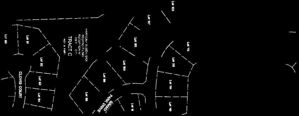
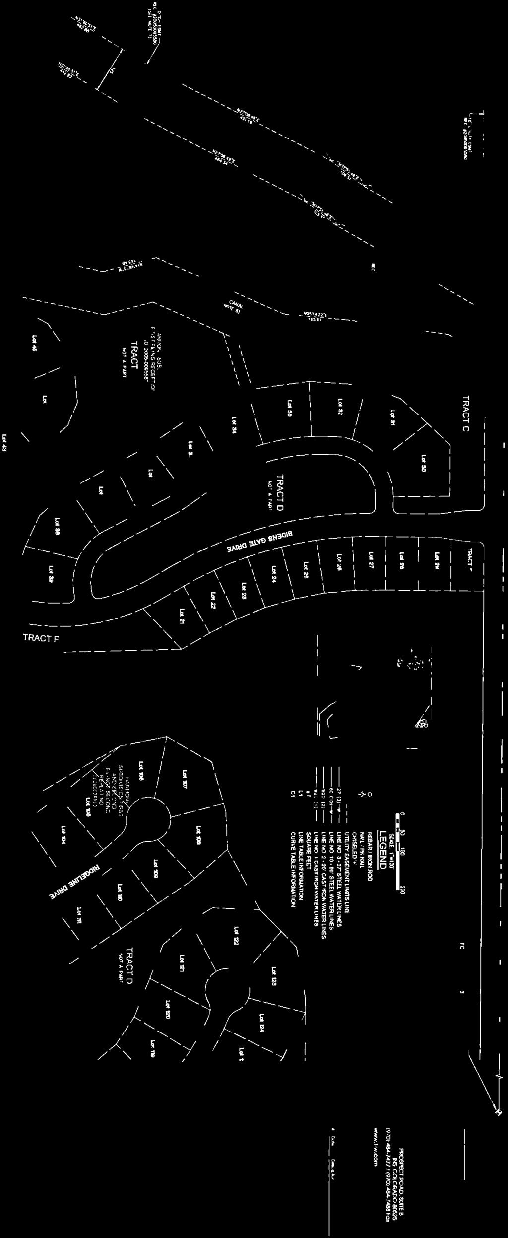
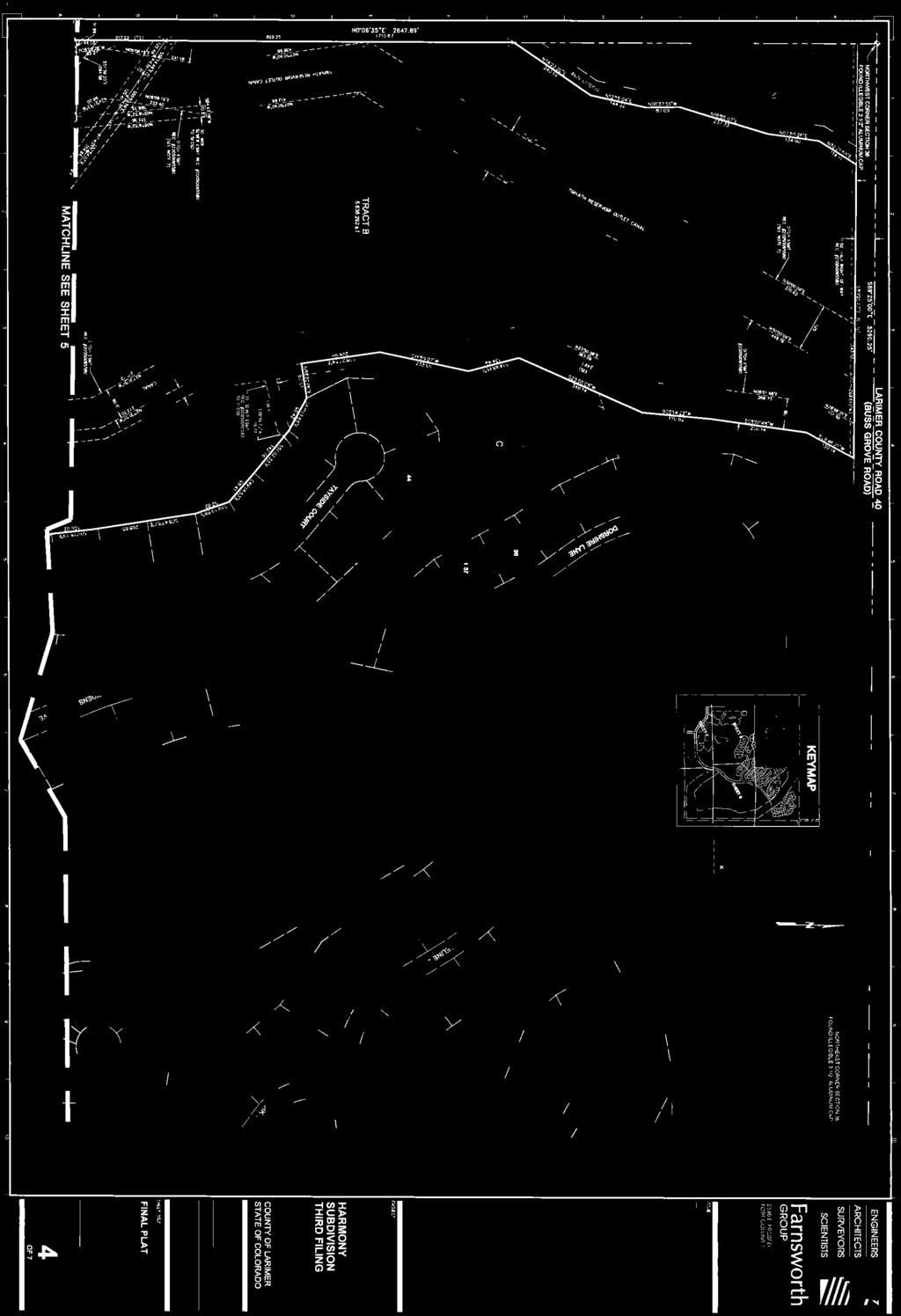
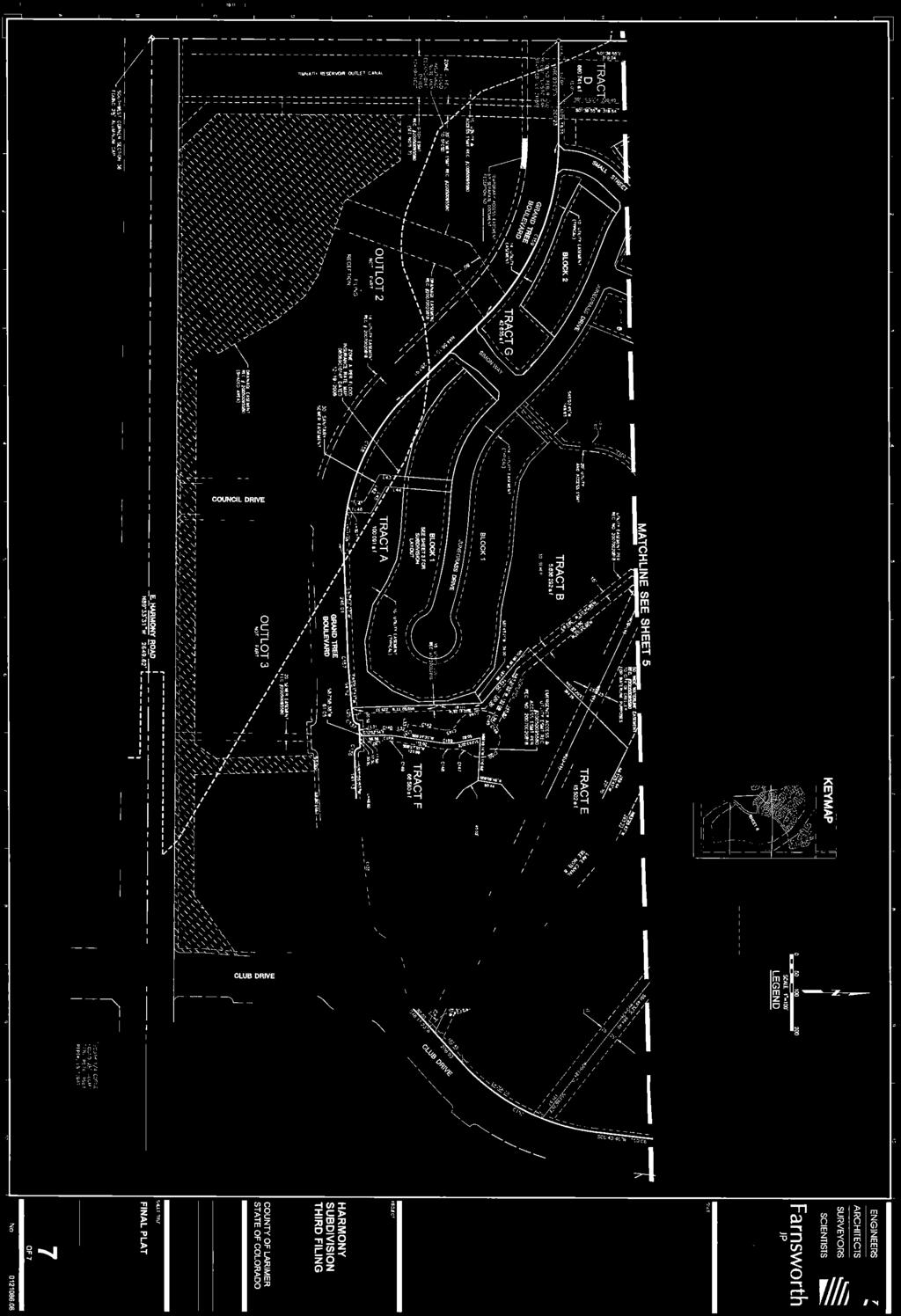
2 Existing Zoning: R-E and MU Districts Proposed Zoning: R-E and MU Districts with a PD Overlay with a PD Overlay Existing Land Use: Single-Family Proposed Land Use: unchanged Residential, Mixed-Use and Golf Course SERVICES: Water: Sewer: Fire: Special Districts: Fort Collins Loveland Water District South Fort Collins Sanitation District Poudre Fire Authority Within Timnath Development Authority Boundaries Adjacent Zoning/Land Uses: Direction Zoning Land Use North FA-1 (County) District Farming South C-2 Community Commercial, MU Vacant/Farming Mixed Use and FA-1 (County) East RMU Residential Mixed-use District Vacant/Farming (Town of Windsor) West MU Mixed Use, R-2 Single Family Residential, and R-E Estate Residential Districts Vacant/Farming Application Description: History: The 642-acre Harmony Subdivision was originally annexed to the Town of Timnath in 2004 as the Nelson Property. The parcel was originally zoned R-E Estate Residential with a Planned Development Overlay and MU Mixed Use. The Preliminary Plat was approved for a total of 515 single-family lots, an 18-hole golf course, and mixed-use tracts. The First Filing Final Plat was approved in June, 2005 with a total of 73 single-family lots. At that time a PD Overlay Amendment was also approved allowing specific exceptions to lot sizes and setbacks for the lots associated with the First Filing. The Second Filing Final Plat was approved in April, 2006 with a total of 121 single-family lots. At that time the PD Overlay was amended to allow specific exceptions to the setbacks related to the second filing lots. In October, 2006 an additional amendment to the PD Overlay Zoning was approved to allow a maximum lot coverage of 35%. In June, 2007 the PD Overlay Zoning was amended to allow additional exceptions to the setbacks and lot coverage for the first and second filing lots. Proposed Actions: The applicant is proposing a final plat of the area indicated by the above legal description, generally located in the southeast corner of the Harmony Subdivision, on the north side of Grand Tree Boulevard. This final plat is the third filing within the Harmony Subdivision and includes 97 single-family residential lots, the smallest lot is 7,040 square feet and the largest lot is 35,208 square feet. Harmony Subdivision Preliminary Plat Amendment (PP ) 2 of 4
3 The two Mixed-Use lots are Tracts E (3.34 acres) and F (1.53 acres) and currently are the locations of the existing maintenance facility and sales office for the Harmony Subdivision respectively. The rezoning application that is being processed concurrently redefines the zoning boundary to align the Mixed-Use Zone district with the boundaries of these two tracts as was originally intended. Outlot 1 (8.25 acres) is also being platted with this filing to define the lot for the future club house/recreation center. Tracts A, C, D, and G (20.23 total acres) are all common open space associated with the residential portion of the project and will be maintained by Harmony, LLC. Tract B ( acres) is associated with the Golf Course and is privately owned and maintained by Harmony, LLC. Land Use: This Final Plat application has been reviewed against the Timnath Land Use Codes and Timnath Comprehensive Plan to ensure conformity. Upon completion of this review, staff has determined that all necessary elements of the Land Use Code have been adequately addressed for this application. Future Approvals/Processes: We are concurrently processing the review of Zoning Map Amendments, PD Overlay Zoning Amendments, and Preliminary Plat Amendments for all of Harmony Subdivision as well as a Final Plat application for the Harmony 4 th Filing. Exhibits associated with the Harmony Subdivision 3 rd Filing will be appended to the currently approved Subdivision Improvements Agreement for all of Harmony Subdivision and will be recorded with Larimer County. Review Criteria/Recommendation: This application was submitted as a complete and comprehensive application and adequately addressed all elements required to proceed with the approval process. Upon review of this application by all referral agencies and applicable ordinances, regulations, standards, criteria, and policies, all criteria set forth in Section C of the Timnath Land Use Code (Tab 8, Final Plat Evaluation Forms, of the Planning Commission Manual) have been met and staff recommends approval. Final Plat Review Criteria. In addition to all provisions of this Code, the Town shall use the following criteria to evaluate the applicant s final plat application: 1. The final plat conforms to the approved preliminary plat and incorporates required changes, modifications and conditions attached to the approval of the preliminary plat unless otherwise approved by the Board. This final plat is in conformance with the proposed Preliminary Plat Amendments being concurrently processed with this application. 2. The development will substantially comply with this Code. This development substantially complies with the Town of Timnath Municipal Code. 3. All applicable technical standards have been met. (Ord ; Ord ; Ord ) There are still minor technical comments that need to be addressed (see attached). Harmony Subdivision Preliminary Plat Amendment (PP ) 3 of 4
4 Referral Comments: Not Returned: Timnath Finance Department, Poudre River Public Library District, Poudre School District, Qwest Communication, Timnath Attorney, Timnath Public Works, Xcel Energy Returned with No Comments: Poudre Fire Authority, Timnath Police Department, Safebuilt, ComCast, AT&T Communication, Timnath Planning, City of Greeley Water. Returned with Comments: Timnath Engineering (TST), Fort Collins Loveland Water District, South Fort Collins Sanitation District (see attached). ATTACHMENTS: 1. Harmony Subdivision 3 rd Submittal Comments 2. Final Plat of Harmony Subdivision Third Filing 3. Harmony Subdivision General Development Information RECOMMENDED MOTION Final Plat Finding that a complete application was submitted and reviewed in accordance with all applicable Town regulations, the application conforms with the mission and goals of the Timnath Comprehensive Plan, and all criteria outlined in Section C of the Timnath Municipal Code have been met, I move to recommend approval of the Final Plat of Harmony Subdivision Third Filing as presented in the Planning Commission Communication to the Timnath Town Council with the following conditions: 1. The applicant address all unresolved technical comments as outlined in the attached Harmony Subdivision 3 rd Submittal Comments to the satisfaction of the Town Staff and Referral Agencies prior to recording the Final Plat, and; 2. The appropriate exhibits be appended to the approved Subdivision Improvements Agreement prior to recording the Final Plat, and; 3. That Ordinance No. 7, Series 2013, an Ordinance regarding the Harmony Subdivision Zoning Map Amendments and Planned Development Overlay Amendments is approved by the Timnath Town Council prior to Final Plat approval, and; 4. That Resolution No. 7, Series 2013 a Resolution regarding the Harmony Subdivision Preliminary Plat Amendments is approved by Town Council prior to Final Plat approval. Harmony Subdivision Preliminary Plat Amendment (PP ) 4 of 4
 DATE: Thursday May 2, 2013 The following represents the 3rd review of the above application by Staff and the affected referral agencies.")
5 MEMORANDUM TO: FROM: RE: Mark Tingey, Harmony, LLC (via e mail) Matt Blakely, Town Planner 3rd Submittal Comments for Harmony Subdivision 3 rd Filing Final Plat, PD Overlay Amendment, and Preliminary Plat Amendment (FP , PP , RZ ) DATE: Thursday May 2, 2013 The following represents the 3rd review of the above application by Staff and the affected referral agencies. The included comments are from all of the agencies that have provided comments. Please provide a point by point response to each of the following comments along with the original comment in a resubmittal to the Town. The following items must be addressed by the applicant: Town Planner, Matt Blakely (970) x19 PD Overlay All comments have been addressed to the Town s satisfaction. Preliminary Plat All comments have been addressed to the Town s satisfaction. Zoning Map All comments have been addressed to the Town s satisfaction. Final Plat All comments have been addressed to the Town s satisfaction. Landscape Plan Comments All comments have been addressed to the Town s satisfaction. Engineering, Steve Humann, TST Inc. (970) All comments removed have been addressed to the Town s satisfaction. Remaining comments are listed below: 1. Traffic impact Study No Comments 2. Geotechnical Report No Comments 3. Drainage Study No Comments 4. Preliminary Plat All comments have been addressed. 5. Final Plat All comments have been addressed. 6. Construction Plans a. Street names Addressed b. Notes Addressed Phone: (970) FAX: (970) Goodman St. Timnath, CO 80547
6 c. Storm Sewer Addressed d. Street Design Intersection grading and spot elevations addressed BUT the intersection design at each end of Small Street (Sheets C20, C21, and C25A) still does not drain correctly. e. Detail Sheets Addressed Additional Referral Agency Comments: In addition to these comments, please find the attached comments from: Fort Collins Loveland Water District/South Fort Collins Sanitation District comments are attached. Documents Required for Resubmittal: PDF Revised Construction Drawings (PICPs) PDF Written Response to Comments Note: You have been scheduled for a Public Hearing before the Town s Planning Commission on May 8th, 2013 at 7pm at the Town Administration Building. We have received the colored renderings and we will have them available for the meeting. It is important that a representative of this project be present at this meeting to present the project to the Planning Commission and answer any questions they may have. Please contact me at (970) or mblakely@timnathgov.com if you would like to schedule a comment review meeting and/or if you would like to schedule the Planning Commission Public Hearing. Cc: Byron Collins, Harmony, LLC ( ) Tom Dugan, Pinecrest ( ) Steve Humann, TST Inc. ( ) Don Taranto, TST Inc. ( ) April Getchius, Town Manager ( ) Town File (HMYS) Page 2 of 2
 AKA Timnath")

7 FORT COLLINS LOVELAND WATER DISTRICT SOUTH FORT COLLINS SANITATION DISTRICT April 29, 2013 Mr. Matt Blakely, Town Planner Town of Timnath 4800 Goodman Street Timnath, CO RE: Harmony Subdivision Amended Preliminary Plat Final Plat Filing 3, Rezoning (PD Overlay Amendment) AKA Timnath South 3 rd Filing, Third Submittal Dear Mr. Blakely, The Fort Collins - Loveland Water District and the South Fort Collins Sanitation District have reviewed the above mentioned project and submit the following comments. The length of the vertical water line deflection needs to be identified, show the beginning and ending stations of the deflection. All inverts of the existing connection manholes 5 on sheet C12 needs to be identified. The water line crossing in the storm sewer profiles are shown 10 feet deep. This is contrary to District requirements. Is it possible to re-route the waterline to the south of the box culvert to avoid the excessive depth? The detail sheet CD2 for the 8 inch water line crossing at the 4 x 8 box culvert was not provided for review. A water line valve is to be added to the 60 feet west of the elliptical RCP. The casing pipe needs to be shown on the water plans. The proposed ditch across the District s easement south of Storm Drain 9 restricts access for maintenance. Identify how this issue will be addressed. I am concerned that the water distribution looping is inadequate from the proposed connection in Grand Tree Boulevard to Simon Way. There would be approximately 87 homes out of water because it is a sole source water feed to Filing 3 until the development to the west connects into Grand Tree. Further, there does not appear to be adequate fire flow if the water line in Grand Tree was disrupted between Simon Way and Small Street. The Districts will require another review due to the nature of the above comments. Please do not hesitate to contact me at , extension 104, if you have any questions or require additional information. Respectfully, Mr. Terry W. Farrill, P.E. District Engineer xc: Mr. Michael D. DiTullio, District Manager Mr. Byron Collins 5150 Snead Drive, Fort Collins, CO Phone (970) Fax (970)

8
9
10

11


12


13
14
15 Harmony Subdivision General Development Information Town of Timnath, Colorado Rezoning and PD Overlay Amendment Preliminary Plat Amendment Third Filing Final Plat January 22, 2013 Revised: March 15, 2013 Harmony, LLC Timnath, Colorado
16 Project Overview The Harmony Subdivision is a mixed-use master planned community consisting of a mix of land uses including large lot single family detached homes as well as lifestyle homes and a mixeduse neighborhood center as well as a world class golf course. The property was annexed into the Town of Timnath in December of 2004 and zoned R-E (Estate Residential) and MU (Mixed Use) with a PD Overlay District at the time of annexation. A Preliminary Plat was approved at the time of annexation and zoning allowing for a total of 515 residential units on approximately 642 acres for a density of 0.80 residential units per acre. The First and Second filings have been platted and developed with 72 single-family lots in the First Filing and 132 single-family lots and two large acreage estate lots in the Second Filing (a total of 206 existing developed lots). Note that the First Filing was originally platted with 73 single family lots but Lots 1 and 2 were later replatted into one larger lot eliminating one platted lot leaving a total of 72 lots in the First Filing. 112 homes are built and occupied or under construction within these first two filings. With this submittal to the Town of Timnath, the applicant, Harmony, LLC, is requesting the following: 1. An amendment to a portion of the existing Zoning Map and an amendment to the existing PD Overlay exceptions to allow for additional exceptions for the Third and all future filings. 2. An amendment to the approved Preliminary Plat to update and revise the approved plan for modifications to the street and lot layouts for the Third and future filings, and 3. Review and approval of the Third Filing Final Plat. Property Owners/Applicant/Consultants Property Ownership Information Please see Ownership Portion of the Title Commitment, submitted with this application Property Owners Harmony, LLC Paragon Investment Group, LLC Mr. Byron Collins and Mr. Mark Tingey Mr. Byron Collins 6432 Grand Tree Blvd Grand Tree Blvd. Timnath, CO Timnath, CO (970) Fax: (970) (970) Fax: (970) mtingey@comcast.net byroncollins@comcast.net byroncollins@comcast.net Harmony Club, LLC Mr. Rodney Nelson Mr. Byron Collins WCR Grand Tree Blvd. Eaton, CO
17 Timnath, CO (970) Fax: (970) Applicant/Developer Harmony, LLC c/o Mr. Byron Collins and Mr. Mark Tingey 6432 Grand Tree Blvd. Timnath, CO (970) Fax: (970) Planning Consultant Civil Engineer and Surveyor PineCrest Planning & Design LLC Farnsworth Group Mr. Tom Dugan Mr. Brian Zick & Mr. JC Cundall 4225 Westshore Way 2310 East Prospect Fort Collins, CO Fort Collins, CO (970) Fax: (970) (970) Fax: (970) Transportation Engineer Landscape Designer Mr. Matt Delich Mr. John Gettman Traffic & Transportation Engineering Centennial Design LLC 2722 Glen Haven Drive 601 S. 9 th Street Loveland, CO Berthoud, CO (970) Fax: (970) (970) matt@delichassoc.com centennialdesign@hotmail.com Mineral Right Owners and Lessees (Mineral Estate) State of Colorado Land Board Mr. T.J. Kelly, Mineral Leasing Agent 1127 Sherman Street, Suite 300 Denver, Co For the following parcel of land: N ½ and SE ¼ of Sec 36, Township 7 North, Range 68 West of the Sixth Principal Meridian, Town of Timnath, County of Larimer, State of Colorado Harmony, LLC c/o Mr. Byron Collins and Mr. Mark Tingey 6432 Grand Tree Blvd. Timnath, CO (970) Fax: (970)
18 For the following parcel of land: SW ¼ of Sec 36, Township 7 North, Range 68 West of the Sixth Principal Meridian, Town of Timnath, County of Larimer, State of Colorado Surrounding and Interested Property Ownership Report The required Surrounding and Interested Property Ownership Report as well as the required Public Hearing Notification Envelopes will be submitted after the first review by the Town staff as requested by the Town Planner. Ditch Companies Lake Canal Reservoir Company Cache La Poudre Reservoir Co. Mr. Rodney Nelson, President Mr. Dale Towbridge, Manager 6312 E. Harmony Road P.O. Box 104 Fort Collins, CO Lucerne CO (970) (970) Application Fees The Signed Fee Agreement is included with this submittal as well as the following application fees: 1. Fee Agreement: $10, PD Overlay Amendment Application Fee: $ Preliminary Plat Amendment Application Fee: $3, ($ $10/lot over 25 lots) (278 lots) 4. Final Plat Application Fee: $ Poudre Fire Authority Review Fee: $ Legal Description A TRACT OF LAND BEING OUTLOT 1, OUTLOT 5, SIMON COURT AND TRACT G, HARMONY SUBDIVISION SECOND FILING AND TRACT B, HARMONY SUBDIVISION FIRST AND SECOND FILINGS SECOND REPLAT LOCATED IN SECTION 36, TOWNSHIP 7 NORTH, RANGE 68 WEST OF THE SIXTH PRINCIPAL MERIDIAN, TOWN OF TIMNATH, COUNTY OF LARIMER, STATE OF COLORADO. REZONING and PD OVERLAY AMENDMENT - EXCEPTIONS Harmony was annexed into the Town of Timnath in December 2004 prior to the Town s adoption of any formal codes and anomalies exist between the current development within Harmony and the Town s current Land Use Code and design standards. As stated in the Amended and Restated Annexation and Development Agreement (item 23F under Vested Property Rights) the Town and Property Owner/Developer acknowledge that there are various irregularities and non-conforming residential improvements now existing on the Property such 4
19 as, but not limited to, front yard courtyard walls, auto courtyards with courtyard walls, lot coverage percentages, side yard setbacks, front loading garages, large acreage estate lots, and the like. The irregularities and non-conforming residential improvements within the Property were accepted and approved by the Town at the time of the Agreement. Also, as stated in the Agreement, the Town shall not deny building permits for residential improvements within the Property in the future solely based upon similar non-conforming aesthetic irregularities so long as such irregularities: (i) do not adversely impact public health and safety, (ii) are reasonably harmonious with the existing residential improvements within the Property, and (iii) are approved by the Design Review Committee of the homeowners association for the Property. It is the overall intent of this PD Overlay Amendment to carry forward with these same design standards throughout the balance of the Harmony neighborhood as the previous filings were permitted. The Harmony Subdivision is zoned R-E (Estate Residential) and MU (Mixed Use) allowing a variety of residential, commercial and business uses as well as a world class golf club and course with a Planned Development (PD) Overlay District overlaying the entire property. The current boundary between the R-E Zone District and the MU Zone District divides the Third Filing single family lots and at the recommendation of Town staff, the applicant is proposing to rezone the single family portion of the Third Filing to R-E so that all of the single family residential lots within the Third Filing are in the same zoning district (the R-E Zone District). The boundary of the MU Zone District is shifted south and includes the entire portions of Tract E and F of the Third Filing. The intent and purpose of the PD Overlay District is to permit and encourage innovative design and high quality, master-planned developments on large parcels of land. The PD Overlay District is also intended to permit greater flexibility in the application of zoning and development standards and greater freedom in providing a mix of land uses in the development of a balanced community. The PD Overlay District allows the Harmony Subdivision to preserve critical environmental resources, provide vast amounts of open space and recreational amenities, include exceptional design, and provide greater efficiencies in the layout and provision of roads, utilities and other infrastructure. With the approval of the First and Second Filings of the Harmony Subdivision, zoning exceptions have been approved for the PD Overlay District. These exceptions to the standard R- E zone district allowed for a smaller minimum lot size, a reduced minimum front, rear, and side yard setbacks, and a reduced minimum distance between buildings as well as an exception to the lot coverage ratio based on the type of home product. As approved by the Town Council, many of these exceptions apply to the entire project including the Third, Fourth, and all future filings. This current submittal requests that additional specific exceptions be applied to the Third Filing, Fourth Filing, and all future filings whose lots have or will be platted for which specific exceptions can be determined. Included in this exception would be identifying the lot coverage ratio for each phase. 5
20 Subdivision Regulation Exceptions (in addition to the previously approved PD Overlay Exceptions) Zoning, Land Use and Design Standards that the Third and Fourth Filings as well as all future filings vary from are listed below: 3 rd Filing 4 th Filing and R-E Zone PD Exceptions Future Filing PD Exceptions Minimum Lot Area: 1 acre 0.16 acre 0.21 acre Minimum Lot Width at House Setback from ROW: 140 feet 60 feet 60 feet Minimum Distance Between Buildings: 40 feet 10 feet 10 feet Street Continuity Max. (Town Standard): 660 feet 850 feet 1,200 feet Lot Coverage. Lot Coverage is defined as the ratio between the lot area located under a solid roof and the entire lot area. Lifestyle home lots, defined as any lot that is part of an enclave with a separate Home Owner s Association (HOA) responsible for commonly maintained but individually owned areas of each lot (i.e. maintenance-free), will have a maximum lot coverage of 60%. A maximum lot coverage of 50% applies to all single-family estate lots for the Harmony PD. The following table provides a listing of which lots are lifestyle home lots, with a maximum 60% lot coverage and which are single-family estate lots, with a maximum 50% lot coverage for the Third, Fourth and any future filings. Harmony Lot Coverage Table; Third, Fourth and any Future Single-Family Residential Filings. Third Filing PD Exceptions Fourth and all Future Filing PD Exceptions Single-Family Estate Lots All Lots Lifestyle Home Lots All Lots Maximum Lot Coverage 60% 50% Block Diversity and Garage Orientation /Placement Standards Harmony by virtue of the neighborhood being a custom home community, shall be exempt from the Land Use Code requirements in Section C.6 for garage orientation and placement standards and Section D requiring a block diversity plan. This exception shall apply to all development within the Harmony Subdivision. Street Continuity. Street Continuity is defined in the Larimer County Urban Area Street Standards as the continuous length of a roadway segment that is uninterrupted by 90 degree turns or controlled intersections. The adopted Town standard is a maximum of 660 between intersections. Due to the topographic features of the site as well as the open space features and to help provide for greater efficiencies in the design of the neighborhoods, street lengths in excess of the 660 standard are being requested. Note that the Preliminary Plat that was approved by the Town in 2004 has numerous streets that exceed this standard. 6
21 A safety concern is typically associated with the longer distance between streets with the possibility of traffic cutting through neighborhoods without any traffic calming devices in place. The street and lot layouts of the proposed neighborhoods discourage and in some cases eliminate the possibility of this concern and stop signs will be placed at all intersections that exceed the 660 standard to slow and stop traffic as it moves through the neighborhood. Residential Lot Access to Adjacent Street. Harmony by virtue of the neighborhood being a custom home community, shall be exempt from the Land Use Code requirements in Section B.2 which requires a no greater than 20 feet in width. The maximum driveway width for the Harmony Subdivision shall be no greater than 30 feet in width. This exception shall apply to all development within the Harmony Subdivision. Justification and Benefits Provided. The Town of Timnath Land Use Code provides for the PD Overlay Zone District to permit and encourage innovative design and high quality, master-planned developments on large parcels of land. The PD Overlay District is also intended to permit greater flexibility in the application of zoning and development standards and greater freedom in providing a mix of land uses in the development of a balanced community. Harmony provides a high quality master-planned community, offering a unique lifestyle to its residents. Some of the unique features include low densities, a future mixed-use component, a championship golf course and club house, significant topographic variety, and large amounts of open space. In order to take advantage of the approximately 57% of the site which is open space, lots are clustered and reduced in size from codified one acre lots as defined in typical R-E zoning. Although Harmony varies from the underlying strict R-E zoning standards, the PD Overlay District allows Harmony to provide a model example for the Timnath Land Use Plan goals for the area. The PD Overlay District exceptions that allow the Harmony development reductions in setbacks and lot sizes, the lot coverage maximums as well as the increase in the street continuity are all land planning features that have made Harmony the premier neighborhood and community in Northern Colorado. Noted benefits include: - Harmony has a very low density with less than 1 dwelling unit per acre. This has been a constant from the very first planning stages and is consistent with the underlying R-E zoning. - With the golf course and open space tracts, there are vast amounts of open space. The lots have been clustered and the streets have been designed to blend in with the natural characteristics of the land. This community is an excellent example of utilization of site topography, natural features and vegetation. The street and lot layouts are designed to enhance and compliment the landform, with walkouts and exceptional views of the Front Range. - Every lot backs to open space and/or the golf course and in some cases both. Visually the overall effect is a very open neighborhood even with the reduced setbacks and proposed increases in lot coverage. - The Harmony development has strict architectural control and site design covenants developed to maintain the intent and design of the community. These covenants dictate architectural control while still providing the most flexibility to the homeowner. Homes within Harmony incorporate a variety of covered outdoor living spaces, entry features, 7
22 patios and oversized garages. These elements enhance the livability of the home while maintaining significant visual interest as viewed from the street but increased the overall roofed square footage resulting in a higher lot coverage percentage. Compliance with the Town Municipal Code The applicant believes that the proposed exceptions to the PD Overlay District meet the intent of the Town of Timnath s Land Use Code for the following reasons: A. Promotes a compact, well-defined, sustainable neighborhood that enhances the Town s character. B. Creates livable neighborhoods that foster a sense of community. C. Provides for innovative, quality site design, architecture and landscaping. D. Encourages the proper arrangement of streets in relation to existing and planned streets and ensuring streets facilitate safe, efficient and pleasant walking, biking and driving. E. Provides for a variety of sizes and housing types. PRELIMINARY PLAT AMENDMENT The Preliminary Plat for the Harmony Subdivision was approved for the 642 acre site by the Town of Timnath in December This approved Preliminary Plat allowed for a total of 515 single family residential lots with an overall density of 0.80 units per acre as well as mixed use residential, commercial and business uses. The First and Second filings have been platted and developed with 72 single-family lots in the First Filing (note that the original First Filing was platted with 73 lots but Lots 1 and 2 were later combined in a replat) and 132 single-family lots and two large acreage estate lots in the Second Filing (a total of 206 existing developed lots). 112 homes are built and occupied or under construction within these first two filings. This amendment request to the Preliminary Plat is for unplatted areas within the Harmony Subdivision, specifically the area to the east of Club Drive and the area west of the maintenance facility in the southwest portion of the development, north of Grand Tree Blvd. With this amendment, the applicant is requesting the approval to make revisions to the street and lot layouts without exceeding the total number of lots or overall density permitted by the existing approved Preliminary Plat and zoning. Legal Description (for Amended Portions of the Preliminary Plat) A TRACT OF LAND BEING OUTLOT 1, OUTLOT 5, SIMON COURT AND TRACT G, HARMONY SUBDIVISION SECOND FILING AND TRACT B, HARMONY SUBDIVISION FIRST AND SECOND FILINGS SECOND REPLAT LOCATED IN SECTION 36, TOWNSHIP 7 NORTH, RANGE 68 WEST OF THE SIXTH PRINCIPAL MERIDIAN, TOWN OF TIMNATH, COUNTY OF LARIMER, STATE OF COLORADO. 8
23 Land Use Summary Existing Zoning R-E Estate Residential District and MU Mixed Use District with PD Overlay as amended. Land Use Acreage No. of Units % of Total Residential Mixed Use Open Space/Neighborhood Parks Golf Course/Open Space TOTAL % Compliance with the Town Municipal Code The applicant believes that the proposed revisions to the approved Preliminary Plat meet the intent of the Town of Timnath s Land Use Code for the following reasons: 1. By allowing the revisions to the Preliminary Plat to proceed, the applicant believes it has met the intent of the Land Use Code by: A. Promoting compact, well-defined, sustainable neighborhoods that enhance the Town s character. B. Creates livable neighborhoods that foster a sense of community. C. Encouraging the proper arrangement of streets in relation to existing or planed streets and ensuring streets facilitate safe, efficient and pleasant walking, biking and driving. D. Providing a variety of lot sizes and housing types. E. Provides for innovative, quality site design, architecture and landscaping. F. Encourages the proper arrangement of streets in relation to existing and planned streets and ensuring streets facilitate safe, efficient and pleasant walking, biking and driving. G. Provides for a variety of sizes and housing types. H. Provides open spaces for adequate storm water management. I. Ensuring compliance with the Code and Town Comprehensive Plan. Compliance with the Town Comprehensive Plan The applicant believes that the proposed revisions to the approved Preliminary Plat meet the intent of the Town of Timnath s Comprehensive Plan per the June 2007 update for the following reasons: 1. By allowing the revised Preliminary Plat to proceed as proposed, the applicant believes it has met the following Community Goals provisions as stated in the Comprehensive Plan: A. Growth Management (GM) GM Goal 1 Development occurring within or around Timnath will preserve and enhance the small town qualities and characteristics of the town. GM Goal 3 Require construction of adequate public facilities and infrastructure as new development occurs. 9
24 GM Goal 4 Development in Timnath will pay its own way with regard to infrastructure improvements and services needed to support growth. GM Goal 5 Ensure that growth occurs in a logical and connected pattern. GM Goal 7 Balance the staging and land use mix of residential, commercial and employment land uses in planned developments to ensure that residents needs are met and the Town s fiscal and economic health is safeguarded. B. Land Use (LU) LU Goal 2 Ensure an appropriate mix of housing types and densities in order to preserve the existing small town character. LU Goal 3 Include a mixed use, commercial, and industrial districts that provide jobs and services to both local and regional citizens, and revenue to the town. LU Goal 4 Foster the small town character of Timnath through well-designed growth and preservation of open space buffers within the GMA area. C. Community Image and Design (CID) CID Goal 1 New development and redevelopment in the Town of Timnath will seek to preserve and enhance the town s existing small town character, form, and charm. CID Goal 6 Require exceptional and well-planned site and landscape design in residential and commercial areas, including elements such as: large, contiguous open spaces; meaningful setbacks from major roadways or open corridors; tree lined streets; appropriate design and scale signage; preservation of stands of healthy trees. D. Community Facilities and Services (CFS) CFS Goal 1 Ensure that services and infrastructure are provided to citizens in a cost-effective manner. CFS Goal 2 Work with service providers that offer facilities and services such as potable water, sanitary sewer, schools, libraries, police and public safety to the Town. GFS Goal 3 - Infrastructure that accompanies new development, or is implemented in the existing town must be state of the art yet maintain the small town character. GFS Goal 4 Timnath should be a pedestrian and bicycle-friendly community. Off-street bike and pedestrian trails, bike lanes along heavily traveled roads, and sidewalks along urban streets should be provided throughout the community. GFS Goal 6 Ensure that mechanisms are provided for maintenance of infrastructure constructed or required to serve newly annexed and developing areas, including streets. E. Recreation and Open Space (ROS) ROS Goal 1 Provide a balanced and connected system of recreation facilities, parks and open space that builds on the assets of Town. ROS Goal 5 Develop a connective system of trails and greenways that provide opportunities for pedestrian, bicycle and equestrian recreation. F. Environmental (ENV) ENV Goal 1 Grow in a manner that will complement the natural characteristics of the area, including such elements as climate, topography, vegetation, waterways, groundwater, and wildlife. 10
25 ENV Goal 4 Provide and preserve existing healthy trees of desirable species, whenever possible. ENV Goal 5 Protect water resources in line with all applicable State of Colorado statues. 2. By allowing the amendments to the Preliminary Plat to proceed as proposed the applicant believes it has met the following Growth Management (GM) principles and policies as stated in the Comprehensive Plan: A. GM Principle 1 GM Policy 1.1 The town will establish a Growth Management Area (GMA) for the Town of Timnath that will contain the Town s planned and desired growth over the next years. The Timnath GMA is delineated on the Land Use map. The Growth Management Area is intended to depict appropriate locations of future urbanlevel development around Timnath. Urban-level development is defined as an average density of at least 2 housing units per acre, with existing or planned availability of public water and public sanitary sewer. A lower average density may occur in areas that serve as a buffer on the periphery of the GMA. GM Policy 1.2 Adopt and implement the Timnath Comprehensive Plan establishing the preferred pattern of growth for Timnath and surrounding areas. GM Policy 1.7 The Plan identifies areas within the GMA that are suitable for development, and the general land uses and type of development that the town envisions. The plan also identifies general areas that should remain as open space to serve areas of recreation, buffers, and gateways to the community. The relationships between all of the various components are depicted in the Land Use Plan as a general guide for development of the area. B. GM Principle 2 GM Policy 2.3 Encourage clustered development and other innovative development strategies within areas designated for residential. C. GM Principle 4 GM Policy 4.1 Encourage development only where it can be adequately served by critical public facilities and services such as water, sewer, transportation, schools, fire and emergency services, and parks. GM Policy 4.2 Create a fee structure for development in Timnath that provides the appropriate level of funding for services that are required by new development, including cooperation with Larimer County, the City of Fort Collins, the Town of Windsor and other jurisdictions that levy fees for development impacts. This shall include mechanism for funding of operation and maintenance of facilities and services that are required to serve new development areas. 3. By allowing the revisions to the Preliminary Plat to proceed as proposed the applicant believes it has met the following Land Use (LU) principles and policies as stated in the Comprehensive Plan: A. Land Use Principle 3 LU Policy 3.3 Provide opportunities for urban density residential development in the low-density residential area that is similar or lower than the density in Downtown Core. Low-density residential areas will serve as transition areas between residential areas and County Density residential areas. Development of these areas will promote 11
26 connectivity between neighborhoods and maintain the small town character, through the use of linkages such as streets, trails, and open space. 4. By allowing the revisions to the Preliminary Plat to proceed as proposed the applicant believes it has met the following Community Image and Design (CID) principles and policies as stated in the Comprehensive Plan: A. CID Principle 1 CID Policy 1.2 Assign a zone district to annexed land that is based upon the Comprehensive Land Use Plan. Each zoning district in Timnath will have its own set of standards and regulations that apply to all new development and redevelopment. The depth and detail of each district s standards will vary depending on what is determined appropriate to preserve and enhance Timnath s small town character. The standards and regulations will provide specific direction to landowners regarding the type and intensity of development permitted and how development needs to occur. Site planning, architecture, lighting, and signage will be regulated in order to achieve the intended character for the area, per the Comprehensive Plan. CID Policy 1.5 Require appropriate streetscape design on new or redeveloped roads, including the provision of street trees and sidewalks. 5. By allowing the revisions to the Preliminary Plat to proceed as proposed the applicant believes it has met the following Economy (EC) principles and policies as stated in the Comprehensive Plan: A. EC Principle 1 EC Policy 1.1 Provide an adequate supply of land suitable for commercial and employment development at key locations along Harmony Road/County Road 38, Mulberry Road/Hwy 14, and throughout the GMA area. EC Policy 1.2 Encourage a mix of commercial uses in appropriate areas of the GMA as indicated on the Future Land Use Map. For example, small retail, offices, sit-down restaurants, and entertainment venues may be the most appropriate in the Downtown Core, while more regional-type commercial (lodging, chain-style restaurants, and gas stations) may be appropriate at the Harmony Road/I-25 interchange. The Harmony Road/County Road 38, Mulberry Road/Hwy 14 corridors are desirable locations for a variety of commercial, business, light industrial, and office uses. 6. By allowing the revisions to the Preliminary Plat to proceed as proposed the applicant believes it has met the following Transportation (TR) principles and policies as stated in the Comprehensive Plan: A. TR Principle 2 TR Policy 2.1 Develop and incorporate a system of bicycle lanes and trails that connect to the Downtown Core and other activity centers and neighborhoods into the design of streets and developments in Timnath. The bicycle lanes will be consistent throughout the town and continuous when possible. TR Policy 2.3 Incorporate pedestrian sidewalks and connections that accommodate and encourage pedestrian activity into new development and street construction projects. 12
27 7. By allowing the revisions to the Preliminary Plat to proceed as proposed the applicant believes it has met the following Community Facilities and Services (CFS) principles and policies as stated in the Comprehensive Plan: A. CFS Principle 1 CFS Policy 1.3 Require developers to pay for all infrastructure improvements required for new development. 8. By allowing the revisions to the Preliminary Plat to proceed as proposed the applicant believes it has met the following Recreation and Open Space (ROS) principles and policies as stated in the Comprehensive Plan: A. ROS Principle 2 ROS Policy 2.1 Preserve an extensive open space network to retain the natural setting that exists within the GMA, to buffer the town from surrounding communities, and to provide recreational opportunities for residents. 9. By allowing the revisions to the Preliminary Plat to proceed as proposed the applicant believes it has met the following Environment (ENV) principles and policies as stated in the Comprehensive Plan: A. ENV Principle 1 ENV Policy 1.1 Preserve important visual features of the landscape and encourage the use of indigenous vegetation within new developments or redevelopment through the use of appropriate design and land use regulations. In summary, the applicant believes that the proposed preliminary plat revisions and development are in substantial conformance with the Town s Municipal Code (Land Use Code) and Comprehensive Plan. While not meeting all of the principles and policies of the plan, the majority as related to the project are met or exceeded. This Preliminary Plat Amendment request will help the Town meet many of its goals and assist the Town in providing a mix of different residential housing types while preserving open space corridors throughout the site. HARMONY SUBDIVISION THIRD FILING FINAL PLAT This Third Filing of the Harmony Subdivision is located within the southwest portion of the Harmony development and is approximately 188 acres in size. There are 97 residential lots, two mixed use tracts (the existing maintenance facility-tract E and the Harmony Center building Tract F), acres of privately owned neighborhood parks and common open space, acres of golf course/open space, and one outlot (future clubhouse/recreation center-outlot 1) totaling 8.25 acres. The overall gross density is 0.52 residential units per acre. The proposed homes in this phase will be considered Lifestyle Homes in which the Homeowners Association (HOA) will be responsible for maintaining all of the common open space areas as well as the individually owned areas within each lot. Consistency with Approved Preliminary Plat This Third Filing of the Harmony Subdivision will be in general conformance with the amended Preliminary Plat as submitted with this application. 13
28 Protective Covenants, Home Owners Association Documents and Architectural Design Guidelines These documents were submitted and approved with previous filings within the Harmony Subdivision. These documents are the same for this Third and all future filings and all lots and tracts within the Harmony Subdivision will be required to comply with the same covenants and restrictions currently in place upon final plat approval and recording. A copy of these documents is included with this submittal. Legal Description A TRACT OF LAND BEING OUTLOT 1 AND SIMON COURT, HARMONY SUBDIVISION SECOND FILING AND TRACT B, HARMONY SUBDIVISION FIRST AND SECOND FILINGS SECOND REPLAT LOCATED IN SECTION 36, TOWNSHIP 7 NORTH, RANGE 68 WEST OF THE SIXTH PRINCIPAL MERIDIAN, TOWN OF TIMNATH, COUNTY OF LARIMER, STATE OF COLORADO. Land Use Summary Existing Zoning: R-E and MU with PD Overlay (Town of Timnath) Land Use Acreage No. of Residential Units Residential (Lots & ROW) Neighborhood Parks and Open Space (Tracts A, C, D and G) Mixed Use Tracts (Tracts E & F) Golf Course/Open Space (Tract B) Future Development (Outlot 1) TOTAL Subdivision Improvement Agreement (SIA) Upon review of the plat submittal, the applicant will work with Town staff on preparation of the Subdivision Improvements Agreement. Open Space Ownership and Dedication All open space and recreation facilities will be privately owned and maintained by the Harmony Club, LLC. Soils Reports An overall soils report for the development has been submitted with this application and additional soils testing will be completed once overlot grading is completed and will include all necessary pavement designs for the development. 14
29 Compliance with the Town Municipal Code The applicant believes that the proposed Third Filing Final Plat meets the intent of the Town of Timnath s Land Use Code for the following reasons: 1. By allowing the final plat to proceed as proposed, the applicant believes it has meet the intent of the Land Use Code by: A. Promoting compact, well-defined, sustainable neighborhoods that enhance the Town s character. B. Create livable neighborhoods that foster a sense of community and reduce dependency on private vehicles. C. Encouraging the proper arrangement of streets in relation to existing or planned streets and ensuring streets facilitate safe, efficient and pleasant walking, biking and driving. D. Providing a variety of lot sizes and housing types. E. Protecting sensitive natural and historic areas and the Town s environmental quality. F. Providing adequate and convenient open spaces. G. Providing open spaces for adequate storm water management. H. Providing protection from geologic hazards and flood management. I. Ensuring compliance with the Code and Town Comprehensive Plan. Compliance with the Town Comprehensive Plan The applicant believes that the proposed Third Filing Final Plat meets the intent of the Town of Timnath s Comprehensive Plan per the June 2007 update for the following reasons: 1. By allowing the Third Filing Final Plat to proceed as proposed, the applicant believes it has met the following Community Goals provisions as stated in the Comprehensive Plan: A. Growth Management (GM) GM Goal 1 Development occurring within or around Timnath will preserve and enhance the small town qualities and characteristics of the town. GM Goal 3 Require construction of adequate public facilities and infrastructure as new development occurs. GM Goal 4 Development in Timnath will pay its own way with regard to infrastructure improvements and services needed to support growth. GM Goal 5 Ensure that growth occurs in a logical and connected pattern. GM Goal 7 Balance the staging and land use mix of residential, commercial and employment land uses in planned developments to ensure that residents needs are met and the Town s fiscal and economic health is safeguarded. B. Land Use (LU) LU Goal 2 Ensure an appropriate mix of housing types and densities in order to preserve the existing small town character. LU Goal 4 Foster the small town character of Timnath through well-designed growth and preservation of open space buffers within the GMA area. C. Community Image and Design (CID) 15
30 CID Goal 1 New development and redevelopment in the Town of Timnath will seek to preserve and enhance the town s existing small town character, form, and charm. CID Goal 6 Require exceptional and well-planned site and landscape design in residential and commercial areas, including elements such as: large, contiguous open spaces; meaningful setbacks from major roadways or open corridors; tree lined streets; appropriate design and scale signage; preservation of stands of healthy trees. D. Community Facilities and Services (CFS) CFS Goal 1 Ensure that services and infrastructure are provided to citizens in a cost-effective manner. CFS Goal 2 Work with service providers that offer facilities and services such as potable water, sanitary sewer, schools, libraries, police and public safety to the Town. GFS Goal 3 - Infrastructure that accompanies new development, or is implemented in the existing town must be state of the art yet maintain the small town character. GFS Goal 4 Timnath should be a pedestrian and bicycle-friendly community. Off-street bike and pedestrian trails, bike lanes along heavily traveled roads, and sidewalks along urban streets should be provided throughout the community. GFS Goal 6 Ensure that mechanisms are provided for maintenance of infrastructure constructed or required to serve newly annexed and developing areas, including streets. E. Recreation and Open Space (ROS) ROS Goal 1 Provide a balanced and connected system of recreation facilities, parks and open space that builds on the assets of Town. ROS Goal 5 Develop a connective system of trails and greenways that provide opportunities for pedestrian, bicycle and equestrian recreation. F. Environmental (ENV) ENV Goal 1 Grow in a manner that will complement the natural characteristics of the area, including such elements as climate, topography, vegetation, waterways, groundwater, and wildlife. ENV Goal 4 Provide and preserve existing healthy trees of desirable species, whenever possible. ENV Goal 5 Protect water resources in line with all applicable State of Colorado statues. 2. By allowing the Third Filing Final Plat to proceed as proposed the applicant believes it has met the following Growth Management (GM) principles and policies as stated in the Comprehensive Plan: D. GM Principle 1 GM Policy 1.1 The town will establish a Growth Management Area (GMA) for the Town of Timnath that will contain the Town s planned and desired growth over the next years. The Timnath GMA is delineated on the Land Use map. The Growth Management Area is intended to depict appropriate locations of future urbanlevel development around Timnath. Urban-level development is defined as an average density of at least 2 housing units per acre, with existing or planned 16
PLANNING COMMISSION COMMUNICATION
 PLANNING COMMISSION COMMUNICATION Meeting Date: September 17 th, 2013 Presented by: Matt Blakely Owner: Applicant: Jamie and Brandon Bohn Jamie Bohn Item: Conditional Use Permit for a Family Child Care
ARTICLE 15 - PLANNED UNIT DEVELOPMENT
 Section 15.1 - Intent. ARTICLE 15 - PLANNED UNIT DEVELOPMENT A PUD, or Planned Unit Development, is not a District per se, but rather a set of standards that may be applied to a development type. The Planned
Guide to Combined Preliminary and Final Plats
 Guide to Combined Preliminary and Final Plats Introduction The Douglas County is committed to providing open, transparent application processes to the public. This Guide is provided to assist anyone interested
The following regulations shall apply in the R-E District:
 "R-E" RESIDENTIAL ESTATE DISTRICT (8/06) The following regulations shall apply in the R-E District: 1. Uses Permitted: The following uses are permitted. A Zoning Certificate may be required as provided
Staff Report: Date: Applicant: Property Identification: Acreage of Request: Current Zoning of Requested Area: Requested Action: Attached:
 Staff Report: Completed by Jeff Palmer Director of Planning & Zoning Date: November 7, 2018, Updated November 20, 2018 Applicant: Greg Smith, Oberer Land Developer agent for Ronald Montgomery ET AL Property
Guide to Preliminary Plans
 Guide to Preliminary Plans Introduction The Douglas County is committed to providing open, transparent application processes to the public. This Guide is provided to assist anyone interested in the procedures
PLANNED UNIT DEVELOPMENTS (Ordinance No.: 3036, 12/3/07; Repealed & Replaced by Ordinance No.: 4166, 10/15/12)
") 159.62 PLANNED UNIT DEVELOPMENTS (Ordinance No.: 3036, 12/3/07; Repealed & Replaced by Ordinance No.: 4166, 10/15/12) A. PURPOSE 1. General. The Planned Unit Development (PUD) approach provides the flexibility
159.62 PLANNED UNIT DEVELOPMENTS (Ordinance No.: 3036, 12/3/07; Repealed & Replaced by Ordinance No.: 4166, 10/15/12) A. PURPOSE 1. General. The Planned Unit Development (PUD) approach provides the flexibility
SUBDIVISION APPLICATION CHECKLIST SKETCH PLAN PRELIMINARY PLAT FINAL PLAT
 RECEIVED STAMP SUBDIVISION APPLICATION CHECKLIST SKETCH PLAN PRELIMINARY PLAT FINAL PLAT A checklist of background information and submission requirements for processing of a sketch plan, preliminary plat
Staff Report: Date: Applicant: Property Identification: Acreage of Request: Current Zoning of Requested Area: Requested Action: Attached:
 Staff Report: Completed by Jeff Palmer Director of Planning & Zoning Date: November 7, 2018 Applicant: Greg Smith, Oberer Land Developer agent for Ronald Montgomery ET AL Property Identification: Frontage
Appendix J - Planned Unit Development (PUD)
") Appendix J - Planned Unit Development (PUD) Intent and Purpose The purpose of the PUD is: 1. To provide development that is consistent with the Comprehensive Land Use Plan and promote the goals and objectives
Appendix J - Planned Unit Development (PUD) Intent and Purpose The purpose of the PUD is: 1. To provide development that is consistent with the Comprehensive Land Use Plan and promote the goals and objectives
PLANNING AND ZONING DEPARTMENT
 Town of Minturn Development Review Process: Guide To Planned Unit Developments (Concept Plan) This guide describes the Planned Unit Development Process. This guide should be utilized in conjunction with
TOOELE COUNTY LAND USE ORDINANCE CHAPTER 31 Page 1
 CHAPTER 31 PLANNED COMMUNITY ZONE (P-C) Section 31-1 Definitions. 31-2 Purpose. 31-3 Land use districts. 31-4 P-C zone area minimum requirements. 31-5 Permitted uses. 31-6 Conditional uses. 31-7 Planning
CHECKLIST FOR DEVELOPMENT REVIEW
 CHECKLIST FOR DEVELOPMENT REVIEW Petitions and related documents and plans for land development or other proposals regulated by Title 16 of the Municipal Code (Development Ordinance) and Title 17 of the
Town of Cary, North Carolina Rezoning Staff Report 14-REZ-31 Cary Park PDD Amendment (Waterford II) Town Council Meeting January 15, 2015
 Town Council Meeting January 15, 2015") Town of Cary, North Carolina Rezoning Staff Report 14-REZ-31 Cary Park PDD Amendment (Waterford II) Town Council Meeting January 15, 2015 REQUEST To amend the Town of Cary Official Zoning Map by amending
Town of Cary, North Carolina Rezoning Staff Report 14-REZ-31 Cary Park PDD Amendment (Waterford II) Town Council Meeting January 15, 2015 REQUEST To amend the Town of Cary Official Zoning Map by amending
Guide to Minor Developments
 Guide to Minor Developments Introduction The Douglas County (DCD) is committed to providing open, transparent application processes to the public. This Guide is provided to assist anyone interested in
In order to permit maximum applicability of the PUD District, PUD-1 and PUD-2 Districts are hereby created.
 ARTICLE III. PUD ned Unit Development Overlay District 205-128. Purpose. The PUD ned Unit Development Overlay District is intended to provide flexibility in the design of planned projects; to encourage
Guide to Replats. Step 1. Step 2. Step 3. Step 4. Step 5. Step 6. Step 7. Step 8. Step 9. Step 10
 Guide to Replats Introduction Douglas County is committed to providing open, transparent application processes to the public. This Guide is provided to assist anyone interested in the procedures and expectations
STAFF REPORT FOR MAJOR SUBDIVISION
 STAFF REPORT FOR MAJOR SUBDIVISION FINAL PLAT CASE NO. FA-12-003 HEARING DATE: November 6, 2013 CASE NAME: Solterra Subdivision Filing No. 13 PROCEDURE: Planning Commission ADDRESS OF MAJOR SUBDIVISION
SPECIAL ZONING DISTRICTS
 SPECIAL ZONING DISTRICTS 5.01 5.99 RESERVED 5.100 PLANNED DEVELOPMENTS: Purpose: This district is intended to accommodate unified design of residential, commercial, office, professional services, retail
ORDINANCE NOW THEREFORE, BE IT ENACTED BY THE CITY COMMISSION OF THE CITY OF WINTER GARDEN, FLORIDA, AS FOLLOWS:
 ORDINANCE 12-02 AN ORDINANCE OF THE CITY OF WINTER GARDEN, FLORIDA, AMENDING ARTICLE V OF CHAPTER 118 OF THE WINTER GARDEN CODE OF ORDINANCES ENTITLED PLANNED UNIT DEVELOPMENTS CREATING URBAN VILLAGE PLANNED
Initial Subdivision Applications Shall Include the Following:
 Initial Subdivision Applications Shall Include the Following: 1) Subdivision Application Form: completely filled out (12 copies) 2) Plat: The Plat must adhere to the requirements set forth in the Town
Rapid City Planning Commission
 Rapid City Planning Commission Initial Planned Development Overlay Project Report March 9, 2017 Item #15 Applicant Request(s) Case # 17PD007 Initial Planned Development Overlay to allow a residential development
Residential Major Subdivision Review Checklist
 Residential Major Subdivision Review Checklist Plan Submittal Requirements: 2 full sets of stamped plans Electric submittal - all plans contained in a single PDF 3 full sets if commercial kitchen or dining
STAFF REPORT FOR MAJOR SUBDIVISION
 STAFF REPORT FOR MAJOR SUBDIVISION FINAL PLAT CASE NO. FA-14-001 HEARING DATE: January 6, 2016 CASE NAME: Solterra Subdivision Filing No. 16 PROCEDURE: Planning Commission ADDRESS OF MAJOR SUBDIVISION
STAFF REPORT FOR MAJOR SUBDIVISION
 STAFF REPORT FOR MAJOR SUBDIVISION FINAL PLAT CASE NO. FA-13-001 HEARING DATE: November 6, 2013 CASE NAME: Solterra Subdivision Filing No. 14 PROCEDURE: Planning Commission ADDRESS OF MAJOR SUBDIVISION
Article 6: Planned Unit Developments
 LUDC 2013 GARFIELD COUNTY, COLORADO Article 6: Planned Unit Developments ARTICLE 6 PLANNED UNIT DEVELOPMENTS TABLE OF CONTENTS DIVISION 1. GENERAL.... 1 6-101. GENERAL PROVISIONS.... 1 A. Purpose....
PLANNING COMMISSION STAFF REPORT
 PLANNING COMMISSION STAFF REPORT REZONING CASE: RZ-16-001 REPORT DATE: March 8, 2016 CASE NAME: Trailbreak Partners Rezoning PLANNING COMMISSION DATE: March 16, 2016 ADDRESSES OF REZONING PROPOSAL: 5501
STAFF REPORT FOR MAJOR SUBDIVISION
 STAFF REPORT FOR MAJOR SUBDIVISION FINAL PLAT CASE NO. FA-12-002 HEARING DATE: September 5, 2012 CASE NAME: Solterra Subdivision Filing No. 12 PROCEDURE: Planning Commission ADDRESS OF MAJOR SUBDIVISION
SUBJECT: Application for Planned Unit Development and Rezoning 1725 Winnetka Road
 TO: FROM: CHAIRMAN BILL VASELOPULOS AND MEMBERS OF THE PLAN & ZONING COMMISSION STEVE GUTIERREZ DIRECTOR OF COMMUNITY DEVELOPMENT MEETING DATE: September 5, 2017 SUBJECT: Application for Planned Unit Development
Chapter SPECIAL USE ZONING DISTRICTS
 Chapter 20.20 Sections: 20.20.010 Urban Transition (U-T) Zoning District 20.20.020 Planned Development (P-D) Zoning Districts 20.20.010 Urban Transition (U-T) Zoning District A. Purpose. The purpose of
PLANNING COMMISSION STAFF REPORT
 PLANNING COMMISSION STAFF REPORT REZONING CASE: RZ-15-002 REPORT DATE: January 26, 2016 CASE NAME: Thursday Lunch Club Rezoning PLANNING COMMISSION DATE: February 17, 2016 ADDRESS OF REZONING PROPOSAL:
APPLICATION PROCEDURE
 ANTRIM PLANNING BOARD P. O. Box 517 Antrim, New Hampshire 03440 Phone: 603-588-6785 FAX: 603-588-2969 APPLICATION FORM AND CHECKLIST FOR MINOR OR MAJOR SITE PLAN REVIEW File Date Received By APPLICATION
PRIMUS TRACT MOUNT PLEASANT, SOUTH CAROLINA
 DEVELOPMENT GUIDELINES FOR PRIMUS TRACT MOUNT PLEASANT, SOUTH CAROLINA Date February 18, 2015 PLANNING COMMISSION SUBMITTAL Owner/Developer: American Star Development SC, LLC P.O. Box 211 Sullivans Island,
Attachment 4. Planning Commission Staff Report. June 26, 2017
 Planning Commission Staff Report June 26, 2017 Agenda #: Regular Agenda - 2 Title: Applicant: Request: Location: Existing Zoning: Proposed Use: Staff Planner: The Brands and The Brands West Eagle Crossing
Chapter Planned Residential Development Overlay
 Chapter 19.29 Planned Residential Development Overlay Sections 010 Purpose 020 Scope 030 Definitions 030 Minimum Size 040 Allowable Uses 050 Minimum Development Standards 060 Density Bonus 070 Open Space
CHAPTER34 PRUD - PLANNED RESIDENTIAL UNIT DEVELOPMENT
 CHAPTER34 PRUD - PLANNED RESIDENTIAL UNIT DEVELOPMENT 17-34-1 17-34-2 17-34-3 17-34-4 17-34-5 17-34-6 17-34-7 17-34-8 17-34-9 Purpose Planned Residential Unit Development Defined Planned Residential Unit
Cover Letter with Narrative Statement
 Cover Letter with Narrative Statement March 31, 2017 rev July 27, 2017 RE: Rushton Pointe Residential Planned Unit Development Application for Public Hearing for RPUD Rezone PL2015 000 0306 Mr. Eric Johnson,
PLANNED DEVELOPMENT DISTRICT STANDARDS. Cadence Site
 PLANNED DEVELOPMENT DISTRICT STANDARDS Cadence Site A Planned Development District 1. Statement of General Facts, Conditions and Objectives Property Size: Approximately 57.51 Acres York County Tax Map
Urban Planning and Land Use
 Urban Planning and Land Use 701 North 7 th Street, Room 423 Phone: (913) 573-5750 Kansas City, Kansas 66101 Fax: (913) 573-5796 Email: planninginfo@wycokck.org www.wycokck.org/planning To: From: City Planning
DEVELOPMENT DEPARTMENT STAFF REPORT THE PARK AT 5 TH
 DEVELOPMENT DEPARTMENT STAFF REPORT ARB Meeting Date: July 3, 2018 Item #: _PZ2018-293_ THE PARK AT 5 TH Request: Site Address: Project Name: Parcel Number: Applicant: Proposed Development: Current Zoning:
Section Preliminary Plat Checklist and Application Forms
 Section 201 - Preliminary Plat Checklist and Application Forms PRELIMINARY SUBDIVISION PLAT REVIEW PROCESS CHART PRELIMINARY SUBDIVISION PLAT APPLICATION PRELIMINARY PLAT REVIEW CHECKLIST CITY OF NAMPA
Site Plan Application
 Site Plan Application City of St. Pete Beach Community Development Department 155 Corey Avenue St. Pete Beach, Florida 33706 (727) 367-2735 www.stpetebeach.org Case Number: PROPERTY OWNER: Name: Address:
SECTION 16. "PUD" PLANNED UNIT DEVELOPMENT OVERLAY DISTRICT
 SECTION 6. "PUD" PLANNED UNIT DEVELOPMENT OVERLAY DISTRICT Subsection. Purpose. This district is established to achieve the coordinated integration of land parcels and large commercial and retail establishments
I. Requirements for All Applications. C D W
 108-16.1. Application checklists. Checklist for Required Submissions to the Planning Board or Zoning Board of Adjustment of Monroe Township All required submissions are to be made to the Administrative
PLANNING COMMISSION REPORT Regular Agenda -Public Hearing Item
 PDP-13-00518 Item No. 3B- 1 PLANNING COMMISSION REPORT Regular Agenda -Public Hearing Item PC Staff Report 2/24/14 ITEM NO. 3B PRELIMINARY DEVELOPMENT PLAN FOR HERE @ KANSAS; 1101 INDIANA ST (SLD) PDP-13-00518:
SUBJECT PARCEL(S) Property Owner(s) TMS Number Approximate Acreage Carolina Park Development, LLC
 Property Owner(s) TMS Number Approximate Acreage Carolina Park Development, LLC") Staff Report Special Planning Commission Meeting November 19, 2014 For reference, the Zoning Code and Land Development Regulations are available online. AGENDA ITEM 5c. SKETCH PLAN APPROVAL REQUEST: Request
Staff Report Special Planning Commission Meeting November 19, 2014 For reference, the Zoning Code and Land Development Regulations are available online. AGENDA ITEM 5c. SKETCH PLAN APPROVAL REQUEST: Request
PLANNING COMMISSION STAFF REPORT. Merrimac PLNSUB Planned Development 38 West Merrimac November 9, Request. Staff Recommendation
 PLANNING COMMISSION STAFF REPORT Merrimac PLNSUB2011-00374 Planned Development 38 West Merrimac November 9, 2011 Planning and Zoning Division Department of Community and Economic Development Applicant:
Article Optional Method Requirements
 Article 59-6. Optional Method Requirements [DIV. 6.1. MPDU DEVELOPMENT IN RURAL RESIDENTIAL AND RESIDENTIAL ZONES Sec. 6.1.1. General Requirements... 6 2 Sec. 6.1.2. General Site and Building Type Mix...
Operating Standards Attachment to Development Application
 Planning & Development Services 2255 W Berry Ave. Littleton, CO 80120 Phone: 303-795-3748 Mon-Fri: 8am-5pm www.littletongov.org Operating Standards Attachment to Development Application 1 PLANNED DEVELOPMENT
City of East Orange. Department of Policy, Planning and Development LAND USE APPLICATION & SITE PLAN REVIEW CHECKLIST
 Department of Policy, Planning and Development LAND USE APPLICATION & SITE PLAN REVIEW CHECKLIST COMPLETE: Applicant Information: Type of Proposal: OFFICE USE ONLY: New Residential Case #: Date: New Accessory
Community Development
 Land Use Petition RZ-16-002 Date of Staff Recommendation Preparation: April 15, 2016 (CEL) Date of Planning Commission Recommendation: May 3, 2016 PROJECT LOCATION: DISTRICT/SECTION/LANDLOT(S): ACREAGE
TOWN OF ORO VALLEY PLANNING & ZONING COMMISSION MEETING DATE: December 6, 2011
 PLANNING & ZONING COMMISSION MEETING DATE: December 6, 2011 TO: FROM: SUBJECT: PLANNING & ZONING COMMISSION Matt Michels, Senior Planner mmichels@orovalleyaz.gov; tel. 229-4822 Public Hearing: Rancho de
Tentative Map Application Review Procedures
 FOR REFERENCE ONLY This page is not part of the application. Tentative Map Application Review Procedures The tentative map process in Churchill County is designed to provide a mechanism in order to divide
Letter of Intent May 2017 (Revised November 2017)
") THE BEACH AT WOODMOOR LETTER OF INTENT MAY 2017 (REVISED NOVEMBER 2017) OWNER/APPLICANT: CONSULTANT: Lake Woodmoor Holdings LLC N.E.S. Inc. 1755 Telstar Drive, Suite 211 619 North Cascade Avenue Colorado
THE BEACH AT WOODMOOR LETTER OF INTENT MAY 2017 (REVISED NOVEMBER 2017) OWNER/APPLICANT: CONSULTANT: Lake Woodmoor Holdings LLC N.E.S. Inc. 1755 Telstar Drive, Suite 211 619 North Cascade Avenue Colorado
Special Use Permit - Planned Unit Development Checklist. Property Address:
 Special Use Permit - Planned Unit Development Checklist Special Use Permit Number. Parcel Code/s #28-11- - - Property Address: Applicant: ARTICLE VIII Ordinance Reference - Section 8.1.2 Permit Procedures:
SITE DEVELOPMENT PLAN REQUIREMENTS CHECKLIST
 SITE DEVELOPMENT PLAN REQUIREMENTS CHECKLIST Completed DRC Application for Review Required for Application Process DRC Processing Fee 1 Commercial $2,500.00 Fire Department Review Fee 150.00 Total $2,650.00
MIDWAY CITY Planning Office 75 North 100 West Phone: x105 Midway, Utah Fax:
 MIDWAY CITY Planning Office 75 North 100 West Phone: 435-654-3223 x105 Midway, Utah 84049 Fax: 435-654-2830 mhenke@midwaycityut.org Preliminary/ Final Application for Small Scale Subdivision Application
City of Sanibel. Planning Department STAFF REPORT
 City of Sanibel Planning Department STAFF REPORT Planning Commission Meeting: July 23, 2013 Planning Commission Agenda Item: No 7b. Application Number: 13-7438DP Applicant Name: Attorney Beverly Grady
CHAPTER 10 Planned Unit Development Zoning Districts
 CHAPTER 10 Planned Unit Development Zoning Districts Section 10.1 Intent and Purpose The Planned Unit Development (PUD) districts are intended to offer design flexibility for projects that further the
PLANNED UNIT DEVELOPMENT & SUBDIVISION STAFF REPORT Date: April 18, 2019
 PLANNED UNIT DEVELOPMENT & SUBDIVISION STAFF REPORT Date: April 18, 2019 DEVELOPMENT NAME SUBDIVISION NAME Springhill Village Subdivision Springhill Village Subdivision LOCATION 4350, 4354, 4356, 4358,
PALM BEACH COUNTY PLANNING, ZONING AND BUILDING DEPARTMENT ZONING DIVISION
 PALM BEACH COUNTY PLANNING, ZONING AND BUILDING DEPARTMENT ZONING DIVISION Application No.: CA-2012-00688 Control No.: 2011-00552 Applicant: Garry Bernardo Owners: Garry Bernardo Agent: Frogner Consulting,
ARTICLE 14 PLANNED UNIT DEVELOPMENT (PUD) DISTRICT
 DISTRICT") ARTICLE 14 PLANNED UNIT DEVELOPMENT (PUD) DISTRICT Section 14.01 Intent. It is the intent of this Article to allow the use of the planned unit development (PUD) process, as authorized by the Michigan Zoning
ARTICLE 14 PLANNED UNIT DEVELOPMENT (PUD) DISTRICT Section 14.01 Intent. It is the intent of this Article to allow the use of the planned unit development (PUD) process, as authorized by the Michigan Zoning
FINAL DRAFT 12/1/16, Rev. to 7/18/17
 FINAL DRAFT 12/1/16, Rev. to 7/18/17 (As Adopted 8/8/17 Effective 9/1/17) SHELTON PLANNING AND ZONING COMMISSION Proposed Amendments to Zoning Regulations I. Amend Section 23 PERMITTED USES by inserting
ORDINANCE WHEREAS, the adoption of this Ordinance shall not be construed as an admission that the aforesaid claim has merit or is correct; and
 ORDINANCE 12-24 AN ORDINANCE OF THE CITY OF WINTER GARDEN, FLORIDA, REPEALING ORDINANCE 12-02 AND REPLACING IT WITH THE AMENDMENTS TO ARTICLE V OF CHAPTER 118 OF THE WINTER GARDEN CODE OF ORDINANCES CONTAINED
Planned Unit Development (PUD). Sections:
. Sections:") Chapter 19.07. Planned Unit Development (PUD). Sections: 19.07.01. Purpose. 19.07.02. PUD Definition and Design Compatibility. 19.07.03. General PUD Standards. 19.07.04. Underlying Zones. 19.07.05. Permitted
Chapter 19.07. Planned Unit Development (PUD). Sections: 19.07.01. Purpose. 19.07.02. PUD Definition and Design Compatibility. 19.07.03. General PUD Standards. 19.07.04. Underlying Zones. 19.07.05. Permitted
SKETCH PLAN REVIEW SPECIAL EXCEPTION, SPECIAL REVIEW,
 www.larimer.org Planning Department 200 W. Oak Street 3 rd Floor Fort Collins, CO 80521 970-498-7683 SKETCH PLAN REVIEW SKETCH PLAN REVIEW for Conservation Developments, Planned Land Divisions, Subdivisions,
Residential Minor Subdivision Review Checklist
 Residential Minor Subdivision Review Checklist Plan Submittal Requirements: 2 full sets of stamped plans Electric submittal - all plans contained in a single PDF 3 full sets if commercial kitchen or dining
ARTICLE 13 CONDOMINIUM REGULATIONS
 ARTICLE 13 CONDOMINIUM REGULATIONS Section 13.01 Purpose. The purpose of this Article is to regulate projects that divide real property under a contractual arrangement known as a condominium. New and conversion
APPLICATION SUBMITTAL REQUIREMENTS FOR Tentative Parcel or Subdivision Maps
 CITY OF EL CERRITO Community Development Department Planning and Building Division 10890 San Pablo Avenue, El Cerrito, CA 94530 (510) 215-4330 FA (510) 233-5401 planning@ci.el-cerrito.ca.us APPLICATION
APPLICATION REVIEW CHECKLISTS
 APPLICATION REVIEW CHECKLISTS The following must be submitted with and are part of each application. No application is complete until all required documentation has been submitted to the Community Development
DRAFT FOR PUBLIC HEARING (rev. March, 2016)
") Chapter 200. ZONING Article VI. Conservation/Cluster Subdivisions 200-45. Intent and Purpose These provisions are intended to: A. Guide the future growth and development of the community consistent with
Chapter 200. ZONING Article VI. Conservation/Cluster Subdivisions 200-45. Intent and Purpose These provisions are intended to: A. Guide the future growth and development of the community consistent with
Chapter 100 Planned Unit Development in Corvallis Urban Fringe
 100.100 Scope and Purpose. Chapter 100 Planned Unit Development in Corvallis Urban Fringe (1) All applications for land divisions in the Urban Residential (UR) and Flood Plain Agriculture (FPA) zones within
Condominium Unit Requirements.
 ARTICLE 19 CONDOMINIUM REGULATIONS Section 19.01 Purpose. The purpose of this Article is to regulate projects that divide real property under a contractual arrangement known as a condominium. New and conversion
PLANNING & DEVELOPMENT SERVICES 1800 Continental Place Mount Vernon, WA Inspections Office Fax 360.
 PLANNING & DEVELOPMENT SERVICES 1800 Continental Place Mount Vernon, WA 98273 Inspections 360.416.1330 Office 360.416-1320 Fax 360.416-1340 Date Received: Administrative Setback Reduction Checklist Pursuant
Certified Survey Map (CSM) Submittal Updated: 6/29/18
 Submittal Updated: 6/29/18") Certified Survey Map (CSM) Submittal Updated: 6/29/18 Town of Middleton 7555 W. Old Sauk Road Verona, WI 53593-9700 Phone: 608-833-5887 Fax: 608-833-8996 info@town.middleton.wi.us The Town of Middleton
Certified Survey Map (CSM) Submittal Updated: 6/29/18 Town of Middleton 7555 W. Old Sauk Road Verona, WI 53593-9700 Phone: 608-833-5887 Fax: 608-833-8996 info@town.middleton.wi.us The Town of Middleton
MIDWAY CITY Municipal Code
 MIDWAY CITY Municipal Code TITLE 9 ANNEXATION CHAPTER 9.01 PURPOSE CHAPTER 9.02 GENERAL REQUIREMENTS CHAPTER 9.03 PROPERTY OWNER INITIATION OF ANNEXATION CHAPTER 9.04 PROCEDURES FOR CONSIDERATION OF PETITION
CHAPTER 14 PLANNED UNIT DEVELOPMENTS
 9-14-1 9-14-1 CHAPTER 14 PLANNED UNIT DEVELOPMENTS SECTION: 9-14-1: Purpose 9-14-2: Governing Provisions 9-14-3: Minimum Area 9-14-4: Uses Permitted 9-14-5: Common Open Space 9-14-6: Utility Requirements
CONDOMINIUM REGULATIONS
 ARTICLE 37 CONDOMINIUM REGULATIONS SECTION 37.01. Purpose The purpose of this Article is to regulate projects that divide real property under a contractual arrangement known as a condominium. New and conversion
ARTICLE 900 PLAT AND PLAN REQUIREMENTS
 ARTICLE 900 PLAT AND PLAN REQUIREMENTS SEC. 900.1 ITEMS TO BE SHOWN ON PLAT OR PLAN General (1) Property lines of all property owners adjacent to the exterior boundaries of the project shall be located
ARTICLE IV: DEVELOPMENT STANDARDS
 ARTICLE IV: DEVELOPMENT STANDARDS IV-53 409 PRIVATE STREETS A private street means any way that provides ingress to, or egress from, property by means of vehicles or other means, or that provides travel
Sec Planned unit development (PUD) zoning district requirements and procedures.
 zoning district requirements and procedures.") Sec. 10-6.696. Planned unit development (PUD) zoning district requirements and procedures. (a) Purpose and intent of district. The planned unit development (PUD) zoning district is intended to provide
Sec. 10-6.696. Planned unit development (PUD) zoning district requirements and procedures. (a) Purpose and intent of district. The planned unit development (PUD) zoning district is intended to provide
CITY OF OCOEE LAND DEVELOPMENT CODE SUFFICIENCY TABLE WITH NOTES
 CITY OF OCOEE LAND DEVELOPMENT CODE SUFFICIENCY TABLE WITH NOTES The Sufficiency Table is a checklist to help identify the types of information and documentation needed for various types of projects. The
New Electronic Planning Commission Submittal Process
 New Electronic Planning Commission Submittal Process STANDARD OPERATING PROCEDURE Purpose: To outline the electronic submittal process for applications to the Planning Commission. Background: Procedure:
Urban Planning and Land Use
 Urban Planning and Land Use 701 North 7 th Street, Room 423 Phone: (913) 573-5750 Kansas City, Kansas 66101 Fax: (913) 573-5796 Email: planninginfo@wycokck.org www.wycokck.org/planning To: From: City Planning
ARTICLE 23 CONDOMINIUM STANDARDS
 ARTICLE 23 CONDOMINIUM STANDARDS Section 23.01 Intent. The intent of this Article is to provide regulatory standards for condominiums and site condominiums similar to those required for projects developed
UPPER MOUNT BETHEL TOWNSHIP NORTHAMPTON COUNTY, PENNSYLVANIA
 UPPER MOUNT BETHEL TOWNSHIP NORTHAMPTON COUNTY, PENNSYLVANIA JOINDER DEED / LOT CONSOLIDATION TOWNSHIP REVIEW PROCESS When accepting proposed Joinder Deeds / Lot Consolidations, review the Joinder Deed
REPLACEMENT EXHIBIT 2 SECOND AMENDMENT TO THE COMPREHENSIVE DEVELOPMENT PLAN
 REPLACEMENT EXHIBIT 2 SECOND AMENDMENT TO THE COMPREHENSIVE DEVELOPMENT PLAN User s Guide for the Douglas County Town of Parker Intergovernmental Agreement (IGA) Please be advised that approved amendments
Bowie Marketplace Residential Detailed Site Plan Statement of Justification January 13, 2017 Revised February 2, 1017
 Bowie Marketplace Residential Detailed Site Plan Statement of Justification January 13, 2017 Revised February 2, 1017 Submitted on behalf of: BE Bowie LLC 5410 Edson Lane, Suite 220 Rockville, MD 20852
SUBDIVISION DESIGN PRINCIPLES AND STANDARDS
 SECTION 15-200 SUBDIVISION DESIGN PRINCIPLES AND STANDARDS 15-201 STREET DESIGN PRINCIPLES 15-201.01 Streets shall generally conform to the collector and major street plan adopted by the Planning Commission
APPLICATION PROCESSING. CHECK WITH STAFF - Development Services Staff will explain the requirements and procedures to you.
 PLANNED DEVELOPMENT ZONE 1810 E. HAZELTON AVENUE, STOCKTON CA 95205 BUSINESS PHONE: (209) 468-3121 Business Hours: 8:00 a.m. to 5:00 p.m. (Monday through Friday) STEP 1 STEP 2 FEE FORM DEED SERVICES APPLICATION
PROPOSED AMENDMENTS TO THE DERBY ZONING REGULATIONS AUGUST 12, 2008
 ARTICLE II Definitions and word usage 195-7. Definitions and word usage. Modify the following: HOUSING FOR THE ELDERLY OLDER PERSONS Housing in accordance with and as defined in the United States Fair
ARTICLE FIVE FINAL DRAFT
 ARTICLE FIVE 021218 FINAL DRAFT Sec. 503.6 Open Space Preservation Option Open Space Preservation Option Open Space Preservation developments may be approved in the AR, R-1, R-2 and R-3 zoning districts,
STATE OF MICHIGAN COUNTY OF MARQUETTE, TOWNSHIP OF NEGAUNEE LAND DIVISION, SUBDIVISION AND CONDOMINIUM ORDINANCE
 STATE OF MICHIGAN COUNTY OF MARQUETTE, TOWNSHIP OF NEGAUNEE LAND DIVISION, SUBDIVISION AND CONDOMINIUM ORDINANCE Adopted: August 8 th, 2008 Effective: August 28 th, 2008 Sec.100. Title ARTICLE I GENERAL
FREQUENTLY USED PLANNING & ZONING TERMS
 City Of Mustang FREQUENTLY USED PLANNING & ZONING TERMS Abut: Having property lines, street lines, or zoning district lines in common. Accessory Structure: A structure of secondary importance or function
Courtyards at Kinnamon Park Sketch Plan
 Courtyards at Kinnamon Park Sketch Plan Courtyards at Kinnamon Park Sketch Plan Staff Analysis PART 1: PROJECT SUMMARY Applicant: EPCON Communities Property Owner: Johnsie M. Kinnamon Heirs, Douglas and
SITE PLAN REVIEW ADMINISTRATIVE REVIEW. Please Note: Once submitted to the County, all application materials become a matter of public record.
 200 W. Oak Street, 3rd Floor Fort Collins, CO 80521 (970) 498-7683 / larimer.org/planning SITE PLAN REVIEW ADMINISTRATIVE REVIEW The submittal requirements listed in this packet are intended to collect
REPORT OF THE PLANNING AND DEVELOPMENT DEPARTMENT FOR APPLICATION FOR REZONING ORDINANCE TO PLANNED UNIT DEVELOPMENT MAY 18, 2017
 BEL REPORT OF THE PLANNING AND DEVELOPMENT DEPARTMENT FOR APPLICATION FOR REZONING ORDINANCE 2016-805 TO PLANNED UNIT DEVELOPMENT MAY 18, 2017 The Planning and Development Department hereby forwards to
STAFF REPORT FOR ANNEXATION AND ZONING. CASE NAME: Taylor Annexation and Zoning PC DATE: August 7, 2013
 STAFF REPORT FOR ANNEATION AND ZONING ANNEATION CASE NO: A-13-001 ZONING CASE NO: RZ-13-002 REPORT DATE: July 30, 2013 CASE NAME: Taylor Annexation and Zoning PC DATE: August 7, 2013 ADDRESS OF PROPOSAL:
RECOMMENDATION: Approval subject to the following conditions:
 RECOMMENDATION: Approval subject to the following conditions: 1) Approval under this preliminary plan is limited to 2 lots for 2 dwelling units 2) The record plat must note that the preliminary plan is
DIVISION 9. PLANNED URBAN DEVELOPMENT CLASSIFICATION BY SPECIAL USE FOR ALL ZONING DISTRICTS Sec Statement Of Purpose: (a) Planned
 Planned") DIVISION 9. PLANNED URBAN DEVELOPMENT CLASSIFICATION BY SPECIAL USE FOR ALL ZONING DISTRICTS Sec. 12-169. Statement Of Purpose: (a) Planned developments are such substantially different character from
DIVISION 9. PLANNED URBAN DEVELOPMENT CLASSIFICATION BY SPECIAL USE FOR ALL ZONING DISTRICTS Sec. 12-169. Statement Of Purpose: (a) Planned developments are such substantially different character from