PLANNING PROPOSAL. Reclassification of Community Land to Operational Land at Various Sites
|
|
|
- Willis Stephens
- 5 years ago
- Views:
Transcription

1 PLANNING PROPOSAL Reclassification of Community Land to Operational Land at Various Sites Amendment No. 86 to Lake Macquarie Local Environmental Plan 2004 Or Amendment to Draft Lake Macquarie Local Environmental Plan 2014 Prepared by LAKE MACQUARIE CITY COUNCIL Subject lands: 8c Main Road Cardiff Heights 58c Marshall Street New Lambton Heights 17 Walker Street Warners Bay 256 Lake Road Glendale 88 Neilson Street Edgeworth 11 Luprena Close Charlestown 320 Pacific Highway Charlestown
2 CONTENTS INTRODUCTION PART 1 Objective of the Planning Proposal PART 2 Explanation of Provisions PART 3 Justification of the Provisions Section A: Need for the Planning Proposal Section B: Relationship to Strategic Planning Framework Section C: Environmental, Social and Economic Impact Section D: State and Commonwealth Interests PART 4 Maps PART 5 Community Consultation PART 6 Project Timeline APPENDIX: Annex A Annex B Annex C Annex D Annex E Annex F Maps SEPP Assessment Ministerial Directions Assessment Council Resolutions Consultation Supporting Information 8c Main Road, Cardiff Heights & 58c Marshall Street, New Lambton Heights - Deposited Plan and Title Search 17 Walker Street, Warners Bay - Deposited Plan and Title Search - Deed between Verlie Mavis Gray and Lake Macquarie City Council 256 Lake Road, Glendale - Deposited Plan and Title Search - Council Resolution and other documents relating to transfer of land to Council - from Council s Community Planner for Ageing and Disability 88 Neilson Street, Edgeworth - Deposited Plan and Title Search - Letter dedicating land to Council 11 Luprena Close, Charlestown - Deposited Plan and Title Search 320 Pacific Highway, Charlestown - Deposited Plan and Title Search ii
3 INTRODUCTION This Planning Proposal provides an explanation of the intended effect and justification for the following proposed amendments to the Lake Macquarie Local Environmental Plans: Reclassification of the following Council owned sites from Community Land to Operation Land: Lot 41 DP (8c Main Road Cardiff Heights) Lot 42 DP (58c Marshall Street New Lambton Heights) Part Lot 31 DP (17 Walker Street Warners Bay) Lot 12 DP (256 Lake Road Glendale) Lot 102 DP (88 Neilson Street Edgeworth) Part Lot 22 DP (11 Luprena Close Charlestown) Part Lot 100 DP (320 Pacific Highway Charlestown) Rezoning of the following Council owned sites: Lot 102 DP (88 Neilson Street Edgeworth) Part Lot 22 DP (11 Luprena Close Charlestown) Part Lot 100 DP (320 Pacific Highway Charlestown) Council resolved at their meetings on the 26 th November 2012 and the 8 th of July 2013 to support the preparation and lodgement of this Planning Proposal to the Department of Planning and Infrastructure. Council considered public submissions and results from the public hearing at its meeting on 14 July 2014 where it resolved to support the Planning Proposals and its submission to the Department of Planning & Environment. A copy of the Council resolutions are attached in Annex D. The Planning Proposal has been prepared in accordance with section 55 of the Environmental Planning and Assessment Act 1979 and the format specified within the relevant Department of Planning Guidelines including A Guide to Preparing Local Environmental Plans and A Guide to Preparing Planning Proposals. 1
4 Part 1- Objective of the Planning Proposal The Planning Proposal seeks to amend Schedule 3 of the Lake Macquarie Local Environmental Plan 2004 (LMLEP 2004), and Schedule 4 of the Draft Lake Macquarie Local Environmental Plan 2014 (Draft LMLEP 2014) to enable the reclassification of the Community land (detailed in the below tables within Part 2) to Operational land. The Planning Proposal also seeks to rezone three of the parcels, two from Open Space to Residential zonings, and one from Open Space to a Tourism zoning. Part 2- Explanation of Provisions Council is currently in the process of adopting a new comprehensive LEP based on the Standard Instrument LEP. Due to this the Planning Proposal includes changes to both the current LMLEP 2004 and the Draft LMLEP These are outlined within the following Tables 2.1 and 2.2. Table 2.1 Proposed LMLEP 2004 Amendments Subject of Amendment Explanation of Provision Schedule 3 Reclassification of Community Land to Operational Land Inclusion of the following properties to the Schedule: Lot 41 DP (8c Main Road Cardiff Heights) Part 1 No interests changed Lot 42 DP (58c Marshall Street New Lambton Heights) Part 1 No interests changed Part Lot 31 DP (17 Walker Street Warners Bay) Part 2 - Trusts etc to be discharged Removal of Public Reserve notation (to be reinstated to the land remaining in Council ownership) All other interests to remain Lot 12 DP (256 Lake Road Glendale) Part 2 - Trusts etc to be discharged Removal of Trust for Public Purpose (Aged Care Accommodation). All other interests to remain Lot 102 DP (88 Neilson Street Edgeworth) Part 2 - Trusts etc to be discharged Removal of Public Reserve notation All other interests to remain Part Lot 22 DP (11 Luprena Close Charlestown) Part 2 - Trusts etc to be discharged 2
5 Removal of Public Reserve notation (to be reinstated to the land remaining in Council ownership) All other interests to remain Part Lot 100 DP (320 Pacific Highway Charlestown) Part 1 No interests changed LMLEP 2004 Land Zoning Map Inclusion of the following amendments to the zoning map: Lot 102 DP (88 Neilson Street Edgeworth) from 6(1) Open Space to 2(1) Residential, consistent with surrounding zones. Part Lot 22 DP (11 Luprena Close Charlestown) from 6(1) Open Space to 2(2) Residential (Urban Living), consistent with surrounding zones. Part Lot 100 DP (320 Pacific Highway Charlestown) from 6(1) Open Space to 6(2) Tourism and Recreation, consistent with surrounding zones. 3
6 Table 2.2 Proposed Draft LMLEP 2014 Amendments Subject of Amendment Schedule 4 Classification and reclassification of public land Explanation of Provision Inclusion of the following properties to the Schedule: Lot 41 DP (8c Main Road Cardiff Heights) Part 1 No interests changed Lot 42 DP (58c Marshall Street New Lambton Heights) Part 1 No interests changed Part Lot 31 DP (17 Walker Street Warners Bay) Part 2 - Trusts etc to be discharged Removal of Public Reserve notation (to be reinstated to the land remaining in Council ownership) All other interests to remain Lot 12 DP (256 Lake Road Glendale) Part 2 - Trusts etc to be discharged Removal of Trust for Public Purpose (Aged Care Accommodation). All other interests to remain Lot 102 DP (88 Neilson Street Edgeworth) Part 2 - Trusts etc to be discharged Removal of Public Reserve notation All other interests to remain Part Lot 22 DP (11 Luprena Close Charlestown) Part 2 - Trusts etc to be discharged Removal of Public Reserve notation (to be reinstated to the land remaining in Council ownership) All other interests to remain Part Lot 100 DP (320 Pacific Highway Charlestown) Part 1 No interests changed Land Zoning Map Inclusion of the following amendments to the zoning map: Lot 102 DP (88 Neilson Street Edgeworth) from RE1 Public Recreation to R2 Low Density Residential, consistent with surrounding zones. Part Lot 22 DP (11 Luprena Close Charlestown) from RE1 Public Recreation to R3 Medium Density Residential, consistent with surrounding zones. 4
7 Part Lot 100 DP (320 Pacific Highway Charlestown) from RE1 Public Recreation to SP3 Tourist, consistent with surrounding zones. Lot Size Map Inclusion of the following amendments to the lot size map: Lot 102 DP (88 Neilson Street Edgeworth) currently not defined on map, is to be amended to show the minimum lot size for land zoned R2 Low Density Residential 450sqm. Part Lot 22 DP (11 Luprena Close Charlestown) - currently not defined on map, is to be amended to show the minimum lot size for land zoned R3 Medium Density Residential 900sqm. Height of Buildings Map Inclusion of the following amendments to the height of buildings map: Lot 102 DP (88 Neilson Street Edgeworth) currently not defined on map, is to be amended to show maximum building height of 8.5m. Part Lot 22 DP (11 Luprena Close Charlestown) - currently not defined on map, is to be amended to show maximum building height of 10m. 5
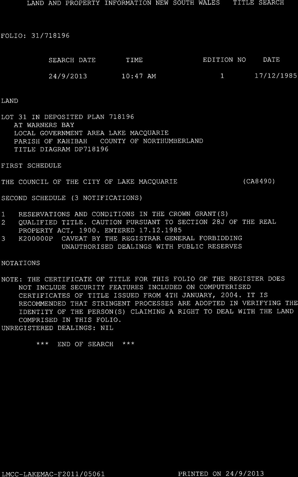
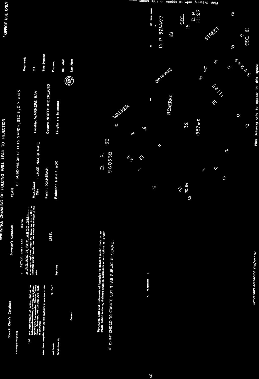
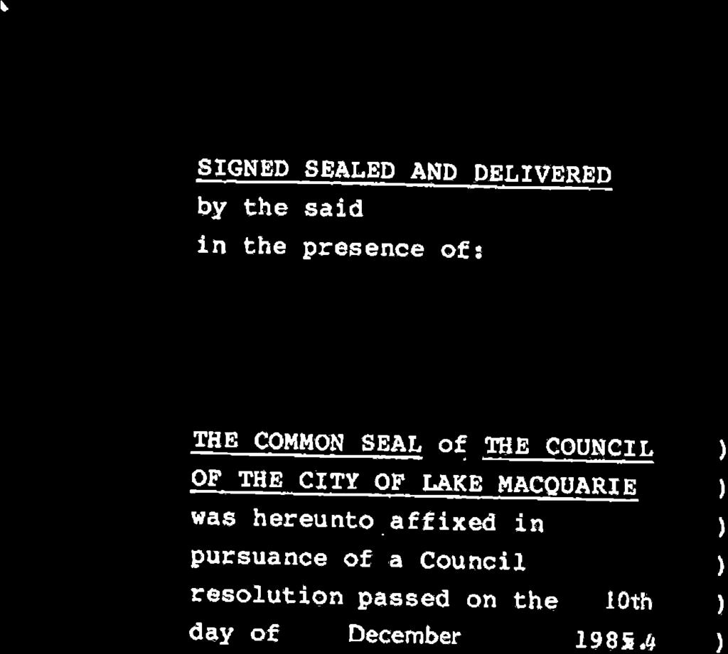
8 Part 3 Justification for the Provisions Section A - Need for the Planning Proposal 1. Is the planning proposal a result of any strategic study or report? The Planning Proposal has not been prepared following any outcomes of a study or report relevant to the subject properties. These properties have been identified through routine administrative tasks as either administrative anomalies or being identified as no longer being required or considered appropriate for their intended purpose. Necessary investigations were undertaken into each property to determine their appropriateness for reclassification and rezoning (where applicable). The outcomes of these investigations and reasoning to pursue the proposed amendments are outlined below. 8c Main Road, Cardiff Heights - Lot 41 DP & 58c Marshall Street, New Lambton Heights - Lot 42 DP In 2012, Council sold three parcels of land adjoining the subject lots to the NSW Roads & Maritime Services (RMS) for the purposes of future road works. Throughout these negotiations, the RMS indicated their intention to additionally acquire the subject lots (Lots 41 and 42 on DP ) for the future road works. The subject lots were acquired by Council in the 1970 s for the construction of a new road, however construction did not eventuate and Council officers have since confirmed that there are no longer any plans for the construction of a road in this location. The lots were never dedicated as road, nor were they advertised as Operational Land during the transitional provisions of the Local Government Act 1993 (LG Act). The subject lots are therefore Community Land and reclassification to Operational Land is required to enable their sale. Both lots are zoned 2(1) Residential under the LMLEP 2004 (as illustrated in Figure 2) yet only have a total area of 69.6sqm with no street frontage. It is therefore considered that they have little development potential either as standalone lots or as a consolidated lot. Sale to the adjoining land owner RMS is considered to be an appropriate course of action. 17 Walker Street, Warners Bay - Lot 31 DP The subject site (Lot 31 in DP ) has an area of 635.5sqm and is currently zoned part 2(2) Residential (Urban Living) and part 7(2) Conservation (Secondary) under the LMLEP 2004 (as illustrated in Figure 5). The site is Community Land due to its dedication as a Public Reserve upon the registration of DP in Prior to the registration of DP , Council entered into a Deed with the previous land owner in regards to the land s future public reserve dedication and paid $6,000 compensation for the land. Upon the registration of DP , two lots were created, Lots 31 and 32. Lot 32 is accessed via a 3.66m wide frontage to Walker Street which is of insufficient width under current planning controls. This width additionally limits the development potential of Lot 32 and the owner has approached Council with 6
9 a request to purchase part of Lot 31 to increase the road frontage and improve access potential. Historically it was proposed to create a road through Lot 31 linking Walker Street to Margaret Street to the west. To facilitate this, part of Lot 31 was zoned 5C Special Uses (Proposed Local Road Reservation) with the balance being zoned 6(c) Open Space (Local Reservation) under the Lake Macquarie Local Environmental Plan The local road proposal has since been abandoned and the land rezoned to its current zones. The residential zoned portion of Lot 31 is irregular in shape and not considered to be of sufficient area to enable development in its own right. Sale of part of Lot 31 for consolidation with adjoining Lot 32 is therefore proposed as outlined in Figure 6 to facilitate the future development of Lot 32 in accordance with its current medium density zoning. 256 Lake Road, Glendale - Lot 12 DP In 1972 Council was approached by the owner of Lot 3 DP (the parent lot of the subject lot) who proposed to subdivide his land into two lots and dedicate one of those lots to Council for aged care purposes. On 21 November 1972, Council resolved to accept the gift of the land on the understanding that it be used to construct aged care units. The parent lot was subdivided in 1974 to create Lots 11 and 12 in DP The subdivider retained Lot 11 and Lot 12 was transferred to Council s ownership on 11 October On 30 June 1975, a report was submitted to Council stating that Council did not have the funds or personnel to construct and manage an Aged Care Facility. A proposal to lease the land to the Lions Club was subsequently considered but the Lions Club notified Council on 18 July 1977 that it could not continue with the leasing of the land due to limitations in Government funding required for the development. Council has subsequently determined that the land to not be suitable for aged care purposes due to bushfire issues (it is located adjacent to heavily vegetated land that is zoned for Conservation), it is heavily vegetated itself, it is a sloping site and is distant from public transport and basic services such as retail and community services and facilities. It is also considered that the site would not comply with the requirements of SEPP (Housing for Seniors and People with a Disability) This understanding has been supported by Council s Community Planner for Ageing and Disability. The land was advertised as Operational Land in 1994 with the transitional provisions of the LG Act however as it was gifted to Council for a specific purpose it is subject to an implied trust and the advertisement is effectively invalid. In order to act outside the purpose designated by the trust (i.e. use of land for any purpose other than aged care), the trust will first have to be extinguished. Reclassification under section 30 of the LG Act will result in the release of the trust. As current planning considerations do not support the use proposed for the land by the trust, reclassification to Operational Land is recommended to enable the land to be developed in accordance with its highest and best use. 7
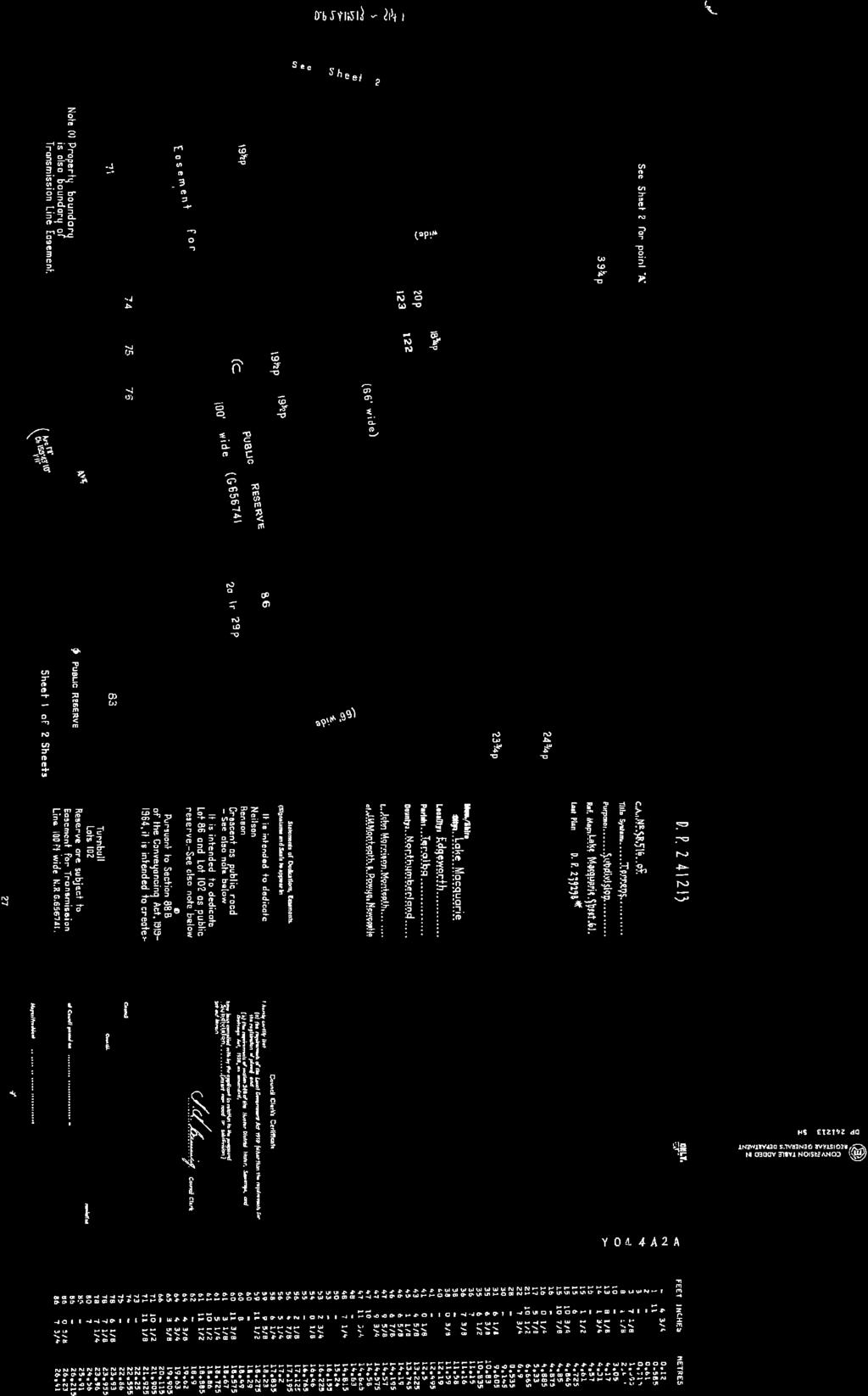
10 Any proceeds derived from the sale of the land is intended to be internally isolated for age care purposes and kept within a Restricted General Fund for this purpose. The subject site contains an area of 6509sqm and is zoned 2(1) Residential under the LMLEP 2004 (as illustrated in Figure 8) and proposed R2 Low Density Residential under the Draft LMLEP The land may be appropriate for a residential use and if reclassified, will be either be developed or offered for sale, depending on prevailing market conditions once reclassification completed. 88 Neilson Street, Edgeworth - Lot 102 DP The subject site has an area of 290.9sqm and is zoned 6(1) Open Space under the LMLEP 2004 (as illustrated in Figure 11). The site is currently fenced in with adjoining privately owned parcels at 78 and 80 Neilson Street, and contains an easement for a transmission line wide. The site is Council Community Land due to its dedication as a Public Reserve upon the registration of DP in Prior to the registration of DP241243, the City of Newcastle Gas and Coke Co Ltd agreed to dedicate the site as open space to Council without cost. Council was approached by the owner of 80 Neilson Street (who is also currently negotiating the purchase of 78 Neilson Street) to acquire the subject site. The applicant s land (80 and 78 Neilson Street) is identified in the Draft LMLEP 2014 as part of an urban release area and was rezoned in 2010 to permit residential development. The applicant proposes to subdivide this land for residential purposes and has discussed this proposal with Council officers at a Development Unit meeting on 7 March Three potential access points to the proposed subdivision were identified and discussed at that meeting and the subject Council-owned land was identified as the preferred location due to it inflicting the least impact to existing nearby residences. It is proposed to reclassify the land to Operational Land to facilitate its sale, and rezone to a residential zone consistent with the applicant s adjoining land holdings. The site is proposed to be rezoned to allow it to be incorporated with the future proposed development of adjoining 2(1) Residential land (80 and 78 Neilson Street) as previously outlined. The minimum lot size and building height s proposed for the parcel reflects that of the adjoining 2(1) Residential land to ensure consistency. 11 Luprena Close, Charlestown - Lot 22 DP The subject land is zoned 6(1) Open Space under the LMLEP 2004 (as illustrated in Figure 17) and contains an area of 1,842sqm. The site is Community Land due to its dedication as a public reserve upon the registration of DP in The owner of an adjoining parcel (75 Dudley Road) is pursuing the amendment to resolve encroachments onto the public reserve caused by the southern and 8
11 western boundary fences and pool decking. The applicant obtained development consent for the alterations and additions, however throughout their construction, encroachments ranging from 0.40m to 0.58m at the western boundary and to a maximum width of 1.18m to the southern boundary, were discovered. The western boundary encroachment affects the pedestrian access way from Dudley Road to the reserve in Luprena Close. The access way however possesses a width of 4.695m and the maximum width of the encroachment to that part is 0.58m, allowing a 4.115m wide access way to remain available to pedestrians. The affected area south of the applicant s land is a small triangular portion that sits between 75 Dudley Road to the north and 14 Luprena Close to the south. Although the land forms part of the public reserve, it is not considered ideal for use by the public due to its size and relation to the remainder of the public reserve. The applicant obtained an identification survey when he purchased the property in Since that time four development applications have been approved and works completed for dwelling alterations and additions (2001 and 2006), garage (2004) and swimming pool (2011). No encroachments were identified in the 1998 survey or at any time throughout construction of the above mentioned works. When constructing the pool, the western boundary fence was replaced but was constructed inside of the location of the original fence. No encroachments were identified at this time. The survey reports obtained disclosed a variance in boundary lengths which has more than likely led to confusion over the location of the boundary, and the resultant encroachments. Council is supportive of the reclassification, rezoning and sale of the encroachment lands. This land has a total area of approximately 15.6sqm. The portion of the site subject to the reclassification is required to be rezoned from 6(1) Open Space to a residential zone in order for the encroachment issue to be accurately rectified. A change in zoning to 2(2) Residential (Urban Living) is considered appropriate for the site as it will reflect the current zoning of 75 Dudley Road in which the portion will be amalgamated with following its subdivision and sale. The minimum lot size and building height s proposed for the rezoned portion reflect that of the adjoining 2(2) Residential (Urban Living) land to ensure consistency. 320 Pacific Highway, Charlestown Part Lot 100 DP The subject land is Council owned Community Land zoned 6(1) Open Space under the LMLEP 2004 (as illustrated in Figure 23). An unauthorised structure (rotunda), constructed and used by the adjoining business Apollo Hotel, encroaches on to the site (as illustrated in Figure 22). The site was acquired prior to 1976 and was not advertised as Operational Land when the LG Act was introduced, therefore the site remains to be Community Land. 9
12 The site of the encroachment, part lot 100 DP , forms part of the highly disturbed area between the developed land of the Apollo Hotel and the bushland that constitutes Charlestown Park. The site of the encroachment is approximately 400m 2. The Apollo Hotel (Land) Pty Limited has requested to purchase or lease the portion of land within Council s community land, on which the rotunda and associated landscaping has been erected. The rotunda was constructed without appropriate Council approval, by the previous owners of the Apollo Hotel, and is used by the current owners, specifically for wedding events. The current owners wish to retain the rotunda to enhance the appeal of the Apollo Hotel. Condition 7 of a Development Consent issued in 2008, to extend the Apollo Hotel, required the removal of the rotunda, and vegetation rehabilitation of the site, by 30 July An application to modify the Development Consent resulted in a new condition that allowed the Apollo Hotel to make an application for reclassification of the land on which the rotunda and associated landscaping is erected. If the application was made by 30 July 2012, the requirement for removal of the rotunda was to be extended to 30 July 2014, unless the outcome of the reclassification application permits the rotunda and associated landscaping to remain. The applicant submitted formal application for reclassification and rezoning of the land on 16 May 2012 and Council is supportive of the encroachment lands reclassification, rezoning and sale. The subject portion of the site is required to be rezoned in order to facilitate the permissible use of the encroachment. The proposed zoning 6(2) Tourism and Recreation will be consistent with that of the adjoining Apollo Hotel parcel for which the subject land will be consolidated with following reclassification. A minimum lot size and building height map has not been proposed for the subject portion to ensure it will align with the adjoining tourism zoned Apollo Hotel site following its consolidation. 2. Is the planning proposal the best means of achieving the objectives or intended outcomes, or is there a better way? The proposed Planning Proposal amendments are considered the best means of achieving the intended outcomes for each property. All the properties are classified as Community Land under the provisions of the LG Act which possess statutory limitations on their use. To achieve the long term objective for each parcel, each must first be reclassified to Operational land. Investigations reveal that none of the lands were dedicated to Council in lieu of section 94 contributions and therefore reclassification by way of LEP amendment, pursuant to the provisions of the Environmental Planning and Assessment Act 1979, is the only action available to achieve the desired outcomes. 3. (a) If the provisions of the planning proposal include the extinguishment of any interests in the land, what are the reasons why the interests are proposed to be extinguished. The proposal seeks to remove the following affectations pursuant to section 30 of the Local Government Act 1993: 10
13 i. Warners Bay Lot 31 DP Public reserve notation ii. iii. iv. Edgeworth Lot 102 DP Public reserve notation Charlestown Lot 22 DP Public reserve notation The removal of the public reserve status of the above lots is required in order to facilitate the reclassification of the lots to Operational Land. The Warners Bay and Charlestown lots are only part lot reclassifications, however in order to facilitate this, the public reserve status must be removed from the whole lot. It will then be a requirement of Council during the subdivision process that the public reserve status be re-instated to the land to remain in Council ownership. Glendale Lot 12 DP Trust for Public Purpose (Aged Care Accommodation) (b) The concurrence of the landowner, where the land is not owned by the relevant planning authority. Lake Macquarie Council is the land owner for all of the sites subject of the Planning Proposal. Section B Relationship to Strategic Planning Framework 4. Is the planning proposal consistent with the objectives and actions contained within the applicable regional or sub-regional strategy (including exhibited draft strategies)? Lower Hunter Regional Strategy The proposed reclassifications and rezoning are consistent with the Lower Hunter Regional Strategy (LHRS), which has a focus on encouraging residential infill development and increasing housing choice. The strategy specifically identifies Glendale as an emerging Major Regional Centre and Warners Bay as a Town Centre. The proposed reclassifications in these areas will allow the land, currently zoned for residential purposes, to be sold and developed for their intended use and will subsequently support the growth and further establishment of these centres. The Edgeworth site, although not specifically identified within the LHRS, is located within an established urban area close to the emerging Major Regional Centre of Glendale. The reclassification and rezoning of this site will encourage the future development of adjoining residential zoned land which will ultimately support increased growth for the area which is adjoining an emerging Major Regional centre. The provisions of the LHRS are not impacted upon by the remaining subject lands which are administrative amendments (Charlestown sites) or are to support future road development (New Lambton Heights/Cardiff Heights sites). The proposal is not contrary to the provisions of the Lower Hunter Conservation Plan. 5. Is the planning proposal consistent with the local council s Community Strategic Plan, or other local strategic plan? 11
14 Lifestyle 2030 Strategy Lifestyle 2030 (LS2030) provides the long-term direction for the overall development of the city and describes Council s high level policies for managing private and public development within Lake Macquarie. The proposal is consistent with the strategic plan maps in the LS2030. The Glendale and Edgeworth sites are identified within a growth and expansion corridor, with Glendale being identified as an emerging major regional centre in line with the LHRS. The intended future use of these sites to promote future residential development is consistent with the objectives of the strategy. The Edgeworth site is adjacent to the LMCC Investigation Area however the lands adjoining the subject site are currently zoned for residential purposes, therefore will not require any investigations for future rezoning for urban development. The Warners Bay site is identified between the Edgeworth/Glendale/Cardiff growth and expansion corridor and the town centre of Warners Bay. The reclassification to support a higher residential use on the adjoining site in line with its zoning provision is considered consistent with the vision for this area under the strategy. No sites are identified in the Green System map as having any significant environmental features. 6. Is the planning proposal consistent with applicable state environmental planning policies (SEPPs)? An assessment of the proposal against the relevant State Environmental Planning Policies (SEPPs) is provided within Appendix B. 7. Is the planning proposal consistent with applicable Ministerial Directions (s.117 directions)? An assessment of the proposal against the Section 117 Ministerial Directions is provided within Appendix C. Section C Environmental, Social and Economic Impact 8. Is there any likelihood that critical habitat or threatened species, populations or ecological communities, or their habitats, will be adversely affected as a result of the proposal? No sites within the planning proposal include or adjoin sensitive environmental features. The subject sites are currently removed from any significant environmental corridors and are either previously established/disturbed sites or cleared of vegetation. The proposal will not adversely affect any species, habitats or communities. The rezonings associated with this application are considered negligible in regards to environmental impact. 9. Are there any other likely environmental effects as a result of the planning proposal and how are they proposed to be managed? 12
15 No adverse environmental effects are anticipated as a result of the Planning Proposal due to the minor nature of the proposed reclassifications and rezonings. 10. How has the planning proposal adequately addressed any social and economic effects? The proposed reclassifications and rezonings will largely have positive social and economic benefits for the community in that it will: Enable and/or facilitate the future development of land for purposes consistent with its current zoning and strategic intent; Enable the sale of Council owned land that will generate public funds for future expenditure on public and aged care focused purposes; and Rectify existing encroachments to public reserves and other Council owned Open Space areas to allow the boundaries of these public areas to be clearly and accurately defined. No negative social or economic effects are anticipated from the proposed amendments. Section D State and Commonwealth Interests 11. Is there adequate public infrastructure for the planning proposal? The proposal will not require any changes to the delivery of public infrastructure to any of the lands or suburbs included in the Planning Proposal. 12. What are the views of State and Commonwealth Public Authorities consulted? Consultation with the applicable Government Authorities will be undertaken in accordance with the Gateway Determination once issued. 13
16 Part 4- Maps The maps proposed to be included as part of the LEP Amendment are outlined within Part 2 of this Planning Proposal and are attached within Appendix A. Part 5- Community Consultation Consultation with Public Authorities/Groups The following public authorities/groups have been consulted Mine Subsidence Board, NSW Rural Fire Service (RFS), and Awabakal Aboriginal Land Council. No objection has been raised to the Planning Proposal except for the Glendale site at No 256 Lake Road, Lot 12 DP The Mine Subsidence Board and the Rural Fire Service both stated that the site is not suitable for residential subdivision other than for a single dwelling house. The site is already zoned Residential under LMLEP 2004 (and will remain residential under the Draft LMLEP 2014), and the planning proposal will reclassify the land to remove the implied trust for aged care purposes. The objections are to the future possible redevelopment of the land, which will be subject to future consideration by council, and are not considered to impede this planning proposal. No objections were received in relation to the remaining properties. Exhibition The proposal was placed on public exhibition from 16 December to 10 February 2013 with three written submissions being received. The submissions received related to the following properties: 8C Main Road, Cardiff Heights & 58C Marshall Street, New Lambton Heights No objections were raised relative to the reclassification. 88 Neilson Street, Edgeworth Question raised from applicant regarding the need for land to be purchased given its future proposed use. 11 Luprena Close, Charlestown Concern and uncertainty expressed over the size of the proposal and future possible uses of the land. No objections were received in relation to the remaining properties. Public Hearing A public hearing was held on 1 April Four members of the public attended the hearing. The independent facilitator s report prepared for the Public Hearing summarised the feedback as follows: One of the participants expressed the view quite strongly that no exceptions should be made to Council s rules in cases such as this. They should all be treated in exactly the same manner. Whilst expressing sympathy for the property owner in this situation, the community member reiterated his view that 14
17 it should not be afforded any special consideration and the encroachment should be made good by the owner. The same hearing participant reported a discrepancy between two different letters received in relation to the hearing, one of which was phrased, in what he believed was a very general manner, creating a perception that Council may consider reclassifying a larger section of the community land effected by the encroachment to enable other development to take place. Council representative Greg Weir advised that the reclassification was for the 15.6sqm strip only and Council had not, and would not support the reclassification/rezoning of the balance of the site. One of the hearing participants reported hearing rumours that flats were to be constructed on the site. Council staff confirmed that there was never any intention to do anything other than deal with the minor encroachment created by the owner of this particular property, through what appears to have been a survey and set out error. No other representations were received in relation to the remaining properties. Part 6 Project Timeline The following table provides an indicative timeline for the Draft Local Environmental Plan: Task Timeline Gateway Determination November 2013 Public Exhibition (28 days) December 2013 Public Hearing April 2014 Consideration of submissions & prepare report on Public Hearing April 2014 Report to Council post exhibition July 2014 Submission to Department August 2014 Notification of Plan Made November


18 ANNEX A - MAPS 8c Main Road Cardiff Heights & 58c Marshall Street Lambton Heights Lot 41 DP & Lot 42 DP Figure 1 Aerial map MAIN ROAD MARSHALL STREET 8C Main Road 58C Marshall Street Figure 2 Existing zone under LMLEP
19 Figure 3 Draft Zone Map under LMLEP


20 17 Walker Street Warners Bay Part Lot 31 DP Figure 4 Aerial map WALKER STREET 17 Walker Street Figure 5 Existing zone under LMLEP

21 Figure 6 Draft Zone Map under LMLEP


22 256 Lake Road Glendale Lot 12 DP Figure 7 Aerial map 256 Lake Road Figure 8 Existing zone under LMLEP
23 Figure 9 Draft Zone Map under LMLEP


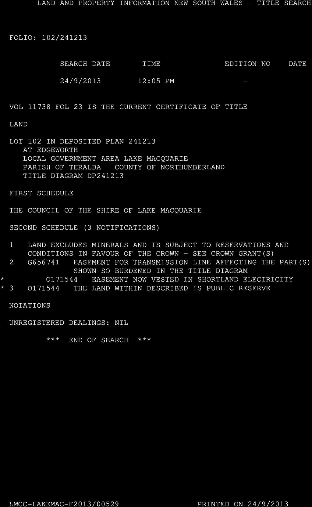
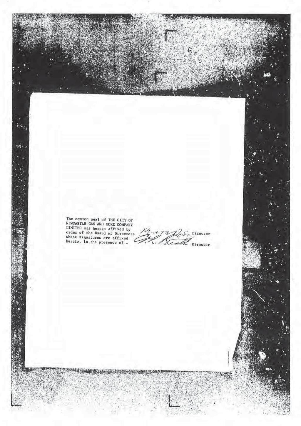
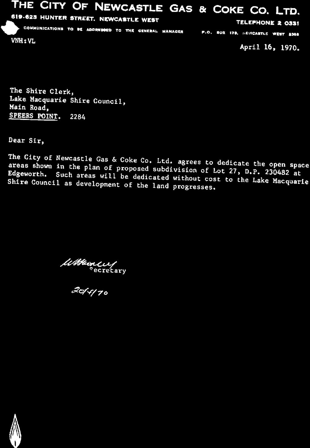
24 88 Neilson Street Edgeworth Lot 102 DP Figure 10 Aerial map 88 Neilson Street Figure 11 Existing zone under LMLEP

25 Figure 12 Draft Zone Map under LMLEP
26 Figure 13 Draft Zone Map under Draft LMLEP
27 Figure 14 Draft Building Height Map under Draft LMLEP
28 Figure 15 Draft Lot Size Map under Draft LMLEP


29 11 Luprena Close Charlestown Part Lot 22 DP Figure 16 Aerial map 11 Luprena Close Figure 17 Existing zone under LMLEP

30 Figure 18 Draft Zone Map under LMLEP
31 Figure 19 Draft Zone Map under Draft LMLEP
32 Figure 20 Draft Building Height Map under Draft LMLEP
33 Figure 21 Draft Lot Size Map under Draft LMLEP


34 320 Pacific Highway Charlestown Part Lot 100 DP Figure 22 Aerial map Figure 23 Existing zone under LMLEP
35 Figure 24 Draft Zone Map under LMLEP
36 Figure 25 Draft Zone Map under Draft LMLEP
37 ANNEX B SEPP ASSESSMENT Planning Proposal s Assessment against Applicable SEPPs SEPP Applicable Consistency State Environmental Planning Policy No 19 Bushland in Urban Areas State Environmental Planning Policy No 71 Coastal Protection N/A Yes Although the Planning Proposal includes Public Reserve and Open Space zoned sites, no areas subject of the Planning Proposal currently contain urban bushland. 17 Walker Street Warners Bay is identified as being within the coastal zone. Accordingly any future development of the land would need to be consistent with the SEPP and its supporting documents. State Environmental Planning Policy (Exempt and Complying Development Codes) 2008 Yes Upon removal of the public reserve status of part 17 Walker Street Warners Bay, 88 Neilson Street Edgeworth and part of 11 Luprena Close Charlestown, certain exemptions on the use of the SEPP under the General Housing Code and the Rural Housing Code will no longer apply (SEPP Clause 1.19(6)(b). State Environmental Planning Policy (Housing for Seniors or People with a Disability) 2004 Yes The SEPP has the potential to apply to the future development of the proposed residential zoned sites included within the Planning Proposal. 256 Lake Road Glendale was gifted to Council in 1974 on the understanding that it would be used to construct aged care accommodation. As further outlined within Part B - Section A (1), investigations into this use of the site resolved that it was unsuitable for the use due to the slope of the land, bushfire issues and inaccessibility to public transport among others. Under section 30 of the Local Government Act 1993, the reclassification of the site will extinguish the implied trust that the land be used for aged care. Any proceeds derived from the future sale of 256 Lake Road is intended to be set aside for aged care purposes to align with the lands original intent. 35
38 ANNEX C MINISTERIAL DIRECTION ASSESSMENT Planning Proposal s assessment against Ministerial Directions Ministerial Direction Applicable Consistency 1. Employment and Resources 1.1 Business and Industrial Zones N/A Rural Zones N/A Mining, Petroleum Production and Extractive Industries N/A Oyster Aquaculture N/A Rural Lands N/A - 2. Environment and Heritage 2.1 Environment Protection Zones N/A Coastal Protection Yes 17 Walker Street Warners Bay is identified within the coastal zone. The proposed reclassification at this site will not impact upon the provisions of the NSW Coastal Policy, Coastal Design Guidelines 2003, or the NSW Coastline Management Manual. Any future development of the land would need to be consistent with the SEPP and its supporting documents. 2.3 Heritage Conservation N/A Recreation Vehicle Area N/A - 3. Housing, Infrastructure and Urban Development 3.1 Residential zones Yes All sites with the exclusion of 88 Neilson Street Edgeworth, 11 Luprena Close Charlestown and 320 Pacific Highway Charlestown, are identified within a residential zoning. The reclassification s and rezoning s proposed within this planning proposal 36
39 Planning Proposal s assessment against Ministerial Directions Ministerial Direction Applicable Consistency 3.2 Caravan Parks and Manufactured Home Estates N/A Home Occupations N/A - will allow for the sale of subject lots to facilitate future residential development in the subject areas. It is considered that the planning proposal is consistent with the objectives of this ministerial direction. 3.4 Integrating Land Use and Transport Yes It is proposed to rezone 88 Neilson Street Edgeworth and part of 11 Luprena Close Charlestown to residential zonings consistent with adjoining residential lots within established residential areas. It is also proposed to rezoned part of 320 Pacific Highway Charlestown to a tourist zoning consistent with an adjoining established tourist use. It is considered that the proposed rezoning s outlined within the planning proposal are consistent with the objectives of this ministerial direction. 3.5 Development Near Licensed Aerodromes N/A - 4. Hazard and Risk 4.1 Acid Sulfate Soils Yes 17 Walker Street Warners Bay and 88 Neilson Street Edgeworth are identified within the Lake Macquarie Acid Sulfate Soils Planning Maps. The Warners Bay site is identified as a Category 3 site and the Edgeworth site a Category 5. Any future development on either site would need to be aware of this constraint and address the requirements of Clause 35 of the LMLEP 2004, or equivalent within the Draft LMLEP 2014 (currently Clause 7.1). 4.2 Mine Subsidence and Unstable Land Yes All sites are identified within a Mine Subsidence District. Consultation with the Mine Subsidence Board was undertaken with no objection being raised for all sites except 265 Lake Road, Glendale (Lot 12 DP ). The Board would not support subdivision or development on this lot other than for one dwelling built to strict pothole requirements (see letter in Annex E). 4.3 Flood Prone Land N/A 17 Walker Street Warners Bay is identified as flood prone land however no change to the zoning of the site is proposed. 37
40 Planning Proposal s assessment against Ministerial Directions Ministerial Direction Applicable Consistency 4.4 Planning for Bushfire Protection Yes All sites with the exclusion of 11 Luprena Close Charlestown are identified within the Lake Macquarie Bushfire Prone Land map. Consultation with the NSW Rural Fire Service was undertaken with no objection being raised for all sites except 265 Lake Road, Glendale (Lot 12 DP ). The RFS considers that the site is only suitable for a single dwelling house due to the high bushfire risk that exists (see letter in Annex E). 5. Regional Planning 5.1 Implementation of Regional Strategies Yes The Lower Hunter Regional Strategy applies to all sites within the proposal. The strategy has been addressed within Part 3 Section B (4) of the Planning Proposal. 5.2 Sydney Drinking Water Catchments N/A Farmland of State and Regional Significance on the NSW Far North Coast 5.4 Commercial and Retail Development along the Pacific Highway, North Coast 5.5 Development in the vicinity of Ellalong, Paxton and Millfield (Cessnock LGA) N/A - N/A - N/A Sydney to Canberra Corridor N/A Central Coast N/A Second Sydney Airport: Badgerys Creek N/A - 6. Local Plan Making 6.1 Approval and Referral Requirements Yes It is considered that the planning proposal is consistent with the objectives of this ministerial direction. 38
41 Planning Proposal s assessment against Ministerial Directions Ministerial Direction Applicable Consistency 6.2 Reserving Land for Public Purposes Yes 88 Neilson Street Edgeworth and 11 Luprena Close Charlestown are identified as Public Reserve with a 6(1) Open Space zoning. 320 Pacific Highway Charlestown also possesses a 6(1) Open Space zoning which has an intent for community use. Necessary investigations into the rezoning of these parcels have considered them to be acceptable and of minor loss to the community (investigations outlined within Part 3- Section A (1) of the Planning Proposal). The rezoning of these portions following the investigations received Council. 6.3 Site Specific Provisions Yes The rezoning s included within the Planning Proposal will rectify existing encroachments except for 88 Neilson Street Edgeworth which is intended to facilitate future residential development of adjoining lots zoned for that purpose. All sites proposed for rezoning will apply a zone consistent with those surrounding the subject site. No development standards in addition to those already contained within the LEP will be applied. 39
42 ANNEX D COUNCIL RESOLUTIONS 40
43
44
45
46
47
48
49 ANNEX E CONSULTATION 41
50
51
52
53
54 Michael Murray and Associates Pty Ltd Public Hearing Report Reclassification of Community Land Tuesday 1 st April 2014 Lake Macquarie City Council Administration Centre Magenta Room Michael Murray & Associates 4 Kanwary Close Raymond Terrace NSW 2324 Phone: mm@mmurray.com.au
55 Background A public hearing was conducted in the Magenta Room at Lake Macquarie City Council Administration Centre on Tuesday 1 st April 2014, to enable members of the community to express, and have recorded their views on the proposal to reclassify the following parcels of land: from Community to Operational Land: 8c Main Road, Cardiff Heights 17 Walker Street, Warner s Bay 256 Lake Road, Glendale 88 Neilson Street, Edgeworth 11 Luprena Close, Charlestown 320 Pacific Highway, Charlestown The public hearing had been advertised by Council in the local press in accordance with regulatory requirements. Attendance The hearing was attended by Council staff members Andrejs Rubenis, Statutory Property Officer, Mr Greg Weir, Recreation and Land Planning Coordinator, and the independent facilitator, Michael Murray. 4 members of the public attended the hearing to provide input. The Process The meeting opened at 6:05. The Feedback The following feedback was received from the members of the public in attendance at the hearing. The only property from the group included in the hearing was 11 Luprena Close Charlestown. No comments were received at the hearing for any of the other properties. One of the participants expressed the view quite strongly that no exceptions should be made to Council s rules in cases such as this. They should all be treated in exactly the same manner. Whilst expressing sympathy for the property owner in this situation, the community member reiterated his view that it should not be afforded any special consideration and the encroachment should be made good by the owner. The same hearing participant reported a discrepancy between two different letters received in relation to the hearing, one of which was phrased, in what he believed was a very general manner, creating a perception that Council may consider reclassifying a larger section of the community land effected by the encroachment to enable other development to take place. Council representative Greg Weir advised that the reclassification was for the 15.6sqm strip only and Council had not, and would not support the reclassification/rezoning of the balance of the site. One of the hearing participants reported hearing rumours that flats were to be constructed on the site. Council staff confirmed that there was never any intention to do anything other than deal with the minor encroachment created by the owner of this particular property, through what appears to have been a survey and set out error. Public Hearing Report 5th April 2014 Page 2
56 Conclusion I am satisfied as the independent facilitator of the hearing that members of the community had the opportunity to provide input in relation to the proposed reclassifications. I also submit that the summary of the comments and questions, provided in this report, is a fair reflection of the content of the oral submissions made by the participants in the hearing. The meeting closed at 6.35pm. Michael Murray Managing Director, Michael Murray & Associates 5 th April 2014 Public Hearing Report 5th April 2014 Page 3
57 ANNEX F SUPPORTING INFORMATION 42
58
59
60

61
62

63
64

65

66

67

68
69
70
71
72
73
74

75

76

77

78
79

80

81
82
83
84
85
86
87
88
89

90


91
92

93
94
95
96
97
98
99

100


101
PLANNING PROPOSAL. Reclassification of Community Land to Operational Land at. 2C T C Frith Avenue BOOLAROO. (Part Lot 2 DP )
") PLANNING PROPOSAL Version for Final Report to DoPE Reclassification of Community Land to Operational Land at 2C T C Frith Avenue BOOLAROO (Part Lot 2 DP 1183441) Amendment to Lake Macquarie Local Environmental
PLANNING PROPOSAL Version for Final Report to DoPE Reclassification of Community Land to Operational Land at 2C T C Frith Avenue BOOLAROO (Part Lot 2 DP 1183441) Amendment to Lake Macquarie Local Environmental
PLANNING PROPOSAL. Reclassification of Community Land to Operational Land at Various Sites Housekeeping Amendment
 PLANNING PROPOSAL Final Version Reclassification of Community Land to Operational Land at Various Sites 2016 Housekeeping Amendment Amendment No. 25 to Lake Macquarie Local Environmental Plan 2014 Prepared
Part 1 Objective of the Planning Proposal. Part 2 Explanation of the Provisions. Lake Macquarie City. Local Government Area:
 Planning Proposal - Administrative Amendment No. 9 to Lake Macquarie Local Environmental Plan Part 4 - Principal Development Standards (PP-2015-005-00) As Published 2 October 2015 Local Government Area:
SAI Global Property. This Certificate contains important information about the land described above.
 "1 m 1 maitland city council SECTION 10.7 PLANNING CERTIFICATE Environmental Planning and Assessment Act, 1979 as amended Certificate No.: PC/2018/2468 Certificate Date: 10/08/2018 Fee Paid: $53.00 Receipt
By John Korff. Section 149 certificate and its impact on property
 By John Korff Section 149 certificate and its impact on property Contents Contents...2 Executive Summary...4 Introduction...4 Local Environmental Plan (LEP):...5 Development Control Plans (DCP):...5 DCP
A Guide to the Municipal Planning Process in Saskatchewan
 A Guide to the Municipal Planning Process in Saskatchewan A look at the municipal development permit and the subdivision approval process in Saskatchewan May 2008 Prepared By: Community Planning Branch
Biodiversity Planning Policy and Guidelines for (LEP) Rezoning Proposals
 Rezoning Proposals") Council Policy Biodiversity Planning Policy and Guidelines for (LEP) Rezoning Proposals Table of Contents Table of Contents... 1 Policy... 2 Policy Objectives... 2 Policy Statement... 2 Guidelines... 2
Council Policy Biodiversity Planning Policy and Guidelines for (LEP) Rezoning Proposals Table of Contents Table of Contents... 1 Policy... 2 Policy Objectives... 2 Policy Statement... 2 Guidelines... 2
Warringah Local Environmental Plan 2011
 New South Wales Warringah Environmental Plan 2011 under the Environmental Planning and Assessment Act 1979 I, the Minister for Planning and Infrastructure, pursuant to section 33A of the Environmental
Ryde Local Environmental Plan 2010
 New South Wales under the Environmental Planning and Assessment Act 1979 I, the Minister for Planning, pursuant to section 33A of the Environmental Planning and Assessment Act 1979, adopt the mandatory
Flinders Avenue, Lara Planning Scheme Amendment Combined Application for Rezoning and Multi-Lot Subdivision Reference : Decembe
 143-179 Flinders Avenue, Lara Planning Scheme Amendment Combined Application for Rezoning and Multi-Lot Subdivision Reference: 14134-03 TGM Group Geelong Melbourne Ballarat 1/27-31 Myers Street (PO Box
PLANNING CERTIFICATE Under Section 149 of the Environmental Planning and Assessment Act, 1979
 INFOTRACK PTY LIMITED GPO BOX 4029 SYDNEY NSW 2001 PLANNING CERTIFICATE Under Section 149 of the Environmental Planning and Assessment Act, 1979 Applicant: Applicant's reference: Address of property: Owner:
The Hills Local Environmental Plan 2012
 New South Wales The Hills Environmental Plan 2012 under the Environmental Planning and Assessment Act 1979 I, the Minister for Planning and Infrastructure, pursuant to section 33A of the Environmental
Strathfield Local Environmental Plan 2012
 New South Wales Environmental Plan 2012 under the Environmental Planning and Assessment Act 1979 I, the Minister for Planning and Infrastructure, pursuant to section 33A of the Environmental Planning and
LAKE MACQUARIE COASTAL WETLANDS PARK PROPOSAL. FINAL DRAFT MEMORANDUM OF UNDERSTANDING (September 2010)
") LAKE MACQUARIE COASTAL WETLANDS PARK PROPOSAL FINAL DRAFT MEMORANDUM OF UNDERSTANDING ( FOREWORD The Lake Macquarie Coastal Wetlands Park proposal was initiated by community groups and was formally endorsed
LAKE MACQUARIE COASTAL WETLANDS PARK PROPOSAL FINAL DRAFT MEMORANDUM OF UNDERSTANDING ( FOREWORD The Lake Macquarie Coastal Wetlands Park proposal was initiated by community groups and was formally endorsed
Action P12: Develop a South West Priority Growth Area land use and infrastructure plan
 31 March 2017 Sheridan Dudley South West District Commissioner Greater Sydney Commission PO Box 257 Parramatta NSW 2124 Dear Sheridan, Re: SUBMISSION TO DRAFT SYDNEY SOUTH WEST DISTRICT PLAN MacroPlan
Woollahra Local Environmental Plan 2014
 New South Wales Local Environmental Plan 2014 under the Environmental Planning and Assessment Act 1979 I, the Minister for Planning, pursuant to section 33A of the Environmental Planning and Assessment
Botany Bay Local Environmental Plan 2013
 New South Wales Botany Bay Environmental Plan 2013 under the Environmental Planning and Assessment Act 1979 I, the Minister for Planning and Infrastructure, pursuant to section 33A of the Environmental
Wollongong Local Environmental Plan 2009
 New South Wales Wollongong Local Environmental Plan 2009 under the Environmental Planning and Assessment Act 1979 I, the Minister for Planning, pursuant to section 33A of the Environmental Planning and
Kogarah Local Environmental Plan 2012
 New South Wales Kogarah Local Environmental Plan 2012 under the Environmental Planning and Assessment Act 1979 I, the Minister for Planning and Infrastructure, pursuant to section 33A of the Environmental
Appendix E Evaluation of consequences of proposed change to clause 7.9 Development subject to acoustic controls.
 Appendix E Evaluation of consequences of proposed change to clause 7.9 Development subject to acoustic controls. This Appendix contains more detailed analysis of Issue 8 (refer to Appendix A, but excluding
Environmental Planning and Assessment Act 1979
 New South Wales State Environmental Planning Policy (Sydney Region Growth Centres) Amendment (East Leppington Precinct) 2013 under the Environmental Planning and Assessment Act 1979 Her Excellency the
Queanbeyan Local Environmental Plan (South Tralee) 2012
 2012") New South Wales Queanbeyan Local Environmental Plan (South Tralee) 2012 under the Environmental Planning and Assessment Act 1979 I, the Minister for Planning and Infrastructure, pursuant to section 33A
New South Wales Queanbeyan Local Environmental Plan (South Tralee) 2012 under the Environmental Planning and Assessment Act 1979 I, the Minister for Planning and Infrastructure, pursuant to section 33A
Canterbury Local Environmental Plan 2012
 New South Wales Canterbury Environmental Plan 2012 under the Environmental Planning and Assessment Act 1979 I, the Minister for Planning and Infrastructure, pursuant to section 33A of the Environmental
Liverpool Local Environmental Plan 2008
 New South Wales Liverpool Local Environmental Plan 2008 under the Environmental Planning and Assessment Act 1979 I, the Minister for Planning, pursuant to section 33A of the Environmental Planning and
Hawkesbury Local Environmental Plan 2012
 New South Wales Hawkesbury Environmental Plan 2012 under the Environmental Planning and Assessment Act 1979 I, the Minister for Planning and Infrastructure, pursuant to section 33A of the Environmental
Bankstown Local Environmental Plan 2015
 New South Wales Bankstown Local Environmental Plan 2015 under the Environmental Planning and Assessment Act 1979 I, the Minister for Planning, pursuant to section 33A of the Environmental Planning and
Division 5 Residential Low Density Zone: Assessment Criteria and Assessment Tables
 Division 5 Residential Low Density Zone: Assessment Criteria and Assessment Tables 4.5.1 Residential Low Density Zone The provisions in this division relate to the Residential Low Density Zone as follows
Gisborne District Council
 12.0 SUBDIVISION... 1 12.1 INTRODUCTION... 1 12.2 ISSUE... 1 12.3 OBJECTIVE (SUBDIVISION)... 1 12.4 POLICIES (SUBDIVISION)... 2 12.5 METHODS OF IMPLEMENTATION... 4 12.5.1 REGULATION... 4 12.6 RULES FOR
Section 12A Purpose of Subdivision Provisions
 Section 12A 12A Purpose of Subdivision Provisions Subdivision is primarily about creating land parcels that define and redefine property rights and, in most instances, the creation of new parcels of land
For Vintages of Four Mile Creek Town of Niagara on the Lake, Ontario
 Planning Impact Analysis For Vintages of Four Mile Creek Town of Niagara on the Lake, Ontario Prepared by: Upper Canada Consultants 261 Martindale Road Unit #1 St. Catharines, Ontario L2W 1A1 Prepared
MIDWAY CITY Municipal Code
 MIDWAY CITY Municipal Code TITLE 9 ANNEXATION CHAPTER 9.01 PURPOSE CHAPTER 9.02 GENERAL REQUIREMENTS CHAPTER 9.03 PROPERTY OWNER INITIATION OF ANNEXATION CHAPTER 9.04 PROCEDURES FOR CONSIDERATION OF PETITION
From: Gerard Reiter, EGM/Asset Management Date: 14 April 2015 Peter McIntyre, Managing Director
 TO THE BOARD Item: 6 From: Gerard Reiter, EGM/Asset Management Date: 14 April 2015 Peter McIntyre, Managing Director Category: FOR APPROVAL SECOND SUPPLY TO THE ACT STOCKDILL DRIVE 330kV SWITCHING STATION
Great Lakes Local Environmental Plan 2014
 New South Wales Great Lakes Local Environmental Plan 2014 under the Environmental Planning and Assessment Act 1979 I, the Minister for Planning and Infrastructure, pursuant to section 33A of the Environmental
Coffs Harbour Local Environmental Plan 2013
 New South Wales Coffs Harbour Environmental Plan 2013 under the Environmental Planning and Assessment Act 1979 I, the Minister for Planning and Infrastructure, pursuant to section 33A of the Environmental
Moree Plains Local Environmental Plan 2011
 New South Wales Moree Plains Local Environmental Plan 2011 under the Environmental Planning and Assessment Act 1979 I, the Minister for Planning and Infrastructure, pursuant to section 33A of the Environmental
Greater Taree Local Environmental Plan 2010
 New South Wales Greater Taree Environmental Plan 2010 under the Environmental Planning and Assessment Act 1979 I, the Minister for Planning, pursuant to section 33A of the Environmental Planning and Assessment
Manly Local Environmental Plan 2013
 New South Wales Environmental Plan 2013 under the Environmental Planning and Assessment Act 1979 I, the Minister for Planning and Infrastructure, pursuant to section 33A of the Environmental Planning and
13 Sectional Map Amendment
 13 Sectional Map Amendment Introduction This chapter reviews land use and zoning policies and practices in Prince George s County and presents the proposed zoning in the sectional map amendment (SMA) to
Kiama Local Environmental Plan 2011
 New South Wales Environmental Plan 2011 under the Environmental Planning and Assessment Act 1979 I, the Minister for Planning and Infrastructure, pursuant to section 33A of the Environmental Planning and
Shellharbour Local Environmental Plan 2013
 New South Wales Shellharbour Environmental Plan 2013 under the Environmental Planning and Assessment Act 1979 I, the Minister for Planning and Infrastructure, pursuant to section 33A of the Environmental
Standard for the acquisition of land under the Public Works Act 1981 LINZS15005
 Standard for the acquisition of land under the Public Works Act 1981 LINZS15005 Version date: 20 February 2014 Table of contents Terms and definitions... 5 Foreword... 6 Introduction... 6 Purpose... 6
SCHEDULE 3 TO THE URBAN GROWTH ZONE. Shown on the planning scheme map as UGZ3 QUARRY HILLS PRECINCT STRUCTURE PLAN. 1.0 The Plan
 SCHEDULE 3 TO THE URBAN GROWTH ZONE 1.0 The Plan Shown on the planning scheme map as UGZ3 QUARRY HILLS PRECINCT STRUCTURE PLAN Map 1 to Schedule 3 to Clause 37.07 shows the Future Urban Structure for Quarry
Regeneration and Property Committee. 16 March 2017
 Regeneration and Property Committee 16 March 2017 Subject: Director/Head of Service: Access rights relating to the compulsory purchase of land to the rear of 7-10 St Margaret's Street, Canterbury, CT1
Explanatory Notes. for. The Planning and Development Act, 2007
 Explanatory Notes for The Planning and Development Act, 2007 Introduction The purpose of these notes is to explain the provisions of The Planning and Development Act, 2007 (the Act). The explanatory notes
RESIDENTIAL AND RECREATIONAL
 Energy, Mines & Resources Land Management Branch 320-300 Main Street Whitehorse, Yukon Y1A 2B5 667-5215 Fax 667-3214 www.emr.gov.yk.ca RESIDENTIAL AND RECREATIONAL Lot Enlargement Policy OBJECTIVE To facilitate
This decision is made under sections 130( 1 ) and 133 of the Environment Protection and Biodiversity Conservation Act 1999.
 and 133 of the Environment Protection and Biodiversity Conservation Act 1999.") Australian Government Department of the Environment and Energy Approval Mt Arthur Coal open cut modification, Muswellbrook, NSW, (EPBC 2014/7377). This decision is made under sections 130( 1 ) and 133
Australian Government Department of the Environment and Energy Approval Mt Arthur Coal open cut modification, Muswellbrook, NSW, (EPBC 2014/7377). This decision is made under sections 130( 1 ) and 133
Gwydir Local Environmental Plan 2013
 New South Wales under the Environmental Planning and Assessment Act 1979 I, the Minister for Planning and Infrastructure, pursuant to section 33A of the Environmental Planning and Assessment Act 1979,
Jason Smith, Manager of Development Services Infill Development Draft Official Community Plan Amendment and Policy
 Council Agenda Information Regular Council March 06, 2018 VILLAGE OF ANMORE REPORT TO COUNCIL Date: Submitted by: Subject: Jason Smith, Manager of Development Services Infill Development Draft Official
Environmental Planning and Assessment Act 1979
 New South Wales State Environmental Planning Policy (Infrastructure) Amendment (Schools, Affordable Housing and Metro Rail) 2009 under the Environmental Planning and Assessment Act 1979 Her Excellency
Implementation. Approved Master Plan and SMA for Henson Creek-South Potomac 103
 Implementation Approved Master Plan and SMA for Henson Creek-South Potomac 103 104 Approved Master Plan and SMA for Henson Creek-South Potomac Sectional Map Amendment The land use recommendations in the
Bega Valley Local Environmental Plan 2013
 New South Wales Bega Valley Environmental Plan 2013 under the Environmental Planning and Assessment Act 1979 I, the Minister for Planning and Infrastructure, pursuant to section 33A of the Environmental
Implementation Tools for Local Government
 Information Note #5: Implementation Tools for Local Government This Information Note is a guide only. It is not a substitute for the federal Fisheries Act, the provincial Riparian Areas Regulation, or
This program has been made possible by the New South Wales Government through the EPAs Contaminated Land Management Program under funding provided by
 This program has been made possible by the New South Wales Government through the EPAs Contaminated Land Management Program under funding provided by the NSW Environmental Trust SEPP55 introduced in 1998
Riverton Properties Ltd Proposed Special Housing Area
 Riverton Properties Ltd Proposed Special Housing Area Housing Accords and Special Housing Areas Act 2013 Expression of Interest 1 This Expression of Interest is made on behalf of Riverton Properties Ltd,
Staff Report for Council Public Meeting
 Agenda Item 3.3 a Staff Report for Council Public Meeting Date of Meeting: April 11, 2018 Report Number: SRPRS.18.087 Department: Division: Subject: Planning and Regulatory Services Development Planning
ADMINISTRATIVE GUIDANCE
 11 ADMINISTRATIVE GUIDANCE ON CONTAMINATED SITES Effective date: April 1, 2013 Version 1.1 May 2013 Expectations and Requirements for Contaminant Migration Introduction This guidance focusses on the ministry
Larimer County Planning Dept. Procedural Guide for 1041 PERMITS
 - Larimer County Planning Dept. Procedural Guide for 1041 PERMITS PLEASE NOTE: A PRE-APPLICATION CONFERENCE IS REQUIRED PRIOR TO SUBMITTING THIS APPLICATION. PURPOSE: State Statutes allow local governments
Kiama Local Environmental Plan 2011
 Kiama Environmental Plan 2011 As at 27 January 2016 Part 1 Preliminary 1.1 Name of Plan This Plan is Kiama Environmental Plan 2011. 1.1AA Commencement This Plan commences on the day on which it is published
Greater Hume Local Environmental Plan 2012
 New South Wales Greater Hume Environmental Plan 2012 under the Environmental Planning and Assessment Act 1979 I, the Minister for Planning and Infrastructure, pursuant to section 33A of the Environmental
18 Sale and Other Disposition of Regional Lands Policy
 Clause 18 in Report No. 7 of Committee of the Whole was adopted, without amendment, by the Council of The Regional Municipality of York at its meeting held on April 19, 2018. 18 Sale and Other Disposition
Greater Shepparton Planning Scheme Amendment C188 Shepparton North Growth Area
 Planning and Environment Act 1987 Panel Report Greater Shepparton Planning Scheme Amendment C188 Shepparton North Growth Area Front page 22 March 2017 Planning and Environment Act 1987 Panel Report pursuant
SCHEDULE 12 TO THE URBAN GROWTH ZONE. Shown on the planning scheme map as UGZ12. Kororoit Precinct Structure Plan
 SCHEDULE 12 TO THE URBAN GROWTH ZONE Shown on the planning scheme map as UGZ12. Kororoit Precinct Structure Plan 1.0 The plan Map 1 below shows the future urban structure proposed in the Kororoit Precinct
Request for Proposal to Develop a Land Use Master Plan
 Request for Proposal to Develop a Land Use Master Plan PO Box 141, 400 Centre Road, Lions Bay, BC V0N 2E0 Phone: 604-921-9333 Fax: 604-921-6643 Email: office@lionsbay.ca Web: www.lionsbay.ca TABLE OF CONTENTS
Resource Consent Application Form
 Resource Consent Application Form Section 88 of the Resource Management Act 1991. This form provides us with your contact information and details about your proposal. Please print clearly and complete
DEDICATION OF LOCAL PURPOSE (ROAD) RESERVE AS LEGAL ROAD - QUEENS ROAD, WAIKANAE
 RESERVE AS LEGAL ROAD - QUEENS ROAD, WAIKANAE") Chairperson and Committee Members REGULATORY MANAGEMENT COMMITTEE 5 MAY 2011 Meeting Status : Public Purpose of Report: For Decision DEDICATION OF LOCAL PURPOSE (ROAD) RESERVE AS LEGAL ROAD - QUEENS ROAD,
Chairperson and Committee Members REGULATORY MANAGEMENT COMMITTEE 5 MAY 2011 Meeting Status : Public Purpose of Report: For Decision DEDICATION OF LOCAL PURPOSE (ROAD) RESERVE AS LEGAL ROAD - QUEENS ROAD,
City of Surrey PLANNING & DEVELOPMENT REPORT File:
 City of Surrey PLANNING & DEVELOPMENT REPORT PROPOSAL: Planning Report Date: February 9, 2009 Development Variance Permit in order to permit a reduced lot frontage to allow subdivision into two half-acre
Frequently Asked Questions
 Frequently Asked Questions Cambridge West Land Use Planning Matters January 10, 2018 Q1 What is proposed for the undeveloped lands within the Cambridge West area? A. Four separate landowners each own part
STAFF REPORT. Permit Number: Unlimited. Kitsap County Board of Commissioners; Kitsap County Planning Commission
 STAFF REPORT Permit Number: 15 00550 Unlimited DATE: March 2, 2016 TO: FROM: Kitsap County Board of Commissioners; Kitsap County Planning Commission Katrina Knutson, AICP, Senior Planner, DCD and Jeff
PLANNING SUBMISSION & CLAUSE 56 ASSESSMENT RESIDENTIAL SUBDIVISION OF LAND 1525 POUND ROAD, CLYDE NORTH (LOT 2 PS F, SIENNA PARK ESTATE)
") PLANNING SUBMISSION & CLAUSE 56 ASSESSMENT RESIDENTIAL SUBDIVISION OF LAND 1525 POUND ROAD, CLYDE NORTH (LOT 2 PS 327975F, SIENNA PARK ESTATE) DFC (PROJECT MANAGEMENT) PTY LTD (A DENNIS FAMILY CORPORATION
PLANNING SUBMISSION & CLAUSE 56 ASSESSMENT RESIDENTIAL SUBDIVISION OF LAND 1525 POUND ROAD, CLYDE NORTH (LOT 2 PS 327975F, SIENNA PARK ESTATE) DFC (PROJECT MANAGEMENT) PTY LTD (A DENNIS FAMILY CORPORATION
Kitsap County Department of Community Development
 Kitsap County Department of Community Development Staff Report and Recommendation Annual Comprehensive Plan Amendment Process for 2018 George s Corner LAMIRD Boundary Adjustment Report Date 7/16/2018 Hearing
Dungog Local Environmental Plan 2014
 New South Wales Dungog Environmental Plan 2014 under the Environmental Planning and Assessment Act 1979 I, the Minister for Planning, pursuant to section 33A of the Environmental Planning and Assessment
Staff Report for Council Public Meeting
 Agenda Item 3.3 Staff Report for Council Public Meeting Date of Meeting: September 27, 2017 Report Number: SRPRS.17.134 Department: Division: Subject: Planning and Regulatory Services Development Planning
Harden Local Environmental Plan 2011
 New South Wales under the Environmental Planning and Assessment Act 1979 I, the Minister for Planning, pursuant to section 33A of the Environmental Planning and Assessment Act 1979, adopt the mandatory
Environmental Planning and Assessment Act 1979
 New South Wales State Environmental Planning Policy (Major Development) Amendment (State Significant Sites South Wallarah Peninsula) 2010 under the Environmental Planning and Assessment Act 1979 His Excellency
Appendix 5 - Track Changed Ordinance
 SCHEDULE 1 TO THE URBAN GROWTH ZONE Shown on the planning scheme map as UGZ1 1.0 The Plan Shepparton North East Plan 1 shows the future urban structure proposed in the Shepparton North East Precinct Structure
Town Planning Evidence Statement Instructed by Best Hooper Lawyers on behalf of Southern Rural Water
 Town Planning Evidence Statement Instructed by Best Hooper Lawyers on behalf of Southern Rural Water Planning Panels Victoria Amendment C227 to the Wyndham Planning Scheme Statement prepared by John Glossop,
Blacktown Local Environmental Plan 2015
 New South Wales Blacktown Local Environmental Plan 2015 under the Environmental Planning and Assessment Act 1979 I, the Minister for Planning, pursuant to section 33A of the Environmental Planning and
HOW TO APPLY FOR A USE PERMIT
 HOW TO APPLY FOR A USE PERMIT MENDOCINO COUNTY PLANNING AND BUILDING SERVICES What is the purpose of a use permit? Throughout the County, people use their properties in many different ways. They build
Barbara County Housing Element. Table 5.1 Proposed Draft Housing Element Goals, Policies and Programs
 Table 5.1 Proposed Draft Housing Element Goals, Policies and Programs Goal 1: Enhance the Diversity, Quantity, and Quality of the Housing Supply Policy 1.1: Promote new housing opportunities adjacent to
Wingecarribee Local Environmental Plan 2010
 New South Wales Wingecarribee Environmental Plan 2010 under the Environmental Planning and Assessment Act 1979 I, the Minister for Planning, pursuant to section 33A of the Environmental Planning and Assessment
NSW Travelling Stock Reserves Review Public consultation paper
 NSW Travelling Stock Reserves Review Public consultation paper A collaborative project between: Local Land Services Department of Industry Lands Contents Executive summary 2 1. About TSRs 3 What are TSR
fact sheet INFORMATION REGARDING 1(A) RURAL LAND IN NORTH ARM COVE, PINDIMAR, BUNDABAH, CARRINGTON AND HAMILTON VILLAGE LOCALITIES
 RURAL LAND IN NORTH ARM COVE, PINDIMAR, BUNDABAH, CARRINGTON AND HAMILTON VILLAGE LOCALITIES") fact sheet Breese Parade Forster PO Box 450 Forster NSW 2428 phone 02 6591 7222 fax 02 6591 7200 email council@greatlakes.nsw.gov.au website www.greatlakes.nsw.gov.au INFORMATION REGARDING 1(A) RURAL LAND
fact sheet Breese Parade Forster PO Box 450 Forster NSW 2428 phone 02 6591 7222 fax 02 6591 7200 email council@greatlakes.nsw.gov.au website www.greatlakes.nsw.gov.au INFORMATION REGARDING 1(A) RURAL LAND
City of Surrey PLANNING & DEVELOPMENT REPORT File: Rezoning from RA to RF in order to allow subdivision into 2 single family lots.
 City of Surrey PLANNING & DEVELOPMENT REPORT File: 7911-0033-00 Planning Report Date: April 23, 2012 PROPOSAL: Rezoning from RA to RF in order to allow subdivision into 2 single family lots. LOCATION:
FISHERMANS BEND SUBMISSION NO. 136 PLANNING REVIEW PANEL 14 & 16 SALMON STREET, PORT MELBOURNE
 SUBMISSION NO. 136 FISHERMANS BEND PLANNING REVIEW PANEL 14 & 16 SALMON STREET, PORT MELBOURNE PRESENTED BY: ANDREA PAGLIARO ON BEHALF OF BELLAMIA NOMINEES PTY LTD & PCLC INVESTMENT PTY LTD INTRODUCTION
Deniliquin Local Environmental Plan 2013
 New South Wales Deniliquin Local Environmental Plan 2013 under the Environmental Planning and Assessment Act 1979 I, the Minister for Planning and Infrastructure, pursuant to section 33A of the Environmental
DRAFT FOR PUBLIC HEARING (rev. March, 2016)
") Chapter 200. ZONING Article VI. Conservation/Cluster Subdivisions 200-45. Intent and Purpose These provisions are intended to: A. Guide the future growth and development of the community consistent with
Chapter 200. ZONING Article VI. Conservation/Cluster Subdivisions 200-45. Intent and Purpose These provisions are intended to: A. Guide the future growth and development of the community consistent with
Information Memorandum
 Information Memorandum Frenchs Forest 67-75 Dareen Street 320-328 Warringah Road Agent - Stuart Bath 0416 207 215 INFORMATION Memorandum Sections 1 Executive Summary 2 About the property 3 Northern Beaches
15.1 Introduction. Waipa District Plan. Section 15 - Infrastructure, Hazards, Development and Subdivision. Page Version - 1 November 2016 Page 1 of 56
 15.1 Introduction 15.1.1 How and where development and subdivision occurs is critical to the sustainable management of the District s natural and physical resources. This section of the Plan focuses on
Richmond Valley Local Environmental Plan 2012
 New South Wales Richmond Valley Environmental Plan 2012 under the Environmental Planning and Assessment Act 1979 I, the Minister for Planning and Infrastructure, pursuant to section 33A of the Environmental
Strathcona County Municipal Policy Handbook. Last Review Date: May 21, 2013 Next Review Date: 05/2016
 SER-008-019 Strathcona County Municipal Policy Handbook Conceptual Schemes Date of Approval by Council: 09/28/04; 05/08/2007; 05/21/2013 Resolution No: 786/2004; 386/2007; 314/2013 Lead Role: Chief Commissioner
PIA would be pleased to meet with the Department to outline any aspect of our submission. Please contact myself or John Brockhoff on
 31 January 2018 Deborah Brill Director, Housing and Infrastructure Policy Department of Planning and Environment PO Box 39 SYDNEY NSW 2001 Dear Deborah, PIA Submission: Affordable Housing SEPP 70 Amendments
RED HEAD VILLAGES ASSOCIATION (Inc) North Bendalong, Bendalong, Berringer, Cunjurong, Manyana
 North Bendalong, Bendalong, Berringer, Cunjurong, Manyana") RED HEAD VILLAGES ASSOCIATION (Inc) North Bendalong, Bendalong, Berringer, Cunjurong, Manyana Russ Pigg General Manager Shoalhaven City Council P.O. Box 42 Nowra NSW, 2541 PO Box 2015 Bendalong NSW 2539
RED HEAD VILLAGES ASSOCIATION (Inc) North Bendalong, Bendalong, Berringer, Cunjurong, Manyana Russ Pigg General Manager Shoalhaven City Council P.O. Box 42 Nowra NSW, 2541 PO Box 2015 Bendalong NSW 2539
Town of Bristol Rhode Island
 Town of Bristol Rhode Island Subdivision & Development Review Regulations Adopted by the Planning Board September 27, 1995 (March 2017) Formatted: Highlight Formatted: Font: 12 pt Table of Contents TABLE
Development and. Public Rights of Way. Advice note for developers and development management officers
 Development and Public Rights of Way Advice note for developers and development management officers January 2010 Advice note for developers and development management officers Development and Public Rights
O-I (Office-Institutional) and AG-1(Agricultural)
 and AG-1(Agricultural)") PROPERTY INFORMATION ADDRESS 3503 and 3505 Bethany Bend DISTRICT, LAND LOTS 2/1 973 and 974 OVERLAY DISTRICT State Route 9 PETITION NUMBERS EXISTING ZONING O-I (Office-Institutional) and AG-1(Agricultural)
PROPERTY INFORMATION ADDRESS 3503 and 3505 Bethany Bend DISTRICT, LAND LOTS 2/1 973 and 974 OVERLAY DISTRICT State Route 9 PETITION NUMBERS EXISTING ZONING O-I (Office-Institutional) and AG-1(Agricultural)
Parramatta City Centre Local Environmental Plan 2007
 New South Wales Parramatta City Centre Local Environmental Plan 2007 under the Environmental Planning and Assessment Act 1979 I, the Minister for Planning, make the following local environmental plan under
Presentation to the Real Estate Institute of New Zealand 28 October 2016
 Presentation to the Real Estate Institute of New Zealand 28 October 2016 Disclaimer This presentation provides a high level overview of specific parts of the Proposed Auckland Unitary Plan Decisions Version
6. REPORT BY THE CHAIRPERSON OF THE FENDALTON/WAIMAIRI COMMUNITY BOARD - 4 NOVEMBER 2009
 6. REPORT BY THE CHAIRPERSON OF THE FENDALTON/WAIMAIRI COMMUNITY BOARD - 4 NOVEMBER 2009 1. POUND ROAD ROAD STOPPING AND LAND SWAP General Manager responsible: General Manager City Environment, DDI 941-8608
At its 4 October 2002 meeting the Regulatory and Consents Committee resolved:
 1. PERIODIC DETENTION CENTRES IN THE BUSINESS 1 ZONE Officer responsible Author Environmental Services Manager Sean Elvines, DDI 941-8295 The purpose of this report is to provide an overview of the estimated
FOR PL A N N ERS. Michael Forwood. Tuesday 11 July 2017
 ESSENTIAL REFERRALS FOR PL A N N ERS Michael Forwood Tuesday 11 July 2017 OVERVIEW Legislation Schedule 10 of the Planning Regulation Referrals Process SARA Referrals Non SARA Referrals Tricks and Traps