Town of Chino Valley MEETING NOTICE PLANNING AND ZONING COMMISSION AGENDA
|
|
|
- Frank Greene
- 5 years ago
- Views:
Transcription

1 Town of Chino Valley MEETING NOTICE PLANNING AND ZONING COMMISSION REGULAR MEETING TUESDAY, APRIL 3, :00 P.M. Council Chambers 202 N. State Route 89 Chino Valley, Arizona AGENDA 1. CALL TO ORDER 2. PLEDGE OF ALLEGIANCE 3. ROLL CALL 4. MINUTES a. Consideration and possible action to approve the March 20, 2018 special meeting minutes. 5. STAFF REPORTS 6. PUBLIC HEARING a. Consideration and possible action regarding a request for a zone change for approximately 2 acres of real property generally located 960 feet south of the southeast corner of East Road 5 North and State Route 89 at 3795 N. State Route 89, from CL (Commercial Light) zoning district to CH (Commercial Heavy) zoning district. (Alex Lerma, Associate Planner) b. Consideration and possible action regarding a request for a zone change for approximately 5 acres of real property generally located west of the southwest corner of West Road 1 South and South Road 1 West at 584 South Road 1 West, from AR-5 (Agricultural Residential 5 Acre Minimum) zoning district to SR-1 (Single Family Residential 1 Acre Minimum) zoning district. (Alex Lerma, Associate Planner) Agenda Planning & Zoning April 3, 2018 Page 1
2 c. Consideration and possible action regarding a request to rezone approximately 44 acres of real property generally located on the northeast corner of North Road 1 East and East Perkinsville Road at 1204 East Perkinsville Road, from AR-5 (Agricultural Residential 5 Acre Minimum) zoning district to SR-0.16 PAD (Single Family Residential 7,000 Square Foot Minimum Lot Area) zoning district with a Planned Area Development Overlay zoning district to modify the SR-0.16 zoning district development standards. (Jason Sanks, Development Service Director) d. Consideration and possible action regarding a request for a Conditional Use Permit for approximately 120 acres of real property located northwest of North Jasper Trail at 4820 East Perkinsville Road to allow a hot mix asphalt plant in the I (Industrial) zoning district. (Jason Sanks, Development Services Director) e. Consideration and possible action regarding a request to amend the CUP (Conditional Use Permit) for approximately 2.82 acres of real property generally located 274 feet north of the northwest corner of West Road 3 North and State Route 89 at 2062 North State Route 89 to allow the installation and replacement of an electronic sign in the CL (Commercial Light) zoning district. (Alex Lerma, Associate Planner) 7. NON-PUBLIC HEARING ACTION ITEMS 8. DISCUSSION ITEMS 9. PUBLIC COMMENTS Call to the Public is an opportunity for the public to address the Commission on any issue within the jurisdiction of the Commission that is not on the agenda. Public comment is encouraged. Individuals are limited to speak for three (3) minutes. The total time for Call to the Public may be up to 30 minutes per meeting. Commission action taken as a result of public comment will be limited to directing staff to study the matter, scheduling the matter for further consideration and decision at a later date, or responding to criticism. 10. ADJOURN Dated this 28th day of March, By: Jason Sanks, Development Services Director A copy of the agenda and background material provided to the Commissioners is available for public inspection at the Marion Lassa/Chino Valley Library, 1020 W. Palomino Road, Chino Valley, Arizona. Further details may be obtained by contacting Development Services Department at 1982 Voss, Chino Valley, Arizona (928) The Town endeavors to make all public meetings accessible to persons with disabilities. With 72 hours advance notice, special assistance can also be provided for sight and/or hearing impaired persons at public meetings. Please call (voice) or use 711 (Telecommunications Arizona Relay Service ) to request an accommodation to participate in this meeting. Agenda Planning & Zoning April 3, 2018 Page 2
3 Planning and Zoning Commission Regular Meeting Date: 04/03/2018 March 20, 2018 Minutes 4.a. CASE DESCRIPTION: Consideration and possible action to approve the March 20, 2018 special meeting minutes. ANALYSIS: RECOMMENDATION Approve the March 20, 2018 special meeting minutes. March 20, 2018 Minutes Attachments
4 D R A F T MINUTES OF THE SPECIAL PLANNING AND ZONING MEETING OF THE TOWN OF CHINO VALLEY MARCH 20, :00 P.M. The Planning and Zoning Commission of the Town of Chino Valley, met for a Special Meeting in the Chino Valley Council Chambers, located at 202 N. State Route 89, Chino Valley, Arizona. 1) CALL TO ORDER Chair Chuck Merritt called the meeting to order at 6:00 p.m. 2) PLEDGE OF ALLEGIANCE Commissioner Tom Armstrong led the Pledge of Allegiance. 3) ROLL CALL Present: Absent: Staff Present: 4) MINUTES Chair Chuck Merritt; Vice-Chair Gary Pasciak; Commissioner Tom Armstrong; Commissioner Michael Bacon; Commissioner John McCafferty; Commissioner William Welker; Alternate Welles Geary Commissioner Claude Baker Development Services Director Jason Sanks; Associate Planner Alex Lerma; Town Manager Cecilia Grittman; Deputy Town Clerk, Recorder Vickie Nipper; a) Consideration and possible action to approve March 6, 2018 meeting minutes. MOVED by Commissioner Michael Bacon, seconded by Commissioner Tom Armstrong to approve the March 6, 2018 regular meeting minutes. Vote: 6-0 PASSED - Unanimously 5) STAFF REPORTS Development Services Director Sanks reported on the following: The Hawksnest PAD amendment application has been withdrawn. Internal department improvements, including record keeping, case processing, form document upgrades, updating and correcting the zoning map, updating the public notices, and creating official zoning exhibits for Commission cases. Staff has updated and restructured a draft Unified Development Ordinance (UDO) which will be reviewed by the UDO Subcommittee and constituents in small sections. Minutes Planning & Zoning Commission March 20, 2018 Page 1
5 Staff is working on an enhanced General Plan land use map. The enhanced General Plan map will have an underlay of the parcel map so that parcel locations are showing underneath the General Plan map and land use designation for parcels are clear. Staff is rebuilding zoning case files, conditional use permit files, and preliminary and final plat files, beginning with current year s files and working back to the year There are as many case files for the first two months of the current year as the Department had in There are also six cases to initiate rezoning and General Plan amendments. There will also be two preliminary subdivision plats for approximately 300 lots, which will include development agreements, water rights, etc. 6) PUBLIC HEARING a) Hawksnest PAD Amendment - This Applicant has withdrawn the application as of March 14, b) Consideration and possible action regarding a request for a zone change for a property generally located east, off State Route 89, east of the corner of Staley Lane and Durham Drive at 3845 Durham Drive, Chino Valley, Arizona, The applicant is requesting to rezone the 2.5 acre property from (CL) Commercial Light to (CH) Commercial Heavy. (Alex Lerma, Associate Planner) Associate Planner Lerma presented the following information to the Commission: The surrounding properties are zoned Commercial Heavy to the North and South, Commercial Light to the West and Commercial Heavy for parcels adjacent to State Rt. 89. The subject property is currently vacant. The adjacent properties are being used as contractor s yard and storage areas. The owners of the adjacent Commercial Light parcels are working on requesting a zoning change because the property s current use is Commercial Heavy. The proposed designation is in conformance with the current land use designation of Commercial/Multifamily Residential. The applicant would like to move CNR Trucking from another location in town to this location. The business activities consist of heavy vehicle and equipment maintenance. The applicant has proposed two buildings: a storage area with a caretaker residence and a maintenance shop. The area on the front of the property will be landscaped. A neighborhood meeting was held March 14, 2018 with only one property owner in attendance, and there was no objection to the application for the zone change. Commissioners questioned if the fencing around the property would be improved. Associate Planner Lerma explained that the UDO requires that the designated area have a six- to eight-foot fence. If the applicant considers the whole property as a storage area, then the entire property would need to be fenced off completely. As the rear of the property is adjacent to State land, staff should consider if that area should be fenced off. Screened chain-link fences would satisfy the fence requirements. Chair Merritt opened the hearing to public comment. No public comments were made. MOVED by Commissioner Tom Armstrong, seconded by Commissioner William Welker to recommend approval to Town Council of this request to rezone approximately 2.5 acres of real property located off the corner of Staley Lane and Durham Drive, east off State Route 89 at 3845 Durham Drive, Chino Valley, AZ from (CL) Commercial Light to (CH) Commercial Heavy. Minutes Planning & Zoning Commission March 20, 2018 Page 2
6 Vote: 6-0 PASSED - Unanimously 7) NON-PUBLIC HEARING ACTION ITEMS 8) DISCUSSION ITEMS a) Brook Apartments, a 6.85 acre project generally located approximately 1,400 feet west of State Route 89 and 620 feet south of West Road 2 North at 740 West Road 1 North is scheduled to go before the Planning and Zoning Commission on May 1, The applicant is proposing to rezone the property from (MR-1) Multi-Family Residential-1 Acre Minimum to (MR-1) Multi-Family Residential-1 Acre Minimum with a Planned Area Development Overlay. (Jason Sanks, Development Services Director) Mr. Sanks presentation and discussion with the Commission included the following: The project location is South of Heritage Place Commercial Subdivision. Heritage Place has the final plat and the roads have been dedicated to the Town. The applicants want to do a Planned Area Development (PAD) Overlay that will significantly increase the parcel density. The current density requirements are 14.5 units per acre with a 3,000 square foot land area per unit requirement. The equivalent density for the PAD request would equate to nearly 10 units per acre more than what is currently allowed. Zoning in the surrounding area is mixed and buffer zones should be considered to mitigate the impact to the surrounding properties. The project is located in the future community core, and the General Plan allows for larger density projects in the core areas. This project would be the third proposed apartment complex in the core area. This project would be comprised of 192 units spread across four three-story identical buildings. Open space, parking, and pedestrian circulation should be considered. A conceptual landscape plan is required as part of the application for a PAD. Staff can request more exhibits detailing plans when an applicant has deviated from the standard requirements. The applicant has provided permanent landscaping and a double row of trees between residential areas on the south. The project is complex with a significant increase to land density. It would eliminate access to an undeveloped commercial subdivision, which requires significant offset improvements to provide the necessary access. Utility extensions are also necessary. Staff met with the applicant and other associated property owners to discuss working with developers for a possible agreement regarding infrastructure extensions such as streets and sidewalks, any necessary changes to Road 2 North, and the future development for the commercial subdivision street. Development Agreements do not go to P&Z for review but go directly to Council for consideration. Applicant s agent, Ruth Maydays' presentation and discussion with the Commission included the following: An overview of the overall project that was provided to the Commission; A description of the one and two-bedroom apartment units and the associated unit parking areas; A review of the landscaping and building design plans; Names of key figures in the design and development of the project; and Minutes Planning & Zoning Commission March 20, 2018 Page 3
7 Details for the neighborhood meeting scheduled for the last week of March. Mr. Sanks added that the public meeting was not yet scheduled. He reviewed the notification process and explained this would not come to P&Z until a traffic study was conducted. Commissioners discussed traffic analysis and impacts. Mr. Sanks explained that the town will be working on a dual scope contract that will include the Traffic Study Impact of another apartment complex project as well as a larger-scoped town traffic impact study that will address the surrounding area of Road 1 West and the Road 2 North intersection at State Highway 89. Commissioners and staff also discussed: Water and sewer main line distances to the project. Possible access road improvements to the development project to the North. Project detention basin drainage issues that are being reviewed and resolved by the project engineer. The necessity of a second access point because of the number of units. Mr. Sanks explained that the applicant and the Fire Marshall are researching emergency access, and that the buildings will be sprinklered. The Town does not have a zoning district to accommodate this project, so the PAD overlay is necessary and he suggested that the Town should consider introducing districts that can accommodate large development projects. Comments from the Chino Valley Irrigation District which had an easement on the right side of the property that appears will be landscaped. Mr. Sanks stated that the Town has not received any formal comments but the applicant has met with them. Commissioners had concerns regarding the following: The lack of recreational facilities presented at the development stage: Ms. Mayday reviewed the open space and recreational areas. The lack of sidewalks: Ms. Mayday explained that the plan includes interior sidewalks and they are working with the other developers on the inclusion of exterior sidewalks during the development phase Screening/buffering: Ms. Mayday explained that the only wall was a 3 wall for the parking area. Mr. Sanks advised that if the Commission wanted a 6 screen wall, they could request one. Chair Merritt did not want to open the discussion to the public since the matter had not had any advertised public meetings, but he allowed one question by Crystal Foley, resident and owner of the adjoining property to the west of the project who was concerned that her address was listed for this project. Commissioners stated that Mr. Sanks would address that issue. 9) PUBLIC COMMENTS Call to the Public is an opportunity for the public to address the Commission on any issue within the jurisdiction of the Commission that is not on the agenda. Public comment is encouraged. Individuals are limited to speak for three (3) minutes. The total time for Call to the Public may be up to 30 minutes per meeting. Commission action taken as a result of public comment will be limited to directing staff to study the matter, scheduling the matter for further consideration and decision at a later date, or responding to criticism. Minutes Planning & Zoning Commission March 20, 2018 Page 4
8 10) ADJOURN MOVED by Vice-Chair Gary Pasciak, seconded by Commissioner John McCafferty to adjourn the meeting at 6:57 p.m. Vote: 6-0 PASSED - Unanimously Chair Charles Merritt Date Minutes Planning & Zoning Commission March 20, 2018 Page 5
9 Planning and Zoning Commission Regular Meeting Date: 04/03/2018 Parsons Zone Change 6.a. CASE DESCRIPTION: Consideration and possible action regarding a request for a zone change for approximately 2 acres of real property generally located 960 feet south of the southeast corner of East Road 5 North and State Route 89 at 3795 N. State Route 89, from CL (Commercial Light) zoning district to CH (Commercial Heavy) zoning district. (Alex Lerma, Associate Planner) LOCATION: Located 960 feet south of the southeast corner of East Road 5 North and State Route 89 at 3795 North State Route 89, Chino Valley, AZ FACTS: 1. Applicant: Carolyn Thibault/ Robert Parsons 2. Owner: Carolyn Thibault/ Robert Parsons 3. Parcel Number: H 4. Site Area: 2 acres 5. Existing zoning: CL (Commercial Heavy) 6. Intended Use. Existing Manufacturing Use ANALYSIS: See attached Staff Report SITE PLAN See attached Site Plan RECOMMENDATION Forward to Town Council approval of a zone change of parcel H from the current zoning of (CL) Commercial Light to (CH) Commercial Heavy on property located 960 feet south of the southeast corner of East Road 5 North and State Route 89 at 3795 N. State Route 89, from CL (Commercial Light) zoning district to CH (Commercial Heavy) zoning district. Parsons Staff Report Parsons AerialMap Parsons_ZoningCaseExhibit Attachments
10 PLANNING AND ZONING COMMISION STAFF REPORT APPLICATION SUMMARY File Number: Assessor s Parcel Number: Site Location: Property Owner: Applicant: Request: ZC H Located 960 feet south of the southeast corner of East Road 5 North and State Route 89 at 3795 North State Route 89, Chino Valley, AZ Carolyn Thibault/ Robert Parsons Carolyn Thibault/ Robert Parsons Request for a zone change from (CL) Commercial Light to (CH) Commercial Heavy SITE DATA Existing Zoning Lot Size Subdivision General Plan Land Use Designation Existing Land Use (CL) Commercial Light 2 acres (approximately 87,120 sq. ft.) N/A Commercial/ Multi-Family Residential Five (5) existing buildings BACKGROUND SITE DESCRIPTION The subject property is 960 feet south of the southeast corner of East Road 5 North and State Route 89 at 3795 North State Route 89. The site is currently zoned CL (Commercial Light) under the Town of Chino Valley Unified Development Ordinance. The parcel is identified with a Land Use Designation of Commercial/ Multi-Family Residential under the Town of Chino Valley General Plan Potential Land Use Map. Existing improvements on the property include five (5) steel buildings on site. See Figure 1.
 with a mini storage use. To the east, properties are zoned CL (Commercial Light), CH (Commercial Heavy), and State Land.")
11 Figure 1: Aerial Map SURROUNDING PROPERTIES AND LAND USES The area is predominantly comprised of commercial uses. The property directly north is zoned CL (Commercial Light) and is currently vacant. Further north the property is zoned CH (Commercial Heavy) with a mini storage use. To the east, properties are zoned CL (Commercial Light), CH (Commercial Heavy), and State Land. Directly east, the property has a contractors yard use with the storing of heavy vehicles, the other properties are currently vacant. Directly south, properties are zoned CL (Commercial Light), CH (Commercial Heavy) and MR-1/MHP-4 (Multi-Family Residential- 1 Acre Minimum/ Mobile Home Park- Residential 4 Acre Minimum). The property to the south is currently uses for the commercial whole sale of sod and other services, further south properties are vacant. To the west, adjacent State Route 89, properties are zoned CL (Commercial Light), and CH (Commercial Heavy). Land uses to the west include RV storage, towing company and impound yard. See Figure 2 AREA ZONING GENERAL PLAN LAND USE DESIGNATION North CH, CL Commercial/ Multi- Family Residential East CL, CH, STATE Commercial/ Multi- Family Residential South CL, CH, Commercial/ Multi- Family MR-1/MHP-4 Residential West CL, CH Commercial/ Multi- Family Residential LAND USE Mini Storage Units, Vacant Vacant, Contractors Storage Yard Whole Sale Sod & Services, Vacant Vacant, RV Storage, Towing Company Impound Yard
 year.")
12 Figure 2: Zoning Map PROJECT DESCRIPTION The applicant is requesting a change in zoning district from (CL (Commercial Light) to CH (Commercial Heavy) to allow a current manufacturing use on site. The manufacturing business has been on site for the past ten (10) year. With the approved zone change, the applicants tenant will be able to continue running his manufacturing business on site under the proper zoning district. PUBLIC REVIEW & HEARING PROCESS The Town Staff notified property owners within a 300 radius, resulting in twelve (12) letters to surrounding property owners. Property received information regarding the applicate request for a zone change. To date, no responses to those letters have been received by the Town. The neighborhood meeting was held on March 12, At said meeting, there were two property owners who attended the meeting. One of the property owners simply wanted to know the reasoning for the zone change. A representative for the property own to north of the subject property had concerns of the increase of traffic and traffic backing up on Staley Lane due to the applicants zone change. The applicant cleared the concern by stating that all access to the subject property was done through State Route 89 and not Staley Lane and that any traffic generated by the site would be done form and to State Route 89. Both property owners approved the applicants request for a zone change. STAFF ANALYSIS AND RECOMMENDATION GENERAL PLAN CONFORMANCE The requested Commercial Heavy zoning district is in conformance with the 2014 Chino Valley General Plan s Future Land Use Map, which places the property in the Commercial/ Multi-Family Residential land use designation.
13 ZONING The parcel s current zoning district of (CL) Commercial Light is intended to provide for neighborhood amenity and some general commercial uses. Land uses is composed chiefly of retail and service businesses, offices, and apartments. The uses allowed in the CL zoning district are light in nature and their impact on surrounding properties are minimal. The applicant has a tenant (Torro Manufacturing) that has been running a manufacturing business for the past ten (10) years onsite with an active business license. Manufacturing is not a permitted use under the CL list of permitted uses. The tenant cannot renew his business license based on the conflict of the current use and the permitted uses allowed in the current zoning district. Prior land use and business history of this property include cabinet manufacturing, upholstery and automotive repair and services. This indicates that the site has historically been the location for businesses that would generally be considered allowed only in the CH or Industrial zoning districts. The CH zoning district is intended to provide for and encourage commercial and light manufacturing facilities that are not appropriately located next to residential zoning. Those uses in CH are heavier in nature and tend to have a higher impact on surrounding properties opposed to uses allowed in the CL zoning district. Staff supports the applicants request to rezone the property to the CH zoning district. The property to the north is zoned CH and operates as a mini storage. The property to the west is also zoned CH and operates as a contractors yard with the storage commercial trucks. The properties adjacent State Route 89 are also zoned CH with used of an RV storage yard and towing and impound yard. The type of uses surrounding the subject property are similar in nature, due to the fact that the manufacturing business has been in operation for the past 10 with no public complaints, negative impact on surrounding businesses and properties will be minimal. STAFF RECOMMENDATION Staff recommends that the Planning and Zoning Commission forward to the Town Council a recommendation of approval for a zone change of parcel H from the current zoning of (CL) Commercial Light to (CH) Commercial Heavy. Parliamentary Procedure Chairman: I would entertain a motion Commissioner: I move to recommend approval to Town Council of this request to rezone approximately 2 acres of real property located 960 feet south of the southeast corner of East Road 5 North and State Route 89 at 3795 North State Route 89, Chino Valley, AZ from (CL) Commercial Light to (CH) Commercial Heavy. Chairman: Do we have a second? Commissioner: I ll second Chairman: All in favor Commission: Aye (or nay) Chairman: Anybody opposed? Chairman: Motion is carried (or denied)


14 # 34 48'9"N '4"W 34 48'9"N '52"W # # 34 48'3"N '4"W USDA-FSA -APFO Aerial Photography Field Office, Yavapai County, Prescott National Forest, Coconino National Forest, Kaibab National Forest, Yavapai County GIS 34 48'3"N '52"W # Disclaimer: Map and parcel information is believed to be accurate but accuracy is not guaranteed. No portion of the information should be considered to be, or used as, a legal document. The information is provided subject to the express condition that the user knowingly waives any and all claims for damages against Yavapai County that may arise from the use of this data. Yav apai County assum es no respons ibility for errors, omiss ions, and/or inaccuracies in this mapping product Miles Kilometers 1:1,500 Map Created 3/27/2018
15 Zoning Exhibit A CH CL STALEY LN l = CL CH N STATE ROUTE Existing Zoning AR-5 PROPOSED ZONING SR DURHAM DR CH MR-1/MHP CL CH Z : Parsons Applicant: Robert W. Parsons/ Carolyn Thibault Request: Commercial Light (CL) to Commercial Heavyl (CH) Location: 3795 N State Route 89 Chino Valley, AZ, APN H ³ Not Subject Property to Scale
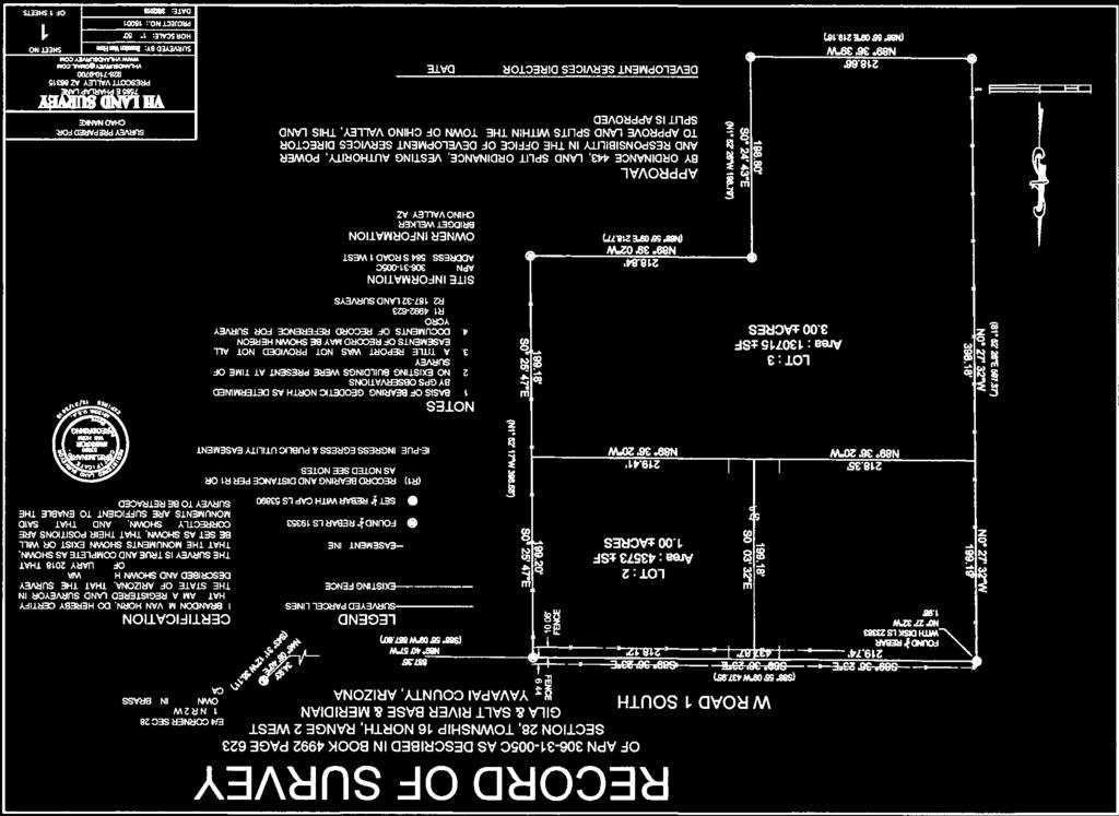
16 Planning and Zoning Commission Regular Meeting Date: 04/03/2018 Nanke Zone Change 6.b. CASE DESCRIPTION: Consideration and possible action regarding a request for a zone change for approximately 5 acres of real property generally located west of the southwest corner of West Road 1 South and South Road 1 West at 584 South Road 1 West, from AR-5 (Agricultural Residential 5 Acre Minimum) zoning district to SR-1 (Single Family Residential 1 Acre Minimum) zoning district. (Alex Lerma, Associate Planner) LOCATION: Located approximately 912 feet west of the southwest corner of West Road 1 South and South Road 1 West at 584 South Road 1 West. FACTS: 1. Applicant: North Blue, LLC 2. Owner: Chad Nanke 3. Parcel Number: C 4. Site Area: 5 acres 5. Existing zoning: AR-5 (Agricultural Residential- 5 Acre Minimum) 6. Intended Use: Vacant ANALYSIS: See attached Staff Report SITE PLAN See attached Site Plan RECOMMENDATION Forward to Town Council approval of a change in zoning district for parcel C from the current zoning of (AR-5) Agricultural Residential 5-Acre Minimum to (SR-1) Single Family Residential 1-Acre Minimum for property located west of the southwest corner of West Road 1 South and South Road 1 West at 584 South Road 1 West. Nanke Staff Report Nanke Record of Survey Nanke_ZoningMap Attachments
17 z PLANNING AND ZONING COMMISION STAFF REPORT APPLICATION SUMMARY File Number: Assessor s Parcel Number: Site Location: Property Owner: Applicant: Request: ZC C Located approximately 912 feet west of the southwest corner of West Road 1 South and South Road 1 West at 584 South Road 1 West. North Blue, LLC Chad Nanke Request for a zone change from (AR-5) Agricultural Residential- 5 Acre Minimum) to SR-1 (Single Family Residential- 1.0 Acre Minimum). SITE DATA Existing Zoning Lot Size Subdivision General Plan Land Use Designation Existing Land Use AR-5 (Agricultural Residential- 5 Acre Minimum) 5 acres (approximately 217,800 sq. ft.) N/A Medium Density Residential (2 acres or less) Vacant BACKGROUND SITE DESCRIPTION The subject property is located approximately 912 feet west of the southwest corner of West Road 1 South and South Road 1 West at 584 South Road 1 West. The property is currently zoned Agricultural Residential- 5 Acre Minimum under the Town of Chino Valley Unified Development Ordinance. The parcel is identified with a Land Use Designation of Medium Density Residential (2 acres or less) under the Town of Chino Valley General Plan Potential Land Use Map. The parcel is currently vacant. See Figure 1.
. To the west, properties are zoned SR-2.")
18 Figure 1: Site Map SURROUNDING PROPERTIES ZONING AND LAND USES The area is predominantly a low/medium density single family residential. The properties directly north are zoned AR-5 (Agricultural Residential- 5 Acre Minimum and SR-1 (Signal Family Residential- 1 Acre Minimum). To the west, properties are zoned SR-2.5 (Signal Family Residential- 2.5 Acre Minimum). Directly south, properties are zoned AR-5 (Agricultural Residential- 5 Acre Minimum). To the east of the subject parcel, properties are zoned (SR-1) Signal Family Residential- 1 Acre Minimum, (CL) Commercial Light and (AR-5) Agricultural Residential- 5 Acre minimum. See Figure 2 AREA ZONING GENERAL PLAN LAND USE DESIGNATION North AR-5, SR-1 Medium Density Residential (2 ac or less) West SR-2.5 Medium Density Residential (2 ac or less) South AR-5 Medium Density Residential (2 ac or less) East SR-1, CL, AR-5 Medium Density Residential (2 ac or less) LAND USE Low Density Single Family Home, Vacant Lots, Mollie Rae Estates Subdivision, Harmony Acres Subdivision Angus Acres Subdivision Low Density Single Family Homes Medium Density Single Family Homes, Low Density Single Family Homes
 parcels and build 1,600SF minimum single-level homes on each newly")
19 Figure 2: Zoning Map PROJECT DESCRIPTION The applicant is requesting approval of a change from Agricultural Residental-5 Acres Minimum to Single Family Residential 1 Acre Minimum. If the applicant is successful in receiving the approval of the rezoning, they intend to subdivide the property into three (3) parcels and build 1,600SF minimum single-level homes on each newly created parcels. The applicant is intending to deed restrict the homes to site-built homes only. Without approval of a zone change, the applicant could not proceed with the lot split. Mr. Nanke is intending to create legal assess to the lot by providing a 50 public way/easement across future lots 1 and 2. See Figure 3. PUBLIC REVIEW & HEARING PROCESS Town Staff notified property owners within a 300 radius, resulting in ten (10) notices of the neighborhood meeting and public hearings. Property owners received information regarding the applicant request for a zone change. To date, no responses to those letters have been received by the Town. The neighborhood meeting was held on March 12, 2018 on site. Three surrounding property owners attended the meeting. Since Mr. Nanke is intending to connect the three (3) future homes to Town water and sewer, one of the property owners was concerned that that Town would force them too to connect to the Towns utility lines. Property owners were also pleased to hear that Mr. Nanke would deed restrict the properties to site-built homes to add value and appeal to the surrounding neighborhoods.
20 Figure 3: Land Survey STAFF ANALYSIS AND RECOMMENDATION GENERAL PLAN CONFORMANCE The current (AR-5) Agricultural Residential- 5 Acre Minimum is in conformance with the 2014 Chino Valley General Plan s Future Land Use Map which places the property in a Medium Density Residential (2 acres or less) land use. The proposed zoning of (SR-1) Single Family Residential- 1 Acre Minimum will continue to be in conformance with the Medium Density Residential (2 acres or less) land use designation. ZONING The parcel s current AR-5 zoning is intended to promote and preserve low-density single-family residential and agricultural development. The district s regulations and development standards are designed to protect the single-family residential and agricultural character of the district and to prohibit all incompatible activities. Development patterns in the general surrounding area show that properties that were once low-density single-family residential and agricultural have transitioned into medium-density single-family residential properties including the nearby Mollie Rae and Harmony Acres Subdivision. The applicant s request for a SR-1 zone change will be supported by the same zoning district identified to the north and further east of the subject property. The regulations and property development standards of the SR-1 zoning district will protect the single-family residential character of the district.
21 STAFF RECOMMENDATION Staff recommends that the Planning and Zoning Commission forward to Town Council a recommendation of approval for a change in the zoning district for parcel C from the current zoning of (AR-5) Agricultural Residential 5-Acre Minimum to (SR-1) Single Family Residential 1-Acre Minimum. Parliamentary Procedure Chairman: I would entertain a motion Commissioner: I move to recommend approval to Town Council of this request to rezone approximately 5 acres of real property located approximately 912 feet west of the southwest corner of West Road 1 South and South Road 1 West at 584 South Road 1 West from (AR-5) Agricultural Residential- 5 Acre Minimum to (SR-1) Single Family Residential-1 Acres Minimum. Chairman: Do we have a second? Commissioner: I ll second Chairman: All in favor Commission: Aye (or nay) Chairman: Anybody opposed? Chairman: Motion is carried (or denied)
22
23 Zoning Exhibit A SR AR SR W ROAD 1 SOUTH Existing Zoning AR-5 PROPOSED ZONING SR SR-2.5 AR Z : Nanke Applicant: North Blue, LLC Request: Agriculture Residential (AR-5) to Single Family Residential (SR-1) Location: 584 S Road 1 West Chino Valley, AZ, APN C ³ Not Subject Property to Scale
24 Planning and Zoning Commission Regular Meeting Date: 04/03/2018 Perkinsville Road 40 PAD 6.c. CASE DESCRIPTION: Consideration and possible action regarding a request to rezone approximately 44 acres of real property generally located on the northeast corner of North Road 1 East and East Perkinsville Road at 1204 East Perkinsville Road, from AR-5 (Agricultural Residential 5 Acre Minimum) zoning district to SR-0.16 PAD (Single Family Residential 7,000 Square Foot Minimum Lot Area) zoning district with a Planned Area Development Overlay zoning district to modify the SR-0.16 zoning district development standards. (Jason Sanks, Development Service Director) LOCATION: Generally located on the northeast corner of North Road 1 East and East Perkinsville Road at 1204 East Perkinsville Road. FACTS: 1. Applicant: Gammage & Burnham PLC, Lindsay Schube 2. Owner: PerkAZ Property LLC 3. Parcel Number: H 4. Site Area: 44.3 Acres 5. Existing zoning: AR-5 (Agricultural Residential- 5 Acre Minimum) 6. Intended Use: Single Family Residential Subdivision ANALYSIS: See Attached Staff Report SITE PLAN See attached Site Plan RECOMMENDATION Forward to Town Council a recommendation of approval for a zone change of parcel H from the current zoning of AR-5 (Agricultural Residential-5 Acre Minimum) to SR-0.16 (Single Family Residential-7,000 Square Foot Minimum Lot Area) with a PAD (Planned Area Development) Overlay with the following conditions: 1. The development shall be in general conformance with the Conceptual Site Plan, Perimeter Wall Plans and Landscape Plan, as approved or modified by the Town s Development Services Director, with specific regard to the following: a) Location of pedestrian multi-use trail providing connectivity to Perkinsville Road; b) Perimeter landscaping along Perkinsville Road and Road 1 East; and c) Location of park including that two (2) picnic tables, one (1) tot lot, and one (1) Ramada shall be provided.
25 Perkinsville40 Staff Report PerkinsvilleRoad40_ConseptPlan PerkinsvilleRoad40_LandscapePlan Perkinsville40_Con_Wall_Plan Perkinville40_Character_Images Perkinsvile40_ZoningCaseExhibit Attachments
26 PLANNING AND ZONING COMMISION STAFF REPORT APPLICATION SUMMARY File Number: Assessor s Parcel Number: Site Location: Property Owner: Applicant: Request: ZC H Located on the northeast corner of East Perkinsville Road and North Road 1 East intersection at 1204 East Perkinsville Road, Chino Valley, AZ PerkAZ Property LLC Gammage & Burnham PLC, Lindsay Schube Request for a zone change from AR-5 (Agricultural Residential - 5 Acre Minimum) zoning district to SR-0.16 (Single Family Residential 7,000 Square Foot Minimum Lot Area) zoning district with a Planned Area Development overlay SITE DATA Existing Zoning Lot Size Subdivision General Plan Land Use Designation Existing Land Use (AR-5) Agricultural Residential- 5 Acre Minimum 44.3 acres (approximately 1,929,708 sq. ft.) N/A Medium Density Residential (2 ac or less) Single Family Residence BACKGROUND SITE DESCRIPTION The subject property is located on the northeast corner of East Perkinsville Road and North Road 1 East intersection at 1204 East Perkinsville Road. The site is currently zoned AR-5 (Agricultural Residential- 5 Acre Minimum) under the Town of Chino Valley Unified Development Ordinance. The parcel is identified with a Land Use Designation of Medium Density Residential (2 ac or less under the Town of Chino Valley General Plan Potential Land Use Map. The site is accessed via a private driveway from East Perkinsville Road. Existing improvements on the property include a vacant residence, accessory structures, vacant greenhouse structures on a concrete pad, and livestock fencing. See Figure 1.

27 Figure 1: Aerial Map SURROUNDING PROPERTIES AND LAND USES The area is predominantly comprised of medium and low density single family residential properties. The subject property is bounded on the south by East Perkinsville Road, on the west by North Road 1 East, on the north by East Road 3 North, and on the east by the Chino Valley Nursery. The properties to the north are zoned AR-5 (Agricultural Residential- 5 Acre Minimum), SR-1 (Single Family Residential- 1 Acre Minimum) and CL (Commercial Light) with vacant land and single family residential properties. To the west properties are zoned SR-1 (Single Family Residential- 1 Acre Minimum), CL (Commercial Light) and PL (Public Land). Those properties to the west are identified as single family residential properties and a storage mill. To the south parcels are zoned AR-5 (Agricultural Residential- 5 Acre Minimum), SR-2.5 (Single Family Residential- 2.5 Acre Minimum) and PL (Public Land), CL (Commercial Light) and SR-0.16 (Single Family Residential 7,000 Square Foot Minimum Lot Area). The south area is comprised of single family residence, vacant land and the Towns recreational center. To the east, the property is zoned AR-5 (Agricultural Residential- 5 Acre Minimum) and is identified as the Chino Valley Nursery, currently vacant. See Figure 2 AREA ZONING GENERAL PLAN LAND USE DESIGNATION North AR-5, SR-1, and CL Medium Density Residential (2ac or less) West SR-1, CL, PL Medium Density Residential (2ac or less) LAND USE Single Family Residence, Vacant Single Family Residence, Vacant, Storage Mill South CL, CH, MR-1/MHP-4 Medium Density Residential (2ac or less) Single Family Residence, Vacant, Town Recreational Center West AR-5 Medium Density Residential (2ac or less) Vacant Nursery
 zoning district with a Planned Area Development Overlay to create a new single-family residential community known currently as")
28 Figure 2: Zoning Map PROJECT DESCRIPTION The applicant requests to rezone the property from AR-5 (Agricultural Residential- 5 Acre Minimum) zoning district to SR-0.16 PAD (Single Family Residential- 7,000 Square Foot Minimum) zoning district with a Planned Area Development Overlay to create a new single-family residential community known currently as Perkinsville Road 40. The proposed SR-0.16 zoning district is consistent with the Medium Density Residential (2 ac or less) General Plan land use designation. The Conceptual Site Plan proposes 159 (minimum 56 x 125 ) single-family lots for individual ownership with a corresponding density of approximately 3.6 dwelling units per gross acre. (See Exhibit A- Concept Plan) Primary access to the community will be provided form North Road 1 East and East Perkinsville Road. The majority of the lots in the Conceptual Site Plan are oriented in a north-south direction around four (4) east-west streets. The north-south spine street and large open space amenity areas split the two grids of lots. The applicant has thoughtfully designed Perkinsville Road 40 to meet current and f uture housing demands. The project s proximity to Old Home Manor Industrial Park and transportation corridors makes it uniquely suited to accommodate the proposed density. Moreover, building new housing on smaller lots in an area served by public sewer and water results in a more efficient use of land and allows for more diverse housing opportunities. With the PAD overlay, the applicant modified development standards are supported by the provision of meaningful open space amenities and landscape tracts. This includes landscaped buffers at the project perimeter adjoining existing roadways. The minor deviations from standard requirements are reasonable considering the overall quality of the project.
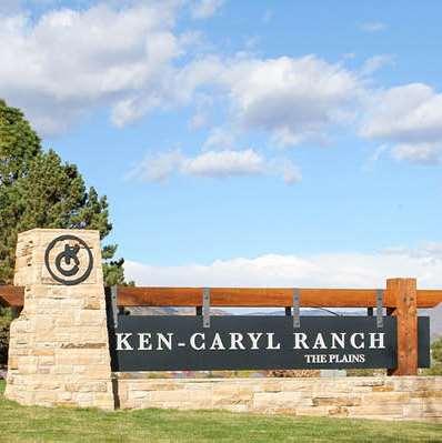
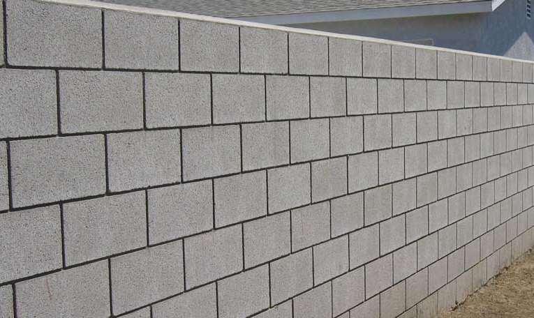
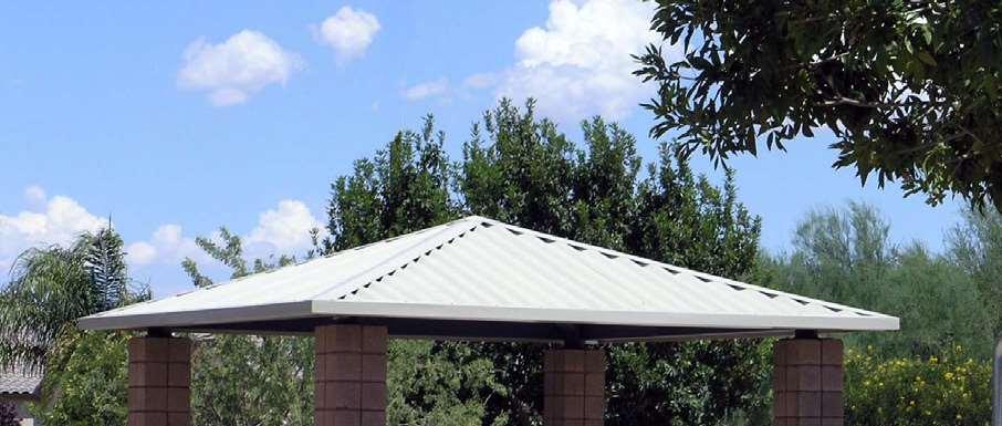
29 Landscape/ Open Space/ Amenities The project s location, adjacent to the Chino Valley Community Center Park (Town Park), will provide future residents of this community with easy access to an aquatic center, baseball and softball fields, playgrounds, soccer fields, and sand volleyball courts. The open space within the Project will provide both passive and active amenities and will provide pedestrian connection to the vast indoor and outdoor recreational opportunities offered at the Town Park. Perkinsville Road 40 is plans to include 6.4 acres of open space, making up 14% of the gross project area. (See Exhibit B- Landscape Plan) These common open spaces will include several passive open spaces areas, located in the middle of the Project will be located a central park with active recreational amenities, and a multi-use pedestrian trail that forms the backbone of the community by creating connectivity and opportunities for interaction among residents. The centrally located neighborhood park consists of approximately 1.3 acres and is directly accessible from multi-use trails and sidewalks. In addition to the recreational opportunities offered at the Town Park south of the Project, amenities in the central park will include two (2) picnic tables, one (1) tot lot, one (1) Ramada, seating areas, and shade trees. The project design will include multi-use trails and will serve as the social backbone of the neighborhood and will connect to the sidewalks along adjacent public roadways, as well as the Town Park. The multi-use trail corridor will be designed as a tree-lined, detached path with landscaping and shade. The Project design will provide future residents with a heightened sense of place and arrival with treelined boulevard-style entry from both East Perkinsville Road and north Road 1 East. The entrance from Road 1 East will open up to a larger open space tract with passive recreational opportunities that will create an open and inviting community environment. These open spaces will provide enhanced landscaping, shade trees, and seating areas to emphasize the social importance of passive open spaces as a gathering spot for community residents. The open spaces will serve as dual purpose facilities. Retention areas will be incorporated in the open space tracts, generally in the turf area, while sidewalks, trails, play equipment, and other active recreational amenities will be located outside of designated retention areas. Apart from the abundant amount of common area provided at the entrances and the central park, a landscaped buffer is planned along the north and south property line adjacent roadways. Decorative masonry perimeter theme walls will be used throughout the community, along adjacent public streets, open space areas, and the neighborhood perimeter to enhance the streetscape and visual presence of the community. Further, the perimeter walls/fencing is strategically planned along the perimeters of the Project to promote security and minimize impact from adjacent properties and roadways. (See Exhibit C- Conceptual Perimeter Wall Plan) The Conceptual Perimeter Wall Plan depicts where the following two types of 6-foot perimeter walls are proposed. Articulated, decorative themed walls abutting public roadways; and Standard block walls abutting adjacent private properties. The applicant has provided images to conceptually illustrate the design intent for amenity features and perimeter walls. These exhibits and images are conceptual only and intended to be illustrative of the character and quality of the community. (See Exhibit D- Character Images)
30 PLANNED AREA DEVELOPMENT PROPOSED MODIFICATIONS The SR-0.16 zoning classification will facilitate development at a density that is consistent with existing development in the immediate vicinity while allowing flexibility in lot area, dimensions, and other development standards. The applicants proposed SR-0.16 PAD standards are provided below. SR-0.16 PAD Development Standards SR-0.16 Standards Proposed SR-0.16 PAD Standards Minimum Lot Area 7,000 sq. ft. 7,000 sq. ft. Minimum Lot Frontage 50 ft. 50 ft. Minimum Building Setback from Arterial E. Perkinsville Rd. ( Ref. Section 4.28) Minimum Building Setback from Arterial- Road 1 East (Ref. Section 4.28) Minimum Building Setback from Arterial- Road 3 North (Ref. Section 4.28) Minimum Front Yard Setback (Section 4.28) 50 ft. 25 ft. * 50 ft. 50 ft. 50 ft. 20 ft. * 25 ft. 15 ft. * to livable 20 ft. * to garage (driveway) Minimum Side Yard Setback 10 ft. 5 ft. /10 ft. (15 ft. total)* Minimum Side Street Yard Setback from Local Street (Section 4.28) 20 ft. 10 ft. * Minimum Rear Yard Setback 10 ft. 10 ft. Maximum Building Height 25 ft. 2 stories/ 30 ft. * Accessory Building 5 ft. side / 10 ft. rear 5 ft. side / 5 ft. rear* Maximum Lot Coverage 50 % 55%* *INIDATES A PROPOSED MODIFICATION TO THE STANDARD In exchange for modified development standards, the project is able to provide additional, meaningful, open space amenities and landscape tracts, including landscaped buffers along the project perimeter and adjoining existing roadways. Approval of the proposed modifications to the development standards will result in a residential community with varying housing types and an overall higher quality of design. PUBLIC REVIEW & HEARING PROCESS Town Staff notified property owners within a 300 radius, resulting in twenty six (26) letters to surrounding property owners. Property received information regarding the applicate request for a zone change. To date, no responses to those letters have been received by the Town. The Firm representing the applicant revived the following two calls inquiries prior to the Neighborhood Meeting: 1. Feb. 14, 2018 A phone call was received from a real estate agent representing the owner of the 4-acre parcel adjacent to the northwest of the subject property. The owner is in
31 support of the applicants request for a zone change, but is elderly and lives out of town, so she will not be able to attend any of the public meetings. 2. Feb. 15, 2018 A phone call was received from Joyce Ford. She owns two parcels (one home) northeast of the property off of E. Red Cinder Road. She wanted to know what the proposal is and if it would utilize ground water that could potentially impact her well. It was explained to her that the project currently is requesting a zone change from agriculture to residential; a future subdivision application would be processed later; and that all residential units would hook up to public Town sewer and water, available in Perkinsville Road. She wanted to know if the Town would require her to dedicate land for public road. She was informed that the Town cannot make another property dedicate land; only the project site would be required to dedicate adjacent road frontage right-ofway. The neighborhood meeting was held on February 28, Approximately 10 property owners attended the meeting. An introduction was given by the applicant giving an overview of the development proposal. The applicant introduced the project exhibits, including a conceptual landscaping plan, conceptual development plan and design concepts. One of the property owners simply wanted to know the timing for the subdivision to be constructed. The Applicant stated that there is currently no developer or buyer for the property, so the time frame was unknown. Property owners wanted to know how tall the homes would be. The applicant stated that they would propose a modification through the PAD Overlay to increase the building height for SR-0.16 development standards from 25 to 30. Property owners asked if the project would be served with Town water and raised the issues if the Town would require existing homes in the area to connect to public water and/ or sewer. The applicant responded that the Town would be providing water to the project and that the Town would not require surrounding property owner to hook up to Town water/sewer. Ove rall the property owners who attended the meeting were in support of the zone change and were pleased with the design concepts the applicant provided. STAFF ANALYSIS AND RECOMMENDATION The property has a General Plan land use designation of MDR (Medium Density Residential). The application is to request a Zone Change from AR-5 to SR-0.16 with a PAD overlay, remain under the General Plan Medium Density Residential land use designation. The Applicant proposes residential development at a density that meets the intent of the MDR designation with a minimum lot size of 7,000 square feet. The Land Use Element section of the General Plan discusses the prevailing land use patterns in Chino Valley reflecting large residential-use lots spreading out long distances from each other and from shopping, schools, parks, series and other uses. This requires residents to drive long distances and does not promote a walkable community. The small residential lots proposed by the applicant will meet the need for smaller lots and higher density residential development. Through the General Plan, the Town has identified key areas for Community Cores within the Town of Chino Valley that provide convenience to neighborhood residents by concentrating various uses. The Recreation/ Employment/ Gateway Core is located at the intersection of Perkinsville Road and State Route 89, approximately 1,700 feet to the east of the subject property. The development will facilitate higher residential density near a Community Core as envisioned by the Town.
32 Furthermore the Land Use Element Section of the General Plan, when discussing future possibilities for land uses, the Plan encourage future subdivisions to be planned so that homes were located within an area offering options for waling, biking, or short-distance driving the subdivision might be considered to be part of a Community Core. The development will create a smooth transition from large lot residential and agricultural uses of the east to the more intense development envisioned at the Community Core to the west. The location of greater residential development to close proximity to services of the Community Core and the Chino Valley Community Center will facilitate the goal of ensuring a safe and walkable community. The project will also provide more affordable work force housing as needed for the long term development of the nearby Old Home Manor Industrial Park. STAFF RECOMMENDATION Staff recommends that the Planning and Zoning Commission forward to Town Council a recommendation of approval for a zone change of parcel H from the current zoning of AR-5 (Agricultural Residential- 5 Acre Minimum) to SR-0.16 (Single Family Residential- 7,000 Square Foot Minimum Lot Area) with a PAD (Planned Area Development) Overlay with the following conditions: 1. The development shall be in general conformance with the Conceptual Site Plan, Perimeter Wall Plans and Landscape Plan, as approved or modified by the Town s Development Services Director, with specific regard to the following: a) Location of pedestrian multi-use trail providing connectivity to Perkinsville Road; b) Perimeter landscaping along Perkinsville Road and Road 1 East; and c) Location of park including that two (2) picnic tables, one (1) tot lot, and one (1) Ramada shall be provided. Parliamentary Procedure Chairman: I would entertain a motion Commissioner: I move to recommend approval to Town Council of this request to rezone approximately 44.3 acres of real property located on the northeast corner of East Perkinsville Road and North Road 1 East intersection at 1204 East Perkinsville Road form the current zoning district of AR-5 (Agricultural Residential- 5 Acre Minimum) to SR-0.16 (Single Family Residential- 7,000 Square Foot Minimum Lot Area) with a PAD (Planned Area Development) Overlay with the following conditions: 1. The development shall be in general conformance with the Conceptual Site Plan, Perimeter Wall Plans and Landscape Plan, as approved or modified by the Town s Development Services Director, with specific regard to the following: a) Location of pedestrian multi-use trail providing connectivity to Perkinsville Road; b) Perimeter landscaping along Perkinsville Road and Road 1 East; and c) Location of park including that two (2) picnic tables, one (1) tot lot, and one (1) Ramada shall be provided. Chairman: Do we have a second? Commissioner: I ll second Chairman: All in favor
33 Commission: Aye (or nay) Chairman: Anybody opposed? Chairman: Motion is carried (or denied)

34 EXHIBIT A- CONCEPT PLAN

35 EXHIBIT B- LANDSCAPE PLAN

36 EXHIBIT C- PERIMETER WALL PLAN

37 EXHIBIT D - CHARACTER IMAGES

 Existing Zoning: AR-5 (Agricultural / Residential) Proposed Zoning:")


38 PERKINSVILLE ROAD PERKINSVILLE ROAD 40 CONCEPTUAL SITE PLAN NOVEMBER 29, 2017 CHINO VALLEY COMMUNITY CENTER PARK PL CHINO MEADOWS SR NORTH SCALE: 1 = 300 N ROAD 1 EAST Site Data Chart General Plan Designation: Medium Density Residential (2 Acres or Less) Existing Zoning: AR-5 (Agricultural / Residential) Proposed Zoning: SR-0.16 (Single Family Residential) with PAD Overlay Gross Acreage: +/ Acres Total Net Acreage: +/ Acres Total Yield: 159 Dwelling Units (56 x125 Minimum) Proposed Density: 3.6 Du/ Gross Acre Open Space: +/-6.4 Acres (14.4%) E ROAD 3 NORTH SR-1 AR-5 AR-5 CL CHINO VALLEY NURSERY AR-5 STATE ROUTE 89 CL AR-5 Note: This drawing is conceptual in nature. The lot layout is subject to change through the design and development process. PARK 1.3 AC Typical Lot Fit Diagram 50 MIN. REAR 10 SIDE FRONT 20 ROW
39 AR-5 E ROAD 3 NORTH STATE ROUTE 89 SR-1 N ROAD 1 EAST AR-5 PARK 1.3 AC CHINO VALLEY NURSERY AR-5 CL PERKINSVILLE ROAD CL AR-5 CHINO VALLEY COMMUNITY CENTER PARK PL CHINO MEADOWS SR-0.16 Note: This drawing is conceptual in nature. The lot layout is subject to change through the design and development process. EXHIBIT 1 NORTH SCALE: 1 = 300 PERKINSVILLE ROAD 40 CONCEPTUAL LANDSCAPE PLAN NOVEMBER 28, 2017

40 March 20, 2018 EXHIBIT 2


41 ENTRY SIGNAGE WALLS Note: Images shown are meant to illustrate design intent and character. Further detail will be provided through the design and development process PERKINSVILLE ROAD 40 CHARACTER IMAGES NOVEMBER 27, 2017 AMENITY & SITE LANDSCAPE EXHIBIT 3
42 ' ' / N ROAD 1 EAST Zoning Exhibit A CL/AR ' / ' CL SR SR SR CL / SR Existing Zoning AR Proposed Zoning SR-0.16 PAD SR CL AR SR ' E PERKINSVILLE RD Z : Perkinsville Road 40 PL Applicant: Lindsay Schube/ Gammage & Burnham PLC Request: Agriculture Residential (AR-5) to Single Family Residential SR-0.16 PAD SR-0.16 Location: 1204 E Perkinsville Road Chino Valley, AZ, APN H ³ Not CL FLINT WAY DEL RIO RD Subject Property to Scale
43 Planning and Zoning Commission Regular Meeting Date: 04/03/2018 Fletcher Industrail CUP 6.d. CASE DESCRIPTION: Consideration and possible action regarding a request for a Conditional Use Permit for approximately 120 acres of real property located northwest of North Jasper Trail at 4820 East Perkinsville Road to allow a hot mix asphalt plant in the I (Industrial) zoning district. (Jason Sanks, Development Services Director) LOCATION: Located northwest of North Jasper Trail at 4820 East Perkinsville Road. FACTS: 1. Applicant: James Fletcher 2. Owner: James Fletcher 3. Parcel Number: Site Area: 120 Acres 5. Existing zoning: I (Industrial) 6. Intended Use: Mining/ Crushing Hard Rock ANALYSIS: See attached Staff Report SITE PLAN See attached Site Plan RECOMMENDATION Forward to the Town Council a recommendation of approval for a Conditional Use Permit for to allow a hot mix/ asphalt plant in the I (Industrial) zoning district on property located northwest of North Jasper Trail at 4820 East Perkinsville Road subject to the following conditions: 1.) The hot mix facility will be developed in accordance with the exhibits provided by the applicant. 2.) Applicant will comply with all federal, state and local regulations. 3.) All required permits by State and Federal authorities will be completed before the start of the plant. Fletcher CUP Staff Report Fletcher CUP Site Plan Fletchers_ZoningCaseExhibit Attachments
44 PLANNING AND ZONING COMMISION STAFF REPORT APPLICATION SUMMARY File Number: C Assessor s Parcel Number: Site Location: Property Owner: Applicant: Request: Located northwest of North Jasper Trail at 4820 East Perkinsville Road James Fletcher James Fletcher Request to approve a Conditional Use Permit to allow a hot mix asphalt plant in the I (Industrial) zoning district. SITE DATA Existing Zoning Lot Size Subdivision General Plan Land Use Designation Existing Land Use I (Industrial) 120 acres (approximately 5, 227,200 sq. ft.) N/A Future Growth Areas: Industrial/ Agri-business/ Contained Planned Community Mining / crushing hard rock BACKGROUND SITE DESCRIPTION The subject property is located northwest of North Jasper Trail at 4820 East Perkinsville Road. The property is currently accessed by going east on East Perkinsville Road, turning north on East Haystack Road and merging onto North Jasper Trail. The site is identified with an I (Industrial) zoning district under the Town of Chino Valley UDO (Unified Development Ordinance). The parcel is identified with a Land Use Designation of Future Growth Areas: Industrial/ Agri-business/ Contained Planned Community under the Town of Chino Valley General Plan Potential Land Use Map. The site currently has heavy machinery and portable structures. The parcel is located directly west of the Chino Valley town limits. (See Figure 1.) PROJECT DESCRIPTION & HISTORY During the 1990 s, the applicant leased the subject site (Red Rock pit) out to United Metro Materials. United Metro Materials crushed and screened gravel for highway projects and concrete products. During the 2000 s, the applicant continued using the site to crush asphalt products for local contractors and other rock products.
45 In December of 2001, the Town of Chino Valley Annexed the property into the Town limits and through a development agreement the parties agreed that the zoning designation to be adopted by the Town of Chino Valley after the annexation would be I (Industrial) zoning to allow the historical uses of the property. As the need for asphalt products have increased in the area surrounding Chino Valley, the applicant has decided to install a plant on site. It is proposed that the asphalt plan will use the rock that is crushed on site to blend with oil to produce the asphalt products. There will be a bag house to catch the dust out of the plant, which is monitored and regulated by ADEQ (Arizona Department of Envi ronmental Quality. (See Figure 2) SURROUNDING PROERTIES ZONING AND LAND USES The area is predominantly made up of undeveloped land and rural single family residences within Yavapai County. The properties directly north have a zoning district of State (State Land) and is currently vacant. To the west, properties are zoned I (Industrial), State, and AR-4 (Agricultural Residential- 4 Acers Minimum). Directly west of the parcel is currently vacant, further west properties are vacant. To the south properties are zoned SR-1 (Single-Family Residential- 1 Acre Minimum) and STATE, these areas are currently vacant and undeveloped. To the east, properties are within Yavapai County s jurisdiction and have a County zoning of RCU-2A (Residential, Single-Family, Rural). Directly east of the subject property the parcel is vacant and further along in a southeast direction is the Haystack Ranches Subdivision. AREA ZONING GENERAL PLAN LAND USE DESIGNATION North STATE Future Growth Areas: Industrial/ Agri-business/ Contained Planned Community West I, STATE, AR-4 Future Growth Areas: Industrial/ Agri-business/ Contained Planned Community South SR-1, STATE Future Growth Areas: Industrial/ Agri-business/ Contained Planned Community East RCU-2A (Yavapai County Zoning District) Future Growth Areas: Industrial/ Agri-business/ Contained Planned Community EXISITING LAND USE Vacant Land Vacant Land Vacant Land Haystack Ranches Subdivision, Vacant Land (Yavapai County Area)
46 PUBLIC REVIEW PARTICIPATION The Town Staff notified property owners within a 600 radius, resulting in twelve (6) letters to surrounding property owners. Property owners received information regarding the applicant s request for a CUP to allow a hot mix asphalt plant in the I (Industrial) zoning district. To date, no responses to those letters have been received by the Town. The neighborhood meeting was held on March 12, At said meeting, there were one property owner who attended the meeting. One of the property owners was concerned with the odors and emmissions of the site. The applicant assured the property owner that the site will be regulated through the state and federal authorities and that the site would be receiving frequent inspections. STAFF ANALYSIS AND RECOMMENDATION SIGNIFICANT IMPACT To reduce admissions, the applicant will install a bag house to catch the dust from the plant and will be monitored by ADEQ and the state mining inspector. The applicant currently has an ADEQ Air Quality Class 1 permit. Class 1 permits are issued to any source that meets the requirements of Arizona Administrative Code (A.A.C.) Title 18, Chapter 2, Article 302 (B) (1). Such sources include: Any Major Source- any source that has the potential to emit 100 tons per year of any criteria air pollutant. A source is also considered major if it has the potential to emit 10 tons per year of any signal Hazardous Air Pollutant or 25 tons per year of any combination of Hazardous Air Pollutants. Any Affected Source- is a source that includes one or more units which ae subject to emission reduction requirements or limitations under Title IV of the Clean Air Act. Solid Waste Incinerations Units- Subject to Section 129(e) of the Clean Air Act. The site will also have water trucks for dust control from the loaders and trucks. The state has already permitted the applicant 279 acre feet of water for the site, under permit # for production and dust control. The following are permits the applicants has for the site: State Mining Permits ADWR (Arizona Department of Water Resource) Water Rights Permit MSHA (Mine Safety and Health Administration) Federal Mining Permit ADEQ (Arizona Department of Environmental Quality) Air Quality Class 1 Permit ADOT (Arizona Department of Transportation) Contractors-Furnished Material Sources Permit The current or any future operator must meet all federal, state, and local permitting requirements for the proposed uses on the property including mineral extraction, crushing operations and batch plant operations. Dust, noise, and odor are of primary concern as well as potential environmental contamination from vehicles and multiple fuel and oil sources.
47 GENERAL PLAN CONFORMANCE The current I (Industrial) zoning is already in conformance with the 2014 Chino Valley General Plan s Future Land Use Map, which places the property in a Future Growth Areas: Industrial/ Agri-business/ Contained Planned Community. The property s existing mining and crushing rock operation, along with its location on the very eastern edge of town, make it an excellent location for the proposed hot mix facility. CONSISTANCY WITH THE ZONING ORDINANCE The parcel s current zoning district is I (Industrial). Historically the land use of the property has been that of a mining and crushing rock site since the 1990s, since annexing into the Town the property has abide by the development standards set forth by the Industrial zoning district. The purpose of the Industrial zoning district is: Intended to provide to for and encourage industrial development within the Town, while insuring that such activities will have minimal impact on the surrounding districts. The existing land use of a mining and crushing rock operation is already permitted within the Industrial zoning district and is listed in Section 3.17 of the UDO as mining and associated batch plant, concrete plants and similar uses. The proposed Hot Mix/Asphalt Plan is also an allowable use subject to CUP approval. Staff recommends that the Planning and Zoning Commission forward to the Town Council a recommendation of approval for a Conditional Use Permit for to allow a hot mix/ asphalt plant in the I (Industrial) zoning district, subject to the following conditions: 1.) The hot mix facility will be developed in accordance with the exhibits provided by the applicant. 2.) Applicant will comply with all federal, state and local regulations. 3.) All required permits by State and Federal authorities will be completed before the start of the plant. Parliamentary Procedure Chairman: I would entertain a motion Commissioner: I move to recommend approval to the Town Council of this request to for a Conditional Use Permit for approximately 120 acres of real property located northwest of North Jasper Trail at 4820 East Perkinsville Road to allow a hot mix asphalt plant in the I (Industrial) zoning district, subject to the following conditions: 1.) The hot mix facility will be developed in accordance with the exhibits provided by the applicant. 2.) Applicant will comply with all federal, state and local regulations. 3.) All required permits by State and Federal authorities will be completed before the start of the plant.
48 Chairman: Do we have a second? Commissioner: I ll second Chairman: All in favor Commission: Aye (or nay) Chairman: Anybody opposed? Chairman: Motion is carried (or denied)

49 FIGURE 1. AERIAL MAP

50 FIGURE 2. Zoning Map
51 FIGURE 3. Site Plan

52 50' EASEMENT 400' ROCK EMPLOYER PORTABLE ASPHALT PLANT PARKING I- INDUSTRIAL SR ' 1320' 1320' 1320' 1320' I-INDUSTRIAL FLETCHER STATE STATE 2640' 300' 800' N JASPER TRAIL
53 Exhibit A STATE 1320 I Existing Zoning I SR-2 N Jasper Trl STATE SR-2 CUP : Fletcher Applicant: Carol A. Fletcher & James Fletcher Request: Asphalt Plant Location: 4820 Perkinsville, Chino Valley, AZ, APN ³ Not Subject Property to Scale
54 Planning and Zoning Commission Regular Meeting Date: 04/03/2018 St. Catherine Laboure Catholic Church CUP 6.e. CASE DESCRIPTION: Consideration and possible action regarding a request to amend the CUP (Conditional Use Permit) for approximately 2.82 acres of real property generally located 274 feet north of the northwest corner of West Road 3 North and State Route 89 at 2062 North State Route 89 to allow the installation and replacement of an electronic sign in the CL (Commercial Light) zoning district. (Alex Lerma, Associate Planner) LOCATION: Generally located 274 feet north of the northwest corner of West Road 3 North and State Route 89 at 2062 North State Route 89. FACTS: 1. Applicant: A &B Signs Co. Inc. (Bryan Wieweck) 2. Owner: St. Catherine Laboure Church 3. Parcel Number E 4. Site Area: 2.82 Acres 5. Existing zoning: CL (Commercial Light) 6. Intended Use: Community Church ANALYSIS: See attached Staff Report SITE PLAN See attached Design Plan RECOMMENDATION Forward to Town Council approval of a conditional use permit for the proposed electrical display for St. Catherine Laboure Catholic Church on property located 274 feet north of the northwest corner of West Road 3 North and State Route 89 at 2062 North State Route 89 subject to the following conditions: 1) The electronic sign shall not contain any form of animation and must remain static for at least eight seconds with a transition time of no greater than two seconds. If the Town and/or Arizona Department of Transportation ( ADOT ) develop more stringent requirements for static and transition time code for electronic signs, the sign that is subject to this Use Permit shall be modified to comply. 2) If the Town receives complaints from community residents of excessive brightness or glare at night, the applicant shall submit sign modification plans to the Development Services Department for review and approval that ensure brightness and glare are reduced to satisfactory levels. 3) Information displayed on the electronic sign shall be exclusive to activities and events that occur only on the premises, in compliance with ADOT regulations (A.R.S through and A.A.C. R and R ) and the Town s prohibition of off-site commercial signs.
55 St. Catherine_Staff Report St. Catherine Design Plan St. Catherine ZoningCaseExhibit Attachments
56 PLANNING AND ZONING COMMISION STAFF REPORT APPLICATION SUMMARY File Number: C Assessor s Parcel Number: Site Location: Property Owner: Applicant: Request: E Located approximately 270 feet north of the northwest corner of West Road 3 North and State Route 89 intersection at 2062 North State Route 89. St. Catherine Laboure Church A & B Signs Co. Inc. (Bryan Wieweck) Request for to amend the Conditional Use Permit (CUP) to allow the installation and replacement of an electrical sign. SITE DATA Existing Zoning Lot Size Subdivision General Plan Land Use Designation Existing Land Use CL (Commercial Light) 2.82 acres (approximately 122,839 sq. ft.) N/A Commercial/ Multi-Family Residential Community Church BACKGROUND SITE DESCRIPTION The subject property is approximately 270 feet north of the northwest corner of West Road 3 North and State Route 89 intersection at 2062 North State Route. The property currently accessed via North State Route 89. The site is identified with the CL (Commercial Light) zoning district under the Town of Chino Valley UDO (Unified Development Ordinance). The parcel is identified with a Land Use Designation of Commercial/ Multi-Family Residential under the Town of Chino Valley General Plan Potential Land Use Map. The site is accessed going north on State Route 89. Existing improvements on the property include a 9038 sq. ft. Church building, a modular classrooms, and a mobile home. (See Figure 1.) PROJECT DESCRIPTION & HISTORY With its close proximity to State Route 89, St. Catherine Laboure Church would like to replace its previous sign with a freestanding monument sign with a digital display. The double-sided digital display portion of
57 the freestanding monument sign will be approximately 15 sq. ft. in area (28.3 X75.5 ) and the LED reader panels will be in 16mm hi-resolution RGB (red-green-blue) with wireless communication. The electronic information centers will have a light sensor built in to them to automatically dim as the ambient light decreases. The new free standing monument sign will be located at least 6 feet from property line and will conform to the development standards set forth by the Commercial Light zoning district. (See Figure 2) Originally the applicate was granted a CUP to allow a free standing monument sign which included a light emitting diode (LED) Message reader board through Ordinance No and passed on June 25 th, (See Figure 3) The LED message reader board that was approved was 32 sq. ft. in area and was approximately 3 above ground level. With damages to the sign caused by a car accident, the property owners decided to completely remove the approved sign. The property owners submitted plans for the construction of a new sign at the beginning of this year. The proposed sign substantially differed from the one previously approved by council in Although the electronic display portion of the proposed sign abides by requirements set forth by the sign standards in the UDO, Staff believes that the increase in high from the three (3) feet above ground level that was approved originally in 2013, to the now proposed six (6) feet in the new design plan merits review and approval by Council in addition to the signs being location long a major thoroughfare along State Route 89. APPLICABLE STATUTES/ ORDINANCES GENERAL SIGN REGULATIONS A. The regulations, requirements, and provisions set forth in this Chapter shall apply to all signs erected, placed, or constructed within the Town. B. All signs shall be structurally designed, constructed, erected, and maintained in conformance with all applicable Technical Codes and regulations. C. Signs shall not be constructed or located in a manner that interferes with pedestrian or vehicular travel, obstructs free and clear vision of traffic, poses a hazard to either pedestrians or vehicles, or in such a manner to confuse, distract, or interfere with traffic and/or pedestrians. D. Signs shall be located a minimum of six feet (6') from property lines. E. All signs and sign structures, conforming and non-conforming, shall be maintained in good order, repair, and appearance at all times so as not to constitute a danger or hazard to the public safety or create visual blight as determined by the Zoning Administrator or his/her designee. F. All illuminated signs shall comply with Section 4.24 Outdoor Lighting including, but not limited to, Subsection General Requirements, Subsection (P). G. A non-commercial sign may be located in any location that a commercial sign is permitted and shall comply with the regulations set forth in this Chapter for that location. (Ord , passed )
58 SIGN STANDARDS B. Freestanding Signs USE ZONING DISTRICT MAXIMUM AREA CL, CH, I, PL and OS Shopping Centers or Commercial Centers MAXIMUM HEIGHT See Speed Limit Table B-2 STANDARDS One sign may be permitted for every 500 ft. of street frontage; Maximum of 2 signs per street frontage. Individual buildings within the development and/or the PAD sites within the commercial center shall not be considered as separate developments for signage purposes. May be illuminated. Speed Limit Table B-2 Speed Limit of Adjacent Roadway Maximum Area Maximum Height > 35 MPH 96 sq. ft. 12 ft. C. Electronic Signs Uses Zoning District Maximum Area Maximum Height Standards CL, CH, I, PL, and OS Electronic Signs: Per Use Permit Electronic Signs: Per Use Permit Electronic Signs: As conditioned in Use Permit. CL, CH, I, PL, and OS Reader Panel Signs: 32 sq. ft. Reader Panel Signs: 14 feet 8 foot minimum height to bottom of sign panel. SURROUNDING PROPERTIES ZONING AND LAND USES The area is predominantly made up of low density single family residences and commercial properties. The properties directly north and west are zoned CL (Commercial Light) and are currently vacant. To the south, properties are zoned CL (Commercial Light), the property directly south is a single family residence and further south is located a commercial center. To the east, adjacent State Route 89, properties are zoned CL (Commercial Light). Land uses include a single family residence, vacant land and an auto shop.
59 AREA ZONING GENERAL PLAN LAND USE DESIGNATION North CL Commercial/ Multi- Family Residential West CL Commercial/ Multi- Family Residential South CL Commercial/ Multi- Family Residential East CL Commercial/ Multi- Family Residential EXISITING LAND USE Vacant Land Vacant Land Single Family Residence, Commercial Center Single Family Residence, Vacant Land, Auto Shop PUBLIC REVIEW PARTICIPATION The Town Staff notified property owners within a 300 radius, resulting in fourteen (14) letters to surrounding property owners. Property owners received a copy of the design plan proposed by the applicant. To date, no responses to those letters have been received by the Town. STAFF ANALYSIS AND RECOMMENDATION GENERAL PLAN CONFORMANCE The current CL (Commercial Light) is in conformance with the 2014 Chino Valley General Plan s Future Land Use Map, which places the property in a Commercial/Multi-Family Residential Land Use. The property s land use of a community church has been the same in the previous years and will continue to do so in the near future. CONSISTANCY WITH THE ZONING ORDINANCE The parcels current zoning district is CL (Commercial Light). Historically the land use of the property has been that of a community church and has abide by the development standards set forth by the Commercial Light zoning district. The purpose of the Commercial Light district is: to provide for neighborhood amenity and some general commercial uses. Land use is composed chiefly of retail and service businesses, offices, and apartments, together with necessary accessory uses. The existing land use of a community church is already permitted within the Commercial Light district. The proposed sign is also an allowable use, subject to CUP approval. TRAFFIC HAZARD OR CONGESTION: The lighting of the sign will make the sign more visible to traffic. A conce rn with electronic/digital display is the fact that the message changes every few seconds and has the potential to distract motorists. The Town s sign regulations do not dictate requirements regarding a time frame between the changing of messages in an effort to minimize the potential for distraction. The applicant has indicated that the
60 electronic information center will use a light sensor built in to automatically dim as the ambient light decreases. Arizona Revised Statutes , , and relate to the regulation and control of electronic outdoor advertising located along Arizona highways. Section E1 states that electrical outdoor advertising signs must not contain any form of animation and must remain static for at least eight seconds with a transition time of no greater than two seconds. Since this sign will be located on SR-89, staff has proposed matching this criteria in the conditions of approval for the CUP. ON-PREMISE VS OFF-PREMISE SINGS: Signs abutting ADOT right of way are either categorized as On-Premise or Off- Premise signs. ADOT defines an On-Premise as a sign that is located on the premises of the activity that the sign advertises. The premises is defined as that land that is actually used and integral to the activity. If the sign advertises only the activity on the premises, it is exempt from the State s requirements for size, location, and spacing and does not need an Arizona Outdoor Advertising Permit. Furthermore ADOT defines an Off-Premise Sign as signs that are located on premises other than where the activity, service or production that the sign advertises is located. The State s regulations control the size, location, spacing, and lighting of billboards that are along the regulated highways. An Arizona Outdoor Advertising Permit is required before erecting or maintaining a billboard along a regulated highway. This is in addition to any permit that is required by the local governing jurisdiction. The information displayed on the proposed church sign will need to stay exclusive to the property and its activities to be considered an On-Premise sign. This means that if church wants to advertise sponsored community events, those events will need to be conducted on site. If in the future church wishes to display information not related to the site itself, ADOT will consider it a billboard and an Off-Premise Sign. STAFF RECOMMENDATION Staff recommends that the Planning and Zoning Commission forward to the Town Council a recommendation of approval for a Conditional Use Permit for the proposed electrical display for St. Catherine Laboure Catholic Church, subject to the following conditions: 1) The electronic sign shall not contain any form of animation and must remain static for at least eight seconds with a transition time of no greater than two seconds. If the Town and/or Arizona Department of Transportation ( ADOT ) develop more stringent requirements for static and transition time code for electronic signs, the sign that is subject to this Use Permit shall be modified to comply. 2) If the Town receives complaints from community residents of excessive brightness or glare at night, the applicant shall submit sign modification plans to the Development Services Department for review and approval that ensure brightness and glare are reduced to satisfactory levels. 3) Information displayed on the electronic sign shall be exclusive to activities and events that occur only on the premises, in compliance with ADOT regulations (A.R.S through and A.A.C. R and R ) and the Town s prohibition of off-site commercial signs.
61 Parliamentary Procedure Chairman: I would entertain a motion Commissioner: I move to recommend approval to Town Council of this request for of a Conditional Use Permit for the proposed electrical display for parcel E, located approximately 270 feet north of the northwest corner of West Road 3 North and State Route 89 intersection at 2062 North State Route 89 subject to the following conditions: 1) The electronic sign shall not contain any form of animation and must remain static for at least eight seconds with a transition time of no greater than two seconds. If the Town and/or Arizona Department of Transportation ( ADOT ) develop more stringent requirements for static and transition time code for electronic signs, the sign that is subject to this Use Permit shall be modified to comply. 2) If the Town receives complaints from community residents of excessive brightness or glare at night, the applicant shall submit sign modification plans to the Development Services Department for review and approval that ensure brightness and glare are reduced to satisfactory levels. 3) Information displayed on the electronic sign shall be exclusive to activities and events that occur only on the premises, in compliance with ADOT regulations (A.R.S through and A.A.C. R and R ) and the Town s prohibition of off-site commercial signs. Chairman: Do we have a second? Commissioner: I ll second Chairman: All in favor Commission: Aye (or nay) Chairman: Anybody opposed? Chairman: Motion is carried (or denied)

62 FIGURE 1. AERIAL MAP

63 FIGURE 2. Proposed Design Plan

64 FIGURE 3. Originally Approved Design Plan


65
DECEMBER 5, :00 P.M.
 MINUTES OF THE REGULAR PLANNING AND ZONING MEETING OF THE TOWN OF CHINO VALLEY DECEMBER 5, 2017 6:00 P.M. The Planning and Zoning Commission of the Town of Chino Valley, met for a Regular Meeting in the
Planning and Zoning Commission STAFF REPORT REQUEST. DSA : Zone Change from R-3 (Multi-Family Residential) to B-4 (Community Services).
 to B-4 (Community Services).") Planning and Zoning Commission STAFF REPORT AGENDA # TO: FROM: PLANNING AND ZONING COMMISSION Joseph Horn, City Planner MEETING DATES: August 4, 2016 SUBJECT: Gino Tarantini zone change requests REQUEST
Planning and Zoning Commission STAFF REPORT AGENDA # TO: FROM: PLANNING AND ZONING COMMISSION Joseph Horn, City Planner MEETING DATES: August 4, 2016 SUBJECT: Gino Tarantini zone change requests REQUEST
JUNE 5, :00 RM.
 MINUTES OF THE REGULAR PLANNING AND ZONING MEETING OF THE TOWN OF CHINO VALLEY JUNE 5, 2018 6:00 RM. The Planning and Zoning Commission ofthe Town ofchino Valley met for a Regular Meeting in the Chino
PLANNING AND ZONING COMMISSION FEBRUARY 20, :30 P.M. PLANNING AND ZONING MEMBERS PRESENT MEMBERS ABSENT: STAFF PRESENT:
 PLANNING AND ZONING COMMISSION FEBRUARY 20, 2018 5:30 P.M. PLANNING AND ZONING MEMBERS PRESENT Chair Lester Fettig Omar Crisp Paulino Castillo Lydia Alaniz Bryant Ward Jessica Walker Jeremy Langley MEMBERS
Cover Letter with Narrative Statement
 Cover Letter with Narrative Statement March 31, 2017 rev July 27, 2017 RE: Rushton Pointe Residential Planned Unit Development Application for Public Hearing for RPUD Rezone PL2015 000 0306 Mr. Eric Johnson,
MINUTES OF THE WORK STUDY MEETING OF THE QUEEN CREEK PLANNING AND ZONING COMMISSION AGENDA
 November 14, 2012, Page 1 of 5 MINUTES OF THE WORK STUDY MEETING OF THE QUEEN CREEK PLANNING AND ZONING COMMISSION WHEN: WEDNESDAY, NOVEMBER 14, 2012 WHERE: TOWN HALL COUNCIL CHAMBERS TIME: 6:00 p.m. Pursuant
1. Roll Call. 2. Minutes a. September 26, 2016 Regular Meeting. 3. Adoption of the Agenda. 4. Visitors to Be Heard
 1. Roll Call City of Vermillion Planning Commission Agenda 5:30 p.m. Regular Meeting Tuesday, October 11, 2016 Large Conference Room 2 nd Floor City Hall 25 Center Street Vermillion, SD 57069 2. Minutes
Marion County Board of County Commissioners
 Marion County Board of County Commissioners Date: 12/29/2015 P&Z: 12/28/2015 BCC: 1/12/2016 Item Number 160113Z Type of Application Rezoning Request From: A-1 (General Agriculture) To: PUD (Planned Unit
TOWN OF ORO VALLEY PLANNING & ZONING COMMISSION MEETING DATE: December 6, 2011
 PLANNING & ZONING COMMISSION MEETING DATE: December 6, 2011 TO: FROM: SUBJECT: PLANNING & ZONING COMMISSION Matt Michels, Senior Planner mmichels@orovalleyaz.gov; tel. 229-4822 Public Hearing: Rancho de
MINUTES JOINT MEETING LINCOLN COUNTY and SIOUX FALLS PLANNING COMMISSIONS 7:00 pm August 10, 2011
 MINUTES JOINT MEETING LINCOLN COUNTY and SIOUX FALLS PLANNING COMMISSIONS 7:00 pm August 10, 2011 Commissioners Room - Lincoln County Court House A joint meeting of the Lincoln County and Sioux Falls Planning
LEMOORE PLANNING COMMISSION Regular Meeting AGENDA Lemoore Council Chamber 429 C Street. May 14, :00 p.m.
 LEMOORE PLANNING COMMISSION Regular Meeting AGENDA Lemoore Council Chamber 429 C Street May 14, 2018 7:00 p.m. 1. Pledge of Allegiance 2. Call to Order and Roll Call 3. Public Comment This time is reserved
PRELIMINARY PLANNED AREA DEVELOPMENT APPLICATION (PAD)
") PRELIMINARY PLANNED AREA DEVELOPMENT APPLICATION (PAD) Preliminary Planned Area Development Fee: Date Paid SECTION 1.9.4.1 PRELIMINARY PAD APPLICATION A Master development plan (showing general land use
PRELIMINARY PLANNED AREA DEVELOPMENT APPLICATION (PAD) Preliminary Planned Area Development Fee: Date Paid SECTION 1.9.4.1 PRELIMINARY PAD APPLICATION A Master development plan (showing general land use
CITY OF ALBERT LEA PLANNING COMMISSION ADVISORY BOARD
 CITY OF ALBERT LEA PLANNING COMMISSION ADVISORY BOARD 9/1/2015, 5:30 p.m. City Council Chambers AGENDA A. CALL TO ORDER AND ROLL CALL B. APPROVAL OF THE AGENDA C. APPROVAL OF MINUTES 1. PC Minutes from
Staff Report: Date: Applicant: Property Identification: Acreage of Request: Current Zoning of Requested Area: Requested Action: Attached:
 Staff Report: Completed by Jeff Palmer Director of Planning & Zoning Date: November 7, 2018, Updated November 20, 2018 Applicant: Greg Smith, Oberer Land Developer agent for Ronald Montgomery ET AL Property
MINUTES. May 1, Chairman Smith called the City Plan Commission Meeting to order at 7 p.m.in the City Council Chambers.
 MINUTES May 1, 2018 Chairman Smith called the City Plan Commission Meeting to order at 7 p.m.in the City Council Chambers. The following Commission members were in attendance: Michael Smith, Chairman Ken
ZONING AMENDMENT & SUBDIVISION STAFF REPORT Date: November 3, 2016
 ZONING AMENDMENT & SUBDIVISION STAFF REPORT Date: November 3, 2016 APPLICANT NAME SUBDIVISION NAME David Shumer 5955 Airport Subdivision CITY COUNCIL DISTRICT District 6 5955 Airport Boulevard, 754 Linlen
Board of Adjustments Staff Brief
 Town of Chino Valley Development Services Department 1982 N. Voss Drive #203 Chino Valley, AZ 86323 928-636-4427 www.chinoaz.net Board of Adjustments Staff Brief Date: August 25, 2014 Agenda Item: VAR14-002
Financial Impact Statement There are no immediate financial impacts associated with the adoption of this report.
 STAFF REPORT Planning and Development Department Subject: Application by RYC Property to rezone a portion of lands on John Murray Dr. and Megan Lynn Dr. from R2 to R3 and to enter into a Development Agreement
Planning Department Oconee County, Georgia
 Planning Department Oconee County, Georgia STAFF REPORT REZONE CASE #: 6985 DATE: October 31, 2016 STAFF REPORT BY: Andrew C. Stern, Planner APPLICANT NAME: Williams & Associates, Land Planners PC PROPERTY
Also present were Bill Mann, Senior Planner and Senior Secretary Amber Lehman.
 held Monday, August 26, 2013, at 7:00 P.M. in the Council Chambers, 11 North 3 rd Street, Jacksonville Beach, Florida Call to Order The meeting was called to order by Chairman Greg Sutton. Roll Call Greg
MINUTES OF THE PLANNING AND ZONING COMMISSION CITY OF HAYDEN, KOOTENAI COUNTY, IDAHO. September 17, 2018
 MINUTES OF THE PLANNING AND ZONING COMMISSION CITY OF HAYDEN, KOOTENAI COUNTY, IDAHO September 17, 2018 Regular Meeting: 5:00 PM Council Chambers Hayden City Hall, 8930 N. Government Way, Hayden, ID 83835
PLANNING COMMISSION MINUTES OF MEETING Wednesday, December 12, :00 p.m.
 0 PLANNING COMMISSION MINUTES OF MEETING Wednesday, December, 0 :00 p.m. A quorum being present at Centerville City Hall, North Main Street, Centerville, Utah, the meeting of the Centerville City Planning
RC ; Reclassification The Garrison at Stafford Proffer Amendment (formerly Stafford Village Center)
") Board of Supervisors Robert Bob Thomas, Jr., Chairman Laura A. Sellers, Vice Chairman Meg Bohmke Jack R. Cavalier Wendy E. Maurer Paul V. Milde, III Gary F. Snellings Anthony J. Romanello, ICMA CM County
Board of Supervisors Robert Bob Thomas, Jr., Chairman Laura A. Sellers, Vice Chairman Meg Bohmke Jack R. Cavalier Wendy E. Maurer Paul V. Milde, III Gary F. Snellings Anthony J. Romanello, ICMA CM County
Proposed Overland Park Kansas Ordinance RE-1 Residential Estates Community
 18.171 RE-1 Residential Estate Community 18.171.010 Statement of intent. The zoning of property as RE-1, (Residential Estates Community, 1 dwelling unit per Gross acre density), is intended to provide
PLANNING COMMISSION STAFF REPORT
 PLANNING COMMISSION STAFF REPORT West Capitol Hill Zoning Map Amendment Petition No. PLNPCM2011-00665 Located approximately at 548 W 300 North Street, 543 W 400 North Street, and 375 N 500 West Street
PLANNING COMMISSION REPORT REGULAR AGENDA
 PP-4-4-11 Item No. 9-1 PLANNING COMMISSION REPORT REGULAR AGENDA PC Staff Report 06/22/11 ITEM NO 9: PRELIMINARY PLAT; KASOLD WATER TOWER ADDITION; SE OF TAM O SHANTER & KASOLD DR (MKM) PP-4-4-11: Consider
VILLAGE OF DOWNERS GROVE PLAN COMMISSION VILLAGE HALL COUNCIL CHAMBERS 801 BURLINGTON AVENUE. January 7, :00 p.m. AGENDA
 VILLAGE OF DOWNERS GROVE PLAN COMMISSION VILLAGE HALL COUNCIL CHAMBERS 801 BURLINGTON AVENUE January 7, 2019 7:00 p.m. 1. Call to Order AGENDA 2. Roll Call a. Pledge of Allegiance 3. Approval of Minutes
Lincoln County Board of Commissioner s Agenda Item Cover Sheet
 Lincoln County Board of Commissioner s Agenda Item Cover Sheet Board Meeting Date: Agenda Item Type: Consent Agenda: Public Hearing: Regular Agenda: Presentation Time (est): Submitting Person: Phone Number/Ext:
ZONING AMENDMENT, PLANNED UNIT DEVELOPMENT & SUBDIVISION STAFF REPORT Date: August 8, 2013
 ZONING AMENDMENT, PLANNED UNIT DEVELOPMENT & SUBDIVISION STAFF REPORT Date: August 8, 2013 NAME SUBDIVISION NAME PV-Magnolia, LLC Twelve Trees Subdivision LOCATION 2860, 2862 and 2866 Pleasant Valley Road
City and County of Broomfield, Colorado
 City and County of Broomfield, Colorado CITY COUNCIL AGENDA MEMORANDUM To: From: Mayor and City Council George Di Ciero, City and County Manager Teri Malies, Principal Planner Terrance Ware, Planning Director
Board of Zoning and Planning Members. Justin A. Milam, AICP, Planning Officer. Positive recommendation of a rezoning to City Council.
 To: From: Board of Zoning and Planning Members Justin A. Milam, AICP, Planning Officer Prepared for Meeting Dated: Tuesday, February 19, 2013 Subject: Action Requested: Master Plan Objective: BZAP review
DEWITT CHARTER TOWNSHIP 1401 W. HERBISON ROAD, DeWITT, MI PLANNING COMMISSION MINUTES MONDAY, APRIL 7, 2008
 DEWITT CHARTER TOWNSHIP 1401 W. HERBISON ROAD, DeWITT, MI PLANNING COMMISSION MINUTES MONDAY, APRIL 7, 2008 The regularly scheduled meeting of the DeWitt Charter Township Planning Commission was called
Article Optional Method Requirements
 Article 59-6. Optional Method Requirements [DIV. 6.1. MPDU DEVELOPMENT IN RURAL RESIDENTIAL AND RESIDENTIAL ZONES Sec. 6.1.1. General Requirements... 6 2 Sec. 6.1.2. General Site and Building Type Mix...
SUBDIVISION, PLANNED UNIT DEVELOPMENT, ZONING AMENDMENT, & SIDEWALK WAIVER STAFF REPORT Date: July 19, 2018
 SUBDIVISION, PLANNED UNIT DEVELOPMENT, ZONING AMENDMENT, & SIDEWALK WAIVER STAFF REPORT Date: July 19, 2018 NAME SUBDIVISION NAME LOCATION West Mobile Properties, LLC U.S. Machine Subdivision 556, 566,
PALM BEACH COUNTY PLANNING, ZONING AND BUILDING DEPARTMENT ZONING DIVISION
 PALM BEACH COUNTY PLANNING, ZONING AND BUILDING DEPARTMENT ZONING DIVISION Application No.: Z-2014-01627 Application Name: Dazco Center Control No.: 2003-00040 Applicant: 4730 Hypoluxo LLC Owners: 4730
Town of Waxhaw Board of Commissioners. Waxhaw Police Department Community Meeting Room Tuesday January 12, 2016
 Town of Waxhaw Board of Commissioners Waxhaw Police Department Community Meeting Room Tuesday January 12, 2016 Petition RZ-003994-2015 A request by the Town of Waxhaw Planning & Community Development Department,
MINUTES JOINT MEETING LINCOLN COUNTY and SIOUX FALLS PLANNING COMMISSIONS 7:00 pm July 14, 2010
 MINUTES JOINT MEETING LINCOLN COUNTY and SIOUX FALLS PLANNING COMMISSIONS 7:00 pm July 14, 2010 Commissioners Room - Lincoln County Court House A joint meeting of Lincoln County and Sioux Falls Planning
Condominium Unit Requirements.
 ARTICLE 19 CONDOMINIUM REGULATIONS Section 19.01 Purpose. The purpose of this Article is to regulate projects that divide real property under a contractual arrangement known as a condominium. New and conversion
Draft Model Access Management Overlay Ordinance
 Draft Model Access Management Overlay Ordinance This model was developed using the City of Hutchinson and the Trunk Highway 7 corridor. The basic provisions of this model may be adopted by any jurisdiction
THE CITY OF RAYMORE, MISSOURI Single-Family Residential Zoning Districts
 THE CITY OF RAYMORE, MISSOURI Single-Family Residential Zoning Districts REGULATIONS COMMON TO ALL DISTRICTS: Uses permitted in each district include detached single-family dwellings, manufactured homes
VILLAGE OF ORLAND PARK
 14700 Ravinia Avenue Orland Park, IL 60462 www.orlandpark.org Ordinance No: File Number: 2016-0865 ORDINANCE REZONING CERTAIN REAL ESTATE FROM E-1 ESTATE RESIDENTIAL DISTRICT TO COR MIXED USE DISTRICT
Marion County Board of County Commissioners
 Marion County Board of County Commissioners Date: 12/2/2015 P&Z: 11/30/2015 BCC: 12/16/2015 Item Number 151210SU Type of Application Special Use Permit Request To establish a Clay Electric Co-Operative
REGULAR MEETING OF THE PLANNING COMMISSION Dearborn, Michigan. June 12, 2017
 REGULAR MEETING OF THE PLANNING COMMISSION Dearborn, Michigan June 12, 2017 The regular meeting was called to order at 7:08 P.M. by Chairperson Siwik. Upon roll call, the following members were present:
Magna Metro Township Council Meeting Public Meeting Agenda. Tuesday, July 18, :00 P.M.
 Planning and Development Services 2001 S. State Street N3-600 Salt Lake City, UT 84190-4050 Phone: (385) 468-6700 Fax: (385) 468-6674 www.pwpds.slco.org Magna Metro Township Council Meeting Public Meeting
EDGERTON CITY HALL PLANNING COMMISSION MEETING REGULAR SESSION March 12, 2019
 EDGERTON CITY HALL PLANNING COMMISSION MEETING REGULAR SESSION The met in regular session with Chair John Daley calling the meeting to order at 7:00 p.m. All present participated in the Pledge of Allegiance.
SPRINGETTSBURY TOWNSHIP ZONING HEARING BOARD AUGUST 6, 2015
 SPRINGETTSBURY TOWNSHIP ZONING HEARING BOARD AUGUST 6, 2015 MEMBERS IN ATTENDANCE: ALSO IN ATTENDANCE: NOT PRESENT: Dale Achenbach, Chairman Sande Cunningham David Seiler Trisha Lang, Director of Community
CITY OF SANTA ROSA COMMUNITY DEVELOPMENT DEPARTMENT STAFF REPORT FOR PLANNING COMMISSION SEPTEMBER 10, 2015 APPLICANT FILE NUMBER MJP
 ITEM NO. 9 CITY OF SANTA ROSA COMMUNITY DEVELOPMENT DEPARTMENT STAFF REPORT FOR PLANNING COMMISSION SEPTEMBER 10, 2015 PROJECT TITLE Yogurt Time Center ADDRESS/LOCATION 3093 Marlow Road ASSESSOR S PARCEL
A. CONSIDERATION OF THE UNAPPROVED MINUTES OF DECEMBER 11, 2018
 I. CALL TO ORDER OFFICIAL AGENDA PLANNING & ZONING COMMISSION CITY OF STARKVILLE, MISSISSIPPI MEETING OF TUESDAY, JANUARY 8, 2018 1ST FLOOR CITY HALL COURT ROOM 110 WEST MAIN STREET AT 5:30 PM II. III.
Appendix A: Guide to Zoning Categories Prince George's County, Maryland
 Appendix A: Guide to Zoning Categories Prince George's County, Maryland RESIDENTIAL ZONES 1 Updated November 2010 R-O-S: Reserved Open Space - Provides for permanent maintenance of certain areas of land
CLEARFIELD CITY COUNCIL AGENDA AND SUMMARY REPORT July 31, 2018 SPECIAL POLICY SESSION
 CLEARFIELD CITY COUNCIL AGENDA AND SUMMARY REPORT July 31, 2018 SPECIAL POLICY SESSION Meetings of the City Council of Clearfield City may be conducted via electronic means pursuant to Utah Code Ann. 52-4-207
CONDOMINIUM REGULATIONS
 ARTICLE 37 CONDOMINIUM REGULATIONS SECTION 37.01. Purpose The purpose of this Article is to regulate projects that divide real property under a contractual arrangement known as a condominium. New and conversion
PALM BEACH COUNTY PLANNING, ZONING AND BUILDING DEPARTMENT ZONING DIVISION
 PALM BEACH COUNTY PLANNING, ZONING AND BUILDING DEPARTMENT ZONING DIVISION Application No.: Z/CA-2013-00493 Application Name: Trails Charter School Control No.: 2013-00085 Applicant: MG3 ALF Military LLC
LOCAL PLANNING AGENCY MEETING Martin County Commissioner Chambers 2401 S.E. Monterey Road Stuart, Florida MEETING MINUTES- November 5, 2015
 LOCAL PLANNING AGENCY MEETING Martin County Commissioner Chambers 2401 S.E. Monterey Road Stuart, Florida 34996 MEETING MINUTES- November 5, 2015 Present: Chairman Jim Moir Vice Chairperson Crystal Lucas
BOARD OF ZONING ADJUSTMENT MINUTES MEETING OF SEPTEMBER 9, :00 P.M. MOBILE GOVERNMENT PLAZA, MULTI-PURPOSE ROOM
 BOARD OF ZONING ADJUSTMENT MINUTES MEETING OF SEPTEMBER 9, 2002-2:00 P.M. MOBILE GOVERNMENT PLAZA, MULTI-PURPOSE ROOM MEMBERS PRESENT John Peebles, Chairman Reid Cummings, Vice-chairman Rev. P. H. Lewis
PLANNING ANALYSIS ZONING CASE 18-TOD-Z-026 NAK S CROSSING PUD AMENDMENT. GC-3-A (General Commercial) GC-3-A (General Commercial)
 GC-3-A (General Commercial)") PLANNING ANALYSIS ZONING CASE 18-TOD-Z-026 NAK S CROSSING PUD AMENDMENT GENERAL INFORMATION Applicant/Owner: Current Zoning: Bruce Nakfoor PUD/TOD (Planned Unit Development/Transit Oriented Development
PLANNING ANALYSIS ZONING CASE 18-TOD-Z-026 NAK S CROSSING PUD AMENDMENT GENERAL INFORMATION Applicant/Owner: Current Zoning: Bruce Nakfoor PUD/TOD (Planned Unit Development/Transit Oriented Development
4.2 RESIDENTIAL ZONING DISTRICTS
 4.2 RESIDENTIAL ZONING DISTRICTS A. Purpose: To define regulations and standards for each residential zoning district in the City. The following sections identify uses, regulations, and performance standards
EDMOND PLANNING COMMISSION 20 S. Littler, Edmond, Oklahoma Tuesday, May 6, :30 p.m.
 City of Edmond NOTICE OF PUBLIC MEETING The City of Edmond encourages participation from all its citizens. If participation at any Public meeting is not possible due to a disability, notification to the
A. CONSIDERATION OF THE UNAPPROVED MINUTES OF NOVEMBER 13, 2018
 I. CALL TO ORDER OFFICIAL AGENDA PLANNING & ZONING COMMISSION CITY OF STARKVILLE, MISSISSIPPI MEETING OF TUESDAY, DECEMBER 11, 2018 1ST FLOOR CITY HALL COURT ROOM 110 WEST MAIN STREET AT 5:30 PM II. III.
Chapter CC COMMUNITY COMMERCIAL ZONES REGULATIONS
 Effective April 14, 2011 Chapter 17.35 CC COMMUNITY COMMERCIAL ZONES REGULATIONS SECTIONS: 17.35.010 Title, Intent, and Description 17.35.020 Required Design Review Process 17.35.030 Permitted and Conditionally
M E M O R A N D U M. Planning and Zoning Commission. Daniel Turner, Planner I
 M E M O R A N D U M Meeting Date: Monday, April 10, 2017 Item No. F-4 To: From: Planning and Zoning Commission Daniel Turner, Planner I Subject: Consider a recommendation of a Preliminary Site Evaluation
ORDINANCE NO. NOW, THEREFORE, BE IT ORDAINED BY THE CITY COUNCIL OF THE CITY OF BRYAN, TEXAS:
 LOCATION MAPS: ORDINANCE NO. AN ORDINANCE OF THE CITY OF BRYAN, TEXAS, AMENDING CHAPTER 130, ZONING, OF THE CITY OF BRYAN CODE OF ORDINANCES, BY CHANGING THE ZONING CLASSIFICATION FROM AGRICULTURAL - OPEN
MAYOR AND CITY COUNCIL OF LAUREL DEPARTMENT OF ECONOMIC AND COMMUNITY DEVELOPMENT
 MAYOR AND CITY COUNCIL OF LAUREL DEPARTMENT OF ECONOMIC AND COMMUNITY DEVELOPMENT 8103 Sandy Spring Road Laurel, Maryland 20707 (301) 725-5300 Web: http://www.citvoflaurel.orq E-mail: ecd laurel.md.us
Staff Report: Date: Applicant: Property Identification: Acreage of Request: Current Zoning of Requested Area: Requested Action: Attached:
 Staff Report: Completed by Jeff Palmer Director of Planning & Zoning Date: November 7, 2018 Applicant: Greg Smith, Oberer Land Developer agent for Ronald Montgomery ET AL Property Identification: Frontage
RECOMMENDATION Following the public hearing, consider Zoning Case PD14-16, with a Development Plan.
 Staff Report Zoning Case PD14-16 (Helzer Tract) Planning and Zoning Meeting Date: 12-17-14 Document Being Considered: Ordinance RECOMMENDATION Following the public hearing, consider Zoning Case PD14-16,
City of Sachse, Texas Page 1
 City of Sachse, Texas Meeting Agenda 3815 Sachse Road, Building B Sachse, TX 75048 Planning & Zoning Commission Monday, September 24, 2018 6:30 PM Council Chambers Conference Room / Council Chambers To
VILLAGE OF DOWNERS GROVE PLAN COMMISSION VILLAGE HALL COUNCIL CHAMBERS 801 BURLINGTON AVENUE. June 2, :00 p.m. AGENDA
 VILLAGE OF DOWNERS GROVE PLAN COMMISSION VILLAGE HALL COUNCIL CHAMBERS 801 BURLINGTON AVENUE June 2, 2014 7:00 p.m. AGENDA 1. Call to Order 2. Roll Call a. Pledge of Allegiance 3. Approval of Minutes April
Metropolitan Planning Commission. DATE: April 5, 2016
 TO: FROM: Metropolitan Planning Commission MPC Staff DATE: April 5, 2016 SUBJECT: Petition of Nine Line Inc. Robert McCorkle, Agent PIN: 2-1034-01-002 380.5 Acres Aldermanic District: 5 (Shabazz) County
VILLAGE OF MONTGOMERY
 VILLAGE OF MONTGOMERY Plan Commission Meeting Agenda March 3, 2016 7:00 P.M. Village Hall Board Room 200 N. River Street, Montgomery, IL 60538 I. Call to Order II. III. Pledge of Allegiance Roll Call IV.
SUBJECT PARCEL(S) Property Owner(s) TMS Number Approximate Acreage Carolina Park Development, LLC
 Property Owner(s) TMS Number Approximate Acreage Carolina Park Development, LLC") Staff Report Special Planning Commission Meeting November 19, 2014 For reference, the Zoning Code and Land Development Regulations are available online. AGENDA ITEM 5c. SKETCH PLAN APPROVAL REQUEST: Request
Staff Report Special Planning Commission Meeting November 19, 2014 For reference, the Zoning Code and Land Development Regulations are available online. AGENDA ITEM 5c. SKETCH PLAN APPROVAL REQUEST: Request
DEVELOPMENT DEPARTMENT STAFF REPORT THE PARK AT 5 TH
 DEVELOPMENT DEPARTMENT STAFF REPORT ARB Meeting Date: July 3, 2018 Item #: _PZ2018-293_ THE PARK AT 5 TH Request: Site Address: Project Name: Parcel Number: Applicant: Proposed Development: Current Zoning:
RP-2, RP-3, RP-4, AND RP-5 PLANNED RESIDENTIAL DISTRICTS
 6.10 - RP-2, RP-3, RP-4, AND RP-5 PLANNED RESIDENTIAL DISTRICTS 6.10.1 GENERAL DESCRIPTION: 6.10.1.1 The regulations established in this Section are intended to provide optional methods of land development
AAAA. Planning and Zoning Staff Report Lake Shore Land Holdings, LLC CU-PH Analysis
 AAAA Planning and Zoning Staff Report Lake Shore Land Holdings, LLC CU-PH2016-28 Hearing Date: April 21, 2016 Development Services Department Applicant: BRS Architects/Cindy Huebert Staff: Kyle McCormick,
NOTICE OF MEETING AND AGENDA FOR THE PLANNING COMMISSION OF SPRINGVILLE, UTAH... JANUARY 23, 2018
 NOTICE OF MEETING AND AGENDA FOR THE PLANNING COMMISSION OF SPRINGVILLE, UTAH............................ JANUARY 23, 2018 Notice is hereby given that the Planning Commission will hold a public meeting
Town of Cary, North Carolina Rezoning Staff Report 12-REZ-27 Morris Branch Town Council Public Hearing January 24, 2013
 Town of Cary, North Carolina Rezoning Staff Report 12-REZ-27 Morris Branch Town Council Public Hearing January 24, 2013 REQUEST To amend the Town of Cary Official Zoning Map to rezone approximately 9.0
2. The AT&T WCF shall consist of a stealth design (faux saguaro cactus) with a maximum height of 30 feet above adjacent grade;
 with a maximum height of 30 feet above adjacent grade;") AGENDA ITEM # DATE: October 24, 2011 COAC NUMBER: 11-4698 CITY OF GOODYEAR CITY COUNCIL ACTION FORM SUBJECT: Special Use to allow the installation of a proposed AT&T Wireless Communication Facility to
AGENDA ITEM # DATE: October 24, 2011 COAC NUMBER: 11-4698 CITY OF GOODYEAR CITY COUNCIL ACTION FORM SUBJECT: Special Use to allow the installation of a proposed AT&T Wireless Communication Facility to
09/15 Agenda. Documents: 9.3 PB AGENDA.PDF Documents: STAFF REPORT.PDF Documents: STAFF REPORT.PDF.
 1. 09/15 Agenda Documents: 9.3 PB AGENDA.PDF 2. 1509-1 Documents: 1509-1 STAFF REPORT.PDF 3. 1509-2 Documents: 1509-2 STAFF REPORT.PDF 4. 09/15 Minutes Documents: 09.02.15 PB MINUTES.PDF IREDELL COUNTY
City of Colleyville City Council Agenda Briefing
 City of Colleyville City Council Agenda Briefing City Hall 100 Main Street Colleyville, Texas 76034 www.colleyville.com Agenda Number 5a Agenda Date 01/06/2015 Number Ordinance O-14-1942 Type Ordinance
MEMORANDUM. DATE: August 31, Honorable Mayor and City Councilmembers Patrick Klaers, City Administrator. Matthew Bachler, Associate Planner
 NEW BUSINESS 8B MEMORANDUM DATE: August 31, 2015 TO: FROM: Honorable Mayor and City Councilmembers Patrick Klaers, City Administrator Matthew Bachler, Associate Planner SUBJECT: Planning Case #15-016 Applicant:
2. Rezone a portion of the lot from R2 (Small Lot Residential) to RD2 (Duplex: Housing Lane).
 to RD2 (Duplex: Housing Lane).") Public Notice September 6, 2018 Subject Property Subject Property: 337 Hastings Ave Lot 24, District Lot 1, Group 7, Similkameen Division Yale (Formerly Yale-Lytton) District, Plan 932 Application: The
Public Notice September 6, 2018 Subject Property Subject Property: 337 Hastings Ave Lot 24, District Lot 1, Group 7, Similkameen Division Yale (Formerly Yale-Lytton) District, Plan 932 Application: The
PLANNED UNIT DEVELOPMENT (East), PLANNED UNIT DEVELOPMENT (West) STAFF REPORT Date: September 18, 2014
, PLANNED UNIT DEVELOPMENT (West) STAFF REPORT Date: September 18, 2014") PLANNED UNIT DEVELOPMENT (East), PLANNED UNIT DEVELOPMENT (West) STAFF REPORT Date: September 18, 2014 DEVELOPMENT NAME LOCATION McGowin Park, LLC PLANNED UNIT DEVELOPMENT (East) 1401 Satchel Paige Drive
PLANNED UNIT DEVELOPMENT (East), PLANNED UNIT DEVELOPMENT (West) STAFF REPORT Date: September 18, 2014 DEVELOPMENT NAME LOCATION McGowin Park, LLC PLANNED UNIT DEVELOPMENT (East) 1401 Satchel Paige Drive
Exhibit D. Tallow Ridge PUD. Written Description. Date: January 5, E. City Development Number:
 Exhibit D Tallow Ridge PUD Written Description Date: January 5, 2016 I. SUMMARY DESCRIPTION OF THE PROPERTY A. Current Land Use Designation: RR B. Current Zoning District: PUD C. Requested Zoning District:
Primary Districts Established 4
 4.1 GENERAL PURPOSE SECTION 4 PRIMARY DISTRICTS ESTABLISHED The Town of Waxhaw, North Carolina is hereby divided into PRIMARY ZONING DISTRICTS as designated herein and as shown on the Official Zoning Map.
NYE COUNTY, NV PAHRUMP REGIONAL PLANNING COMMISSION REGULAR MEETING OCTOBER 12, 2016
 NYE COUNTY, NV PAHRUMP REGIONAL PLANNING COMMISSION REGULAR MEETING OCTOBER 12, 2016 Staff Report Agenda Item No. 10 CASE DESCRIPTION(S): For possible action ZC-2016-000009: Public hearing, discussion,
R E S O L U T I O N. 2. Development Data Summary:
 R E S O L U T I O N WHEREAS, the Prince George s County Planning Board has reviewed Special Permit Application No. SP-170001, Mama s Care Assisted Living Facility, requesting to expand an existing congregate
PLANNING AND DEVELOPMENT COMMISSION (PDC) SUMMARY MINUTES September 6, 2018
 SUMMARY MINUTES September 6, 2018") PLANNING AND DEVELOPMENT COMMISSION (PDC) SUMMARY MINUTES Members Present: David Bramblett, Chair; Cheryl Phillips, 1 st Vice Chair; William Garvin, 2 nd Vice Chair; Joel Brender; and James Brooks Staff
PLANNING AND DEVELOPMENT COMMISSION (PDC) SUMMARY MINUTES Members Present: David Bramblett, Chair; Cheryl Phillips, 1 st Vice Chair; William Garvin, 2 nd Vice Chair; Joel Brender; and James Brooks Staff
Planning and Zoning Commission
 Village of Lemont Planning and Zoning Commission 418 Main Street Lemont, Illinois 60439 phone 630-257-1595 fax 630-257-1598 PLANNING & ZONING COMMISSION Regular Meeting Wednesday, January 18, 2012 6:30
ARTICLE 13 CONDOMINIUM REGULATIONS
 ARTICLE 13 CONDOMINIUM REGULATIONS Section 13.01 Purpose. The purpose of this Article is to regulate projects that divide real property under a contractual arrangement known as a condominium. New and conversion
Subchapter 5 Zoning Districts and Limitations
 Subchapter 5 Zoning Districts and Limitations 35.5.1 Rural Districts Sections: 35.5.1.1 Purpose. 35.5.1.2 Permitted Uses. 35.5.1.3 General Regulations. 35.5.1.1 Purpose. The purpose of a Rural District
REPORT TO THE SHELBY COUNTY PLANNING COMMISSION From the Department of Development Services Planning Services. February 4, 2019
 REPORT TO THE SHELBY COUNTY PLANNING COMMISSION From the Department of Development Services Planning Services February 4, 2019 Case No. Request for Rezoning Approval From E-1 to E-2 SD This is a request
M E M O R A N D U M. Meeting Date: April 19, Item No. H-2. Mark Hafner, City Manager. Michele Berry, Planner II
 M E M O R A N D U M Meeting Date: April 19, 2016 Item No. H-2 To: From: Subject: Mark Hafner, City Manager Michele Berry, Planner II PUBLIC HEARING: Consider an ordinance approving a Specific Use Permit
PLANNING & ZONING DEPARTMENT Town Hall Annex, 66 Prospect St., Ridgefield, CT Fax
 PLANNING & ZONING DEPARTMENT Town Hall Annex, 66 Prospect St., Ridgefield, CT 06877 203-431-2766 Fax 203-431-2737 ADOPTED AMENDMENT TO THE ZONING REGULATIONS NEW Section 5.6 Neighborhood Business Zone
M E M O R A N D U M. Meeting Date: October 23, Item No. F-1. Planning and Zoning Commission. Daniel Turner, Planner I
 M E M O R A N D U M Meeting Date: October 23, 2017 Item No. F-1 To: From: Subject: Planning and Zoning Commission Daniel Turner, Planner I PUBLIC HEARING: Consider a recommendation of a of Planned Development
ARLINGTON COUNTY, VIRGINIA. County Board Agenda Item Meeting of September 19, 2015
 ARLINGTON COUNTY, VIRGINIA County Board Agenda Item Meeting of September 19, 2015 DATE: August 28, 2015 SUBJECT: Request to authorize advertisement of public hearings by the Planning Commission and the
Planning and Zoning Commission STAFF REPORT
 TO: FROM: Planning and Zoning Commission STAFF REPORT CASA GRANDE PLANNING AND ZONING COMMISSION James Gagliardi, AICP, City Planner MEETING DATE: September 1, 2016 REQUEST AGENDA # Request by Marshall
PLANNING AND ZONING COMMISSION AGENDA MEMORANDUM
 City and County of Broomfield, Colorado PLANNING AND ZONING COMMISSION AGENDA MEMORANDUM To: Planning and Zoning Commission From: John Hilgers, Planning Director Anna Bertanzetti, Principal Planner Meeting
CUP ; Conditional Use Permit - 5 Twelve Convenience Store Expansion
 Board of Supervisors Meg Bohmke, Chairman Gary F. Snellings, Vice Chairman Jack R. Cavalier Thomas C. Coen L. Mark Dudenhefer Wendy E. Maurer Cindy C. Shelton 2 March 28, 2018 Thomas C. Foley County Administrator
Glades County Staff Report and Recommendation Unified Staff Report for Small Scale Plan Amendment and Rezoning
 Glades County Staff Report and Recommendation Unified Staff Report for Small Scale Plan Amendment and Rezoning CASE NUMBERS: COMP17-02 and RZ17-02 DATE of STAFF REPORT: May 1, 2017 CASE TYPE: Application
Washington County, Minnesota Ordinances
 Washington County, Minnesota Ordinances Ordinance No. 153 Text Amendment to the Washington County Development Code - Chapter One, Section 2 and Chapter Two, Part 1, Part 2, Part 3, of the Development Code
PLANNED UNIT DEVELOPMENT & SUBDIVISION STAFF REPORT Date: April 18, 2019
 PLANNED UNIT DEVELOPMENT & SUBDIVISION STAFF REPORT Date: April 18, 2019 DEVELOPMENT NAME SUBDIVISION NAME Springhill Village Subdivision Springhill Village Subdivision LOCATION 4350, 4354, 4356, 4358,
A. Consideration of the unapproved December 8, 2015 minutes B. Consideration of the unapproved January 12, 2016 minutes
 OFFICIAL AGENDA PLANNING & ZONING COMMISSION CITY OF STARKVILLE, MISSISSIPPI MEETING OF TUESDAY, April 12, 2016 CITY HALL - COURT ROOM, 110 West Main Street, 5:30 PM I. CALL TO ORDER II. III. IV. PLEDGE