Outer Banks Corridor Update. Sterling Baker Division Maintenance Engineer Division One March 25, 2015
|
|
|
- Reynard Walker
- 5 years ago
- Views:
Transcription
1 Outer Banks Corridor Update Sterling Baker Division Maintenance Engineer Division One March 25, 2015
2 Report Overview This report is the Department s summary on the identification of federally owned property that is necessary to construct or to manage existing and future transportation corridors on the Outer Banks as required by S.L , Section 14.7(h). SECTION 14.7.(h) Identification of Outer Banks Transportation Corridor. No Later than November 30, 2014, the Department of Transportation shall identify federally owned property that is necessary to construct or to manage existing and future transportation corridors on the Outer Banks and shall report this information to the chairs of the Joint Legislative Transportation Oversight Committee, to the Secretary of the Department of Administration, and to the Fiscal Research Division. NCDOT submitted this report to the Joint Legislative Transportation Oversight Committee on November 26,
3 Bonner Bridge NCDOT Projects Along the Outer Banks Bonner Bridge replacement project (STIP No. B-2500) Buxton to Avon planning & environmental studies for maintaining roadway (STIP No. R-4070B) Hatteras Village hot spot interim improvements (STIP No. R-3116B) Ocracoke Island hot spot interim improvements (STIP No. R-3116A) 1963 Built bridge 1989 Process to invest in new bridge Selected alternative Environmental studies 2011 Hurricane Irene 3
, U.S. Fish & Wildlife, and NCDOT are working to finalize a minor shift in existing easements needed for construction of Bonner Bridge replacement at Oregon Inlet.")
4 Bonner Bridge Replacement Project (B-2500) Cape Hatteras National Seashore (National Park Service), U.S. Fish & Wildlife, and NCDOT are working to finalize a minor shift in existing easements needed for construction of Bonner Bridge replacement at Oregon Inlet. Tentative agreement reached in March 2014 for an easement shift on Bodie Island which is managed by Cape Hatteras National Seashore (NPS). Agreement reached in September 2014, and is pending execution, for a minor easement shift on Pea Island which is managed by the Pea Island National Wildlife Refuge. 4

5 Bonner Bridge Replacement Project (B-2500) This project is subdivided into several smaller projects along Pea Island due to complexities associated with the project. 5

6 6
7 Pea Island Long Term Improvements, Bonner Bridge Replacement Project Phase IIa (B-2500A) Need approximately 2.5 acres for a temporary construction easement. Easement located within existing NC 12 easement alternative in Pea Island National Wildlife Refuge. Most of the temporary construction easement is located on each side of the existing temporary bridge location with the remainder required along the length of the west side of NCDOT s existing NC 12 easement. Temporary construction access is also required at three areas along the west side of the project to access water in the Pamlico Sound for pile jetting. 7

8 Pea Island Long Term Improvements, Bonner Bridge Replacement Project Phase IIa (B-2500A) West Side Construction Easement West Side Construction Easement needed for Pile Jetting 8

 West Side")
9 Pea Island Long Term Improvements, Bonner Bridge Replacement Project Phase IIa (B-2500A) West Side Construction Easement 9


10 Pea Island Long Term Improvements, Bonner Bridge Replacement Project Phase IIA (B-2500A) West Side Construction Easement needed for Pile Jetting 10
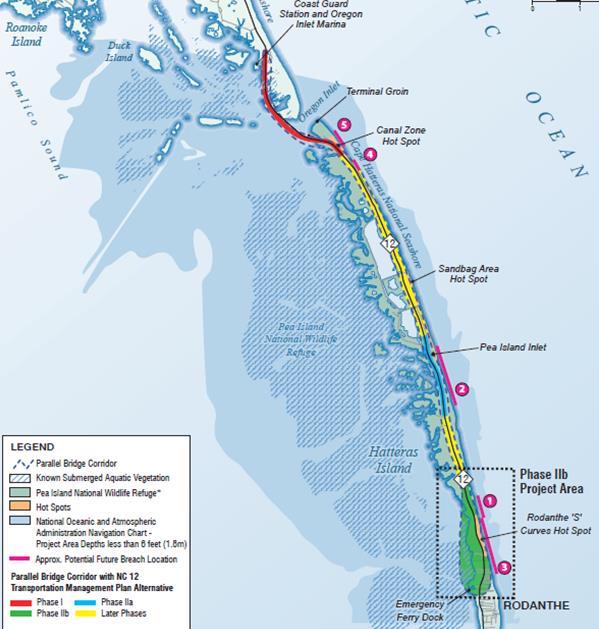
11 NC 12 Rodanthe Breach Long Term Improvements, Bonner Bridge Replacement Project Phase IIb (B-2500B) NCDOT and FHWA have completed an Environmental Assessment for this phase of the NC 12 / Bonner Bridge replacement project. Two alternatives were considered in the document: 1) Bridge within Existing NC 12 Easement and 2) Bridge on New Location. Although NCDOT named the Bridge within the Existing NC 12 Easement as its Preferred Alternative, consideration is still being given to both alternatives in light of comments received from the public and from resource and regulatory agencies. Depending on the final decision, estimated use of federally owned property is as follows: 1) Bridge within Existing NC 12 Easement Alternative Approximately 2.1 acres of temporary construction easement within the Pea Island Nation Wildlife Refuge needed for this option. The temporary construction easement is located along most of the length of this option on both sides of NCDOT s existing NC 12 easement. 2) Bridge on New Location Alternative Approximately 2.8 acres of land within the boundary of the Pea Island National Wildlife Refuge would be needed for this alternative. The new permanent easement consists of land at the northern terminus of the alternative west of the existing NC 12 easement and assumes an easement width of 100. An additional 0.7 acres of temporary construction easement is also expected beyond the 2.8 acres of permanent easement. 11

12 NC 12 Rodanthe Breach Long Term Improvements, Bonner Bridge Replacement Project Phase IIb (B-2500B) 12
 options for stabilizing this area of Hatteras Island.")

13 NC 12 Buxton / Avon Hot Spot (R-4070B) The Department is currently preparing a feasibility study considering both short-term (5 years) and long-term (50 years) options for stabilizing this area of Hatteras Island. The draft of the feasibility study report estimates up to 50 acres of land within the Cape Hatteras National Seashore (NPS) may be needed as easement for long-term alternatives under consideration. During the project development process, alternatives may be added based on input from the public and agency stakeholders that could change this early estimate of needs. 13
14 NC 12 Hatteras Village Hot Spot (R-3116B) The Department is currently preparing a feasibility study considering both short-term (5 years) and long-term (50 years) options for stabilizing this area of southern Hatteras Island. Up to 50 acres of land within the Cape Hatteras National Seashore (NPS) may be needed as easement for long-term alternatives under consideration. During the project development process, alternatives may be added based on input from the public and agency stakeholders that could change this early estimate of needs. 14

15 NC 12 Hatteras Village Hot Spot (R-3116B) 15

16 NC 12 Hatteras Village Hot Spot (R-3116B) Locations where dunes blew out Locations of dune breach Location of NC 12 NC 12 Post Hurricane Irene
17 NC 12 Northern Ocracoke Island Hot Spot (R-3116A) The Department is currently preparing a feasibility study considering both short-term (5 years) and long-term (50years) options for stabilizing this area of Ocracoke Island that is prone to ocean overwash. Up to 60 acres of land within the National Park Service lands within the Cape Hatteras National Seashore could be required as easement for long-term alternatives under consideration. During the project development process, alternatives may be added based on input from the public and agency stakeholders that could change this early estimate of needs. 17
")
18 NC 12 Northern Ocracoke Island Hot Spot (R-3116A) 18
")


19 NC 12 Northern Ocracoke Island Hot Spot (R-3116A) Locations where road is flooded Locations where dunes blew out Location of NC 12 NC 12 Post Hurricane Irene


20 Bonner Bridge Questions or Comments?? 1963 Built bridge 1989 Process to invest in new bridge Selected alternative Environmental studies 2011 Hurricane Irene 20
V. Economic Assessment
 V. Economic Assessment A. Overview of Economic Considerations The potential economic impact to State and local governments, and the private sector from erosion due to shifting inlets was assessed. Using
State Dredging Study Update NCBIWA Annual Meeting
 State Dredging Study Update NCBIWA Annual Meeting November 13, 2017 Study Purpose Three (3) Studies Requested Use of Dredge Manteo for Additional Work Acquisition of Dedicated Dredging Capacity Cost/Benefit
Locally Administered Projects Overview
 Locally Administered Projects Overview Locally Administered Projects Overview What you will learn from this Presentation: Major Steps of administering a federal-aid project by a local government agency
APPENDIX J LAND AND DEVELOPMENT MANAGEMENT
 APPENDIX J LAND AND DEVELOPMENT MANAGEMENT Land and Development Management I. Context of Land Management Considerations in the Stabilization Effort The Reformulation Study was undertaken to identify a
Project Description Preferred Alternative
 DETERMINATION AND FINDINGS PURSUANT TO SECTION 204 OF EMINENT DOMAIN PROCEDURE LAW (EDPL) CITY OF SYRACUSE, PROEJCT SPONSOR CREEKWALK PHASE II JEFFERSON STREET TO COLVIN STREET PROJECT IDENTIFICATION NO.
Section 4(f) Why don t we build the road through this green space over here?
 Why don t we build the road through this green space over here?") Section 4(f) Why don t we build the road through this green space over here? Objectives Section 4(f) What is Section 4(f)? understand the basics of the law and applicability; Is this a Section 4(f) situation?--develop
Section 4(f) Why don t we build the road through this green space over here? Objectives Section 4(f) What is Section 4(f)? understand the basics of the law and applicability; Is this a Section 4(f) situation?--develop
6.5 LAND AND WATER CONSERVATION FUND ACT SECTION
 along the Trinity River Corridor are given the opportunity to review and comment upon them. The proposed project would be required to obtain a CDC from the floodplain/cdc administrators of Dallas and Irving.
content chapter Section 4(f) Parks, Recreation Areas, Historic Sites, Wildlife and Waterfowl Refuges
 Parks, Recreation Areas, Historic Sites, Wildlife and Waterfowl Refuges") chapter Section 4(f) Parks, Recreation Areas, Historic Sites, Wildlife and Waterfowl Refuges 22 content 22.1 Summary of Key Legislation, Regulations, and Guidance 22.2 Agency Roles 22.3 General Methodology
chapter Section 4(f) Parks, Recreation Areas, Historic Sites, Wildlife and Waterfowl Refuges 22 content 22.1 Summary of Key Legislation, Regulations, and Guidance 22.2 Agency Roles 22.3 General Methodology
Documentation Standard for an Individual Section 4(f) Evaluation
 Evaluation") Documentation Standard for an Individual Section 4(f) Evaluation Use this documentation standard (DS) to prepare an Individual Section 4(f) evaluation for Federal Highway Administration (FHWA) projects
Documentation Standard for an Individual Section 4(f) Evaluation Use this documentation standard (DS) to prepare an Individual Section 4(f) evaluation for Federal Highway Administration (FHWA) projects
ELK RAPIDS TOWNSHIP ANTRIM COUNTY, MICHIGAN ORDINANCE NO
 ELK RAPIDS TOWNSHIP ANTRIM COUNTY, MICHIGAN ORDINANCE NO. 3-2011 AN ORDINANCE TO REPLACE THE SUBDIVISION CONTROL ORDINANCE WITH A NEW SUBDIVISION DEVELOPMENT ORDINANCE, IN ACCORD WITH THE LAND DIVISION
Community Development Department Planning Division 1600 First Street + P.O. Box 660 Napa, CA Napa (707)
") Community Development Department Planning Division 1600 First Street + P.O. Box 660 Napa, CA 94559-0660 Napa (707) 257-9530 PLANNING COMMISSION STAFF REPORT JUNE 16, 2016 AGENDA ITEM # 6.B. 16-0056-EXT;
Community Development Department Planning Division 1600 First Street + P.O. Box 660 Napa, CA 94559-0660 Napa (707) 257-9530 PLANNING COMMISSION STAFF REPORT JUNE 16, 2016 AGENDA ITEM # 6.B. 16-0056-EXT;
FIGURE EIGHT ISLAND HOMEOWNERS ASSOCIATION, INC. Case Study
 FIGURE EIGHT ISLAND HOMEOWNERS ASSOCIATION, INC. Case Study by Howard O. Rockness Professor of Accounting University of North Carolina Wilmington Joanne W. Rockness Camerson Professor of Accounting University
Preliminary Subdivision Application (Minor) (Three (3) lots or less)
 (Three (3) lots or less)") Gunnison City Offices www.gunnisoncity.org 38 West Center Gunnison, Utah 84634 (435) 528 7969 Date of Application: Preliminary Subdivision Application (Minor) (Three (3) lots or less) APPLICANT INFORMATION
Gunnison City Offices www.gunnisoncity.org 38 West Center Gunnison, Utah 84634 (435) 528 7969 Date of Application: Preliminary Subdivision Application (Minor) (Three (3) lots or less) APPLICANT INFORMATION
Petition R17-12 Villages at Skybrook North Conditional District Rezoning Revision to delete 10 garage recess requirement.
 Petition R17-12 Villages at Skybrook North Conditional District Rezoning Revision to delete 10 garage recess requirement. PART 1: PROJECT SUMMARY Applicant: Laureldale, LLC Property Owner: Laureldale,
September 2018 MLS Statistical Report
 September 218 MLS Statistical Report Total Sales Blame it on Hurricane Florence but overall, sales dropped drastically in August - down 17%. Total Sales Sept'18 172-17% Sept'17 26-2% Sept'16 211 7% 3 2
Town of Surf City. City Council Presentation April 2, 2013 PETER A. RAVELLA, PRINCIPAL PAR CONSULTING, LLC
 Town of Surf City City Council Presentation April 2, 2013 PETER A. RAVELLA, PRINCIPAL CONSULTING, LLC I. Review Workshop schedule & Input SC-NTB Federal Project Plan 1550 Funding Contributors You re Not
CHAPTER 3: IDENTIFYING SECTION 4(f) PROPERTIES
 PROPERTIES") CHAPTER 3: IDENTIFYING SECTION 4(f) PROPERTIES Section 4(f) and its provisions state that publicly owned parks, recreation areas, wildlife and waterfowl refuges, and publicly and privately owned historic
CHAPTER 3: IDENTIFYING SECTION 4(f) PROPERTIES Section 4(f) and its provisions state that publicly owned parks, recreation areas, wildlife and waterfowl refuges, and publicly and privately owned historic
Sound Wal Overview 1
 Sound Wall Overview 1 North Coast Corridor Program A 30-year comprehensive and sustainable solution for the region that integrates: Express Lanes on I-5 Double tracking the coastal rail line Integrated
Richardson s TOD Experience From ULI Panel Report to Breaking Ground. September 8, 2011
 Richardson s TOD Experience From ULI Panel Report to Breaking Ground Presented to ULI Minnesota District Council Presented By: Gary Slagel President and CEO CapitalSoft Former Mayor, City of Richardson,
Preliminary Subdivision Application (Major) (Four (4) lots or more)
 (Four (4) lots or more)") Gunnison City Offices www.gunnisoncity.org 38 West Center Gunnison, Utah 84634 (435) 528 7969 Date of Application: Preliminary Subdivision Application (Major) (Four (4) lots or more) APPLICANT INFORMATION
Gunnison City Offices www.gunnisoncity.org 38 West Center Gunnison, Utah 84634 (435) 528 7969 Date of Application: Preliminary Subdivision Application (Major) (Four (4) lots or more) APPLICANT INFORMATION
SANTA BARBARA COUNTY ZONING ADMINISTRATOR STAFF REPORT November 20, 2015
 SANTA BARBARA COUNTY ZONING ADMINISTRATOR STAFF REPORT November 20, 2015 PROJECT: Acquistapace Tentative Parcel Map HEARING DATE: December 7, 2015 STAFF/PHONE: Dana Eady, (805) 934-6266 GENERAL INFORMATION
EXPRESS LANES NORTHERN EXTENSION TECHNICAL REPORT SEPTEMBER 2016
 I N T E R S TAT E 3 9 5 EXPRESS LANES NORTHERN EXTENSION R I G H T O F W AY TECHNICAL REPORT SEPTEMBER 2016 INTERSTATE 395 EXPRESS LANES NORTHERN EXTENSION Right of Way Technical Report City of Alexandria,
PENNY LAKES SUBDIVISION
 PENNY LAKES SUBDIVISION Engineering Comments: A portion of the site may be located within the J.B. Converse watershed, the primary drinking water supply for the Mobile Area Water and Sewer System. Consultation
Creek Rehabilitation Plan for Apple Valley Questions and Answers from the Pre-Bid Meeting and Site Visit 06/23/2016
 Questions and Answers from the Pre-Bid Meeting and Site Visit 06/23/2016 Q: What are the threatened and endangered species concerns in the area? A: This is potential habitat for Prebles Meadow Jumping
Curriculum Vitae. Edward Clay Swindell. 226 Ibis Way Telephone:
 Curriculum Vitae Edward Clay Swindell Address: 226 Ibis Way Telephone: 252 256-0182 Elizabeth City, NC 27909 Email: cswindell@embarqmail.com EDUCATION 1991-96 East Carolina University, Greenville, NC.
City of Concord, NH. Subdivision Regulations
 City of Subdivision Regulations Adopted: December 15, 2010 Revised: October 5, 2011 April 17, 2013 July 18, 2016 City of Concord Planning Board Planning Division Community Development Department Foreword
Zoning By-law and Zoning By-law Amendments to Permit Short-term Rentals
 PG24.8 REPORT FOR ACTION Zoning By-law and Zoning By-law Amendments to Permit Short-term Rentals Date: October 19, 2017 To: Planning and Growth Management Committee From: Acting Chief Planner and Executive
APPENDIX D REAL ESTATE PLAN
 APPENDIX D REAL ESTATE PLAN APPENDIX D REAL ESTATE PLAN TABLE OF CONTENTS 1. STATEMENT OF PURPOSE 2. REFERENCES 3. AUTHORIZATION 4. BACKGROUND 5. LOCATION 6. REAL ESTATE REQUIREMENTS 7. OWNERSHIP OF REAL
Burleigh County Water Resource District 1811 East Thayer Avenue Bismarck, North Dakota (701)
") Burleigh County Water Resource District 1811 East Thayer Avenue Bismarck, North Dakota 58501 (701) 222-3499 www.bcwrd.org Fox Island Flood Control Project Public Hearing Summary September 7, 2016 General
Burleigh County Water Resource District 1811 East Thayer Avenue Bismarck, North Dakota 58501 (701) 222-3499 www.bcwrd.org Fox Island Flood Control Project Public Hearing Summary September 7, 2016 General
SUSAN A. MAURIELLO, J.D., COUNTY ADMINISTRATIVE OFFICER LEAD AGENCY FOR RAIL RIGHT-OF-WAY ACQUISITION
 County of Santa Cruz COUNTY ADMINISTRATIVE OFFICE 701 OCEAN STREET, SUITE 520, SANTA CRUZ, CA 95060-4073 (831) 454-2100 FAX: (831) 454-3420 TDD: (831) 454-2123 SUSAN A. MAURIELLO, J.D., COUNTY ADMINISTRATIVE
6.5 LAND AND WATER CONSERVATION FUND ACT SECTION
 6.3.7 Recommended Determination Findings for Public Parks and Recreational Areas A direct use of and temporary use of 2.5 acres of Elm Fork Greenbelt (750 square feet of actual ground space with the balance
CITY OF DAYTON Meeting Date:
 CITY OF DAYTON Meeting Date: 3-8-18 PLANNING COMMISSION Item Number: H PRESENTER: Scott Weideman ITEM: Application by Scott and Pamela Weidema for a Comprehensive Plan Amendment to reguide their property
I-820 / SH 121 INTERCHANGE IN NE TARRANT COUNTY
 / SH 121 INTERCHANGE IN NE TARRANT COUNTY / SH 121 Interchange Public Hearing October 5, 2017 1 PUBLIC HEARING / SH 121 INTERCHANGE from approximately 2,000 feet north of Pipeline Road/Glenview Drive to
5.5 Relocations and Displacements
 I-70 East Final EIS 5.5 Relocations and Displacements 5.5 Relocations and Displacements This section investigates the impacts from the project alternatives resulting from land acquisition of residential
$15,000, /- Acres. Carteret County, NC
 pamlico@sound hunting@f@timber conservation easement 5609.98 +/- Acres Carteret County, NC $15,000,000 National Land Realty 669 Marina Drive Ste B-4 Charleston, SC 29492 www.nationalland.com Chris Herron-Marshall
SHORE DRIVE CORRIDOR: PAST, PRESENT, & FUTURE APRIL 19, 2018 BAYFRONT ADVISORY COMMISSION
 SHORE DRIVE CORRIDOR: PAST, PRESENT, & FUTURE APRIL 19, 2018 BAYFRONT ADVISORY COMMISSION 1 OVERVIEW I. Shore Drive Corridor Overview II. Shore Drive Corridor History III. Completed Projects IV. Current
The following information is for use by the Lincoln County Planning Board at their meeting/public hearing on February 3, 2014.
 LINCOLN COUNTY PLANNING & INSPECTIONS DEPARTMENT 302 NORTH ACADEMY STREET, SUITE A, LINCOLNTON, NORTH CAROLINA 28092 704-736-8440 OFFICE 704-736-8434 INSPECTION REQUEST LINE 704-732-9010 FAX To: Planning
McMULLIN AREA GROUNDWATER SUSTAINABILITY AGENCY
 Raisin City Water District Mid- Valley Water District McMULLIN AREA GROUNDWATER SUSTAINABILITY AGENCY Fee Study Final Report April 12, 2018 {00436891;1} PO Box 3065 Oakland, CA 94609 (510) 545-3182 {00436891;1}
CITY OF CORNING TENTATIVE MAPS
 CITY OF CORNING TENTATIVE MAPS APPLICANT S GUIDE TO PROCEDURES WHAT IS A TENTATIVE MAP? A division of land for the purpose of sale, lease, or finance requires submittal of a map for City approval showing
Annutteliga Hammock Project Surplus and Consolidation Strategy
 Project Overview Annutteliga Hammock is a 31,250-acre partnership acquisition project of the Florida Forever program, of which 12,231 acres have been acquired to date. The intent of the project is to provide
CITY OF FORT COLLINS NATURAL AREAS AND CONSERVED LANDS EASEMENT POLICY
 CITY OF FORT COLLINS NATURAL AREAS AND CONSERVED LANDS EASEMENT POLICY Adopted January 3, 2012 PURPOSE: The purpose of the policy statement is to clarify the policies and procedures of the City of Fort
Buyer s Guide Making the dream of owning real estate on the Outer Banks of North Carolina a dream come true!
 Buyer s Guide Making the dream of owning real estate on the Outer Banks of North Carolina a dream come true! Tammy Russell Broker, RSPS 252-489-8054 shopobxhomes@gmail.com www.shopobxhomes.com Beach Realty
MAXIMIZING THE VALUE OF PROJECT-LEVEL PROGRAMMATIC AGREEMENTS IN SECTION 106 CONSULTATION
 MAXIMIZING THE VALUE OF PROJECT-LEVEL PROGRAMMATIC AGREEMENTS IN SECTION 106 CONSULTATION 2018 Joint AASHTO Committee Meeting, Spokane, Washington Antony Opperman, Cultural Resources Program Manager July
DESIGN PUBLIC HEARING MAY 18, 2017 GROVELAND TOWN HALL GROVELAND, MASSACHUSETTS 7:00PM FOR THE PROPOSED
 DESIGN PUBLIC HEARING MAY 18, 2017 AT GROVELAND TOWN HALL GROVELAND, MASSACHUSETTS 7:00PM FOR THE PROPOSED GROVELAND COMMUNITY TRAIL PROJECT Roadway Project Management Section IN THE TOWN OF GROVELAND,
BRIDGETON SUBDIVISION APPLICATION CHECKLIST
 APPLICATION NAME AND # CHECKLIST COMPLETED BY: DATE: Signature and printed name BRIDGETON SUBDIVISION APPLICATION CHECKLIST TO SUBDIVISION APPLICANTS: The attached checklist is to assist you in the submission
Evaluating and Processing Road and Utility Easement Proposals on Corps Lands and Flowage Easements
 Evaluating and Processing Road and Utility Easement Proposals on Corps Lands and Flowage Easements Don Wiese Natural Resources Manager Fort Worth District September 13, 2017 US Army Corps of Engineers
Introduction to INRMP Implementation Options
 El Dorado County Integrated Natural Resources Management Plan Introduction to INRMP Implementation Options 1 Our approach to the options evaluation is based on the INRMP components as they are currently
Draft Ordinance: subject to modification by Town Council based on deliberations and direction ORDINANCE 2017-
 ORDINANCE 2017- Draft Ordinance: subject to modification by Town Council based on deliberations and direction AN INTERIM URGENCY ORDINANCE OF THE TOWN COUNCIL OF THE TOWN OF LOS GATOS ESTABLISHING A TEMPORARY
A Guide to the Municipal Planning Process in Saskatchewan
 A Guide to the Municipal Planning Process in Saskatchewan A look at the municipal development permit and the subdivision approval process in Saskatchewan May 2008 Prepared By: Community Planning Branch
PLANNING COMMISSION. Agenda Item # 1.
 PLANNING COMMISSION Agenda Item # 1. CASE SUMMARY Street Closure Planning Commission October 7, 2015 SC-1-1015 Jeff Walton, 341-3260, jeff.walton@wilmingtonnc.gov Staff recommendation APPROVAL Planning
5.5 Relocations and Displacements
 I-70 East Supplemental Draft EIS 5.5 Relocations and Displacements 5.5 Relocations and Displacements This section investigates the impacts to residential units, businesses, and non-profit associations
February 29, To: Sarah Absher Senior Planner Tillamook County Department of Community Development
 February 29, 2016 To: Sarah Absher Senior Planner Tillamook County Department of Community Development From: Richard Hook Chair, Neskowin Citizen Advisory Committee Subject: Application 851-15-000265-PLNG:
DAWES SWITCHING STATION SUBDIVISION
 DAWES SWITCHING STATION SUBDIVISION Engineering Comments: Must comply with the Mobile County Flood Damage Prevention Ordinance. Development shall be designed to comply with the storm water detention and
AGENDA ITEM Public Utilities Commission City and County of San Francisco
 WATER WASTEWATER POWER AGENDA ITEM Public Utilities Commission City and County of San Francisco MEETING DATE May 11, 2010 Approve Project - Mitigated Negative Declaration: Regular Calendar Bureau Manager:
Su-Knik Mitigation Bank Modification Memorandum
 Su-Knik Mitigation Bank Modification Memorandum Regarding: Request for Approved Instrument Modification for the Su-Knik Mitigation Bank (Expansion of the Su-Knik Mitigation Bank Service Area) Request:
Agenda Item No.: G.1 Date: August 11, 2009
 Agenda Item No.: G.1 Date: August 11, 2009 CASE NUMBER: PHG 09-0015 APPLICANT: LOCATION: TYPE OF PROJECT: PROJECT DESCRIPTION: Humberto Martinez On the eastern side of Orange Street, western side of Escondido
Rezoning Petition Final Staff Analysis May 21, 2018
 Rezoning Petition 2017-182 Final Staff Analysis May 21, 2018 REQUEST LOCATION Current Zoning: R-3 (single family) and no zoning (current NC State right-of-way) Proposed Zoning: B-2(CD) (general business,
Silver Line Acceptance
 Finance & Administration Committee Action Item III-A June 12, 2014 Silver Line Acceptance Washington Metropolitan Area Transit Authority Board Action/Information Summary Action Information MEAD Number:
Sandy Oakleaf Memorial Tennis Courts Background Information
 Sandy Oakleaf Memorial Tennis Courts Background Information The tennis courts located south of the JSH were built in 1990 as a memorial to Sandy Oakleaf, ACCHS student, who died in 1988. They were partially
TREASURE COAST REGIONAL PLANNING COUNCIL M E M O R A N D U M
 TREASURE COAST REGIONAL PLANNING COUNCIL M E M O R A N D U M To: Council Members AGENDA ITEM 6A From: Date: Subject: Staff May 20, 2011 Council Meeting Local Government Comprehensive Plan Review Draft
MOTION NO. M Property Exchange Agreement with the University of Washington for the Northgate Link Extension
 MOTION NO. M2012-93 Property Exchange Agreement with the University of Washington for the Northgate Link Extension MEETING: DATE: TYPE OF ACTION: STAFF CONTACT: PHONE: Board 12/20/12 Final Action Ahmad
Town of Waxhaw Board of Commissioners. Waxhaw Police Department Community Meeting Room Tuesday January 12, 2016
 Town of Waxhaw Board of Commissioners Waxhaw Police Department Community Meeting Room Tuesday January 12, 2016 Petition RZ-003994-2015 A request by the Town of Waxhaw Planning & Community Development Department,
Exit 25 Sam Furr Road
 Exit 25 Sam Furr Road Huntersville 101: Planning Department 1. Planning Overview 2. Basic Regulatory Framework: State Statutes 3. Overview of Long Range Planning 4. Tools to Implement Long Range Plan Vision
B. Subarea Provisions, including the Design Elements and Area of Special Concern and Potential Park/Open Space/Recreation Requirements;
 ARTICLE III: LAND USE DISTRICTS III-1 300 INTRODUCTION Article III of the Washington County Community Development Code consists of the primary and overlay districts which apply to the unincorporated areas
1708 Martin Luther King Jr. Way
 November 19, 2008 Planning and Development Department Land Use Planning Division 1708 Martin Luther King Jr. Way Tentative Map #7915 to create five (5) residential condominium units and two (2) commercial
79th OREGON LEGISLATIVE ASSEMBLY Regular Session. Enrolled. House Bill 4031
 79th OREGON LEGISLATIVE ASSEMBLY--2018 Regular Session Enrolled House Bill 4031 Introduced and printed pursuant to House Rule 12.00. Presession filed (at the request of House Interim Committee on Agriculture
RESOLUTION NO (1)
") RESOLUTION NO. 2016-082016(1) A RESOLUTION OF THE FIRE BOARD OF THE UPPER CAPTIVA FIRE PROTECTION AND RESCUE SERVICE DISTRICT, LEE COUNTY, FLORIDA; ESTABLISHING AND APPROVING THE AMOUNT OF THE FIRE SERVICES
RESOLUTION NO. 2016-082016(1) A RESOLUTION OF THE FIRE BOARD OF THE UPPER CAPTIVA FIRE PROTECTION AND RESCUE SERVICE DISTRICT, LEE COUNTY, FLORIDA; ESTABLISHING AND APPROVING THE AMOUNT OF THE FIRE SERVICES
THE BLUFFS AT CYPRESS CREEK SUBDIVISION
 THE BLUFFS AT CYPRESS CREEK SUBDIVISION Engineering Comments: Must comply with all stormwater and flood control ordinances. Any work performed in the right-of-way will require a right-of-way permit. Traffic
This policy replaces the Tenancy Policy of all Circle registered providers and Affinity Sutton Homes.
 Tenancy Policy This policy replaces the Tenancy Policy of all Circle registered providers and Affinity Sutton Homes. 1. Purpose and Scope This policy sets out for customers, staff and local authorities
TREASURE COAST REGIONAL PLANNING COUNCIL M E M O R A N D U M. To: Council Members AGENDA ITEM 9D
 TREASURE COAST REGIONAL PLANNING COUNCIL M E M O R A N D U M To: Council Members AGENDA ITEM 9D From: Date: Subject: Staff May 15, 2015 Council Meeting Local Government Comprehensive Plan Review Draft
PRELIMINARY PLAT CHECK LIST
 PRELIMINARY PLAT CHECK LIST Name of Proposed Subdivision: The following items must be included with the initial submittal of a Preliminary Plat: Application, filled out completely Project Narrative Pre-application
Appendix C. Real Estate. Brazos Island Harbor, Texas Channel Improvement Project Cameron County, Texas
 Appendix C Real Estate Brazos Island Harbor, Texas Channel Improvement Project Cameron County, Texas U.S. Army Corps of Engineers, Galveston District 2000 Fort Point Road Galveston, Texas 77550 December
VIKING PLACE SUBDIVISION, PHASE II
 VIKING PLACE SUBDIVISION, PHASE II Engineering Comments: Must comply with the Mobile County Flood Damage Prevention Ordinance. The plat illustrates the proposed 22 lot, 7.2 + acre subdivision which is
REGULAR FINAL PLAT SUBDIVISION APPLICATION
 REGULAR FINAL PLAT SUBDIVISION APPLICATION Name of Subdivision (Subdivision Name must be approved by at 856-6216) ( )Cluster Subdivision ( )Lot-by-Lot Subdivision ( )Open Space Subdivision Name of Subdivision
ARTICLE 5 MINOR SUBDIVISION/LAND DEVELOPMENT
 ARTICLE 5 MINOR SUBDIVISION/LAND DEVELOPMENT SECTION 501 ONLY FINAL PLAN REQUIRED The classification of a proposed subdivision as a "Minor Subdivision" shall only require the submission, review and approval
HERON LANDING SUBDIVISION
 HERON LANDING SUBDIVISION Engineering Comments: Per FEMA guidelines, any development greater than 5 acres in size or subdivision 50 lots in size, requires a flood study. Width of drainage easement to be
The United States Mortgage Crisis and Cadastral Data. Donald Buhler, Bureau of Land Management. David Cowen, University of South Carolina
 The United States Mortgage Crisis and Cadastral Data Donald Buhler, Bureau of Land Management David Cowen, University of South Carolina What Have Americans Paid (and Maybe the Rest of the World) for Not
UPPER MOUNT BETHEL TOWNSHIP, NORTHAMPTON COUNTY, PA MINOR SUBDIVISION FINAL PLAN CHECKLIST* YES** NO
 UPPER MOUNT BETHEL TOWNSHIP, NORTHAMPTON COUNTY, PA MINOR SUBDIVISION FINAL PLAN CHECKLIST* YES** NO GENERAL SUBMISSION ITEMS Does the submission include: 1. Seven (7) copies of completed Application Form?
Conceptual Scheme SE W4
 December 2012 1. PURPOSE 1.1. The purpose of a Conceptual Scheme (CS) is as follows: a) To provide a framework for the subsequent subdivision and/or development of land within the Country Residential Policy
3. Adopt the Preliminary Use and Management Plan for the property granted to the District.
 R-13-119 Meeting 13-34 December 11, 2013 AGENDA ITEM AGENDA ITEM 8 Approval of an Agreement to Exchange Real Property Interests with Santa Clara County (County) Roads & Airports concerning County property
TECHNICAL PRESENTATION Project History and Description of the Proposed Improvements Perry Steger, Steger & Bizzell Engineering, Inc.
 December 2, 2008 The Texas Department of Transportation (TxDOT), the Federal Highway Administration and Williamson County welcome you to tonight s Public Hearing concerning plans to improve Ranch-to-Market
CHAPTER 1 OVERVIEW OF THE PROGRAM AND PLAN
 OVERVIEW OF THE PROGRAM AND PLAN INTRODUCTION The public housing agency (PHA) receives its funding for the Housing Choice Voucher (HCV) program from the Department of Housing and Urban Development. The
PLANNING & ZONING COMMISSION RESOLUTION A RESOLUTION OF THE PLANNING COMMISSION OF THE CITY OF ALBANY, COUNTY
 PLANNING & ZONING COMMISSION RESOLUTION 0-0 A RESOLUTION OF THE PLANNING COMMISSION OF THE CITY OF ALBANY, COUNTY OF ALAMEDA, STATE OF CALIFORNIA, APPROVING A TENTATIVE PARCEL MAP TO CREATE A PARCEL AT
TENTATIVE PARCEL MAP TIME EXTENSION
 EL DORADO COUNTY DEVELOPMENT SERVICES ZONING ADMINISTRATOR STAFF REPORT Agenda of: October 15, 2008 Item No.: Staff: 4.a. Mel Pabalinas TENTATIVE PARCEL MAP TIME EXTENSION APPLICATION FILE NO.: APPLICANT:
Township of Little Egg Harbor Planning Board 665 Radio Road Little Egg Harbor, New Jersey Phone: ext. 221 Fax:
 BLOCK(S) LOT(S) Township of Little Egg Harbor Planning Board 665 Radio Road Little Egg Harbor, New Jersey 08087 Phone: 609-296-7241 ext. 221 Fax: 609-294-3040 Development Application Amended Development
LINCOLN COUNTY PLANNING & INSPECTIONS DEPARTMENT
 LINCOLN COUNTY PLANNING & INSPECTIONS DEPARTMENT 30 NORTH ACADEMY STREET, SUITE A, LINCOLNTON, NORTH CAROLINA 809 704-736-8440 OFFICE 704-736-8434 INSPECTION REQUEST LINE 704-73-900 FAX To: Board of Commissioners
RESOLUTION NO. R To Acquire Real Property Interests Required for the Downtown Redmond Link Extension
 RESOLUTION NO. R2018-07 To Acquire Real Property Interests Required for the Downtown Redmond Link Extension MEETING: DATE: TYPE OF ACTION: STAFF CONTACT: Capital Committee Board PROPOSED ACTION 03/08/2018
Surf's Up - Frisco, NC
 1-800-237-1138 rent@surforsound.com www.surforsound.com Surf's Up - Frisco, NC Description OCEANFRONT Frisco - Sandpiper Dr. SURF'S UP at this statuesque oceanfront beach escape with unique floorplan.
STAFF SUMMARY FOR Z18-09 CONDITIONAL ZONING DISTRICT APPLICATION
 STAFF SUMMARY FOR Z18-09 CONDITIONAL ZONING DISTRICT APPLICATION APPLICATION SUMMARY Case Number: Z18-09 Request: Conditional R-10 Zoning District in order to develop a performance residential development
1. APPLICANT: Polsinelli, Shalton & Welte is the applicant for this request.
 5. REVISED PRELIMINARY PLAN APPROVAL - THE RETREAT AT MAPLECREST - Vicinity of the northeast corner of 159 th Street and U.S. 69 Highway 1. APPLICANT: Polsinelli, Shalton & Welte is the applicant for this
Gates County Planning and Zoning
 Gates County Planning and Zoning PO Box 411, 200 Court Street, Gatesville, NC 27938 phone: 252-357-2411 fax: 252-357-0073 Application for Technical Review Committee For Staff Use Only: Date: Application
MINUTE ORDER BONNER COUNTY COMMISSIONERS PUBLIC HEARING MINUTES AUGUST 6, 2015
 MINUTE ORDER BONNER COUNTY COMMISSIONERS PUBLIC HEARING MINUTES AUGUST 6, 2015 CALL TO ORDER: Chair Cary Kelly called the Bonner County Commissioners hearing to order at 1:00 p.m. in the 3rd floor meeting
UNIVERSITY OF MINNESOTA BOARD OF REGENTS. Facilities Committee. Thursday, May 8, :45 11:45 a.m. 600 McNamara Alumni Center, West Committee Room
 UNIVERSITY OF MINNESOTA BOARD OF REGENTS Facilities Committee Thursday, May 8, 2008 9:45 11:45 a.m. 600 McNamara Alumni Center, West Committee Room Committee Members David Metzen, Chair Dallas Bohnsack,
Mayport Village Community Redevelopment Area Community Workshop #1 Marine Science Education Center February 12, 2015
 Mayport Village Community Redevelopment Area Community Workshop #1 Marine Science Education Center February 12, 2015 Team Introductions Project Overview and Goals CRA and TIF 101 Role of CAC and TAC Mayport
K. All adjoining lots under common deed, for use as a single residence, are considered to be one lot.
 Yadkin Project Shoreline Management Plan (FERC No. 2197) Appendix E: Specifications for Private Recreation Facilities at High Rock and Narrows Reservoirs I. General A. These Specifications of Cube Yadkin
THREE RIVERS PARK DISTRICT BOARD OF COMMISSIONERS
 1. OPENING BUSINESS A. Call to Order B. Pledge of Allegiance C. Roll Call 2. APPROVAL OF AGENDA THREE RIVERS PARK DISTRICT BOARD OF COMMISSIONERS SPECIAL MEETING Administrative Center - Board Room 3000
IRS FORM 8283 SUPPLEMENTAL STATEMENT DONATION OF CONSERVATION EASEMENT
 Name(s) shown on income tax return Identifying Number Robert T. Landowner 021-34-1234 Susan B. Landowner 083-23-5555 IRS FORM 8283 SUPPLEMENTAL STATEMENT DONATION OF CONSERVATION EASEMENT On November 12,
Rye City Planning Commission Minutes October 23, 2012
 Rye City Planning Commission Minutes 0 0 0 MEETING ATTENDANCE: Planning Commission Members: Nick Everett, Chair Martha Monserrate, Vice-Chair Barbara Cummings Carolyn Cunningham Hugh Greechan Peter Jovanovich
SUBDIVISION DEFINED, EXEMPTIONS FROM DEFINITION:
 12-611: SUBDIVISION DEFINED, EXEMPTIONS FROM DEFINITION: A. 1. Minor Land Division (MLD) shall mean any division of land into four (4) or fewer lots. 2. Minor Subdivision shall mean any division of land
APPENDIX F REAL ESTATE
 APPENDIX F REAL ESTATE Real Estate Plan For Broward County, Florida Shore Protection Project Segments II and III General Reevaluation Report 1. Statement Of Purpose. The Real Estate Plan is tentative in