I-820 / SH 121 INTERCHANGE IN NE TARRANT COUNTY
|
|
|
- Edith Bridges
- 5 years ago
- Views:
Transcription


1 / SH 121 INTERCHANGE IN NE TARRANT COUNTY / SH 121 Interchange Public Hearing October 5, PUBLIC HEARING / SH 121 INTERCHANGE from approximately 2,000 feet north of Pipeline Road/Glenview Drive to approximately 3,200 feet south of Randol Mill Road SH 121 from to approximately 5,000 feet west of Handley Ederville Road October 5, 2017 CSJ s: &
2 Project Partners Federal Highway Administration (FHWA) North Central Texas Council of Governments (NCTCOG) City of Fort Worth City of Richland Hills City of North Richland Hills City of Hurst Tarrant County Trinity Railway Express (TRE) Fort Worth Transportation Authority (The T) Texas Transportation Institute 3 Public Hearing Agenda Welcome & Introductions Public Hearing Purpose Project Design Environmental Right of Way Mr. John Cordary, P.E. Mr. John Cordary, P.E. Mr. Darrell Thompson, P.E. Ms. Jamye Sawey Mr. Kelly Price 15-Minute Recess Opportunity for Statements Adjournment Mr. John Cordary, P.E. Mr. John Cordary, P.E. 4 2


3 Public Hearing Purpose Provide a project update to the public. Inform the public of project design. Provide the environmental analysis to the public. Give the public an opportunity to provide input. Develop a record of public engagement and collect formal statements. 5 Public Comments Verbal comments: Fill out a form at the registration desk. Comment period after 15-minute recess. Remarks are limited to 3 minutes. Written statements: Must be received or postmarked by Friday, Oct 20, 2017, and can be submitted by: Place comment forms in a comments box near registration tables. Mail to the address on the comment form. You may include charts, graphs and other exhibits (must be in hard copy format). 6 3
4 Corridor History The corridor was originally constructed in the mid- 1960s. The SH 121 corridor was originally constructed in the mid- 1960s. The existing and SH 121 facilities have not been updated to current highway design standards. The existing and SH 121 facilities, including bridge and pavement structures, were designed and constructed for much less traffic than is currently using the roadways. 7 Project Purpose and Need Goals of the proposed project: Reduce traffic congestion on existing roadways; to provide a safer, more convenient route for traveling through the area; and to increase mobility and provide access, including improved emergency service access to the area. Construct an interchange at /SH 121 to provide full directional connectivity between these two major highways. Extend concurrent tolled managed lanes (one lane in each direction) along from the north SH 121 Interchange to Trinity Blvd and along SH 121 from to Handley Ederville Rd. 8 4
5 Prior Public Involvement Initiated in : Public Meeting to present 3 alternatives. 2000: several meetings with surrounding communities to provide update on progress and refine design. 2004: Preferred Alternative selected and presented in Public Hearing. Finding of No Significant Impact issued March 18, Prior Public Involvement 2009: North Tarrant Express (NTE), Segments 2-4 Included as Segment 4 of the CDA. Master Development Plan revised schematic design. October/November 2012 CDA for Segment 4 terminated. Consultant contract to update preliminary design and environmental analysis executed. April 2013 and April 2014: Open house public meetings Presented revised Preferred Alternative. Displays of project design layouts. 10 5


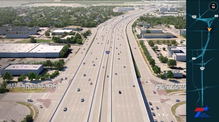
6 / SH 121 Interchange Project Location Project Limit: North Project Limit: West Project Limit: South 11 Project Description Existing Project Limit: South Trinity Blvd SH 183/ Baker Blvd SH 10/ Hurst Blvd Glenview Dr Pipeline Dr John T White Project Limit: North 12 6


7 Project Description Existing Northern Limits Looking South W Pipeline Rd Glenview Dr 13 Project Description Proposed Northern Limits Looking South W Pipeline Rd Glenview Dr 14 7


8 Project Description Existing Pipeline/Glenview Road Looking South W Pipeline Rd Glenview Dr NB GP ML SB GP ML SB GP SH Project Description Proposed Pipeline/Glenview Road Looking South W Pipeline Rd Glenview Dr NB GP ML SB GP 16 8


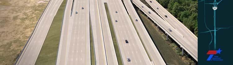
9 Project Description Existing Looking South to Hurst/Baker Boulevard Hurst Blvd SH 10 Baker Blvd SH 183 NB GP SB GP 17 Project Description Proposed Looking South to Hurst/Baker Boulevard Hurst Blvd SH 10 Baker Blvd SH 183 NB GP ML SB GP 18 9


10 Project Description Existing Hurst/Baker Boulevard Looking South Baker Blvd SH 183 Hurst Blvd SH 10 NB GP EB GP SH121 WB GP SH121 SB GP 19 Project Description Proposed Hurst/Baker Boulevard Looking South Baker Blvd SH 183 Hurst Blvd SH 10 NB GP ML ML SB GP WB GP SH


11 Project Description Existing Looking South at Trinity Boulevard Trinity Blvd Trinity Blvd NB GP SB GP 21 Project Description Proposed Looking South at Trinity Boulevard Trinity Blvd N-W DC E-S DC Trinity Blvd NB GP ML SB GP 22 11


12 Project Description Existing Looking South at Mosier Valley Lake Randol Mill West Fork Trinity River Randol Mill West Fork Trinity River Mosier Valley Lake Mosier Valley Lake NB GP SB GP 23 Project Description Proposed Looking South at Mosier Valley Lake Randol Mill Randol Mill West Fork Trinity River West Fork Trinity River Mosier Valley Lake Mosier Valley Lake NB GP SB GP 24 12


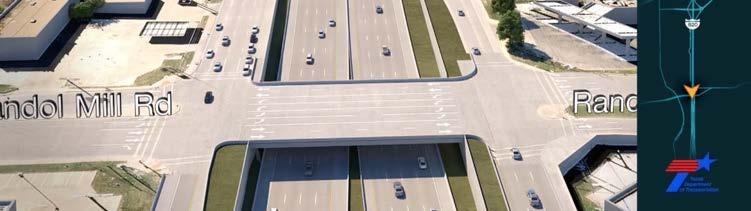
13 Project Description Existing Looking South at Randol Mill Road Randol Mill Randol Mill NB GP SB GP 25 Project Description Proposed Looking South at Randol Mill Road Randol Mill Randol Mill NB GP SB GP 26 13


14 Project Description Existing SH 121 Project Limit: West TRE 27 Project Description Existing SH 121 SH 121 Looking East from Western Project Limits WB GP SH121 EB GP SH


15 Project Description Proposed SH 121 SH 121 Looking East from Western Project Limits WB GP SH121 EB GP SH Project Description Existing SH 121 SH 121 Looking East at Handley Ederville Road WB GP SH121 EB GP SH


16 Project Description Proposed SH 121 SH 121 Looking East at Handley Ederville Road N-W DC E-S DC N-W DC WB GP SH121 EB ML SH121 EB GP SH Project Implementation The estimated construction cost for the ultimate project is $441 million. Approximately $201 million in state, federal and local funds has been identified for the interim project
17 Construction Phasing Interim Project To be awarded for contract in December Begin construction spring Includes: Direct Connections between SH 121 and. Reconstruction along south of Trinity Blvd striped to three general purpose mainlanes and auxiliary lanes each direction. Widening of existing facility along north of Trinity Blvd up to five northbound and six southbound general purpose mainlanes. Reconstruct bridge and U-turn for SH 10 and SH 183 over. Limited sidewalks near SH 10/SH 183 and along the northbound frontage road over the Trinity Railway Express. Widening of existing facility along SH 121 to three lanes each direction. 33 National Environmental Policy Act (NEPA) Process A Categorical Exclusion (CE) is being prepared in accordance with the National Environmental Policy Act, or NEPA. The environmental documentation identifies social, economic, and environmental effects of the proposed project. Includes an evaluation of the following: Air Quality Indirect and Cumulative effects Cultural Resources Hazardous materials Community Impacts Water quality Traffic noise Vegetation and Wildlife The environmental review, consultation, and other actions required by applicable Federal environmental laws for this project are being, or have been, carried-out by TxDOT pursuant to 23 U.S.C. 327 and a Memorandum of Understanding dated December 16, 2014, and executed by FHWA and TxDOT
18 Previous NEPA Studies Initiated in 1992 The project began with the analysis of three Build Alternatives. March 18, 2004 FHWA issued a Finding of No Significant Impact (FONSI) for from the SH 121 north interchange to Randol Mill Road. Since March 2004 Regional requirements changed. TxDOT Environmental Affairs Division determined a new Environmental Decision necessary for the project. August 2017 Reclassified project as a Categorical Exclusion, pending the outcome of the environmental analysis and public involvement. 35 NEPA: Right of Way and Easements The proposed project would require a total of approximately 23 acres of additional right of way (ROW) and an approximate 0.03 acre of drainage easement. A railroad agreement would also be required for an additional 0.05 acre drainage easement. Project potentially displaces 3 commercial structures. Approximately acres from 7 parcels for first phase construction has been purchased under March 2004 environmental clearance. Approximately 0.09 acres from 3 parcels would be acquired for first phase construction after environmental clearance of this project is received
19 NEPA: Bicycle and Pedestrian Accommodations Frontage roads include sidewalk and wider outside lanes. Pedestrian structures proposed over Trinity Rail Express. No sidewalk is proposed along the eastbound SH 121 frontage road from Handley Ederville Road to. Adjacent to the TRE railroad right of way, creating a safety issue. Sidewalk proposed along the westbound SH 121 frontage road providing safe access. Trinity River Vision trail proposed near the West Fork Trinity River. Separate project by the City of Fort Worth through the aid of federal dollars. 37 NEPA: Vegetation and Wildlife Permanent habitat impacts of the proposed project: 14.8 acres of Edwards Plateau Savannah, Woodland, and shrub land 12.8 acres of Floodplain 7.9 acres of Riparian Expected disturbance to habitat of species including Western Burrowing Owl, Plains Spotted Skunk, Texas Garter Snake, Timber Rattlesnake, Mussels, and Texas Milk Vetch. Proposed project is not expected to result in harm to any threatened or endangered species
20 NEPA: Water Resources Proposed project crosses the 100-year floodplains of West Fork Trinity River, but base flood elevations would not be increased to a level that would violate applicable floodplain regulations. Corridor Development Certificate (CDC) was obtained on August 22, Permanent impacts due to construction are expected to occur to two of the four water crossings within the project limits. Waters include Calloway Branch, WF-9, Mosier Valley Lake and its tributaries, and West Fork Trinity River and its tributary. A pre-construction Notification is currently being coordinated with the United States Army Corps of Engineers. More than 5 acres of earth disturbance would be necessary; therefore, a Storm Water Pollution Prevention Plan (SW3P) would be implemented. 39 NEPA: Cultural Resources Archeology: Reviews of cultural databases documenting previous archeological surveys indicated no need for further field investigations. Historic Properties: Database review and Historic Resources Survey indicated no historic resources would be impacted by the proposed project. Does not impact publicly owned lands from parks, recreational area, or wildlife and waterfowl refuge
21 NEPA: Traffic Noise FHWA traffic noise model Traffic noise analyzed noise levels at 13 receiver locations. Existing 2015 and forecasted 2035 traffic data. Considers traffic volumes, types of vehicles and speeds, as well as roadway and terrain features. Four locations identified where noise impacts are projected to approach or exceed the Noise Abatement Criteria. The locations represent 119 single and multi-family residences adjacent to the project. Proposed noise-abatement measures must be both feasible and reasonable to be incorporated within the project. 41 NEPA: Traffic Noise Barrier Location Southbound from JW Delaney Road to north of Mandy Lane between the general purpose mainlanes and the frontage road. Northbound from south of Cooper Drive to north of Redbud Drive along the existing right of way. Southbound from north of Rogan Drive to Glenview Drive along the existing right of way. Southbound SH 121 from north of Handley Ederville Road to south of Kingsbury Avenue between the general purpose mainlanes and the frontage road. Length (feet) Height (feet) Estimated Cost 1, $390,744 1, $342,972 1, $453,240 5, $1,114,
22 NEPA: Traffic Noise Noise workshops will be conducted during the preparation of detailed construction plans for the project. Abutting property owners will be given the opportunity to participate in these workshops. Incorporated noise barriers would be implemented during construction of the ultimate project. 43 NEPA: Air Quality and Hazardous Materials Air Quality: The project conforms to the Metropolitan Transportation Plan and State Transportation Improvement Plan. Adverse effects to air quality are not anticipated and mobile source air toxics are expected to decrease in future years. Hazardous Materials: Construction of the proposed project would include drilling of bridge piers, excavation, and other earth moving activities. Potential to encounter hazardous materials and substances associated with past human activities. No hazardous materials concerns were identified for the proposed activities based on analysis of the Initial Site Assessment
23 NEPA: CE Summary Based on studies thus far, the environmental investigations indicate the proposed project would have no significant impact on the quality of the human environment. Revisions may be made to the environmental documents to update them or to address the needs of the state and federal agencies. Revisions may also be made as a result of public comments received tonight or during the comment period. After all necessary revisions are provided, a CE determination is anticipated for this project. 45 Proposed Right of Way Approximately 23 acres of right of way and 0.03 acres of drainage easements required from 31 parcels. Railroad agreement for 0.05 acre drainage easement. Estimated cost of right of way is $13 million. Estimated cost of utility adjustments is $20.1 million. Proposed right of way would directly result in potential displacement of 3 commercial buildings and 5 advertising billboards. 5 driveways would be removed due to new denial of access. 6 driveways would be modified to entry/exit only
24 Equal Treatment Policy Uniform Relocation Assistance and Real Property Acquisition Act of 1970 Law passed in 1970 that was designed to ensure that anyone who owned property needed for a public purpose would be treated fairly. The law establishes guidelines for the acquisition of property and the relocation of displaced individuals and businesses. It is the policy of the Texas Department of Transportation that individuals impacted by transportation systems expansion shall not be denied benefits excluded from participation or otherwise be subjected to discrimination based on the grounds of race, color, sex, age, handicaps or national origin. 47 Right of Way Acquisition Process Each impacted property owner is offered just compensation for the property needed for the project. To arrive at this value, independent appraisers are hired to prepare detailed appraisals and establish value. Acquisition of access control, when no land is being acquired from the property owner, may only occur if an appraisal determines the access denial reaches a level of a material impairment of direct access that affects the market value of the remaining property. If the access control line does not materially impair direct access and/or does not affect the market value of the tract, access control will remain under the Department s police or permit power
25 Right of Way Acquisition Process A written offer to the property owner would be made based on the value determined in the appraisal. Property owner would be given a minimum of 30 days to consider the offer. 49 Right of Way Acquisition Process Right of Way Brochures: Available on the TxDOT Website Brochures are available by contacting our office. We have a limited supply tonight! 50 25
26 Public Inquiries The draft environmental documentation and preliminary designs can be viewed tonight or at the following locations: TxDOT Fort Worth District Office 2501 SW Loop 820 Fort Worth, TX (817) (Mr. John Tillinghast, P.E.) TxDOT North Tarrant County Office 2501 W. Euless Blvd Euless, Tx (817) (Mr. Minh Tran, P.E.) These materials are also available on TxDOT s Website: 51 Recess 15 minute recess. Please register your attendance and sign up to speak at one of the registration tables. Public comment period will begin following the recess
27 Public Comments The public comment section of tonight s program allows attendees to officially register their comments on the proposed project. Public comments made will not receive a response during this section of the program. Please state your full name and address for the record. Please limit your comments to 3 MINUTES. 53 Public Comments Written comments must be postmarked by: Friday, Oct 20, 2017 Please mail written comments to: Mr. Loyl Bussell, P.E. District Engineer TxDOT Fort Worth District 2501 SW Loop 820 Fort Worth, Texas
28 Adjournment Thank You for Attending 55 28
FM 1626 Public Hearing - January 14, 2016
 FM 1626 Public Hearing - January 14, 2016 Travis County, in conjunction with the Texas Department of Transportation (TxDOT), welcomes you to tonight s public hearing concerning proposed improvements to
TECHNICAL PRESENTATION Project History and Description of the Proposed Improvements Perry Steger, Steger & Bizzell Engineering, Inc.
 December 2, 2008 The Texas Department of Transportation (TxDOT), the Federal Highway Administration and Williamson County welcome you to tonight s Public Hearing concerning plans to improve Ranch-to-Market
PUBLIC HEARING FM 2499 Section 4
 PUBLIC HEARIG FM 2499 Section 4 From FM 47 to FM 2181 October 4, 2 University of orth Texas Coliseum 6 orth Texas Boulevard Denton, Texas Tonight s Agenda Purpose of Tonight s Hearing Welcome & Introduction
IH 35W Public Hearing CSJs: , , , and COMMENT AND RESPONSE REPORT
 IH 35W Public Hearing COMMENT AND RESPONSE REPORT Public Hearing December 15, 2011 Comment and Response Report IH 35W: From SH 114 to IH 820 (CSJs 0014-16-252, 0014-16-255, 0081-12-041, and 0081-13-904)
PUBLIC HEARING AGENDA Gregg Manor Road - From Hill Lane to US 290 Travis County, Texas
 July 26, 2012 The Texas Department of Transportation (TxDOT) and the City of Manor welcome you to tonight s Public Hearing concerning the proposed extension of Gregg Manor Road from Hill Lane to United
PUBLIC HEARING. Loop 88 Segment 3 Thursday, October 12, 2017 Lubbock-Cooper Performing Arts Center at 6:00p.m. Date. Footer Text
 PUBLIC HEARING Loop 88 Segment 3 Thursday, October 12, 2017 Lubbock-Cooper Performing Arts Center at 6:00p.m. KYLAN FRANCIS, P.E. Director of Transportation Planning & Development Convene Public Hearing
Welcome to the Location Public Hearing for Highway 89 Improvements
 Welcome to the Location Public Hearing for Highway 89 Improvements AHTD Job 080457 April 6, 2017 How do I get involved? Please sign in at the registration table. Gather information, view the displays,
INFORMATIONAL HANDOUT
 OPEN HOUSE PUBLIC INVOLVEMENT MEETING ROOTSTOWN ELEMENTARY SCHOOL 4190 STATE ROUTE 44, ROOTSTOWN, OHIO Thursday, May 11, 2017 5:00 PM to 7:00 PM ODOT Project: POR-SR44-7.71; PID 102204 Rootstown Township,
CHAPTER 3: IDENTIFYING SECTION 4(f) PROPERTIES
 PROPERTIES") CHAPTER 3: IDENTIFYING SECTION 4(f) PROPERTIES Section 4(f) and its provisions state that publicly owned parks, recreation areas, wildlife and waterfowl refuges, and publicly and privately owned historic
CHAPTER 3: IDENTIFYING SECTION 4(f) PROPERTIES Section 4(f) and its provisions state that publicly owned parks, recreation areas, wildlife and waterfowl refuges, and publicly and privately owned historic
6.5 LAND AND WATER CONSERVATION FUND ACT SECTION
 along the Trinity River Corridor are given the opportunity to review and comment upon them. The proposed project would be required to obtain a CDC from the floodplain/cdc administrators of Dallas and Irving.
CITY OF FORT COLLINS NATURAL AREAS AND CONSERVED LANDS EASEMENT POLICY
 CITY OF FORT COLLINS NATURAL AREAS AND CONSERVED LANDS EASEMENT POLICY Adopted January 3, 2012 PURPOSE: The purpose of the policy statement is to clarify the policies and procedures of the City of Fort
EXPRESS LANES NORTHERN EXTENSION TECHNICAL REPORT SEPTEMBER 2016
 I N T E R S TAT E 3 9 5 EXPRESS LANES NORTHERN EXTENSION R I G H T O F W AY TECHNICAL REPORT SEPTEMBER 2016 INTERSTATE 395 EXPRESS LANES NORTHERN EXTENSION Right of Way Technical Report City of Alexandria,
PROJECT: P 0037(129)207 PCN: 039K BROWN COUNTY. S.D. Highway 37 From Aspen Ave to U.S. Highway 12 in Groton
207 PCN: 039K BROWN COUNTY. S.D. Highway 37 From Aspen Ave to U.S. Highway 12 in Groton") Public Meeting/ Open House September 4, 2014 PROJECT: P 0037(129)207 PCN: 039K BROWN COUNTY S.D. Highway 37 From Aspen Ave to U.S. Highway 12 in Groton Grading, Storm Sewer, Curb & Gutter, Sidewalk, Roadway
Public Meeting/ Open House September 4, 2014 PROJECT: P 0037(129)207 PCN: 039K BROWN COUNTY S.D. Highway 37 From Aspen Ave to U.S. Highway 12 in Groton Grading, Storm Sewer, Curb & Gutter, Sidewalk, Roadway
DESIGN PUBLIC HEARING JANUARY 12, 2017 TOWN HALL SULLIVAN MEETING ROOM 558 SOUTH MAIN STREET RAYNHAM, MASSACHUSETTS 7:00 PM FOR THE PROPOSED
 DESIGN PUBLIC HEARING JANUARY 12, 2017 AT TOWN HALL SULLIVAN MEETING ROOM 558 SOUTH MAIN STREET RAYNHAM, MASSACHUSETTS 7:00 PM FOR THE PROPOSED REPLACEMENT OF BRIDGE NO. R-02-013 US ROUTE 44 OVER STATE
Section 4(f) Why don t we build the road through this green space over here?
 Why don t we build the road through this green space over here?") Section 4(f) Why don t we build the road through this green space over here? Objectives Section 4(f) What is Section 4(f)? understand the basics of the law and applicability; Is this a Section 4(f) situation?--develop
Section 4(f) Why don t we build the road through this green space over here? Objectives Section 4(f) What is Section 4(f)? understand the basics of the law and applicability; Is this a Section 4(f) situation?--develop
Public Notice U.S. ARMY CORPS OF ENGINEERS, GALVESTON DISTRICT AND TEXAS COMMISSION ON ENVIRONMENTAL QUALITY
 Public Notice U.S. Army Corps Permit Application No: SWG-2016-00384 Of Engineers Date Issued: 27 December 2018 Galveston District Comments Due: 29 January 2019 U.S. ARMY CORPS OF ENGINEERS, GALVESTON DISTRICT
5.5 Relocations and Displacements
 I-70 East Final EIS 5.5 Relocations and Displacements 5.5 Relocations and Displacements This section investigates the impacts from the project alternatives resulting from land acquisition of residential
5.5 Relocations and Displacements
 I-70 East Supplemental Draft EIS 5.5 Relocations and Displacements 5.5 Relocations and Displacements This section investigates the impacts to residential units, businesses, and non-profit associations
DESIGN PUBLIC HEARING
 DESIGN PUBLIC HEARING October 25, 2016 AT STEVENS MEMORIAL LIBRARY 345 MAIN STREET NORTH ANDOVER, MASSACHUSETTS 7:00 PM FOR THE PROPOSED Chickering Road (Route 125) & Massachusetts Avenue Intersection
DESIGN PUBLIC HEARING JULY 7, 2016 CITY COUNCIL HEARING ROOM, FIRST FLOOR ONE GOVERNMENT CENTER FALL RIVER, MASSACHUSETTS 6:30 PM FOR THE PROPOSED
 DESIGN PUBLIC HEARING JULY 7, 2016 AT CITY COUNCIL HEARING ROOM, FIRST FLOOR ONE GOVERNMENT CENTER FALL RIVER, MASSACHUSETTS 6:30 PM FOR THE PROPOSED AIRPORT ROAD OVER ROUTE 24, BRIDGE DECK REPLACEMENT
1.1 Purpose. The purpose of this chapter is to summarize guidance on those requirements generally applicable to grant programs.
 523 FW 1 Summary FWM#: 061 (new) Date: December 17, 1992 Series: State Grant Programs Part 523: Federal Aid Compliance Requirements Originating Office: Division of Federal Aid 1.1 Purpose. The purpose
Boot Camp Breakout Session #3. September 19, 2018 Carolyn France Moderator Transportation Alternatives Program Manager, Central Office
 Boot Camp Breakout Session #3 September 19, 2018 Carolyn France Moderator Transportation Alternatives Program Manager, Central Office Environmental Overview Kevin Bradley Lynchburg District Environmental
SEQRA (For Land Surveyors) Purpose of this Presentation
 Purpose of this Presentation") SEQRA (For Land Surveyors) Purpose of this Presentation Understand the basics and legal requirements of SEQRA Recognize the role that Land Surveyors play in the SEQRA Identify the problems posed by SEQRA
SEQRA (For Land Surveyors) Purpose of this Presentation Understand the basics and legal requirements of SEQRA Recognize the role that Land Surveyors play in the SEQRA Identify the problems posed by SEQRA
Guide to Combined Preliminary and Final Plats
 Guide to Combined Preliminary and Final Plats Introduction The Douglas County is committed to providing open, transparent application processes to the public. This Guide is provided to assist anyone interested
Evaluating and Processing Road and Utility Easement Proposals on Corps Lands and Flowage Easements
 Evaluating and Processing Road and Utility Easement Proposals on Corps Lands and Flowage Easements Don Wiese Natural Resources Manager Fort Worth District September 13, 2017 US Army Corps of Engineers
Board of Supervisors' Agenda Items
 A. Roll Call B. Closed Session COUNTY OF SAN DIEGO BOARD OF SUPERVISORS REGULAR MEETING MEETING AGENDA WEDNESDAY, SEPTEMBER 14, 2016, 9:00 A.M. BOARD OF SUPERVISORS NORTH CHAMBER 1600 PACIFIC HIGHWAY,
Public Notice. Applicant: Avere Real Estate Project No.: SWF Date: May 30, Phone Number:
 Public Notice Applicant: Avere Real Estate Project No.: SWF-2017-00150 Date: May 30, 2017 Purpose The purpose of this public notice is to inform you of a proposal for work in which you might be interested.
9. REZONING NO Vicinity of the northwest corner of 143 rd Street and Metcalf Avenue
 9. REZONING NO. 2002-15 Vicinity of the northwest corner of 143 rd Street and Metcalf Avenue 1. APPLICANT: Andrew Schlagel is the applicant for this request. 2. REQUESTED ACTION: The applicant is requesting
Documentation Standard for an Individual Section 4(f) Evaluation
 Evaluation") Documentation Standard for an Individual Section 4(f) Evaluation Use this documentation standard (DS) to prepare an Individual Section 4(f) evaluation for Federal Highway Administration (FHWA) projects
Documentation Standard for an Individual Section 4(f) Evaluation Use this documentation standard (DS) to prepare an Individual Section 4(f) evaluation for Federal Highway Administration (FHWA) projects
WELCOME Garland Power & Light
 WELCOME WELCOME Need & Benefit The Federal Energy Regulatory Commission has ordered the City of Garland/ under section 210 of the Federal Power Act to interconnect with Southern Cross Transmission LLC
PROJECTS: P 0083(74)56; 036E; JONES COUNTY NH 0083(79)45; 04E7; MELLETTE COUNTY NH 0083(80)44; 04E8; MELLETTE COUNTY
56; 036E; JONES COUNTY NH 0083(79)45; 04E7; MELLETTE COUNTY NH 0083(80)44; 04E8; MELLETTE COUNTY") Public Meeting/ Open House October 16, 2014 PROJECTS: P 0083(74)56; 036E; JONES COUNTY NH 0083(79)45; 04E7; MELLETTE COUNTY NH 0083(80)44; 04E8; MELLETTE COUNTY U.S. Highway 83 From White River to South
Public Meeting/ Open House October 16, 2014 PROJECTS: P 0083(74)56; 036E; JONES COUNTY NH 0083(79)45; 04E7; MELLETTE COUNTY NH 0083(80)44; 04E8; MELLETTE COUNTY U.S. Highway 83 From White River to South
Texas Land Trust Conference March 6, 2015
 Texas Land Trust Conference March 6, 2015 James D. Bradbury James D. Bradbury, PLLC Austin Fort Worth An Overview Unique area of law where the government can take private property Protected by the US Constitution
ENVIRONMENTAL CONSIDERATIONS WHEN ACQUIRING RIGHT-OF-WAY EARLY. Patrick Lee TxDOT Environmental Affairs Division
 ENVIRONMENTAL CONSIDERATIONS WHEN ACQUIRING RIGHT-OF-WAY EARLY Patrick Lee TxDOT Environmental Affairs Division HB 2646 Amends Transportation Code, Section 202.112(a): (a) The commission may acquire real
6.5 LAND AND WATER CONSERVATION FUND ACT SECTION
 6.3.7 Recommended Determination Findings for Public Parks and Recreational Areas A direct use of and temporary use of 2.5 acres of Elm Fork Greenbelt (750 square feet of actual ground space with the balance
SECTION 7000 LAND DEVELOPMENT REQUIREMENTS
 SECTION 7000 LAND DEVELOPMENT REQUIREMENTS 7000 LAND DEVELOPMENT REQUIREMENTS... 1 7001 LEGISLATIVE AUTHORITY... 1 7001.1 LAND DEVELOPMENT... 1 7001.1.1 Title 40, Idaho Code... 1 7001.1.2 Idaho Code 40-1415
EMINENT DOMAIN Educational Series
 EMINENT DOMAIN 2017 Educational Series EMINENT DOMAIN OVERVIEW For decades, the Texas Department of Transportation (TxDOT) has been acquiring real property to establish a modern state highway system. The
Purpose of the Public Hearing
 Purpose of the Public Hearing To provide you with Information on the proposed sidewalk project(s) Opportunities to review plans and exhibits The ability to ask questions and get answers about each project
PLANNED UNIT DEVELOPMENT (East), PLANNED UNIT DEVELOPMENT (West) STAFF REPORT Date: September 18, 2014
, PLANNED UNIT DEVELOPMENT (West) STAFF REPORT Date: September 18, 2014") PLANNED UNIT DEVELOPMENT (East), PLANNED UNIT DEVELOPMENT (West) STAFF REPORT Date: September 18, 2014 DEVELOPMENT NAME LOCATION McGowin Park, LLC PLANNED UNIT DEVELOPMENT (East) 1401 Satchel Paige Drive
PLANNED UNIT DEVELOPMENT (East), PLANNED UNIT DEVELOPMENT (West) STAFF REPORT Date: September 18, 2014 DEVELOPMENT NAME LOCATION McGowin Park, LLC PLANNED UNIT DEVELOPMENT (East) 1401 Satchel Paige Drive
Draft Model Access Management Overlay Ordinance
 Draft Model Access Management Overlay Ordinance This model was developed using the City of Hutchinson and the Trunk Highway 7 corridor. The basic provisions of this model may be adopted by any jurisdiction
1. APPLICANT: Polsinelli, Shalton & Welte is the applicant for this request.
 5. REVISED PRELIMINARY PLAN APPROVAL - THE RETREAT AT MAPLECREST - Vicinity of the northeast corner of 159 th Street and U.S. 69 Highway 1. APPLICANT: Polsinelli, Shalton & Welte is the applicant for this
Guide to Preliminary Plans
 Guide to Preliminary Plans Introduction The Douglas County is committed to providing open, transparent application processes to the public. This Guide is provided to assist anyone interested in the procedures
Appendix G. Non-Federal Letters of Support and Draft Real Estate Plan
 Appendix G Non-Federal Letters of Support and Draft Real Estate Plan REAL ESTATE PLAN UPPER DELAWARE RIVER WATERSHED FEASABILITY STUDY LIVINGSTON MANOR, NEW YORK 1. GENERAL 2. REAL ESTATE REQUIREMENTS
DEPARTMENT OF THE ARMY OFFICE OF THE CHIEF OF ENGINEERS WASHINGTON, D.C
 DEPARTMENT OF THE ARMY OFFICE OF THE CHIEF OF ENGINEERS WASHINGTON, D.C. 20314-1000 REPLY TO ATTENTION OF: CECW-PM (10-1-7a) THE SECRETARY OF THE ARMY 1. I submit for transmission to Congress my report
SUBDIVISION, PLANNED UNIT DEVELOPMENT, ZONING AMENDMENT, & SIDEWALK WAIVER STAFF REPORT Date: July 19, 2018
 SUBDIVISION, PLANNED UNIT DEVELOPMENT, ZONING AMENDMENT, & SIDEWALK WAIVER STAFF REPORT Date: July 19, 2018 NAME SUBDIVISION NAME LOCATION West Mobile Properties, LLC U.S. Machine Subdivision 556, 566,
SHORE DRIVE CORRIDOR: PAST, PRESENT, & FUTURE APRIL 19, 2018 BAYFRONT ADVISORY COMMISSION
 SHORE DRIVE CORRIDOR: PAST, PRESENT, & FUTURE APRIL 19, 2018 BAYFRONT ADVISORY COMMISSION 1 OVERVIEW I. Shore Drive Corridor Overview II. Shore Drive Corridor History III. Completed Projects IV. Current
Section 1: US 19 Overlay District
 Section 1: US 19 Overlay District Section 1.1 Intent and Purpose The purpose of the US Highway 19 Overlay District is to manage access to land development along US Highway 19 in a manner that preserves
PLANNED UNIT DEVELOPMENT, SIDEWALK WAIVER, & SUBDIVISION STAFF REPORT Date: November 6, 2008
 PLANNED UNIT DEVELOPMENT, SIDEWALK WAIVER, & SUBDIVISION STAFF REPORT Date: November 6, 2008 DEVELOPMENT NAME SUBDIVISION NAME LOCATION Frascati Shops, Inc. Frascati Subdivision 1120 Paper Mill Road CITY
DESIGN PUBLIC HEARING FEBRUARY 9, ABIGAIL ADAMS MIDDLE SCHOOL Auditorium WEYMOUTH, MASSACHUSETTS 7:00 PM FOR THE PROPOSED
 DESIGN PUBLIC HEARING FEBRUARY 9, 2012 AT ABIGAIL ADAMS MIDDLE SCHOOL Auditorium WEYMOUTH, MASSACHUSETTS 7:00 PM FOR THE PROPOSED FORE RIVER BRIDGE REPLACEMENT ROUTE 3A (WASHINGTON STREET/BRIDGE STREET)
REFERRAL. COUNTY OF SAN LUIS OBISPO Department of Public Works. Colt Esenwein, Director
 COUNTY OF SAN LUIS OBISPO Department of Public Works Colt Esenwein, Director REFERRAL Date: June 5, 2018 To: Terry Wahler, Project Planner From: Glenn Marshall, Development Services Subject: Public Works
Appendix A. Definitions
 Definitions 1. Terms Defined. Words contained in this are those having a special meaning relative to the purposes of this Ordinance. Words not listed in this section shall be defined by reference to: (1)
TOWN OF WHITBY REPORT RECOMMENDATION REPORT
 TOWN OF WHITBY REPORT RECOMMENDATION REPORT REPORT TO: Planning and Development Committee REPORT NO: PL 4-08 DATE OF MEETING: January 21, 2008 FILE NO(S): MI-01-07 (SW- 2002-03) PREPARED BY: Planning Department
RIGHT OF WAY DATA SHEET (Form #)
") STATE OF CALIFORNIA DEPARTMENT OF TRANSPORTATION RIGHT OF WAY DATA SHEET (Form #) Date 07/16/2015 Dist 03 Co PLA Rte 80 P/M 0.1/2.2 and 4.1/6.0 EA 03-3F230 EXHIBIT 4-EX-1 (REV 3/2004) Page 1 of 6 Project
STATE OF CALIFORNIA DEPARTMENT OF TRANSPORTATION RIGHT OF WAY DATA SHEET (Form #) Date 07/16/2015 Dist 03 Co PLA Rte 80 P/M 0.1/2.2 and 4.1/6.0 EA 03-3F230 EXHIBIT 4-EX-1 (REV 3/2004) Page 1 of 6 Project
PUBLIC INFORMATION MEETING JULY 19, 2017 HOLYOKE COMMUNITY COLLEGE KITTREDGE CENTER HOLYOKE, MASSACHUSETTS 7:00 PM FOR THE PROPOSED
 PUBLIC INFORMATION MEETING JULY 19, 2017 AT HOLYOKE COMMUNITY COLLEGE KITTREDGE CENTER HOLYOKE, MASSACHUSETTS 7:00 PM FOR THE PROPOSED Improvements to Lower Westfield Road on I-91 (Interchange 15) Project
Project NH 0018(179)402 PCN 036L Hutchinson and Turner County. US18 From US81 to SD19. Grading, Structure (Bridge), and Interim Surfacing
402 PCN 036L Hutchinson and Turner County. US18 From US81 to SD19. Grading, Structure (Bridge), and Interim Surfacing") Public Meeting/ Open House 2/12/2015 Project NH 0018(179)402 PCN 036L Hutchinson and Turner County US18 From US81 to SD19 Grading, Structure (Bridge), and Interim Surfacing The South Dakota Department
Public Meeting/ Open House 2/12/2015 Project NH 0018(179)402 PCN 036L Hutchinson and Turner County US18 From US81 to SD19 Grading, Structure (Bridge), and Interim Surfacing The South Dakota Department
Answers to Chatham Residents Questions about the Western Wake Partners
 Answers to Chatham Residents Questions about the Western Wake Partners We want the residents of Chatham County to fully understand the purpose and impact of the Western Wake Partners (WWP) request for
CITY OF FARMERSVILLE CITIZEN ADVISORY COMMITTEE AGENDA November 17, :30 P.M. 1, COUNCIL CHAMBERS, CITY HALL
 I. PRELIMINARY MATTERS CITY OF FARMERSVILLE CITIZEN ADVISORY COMMITTEE AGENDA November 17, 2014 6:30 P.M. 1, COUNCIL CHAMBERS, CITY HALL Call to Order, Roll Call, Prayer and Pledge of Allegiance Welcome
PALM BEACH COUNTY ENGINEERING DEPARTMENT. ZONING COMMISSION SUBDIVISION VARIANCE STAFF REPORT October 1, 2015
 PALM BEACH COUNTY ENGINEERING DEPARTMENT ZONING COMMISSION SUBDIVISION VARIANCE STAFF REPORT October 1, 2015 APPLICATION NO. CODE REQUIRED PROPOSED VARIANCE SECTION SD-147 11.E.9.B.2 When lots are platted
MAYHILL ROAD WIDENING AND IMPROVEMENTS PROJECT - PUBLIC MEETING December 15, 2010 COMMENT CARD QUESTIONS AND ANSWERS
 MAYHILL ROAD WIDENING AND IMPROVEMENTS PROJECT - PUBLIC MEETING December 15, 2010 COMMENT CARD QUESTIONS AND ANSWERS The following questions and comments were received in written and spoken form at a public
Appendix B Real Estate Plan
 Appendix B Real Estate Plan B-1 REAL ESTATE PLAN Prepared for U.S. Army Corps of Engineers Southwestern Division Little Rock District As of May 1, 2013 Prepared by Ronald Bridges Real Estate Division ANY
Diamond Falls Subdivision PROPOSED YELLOWSTONE COUNTY BOARD OF PLANNING FINDINGS OF FACT
 Diamond Falls Subdivision PROPOSED YELLOWSTONE COUNTY BOARD OF PLANNING FINDINGS OF FACT The City/County Planning Staff has prepared the Findings of Fact for the Diamond Falls Subdivision. These findings
Project Description Preferred Alternative
 DETERMINATION AND FINDINGS PURSUANT TO SECTION 204 OF EMINENT DOMAIN PROCEDURE LAW (EDPL) CITY OF SYRACUSE, PROEJCT SPONSOR CREEKWALK PHASE II JEFFERSON STREET TO COLVIN STREET PROJECT IDENTIFICATION NO.
McGowin Park, LLC. B-3, Community Business District
 # 10, 11, 12 SUB2014-00024 ZON2014-00500 ZON2014-00501 SUBDIVISION, PLANNED UNIT DEVELOPMENT (East), PLANNED UNIT DEVELOPMENT (West) STAFF REPORT Date: April 3, 2014 DEVELOPMENT NAME LOCATION McGowin Park,
PROJECT NH 0050(99)381 PCN 6926 YANKTON COUNTY. SD HWY 50 (4 th Street) from Broadway Ave to Archery Road in Yankton, SD
381 PCN 6926 YANKTON COUNTY. SD HWY 50 (4 th Street) from Broadway Ave to Archery Road in Yankton, SD") Public Meeting/ Open House April 4, 2013 PROJECT NH 0050(99)381 PCN 6926 YANKTON COUNTY SD HWY 50 (4 th Street) from Broadway Ave to Archery Road in Yankton, SD Grading, PCC Pavement, Asphalt Concrete
Public Meeting/ Open House April 4, 2013 PROJECT NH 0050(99)381 PCN 6926 YANKTON COUNTY SD HWY 50 (4 th Street) from Broadway Ave to Archery Road in Yankton, SD Grading, PCC Pavement, Asphalt Concrete
MnDOT Contract No Exhibit B. Scope of Work. Scope of Work
 MnDOT Contract No. 1032993 Contract General Description The purpose of this contract is to provide the State with the survey accurate re-establishment of designated Public Land Survey section boundaries
Application Procedures for Easements or Rights of Way on City of Fort Collins Natural Areas and Conserved Lands March 2012
 Application Procedures for Easements or Rights of Way on City of Fort Collins Natural Areas and Conserved Lands March 2012 IMPORTANT NOTE: This document was created to accompany the City of Fort Collins
1. The reason provided for the opposing votes was that the two commissioners wanted something else to be developed on their parcel.
 Agenda Item #6.2 SUBJECT: PUBLIC HEARING - APPEAL OF PLANNING COMMISSION DECISION DENYING THE APPROVAL OF THE TENTATIVE PARCEL MAP, CONDITIONAL USE PERMIT, AND SITE AND ARCHITECTURAL REVIEW FOR THE CONSTRUCTION
AUTUMNDALE SUBDIVISION, RESUBDIVISION OF LOTS
 AUTUMNDALE SUBDIVISION, RESUBDIVISION OF LOTS 100-102 Engineering Comments: Road shall be constructed per City standards and according to the City s street acceptance process. Cul-de sac approval subject
River Rock Estates Sketch Plan, a proposed major subdivision in S24, T35N R2W NMPM on County Rd 119 (PLN18-336)
") MEMORANDUM Archuleta County Development Services Planning Department 1122 HWY 84 P. O. Box 1507 Pagosa Springs, Colorado 81147 970-264-1390 Fax 970-264-3338 TO: Archuleta County Planning Commission FROM:
MEMORANDUM Archuleta County Development Services Planning Department 1122 HWY 84 P. O. Box 1507 Pagosa Springs, Colorado 81147 970-264-1390 Fax 970-264-3338 TO: Archuleta County Planning Commission FROM:
Department of Planning & Development Services
 Department of Planning & Development Services S T A F F R E P O R T February 9, 2015 CASE NO: PROJECT: EXECUTIVE SUMMARY: ZA14-154 Plat Revision for Lots 25R-1A, 25R-1B and 25R-1C, Block 1, Woodland Heights
PUBLIC NOTICE. Attn: David Syster 5315 South College Road., Suite E Wilmington, North Carolina 28412
 US Army Corps Of Engineers Wilmington District PUBLIC NOTICE Issue Date: April 23, 2013 Comment Deadline: May 23, 2013 Corps Action ID #: SAW-2003-00214 The Wilmington District, Corps of Engineers (Corps)
Environmental Assessment South Administrative Site Proposed Property Sale
 Department of Agriculture Forest Service June 2010 Environmental Assessment 6200 South Administrative Site Proposed Property Sale Uinta-Wasatch-Cache NF Salt Lake Ranger District Salt Lake County, Utah
content chapter Section 4(f) Parks, Recreation Areas, Historic Sites, Wildlife and Waterfowl Refuges
 Parks, Recreation Areas, Historic Sites, Wildlife and Waterfowl Refuges") chapter Section 4(f) Parks, Recreation Areas, Historic Sites, Wildlife and Waterfowl Refuges 22 content 22.1 Summary of Key Legislation, Regulations, and Guidance 22.2 Agency Roles 22.3 General Methodology
chapter Section 4(f) Parks, Recreation Areas, Historic Sites, Wildlife and Waterfowl Refuges 22 content 22.1 Summary of Key Legislation, Regulations, and Guidance 22.2 Agency Roles 22.3 General Methodology
JOINT PUBLIC NOTICE CORPS OF ENGINEERS STATE OF ARKANSAS Application Number: Date: December 9, 2016 Comments Due: January 3, 2017
 US Army Corps of Engineers Little Rock District JOINT PUBLIC NOTICE CORPS OF ENGINEERS STATE OF ARKANSAS Application Number: 2016-00183-1 Date: December 9, 2016 Comments Due: January 3, 2017 TO WHOM IT
FINAL DRAFT 10/23/06 ARTICLE VI
 FINAL DRAFT 10/23/06 ARTICLE VI 185-41.1. Planned Residential Development A. Purpose and Intent. The purposes of the Planned Residential Development (PRD) bylaw are to maintain the rural character of Dover,
Fair Housing It s the Law
 Fair Housing It s the Law What you need to know about fair housing law in Mississippi Fair Housing Act The Fair Housing Act protects citizens from housing discrimination on the basis of race, color, national
FINDING OF NO SIGNIFICANT IMPACT TENNESSEE VALLEY AUTHORITY DISPOSAL FEE OWNERSHIP OF YELLOW CREEK INDUSTRIAL PARK PROPERTIES
 FINDING OF NO SIGNIFICANT IMPACT TENNESSEE VALLEY AUTHORITY DISPOSAL FEE OWNERSHIP OF YELLOW CREEK INDUSTRIAL PARK PROPERTIES In 1971, the Tennessee Valley Authority (TVA) partnered with the Mississippi
Figures List for New LPA Manual
 EPG 136.1 Introduction 136.1.10.1 136.1.1 LPA Planning Process Chart 136.1.10.2 136.1.2 MoDOT Programming Process Chart 136.1.10.3 136.1.3 Right of Way Process 136.1.10.4 136.1.4 Preliminary Plans Process
DESIGN PUBLIC HEARING FEBRUARY 28, 2018 KENNEDY MIDDLE SCHOOL, AUDITORIUM SPRINGFIELD, MASSACHUSETTS 6:30 PM FOR THE PROPOSED
 DESIGN PUBLIC HEARING FEBRUARY 28, 2018 AT KENNEDY MIDDLE SCHOOL, AUDITORIUM SPRINGFIELD, MASSACHUSETTS 6:30 PM FOR THE PROPOSED BAY STREET AND BERKSHIRE AVENUE INTERSECTION IMPROVEMENTS PROJECT NO. 608411
PLANNED UNIT DEVELOPMENT & SUBDIVISION STAFF REPORT Date: July 20, 2017
 PLANNED UNIT DEVELOPMENT & SUBDIVISION STAFF REPORT Date: July 20, 2017 DEVELOPMENT NAME SUBDIVISION NAME LOCATION Rangeline Crossing III Subdivision Rangeline Crossing III Subdivision 5289 Halls Mill
Skagit River Flood Risk Management General Investigation Skagit County, Washington. Draft Feasibility Report and Environmental Impact Statement
 General Investigation Skagit County, Washington Draft Feasibility Report and Environmental Impact Statement May 2014 Real Estate Requirements of Selected Plan This Real Estate Plan Summary (REP) is presented
APPENDIX D - REAL ESTATE
 APPENDIX D - REAL ESTATE 1. Purpose Real Estate Plan For Feasibility Study For Lake Lou Yaeger Section 206 Aquatic Ecosystem Restoration Continuing Authorities Project Feasibility Study This report is
Part 5 - Accommodating Utility Facilities Within Public Freeway Rights-of-Way and Public Railroad Rights-of-Way
 290-RICR-20-00-5 TITLE 290 - DEPARTMENT OF TRANSPORTATION CHAPTER 20 - GOVERNMENT AND UTILITIES SUBCHAPTER 00 - N/A Part 5 - Accommodating Utility Facilities Within Public Freeway Rights-of-Way and Public
Guide to Replats. Step 1. Step 2. Step 3. Step 4. Step 5. Step 6. Step 7. Step 8. Step 9. Step 10
 Guide to Replats Introduction Douglas County is committed to providing open, transparent application processes to the public. This Guide is provided to assist anyone interested in the procedures and expectations
Guidelines for the Approval of New Homes Sales Offices (Building Permits, Agreements, Securities)
") Guidelines for the Approval of New Homes Sales Offices (Building Permits, Agreements, Securities) ENCLOSURES: Site Plan Application Building Permit Application Grading and Drainage Approval Requirements
Guidelines for the Approval of New Homes Sales Offices (Building Permits, Agreements, Securities) ENCLOSURES: Site Plan Application Building Permit Application Grading and Drainage Approval Requirements
Floodplain Development Land Use Review
 PUBLIC WORKS - COMMUNITY DEVELOPMENT 333 Broadalbin Street SW, PO Box 490, Albany, Oregon 97321-0144 BUILDING 541-917-7553 PLANNING 541-917-7550 Floodplain Development Land Use Review Application Information
2012 COMMUNITY INFORMATION
 2012 COMMUNITY INFORMATION THE HARPER S PRESERVE COMMUNITY ASSOCIATION INC. ( HOA ) HAS PREPARED THIS COURTESY NOTICE OFSUMMARY INFORMATION TO ENCOURAGE THOSE INTERESTED IN HARPER S PRESERVE TO START TO
M-43 CORRIDOR OVERLAY ZONE
 ARTICLE 26.00 M-43 CORRIDOR OVERLAY ZONE Section 26.01 Findings A primary function of the M-43 state highway is to move traffic through the Township and to points beyond. As the primary east-west arterial
DESIGN PUBLIC HEARING MAY 18, 2017 GROVELAND TOWN HALL GROVELAND, MASSACHUSETTS 7:00PM FOR THE PROPOSED
 DESIGN PUBLIC HEARING MAY 18, 2017 AT GROVELAND TOWN HALL GROVELAND, MASSACHUSETTS 7:00PM FOR THE PROPOSED GROVELAND COMMUNITY TRAIL PROJECT Roadway Project Management Section IN THE TOWN OF GROVELAND,
5. Land Acquisition and Displacement
 Northern Branch Corridor SDEIS March 2017 5. Land Acquisition and Displacement 5.1. Chapter Overview 5.1.1. Introduction Implementation of the Preferred Alternative would require the acquisition of property
SECTION 4(F) & CHAPTER 26. TxDOT Environmental Conference 2017
 & CHAPTER 26. TxDOT Environmental Conference 2017") SECTION 4(F) & CHAPTER 26 TxDOT Environmental Conference 2017 Table of Contents 1 2 3 4 5 6 7 What s the Difference? Section 4(f) Section 4(f) Exceptions Section 4(f) De Minimis Section 4(f) Documentation
SECTION 4(F) & CHAPTER 26 TxDOT Environmental Conference 2017 Table of Contents 1 2 3 4 5 6 7 What s the Difference? Section 4(f) Section 4(f) Exceptions Section 4(f) De Minimis Section 4(f) Documentation
Creek Rehabilitation Plan for Apple Valley Questions and Answers from the Pre-Bid Meeting and Site Visit 06/23/2016
 Questions and Answers from the Pre-Bid Meeting and Site Visit 06/23/2016 Q: What are the threatened and endangered species concerns in the area? A: This is potential habitat for Prebles Meadow Jumping
PLANNING AND ZONING COMMISSION AGENDA MEMORANDUM
 To: Planning and Zoning Commission From: John Hilgers, Planning Director Anna Bertanzetti, Principal Planner Meeting Date Agenda Category Agenda Item # June 23, 2014 Commission Business 4.a 1. Public Hearing
Tiered Environmental Review Format (2017)
") Tiered Environmental Review Format (2017) This tiered review format [per 24CFR 58.15] is designed to be used for activities that are categorically excluded [per 24CFR 58.35(a)] subject to the laws and
Tiered Environmental Review Format (2017) This tiered review format [per 24CFR 58.15] is designed to be used for activities that are categorically excluded [per 24CFR 58.35(a)] subject to the laws and
APPENDIX 2 PROCEDURES AND SUPPLEMENTARY INFORMATION
 APPENDIX 2 PROCEDURES AND SUPPLEMENTARY INFORMATION APPENDIX 2 - PROCEDURES AND SUPPLEMENTARY INFORMATION 1. Building Code Act 1.1 General The Building Code Act provides the enabling authority for Councils
CONDITIONAL USE PERMIT Application Packet
 CONDITIONAL USE PERMIT Application Packet Community Development Department 1020 East Pioneer Road, Draper, UT 84020 (801) 576-6539 Fax (801) 576-6526 Dear Applicant, This application packet has been developed
TREASURE COAST REGIONAL PLANNING COUNCIL M E M O R A N D U M
 TREASURE COAST REGIONAL PLANNING COUNCIL M E M O R A N D U M To: Council Members AGENDA ITEM 5F From: Date: Subject: Staff July 16, 2010 Council Meeting Local Government Comprehensive Plan Review Draft
Paintbrush North Siesta/Paintbrush Corridor Meeting. Saturday May 5, :00 4:00 PM
 Paintbrush North Siesta/Paintbrush Corridor Meeting Saturday May 5, 2012 2:00 4:00 PM Welcome and Introductions Supervisor Liz Archuleta District 2 Coconino County 2 Opening Remarks Natural Resources Conservation
Guide to Permitting Town of Groton, MA
 Guide to Permitting Town of Groton, MA Introduction The purpose of this guidebook is to assist homeowners, property and business owners, developers, brokers and contractors who want to develop land within
Welcome to the Location & Design Public Hearing for: Baymont Inn & Suites, Lake Hamilton, Arkansas Thursday, June 25, How do I become involved?
 Welcome to the Location & Design Public Hearing for: AHTD JOB NO. 060432 HIGHWAY 7 WIDENING HIGHWAY 290-OUACHITA RIVER BRIDGE Baymont Inn & Suites, Lake Hamilton, Arkansas Thursday, June 25, 2015 How do
Short Title: Performance Guarantees/Subdivision Streets. (Public) April 28, 2016
 April 28, 2016") GENERAL ASSEMBLY OF NORTH CAROLINA SESSION S SENATE BILL Transportation Committee Substitute Adopted // House Committee Substitute Favorable // Fourth Edition Engrossed // Short Title: Performance Guarantees/Subdivision
GENERAL ASSEMBLY OF NORTH CAROLINA SESSION S SENATE BILL Transportation Committee Substitute Adopted // House Committee Substitute Favorable // Fourth Edition Engrossed // Short Title: Performance Guarantees/Subdivision