APPRAISAL OF 3,470.5 ACRES SE QUADRANT S.R. 200 AND SW 140TH ST. DUNNELLON, MARION COUNTY, FL
|
|
|
- Christine Mason
- 5 years ago
- Views:
Transcription

1 APPRAISAL OF 3,470.5 ACRES SE QUADRANT S.R. 200 AND SW 140TH ST. DUNNELLON, MARION COUNTY, FL
2 APPRAISAL OF 3,470.5 ACRES LOCATED IN THE SOUTHEAST QUADRANT OF STATE ROAD 200 AND SW 140TH STREET, DUNNELLON, MARION COUNTY, FLORIDA UEI 3506 FOR AZ Ocala Ranch, LLC c/o Miranda Fitzgerald Esq. Lowndes, Drosdick, Doster, Kantor & Reed, P.A. 215 North Eola Drive Orlando, FL 33607
3 TABLE OF CONTENTS Letter of Transmittal Opinions of Market Value Certification Identification of the Appraisal Problem Scope of Work Assignment Conditions Description of the Real Property Appraised Market Area Location, Description, and Trend Three Year History of Subject property Ownership Physical Description of the Subject property Market Value as with a Future Land Use Designation of Rural Community and An Associated Zoning of Planned Unit Development (PUD) District Legal Encumbrances Highest and Best Use Analysis Exposure Time Introduction to the Appraisal Process Valuation Methodology Sales Comparison Approach Ocala Ranch Comparable Land Sales Qualitative Analysis of the Comparable Land Sales Sales Comparison Approach Servient Estate Land Conservation Servient Estate Land Sales Qualitative Analysis of the Comparable Servient Estate Land Sales. 47 Reconciliation and Final Market Value Estimate Market Value with Rural Land Future Land Use Designation and Zoned Agricultural (A-1) Legal Encumbrances Highest and Best Use Analysis Exposure Time Sales Comparison Approach Comparable Agricultural Land Sales
4 Qualitative Analysis of Comparable Agricultural Land Sales.. 55 Assumptions and Limiting Conditions Appraisers' Qualifications Addenda.
5 December 26, 2017 AZ Ocala Ranch, LLC. c/o Miranda Fitzgerald Esq. Lowndes, Drosdick, Doster, Kantor & Reed, P.A. 215 North Eola Drive Orlando, FL Re: 3,470.5 Acres located in the Southeast Quadrant of State Road 200 and SW 140th Street, Dunnellon, Marion County, Florida, Dear Ms. Fitzgerald: As requested, a detailed investigation, analysis, and appraisal have been made of the market value of the fee simple estate of the referenced property with a Marion County Future Land Use designation of Rural Community and the market value of the fee simple estate of the referenced real property with a Marion County Future Land Use designation of Rural Land. The market value estimates are as of the retrospective date of July 18, 2017, which is the date the Marion County Board of County Commissioners denied a change of the current Future Land Use category from Rural Land to Rural Community Based on our assignment, a summary of the data we analyzed, our analysis of the data, and our market value estimates are conveyed in an appraisal report format. The attached appraisal report complies with the reporting requirements of Standards Rule 2-2(a) of the Uniform Standards of Professional Appraisal Practice, effective January 1, 2016 through December 31, 2017 for an appraisal report. As such, the attached appraisal report presents summary discussions of the data, reasoning, and analyses that were used in the appraisal process to develop the appraiser s opinions of market value. Supporting documentation concerning the data and analyses is retained in the appraiser s Workfile. The depth of discussion contained in this report is specific to the needs of the client and to the intended use stated within the appraisal report.
6 Page 2 AZ Ocala Ranch, LLC c/o Miranda Fitzgerald Esq. December 26, 2017 The opportunity to have been of service is appreciated. If you have questions or comments, or require additional information, please contact us. Sincerely, Michael A. McElveen, MAI, CCIM, CRE State-Certified General Real Estate Appraiser RZ360 Michael P. Linebaugh State-Certified General Real Estate Appraiser RZ3452
7 OPINIONS OF MARKET VALUE Upon request for valuation by AZ Ocala Ranch, LLC, c/o Miranda Fitzgerald Esq., Lowndes, Drosdick, Doster, Kantor & Reed, P.A., 215 North Eola Drive, Orlando, FL 33607, we inspected, collected and analyzed relevant data and performed an appraisal of the retrospective market value of the fee simple estate of the 3,470.5 gross acres located in the southeast quadrant of State Road 200 and SW 140th Street, Dunnellon, Marion County, Florida, with a future land use designation of Rural Community and the retrospective market value of the fee simple interest of the referenced real property with a future land use designation of Rural Land. The market value estimates are as of the retrospective valuation date of July 18, 2017, which is the date the Marion County, Board of County Commissioners denied a change of the future land use map for the subject property from the Rural Land to the Rural Community designation (Case Number 2017-L01). In our opinion, the subject fee simple and servient estates with a Rural Community future land use designation had a market value, as of the retrospective date of July 18, 2017 of THIRTY NINE MILLION THREE HUNDRED SIXTY-EIGHT THOUSAND DOLLARS ($39,368,000). In our opinion, the subject fee simple estate with a Rural Land future land use designation had a market value of the retrospective date of July 18, 2017 of NINETEEN MILLION EIGHTY-EIGHT THOUSAND DOLLARS ($19,088,000).
8 CERTIFICATION We certify that, to the best of our knowledge and belief: The statements of fact contained in this report are true and correct. The reported analyses, opinions, and conclusions are limited only by the reported assumptions and limiting conditions and are our personal, impartial, and unbiased professional analyses, opinions, and conclusions. We have no present or prospective interest in the property that is the subject of this report and no personal interest with respect to the parties involved. We have provided appraisal services regarding the subject property within the three year period immediately preceding acceptance of this assignment, as an appraiser or in any other capacity. We appraised the subject real property in January 2017 to estimate full compensation for the taking of real property by Sabal Trail Natural Gas Pipeline. We have no bias with respect to the property that is the subject of this report or to the parties involved with this assignment. Our engagement in this assignment was not contingent upon developing or reporting predetermined results. Our compensation for completing this assignment is not contingent upon the development or reporting of a predetermined value or direction in value that favors the cause of the client, the amount of the value opinion, the attainment of a stipulated result, or the occurrence of a subsequent event directly related to the intended use of this appraisal. The reported analyses, opinions, and conclusions were developed, and this report has been prepared, in conformity with the requirements of the Code of Professional Ethics & Standards of Professional Appraisal Practice of the Appraisal Institute, which include the Uniform Standards of Professional Appraisal Practice; effective January 1, 2016 through December 31, The use of this report is subject to the requirements of the Appraisal Institute relating to review by its duly authorized representatives. Michael A. McElveen, MAI, CCIM, CRE, and Michael P. Linebaugh and Brian E. Brown have made personal inspections of the property that is the subject of this report. As of the date of this report, Michael A. McElveen, MAI, CCIM, CRE and Michael P. Linebaugh have completed the continuing education program of the Appraisal Institute.

9 As of the date of this report, Michael P. Linebaugh, is a State-Certified General Real Estate Appraiser RZ3452. Michael A. McElveen, MAI, CCIM, CRE State-Certified General Real Estate Appraiser RZ360 Michael P. Linebaugh State-Certified General Real Estate Appraiser RZ3452
10 1 IDENTIFICATION OF THE APPRAISAL PROBLEM Client The Client of this specific appraisal assignment is AZ Ocala Ranch, LLC c/o Miranda Fitzgerald Esq., Lowndes, Drosdick, Doster, Kantor & Reed, P.A., 215 North Eola Drive, Orlando, FL Intended User The Intended User of this appraisal report and the opinions contained herein is AZ Ocala Ranch, LLC c/o Miranda Fitzgerald Esq., Lowndes, Drosdick, Doster, Kantor & Reed, P.A., 215 North Eola Drive, Orlando, FL Intended Use The intended use of the appraisers' opinions as identified by the appraiser based on communication with our Client at the time of the assignment is to assist the Client and Intended Users as evidence before the Marion County Board of County Commissioners and in judicial proceedings Type of Value The type of value to be estimated is a market value. Market value is defined as: The most probable price, as of a specified date, in cash, or in terms equivalent to cash, or in other precisely revealed terms, for which the specified property rights should sell after reasonable exposure in a competitive market under all conditions requisite to a fair sale, with the buyer and seller each acting prudently, knowledgeably, and for self-interest, and assuming that neither is under undue duress. 1 Real Property Rights Appraised The real property rights that are to be valued are the fee simple estate. Fee simple estate is defined as: "Absolute ownership unencumbered by any other interest or estate, subject only to the limitations imposed by the governmental powers of taxation, eminent domain, police power and escheat. 2 Real Property is defined as: An interest or interests in real estate. 3 Dominant estate is defined as: A property that is served or benefitted by an easement. 4 1 Market Value. (2015). In The Dictionary of Real Estate Appraisal (6th ed., pp ). Chicago, IL: The Appraisal Institute. 2 Fee Simple. (2015). In The Dictionary of Real Estate Appraisal (6th ed., p. 90). Chicago, IL: The Appraisal Institute. 3 The Appraisal Institute. (2015). Real property. In The Dictionary of Real Estate Appraisal (6th ed., p. 188). Chicago, IL: The Dictionary of Real Estate Appraisal.
11 2 Servient estate is defined as: A property burdened by an easement. 5 Effective Date of the Appraisal The effective date of the market value estimate is July 18, Date of Report The date of this appraisal is December 26, SCOPE OF WORK Scope of work is defined as: The type of data and the extent of research and analyses. 6 The scope of work of this appraisal is to: Inspect the subject property sufficiently to describe the real estate in the appraisal report; Develop an opinion of highest and best use and derive meaningful comparisons, in light of our opinion, to be used in the appraisal of the property; Research and analyze physical and economic factors that affect the quantity and quality, as well as the durability of value of the subject property; Collect, qualify and analyze relevant and obtainable publicly available data that materially and observably contributes to the understanding of the value of the subject property and/or increases the validity and quality of the opinions being composed, and; Apply the most relevant valuation methodologies, based on the type, quantity, and quality of the data, to arrive at a credible value opinion. The valuation methodologies that are applicable in the appraisal of the subject real property can include the cost approach, sales comparison approach, and income capitalization approach. The scope of work of this assignment has not been limited by the client in any manner. The objective of this assignment is to estimate the market value of the fee simple estate with a Marion County Future Land Use designation of Rural Communities and the market value of the fee simple estate with a Marion County Future Land Use designation of Rural Land. 4 The Appraisal Institute. (2015). Dominant estate. In The Dictionary of Real Estate Appraisal (6th ed., p. 68). Chicago, IL: The Appraisal Institute. 5 The Appraisal Institute. (2015). Servient estate. In The Dictionary of Real Estate Appraisal (6th ed., p. 212). Chicago, IL: The Appraisal Institute. 6 The Appraisal Institute. (2015). Scope of work. In The Dictionary of Real Estate Appraisal (6th ed., p. 209). Chicago, IL: The Appraisal Institute.
12 3 For us to estimate the two market values we have two scopes of work, one scope of work for the property with a Marion County Future Land Use designation of Rural Community and another scope of work to estimate the market value of the fee simple estate with a Marion County Future Land Use designation of Rural Land. The scope of work applicable in both valuation scenarios is the sales comparison approach. Market Area The market area of the subject property has been geographically defined as being within a radius of 10-miles emanating from the subject. We inspected the market area to ascertain the social, economic, environmental, and governmental characteristics of the market area. We inspected the area around the subject property to estimate the market area boundaries, to research the market area for leads on land sales, development trends, and development intensity. Demographic data for the analysis of the market area population was provided by STDBOnline/ESRI. Data for the analysis of the environmental and governmental characteristics of the market area was obtained from our inspection of the market area, Marion County Government and from the Southwest Florida Water Management District. Subject Properties Ocala Ranch With a comprehensive land use plan designation of Rural Community the subject property is to be developed with the Ocala Ranch community and the Marion Mitigation Bank (servient estate land). The Ocala Ranch community is to comprise 2,082 gross acres that are located along the east side of State Road 200 approximately ½-mile north of the Withlacoochee River. We performed an on-site inspection of the subject site. During our inspection of the site, we analyzed the site linkages, road frontage, access, topography, site size, site configuration, environmental features and the spatial relationship of the subject site to potential users of the site, competing uses, externalities and other value influencing site characteristics. We obtained and analyzed information on the Ocala Ranch site from the following data sources: Marion County Government; Marion County Property Appraiser; Marion County Clerk of Court; Ocala Ranch Application for Large- and small-scale Comprehensive Plan Amendments by Farner Barley and Associates, Inc.; Ocala Ranch Development of Regional Impact Application for Development Approval (DRI-ADA) by Farner Barley and Associates
13 4 Ocala Ranch Rezoning Application for Planned Unit Development by Farner Barley and Associates, Inc.; and Request for Relief Under The Florida Land Use & Environmental Dispute Resolution Act, dated August 16, Servient Estate Land The proposed Marion Mitigation Bank which will result in the servient estate land, is to be located on the east side of the Ocala Ranch community and to extend to the southern terminus of Southwest 80 th Avenue to the east. The servient estate parcel will contain 1,388.3 gross acres, of which acres are wetlands and 1, acres are uplands. During our inspection of the site, we analyzed the site linkages, road frontage, access, topography, site size, site configuration, environmental features and the spatial relationship of the subject site to potential users of the site, competing uses, externalities and other value influencing site characteristics. To perform our scope of work on the servient estate land we obtained and analyzed the same information sources as the Ocala Ranch site: Sales Comparison Approach Rural Community Ocala Ranch Community To perform the sales comparison approach to estimate the market value of the fee simple estate of the 2,082.2 gross acres with a Marion County Future Land Use designation of Rural Community that are to be developed as the Ocala Ranch community we searched for land sales data from the following data sources: Respective Florida county property appraiser websites; CoStar.com; Loopnet.com; and Active broker websites. Each of the comparable land sales was verified with a party involved with the transaction to confirm that the sale price reflects the tenets of market value. Servient Estate Land To perform the sales comparison to estimate the market value of the servient estate of 1,388.3 gross acres that is to be developed as the Marion Mitigation Bank, we searched for land sales of the servient estate of a conservation easement, that occurred between 2014 and the date of valuation, the land sale had an area greater than 300 acres and the land is located in Florida. We searched for servient estate land sales data from the following data sources: Respective Florida county property appraiser websites;
14 5 CoStar.com; Loopnet.com; Active broker websites; Market participants. Sales Comparison Approach Rural Land Future Land Use To perform the sales comparison approach to estimate the market value of the fee simple estate of the 3,470.5 gross acres with a future land use designation of Rural Land by Marion County we searched the public records of Marion and Sumter Counties for land sales within the market area or within competing market areas; the land sale had a highest and best use that is similar to or the same as the highest and best use of the subject site; the land sale occurred between January 2016 and the date of value; the site size was greater than 300 gross acres; and the sale of the land conformed to the tenets of market value. A sufficient quantity of comparable land sales is available to provide a highly credible opinion of the market value of the fee simple interest of the subject site. To obtain land sale data, we inspected the market area of the subject property and used data obtained from the following sources: MLS Advantage; ArcGIS; Realquest.com; Active Brokers websites; Marion County government websites; and Sumter County government websites. Each land sale was inspected, photographed, public record information obtained and the sale was verified with a party involved in the transaction to ascertain that the sale conformed to the tenets of market value.
15 6 ASSIGNMENT CONDITIONS Hypothetical Condition To estimate the market value of the fee simple estate with a future land use designation of Rural Community we used an assumption that is a hypothetical condition. A hypothetical condition is: A condition that is presumed to be true when it is known to be false. A condition, directly related to a specific assignment, which is contrary to what is known by the appraiser to exist on the effective date of the assignment results, but is used for the purpose of analysis." 7 The valuation of the subject property with a future land use designation of Rural Community is based on the hypothetical condition that on the retrospective date of valuation the subject 3,470.5 gross acres had a Marion County Future Land Use designation of Rural Community. The market value of the servient estate of the 1,388.3 gross acres that are to be developed with the Marion Mitigation Bank is based on the Hypothetical Condition that the 1,388.3 gross acres are encumbered with a conservation easement. The real property rights that comprise the servient estate are enumerated later in this report. The use of these hypothetical conditions is permitted by the USPAP because: They are used for the purpose of reasonable analysis; the hypothetical conditions result in a credible analysis; and We complied with the disclosure requirements the USPAP for hypothetical conditions. The use of the hypothetical condition might have affected the assignment results. Extraordinary Assumptions To estimate the market value of the fee simple estate with a future land use designation of Rural Community we have used an extraordinary assumption. An extraordinary assumption is: "An assumption, directly related to a specific assignment, as of the effective date of the assignment results, which, if found to be false, could alter the appraiser's opinions or conclusions. 8 Extraordinary assumptions presume as fact otherwise uncertain information about physical, legal, or economic characteristics of the subject property; or about conditions external to the property such as market conditions or trends; or about the integrity of data used in an analysis. An extraordinary assumption may be used in an assignment only if: it is required to properly develop credible opinions and conclusions; the appraiser has a reasonable basis for the extraordinary assumption; use of the extraordinary assumption results in a credible analysis; and the appraiser complies with the disclosure requirement set forth in USPAP for extraordinary assumptions. 7 The Appraisal Foundation. (n.d.). Definitions. In Uniform Standards of Professional Appraisal Practice ( ed., p. 3). Washington DC: The Appraisal Foundation. 8 The Appraisal Foundation. (n.d.). Definitions. In Uniform Standards of Professional Appraisal Practice ( ed., p. 3). Washington DC: The Appraisal Foundation.
16 7 The analysis of the subject real property involves an extraordinary assumption relating to reliance on others in the valuation of the subject real property with a future land use designation of Rural Community. In our valuation of the subject property, we considered the following: Ocala Ranch Application for Large Scale Comprehensive Plan Amendments by Farner Barley and Associates, Inc.; The use of this extraordinary assumption is permitted by the USPAP because: the extraordinary assumption is required to properly develop credible opinions and conclusions; We have a reasonable basis for the extraordinary assumption since the other experts have extensive experience and are licensed in their fields; the extraordinary assumption results in a credible analysis; and we complied with the disclosure requirements set forth in USPAP for an extraordinary assumption. The use of the extraordinary assumption might have affected the assignment results. DESCRIPTION OF THE REAL PROPERTY APPRAISED Market Area Location, Description and Trend A market area is an area where occupants usually have an observable commonalty of interests. Habitats, buildings, and business enterprises are relatively uniform; that is, the market area exhibits a greater degree of commonalty than the larger area. The productivity of real estate is strongly influenced by its economic and physical location. The analysis of economic location goes beyond identification of the physical position of one property in relation to another. Analysis of economic location begins with identification of the economic activities in the neighborhood or trade area, which is delineated by physical, political, social and economic boundaries, or by the time/distance relationships represented by travel times to and from common destinations. The geographic extent of the market area for a property is determined by the real estate itself, and these boundaries can be established using various criteria. The boundaries of neighborhoods and trade areas can be based on geographic features such as lakes, hills, mountains, structures, patterns, terrain, vegetation, and lot sizes. Market areas can also be delineated by topographic features that prevent development or impede transportation between sections of a community. Manmade features such as expressways, divided highways, one-way streets, walls, building bulk lines, bridges, infrastructure, and designated environments can create market area boundaries, as can political or legal jurisdictions. The time/distance variable is a major economic determinant of a market area. The cost of transporting people or goods from a facility to other specific locations must be considered in relation with the cost to access competitive sites. In general, urban and suburban land uses in Marion County are clustered around the City of Ocala, with land uses being primarily rural and agricultural outside of the city. This area also
17 8 contains the Ocala National Forest with significant conservation and ecological sanctuary areas to the east of Ocala. Considering the size, location, and use of the subject properties, along with naturally formed and man-made boundaries, we are of the opinion the market area of the subject properties is within a 10-mile radius of the subject property. The defined market area contains 314 square miles. Refer to Figure 1 below for a map for spatial reference of the defined market area. To provide a comparison with the dynamics and characteristics of the market area, we will compare the social and economic characteristics of the market area with the social and economic characteristics of larger area, in this instance Marion County.

18 Figure 1 9
19 10 Social Considerations Social considerations in a market area analysis involve a description of market area occupants, revealing their reasons and motivations for living and working within the market area. These reasons may include the trade area s reputation, environment, availability of public services, abundance and convenience of recreation, affordability of land and housing, and convenience to employment centers. Population The estimated 2016 population within the market area was 96,191 persons, and this population count is projected to increase 3.80 percent to 99,846 persons by The estimated 2016 Marion County market area population was 344,417 persons and this population count is projected to increase 3.74 percent to 357,308 persons by Figure 2 depicts the estimated 2016 population density per square mile within the market area. As evidenced in Figure 2, the area with the highest population density is the City of Ocala, which lies northeast of the subject property. There is also a densely populated area about 5 miles northeast of the subject properties along State Road 200 and southwest of the subject, in Beverly Hills, Florida. Both of these areas are home to retirement and active adult planned residential communities.

20 Figure 2 11
21 12 Households Within the 10-mile radius market area in 2016, there was an estimated 42,834 households and it is estimated that the quantity of households within the market area will increase 3.46 percent to 44,316 households by This population projection does not take into account the population growth generated by the development of the subject property. The estimated 2016 average household size within the market area was 2.23 persons, which is less than the average household size in Marion County of 2.37 persons per household. Generally this is an indication that the population with in the market area is older than the population in the comparison area. Age Within the market area in 2016, the estimated median age was 59.1 years and the market area estimated median age is projected to increase 3.55 percent to 61.2 years by The 2016 median age within the market area is significantly older than the Marion County population. The estimated 2016 median age within Marion County was 49.3 years and the Marion County median age is expected to increase 3.45 percent to 51 years by Within the 10-mile radius market area in 2016, it is estimated the largest age group was the 65 to 74-year old age group comprising 20.7 percent of the market area population, as shown in Figure 3. This age group is followed by the 55 to 64-year old age group and the 75 to 84-year old age group. These two age groups comprised 14.6 percent and 14.2 percent of the market area population, respectively. Within the extended market area in 2016 the largest age group was estimated to be the 65 to 74-year old age group, accounting for 16.1 percent of the market area population. This age group is followed by the 55 to 64-year old age group and the 45 to 54-year old age group, accounting for 14.4 percent and 12.1 percent of the Marion County population, respectively.

22 13 Figure 3 In 2016 it is estimated the subject market area has a higher concentration of the population 55 years of age and greater, while Marion County has a higher concentration of the population younger than 55 years. The population in the market area is older than the County as a whole, and aging. By 2021 within the market area, the representation of each age group under 55 is expected to decrease while the 55 years and older population is expected to grow in representation. The area s popularity with retirement age adults is a main contributing factor to the aging population. Economic Considerations Per Capita Income The per capita income within the 10-mile radius market area in 2016 was estimated at $24,118 and it is projected to increase 9.95 percent to $26,517 by The estimated 2016 per capita income within Marion County is $23,700, which is slightly less than the 2016 estimated per capita income within the market area. The Marion County 2016 per capita income is projected to increase 8.30 percent to $25,668 by Median Household Income The estimated 2016 median household income within the market area was $40,004 and it is projected to increase percent to $44,525 by The estimated 2016 median household income within Marion County is $40,353, which is slightly greater than the 2016 estimated median household income within the market area. This may indicate a higher percentage of two-wage earner families compared with the

23 14 market area and generally a younger population. The 2016 estimated median household income within Marion County is projected to increase percent to $44,929 by In 2016, it is estimated that the largest household income category within the 10-mile radius market area was the $35,000 to $49,000 income group comprising 20.0 percent of the market area households. This household income category is followed by the $50,000 to $74,999 category and the $25,000 to $34,999 household income category. These two household income categories accounted for 19.4 percent and 15.1 percent of the market area households, respectively. As seen in Figure 4 below, comparing the market area estimated 2016 household income with the Marion County household income indicates the market area has higher representation in the household income groups between $15,000 and $49,000. The higher representation in the lower household income groups is the cause of the lower 2016 estimated median household income compared with the 2016 median household income in the extended market area. Figure 4 Employment In 2016 Marion County has a civilian employment rate of 92.3 percent. Employment in the county varies by sector, and is most heavily concentrated in retail trade at 18.9 percent of the extended market area employees, followed by health care and social assistance and accommodation and food services with 17.4 percent and 10.0 percent of the market area
24 15 employees, respectively. Refer to the following chart for a depiction of the allocation of market area employees by sector: Figure 5 Percent of Population 20% 18% 16% 14% 12% 10% 8% 6% 4% 2% 0% 2016 Employed Population by Industry Industry Employment centers are generally located to the north of the subject property in the City of Ocala. The area immediately surrounding the subject property has a lower concentration of businesses by comparison. Refer to Figure 6 for a heat map showing intensity of business centers in the extended market area per census tract.

25 Figure 6 16
26 17 Environmental Characteristics The market area has good quality linkages provided by the following: State Road 200; U.S. Route 41; Interstate-75; and Highway 484. Within the market area, State Road 200 transitions from a two-lane southwest/northeast asphalt paved arterial to a six-lane arterial north of the subject property. U.S. Route 41 is a two-lane, north/south, paved arterial that runs along the west side of the State of Florida. Highway 484 is a two-lane, east/west, paved arterial in the market area. Land use within the market area includes primarily rural and agricultural uses, with light scattering of single-family residential. Governmental Considerations The market area is comprised of portions of the City of Ocala and unincorporated Marion and Citrus Counties. Governmental services provided within the market area appear to be in proportion to the governmental tax burden. THREE YEAR HISTORY OF SUBJECT PROPERTY OWNERSHIP A review of the public records of the Marion County Property Appraiser s Office and the Official Records of the Clerk of the Court of Marion County indicates the owner of the Ocala Ranch parcel as of the date of valuation was AZ Ocala Ranch, LLC., & Marion Mitigation, LLC., and the owner of the mitigation bank parcel was Marion Mitigation, LLC. Each entity is a subsidiary of the same parent company. According to the Official Records of Marion County, ownership of the 1,388.3 gross acre mitigation bank site was transferred from AZ Ocala Ranch to Marion Mitigation, LLC., via a Warranty Deed dated September 19, 2016 recorded in Marion County Official Records Book 6463 Page 184. This transaction was a transfer between related entities, was not exposed to the open market and the buyer and seller were not acting in their own best interest and therefore this transaction is not an arm s length transaction and is not indicative of market value. In the normal course of our business, our research of the Official Records of Marion County and our conversation with our client, we are not aware that the subject property has been subject to any other transfer of interest, or agreement of sale or purchase or listing to sell the subject within three years of the date of value.
27 18 Overall Site Description PHYSICAL DESCRIPTION OF THE SUBJECT PROPERTY The overall subject property is 3,470.5 gross acres located in the southeast quadrant of State Road 200 and SW 140 th Street in southwest Marion County. Of the 3,470.5 gross acres, there are 3, acres of uplands and acres of wetlands. The wetlands are predominately located on the eastern portion of the subject property and are not an impediment to utilization of the overall site. The subject property is irregular in configuration and is relatively level with elevations ranging from 50 feet to 55 feet. The subject property has approximately 1.2 linear miles of frontage along the south side of State Road 200. State Road 200 is a two-lane, northeast/southwest, asphalt-paved arterial. The site also has frontage along the west side of SW 110 th Avenue and the south side of SW 160 th Street. Both SW 110 th Avenue and SW 160 th Street are unpaved local roadways and are not suitable for access to the subject site. Publicly maintained sanitary sewer is available along the south side of State Road 200. Potable water is not immediately available to the subject property. Development of the site will require on-site wells and an on-site water treatment plant to supply potable water. Electricity is provided by Duke Energy and telecommunications is provided by AT&T. The subject property is located in Federal Emergency Management Agency (FEMA) flood zones "A" and "X" in accordance with community panel numbers 12083C0689D, 12083C0827D, 12083C0831D, and 12083C0835D dated August 28, The "A" flood zone is a special flood hazard area inundated by the 100 year flood with no base flood elevation determined. Areas within flood zone "X" are determined to experience minimal flooding and are located above the 500-year floodplain. Ocala Ranch Community Site Description As proposed the Ocala Ranch community portion of the property is located in the southeast quadrant of State Road 200 and SW 140 th Street in southwest Marion County. This site contains 2,082.2 gross acres consisting of 2,075 acres of uplands and 7.26 acres of wetlands. The wetlands are intermittently scattered throughout the tract and are not an impediment to utilization of the site. The overall Ocala Ranch community property is irregular in configuration and is relatively flat with elevations ranging from 50 feet to 55 feet. The Ocala Ranch property has approximately 1.2 linear miles of frontage along the south side of State Road 200. State Road 200 is a two-lane, northeast/southwest, asphalt-paved arterial. The site also has frontage along the west side of SW 110 th Avenue and the south side of SW 160 th Street. Both SW 110 th Avenue and SW 160 th Street are unpaved local roadways and are not suitable for access to the subject site. Publicly maintained sanitary sewer is available along the south side of State Road 200. Potable water is not immediately available to the subject property. Development of the site will require on-site wells and an on-site water treatment plant to supply potable water. Electricity is provided by Duke Energy and telecommunications is provided by AT&T.
28 19 Servient Estate Land Description The Marion Mitigation Bank servient estate land would be located on the east side of the Ocala Ranch community site, extending to the southern terminus of Southwest 80 th Avenue to the east. The southern border of the servient estate land is consistent with the southern border of the AZ Ocala Ranch property. The servient estate land contains 1,388.3 gross acres, of which acres are designated wetlands and 1, acres are uplands. The servient estate land is approximately rectangular in configuration with a width on the north boundary of 11, linear feet, a width on the south boundary of 12, linear feet and an east boundary of 5, linear feet. The servient estate is generally level and is approximately rectangular in configuration. Improvement Description The subject is improved with security fencing and miscellaneous agriculture improvements. The improvements are in varying states of condition and effective age; however, they are in adequate condition to serve their intended purpose of agriculture. Refer to the following figures for depictions of the subject property.

29 20 Figure 7 Subject Location Map

30 21 Figure 8 Subject Aerial Photograph

31 22 Figure 9 Ocala Ranch Existing Conditions

32 23 Figure 10 Ocala Ranch Wetlands and Surface Waters

33 24 Figure 11 Servient Estate Land Aerial
34 25 Figure 12 Servient Estate Wetlands
35 MARKET VALUE OF THE FEE SIMPLE ESTATE WITH A FUTURE LAND USE DESIGNATION OF RURAL COMMUNITY 26
36 27 Land Use LEGAL ENCUMBRANCES The Future Land Use Element (FLUE) of the Marion County Comprehensive Plan is designed to provide a comprehensive, area-wide vision for sustainable urban, suburban and rural growth that supports a transportation network, variety of land uses, natural and agricultural resources, and open space. The 2035 Future Land Use Element guides the future development of areas in Marion County to insure that such future development supports the vision and development pattern of Marion County in a sustainable manner. The Future Land Use Element is the overall guide to management of the development of land in Marion County. Based on the hypothetical condition discussed previously in this report we assume the subject property has a future land use plan designation of Rural Community. The Rural Community land use designation is intended to allow for the establishment of selfsufficient, mixed use, and/or unincorporated cities that are master planned communities within the Rural Areas of the county. This designation allows for a mix of residential (singlefamily and multi-family), commercial, industrial, and other uses that are not permitted within the Rural Area. This type of development is required to provide a minimum of 40 percent permanent open space and be approved with a PUD zoning classification. Properties that are suitable to request this designation consist of a minimum of 300 acres or may be allowed to recognize existing unincorporated cities that may be less than 300 acres in size. The density range can be up to three dwelling units per one gross acre and a maximum Floor Area Ratio of 0.75 for non-residential uses. Zoning On the date of valuation the subject property was zoned Agricultural-1 (A-1). The A-1 district generally allows for agricultural and rural residential uses and is used as a land holding mechanism to reduce holding costs. The property owner applied to Marion County for a rezoning to Planned Unit Development (PUD) district (Case Number Z ) which coincides with the client s application to change the comprehensive land use plan designation to Rural Community. The proposed zoning would allow development of a master planned residential community that includes 5,891 residential units, 135,000 square feet of square feet of commercial space, two 18-hole golf courses (36 holes), and amenities that include two resort style recreational centers, a nature park, and walking trails. Of the 5,891 dwelling units, there are 5,400 singlefamily detached units, 250 multi-family units, 216 independent Living units, and 150 assisted living units (25 dwelling unit equivalent). Private Encumbrances The subject property is encumbered with a 295 foot wide overhead powerline easement that contains 33 gross acres and traverses the northwest quadrant of the site from east to west.
37 28 There is additionally a 50-foot wide natural gas pipeline easement containing acres that enters the subject tract at is southwest corner along its State Road 200 frontage moving north east to its intersection adjacent to the south of the 295 foot wide high voltage powerline easement. The permanent easement runs parallel with the powerline easement until the powerline intersects the site s northwest boundary. At that intersection, the permanent easement pivots perpendicular and travels south of the powerline and parallel with the subject s western and northern property boundaries until it enters the servient estate. The 1,388.3 acre servient estate land is intended to be encumbered with a conservation easement that protects the land from future development, agriculture, and silviculture by recording a conservation easement. The proposed conservation easement severely limits the real property rights, and thus highest and best use, remaining with the underlying owner retains the rights to use the property only for non-commercial recreation uses.

38 29 Figure 13 Ocala Ranch Conceptual Plan
39 30 HIGHEST AND BEST USE ANALYSIS Highest and Best Use, as Vacant Ocala Ranch Land Legally Permissible Our valuation is based on the hypothetical condition that the subject property has a future land use designation of Rural Community. Rural Community (RC) allows for up to three dwelling units per acre and a maximum floor area ratio of 0.75 for non-residential uses. The Rural Community future land use designation would be compatible with a rezoning of the 2,082.2 gross acre site to allow 5,891 residential units, 135,000 square feet of square feet of commercial space, two 18-hole golf courses (36 holes), and amenities. Physically Possible The Ocala Ranch community site contains 2,082.2 gross acres and is located in the southeast quadrant of State Road 200 and SW 140th Street in southwest Marion County. Of the 2,082.2 gross acres, there are 2,075 upland acres and seven wetland acres. The wetlands are intermittently scattered throughout the subject residential tract and are not an impediment to utilization of the overall site and are not an impediment to development or an extraordinary expense. The topography of the overall site is generally level with minor changes of elevation throughout the site. Electricity, telecommunications, and sanitary sewer are available to the site. Potable water is not immediately available to the subject property as such development of the site will require on-site wells and an on-site water treatment plant to supply potable water. Sanitary sewer is available to the subject property. The subject has good quality linkages provided by 1.2 miles of frontage on the west side of State Road 200, a generally north/south arterial. The subject is of sufficient size, configuration, topography, and linkages to be developed with a variety of regional scale mixed uses. Financially Feasible The median single-family home price in the Ocala MSA was at a recession low of $73,300 in September Signs of recovery and optimism for the future were evident throughout 2011 as home prices stabilized. An improving job market, low prices, and loosening credit allowed more buyers back into the market place. In July 2012, the Ocala MSA median home price improved percent over the recession low. The residential market has been in recovery mode ever since as evidenced by year over year, July to July increases in the median single-family home sale price of percent in 2013, 3.77 percent in 2014, 4.50 percent in 2015, percent in 2016, and 7.14 percent in Increases in the median home sales price are attributed to decreases in existing home inventory and a backlog of housing starts. With the residential market improving at a strong
40 31 pace in 2012 and 2013, developers came back into play to purchase opportunities that were abandoned or shelved due to the recession. These types of opportunities have dwindled over the past couple years and developers are looking to move onto new areas and markets and are undertaking new projects. As evidenced by the comparable land sales, national developers are buying large tracts of land with good locational and physical characteristics, similar to Ocala Ranch, with the intent of owning long term projects that will create consistent cash flows over the next 15 to 25 years or longer. Typically, single-family residential development is the first use to be developed with the support uses such as multi-family and commercial following when population density within the development is at appropriate levels. We researched and analyzed absorption rates of communities in Marion County that are similar to the Ocala Ranch development proposed. Following in Table 1 is a summary of residential absorption rates at these communities:
41 32 Table 1 Lots and New Homes Sold Competing 55+ Projects Semi Annual On Top Of the World Stone Creek Ocala Preserve *Q Q Q Q Q Q N/A Q N/A Q N/A Q N/A Q N/A Q N/A Q N/A Sources: Marion County PA, Clerk of Courts & Realquest *Does not include December These competing communities are amenitized, planned communities. On Top of The World is located on State Road 200, approximately 5.7 miles northeast of the subject property in southwest Marion County. Stone Creek is located on SW 80 th Avenue, approximately 8 miles north of the subject in southwest Marion County. Ocala Preserve is located US Highway 27, approximately 16.5 miles north of the subject in central west Marion County. Each community has good quality absorptions with quarterly lot sold averages in 2016 and 2017 of 45, 36, and 15, respectively. Based on the data presented, it is evident that there is strong demand for new construction single-family in age restricted communities in southern Marion County. Based on the foregoing, we are of the opinion that an amenitized residential community is financially feasible. Maximally Productive Considering the legally permissible, physically possible and financially feasible uses of the Ocala Ranch site, we are of the opinion the highest and best use of the subject site is an amenitized residential community. Highest and Best Use, as Vacant Servient Estate Land The Servient Estate land contains 1,388.3 gross acres and is located on the west side of the Ocala Ranch community property and extends to the southern terminus of Southwest 80th Avenue to the east. Of the 1,388.3 gross acres, there are 1, upland acres and wetland acres. The 1,388.3 acre servient estate land is intended to be encumbered with a conservation easement that protects the land from future development, agriculture, and
42 33 silviculture by recording a conservation easement. The proposed conservation easement severely limits the real property rights, and thus highest and best use, remaining with the underlying owner retains the rights to use the property only for non-commercial recreation uses. Therefore, the highest and best use of the Servient Estate land is non-commercial recreation. EXPOSURE TIME The reasonable exposure time is the estimated length of time the property interest being appraised would have been offered on the market prior to a hypothetical consummation of a sale at market value on the effective date of the appraisal; an opinion based on an analysis of past events assuming a competitive and open market. The opinion of the time period of reasonable exposure is not intended to be a predication of a date of sale. The reasonable exposure period is a function of price, time and use, not an isolated opinion of time alone. The opinion of reasonable exposure time can be based on one or more of the following: statistical information about days on the market; information gathered through sales verifications; and interviews of market participants. We interviewed market participants ascertain the exposure time of commercial sites that are similar to the subject property. The exposure time responses of market participants ranged from 12 months to 24 months. Based on an examination of the subject property, market participants and sales data, we are of the opinion that, if the subject properties are adequately exposed to the market and appropriately priced, an exposure time of 12 to 24 months is reasonable probable.
43 34 INTRODUCTION TO APPRAISAL PROCESS Traditionally, three approaches are used to arrive at an estimate of market value: the cost, sales Comparison, and income capitalization approaches. Ideally, each approach, properly employed, provides an accurate indication of market value, but due to the unique characteristics of various types of properties, one or more of the approaches may be inappropriate or inapplicable in arriving at an estimate of value. The three approaches are: Cost Approach The Cost Approach is based on the principle of substitution; that no prudent person would pay more for a property than the cost to acquire a similar site and construct a building of equal desirability and utility, assuming no undue or costly delay. The procedure involves, first, estimating value of the site, as if vacant. Anticipated costs necessary to reconstruct all improvements are then estimated, predicated upon labor and material prices prevailing on the appraisal date. From this construction cost estimate, deductions are made for accrued depreciation caused by physical deterioration and functional an economical obsolescence. This depreciated cost figure is added to the estimated value of the site, resulting in the indication of value by the Cost Approach. The Cost Approach is most accurate when applied to a relatively new structure with no functional deficiencies, and which represents highest and best use of the site. A negative feature of the Cost Approach is that depreciation estimates are difficult to precisely measure from market data, so that the indication of value may largely depend on the experience, judgment, and ability of the appraiser. Sales Comparison Approach The sales comparison approach is also based on the principle of substitution; that a prudent person would pay no more for a property than the cost to acquire another property of similar desirability or utility. The process involves the collecting, analyzing, and comparing of sales, listings, and offers for properties similar to the property under appraisement. After the most comparable transactions are identified, adjustments are made for such variables as changes in market conditions since date of sale, location, size, physical characteristics, and terms of sale. Advantages of the sales comparison approach are that it permits direct comparison of the property under appraisement to factual market transactions involving similar properties, and that it is probably the approach most easily understood. Limitations of the sales comparison approach are that no two properties are identical, and dissimilarities between the comparable properties and the subject may relate to intangible qualities that are difficult to measure. Income Capitalization Approach The Income Capitalization Approach is also based on the principle of anticipation; that value of a property may be measured by the present worth of anticipated future benefits accruing to the ownership and use of the property. The procedure involves estimating gross income
44 35 the property is capable of producing, then deducting vacancy/collection losses and expenses that might be incurred in the operation. Resultant net income, as estimated by the value, is converted to an indication of value through various means of capitalization or discounting. The income capitalization approach is most accurate in valuation of income producing properties. If sufficient sales of tenant-occupied, investor-owned comparables may be located, the income capitalization approach can provide a highly accurate value indication. The approach, however, has limited application for non-income producing properties, such as vacant land. Reconciliation of Value Indications The final step in the valuation process is reconciliation of value estimates indicated by the approaches outlined above, weighing each according to their relative importance, based on market appropriateness and availability and reliability of data. Dependent on the type of property and the purpose of the appraisal, one or all of the approaches may be considered reliable. The result of this final reconciliation of values is the estimate of value as defined in the report. VALUATION METHODOLOGY To estimate the market value of the subject site with a Rural Community future land use designation, we performed a sales comparison approach. A sufficient quantity of good quality comparable land sales were found from a time period relevant to the subject date of value and the characteristics of these land sales were compared with the subject to arrive at a market value estimate. We considered but did not use the cost and income capitalization approaches because these valuation methodologies are generally not applicable to the valuation of vacant regional scale mixed use land.
45 36 SALES COMPARISON APPROACH OCALA RANCH The Ocala Ranch site is 2,082.2 gross acres that is planned to be rezoned and developed with 5,891 dwelling units and 135,000 square feet of commercial space. To estimate the market value of the fee simple estate of the land, we researched and analyzed five comparable land sales. The comparable land sales are analyzed on a relative qualitative basis. A relative qualitative comparison is the study of the relationships indicated by market data. This technique reflects the nature of real estate markets and the collective action of buyers and sellers. To apply this technique, the appraiser analyzes comparable land sales to determine whether the characteristics of the comparable land sales are inferior, superior or equal to those same characteristics of the subject property. The appropriate unit of comparison to use in the valuation of the development land is the overall sale price per expected residential unit. In our qualitative comparison analysis of the comparable land sales, each of the comparable land sales is analyzed for real property rights conveyed, financing, conditions of sale, market conditions, location, and physical characteristics Refer to the following land sales summary chart and location map for pertinent details of the comparable land sales. Refer to the Addenda of this report for detailed information of the comparable land sales.
46 37 Table 2 Comparable Land Sales Sale No. Subject Name Ocala Ranch PUD Latitude Margaritaville Serenoa (FKA Avalon Groves) Southern Oaks The Place At Corkscrew West Villages Location SEC SR 200 & SW NWC LPGA Blvd & E Terminus Of SEQ CR 468 & FL NS Corkscrew Rd, NWQ S River Rd & 140th St Tournament Dr Sawgrass Bay Blvd, E of US Hwy 27 Turnpike E of Alico Rd Winchester Blvd City/Town Ocala Daytona Beah Clermont Wildwood Estero Venice County Marion Volusia Lake Sumter Lee Sarasota Sale Date N/A Feb-17 Oct-16 Sep-16 Oct-15 May-14 Sale Price N/A $27,200,000 $16,500,000 $25,000,000 $20,000,000 $86,250,000 Gross Acres 2,082 1, ,335 1,361 9,650 Wetland Acres ,308 Percent Wetlands 0.3% 24.2% 42.3% 41.4% 7.49% 34.3% Upland Acres 2,075 1, ,368 1,259 6,342 Entitlements Yes Yes Yes Yes No Yes Use SFR Community SFR Community SFR Community SFR Community SFR Commununity SFR Community Res Units 5,891 3,400 1,659 3,144 1,325 19,645 Projected Start Date 1-3 Years Years Projected Buildout 15 to 20 Years years years years years years Notes 5,400 SFR, 250 MF, 216 Ind Living, 300 bed ACLF (25units), 36 holes, & 135K non-res. Indications Price per Gross Acre Upland Price Per Acre Units Per Gross Acre Price/ Unit Source: Urban Economics Inc 3,400 Res Units& 215K Com 1,659 SFR & 525K non-res. 1,214 SFR, 1,930 MF, 300 bed ACLF, & mill non-res. 1,361 SFR 15,000 Res Units & 3 mill non-res. Added 4,645 Res units post sale N/A $17,150 $16,751 $10,706 $14,692 $8,938 N/A $22,629 $29,049 $18,273 $15,882 $13, N/A $8,000 $9,946 $7,952 $15,094 $4,390

47 Figure 14 38
48 39 Comparable Land Sale 2072 is known as Latitude Margaretville and is located in the northwest corner of LPGA Boulevard and Tournament Drive in north Volusia County. The site contains 1,586 gross acres consisting of 1,202 upland acres and 384 acres of wetlands. The site is planned as an adult community and will have up to 3,400 residential units and 215,000 square feet of commercial use. The contract is expected to close in early 2017 for a contract price of $28,400,000. The project is expected to have a 10 to 15 year buildout with construction beginning in Comparable Land Sale 2291 is known as Serenoa (Formerly Avalon Groves) and is located along the at eastern terminus of Sawgrass Bay Boulevard, east of U.S. Highway 27, approximately 11.8 miles south of the City of Clermont. This site has 985 gross acres consisting of 568 upland acres and 417 wetland acres. In June 2016 the property was approved for development of 1,659 dwelling units, 350,000 square feet of commercial/office/retail, 175,000 square feet of institutional/civic uses and associated community recreational facilities. The property was purchased in October 2016 for $16,500,000 by Kolter Homes and is planned to be developed with an active adult community. The project is expected to have a 10 to 15 year buildout with construction beginning in Comparable Land Sale 2114 is known as Southern Oaks and is located in the southeast quadrant of County Road 468 and the Florida Turnpike (SR 91) within the City of Wildwood, Sumter County. This site contains 2,335 gross acres consisting of 1,368 upland acres and 967 wetland acres. In 2012, the property was approved for development of 1,214 single-family units, 1,930 multi-family units, 300 assisted living beds, and million square feet of nonresidential uses. The property was purchased in September 2016 by the Villages Land Company and is planned to be developed with an active adult community. The project is expected to have a 15 to 20 year buildout and to begin within the next two years. Comparable Land Sale 2038 is known as The Place at Corkscrew and is located on the north side of Corkscrew Road approximately 6.25 miles east of Interstate-75 in Estero, Lee County. The site contains 1,361 gross acres consisting of 1,259 upland acres and 102 wetland acres. Subsequent to the sale date on August 2016, the site was approved for development of 1,325 single-family units. The project is expected to have a 10 to 15 year buildout with construction beginning in Comparable Land Sale 2071 is known as The West Villages and is located in the northwest quadrant of South River Road and Winchester Boulevard in southeast Sarasota County, partially within the City of North Port. The site contains 9,650 gross acres consisting of 6,342 upland acres and 3,308 wetland acres. In 2007, the City of North Port entered into a unique partnership with the private sector through an adoption of the Village District Pattern Planning (VDPP) process and the supporting changes land development code with approval from the State of Florida. The VDPP allowed for up to 15,000 residential uses and up to 3 million square feet of non-residential uses on approximately 8,000 acres within the City of North Port. In May 2014, Mattamy Homes along with a local development partner purchased the property and an additional 1,650 gross acres in Sarasota County for $86,250,000. Subsequently, the buyers applied to add 4,645 residential units to the overall development and are currently in the process of obtaining approvals for those units as of the date of this report. It is reasonably probable the buyers will be able to obtain the additional entitlements.
49 40 The project is expected to have a buildout of 30 to 40 years with construction beginning in Qualitative Analysis of the Comparable Land Sales In our qualitative comparison analysis of the Comparable Land Sales, each of the comparable land sales is analyzed for property rights conveyed, financing, conditions of sale, market conditions, extraordinary cost, location, and physical characteristics. Real Property Rights Conveyed We are appraising the fee simple bundle of rights of the subject parcel. All of the Comparable Land Sales are sales of the fee simple rights in realty, which is similar to the bundle of rights being appraised and therefore the sale price of each comparable land sale is reflective of the fee simple estate which is similar to the real property rights being appraised. At the time of sale Comparable Land Sale 2038 did not have development entitlements in place and is therefore similar to the subject in terms of property rights. The remainder of the comparable land sales had approved zoning in place at the time of sale that is commensurate with the highest and best use of the site and these land sales are therefore superior to the subject for real property rights. Financing A tenet of an arm s length transaction is that the sale price is paid in cash, or in terms equivalent to cash 9 Based on our verification of the land sales and a review of official records, all of the comparable land sales sold for cash or with a cash equivalent instrument and therefore the sale price of each sales is similar to payment in cash or its equivalent tenet of contributory value. Conditions of Sale The purpose of this assignment is to estimate market value and market value requires typical motivations of buyers and sellers... to consummate the sale. Based on our verification of the conditions of sale of the comparable land sales, all of the comparable sales are the result of typical conditions of sale. Therefore, the sale price of each of the comparable land sales is the product of the typical conditions of sale tenet of market value Market Value. (2015). In The Dictionary of Real Estate Appraisal (6th ed., pp ). Chicago, IL: Appraisal Institute. 10 Market Value. (2015). In The Dictionary of Real Estate Appraisal (6th ed., pp ). Chicago, IL: Appraisal Institute.
50 41 Market Conditions According to Saunders Real Estate, In Central Florida, 2016 values for residential land are up compared to The Land Report includes tracts that are in fill, directly contiguous to growth, or very close to growth, and has residential land use or zoning allowing 3+ units per acre. This is mostly for single family and some low density multi-family. Prices on transitional lands close to development are typically 100 to 130 percent higher than their associated agricultural per acre value. An increase in the median home price is attributed to a decrease in the existing home inventory and a backlog of housing starts. With the residential market improving at a strong pace in 2012 and 2013, developers came back into play looking to seize opportunities that were abandoned or shelved due to the recession. These types of opportunities have dwindled over the past couple years and developers are looking to move onto new areas and markets and are undertaking new projects. As evidenced by the comparable land sales, national developers are buying large tracts of land with good locational and physical characteristics with the intent of owning long term projects that will create consistent cash flows over the next 10 to 25 years or longer. Typically, single-family residential development is the first use to be developed with the support uses such as multi-family and commercial following when population density within the development is at appropriate levels. Given the status of the current real estate market recovery, the increase of large tract residential sale activity, we are of the opinion that residential land values have continued to recover since Therefore, the market condition at the time of each of the comparable land sales is inferior to the market conditions on the date of value. The magnitude of the inferiority is in proportion to the quantity of time that has passed between the date of the comparable land sale and the date of value. Extraordinary Cost Extraordinary cost is any cost to ready the Comparable Land Sale for its highest and best use that is atypical for similar properties within the market area. The extraordinary cost has been added to the nominal purchase price of the comparable property to render the adjusted purchase price
51 42 Location Comparable Land Sale 2072 is located in the northwest corner of LPGA Boulevard and Tournament Drive in North Volusia County. Development of this property began in 2017 due to its location; therefore the location of the Comparable Land Sale 2072 is slightly superior to the location of the subject property. Comparable Land Sale 2291 is located along the at eastern terminus of Sawgrass Bay Boulevard and east of US Highway 27, approximately 11.8 miles south of the City of Clermont. Development of this property began in 2017 due to its location; therefore the location of the Comparable Land Sale 2291 is slightly superior to the location of the subject property. Comparable Land Sale 2114 is located in the southeast quadrant of County Road 468 and the Florida Turnpike (SR 91) within the City of Wildwood, Sumter County. Development of this property is expected to begin within one to two years due to its location; therefore the location of the Comparable Land Sale 2114 is similar to the location of the subject property. Comparable Land Sale 2071 is located in the northwest quadrant of South River Road and Winchester Boulevard in southeast Sarasota County partially within the City of North Port. Development of this property began in 2017 due to its location; therefore the location of the Comparable Land Sale 2071 is slightly superior to the location of the subject property. Comparable Land Sale 2038 is located on the north side of Corkscrew Road approximately 6.25 miles east of Interstate-75 in Estero, Lee County. Development of this property began in 2017 due to its location; therefore the location of the Comparable Land Sale 2038 is slightly superior to the location of the subject property. Physical Characteristics The Ocala Ranch site is 2,082.2 gross acres and the comparable land sales range in size from 985 gross acres to 9,650 gross acres. Analysis of the comparable land sales indicate that smaller tracts sell for more on a per gross acre basis than larger tracts. This is due to longer absorption periods for the larger tracts and the economic principal of diminishing marginal returns. For example, the projected buildout timeline of Comparable Sale 2071 (9,650 gross acres) is 30 to 40 years whereas Comparable Sale 2291 (985 gross acres) is expected to be fully developed within 10 to 15 years. Thus, the return on investment is expected to be realized much sooner on Comparable Land Sale 2291 compared with Comparable Land Sale Therefore, Comparable Land Sales 2038, 2291, and 2072 are superior to the subject in terms of size, Comparable Land Sales 2072 and 2114 are similar to the subject property in terms of size, and Comparable Land Sale 2071 is inferior to the subject property in terms of size. The sales price on a per unit basis of the comparable land sales ranges from $4,390 per unit to $15,094 per unit with dominant clustering between $7,952 per unit to $9,946 per unit. Based on the qualitative analysis, we are of the opinion the subject property had a market
52 43 value of the fee simple estate of $6,500 per unit. Applying this market value estimate per unit of $6,500 to the subject density of 5,891 units indicates a market value as follows: $6,500 per unit * 5,891 units = $38,291,500 Rounded $38,292,000 The gross market value estimate of $38,292,000 equates to a market value per upland acre of $18,390 which is within the range of the comparable land sales on a per acre basis.
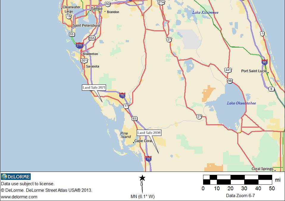
53 44 SALES COMPARISON APPROACH SERVIENT ESTATE LAND The servient estate land is 1,388.3 gross acres consisting of wetland acres and 1, upland acres. The proposed rezoning of the subject designates the 1,388.3 acre servient estate land as open space. Use of this land is limited to non-commercial recreational uses only. To estimate the market value this land area as encumbered with a conservation easement, we researched sales of land encumbered with conservation easements (sales of the servient estate) and sales of the servient estate mitigation banks that have similar restrictions on use. Refer to the following land sales summary chart and location map for pertinent details of the comparable servient estate land sales that we analyzed to estimate the market value of the servient estate land.
54 45 Table 3 Comparable Servient Estate Land Sales Sale No. Land Type Location Sale Date 2292 Mitigation Bank 2293 Mitigation Bank 2076 WRP Easement Source: Urban Economics Inc NEQ US Hwy 17 & SR 64, Wauchula, Hardee SEQ SR 52 & Land O Lakes Blvd, Land O Lakes, Pasco County NWQ SR 70 & Placid Lakes Blvd, Lake Placid, Highlands County Conserved / Wetland Acres Encumbered /Wetland % Cons Sale Price Only Price / Conserved AC Dec % $ 375,000 $ 759 Dec-16 1, % $ 850,000 $ 777 Dec-15 7, % $4,588,250 $ 625

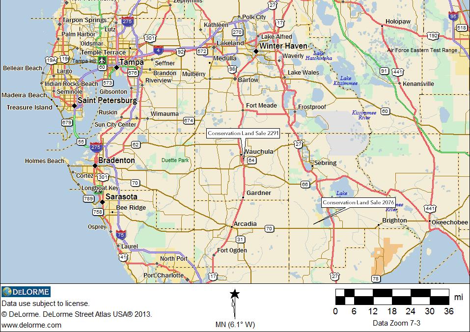
55 Figure 15 46
56 47 Qualitative Analysis of the Comparable Servient Estate Sales Real Property Rights Conveyed We are appraising the market value of the servient estate as encumbered by the conservation easement restrictions contained in the addenda of this report. Use of the subject 1,388.3 gross acres is limited to non-commercial recreational uses. Comparable Servient Estate Land Sales 2291 and 2292 are the remainder rights of mitigation bank land that are encumbered with highly restrictive conservation easements that allow for recreational uses that are similar to the subject allowable uses. Comparable Servient Estate Land Sales 2076 is encumbered with Water Resource Protection (WRP) easements which are highly restrictive allowing recreational uses, similar to the subject allowable uses. Therefore, each of the comparable servient estate land sales have been conveyed with property rights that are similar to the subject servient estate. Financing All of the comparable servient estate land sales sold for cash or with a cash equivalent instrument and therefore the sale price of each of these land sales is similar to payment in cash or its equivalent tenet of market value. Conditions of Sale Based on our verification of the comparable servient estate land sales, all of these comparable land sales are the result of conditions typical of a market sale. Therefore, the sale price of each of the comparable servient land sales is the result of typical conditions of sale. Market Conditions To estimate the difference of market conditions on the date of the comparable land sale and the date of the market value estimate, we performed a matched pairs analysis using the comparable servient estate land sales. The comparable servient estate land sales occurred between December 2015 and December Based on this matched pairs analysis, it is our opinion that conservation servient estate land value has been relatively stable between the date of the comparable sales and the retrospective date of value. Therefore, each of the comparable servient estate land sales is similar to the subject property in terms of change of market conditions.
57 48 Extraordinary Cost Based on our confirmation of the comparable servient estate land sales there are no extraordinary costs associated with the comparable sales. Location Comparable Servient Estate Land Sales 2076 is located in Highland County, Comparable Servient Estate Land Sale 2291 is located in Hardee County, and Comparable Servient Estate Land Sale 2292 is located in Pasco County. Analysis of the comparable servient estate land sales does not indicate an adjustment for a difference in location between the location of the subject and the locations of the comparable servient estate sales. Therefore, each of the comparable servient estate land sales is similar to the subject in terms of location. Physical Characteristics Analysis of the comparable servient estate land sales indicates no discount for upland/wetland ratio. Therefore, each of the comparable servient estate land sales is similar to the subject in terms of physical characteristics. The sales price per gross acre of the comparable servient estate sales range from $625 per gross acre to $777 per gross acre. Based on our qualitative analysis, we are of the opinion the market value of the subject servient estate should be at the upper of the range of market value indications. We are of the opinion the subject servient estate land had a market value of the servient estate of $775 per gross acre. Applying this market value estimate to the subject servient estate encumbered land area indicates a market value estimate as follows: $775 per gross acre * 1,388.3 acres = $1,075,933 Rounded $1,076,000 The market value of the subject property site with a future land use designation of Rural Community is as follows: Table 4 Market Value with Rural Community Future Land Use Market Value of Development Land $ 38,292,000 + Market Value of Mitigation Land $ 1,076,000 Market Value As Approved $ 39,368,000
58 MARKET VALUE OF THE FEE SIMPLE ESTATE WITH A RURAL LAND FUTURE LAND USE DESIGNATION 49
59 50 Land Use LEGAL ENCUMBRANCES The subject has a Future Land Use Designation under the Marion County Comprehensive Plan of Rural Land. The Rural Land Future Land Use (FLU) designation is intended to preserve permanent open space and the character of the county's rural areas while allowing the clustering of rural development. Uses permitted in the Rural Land FLU designation include agricultural and/or agricultural related uses including commercial and industrial uses that are functionally related to rural and/or agricultural activities, neighborhood commercial uses, residential development including detached single-family homes, mobile homes, and manufactured housing. Density must not exceed one dwelling unit per 10 gross acres within the Rural Land FLU designation. Zoning The subject has a zoning designation under the Marion County Land Development Code of General Agriculture (A-1). The A-1 zoning designation is intended to preserve agriculture as the primary use. Minimum front, side, and rear setbacks for buildings or structures are 25 feet. Minimum front setbacks for accessory buildings housing livestock are 75 feet, with side and rear setbacks at 25 feet. Minimum front setbacks for accessory buildings housing poultry are 100 feet, with side and rear setbacks at 25 feet. Minimum front and side setbacks for pool enclosures are 25 feet, with rear setbacks of 10 feet. Minimum tract width in the A-1 zoning designation is 150 feet, and minimum lot size is 10 acres. Maximum density is one dwelling unit per 10 gross acres. Private Encumbrances The subject property is encumbered by a 295 foot wide overhead powerline easement that contains 33 gross acres and traverses the northwest quadrant of the subject site from east to west. Additionally, there is a 50-foot wide natural gas pipeline easement containing acres that enters the subject tract at is southwest corner along its State Road 200 frontage moving north east to its intersection adjacent to the south of the 295 foot wide High Voltage powerline corridor. The permanent easement runs parallel to the easement powerline until the powerline intersects the site s northwest boundary.
60 51 Highest and Best Use, as Vacant Legally Permissible HIGHEST AND BEST USE ANALYSIS The subject has a Future Land Use designation by Marion County of Rural Land and is zoned Agriculture (A-1) by Marion County. The subject future land use designation and zoning district allows for agricultural uses and rural residential use with a maximum density of one dwelling unit per 10 gross acres. The current agricultural use of the subject land conforms to the standards of the zoning district and future land use designation. In January 2017, the property owner has submitted a plan for 5,891 dwelling units and 135,000 square feet of commercial with Marion County. On July 18, 2017, the Marion County BOCC denied the requests of owner for an amendment to the future land use map for the subject property from the Rural Land designation to the Rural Community designation (Case Number 2017-L01) and the related rezoning request from Agricultural (A-1) district to Planned Unit Development (PUD) district (Case Number Z ). Based on this recent denial by the Marion County BOCC, a change in the comprehensive plan and zoning district is not reasonably probable within the foreseeable future. Based on the foregoing, it is our opinion the legally permissible uses of the subject property are agricultural and rural residential uses. Physically Possible The subject site is irregular in configuration and contains 3,470.5 acres, of which 3, acres are uplands and acres are jurisdictional wetlands. The subject has good quality linkages provided by 1.2 miles of frontage on the west side of State Road 200, a generally north/south arterial. Access to the site is from State Road 200. The subject site topography is generally level and the site is near road grade. The subject site is of sufficient size, configuration, topography, and linkages to be developed with a variety of agricultural and rural residential uses. Financially Feasible Legally, the subject property has a land use for a variety of agricultural uses and rural residential uses with maximum density of one unit per 10 acres. Physically, the subject property is of sufficient size, configuration, topography and linkages to be developed with a variety of legally permissible uses. The subject property is at located in the southeast quadrant of State Road 200 and SW 140th Street in southwest Marion County. Land uses located north of the subject along State Road 200 are single-family residential uses and preservation areas that include the Halpata Tastanki Preserve and Ross Prairie State Forest.
61 52 Based on the foregoing, we are of the opinion that the financially feasible use of the subject is agricultural land. Maximally Productive Considering the legally permissible, physically possible and financially feasible uses of the subject site, we are of the opinion the highest and best use of the site is agricultural land. EXPOSURE TIME We interviewed market participants ascertain the exposure time of commercial sites that are similar to the subject property. The exposure time responses of market participants ranged from 12 months to 24 months. Based on an examination of the subject property, market participants and sales data, we are of the opinion that, if the subject properties are adequately exposed to the market and appropriately priced, an exposure time of 12 to 24 months is reasonable probable.
62 53 SALES COMPARISON APPROACH In our qualitative comparison analysis of the comparable agricultural land sales, each of the comparable agricultural land sales is analyzed for real property rights conveyed, financing, conditions of sale, market conditions, location, and physical characteristics. Following in Table 5 is summary information of the comparable land analyzed. Table 5 Sale Location No SWC W Hwy 318 & NW 150th Ave Williston Comparable Agricultural Land Sales Sale Date Sale Price Gross Acres Percent Wetlands Price / Gross Acre May-17 $ 1,600, % $ 4, SS E CR 470, W of FL Tpke, Sumterville 2296 SWQ SE Hwy 42 & CR 209, Summerfield Feb-17 $ 18,070,000 4, % $ 4,374 Oct-16 $ 7,766,900 1, % $ 6,338 Source: Urban Economics Inc


63 Figure 16 54
64 55 Qualitative Analysis of Comparable Agricultural Land Sales Property Rights Conveyed Based on our conversation with our client, we are appraising the fee simple estate of the subject site. Founded on our analysis of the official records and our verification of the comparable agricultural land sales all of the comparable agricultural land sales are sales of the fee simple estate in real property, which is a bundle of rights that is similar to the bundle of rights being appraised. The real property rights sold with the comparable agricultural land sales are, therefore, similar to the real property rights being appraised. Financing Based on our verification of the land sale and/or our examination of public records we are of the opinion all of the comparable agricultural land sales sold for cash or with a cash equivalent instrument, therefore the sale price of each of the comparable agricultural land sales is reflective of cash which is similar to the payment in cash tenet of market value. Conditions of Sale Based on our verification of the comparable land sales, the sale prices of the comparable agricultural land sales are the result of typical sale conditions and are, thus similar to the conditions of sale tenet of market value. Market Conditions To estimate the difference in market conditions, if any, on the date of comparable land sale and the date of value we analyzed data from the National Agricultural Statistics Service (NASS) and information from the Saunders Real Estate 2016 Lay of the Land Market Report. According to NASS, Pasture values in Florida had an average per acre value of $6,750 per acre in 2017, an increase of 0.30 percent over the previous year s average value of $6,730per acre. Since 2014, Pasture values in Florida have remained relatively stable with year over year increases of 0.92 percent in 2015, and 2.59 percent in The comparable agricultural land sales occurred between October 2016 and May Based on the foregoing, the market condition at the time of each of the comparable agricultural land sales was slightly inferior to the market conditions on the date of value. The magnitude of the inferiority is in proportion to the quantity of time that has passed between the date of the comparable land sale and the date of value.
65 56 Location Comparable Agricultural Land Sale 2294 is located at the southwest corner of West Highway 318 and NW 150 th Avenue, Williston, Marion County. This comparable land sale fronts on an arterial which is similar to the subject s paved road frontage on State Road 200 and this land sale therefore has a location that is similar to the subject in terms of road frontage and access. The market area of this comparable land sale has an inferior population density and inferior nearby uses compared with the subject market area and it is therefore, inferior to the subject in terms of market area. Overall this comparable land sale has a location that is inferior to the location of the subject property. Comparable Land Sale 2295 is located on the south side East County Road 470, west of the Florida Turnpike, Sumterville, Sumter County. This comparable land sale fronts on an arterial which is similar to the subject s paved road frontage on State Road 200 and this land sale is therefore similar to the subject in terms of road frontage and access. The market area for this comparable land sale has an inferior population density and inferior nearby uses compared with the subject market area and it is therefore, inferior to the subject in terms of market area. Overall this comparable land sale has a location that is inferior to the location of the subject property. Comparable Land Sale 2296 is located at the southwest quadrant of SE County Road 42 and County Road 209, Summerfield, Marion County. This comparable land sale fronts on an arterial which is similar to the subject s paved road frontage from State Road 200 and this land sale is therefore similar to the subject in terms of road frontage and access. The market area for this comparable land sale has similar population density and similar nearby uses compared with the subject market area and it is therefore, similar to the subject in terms of market area. Overall this comparable land sale has a location that is similar to the location of the subject property. Physical Characteristics The subject property comprises 3,470.5 gross acres and the comparable agricultural land sales range in size from 400 to 4,131 upland acres. Based on the economic principal of diminishing economic returns comparable land sales smaller than the subject size of 3,470.5 gross acres are superior to the subject on a per acre basis and comparable land sales larger than the subject size are inferior to the subject on a per acre basis. In terms of the remaining physical characteristics, all of the comparable land sales are approximately similar to the physical characteristics of the subject property with the exception of their ratio of wetlands. The subject gross land area is 6.93 percent wetlands. Comparable Agricultural Land Sale 2294 has 0.44 percent wetlands which is slightly superior to the subject s ratio of wetlands. Comparable Agricultural Land Sale 2295 has percent wetlands which is similar to the subject s ratio of wetlands. Comparable Agricultural Land Sale 2296 has percent wetlands which is inferior to the subject s ratio of wetlands. Each of the comparable agricultural land sales has a sufficient size and configuration to be developed with a variety of agricultural uses, therefore each of the comparable agricultural land sales is similar to the subject in terms of physical characteristics.
66 57 Considering the qualitative analysis of the comparable land sales, we are of the opinion the subject property had a market value per acre of $5,500. Applying this market value estimate to the subject land area indicates a market value estimate as follows: $5,500 per gross acre * 3, acres = $19,087,750 Rounded $19,088,000 In our opinion, the subject fee simple estate with a Rural Land future land use designation had a market value of the retrospective date of July 18, 2017 of NINETEEN MILLION EIGHTY-EIGHT THOUSAND DOLLARS ($19,088,000).
67 58 ASSUMPTIONS AND LIMITING CONDITIONS 1. No responsibility is assumed for the legal description or for matters including legal or title considerations. Title to the property is assumed to be good and marketable unless otherwise stated. 2. The property is appraised free and clear of all encumbrances, unless otherwise noted. 3. It is assumed that there are no hidden or unapparent conditions of the property's subsoil or structure that render it more or less valuable. No responsibility is assumed for such conditions or for arranging for engineering studies that may be required to discover them. 4. Subsurface rights (minerals, oil, or water) were not considered in this report. 5. Description and condition of physical improvements, if any, described herein are based on visual observation. As no engineering tests were conducted, no liability can be assumed for soundness of structural members. 6. All value estimates have been made contingent on zoning regulations and land use plans in effect as of the date of appraisal, and based on information provided by governmental authorities and employees. 7. It is assumed that there is full compliance with all applicable federal, state, and local environmental laws and regulations, unless noncompliance is stated, defined, and considered in the appraisal report. 8. It is assumed that all applicable zoning and land use regulations and restrictions have been complied with, unless a nonconformity has been stated, defined, and considered in the appraisal report. 9. It is assumed that all required licenses, certificates of occupancy, consents, or other legislative or administrative authority from any local, state, or national government or private entity or organization have been or can be obtained or renewed for any use on which the value estimate contained in this report is predicated. 10. No responsibility is assumed by the appraiser for applicability of "concurrency laws", referring to the 1985 amendments to Chapter 163, Florida Statutes. At this time it is unclear what effect, if any, these laws might have on any property in any given county. As various legislative and judicial action is pending, the reader is cautioned to fully investigate the likelihood of development moratorium or other governmental action with appropriate municipal, county, or state officials. 11. This appraisal report covers only the premises herein; and no figures provided, analysis thereof, or any unit values derived therefrom are to be construed as applicable to any other property, however similar they may be.
68 Distribution of the total valuation in this report between land and improvements applies only under the existing program of utilization. Separate valuations of land and improvements must not be used in any other manner, nor in conjunction with any other appraisal, and are invalid if so used. 13. The appraiser, by reason of this report, is not required to give testimony in court with reference to the property herein, nor obligated to appear before any governmental body, board, or agent, unless arrangements have been previously made therefor. 14. This appraisal has been prepared solely for the private use of the client who is listed above as the addressee. No other party is entitled to rely on the information, conclusions, or opinions contained herein. 15. Neither all nor any portion of the contents of this appraisal shall be conveyed to the public through advertising, public relations, news, sales, or other media without the written consent and approval of the appraiser, particularly as to valuation conclusions, identity of the appraiser or firm with which he is connected, or any reference to the Appraisal Institute or to the MAI designation. Furthermore, neither all nor any portion of the contents of this appraisal shall be used in connection with any offer, sale, or purchase of a security (as that term is defined in Section 2(l) of the Securities Act of 1933) without the prior express written consent of the appraiser. 16. Possession of this report or copy thereof does not convey any right of reproduction or publication, nor may it be used by any but the client, the mortgagee, or its successors or assigns, mortgage insurers, or any state or federal department or agency without the prior written consent of both the client and the appraiser, and, in any event, only in its entirety. 17. Unless stated otherwise, the possibility of hazardous material, which may or may not be present on the property, was not observed by the appraiser during the course of the normal inspection and research conducted during the appraisal assignment. The appraiser, however, is not professionally qualified to detect such substances, and inspection by a professional in the field is recommended for any property. The presence of substances such as asbestos, urea-formaldehyde foam insulation, or other potentially hazardous materials could affect the value of the property, if found. The value estimate is predicated on the assumption that there is no such material on or in the property that would cause a loss in value. No responsibility is assumed for any such conditions, or for any expertise or engineering knowledge required to discover them. This appraisal report is subject to receipt of an environmental audit confirming that no hazardous or toxic material is located on the premises. Should such material be discovered, final value estimates herein would be reduced by the cost to remove such substances and to restore the premises to serviceable condition, and would further be reduced by indirect expenses and income losses incurred by the owner during abatement. Such adjustments to the value estimate contained herein may be made only by the appraiser and only upon receipt of the environmental audit, construction cost estimates and other data satisfactory to the appraiser at his sole discretion. 18. The Americans With Disabilities Act (ADA), enacted in 1990, provided civil rights protection to persons with disabilities. Title III of this act provides that persons with
69 disabilities are to be provided access equal to, or similar to, that available to the general public in all areas of "public accommodation," which generally means any retail, recreation, social service or lodging establishment. It does not apply to "commercial facilities," which could be a single-tenant office or manufacturing facility, and generally does not require alterations to existing buildings, unless other alterations are made. This latter is subject to interpretation, but it should be assumed that any significant renovation requiring a building permit will also require that the building be brought to current handicap requirements for all or a portion of the building. The appraiser is not professionally qualified in these matters, this appraisal does not constitute an inspection as to compliance with the provisions of the act, and no responsibility is assumed for any known or unknown conditions related to the act, civil rights or building code provisions. A number of professional engineering firms specialize in these matters, and such professional advice should be obtained if any doubt as to conformity exists. 60
70 MICHAEL A. MCELVEEN, MAI, CCIM, CRE President Urban Economics, Inc. 810 South Sterling Avenue Tampa, FL Urban Economics, Inc. - Tampa, Florida - Michael A. McElveen is president of Urban Economics, Incorporated, a real estate consultancy providing econometrics, valuation, spatial analytics, economic impact and stigma effect advice and opinions for 28 years. The focus of Michael A. McElveen has been expert witness testimony, having testified numerous times at either a jury trial, hearing or by deposition. Mr. McElveen has performed valuations, evaluations, counseling and expert witness testimony on many types of real estate including offices, aviation and port related real estate, manufacturing, hospitality, golf courses, regional scale retail, master-planned residential communities, Developments of Regional Impact, condominiums, apartments, convenience stores, gas stations, and either entitled or unentitled land. Environmental Impairment Mr. McElveen has been recognized by his peers as an expert in the valuation and marketability of real property that is affected by an environmental impairment. He has written articles on the marketability and valuation of impaired properties and lectured many professional groups on development within Brownfields. Mr. McElveen has been accepted by the courts of Florida as an expert on the effect of contamination (stigma) on the value of real property. A brief summary of environmental impairment experience follows: Jacksonville, FL Cleaning solvents, VOC s and heavy metals in the ground water of 86 singlefamily homes; St. Thomas, USVI Petroleum Groundwater Contamination; Orlando, FL Unexploded World War II ordinance and associated stigma on residential community; Tallevast, FL Groundwater contamination and proximity to super fund site on 150 homes, lots, and commercial properties; Tampa, FL Arsenic based solvents in the ground water of commercial development site; Jacksonville, FL Solvents, heavy metals, and VOC s in groundwater and soil of development site; Tampa, FL Mulberry Phosphate acidic wastewater slurry spill into Alafia River and impact on homes & commercial; Clearwater, FL Asbestos contamination in regional shopping mall; Port St. Joe Impaired fill material in single-family community; Largo, FL Off site source of groundwater contamination on retail site; Largo, FL Off site source of groundwater contamination on business park; Sarasota, FL Petroleum groundwater contamination of single-family home; Tavernier, FL sewage contamination of single-family home; Florida Numerous dry cleaning solvent sites; Florida Numerous landfill sites and site proximate to landfills; Florida Numerous brownfield sites. Aviation/Port Related Real Estate As an active single engine land - instrument rated private pilot and US Merchant Marine Captain, Mr. McElveen has broad practical knowledge based experience with the distinctive aspects of aviation/port real estate. As a result of this combination of knowledge and experience, Mr. McElveen has been sought out to provide counseling and instruction to The Center for Transportation Research
71 of the University of South Florida as it relates to the valuation of aviation real estate and aviation real estate rent and leasing. Mr. McElveen s recent aviation/port related accomplishments are: Instrument Rated, Single-engine Land (SEL) Private Pilot; US Merchant Marine Officer of uninspected passenger vessels (Captain), near coastal waters, 100 tons; Port Canaveral Land lease rent and terms study of all Port property south of shipping channel and proposed The Cove at Port Canaveral retail center; Clearwater, FL US Army Corp of Engineers corporate aircraft hangar rent and terms study; Orange County, FL Approved aviation and non-aviation related real estate appraiser with OCAA; Opa Locka, FL Real estate appraisal review and consulting of ground leases with Miami- Dade Aviation Department; FDOT Aviation & Space Ports Advisor to The Center for Transportation Research (CUTR) publication Guidelines for Determining Market Value & Market Rent of Airport Property; FDOT Aviation & Space Ports Advisor to The Center for Transportation Research (CUTR) publication Florida Aviation Facilities Rent Study; Florida Aviation Trades Association Author and analyst of Florida Hangar Rent Survey, Spring Economic Analysis Economic Impact Studies An economic Impact study is the quantification of the effect of a change within a community s economic structure. This analysis requires the analyst to establish assumptions and key relationships that direct how change occurs and the magnitude of the change. Mr. McElveen uses the latest version of the IMPLAN economic impact modeling solution software to measure the economic benefits of real estate development on a community, county or region. Econometric/Meta-analysis Meta-analysis of the impact of a Home Depot Improvement Store on the value of nearby homes, Cape Coral, FL and Jacksonville Beach, FL; Economic Impact study of a 9,400-acre aggregate mine on Levy County, FL; Econometric study of the sales price effect of an aggregate mine on the sales prices of nearby homes, Hernando County, FL; Economic Impact study of 1 million square foot regional mall on Hillsborough County, FL; Economic Impact study of urban infill condominiums, Tampa, FL; Econometric study of the marginal impact of an additional 18-hole golf course and equestrian facility on the value of residential lots, Lake County, FL; Meta-analysis of the marginal impact of a 9-hole executive golf course and swimming pool on the value of homes, Trinity, FL; ANOVA analysis of delay damages caused by construction defects of residential condominium, Jacksonville Beach, FL; Analysis of damages caused by change of development plan for residential condominiums, St. Johns, USVI; Review of economic loss damages of a single-family home from loss of view Cruz Bay, St. John, USVI; Use of comparison of means to estimate economic benefit and marginal property tax increase of navigable residential canals on the tax base of the City of Tampa; Sales price index trend of fractured condominium sales in Osceola County; Econometric study of the rent effect of deficient parking at neighborhood retail centers, Charlotte County, FL; Econometric study of the sales price effect of location and community waterfront in Martin County, FL; Economic Impact of 84 room hotel, Tampa, FL.
72 Counseling Spatial Analytics The change of location of real estate can have a most dramatic impact on value, marketability, and/or use of real property. Mr. McElveen has performed studies of the impact on real estate from a change of location. Some of the locational studies are the impact of a frontage road and overpass on convenience retail and service stations, impact on residences of increased traffic flow into a residential community and proximity of interstate externalities on apartment communities. He has provided extensive counseling to The Home Depot Corporation in their effort to educate neighborhood groups on the development of big box uses near residential communities. Mr. McElveen provides spatial analysis with the use of ESRI ArcView GIS software and econometrics that provides a compelling visual depiction of the value impact of a change of location on the use and value of real estate. Education Bachelor of Arts Finance, University of South Florida Bachelor of Science, Florida State University Professional Associations Appraisal Institute (MAI), Certificate No CCIM Institute of the National Association of Realtors (CCIM) American Real Estate Society (ARES) National Association of Business Economists (NABE) Florida Real Estate Broker, BK89611 State of Florida Certified General Real Estate Appraiser, RZ360 American Real Estate and Urban Economics Association The Counselors of Real Estate (CRE), Member ID 2592 Expert Witness Expert Witness in Federal Bankruptcy Court, Florida Middle District and Florida Lower District, Courts of Miami-Dade, Pasco, Hillsborough, Pinellas, Lee, Broward, Orange, Polk, Alachua, Hardee, Hernando, Manatee, Palm Beach, St. Johns, Sumter, Washington and Volusia Counties. Published Publications McElveen, M. A., & Diskin, B. A., Ph. D. (1990). Valuation of anchor department stores. The Assessment Digest, 12(5), McElveen, M. A. (2012, Spring). Florida Hangar Rent Survey. Florida Aviation Business, 7-8. McElveen, M. A., Haynes, J. B., & Diskin, B. A., Ph. D. (1990). Lender perceptions of value influences of asbestos contamination in income-producing buildings. Assessment Digest, 12(6), McElveen, M. A., MAI, CCIM, CRE, Brown, B. E., MA, & Gibbons, C. M., MAURP. (2017). Natural gas pipelines and the value of nearby homes: A spatial analysis. Journal of Housing Research, 26(1), doi: Working Papers McElveen, M. A., MAI, CCIM, Brown, B. E., MA, & Gibbons, C. M., MAURP. (2017). Timeshares real property and the vacation experience (Working paper).
73 McElveen, M. A., MAI, CCIM, Brown, B. E., MA, & Gibbons, C. M., MAURP. (2017). The sales price effect of an elevated expressway on nearby homes. (Working paper). Presentations/Service September 2015 Natural gas pipelines and the valuation of nearby homes, International Right of Way Association, Southeast Chapter, Annual Conference, Panama City, Florida. April, Natural gas pipelines and the valuation of nearby homes: A spatial analysis was accepted for presentation at the American Real Estate Society, 2015 Annual Conference, Ft. Myers, Florida. April Spatial Analytics/GIS Applications, presentation at the American Real Estate Society, 2015 Annual Conference, Ft. Myers, Florida ARES Manuscript Awards Committee, Spatial Analytics/GIS Applications Past President, Florida State University Trends Conference Past Board Member, Florida State University Trends Conference
74 MICHAEL P. LINEBAUGH Vice President, Property Rights Urban Economics, Inc. 810 South Sterling Avenue Tampa, FL Urban Economics, Inc. - Tampa, Florida - Michael P. Linebaugh is Vice President, Property Rights of Urban Economics, Incorporated, a real estate consultancy providing econometrics, valuation, spatial analytics, economic impact and stigma effect advice and opinions. Mr. Linebaugh has been providing real estate valuation services for litigation and non-litigation purposes since Mr. Linebaugh has performed valuations, evaluations, and counseling on many types of real estate including offices, retail, port related real estate, warehousing, manufacturing, railroad corridor, hospitality, golf courses, regional scale retail, masterplanned residential communities, Developments of Regional Impact, condominiums, apartments, convenience stores, gas stations, agricultural properties, and either entitled or unentitled land. Education Bachelor of Science, Finance and Real Estate, Florida State University, 2006 State of Florida Certified General Real Estate Appraiser, RZ3452 Professional Associations
75 ADDENDA
76
77
78

79 Land Sale No Property Identification Record ID 2072 Property Type Residential Property Name Latitude Margaretville Address Daytona Beach, Volusia County, Florida Location NWC LPGA Blvd & Tournament Dr. Tax ID Sale Data Grantor Grantee Sale Date Deed Book/Page Property Rights Conditions of Sale Financing Verification Consolidated Tomoka Land Co Minto Communities December 15, 2016 Contract update (Early 2017 close) N/A (Contract) Fee simple Arm's length Unknown William Bullock; , Confirmed by Michael Linebaugh Sale Price $27,200,000 Cash Equivalent $27,200,000
80 Land Data Zoning Topography Utilities Shape Land Sale No (Cont.) PD-G, Planned Development General Generally level All available Irregular Land Size Information Gross Land Size 1, Acres or 69,086,160 SF Uplands Land Size 1, Acres or 52,359,120 SF, 75.79% Wetlands Land Size Acres or 16,727,040 SF, 24.21% Planned Units 3,400 Indicators Sale Price/Gross Acre $17,150 Sale Price/Gross SF $0.39 Sale Price/Uplands Acre $22,629 Sale Price/Uplands SF $0.52 Sale Price/Planned Unit $8,000 Remarks Comparable Development Land Sale 2072 is known as Latitude Margaretville and is located in the northwest corner of LPGA Boulevard and Tournament Drive in north Volusia County. The site contains 1,586 gross acres consisting of 1,202 upland acres and 384 acres of wetlands. The site is planned as an adult community and will have up to 3,400 residential units and 215,000 square feet of commercial use. Construction began in 2017 and the project is expected to have a 10 to 15 year buildout.

81 Land Sale No Property Identification Record ID 2114 Property Type Residential Property Name Southern Oaks Address Wildwood, Sumter County, Florida Location SEQ CR 468 & FL Turnpike Tax ID G36=002 Sale Data Grantor Daryl M. Carter, Trustee Grantee The Villages Land Company, LLC Sale Date September 22, 2016 Deed Book/Page 3159/511 Property Rights Fee simple Marketing Time 3 years Conditions of Sale Arm s length Financing Cash to seller Verification Daryl Carter; , Confirmed by Michael Linebaugh Sale Price $25,000,000 Cash Equivalent $25,000,000 Land Data Zoning DRI, Development of Regional Impact
82 Land Sale No (Cont.) Topography Utilities Shape Generally level All available Irregular Land Size Information Gross Land Size 2, Acres or 101,712,600 SF Uplands Land Size 1, Acres or 59,590,080 SF, 58.59% Wetlands Land Size Acres or 42,122,520 SF, 41.41% Planned Units 3,144 Indicators Sale Price/Gross Acre $10,707 Sale Price/Gross SF $0.25 Sale Price/Uplands Acre $18,275 Sale Price/Uplands SF $0.42 Sale Price/Planned Unit $7,952 Remarks This site is known as Southern Oaks and is located in the southeast quadrant of County Road 468 and the Florida Turnpike (SR 91) within the City of Wildwood, Sumter County. The site contains 2,335 gross acres consisting of 1,368 upland acres and 967 acres of wetlands. In 2012, the property was approved for development of 1,214 single-family units, 1,930 multi-family units, 300 assisted living beds, and million square feet of non-residential uses. The property was purchased in September 2016 by the Villages Land Company and is planned to be developed with an active adult community. The project is expected to have a 15 to 20 year buildout and to begin within three years of the sale date.

83 Land Sale No Property Identification Record ID 2038 Property Type Residential Property Name The Place at Corkscrew Address Estero, Lee County, Florida Location NS Corkscrew Rd, E of Alico Rd Tax ID Sale Data Grantor Resource Conservation Holdings Grantee The Place at Corkscrew LLC Sale Date October 25, 2015 Deed Book/Page Property Rights Fee simple Conditions of Sale Arm's length Financing $15,000,000 mortgage with Florida Community Bank Verification Dominic Cameratta; , Confirmed by Michael Linebaugh Sale Price $20,000,000 Cash Equivalent $20,000,000 Land Data Zoning Topography Utilities Shape RPD, Residential Planned Development Generally level All Available Nearly rectangular
84 Land Sale No (Cont.) Land Size Information Gross Land Size 1, Acres or 59,285,160 SF Uplands Land Size 1, Acres or 54,842,040 SF, 92.51% Wetlands Land Size Acres or 4,443,120 SF, 7.49% Planned Units 1,325 Indicators Sale Price/Gross Acre $14,695 Sale Price/Gross SF $0.34 Sale Price/Uplands Acre $15,886 Sale Price/Uplands SF $0.36 Sale Price/Planned Unit $15,094 Remarks Comparable Development Land Sale 2038 is known as The Place at Corkscrew and is located on the north side of Corkscrew Road approximately 6.25 miles east of Interstate-75 in Estero, Lee County. The site contains 1,361 gross acres consisting of 1,259 upland acres and 102 acres of wetlands. Subsequent to the sale date on August 2016, the site was approved for development of 1,325 single-family lots. The project is expected to have a 10 to 15 year buildout and is expected to start construction in late 2017.
85 Land Sale No Property Identification Record ID 2071 Property Name Thomas Ranch/West Villages Address Florida Location NWQ S River Rd & Winchester Blvd Tax ID Sale Data Grantor Fourth Quarter Properties XXXII, LLC Grantee Thomas Ranch Land Partners North Port, LLP et al Sale Date May 28, 2014 Deed Book/Page Property Rights Fee simple Conditions of Sale Arm s length Financing $57,000,000 mortgage with Synovous Bank Verification John Dunphy; Sale Price $86,250,000 Cash Equivalent $86,250,000
86 Land Sale No (Cont.) Land Data Zoning Topography Utilities Shape Multiple (Sarasota County & North Port) Generally level All available Irregular Land Size Information Gross Land Size 9, Acres or 420,354,000 SF Uplands Land Size 6, Acres or 276,257,520 SF, 65.72% Wetlands Land Size 3, Acres or 144,096,480 SF, 34.28% Indicators Sale Price/Gross Acre $8,938 Sale Price/Gross SF $0.21 Sale Price/Uplands Acre $13,600 Sale Price/Uplands SF $0.31 Remarks This site is known as The West Villages and is located in the northwest quadrant of South River Road and Winchester Boulevard in southeast Sarasota County, partially within the City of North Port. The site contains 9,650 gross acres consisting of 6,342 upland acres and 3,308 acres of wetlands. In 2007, the City of North Port entered into a unique partnership with the private sector through an adoption of the Village District Pattern Planning (VDPP) process and the supporting changes land development code with approval from the State of Florida. The VDPP allowed for up to 15,000 residential uses and up to 3 million square feet of non-residential uses on approximately 8,000 acres within the City of North Port. In May 2014, Mattamy Homes along with a local development partner purchased the property and an additional 1,650 gross acres in Sarasota County for $86,250,000. Subsequently, the buyers applied to add 4,645 residential units to the overall development and are currently in the process of obtaining approvals for those units as of the date of this report. It is reasonably probable the buyers will be able to obtain the additional entitlements. The project is expected to have a buildout of 30 to 40 years and is expected to begin site development in early 2017.

87 Conservation Land Sale No Property Identification Record ID 2292 Property Type Conservation Address Wauchula, Hardee County, Florida Location NEQ US Hwy 17 & SR 64, Wauchula Tax ID Sale Data Grantor EIP Florida, LLC Grantee Dean R & Donna S Ott Sale Date December 11, 2017 Deed Book/Page Property Rights Servient Estate Marketing Time 11 mos Conditions of Sale Arm's length Financing Cash to seller Verification Jack Koehler; , December 18, 2017; Confirmed by Michael Linebaugh Sale Price $375,000 Cash Equivalent $375,000
88 Conservation Land Sale No (Cont.) Land Data Zoning Topography Utilities F-R, Farm-Residential Generally level N/A Land Size Information Gross Land Size Acres or 21,518,640 SF Conservation Land Size Acres or 21,518,640 SF, % Indicators Sale Price/Gross Acre $759 Sale Price/Gross SF $0.02 Sale Price/Conservation $759 Acre Sale Price/Conservation $0.02 SF Remarks This site is located in the northeast quadrant of US Highway 17 and State Road 64, Wauchula, Hardee County. This site has substantial frontage along the east and west sides of the Peace River. This site is an active mitigation bank. This sale is the sale of underlying servient estate of the site and did not include any mitigation bank credits. Allowable use of the property is highly restricted non-commercial recreation only.

89 Conservation Land Sale No Property Identification Record ID 2293 Property Type Conservation Address Land O Lakes, Pasco County, Florida Location SEQ SR 52 & Land O' Lakes Blvd Tax ID Sale Data Grantor EIP Florida LLC Grantee Old Florida Ranch, LLC Sale Date December 02, 2016 Deed Book/Page 9467/1707 Property Rights Servient Estate Conditions of Sale Arm's length Financing Cash to Seller Verification Jack Koehler; , December 18, 2017; Confirmed by Michael Linebaugh Sale Price $850,000 Cash Equivalent $850,000 Land Data Zoning MPUD, Mixed Planned Unit Development
90 Conservation Land Sale No (Cont.) Topography Utilities Shape Generally level N/A Irregular Land Size Information Gross Land Size 1, Acres or 47,633,993 SF Conservation Land Size 1, Acres or 47,633,993 SF, % Indicators Sale Price/Gross Acre $777 Sale Price/Gross SF $0.02 Sale Price/Conservation $777 Acre Sale Price/Conservation $0.02 SF Remarks This site is located in the southeast quadrant of State Road 52 and Land O' Lakes Boulevard, Land O' Lakes, Pasco County. This site has frontage along both State Road 52 and Land O' Lakes Boulevard. This site is an active mitigation bank. This sale is the sale of underlying servient estate of the site and did not include any mitigation bank credits. Allowable use of the property is highly restricted non-commercial recreation only.

91 Conservation Land Sale No Property Identification Record ID 2076 Property Type Conservation Address Lake Placid, Highlands County, Florida Location NWQ SR 70 & Placid Lakes Blvd Tax ID C A Sale Data Grantor Westby Corporation Grantee Roman III Ranch, LLC Sale Date December 11, 2015 Deed Book/Page 2507 Recorded Plat 621 Property Rights Servient Estate Marketing Time 10 mos Conditions of Sale Arm's length Financing Cash to seller Verification Dean Saunders; , December 11, 2017; Confirmed by Michael Linebaugh Sale Price $4,588,250 WRP Land only Cash Equivalent $4,576,300 Land Data Zoning Topography Ag, Agricultural Generally level
92 Conservation Land Sale No (Cont.) Utilities Shape Electric & telecommunications Irregular Land Size Information Gross Land Size 7, Acres or 319,782,672 SF Conservation Land Size 7, Acres or 319,782,672 SF, % Indicators Sale Price/Gross Acre $625 Sale Price/Gross SF $0.01 Sale Price/Conservation $625 Acre Sale Price/Conservation $0.01 SF Remarks This property is located in the northwest quadrant of State Road 70 and Placid Lakes Boulevard, Lake Placid, Highlands County. This sale is the conservation portion of sale of 7, gross acres for a recorded sale price of $6,281,500. According to the broker, the conservation land contributed $625 per acre to the overall sale price. The conservation site is encumbered with two Wetlands Reserve Program (WRP) easements. Rights retained by the servient estate include title, quiet enjoyment, control of access, non-commercial recreational uses, subsurface resources, and limited water uses and water rights.

93 Agricultural Land Sale No Property Identification Record ID 2294 Property Type Agricultural, Pasture Address Williston, Marion County, Florida Location SWC W Hwy 318 & NW 150th Ave Tax ID Sale Data Grantor Four Circle Investments, LLC Grantee George Sabates Sale Date May 09, 2017 Deed Book/Page 6577/605 Property Rights Fee simple Conditions of Sale Arm's length Financing Cash to seller Verification George Benedicty; , December 11, 2017; Confirmed by Michael Linebaugh Sale Price $1,600,000 Cash Equivalent $1,600,000
94 Agricultural Land Sale No (Cont.) Land Data Zoning Topography Utilities Shape PUD, Planned Unit Development Generally level Electric and telephone nearly rectangular Land Size Information Gross Land Size Acres or 17,424,000 SF Wetlands Land Size Acres or 77,101 SF, 0.44% Indicators Sale Price/Gross Acre $4,000 Sale Price/Gross SF $0.09 Remarks This site is located on the south side of West Highway 318, across from the southern terminus of NW 150th Avenue, Williston, Marion County. Access to the site is from West Highway 318. West Highway 318 is a two-lane, undivided, east/west arterial. Surrounding land uses are predominately agricultural and rural residential. In 2015, the seller obtain an approved rezoning to from A-1(Agricultural) to PUD to allow for development of 39 residential lots ranging in size from 5.0 to 16 acres, an eight residential unit bed and breakfast inn and accessory recreational facilities.

95 Agricultural Land Sale No Property Identification Record ID 2295 Property Type Agricultural, Pasture Address Wildwood, Sumter County, Florida Location SWQ SE Hwy 42 & CR 209 Tax ID K Sale Data Grantor Wildwood Ranch LLC & TML of Marion, LLC Grantee Buffalo Hide & Cattle Company, LLC Sale Date April 12, 2017 Deed Book/Page 3222/200 Property Rights Fee simple Conditions of Sale Arm's length Financing Cash to seller Sale Price $18,070,000 assemblage Cash Equivalent $18,070,000 Land Data Zoning Topography Utilities Shape PD, Planned Development Generally level All available Nearly rectangular
96 Agricultural Land Sale No (Cont.) Land Size Information Gross Land Size 4, Acres or 179,943,311 SF Acres or 18,045,601 SF, 10.03% Indicators Sale Price/Gross Acre $4,374 Sale Price/Gross SF $0.10 Remarks This site is located on the south side of County Road 470, approximately 2.83 miles west of the Florida Turnpike, within the City of Wildwood, Sumter County. Access to the site is from County Road 470. County Road 470 is a two-lane, undivided, east/west arterial. Surrounding land uses along County Road 470 include rural residential, industrial, and vacant land. The site was previously approved for development of the Landstone Communities DRI and was approved for development of up to 8,025 residential units, 430,000 square feet of non-residential uses, and an 18-hole golf course. Subsequent to the sale, the buyer rescinded the DRI and downzoned the property to Agricultural 10 (A-10).

97 Agricultural Land Sale No Property Identification Record ID 2296 Property Type Agricultural Address Flagler Beach, Marion County Location SWQ SE Hwy 42 & CR 209, Summerfield Tax ID Sale Data Grantor Various Grantee 3R's Land Company, LLC & 3R's Ranch, LLC Sale Date October 05, 2016 First purchase Deed Book/Page 6467/1666 et al Property Rights Fee simple Conditions of Sale Arm's length Financing Cash to sellers Verification Rochelle - Rep of Buyer; , December 15, 2017; Confirmed by Michael Linebaugh Sale Price $8,179,900 Assemblage Cash Equivalent $8,179,900
Anatomy Of An Appraisal
 Anatomy Of An Appraisal Leslie A. Fields The most important thing to know about an appraisal report is how to review and critique it. Leslie A. Fields a partner with the Law Firm of Faegre & Benson LLP,
APPRAISAL REPORT OF GROSS ACRES/17.72± USABLE ACRES OF VACANT COMMERCIAL LAND
 APPRAISAL REPORT OF 20.22 GROSS ACRES/17.72± USABLE ACRES OF VACANT COMMERCIAL LAND LOCATED AT NORTHWEST CORNER OF LAND O LAKES BOULEVARD & SUNTERRA DRIVE LAND O LAKES, FLORIDA 34638 Job No.: 14-0227 Prepared
619 STANDARD 2: REAL PROPERTY APPRAISAL, REPORTING
 619 STANDARD 2: REAL PROPERTY APPRAISAL, REPORTING 620 In reporting the results of a real property appraisal, an appraiser must communicate each analysis, 621 opinion, and conclusion in a manner that is
RESTRICTED APPRAISAL REPORT
 Restricted Use Appraisal Report Thomas J. Schulte & Associates Page #1 RESTRICTED APPRAISAL REPORT SUBJECT ASSIGNMENT Property City: Zip Code: County: Legal Description: Assessor's Parcel #: Tax Year:
To all Appraisers: Brief Overview:
 To all Appraisers: As the appraisal industry continues to change, the demand for alternative valuation solutions grows. That is why is excited to announce the addition of a new product - the Desktop Appraisal
How to Read a Real Estate Appraisal Report
 How to Read a Real Estate Appraisal Report Much of the private, corporate and public wealth of the world consists of real estate. The magnitude of this fundamental resource creates a need for informed
AHDC. THA Affordable Housing Development Corp. Board of Directors Meeting
 AHDC THA Affordable Housing Development Corp. Board of Directors Meeting November 19, 2014 AHDC Meeting Agenda THA Affordable Housing Development Corp. November 19, 2014 I. CALL TO ORDER II. MINUTES FROM
REED APPRAISAL COMPANY REAL PROPERTY APPRAISERS AND CONSULTANTS
 REAL PROPERTY APPRAISERS AND CONSULTANTS 100 SOUTH KENTUCKY AVENUE #230 ip.o. BOX 1645 ilakeland, FLORIDA 33802-1645 OFFICE: (863) 688-6718 ifax: (863) 688-5993iEMAIL: stan@reedappraisalco.com TO: Henry
RAINS COUNTY APPRAISAL DISTRICT
 RAINS COUNTY APPRAISAL DISTRICT 2017 MASS APPRAISAL SUMMARY REPORT mass appraisal report 2017 uspap_appr_report RAINS COUNTY APPRAISAL DISTRICT 2017 MASS APPRAISAL SUMMARY REPORT Identification of Subject:
EvaluePro Real Estate Restricted Appraisal Report
 EvaluePro Real Estate Restricted Appraisal Report EvaluePro Highlights Property Street: 1000 Main Street City: Anytown State: NC Zip: 12345 Property Owner: Mr. & Mrs. Property Owner Estimated Market Value:
Guide Note 6 Consideration of Hazardous Substances in the Appraisal Process
 Guide Note 6 Consideration of Hazardous Substances in the Appraisal Process Introduction The consideration of environmental conditions along with social, economic, and governmental conditions is fundamental
APPRAISAL OF REAL PROPERTY
 Main File No. Page #1 APPRAISAL OF REAL PROPERTY LOCATED AT 1142 Mill Rd Greenleaf, WI Prt of NW1/4 NW Frac 1/4 & Prt of SW 1/4 NW Frac 1/4 Sec 18 T21N R20E Desc in 1666521 Ex Rd FOR OPINION OF VALUE 410,000.00
A Demonstration Appraisal Report. Of a. Located at. Date of Appraisal. Prepared for. Prepared by
 A Demonstration Appraisal Report Of a Located at Date of Appraisal Prepared for Prepared by International Association of Assessing Officers Professional Designation Subcommittee 314 W. 10 th Street Kansas
Dear Valuation Professional
 Dear Valuation Professional First American Mortgage Solutions LLC has a new product offering that we would like you to consider adding to your list of services with us - (Property Assessment Collateral
AN APPRAISAL OF Acre Residential Site Northwest Corner Pleasant View Road & Gaar Road Richmond, Indiana 47374
 AN APPRAISAL OF 3.75 Acre Residential Site Northwest Corner Pleasant View Road & Gaar Road Richmond, Indiana 47374 American United Appraisal Company, Inc. Real Estate Appraisers Jay E. Allardt, SRA August
VALUE FINDING APPRAISAL REPORT
 RE 90 Rev. 01-2014 VALUE FINDING APPRAISAL REPORT (Compensation not to exceed $65,000) COUNTY John Doe 2880 Lancaster-Newark Rd. (SR 37), Pleasant Twp., 43030 Owner Mailing Address of Owner East side of
Address Southeast Quadrant of U.S. Highway 41 and Sumter Boulevard City. North Port State. FL Zip Code County
 SUBJECT AERIAL LOCATION LAND AREA THREE-YEAR OWNERSHIP HISTORY OF SUBJECT Address Southeast Quadrant of U.S. Highway 41 and Sumter Boulevard City North Port State FL Zip Code 34287 County Sarasota Nearest
A Demonstration Appraisal Report. Of a. Located at. Date of Appraisal. Prepared for. Prepared by
 A Demonstration Appraisal Report Of a Located at Date of Appraisal Prepared for Prepared by International Association of Assessing Officers Professional Designation Subcommittee 314 West 10 th Street Kansas
As Of: Prepared For: Prepared By:
 of 216 SW 131st St As Of: 06/11/11 Prepared For: Prime Pacific Bank 2502 196th St SW Lynnwood WA 98036 Prepared By: Cynthia A. Nagle, CREA 922 N Cedar St Tacoma, WA 98406 RESTRICTED APPRAISAL REPORT Restriction
Appraisal Stream Restricted Use Residential Appraisal Report
 Appraisal Stream Restricted Use Residential Appraisal Report File No. 769kemplin This report is limited to the sole and exclusive use of the client. The appraiser's opinions and conclusions set forth in
REPORTING GUIDELINES FOR REAL ESTATE APPRAISAL REPORTS
 Property Tax Valuation Reporting REPORTING GUIDELINES FOR REAL ESTATE APPRAISAL REPORTS Robert F. Reilly and Robert P. Schweihs 43 INTRODUCTION Appraisal reports become important documents in property
LAND APPRAISAL REPORT
 IDENTIFICATION LAND APPRAISAL REPORT Page #1 File No. Borrower None Census Tract * Map Reference 462820011000315 Property Address NWC Gaar and Pleasant View Roads City Richmond County Wayne State IN Zip
Staff Report: Date: Applicant: Property Identification: Acreage of Request: Current Zoning of Requested Area: Requested Action: Attached:
 Staff Report: Completed by Jeff Palmer Director of Planning & Zoning Date: November 7, 2018 Applicant: Greg Smith, Oberer Land Developer agent for Ronald Montgomery ET AL Property Identification: Frontage
Guide Note 15 Assumptions and Hypothetical Conditions
 Guide Note 15 Assumptions and Hypothetical Conditions Introduction Appraisal and review opinions are often premised on certain stated conditions. These include assumptions (general, and special or extraordinary)
APPRAISAL REPORT. Vacant Commercial Land SW 268 th Street Miami, FL Cruz Appraisals, Inc SW 72 nd Street, Suite 263 Miami, FL 33173
 APPRAISAL REPORT Prepared for Mr Jorge Palomeras Jpal Marketing Corporation Property Appraised Vacant Commercial Land 12711 SW 268 th Street Miami, FL 33032 Date of Valuation October 6, 2017 Prepared by
Cover Letter with Narrative Statement
 Cover Letter with Narrative Statement March 31, 2017 rev July 27, 2017 RE: Rushton Pointe Residential Planned Unit Development Application for Public Hearing for RPUD Rezone PL2015 000 0306 Mr. Eric Johnson,
Staff Report: Date: Applicant: Property Identification: Acreage of Request: Current Zoning of Requested Area: Requested Action: Attached:
 Staff Report: Completed by Jeff Palmer Director of Planning & Zoning Date: November 7, 2018, Updated November 20, 2018 Applicant: Greg Smith, Oberer Land Developer agent for Ronald Montgomery ET AL Property
Swisher County Appraisal District 2017 Mass Appraisal Report
 Swisher County Appraisal District 2017 Mass Appraisal Report Prepared Pursuant to Standard 6 of the Uniform Standards of Professional Appraisal Practice 1 TABLE OF CONTENTS Introduction 3 Listing of Taxing
BADGER Appraisals, LLC
 BADGER Appraisals, LLC PO Box 2222 Appleton, WI 54912 T (920) 687-9000 / F (920) 687-9244 info@badgerappraisals.com www.badgerappraisals.com Appraisal Service Brown * Calumet * Outagamie * Winnebago APPRAISAL
January 11, 2017 MEMORANDUM. Issue. Background. Commissioner s Recommendation
 State Board of Regents Board of Regents Building, The Gateway 60 South 400 West Salt Lake City, Utah 84101-1284 TAB Q Phone 801.321.7101 Fax 801.321.7199 TDD 801.321.7130 www.higheredutah.org January 11,
ILLINOIS HOUSING DEVELOPMENT AUTHORITY APPRAISAL SCOPE AND GUIDELINES December 2015
 ILLINOIS HOUSING DEVELOPMENT AUTHORITY APPRAISAL SCOPE AND GUIDELINES December 2015 As part of the Common Application for Multifamily Financing, the Illinois Housing Development Authority (IHDA) requires
BADGER Appraisals, LLC
 BADGER Appraisals, LLC PO Box 2222 Appleton, WI 54912 T (920) 687-9000 / F (920) 687-9244 info@badgerappraisals.com www.badgerappraisals.com Residential Appraisal Service Brown * Calumet * Outagamie *
APPRAISAL REVIEW REPORT. April 7, Yasmi Govin, Director of Business and Property Management Broward County Aviation Department
 Public Works Department Facilities Management Division REAL PROPERTY SECTION 115 S. Andrews Avenue, Room 501 Fort Lauderdale, Florida 33301 954-357-6808 FAX 954-357-6292 APPRAISAL REVIEW REPORT April 7,
APPRAISAL REVIEW REPORT
 APPRAISAL REVIEW REPORT REVIEW OF APPRAISALS BY BECCARIA & WEBER, INC. RE: BUENA VISTA MOBILE HOME PARK PALO AL TO, CALIFORNIA REVIEWED BY JAMES BRABANT, MAI PREPARED FOR Law Foundation of Silicon Valley,
Mike Dalton Jr. and Associates. Christina Adams INVOICE NUMBER Mike Dalton Jr. and Associates 8191 Wethersfield Drive. PB125 Germantown, TN 38138
 Mike Dalton Jr. and Associates FROM: INVOICE Christina Adams INVOICE NUMBER Mike Dalton Jr. and Associates 8191 Wethersfield Drive Germantown, TN 38138 DATE 08/14/2016 Telephone Number: (901) 674-0239
Case 9:15-cv DMM Document Entered on FLSD Docket 11/22/2017 Page 1 of 12
 Case 9:15-cv-80946-DMM Document 181-5 Entered on FLSD Docket 11/22/2017 Page 1 of 12 APPRAISAL OF A 1.31 ACRE SITE LOCATED AT: XXX 77th Trl N (long legal description/see page #1) Palm Beach Gardens, FL
Across-the-Fence Value and Hostage Occupancy Agreements
 Across-the-Fence Value and Hostage Occupancy Agreements EUCI Conference: Electric Transmission Projects San Diego, California September 19, 2016 John T. Schmick Shenehon Company 2 What is the goal of valuation
SUBJECT: The Appraisal of Real Property That May Be Impacted by Environmental Contamination
 1 ADVISORY OPINION 9 (AO-9) 1 2 3 4 This communication by the Appraisal Standards Board (ASB) does not establish new standards or interpret existing standards. Advisory Opinions are issued to illustrate
APPRAISAL OF 1117 MONROE STREET, VICKSBURG, MS 39180
 APPRAISAL OF 1117 MONROE STREET, VICKSBURG, MS 39180 CLIENT/INTENDED USER: GLENN TRIPLETT INTENDED USE/USER: TO ASSIST THE CLIENT IN MAKING A PURCHASING DECISION. THIS REPORT IS NOT INTENDED FOR ANY OTHER
UPDATED MARKET VALUE APPRAISAL. Day Care/Senior Center Property and Excess Parcel Governors Drive Olympia Fields, Illnois.
 J _,i UPDATED MARKET VALUE APPRASAL Day Care/Senior Center Property and Excess Parcel 20080 Governors Drive Olympia Fields, llnois _ as of: March 16, 2007 Prepared for: Mr. Steve Townsend, Vice President
Contents Lists of Figures and Tables xi About the Author xiii Foreword xv Acknowledgments xvi Part I Introduction
 CHAPTER # Contents Lists of Figures and Tables... xi About the Author... xiii Foreword...xv Acknowledgments...xvi Part I Introduction... 1 1 Overview of Land Valuation Assignments and Adjustment Procedures...
procedures Basic Appraisal F i n a l Examination #2 2 nd edition
 F i n a l Examination #2 A n s w e r Key Page 82 1. When determining effective gross income from potential gross income, an appraiser considers a. debt service. b. depreciation. c. fixed expenses. d. vacancy
SUBJECT: Unacceptable Assignment Conditions in Real Property Appraisal Assignments
 1 2 3 4 5 6 7 8 9 10 11 12 13 14 15 16 17 18 19 20 21 22 23 24 25 26 27 28 29 30 31 32 ADVISORY OPINION 19 (AO-19) This communication by the Appraisal Standards Board (ASB) does not establish new standards
Individual Cooperative Interest Appraisal Report
 PURPOSE Individual Cooperative Interest Appraisal Report The purpose of this appraisal report is to provide the client with a credible opinion of the defined value of the subject property, given the intended
BUSI 330 Suggested Answers to Review and Discussion Questions: Lesson 1
 BUSI 330 Suggested Answers to Review and Discussion Questions: Lesson 1 1. The three characteristics necessary to gain professional recognition are: Integrity, Competence, and Provide Quality Work. Students
 Page 1 of 5 STANDARD 3: APPRAISAL REVIEW, DEVELOPMENT AND REPORTING In performing an appraisal review, an appraiser acting as a reviewer must develop and report a credible opinion as to the quality of
William K. Boyd, Inc.
 Real Estate Appraisers & Consultants Main Office 1564 Lakeview Drive Sebring, FL 33870 Satellite Office 410 Northwest 2 nd St Okeechobee, FL 34972 Phone: 863 385-6192 Fax: 866-384-0258 November 22, 2017
BUILD-OUT ANALYSIS GRANTHAM, NEW HAMPSHIRE
 BUILD-OUT ANALYSIS GRANTHAM, NEW HAMPSHIRE A Determination of the Maximum Amount of Future Residential Development Possible Under Current Land Use Regulations Prepared for the Town of Grantham by Upper
2014 Plan of Conservation and Development. Development Plan & Policies
 The Town of Hebron Section 3 2014 Plan of Conservation and Development Development Plan & Policies C. Residential Districts I. Residential Land Analysis This section of the plan uses the land use and vacant
Appraisal and Market Analysis of Indoor Waterpark Resorts
 Appraisal and Market Analysis of Indoor Waterpark Resorts By David J. Sangree, MAI, CPA, ISHC An appraisal of an indoor waterpark resort is similar to other appraisals in that it is a professional appraiser
Chapter 100 Planned Unit Development in Corvallis Urban Fringe
 100.100 Scope and Purpose. Chapter 100 Planned Unit Development in Corvallis Urban Fringe (1) All applications for land divisions in the Urban Residential (UR) and Flood Plain Agriculture (FPA) zones within
ARTICLE 23 CONDOMINIUM STANDARDS
 ARTICLE 23 CONDOMINIUM STANDARDS Section 23.01 Intent. The intent of this Article is to provide regulatory standards for condominiums and site condominiums similar to those required for projects developed
APPRAISAL OF REAL PROPERTY LOCATED AT: FOR: AS OF: BY:
 APPRAISAL OF REAL PROPERTY LOCATED AT: 489 MEADOWS EDGE COURT DEED BOOK 2896, PAGE 2759 CLEMMONS, NC 27012 FOR: ESTATE OF WILLIAM C. McINTOSH % BAILEY & THOMAS P.O. BOX 52 WINSTON-SALEM, NC 27102 AS OF:
Industrial and Commercial Real Estate Appraisal Procedures
 Property Valuation Thought Leadership Industrial and Commercial Real Estate Appraisal Procedures John C. Ramirez The application of the asset-based approach to business valuation often involves the appraisal
AG-AMERICA COMMERCIAL FARM AND RANCH COLLATERAL VALUATION GUIDE
 AG-AMERICA COMMERCIAL FARM AND RANCH COLLATERAL VALUATION GUIDE Table of Contents CHAPTER CV101 COLLATERAL VALUATION STANDARDS AND GUIDES... 1 CV101.1 Overview... 1 General Guidance on Terms:... 1 CHAPTER
Marion County Board of County Commissioners
 Marion County Board of County Commissioners Date: 6/4/217 P&Z: 9/25/217 BCC Transmittal: 1/17/217 BCC Adopt: TBD Amendment No: 217-L6 Type of Application Large-Scale Comp Plan Amendment Request: Change
Case 9:15-cv DMM Document Entered on FLSD Docket 11/22/2017 Page 1 of 11
 Case 9:15-cv-80946-DMM Document 181-3 Entered on FLSD Docket 11/22/2017 Page 1 of 11 G.F. Lubeck Appraisers, LLC 1250 N. Ocean Drive Riviera Beach, FL 33404 www.lubeckappraisers.com March 01, 2017 James
1057 Canton RD Marietta, GA 30066
 1057 Canton RD Marietta, GA 30066 +/- 1.49 Acres Presently Zoned LI $350,000 With all utilities available. Very little lot prep necessary for most uses. Two Level steppes descending from the street level.
APPRAISAL OF REAL PROPERTY LOCATED AT: FOR: AS OF: BY:
 APPRAISAL OF REAL PROPERTY LOCATED AT: 627/631 NW 14 STREET SEE ADDENDUM FOR COMPLETE LEGAL DESCRIPTION FLORIDA CITY, FL 33034 FOR: 1261 HOMESTEAD ROAD LEHIGH ACRES, FL 33936 AS OF: 10/20/2014 BY: LINDA
RevuPro Appraisal Review
 RevuPro Appraisal Review Getting It Right ELLIOTT introduces its flagship review product RevuPro, as an independent appraisal review service. Q. What is it and what does it do? A. RevuPro is a fast, economical
Restricted Use Appraisal Report Residential
 Client File #: Appraisal File #: Restricted Use Appraisal Report Residential Appraisal Company: Address: Form 200.04* Phone: Fax: Website: Appraiser: Co-Appraiser: AI Membership (if any): SRA MAI SRPA
LOCAL IMPROVEMENT DISTRICT APPRAISER PRESENTATION. November 2017
 LOCAL IMPROVEMENT DISTRICT APPRAISER PRESENTATION November 2017 SPECIAL BENEFIT STUDY WHY? A special benefit study is a tool consistently used with LID projects. Municipality retains an expert consultant
5976 Okeechobee Boulevard, West Palm Beach, Palm Beach County, Florida PO As of July 19, 2015
 REAL ESTATE APPRAISAL REPORT Of 5976 Okeechobee Boulevard, West Palm Beach, Palm Beach County, Florida PO 151223 As of July 19, 2015 Prepared For Town of Palm Beach 360 S. County Road Palm Beach, FL 33480
8Land Use. The Land Use Plan consists of the following elements:
 8Land Use 1. Introduction The Land Use Plan consists of the following elements: 1. Introduction 2. Existing Conditions 3. Opportunities for Redevelopment 4. Land Use Projections 5. Future Land Use Policies
Restricted Use Appraisal Report Of a development site
 A development site Located at: 700' E of SEC of 6th Avenue and 328 St Homestead, Florida As of November 7, 2017 Restricted Use Appraisal Report Of a development site Restricted Use Appraisal Report Of
Exhibit IV. Property Appraisal Report by Intrgra Realty Resources dated 10/3/16
 Exhibit IV. Property Appraisal Report by Intrgra Realty Resources dated 10/3/16 RFP 2018C-01 COMMERCIAL REAL ESTATE SERVICES - FLAGLER CENTER PROPERTY Page 40 of 42 Integra Realty Resources Jacksonville
EVALUATION AND APPRAISAL REPORT OF THE CITY OF FELLSMERE COMPREHENSIVE PLAN APPENDIX D HOUSING ELEMENT
 OBJECTIVE H-A-1: ALLOW AFFORDABLE HOUSING AND ADEQUATE SITES FOR VERY LOW, LOW, AND MODERATE INCOME HOUSING. The City projects the total need for very low, low, and moderate income-housing units for the
Land, Agricultural Improvements, CAFO, Rural Residence, Farm
 *--FSA Appraisal Guidelines Land, Agricultural Improvements, CAFO, Rural Residence, Farm The following information elements and content descriptions are provided as guidelines to assist lenders and appraisers
WATERFRONT LOCAL IMPROVEMENT DISTRICT OVERVIEW. November 2017
 WATERFRONT LOCAL IMPROVEMENT DISTRICT OVERVIEW November 2017 LOCAL IMPROVEMENT DISTRICT Funding tool by which property owners financially contribute to a project that will increase the value of their property
UNDERSTANDING HOW USPAP APPLIES TO REAL PROPERTY APPRAISAL PRACTICE USPAP Matrix
 UNDERSTANDING HOW USPAP APPLIES TO REAL PROPERTY APPRAISAL PRACTICE - 2014-2015 USPAP Matrix This matrix assumes an Appraisal Report Format under S. R. 2-2(a). *Last updated 9/11/14* GENERAL Violation
Real Estate Appraisal Professional Standards
 Real Estate Appraisal Professional Standards Summary This proposal is to amend the Florida Administrative Code (FAC) to allow a Certified Residential Appraiser or a Certified General Appraiser to use standards
Demonstration Appraisal Report Utilizing a Form Report
 Demonstration Appraisal Report Utilizing a Form Report National Association of Independent Fee Appraisers 330 North Wabash Avenue, Suite 2000 Chicago, IL 60611 Phone: (312) 321-6830 Fax: (312) 673-6652
City of Hammond Purchasing Department. RFP # Invitation to Bid for. "Sale of City-Owned Property"
 City of Hammond Purchasing Department RFP # 14 19 Invitation to Bid for "Sale of City-Owned Property" Bids Shall Be Received by the Purchasing Department City of Hammond 310 East Charles Street P.O. Box
APPRAISAL REPORT OF:
 APPRAISAL REPORT OF: 1.435+ Acres (62,530+ SF) of Land Located at the Southeast Corner of Bullard Parkway & 56 th Street In Temple Terrace, Hillsborough County, Florida Property PREPARED FOR: City of Temple
PLANNED RESIDENTIAL DEVELOPMENT (PRD)
") PLANNED RESIDENTIAL DEVELOPMENT SECTION 10. PLANNED RESIDENTIAL DEVELOPMENT (PRD) 10.1 Purpose Planned Residential Development allows by special permit from the Board an alternative pattern of residential
PLANNED RESIDENTIAL DEVELOPMENT SECTION 10. PLANNED RESIDENTIAL DEVELOPMENT (PRD) 10.1 Purpose Planned Residential Development allows by special permit from the Board an alternative pattern of residential
2014 Plan of Conservation and Development
 The Town of Hebron Section 1 2014 Plan of Conservation and Development Community Profile Introduction (Final: 8/29/13) The Community Profile section of the Plan of Conservation and Development is intended
2018 SCCAI RESIDENTIAL SYMPOSIUM USPAP OF THE FUTURE. Paula Konikoff, JD, MAI, AI GRS
 USPAP OF THE FUTURE Paula Konikoff, JD, MAI, AI GRS WHERE WE ARE NOW 2 Joint task force for Improvement of USPAP Appraisal Institute and Appraisal Foundation develop USPAP Optimization Concept 3 When unnecessary
APPRAISAL REPORT OF. TANGERINE PLAZA SHOPPING CENTER nd Street South St. Petersburg, Pinellas County, Florida URS File Number
 APPRAISAL REPORT OF TANGERINE PLAZA SHOPPING CENTER 1794 22 nd Street South St. Petersburg, Pinellas County, Florida 33712 URS File Number 181583 FOR Mr. Bruce E. Grimes Director, Real Estate City of St.
As of JANUARY 12, Prepared for TENNESSEE STATE BANK ATTN: JULIE KING 2210 PARKWAY P.O. BOX 1260 PIGEON FORGE, TN 37868
 RESTRICTED APPRAISAL REPORT RIVER CROSSING - 55.92+ ACRES OF VACANT LAND ON GREENWOOD ROAD CHATTANOOGA, HAMILTON COUNTY, TENNESSEE TENNESSEE STATE BANK FILE#: 11169 BENCHMARK TRUST FILE #: 15-123 As of
RESTRICTED USE APPRAISAL. Jones Park Disposal Project
 RESTRICTED USE APPRAISAL Jones Park Disposal Project Prepared for: The City of Colorado Springs, on Behalf of its Enterprise, Colorado Springs Utilities 121 South Tejon Street Colorado Springs, CO 80903
PLANNED UNIT DEVELOPMENTS (Ordinance No.: 3036, 12/3/07; Repealed & Replaced by Ordinance No.: 4166, 10/15/12)
") 159.62 PLANNED UNIT DEVELOPMENTS (Ordinance No.: 3036, 12/3/07; Repealed & Replaced by Ordinance No.: 4166, 10/15/12) A. PURPOSE 1. General. The Planned Unit Development (PUD) approach provides the flexibility
159.62 PLANNED UNIT DEVELOPMENTS (Ordinance No.: 3036, 12/3/07; Repealed & Replaced by Ordinance No.: 4166, 10/15/12) A. PURPOSE 1. General. The Planned Unit Development (PUD) approach provides the flexibility
MODULE 7-A: APPRAISALS, BPOS AND USPAP
 MODULE 7-A: APPRAISALS, BPOS AND USPAP LEARNING OBJECTIVES One of the most challenging aspects of the real estate business is the development of prices or values of the rights to real estate. Buyers and
RENITA HURDSMAN BEAR RIVER STATE PARK LAND EXCHANGE PROPOSAL
 DETAILED ANALYSIS RENITA HURDSMAN BEAR RIVER STATE PARK LAND EXCHANGE PROPOSAL June 1, 2006 Prepared by the Office of State Lands and Investments Herschler Building, 3W 122 West 25 th Street Cheyenne,
Restricted Use Appraisal Report Residential
 Client File #: Appraisal File #: Restricted Use Appraisal Report Residential Form 200.04 * Appraiser: AI Membership (if any): SRA MAI SRPA AI Affiliation (if any): Candidate for Designation Practicing
Superior Traffic Control 100 Main Street Christiana / Rutherford County TN
 311 S. ROYAL OAKS BOULEVARD, SUITE 110 FRANKLIN, TN 37064 615.866.4863 BGJONES@BGJONESCOMPANY.COM WWW.BGJONESCOMPANY.COM RESTRICTED APPRAISAL REPORT THE FOLLOWING REPORT IS INTENDED TO COMPLY WITH THE
TABLE OF CONTENTS. Borrower/Client. File No. Property Address th Ave. Lender. City of Fulton. City of Fulton. Invoice...
 File No. 03-30-12-03 5000 16th Ave City Fulton County Whiteside State IL Zip Code TABLE OF CONTENTS Invoice... 1 Summary of Salient Features... 2 USPAP Identification... 3 GP Land... 4 Additional Comparables
2013 Profile of Home Buyers and Sellers Metro Indianapolis Report
 Prepared for: Metro Indianapolis Board of REALTORS Prepared by: Research Division December 2013 Table of Contents Introduction... 2 Highlights... 3 Conclusion... 6 Methodology..7 Report Prepared by: Jessica
RESIDENTIAL APPRAISAL SUMMARY REPORT
 SUBJECT ASSIGNMENT MARKET AREA DESCRIPTION Property City: Zip Code: County: Legal Description: Assessor's Parcel #: Tax Year: R.E. Taxes: $ Special Assessments: $ Borrower (if applicable): Current Owner
OHIO DEPARTMENT OF TRANSPORTATION OFFICE OF REAL ESTATE
 OHIO DEPARTMENT OF TRANSPORTATION OFFICE OF REAL ESTATE DATE: April 3, 2017 TO: FROM: RE: Users of the Real Estate Manual Jared Miller, Manager Appraisal Unit Changes and Updates to the Real Estate Manual
APPRAISAL REPORT 7.64 ACRE SHOVEL READY SITE 24 ASPEN PARK BOULEVARD TOWN OF DEWITT ONONDAGA COUNTY, NEW YORK
 APPRAISAL REPORT 7.64 ACRE SHOVEL READY SITE 24 ASPEN PARK BOULEVARD TOWN OF DEWITT ONONDAGA COUNTY, NEW YORK APPRAISAL REPORT 7.64 ACRE SHOVEL READY SITE 24 ASPEN PARK BOULEVARD TOWN OF DEWITT ONONDAGA
STAFF REPORT. Permit Number: Porter. Kitsap County Board of Commissioners; Kitsap County Planning Commission
 STAFF REPORT Permit Number: 15 00461 Porter DATE: November 9, 2015 TO: FROM: Kitsap County Board of Commissioners; Kitsap County Planning Commission Katrina Knutson, AICP, Senior Planner, DCD and Jeff
WALLER COUNTY APPRAISAL DISTRICT MASS APPRAISAL REPORT APPRAISAL YEAR 2018
 WALLER COUNTY APPRAISAL DISTRICT MASS APPRAISAL REPORT APPRAISAL YEAR 2018 ADDENDUM TO WCAD REAPPRAISAL PLAN FOR 2017 AND 2018 WALLER COUNTY APPRAISAL DISTRICT Uniform Standards of Professional Appraisal
Presented by Appraisal Institute Canada & Appraisal Institute
 VALUATION BEYOND BORDERS 2017 INTERNATIONAL CONFERENCE Presented by Appraisal Institute Canada & Appraisal Institute 1 LITIGATION SUPPORT REVIEW CASE Subject s Basic Factors: Community: Vital, growing
MARKET VALUE ESTIMATE. April 6, Land, Commercial Lots Southpark Subdivision Six Commercial Lots /- S. Harrison Street Olathe, Kansas 66061
 MARKET VALUE ESTIMATE April 6, 2018 Land, Commercial Lots Southpark Subdivision Six Commercial Lots 14600+/- S. Harrison Street Olathe, Kansas 66061 An Appraisal Report prepared for Job No. 5035726 Bliss
4.2 LAND USE INTRODUCTION
 4.2 LAND USE INTRODUCTION This section of the EIR addresses potential impacts from the Fresno County General Plan Update on land use in two general areas: land use compatibility and plan consistency. Under
MHC 2012 Housing Tax Credit Cycle MARKET STUDY GUIDE
 MHC 2012 Housing Tax Credit Cycle MARKET STUDY GUIDE I. DATA SOURCES 1. Acceptable data sources include: a. The 2000 Census b. Data from state or local planning bodies c. Data purchased commercially from
Guide Note 12 Analyzing Market Trends
 Guide Note 12 Analyzing Market Trends Introduction Since the value of a property is equal to the present value of all of the future benefits it brings to its owner, market value is dependent on the expectations
APPRAISAL REPORT. PREPARED FOR Margaret Christopher, MAI ABC Bank N.A. Client ID: Sample Appraisal Report - Industrial
 APPRAISAL REPORT Please be advised that if this appraisal report was transmitted by e-mail it may have been necessary to reduce the file size and therefore images may not be as clear as the original. If
REAL ESTATE APPRAISAL SERVICES
 Request for Qualifications and Proposals for REAL ESTATE APPRAISAL SERVICES Required by MISSOURI HOUSING DEVELOPMENT COMMISSION RESPONSES DUE: Friday, August 30, 2013 by 4:30 P.M. Central Time SECTION
MARKET VALUE BASIS OF VALUATION
 4.2 INTERNATIONAL VALUATION STANDARDS 1 MARKET VALUE BASIS OF VALUATION This Standard should be read in the context of the background material and implementation guidance contained in General Valuation