MARKET VALUE ESTIMATE. April 6, Land, Commercial Lots Southpark Subdivision Six Commercial Lots /- S. Harrison Street Olathe, Kansas 66061
|
|
|
- Albert Short
- 5 years ago
- Views:
Transcription


1 MARKET VALUE ESTIMATE April 6, 2018 Land, Commercial Lots Southpark Subdivision Six Commercial Lots /- S. Harrison Street Olathe, Kansas An Appraisal Report prepared for Job No

2 Bliss Associates, LLC 1000 Walnut St., Ste. 920 Real Estate Valuation Kansas City, MO and Professional Services fax April 25, 2018 Dear : The appraisal report you requested is enclosed. The purpose of the appraisal is to develop an opinion of market value. The client and intended user is, its successor s or assigns, and the intended use is to assist the client in documenting the value of the subject property for loan underwriting, risk classification, and other purposes. The subject of this report is as follows: Southpark Subdivision Six Commercial Lots Land, Commercial Lots /- S. Harrison Street Olathe, Kansas The appraisal complies with the Uniform Standards of Professional Appraisal Practice (USPAP) and the appraisal requirements of Title IX of the Financial Institutions Reform, Recovery and Enforcement Act of 1989 (FIRREA). In addition, the appraisal complies with the report requirements of the client. Real property interest appraised is the fee simple estate. The final value indication as of April 6, 2018, is $4,000,000. This valuation is subject to standard assumptions and general limiting conditions, as detailed in the attached report. No extraordinary assumptions or hypothetical conditions apply. Thank you for choosing Bliss Associates, LLC. Sincerely, Bliss Associates, LLC By: Kenny Meyers, MAI, SRA Vice President State Certified General Appraiser Kansas# G-382
3 Preface TABLE OF CONTENTS PREFACE SPECIAL LIMITING CONDITIONS ii CERTIFICATION iii INTRODUCTION EXECUTIVE SUMMARY 1 RECONCILIATION 2 SCOPE OF WORK 3 CRITERIA 4 MARKET AREA MARKET AREA ANALYSIS 7 SUBJECT IDENTIFICATION 13 HISTORY OF THE PROPERTY 15 SITE DESCRIPTION 16 SUBJECT PHOTOGRAPHS 22 REAL ESTATE TAXES 23 USE EXPOSURE AND MARKETING TIME 24 HIGHEST AND BEST USE 25 SALES COMPARABLE LAND SALES 27 RETAIL LOT VALUE LOT RETAIL LOT VALUE LOT RETAIL LOT VALUE LOT RETAIL LOT VALUE LOT RETAIL LOT VALUE LOT RETAIL LOT VALUE LOT BULK DISCOUNT ANALYSIS SIX COMMERCIAL LOTS 40 DOCUMENTS ENGAGEMENT LETTER LAND SALE WRITE-UPS APPRAISER QUALIFICATIONS i
4 Preface SPECIAL LIMITING CONDITIONS USPAP defines extraordinary assumption as an assumption, directly related to a specific assignment, as of the effective date of the assignment results, which, if found to be false, could alter the appraiser s opinions or conclusions. A hypothetical condition is defined as a condition, directly related to a specific assignment, which is contrary to what is known by the appraiser to exist on the effective date of the assignment results, but is used for the purpose of analysis. The following extraordinary assumptions and/or hypothetical conditions apply to this appraisal. The client is advised that their use might have affected the assignment results. Extraordinary Assumptions No extraordinary assumptions are made in this appraisal. Hypothetical Conditions No hypothetical conditions are imposed on this appraisal. ii
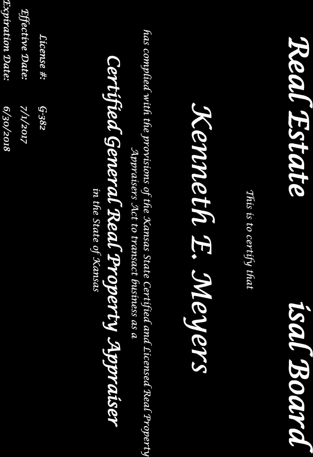
5 Preface CERTIFICATION I certify that, to the best of my knowledge and belief: The statements of fact contained in this report are true and correct. The reported analyses, opinions, and conclusions are limited only by the reported assumptions and limiting conditions and are my personal, impartial, and unbiased professional analyses, opinions, and conclusions. I have no present or prospective interest in the property that is the subject of this report and no personal interest with respect to the parties involved. I have previously appraised the property that is the subject of this report within the three- year period immediately preceding acceptance of this assignment. I have no bias with respect to the property that is the subject of this report or to the parties involved with this assignment. My engagement in this assignment was not contingent upon developing or reporting predetermined results. My compensation for completing this assignment is not contingent upon the development or reporting of a predetermined value or direction in value that favors the cause of the client, the amount of the value opinion, the attainment of a stipulated result, or the occurrence of a subsequent event directly related to the intended use of this appraisal. My analyses, opinions, and conclusions were developed, and this report has been prepared, in conformity with the Uniform Standards of Professional Appraisal Practice. I have made a personal inspection of the property that is the subject of this report. No one provided significant real property appraisal assistance to the person signing this report. The reported analyses, opinions, and conclusions were developed, and this report has been prepared, in conformity with the Code of Professional Ethics and Standards of Professional Appraisal Practice of the Appraisal Institute. The use of this report is subject to the requirements of the Appraisal Institute relating to review by its duly authorized representatives. As of the date of this report, I have completed the continuing education program of the Appraisal Institute. By: Kenny Meyers, MAI, SRA State Certified General Appraiser Kansas # G-382 Missouri # RA Effective date of the opinion: April 6, 2018 Date of the appraisal report: April 25, 2018 iii
6 Introduction EXECUTIVE SUMMARY Property/Location Southpark Subdivision Six Commercial Lots /- S. Harrison Street Olathe, Kansas Parcel Numbers DP (Lot 10) DP (Lot 11) DP (Lot 12) DP (Lot 13) DP (Lot 14) DP (Lot 29) Effective Date April 6, 2018 Property Rights Fee simple estate Owners of Record Land Areas Lot 10 86,492 SF (1.99 acres) Lot 11 61,333 SF (1.41 acres) Lot 12 44,699 SF (1.03 acres) Lot ,855 SF (2.94 acres) Lot ,439 SF (6.39 acres) Lot ,222 SF (8.04 acres) Gross Total 949,040 SF (21.79 acres) Zoning Highest and Best Use As Vacant C-2, Community Center District Future commercial development as warranted by demand VALUE ESTIMATES: Cost Approach Not Developed Income Approach Not Developed Sales Comparison Approach $4,000,000 FINAL VALUE ESTIMATE: $4,000,000 1
7 Introduction RECONCILIATION The subject property consists of six commercial lots located within the Southpark subdivision in the southwest quadrant of Old US-56 Highway and S. Harrison Street in Olathe, Kansas. The commercial subdivision is located west of S. Harrison Street, on both the north and south sides of Frontier Lane. This subdivision was originally was platted in 1987 and 1988, prior to the plat and development of the Great Mall of the Great Plains in The following table summarizes the six lots that make up the subject. Subject Summary Lot Lot Frontage/Visibility Lot Zoning Size (SF) Size (Acres) Description 10 Commercial 86, Second Tier 11 Commercial 61, Second Tier 12 Commercial 44, Primary Interior 13 Commercial 127, Primary Corner 14 Commercial 278, Second Tier 29 Commercial 350, Primary Corner Total 949, In the cost approach, the subject s direct and indirect development costs are typically estimated using Marshall Valuation Service, a national cost estimate source, and comparable subdivision costs. These costs (including an allowance for profit) are then added to the estimated (underlying) land value to arrive at a concluded indication of value by this approach. The cost approach is a reliable method of estimating value for newer properties; however, for investors, this approach carries little weight. Especially in the case of subdivisions, commercial or residential, once development has occurred market participants give very little consideration to this approach to value. The subject lots have already been developed, therefore the cost approach to value is not developed. The income approach was not developed in this analysis. Due to the lack of commercial lot sale activity in the subject project as well as the Olathe market in general, estimating absorption of the individual lots over time would be highly speculative and would not likely reflect the perspective of potential buyers in the marketplace. As a result, the income approach was not developed. The sales comparison approach involved a direct comparison between the subject sites and available land sales. Adjustments were applied for differences likely to be perceived by market participants. The resulting adjusted sale prices were reconciled for a concluded land value via the sales comparison approach. An appropriate bulk discount rate was then applied to the gross retail value of the pad sites to provide an indicated market value as developed. Given the nature of the subject property, the sales comparison approach is the most reliable indicator for the subject property. The quality and quantity of data was sufficient for a credible estimate of value. FINAL VALUE ESTIMATE: $4,000,000 2
8 Introduction SCOPE OF WORK Scope of work is defined by the Uniform Standards of Professional Appraisal Practice (USPAP) as the type and extent of research and analysis in an assignment. The scope of this assignment complies with USPAP, the Financial Institutions Reform, Recovery and Enforcement Act (FIRREA) of 1989, and the specific reporting requirements of the client. The specific scope of work for this appraisal assignment (and report) is outlined below. The resulting analysis is considered adequate to provide a credible result given the purpose, intended use, and intended users of the assignment. Property Identification & Inspection The property was identified using an address and legal descriptions provided by the client. It was further identified through County records. Kenny Meyers inspected the subject property on April 6, The inspection consisted of viewing the property from street frontages. Photographs were taken during the inspection. The surrounding neighborhood was also inspected from public roadways. Type and Extent of Data Researched Public records were researched for zoning, tax and assessment data, and flood determination. The overall site areas are based on Johnson County records. All regional, county, city, and other statistical information were obtained from published sources. Verbal information was provided by the listing broker regarding current market activity, perceived marketability, asking rates and general market information. The market was researched to obtain retail lot sales, bulk sales and general retail market information for use in this analysis. The data was researched using CoStar, the Bliss Associates proprietary database, data from brokers and other appraisers familiar with the area and/or property type, and published survey data. Type and Extent of Analysis Applied The highest and best use of the property was analyzed in the USE section of this report. The sales comparison approaches was applied. The cost and income approaches were not performed because they are not necessary for credible assignment results, based on the property type. Appropriate methodology and techniques deemed pertinent and necessary to the analysis were utilized. The results of the approach were reconciled for the final indication of value. Type of Appraisal Report This is an appraisal report which is intended to comply with the reporting requirements set forth under USPAP S.R. 2-2(a). As such, the report contains summaries of the pertinent data, reasoning and analyses used in the appraisal process to develop the opinion of value. The reporting is specific to the needs of the client. 3
9 Introduction CRITERIA Purpose The purpose of this appraisal is to estimate market value. Type of Value The type of value developed in this report is the market value. The definition of value is stated below. Definition of Market Value Market value means the most probable price which a property should bring in a competitive and open market under all conditions requisite to a fair sale, the buyer and seller each acting prudently and knowledgeably, and assuming the price is not affected by undue stimulus. Implicit in this definition is the consummation of a sale as of a specified date and the passing of title from seller to buyer under conditions whereby: (1) Buyer and seller are typically motivated; (2) Both parties are well informed or well advised, and acting in what they consider their own best interests; (3) A reasonable time is allowed for exposure in the open market; (4) Payment is made in terms of cash in United States dollars or in terms of financial arrangements comparable thereto; and (5) The price represents the normal consideration for the property sold unaffected by special or creative financing or sales concessions granted by anyone associated with the sale. 1 Intended Use The intended use, or function, of the appraisal is to assist in documenting the value of the subject property for loan underwriting, risk classification, and other bank purposes. Intended User/Client This report is for the exclusive use of, which is also the client. The appraisers and Bliss Associates are not responsible for any unauthorized use. Effective Date April 6, 2018 Property Rights The real property interest appraised is the fee simple estate. 1 Code of Federal Regulations; Title 12, FIRREA 323.2: Section 323.2(g) amended at 57 Fed. Reg. 9049, March 16, 1992; 59 Fed. Reg ; revised as of January 1,
10 Introduction Standard Assumptions and General Limiting Conditions This report assumes the following: 1. That title to the property interest appraised is good and marketable, unless otherwise noted; the report assumes no responsibility for the legal description or for legal matters or those relating to title considerations. 2. That the property is free and clear of any and all liens or encumbrances unless stated otherwise. 3. That the property has responsible ownership and competent property management. 4. The information furnished by others is reliable; however, no warranty is given for the accuracy of such information. 5. That all engineering is correct; the intention of the report is that plot plans and illustrative materials are to assist the reader in visualizing the property. 6. That there are no hidden or unapparent conditions of the property, subsoil, or structures that render it more or less valuable. No responsibility is assumed for such conditions or for procuring engineering services that may be necessary to discover them. 7. That the property complies fully with all applicable federal, state, and local environmental regulations and laws, unless noncompliance is specified in the report. 8. That the property complies with all zoning and use regulations and restrictions, unless the report acknowledges nonconformity. 9. That the owners and/or property managers either have or could procure or renew any licenses, certificates of occupancy, consents, or other legislative or administrative authority from any local, state, or national government, or private entity or organization, upon which the value conclusion reported depends. 10. That the utilization of the land and improvements is within the boundaries or property lines and that there are no encroachments or trespasses by or upon the property, unless noted in the report. Additional conditions bearing upon this report are as follows: 1. The distribution, if any, of the total valuation in this report between land and improvements applies only under the stated program of utilization; any separate allocations must not be used in any other appraisal and are invalid if so used. 2. Possession of this report, or any copy hereof, does not imply the right of publication. 3. By reason of this appraisal, the appraiser is relieved of any obligation to give further consultation or testimony, or to attend court with reference to the property in question, unless prior arrangements have been made. 4. Neither all nor any part of this report--especially any conclusions regarding value, the identity of the appraiser or the firm with which the appraiser is associated--may be disseminated to the public through advertising, public relations, news, sales-promotion, or other media without the prior written consent and approval of the appraiser. 5
11 Introduction 5. The value estimates in the report apply to the entire property interest as described in the report; any proration or division of the total into fractional interests would invalidate the value conclusions, unless such proration or division of interests has been set forth in the report. 6. Unless stated otherwise in this report, the appraiser has not been advised or become aware of the existence of any hazardous substances and/or toxic wastes that may or may not be present on the property; the appraiser has no knowledge of the existence of such materials on or in the property; the value estimated in the report is contingent upon the assumption that there is no hazardous condition on or in the property, or in such proximity to the property that it would cause a loss in value. 7. No compliance survey or analysis of the subject property relating to the requirements of the Americans with Disabilities Act of 1991 (ADA) exists. Such a survey could reveal that the property does not comply with one or more requirements of the Act, thus having a negative effect upon value. Unless stated otherwise in the report, there is no direct evidence relating to this issue. This report does not, therefore, consider possible noncompliance in estimating the value of the property. 6

12 Market Area MARKET AREA ANALYSIS Location/Access The subject property is situated in the southern portion of Olathe along the Interstate 35 corridor, between Santa Fe Street and W. 151 st Street. The area has reasonably good accessibility via an interchange with Old 56 Highways as well as W. 151 st Street. The following map shows the location of the subject property in relation to the overall Kansas City Metropolitan Area at large and the major transportation linkages. Market Area Map Metro Area Perspective 7

13 Market Area Market Area Map Immediate Neighborhood Area Land Uses and Trends The immediate neighborhood is the Interstate 35 corridor between 159 th Street on the south and Santa Fe Street on the north in Olathe, Kansas. There is significant commercial development located at the interchange of 151 st Street and I-35 including the Olathe Medical Center located west of I-35. Medical office buildings surround the hospital primarily to the north and west. The Medical Center has expanded considerably over the years and has over 2,600 employees. There are a number of restaurants, banks, hotels and other retailers surrounding the former Great Mall of the Great Plains south of the subject property. The Great Mall opened in 1997 with a number of well-known anchor stores and plans for expansion. Anchors originally included Burlington Coat Factory, Dickinson Theaters, Dillards Outlet, DSW, Linens N Things, Marshall s, Old Navy and Sak s Fifth Avenue (opened 2000). Several of the original anchors subsequently vacated, and the mall suffered for an extended time from significant vacancy. The current owners of the mall recently demolished it except for the Burlington Coat Factory store which is still operating. There has been no announcement yet as to the nature of the future redevelopment of the Mall site. Many of the restaurants on pad sites in front of the mall have also struggled to remain viable and several have closed. Home Depot and Target anchor a smaller, more viable shopping center located southeast of I-35 and 151 st Street and west of US 169, and there are a number of other restaurants and small retail users in this center. Industrial development is situated along the east side of US 169 (Highway 7). Further north is additional small industrial and office development. 8

14 Market Area There is no significant residential development within the immediate neighborhood. There are single-family residential subdivision developments north of Old Highway 56/Highway 7 and east of Interstate 35. Within the past five years, development on the west side of the interstate has included medical office buildings and light industrial buildings. GARMIN International is located about one mile east of the subject at the northwest corner of 151 st Street and Ridgeview. S. Harrison Street has an average traffic count of 19,100 cars per day, while Old US-56 Highway has an average traffic count of 17,200 cars per day. Land uses immediately surrounding the subject are shown on the following aerial map. Area Demographics The following map shows a 1-mile, 3-mile and 5-mile radius from the location of S Harrison Street in Olathe, Kansas: 9
 Census Trends 2010 % Change 10-17 2017 % Change 17-22 2022 Population 4,673 8.8% 5,083 6.0% 5,386 Number of Households 1,645 7.7% 1,772 5.")
15 Market Area The following charts show population demographics, particularly household and median income demographics within a 1-mile, 3-mile and 5-mile radius from the location of S Harrison Street: S Harrison Street (1-Mile Radius) Census Trends 2010 % Change % Change Population 4, % 5, % 5,386 Number of Households 1, % 1, % 1,872 Median Household Income $50, % $54,303 *Data from STDBOnline The population within a 1-mile radius of the area has increased 8.8% since the previous census was taken in 2010 to reach 5,083 people. An increase of 6.0% is expected within the next five years. There are currently estimated to be 1,772 households within the area, with a median household income of $50,773. This is expected to increase to $54,303 per household by 2022 for 1,872 households S Harrison Street (3-Mile Radius) Census Trends 2010 % Change % Change Population 71, % 76, % 81,073 Number of Households 24, % 26, % 27,752 Median Household Income $75, % $81,347 *Data from STDBOnline The current population in the area within 3-miles of the subject property is estimated to be 76,728 people. Current estimates expect an increase of 5.7% over the next five years to 10
16 Market Area reach 81,073 people by There are 26,378 households within 3-miles of the area, bearing a median household income of $75,328. This is expected to increase to $81,347 per household by 2022 for 27,752 households S Harrison Street (5-Mile Radius) Census Trends 2010 % Change % Change Population 128, % 140, % 149,775 Number of Households 44, % 48, % 51,246 Median Household Income $82, % $90,668 *Data from STDBOnline The population within a 5-mile radius of the subject property has increased 9.8% since the previous census was taken in 2010 to reach 140,619 people. An increase of 6.5% is expected over the next five years. There are currently estimated to be 48,293 households within the subject area, with a median household income of $82,403. This is expected to increase to $90,668 per household by 2022 for 51,246 households. The following table shows the relative retail sales of the area compared to the relative retail expenditures of the area s population: Area Market Profile Mile 3-Mile 5-Mile Demand (Retail Potential) $53,451,195 $1,073,605,797 $2,203,251,443 Supply (Retail Sales) $119,690,342 $1,469,130,973 $2,574,863,791 Retail Gap ($66,239,147) ($395,525,176) ($371,612,348) *Data from STDBOnline The chart shows the total retail expenditures of the subject population and compares them to the actual retail sales within the subject area. If the retail sales are greater than the retail potential, it shows that neighboring communities are shopping within the subject area at a greater rate. If the retail sales are less than the retail potential, it shows that the subject area s population is doing a portion of its shopping in neighboring communities. We call this comparison the retail gap. The table below shows the top ten retail consumer expenditures for households within each radius from the subject property: 11
17 Market Area Top Retail Consumer Expenditures Mile 3-Mile 5-Mile Food And Beverages $6,680 $8,983 $10,083 Food At Home $3,987 $5,317 $5,941 Food Away From Home $2,693 $3,666 $4,142 Entertainment $2,446 $3,340 $3,757 TV, Video and Audio $1,007 $1,336 $1,484 Apparel $1,735 $2,377 $2,694 Household Furnishings and Appliances $991 $1,356 $1,528 Furniture $466 $637 $720 Child Care $397 $561 $649 Lawn and Garden $311 $438 $491 C omputer $170 $231 $260 Household Supplies $559 $754 $843 Transportation $4,845 $6,540 $7,321 Vehicle Purchases $1,806 $2,464 $2,773 Gasoline and Motor Oil $2,197 $2,937 $3,275 Maintenance and Repairs $843 $1,139 $1,273 *Data from STDBOnline The table takes the area s retail sales and breaks them down by the type of product being sold for selected categories. Top retail sectors for the subject areas include food and beverages, transportation, entertainment, and apparel. 12

18 Subject IDENTIFICATION Brief Property Description The subject property consists of six commercial lots located within the Southpark subdivision in the southwest quadrant of Old US-56 Highway and S. Harrison Street in Olathe, Kansas. The commercial subdivision is located west of S. Harrison Street, on both the north and south sides of Frontier Lane. This subdivision was originally platted in 1987 and 1988, prior to the plat and development of the Great Mall of the Great Plains in The following table summarizes the six lots that make up the subject. Subject Summary Lot Lot Frontage/Visibility Lot Zoning Size (SF) Size (Acres) Description 10 Commercial 86, Second Tier 11 Commercial 61, Second Tier 12 Commercial 44, Primary Interior 13 Commercial 127, Primary Corner 14 Commercial 278, Second Tier 29 Commercial 350, Primary Corner Total 949, The following map is an aerial image of the six commercial lots that are the subject of this appraisal. 13
19 Subject Address & Parcel Numbers The following is a breakdown of the lot numbers parcel numbers assigned to each lot by Johnson County, Kansas. There are no addresses assigned to each lot by Johnson County. However, an approximate address of /- S. Harrison Street is assigned by the appraiser to the entire eight parcels within the commercial subdivision. Lot Parcel # 10 DP DP DP DP DP DP Legal Descriptions Briefly, the legal description for the subject property is as follows: Lots 10, 11, 12, 13, 14 and 29, South Park Phases I and II. Ownership 14
20 Subject HISTORY OF THE PROPERTY The commercial subdivision Southpark Phase I was platted in 1987, while Southpark Phase II was platted in 1988 by the developers Olathe/Santa Fe Partnership. The overall commercial subdivision was developed with streets and infrastructure and had some activity in the late 1980s, with a stagnant history of lot sale activity until the mid-1990s, when the development of the Great Mall of the Great Plains was announced. During this time Southpark Phase II had a tax benefit bond in place for installation and replacement of streets, sewers, and water lines, with a special assessment in place for Southpark Phase II beginning in 1996 and ending in Eight parcels totaling over 65 acres were under the ownership of Olathe/Santa Fe Partnership since During this period Olathe/Santa Fe Partnership was a development/investment company with the intent of selling the commercial lots prior to the economic recession. The parcels have been on the market since Due to the economic recession, commercial development declined and the ownership was transferred from Olathe/Santa Fe Partnership to via a Sheriff s Deed as a result of foreclosure. The received title to the property on October 25, There were a total of eight lots at that time. Since the property was acquired by the current owners, it has been listed for sale with Colliers International. On March 2, 2015, 42 acres of the site (Lots 27, 28 and part of Lot 29) were sold to Van Duss Investments, LLC, for a purchase price of $2,147,500 or $1.17/SF. This sale comprised the least visible portion of the 65 acres and did not include any of the Harrison Road frontage. A portion of the tract was zoned for industrial use. The following is a list of the current asking prices for the subject lots. According to the listing agent (Bob Galamba), there have been several inquiries regarding the subject lots over the past year, but no specific offers and no negotiations are currently in process on any of the lots. Listing Price Summary - Commercial Lots Lot Lot Lot Price Lot Type Size (SF) Price PSF 10 Commercial 86,492 $691,936 $ Commercial 61,333 $490,664 $ Commercial 44,699 $446,990 $ Commercial 127,855 $1,278,550 $ Commercial 278,439 $2,227,512 $ Commercial 350,222 $2,626,665 $7.50 Total 949,040 $7,762,317 Average Listing Price $970,290 $8.18 No other sales, offers or listings of the property are known to have taken place within the past three years. 15

21 Subject SITE DESCRIPTION Location, Frontage and Access The Southpark commercial subdivision is situated on the southwest quadrant of S. Harrison Street and Old U.S. 56 Highway, just north of the former Great Mall of the Great Plains and west of Interstate 35. The subdivision is located one block south of Old U.S. 56 Highway, with access to Interstate 35 available via an interchange at Old U.S. 56 Highway approximately two blocks east of the subdivision, as well as an interchange at W. 151 st Street south of the subject. The subdivision has overall average to good access from the neighborhood area and average to good visibility from Old 56 Highway and S Harrison Street/Kansas 7 Highway. It should be noted that S. Harrison Street/K-7 Highway is a divided road with median with access to Frontier Lane available only to southbound traffic, with northbound traffic access available via South Park Boulevard at a traffic light interchange to the south of the subject lots. The following map shows the location of subject property within the immediate neighborhood area. County Aerial Parcel Map Each commercial lot has frontage along Harrison Street (Kansas 7 Highway), Frontier Lane, Fountain Drive, and/or Flaming Road, with the frontage of each lot outlined in the following table. In terms of overall access and visibility characteristics from thoroughfares, Lots 10, 11 and 14, are rated overall average; while Lots 12, 13, and 29 are rated overall good in terms of access/visibility. 16
22 Subject Lot Parcel # Harrison St. Frontier Ln. Fountain Dr. Flaming Rd. Access/Visibility 10 DP N/A N/A 220' N/A Average 11 DP N/A N/A N/A 306' Average 12 DP ' N/A N/A 171' Good 13 DP ' 266' N/A 483' Good 14 DP N/A 535' 503' 483' Average 29 DP ' 851 N/A N/A Good Shape, Dimensions and Area The overall site for the commercial subdivision has an irregular shape that is laid out in the aerial map above. The subject consists of lots within both Southpark Phase I and Phase II, with six lots total. The following map is a county parcel map of the eight lots included in the subject property. The six commercial lots contain a total of 949,040 square feet, or acres, and range from 1.03 acres to 8.04 acres, with Lots considered smaller commercial lots and Lots 13, 14 and 29 considered mid-sized commercial lots. The following table is a breakdown of the lot sizes and frontage characteristics. Lot Zoning Size (SF) Size (Acres) Description 10 Commercial 86, Second Tier 11 Commercial 61, Second Tier 12 Commercial 44, Primary Interior 13 Commercial 127, Primary Corner 14 Commercial 278, Second Tier 29 Commercial 350, Primary Corner Total 949, Topography/Flood Hazard The overall subject site has basically level to gently rolling topography, and drainage appears to be adequate. According to flood map 20091C0093G, dated August 3, 2009, the entire site is located in flood Zone X which is an area outside of any special flood hazard area. 17

23 Subject Hazardous Materials/Toxic Wastes It is assumed there are no hazardous substances affecting the subject property. No hazardous materials were observed during an inspection of the property. We assume that no toxic wastes were present within the soils. However, Bliss Associates, LLC is not qualified to detect the presence or absence of such materials. If further evidence is needed regarding the lack of danger from hazardous materials or toxic waste, authorities with expertise in detecting these conditions should be consulted (see Standard Assumptions and Limiting Conditions, in the APPRAISAL section of this report). Utilities Each lot within the subdivision has access to all public utilities, including electrical, natural gas, water, and sanitary sewers. Utilities to the site are sufficient for most potential users. Street Improvements Frontier Lane, Fountain Drive, and Flaming Road are each fully improved asphalt-paved two drive roads with curbs and gutters. S. Harrison Street is a fully improved and divided fourlane asphalt-paved road. Harrison Street/K-7 Highway is improved with curbs, gutters, and streetlights, with sidewalks also along Harrison Street. There is a traffic light interchange at S. Harrison Street and South Park Boulevard, to the south of the subject lots, with a median blocking access to Frontier Lane to northbound traffic along Harrison Street. 18

24 Subject Easements/Encroachments Typical street and utility easements are assumed to exist. It should be noted that there is a reciprocal easement declaration on Lots 10 and 11 of the subject lots, which allows for common area/surplus parking shared by Toys R Us and other future developments within Lots 10 and 11. The following map outlines the surplus/shared parking areas in red, with existing parking lot and site improvements in place on these portions of the lots. This easement appears to limit any future building improvements on Lots 10 and 11 to the northern portions of the sites. However, this is not considered detrimental to these tracts as parking would have to be provided regardless. Zoning All six of the subject sites are zoned C-2, Community Center District, by the City of Olathe, Kansas. The primary purpose of the C-2 district is to provide a location for a full-range of retail and office development serving the general needs of the community. The current zoning allows for retail or general commercial use, and conforms to other primarily commercial retail properties surrounding the subject property along Old U.S. 56 Highway and S. Harrison Street. The following map illustrates the zoning in the subject s immediate neighborhood. 19

25 Subject Zoning Map Site Improvements Lots 10 and 11 have site improvements consisting of an asphalt parking lot and exterior pole lighting on a portion of these sites, due to the existing easement in place that allows for the Toys R Us big box retail store to the south to allow for surplus parking on the subject lots. The parking lot improvements are not considered detrimental to the future use of the sites. The following aerial map shows both lots and the existing site improvements in place on the lots. 20
 Great Mall of the Great Plains, with adequate accessibility and visibility, although access is somewhat limited to")
26 Subject Site Improvements Lots 10 and 11 Conclusion The subject property consists of six commercial lots that are situated at the southwest quadrant of Old U.S. 56 Highway and S. Harrison Street/K-7 Highway in a commercial neighborhood just north of the (former) Great Mall of the Great Plains, with adequate accessibility and visibility, although access is somewhat limited to northbound traffic along S. Harrison Street. All utilities are available to the sites and there are no known adverse factors impacting the sites. The sites are zoned for commercial development and appear adequate to support this type of use. 21


 LOOKING")
 LOOKING WEST ACROSS NORTHERN")

27 Subject SUBJECT PHOTOGRAPHS LOOKING WEST FROM FLAMING ROAD ACROSS PARKING AREAS ON LOTS 10 AND 11 LOOKING NORTH ALONG FLAMING ROAD (SUBJECT LOTS 12 & 13 ON RIGHT) LOOKING NORTH ALONG FLAMING ROAD (SUBJECT LOTS 11 & 14 ON LEFT) LOOKING WEST ALONG FRONTIER LANE (SUBJECT LOT 29 ON RIGHT) LOOKING WEST ACROSS NORTHERN PORTION OF LOT 14 LOOKING SOUTH ALONG FOUNTAIN DRIVE FROM FRONTIER LANE (SUBJECT LOT 14 ON LEFT) 22
28 Subject REAL ESTATE TAXES Real estate taxes are calculated by multiplying the assessed value by the applicable mill levies. The assessed value is based upon a percentage of the assessor's estimate of market value. In Kansas, the assessed value is 25% of the appraised value for developed commercial properties, while developed lots similar to the subject are typically classified and assessed as agricultural land until developed, and are assessed at 30% of the county appraised value based on productivity. The subject s historical taxes are as follows. HISTORICAL COUNTY APPRAISED VALUES, ASSESSED VALUES, AND REAL ESTATE TAXES Owner: Mailing Address: 2016 Parcel # Appraised Value Assessed Value Real Estate Taxes DP $90,350 $22,619 $2, DP $147,830 $36,972 $4, DP $410 $123 $15.51 DP $1,160 $348 $43.89 DP $2,530 $759 $95.73 DP $3,180 $954 $ Total $245,460 $61,775 $7, Parcel # Appraised Value Assessed Value Real Estate Taxes DP $90,350 $22,621 $2, * DP $147,770 $36,958 $4, * DP $440 $132 $17.07 * DP $1,250 $375 $48.49 * DP $2,720 $816 $ * DP $3,420 $1,026 $ * Total $245,950 $61,928 $8, *half paid Lots 10 and 11 are classified and assessed as commercial property as they have parking lot improvements situated on them. Lots 12, 13, 14 and 29 are classified and assessed as agricultural property. The property s appraised and assessed values for tax purposes have fluctuated over the past three years. Lots 10 and 11 have higher appraised and assessed values due to the site improvements in place. The subject was previously impacted by special assessments for the installation of the street, sewers, and a water line for Southpark, Phase II. However, the specials paid off in For 2017, the total tax amount for the subject property was just over $8,000. No significant change in the subject s real estate tax structure is anticipated until development of the site(s) occurs. 23
29 Use EXPOSURE AND MARKETING TIME The reasonable exposure time inherent in the market-value concept is always presumed to precede the effective date of the appraisal {USPAP, SR-1-2(c), SMT-6}. By contrast, reasonable marketing time is an opinion of the amount of time it might take to sell a property interest at the concluded market value level during the period of time immediately after the effective date of an appraisal {USPAP, Advisory Opinion, AO-7}. The subject property has an average to good overall location for commercial development near the Interstate 35 corridor; however, commercial development within the immediate area of the subject has been stagnant for several years, with the Great Mall of the Great Plains performing poorly and subsequently being demolished. However, the area remains viable due to a strong employment base created by the presence of Olathe Medical Center, GARMIN and surrounding industrial and retail development. A significant amount of vacant land and pad sites remain available on the market in the subject s immediate area. Although supply of commercial land still outweighs demand within the immediate market area, the subject property has average locational appeal within the area. Overall, the subject s marketability is rated as average. Plans to demolish the existing mall for redevelopment were announced approximately two years ago. Demolition was completed about eighteen months ago with the exception of the Burlington Coat Factory store, which is still open and operating. No specifics regarding future redevelopment of the mall site have been announced to date. However, there have been recent indications that the current owners of the mall site are in negotiations with other parties regarding a mixed-use development on the site. Any redevelopment of this site would be considered a significant positive factor to the overall marketability of the subject tracts. The subject lots have been on the market for several years (since 2005) with no firm offers. Due to the under-performance of the mall, the recent sluggish economy and the high special assessments prior to 2014, historical exposure time for the subject has been more than 10 years. However, with the special assessments paid off, the improving economy and the potential redevelopment of the mall site, demand for the subject lots should improve over the next few years. With this in mind, if the subject were placed on the market today, the value estimates contained in this report are intended to reflect a reasonable marketing time for the subject of 12 to 24 months. 24
30 Use HIGHEST AND BEST USE Highest and best use may be defined as, "the reasonably probable and legal use of vacant land or an improved property, which is legally permissible, physically possible, appropriately supported, financially feasible, and that results in the highest value." (The Appraisal of Real Estate 13th Edition, page 278) Because the use of land can be limited by the presence of improvements, highest and best use is determined separately for the site as though vacant and available to be put to its highest and best use, and for the property as improved. Highest and best use must meet four criteria. It must be: physically possible legally permissible financially feasible maximally productive. These criteria are usually considered sequentially; a use may be financially feasible, but this is irrelevant if it is physically impossible or legally prohibited. Highest and Best Use as Vacant Physically, the subject property has good characteristics for potential development. It consists of six developed commercial lots that are all ready for vertical construction. Access is adequate from S. Harrison Street via Frontier Lane and South Park Boulevard. The lots are located just north of the former Great Mall of the Great Plains site in the southwest quadrant of Old 59 Highway and S. Harrison Street (K-7 Highway), just west of Interstate 35. Physically, the lots could accommodate a variety of potential uses, with probable uses being retail or office use. Legally, the sites are zoned C-2 and are capable of accommodating small- to larger scale retail and service uses that serve the day-to-day convenience needs of nearby residents as well as the occasional needs of residents within a larger trade area. Office and general commercial uses likely for the subject property are allowed uses under the C-2 zoning. There are no other significant legal restrictions known to affect the property. New commercial construction has been slow in the subject s market area for several years. Although some new retail development has occurred in the area, demand has been relatively weak due in the area since the economic recession. Although speculative construction is probably not financially feasible, this does not preclude development for a specific user (build-to-suit or owner-occupant). Regardless of feasibility, no other use would result in a higher value and still conform to the other criteria, so retail or compatible commercial development is considered maximally productive. The concluded highest and best use is commercial development as warranted by demand. 25
31 Sales SALES COMPARISON APPROACH Introduction Typically, a discounted cash flow analysis would offer a reasonable indication of market value for developed commercial lots. However, given the lack of sales activity of commercial lots in the market area over recent years, it is very difficult to develop a credible estimate of the absorption period necessary to sell out all six commercial lots of the subject property. Although some moderate improvement in the economy has been experienced recently, the level and extent to which the market will continue to recover is uncertain. As such, projecting a time frame for the sell-off of the lots on an individual basis is highly subjective. Therefore, the income approach would not provide a reliable indication of value for the subject and is not developed. Alternatively, the bulk discount method of valuation has been employed in this analysis. The first step in utilizing this method is to estimate a retail value for each of the individual lots in order to arrive at a gross retail value for the property. To this is applied a bulk discount percentage derived through analysis of bulk lot sales. Due to the varying sizes and other characteristic differences of each commercial lot that makes up the subject property, each lot is compared and analyzed with other market commercial land sales on an individual basis. In order to estimate the value of each lot of the subject property, sales of similar sites in the subject s market area have been researched for comparison to the subject. The basis of valuation is the price per square foot of land area. The following charts and analyses summarize several sales of comparable commercial lots within Johnson County. 26
 Acres Price/SF Zon.")
32 Sales COMPARABLE LAND SALES The following sales are the most comparable found during our research. Land Comparables 1 through 3 will be used for comparison and valuation of Lots 13, 14 and 29. Land Comparables 4 through 6 will be used for Lots 10, 11 and 12. Land Sale Summary No. Name Address Sale Date Sale Price Size (SF) Acres Price/SF Zon. 1 Vacant Land Pflumm Road, Olathe, KS 06/22/17 $1,613, , $5.85 CP-2 2 Olathe Health 2090 W. Dartmouth St., Olathe, KS 09/14/16 $834,718 95, $8.73 C-2 3 Ranch House S. Greenwood St., Olathe, KS 03/31/16 $2,000, , $6.87 BP 4 Casey's W. 151st St., Olathe, KS 07/17/17 $500,000 61, $8.17 CP-2 5 Proposed Daycare 2045 W. Dartmouth St., Olathe, KS 05/10/17 $600,000 74, $8.10 C-2 6 Office Site 6830 Anderson St., Shawnee, KS 01/05/17 $644,688 83, $7.74 PUDOC Land Sale Location Map 27
33 Sales All of the above sales involved the fee simple property rights, cash or its equivalent in financing terms, and no unusual conditions of sale. The land sales occurred between March, 2016 and July, Although the overall market has improved steadily over the past 12 to 24 months, it is difficult to discern any real change in land prices during this time period. Therefore, no adjustments are considered necessary for property rights, terms, sales conditions or changing market conditions. Thus no adjustments will be made to any of the sales for these items in the following analyses and they will not be discussed further. For reference purposes, the following table summarizes the subject lots: Lot Lot Frontage/Visibility Lot Zoning Size (SF) Size (Acres) Description 10 Commercial 86, Second Tier 11 Commercial 61, Second Tier 12 Commercial 44, Primary Interior 13 Commercial 127, Primary Corner 14 Commercial 278, Second Tier 29 Commercial 350, Primary Corner RETAIL LOT VALUE LOT 10 The table below illustrates the adjustments considered necessary for each sale. A brief summarized explanation of the applied adjustments follows the grid. Lot 10 is a second tier lot containing 86,492 square feet. Sale No Date of Sale 7/17 5/17 1/17 Price/SF $8.17 $8.10 $7.74 Property Rights 0% 0% 0% Financing 0% 0% 0% Conditions of Sale 0% 0% 0% Market Conditions 0% 0% 0% Adjusted Price/SF $8.17 $8.10 $7.74 Location/Access -5% 0% 0% Zoning 0% 0% 0% Utility/Topography 0% 0% 0% Size -5% 0% 0% Net Adjustment -10% 0% 0% Adjusted Price/SF $7.35 $8.10 $
34 Sales Characteristics Adjustments Location/access Lot 10 is a second tier lot with limited visibility from Harrison Road. Sales 5 and 6 are also second tier sites and are considered similar to the subject. Sale 4 is located along 151 st Street just east of Pflumm Road and has superior access and visibility. This sale is adjusted downward. Zoning/Use The subject and all of the sales are zoned for commercial use and no adjustments are considered appropriate in this category. Utility/Topography The subject and all of the sales are considered adequate in overall utility and topography to support development and no adjustments are made in this category. Site Size (SF) Typically, larger sites sell at lower unit prices than smaller sites as there are fewer available buyers, more investment dollars required, and greater risk associated with their development. The subject lot consists of 86,492 SF, or 1.99 acres. The sales range in size from 61,212 to 83,299 square feet. Sales 5 and 6 are similar to the subject is size, but Sale 1 is smaller and is adjusted downward for size accordingly. Conclusion After adjustments, the sale comparables range from $7.35/SF to $8.10/SF with an average of $7.73/SF. None of the sales required significant adjustment. Equal consideration has been given to all the sales. The concluded value is trended toward the middle of the range, or $7.50/SF calculated as follows: The concluded value is $650,000 rounded. Unit Price SF Ind. Value $7.50 x 86,492 = $648,690 29
35 Sales RETAIL LOT VALUE LOT 11 The table below illustrates the adjustments considered necessary for each sale. A brief summarized explanation of the applied adjustments follows the grid. Lot 11 is a second tier lot containing 61,333 square feet. Sale No Date of Sale 7/17 5/17 1/17 Price/SF $8.17 $8.10 $7.74 Property Rights 0% 0% 0% Financing 0% 0% 0% Conditions of Sale 0% 0% 0% Market Conditions 0% 0% 0% Adjusted Price/SF $8.17 $8.10 $7.74 Location/Access -5% 0% 0% Zoning 0% 0% 0% Utility/Topography 0% 0% 0% Size 0% 5% 5% Net Adjustment -5% 5% 5% Adjusted Price/SF $7.76 $8.51 $8.13 Characteristics Adjustments Location/access Lot 11 is a second tier lot with limited visibility from Harrison Road. Sales 5 and 6 are also second tier sites and are considered similar to the subject. Sale 4 is located along 151 st Street just east of Pflumm Road and has superior access and visibility. This sale is adjusted downward. Zoning/Use The subject and all of the sales are zoned for commercial use and no adjustments are considered appropriate in this category. Utility/Topography The subject and all of the sales are considered adequate in overall utility and topography to support development and no adjustments are made in this category. Site Size (SF) Typically, larger sites sell at lower unit prices than smaller sites as there are fewer available buyers, more investment dollars required, and greater risk associated with their development. The subject lot consists of 61,333 SF, or 1.41 acres. The sales range in size from 61,212 to 83,299 square feet. Sales 5 and 6 are larger than the subject and are adjusted upward. Sale 4 is considered reasonably similar to the subject in size and no adjustment was made to this sale. 30
36 Sales Conclusion After adjustments, the sale comparables range from $7.76/SF to $8.51/SF with an average of $8.13/SF. None of the sales required significant adjustment. Equal consideration has been given to all the sales. The concluded value is trended toward the middle of the range, or $8.00/SF calculated as follows: The concluded value is $500,000 rounded. Unit Price SF Ind. Value $8.00 x 61,333 = $490,664 31
37 Sales RETAIL LOT VALUE LOT 12 The table below illustrates the adjustments considered necessary for each sale. A brief summarized explanation of the applied adjustments follows the grid. Lot 12 is a first tier lot containing 44,699 square feet. Sale No Date of Sale 7/17 5/17 1/17 Price/SF $8.17 $8.10 $7.74 Property Rights 0% 0% 0% Financing 0% 0% 0% Conditions of Sale 0% 0% 0% Market Conditions 0% 0% 0% Adjusted Price/SF $8.17 $8.10 $7.74 Location/Access 0% 5% 5% Zoning 0% 0% 0% Utility/Topography 0% 0% 0% Size 5% 10% 10% Net Adjustment 5% 15% 15% Adjusted Price/SF $8.58 $9.32 $8.90 Characteristics Adjustments Location/access Lot 12 is a first tier lot with good frontage and visibility along Harrison Road. Sales 5 and 6 are second tire sites and have been adjusted upward accordingly. Sale 4 is located along 151 st Street just east of Pflumm Road and has similar accessibility and visibility. No adjustment is made to this sale. Zoning/Use The subject and all of the sales are zoned for commercial use and no adjustments are considered appropriate in this category. Utility/Topography The subject and all of the sales are considered adequate in overall utility and topography to support development and no adjustments are made in this category. Site Size (SF) Typically, larger sites sell at lower unit prices than smaller sites as there are fewer available buyers, more investment dollars required, and greater risk associated with their development. The subject lot consists of 44,699 SF, or 1.03 acres. The sales range in size from 61,212 to 83,299 square feet. All of the sales are larger than the subject and all have been adjusted upward accordingly. 32
38 Sales Conclusion After adjustments, the sale comparables range from $8.58/SF to $9.32/SF with an average of $8.93/SF. None of the sales required significant adjustment. Equal consideration has been given to all of the sales. A concluded value is trended toward the middle of the range, or $9.00/SF calculated as follows: The concluded value is $400,000 rounded. Unit Price SF Ind. Value $9.00 x 44,699 = $402,291 33
39 Sales RETAIL LOT VALUE LOT 13 The table below illustrates the adjustments considered necessary for each sale. A brief summarized explanation of the applied adjustments follows the grid. Lot 13 is a first tier lot containing 127,855 square feet. Sale No Date of Sale 6/17 9/16 3/16 Price/SF $5.85 $8.74 $6.87 Property Rights 0% 0% 0% Financing 0% 0% 0% Conditions of Sale 0% 0% 0% Market Conditions 0% 0% 0% Adjusted Price/SF $5.85 $8.74 $6.87 Location/Access 0% 0% -5% Zoning 0% 0% 0% Utility/Topography 10% 0% 10% Size 15% -5% 15% Net Adjustment 25% -5% 20% Adjusted Price/SF $7.31 $8.30 $8.24 Characteristics Adjustments Location/access Lot 13 is a first tier lot with good frontage and visibility along Harrison Road. Sales 1 and 2 are also first tier sites with similar visibility as the subject and no adjustments are made. Sale 3 is a second tier site with somewhat limited visibility. However, this sale is located in an area of superior overall demand and development activity. This more than offsets the second tier characteristic and a modest downward adjustment was made to this sale for location. Zoning/Use The subject and all of the sales are zoned for commercial use and no adjustments are considered appropriate in this category. Utility/Topography The subject and all of the sales are considered adequate in overall utility and topography to support development. However, the buyer of Sale 1 had to construct an access road into the development from 151 st street. An upward adjustment was made to account for this. Sale 3 consisted of two non-contiguous tracts which has inferior utility compared to a single tract. This sale was also adjusted upward for inferior utility. Site Size (SF) Typically, larger sites sell at lower unit prices than smaller sites as there are fewer available buyers, more investment dollars required, and greater risk associated with their development. The subject lot consists of 127,855 SF, or 2.94 acres. The sales range in size from 95,573 to 290,958 square feet. Sales 1 and 3 are larger than the subject and are adjusted upward accordingly. Sale 2 is smaller and a modest downward adjustment is made. 34
40 Sales Conclusion After the sales adjustments, the sale comparables range from $7.31/SF to $8.24/SF with an average of $7.95/SF. All of the sales have been given equal consideration in the final analysis. A concluded unit value of $8.00/SF is estimated calculated as follows: The concluded value is $1,000,000 rounded. Unit Price SF Ind. Value $8.00 x 127,855 = $1,022,840 35
41 Sales RETAIL LOT VALUE LOT 14 The table below illustrates the adjustments considered necessary for each sale. A brief summarized explanation of the applied adjustments follows the grid. Lot 14 is a second tier lot containing 278,439 square feet. Sale No Date of Sale 6/17 9/16 3/16 Price/SF $5.85 $8.74 $6.87 Property Rights 0% 0% 0% Financing 0% 0% 0% Conditions of Sale 0% 0% 0% Market Conditions 0% 0% 0% Adjusted Price/SF $5.85 $8.74 $6.87 Location/Access -5% -5% -10% Zoning 0% 0% 0% Utility/Topography 10% 0% 10% Size 0% -20% 0% Net Adjustment 5% -25% 0% Adjusted Price/SF $6.14 $6.56 $6.87 Characteristics Adjustments Location/access Lot 14 is a second tier, corner lot that still has reasonably good visibility from Harrison Road. Sales 1 and 2 are first tier sites with superior visibility to as the subject and downward adjustments are made. Sale 3 is also a second tier site with somewhat limited visibility. However, this sale is located in an area of superior overall demand and development activity. A downward adjustment was made to this sale for location. Zoning/Use The subject and all of the sales are zoned for commercial use and no adjustments are considered appropriate in this category. Utility/Topography The subject and all of the sales are considered adequate in overall utility and topography to support development. However, the buyer of Sale 1 had to construct an access road into the development from 151 st street. An upward adjustment was made to account for this. Sale 3 consisted of two non-contiguous tracts which has inferior utility compared to a single tract. This sale was also adjusted upward for inferior utility. Site Size (SF) Typically, larger sites sell at lower unit prices than smaller sites as there are fewer available buyers, more investment dollars required, and greater risk associated with their development. The subject lot consists of 278,439 SF, or 6.39 acres. Sales 1 and 3 are considered similar enough to the subject in size that no adjustment is warranted. Sale 2 is much smaller than the subject and a downward adjustment is made. 36
42 Sales Conclusion After the sales adjustments, the sale comparables range from $6.14/SF to $6.87/SF with an average of $6.52/SF. All of the sales have been given equal consideration in the final analysis. A concluded unit value of $6.50/SF is estimated calculated as follows: The concluded value is $1,800,000 rounded. Unit Price SF Ind. Value $6.50 x 278,439 = $1,809,854 37
43 Sales RETAIL LOT VALUE LOT 29 The table below illustrates the adjustments considered necessary for each sale. A brief summarized explanation of the applied adjustments follows the grid. Lot 29 is a first tier lot containing 350,222 square feet. Sale No Date of Sale 6/17 9/16 3/16 Price/SF $5.85 $8.74 $6.87 Property Rights 0% 0% 0% Financing 0% 0% 0% Conditions of Sale 0% 0% 0% Market Conditions 0% 0% 0% Adjusted Price/SF $5.85 $8.74 $6.87 Location/Access 0% 0% -5% Zoning 0% 0% 0% Utility/Topography 10% 0% 10% Size 0% -20% 0% Net Adjustment 10% -20% 5% Adjusted Price/SF $6.44 $6.99 $7.21 Characteristics Adjustments Location/access Lot 29 is a first tier, corner lot with good frontage and visibility from Harrison Road. Sales 1 and 2 are also first tier sites with similar visibility as the subject and no adjustments are made. Sale 3 is a second tier site with somewhat limited visibility. However, this sale is located in an area of superior overall demand and development activity. This more than offsets the second tier characteristic and a modest downward adjustment was made to this sale for location. Zoning/Use The subject and all of the sales are zoned for commercial use and no adjustments are considered appropriate in this category. Utility/Topography The subject and all of the sales are considered adequate in overall utility and topography to support development. However, the buyer of Sale 1 had to construct an access road into the development from 151 st street. An upward adjustment was made to account for this. Sale 3 consisted of two non-contiguous tracts which has inferior utility compared to a single tract. This sale was also adjusted upward for inferior utility. Site Size (SF) Typically, larger sites sell at lower unit prices than smaller sites as there are fewer available buyers, more investment dollars required, and greater risk associated with their development. The subject lot consists of 350,222 SF, or 8.04 acres. Sales 1 and 3 are considered similar enough to the subject in size that no adjustment is warranted. Sale 2 is much smaller than the subject and a downward adjustment is made. 38
44 Sales Conclusion After the sales adjustments, the sale comparables range from $6.44/SF to $7.21/SF with an average of $6.88/SF. All of the sales have been given equal consideration in the final analysis. A concluded unit value of $7.00/SF is estimated calculated as follows: The concluded value is $2,450,000 rounded. Unit Price SF Ind. Value $7.00 x 350,222 = $2,451,554 39
45 Sales BULK DISCOUNT ANALYSIS SIX COMMERCIAL LOTS Gross Retail Value Six Commercial Lots The gross retail value (GRV) for the six commercial lots is calculated below. Lot Lot Price Lot Lot Price Frontage/Visibility Lot Type Size (SF) PSF Price (Rounded) Description 10 Commercial 86,492 $7.50 $648,690 $650,000 Second Tier 11 Commercial 61,333 $8.00 $490,664 $500,000 Second Tier 12 Commercial 44,699 $9.00 $402,291 $400,000 Primary Interior 13 Commercial 127,855 $8.00 $1,022,840 $1,000,000 Primary Corner 14 Commercial 278,439 $6.50 $1,809,854 $1,800,000 Second Tier 29 Commercial 350,222 $7.00 $2,451,554 $2,450,000 Primary Corner Total 949,040 $6,825,893 $6,800,000 The concluded gross retail value for all six commercial lots is concluded at $6,800,000. Bulk Discount Analysis In order to convert Gross Retail Value into market value, two methods can be applied. The first method is a discounted cash flow analysis, which was applied in the Income section of this report. The second method is the application of a bulk discount percentage derived through analysis of bulk lot sales, which are summarized below. Bulk sales of commercial lots are rare, and only five bulk sales were found during our research. These sales are summarized in the following table. In addition, several bulk sales of residential lots are shown. These are not really comparable to the subject, but since discounts on residential lots are usually less than on commercial lots, the residential bulk sales tend to reflect the lower end of a reasonable bulk discount range. Bulk Average Name Sale # Sale Price Retail Bulk Conditions No. Location Date Lots Per SF Price/SF Discount of Sale 1 The Commons Mar $2.19 $ % Bank Sale St, Joseph, MO 2 I-470 Business Center Feb $3.59 $ % Market Lee's Summit, MO 3 K-7 & Prairie Star Parkway Dec-13 4 $4.57 $ % Market Lenexa, KS 4 Raymore Municipal Complex Jun-06 8 $3.40 $ % Market Raymore, MO 5 Corporate Lakes Commercial Sep-97 7 $3.91 $ % Bank Sale Overland Park, KS Residential Sales 1 Chapel Ridge, 5th Plat Jan $63,500 $70,000 9% Market Parkville, MO 2 Meadowood of the Good Ranch Sep $28,000 $35,000 20% Market Raymore, MO 3 Seven Bridges Jul $40,000 $45,000 11% Market Platte City, MO 4 Ward Park Place Oct $23,000 $29,900 23% Market Raymore, MO 5 Genesis Village Aug $26,000 $34,000 24% Market Kansas City, MO 6 Shadowbrook Oct $26,500 $35,000 24% Market Kearney, MO 7 Estates of Greenview Ridge Jun $62,500 $80,000 22% Market Shawnee, KS 40
46 Sales The commercial sales in the table above reflect a bulk discount range of between 35% and 56%. The residential sales reflect a lower range of 9% to 24%. As can be seen, discount rates for residential sales are generally much lower than commercial sales. Commercial Sales 1 and 5 were both sales by financial institutions after foreclosure and reflect the upper end of the range. Sales 2, 3 and 4 were arm s length sales. Of the more recent sales, Commercial Sale 3 is the most similar to the subject number of lots. There is a direct relationship between the anticipated future absorption for a development and the amount of discount reflected in its sale price. Typically, shorter anticipated absorption periods tend to reflect lower discount rates. That is why residential bulk discounts are typically lower than commercial discounts. The projected absorption for commercial projects is typically longer. In addition, holding costs for commercial projects are typically higher than for residential projects. The subject is considered superior to commercial Sale 1, but is reasonably similar to the other sales. Commercial sales 2 through 5 reflect a bulk discount range of 35% to 43%. The residential sales are all considered superior to the subject in anticipated future absorption. As a result, a reasonable bulk discount rate for the subject should fall well above the range provided by the residential sales, but should fall in the middle of the range provided by the commercial sales. Conclusion Based on the data, it is believed a concluded discount rate for the subject should fall in the lower to middle end of the rage provided by the commercial sales or approximately 35% to 45%. Applied to the subject: GRV Bulk Disc. Value $6,800,000 x 35% = $4,420,000 $6,800,000 x 45% = $3,740,000 Rounded $4,000,000 The concluded value for the subject is $4,000,000. This equates to $4.21/SF of overall land area. VALUE ESTIMATE SALES COMPARISON APPROACH: $4,000,000 41
47 Sales 42

48 April 2, 2018 Kenny Meyers Bliss Associates, LLC 1000 Walnut Street, Ste. 920 Kansas City, MO RE: Southpark Subdivision-Six Commercial Lots, S Harrison Street, Olathe, KS Dear Kenny: Please accept this letter as official engagement of your services to provide an appraisal for the property referenced above. is the sole owner of the appraisal reports to be provided, so please refer to the Bank as the client in your written reports. All appraisal reports are to be prepared in accordance with the Uniform Standards of Professional Appraisal Practice issued by the Appraisal Foundation. If the information required or deemed pertinent to the completion of an appraisal is unavailable, this fact shall be disclosed and explained in the appraisal. We will notify you of any questions that we may have about the appraisal reports, or of any deficiencies noted in our review of the reports. If the reports are returned to you, we would like you to agree to correct the deficiencies or clarify an issue promptly. If you are not able to do so, we would like you to notify the Bank as soon as possible. Please include an invoice with the report. Payment of agreed upon fees will be remitted to you upon the review and acceptance of the completed reports. The agreed upon fee for the report is $2, and the delivery is to be no later than April 26, If any terms and conditions described above are unacceptable or not as agreed, please notify me. Please contact Michelle Guthrie at with any questions that you may have concerning the property. Sincerely, Vickie J. Fastnacht Assistant Vice President

49 COMPARABLE SALE NO. 1 Land Commercial Land Sale S Pflumm Rd Olathe, KS BlissWorld No Transaction Sale Price: $1,613,538 Conditions of Sale: Arm's Length Interest Conveyed: Fee Simple Seller: Pflumm Associates, LLC Buyer: Pflumm 151, LLC Terms: Market Sale Date: 6/22/2017 This site was purchased for the purpose of developing a retail center. At the time of sale, the buyers already had an LOI from Casey's (convenience store) to acquire 1.4 acres on the southeast corner of the site (151st street frontage) for $500,000. Analysis: Price / SF Land: $5.85 Land SF: 275,734 Acres: 6.33 Zoning: CP-2 Shape: Irregular Frontage: Topography: Utilities - Water: Utilities - Gas: Utilities - Sewer: Utilities - Electric Highest&Best Use: Level Yes Yes Yes Yes Commercial Retail and Office This site is situated on the northeast corner of 151st Street and Pflumm Road. The site has approximately 900 feet of frontage on Pflumm Road and 500 feet along 151st Street. Comparable Sale - 1

50 COMPARABLE SALE NO. 2 Land Commercial Olathe Health 2090 W Dartmouth St Olathe, KS BlissWorld No Transaction Sale Price: $834,718 Conditions of Sale: Arm's length Interest Conveyed: Fee Simple Seller: The Shops at Prairie Farms, LLC Buyer: Olathe Medical Services, Inc. Terms: Cash to seller Sale Date: 9/14/2016 Book: Page: Purchased for construction of an Olathe Health clinic. Analysis: Price / SF Land: $8.74 Land SF: 95,573 Acres: 2.19 Zoning: C-2 Shape: Rectangular Frontage: Topography: Utilities - Water: Utilities - Gas: Utilities - Sewer: Utilities - Electric Proposed Dev.: Depth: Tax ID: DP Legal: Lot 3, The Shops at Prairie Farms Level Yes Yes Yes Yes Medical office The property is located at the southwest corner of Santa Fe Street and Hedge Lane, directly south of Olathe West High School. Comparable Sale - 2

51 COMPARABLE SALE NO. 3 Land Commercial Ranch House Senior LIving S Greenwood St Olathe, KS BlissWorld No Transaction Sale Price: $2,000,000 Conditions of Sale: Arm's Length Interest Conveyed: Fee Simple Seller: GBC, LLC Buyer: Klaton Real Estate, LLC Terms: Market Aerial View Sale Date: 3/31/2016 Book: Page: The buyer already owned adjacent property but the property was exposed to the market for other potential buyers prior to the sale. The site is on the northeast corner of Greenwood and 133rd Street and also has frontage along 134th Place. Analysis: Price / SF Land: $6.87 Land SF: 290,958 Acres: 6.68 Zoning: BP Shape: Irregular Legal: Lengthy, see files Topography: Utilities - Water: Utilities - Gas: Utilities - Sewer: Utilities - Electric Proposed Dev.: Gently Sloping Yes Yes Yes Yes Senior Living The property is two non-contiguous tracts of 4.75 acres and 1.93 acres respectively. The sites are situated in the southeast quadrant of 133rd Street and Greenwood. Comparable Sale - 3

52 COMPARABLE SALE NO. 4 Land Retail Casey's W 151st St Olathe, KS BlissWorld No Transaction Sale Price: $500,000 Conditions of Sale: Arm's Length Interest Conveyed: Fee Simple Seller: Pflumm 151, LLC Buyer: Casey's Retail Company Terms: Cash To Seller Sale Date: 7/17/2017 Deed No.: T Book: Page: This site was purchased for construction of a Casey's General Store facility. This was the first site sold within this commercial project situated on the northeast corner of 151st Street and Pflumm Road. Analysis: Price / SF Land: $8.17 Land SF: 61,212 Zoning: CP-2 Shape: Irregular Frontage: Tax ID: Legal: Topography: Utilities - Water: Utilities - Gas: Utilities - Sewer: Utilities - Electric Proposed Dev.: Highest&Best Use: Level Yes Yes Yes Yes Casey's General Store Retail DF Part of SWQ of SWQ of Section 3, Township 14, Range 24, city of Olathe, Johnson County, Kansas. This site is situated along the north side of 151st street, just east of Pflumm Road. The site is on the corner of 151st Street and the access drive leading into the development. Comparable Sale - 4

53 COMPARABLE SALE NO. 5 Land Commercial Proposed Daycare 2045 W Dartmouth St Olathe, KS BlissWorld No Transaction Sale Price: $600,000 Conditions of Sale: Arm's length Interest Conveyed: Fee Simple Seller: Prairie Center Development, LLC Buyer: KPF Investment Group, LLC Terms: Cash to seller Sale Date: 5/10/2017 Book: Page: Site was purchased for construction of a childcare facility (Kiddi Kollege). Analysis: Price / SF Land: $8.10 Land SF: 74,076 Acres: 1.70 Zoning: C-2 Shape: Irregular Frontage: Tax ID: DP Legal: Lot 1, The Shops at Prairie Farms Topography: Utilities - Water: Utilities - Gas: Utilities - Sewer: Utilities - Electric Proposed Dev.: Level Yes Yes Yes Yes Daycare Property is located on the southwest corner of S Hedge Lane and Dartmouth Street, just south of Santa Fe Street, across from Olathe West High School. Comparable Sale - 5

54 COMPARABLE SALE NO. 6 Land Office Vacant Site 6830 Anderson St Shawnee, KS BlissWorld No Transaction Sale Price: $644,688 Conditions of Sale: Arm's Length Interest Conveyed: Fee Simple Seller: Shawnee Holdings, LLC Buyer: Highlands Development, LLC Terms: Cash to Seller Sale Date: 1/5/2017 Deed No.: T Book: Page: This site was purchased for development with an office building. Analysis: Price / SF Land: $7.74 Land SF: 83,299 Topography: Level Acres: 1.91 Utilities - Water: Yes Zoning: PUDOC Utilities - Gas: Yes Shape: Rectangular Utilities - Sewer: Yes Frontage: Utilities - Electric Yes Depth: Proposed Dev.: Office Building Highest&Best Use: Retail or Office Tax ID: QP Legal: Lot 17, Shawnee Crossings Retail Center, 8th Plat This site is situated on the northwest corner of 68th Terrace and Anderson Street within the Shawnee Crossings retail and office development. the site has 206 feet of frontage on Anderson Street and 389 feet of frontage on 68th Terrace. Comparable Sale - 6
55 KENNY MEYERS, MAI, SRA Designations/Certifications MAI Member - Appraisal Institute No SRA Member Appraisal Institute Missouri State Certified General Real Estate Appraiser No. RA Kansas State Certified General Real Property Appraiser No. G-382 Completed Appraisal Institute s Litigation Professional Development Program Experience 44 years active experience in the real estate industry 41 years full-time real estate appraisal experience involving all types of property Expert Valuation Witness in several jurisdictions including: Federal Tax Court Federal Bankruptcy Court Kansas Court of Tax Appeals (COTA) Various Missouri Courts: Jackson County, Platte County, Lafayette County, Taney County Various Kansas Courts: Johnson County, Wyandotte County, Sedgwick County, Franklin County, Leavenworth County Professional Affiliations Greater Kansas City Chapter of the Appraisal Institute (Various chairmanships and committees) Past President: K.C. Data Service, Inc. (1989/90) Member: Home Builders Association of Kansas City Recent Course Work & Seminars * 2017, McKissock, Appraisal of REO and Foreclosure Properties * 2017, McKissock, Avoiding Mortgage Fraud for Appraisers * 2016, McKissock, Supervisor-Trainee Course * 2016, AI, Business Practices & Ethics * 2015, AI, Introduction to Green Buildings: Principles and Concepts * 2015, AI, Rates and Ratio s: Making Sense of GIM s, OAR s and DCF * 2015, AI, Analyzing Operating Expenses * 2012, AI, Condemnation Appraising: Principles & Applications (Exam Passed) * 2012, AI, Online Cool Tools, New Technology for Real Estate Appraisers * 2010, AI, The Appraiser as an Expert Witness: Preparation & Testimony (Exam Passed) * 2010, AI, Litigation Appraising: Specialized Topics and Applications (Exam Passed) * 2009, AI, What Commercial Clients Would Like Appraisers to Know * 2009, AI, Appraisal Challenges: Declining Markets & Sales Concessions * 2008, AI, Subdivision Valuation * 2007, AI, Supporting Capitalization Rates * 2007, Eminent Domain: Legal Update * 2005, AI, The Road Less Traveled Special-Use Properties * 2003, AI, Course 800, Separating Real & Personal Property from Intangible Interest * 2002, AI, Effective Appraisal Writing * 2000, AI, Partial Interest Valuation - Divided * Uniform Standards of Professional Appraisal Practice (USPAP Update)** (**taken every 2 years as required; last taken in January, 2016) Numerous Courses and Seminars (dating back to 1976) necessary to achieve the MAI and SRA Professional Designations awarded by the Appraisal Institute
56
To all Appraisers: Brief Overview:
 To all Appraisers: As the appraisal industry continues to change, the demand for alternative valuation solutions grows. That is why is excited to announce the addition of a new product - the Desktop Appraisal
RESTRICTED APPRAISAL REPORT
 Restricted Use Appraisal Report Thomas J. Schulte & Associates Page #1 RESTRICTED APPRAISAL REPORT SUBJECT ASSIGNMENT Property City: Zip Code: County: Legal Description: Assessor's Parcel #: Tax Year:
AN APPRAISAL OF Acre Residential Site Northwest Corner Pleasant View Road & Gaar Road Richmond, Indiana 47374
 AN APPRAISAL OF 3.75 Acre Residential Site Northwest Corner Pleasant View Road & Gaar Road Richmond, Indiana 47374 American United Appraisal Company, Inc. Real Estate Appraisers Jay E. Allardt, SRA August
A Demonstration Appraisal Report. Of a. Located at. Date of Appraisal. Prepared for. Prepared by
 A Demonstration Appraisal Report Of a Located at Date of Appraisal Prepared for Prepared by International Association of Assessing Officers Professional Designation Subcommittee 314 W. 10 th Street Kansas
FIRST AMENDMENT TO LEASE
 Attachment 1 FIRST AMENDMENT TO LEASE THIS FIRST AMENDMENT TO LEASE, dated, 2013 ( First Amendment ), by and between the State of California, acting by and through its Department of General Services, (hereinafter
A Demonstration Appraisal Report. Of a. Located at. Date of Appraisal. Prepared for. Prepared by
 A Demonstration Appraisal Report Of a Located at Date of Appraisal Prepared for Prepared by International Association of Assessing Officers Professional Designation Subcommittee 314 West 10 th Street Kansas
LAND APPRAISAL REPORT
 IDENTIFICATION LAND APPRAISAL REPORT Page #1 File No. Borrower None Census Tract * Map Reference 462820011000315 Property Address NWC Gaar and Pleasant View Roads City Richmond County Wayne State IN Zip
As Of: Prepared For: Prepared By:
 of 216 SW 131st St As Of: 06/11/11 Prepared For: Prime Pacific Bank 2502 196th St SW Lynnwood WA 98036 Prepared By: Cynthia A. Nagle, CREA 922 N Cedar St Tacoma, WA 98406 RESTRICTED APPRAISAL REPORT Restriction
Individual Cooperative Interest Appraisal Report
 PURPOSE Individual Cooperative Interest Appraisal Report The purpose of this appraisal report is to provide the client with a credible opinion of the defined value of the subject property, given the intended
Anatomy Of An Appraisal
 Anatomy Of An Appraisal Leslie A. Fields The most important thing to know about an appraisal report is how to review and critique it. Leslie A. Fields a partner with the Law Firm of Faegre & Benson LLP,
Mike Dalton Jr. and Associates. Christina Adams INVOICE NUMBER Mike Dalton Jr. and Associates 8191 Wethersfield Drive. PB125 Germantown, TN 38138
 Mike Dalton Jr. and Associates FROM: INVOICE Christina Adams INVOICE NUMBER Mike Dalton Jr. and Associates 8191 Wethersfield Drive Germantown, TN 38138 DATE 08/14/2016 Telephone Number: (901) 674-0239
Appraisal Stream Restricted Use Residential Appraisal Report
 Appraisal Stream Restricted Use Residential Appraisal Report File No. 769kemplin This report is limited to the sole and exclusive use of the client. The appraiser's opinions and conclusions set forth in
APPRAISAL OF REAL PROPERTY LOCATED AT: FOR: AS OF: BY:
 APPRAISAL OF REAL PROPERTY LOCATED AT: 489 MEADOWS EDGE COURT DEED BOOK 2896, PAGE 2759 CLEMMONS, NC 27012 FOR: ESTATE OF WILLIAM C. McINTOSH % BAILEY & THOMAS P.O. BOX 52 WINSTON-SALEM, NC 27102 AS OF:
BADGER Appraisals, LLC
 BADGER Appraisals, LLC PO Box 2222 Appleton, WI 54912 T (920) 687-9000 / F (920) 687-9244 info@badgerappraisals.com www.badgerappraisals.com Appraisal Service Brown * Calumet * Outagamie * Winnebago APPRAISAL
2. Is the information in the contract section complete and accurate? Yes No Not Applicable If Yes, provide a brief summary.
 The purpose of this appraisal field review report is to provide the lender/client with an opinion on the accuracy of the appraisal report under review. Property Address City State Zip Code Borrower Owner
EvaluePro Real Estate Restricted Appraisal Report
 EvaluePro Real Estate Restricted Appraisal Report EvaluePro Highlights Property Street: 1000 Main Street City: Anytown State: NC Zip: 12345 Property Owner: Mr. & Mrs. Property Owner Estimated Market Value:
APPRAISAL OF 1117 MONROE STREET, VICKSBURG, MS 39180
 APPRAISAL OF 1117 MONROE STREET, VICKSBURG, MS 39180 CLIENT/INTENDED USER: GLENN TRIPLETT INTENDED USE/USER: TO ASSIST THE CLIENT IN MAKING A PURCHASING DECISION. THIS REPORT IS NOT INTENDED FOR ANY OTHER
REED APPRAISAL COMPANY REAL PROPERTY APPRAISERS AND CONSULTANTS
 REAL PROPERTY APPRAISERS AND CONSULTANTS 100 SOUTH KENTUCKY AVENUE #230 ip.o. BOX 1645 ilakeland, FLORIDA 33802-1645 OFFICE: (863) 688-6718 ifax: (863) 688-5993iEMAIL: stan@reedappraisalco.com TO: Henry
RAINS COUNTY APPRAISAL DISTRICT
 RAINS COUNTY APPRAISAL DISTRICT 2017 MASS APPRAISAL SUMMARY REPORT mass appraisal report 2017 uspap_appr_report RAINS COUNTY APPRAISAL DISTRICT 2017 MASS APPRAISAL SUMMARY REPORT Identification of Subject:
APPRAISAL REPORT OF THE REAL PROPERTY LOCATED AT. Enterprise Rd Dillon, SC Ronnie Gardner. March 1, 2018
 APPRAISAL REPORT OF THE REAL PROPERTY LOCATED AT Dillon, SC 29536 for as of March 1, 2018 by David McLaurin 105 West Harrison Street Dillon, SC 29536 IDENTIFICATION NEIGHBORHOOD SITE MARKET DATA ANALYSIS
BADGER Appraisals, LLC
 BADGER Appraisals, LLC PO Box 2222 Appleton, WI 54912 T (920) 687-9000 / F (920) 687-9244 info@badgerappraisals.com www.badgerappraisals.com Residential Appraisal Service Brown * Calumet * Outagamie *
Uniform Agricultural Appraisal Report
 File No. Uniform Agricultural Appraisal Report Prepared For: Intended User: Prepared By: Date Prepared: UAAR Agri management Uniform Agricultural Appraisal Report File No # Property Identification Owner/Occupant:
Dear Valuation Professional
 Dear Valuation Professional First American Mortgage Solutions LLC has a new product offering that we would like you to consider adding to your list of services with us - (Property Assessment Collateral
RESIDENTIAL APPRAISAL SUMMARY REPORT
 SUBJECT ASSIGNMENT MARKET AREA DESCRIPTION Property City: Zip Code: County: Legal Description: Assessor's Parcel #: Tax Year: R.E. Taxes: $ Special Assessments: $ Borrower (if applicable): Current Owner
ILLINOIS HOUSING DEVELOPMENT AUTHORITY APPRAISAL SCOPE AND GUIDELINES December 2015
 ILLINOIS HOUSING DEVELOPMENT AUTHORITY APPRAISAL SCOPE AND GUIDELINES December 2015 As part of the Common Application for Multifamily Financing, the Illinois Housing Development Authority (IHDA) requires
619 STANDARD 2: REAL PROPERTY APPRAISAL, REPORTING
 619 STANDARD 2: REAL PROPERTY APPRAISAL, REPORTING 620 In reporting the results of a real property appraisal, an appraiser must communicate each analysis, 621 opinion, and conclusion in a manner that is
SUBJECT: The Appraisal of Real Property That May Be Impacted by Environmental Contamination
 1 ADVISORY OPINION 9 (AO-9) 1 2 3 4 This communication by the Appraisal Standards Board (ASB) does not establish new standards or interpret existing standards. Advisory Opinions are issued to illustrate
Copyright, 1999, 2002, 2004, Freddie Mac. All Rights Reserved.
 Page 1 of 13 Engineering Requirements/Chapter 12: Appraiser and Appraisal Requirements/12.1: General requirements 12.1: General requirements For all multifamily purchase programs and products, the Seller/Servicer
Appraisal and Market Analysis of Indoor Waterpark Resorts
 Appraisal and Market Analysis of Indoor Waterpark Resorts By David J. Sangree, MAI, CPA, ISHC An appraisal of an indoor waterpark resort is similar to other appraisals in that it is a professional appraiser
Address Southeast Quadrant of U.S. Highway 41 and Sumter Boulevard City. North Port State. FL Zip Code County
 SUBJECT AERIAL LOCATION LAND AREA THREE-YEAR OWNERSHIP HISTORY OF SUBJECT Address Southeast Quadrant of U.S. Highway 41 and Sumter Boulevard City North Port State FL Zip Code 34287 County Sarasota Nearest
Guide Note 6 Consideration of Hazardous Substances in the Appraisal Process
 Guide Note 6 Consideration of Hazardous Substances in the Appraisal Process Introduction The consideration of environmental conditions along with social, economic, and governmental conditions is fundamental
Case 9:15-cv DMM Document Entered on FLSD Docket 11/22/2017 Page 1 of 12
 Case 9:15-cv-80946-DMM Document 181-5 Entered on FLSD Docket 11/22/2017 Page 1 of 12 APPRAISAL OF A 1.31 ACRE SITE LOCATED AT: XXX 77th Trl N (long legal description/see page #1) Palm Beach Gardens, FL
APPRAISAL REPORT. Vacant Commercial Land SW 268 th Street Miami, FL Cruz Appraisals, Inc SW 72 nd Street, Suite 263 Miami, FL 33173
 APPRAISAL REPORT Prepared for Mr Jorge Palomeras Jpal Marketing Corporation Property Appraised Vacant Commercial Land 12711 SW 268 th Street Miami, FL 33032 Date of Valuation October 6, 2017 Prepared by
Colorado Appraisal Consultants
 Colorado Appraisal Consultants SUBJECT Individual Condominium Unit Appraisal Report File # The purpose of this summary appraisal report is to provide the lender/client with an accurate, and adequately
Swisher County Appraisal District 2017 Mass Appraisal Report
 Swisher County Appraisal District 2017 Mass Appraisal Report Prepared Pursuant to Standard 6 of the Uniform Standards of Professional Appraisal Practice 1 TABLE OF CONTENTS Introduction 3 Listing of Taxing
Individual Condominium Unit Appraisal Report
 The purpose of this summary appraisal report is to provide the lender/client with an accurate, and adequately supported, opinion of the market value of the subject property. SUBJECT Property Address Unit
VALUE FINDING APPRAISAL REPORT
 RE 90 Rev. 01-2014 VALUE FINDING APPRAISAL REPORT (Compensation not to exceed $65,000) COUNTY John Doe 2880 Lancaster-Newark Rd. (SR 37), Pleasant Twp., 43030 Owner Mailing Address of Owner East side of
APPRAISING COMMERCIAL INVESTMENT PROPERTY
 APPRAISING COMMERCIAL INVESTMENT PROPERTY Cydney G. Bender-Reents, MAI President Jared M. Calabrese, MAI Senior Appraiser YOUR HOUSE AS SEEN BY: Yourself Your Lender YOUR HOUSE AS SEEN BY: Your Buyer Your
Superior Traffic Control 100 Main Street Christiana / Rutherford County TN
 311 S. ROYAL OAKS BOULEVARD, SUITE 110 FRANKLIN, TN 37064 615.866.4863 BGJONES@BGJONESCOMPANY.COM WWW.BGJONESCOMPANY.COM RESTRICTED APPRAISAL REPORT THE FOLLOWING REPORT IS INTENDED TO COMPLY WITH THE
Interagency Appraisal and
 Interagency Appraisal and Evaluation (IAEG) Workshop Purpose (77456) Supersedes the 1994 Interagency Appraisal & Evaluation Guidelines Address supervisory matters relating to real estate appraisal and
Industrial and Commercial Real Estate Appraisal Procedures
 Property Valuation Thought Leadership Industrial and Commercial Real Estate Appraisal Procedures John C. Ramirez The application of the asset-based approach to business valuation often involves the appraisal
APPRAISAL OF REAL PROPERTY
 Home Appraisals, Inc. (866) 533-7173 APPRAISAL OF REAL PROPERTY File # LOCATED AT Field Review Form Sample FOR OPINION OF VALUE 35, AS OF 11/1/7 TABLE OF CONTENTS One-Unit Field Review... 1 General Text
APPRAISAL OF REAL PROPERTY LOCATED AT: FOR: AS OF: BY:
 APPRAISAL OF REAL PROPERTY LOCATED AT: 627/631 NW 14 STREET SEE ADDENDUM FOR COMPLETE LEGAL DESCRIPTION FLORIDA CITY, FL 33034 FOR: 1261 HOMESTEAD ROAD LEHIGH ACRES, FL 33936 AS OF: 10/20/2014 BY: LINDA
APPRAISAL OF REAL PROPERTY
 Main File No. Busick 1706 Page #1 APPRAISAL OF REAL PROPERTY LOCATED AT Burnsville, NC Deed Book 725 Page 505 FOR 8777 Holiday Springs Rd Rockledge, FL 32955 OPINION OF VALUE 660,000 AS OF 06/26/2017 BY
Uniform Agricultural Appraisal Report
 File No. Uniform Agricultural Appraisal Report Prepared For: Intended User: Prepared By: Date Prepared: Uniform Agricultural Appraisal Report Executive Summary USE OF APPRAISAL CLIENT/OWNER INSPECTION
INVOICE $ $ $ $ $ $ Date: File No. Case No. 05/24/07 APN Prepared for:
 INVOICE Date: 05/24/07 File No. APN 933-050-026 Prepared for: SHULMAN, HODGES & BASTIAN LLP 26632 TOWNE CENTER DRIVE #300 FOOTHILL RANCH, CA 92610 Property Appraised: BRIONES/KOKEE APN: 933-050-026 (VIA
Cindy Campbell Owner: St. Croix County 1101 Carmichael Rd Hudson, WI TO: FROM:
 DATE: 03/13/2013 TO: FROM: Cindy Campbell Owner: St. Croix County 1101 Carmichael Rd Hudson, WI 54016 LuAnne N. Larson P. O. Box 37 Hudson, WI 54016 RE: 46 222nd Avenue, Somerset, WI 54025 Dear Ms. Campbell:
How to Read a Real Estate Appraisal Report
 How to Read a Real Estate Appraisal Report Much of the private, corporate and public wealth of the world consists of real estate. The magnitude of this fundamental resource creates a need for informed
Real Property Appraisal Summary Report of an Existing Office Condominium Unit
 Real Property Appraisal Summary Report of an Existing Office Condominium Unit Located at: Morlake Executive Suites Condominium Complex 114 Morlake Drive, Suite 202 Mooresville, Iredell County, North Carolina,
TABLE OF CONTENTS. Borrower/Client. File No. Property Address th Ave. Lender. City of Fulton. City of Fulton. Invoice...
 File No. 03-30-12-03 5000 16th Ave City Fulton County Whiteside State IL Zip Code TABLE OF CONTENTS Invoice... 1 Summary of Salient Features... 2 USPAP Identification... 3 GP Land... 4 Additional Comparables
Exterior Only Inspection Residential Appraisal Report File #
 SUBJECT Summary Appraisal Report Brian J. Davis & Associates Exterior Only Inspection Residential Appraisal Report File # Page #3 The purpose of this summary appraisal report is to provide the lender/client
COMMERCIAL PROPERTY SUMMARY APPRAISAL REPORT
 Redwood Appraisal (650) 533-4065 COMMERCIAL PROPERTY SUMMARY APPRAISAL REPORT Property Address: City: State: Zip: County: Legal Description: Page #1 SUBJECT Building Name (if applicable): Parcel ID #(s):
APPRAISAL OF REAL PROPERTY
 Page # 2 APPRAISAL OF REAL PROPERTY LOCATED AT Block 7, Castle Brewer Court, Plat Book 10, Page 18 FOR Sanford Housing Authority 94 Castle Brewer Ct. OPINION OF VALUE 30,000 AS OF 12/14/2012 BY William
MAGNOLIA OAKS APPRAISALS, INC.
 MAGNOLIA OAKS APPRAISALS, INC. File No. 20170304 APPRAISAL OF VACANT LAND LOCATED AT: Lot 1001, Bear Paw Ridge Dahlonega, GA 30533 FOR: David Sharpe 9811 Blaine Court Golden Oak, FL 32836 BORROWER: SHARPE,
As of JANUARY 12, Prepared for TENNESSEE STATE BANK ATTN: JULIE KING 2210 PARKWAY P.O. BOX 1260 PIGEON FORGE, TN 37868
 RESTRICTED APPRAISAL REPORT RIVER CROSSING - 55.92+ ACRES OF VACANT LAND ON GREENWOOD ROAD CHATTANOOGA, HAMILTON COUNTY, TENNESSEE TENNESSEE STATE BANK FILE#: 11169 BENCHMARK TRUST FILE #: 15-123 As of
APPRAISAL REPORT. NNA Canal St Coeur d' Alene ID PREPARED FOR. Prestige Realty of North Idaho 805 E Sherman Ave CDA, ID AS OF
 APPRAISAL REPORT OF NNA Canal St Coeur d' Alene ID 83814 PREPARED FOR Prestige Realty of North Idaho 805 E Sherman Ave CDA, ID 83814 AS OF July 21, 2008 PREPARED BY 12536 Kensington Ave Hayden Lake, ID
Case 9:15-cv DMM Document Entered on FLSD Docket 11/22/2017 Page 1 of 11
 Case 9:15-cv-80946-DMM Document 181-3 Entered on FLSD Docket 11/22/2017 Page 1 of 11 G.F. Lubeck Appraisers, LLC 1250 N. Ocean Drive Riviera Beach, FL 33404 www.lubeckappraisers.com March 01, 2017 James
William K. Boyd, Inc.
 Real Estate Appraisers & Consultants Main Office 1564 Lakeview Drive Sebring, FL 33870 Satellite Office 410 Northwest 2 nd St Okeechobee, FL 34972 Phone: 863 385-6192 Fax: 866-384-0258 November 22, 2017
EMPLOYEE RELOCATION COUNCIL SUMMARY APPRAISAL REPORT
 EMPLOYEE RELOCATION COUNCIL SUMMARY APPRAISAL REPORT Client: Client File #: Client Address: Suite #: Homeowner: Subject Property Address: County: Appraiser Company Name: TOMAINO APPRAISAL Appraiser File
Chapter 35. The Appraiser's Sales Comparison Approach INTRODUCTION
 Chapter 35 The Appraiser's Sales Comparison Approach INTRODUCTION The most commonly used appraisal technique is the sales comparison approach. The fundamental concept underlying this approach is that market
APPRAISAL REPORT 7.64 ACRE SHOVEL READY SITE 24 ASPEN PARK BOULEVARD TOWN OF DEWITT ONONDAGA COUNTY, NEW YORK
 APPRAISAL REPORT 7.64 ACRE SHOVEL READY SITE 24 ASPEN PARK BOULEVARD TOWN OF DEWITT ONONDAGA COUNTY, NEW YORK APPRAISAL REPORT 7.64 ACRE SHOVEL READY SITE 24 ASPEN PARK BOULEVARD TOWN OF DEWITT ONONDAGA
YOUNG CENTRAL APPRAISAL DISTRICT
 YOUNG CENTRAL APPRAISAL DISTRICT 2018 - MASS APPRAISAL REPORT AS OF 8/07/2018 1 2 2018 - MASS APPRAISAL REPORT INTRODUCTION: The Young Central Appraisal District has prepared and published this report
AG-AMERICA COMMERCIAL FARM AND RANCH COLLATERAL VALUATION GUIDE
 AG-AMERICA COMMERCIAL FARM AND RANCH COLLATERAL VALUATION GUIDE Table of Contents CHAPTER CV101 COLLATERAL VALUATION STANDARDS AND GUIDES... 1 CV101.1 Overview... 1 General Guidance on Terms:... 1 CHAPTER
Summary of Assignment. Identification of Property and Appraisal
 Summary of Assignment My assignment is to review an appraisal of the Athow Property owned by Lewis and Janice Athow. The property is located near the mouth of the Dungeness River in Clallam County, Washington
AHDC. THA Affordable Housing Development Corp. Board of Directors Meeting
 AHDC THA Affordable Housing Development Corp. Board of Directors Meeting November 19, 2014 AHDC Meeting Agenda THA Affordable Housing Development Corp. November 19, 2014 I. CALL TO ORDER II. MINUTES FROM
RevuPro Appraisal Review
 RevuPro Appraisal Review Getting It Right ELLIOTT introduces its flagship review product RevuPro, as an independent appraisal review service. Q. What is it and what does it do? A. RevuPro is a fast, economical
Source: Reg. Y, 55 FR 27771, July 5, 1990, unless otherwise noted.
 Subpart G Appraisal Standards for Federally Related Transactions Source: Reg. Y, 55 FR 27771, July 5, 1990, unless otherwise noted. 225.61 Authority, purpose, and scope. (a) Authority. This subpart is
UPDATED MARKET VALUE APPRAISAL. Day Care/Senior Center Property and Excess Parcel Governors Drive Olympia Fields, Illnois.
 J _,i UPDATED MARKET VALUE APPRASAL Day Care/Senior Center Property and Excess Parcel 20080 Governors Drive Olympia Fields, llnois _ as of: March 16, 2007 Prepared for: Mr. Steve Townsend, Vice President
Real Estate Appraisal Professional Standards
 Real Estate Appraisal Professional Standards Summary This proposal is to amend the Florida Administrative Code (FAC) to allow a Certified Residential Appraiser or a Certified General Appraiser to use standards
APPRAISAL REPORT OF GROSS ACRES/17.72± USABLE ACRES OF VACANT COMMERCIAL LAND
 APPRAISAL REPORT OF 20.22 GROSS ACRES/17.72± USABLE ACRES OF VACANT COMMERCIAL LAND LOCATED AT NORTHWEST CORNER OF LAND O LAKES BOULEVARD & SUNTERRA DRIVE LAND O LAKES, FLORIDA 34638 Job No.: 14-0227 Prepared
Integra Realty Resources Memphis. Appraisal of Real Property
 Integra Realty Resources Memphis Appraisal of Real Property Retail Property 1219 1295 Main Street Southaven, Desoto County, Mississippi 38671 Prepared For: Presidential Bank Effective Date of the Appraisal:
MARKET RENTAL ANALYSIS OF A: MEDICAL OFFICE SPACE LOCATED AT XXXXXXXX SUITE XXXX NEW YORK, NEW YORK DATE OF RENTAL VALUE: DECEMBER 3, 2014
 MARKET RENTAL ANALYSIS OF A: MEDICAL OFFICE SPACE LOCATED AT XXXXXXXX SUITE XXXX NEW YORK, NEW YORK 10017 DATE OF RENTAL VALUE: DECEMBER 3, 2014 DATE OF REPORT: DECEMBER 10, 2014 PREPARED FOR: XXXXXXXXXXXXXX
Exhibit IV. Property Appraisal Report by Intrgra Realty Resources dated 10/3/16
 Exhibit IV. Property Appraisal Report by Intrgra Realty Resources dated 10/3/16 RFP 2018C-01 COMMERCIAL REAL ESTATE SERVICES - FLAGLER CENTER PROPERTY Page 40 of 42 Integra Realty Resources Jacksonville
APPRAISAL OF REAL PROPERTY
 Page # 2 APPRAISAL OF REAL PROPERTY LOCATED AT Lake Monroe Ter. Lengthy Legal FOR Sanford Housing Authority 94 Castle Brewer Ct. OPINION OF VALUE 105,000 AS OF 12/14/2012 BY William Berkey Beaumont Matthes
City of Hammond Purchasing Department. RFP # Invitation to Bid for. "Sale of City-Owned Property"
 City of Hammond Purchasing Department RFP # 14 19 Invitation to Bid for "Sale of City-Owned Property" Bids Shall Be Received by the Purchasing Department City of Hammond 310 East Charles Street P.O. Box
Land, Agricultural Improvements, CAFO, Rural Residence, Farm
 *--FSA Appraisal Guidelines Land, Agricultural Improvements, CAFO, Rural Residence, Farm The following information elements and content descriptions are provided as guidelines to assist lenders and appraisers
5976 Okeechobee Boulevard, West Palm Beach, Palm Beach County, Florida PO As of July 19, 2015
 REAL ESTATE APPRAISAL REPORT Of 5976 Okeechobee Boulevard, West Palm Beach, Palm Beach County, Florida PO 151223 As of July 19, 2015 Prepared For Town of Palm Beach 360 S. County Road Palm Beach, FL 33480
BUSI 330 Suggested Answers to Review and Discussion Questions: Lesson 1
 BUSI 330 Suggested Answers to Review and Discussion Questions: Lesson 1 1. The three characteristics necessary to gain professional recognition are: Integrity, Competence, and Provide Quality Work. Students
The Gorman Group, Ltd 1200 West 175 th Street East Hazel Crest, Illinois
 1200 West 175 th Street East Hazel Crest, Illinois 60429 708-799-4200 www.gormangrp.com xxxxxxxxx Street Chicago, Illinois. D:\F\WW\Sample MACRS Report.doc Page 1 of 15 SUMMARY Location: Client: xxxxxxxx
Across-the-Fence Value and Hostage Occupancy Agreements
 Across-the-Fence Value and Hostage Occupancy Agreements EUCI Conference: Electric Transmission Projects San Diego, California September 19, 2016 John T. Schmick Shenehon Company 2 What is the goal of valuation
Restricted Use Appraisal Report Of a development site
 A development site Located at: 700' E of SEC of 6th Avenue and 328 St Homestead, Florida As of November 7, 2017 Restricted Use Appraisal Report Of a development site Restricted Use Appraisal Report Of
STATEMENT OF LIMITING CONDITIONS AND APPRAISER'S CERTIFICATION
 DEFINITION OF MARKET VALUE:The most probable price which a property should bring in a competitive and open market under all conditions requisite to a fair sale, the buyer and seller, each acting prudently,
MODULE 7-A: APPRAISALS, BPOS AND USPAP
 MODULE 7-A: APPRAISALS, BPOS AND USPAP LEARNING OBJECTIVES One of the most challenging aspects of the real estate business is the development of prices or values of the rights to real estate. Buyers and
REPORTING GUIDELINES FOR REAL ESTATE APPRAISAL REPORTS
 Property Tax Valuation Reporting REPORTING GUIDELINES FOR REAL ESTATE APPRAISAL REPORTS Robert F. Reilly and Robert P. Schweihs 43 INTRODUCTION Appraisal reports become important documents in property
Birdville ISD Purchasing Department
 Birdville ISD Purchasing Department DATE: October 13, 2017 SUBJECT: Addendum 1 for Bid #033-18 Sale of Real Property The following items clarify the plans and specifications and shall become a part of
APPRAISAL OF REAL PROPERTY FOR Vacant Commercial Land HIGHWAY 42 LAND LOT 101, 7 TH LAND DISTRICT MCDONOUGH, HENRY COUNTY, GEORGIA
 APPRAISAL OF REAL PROPERTY FOR Vacant Commercial Land HIGHWAY 42 LAND LOT 101, 7 TH LAND DISTRICT MCDONOUGH, HENRY COUNTY, GEORGIA AS OF: November 6, 2007 PREPARED FOR: Mr. Ronnie Burch The First State
Land / Site Valuation A Basic Review. Leslie G. Pruitt Certified General Appraiser
 Land / Site Valuation A Basic Review Leslie G. Pruitt Certified General Appraiser Whose is the land, it is to the sky and the depth Whose is the land, it is to the sky and the depth This ancient maxim
APPRAISAL OF REAL PROPERTY
 Page # 2 APPRAISAL OF REAL PROPERTY LOCATED AT E. 5th St. Lots 1 to 4, Blk 6, Tr. D, Town of Sanford, Plat Book 1, Page 56 FOR Sanford Housing Authority 94 Castle Brewer Ct. OPINION OF VALUE 15,000 AS
SUBJECT: Unacceptable Assignment Conditions in Real Property Appraisal Assignments
 1 2 3 4 5 6 7 8 9 10 11 12 13 14 15 16 17 18 19 20 21 22 23 24 25 26 27 28 29 30 31 32 ADVISORY OPINION 19 (AO-19) This communication by the Appraisal Standards Board (ASB) does not establish new standards
[Code of Federal Regulations] [Title 12, Volume 5] [Revised as of January 1, 2004] From the U.S. Government Printing Office via GPO Access
![[Code of Federal Regulations] [Title 12, Volume 5] [Revised as of January 1, 2004] From the U.S. Government Printing Office via GPO Access](/thumbs/80/82487200.jpg "[Code of Federal Regulations] [Title 12, Volume 5] [Revised as of January 1, 2004] From the U.S. Government Printing Office via GPO Access") [Code of Federal Regulations] [Title 12, Volume 5] [Revised as of January 1, 2004] From the U.S. Government Printing Office via GPO Access TITLE 12--BANKS AND BANKING CHAPTER V--OFFICE OF THRIFT SUPERVISION,
[Code of Federal Regulations] [Title 12, Volume 5] [Revised as of January 1, 2004] From the U.S. Government Printing Office via GPO Access TITLE 12--BANKS AND BANKING CHAPTER V--OFFICE OF THRIFT SUPERVISION,
PINECREST ACADEMY OF NEVADA
 NOTICE OF PUBLIC MEETING of the Board of Directors of PINECREST ACADEMY OF NEVADA tice is hereby given that the Board of Directors of Pinecrest Academy of Nevada, a public charter school, will conduct
APPRAISAL REVIEW REPORT
 APPRAISAL REVIEW REPORT REVIEW OF APPRAISALS BY BECCARIA & WEBER, INC. RE: BUENA VISTA MOBILE HOME PARK PALO AL TO, CALIFORNIA REVIEWED BY JAMES BRABANT, MAI PREPARED FOR Law Foundation of Silicon Valley,
 Page 1 of 5 STANDARD 3: APPRAISAL REVIEW, DEVELOPMENT AND REPORTING In performing an appraisal review, an appraiser acting as a reviewer must develop and report a credible opinion as to the quality of
LOOP 410 / HIGHWAY 151 AREA DEVELOPMENT PROPERTY
 LOOP 410 / HIGHWAY 151 AREA DEVELOPMENT PROPERTY LOCATION: SIZE: FRONTAGE: The tract is located at the southwest corner of Loop 410 and Lakeside Parkway in the southwest quadrant of Loop 410 / Highway
Guide Note 15 Assumptions and Hypothetical Conditions
 Guide Note 15 Assumptions and Hypothetical Conditions Introduction Appraisal and review opinions are often premised on certain stated conditions. These include assumptions (general, and special or extraordinary)
Restricted Use Appraisal Report Residential
 Client File #: Appraisal File #: Restricted Use Appraisal Report Residential Appraisal Company: Address: Form 200.04* Phone: Fax: Website: Appraiser: Co-Appraiser: AI Membership (if any): SRA MAI SRPA
Uniform Residential Appraisal Report (URAR) Model Appraisal
 Model Appraisal") Basic Appraisal Procedures Residential Applications & Model Appraisals 15-13 Uniform Residential Appraisal Report (URAR) Model Appraisal On the following pages are examples of a completed Fannie Mae/Freddie
Basic Appraisal Procedures Residential Applications & Model Appraisals 15-13 Uniform Residential Appraisal Report (URAR) Model Appraisal On the following pages are examples of a completed Fannie Mae/Freddie
ZELL & ASSOCIATES Real Estate Appraisers and Counselors
 ZELL & ASSOCIATES Real Estate Appraisers and Counselors A Complete Appraisal Report of: 7.47 Acres of Land Known as the: SE Division Property Located At: 15004 SE Division Street Portland OR, 97236 Prepared
Avoiding Common Errors in Appraisals for Financial
 Avoiding Common Errors in Appraisals for Financial Institutions Panelists: Brian Bailey, CCIM, Senior Financial Analyst Commercial Real Estate, Federal Reserve Bank of Atlanta James Murrett, MAI, Director
Sri Lanka Accounting Standard LKAS 40. Investment Property
 Sri Lanka Accounting Standard LKAS 40 Investment Property LKAS 40 CONTENTS SRI LANKA ACCOUNTING STANDARD LKAS 40 INVESTMENT PROPERTY paragraphs OBJECTIVE 1 SCOPE 2 DEFINITIONS 5 CLASSIFICATION OF PROPERTY