PRELIMINARY DECISION
|
|
|
- Wilfrid Terry
- 5 years ago
- Views:
Transcription

1 STATE OF ALASKA DEPARTMENT OF NATURAL RESOURCES DIVISION OF MINING, LAND & WATER PRELIMINARY DECISION ADL Material Site ADL Alaska Railroad Corporation Material Sale Material Site Designation and Application for Negotiated Material Sale AS This (PD) is the initial determination on a proposed disposal of interest in State land and is subject to comments received during the public notice period. The public is invited to comment on this PD. The deadline for commenting is 5:00 PM on May 2, Please see the Comments section of this decision for details on how and where to send comments for consideration. Only the applicant and those who comment have the right to appeal the Final Finding and Decision (FFD). Proposed Action: The Department of Natural Resources (DNR), Division of Mining, Land and Water (DMLW), Southcentral Regional Office (SCRO) has received a request from the Alaska Railroad Corporation (ARRC) to develop a 14-acre material site, serialized as ADL , along the Old Seward Highway, accessed from both Milepost 86.5 and 87.5 of the New Seward Highway. The proposed material site ADL is commonly referred to as the Kern Site. ARRC has applied for a material sale contract, serialized as ADL , to extract up to 300,000 cubic yards (cy) of sand and gravel. The location of the proposed project area is further described as being within the North 1/2 of Section 33, Township 10 North, Range 2 East, Seward Meridian. SCRO is considering designating ADL as a 51-acre material site under AS (e) as required by AS (b). SCRO is considering designating a larger material site than the requested sale because of potential third party material interests at this location. This designation will allow for subsequent issuance of material sale contracts under AS , including the requested material sale contract for 2 years and 300,000 cy of material at the representative regional sales price (RRSP), currently $3.25/cy, pursuant to AS (b). Scope of Review: The scope of this decision is to determine if it is in the State s best interest to designate a material site, ADL , and subsequently issue material sale contract s, including material sale contract ADL , to ARRC on state-owned uplands. Under AS (e)(1-2), the scope of the administrative review is limited to the opening of a 51-acre material site for the continuous sale Page 1 of 20
2 and extraction of materials by purchasers until the site is closed by SCRO. Contracts for the sale of material may be issued by SCRO either by negotiated, competitive, limited, and public and charitable material sale methods with no additional notice. Contracts issued under AS will be issued at the RRSP/cy determined by the Commissioner, or Fair Market Value (FMV) determined by an independent appraisal. Contracts issued under the authority of AS (a) Public and Charitable may be issued at less than FMV. Authority: The designation of ADL is being adjudicated pursuant to AS Disposal of Materials; AS (e) Powers and Duties of the Director; and AS Public Notice. The material sale contract ADL is being adjudicated pursuant to AS Disposal of Materials; AS Reclamation; 11 AAC 97 Mining Reclamation; and 11 AAC 71 Timber and Material Sale Procedures. The Director of DMLW is authorized by AS (a)(6) to authorize material site designations for the State of Alaska. The Director has subsequently delegated authority to the Regional Manager of SCRO to designate material sites and execute material sales under AS (b)(1) and Department Order 03. Administrative Record: Material site ADL and material sale contract ADL constitute the administrative record in this case. Legal Description, Location, and Geographical Features: The state land where the proposed material site and material sale contract are located is described as follows: Legal Description: N ½ of Section 33, Township 10 North, Range 2 East, Seward Meridian Geographical Location: Located along the Old Seward Highway alignment, at milepost 71.4 of the railroad and milepost 87 of the New Seward Highway. 3 miles south of Girdwood and north of Lake No Approximate Latitude/Longitude: N, W Area Geographical Features: Lake No / Kern Mountain Avalanche Path Existing surveys: US 4805 / Plat Tract 33A Municipality/Borough: Municipality of Anchorage Native Corporations/Federally Recognized Tribes: Cook Inlet Region, Inc. Size: 51 acres, more or less Page 2 of 20
 issued on December 15, 2017, from DMLW s Realty Services Section, attests the State of Alaska holds title to the subject land.")
3 Figure 1 A representation of the Kern material site approximate location. Title: The State of Alaska holds fee title to the subject land under GS 522, Patent No dated May 13, A DNR Title Report (RPT-10325) issued on December 15, 2017, from DMLW s Realty Services Section, attests the State of Alaska holds title to the subject land. Third Party Interests: There are two known third party interests. FUP, ADL 19467, issued to the Department of Transportation & Public Facilities (DOT&PF) in 1964, authorizes the removal of 60,000 cy, however, this does not prevent other users from extracting on site. Proposed material site ADL would be placed on top of ADL 19467, making the site available for future sales, or extraction activities by DOT&PF under ADL Proposed material sale contract ADL would partially overlap ADL by approximately 6 acres. It is anticipated material may be removed from a portion of the ADL DOT&PF does not object to ARRC developing the site provided that DOT&PF is not responsible for management of the site or its operators. Page 3 of 20
4 FUP, ADL 24883, issued to DOT&PF in 1964, authorizes the removal of suitable road building material for Federal Aid Project ERFO-2(1). Proposed material site ADL would be placed on top of ADL 24883, making the site available for future sales. Proposed material sale contract ADL is not expected to overlap ADL DOT&PF does not object to ARRC developing the site provided that DOT&PF is not responsible for management of the site or its operators. Planning and Classification: ADL and ADL are located within the Turnagain Arm Management Plan, Management Unit 5 East Turnagain Arm, Subunit 5f Kern Creek. Subunit 5f has a surface designation as Materials which translates to a Material Land Classification according to table 4-1 Conversion of Land Use Designations to Classifications. The Material Land Classification is found to be consistent with the proposed use of the subject parcel. Previous material extraction has occurred at this location, however, the management intent for this subunit discourages material extraction if a comparable source is found due to its visibility from the New Seward Highway Scenic Corridor. The material site is distanced from the New Seward Highway alignment by Lake No , in addition to having secondary succession vegetation behind the lake, thus the scenic quality of the highway is anticipated to be minimally affected. Comparable sources cannot be considered because of the need to mitigate the Kern avalanche track, and because other sources of material are not within economically feasible trucking distance for the New Seward Highway Milepost Rehabilitation Project. The excavated material from the avalanche track and runout zone is anticipated to be used for the DOT&PF road rehabilitation project. The dual purpose of the proposed material sale impedes locating a comparable source, however, the intent is for the view shed to be minimally impacted with a vegetation buffer maintained around the lake, and north of the railroad tracks where practicable. The proposed land use is therefore consistent with the Turnagain Arm Management Plan. Access: Access to the Kern Site is from the Old Seward Highway, accessed from both Milepost 86.5 and 87.5 of the New Seward Highway. Access must cross the railroad tracks. Contractors will be responsible for obtaining clearance with DOT&PF and ARRC to access the proposed material site. Agency Review: An agency review was conducted on November 13, The deadline for agency comments was December 14, The following agencies were included in the review: DNR DMLW Mining DNR DMLW Water DNR DMLW Realty Services Section DNR DMLW Municipal Entitlements Page 4 of 20
5 DNR DMLW Leasing DNR DMLW Land Sales DNR Office of History and Archaeology/State Historic Preservation Office (SHPO) DNR Division of Oil and Gas (DOG) Department of Fish and Game (ADF&G) Habitat ADF&G Wildlife Conservation Department of Environmental Conservation (DEC) DOT&PF Department of Commerce, Community, and Economic Development (DCCED) National Oceanic and Atmospheric Administration (NOAA) U.S. Army Corps of Engineers (USACE) U.S. Coast Guard (USCG) U.S. Environmental Protection Agency (EPA) U.S. Fish and Wildlife Service (FWS) Municipality of Anchorage (MOA) Alaska Association of Conservation Districts (AACD) Anchorage Soil and Water Conservation District (ASWCD) The following comments were received. DOT&PF Comment DOT&PF has a large road project, New Seward Highway which will require significant amounts of materials and scheduled for construction in Contractors may be interested in this area for obtaining material. Would it be a problem for ARRC to secure the site and turn around and sell to a contractor for the road project? Is there a way to prevent ARRC from inflating the price that may have to be paid by a contractor to use material from this site? SCRO Response Unless an independent appraisal is conducted, SCRO will sell the material to ARRC at RRSP which is currently $3.25/cubic yard. Once the material is paid for and removed from site, it becomes property of ARRC. SCRO cannot dictate what ARRC sells it for, or where it ends up once the material becomes their property. The designation of the material site makes it publicly available for material sale contract applications. Anyone may apply to DNR for a material sale contract. ARRC would not have exclusive use of the site or the material within it. DOT&PF Comment DOT&PF does not object to your issuance of an authorization to ARRC for the development/creation of the site. This is provided and subject to DOT&PF not being responsible for management of the site, ARRC, or other contractors working on behalf of the agencies within the site. Page 5 of 20
6 SCRO Response SCRO acknowledges DOT&PF is not responsible for the site or its operators and DOT&PF does not object to a material sale to ARRC from within the boundaries of FUP ADL and ADL MOA Comment The proposed activity is classified as Mineral Resource Extraction by the Municipality of Anchorage and normally requires conditional use approval. Contact Dave Whitfield, to discuss the need for a conditional use permit. We will want to see how the two streams going through the site will either be avoided or restored. The development plan discusses pollution issues being covered under by the DEC Construction General Permit, typically this type of activity is covered under a Multi Sector General Permit for Industrial Activities. Contact William Ashton, , to determine which general permit would cover this activity. SCRO Response The applicant has been forwarded the comment from MOA. The material sale contract between SCRO and ARRC would stipulate obtaining all authorizations necessary for the proposed activity prior to operations, as well as, compliance with all applicable laws and regulations. ADF&G Comment The proposed 51-acre site is located adjacent to Lake No The lake supports Coho salmon. Two known non-fish bearing streams that flow into the lake are located within the proposed material site. The removal of materials from the two streams may cause sediment to enter the lake reducing aquatic productivity of the lake. To reduce the risk of sediment discharge into Lake No , ADF&G requests no excavation occur below the ordinary high water of the two streams. SCRO Response The applicant has been forwarded the comment from ADF&G. The applicant has updated their development plan to address requiring the contractor to submit for review and approval, acceptable to ARRC and DNR, a Stormwater Pollution Prevention Plan (SWPPP) which will meet the requirements of the Construction General Permit (AK-CGP) through DEC. The contractor will be responsible for installing, maintaining, updating, and removing all Best Management Practices (BMPs) in accordance with the SWPPP. SCRO is not restricting material extraction below the ordinary high water of the two non-fish bearing seasonal streams. The contractor must mitigate potential sedimentation entering the lake using BMPs per the approved SWPPP. Page 6 of 20
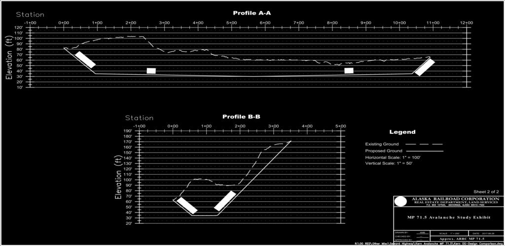
7 Material Site Discussion: In 2012, AS was enacted requiring a material site to be designated prior to execution of material sale contracts on state land. ARRC submitted material sale contract application ADL in fall 2017 and initiated the process for SCRO to designate material site ADL , the Kern Site. This decision is for the designation of a publicly available material site, at the request of ARRC. Designation of material site ADL would allow the 51-acre material site to be available for material sale contracts and limited material permit applications. The public or private sector may submit applications to extract material from the site. 200 cy or less may be requested with a limited material permit application and more than 200 cy may be requested with a material sale contract application. In accordance with AS (d) and (a), material may be sold at RRSP, FMV, public and charitable rate, or a negotiated rate. The 2018 RRSP for this geographic region is $3.25/cy for sand and gravel. The 2018 public and charitable rate is.50/cy beyond the first 5,000cy/year free. A negotiated rate would be subject to competition or demand within the material site. Material Sale Discussion: The proposed ARRC material sale contract anticipates excavating 300,000 cy of sand and gravel from this source in order to readjust the Kern slide avalanche track and runout zone, which moves snow and ice across the railroad tracks annually. This slide path is the second most problematic avalanche route mitigated by ARRC. ARRC intends on selling the removed material to the contractor operating the DOT&PF New Seward Highway Milepost Rehabilitation Project. The rehabilitation project aims to increase safety by straightening curves in high-accident locations, improving intersections, creating more passing opportunities, replacing eight bridges and rehabilitating a ninth bridge. To date, ARRC has not determined which contractor will develop the material site. Once a contractor has been secured, the contractor must submit, for review and approval, a site specific operating plan and site diagram. The contractor must comply with all requirements of the proposed material sale contract issued to ARRC. It is unknown if the contractor will request storing fuel on site, conducting maintenance on site, or storing equipment. ARRC describes gating access to the material site in their development plan, however, a gate is not authorized by this decision. Activities determined to be outside the scope of this decision may require a separate authorization from this office. Compliance with the terms of the contract may be assessed annually. Accounting and payment for material removed will be required by the end of each calendar year the contract is in effect. A completion report detailing events over the course of the contract term will be required upon expiration or termination of the material sale contract. Page 7 of 20
8 The requested extraction area overlays approximately six acres of ADL issued to DOT&PF. DOT&PF has a primary interest in 60,000 cy within the FUP area, however, DOT&PF has provided a non-objection to the requested material sale contract from ARRC. Designating material site ADL would allow DOT&PF to remove material under ADL 19467, allow ARRC to remove material under ADL , and allow for future material sale contracts within the material site boundaries. Development Plan: The Development & Reclamation Plan (DP) attached to this decision, dated January 2018, is under consideration by SCRO. Should the proposed material sale contract be granted, it is anticipated the DP may need to be updated throughout the life of the contract as activities are added or subtracted. The contractor for ARRC must submit and receive approval for a site plan detailing entry and exit points, overburden and topsoil placement, maintenance area locations, and a vegetation buffer along the rail line, prior to commencing operations. If the contractor requests installing a gate on site, the request is beyond the scope of this decision and may require a separate authorization from this office. All updates must be approved, in writing, by SCRO before any construction, deconstruction, or change in activity will be permitted. SCRO reserves the right to require additional agency review and/or public notice for changes which are deemed by SCRO to be beyond the scope of this decision. Hazardous Materials and Potential Contaminants: ARRC submitted an environmental risk questionnaire with the material sale contract application. There are no known environmental contaminants within the considered material site. The contractor may request storing independent fuel containers on site during operations. Independent fuel storage will require obtaining a LUP with SCRO. Adherence to standard material sale contract operating requirements will minimize the risk of leaks or spills. ARRC is expected to follow DEC s Best Management Practices for Gravel/Rock Aggregate Extraction Projects, and must adhere to all DEC environmental regulation, including but not limited to: checking for leaks, the use of duckponds during refueling, and secondary containment of the tanks. ARRC is expected to inspect material site ADL and familiarize itself with the condition and quality of the land. SCRO makes no representations and no warranties, express or implied, concerning the existence or absence of any hazardous substances, hazardous wastes, contaminants, or pollutants on the land here proposed for material site designation and material extraction. The State of Alaska does not assume liability for the removal of hazardous substances, hazardous wastes, contaminants, or pollutants, nor for the remediation of the site should such substances ever be identified. Bonding: In accordance with AS Powers and duties of the director, AS Reclamation financial assurance, 11 AAC Performance guaranty, 11 AAC Bonding required, Page 8 of 20
9 and 11 AAC Performance bond, ARRC will be required to submit a performance guaranty and reclamation bond for the material sale to incentivize performance of the conditions of the material sale contract and to provide a mechanism for DNR to ensure the purchaser shares in financial burden in the event of noncompliance for site cleanup, restoration, and any associated costs after termination or expiration of the material sale contract. The following bonds will be required. $48,750 Performance Bond: Performance guaranties provide a means to pay for corrective action if the buyer fails to comply with contract requirements. In accordance with 11 AAC (3), ARRC will be required to submit a performance guaranty at 5% of the total value of the sale. The sale is projected to be $975,000 based on 300,000 cy at $3.25/cy. $10,500 Reclamation Bond: Reclamation bonds are necessary to ensure the performance of the requirements of the approved reclamation plan, and provide a means to pay for corrective action if the buyer fails to comply with reclamation requirements. In accordance with AS , ARRC will be required to submit a reclamation bond at $750/acre of mined area. The material sale contract is anticipated to disturb 14 acres. Insurance: In accordance with 11 AAC Insurance, ARRC will be required to submit proof of liability and worker s compensation insurance to SCRO with the State of Alaska listed as a NAMED insured party. ARRC will be responsible for maintaining such insurance throughout the term of the material sale contract. Survey: In accordance with AS (e) a recordable Record of Survey must be completed, according to the requirements and standards of the DMLW Survey Section. The draft survey must be submitted for review to the Survey Section within one year of issuance of the survey instructions. The survey must depict the material site boundaries. Compensation: In accordance with AS (d)(1), Disposal of materials, and AS (b) Negotiated sales and personal use of materials, materials will be sold at RRSP periodically determined by the Commissioner for each type of material and for defined geographic regions, under procedure established by regulation; unless the applicant, at its own cost, elects to provide an appraisal, acceptable to the department, determining the fair market value of the materials to be sold. The 2018 RRSP schedule for negotiated material sale contracts within the subject region is $3.25/cy. ARRC must submit payment and accounting for material removed at the end of each calendar year. In accordance with 11 AAC , Negotiated Sales, the applicant must provide a deposit of 10% of the negotiated price. The department will retain the deposit to cover administrative costs incurred in offering the negotiated material sale, except that if the purchaser removes and pays for Page 9 of 20
10 at least 75 percent of the material volume covered by the contract, the deposit may be applied, in whole or in part, to the final payment that becomes due under the contract. $97,500 Initial Deposit: Initial Deposits provide a means to rectify accounts if the buyer fails to extract at least 75% of the authorized volume. In accordance with 11 AAC (d), ARRC will be required to submit an initial deposit at 10% of the total value of the sale. The sale is projected to be $975,000 based on 300,000 cy at $3.25/cy. Reclamation: In accordance with AS Reclamation, a mining operation shall be conducted in a manner that prevents unnecessary and undue degradation of land and water resources, and the mining operation shall be reclaimed as contemporaneously as practicable to leave the site in a stable condition. In order to assign a material sale contract, SCRO must have an approved reclamation plan or letter of intent. If executed, the material sale contract may include an approved reclamation plan. Once ARRC has sourced a contractor, a final reclamation plan will be provided to the State for review and approval. ARRC anticipates reclaiming developed mining areas as contemporaneously as possible once the material is deemed exhausted. Reclamation may re-contour the material site to blend with existing topography. Topsoil, surplus, and berm material will be used to backfill and top dress reclaimed areas. Surplus material will be redistributed and tracked. Reclaimed areas may be stabilized with approved seed mix in accordance with State specifications. Public Notice of the : Pursuant to AS Notice, this PD will be advertised for a 30-day public comment period, starting on April 9, Courtesy notices will be mailed or ed to neighboring property owners, permit/lease holders, and other interested parties on May 2, In addition, the post offices located near the proposed material site in Anchorage, Girdwood, Whittier, Hope, and Moose Pass will be requested to post the notice per AS (b)(3)(B). The notice also will be posted on the Alaska Online Public Notice System for 30 days at: Comments: This decision is subject to both public and agency comments, and all comments received by the comment deadline will be addressed in the FFD. Only those who comment and the applicant have the right to appeal the FFD. Written comments about this project must be received in this office no later than 5:00 PM on May 2, 2018 to be considered. To submit comments or project proposals, please choose one of the following methods: Page 10 of 20
11 Postal: Department of Natural Resources Division of Mining, Land and Water Southcentral Regional Office ATTN: Chandler Long 550 West 7 th Avenue, Suite 900C Anchorage, AK chandler.long@alaska.gov Fax: (907) Questions regarding the proposed material site or material sale can be directed to Chandler Long at (907) Additional copies of the PD and copies of a standard material sale contract may be obtained from her. If public comments result in significant changes to the PD, additional public notice will be given. Interested parties have the right to comment on the PD during the public notice period, after that, commenters who are aggrieved by the FFD will have the right to appeal it. In order to be eligible to appeal the FFD, a person must provide written comments during the PD comment period as per AS (i)-(m). A web address or PDF of the FFD will be sent to any person who comments on the PD, and will include an explanation of the appeal process. The State is prepared to accommodate individuals with disabilities by providing auxiliary aids, services, or specific modifications in order to participate in this review. Individuals who may need such assistance should contact the Department s Public Information Center in Anchorage between the hours of 10:00 am and 5:00 pm, Monday through Friday, by phone at (907) or by TDD at (907) Page 11 of 20
12

13 Attachment A Material Site Map Page 13 of 20

14 Attachment B Avalanche Map Page 14 of 20

15 Page 15 of 20
16 Attachment C Development Plan MP 71.4 KERN PIT - PROJECT DESCRIPTION/RECLAMATION PLAN (REV01) The information below is being submitted as an attachment to provide information requested in the following State of Alaska DNR Division of Mining, Land and Water Applications: Development Plan, Material Site Reclamation Plan or Letter of Intent/annual Reclamation Statement AS , Material Sale Application AS (a), Application Environmental Risk Questionnaire. Written Project Description/Narrative An estimated 0 to 300,000 cubic yards (CY) of material will be extracted annually from pit. The borrow source includes approximately 0 to 2 feet of overburden followed by gravel, sand, and other materials. The total pit volume is estimated to be 300,000 cubic yards. Hours of operation may vary depending on the project schedule, but because the site is not located in or near a commercial or residential area, work may take place 24 hours per day/seven days per week. Conventional bulldozers, track-mounted backhoes, rubber-tired loaders, and CY capacity dump trucks, and CY capacity side or belly dump trucks will be used in the operation of the mine. Loading and transporting materials via rail car is likely. Additional equipment, including a screener, crusher, office trailer, and portable toilets are likely to be used on site, but equipment and structures will be considered on a project specific basis. Each contractor will be responsible for detailing equipment and operations in their development plan, to be submitted for review prior to operation in the site. All activity will be kept within the area dedicated for a given project or operator and will be per approved permits obtained for the site. Individual development plan(s) will be prepared by each contractor(s) who use the site, based on project need and request for access and/or use made to the ARRC. If a modification of the site plan, development plan, or location of structures is required, a modified plan will be submitted DNR to determine if an amendment to the submitted documents will be required. No blasting is currently anticipated to occur on site. If blasting is necessary a separate plan will be submitted for the blasting operations. The working depth will typically be feet below original ground, as long as the depth of excavation remains a minimum of four feet above the ground water level. During active mining, working faces will be as natural angle of repose (approx. 1.5 horizontal: 1 vertical), to maximize amount of material extracted from a given cell. Upon cessation of mining all slopes will be graded to maximum steepness of 2 horizontal: 1 vertical for gravel, sand or cohesive soils and 0.5 horizontal: 1 vertical for rock faces. Material extracted will be leaving the site via haul truck or rail cars. Truck haul routes will occur on a project specific basis. A water truck and/or sweeper may be used for dust control as needed. Page 16 of 20
17 Legal Description Seward Meridian; T10N; R2E; Section 33, SW ¼, SE ¼ Terrain/Ground Cover Light brush overburden on shallow soils underlain by alluvium deposits. Access All traffic will ingress and egress the site via an access road 30feet in width adjacent to the ARRC tracks. This road is the original Seward Highway alignment and roadbed. All necessary approvals will be obtained prior to development of access drives from the proposed pit to the Seward Highway. Construction-related traffic may be expected to generate up to 40 trips maximum per hour, if multiple projects are concurrently operating at the peak of construction. When the site is not actively being mined a gate and lock will be used to prevent access by highway vehicles. Building and Other Structures The likely structures that may be onsite would be a small office trailer, and portable toilets. Should other structures determined to be necessary they will be considered on a project specific basis and an amendment to the permit will be submitted. Power Source Power at the site will be supplied by generators. Hazardous Substances There will be many different types of vehicles and equipment used onsite. The likely hazardous substances that will be at the site will be diesel fuel, gasoline and lubrication oils. Materials will be handled, stored and cleaned up per the current Alaska Department of Environmental Conservation Construction General Permit (AK-CGP). The authorized contractor to use the borrow site will be required to submit for review and approval to the ARRC and DNR an acceptable AK-CGP Plan. Storage tanks are proposed and will be located on lined secondary containment areas or have built in secondary containment. All stationary equipment (equipment that does not have a seat for driving) that contains petroleum products will use secondary containment such as double-walled tanks, lined secondary containment areas. Secondary containment structures will be bermed areas and lined with 20-mil liner and secured with either sandbags or stone. Vehicle fueling will take place on site. The contractor will set up equipment maintenance areas in order to prevent hazardous materials from becoming in contact with the ground. Construction equipment will be inspected daily for leaks. Any leaking equipment will be repaired before the equipment will be allowed to operate, and any spills will be cleaned up immediately. Construction equipment will not be stored, refueled, or serviced within 100 feet of any water body. If equipment is operating on, or adjacent to, a water body and has a petroleum leak that cannot be immediately repaired or controlled, it will be removed from service as soon as the leak is Page 17 of 20
18 discovered, until repairs can be made. Drip pans will be used as a method of secondary containment while performing maintenance on equipment. A spill kit will be present in the fueling area in case of a spill. Hazardous substances will have a Material Safety Data Sheets (MSDS) provided at the site. Water Supply No water supply is currently identified for use in conjunction with the pit. Water needed for dust control or crushing operations will either be hauled to the site by truck from approved locations or a Temporary Water Use Permit will be obtained for one of the water impoundments adjacent to the proposed pit. Parking Areas and Storage Areas Parking areas will be designated onsite and way from the active work. Any leaking vehicles will be handled as outlined in the Hazardous Substances section above. Storage areas will be at designated areas and all potentially hazardous substances will be in appropriate storage containers and properly labeled. Number of People Using the Site It is estimated there will be 1 to 3 people working at the site to load materials in trucks or railcars. The Supervisor/Staff ratio will be approximately 1 to 4 or greater. Maintenance and Operations The contractor will set up equipment maintenance areas in order to prevent hazardous materials from becoming in contact with the ground. Only minor maintenance will be performed (i.e. changing a belt, hose, servicing of equipment and etc..). Major maintenance that requires equipment to be nonoperational for more than 3 days will be hauled off the site for repairs. Dust control is a concern of high priority. All construction contracts involved in development of this pit site shall provide watering for dust control. The construction contractor will be required to obtain a temporary water use permit from the Alaska Department of Natural Resources (ADNR) for any water sources adjacent to the site. Also measures to reduce any by-product dirt transport from the borrow site by vehicle tires will be implemented prior to access to the highway and as described in the approved SWPPP (i.e. rock tracking pad, rumble strip and etc.) A Stormwater Pollution Prevention Plan (SWPPP) will be required for this project and is subject to the Alaska Pollution Discharge Elimination System (APDES) for construction projects disturbing greater than one acre of soil, therefore the project shall be subject to the Alaska Department of Environmental Conservation Construction General Permit (AK-CGP). The authorized contractor to use the borrow site will be required to submit for review and approval to the ARRC and DNR an acceptable SWPPP meeting all requirements of the AK-CGP. The contractor will be responsible for submitting all notifications, maintaining all records, and documenting compliance with the AK-GCP. Contractor will be responsible for installing, Page 18 of 20
19 maintaining, updating, and removing all Best Management Practices (BMPs) in accordance with detailed SWPPP documents. Closure/Reclamation Plan I. Schedule The schedule for interim reclamation is project specific and dependent on the contractor schedule. Interim reclamation plans will be required of each contractor authorized to use the borrow site and will be submitted to the ARRC & DNR for review and acceptance. Reclamation of the proposed mine will generally occur according to the following schedule: 1. Reclamation will take place as developed areas of the mine are closed, with no further plan for material extraction. 2. Reclamation area will be reclaimed, as necessary. 3. Topsoil, surplus, and berm material will be used to backfill and top dress reclamation areas. Surplus material will be redistributed and tracked. 4. Reclamation area will be stabilized as needed with approved seed mix applied in accordance with state specifications. II. Temporary Stabilization In accordance with the Alaska Pollution Discharge Elimination System Construction General Permit, temporary stabilization will be initiated as soon as practicable in areas of the site where construction activities have temporarily or permanently ceased, but no later than 14 days after the construction activities have temporarily or permanently ceased. Temporary stabilization is not needed if construction activities are scheduled to resume within 14 days. In the event that temporary stabilization is precluded by snow cover or frozen ground, the temporary stabilization measures will be implemented as soon as practicable. III. Stabilization Initially, overburden stripped will be and stockpiled within the boundaries of pit boundaries. The stockpiles will be graded to a maximum slope of 2H:1V, tracked walked and seeded to make them stable until they are spread back into the pit for final reclamation on the floor and cut slope as cover material to promote and support vegetation growth. Temporary access roads will be reclaimed by re-contouring the access road area to blend into the existing topography, stabilized and revegetated described in this reclamation plan. IV. Final Grading Cut slopes may be no steeper than 2H:1V to provide acceptable public safety, stability, and erosion protection, but variability in the grade averaging to approximately 3H.1V is preferred. Stabilization must be conducted in accordance with Best Management Practices called out in the SWPPP. V. Revegetation The objective of the revegetation procedures will be to re-establish natural vegetation when the pit or a portion of the pit has been mined to final grades and elevations, without introducing nonnative species. Page 19 of 20
20 This will be accomplished by first using waste material (silt and sand) to flatten cut slopes and grade the pit floor. Next, stockpiled overburden and organic material will be spread over the cut slopes and the pit floor to provide growing medium for native plants to re-establish themselves. The overburden and organic material will be spread in a layer not less than 4 inches thick or more than 2 feet in thickness, except such material may be placed in greater thickness as required to flatten cut slopes out to no steeper than 2H:1V. The spread overburden and organic material shall be tracked, bladed, or otherwise manipulated so that no tree trunks, branches, roots, or stumps protrude more than 4 inches above the finished ground surface. To assist in the re-establishment of native species, and to help to control erosion during the reestablishment period, the spread of overburden material will receive an application of temporary grass seed mixture and fertilizer. The seeding requirements will be as described in the Alaska Department of Transportation and Public Facilities; Standard Specifications for Highway Construction; 2015 Edition; Section 618 Seeding & Section 724 Seed. Page 20 of 20
PRELIMINARY DECISION
 STATE OF ALASKA DEPARTMENT OF NATURAL RESOURCES DIVISION OF MINING, LAND AND WATER PRELIMINARY DECISION ADL 227664 Trinity Point communications site ADL 227675 Pigot Bay communications site Alaska Wireless
PRELIMINARY DECISION
 STATE OF ALASKA DEPARTMENT OF NATURAL RESOURCES DIVISION OF MINING, LAND AND WATER PRELIMINARY DECISION Kodiak Island Borough Application for Lease AS 38.05.810(a) This (PD) is the initial determination
PRELIMINARY DECISION
 STATE OF ALASKA DEPARTMENT OF NATURAL RESOURCES DIVISION OF MINING, LAND AND WATER PRELIMINARY DECISION Alaska Bush Adventures, LLC Application for Lease AS 38.05.070(b) Negotiated This is the initial
PRELIMINARY DECISION
 STATE OF ALASKA DEPARTMENT OF NATURAL RESOURCES DIVISION OF MINING, LAND AND WATER PRELIMINARY DECISION ADL 231168 AK Mountain & Wilderness Huts Association Manitoba Cabin Application for Lease AS 38.05.810(b)-(d)
State of Alaska, Department of Natural Resources Division of Mining, Land & Water South Central Region Office
 State of Alaska, Department of Natural Resources Division of Mining, Land & Water South Central Region Office Proposed Site-Specific Area Plan ADL 226153, City of Mountain Village Introduction: City of
ATTACHMENT B INTERAGENCY LAND MANAGEMENT ASSIGNMENT ADL SPECIAL STIPULATIONS
 1. Term of Assignment ATTACHMENT B INTERAGENCY LAND MANAGEMENT ASSIGNMENT ADL 108284 SPECIAL STIPULATIONS This Assignment is issued for a 25-year term unless canceled, in whole or in part, sixty days after
RENEWAL DECISION Usibelli Coal Mine, Inc. ADL Surface Lease AS (e)
") STATE OF ALASKA DEPARTMENT OF NATURAL RESOURCES DIVISION OF MINING, LAND AND WATER RENEWAL DECISION Usibelli Coal Mine, Inc. Surface Lease AS 38.05.070(e) : Per AS 38.05.070(e), the Department of Natural
STATE OF ALASKA DEPARTMENT OF NATURAL RESOURCES DIVISION OF MINING, LAND AND WATER RENEWAL DECISION Usibelli Coal Mine, Inc. Surface Lease AS 38.05.070(e) : Per AS 38.05.070(e), the Department of Natural
PRELIMINARY DECISION. For an Interagency Land Management Assignment ADL at. to the Department of Natural Resources, Division of Forestry
 PRELIMINARY DECISION For an Interagency Land Management Assignment ADL 108262 at to the Department of Natural Resources, Division of Forestry I. Requested ILMA February 25, 2016 The applicant, the Department
GUIDELINES FOR LEASING UNDER SLO RULE 5
 New Mexico State Land Office Oil, Gas, and Minerals Division Patrick H. Lyons, Commissioner of Public Lands GUIDELINES FOR LEASING UNDER SLO RULE 5 SECTION I - INTRODUCTION AND PURPOSE We are pleased to
ALASKA DEPARTMENT OF NATURAL RESOURCES DIVISION OF MINING, LAND AND WATER MUNICIPAL ENTITLEMENT
 I. PROPOSED ACTION ALASKA DEPARTMENT OF NATURAL RESOURCES DIVISION OF MINING, LAND AND WATER MUNICIPAL ENTITLEMENT PRELIMINARY DECISION CONVEYANCE OF TIDE AND SUBMERGED LAND UNDER AS 38.05.825 MATANUSKA-SUSITNA
Appendix F - Earth Materials Extraction, Processing and Site Reclamation
 Appendix F - Earth Materials Extraction, Processing and Site Reclamation Intent It is the purpose of this Article to establish regulations and standards for surface mining operations and to provide for
SANILAC COUNTY ROAD COMMISSION ROAD POLICIES. A. Drainage, Base and Grade Construction (NON BITUMINOUS)
") I. LOCAL ROADS SANILAC COUNTY ROAD COMMISSION A. Drainage, Base and Grade Construction (NON BITUMINOUS) 1. Cost Sharing: Sanilac County Road Commission Share 17% Township Share 83% 2. A Notice of Construction
I. LOCAL ROADS SANILAC COUNTY ROAD COMMISSION A. Drainage, Base and Grade Construction (NON BITUMINOUS) 1. Cost Sharing: Sanilac County Road Commission Share 17% Township Share 83% 2. A Notice of Construction
Fee $1, Property information and location (All lines applicable to this site must be filled in)
") Gravel Operations Conditional use permit Application Fee $1,000.00 Property information and location (All lines applicable to this site must be filled in) Section Township Range Parcel # Lot # You MUST
Gravel Operations Conditional use permit Application Fee $1,000.00 Property information and location (All lines applicable to this site must be filled in) Section Township Range Parcel # Lot # You MUST
Extractive Industrial Regulatory Ordinance No. 21 revised Dec. 28, 2010 EXTRACTIVE INDUSTRIAL REGULATORY ORDINANCE TYRONE TOWNSHIP, MICHIGAN
 40.101 Sec. 1. TITLE. EXTRACTIVE INDUSTRIAL REGULATORY ORDINANCE TYRONE TOWNSHIP, MICHIGAN ord. no. 21 eff. May 12, 1979, revised Dec. 28, 2010 This ordinance shall be known and cited as the Tyrone Township
STATE OF ALASKA DEPARTMENT OF NATURAL RESOURCES DIVISION OF MINING, LAND, AND WATER
 STATE OF ALASKA DEPARTMENT OF NATURAL RESOURCES DIVISION OF MINING, LAND, AND WATER PRELIMINARY DECISION West Twin Lake Subdivision Remaining Parcels ADLs 420628 420633 Proposed Land Offering in the Unorganized
STATE OF ALASKA DEPARTMENT OF NATURAL RESOURCES DIVISION OF MINING, LAND AND WATER SOUTHCENTRAL REGION
 STATE OF ALASKA DEPARTMENT OF NATURAL RESOURCES DIVISION OF MINING, LAND AND WATER SOUTHCENTRAL REGION Regional Manager s Decision Furie Operating Alaska, LLC ADL 231758 Private Non-Exclusive Easement
CHAPTER SURFACE MINING AND LAND RECLAMATION
 CHAPTER 19.68 SURFACE MINING AND LAND RECLAMATION Section Page 19.68.010 Purpose and Intent... IV-71 19.68.020 Mineral Resource Protection... IV-72 19.68.030 Definitions... IV-72 19.68.040 Incorporation
Bids Due and Opening Wednesday, December 7, 2016 Time 2:00 p.m.
 INVITATION TO BID Bid Package Montrose County 2017 Gravel Crushing Services Bids Due and Opening Wednesday, December 7, 2016 Time 2:00 p.m. Location Montrose County Road and Bridge Office 949 N. 2 nd Street
STATE OF ALASKA DEPARTMENT OF NATURAL RESOURCES STATE PIPELINE COORDINATOR S OFFICE ANALYSIS OF AMENDMENT APPLICATION AND PROPOSED DECISION
 ADL STATE OF ALASKA DEPARTMENT OF NATRAL RESORCES STATE PIPELINE COORDINATOR S OFFICE ANALYSIS OF AMENDMENT APPLICATION AND PROPOSED DECISION TRANS-ALASKA PIPELINE RIGHT-OF-WAY LEASE AMENDMENT - CATHODIC
STATE OF ALASKA DEPARTMENT OF NATURAL RESOURCES DIVISION OF MINING, LAND, AND WATER FINAL FINDING AND DECISION
 STATE OF ALASKA DEPARTMENT OF NATURAL RESOURCES DIVISION OF MINING, LAND, AND WATER FINAL FINDING AND DECISION of a Land Offering in the Fairbanks North Star Borough DMVA Tracts, ADL 420894 Public Access
RESOLUTION NO ORDINANCE NO. 02-1
 RESOLUTION NO. 020828-1 ORDINANCE NO. 02-1 CHISAGO COUNTY, MINNESOTA AN ORDINANCE AMENDING SECTION 7.27 OF THE CHISAGO COUNTY ZONING ORDINANCE CONCERNING MINERAL EXTRACTION THE BOARD OF COUNTY COMMISSIONERS
Instructions to the Applicant
 CONDITIONAL USE PERMIT APPLICATION Lake of the Woods County Land and Water Planning Office 206 8 th Avenue Southeast, Suite #290 Baudette MN 56623-2867 www.co.lake-of-the-woods.mn.us Phone: (218) 634-1945
INSTRUCTIONS AND INFORMATION FOR LAND LEASE APPLICATION
 TED STEVENS ANCHORAGE INTERNATIONAL AIRPORT Department of Transportation & Public Facilities Airport Leasing & Property Management PO Box 196960, Anchorage AK 99519-6960 Phone: 907-266-2420 Fax: 907-266-2458
Construction & Earthwork Request Form (CERF)
") ShoreLand Traditions Construction & Earthwork Request Form (CERF) SECTION 1 SECTION 2 SECTION 3 Definitions and Points to Remember Requirements and Process Site Sketch Requirements and Sample If you have
ShoreLand Traditions Construction & Earthwork Request Form (CERF) SECTION 1 SECTION 2 SECTION 3 Definitions and Points to Remember Requirements and Process Site Sketch Requirements and Sample If you have
COMPETITIVE LAND LEASE FINAL FINDING AND DECISION AS ADL Ultimate Arctic Adventures
 COMPETITIVE LAND LEASE FINAL FINDING AND DECISION AS 38.05.070 ADL 417979 Ultimate Arctic Adventures This final finding and decision (FFD) is intended to complement and update the preliminary finding and
State of Alaska Department of Natural Resources Division of Mining, Land & Water Northern Region Office
 State of Alaska Department of Natural Resources Division of Mining, Land & Water Northern Region Office Preliminary Finding and Decision ADL 419913 City of Delta Junction Proposed Public & Charitable Conveyance
SOIL TRANSPORT, DEPOSIT, AND REMOVAL REGULATION (2011)
") Community Governance Act SOIL TRANSPORT, DEPOSIT, AND REMOVAL REGULATION (2011) Date Enacted: 17 August 2011 Order Number: O.041-2011 Last Amended: 8 May 2015 This version of the Regulation is not the
Community Governance Act SOIL TRANSPORT, DEPOSIT, AND REMOVAL REGULATION (2011) Date Enacted: 17 August 2011 Order Number: O.041-2011 Last Amended: 8 May 2015 This version of the Regulation is not the
Zoning Permit Application
 Zoning Permit Application FOR OFFICE USE ONLY Date Payment Form Amount Receipt # Clerk Required Submittals (circle if presented with application) Incomplete applications may be returned and/or delayed.
1. The Deed of Conservation Easement General Definitions, Conditions, Prohibitions and Easement Committee Definitions for Bluestone Mining.
 Guidelines for Commercial Bluestone Mining on Watershed Agricultural Council (WAC) Conservation Easements The following guidelines are established by WAC to create standards for the development of Commercial
Storm Water Management Facility Restrictive Covenant Language
 Instructions: Please include the following language, as a section outlining maintenance responsibilities for the storm water management facilities, in the Restrictive Covenants of the Homeowners Association
HOUSE BILL lr3434 A BILL ENTITLED. Department of the Environment Licensing and Permitting Prohibited for Mountaintop Removal Coal Mining
 M HOUSE BILL lr By: Delegate Hucker Introduced and read first time: March, 00 Assigned to: Rules and Executive Nominations A BILL ENTITLED 0 0 AN ACT concerning Department of the Environment Licensing
CHAPTER 14: DRIVEWAYS, TOWN HIGHWAYS, AND PRIVATE ROADS
 CHAPTER 14: DRIVEWAYS, TOWN HIGHWAYS, AND PRIVATE ROADS TABLE OF CONTENTS CHAPTER 14: PRIVATE DRIVEWAYS, TOWN HIGHWAYS AND PRIVATE ROADS 14-1 14.0100 AUTHORITY... 14-1 14.0200 TITLE... 14-1 14.0300 REGULATION
WASHINGTON COUNTY DEVELOPMENT CODE
 WASHINGTON COUNTY DEVELOPMENT CODE Pursuant to MSA Ch 394, Washington County has adopted official controls for the purposes of regulating the physical development of land in the unincorporated areas of
The Board of Supervisors of the County of Sacramento, State of California, SECTION 1. Chapter of Title 20 of the Sacramento County Code is
 SCC NO. AN ORDINANCE REPEALING CHAPTER 20.04 OF TITLE 20 OF THE SACRAMENTO COUNTY CODE, AND ADDING A NEW CHAPTER 20.04 TO TITLE 20 OF THE SACRAMENTO COUNTY CODE RELATING TO SURFACE MINING AND RECLAMATION
Ordinance #68. Highlighted items in bold and underline font to be added. Highlighted items in strikethrough font to be removed.
 Ordinance #68 AN ORDINANCE ENTITLED, AN ORDINANCE AMENDING ARTICLE II DEFINITIONS AND CHAPTER 5.22 (WIND ENERGY SYSTEMS) OF ARTICLE V GENERAL REQUIREMENTS OF ORDINANCE 65 AN ORDINANCE AMENDING ORDINANCE
ARTICLE 7. SPECIFIC USE STANDARDS
 ARTICLE 7. SPECIFIC USE STANDARDS Section 7.1 Applicability The following standards apply to specified uses in all zoning districts in which such uses are allowed. Section 7.2 Accessory Apartments (A)
Town of Lisbon, Maine SUBDIVISION REVIEW APPLICATION
 Date Received: Fee Paid (amount): Applicant: Town of Lisbon, Maine SUBDIVISION REVIEW APPLICATION Subdivision Name/Title: This application must be received at the Town Office by close of business on the
Clear Creek County Zoning Regulations: Section 7
 SECTION 7. MINING DISTRICTS - GENERAL PROVISIONS The regulations in this Section apply to all Mining Districts. 701. PURPOSE These Districts are established for the purpose of providing for mining, prospecting,
CHAPTER 30 BUILDING CODE
 CHAPTER 30 BUILDING CODE 30.01 SOUTHEASTERN WISCONSIN CODE ADOPTED Pursuant to the authority of Section 66.035 of the Wisconsin Statutes, the Southeastern Wisconsin Uniform Building Code in the form prepared
SPECIAL USE PERMIT APPLICATION FOR NATURAL DEPOSITS, EXTRACTION AND PROCESSING; CONCRETE BATCH PLANTS; HOT MIX (ROAD/ASPHALT) PLANTS
 PLANTS") SPECIAL USE PERMIT APPLICATION FOR NATURAL DEPOSITS, EXTRACTION AND PROCESSING; CONCRETE BATCH PLANTS; HOT MIX (ROAD/ASPHALT) PLANTS PLEASE READ NOTE AND SIGN BELOW: THE SUBMITTED APPLICATION PACKAGE REQUIRES
SPECIAL USE PERMIT APPLICATION FOR NATURAL DEPOSITS, EXTRACTION AND PROCESSING; CONCRETE BATCH PLANTS; HOT MIX (ROAD/ASPHALT) PLANTS PLEASE READ NOTE AND SIGN BELOW: THE SUBMITTED APPLICATION PACKAGE REQUIRES
MINOR BOUNDARY LINE ADJUSTMENT PROCESS GUIDE
 MINOR BOUNDARY LINE ADJUSTMENT PROCESS GUIDE Clear Creek County Planning Department P.O. Box 2000 Georgetown, Colorado 80444 (303) 679-2436 phone (303) 569-1103 fax 1 PURPOSE To establish criteria and
LOCAL LAW NO. 2, 1987 A LOCAL LAW REGULATING EXCAVATION AND TOPSOIL REMOVAL WITHIN THE TOWN OF CAMBRIA
 LOCAL LAW NO. 2, 1987 A LOCAL LAW REGULATING EXCAVATION AND TOPSOIL REMOVAL WITHIN THE TOWN OF CAMBRIA PASSED BY TOWN OF CAMBRIA TOWN BOARD SEPTEMBER 3, 1987 Be it enacted by the Town Board of the Town
Senate Bill 644 Ordered by the Senate July 4 Including Senate Amendments dated June 29 and July 4
 th OREGON LEGISLATIVE ASSEMBLY--0 Regular Session Sponsored by Senator GIROD B-Engrossed Senate Bill Ordered by the Senate July Including Senate Amendments dated June and July SUMMARY The following summary
LEGISLATIVE COUNSEL'S DIGEST
 Senate Bill No. 209 CHAPTER 8 An act to amend Sections 607, 2207, and 2714 of, and to add Sections 2006.5, 2770.1, and 2773.1.5 to, the Public Resources Code, relating to surface mining. [ Approved by
[Type e-signature] This document has been electronically signed.
![[Type e-signature] This document has been electronically signed.](/thumbs/92/110470274.jpg "[Type e-signature] This document has been electronically signed.") Notice of Coverage - SW State Disposal System (SDS) Permit GCB000000 General Permit Authorization to Dispose of Uncontaminated Concrete Permittee (Owner): Various City or Township: Various County: Various
Notice of Coverage - SW State Disposal System (SDS) Permit GCB000000 General Permit Authorization to Dispose of Uncontaminated Concrete Permittee (Owner): Various City or Township: Various County: Various
APPLICATION. Telephone Fax Address. Telephone Fax Address FOR MARTIN COUNTY USE ONLY
 APPLICATION PRESERVE AREA MANAGEMENT PLAN/ ABBREVIATED PRESERVE AREA MANAGEMENT PLAN Growth Management Department Environmental Division PART 1: Applicant Information A. Land Owner(s) Name Title and Company
LOCATION AND DESIGN DIVISION
 VIRGINIA DEPARTMENT OF TRANSPORTATION LOCATION AND DESIGN DIVISION INSTRUCTIONAL AND INFORMATIONAL MEMORANDUM GENERAL SUBJECT: Virginia Stormwater Management Program SPECIFIC SUBJECT: Virginia Pollutant
CONDITIONAL USE PERMIT APPLICATION FOR AN EXCAVATION/BORROW PIT
 CONDITIONAL USE PERMIT APPLICATION FOR AN EXCAVATION/BORROW PIT CHESAPEAKE PLANNING DEPARTMENT APPLICATION NUMBER: (Ased by Chesapeake Planning Department) GENERAL INFORMATION Project 1. Applicant(s) Intending
CAPE COD COMMISSION MAIN STREET P.O. Box 226 BARNSTABLE, MA FAX:
 CAPE COD COMMISSION 3225 MAIN STREET P.O. Box 226 BARNSTABLE, MA 02630 508 362 3828 FAX: 508 362 3136 1 DATE: TO: FROM: RE: APPLICANT: December 5, 1991 Mr. Preston A. Landers, P.A. Landers, Inc. P.O. Box
APPLICATION PROCEDURE
 ANTRIM PLANNING BOARD P. O. Box 517 Antrim, New Hampshire 03440 Phone: 603-588-6785 FAX: 603-588-2969 APPLICATION FORM AND CHECKLIST FOR EARTH EXCAVATION AND RECLAMATION File # Date Received By APPLICATION
Chapter 136. SOIL EROSION
 1 of 8 12/19/2011 4:17 PM Township of Andover, NJ Monday, December 19, 2011 Chapter 136. SOIL EROSION [HISTORY: Adopted by the Township Committee of the Township of Andover by Ord. No. 77-11 (Ch. XVII
THIS DECLARATION OF RESTRICTIVE COVENANTS is made this day of, 20, by ("Covenantor"). RECITALS
. RECITALS") Model for Use with Permits Without Mitigation Plans STATE OF COUNTY OF DECLARATION OF RESTRICTIVE COVENANTS THIS DECLARATION OF RESTRICTIVE COVENANTS is made this day of, 20, by ("Covenantor"). RECITALS
Model for Use with Permits Without Mitigation Plans STATE OF COUNTY OF DECLARATION OF RESTRICTIVE COVENANTS THIS DECLARATION OF RESTRICTIVE COVENANTS is made this day of, 20, by ("Covenantor"). RECITALS
APPENDIX D - REAL ESTATE
 APPENDIX D - REAL ESTATE 1. Purpose Real Estate Plan For Feasibility Study For Lake Lou Yaeger Section 206 Aquatic Ecosystem Restoration Continuing Authorities Project Feasibility Study This report is
STATE OF ALASKA DEPARTMENT OF NATURAL RESOURCES DIVISION OF MINING, LAND, AND WATER PRELIMINARY DECISION
 STATE OF ALASKA DEPARTMENT OF NATURAL RESOURCES DIVISION OF MINING, LAND, AND WATER PRELIMINARY DECISION Proposed Land Offering in the Matanuska-Susitna Borough AS 38.05.035 (e), AS 38.05.045 and its RELATED
TOWNSHIP OF WANTAGE ORDINANCE #
 TOWNSHIP OF WANTAGE ORDINANCE #2018-10 AN ORDINANCE OF THE TOWNSHIP OF WANTAGE, COUNTY OF SUSSEX, STATE OF NEW JERSEY, AMENDING CHAPTER 23 OF THE TOWNSHIP OF WANTAGE REVISED GENERAL ORDINANCES ENTITLED
PRELIMINARY PLAT CHECK LIST
 PRELIMINARY PLAT CHECK LIST Name of Proposed Subdivision: The following items must be included with the initial submittal of a Preliminary Plat: Application, filled out completely Project Narrative Pre-application
ARTICLE (SM) SURFACE MINING ZONE. 2. To allow the development and use of mineral and aggregate resources;
 SURFACE MINING ZONE. 2. To allow the development and use of mineral and aggregate resources;") ARTICLE 15.00 (SM) SURFACE MINING ZONE 15.01 PURPOSE The purposes of the Surface Mining Zone are: 1. To implement the policies of the Comprehensive Plan; 2. To allow the development and use of mineral
ARTICLE 15.00 (SM) SURFACE MINING ZONE 15.01 PURPOSE The purposes of the Surface Mining Zone are: 1. To implement the policies of the Comprehensive Plan; 2. To allow the development and use of mineral
DOUGLAS COUNTY DEPARTMENT OF HEARING EXAMINER th Street NW East Wenatchee, WAS BEFORE THE DOUGLAS COUNTY HEARING EXAMINER
 DOUGLAS COUNTY DEPARTMENT OF HEARING EXAMINER 140 19 th Street NW East Wenatchee, WAS 98802-4109 BEFORE THE DOUGLAS COUNTY HEARING EXAMINER IN THE MATTER OF ) FINDINGS OF FACT, ) CONCLUSIONS OF LAW, )
GUIDELINES FOR SALT WATER DISPOSAL EASEMENTS
 New Mexico State Land Office Right of Way and Water Resources Bureau Patrick H. Lyons, Commissioner of Public Lands GUIDELINES FOR SALT WATER DISPOSAL EASEMENTS SECTION I. INTRODUCTION AND PURPOSE The
A Minor Land Excavation Operating Permit is used to:
 CHAPTER 400. SECTION 404. PERMIT TYPES AND APPLICATIONS OPERATING PERMITS 404.1. Minor Land Excavation A. Intent and Purpose The intent and purpose of this section is to protect the public health, safety,
DRIVEWAY/ACCESS PERMIT APPLICATION INSTRUCTIONS Douglas County Trunk Highways
 DRIVEWAY/ACCESS PERMIT APPLICATION INSTRUCTIONS Douglas County Trunk Highways It is the policy of the Douglas County Highway Department that permission must be obtained to construct or maintain a driveway
Appendix B Real Estate Plan
 Appendix B Real Estate Plan B-1 REAL ESTATE PLAN Prepared for U.S. Army Corps of Engineers Southwestern Division Little Rock District As of May 1, 2013 Prepared by Ronald Bridges Real Estate Division ANY
MINNESOTA POLLUTION CONTROL AGENCY GENERAL PERMIT FOR DISPOSAL OF UNCOMTAMINATED CONCRETE
 MINNESOTA POLLUTION CONTROL AGENCY GENERAL PERMIT FOR DISPOSAL OF UNCOMTAMINATED CONCRETE ISSUANCE DATE: December 23, 2013 EXPIRATION DATE: December 23. 2018 This permit is a General Permit issued pursuant
TOWN OF WARNER, NEW HAMPSHIRE EARTH EXCAVATION REGULATIONS
 TOWN OF WARNER, NEW HAMPSHIRE EARTH EXCAVATION REGULATIONS Adopted: November 8, 2006 Table of Contents I AUTHORITY 1 II PURPOSE AND SCOPE 1 III DEFINITIONS 1 IV PROJECTS REQUIRING A PERMIT 3 V PROJECTS
STAFF REPORT FOR VESTED RIGHTS DETERMINATION AND #REC AMENDED RECLAMATION PLAN APRIL 22, 2014 PAGE BOS-1
 AMENDED RECLAMATION PLAN APRIL 22, 2014 PAGE BOS-1 OWNER/APPLICANT: AGENT: REQUEST: ENVIRONMENTAL DETERMINATION: RECOMMENDATION: LOCATION: TOTAL ACREAGE: GENERAL PLAN: FRANK DUTRA NORTHERN AGGREGATES,
APPLICATION PROCEDURE
 ANTRIM PLANNING BOARD P. O. Box 517 Antrim, New Hampshire 03440 Phone: 603-588-6785 FAX: 603-588-2969 APPLICATION FORM AND CHECKLIST FOR MINOR OR MAJOR SITE PLAN REVIEW File Date Received By APPLICATION
This EFU District is provided to meet the Oregon statutory and administrative rule requirements.
 ARTICLE III: LAND USE DISTRICTS III-121 340 EXCLUSIVE FARM USE DISTRICT (EFU) 340-1 Intent and Purpose The intent of the Exclusive Farm Use District is to preserve and maintain commercial agricultural
Initial Subdivision Applications Shall Include the Following:
 Initial Subdivision Applications Shall Include the Following: 1) Subdivision Application Form: completely filled out (12 copies) 2) Plat: The Plat must adhere to the requirements set forth in the Town
By-Law of The Corporation of the City of Oshawa
 By-Law 85-2006 of The Corporation of the City of Oshawa being a by-law to control the dumping of fill, removal of topsoil and alteration of grades. WHEREAS s. 142 of the Municipal Act, 2001, S.O. 2001,
WALWORTH COUNTY RESOURCE MANAGEMENT/CONSERVATION (262) Land Disturbance/Erosion Control Fay Amerson, Urban Program Specialist
 Land Disturbance/Erosion Control Fay Amerson, Urban Program Specialist") WALWORTH COUNTY LAND USE AND RESOURCE MANAGEMENT SHORELAND ZONING Michael Cotter, Director Lou Olson, Deputy Director WALWORTH COUNTY LAND USE Ph # (262) 741-4972 Fax (262) 741-4974 Deb Grube, Sr. Zoning
WALWORTH COUNTY LAND USE AND RESOURCE MANAGEMENT SHORELAND ZONING Michael Cotter, Director Lou Olson, Deputy Director WALWORTH COUNTY LAND USE Ph # (262) 741-4972 Fax (262) 741-4974 Deb Grube, Sr. Zoning
New Cingular Wireless Telecommunication Tower at County Road 48, Milner Conditional Use Permit
 New Cingular Wireless Telecommunication Tower at 39415 County Road 48, Milner ACTIVITY #: Conditional Use Permit PP2012-023 HEARING DATES: Planning Commission (PC): August 16, 2012 at 6:00pm PETITIONER:
SECTION 4: PRELIMINARY PLAT
 SECTION 4: PRELIMINARY PLAT After the completion of the sketch plan process, if submitted, the owner or developer shall file with the City an application for preliminary plat. The preliminary plat stage
Moore Township Planning Commission 2491 Community Drive, Bath, Pennsylvania Telephone: FAX: Rev:12/23/2013
 2491 Community Drive, Bath, Pennsylvania Telephone: 610-759-9449 FAX: 610-759-9448 Rev:12/23/2013 APPLICATION FORM FOR A SITE PLAN PER MOORE TOWNSHIP ZONING ORDINANCE SECTION 200-58.1 NORTHAMPTON COUNTY,
{{t:t;r:n;o:"signer 2";l:"Date";}}
 Application/File # Date Application Rec'd: Oct 13 2017 Fee Collected $ (for office use only) CONDITIONAL USE APPLICATION MOTLEY MN Site Address (E-911#): 164 MORRISON STREET WEST 410095000 Lake/River Name:
Article III. Erosion and Sedimentation Control
 Article III. Erosion and Sedimentation Control Section 9.6 Erosion and Sedimentation Control Plan Requirements Section 9.6.1 Plan Submission A plan shall be prepared for all land-disturbing activities
Shoreline Use Permits
 The primary objective of the Corps of Engineers in the management of the Table Rock Lake shoreline is to insure the general public full recreational enjoyment and fish and wildlife benefits on public lands
CITY OF PRINCE GEORGE SOIL REMOVAL AND DEPOSIT BYLAW NO. 8772, A Bylaw of the City of Prince George to regulate the removal and deposit of soil.
 CITY OF PRINCE GEORGE SOIL REMOVAL AND DEPOSIT BYLAW NO. 8772, 2017 A Bylaw of the City of Prince George to regulate the removal and deposit of soil. TABLE OF CONTENTS 1. TITLE 2. REPEAL 3. APPLICATION
The intent of the Exclusive Farm Use District is to preserve and maintain commercial agricultural land within the County.
 III 121 340 EXCLUSIVE FARM USE DISTRICT (EFU) 340 1 Intent and Purpose The intent of the Exclusive Farm Use District is to preserve and maintain commercial agricultural land within the County. The purpose
KASSON TOWNSHIP PRIVATE ACCESS ROAD ORDINANCE ORDINANCE NO (EFFECTIVE: MAY 12, 2007)
") KASSON TOWNSHIP PRIVATE ACCESS ROAD ORDINANCE ORDINANCE NO. 2007-01 (EFFECTIVE: MAY 12, 2007) An ordinance providing for the standards and specifications incident to the development of Private Motor Vehicle
KASSON TOWNSHIP PRIVATE ACCESS ROAD ORDINANCE ORDINANCE NO. 2007-01 (EFFECTIVE: MAY 12, 2007) An ordinance providing for the standards and specifications incident to the development of Private Motor Vehicle
LABEL PLEASE NOTE: ALL APPLICATIONS AND SITE PLANS MUST BE COMPLETED IN BLACK OR BLUE INK ONLY Intake by:
 STAFF USE ONLY Thurston County Resource Stewardship 2000 Lakeridge Dr. S.W. Olympia, WA 98502 (360)786-5490 / (360)754-2939 (Fax) TDD Line (360) 754-2933 Email: permit@co.thurston.wa.us Supplemental Application
GENERAL CONDITIONS APPLYING TO SUBDIVISIONS APPROVED BY THE PLANNING BOARD OF THE TOWN OF BETHLEHEM ALBANY COUNTY - NEW YORK
 GENERAL CONDITIONS APPLYING TO SUBDIVISIONS APPROVED BY THE PLANNING BOARD OF THE TOWN OF BETHLEHEM ALBANY COUNTY - NEW YORK February 1976 Revised September 1978 GENERAL CONDITIONS PERTAINING TO SUBDIVISION
Division Development Impact Review.
 Division 51-4.800. Development Impact Review. SEC. 51-4.801. PURPOSE. The general objectives of this division are to promote and protect the health, safety, and general welfare of the public through the
MAJOR BOUNDARY LINE ADJUSTMENT PROCESS GUIDE
 MAJOR BOUNDARY LINE ADJUSTMENT PROCESS GUIDE Clear Creek County Planning Department P.O. Box 2000 Georgetown, Colorado 80444 (303) 679-2436 - phone (303) 569-1103 - fax PURPOSE To establish criteria and
Appendix H: Real Estate Plan
 APPENDIX H Spring Creek North Ecosystem Restoration Feasibility Study Appendix H: Real Estate Plan New York District U.S. Army Corps of Engineers October 2016 Revised: 13 April 2017 Spring Creek North
Chapter 210 CONDITIONAL USES
 Chapter 210 CONDITIONAL USES 210.01 Purpose 210.02 Authorization 210.03 Process Type 210.04 Determination of Major or Minor Conditional Use Review 210.05 Approval Criteria 210.06 Conditions of Approval
Town of Middleborough Conservation Commission 2014 Policy
 Approved February 20, 2014 Town of Middleborough Conservation Commission 2014 Policy The Wetland Protection Act under M.G.L. c. 131, sec. 40 and regulations 310 CMR 10.02(1)(a-f) & 310 CMR 10.02 (2)(a)
STATE OF ALASKA DEPARTMENT OF NATURAL RESOURCES DIVISION OF MINING, LAND, AND WATER. PRELIMINARY DECISION Clark Bay View Subdivision ADL
 STATE OF ALASKA DEPARTMENT OF NATURAL RESOURCES DIVISION OF MINING, LAND, AND WATER PRELIMINARY DECISION Proposed Land Offering in the Unorganized Borough AS 38.05.035 (e), AS 38.05.045 RELATED ACTION(S):
Rezone property from RR(T)D3, D1(T)D3, and RR(T)D15 to D3 and D15 along North Douglas Highway.
D3, D1(T)D3, and RR(T)D15 to D3 and D15 along North Douglas Highway.") DATE: TO: FROM: Planning Commission Chrissy McNally, Planner Community Development Department FILE NO.: AME2013 0016 PROPOSAL: Rezone property from RR(T)D3, D1(T)D3, and RR(T)D15 to D3 and D15 along North
DATE: TO: FROM: Planning Commission Chrissy McNally, Planner Community Development Department FILE NO.: AME2013 0016 PROPOSAL: Rezone property from RR(T)D3, D1(T)D3, and RR(T)D15 to D3 and D15 along North
Lapeer County, Michigan. Earth Material Removal Ordinance No. 801, As amended.
 Lapeer County, Michigan Earth Material Removal Ordinance No. 801, As amended. TABLE OF CONTENTS ARTICLE I INTRODUCTION...3 SECTION 1.01 PURPOSE AND AUTHORIZATION...3 ARTICLE II DEFINITIONS...3 ARTICLE
STAFF REPORT PIPKIN MINERAL EXTRACTION
 STAFF REPORT PIPKIN MINERAL EXTRACTION TO: Douglas County Hearing Examiner FROM: Douglas County Land Services Staff RE: Mineral Extraction, CUP-08-04 DATE: June 4, 2009 I. GENERAL INFORMATION Requested
GRAVEL CRUSHING & STOCKPILING
 MOUNTRAIL COUNTY STANLEY, NORTH DAKOTA BIDDER'S PROPOSAL GRAVEL CRUSHING & STOCKPILING BID OPENING THURSDAY MARCH 1, 2018 10:00 A.M. CONFERENCE ROOM MOUNTRAIL COUNTY SOUTH COMPLEX STANLEY, NORTH DAKOTA
MATERIAL EXCAVATION AND SALE AGREEMENT
 SUBSURFACE/MINERAL OWNER: SURFACE/ACCESS OWNER: MATERIAL EXCAVATION AND SALE AGREEMENT Bering Straits Native Corporation, an Alaska Corporation Attn: Land & Resource Manager PO Box 1008 Nome, AK 99762
JANUARY 2016 MAMARONECK & SHELDRAKE RIVERS NEW YORK FLOOD RISK MANAGEMENT GENERAL REEVALUATION REPORT FOR THE VILLAGE OF MAMARONECK APPENDIX E
 U.S. Army Corps of Engineers New York District MAMARONECK & SHELDRAKE RIVERS NEW YORK FLOOD RISK MANAGEMENT GENERAL REEVALUATION REPORT FOR THE VILLAGE OF MAMARONECK JANUARY 2016 APPENDIX E REAL ESTATE
A. ARTICLE 16 - STEEP SLOPE CONSERVATION DISTRICT
 1600. 1601.A. ARTICLE 16 - STEEP SLOPE CONSERVATION DISTRICT SECTION 1600 PURPOSE The purpose of this Article is to expand upon the Community Development Objectives associated with environmental protection
CHARLES CITY COUNTY SITE PLAN ORDINANCE. This Ordinance shall be known as the Charles City County Site Plan Ordinance.
 CHARLES CITY COUNTY SITE PLAN ORDINANCE Section 1. Title This Ordinance shall be known as the Charles City County Site Plan Ordinance. Section 2. Authority. This Ordinance is enacted pursuant to the authority
Danby Planning Commission 3/13/ pm Meeting at Town Office Regular Meeting Agenda
 Danby Planning Commission 3/13/2017 630pm Meeting at Town Office Regular Meeting Agenda Last meeting minutes revised / approved Agenda reviewed / adjusted as needed Fuller Sand and Gravel Permit Application
PERMIT FEES Within the shore impact zone (Includes Rip-Rap and Sand Blankets) $ Over 51 cubic yards $100.00
 $ Over 51 cubic yards $100.00") WHAT IS A LAND ALTERATION PERMIT? A land alteration permit is a permit to move or excavate dirt, gravel, sand, etc, on property, which is not incidental to an approved building permit or a septic system
WHAT IS A LAND ALTERATION PERMIT? A land alteration permit is a permit to move or excavate dirt, gravel, sand, etc, on property, which is not incidental to an approved building permit or a septic system
TRANSFERABLE DEVELOPMENT RIGHTS PROCESS GUIDE
 TRANSFERABLE DEVELOPMENT RIGHTS PROCESS GUIDE Clear Creek County Planning Department P.O. Box 2000 Georgetown, Colorado 80444 (303) 679-2436 - phone (303) 569-1103 - fax 1 PURPOSE: A Transfer of Development
BACKGROUND There are 23 flood control structures in the Upper Brushy Creek Water Control and Improvement District (District). See attached map.
. See attached map.") BACKGROUND There are 23 flood control structures in the Upper Brushy Creek Water Control and Improvement District (District). See attached map. The U.S Department of Agriculture - Natural Resources Conservation
BACKGROUND There are 23 flood control structures in the Upper Brushy Creek Water Control and Improvement District (District). See attached map. The U.S Department of Agriculture - Natural Resources Conservation
MODEL DEED RESTRICTION FOR THE PENNSYLVANIA STATE PROGRAMMATIC GENERAL PERMIT-3 (PASPGP-3) DECLARATION OF RESTRICTIVE COVENANTS FOR CONSERVATION
 DECLARATION OF RESTRICTIVE COVENANTS FOR CONSERVATION") MODEL DEED RESTRICTION FOR THE PENNSYLVANIA STATE PROGRAMMATIC GENERAL PERMIT-3 (PASPGP-3) DECLARATION OF RESTRICTIVE COVENANTS FOR CONSERVATION THIS DECLARATION OF RESTRICTIVE COVENANTS FOR CONSERVATION
MODEL DEED RESTRICTION FOR THE PENNSYLVANIA STATE PROGRAMMATIC GENERAL PERMIT-3 (PASPGP-3) DECLARATION OF RESTRICTIVE COVENANTS FOR CONSERVATION THIS DECLARATION OF RESTRICTIVE COVENANTS FOR CONSERVATION