Development Review Committee 1020 East Pioneer Road Draper, UT (801) STAFF REPORT August 14, 2018
|
|
|
- Jasmin Davidson
- 5 years ago
- Views:
Transcription


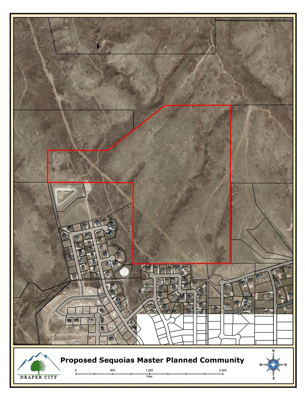
1 Development Review Committee 1020 East Pioneer Road Draper, UT (801) STAFF REPORT August 14, 2018 To: From: Prepared By: Draper City Planning Commission Business Date: August 23, 2018 Development Review Committee Dan Boles, AICP, Planner III Planning Division Community Development Department Re: Sequoias Land Use & Zoning Map Amendment, Development Agreement, Zoning Text Amendment Request Application No.: MA Applicant: Jacob Satterfield, representing Six Blue Bison, LLC Project Location: Approximately 3235 East South Zoning: RR-22 Residential Zone Acreage: Approximately Acres (Approximately 4,788,986 ft 2 ) Request: Request for approval of a Zoning Text and Map Amendment to a new Master Planned Community (MPC). Additionally, a development agreement is proposed as part of the requirements for a MPC zone along with a land use map amendment. SUMMARY This application is a request for approval of a zoning ordinance text change which would create a new zoning category specially tailored to the subject property. This category is called a Master Planned Community. As a part of that request, a Land Use and Zoning Map Amendment and Development Agreement are also being requested for approximately acres. The property is located in the far south-east section of the City off of Suncrest Drive and adjacent to Highland City. The property is currently zoned RR-22 Residential and is vested under the Suncrest development agreement. The applicant is requesting that a Land Use & Zoning Map Amendment, Development Agreement, Zoning Text Amendment be approved to allow for the development of the currently vacant site into a single family residential subdivision. BACKGROUND The property was part of a larger purchase by Draper City in 2011 from Zions bank after the bank took it over from Suncrest. The intent of that purchase was to preserve a majority of the property in its current natural state. However, there were selected pieces of the property that were identified to be sold off for potential development which would help with the purchase of the overall property. The subject property Sequoias Land Use & Zoning Map Amendment, Development Agreement, Zoning Text Amendment Request 1 App. # MA , TA , DA
2 was one of the pieces that were identified and sold off for potential development. The applicant, after purchase of the property submitted an application for a zone change to R3 zoning. After the applicant considered that application further, the applicant revised the application for an MPC zone. ANALYSIS General Plan and Zoning. The Land Use Map of the General Plan calls for the Residential Hillside Low Density land use designation for the subject property. Regarding this category, the general plan states, Hillside low density residential areas will not exceed a density of one single-family detached dwelling unit per 2 to 5 buildable acres. These categories include areas of very large lot single-family neighborhoods or ranchettes as well as areas situated in the surrounding mountains and hillsides, as well as environmentally designed clustered housing with the Suncrest and South Mountain projects being the exceptions. The property has been assigned the RR-22 Residential zoning classification, with vesting under the Suncrest development agreement. The Suncrest Master Plan allows for a gross density of 1.03 dwelling units per acre. It also allows for the clustering of smaller lots as long as the overall density does not exceed the 1.03 units per gross acre outlined in the master plan. The RR-22 Residential zoning designation is consistent with the zoning in the area though it is not identified in the general plan as a preferred zoning category for the Hillside Low Density category. This is likely due to various zoning and general plan updates over the years and a change in the categories on the official records today. The property is surrounded by RR-22 zoning on the north. On the south in Highland City, the property is zoned R1-40 (a residential single-family zone) and in Alpine is CR-40,000 (1 acre) another single family residential zoning category. Master Planned Community Zone Establishment Chapter 9-28 of the Draper City Municipal Code (DCMC) states that the purpose of the Master Planned Community (MPC) Zone is to allow a master planned, architecturally designed development where customized zoning requirements apply in order to permit flexibility and initiative in a large scale site development. The same chapter goes on to set the regulations for establishing a new MPC zone. Some of the requirements to consider an MPC are a fifty-acre minimum size and 30% open space. If the site meets those two standards, the developer may petition to create a new zone through a text amendment to the zoning ordinance. This ordinance is to be tailor made for the specific property and is intended to enable the developer to work with specific challenges specific to that property. In addition to the zoning text amendment, the developer is required to enter into a development agreement with the City. The development agreement is intended to give freedom to regulations of the Municipal Code in return for benefits to the City. These benefits may include, but are not limited to, dedication of desired right-of-way, dedicated open space, or dedication of parks and trails. The third and final element of an MPC zone is the rezone to the newly established zone just created through the text amendment. With the exception of the development agreement, each of these elements have a set of findings to be considered. Additionally, there are specific findings for the establishment of the MPC zone which must be made in order to approve the MPC zone petition. The findings are found below. In addition to the requirements for the MPC zone, in this case, the applicant has elected to amend the land use map to medium density residential so the land use map would be consistent with the proposed MPC. As staff has reviewed the application for the proposed Sequoias Master Planned Community, a number of concerns have come up. Staff always tries to get the application as clean as possible before presenting it to the Planning Commission and City Council. However, at the applicant s request, staff will forward on Sequoias Land Use & Zoning Map Amendment, Development Agreement, Zoning Text Amendment Request 2 App. # MA , TA , DA
3 the application for a decision prior to coming to a mutual agreement that the development agreement and text amendment are ready with either a negative recommendation or no recommendation. In this case, staff has provided two sets of redlines to the applicant at which point the applicant opted to proceed to the public hearings without addressing all comments. The following is an outline of the issues that staff has identified as potential problems with the proposed MPC development. It is not an exhaustive list but is highlights of the top concerns of staff. Development Agreement o With any development agreement, the City looks for what they will be giving to the developer and then the consideration of what the city will get in return. The applicant has outlined two points as consideration to approve the development agreement. First is that the applicant purchased the property which allowed the City to pay off the bond for the purchase of the property from Zions Bank. Staff s concern is that the property was surplused and marketed for the purpose of potentially developing the property. It was not a donation to the City. Secondly, the applicant has stated that an additional benefit to the City is the 30% open space that will be provided through the MPC zone. One of the requirements for the City Council to even consider the MPC zone is that the applicant provide at least 30% open space. As this is a requirement of the MPC zone, it is not an additional benefit to the City. o The development agreement allows the developer to process material on site without limitation. This has become an issue on other projects in the vicinity and should be addressed. o How the site will be served with water, which is a major component of the proposed development, was not addressed in the Development Agreement. There is currently not enough water allocations to service the number of units the applicant is asking for. o The development agreement is inconsistent with the proposed concept plan. The development agreement sets the maximum number of units at 400 while the concept plan attached to the development agreement shows a total of 415 units. The inconsistencies between the development agreement and the concept plans and the text need to be cleared up. Text Amendment o There are a number of findings that need to be made in order for the City Council to approve the MPC zone. These findings are found in section (G). It appears that some of the findings could probably be made but there are some that staff would have trouble making. These include the following: o The zone provides equal or greater protection to sensitive lands than would occur with conventional zoning. Given the mass grading that is likely with this development and that is not addressed under the development agreement, it doesn t appear that approval of the zoning would protect the sensitive lands with the exception of the 30% open space that may or may not be improved. If one of the intents of the MPC is to protect land by clustering properties and reducing cuts in the hillside and removal of vegetation, mass grading the site does not accomplish this goal. o The zone avoids incompatible development on lands subject to natural hazards. Without a completed geohazards report, it is impossible to know how the site as proposed will impact the land as it relates to any potential hazard. We do know that the mountains in and around Draper are subject to faults and other geological and geological hazards. According to the city s GIS, portions of the property are within the Debris Flow area. The applicant has had initial discussions with the Building Department regarding geohazards and geotechnical investigation but has not initiated that review. o There are a number of inconsistencies throughout the document that need to be fixed such as references that state one standard and immediately state a different one. This could easily be fixed but as of now is an issue. Sequoias Land Use & Zoning Map Amendment, Development Agreement, Zoning Text Amendment Request 3 App. # MA , TA , DA
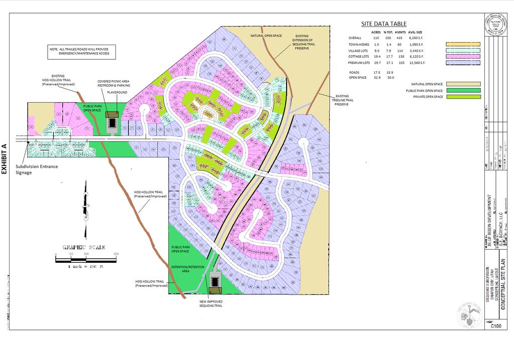
4 o Lot size is an extreme departure to anything else found in the City for single-family residential. The smallest lots (Village Lots) would be allowed to be 2,000 square feet. With care and careful consideration, a product could be placed on a lot that size, but with front setbacks of 20 feet and side setbacks of 5 feet and rear setbacks of 15 feet, a very small building pad is left over. Cottage lots would be allowed to be a minimum of 4,000 square feet and Premium Lots would have to meet 8,000 square feet minimum. Again, the biggest concern is that this (particularly the 2,000 and 4,000 square foot lots) is a far departure of anything else found in the City, particularly in that area. o Accessory buildings would be allowed on even the smallest lots. As mentioned above, given the setbacks and small size of lots, it would be a good idea to limit accessory buildings to the larger lots within the development. o Parking standards in the proposed text states that there shall be a two car garage with every unit. This complies with the standard found in the city s standard parking chapter for single family homes. It doesn t take into consideration the townhomes that are being proposed in the concept plan. Staff is concerned with potential parking issues that this could cause. o The proposed text states that all of the areas labeled as open space would be the responsibility of the City to maintain. The City is not typically interested in taking on the responsibility of maintaining and caring for open space that is resulting from a development. Concept Plan o At 3.63 units per acre, the concept plan is over 3.5 times the 1.03 units per acre that is found in the general SunCrest area. SunCrest may feel denser, but that is a result of the homes being clustered in order to preserve larger pieces of open spaces. As a result, the homes feel closer together and give a greater impression of density. If all of the property that the City recently purchased that was entitled under SunCrest development agreement and is now open space were to be factored in, it would be significantly less dense than 1.03 units per acre. o One the major issues facing the property at this time is that of access. The property, has been granted an access point from SunCrest drive to its west boundary but a development with a single point of access is only allowed thirty lots under current code and since the development agreement doesn t address that point, that standard would apply. The applicant has purchased roughly 32 acres in Alpine and is proposing to subdivide the property and connect to an existing cul-de-sac in Alpine City. If that is approved, that would provide the developer with a second access which is required for a development over 30 units. At this time, the second access in Alpine has not been approved. o Staff has not seen a detailed slope analysis of the property and is concerned with the potential for mass grading of the site. As previously stated, one of the goals of the MPC zone is to provide equal or greater protection to sensitive lands than would otherwise occur with conventional zoning. That finding is, in fact, one that must be made in order for the City Council to approve an MPC zone. o There are not sufficient water Equivalent Residential Units (ERU s) to service the project. o A portion of the property is located on a noted debris flow area per the City s GIS system. The applicant has not yet made application for review of the geotechnical and geohazards reports that are required on the property. It is ideal to have a good idea of what geohazards exist on the property prior to approving a concept plan as they can potentially have an effect on the layout of the proposed development. Zoning Map Amendment o A rezone requires that findings be made that there are adequate facilities to service the development. Whenever a change in zone is contemplated, the impact to the water system has to be considered. On the mountain, the city presently has limited water facilities to provide to future development. Additional language needs to be added which states that any public improvements Sequoias Land Use & Zoning Map Amendment, Development Agreement, Zoning Text Amendment Request 4 App. # MA , TA , DA
5 to support the project will be the responsibility of the developer and not the city or in some way address the need for water. Land Use Map Amendment o The applicant is proposing to change the land use map of the general plan from Hillside low density to medium density residential. The reason for this request is so that the proposed zoning would be in harmony with the general plan on the property. Staff s concern is that a medium density which ranges from 2-4 units per acre is still significantly higher than anything else in the area. The closest homes in the area are in Highland just south of the subject property and they range in size from 0.35 acre to 0.62 acre in size. Staff believes that 2,000-8,000 square foot lots would be out of place in this area. Criteria For Approval. In conjunction with the MPC findings, the criteria for review and potential approval of a Zoning Text and Map Amendment request is found in Sections (E) of the Draper City Municipal Code. This section depicts the standard of review for such requests as: (E) Approval Standards: A decision to amend the text of this title or the zoning map is a matter committed to the legislative discretion of the city council and is not controlled by any one standard. However, in making an amendment, the city council should consider the following factors: 1. Map Amendments: a. Whether the proposed amendment is consistent with goals, objectives and policies of the city's general plan; b. Whether the proposed amendment is harmonious with the overall character of existing development in the vicinity of the subject property; c. Whether the proposed amendment is consistent with the standards of any applicable overlay zone; d. The extent to which the proposed amendment may adversely affect adjacent property; and e. The adequacy of facilities and services intended to serve the subject property, including, but not limited to, roadways, parks and recreation facilities, police and fire protection, schools, stormwater drainage systems, water supplies, and wastewater and refuse collection. 2. Text Amendments: a. Whether the proposed amendment is consistent with goals, objectives and policies of the city's general plan; b. Whether a proposed amendment furthers the specific purpose statements of the zoning ordinance; c. Whether the proposed amendment is appropriate given the context of the request and there is sufficient justification for a modification to the zoning ordinance; d. The proposed amendment will not create a conflict with any other section or part of this title or the general plan; e. Whether the potential effects of the proposed amendment have been evaluated and determined not to be detrimental to public Sequoias Land Use & Zoning Map Amendment, Development Agreement, Zoning Text Amendment Request 5 App. # MA , TA , DA
6 health, safety, or welfare and represents an overall community benefit; and f. The extent to which a proposed text amendment implements best current, professional practices of urban planning, design, and engineering practices. Further criteria for approval of an MPC zone is found in section (7) which states: 7. The proposed MPC text and zoning map amendment and schematic development plan shall be approved only if the City Council makes the following findings: i. The zone is necessary to provide land use or design standards tailored to a specific geographic area and development program that cannot otherwise be provided through conventional zoning. ii. The zone provides equal or greater compatibility with surrounding land uses than would occur with conventional zoning. iii. The zone provides equal or greater protection to sensitive lands than would occur with conventional zoning. iv. The zone avoids incompatible development on lands subject to natural hazards. v. The zone promotes efficient land use by allowing housing and commercial development at densities that are appropriate for the area. vi. The zone provides equal or greater opportunities for alternative modes of transportation such as walking, bicycling, or transit, than would occur with conventional zoning by: (a) encouraging or requiring significant mixed use development where appropriate; and (b) providing a master plan with direct and convenient pedestrian or bicycle connections between all land uses. REVIEWS Planning Division Review. The Draper City Planning Division has completed their review of the Zoning Text, Zoning and Land Use Map Amendments and Development Agreement submission and has outlined the proposal in the body of this staff report. Planning Staff recommends that the Planning Commission reviews the proposals and make either a positive or negative recommendation to the City Council based on the information in the staff report. Engineering and Public Works Divisions Review. The Draper City Engineering and Public Works Division have completed their review of the Land Use & Zoning Map Amendment, Development Agreement, Zoning Text Amendment submission and have provided comments found in Exhibit A of this staff report. Building Division Review. The Draper City Building Division has completed their review of the Land Use & Zoning Map Amendment, Development Agreement, Zoning Text Amendment submission and have provided comments found in Exhibit A of this staff report. Draper City Fire Review. The Draper City Fire has completed their review of the Zoning Text, Zoning Map Amendment and Development Agreement submission and have provided comments found in Exhibit A of this staff report. Parks & Trails Committee Review. The Draper City Parks and Trails Committee have completed their review of the Land Use & Zoning Map Amendment, Development Agreement, Zoning Text Amendment Sequoias Land Use & Zoning Map Amendment, Development Agreement, Zoning Text Amendment Request 6 App. # MA , TA , DA
7 submission and have provided comments found in Exhibit A of this staff report. Noticing. Notice has been properly issued in the manner outlined in the City and State Codes. STAFF RECOMMENDATION Staff recommends the Planning Commission review the staff report and make either a positive or negative recommendation to the City Council for the Zoning Text, Zoning and Land Use Map Amendment and Development Agreement by Jacob Satterfield, representing Six Blue Bison, LLC, application MA , TA and DA Findings for a Positive Recommendation: 1. The proposed text and development agreement meet the intent, goals, and objectives of the Draper City General Plan such as: a. Protect an adequate portion of land as permanent open space. b. Provide a wide range of housing opportunities while protecting property values and promoting quality development. 2. That the MPC zone is necessary to accommodate the single-family and multi-family mix of uses. 3. That the property was intended at its sale to be developed and the proposed development is appropriate for the area. Findings for a Negative Recommendation: 1. The proposed text and development agreement does not meet the intent, goals, and objectives of the Draper City General Plan such as: a. Encourage development that can be adequately supported by required services and facilities; which conserves, to the extent possible, the natural and man-made environment. b. Reduce potential impacts to environmentally sensitive areas such as Corner Canyon, South Mountain, and Lone Peak Wilderness Area, Jordan River Corridor, Willow Creek, etc. by developing effective development standards and policies. c. Incorporate open space, mobility, and drainage networks while protecting the area s character and natural systems. 2. That the proposed development agreement does not provide a clear benefit to the city. 3. That the proposed development agreement would allow extraction, screening of earth from the property in perpetuity beyond the limits of the land disturbance permit. 4. That water resources are limited to service the property. 5. That the proposed exhibit depicts a density of 3.6 units per acre which exceeds the 1.03 units per acre found in the SunCrest development that vests the property in the vicinity. 6. That not all of the findings found in section (7) of the Draper City Municipal Code can be made as required by code. 7. It is unclear what types of hazards may exist on the property until a geotechnical and geohazards analysis has been completed and accepted by the city which would lay out plans to mitigate any potential hazards. MODEL MOTIONS Development Agreement Sample Motion for a Positive Recommendation I move we forward a positive recommendation to the City Council for the Sequoias Development Agreement Request by Jacob Satterfield, representing Six Sequoias Land Use & Zoning Map Amendment, Development Agreement, Zoning Text Amendment Request 7 App. # MA , TA , DA
8 Blue Bison, LLC, application DA , based on the findings listed in the Staff Report dated August 14, 2018: Sample Motion for a Positive Recommendation with modifications I move we forward a positive recommendation to the City Council for the Sequoias Development Agreement Request by Jacob Satterfield, representing Six Blue Bison, LLC, application DA , based on the findings listed in the Staff Report dated August 14, 2018 and as modified by the conditions below: 1. List any findings and conditions Sample Motion for a Negative Recommendation I move we forward a negative recommendation to the City Council for the Sequoias Development Agreement Request by Jacob Satterfield, representing Six Blue Bison, LLC, application DA , based on the following findings: 1. List any additional findings Zoning Text Amendment Sample Motion for a Positive Recommendation I move we forward a positive recommendation to the City Council for the Sequoias Zoning Text Amendment Request by Jacob Satterfield, representing Six Blue Bison, LLC, application TA , based on the findings and subject to the conditions listed in the Staff Report dated August 14. Sample Motion for a Positive Recommendation with modifications I move we forward a positive recommendation to the City Council for the Sequoias Zoning Text Amendment Request by Jacob Satterfield, representing Six Blue Bison, LLC, application TA , based on the findings and subject to the conditions listed in the Staff Report dated August 14, 2018 and as modified by the conditions below: 1. List any additional findings and conditions Sample Motion for a Negative Recommendation I move we forward a negative recommendation to the City Council for the Sequoias Zoning Text Amendment Request by Jacob Satterfield, representing Six Blue Bison, LLC, application TA , based on the following findings: 1. List any additional findings Zoning Map Amendment Sample Motion for a Positive Recommendation I move we forward a positive recommendation to the City Council for the Sequoias Zoning Map Amendment Request by Jacob Satterfield, representing Six Blue Bison, LLC, application MA , based on the findings listed in the Staff Report dated August Sequoias Land Use & Zoning Map Amendment, Development Agreement, Zoning Text Amendment Request 8 App. # MA , TA , DA
9 14, List any additional findings Sample Motion for a Negative Recommendation I move we forward a negative recommendation to the City Council for the Sequoias Zoning Map Amendment Request by Jacob Satterfield, representing Six Blue Bison, LLC, application MA , based on the following findings: 1. List any additional findings Land Use Map Amendment Sample Motion for a Positive Recommendation I move we forward a positive recommendation to the City Council for the Sequoias Land Use Map Amendment Request by Jacob Satterfield, representing Six Blue Bison, LLC, application MA , based on the findings listed in the Staff Report dated August 14, List any additional findings Sample Motion for a Negative Recommendation I move we forward a negative recommendation to the City Council for the Sequoias Land Use Map Amendment Request by Jacob Satterfield, representing Six Blue Bison, LLC, application MA , based on the following findings: 1. List any additional findings Sequoias Land Use & Zoning Map Amendment, Development Agreement, Zoning Text Amendment Request 9 App. # MA , TA , DA


10
11
12 EHIBIT A DEPARTMENT COMMENTS
13 Engineering and Public Works Department MDA review comments: 1. Draper City Municipal Code Title 18 Land Disturbance requires all areas within the Hillside Overlay Zone to have final site plan approval or final subdivision approval prior to beginning construction activities onsite. In Section 5,3 text indicates construction can begin after submittal of development applications. Update to reflect approval of application and obtaining Land Disturbance Permit are required prior to onsite construction. 2. Language in MDA should correlate to the exhibits, such as referencing areas of non-disturbance, unit types and number, etc., such as found in Recital Section F, Section 3, and Section Add limits of construction disturbance to Exhibit C to show areas of native, existing vegetation protection / preservation. 4. The following language should be added to the MDA: This development agreement does not constitute a commitment by the City to provide culinary water service to the development. If the City s existing water system does not have adequate capacity for the proposed development, the Developer shall have the obligation, at no cost to the city, to construct or cause to be constructed the necessary improvements or infrastructure to provide the required water service to the development. Text Amendment review comments: 1. In Section (E)(12)(a), easement shall be Public Utility and Drainage Easement. 2. In Section (E)(12)(b), snow storage easement should be 10-feet. 3. In Section (H)(1) Signage, the entrance signs shall not be located with public right-of-way, within sight distance areas, or clear view areas near intersections. Site Plan and Slope Plan review comments: 1. Exhibit in DA and Text Amendment do not correlate to exhibits provided with submittal. Update all exhibits across all areas. 2. Several intersections appear to have approach angles less than 85. City standard for intersections is for approach angles to be within ±5 of Posted speed limit of the Suncrest Development and surrounding subdivisions is 20 mph. This requires a design speed of 25 mph. Based on rural highways and streets design guidelines, the horizontal curve R is 180 feet. It appears based on an evaluation of the site plan that several horizontal curves are less than 170 feet. 4. The intersections in the area of lots 64, 136, 137 & 101, 249, 115 appear to be spaced at approximately 100 feet. Per the access management requirements in Draper City Code, spacing for public street intersections is a minimum of 150 feet. 5. Intersection slope and street slope appear to meet the ADA standard requirements for 5% maximum slope through the intersections and 12% maximum street slope.
14 6. Site plan does not show any common area(s) or park(s) that may require outdoor irrigation for lawn or other landscaping amenities. If any are considered, include on site plan to accommodate water supply planning. 7. We recommend adding to an exhibit, whether on the site plan or grading plan, showing the public and private street sections. 8. We recommend showing the proposed detention basin(s) for the project due to the fact they may be sizable based on code compliance. 9. Units 1 to 45, 162, 180 to 184, 208 to 212, and 221 to 231 will be required to have driveway access from the private lanes and not the fronting public street due to the proximity of the intersections. 10. Identify areas that are to be protected as areas of non-disturbance by construction activities to preserve natural vegetation. Parks and Trails Comments 1. Do not provide any barbecue area if adjacent to open space. Should consider drinking fountain and parking if also serving as trail head as mentioned below. Clarify ownership of this park. If park and trail head to be same improvement, lump them together under same section in this document. 2. Some lots appear to encroach into the Hog Hollow drainage. Clarify if this is the intent and what measures will be taken to preserve the corridor. 3. Clarify intent of open space areas. Is a developed public park planned? Or should it be identified as natural open space? 4. Clarify whether all new trails will be constructed wide enough to accommodate emergency/maintenance vehicles. We recommend that Sequoia Trail be a single track primitive trail. 5. Show more accurate location of existing road and provide feasible emergency/maintenance access to street (not to trail which would not be wide enough for vehicular access). 6. Show extension of Sequoia Trail to project boundary. Refer to overall concept trail plan for area provided by City. 7. Clarify whether the open space, trailhead and trails will be deeded to the city. If so, also state that all construction will meet Draper City standards and specifications. 8. Do not provide any barbeque area if adjacent to open space. Should consider drinking fountain and parking if also serving as trail head as mentioned below. Clarify ownership of the park. If the park and trail head are to be the same improvement, lump them together under the same section in the text amendment. Building Department 1. The applicant will need to go through the process of submitting and review of all geological, geotechnical and geohazards report approvals for the property prior to the issuance of any permit. Fire Department 1. Fire Access is a concern. (road widths, it appears to have two bridges, is there a second access to Alpine, for this many homes the code says a minimum of two separate access points it is not clear if they have this.
15 2. Fire Flow is another concern. Do we have the water capacity to support a project of this size? If not what are their plans for infrastructure?
16 EHIBIT B PROPOSED CONCEPT PLAN
17 CONCEPTUAL SITE PLAN C100 S.E. SCIENCE, LLC BLUE BISON DEVELOPMENT SEQUOIAS SUBDIVISION DRAPER CITY, UTAH CONCEPTUAL LAYOUT No PAUL S. FESER CIVIL STATE OF UTAH LICENSED PROFESSIONAL ENGINEER
18 I NEER ENG L I CENS ED FESS IONAL PRO No PAUL S. FESER CIVIL ST H ATE OF UTA HIGHLAND CITTY ENTRY NO : CONCEPTUAL SITE PLAN 271 SEQUOIAS SUBDIVISION DRAPER CITY, UTAH CONCEPTUAL LAYOUT 102 S.E. SCIENCE, LLC 261 BLUE BISON DEVELOPMENT 260 C102
19 EHIBIT C PROPOSED ZONING TET
20 : SEQUOIAS MASTER PLANNED COMMUNITY ZONE: A. Purpose: The MPC-Sequoias zone is intended to provide a master planned development where customized zoning requirements apply in order to create an appropriate diversified community in areas of generalized and or outdated zoning. Significant features of the development include thirty percent (30%) open space, trailhead accommodation, preservation of natural trails and recreation. Implementation of the MPC zone will provide the flexibility to create a mix of residential uses that will appeal to many different homebuyers and price ranges not typically found in other zoning classifications within the city. B. Permitted Uses: Accessory dwelling units, per chapter 31 of this title. Accessory structures, per chapter 10 of this title. Church. Dwelling, multi-family. Dwelling, single-family. Home occupations, per chapter 34 of this title. Model homes. C. Conditional Uses: Home occupations, per chapter 34 of this title D. Procedures: Subdivision plat review is required for each portion of the development. Approval of the MPC acknowledges acceptance of the adopted master plan. See exhibit A of this section. E. Development Standards; Single-Family: The development standards of the Sequoias master planned community zone have been established to create lot standards and guide the design of the lighting, landscaping, parking and road infrastructure within the master plan. Single-family residential shall meet the following standards: 1. Lot Size, Frontage and Setbacks For Townhomes (Exact Setbacks and minimum lot sizes shall be determined during site plan review) The following list is approximate guidelines, site plan review will make modifications if required. a. Footprint: Townhome footprint must accommodate a minimum of 2 units and maximum of 6 units. b. Unit size: Each unit must be a minimum of Twenty feet (20 ) wide c. Front setbacks: Fifteen feet (20') minimum; twenty feet (25') to garage minimum; d. Rear setbacks: Fifteen feet (15'); rear decks may protrude five feet (5') into setback; e. Side setbacks: 5 feet (5 ) f. Side access garage: Twenty feet (20') minimum; g. Corner lot setbacks: Fifteen feet (20') minimum h. Private open space: A minimum of Five-Hundred square feet of private open space is required per 1 townhome unit. which will be determined during site plan review. Within the private open space amenities such as a minimum of one (1) shade structure, one (1) barbeque area, one (1) playground, five (5) benches will be provided. i. Townhomes shall include a variety of unit sizes. j. Townhomes shall include a variety of heights. Long continuous rooflines greater than forty feet (40') shall not be permitted. 2. Lot Size, Frontage and Setbacks For Village Lots: a. Minimum lot size: Two thousand (2,000) square feet b. Minimum lot frontage: Twenty-five feet (25'); c. Minimum lot width at front setback: Thirty-two feet (32');
21 d. Front setbacks: Fifteen feet (15') minimum; twenty feet (20') to garage minimum; e. Rear setbacks: Fifteen feet (15'); rear decks may protrude five feet (5') into setback; f. Side setbacks: Three and a half feet (3.5') minimum; g. Side access garage: Twenty feet (20') minimum; h. Corner lot setbacks: Fifteen feet (15') minimum 3. Lot Size, Frontage And Setbacks For Cottage Lots: a. Minimum lot size: Four-thousand (4,000) square feet; b. Minimum lot frontage: Thirty-five feet (35'); c. Minimum lot width at front setback: Forty feet (40' d. Front setbacks: Fifteen feet (15') minimum; twenty feet (20') to garage minimum; e. Rear setbacks: Twenty feet (20'); rear decks may protrude five feet (5') into setback; f. Side setbacks: Five feet (5') minimum; g. Side access garage: Twenty feet (20') minimum; h. Corner lot setbacks: Fifteen feet (15') minimum. 4. Lot Size, Frontage And Setbacks For Premium Lots: 5. Design Criteria: a. Minimum lot size: Eight thousand (8,000) square feet; b. Minimum lot frontage: Fifty feet (50'); c. Minimum lot width at front setback: Sixty feet (60'); d. Front setback: Fifteen feet (15') minimum; twenty feet (20') to garage minimum; e. Rear setbacks: Twenty feet (20'); rear decks may protrude five feet (5') into setback; f. Side setbacks: Total fifteen feet (15'); five feet (5') minimum per side; g. Side access garage: Twenty feet (20') minimum; h. Corner lot setbacks: Fifteen feet (15') minimum. a. Design shall emulate the overall architectural theme of the area with a "mountain classic, mountain modern, prairie or farm house styles". b. Building primary materials shall consist of stucco, wood like material, aged woods, brick, painted brick, composite metal panel, stone and look alike stone products, paintable backer boards, concrete, GFRC, tile or other similar material as approved by Draper City staff and SDRC. c. More than one material shall be required on all residential structures within the development. d. e. Buildings shall use a minimum of fifty percent (35%) primary material. e. Exposed foundation walls shall not exceed four feet (4') above finished grade at any point. f. All exposed sides of the structures shall have framed windows. g. Side and rear elevations that are visible from public and private streets shall match the architectural detailing of the front facade. h. Roof Materials: Asphalt shingles, standing seam metal, bar tile, or similar material. A combination of materials may be used. i. Roof Styles: Any pitched roof covering the main body of the structure shall allowed but must be reviewed and approved by the SDRC to assure the look is consistent with the styles listed in line (a) if the design criteria. 6. Project Lighting: All lighting will follow current city or distract standards. 7. Landscaping and Trees: A detailed tree plan will be provided with each final plat. Cottage lots shall have at least one street tree per lot in a required park strip. Premium lots shall be required to provide street trees within required park strips with spacing between trees at fifteen (15 ) to thirty feet (30 ). In areas where no park strip has been designed, the trees will be incorporated into the overall landscape design utilizing a combination of fire-wise plants and ornamental trees.
22 8. Height of Main Buildings: Thirty-five feet (35') as measured by the currently adopted residential building code a. Town home and village lots Height: To encourage height variation, structures shall be allowed to exceed the maximum height of thirty-five feet (35') by five feet (5') for no more than fifty percent (50%) of the project buildings. 9. Accessory Structures: Accessory structures shall meet the standards of section of this title. 10. Repeat Plan Limitations: No two (2) homes shall have the same elevation on adjoining lots. 11. Roadways Serving Single-Family Development: will follow Draper City Standards 12. Easements: The following easements shall be provided within the development: a. Public Utility Easements: All lots shall have front and rear easements of ten feet (10'). Front easements are to be located behind the sidewalk or behind the curb in areas where no park strip or sidewalk have been designed. One side yard easement of at least five feet (5') will be provided. b. Snow Easements: In areas where no park strip or sidewalk has been designed, a snow storage easement shall be provided. c. Slope Easements: Roadway cut and fill slopes located outside of the dedicated public right of way shall be located within recorded easements providing for slope protection and preservation d. Water and Storm Drain Easements: Required water and storm drain easements shall be a minimum of twenty feet (20'). 13. Colors And Materials: a. Color utilization shall be sensitive to existing development within the vicinity and the natural landscape in which the project is located. Color schemes shall follow the color palette found in the design guidelines. b. High quality materials for building facades will be selected as outlined in the design guidelines 14. Sequoias Design Review Committee (SDRC): The SDRC shall review and approve the site plan prior to city submittal. 15. Landscaping: A detailed landscaping plan shall be required at the time of site plan review. Plant selection and placement shall be guided by fire-wise standards and chapter 23 of this title. 16. Amenities: A fully functional outside social area no less than one thousand (1,000) square feet shall be provided in a central location accessible to all residents of the community. This area shall contain a covered shade structure (pavilion), picnic tables, barbecue area. rest rooms and playground. 17. Fencing: Private fencing shall be permitted when extending directly from the rear of a unit and abutting the back yard of another unit or as a buffer to adjacent land uses. Fencing (at least field fencing) shall be placed along all backyards and side yards that back onto public park open space to help address encroachments into the open space. 18. Parking: A minimum of two (2) car garage is required in every unit, additional parking can be accommodated with driveways. 19. Homeowners' Association: An Sequoias homeowners' association will be formed to maintain private open space within the townhome sections of the community. 20. Roadways Serving Townhomes and village lots: As shown in the Master Plan, there are smaller private access roads to service some of the village lots and townhomes. These private streets will follow the code for such streets and shall be maintained under HOA s of the individual communities F. Open Space: No less than thirty percent (30%) of the development will be set aside as open space as shown in the adopted master plan. All areas labeled as public open space shall be maintained by the city. G. Trails And Trailhead: The developer will work together with the city parks and trails committee to provide design recommendations and further details to the planning commission and city council for approval during the preliminary and final plat process. 1. Sequoias/Hog Hollow Trailhead: A minimum of sixteen (16) parking stalls shall be provided at the Sequoias/Hog Hollow Trailhead. The developer shall install trail map signage and a bike pump/tool station similar to other trailheads.
23 H. Signage: 2. Developer will provide access from parking structure and trailhead to Hog Hollow trail as shown on Master Plan (see Exhibit A) Developer will preserve and or improve upon the Hog Hollow trail in areas that the trail crosses through the development Property. Developer will also improve a trail called Sequoias trail that will run through the main ravine of the property connecting to existing trails marked in Exhibit A. Developer will attempt to keep trails natural where reasonable and commit to improved trails consisting of natural materials where necessary to provide and promote hiking, biking and recreation. 1. Entrance Signs: Two (2) entrance signs shall be permitted in the locations depicted in the master plan. The signs shall not exceed ten feet (10') in height measured to the highest roof surface. Lighting will be allowed to illuminate the name of the development either by direct exterior lighting or within the sign itself. 2. Temporary Signs: a. Model Homes: Model homes shall be allowed one sign not to exceed thirty-two (32) square feet. b. Directional Signs: Developer may install up to two (2) directional signs not to exceed sixteen (16) square feet.
24
25 EHIBIT D PROPOSED DEVELOPMENT AGREEMENT
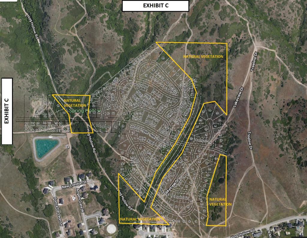
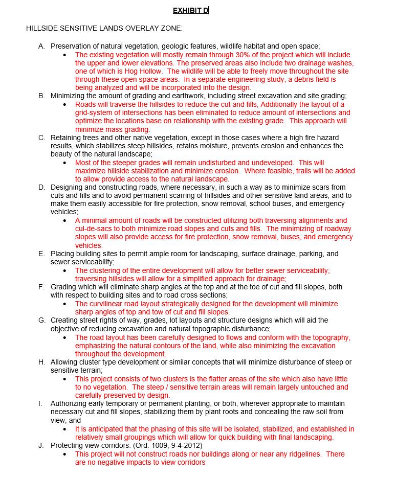
26 Development Agreement SEQUOIAS 110 Acre Development THIS DEVELOPMENT AGREEMENT (this Agreement ) is entered into effective day of 20 by and between Six Blue Bison, LLC, a Utah limited liability company ( Developer ); and DRAPER CITY, a municipality and political subdivision of the State of Utah whose address is 1020 East Pioneer Road, Draper, Utah ( City ). Developer and City are hereinafter sometimes referred to individually as a Party or collectively as the Parties. RECITALS: A. Developer owns or has the option to acquire approximately 110 acres of real property located near approximately 3235 E S Draper, UT (Temp Address) within City's boundaries (the Property ). The legal description of the Property is set forth on Exhibit "A" attached hereto. B. Developer and the City desire that the Property be developed in a unified and consistent fashion pursuant to the Master Plan. C. The Parties desire to enter into this Agreement to specify the rights and responsibilities of the Developer to develop the Property as expressed in this Agreement and the rights and responsibilities of the City to allow and regulate such development pursuant to the requirements of this Agreement. D. The Property is currently included in the Suncrest Development Agreement (SDA). The Developer desires to develop the Property into a master planned residential community to be known as "Sequoias"(the "Project"). In connection with the development of such Project, the Developer has made application to the City to amend the SDA boundary, removing the 110-acre property and changing the zone to a Master Planned Community (the "MPC Zone"), in accordance with Chapter of the Draper City Municipal Code\ E. Contributions to City. Developer and City recognize the Property was purchased from the city. This sum of money was in excess of the original bond used to secure 2400 acres of land once planned to be developed as future phases of Suncrest adding which would have added an estimated 2400 units to the area beyond what currently exists. These 110 acres of land only represents approximately 5% of the 2400 acres of land secured by the city bond, and yet more than paid back the bond used for all 2400 acres. The benefit to the city and its residents is eliminating a large debt and interest expense that was set to convert from interest only to a principal and interest payment that would have required increase in taxes and other expenses in order to service. The Property sits on the furthest most south east portion of land located nearly 1 mile away from any other Draper development or resident, this developments impact on any Draper resident is a nonfactor. The Property is not surrounded by any other Draper development making no need for keeping consistent in zoning or standards, its impact will be unfelt, in fact most Draper residence have never stepped foot on this Property, will never know of its whereabouts or that it even exists
27 in Draper city limits, YET the impact and benefit of the purchase of such development is felt every day as nearly 2300 acres of open space is preserved for wild life, beauty and recreation that Draper residence use and appreciate while also avoid having to pay the financial burden of affording such a luxury. Additional benefits to the residents of Draper are now direct access to trails that otherwise were only used by Alpine and Highland residents. The development will also provide a minimum of 30% open space of which such open space has natural trails and recreation in that will be preserved and improved upon making all residents of Draper and future residents of the development able to use and enjoy where in the past very few if any have. F. The Development offer many benefits to the city and residents of the community such as preserving a minimum of 30% of the land as open space. Open space will also be preserved as much as possible and largely left untouched and kept as natural beauty. An emphasis is put on not altering the natural trails and vegetation wherever possible especially in the open space areas where we have designed around open space areas that are most benefited by not disturbing. See Exhibit B areas marked Open Space and also Exhibit C showing the open space overlay with the natural vegetation and terrain being preserved. Additionally, the Development will add a trailhead parking area, pavilion with restrooms, drinking fountain and playground for all to enjoy. Any natural trail that can be preserved in the designated open space areas will be preserved or improved upon if necessary, with an emphasis on the Hog Hollow trail, and improved portions of the trail made to continue and connect any portions not suitable for recreation such as hiking and biking. A man-made trail will be improved in the main ravine crossing through the Property which will be called Sequoias trail and will connect to natural trails that are existing towards the top of the ravine and development (See Exhibit B for trail location) The layout of the development was designed with the curvature of the land in mind following the contours of the land in a way to preserve a more natural and mountain like layout. The road layout also was placed in a such a way to target areas with little to no vegetation and to reduce as much as possible mass grading and disturbance. The architecture of the development (Detailed in section 999 of the Zoning Text Exhibit G) which details the unique and premium requirements of the development that insure the community to be an exceptional and astatically pleasing luxury product throughout, while still offering a variety of price points and consistency of look and feel typically found within planned communities. G. The intent of this Agreement is to facilitate development of the Project in accordance with the Code and the site-specific land uses and development standards specified in this Agreement. H. City, acting pursuant to its authority under UTAH CODE ANN. 10-9a-101, et seq. ("LUDMA") has made certain determinations with respect to the Property and the proposed Project, and, in the exercise of its legislative discretion, has elected to process and approve this Agreement after all necessary public hearings and procedures have been conducted. NOW, THEREFORE, in consideration of the mutual covenants contained herein and for other good and valuable consideration, the receipt and sufficiency of which is hereby acknowledged, the Parties hereby agree as follows:
28 1. Incorporation of Recitals; Entire Agreement. The above recitals and the exhibits referenced in this Agreement are hereby incorporated by reference as part of this Agreement. This Agreement integrates and constitutes all of the terms and conditions pertaining to the subject matter hereof and supersedes all prior negotiations, representations, promises, inducements, or previous agreements between the Parties hereto with respect to such subject matter. 2. Condition Precedent. This Agreement is contingent upon and shall only become effective at such time, and in the event that: (a) the Draper City Council (the Council ), in the independent, unfettered exercise of its legislative discretion, elects to approve the proposed [rezoning of the Property to the MPC SEQUOIAS zoning designation]; and (b) [Developer in fact acquires fee title to the Property]. This Agreement is not intended to and does not affect or in any way bind or supersede the independent exercise of legislative discretion by the Council in deciding whether to approve or deny the application for the rezoning of the Property [as applicable]. If any such rezoning occurs by legislative action of the Council but subsequently is reversed or revoked by any means other than legislative action of the Council, then this Agreement shall be deemed void ab initio. 3. Concept Plan. Subject to Section 4.2, below, a plan (the Plan ) depicting the permissible lots, building envelopes, street(s) and certain other dimensions and physical attributes of the Project is attached hereto as Exhibit B and is incorporated herein by this reference. The Project shall be limited to a maximum of 400 units Units ( Maximum Residential Units ) and a maximum residential density of 3.6 dwelling units per acre ( Maximum Residential Density ), which Units shall be exclusively used for single family residential purposes and shall be configured and located substantially as shown on the Plan. The approval of the Plan as part of this Agreement satisfies any Code requirement for a concept plan or any other similar requirement for the Project, provided that the Plan shall not constitute a preliminary or final subdivision plat for the Project. 4. Development of the Project. 4.1 Compliance with the Plan and this Agreement. Development of the Project shall be in accordance with the City s vested laws, the City s future laws (to the extent that these are applicable as otherwise specified in this development agreement), the Plan and this Agreement. 4.2 Maximum Residential Units. At buildout of the project, Developer shall be entitled to have developed the Maximum Residential Units as specified in and pursuant to this Agreement of the type and in the general location as shown on the Plan. 4.3 Limitation and No Guarantee. Developer acknowledges that the development of the maximum residential units and every other aspect of the Plan requires that each Development Application comply with the city s vested laws including, without limitation, the City s geologic hazards requirements. The City s entry into this Agreement does not guarantee that the Developer will be able to construct the maximum residential units or any other aspect of the Project until and unless all the applicable requirements of the city s vested laws are complied with. 4.4 Accounting for Residential Units for Parcels Sold to Subdevelopers. Any
29 Parcel sold by Developer to a Subdeveloper shall include the transfer of a specified portion of the maximum residential units sold with the Parcel. At the recordation of a Final Plat or other document of conveyance for any Parcel sold to a Subdeveloper, Developer shall provide the City a report showing the relationship of the Parcel(s) sold, the portion of the maximum residential units transferred with the Parcel(s), the amount of the Maximum Residential Units remaining with Developer and any material effects of the sale on the preliminary Master Plan. 5. Project-Specific Development Standards Site Standards. [If applicable] By this Agreement, the Parties intend to limit the uses, development standards and other regulations otherwise applicable to the Property under the MPC Zone Sequoias MPC zoning designation as described in Title of the Code in order to promote the efficient and creative development of the Property. All design standards follow the City s current code set forth in Title 9 of the Code. Developer shall develop the Project in accordance with the Plan (subject to Section 4) and in full compliance with the Site Standards and the Code Sensitive lands. Developer will design and layout the development in such a way to preserve natural trails, vegetation, geological features and appropriate open space on the property as much as possible or reasonable while also adding improvements and other amenities that work in conjunction with the preestablished recreation and natural beauty in the area See Exhibit B, C & D for details. The building and architecture will be designed in such a way to minimize mass grading and earthwork, and following the requirements and suggestions stated in Title Amendments to Plan. The Plan is a general depiction of locations and dimensions of Lots, building envelopes, streets, and certain other dimensional development attributes of the proposed Project. If required by the Code or the Site Standards, more detailed and specific site plans, subdivision plats and similar shall be submitted for approval before any actual construction may begin on any portion of the Property. Actual development of the Project may deviate or vary slightly or in ways that are irrelevant to planning considerations from what is depicted on the Plan or which represent logical development of the details depicted on the Plan, provided that: City reserves the right to modify the Plan as reasonably necessary to assure Code compliance The number of Units on the Property may not exceed 400 absent a subsequent legislative decision to the contrary by the Council in its sole, unfettered discretion Subject to the foregoing, if Developer desires to modify the Plan in any way, it shall submit a request to City's community development director (the Director ), who may approve minor modifications to the Plan under the foregoing standards. Any requested non-minor modifications to the Plan (including, without
30 limitation, material changes in road alignment, the sizes or locations of Lots or building envelopes, setbacks and other dimensional attributes of the Plan), or any changes to the Site Standards, are subject to approval or disapproval by the Council in the independent, unfettered exercise of its legislative discretion following public hearing before, and recommendation by, the Commission. 6. Appeals. Any decision of the Director (a) approving or denying a request for a minor modification to the Plan, or (b) as to whether a proposed modification is a major amendment to the Plan that requires Council approval, is an administrative decision of City staff that may be appealed to City's appeal authority as provided in the Code. Any decision of the Council concerning a proposed major amendment to the Plan, or any amendment to the Site Standards, is a legislative decision that may be appealed to court as provided in LUDMA. 7. Approval Process for Development Applications. City shall process applications for development of the Project in accordance with the Code. Nothing in this Agreement shall be deemed to relieve Developer of the obligation to comply with all of the applicable requirements for approval of preliminary and final subdivision plats, or preliminary and final site plans, as applicable, for the proposed development of the Project consistent with the terms and conditions of this Agreement and the applicable provisions of the Code City Denial of a Development Application. If the City denies a Development Application the City shall provide a written determination advising the Applicant of the reasons for denial including specifying the reasons the City believes that the Development Application is not consistent with this Development Agreement, the Zoning and/or the City s Vested Laws (or, if applicable, the City s Future Laws) Meet and Confer regarding Development Application Denials. The City and Applicant shall meet within fifteen (15) business days of any Denial to resolve the issues specified in the Denial of a Development Application City Denials of Development Applications Based on Denials from Non- City Agencies. If the City s denial of a Development Application is based on the denial of the Development Application by a Non-City Agency, Applicant shall appeal any such denial through the appropriate procedures for such a decision and not through the processes specified below Mediation of Development Application Denials Issues Subject to Mediation. Issues resulting from the City s Denial of a Development Application that the parties are not able to resolve by Meet and Confer shall be mediated and include the following: i. the location of On-Site Infrastructure, including utility lines and stub outs to adjacent developments ii. right-of-way modifications that do not involve the altering or vacating of a previously dedicated public right-of-way,
31 iii. iv. interpretations, minor technical edits or inconsistencies necessary to clarify or modify documents consistent with their intended purpose of the Development Standards, and the issuance of building permits Mediation Process. If the City and Applicant are unable to resolve a disagreement subject to mediation, the parties shall attempt within ten (10) business days to appoint a mutually acceptable mediator with knowledge of the legal issue in dispute. If the City and Applicant are unable to agree on a single acceptable mediator they shall each, within ten (10) business days, appoint their own representative. These two representatives shall, between them, choose the single mediator. Applicant shall pay the fees of the chosen mediator. The chosen mediator shall within fifteen (15) business days, review the positions of the parties regarding the mediation issue and promptly attempt to mediate the issue between the parties. If the parties are unable to reach agreement, the mediator shall notify the parties in writing of the resolution that the mediator deems appropriate. The mediator's opinion shall not be binding on the parties Arbitration of Development Application Objections Issues Subject to Arbitration. Issues regarding the City s Denial of a Development Application that are subject to resolution by scientific or technical experts such as traffic impacts, water quality impacts, pollution impacts, etc. are subject to arbitration Mediation Required Before Arbitration. Prior to any arbitration the parties shall first attempt mediation as specified in Section Arbitration Process. If the City and Applicant are unable to resolve an issue through mediation, the parties shall attempt within ten (10) business days to appoint a mutually acceptable expert in the professional discipline(s) of the issue in question. If the parties are unable to agree on a single acceptable arbitrator they shall each, within ten (10) business days, appoint their own individual appropriate expert. These two experts shall, between them, choose the single arbitrator. Applicant shall pay the fees of the chosen arbitrator. The chosen arbitrator shall within fifteen (15) business days, review the positions of the parties regarding the arbitration issue and render a decision. The arbitrator shall ask the prevailing party to draft a proposed order for consideration and objection by the other side. Upon adoption by the arbitrator, and consideration of such objections, the arbitrator's decision shall be final and binding upon both parties. If the arbitrator determines as a part of the decision that the City s or Applicant s position was not only incorrect but was also maintained unreasonably and not in good faith, then the arbitrator may order the City or Applicant to pay the arbitrator s fees. 8. Phasing. Developer shall proceed with subdivision and construction of the Project with reasonable diligence. Developer may develop the Project in several phases as market
32 conditions dictate so long as each phase provides for the logical extension of infrastructure and utilities as approved by City and in compliance with the terms of this Agreement and the applicable provisions of the Code. All phasing decisions for the Project shall constitute minor modifications subject to approval by the Director. 9. Payment of Fees Development Application and Review Fees. Developer shall pay to City all fees imposed by City (including, without limitation, application fees, impact fees and connection fees) for review and approval of development of any and all phases of the Project in the amounts set forth in City s Consolidated Fee Schedule from time to time. The Council hereby determines that there is a prevailing public interest in allowing deferral of the payment of fees for final subdivision and final site plan approval on a phase by phase basis for the Project Other Fees. City may charge other fees in existence from time to time during development of the Project, including, without limitation, standard building permit review and inspection fees for improvements to be constructed on the Property that are generally applicable to other developments within City Reservation of Right to Challenge Fees. Notwithstanding any provision of this Agreement, the Developer does not waive Developer s rights under any applicable law to challenge the reasonableness or legality of the amount or imposition of any fees. 10. Vested Rights Vested Rights. Developer shall have the vested right to have preliminary and final subdivision plats, or preliminary and final site plans, as applicable, approved and to develop and construct the Project in accordance with and subject to compliance with the terms and conditions of this Agreement and applicable provisions of the Code. To the extent that there is any conflict between the main body (text portion) of this Agreement and the exhibits to this Agreement, the more specific language or description, as the case may be, shall control. Where any conflict or ambiguity exists between the provisions of the Code and this Agreement (including the exhibits to this Agreement), this Agreement shall govern. Notwithstanding the foregoing, however, the rights vested as provided in this Agreement are not exempt from the application of the Code and to subsequently enacted ordinances to the extent such exemption would impair City s reserved legislative powers. The Sequoias community will be a residential Master Planned Community with vested right to a maximum of 400 units within the development, which is approximately 3.6 units per acre. The community is located within a hillside land use designation by which the developer is taking in to account designs to preserve required open space and follow sensitive lands design requirements. The Land Use Regulations applicable to and governing the development of the Project shall be the Existing Land Use Regulations (unless the City and Developer agree that future Land Use Regulations shall apply) and this Agreement, except when modifications are required by federal, state, county and/or City laws and regulations promulgated to avoid any imminent and substantial risk or threat of injury to the public health and safety. In the event the City imposes by ordinance, resolution or otherwise a moratorium on the issuance of
33 building permits or the regulatory approval and review of subdivisions for any reason, the Developer shall be excluded from such moratorium unless such moratorium is based on a need to avoid an imminent and substantial threat or risk of injury to the health and public safety of the citizens of the City or the general public and residents of the Project or any phase thereof Reserved Legislative Powers. The Parties acknowledge that City is restricted in its authority to limit its police power by contract and that the limitations, reservations and exceptions set forth herein are intended to reserve to City those police powers that cannot be so limited. Notwithstanding the retained power of City to enact such legislation under the police powers, such legislation shall only be applied to modify any development standards that are applicable to the Project under the terms of this Agreement based upon the policies, facts and circumstances meeting the compelling, countervailing public interest exception to the vested rights doctrine of the State of Utah. Any such proposed legislative changes shall be of general application to all development activity in City. Unless City declares an emergency, Developer shall be entitled to prior written notice and an opportunity to be heard with respect to any proposed change and its applicability to the Project under the compelling, countervailing public interest exception to the vested rights doctrine. 11. Infrastructure and the Provision of Municipal Services Construction of Necessary Infrastructure. Developer shall have the obligation to construct or cause to be constructed and installed all of the public or private infrastructure which are located on and/or necessary to service any portion of the Property, including, without limitation, roads, utilities and any off-site improvements necessary to connect to existing utilities Third Party Service Providers. City will be the service provider of the storm drainage and water facilities to service the Project. Developer shall be responsible to obtain the approval and incur the costs of constructing any off-site and on-site infrastructure and improvements from third party service providers (including, but not limited to, Rocky Mountain Power, Dominion Energy and South Valley Sewer Improvement District) that are necessary to service any portion of the Property. City shall reasonably cooperate, as necessary, in seeking approval and permits from such third-party service providers. 12. Term of Agreement. The term of this Agreement (the Term ) shall be for a period of 10 years following the effective date specified above, unless it is terminated earlier, or its Term is modified by written amendment to this Agreement; provided that this Agreement shall continue to be effective perpetually as to applications that have been submitted and development that has occurred within the Project notwithstanding the termination of this Agreement. 13. Assignment. Developer may not assign its rights or delegate its duties under this Agreement to any third party without City's prior written consent, which consent shall not be unreasonably withheld, conditioned or delayed. On Site Processing and Use of Natural Material: Developer and/or its agents, successors and assigns shall be permitted to process natural material located on the Property due to cuts/excavation as a result of road ways and infrastructure of the
34 development, and use such material both processed or unprocessed for the needs of the development. 14. Default. If a Party fails to timely perform its obligations hereunder or to comply with the terms hereof, the Party believing that a default has occurred shall provide written notice (a "Notice of Default") to the defaulting Party as provided herein. Upon the issuance of a Notice of Default, the Parties shall meet within ten business days and confer in an attempt to resolve the issues that are the subject matter of the Notice of Default. If, after meeting and conferring, the Parties are not able to resolve the default, then the Parties shall have the rights and remedies available at law and in equity including, without limitation, injunctive relief, specific performance and termination, but not including compensatory damages, punitive damages or attorney s fees. Each of the Parties hereby irrevocably waives, to the fullest extent possible under applicable law, the right to request or obtain a trial by jury in connection with any lawsuit between the Parties arising from or related to this Agreement. 15. Covenants Run with Land; Recording. This Agreement shall (a) create an equitable servitude on the Property in favor of City; (b) constitute a covenant running with the land; (c) bind every person having any fee, leasehold or other interest in any portion of the Property at any time or from time to time; and (d) inure to the benefit of and be binding upon Developer, City and their respective successors and assigns. City may record this Agreement in the office of the Salt Lake County Recorder so long as City records a termination of this Agreement contemporaneously with any termination of this Agreement due to failure of a condition precedent under Section 2, above. 16. General Provisions. The following provisions are also integral parts of this Agreement: Binding Agreement. This Agreement shall be binding upon and shall inure to the benefit of the successors and assigns of the respective parties hereto Captions. The headings used in this Agreement are inserted for reference purposes only and shall not be deemed to define, limit, extend, describe, or affect in any way the meaning, scope or interpretation of any of the terms or provisions of this Agreement or the intent hereof Counterparts. This Agreement may be signed in any number of counterparts with the same effect as if the signatures upon any counterpart were upon the same instrument. All signed counterparts shall be deemed to be one original Severability. The provisions of this Agreement are severable, and should any provision hereof be void, voidable, unenforceable or invalid, such void, voidable, unenforceable or invalid provision shall not affect the other provisions of this Agreement Waiver of Breach. Any waiver by either party of any breach of any kind or character whatsoever by the other, whether such be direct or implied, shall not be construed as a continuing waiver of or consent to any subsequent breach of this Agreement Cumulative Remedies. The rights and remedies of the parties hereto shall be construed cumulatively, and none of such rights and remedies shall be exclusive of, or in lieu or limitation of, any other right, remedy or priority allowed by law.
35 16.7. Amendment. This Agreement may not be modified except by an instrument in writing signed by the parties hereto Time of Essence. Time is the essence of this Agreement Interpretation. This Agreement shall be interpreted, construed and enforced according to the substantive laws of the state of Utah Notice. Any notice or other communication required or permitted to be given hereunder shall be deemed to have been received (a) upon personal delivery or actual receipt thereof or (b) within three (3) days after such notice is deposited in the United States mail, postage prepaid and certified and addressed to the parties at their respective addresses set forth above. Any Party may change its address or notice by giving written notice to the other Parties in accordance with the provisions of this Subsection Force Majeure. Neither party shall be responsible for delays or failure in performance resulting from acts beyond the control of such party, including without limitation, acts of God, strikes, lockouts, riots, acts of war, epidemics, fire, communication line failures, power surges or failures, earthquakes, unseasonably severe weather conditions, or any other disasters or unusual and reasonably unforeseeable events beyond the reasonable control of the party required to perform, so long as the party charged with performance in that situation diligently pursues such performance. Force majeure events exclude, however, those arising from the financial condition of Developer or its successors Non-Liability of City Officials or Employees. No officer, representative, agent, or employee of City shall be personally liable to Developer, or any owner, officer, representative, agent, employee, successor-in-interest or assignee of Developer, in the event of any default or breach by City or for any amount which may become due to Developer or such related parties of Developer for any obligation arising pursuant to this Agreement No Third-Party Rights. The obligations of the Parties set forth in this Agreement shall not create any rights in or obligations to any persons or parties other than to City, Developer and their permitted successors and assigns. City and Developer, and their permitted successors and assigns, alone shall be entitled to enforce or waive any provisions of this Agreement to the extent that such provisions are for their benefit Survival. All agreements, covenants, representations, and warranties contained herein shall survive the execution and delivery of this Agreement and shall continue in full force and effect throughout the term of this Agreement.
36 DATED effective the date first-above written. CITY: ATTEST: DRAPER CITY, a Utah municipality By:, Recorder By: Troy K. Walker, Mayor APPROVED AS TO FORM: DEVELOPER: [Insert Developer Name] By: Name: Title: Manager STATE OF ) : ss. COUNTY OF ) On 2018, personally appeared before me, who duly acknowledged to me that he executed the foregoing document as a manager of [Insert Developer Name]. Notary Public
37 EHIBIT A Property Description A TRACT OF LAND BEING SITUATED IN THE SOUTH HALF OF SECTION 14, AND THE NORTH HALF OF SECTION 23, TOWNSHIP 4 SOUTH, RANGE 1 EAST, SALT LAKE BASE AND MERIDIAN, BEING MORE PARTICULARLY AS FOLLOWS: BEGINNING AT THE NORTH QUARTER OF SAID SECTION 23, AND RUNNING THENCE NORTH 89 48'28" WEST (NORTH 89 48'21" WEST) ALONG THE NORTH LINE OF SAID SECTION 23 A DISTANCE OF FEET; THENCE NORTH (523.00) FEET; THENCE (SOUTH 89 48'21" EAST ) FEET; THENCE (NORTH 51 48'33" EAST ) FEET; THENCE NORTH 89 43'24" EAST ( ) FEET, MORE OR LESS, TO THE NORTHWEST CORNER OF THE TRACT OF LAND AS DESCRIBED AS ENTRY NO :2010, ON FILE WITH THE OFFICE OF THE UTAH COUNTY RECORDER; THENCE SOUTH 00 21'07" WEST (SOUTH 00 21'16" WEST) ALONG THE WEST LINE OF SAID TRACT OF LAND A DISTANCE OF ( ) FEET, MORE OR LESS, TO THE SOUTHWEST CORNER OF SAID TRACT OF LAND, SAID POINT ALSO BEING THE NORTH LINE OF SWISS ONE PLANNED UNIT RESIDENTIAL DEVELOPMENT PHASE 3, ON FILE WITH THE OFFICE OF THE UTAH COUNTY RECORDER; THENCE SOUTH 89 46'49" WEST (SOUTH 89 47'56" WEST) ( ) FEET, ALONG SAID NORTH LINE, AND A PROLONGATION THEREOF, MORE OR LESS, TO THE QUARTER SECTION LINE OF SAID SECTION 23; THENCE NORTH 00 13'46" EAST (NORTH 00 15'13" EAST) ALONG THE SECTION LINE A DISTANCE OF ( ) FEET TO THE POINT OF BEGINNING. Contains 4,790,320 sq. ft. or acres
38
39
40
Planning Commission Application Summary
 Planning Commission Application Summary Project Name: Ballard Property Rezone Address: 12773 & 12775 South 300 East, 415 East Pheasant View Dr. Current Zoning: RA1 (Residential 40,000 sq. ft. minimum)
Planning Commission Application Summary
 Planning Commission Application Summary Project Name: Creekside Estates Zone Change and Land Use Amendment Address: 571 West 11400 South Current Zoning: RA1 Hearing Date: July 14, 2016 Summary of Request
Planned Unit Development (PUD). Sections:
. Sections:") Chapter 19.07. Planned Unit Development (PUD). Sections: 19.07.01. Purpose. 19.07.02. PUD Definition and Design Compatibility. 19.07.03. General PUD Standards. 19.07.04. Underlying Zones. 19.07.05. Permitted
Chapter 19.07. Planned Unit Development (PUD). Sections: 19.07.01. Purpose. 19.07.02. PUD Definition and Design Compatibility. 19.07.03. General PUD Standards. 19.07.04. Underlying Zones. 19.07.05. Permitted
Planning Commission Application Summary
 Planning Commission Application Summary Project Name: DPMU-CSD Draper West Text Amendment Address: 461 West 13490 South Current Zoning: DPMU-CSD (Draper Point Mixed Use Commercial Special District) Hearing
Exhibit D. Tallow Ridge PUD. Written Description. Date: January 5, E. City Development Number:
 Exhibit D Tallow Ridge PUD Written Description Date: January 5, 2016 I. SUMMARY DESCRIPTION OF THE PROPERTY A. Current Land Use Designation: RR B. Current Zoning District: PUD C. Requested Zoning District:
Planning Commission Application Summary
 Planning Commission Application Summary Project Name: Deer Run Preserve Plat Amendment Address: 962 East Roundhouse Road Current Zoning: RM1 (with Development Agreement) Hearing Date: April 23, 2015 Background
RE: 6. GILL/GREEN COMPREHENSIVE PLAN AMENDMENT, REZONING AND PRELIMINARY PLAT
 commission memo DATE: Thursday - August 9, 2018 TO: Marion Planning & Zoning Commission FROM: David N. Hockett, AICP Principal Planner RE: 6. GILL/GREEN COMPREHENSIVE PLAN AMENDMENT, REZONING AND PRELIMINARY
Draft Zoning Changes for the 2nd Planning Board Public Hearing, January 22, 2018.
 Draft Zoning Changes for the 2nd Planning Board Public Hearing, January 22, 2018. No changes were made at the 1st Public Hearing. Proposed wording for the 1 st Public Hearing in red, eliminated text in
CHAPTER34 PRUD - PLANNED RESIDENTIAL UNIT DEVELOPMENT
 CHAPTER34 PRUD - PLANNED RESIDENTIAL UNIT DEVELOPMENT 17-34-1 17-34-2 17-34-3 17-34-4 17-34-5 17-34-6 17-34-7 17-34-8 17-34-9 Purpose Planned Residential Unit Development Defined Planned Residential Unit
Staff Report PLANNED DEVELOPMENT. Salt Lake City Planning Commission. From: Lauren Parisi, Associate Planner; Date: December 14, 2016
 Staff Report PLANNING DIVISION COMMUNITY & NEIGHBORHOODS To: Salt Lake City Planning Commission From: Lauren Parisi, Associate Planner; 801-535-7932 Date: December 14, 2016 Re: 1611 South 1600 East PLANNED
Planning Commission Application Summary
 Planning Commission Application Summary Project Name: Lone Peak Business Park Minor Subdivision request Address: 12044 South Lone Peak Pkwy. Current Zoning: CSD-LP (Lone Peak Commercial Special District)
Article 7: Residential Land Use and Development Requirements
 Article 7: Residential Land Use and Section 701: Statement of Intent (A) (B) (C) The intent of Article 7 is to develop certain land use and development requirements for the residential uses within Cumru
Washington County, Minnesota Ordinances
 Washington County, Minnesota Ordinances Ordinance No. 153 Text Amendment to the Washington County Development Code - Chapter One, Section 2 and Chapter Two, Part 1, Part 2, Part 3, of the Development Code
Staff Report to the North Ogden Planning Commission
 Staff Report to the North Ogden Planning Commission SYNOPSIS / APPLICATION INFORMATION Application Request: Consideration and action on an administrative application for final approval for the Legacy North
Chapter Residential Mixed Density Zone
 Chapter 19.16 Residential Mixed Density Zone 19.16.010 Purpose and Intent 19.16.020 Permitted Uses 19.16.030 Accessory Permitted Uses 19.16.040 Secondary Permitted Uses 19.16.050 Conditional Uses 19.16.060
Staff Report: Date: Applicant: Property Identification: Acreage of Request: Current Zoning of Requested Area: Requested Action: Attached:
 Staff Report: Completed by Jeff Palmer Director of Planning & Zoning Date: November 7, 2018, Updated November 20, 2018 Applicant: Greg Smith, Oberer Land Developer agent for Ronald Montgomery ET AL Property
REQUEST FOR COUNCIL ACTION
 REQUEST FOR COUNCIL ACTION To: From: Mayor & City Council Dan Boles, AICP, Senior Planner Date: November 18, 2014 Subject: Applicant Presentation: Staff Presentation: Hoggan Lane Plat Amendment Jarin Dana
Planning Department Oconee County, Georgia
 Planning Department Oconee County, Georgia STAFF REPORT REZONE CASE #: 6985 DATE: October 31, 2016 STAFF REPORT BY: Andrew C. Stern, Planner APPLICANT NAME: Williams & Associates, Land Planners PC PROPERTY
TOOELE COUNTY LAND USE ORDINANCE CHAPTER 31 Page 1
 CHAPTER 31 PLANNED COMMUNITY ZONE (P-C) Section 31-1 Definitions. 31-2 Purpose. 31-3 Land use districts. 31-4 P-C zone area minimum requirements. 31-5 Permitted uses. 31-6 Conditional uses. 31-7 Planning
Chapter Planned Residential Development Overlay
 Chapter 19.29 Planned Residential Development Overlay Sections 010 Purpose 020 Scope 030 Definitions 030 Minimum Size 040 Allowable Uses 050 Minimum Development Standards 060 Density Bonus 070 Open Space
(a) Commercial uses on Laurel Avenue, abutting the TRO District to the
 Commercial uses on Laurel Avenue, abutting the TRO District to the") 32X Zoning Code 150.36 TRANSITIONAL RESIDENTIAL OVERLAY DISTRICT. (A) Intent and purpose. (1) It is the intent of the Transitional Residential Overlay District (hereinafter referred to as the "TRO District")
32X Zoning Code 150.36 TRANSITIONAL RESIDENTIAL OVERLAY DISTRICT. (A) Intent and purpose. (1) It is the intent of the Transitional Residential Overlay District (hereinafter referred to as the "TRO District")
SUBDIVISION DESIGN PRINCIPLES AND STANDARDS
 SECTION 15-200 SUBDIVISION DESIGN PRINCIPLES AND STANDARDS 15-201 STREET DESIGN PRINCIPLES 15-201.01 Streets shall generally conform to the collector and major street plan adopted by the Planning Commission
The following regulations shall apply in the R-E District:
 "R-E" RESIDENTIAL ESTATE DISTRICT (8/06) The following regulations shall apply in the R-E District: 1. Uses Permitted: The following uses are permitted. A Zoning Certificate may be required as provided
DRAFT FOR PUBLIC HEARING (rev. March, 2016)
") Chapter 200. ZONING Article VI. Conservation/Cluster Subdivisions 200-45. Intent and Purpose These provisions are intended to: A. Guide the future growth and development of the community consistent with
Chapter 200. ZONING Article VI. Conservation/Cluster Subdivisions 200-45. Intent and Purpose These provisions are intended to: A. Guide the future growth and development of the community consistent with
DEVELOPMENT DEPARTMENT STAFF REPORT THE PARK AT 5 TH
 DEVELOPMENT DEPARTMENT STAFF REPORT ARB Meeting Date: July 3, 2018 Item #: _PZ2018-293_ THE PARK AT 5 TH Request: Site Address: Project Name: Parcel Number: Applicant: Proposed Development: Current Zoning:
TOWN OF ORO VALLEY PLANNING & ZONING COMMISSION MEETING DATE: December 6, 2011
 PLANNING & ZONING COMMISSION MEETING DATE: December 6, 2011 TO: FROM: SUBJECT: PLANNING & ZONING COMMISSION Matt Michels, Senior Planner mmichels@orovalleyaz.gov; tel. 229-4822 Public Hearing: Rancho de
RP-2, RP-3, RP-4, AND RP-5 PLANNED RESIDENTIAL DISTRICTS
 6.10 - RP-2, RP-3, RP-4, AND RP-5 PLANNED RESIDENTIAL DISTRICTS 6.10.1 GENERAL DESCRIPTION: 6.10.1.1 The regulations established in this Section are intended to provide optional methods of land development
ML-4 MULTIFAMILY RESIDENTIAL ZONE. [Added by Ord. No ]
![ML-4 MULTIFAMILY RESIDENTIAL ZONE. [Added by Ord. No ]](/thumbs/90/103301433.jpg "ML-4 MULTIFAMILY RESIDENTIAL ZONE. [Added by Ord. No ]") 55-26. ML-4 MULTIFAMILY RESIDENTIAL ZONE. [Added 2-2-98 by Ord. No. 1998-1 2] The following regulations apply in the ML-4 Zone. A. Permitted Uses. (1) Garden apartments, together with accessory structures
55-26. ML-4 MULTIFAMILY RESIDENTIAL ZONE. [Added 2-2-98 by Ord. No. 1998-1 2] The following regulations apply in the ML-4 Zone. A. Permitted Uses. (1) Garden apartments, together with accessory structures
Section 1: US 19 Overlay District
 Section 1: US 19 Overlay District Section 1.1 Intent and Purpose The purpose of the US Highway 19 Overlay District is to manage access to land development along US Highway 19 in a manner that preserves
Financial Impact Statement There are no immediate financial impacts associated with the adoption of this report.
 STAFF REPORT Planning and Development Department Subject: Application by RYC Property to rezone a portion of lands on John Murray Dr. and Megan Lynn Dr. from R2 to R3 and to enter into a Development Agreement
ARTICLE 15 - PLANNED UNIT DEVELOPMENT
 Section 15.1 - Intent. ARTICLE 15 - PLANNED UNIT DEVELOPMENT A PUD, or Planned Unit Development, is not a District per se, but rather a set of standards that may be applied to a development type. The Planned
PLANNED DEVELOPMENT DISTRICT STANDARDS. Cadence Site
 PLANNED DEVELOPMENT DISTRICT STANDARDS Cadence Site A Planned Development District 1. Statement of General Facts, Conditions and Objectives Property Size: Approximately 57.51 Acres York County Tax Map
In order to permit maximum applicability of the PUD District, PUD-1 and PUD-2 Districts are hereby created.
 ARTICLE III. PUD ned Unit Development Overlay District 205-128. Purpose. The PUD ned Unit Development Overlay District is intended to provide flexibility in the design of planned projects; to encourage
EXHIBIT D. Planned Unit Development Written Description April 13, 2016 Rouen Cove Phase II PUD
 1 EXHIBIT D Planned Unit Development Written Description April 13, 2016 Rouen Cove Phase II PUD Development # 8986.001 Developer: Curtis L. Hart Hart Resources LLC 8051 Tara Lane Jacksonville, Florida
Staff Report to the North Ogden City Council
 Staff Report to the North Ogden City Council SYNOPSIS / APPLICATION INFORMATION Application Request: Consideration and action on an administrative application to provide comments on the preliminary plan
Letter of Intent May 2017 (Revised November 2017)
") THE BEACH AT WOODMOOR LETTER OF INTENT MAY 2017 (REVISED NOVEMBER 2017) OWNER/APPLICANT: CONSULTANT: Lake Woodmoor Holdings LLC N.E.S. Inc. 1755 Telstar Drive, Suite 211 619 North Cascade Avenue Colorado
THE BEACH AT WOODMOOR LETTER OF INTENT MAY 2017 (REVISED NOVEMBER 2017) OWNER/APPLICANT: CONSULTANT: Lake Woodmoor Holdings LLC N.E.S. Inc. 1755 Telstar Drive, Suite 211 619 North Cascade Avenue Colorado
4.2 RESIDENTIAL ZONING DISTRICTS
 4.2 RESIDENTIAL ZONING DISTRICTS A. Purpose: To define regulations and standards for each residential zoning district in the City. The following sections identify uses, regulations, and performance standards
b) Tangerine Corridor Overlay District 1) Tangerine Corridor District Regulations
 Tangerine Corridor Overlay District 1) Tangerine Corridor District Regulations") Attachment 1 Tangerine Road Corridor Overlay District Section 27.10.D.3.f.vi.b Initiation of Code Amendment September 2, 2014, Planning and Zoning Commission b) Tangerine Corridor Overlay District 1) Tangerine
Attachment 1 Tangerine Road Corridor Overlay District Section 27.10.D.3.f.vi.b Initiation of Code Amendment September 2, 2014, Planning and Zoning Commission b) Tangerine Corridor Overlay District 1) Tangerine
Business Park District Zoning Text Amendment (PLNPCM ) ZONING TEXT AMENDMENT
 ZONING TEXT AMENDMENT") Staff Report PLANNING DIVISION COMMUNITY & ECONOMIC DEVELOPMENT To: Salt Lake City Planning Commission From: Maryann Pickering, Principal Planner (801) 535-7660 Date: June 10, 2015 Re: Business Park District
Staff Report PLANNING DIVISION COMMUNITY & ECONOMIC DEVELOPMENT To: Salt Lake City Planning Commission From: Maryann Pickering, Principal Planner (801) 535-7660 Date: June 10, 2015 Re: Business Park District
PLANNED UNIT DEVELOPMENTS (Ordinance No.: 3036, 12/3/07; Repealed & Replaced by Ordinance No.: 4166, 10/15/12)
") 159.62 PLANNED UNIT DEVELOPMENTS (Ordinance No.: 3036, 12/3/07; Repealed & Replaced by Ordinance No.: 4166, 10/15/12) A. PURPOSE 1. General. The Planned Unit Development (PUD) approach provides the flexibility
159.62 PLANNED UNIT DEVELOPMENTS (Ordinance No.: 3036, 12/3/07; Repealed & Replaced by Ordinance No.: 4166, 10/15/12) A. PURPOSE 1. General. The Planned Unit Development (PUD) approach provides the flexibility
Exhibit A-1. Piney Creek Bend Planned Development
 Exhibit A-1 Piney Creek Bend Planned Development A. Purpose and Intent The Piney Creek Bend PD is composed of approximately 90.91 acres, as described in Exhibit D (Field Notes). The development of this
Special Use Permit - Planned Unit Development Checklist. Property Address:
 Special Use Permit - Planned Unit Development Checklist Special Use Permit Number. Parcel Code/s #28-11- - - Property Address: Applicant: ARTICLE VIII Ordinance Reference - Section 8.1.2 Permit Procedures:
Cluster Development Princeton Township, Mercer County
 Cluster Development Princeton Township, Mercer County Division 9 Residential Clusters Section 10B-189 Statement of purposes. The township committee to implement the goals and objectives of the Princeton
Preliminary Subdivision Application (Major) (Four (4) lots or more)
 (Four (4) lots or more)") Gunnison City Offices www.gunnisoncity.org 38 West Center Gunnison, Utah 84634 (435) 528 7969 Date of Application: Preliminary Subdivision Application (Major) (Four (4) lots or more) APPLICANT INFORMATION
Gunnison City Offices www.gunnisoncity.org 38 West Center Gunnison, Utah 84634 (435) 528 7969 Date of Application: Preliminary Subdivision Application (Major) (Four (4) lots or more) APPLICANT INFORMATION
ARTICLE 14 PLANNED UNIT DEVELOPMENT (PUD) DISTRICT
 DISTRICT") ARTICLE 14 PLANNED UNIT DEVELOPMENT (PUD) DISTRICT Section 14.01 Intent. It is the intent of this Article to allow the use of the planned unit development (PUD) process, as authorized by the Michigan Zoning
ARTICLE 14 PLANNED UNIT DEVELOPMENT (PUD) DISTRICT Section 14.01 Intent. It is the intent of this Article to allow the use of the planned unit development (PUD) process, as authorized by the Michigan Zoning
M E M O R A N D U M. Meeting Date: October 23, Item No. F-1. Planning and Zoning Commission. Daniel Turner, Planner I
 M E M O R A N D U M Meeting Date: October 23, 2017 Item No. F-1 To: From: Subject: Planning and Zoning Commission Daniel Turner, Planner I PUBLIC HEARING: Consider a recommendation of a of Planned Development
ARTICLE IV DISTRICT REGULATIONS
 PART 1. RESIDENTIAL DISTRICTS 4-101. RS. Single-Family Residential Suburban District. The RS District is designed for single-family dwellings, and compatible uses, at a density no greater than one dwelling
Section 7.22: Multifamily Assisted Housing in AA-30 Residential Zone (MAHZ) [Note: an additional line will be added to the Table in Article 3, 3.1.
 [Note: an additional line will be added to the Table in Article 3, 3.1.") Section 7.22: Multifamily Assisted Housing in AA-30 Residential Zone (MAHZ) [Note: an additional line will be added to the Table in Article 3, 3.1.1A] 7.22.1 Purpose The purpose of this Special Regulation
Section 7.22: Multifamily Assisted Housing in AA-30 Residential Zone (MAHZ) [Note: an additional line will be added to the Table in Article 3, 3.1.1A] 7.22.1 Purpose The purpose of this Special Regulation
PLANNED UNIT DEVELOPMENT & SUBDIVISION STAFF REPORT Date: April 18, 2019
 PLANNED UNIT DEVELOPMENT & SUBDIVISION STAFF REPORT Date: April 18, 2019 DEVELOPMENT NAME SUBDIVISION NAME Springhill Village Subdivision Springhill Village Subdivision LOCATION 4350, 4354, 4356, 4358,
APPLICANT NAME SUBDIVISION NAME DEVELOPMENT NAME LOCATION. CITY COUNCIL DISTRICT Council District 4 PRESENT ZONING PROPOSED ZONING
 SUBDIVISION, PLANNED UNIT DEVELOPMENT, PLANNING APPROVAL, ZONING AMENDMENT, & SIDEWALK WAIVER REQUEST STAFF REPORT Date: February 17, 2010 APPLICANT NAME SUBDIVISION NAME DEVELOPMENT NAME LOCATION David
O-I (Office-Institutional) and AG-1(Agricultural)
 and AG-1(Agricultural)") PROPERTY INFORMATION ADDRESS 3503 and 3505 Bethany Bend DISTRICT, LAND LOTS 2/1 973 and 974 OVERLAY DISTRICT State Route 9 PETITION NUMBERS EXISTING ZONING O-I (Office-Institutional) and AG-1(Agricultural)
PROPERTY INFORMATION ADDRESS 3503 and 3505 Bethany Bend DISTRICT, LAND LOTS 2/1 973 and 974 OVERLAY DISTRICT State Route 9 PETITION NUMBERS EXISTING ZONING O-I (Office-Institutional) and AG-1(Agricultural)
PLANNED UNIT DEVELOPMENT & SUBDIVISION STAFF REPORT Date: November 17, 2016
 PLANNED UNIT DEVELOPMENT & SUBDIVISION STAFF REPORT Date: November 17, 2016 DEVELOPMENT NAME SUBDIVISION NAME LOCATION Autonation Ford of Mobile Autonation Ford of Mobile Subdivision 901, 909, and 925
Charter Township of Plymouth Zoning Ordinance No. 99 Page 208 Article 21: Residential Unit Developments Amendments: ARTICLE XXI
 Charter Township of Plymouth Zoning Ordinance No. 99 Page 208 ARTICLE XXI RESIDENTIAL UNIT DEVELOPMENTS PURPOSE The purpose of the Residential Unit Development (RUD) is to permit two (2) optional methods
ARTICLE 12 PLANNED UNIT DEVELOPMENT DISTRICTS (PUDS) Sec Intent CHARTER TOWNSHIP OF BRIGHTON ZONING ORDINANCE
 Sec Intent CHARTER TOWNSHIP OF BRIGHTON ZONING ORDINANCE") ARTICLE 12 PLANNED UNIT DEVELOPMENT DISTRICTS (PUDS) Sec. 12-01 Intent 1 2 (a) The intent of this Article is to permit the coordinated development on larger sites, protect significant natural features
ARTICLE 12 PLANNED UNIT DEVELOPMENT DISTRICTS (PUDS) Sec. 12-01 Intent 1 2 (a) The intent of this Article is to permit the coordinated development on larger sites, protect significant natural features
CHAPTER 14 SPECIAL DEVELOPMENTS
 10-14-1 10-14-1 CHAPTER 14 SPECIAL DEVELOPMENTS SECTION: 10-14-1: Cluster and Inner Block Development 10-14-2: Planned Unit Development 10-14-1: CLUSTER AND INNER BLOCK DEVELOPMENT: A. Land Use: Cluster
PERMITTED USES: Within the MX-1 Mixed Use Neighborhood District the following uses are permitted:
 6.25 MX-1 - MIXED USE NEIGHBORHOOD 6.25.1 INTENT: The purpose of the MX-1 Mixed Use Neighborhood District is to accommodate the development of a wide-range of residential and compatible non-residential
ARTICLE FIVE FINAL DRAFT
 ARTICLE FIVE 021218 FINAL DRAFT Sec. 503.6 Open Space Preservation Option Open Space Preservation Option Open Space Preservation developments may be approved in the AR, R-1, R-2 and R-3 zoning districts,
ARTICLE C. ZONING TEXT, DISTRICT CLASSIFICATIONS AND BOUNDARIES
 ARTICLE C. ZONING TEXT, DISTRICT CLASSIFICATIONS AND BOUNDARIES Sec. 10-2054. ZONING TEXT, DISTRICT CLASSIFICATIONS AND BOUNDARIES. In order to regulate the location of structures, the height and bulk
(if more than one, give square footage for each) ANNEXATION LOT LINE Adjustments PRE/FINAL PLAT SPECIAL USE PERMIT
 ANNEXATION LOT LINE Adjustments PRE/FINAL PLAT SPECIAL USE PERMIT") Planning Commission Application Building & development office 915 Third ST. Rawlins WY ph. 307-328-4599 fax. 307-328-4590 PROJECT REVIEW: GENERAL INFORMATION Project name: OFFICE USE ONLY Site address
Planning Commission Application Building & development office 915 Third ST. Rawlins WY ph. 307-328-4599 fax. 307-328-4590 PROJECT REVIEW: GENERAL INFORMATION Project name: OFFICE USE ONLY Site address
Box Elder County Land Use Management & Development Code Article 3: Zoning Districts
 Chapter 3-6 Mobile Homes, Mobile Home Subdivisions, & Recreational Vehicle Parks Box Elder Zoning Ordinance as Adopted October 2007 Sections. 3-6-010. Purpose and Intent. 3-6-020. Conditional Use Permit
NOTICE OF MEETING AND AGENDA FOR THE PLANNING COMMISSION OF SPRINGVILLE, UTAH... JANUARY 23, 2018
 NOTICE OF MEETING AND AGENDA FOR THE PLANNING COMMISSION OF SPRINGVILLE, UTAH............................ JANUARY 23, 2018 Notice is hereby given that the Planning Commission will hold a public meeting
City of Lynden Title 19 ZONING
 City of Lynden Title 19 ZONING Chapters Page Number 19.03 Comprehensive Plan 2 19.05 General Provisions 3 19.09 Maps and District Boundaries 4 19.11 Districts Established 5 19.13 Agricultural Zone 6 19.15
A. Location. A MRD District may be permitted throughout the County provided it meets the standards established herein.
 752. Multi-Residential District (MRD) The Multi-Residential (MRD) District is intended to provide opportunities for rural, suburban and urban density mixed-residential developments consistent with the
Conditional Use Permit case no. CU 14-06: Bristol Village Partners, LLC
 PLANNING AND ZONING COMMISSION STAFF REPORT August 7, 2014 Conditional Use Permit case no. CU 14-06: Bristol Village Partners, LLC CASE DESCRIPTION: LOCATION: LEGAL DESCRIPTION: EXISTING LAND USE: ZONING:
ARTICLE 23 CONDOMINIUM STANDARDS
 ARTICLE 23 CONDOMINIUM STANDARDS Section 23.01 Intent. The intent of this Article is to provide regulatory standards for condominiums and site condominiums similar to those required for projects developed
Preliminary Subdivision Application (Minor) (Three (3) lots or less)
 (Three (3) lots or less)") Gunnison City Offices www.gunnisoncity.org 38 West Center Gunnison, Utah 84634 (435) 528 7969 Date of Application: Preliminary Subdivision Application (Minor) (Three (3) lots or less) APPLICANT INFORMATION
Gunnison City Offices www.gunnisoncity.org 38 West Center Gunnison, Utah 84634 (435) 528 7969 Date of Application: Preliminary Subdivision Application (Minor) (Three (3) lots or less) APPLICANT INFORMATION
SECTION 10.7 R-PUD (RESIDENTIAL PLANNED UNIT DEVELOPMENT) ZONE
 ZONE") Article X Zones 10-20 SECTION 10.7 R-PUD (RESIDENTIAL PLANNED UNIT DEVELOPMENT) ZONE A. PURPOSE AND INTENT: The R-PUD Residential PUD Zone is intended to provide alternative, voluntary zoning procedures
Article X Zones 10-20 SECTION 10.7 R-PUD (RESIDENTIAL PLANNED UNIT DEVELOPMENT) ZONE A. PURPOSE AND INTENT: The R-PUD Residential PUD Zone is intended to provide alternative, voluntary zoning procedures
PLANNING AND ZONING DEPARTMENT
 Town of Minturn Development Review Process: Guide To Planned Unit Developments (Concept Plan) This guide describes the Planned Unit Development Process. This guide should be utilized in conjunction with
SECTION 73 CHESTER VILLAGE DISTRICT REGULATIONS
 SECTION 73 CHESTER VILLAGE DISTRICT REGULATIONS 73.1 AUTHORITY 73.1.1 Authority and Uniformity. It is the intention of the Commission to adopt use regulations and design standards for the area known as
MOBILE HOME PARKS. MOBILE HOME: A manufactured, relocatable dwelling unit which may not meet the minimum requirements of the Uniform Building Code.
 Title 10 Zoning Ordinance Definitions: MOBILE HOME PARKS MOBILE HOME: A manufactured, relocatable dwelling unit which may not meet the minimum requirements of the Uniform Building Code. MOBILE HOME COURT:
SECTION 16. "PUD" PLANNED UNIT DEVELOPMENT OVERLAY DISTRICT
 SECTION 6. "PUD" PLANNED UNIT DEVELOPMENT OVERLAY DISTRICT Subsection. Purpose. This district is established to achieve the coordinated integration of land parcels and large commercial and retail establishments
PLANNING COMMISSION REPORT Regular Agenda -Public Hearing Item
 PDP-13-00518 Item No. 3B- 1 PLANNING COMMISSION REPORT Regular Agenda -Public Hearing Item PC Staff Report 2/24/14 ITEM NO. 3B PRELIMINARY DEVELOPMENT PLAN FOR HERE @ KANSAS; 1101 INDIANA ST (SLD) PDP-13-00518:
AN ORDINANCE AMENDING THE CITY ZONING ORDINANCE AND THE OFFICIAL CODE OF THE CITY OF CLARKSVILLE RELATIVE TO CLUSTER OPTION DEVELOPMENTS
 ORDINANCE 74-2012-13 AN ORDINANCE AMENDING THE CITY ZONING ORDINANCE AND THE OFFICIAL CODE OF THE CITY OF CLARKSVILLE RELATIVE TO CLUSTER OPTION DEVELOPMENTS BE IT ORDAINED BY THE CITY COUNCIL OF THE CITY
CHAPTER 14 PLANNED UNIT DEVELOPMENTS
 9-14-1 9-14-1 CHAPTER 14 PLANNED UNIT DEVELOPMENTS SECTION: 9-14-1: Purpose 9-14-2: Governing Provisions 9-14-3: Minimum Area 9-14-4: Uses Permitted 9-14-5: Common Open Space 9-14-6: Utility Requirements
Time Extension Staff Report
 Time Extension Staff Report Subdivision Name Lunara Subdivision File Number SUB07-00019 Approval Time Extension for Lead Agency Boise City Certification Signature of Boise City Engineer Annexation Date
Final Plats for Major Residential and Commercial Subdivisions Checklist
 Project Name: : This form is a checklist of Zoning Ordinance requirements for major residential and commercial subdivision plats to assist the applicant in their submittal. It is not intended to be a comprehensive
1. Cuyler-Brownsville planned neighborhood conservation (P-N-C) districtphase I (section ). (2) Single-family semiattached dwellings;
 districtphase I (section ). (2) Single-family semiattached dwellings;") Sec. 8-3035. Planned unit development multifamily (PUD-M). A. Purpose. The PUD-M district is intended to allow a variety of residential development including single-family residential, two-family residential,
Sec. 8-3035. Planned unit development multifamily (PUD-M). A. Purpose. The PUD-M district is intended to allow a variety of residential development including single-family residential, two-family residential,
Cover Letter with Narrative Statement
 Cover Letter with Narrative Statement March 31, 2017 rev July 27, 2017 RE: Rushton Pointe Residential Planned Unit Development Application for Public Hearing for RPUD Rezone PL2015 000 0306 Mr. Eric Johnson,
525 Yacht Club Road Oak Point, Texas p f
 ZONING VCM Prestonwood Polo Development, Ltd has re-zoned the 97.08 acre Prestonwood Polo Club property into 22 exclusive home sites overlooking lush 3 green polo fields. Careful attention has been paid
May 12, Chapter RH HILLSIDE RESIDENTIAL ZONES REGULATIONS Sections:
 May 12, 2017 Chapter 17.13 RH HILLSIDE RESIDENTIAL ZONES REGULATIONS Sections: 17.13.010 Title, intent, and description. 17.13.020 Required design review process. 17.13.030 Permitted and conditionally
ZONING ORDINANCE: OPEN SPACE COMMUNITY. Hamburg Township, MI
 ZONING ORDINANCE: OPEN SPACE COMMUNITY Hamburg Township, MI ARTICLE 14.00 OPEN SPACE COMMUNITY (Adopted 1/16/92) Section 14.1. Intent It is the intent of this Article to offer an alternative to traditional
ARTICLE 24 PRIVATE ROAD, SHARED PRIVATE DRIVEWAY AND ACCESS EASEMENT STANDARDS
 ARTICLE 24 PRIVATE ROAD, SHARED PRIVATE DRIVEWAY AND ACCESS EASEMENT STANDARDS SECTION 24.00 INTENT AND PURPOSE The standards of this Article provide for the design, construction and maintenance of private
NORMAN, OKLAHOMA OWNER: RCB BANK APPLICATION FOR 2025 PLAN CHANGE PLANNED UNIT DEVELOPMENT PRELIMINARY PLAT. 12 December 2011 Revised 5 January 2012
 THE VILLAGE AT OAKHURST ADDITION NORMAN, OKLAHOMA OWNER: RCB BANK APPLICATION FOR 2025 PLAN CHANGE PLANNED UNIT DEVELOPMENT PRELIMINARY PLAT 12 December 2011 Revised 5 January 2012 PREPARED BY: THE RIEGER
ORDINANCE NO The Town Council of the Town of Yucca Valley does ordain as follows:
 ORDINANCE NO. 141 AN ORDINANCE OF THE TOWN COUNCIL OF THE TOWN OF YUCCA VALLEY, CALIFORNIA, AMENDING TITLE 8, DIVISION 12, CHAPTER 1 RELATING TO DEFINITIONS AND TITLE 8, DIVISION 8, CHAPTER 3, RELATING
4. facilitate the construction of streets, utilities and public services in a more economical and efficient manner;
 PVPC MODEL BYLAW BY-RIGHT CLUSTER ZONING BYLAW Prepared by Pioneer Valley Planning Commission Revised: October 2001 1.00 Development 1.01 Development Allowed By Right Development in accordance with this
ARTICLE XI CONDITIONAL USE PERMITS
 ARTICLE XI CONDITIONAL USE PERMITS 11.1 Purpose. The City of Hailey recognizes that certain uses possess unique and special characteristics with respect to their location, design, size, method of operation,
CITY OF FERNDALE HEARING EXAMINER
 CITY OF FERNDALE HEARING EXAMINER RE: Planned Unit Development ) 16001-PUD Preliminary Plat ) 16018-SE Plat Variance ) 16002-VAR Application by ) ) MD General, L.L.C. ) FINDINGS OF FACT, Malloy Heights
REVISED # Federal Drive Milestones Therapy Project Review for Planning and Zoning Commission
 REVISED #2012-111 394 Federal Drive Milestones Therapy Project Review for Planning and Zoning Commission Meeting Date: November 7, 2012 and November 19, 2012 Request: Location: Acreage: Existing Zoning:
PLANNED UNIT DEVELOPMENT & SUBDIVISION STAFF REPORT Date: July 20, 2017
 PLANNED UNIT DEVELOPMENT & SUBDIVISION STAFF REPORT Date: July 20, 2017 DEVELOPMENT NAME SUBDIVISION NAME LOCATION Rangeline Crossing III Subdivision Rangeline Crossing III Subdivision 5289 Halls Mill
SECTION 822 "R-1-A" AND "R-1-AH" - SINGLE FAMILY RESIDENTIAL DISTRICTS
 SECTION 822 "R-1-A" AND "R-1-AH" - SINGLE FAMILY RESIDENTIAL DISTRICTS The "R-1-A" and "R-1-AH" Districts are intended to provide for the development of single family residential homes at urban standards
Chapter Plat Design (LMC)
") Chapter 18.14 Plat Design (LMC) Sections: 18.14.010 Lot width 18.14.020 Right-of-way requirements 18.14.030 Pipe stem lots 18.14.040 Division resulting in minimum lot sizes 18.14.050 Flood prone and bad
Chapter 18.14 Plat Design (LMC) Sections: 18.14.010 Lot width 18.14.020 Right-of-way requirements 18.14.030 Pipe stem lots 18.14.040 Division resulting in minimum lot sizes 18.14.050 Flood prone and bad
LYON COUNTY COMMUNITY DEVELOPMENT DEPARTMENT
 LYON COUNTY COMMUNITY DEVELOPMENT DEPARTMENT B UILDING D EVELOPMENT E NGINEERING P LANNING 27 S. MAIN S TREET Y ERINGTON, NEVADA 89447 (775) 463-6591 F AX: (775) 463-5305 34 LAKES B OULEVARD D AYTON, NEVADA
Box Elder County Land Use Management & Development Code Article 3: Zoning Districts
 Chapter 3-8-1 Master Planned Community Zone Ordinance No. 316 as adopted August 11, 2009 Sections. 3-8-1 Purpose and Intent MPC Zones Created Eligibility Master Planned Community Application Submittal
Staff Report: Date: Applicant: Property Identification: Acreage of Request: Current Zoning of Requested Area: Requested Action: Attached:
 Staff Report: Completed by Jeff Palmer Director of Planning & Zoning Date: November 7, 2018 Applicant: Greg Smith, Oberer Land Developer agent for Ronald Montgomery ET AL Property Identification: Frontage
Courtyards at Kinnamon Park Sketch Plan
 Courtyards at Kinnamon Park Sketch Plan Courtyards at Kinnamon Park Sketch Plan Staff Analysis PART 1: PROJECT SUMMARY Applicant: EPCON Communities Property Owner: Johnsie M. Kinnamon Heirs, Douglas and
COMMERCIAL SITE PLAN & CONDITIONAL USE PERMIT REVIEW PROCESS & CHECKLIST
 Community Development 110 South Main Street Springville, UT 84663 COMMERCIAL SITE PLAN & CONDITIONAL USE PERMIT REVIEW PROCESS & CHECKLIST 801.491.7861 www.springville.org Prior to the issuance of a building
CHAPTER 26 PLANNING AND ZONING ARTICLE VII. MOBILE HOMES AND RECREATIONAL VEHICLE (RV) PARKS. Recreational Vehicle (RV) Park Development Standards
 PARKS. Recreational Vehicle (RV) Park Development Standards") CHAPTER 26 PLANNING AND ZONING ARTICLE VII. MOBILE HOMES AND RECREATIONAL VEHICLE (RV) PARKS. Section 26-VII-1. Section 26-VII-2. Section 26-VII-3. Section 26-VII-4. Section 26-VII-5. Purpose Permitted
CHAPTER 26 PLANNING AND ZONING ARTICLE VII. MOBILE HOMES AND RECREATIONAL VEHICLE (RV) PARKS. Section 26-VII-1. Section 26-VII-2. Section 26-VII-3. Section 26-VII-4. Section 26-VII-5. Purpose Permitted
Condominium Unit Requirements.
 ARTICLE 19 CONDOMINIUM REGULATIONS Section 19.01 Purpose. The purpose of this Article is to regulate projects that divide real property under a contractual arrangement known as a condominium. New and conversion
FINAL PLAT CHECKLIST
 FINAL PLAT CHECKLIST Project Name: Tax ID #: Project Number: Date: _ Reviewed By: Telephone: Please address all items marked with an "X" Please return redline comments with corrected plan, original mylar,
ZONING AMENDMENT & SUBDIVISION STAFF REPORT Date: November 3, 2016
 ZONING AMENDMENT & SUBDIVISION STAFF REPORT Date: November 3, 2016 APPLICANT NAME SUBDIVISION NAME David Shumer 5955 Airport Subdivision CITY COUNCIL DISTRICT District 6 5955 Airport Boulevard, 754 Linlen