|
|
|
- Joleen Green
- 5 years ago
- Views:
Transcription

1

2
3

4
5

6
7

8 DRAFT SAN DIEGO REDEVELOPMENT SUCCESSOR AGENCY Approved by San Diego City Council on, 2014 per Resolution No. R-. Approved by Oversight Board on, 2014 per Resolution No. OB Approved by California Department of Finance by letter dated. Introduction and Summary Pursuant to Assembly Bill 1484 ( AB 1484 ), the City of San Diego as designated successor agency to the Redevelopment Agency of the City of San Diego ( Successor Agency ) is required to prepare a Long-Range Property Management Plan ( PMP ) that addresses the disposition and use of non-housing real properties owned by the former Redevelopment Agency of the City of San Diego ( Former RDA ). The PMP, which excludes housing assets, shall be submitted to the local oversight board ( Oversight Board ) and the California Department of Finance ( DOF ) for approval no later than six months following the issuance to the Successor Agency of a Finding of Completion. The DOF issued a Finding of Completion to the Successor Agency on December 2, This PMP has been prepared in accordance with AB 1484 guidelines. This PMP consists of the plan summary contained herein, as well as the four exhibits attached hereto. Successor Agency Long Range Property Management Plan Page 1
9 BACKGROUND On June 27, 2012, the State Legislature passed and Governor Brown signed AB 1484 to make technical and substantive amendments to Assembly Bill X1 26 ( the Dissolution Act ), based upon issues that had arisen in the implementation of the Dissolution Act. AB 1484 also imposes additional statutory provisions relating to the activities and obligations of successor agencies and to the wind-down process of former redevelopment agencies, including the preparation of PMPs. AB 1484 suspends the urgency provisions contained in the Dissolution Act for the disposition of the Former RDA s properties and provides more flexibility and consideration of local benefits. Within six months after receipt of a Finding of Completion from the DOF (following the independent licensed accountant review of the Successor Agency s cash assets, and the Successor Agency s remission of unencumbered cash assets to the County Auditor-Controller), the Successor Agency must submit a PMP that addresses the disposition and use of the non-housing real properties of the Former RDA for approval by the Oversight Board and the DOF. The Successor Agency received its Finding of Completion on December 2, The PMP must include an inventory of all non-housing properties held by the Successor Agency and site-specific characteristics and estimated current values. The PMP must include the Successor Agency s proposed action related to each property according to one of the following four permissible uses: a) the retention of the property for governmental use; b) the retention of the property for future development; c) the sale of the property; or, d) the use of the property to fulfill an enforceable obligation. The properties to be included are those that were not included on the list of Housing Assets that was approved by the Oversight Board on September 18, 2012, and by the DOF on January 4, Those properties were subsequently transferred in late January 2013 to the City of San Diego serving in its capacity as the successor housing entity. Upon approval of the PMP, the included properties shall be placed into a Community Redevelopment Property Trust Fund ( Trust Fund ) established and administered by the Successor Agency in accordance with the approved plan. INVENTORY OF PROPERTIES AB 1484 requires that the PMP include an inventory of all non-housing properties to be placed in the Trust Fund. The inventory shall consist of site-specific characteristics for each property and include all of the following information: o The date of the acquisition of the property and the value of the property at that time, and an estimate of the current value of the property; o The purpose for which the property was acquired; o Parcel data, including address, lot size, and current zoning in the applicable Former RDA redevelopment plan or specific, community, or general plan; o An estimate of the current value of the parcel including, if available, any appraisal information; o An estimate of any lease, rental, or any other revenues generated by the property, and a description of the contractual requirements for the disposition of those funds; Successor Agency Long Range Property Management Plan Page 2
10 o o o The history of environmental contamination, including designation as a brownfield site, any related environmental studies, and history of any remediation efforts; A description of the property s potential for transit-oriented development and the advancement of the Successor Agency s planning objectives; and A brief history of previous development proposals and activity, including the rental or lease of the property. PERMISSIBLE USES AB 1484, specifically California Health and Safety Code Section , requires that the use or disposition of all of the Trust Fund properties be addressed in the PMP. Permissible uses include four categories, which are briefly described below: Governmental Use: Existing assets that were constructed and used for a governmental purpose, such as roads, school buildings, parks, police and fire stations, libraries, and local agency administrative buildings, may be transferred by the Successor Agency to the City of San Diego ( City ) or other appropriate public jurisdiction, which will retain the property for ongoing governmental use. The PMP assumes that AB 1484 s listing of the types of governmental use properties is not an exclusive list. Future Development: Property that may be used for future redevelopment, in which case the Successor Agency would transfer ownership to the City if the property will be used for a project identified in an approved redevelopment plan. The DOF has posted a response to a Frequently Asked Question which seems to indicate that the use and disposition of the property for future development should be consistent with and identified in an approved redevelopment plan, or specific, community or general plan. Enforceable Obligation: Property that may be used to fulfill an enforceable obligation, in which event the Successor Agency presumably will retain ownership of the property until the enforceable obligation has been fulfilled, and upon such time, will transfer or otherwise dispose of the property as required under the enforceable obligation. An enforceable obligation is defined in the provisions of the Dissolution Act and AB Sale of Property: Property that may be sold or liquidated, and presumably not retained for future development, for a governmental use, or to fulfill an enforceable obligation. If the PMP directs liquidation of property or use of revenues generated from a property, such as lease or parking revenues, for any purpose other than to fulfill an enforceable obligation or for a project identified in an approved redevelopment plan, then proceeds from the sale of property must be distributed as property tax to the local taxing entities. Successor Agency Long Range Property Management Plan Page 3
11 GUIDING PRINCIPLES AND OBJECTIVES To facilitate the preparation of the PMP and provide direction and focus for determining the appropriate use category for each property, staff has developed the following guiding principles and objectives: 1. Comply with the provisions of the Dissolution Act and AB Determine the appropriate use and disposition of properties in a manner aimed at developing or reusing them for productive uses that will further community goals and create quality jobs, while maximizing value and future tax revenues to the taxing entities. 3. Retain ownership of properties (through transfer to the City) where projects envisioned in the City s various redevelopment plans were being planned, including those that were subject to previous developer selection through requests for proposals (RFPs), exclusive negotiation agreements (ENAs), or negotiated Disposition and Development Agreements (DDAs) or Owner Participation Agreements (OPAs) that would have moved forward to development but for the Dissolution Act. 4. Consider past community involvement in and support for planning activities and strategies that led to the projects envisioned to be located on the properties. 5. Due to the size, location, development potential or condition of some properties, maximization of value to the taxing entities may best be achieved by holding a property for future development, thereby resulting in positive fiscal benefits flowing to the taxing entities in the future from development of these sites as opposed to immediately selling them on the open market. It is proposed that these properties retained for future development would be subject to a negotiated DDA to ensure timely and appropriate development. 6. Explore opportunities for best positioning properties to maximize their potential values for the benefit of all taxing entities, including combining sites with adjacent properties to create optimized development scenarios. 7. Utilize properties to provide economic development opportunities and stimulate surrounding development, all of which can lead to greater revenue benefits to taxing entities and economic growth to those communities in which they are located. 8. Retain ownership of properties (through transfer to the City) that are currently providing or can be developed to provide important community facilities and benefits, such as parks, fire stations, public parking, grocers, schools, and arts and cultural spaces. 9. Leverage the future development of properties to maximize community benefits and advance community planning objectives where possible. 10. Consider whether a property can support affordable housing development, possibly as part of a mixed-use development and/or as a transit-oriented development. Successor Agency Long Range Property Management Plan Page 4
12 PMP OVERVIEW This summary serves as the body of the PMP and is supplemented by four exhibits that provide the AB 1484-mandated inventory of property information. Exhibit A Property Profiles: Staff has compiled the majority of property inventory information within a profile for each of the Successor Agency s properties/sites. Each profile has been organized to contain a two to three-page Recommended Action section, which includes the identified AB 1484 permissible use category, proposed use, property history, and the entity to which the property will be transferred. Depending upon the permissible use category, the section s row 4 will reference applicable documents that support the identified permissible use category and/or provide important information on the future maintenance of the property. The Recommended Action section of each site s profile indicates whether the site would remain with the Successor Agency (for disposition or managing enforceable obligations) or be transferred to the City, and in some cases provides additional details on the recommended transfers (see Property Transferee ). Each profile also includes a Property Background Attachment, which includes other inventory information required by AB In Section A.1, this attachment includes a Worksheet Reference Number that corresponds to the particular site s Item Number found on Exhibit B as described below. Exhibit A is organized by permissible use category in the following order: Governmental Use, Sale of Property, Future Development and Fulfill Enforceable Obligation. Exhibit B Tracking Worksheet: Numerical data related to the Successor Agency s properties/sites, including Assessor Parcel Numbers (APNs), acquisition values and dates, and estimated current values/sources/dates have been compiled in one worksheet for all properties. Current estimated values have been sourced through the Office of the City Comptroller with the assistance of the City s Real Estate Assets Department. The values are based upon either book or appraised/market basis per property, as noted within Exhibit B. Exhibit B is organized by permissible use category in the same order as Exhibit A, with the Item Number and AB 1484 Permissible Use Category columns color-coded as follows: Governmental Use blue, Sale of Property yellow, Future Development green, and Fulfill Enforceable Obligation red. Exhibit C Maps: Maps for the Successor Agency s properties/sites by project area are included. The properties/sites are color-coded to correspond to the applicable permissible use category consistent with Exhibit B. Exhibit D DOF Long-Range Property Management Plan Checklist: The requested DOF Checklist is provided, indicating that all AB 1484-required information is included in the PMP s Introduction and Summary and Exhibits A, B and C. Successor Agency Long Range Property Management Plan Page 5
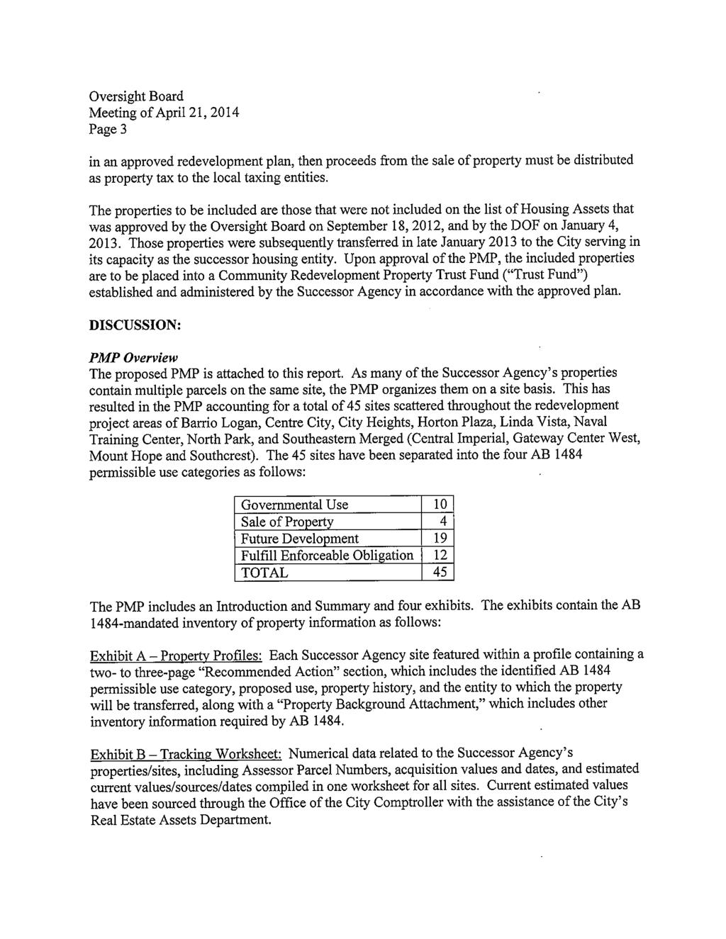
13 SUCCESSOR AGENCY PROPERTIES As many of the Successor Agency s properties contain multiple parcels on the same site, the PMP organizes them on a site basis. This has resulted in the PMP accounting for a total of 45 sites scattered throughout the redevelopment project areas of Barrio Logan, Centre City, City Heights, Horton Plaza, Linda Vista, Naval Training Center, North Park, and Southeastern Merged (Central Imperial, Gateway Center West, Mt. Hope and Southcrest). The 45 sites have been separated into the four AB 1484 permissible use categories as follows: Governmental Use: Governmental Use 10 Sale of Property 4 Future Development 19 Fulfill Enforceable Obligation 12 TOTAL 45 The following properties are recommended to be transferred to the City and held for their intended governmental use: Exhibit B Item # Property Name Project Area 1 Children's Park (including MLK, Jr. Promenade Frontage) Centre City 2 Chollas Creek Drainage Open Space 1 Southeastern Merged 3 Chollas Creek Drainage Open Space 2 Southeastern Merged 4 City Heights Square Mini-Park City Heights 5 G Street Remnants Centre City 6 Harbor Drive Pedestrian Bridge Landing Event Plaza Centre City 7 Horton Heirs Interests Centre City 8 MLK, Jr. Promenade (Bridgeworks/Hilton Hotel Frontage) Centre City 9 MLK, Jr. Promenade (Omni Hotel Frontage) Centre City 10 Morley Green Linda Vista The Governmental Use sites include various properties that are developed as public street and sidewalk segments, parks and open spaces, and open space included as part of channel improvements along Chollas Creek. Per AB 1484, the Successor Agency may transfer property to the appropriate public jurisdiction, which would retain the property for ongoing governmental use. In the case of the Successor Agency s Governmental Use sites, the PMP envisions that such sites will be transferred to the City for the continued use for which the existing improvements were constructed (streets, parks, flood control, etc.). In some cases, the City may be presently maintaining these sites or has entered into an agreement with an adjacent property owner to maintain them into the future, as is the case for many of the parks. Successor Agency Long Range Property Management Plan Page 6
14 Sale of Property: The following properties are recommended to be sold by the Successor Agency: Exhibit B Item # Property Name Project Area 11 Alpha Street/Keeler Court/Boston Avenue Remnant Parcels Southeastern Merged 12 Beta Street Remnant Parcel Southeastern Merged 13 Sixth Avenue Access Driveway (McGurck Building) Centre City 14 World Trade Center Garage Centre City The Sale of Property properties include four sites. Two of the sites (items 11 and 12) are small, remnant parcels remaining from Former RDA-managed developments in southeastern San Diego, and are located adjacent to public street rights-of-way within those projects. The parcels are too small (each 1,000 square feet or less in size and non-contiguous) and too narrow to have any practical development potential and will likely be offered for sale to interested neighboring property owners or the City for right-of-way or other public purposes. The third site (item 13) is located in downtown s Gaslamp Quarter and includes an easement for vehicular and pedestrian access to an adjacent property s loading dock and rear entrance. The easement accommodates a driveway and paving area that is built-out to the property s edges, and is effective in perpetuity. The easement, as well as the site s small size (approximately 2,000 square feet) and dimensions (20 feet wide by 100 feet long), would present a challenge to develop as a stand-alone project. Potential buyers could be adjacent property owners including the holder of the easement. The final Sale of Property site (item 14) is the former World Trade Center (WTC) parking garage with ground-level commercial space located in the downtown core. The garage was separated from the main WTC building that has been adaptively re-used as a permanent homeless housing and services center. The new center was determined to not require on-site parking, so the parking garage was not included in the project. The garage lacks access to elevators, exiting stairways and water that were housed in the main building, as well as a utility power source. The garage s entrance and floor-to-floor design does not meet current van height clearances for Title 24 accessibility, and its fireproofing contains asbestos. Prior to the Former RDA s acquisition of the combined property, the Centre City Development Corporation (now known as Civic San Diego or CivicSD ) retained a consultant on behalf of the Former RDA to analyze potential re-use scenarios for the parking garage as a stand-alone building or redevelopment project. The scenarios determined were: 1) upgrade the garage and its commercial space with an elevator and second stairway; 2) replace the garage with a new building with public parking and ground-floor retail; and, 3) replace the garage with a new mixed-use building with public parking, retail and hotel/office uses. All of the scenarios were determined to carry significant development costs related to the public parking use, ranging from $4,000,000 for scenario one to almost $16,000,000 for scenarios two and three. As a Sale of Property asset, the Successor Agency Long Range Property Management Plan Page 7
15 WTC parking garage would be offered for sale on the open market once the PMP receives final approval. In the case of the Sale of Property sites, the City, in its capacity as the Successor Agency, or its designee, would offer the properties for sale in accordance with required Successor Agency regulations and procedures. Any proceeds from the ultimate sale of the Sale of Property sites would be distributed to the taxing entities in accordance with AB It is worth noting that, based upon the condition and development potential of the Sale of Property sites, which are more fully explained for each property in their respective Property Profiles, even the best sale values that may be obtained for the sites are likely to be nominal. However, there will be positive fiscal benefits flowing to the taxing entities as the smaller sites are transferred from public to private ownership through their sales. In the case of the WTC garage, an asset that is currently incapable of producing revenues in its current state and public ownership, it is expected that substantial positive fiscal benefits to the taxing entities would result from any of the reuse or redevelopment scenarios that may occur on the property. The land beneath the garage is assumed to hold value as well. Successor Agency Long Range Property Management Plan Page 8
16 Future Development: The following properties are recommended for transfer to the City, to be held for future development purposes consistent with the applicable redevelopment, specific, community or general plans: Exhibit B Item # Property Name Project Area Linda Vista Road Linda Vista Linda Vista Road Linda Vista Cesar E. Chavez Parkway Barrio Logan 18 Cedar Gateway Historic Chapel Centre City 19 East Village Green East Block Centre City 20 East Village Green West Block Centre City 21 El Cajon Boulevard/I-15 Site City Heights 22 Fire Station No. 2 (Bayside) Site Centre City 23 Former Valencia Park Library Site Southeastern Merged 24 Gateway Center West Industrial (SR 94, Pickwick Southeastern Merged Avenue & 33rd Street) 25 Gateway Center West Industrial (SR 94, 35th Street & E Southeastern Merged Street) 26 Market Street Site - North Side Southeastern Merged 27 Market Street Site - South Side Southeastern Merged 28 North Park Gateway (Woolworth Building) North Park 29 North Park Mini-Park Site North Park 30 Renaissance at North Park Community Space North Park 31 Sally Wong Property City Heights 32 St. Joseph's Park Site Centre City 33 Two America Plaza Centre City The Future Development sites include several properties acquired for future development of public facilities, such as parks, a fire station and a community space, identified in the redevelopment plans, and/or latest five-year implementation plans, and/or applicable community plans of the various redevelopment project areas. Prior to adoption of the Dissolution Act, California Health and Safety Code Section required redevelopment agencies to adopt implementation plans for redevelopment project areas every five years. Implementation plans were utilized as policy and program documents, with goals and objectives of the agency for the project area and programs, potential projects and estimated expenditures to be made during the next five years, including an explanation on how these will eliminate blight and implement the low- and moderate-income housing requirements of California Community Redevelopment Law. The Future Development category also includes several sites throughout the City that were acquired by the Former RDA to implement economic development, small business, transit-oriented, historic Successor Agency Long Range Property Management Plan Page 9
17 preservation, educational, arts/culture, mixed-use and other public benefit projects in accordance with the various redevelopment and community plans. These sites are known as opportunity sites. In some cases, the opportunity sites were subject to previous requests for interest (RFIs) or RFPs, ENAs, and/or negotiated but not approved agreements (OPAs or DDAs) where developers were identified to move forward with projects envisioned in redevelopment and community plans, but were suspended due to the Dissolution Act. Most of the identified developers have indicated an interest in moving forward with their proposed developments. The Property Profiles provide information on proposed projects that were suspended, if applicable. In the case of the Successor Agency s Future Development sites, the PMP envisions that title to those properties will be transferred to the City in accordance with AB For future parks, the fire station and the community space, the City or its designee will finalize designs for these important public facilities and move forward to construct the projects when funding has been identified. The City or its designee will engage previously-identified developers to re-start their proposed development projects on opportunity sites generally at the place where they were put on hold. Other opportunity sites where projects had not been specifically scoped or developers identified will be subject to competitive bidding through RFIs or RFPs to ensure the best quality developments, development teams and disposition values. It is anticipated that the sites will be sold or leased to developers as part of the development process. In advance of issuing RFIs and RFPs for opportunity sites and designing proposed amenities such as parks, the City or its designee plans to extensively engage the communities in which the future development sites are located. Other broad-based organizations and initiatives, such as the City s new Civic Innovation Lab within the Planning, Neighborhoods & Economic Development Department, will be asked to collaborate with this process to seek out the brightest and most innovative ideas for developing the sites and activating surrounding environments in a manner consistent with the earlier plans that have qualified the opportunity sites for future development under AB Community input is essential to ensuring the future success of the projects envisioned for these sites. While awaiting use or disposition of Future Development sites, the City may grant temporary access and short-term use for special events and other interim uses as reasonable for the specific site and surrounding community. As with the Sale of Property sites, it is worth noting that the best sale values for most of the Future Development opportunity sites are likely to be nominal based upon their conditions and the costs of developing the sites into the projects envisioned within the respective redevelopment, implementation and community plans. However, there will be positive fiscal benefits flowing to the taxing entities as the sites are transferred from public to private ownership through their sales, as well as more substantial positive fiscal benefits to the taxing entities resulting from their future development and any associated increase in property and sales tax revenues. Successor Agency Long Range Property Management Plan Page 10
18 Fulfill Enforceable Obligation: The following properties are recommended to remain with the Successor Agency to honor enforceable obligations: Exhibit B Item # Property Name Project Area 34 6th & K Parkade Centre City 35 Balboa Theatre Horton Plaza 36 Chinese Historical Museum Site Centre City 37 Lyceum Theatre (Tenant Improvements) Horton Plaza 38 Naval Training Center (Liberty Station) Naval Training Center 39 North Park Garage North Park 40 Park-It-On-Market Centre City 41 Petrarca Site Southeastern Merged 42 Tailgate Park Centre City 43 Valencia Business Park Site Southeastern Merged 44 Walker Scott ("On Broadway" Project) Centre City 45 Horton Plaza Improvement Project Site Horton Plaza The Fulfill Enforceable Obligation sites include several properties that are being held for transfer to third parties under the terms of previously-approved agreements (OPAs, DDAs, loan agreements) or developed sites that are subject to long-term agreements, leases and bond indentures requiring that the current uses be maintained for the benefit of the public. Many of the latter types of Fulfill Enforceable Obligation properties are either public parking garages or cultural facilities such as performing arts venues and museums. The Successor Agency owns 54 properties within the Naval Training Center (NTC) project area (commonly known as Liberty Station and combined into one site for purposes of the PMP). All of the properties within NTC satisfy the conditions for the Fulfill Enforceable Obligation use category as they are either subject to the NTC DDA between the Former RDA and McMillin-NTC, LLC (the Master Developer) and/or to subsequent long-term leases. One site included in this use category is the Horton Plaza Improvement Plaza Site (item 45). The site is subject to an OPA ( Horton Plaza OPA ) entered into in January 2011 between its current owner, made up of several affiliates of the Westfield Corporation, and the Former RDA. The parties agreed through the Horton Plaza OPA that the current owner will transfer ownership of a portion of the Horton Plaza retail center (represented by the subject site) to the Former RDA for construction of an urban plaza that, once constructed, would be transferred to the City. The Horton Plaza OPA further requires the current owner to maintain and provide programming for the urban plaza for 25 years, with City oversight following the Former RDA s transfer of site ownership. The current owner s transfer of the site to the Former RDA, now the Successor Agency, occurred in February 2014 following written confirmation from DOF that the OPA has been deemed to be an enforceable obligation (in a DOF letter dated January 14, 2014). To ensure that the Successor Agency can fulfill the Former RDA s obligations per the Horton Plaza OPA, the site is included in Successor Agency Long Range Property Management Plan Page 11
19 the PMP with a recommendation that it remain with the Successor Agency in the short-term during the plaza s construction period, and then transferred to the City as directed in the Horton Plaza OPA for the long-term following completion of construction of the urban plaza. Details of the Former RDA s enforceable obligations and applicable contractual documents are included in the Property Profiles for each of these sites. The Successor Agency will retain ownership of the Fulfill Enforceable Obligation sites and be responsible for complying with the applicable enforceable obligations until they have been fulfilled, either through the transfer of the property to the contracted third party or management of the current use of the several publiclyaccessible facilities under the terms of their contractual documents. For sites awaiting use or disposition, or other scenario under which interim use is reasonable and compatible with the enforceable obligation, the Successor Agency may grant temporary access and short-term use for special events and other interim uses of Fulfill Enforceable Obligation sites. The Successor Agency will transfer certain Fulfill Enforceable Obligation sites to the City upon the eventual termination of the Successor Agency, or upon the expiration of the applicable redevelopment project area, whichever occurs earlier. The City, in its capacity as the Successor Agency, or its designee will manage and monitor the obligations in collaboration as necessary with City departments. Attached Exhibits: A Property Profiles B Tracking Worksheet C Maps of Successor Agency Real Properties by Former Project Areas D DOF Long-Range Property Management Plan Checklist Successor Agency Long Range Property Management Plan Page 12
20 ATTACHMENT 1 PROPERTY MANAGEMENT PLAN WITH EXHIBITS A-D
21
22 EXHIBIT A PROPERTY PROFILES Item AB 1484 Council Property Name No. Permissible Use Category District 1 Children's Park (including MLK, Jr. Promenade Frontage) Governmental Use 3 2 Chollas Creek Drainage Open Space 1 Governmental Use 4 3 Chollas Creek Drainage Open Space 2 Governmental Use 9 4 City Heights Square Mini-Park Governmental Use 9 5 G Street Remnants Governmental Use 3 6 Harbor Drive Pedestrian Bridge Landing Event Plaza Governmental Use 3 7 Horton Heirs Interests Governmental Use 3 8 MLK, Jr. Promenade (Bridgeworks/Hilton Hotel Frontage) Governmental Use 3 9 MLK, Jr. Promenade (Omni Hotel Frontage) Governmental Use 3 10 Morley Green Governmental Use 7 11 Alpha St/ Keeler Ct/ Boston Av Remnant Parcels Sale of Property 9 12 Beta Street Remnant Parcel Sale of Property 9 13 Sixth Avenue Access Driveway (McGurck Building) Sale of Property 3 14 World Trade Center Garage Sale of Property Linda Vista Road Future Development Linda Vista Road Future Development Cesar E. Chavez Parkway Future Development 8 18 Cedar Gateway Historic Chapel Future Development 3 19 East Village Green East Block Future Development 3 20 East Village Green West Block Future Development 3 21 El Cajon Boulevard/I-15 Site Future Development 9 22 Fire Station No. 2 (Bayside) Site Future Development 3 23 Former Valencia Park Library Site Future Development 4 24 Gateway Center West Industrial (SR 94, Pickwick Ave. & 33rd St.) Future Development 8 25 Gateway Center West Industrial (SR 94, 35th Street & E Street) Future Development 8 26 Market Street Site - North Side Future Development 9 27 Market Street Site - South Side Future Development 9 28 North Park Gateway (Woolworth Building) Future Development 3 29 North Park Mini-Park Site Future Development 3 30 Renaissance at North Park Community Space Future Development 3 31 Sally Wong Property Future Development 9 32 St. Joseph's Park Site Future Development 3 33 Two America Plaza Future Development th & K Parkade Fulfill Enforceable Obligation 3 35 Balboa Theatre Fulfill Enforceable Obligation 3 36 Chinese Historical Museum Site Fulfill Enforceable Obligation 3 37 Lyceum Theatre Tenant Improvements Fulfill Enforceable Obligation 3 38 Naval Training Center/Liberty Station Fulfill Enforceable Obligation 2
23 EXHIBIT A Item No. Property Name AB 1484 Permissible Use Category Council District 39 North Park Garage Fulfill Enforceable Obligation 3 40 Park-It-On-Market Fulfill Enforceable Obligation 3 41 Petrarca Site Fulfill Enforceable Obligation 8 42 Tailgate Park Fulfill Enforceable Obligation 3 43 Valencia Business Park Site Fulfill Enforceable Obligation 4 44 Walker Scott ("On Broadway" Project) Fulfill Enforceable Obligation 3 45 Horton Plaza Improvement Project Site Fulfill Enforceable Obligation 3
24 Government Use Items 1 10
25

 was first approved by the Former RDA in 1988 as a part of the downtown linear park project, a portion of which is now known as Martin")
26 CHILDREN S PARK (including MLK, Jr. Promenade Frontage) 420 First Avenue, 101 Island Avenue RECOMMENDED ACTION 1. AB 1484 Permissible Use Governmental Use Category 2. Proposed Use Continued use as a public neighborhood park 3. Property History/Previous Development Proposals and Activity, including the rental or lease of property The site is bounded by Front Street, First Avenue, Harbor Drive and Island Avenue. The concept of the Civic Pond (now known as Children s Park) was first approved by the Former RDA in 1988 as a part of the downtown linear park project, a portion of which is now known as Martin Luther King, Jr. (MLK, Jr.) Promenade. Originally, a hotel development known as Roger Morris Plaza was planned on the northern portion of the site and on the adjoining block to the north of Island Avenue. The hotel project was abandoned and subsequently the northern 35,000 square foot of the Children s Park site was acquired for park purposes. In 1995, City Council and the Former RDA approved resolutions makings findings and determinations in accordance with Health and Safety Code Sections 33445, and consenting to the payment by the Former RDA for the cost of the Children s Park improvements and the Former RDA s authorization to bid and award the project. The City Council resolution established parameters for maintenance of the improvements (see Section 4 below). The park was completed and opened to the public in 1996, and has been in continuous public use since that time. 4. Maintenance and Other Pertinent Agreement(s) Over the last several years, the community has requested that the Former RDA study enhancements to Children s Park to deter the moderate influx of transient and homeless occupation, mitigate the lack of daylight in the park due to the heavy canopy of the pine trees, and increase the use of the park by downtown residents, workers and visitors. In response, the Centre City Development Corporation (now Civic San Diego) commenced a revisioning process for the park in Future improvements discussed include adding a multi-purpose lawn area, play equipment, an interactive water feature, a vendor building with public restrooms, and movable tables and chairs, while improving pedestrian circulation throughout. Civic San Diego is hopeful that preparation of improvement plans will commence during FY 2015, as well as determining potential funding sources to construct improvements in future years. The subject property s maintenance is governed by the Operating and Management Agreement (OMA) between the City of San Diego and Downtown San Diego Partnership, Inc. 1
27 CHILDREN S PARK (including MLK, Jr. Promenade Frontage) 420 First Avenue, 101 Island Avenue Related to the Construction or Use (DSDP), dated April 4, 2005, with the following provisions: Term: continues until June 30, 2015 DSDP currently working toward renewal of Downtown Area Property and Business Improvement District (PBID) and a new OMA by termination date of this agreement As part of Exhibit A, City of San Diego Baseline Services, the City regularly cleans and maintains all public parks in the downtown area, including Children s Park, under the Park & Recreation Department As part of Exhibit B, DSDP Enhanced Services, the DSDP will contract for and oversee maintenance of the public water feature located in Children s Park; City agrees to contribute 50% of the contracted maintenance costs for Children s Park water feature 5. Property Transferee City of San Diego. Maintenance would continue as currently provided in the OMA. 2
28 CHILDREN S PARK (including MLK, Jr. Promenade Frontage) 420 First Avenue, 101 Island Avenue PROPERTY BACKGROUND ATTACHMENT A. Property Details 1. Worksheet Reference Number 1 2. Current Zoning/Land Use Designation MPDO/Hotel/Residential Mixed-Use/Open Space (Downtown/Centre City) (including Community Planning Area) 3. Former RDA Project Area Centre City 4. Current Use (include description of improvements) Land and park improvements constructed and used for public park and open space (neighborhood park) The park consists of the Civic Pond on the south side, which provides a water feature, fountain, crossing pedestrian paths and surrounding palm trees; and a green park on the north side, which consists of grass mounds amongst a decomposed granite walking surface, a sculptural stone wall, Canary Island pine trees and other landscaping. 5. Land Lot Size 60,566 SF 6. Year Park Improvements Built Purpose for Acquisition Construction of public park 8. Appraisal Information (if any) Memorandum from City of San Diego Real Estate Assets Department, October 31, 2013, regarding 2013 Comprehensive Annual Financial Report appraisals. Indicated that the subject property has a nominal value of $1.00 as an existing improved park. B. Property Revenues Estimate of any lease, rental or any other None revenues generated by the property C. Environmental History of environmental contamination, including designation as a brownfield site, any related environmental studies, and history of remediation efforts D. Reuse Assessment 1. Description of the property s potential for transit-oriented development 2. Description of the property s potential for advancement of the planning objectives of the Successor Agency Parcel 3: Removal of two underground tanks occurred in January 1989, just prior to property acquisition. Tanks were 2,000 gallons (previously used to store gasoline, but at the time of removal had been cleaned and used to store potable water for an air-conditioning system) and 7,500 gallons (used to store solvent) in size. As part of the tank removal, soil samples were taken. Results indicated no detectable levels of fuel hydrocarbons and other related hazardous materials. The work was conducted under permits from the County of San Diego Hazardous Materials Management Division, which reviewed a final report after removal of the tanks and indicated that no further investigative work was necessary. None. The property has been constructed as a permanent public park. As an existing neighborhood park, the subject property advances the San Diego Downtown Community Plan s goals and objectives related to parks, open space and recreation. The property is identified as an existing park in the Community Plan s Figure 4-1 and Table
29 THIS PAGE INTENTIONALLY LEFT BLANK 4


30 LONG RANGE PROPERTY MANAGEMENT PLAN CHOLLAS CREEK DRAINAGE OPEN SPACE 1 San Pascual Avenue and Ocean View Boulevard RECOMMENDED ACTION 1. AB 1484 Permissible Use Governmental Use Category 2. Proposed Use Continued use as a creek floodway and public open space 3. Project History/Previous Development Proposals and Activity, including the rental or lease of property Pursuant to City Council Resolution R and Agency Resolution R 03101, these three properties were necessary to be acquired in order to protect the homes along Ocean View Boulevard located in the 100 year flood plain of Las Chollas Creek; to construct channel improvements, including building a berm and installing landscaping and fencing along the rear portions of the Ocean View properties; and to provide the flood control improvements and open space restoration work subsequently completed by the Former RDA and City by its Capital Improvement Project (CIP) # , in The CIP project combined the creek channel improvements noted above with public improvements for the Imperial Marketplace project located to the north. The subject properties should have been transferred to the City with the adjacent larger Creek parcels that were transferred to the City for creek drainage and the open space parkland after flood control improvements were completed. 4. Maintenance and Other Pertinent Agreement(s) Related to the Construction or Use Former Redevelopment Agency Resolution R and City Council Resolution R Approved the expenditure of funds for acquisition of the properties in order to protect the homes along Ocean View Boulevard in the 100 year flood plain of Las Chollas Creek and to construct channel improvements, including building a berm and installing landscaping and fencing along Chollas Creek along the rear of the Ocean View properties Erreca s Inc., Contract Documents for Construction of Imperial Marketplace Public Improvements CIP , February 18, 2000 Schedule of Prices Bidding Sheet: Improvements associated with the construction of the channel P. A 2, Notice Inviting Bids: Construction of Imperial Marketplace Public Improvements, including channel improvements Sec. 9.4, Schedule of Values: includes Channel Improvements Attachment Updated Report of Geotechnical Investigation, CCA Southland, November 1, 1999, page 1: describes the grading plan including Las Chollas Creek Maintenance Governed By: Operation and Maintenance Manual Imperial Marketplace Flood Management Facilities South Las Chollas Creek Leveed Channel Between Ocean View Boulevard and Imperial Avenue (OMM), RBF Consulting, January 2004 P.1: City of San Diego shall be responsible for the operation, inspection and maintenance of the flood management facilities on South Las Chollas Creek between Ocean View Boulevard and Imperial Avenue Exhibit A, Levee Maintenance Reach: Identifies Leveed Reach and Site within levee area NOTE: Adjacent properties that make up the Chollas Creek floodway are under City of San Diego ownership 5. Property Transferee City of San Diego. Maintenance would be provided per the OMM as applicable. 1
31 THIS PAGE INTENTIONALLY LEFT BLANK 2
32 LONG RANGE PROPERTY MANAGEMENT PLAN CHOLLAS CREEK DRAINAGE OPEN SPACE 1 San Pascual Avenue and Ocean View Boulevard PROPERTY BACKGROUND ATTACHMENT A. Property Details 1. Worksheet Reference Number 2 2. Current Zoning/Land Use Designation (including Community SESDPD SF 5000 Residential/Residential (Southeastern San Diego Community, Mountain View Neighborhood) Planning Area) 3. Former RDA Project Area Central Imperial 4. Current Use Vacant land adjacent and within Chollas Creek; located within creek channel and used for flood control 5. Land Lot Size APN : 7,850 SF APN : 1,139 SF APN : 4,200 SF 6. Year Improvements Built Purpose for Acquisition To protect homes along Ocean View Boulevard from the 100 year flood, provide the flood control improvements and open space restoration work as authorized in Resolution R and R Appraisal Information (if any) Memorandum from City of San Diego Real Estate Assets Department, October 31, 2013, regarding 2013 Comprehensive Annual Financial Report appraisals. Indicated that the subject property has a nominal value of $1.00 as an existing improved public facility. B. Property Revenues Estimate of any lease, rental or any None other revenues generated by the property C. Environmental History of environmental The Former RDA does not have any environmental studies specific to this property. contamination, including designation as a brownfield site, any related environmental studies, and history of remediation efforts D. Reuse Assessment 1. Description of the property s potential for transit oriented development 2. Description of the property s potential for advancement of the planning objectives of the Successor Agency None. The property is within the Chollas Creek floodway and will be utilized as part of the creek channel on a permanent basis. As an existing flood control area and open space restored creek within the Chollas Creek floodway and utilized as part of the creek channel on a permanent basis, the Property advances the goals and objectives of the following plans: Southeastern San Diego Community Plan P. 141, Drainage / Flood Objective: Protect property from flooding while retaining the natural appearance of drainage areas to the extent feasible. P. 141, Drainage/Flood Recommendations: Flood control should be provided which ensures the safety of structures and through the use of natural and/or landscaped facilities. P. 217, Vacant Parcels: Describes the drainage channel and area along Ocean View Boulevard have been dedicated as open space, and a linear park along Chollas Creek should be developed to create part of a larger community linkage to the Educational Cultural College on the south and Jackie Robinson YMCA to the north P. 223, Figure 32, Existing Land Use: Site is included in the OS Open Space designation Chollas Creek South Branch Implementation Program The Chollas Creek Enhancement Program identifies the South Branch for Phase I implementation for wetland restoration and rehabilitation, The purpose is to enhance water quality and the quality of wetland resources associated with this urban creek and create a setting for quality 3
33 LONG RANGE PROPERTY MANAGEMENT PLAN CHOLLAS CREEK DRAINAGE OPEN SPACE 1 San Pascual Avenue and Ocean View Boulevard urban development, redevelopment, flood management, and the preservation of open space and natural resources. The overall goal of Phase I is to improve environmental or economic conditions within the central San Diego communities and establish a stable, healthy and sustainable creek environment. P. 6, Phases of Development Map: Site is included in Phase I and Creek Segment 6 P. 9, Chollas Creek South Branch Phase I Areas Map: Site is included in Phase I area P. 22, Enhancement Areas Map: Site is included in EA4 Enhancement Area P. 27, South Branch Proposed Management and Enhancement Projects Map: Site is included in Habitat Restoration or Rehabilitation area P. 49, Imperial Marketplace Segment 6: This project will incorporate flood control along Chollas Creek with landscaping improvements to create a park like area along the creek; specific improvements include the creation of 2.71 acres of flood channel with the reconstructed creek, and planting native vegetation. 4


34 CHOLLAS CREEK DRAINAGE OPEN SPACE 2 38 th Street and Alpha Street RECOMMENDED ACTION 1. AB 1484 Permissible Use Category Governmental Use 2. Proposed Use Continued use as a creek floodway and public open space 3. Project History/Previous Development Proposals and Activity, including the rental or lease of property 4. Maintenance and Other Pertinent Agreement(s) Related to the Construction or Use 5. Property Transferee City of San Diego This is a left over remnant of a total 66-acre vacant land area acquired from Caltrans that it had cleared for the SR252 Highway, including the creek channel. The community protested, the highway was rescinded, and the 66 acres of property was acquired by the Agency for redevelopment with homes, commercial, retail, schools, parks, streets and infrastructure. After acquisition of the entire 66 acres from Caltrans in 1986, the Agency entered into separate development agreements for development of residential, school, parks, commercial, offices, community center and new streets. Subdivision maps were prepared and property transferred to developers and City in phases. This parcel was inadvertently overlooked as part of transfers to City for streets and creek drainage. None. Property is located within the Chollas Creek floodway and utilized as part of the creek channel on a permanent basis. 1
35 CHOLLAS CREEK DRAINAGE OPEN SPACE 2 38 th Street and Alpha Street PROPERTY BACKGROUND ATTACHMENT A. Property Details 1. Worksheet Reference Number 3 2. Current Zoning/Land Use Designation (including Community Planning Area) SESDPD-SF-2500 Southeastern Planned District Residential SF/ Residential du/ac (Southcrest Neighborhood of the Southeastern San Diego Community Plan) 3. Former RDA Project Area Southcrest 4. Current Use Creek Channel and top of creek slope 5. Land Lot Size 13,431 square feet 6. Year Improvements Built Unknown; sometime prior to Caltrans acquisition and Agency acquisition from Caltrans. 7. Purpose for Acquisition Along with the 66 acres of the Caltrans rescinded SR252 highway, the property was acquired for redevelopment with homes, commercial, retail, schools, parks, streets and infrastructure. This remnant property was channelized creek drainage and has remained in the same condition as it was when it was acquired. 8. Appraisal Information (if any) Memorandum from City of San Diego Real Estate Assets Department, October 31, 2013, regarding 2013 Comprehensive Annual Financial Report appraisals. Indicated that the subject property has a nominal value of $1.00 as an existing improved public facility. B. Property Revenues Estimate of any lease, rental or any other None revenues generated by the property C. Environmental History of environmental contamination, The former RDA does not have any environmental studies specific to this property. including designation as a brownfield site, any related environmental studies, and history of remediation efforts D. Reuse Assessment 1. Description of the property s potential None. The property is within the Chollas Creek floodway and will be utilized as part of the for transit-oriented development creek channel on a permanent basis. 2. Description of the property s potential for advancement of the planning objectives of the Successor Agency As an existing flood control area and open space restored creek within the Chollas Creek floodway and utilized as part of the creek channel on a permanent basis, the Property advances the goals and objectives of the following plans: Southeastern San Diego Community Plan P. 141 Drainage / Flood Objective: Protect property from flooding while retaining the natural appearance of drainage areas to the extent feasible. P. 141 Drainage/Flood Recommendations: Flood control should be provided which ensures the safety of structures and through the use of natural and/or landscaped facilities. P.230 Open Space: the SR252 corridor offers the opportunity to develop open space from Southcrest Park extending along the Chollas Creek channel all the way to I-5 (this includes this site). Encroachment into the flood channel should be avoided to maintain open space corridor. Recommends 11-foot dedication on the north of the existing channel for passive use. Chollas Creek South Branch Implementation Program The Chollas Creek Enhancement Program identifies the South Branch for Phase I implementation for wetland restoration and rehabilitation. The purpose is to enhance water quality and the quality of wetland resources associated with this urban creek and creates a setting for quality urban development, redevelopment, flood management, and the preservation of open space and natural resources. Site is included in Maps on P.iii, Restoration and Rehabilitation of Natural Habitat Areas; P.6,Phases of Development and Phase I Creek Segment 8; P 9, Chollas Creek South Branch Phase I Areas Map: P.55, Southcrest 252 Corridor Segment 8: The channel in this reach was constructed in The area was acquired by the State prior to 1960 and cleared for proposed SR 252 freeway, canceled in late 1970 s. 2


 was acquired by the Former Agency in February 2006.")
, La Maestra Family Clinic, Inc.")
36 LONG RANGE PROPERTY MANAGEMENT PLAN CITY HEIGHTS SQUARE MINI PARK 4300 Block of 43 rd Street (East Side), between University and Polk Avenues City Heights Square Projects Senior Housing Project 31,246 SF Mini Park Park 5,348 SF La Maestra Family Clinic 25,947 SF Price Charities Residential/Retail Project 61,922 SF RECOMMENDED ACTION 1. AB 1484 Permissible Use Category Governmental Use 2. Proposed Use Continued use as a public neighborhood mini park 3. Property History/Previous Development Proposals and Activity, including the rental or lease of property In 2005, the Former RDA and San Diego Revitalization Corporation (now Price Charities or Developer ) entered in a Disposition and Development Agreement (DDA) which promoted the development of a four story, 90,000 SF office and retail building as part of a master plan development on the City Heights block bounded by University Avenue, Fairmount Avenue, Polk Avenue and 43 rd Street. The master plan also includes an affordable senior housing project provided by Chelsea Investment Corporation and Senior Community Centers, and a new community clinic/office/retail building by the La Maestra Family Clinic. The final component of the master plan is an approximately 5,400 square foot pocket park to be located between the office/retail building and the senior housing development on 43 rd Street. Pursuant to the DDA, the Developer would convey the park site to the Former RDA with the requirement that the Former RDA or the City of San Diego develop the site as a public park, and it would be conveyed to the City upon completion. The park site (subject property) was acquired by the Former Agency in February The DDA also required the Developer to enter into a Grant of Maintenance and Operations Easement and Agreement ( Maintenance Agreement ) with City Heights Square, L.P. (developer of the senior housing project), La Maestra Family Clinic, Inc. (developer of the community clinic), and the City or Former RDA, to provide for the maintenance and operation of the park. The City Heights Square Planned Development Permit, approved in 2008, also requires that the Developer enter into an agreement to provide maintenance and operations for the public park in perpetuity pursuant to the DDA. The Maintenance Agreement was executed in April Design of the park involved the collaboration of the local Recreation Council, City Heights Area Planning Committee and the City Heights Redevelopment PAC. The General Development Plan for the park was approved in April 2010, and identifies the park improvements to include 1
37 LONG RANGE PROPERTY MANAGEMENT PLAN CITY HEIGHTS SQUARE MINI PARK 4300 Block of 43 rd Street (East Side), between University and Polk Avenues walkways, landscaping, lighting, seating, picnic tables, and public right of way improvements such as sidewalk, parking signs, street lights, and associated landscaping. 4. Maintenance and Other Pertinent Agreement(s) Related to the Construction or Use Construction of the park improvements was held until completion of construction of the underground parking for the adjacent three projects. Park construction was completed in October 2013, and following a 90 day landscape maintenance period, the park opened to the public in February The subject property s maintenance is governed by the Grant of Maintenance and Operations Easement and Agreement between the City of San Diego ( Grantor ) and City Heights Realty, LLC, City Heights Square, L.P., and La Maestra Family Clinic, Inc. ( Grantees ), dated April 7, 2010, with the following provisions: Grantees shall have sole responsibility for repair and maintenance of the park and responsible for all costs and expense associated with the maintenance and operations of the park including water, power, electric and other utility expenses and all required repairs and replacement work. Grantees obligation to operate and maintain the subject property shall be limited to $7,500 per year, for 10 years, subject to an annual increase of 2% and exclusive of any utility costs. At the expiration of the 10 year term, Grantees maintenance obligation shall not exceed the average rate of expense by the City for maintenance of like property under existing City standards for parks. The subject property includes the following easements and encroachments: Grant of Temporary Easement and Remaining Encroachment and Agreement between the Agency and the Developer, May 11, 2010, to accommodate a permanent underground encroachment for a tie back system. Grant of Easement and Agreement between the Agency and La Maestra Family Clinic, Inc., January 22, 2008, to accommodate a storm drain. The Former RDA and City of San Diego entered into a Cooperation Agreement for Design and Construction of City Heights Square Mini Park in February 2010, to set forth a mutual agreement in connection to the Former RDA s transfer of fee title of the subject property and the City s acceptance of fee title to the property, by Grant Deed upon the City s completion of the park construction. 5. Property Transferee City of San Diego. Maintenance would continue as currently provided in the Maintenance Agreement. 2
38 LONG RANGE PROPERTY MANAGEMENT PLAN CITY HEIGHTS SQUARE MINI PARK 4300 Block of 43 rd Street (East Side), between University and Polk Avenues PROPERTY BACKGROUND ATTACHMENT A. Property Details 1. Worksheet Reference Number 4 2. Current Zoning/Land Use Designation Central Urbanized Planned District Commercial Zone (CUPD CU 2 5) (City Heights) (including Community Planning Area) 3. Former RDA Project Area City Heights 4. Current Use (include description of improvements) Land and improvements under construction and to be used as a public mini park. The park will consist of walkways, landscaping, irrigation, security lighting, seating, picnic tables, a gate, public art, and public right of way improvements including sidewalks, street lights, and associated landscaping. 5. Land Lot Size 5,348 SF 6. Year Park Improvements Built Purpose for Acquisition Construction of a public mini park as part of a master planned, mixed use development per a DDA 8. Appraisal Information (if any) Memorandum from City of San Diego Real Estate Assets Department, October 31, 2013, regarding 2013 Comprehensive Annual Financial Report appraisals. Indicated that the subject property has a nominal value of $1.00 as an existing improved park. B. Property Revenues Estimate of any lease, rental or any other None revenues generated by the property C. Environmental History of environmental contamination, including designation as a brownfield site, any related environmental studies, and history of remediation efforts D. Reuse Assessment 1. Description of the property s potential for transit oriented development 2. Description of the property s potential for advancement of the planning objectives of the Successor Agency A Letter Report of the Phase I Environmental Site Assessment for the Property Located at 4302 and 4332 University Avenue, dated December 19, 2000, was prepared by Environmental Business Solutions. This report focused on the property immediately to the south of the mini park site. While lead impacted soils and petroleum hydrocarbon contamination were identified on the property immediately to the south of the mini park site, the Phase I ESA indicated that there was a low likelihood that the property to the south had recognized environmental conditions from an off site source (which would include the mini park site). No additional investigation or remediation has been performed by the Former RDA at the mini park site. None. The property is being constructed as a permanent public park. The Mid City Communities Plan, which includes City Heights, recommends that new and expanded park facilities be added to the communities as it is grossly deficient in park acreage, especially in the older neighborhoods generally west of 54 th Street which includes the subject property. The plan recommends that new park facilities should be provided, including mini parks at scattered locations to help meet park acreage standards. A total of acres of mini parks are recommended for City Heights at unidentified locations. The City Heights Square Mini Park is part of a major mixed use redevelopment project that will advance the planning objectives of the community plan for the City Heights area, especially in relation to provision of parkland. 3
39 THIS PAGE INTENTIONALLY LEFT BLANK 4

.")
40 G STREET REMNANTS South side of G Street between Union & Front Streets; Southeast Corner of G and Columbia Streets RECOMMENDED ACTION 1. AB 1484 Permissible Use Category Governmental Use 2. Proposed Use Continued use as public sidewalks/rights-of-way 3. Property History/Previous Development Proposals and Activity, including the rental or lease of property 1 The subject properties are leftover remnants of larger properties sold by the Former RDA in the 1980s in conformance with disposition and development agreements (DDAs). The first remnant is a four (4)-foot-wide strip of sidewalk that runs along the entire length of the south side of G Street between Union and Front Streets. In 1985, the Former RDA entered into a DDA with Meric, National and Halenza Partners ( 600 Front Developer ) to purchase and develop the larger Agency-owned block of land bounded by G, Front, Market and Union streets for construction of a residential project, now known as 600 Front Street. The Former RDA retained ownership of the northerly four (4) feet of the block for future street widening or wider sidewalks along G Street. The DDA s Scope of Development required that the 600 Front Developer observe a four (4)-foot setback from G Street. Per the DDA s Scope of Development, the 600 Front Developer was responsible for construction of the public off-site improvements (sidewalks, street landscaping and grates, irrigation, street lights, etc.), some of which are now located within the subject remnant property. The second remnant is a four (4)-foot-wide strip of sidewalk that runs along the south side of G Street starting at Columbia and going east for one-half block. In 1987, the Former RDA entered in a DDA with Columbia Place ( CP Developer ), to purchase and develop the larger Agency-owned site within
41 G STREET REMNANTS South side of G Street between Union & Front Streets; Southeast Corner of G and Columbia Streets the block bounded by G, State, Market and Columbia streets for construction of a residential project, now known as Columbia Place. The Former RDA retained ownership of the northerly four (4) feet of the site s northern side to permit future street widening or wider sidewalks along G Street. The DDA s Scope of Development required that the Developer observe a four (4)-foot setback from G Street. Per the DDA s Scope of Development, the Former RDA was responsible for construction of the public off-site improvements (sidewalks, street landscaping and grates, irrigation, street lights, etc.), some of which are now located within the subject remnant property. 4. Maintenance and Other Pertinent Agreement(s) Related to the Construction or Use After construction of the respective public improvements, it appears that the Former RDA retained ownership of these remnant properties as opposed to more typically transferring them to the City of San Diego. Disposition and Development Agreement between the Redevelopment Agency of the City of San Diego and Meric, National and Halenza Partners, June 11, 1985 Disposition and Development Agreement between the Redevelopment Agency of the City of San Diego and Columbia Place, May 19, Property Transferee City of San Diego 2
42 G STREET REMNANTS South side of G Street between Union & Front Streets; Southeast Corner of G and Columbia Streets PROPERTY BACKGROUND ATTACHMENT A. Property Details 1. Worksheet Reference Number 5 2. Current Zoning/Land Use Designation (including MPDO/Residential Mixed-Use (Downtown/Centre City) Community Planning Area) 3. Former RDA Project Area Centre City 4. Current Use (include description of improvements) Land and improvements constructed and used for public sidewalks and rights-of-way The improvements consist of a four-foot strip of sidewalk. 5. Land Lot Size : 401 SF : 392 SF 6. Year Improvements Built Late 1980s 7. Purpose for Acquisition Future redevelopment of downtown s Marina District with residential uses, with the intent to retain property needed for streets, sidewalks and other public improvements 8. Appraisal Information (if any) Memorandum from City of San Diego Real Estate Assets Department, October 31, 2013, regarding 2013 Comprehensive Annual Financial Report appraisals. Indicated that the subject property has a nominal value of $1.00 as an existing public facility. B. Property Revenues Estimate of any lease, rental or any other revenues generated None by the property C. Environmental History of environmental contamination, including designation The Former RDA does not have any environmental studies as a brownfield site, any related environmental studies, and specific to this property. history of remediation efforts D. Reuse Assessment 1. Description of the property s potential for transitoriented development None. The property has been constructed as permanent public improvements and holds no development potential. 2. Description of the property s potential for advancement of the planning objectives of the Successor Agency As existing public improvements that provide a consistent width of sidewalk in the Marina District, the subject property advances the San Diego Downtown Community Plan s goals and objectives related transportation, urban design and neighborhoods. Wider sidewalks are encouraged throughout downtown where feasible to encourage alternative transportation such as walking and to provide an overall pedestrian-oriented environment. 3
43 THIS PAGE INTENTIONALLY LEFT BLANK 4
 was designed to be located partially on the subject property, which had been acquired by the")
 to connect to the MTS 12 th & Imperial trolley station.")
44 HARBOR DRIVE PEDESTRIAN BRIDGE LANDING EVENT PLAZA RECOMMENDED ACTION 1. AB 1484 Permissible Use Category Governmental Use 2. Proposed Use Continued use as a public event plaza 3. Property History Summary The northern ground landing of the Harbor Drive Pedestrian Bridge ( ped bridge ) was designed to be located partially on the subject property, which had been acquired by the Former RDA in the early 2000s as part of the overall development of PETCO Park. Part of subject property was formerly Ninth Avenue right-of-way abandoned as part of the development. The subject property was envisioned as part of the eastward extension of downtown s linear park project (MLK, Jr. Promenade) to connect to the MTS 12 th & Imperial trolley station. In 2004 and 2006, the City of San Diego and the owner/developer of the adjacent property (which became known as the Ballpark Village mixed-use project) entered into a landscape maintenance agreement (LMA) and Owner Participation Agreement (OPA) whereby the developer would design, install and maintain the linear park improvements when constructed in the future. Included in the developer s scope of installation and maintenance responsibilities is the ped bridge s Event Plaza ( plaza ), where the ped bridge s northern landing was located to connect to the linear park extension. In accordance with the OPA, the developer paid for the cost of the plaza improvements and the Former RDA constructed them as part of the ped bridge project. The Former RDA agreed to construct the ped bridge using various sources of local, state and federal funds and private contributions. In May 2008, the City of San Diego agreed to accept the future conveyance of the subject property and all ped bridge project improvements upon completion by the Former RDA through Ordinance No. O In late 2008, the City agreed to provide construction oversight as the ultimate owner and maintenance provider for the ped bridge through a memorandum of understanding (MOU) with the Former Agency and the former Centre City Development Corporation (now Civic San Diego). The MOU also reiterated the parties understanding that the City would take ownership of the ped bridge and subject property and maintain the bridge once completed. The Former RDA completed construction of the ped bridge and plaza in March
45 HARBOR DRIVE PEDESTRIAN BRIDGE LANDING EVENT PLAZA While City accepted ownership and maintenance responsibility for the ped bridge at the project s completion, the transfer of the subject property was pending at the time AB 26 was executed in June With the California Supreme Court s decision to uphold AB 26 in late 2011, the transfer of the subject property has been on hold since that 4. Maintenance and Other Pertinent Agreement(s) Related to the Construction or Use time. The subject property s maintenance is governed by the Landscape Maintenance Agreement (LMA) between the City of San Diego and JMIR Downtown Acquisition, LLC ( Contractor ), dated January 28, 2004, with the following provisions: Term: obligations expire 30 years after the date the Contractor proceeds with maintenance obligations after installation of the improvements Contractor shall, at its own costs and expense, maintain, repair and replace all the park improvements covered by this Agreement to the reasonable satisfaction of the City Contractor shall pay for all utilities (water, electricity, etc.) Contractor shall be obligated to restore and/or replace, at its own cost and expense, any park improvements (other than art objects) damaged or destroyed from any cause whatsoever Redevelopment Agency Resolution R-04277, May 19, 2008 Agency authorized the conveyance of the Agency-owned property and all ped bridge improvements to the City upon completion, and recommended that the City adopt a maintenance ordinance to authorize the future maintenance of the project improvements. City Council Resolution R , May 19, 2008 City agreed to accept the future conveyance of the Former RDA-owned property (the subject property) and all ped bridge project improvements upon completion City Ordinance No. O-19755, May 30, 2008 Approved the City s acceptance of ownership of the ped bridge and ped bridge project improvements upon its completion from the Former RDA, as well as the City s acceptance of maintenance obligations An annual expenditure of an amount not to exceed $40,000 (with CPI adjustments annually) is authorized solely and exclusively to provide funds from the City for the maintenance and operation Memorandum of Understanding (MOU) Regarding the Construction of the Pedestrian Bridge Crossing Harbor Drive between the City of San Diego, the Redevelopment Agency of the City of San Diego and the Centre City Development Corporation, December 2, 2008 Parties agreed that the Former RDA would provide project funding, and that the City shall take ownership of the ped bridge and subject property and be responsible for maintaining the ped bridge once completed 5. Property Transferee City of San Diego. Maintenance would continue as currently provided in the LMA. 2
46 HARBOR DRIVE PEDESTRIAN BRIDGE LANDING EVENT PLAZA PROPERTY BACKGROUND ATTACHMENT A. Property Details 1. Worksheet Reference Number 6 2. Current Zoning/Land Use Designation Ballpark Mixed-Use (Downtown/Centre City) (including Community Planning Area) 3. Former RDA Project Area Centre City 4. Current Use (include description of improvements) Land and improvements constructed and used for a public event plaza and northern landing for ped bridge The plaza consists of flat hardscape finishes, trees, landscaping, bollards, ped bridge elevators, and lighting. 5. Land Lot Size 7,623 SF 6. Year Plaza Improvements Built Purpose for Acquisition Construction of park improvements for extension of linear park 8. Property History/Previous Development Proposals and Activity, including the rental or lease of property With the construction of PETCO Park in downtown San Diego, the Eighth Avenue atgrade crossing centerline was adjusted 70 feet on the north side of the rail crossing to accommodate the new Park Boulevard. In response, the California Public Utilities Commission (PUC) closed the crossing. Through court action brought by the City of San Diego to re-open the crossing, the PUC issued a Final Order that the City would be allowed to open Park Boulevard to cross the rail tracks if pedestrian access was grade separated. This led to the construction of ped bridge. The northern ground landing of the ped bridge was designed to be located partially on the subject property, which had been acquired by the Former RDA in the early 2000s as part of the overall development of PETCO Park. Part of subject property was formerly Ninth Avenue right-of-way abandoned as part of the development. The subject property was envisioned as part of the eastward extension of downtown s linear park project (MLK, Jr. Promenade) to connect to the MTS 12 th & Imperial trolley station. In 2004, the City of San Diego and the owner of the adjacent property (which became known as the Ballpark Village project) entered into a landscape maintenance agreement (LMA) to maintain the anticipated linear park improvements when constructed in the future. In 2006, the Former RDA and Ballpark Village developer entered into an Owner Participation Agreement (OPA) whereby the developer would be responsible to design and install the linear park improvements and maintain of them in accordance with the LMA. Included in the developer s scope of installation and maintenance responsibilities is the ped bridge s Event Plaza ( plaza ). The ped bridge was designed and located so that its north landing would connect to the linear park at the event plaza. In accordance with the OPA, the developer paid for the cost of the plaza improvements and the Former RDA constructed them as part of the ped bridge project. An access easement for the Ballpark Village project is accommodated within the event plaza design. The Former RDA agreed to fund construction of the ped bridge improvements along with various other sources of local, state and federal funds and private contributions. It also agreed to manage the design, bid/award and construction phases of the project. In 2008, the City agreed to accept the future conveyance of the subject property and all ped bridge project improvements upon completion by the Former RDA through Ordinance No. O (dated May 30, 2008). An annual expenditure of an amount not to exceed $40,000 (with CPI adjustments annually) is 3
47 HARBOR DRIVE PEDESTRIAN BRIDGE LANDING EVENT PLAZA authorized solely and exclusively to provide funds from the City for the maintenance and operation of the Project, as long as the Project exists. The City agreed to provide construction oversight as the ultimate owner and maintenance provider for the ped bridge through a memorandum of understanding (MOU) with the Former Agency and the former Centre City Development Corporation (now Civic San Diego) in late The parties also agreed through the MOU that the City would take ownership of the ped bridge and subject property and reiterated its maintenance responsibility. The ped bridge and plaza were completed in March While City accepted ownership and maintenance responsibility for the ped bridge at the project s completion, the transfer of the subject property was pending at the time AB 26 was executed in June With the California Supreme Court s decision to uphold AB 26 in late 2011, the transfer of the subject property has been on hold since that time. 9. Appraisal Information (if any) Memorandum from City of San Diego Real Estate Assets Department, October 31, 2013, regarding 2013 Comprehensive Annual Financial Report appraisals. Indicated that the subject property has a nominal value of $1.00 as an existing improved park. B. Property Revenues Estimate of any lease, rental or any other None revenues generated by the property C. Environmental History of environmental contamination, including designation as a brownfield site, any related environmental studies, and history of remediation efforts The property is impacted with petroleum hydrocarbons, elevated levels of lead, burn ash, and waste products from historical San Diego Gas & Electric operations. Remediation of contamination on the subject parcel in order to complete the ped bridge project was completed in conjunction with construction of the bridge from September 2008 through March A Project Closeout Report, dated October 30, 2009, and an Addendum to the Project Closeout Report, Harbor Drive Pedestrian Bridge, prepared by Ninyo & Moore in March 2012, documented the removal of contaminated soil in order to complete the project. D. Reuse Assessment 1. Description of the property s potential for transit-oriented development 2. Description of the property s potential for advancement of the planning objectives of the Successor Agency A Letter from County of San Diego Department of Environmental Health (DEH), dated November 14, 2012, provided case closure and no further action, acknowledging that soil and hazardous waste management activities had been performed as part of construction of the ped bridge project. Subsurface soil at the property and groundwater are likely still impacted with residual hydrocarbons and potentially other waste products. None. The property has been constructed as a permanent public plaza. As an existing public plaza, the subject property advances the San Diego Downtown Community Plan s goals and objectives related to parks, open space and recreation. In particular, the plaza serves as a smaller public open space area, but is also the first segment constructed to extend the downtown linear park east of Park Boulevard. The plaza s connection to the ped bridge also links the linear park south to the San Diego Bay waterfront and its series of parks and open space. 4


48 HORTION HEIRS INTERESTS Various Locations; Generally East of Front Street & West of 15 th Street in Downtown San Diego RECOMMENDED ACTION 1. AB 1484 Permissible Use Category Governmental Use 2. Proposed Use Continued use as interests/reversionary rights in real property subject to public easements or the public rights-of-way in certain streets in downtown San Diego 3. Project History Summary In the mid 1800 s Alonzo Horton purchased a large tract of land now known as downtown San Diego. When Horton recorded a map of the area, subdividing it into streets, blocks and lots, he retained ownership of the land in many of the street areas subject to their reserved use as streets. He also conveyed street areas to others who recorded the same interest. Although they are ancient, these recorded interests remain valid to the present. The reserved interests in the streets are piecemeal. In some street segments, the owner of the adjacent property is the record owner of the street to its centerline, subject to an easement for public street use. As development was ramping up in the downtown area in the late 1990s and more and more developments were seeking to encroach into streets for efficient underground parking layouts, the Former RDA decided to acquire the street interests to eliminate fragmented ownership of the existing streets so as to encourage orderly development. Acquisition would also clear title on various parcels within public rights-of-way throughout downtown, thereby eliminating potential conflicts for future property development. In its efforts to acquire the interests, the Former RDA initiated condemnation proceedings in The Former RDA made offers to purchase the property interests to the known heirs of Horton and other descendents of original property owners. The patchwork of affected parcels are scattered throughout the former Centre City project area and are generally east of Front Street and west of 15 th Street, with the majority being located within the Marina and East Village districts. 1
49 HORTION HEIRS INTERESTS Various Locations; Generally East of Front Street & West of 15 th Street in Downtown San Diego Following a series of trials, a large majority of the interests were successfully acquired through a combined settlement or quitclaim deeds (96% of cases), while others were acquired through final orders of condemnation in the case where heirs could not be located or were unresponsive to offers or notices related to the condemnation proceedings (4% of cases). 4. Property Transferee City of San Diego 2
50 HORTION HEIRS INTERESTS Various Locations; Generally East of Front Street & West of 15 th Street in Downtown San Diego PROPERTY BACKGROUND ATTACHMENT A. Property Details 1. Worksheet Reference Number 7 2. Current Zoning/Land Use Designation (including Community Planning Area) Zoning/land use designation consistent with immediately adjacent private property for each street segment, although there appear to be no particular development rights associated with the segments as they currently are subject to easements for use as public streets (Downtown/Centre City) 3. Former RDA Project Area Centre City 4. Current Use (include description of improvements) A patchwork of rectangular land parcels scattered throughout the former Centre City project area that carry interests/reversionary rights in real property subject to public easements or the public rights-of-way in certain streets in downtown San Diego The subject properties are encumbered by public streets, sidewalks, utilities, and various easements and prescriptive rights (including encroachments of private underground garages and basements). 5. Land Lot Size Various locations; an actual determination of the total lot size of all locations is unavailable 6. Purpose for Acquisition Clear title on various parcels within public rights-of-way throughout downtown; eliminate fragmented ownership of the existing streets to encourage orderly development 7. Appraisal Information (if any) Memorandum from City of San Diego Real Estate Assets Department, October 31, 2013, regarding 2013 Comprehensive Annual Financial Report appraisals. Indicated that the subject property has a nominal value of $1.00 as existing improved public facilities. B. Property Revenues Estimate of any lease, rental or any other None revenues generated by the property C. Environmental History of environmental contamination, including designation as a brownfield site, any related environmental studies, and history of remediation efforts D. Reuse Assessment 1. Description of the property s potential for transit-oriented development 2. Description of the property s potential for advancement of the planning objectives of the Successor Agency An Appraisal of Horton Heirs Interests in Streets 4% Undivided, Jones, Roach & Caringella, Inc., March 15, 2002, indicated in its analysis that the downtown area has current and historical uses commonly associated with hazardous waste/chemical contamination. Surface soil and groundwater in the downtown area is often impacted with petroleum hydrocarbons, burn ash and elevated levels of metals. To the extent that the properties continue in their current use, it is unlikely that remediation of these surface soils will be required. If these properties are redeveloped for different uses, investigation and remediation could be required. None. The subject properties have been constructed as permanent public improvements and hold no development potential as they currently are subject to easements for use as public streets. As properties that support existing public improvements that provide vital infrastructure to downtown neighborhoods, the subject sites advance the objectives of the San Diego Downtown Community Plan to provide an environment that encourages orderly growth and economic development of the area. 3
51 THIS PAGE INTENTIONALLY LEFT BLANK 4


52 MLK, JR PROMENADE (BRIDGEWORKS/HILTON HOTEL FRONTAGE) 402 K Street, 268 Fourth Avenue RECOMMENDED ACTION 1. AB 1484 Permissible Use Category Governmental Use 2. Proposed Use Continued use as a public neighborhood park 3. Property History/Previous Development Proposals and Activity, including the rental or lease of property The subject property is a part of downtown San Diego s linear park, and within a portion known as the MLK, Jr. Promenade. The linear park was conceptually envisioned in the 1980 s as redevelopment was beginning to transform the Columbia, Marina and Gaslamp neighborhoods and MTS planned to extend the trolley along Harbor Drive to serve the Convention Center and Seaport Village. The Former RDA sought to acquire excess property along the downtown railroad tracks to create a pedestrian park amenity that would link the neighborhoods together. As private developments were anticipated to be developed adjacent to the linear park, the Former RDA worked with developers to incorporate the park s design into new projects and require those developers and projects to maintain the park improvements through landscape maintenance agreements (LMAs) with the City of San Diego. The subject site was formed from vacated public right-of-way from Fourth Avenue, excess railroad property purchased by the Former RDA in 1989, and property from an adjacent owner purchased by the Former RDA in The linear park master plan envisioned a larger open space between Third and Fourth avenues and K Street to be connected with pedestrian path improvements already constructed adjacent to the Harbor Club condominium project to the northwest. The subject site would allow the linear park to extend to the southeast from Third Avenue to Fifth Avenue. 1
53 4. Maintenance and Other Pertinent Agreement(s) Related to the Construction or Use CITY OF SAN DIEGO SUCCESSOR AGENCY MLK, JR PROMENADE (BRIDGEWORKS/HILTON HOTEL FRONTAGE) 402 K Street, 268 Fourth Avenue The open space and park improvements were ultimately designed in conjunction with an adjacent development, the Bridgeworks mixeduse project including the Gaslamp Hilton Hotel, and in accordance with a Disposition and Development Agreement (DDA) between the Former RDA and the Bridgeworks developer (1997). The Former RDA agreed to construct the park improvements, and the Bridgeworks developer agreed to maintain them at its own cost and expense through a LMA with the City signed in The park improvements were constructed and opened to the public in the early 2000s. For many portions of the linear park that have been constructed through similar development agreements with the Former RDA and are subject to LMAs with the City, the ownership of the linear park property has been transferred to the City, such as those adjacent to Harbor Club and CityFront Terrace. For other portions such as the subject site, ownership of the property has remained with the Former RDA. The subject property s maintenance is governed by the Landscape Maintenance Agreement (LMA) between the City of San Diego and S.D. Bridgeworks LLC ( Contractor ), dated January 11, 1999, with the following provisions: Term: expires on January 10, 2029; however, Contractor has the option to extend the term for an additional 30 years or until January 10, 2059 Contractor shall, at its own costs and expense, maintain, repair and replace all the park improvements covered by this Agreement to the reasonable satisfaction of the City Contractor shall pay for all utilities (water, electricity, etc.) Contractor shall be obligated to restore and/or replace, at its own cost and expense, any park improvements (other than art objects) damaged or destroyed from any cause whatsoever 5. Property Transferee City of San Diego. Maintenance would continue as currently provided in the LMA. 2
54 MLK, JR PROMENADE (BRIDGEWORKS/HILTON HOTEL FRONTAGE) 402 K Street, 268 Fourth Avenue PROPERTY BACKGROUND ATTACHMENT A. Property Details 1. Worksheet Reference Number 8 2. Current Zoning/Land Use Designation (including Community Planning Area) MPDO Open Space; GQPDO Open Space (Downtown Community Plan) 3. Former RDA Project Area Centre City 4. Current Use (include description of improvements) Land and park improvements constructed and used for a public park and open space The park consists of trees, landscaping, benches, hardscape and decomposed granite walking paths, a large, open grassy play area, lighting, and public art. 5. Land Lot Size 123,057 SF 6. Year Park Improvements Built Early 2000s 7. Purpose for Acquisition Construction of park improvements for extension of linear park 8. Appraisal Information (if any) Memorandum from City of San Diego Real Estate Assets Department, October 31, 2013, regarding 2013 Comprehensive Annual Financial Report appraisals. Indicated that the subject property has a nominal value of $1.00 as an existing improved park. B. Property Revenues Estimate of any lease, rental or any other revenues None generated by the property C. Environmental History of environmental contamination, including designation as a brownfield site, any related environmental studies, and history of remediation efforts An Environmental Assessment Report (ESA), 401 K Street report, prepared by Targhee, Incorporated in July 1989 and covering a portion of subject property, indicated that two underground tanks may still be located on the property as no records indicate that the tanks have been removed, but did not identify other known instances of surface or subsurface contamination on the larger site. D. Reuse Assessment 1. Description of the property s potential for transitoriented development 2. Description of the property s potential for advancement of the planning objectives of the Successor Agency A Phase II Environmental Site Assessment, Former T.M. Cobb Property report, prepared by Law/Crandall, Inc. in September 1992 and covering a portion of subject site, indicated that the underground fuel tanks identified in the ESA are not located on the site. No soil or water contamination associated with underground fuel tanks was detected in the areas where the tanks were expected to be located. This report also indicated that evidence of ground water contamination was found with relatively low levels of dissolved-phase hydrocarbons. None. The property has been constructed as a permanent public park. As an existing neighborhood park, the subject property advances the San Diego Downtown Community Plan s goals and objectives related to parks, open space and recreation. The property is identified as an existing park in the Community Plan s Figure 4-1 and Table
55 THIS PAGE INTENTIONALLY LEFT BLANK 4


56 MLK, JR PROMENADE (OMNI HOTEL FRONTAGE) Sixth & Seventh Avenues at MLK, Jr Promenade RECOMMENDED ACTION 1. AB 1484 Permissible Use Governmental Use Category 2. Proposed Use Continued use as a public neighborhood park 3. Property History/Previous Development Proposals and Activity, including the rental or lease of property The subject property is a part of downtown San Diego s linear park. The linear park was conceptually envisioned in the 1980 s as redevelopment was beginning to transform the Columbia, Marina and Gaslamp neighborhoods and MTS planned to extend the trolley along Harbor Drive to serve the Convention Center and Seaport Village. The Former RDA sought to acquire excess property along the downtown railroad tracks to create a pedestrian park amenity that would link the neighborhoods together. As private developments were anticipated to be developed adjacent to the linear park, the Former RDA worked with developers to incorporate the park s design into new projects and require those developers and projects to maintain the park improvements through landscape maintenance agreements (LMAs) with the City of San Diego. The subject site was acquired by the Former RDA in 1993 as it was planning to extend the linear park further southeast to Ninth Avenue (current location of Park Boulevard at the railroad tracks). Following completion of the adjacent Gaslamp Quarter Park/MTS trolley improvements and as construction of nearby PETCO Park was in progress, the Former RDA reached an agreement to construct park improvements on the subject property in conjunction with the Omni Hotel/The Metropolitan condominium project. Through a Disposition and Development Agreement (DDA), the project s developer, JMI Realty, Inc., agreed to design and construct the linear park areas fronting the private development, as well as provide on-going maintenance at its own cost and expense. The developer s two LLC entities signed a LMA with the City in 2002 to maintain the park improvements once constructed through
57 MLK, JR PROMENADE (OMNI HOTEL FRONTAGE) Sixth & Seventh Avenues at MLK, Jr Promenade The park improvements were constructed and opened to the public in For many portions of the linear park that have been constructed through similar development agreements with the Former RDA and are subject to LMAs with the City, the ownership of the linear park property has been transferred to the City, such as those adjacent to Harbor Club and CityFront Terrace. For other portions such as the subject site, ownership of the property has remained with the Former RDA. 4. Maintenance and Other Pertinent Agreement(s) Related to the Construction or Use The subject property s maintenance is governed by the Landscape Maintenance Agreement (LMA) between the City of San Diego and San Diego Ballpark Hotel Company LLC and JMIR-San Diego Condo Company LLC (together, the Contractor ), dated April 25, 2002, with the following provisions: Term: expires on the later to occur: (a) April 26, 2032, or (b) the date upon which the non-exclusive easement for the drive and turn-around within the maintenance area serving the site off of the Sixth Avenue right-of-way terminates Contractor shall, at its own cost and expense, maintain, repair and replace all the park improvements covered by this Agreement to the reasonable satisfaction of the City Contractor shall pay for all utilities (water, electricity, etc.) Contractor shall be obligated to restore and/or replace, at its own cost and expense, any park improvements (other than art objects) damaged or destroyed from any cause whatsoever 5. Property Transferee City of San Diego. Maintenance would continue as currently provided in the LMA. 2
58 MLK, JR PROMENADE (OMNI HOTEL FRONTAGE) Sixth & Seventh Avenues at MLK, Jr Promenade PROPERTY BACKGROUND ATTACHMENT A. Property Details 1. Worksheet Reference Number 9 2. Current Zoning/Land Use Existing Park/Open Space (Downtown/Centre City) Designation (including Community Planning Area) 3. Former RDA Project Area Centre City 4. Current Use (include description of improvements) Land and park improvements constructed and used for a public park and open space The park consists of palm trees, landscaping, grass, sidewalk, and lighting. The park area also accommodates a non-exclusive vehicular access drive/drop-off area that provides access from Sixth Avenue to The Metropolitan condominiums, and designed with a pedestrian character. 5. Land Lot Size 5,489 SF 6. Year Park Improvements Built Purpose for Acquisition Construction of park improvements for extension of linear park 8. Appraisal Information (if any) Memorandum from City of San Diego Real Estate Assets Department, October 31, 2013, regarding 2013 Comprehensive Annual Financial Report appraisals. Indicated that the subject property has a nominal value of $1.00 as an existing improved park. B. Property Revenues Estimate of any lease, rental or any None other revenues generated by the property C. Environmental History of environmental contamination, including designation as a brownfield site, any related environmental studies, and history of remediation efforts A Property Closure Report, Westin Park Place Hotel and Condominium Project report (December 2000) by Environmental Business Solutions Report was prepared after completion of remediation on the subject site and an adjacent property for development of a hotel/condominium project and the linear park extension project. The report documented the removal of a 550-gallon underground storage tank and noted that all known and reasonably suspected releases of hazardous substances (including petroleum products and lead-impacted soil and burn ash) in the soil and groundwater on the overall site were assessed and mitigated as necessary to implement the redevelopment project. Residual contamination in the soil and groundwater beneath the project likely remain. D. Reuse Assessment 1. Description of the property s potential for transit-oriented development 2. Description of the property s potential for advancement of the planning objectives of the Successor Agency The report was submitted to the County of San Diego Department of Environmental Health (DEH) for review. DEH provided a closure and no further action letter in October In December 2004, DEH provided the Former RDA a Certificate of Completion for Subarea No. 1 of the Ballpark project, which includes the subject property. The Certificate of Completion determined that the subsurface environmental investigations and remedial actions taken in Subarea No. 1 have been satisfactorily completed. None. The property has been constructed as a permanent public park. As an existing neighborhood park, the subject property advances the San Diego Downtown Community Plan s goals and objectives related to parks, open space and recreation. The property is identified as an existing park in the Community Plan s Figure 4-1 and Table
59 THIS PAGE INTENTIONALLY LEFT BLANK 4

, extensive landscaping, irrigation and a path that transverses the property in a east west direction, at a total cost of")
60 LONG RANGE PROPERTY MANAGEMENT PLAN MORLEY GREEN Linda Vista Road (between Ulric Street and Comstock Street) RECOMMENDED ACTION 1. AB 1484 Permissible Use Category Governmental Use 2. Proposed Use Continued use as a public neighborhood mini park 3. Property History Summary The 1.25 acre subject property was acquired by the Former RDA in 1976 as a vacant site and subsequently improved for use as a passive park. Improvements completed in 1977 included retaining walls (as an art element), extensive landscaping, irrigation and a path that transverses the property in a east west direction, at a total cost of $156,000. Since these improvements were completed, the site has been used as a passive mini park. It is designated as a mini park within the Linda Vista Community Plan. The property is currently maintained by a Maintenance Assessment District (MAD). In 2009, the City of San Diego and Former RDA entered into a Memorandum of Understanding (MOU) for the purpose of preserving the Morley Green park. As the Former RDA owns and manages the park property, and the Linda Vista redevelopment project area was posed to sunset in late 2012, the Former RDA sought to transfer the property to the City, in compliance with the Linda Vista Community Plan, to ensure its preservation in perpetuity. The entities mutually agreed that the Former RDA would transfer fee title ownership of the property to the City for population based park and recreation purposes per General Plan standards at no cost to the City prior to the 2012 sunset date. The City further agreed to assume maintenance responsibilities for the park. In 2010, the Former RDA and City furthered the park transfer through approval of a Cooperation Agreement. The purpose of the Cooperation Agreement was to outline the terms for the conveyance of Morley Park from the Former RDA to the City and ensure its subsequent dedication as a park by the City of San Diego and its maintenance in perpetuity. The Former RDA also directed the Agency Executive Director or designee to pursue grant funds, including Community Development Block Grant funds, to make necessary improvements to Morley Green including addressing Americans with Disabilities Act (ADA) deficiencies. 1
61 4. Maintenance and Other Pertinent Agreement(s) Related to the Construction or Use CITY OF SAN DIEGO SUCCESSOR AGENCY LONG RANGE PROPERTY MANAGEMENT PLAN MORLEY GREEN Linda Vista Road (between Ulric Street and Comstock Street) The Cooperation Agreement was executed in March However, due to the passage of AB 26 in June 2011, which was followed by the California Supreme Court s decision to uphold AB 26 in late 2011, the transfer of Morley Green from the Former RDA to the City was placed on hold pending approval of the Long Range Property Management Plan. The subject property s maintenance is currently provided through the Linda Vista Maintenance Assessment District. Through the 2009 MOU, the City agreed to assume maintenance responsibilities for the park, including continuing maintenance by the MAD with reimbursement from the City s General Fund if it is determined by the City to be beneficial for the Linda Vista community. The City also agreed in the 2011 Cooperation Agreement to assume all obligations associated with the maintenance of the park upon its acceptance. Within the Linda Vista Redevelopment Project Area Fourth Implementation Plan (July 2009 November 2012), approved by the Former RDA in August 2009, under section Special Provisions for the Project Areas Within Six Years of the Time Limit on the Effectiveness of the Redevelopment Plan, it is noted that the Linda Vista Redevelopment Plan term of effectiveness expires November 21, 2012, and that the Agency owned Morley Park parcel will be transferred to the City for inclusion in the population based park inventory. 5. Property Transferee City of San Diego. Maintenance would be provided as envisioned through the MOU and Cooperation Agreement. 2
62 LONG RANGE PROPERTY MANAGEMENT PLAN MORLEY GREEN Linda Vista Road (between Ulric Street and Comstock Street) PROPERTY BACKGROUND ATTACHMENT A. Property Details 1. Worksheet Reference Number Current Zoning/Land Use OP 1 1 (Open Space)/Mini Park (Linda Vista) Designation (including Community Planning Area) 3. Former RDA Project Area Linda Vista 4. Current Use (include description of improvements) Land and improvements constructed and used for designated open space and public park The park consists of low stone walls (which serve as a public art element named groundline), wooden landscape features, extensive landscaping, irrigation, and a path that traverses the property in an east west direction. 5. Land Lot Size 54,450 SF 6. Year Park Improvements Built Purpose for Acquisition Construction of park improvements 8. Property History/Previous Development Proposals and Activity, including the rental or lease of property The 1.25 acre subject property was acquired by the Former RDA in 1976 as a vacant site and subsequently improved for use as a passive park. Improvements completed in 1977 included retaining walls (as an art element), extensive landscaping, irrigation and a path that transverses the property in a east west direction, at a total cost of $156,000. Since these improvements were completed, the site has been used as a passive mini park. It is designated as a mini park within the Linda Vista Community Plan. The property is currently maintained by a Maintenance Assessment District (MAD). In 2009, the City of San Diego and Former RDA entered into a Memorandum of Understanding (MOU) for the purpose of preserving the Morley Green park. As the Former RDA owns and manages the park property, and the Linda Vista redevelopment project area was posed to sunset in late 2012, the Former RDA sought to transfer the property to the City, in compliance with the Linda Vista Community Plan, to ensure its preservation in perpetuity. Morley Park meets the definition of population based parkland per the City of San Diego General Plan standards. As of 2009, the Linda Vista community was considered to have a deficit of approximately 13 acres of usable parkland per the City s General Plan standards. The acceptance of the park would allow the City to count the park s acreage towards the deficit. The entities mutually agreed that the Former RDA would transfer fee title ownership of the property to the City for population based park and recreation purposes per General Plan standards at no cost to the City prior to the 2012 sunset date. The City further agreed to assume maintenance responsibilities for the site, including continuing maintenance by the MAD with reimbursement from the City s General Fund if it is determined by the City to be beneficial for the Linda Vista community. In 2010, the Former RDA and City furthered the park transfer through approval of a Cooperation Agreement. The purpose of the Cooperation Agreement was to outline the terms for the conveyance of Morley Park from the Former RDA to the City and ensure its subsequent dedication as a park by the City of San Diego and its maintenance in perpetuity. Approval of the proposed agreement included: 1. Former RDA would convey fee title of the park to the City on or before the expiration of the Linda Vista Redevelopment Project Area, scheduled to take place on November 12, 2012; 3
63 LONG RANGE PROPERTY MANAGEMENT PLAN MORLEY GREEN Linda Vista Road (between Ulric Street and Comstock Street) 2. Upon acceptance, the City would concurrently assume all obligations associated with the maintenance of the park; and, 3. The City would proceed with dedication of the subject property as a park in accordance with the provisions of City Council Policy No Upon acceptance of the fee title of Morley Green as a population based park, the City's General Fund would assume all expenses associated with its regular maintenance. Upon acceptance of the fee title of Morley Green (originally anticipated to be in November 2012 at the time the Cooperation Agreement was approved), the City's General Fund would have assumed this expense beginning in FY As part of its approval of the Cooperation Agreement, the Former RDA directed the Agency Executive Director or designee to pursue grant funds, including Community Development Block Grant funds, to make necessary improvements to Morley Green including addressing Americans with Disabilities Act (ADA) deficiencies. The Cooperation Agreement was executed in March However, due to the passage of AB 26 in June 2011, which was followed by the California Supreme Court s decision to uphold AB 26 in late 2011, the transfer of Morley Green from the Former RDA to the City was placed on hold pending approval of the Long Range Property Management Plan. 9. Appraisal Information (if any) Summary Appraisal, Rasmuson Appraisal Services, September 28, Determined that the property has no value. Memorandum from City of San Diego Real Estate Assets Department, October 31, 2013, regarding 2013 Comprehensive Annual Financial Report appraisals. Indicated that the subject property has a nominal value of $1.00 as an existing improved park. B. Property Revenues Estimate of any lease, rental or any other None revenues generated by the property C. Environmental History of environmental contamination, including designation as a brownfield site, any related environmental studies, and history of remediation efforts D. Reuse Assessment 1. Description of the property s potential for transit oriented development 2. Description of the property s potential for advancement of the planning objectives of the Successor Agency A Draft Phase I Environmental Site Assessment for Morley Park report was prepared by Advantage Environmental Consultants, LLC, in November The site assessment revealed no evidence of recognized environmental conditions, and indicated that additional environmental assessment at the site is not warranted as of the time of the report. None. The property has been constructed as a permanent public park. As an existing neighborhood mini park, the subject property advances the Linda Vista Community Plan s goals and objectives related to parks, open space and recreation. The property is identified as an existing mini park in the Community Plan (Figure 16), which designates the site for park purposes and describes it as a park like facility with landscaping, seating and public art that draws people into the center of the community and provides an important landscape visual break within the urbanized surroundings. As one of its policies, the Community Plan includes the maintenance of Morley Green as a mini park. 4
64 Sale of Property Items 11 14
65


66 ALPHA ST/KEELER CT/BOSTON AV REMNANT PARCELS Northwest Side of Alpha Street and 43 rd Street RECOMMENDED ACTION 1. AB 1484 Permissible Use Category Sale of Property 2. Proposed Use Tiny remnants for public right of way use or adjacent property ownership 3. Property History/Previous Development Proposals and Activity, including the rental or lease of property After acquisition from Caltrans of the entire 66 acres of the rescinded SR252 Highway, of which this Property is a part, the Agency entered into separate development agreements for residential, school, parks, commercial, offices, community center and new streets. Subdivision maps were prepared and property transferred to developers. These parcels were inadvertently overlooked as part of transfers for streets or private development. The Southcrest Redevelopment Plan goals and objectives include redevelopment of the rescinded SR 252 Highway to meet housing needs and provide commercial -industrial business development and employment. 4. Property Transferee Remain with Successor Agency 5. Anticipated Process Civic San Diego, on behalf of the Successor Agency, will offer the subject property for sale in accordance with AB 1484 and applicable City Municipal Code and Council Policy provisions and procedures. In accordance with Health and Safety Code section (c)(2)(B), the proceeds from the sale will be distributed as property tax to the taxing entities. 1
67 ALPHA ST/KEELER CT/BOSTON AV REMNANT PARCELS Northwest Side of Alpha Street and 43 rd Street PROPERTY BACKGROUND ATTACHMENT A. Background Information 1. Worksheet Reference Number(s) Current Zoning/Land Use Designation (including Community Planning Area) SESDPD I-1 Light Industrial and SESDPD- /Business Park-Office Commercial (Southcrest Neighborhood of the Southeastern San Diego Community Plan) 3. Former RDA Project Area Southcrest 4. Current Use Small remnant parcels adjacent to right of way and vacant private property 5. Land Lot Size 1002, 828, and 261 square feet (2,091 total) 6. Purpose for Acquisition These parcels are left over remnants of a total 66-acre vacant property acquired from Caltrans that had been cleared for the SR252 Highway. The community protested, the highway was rescinded, and property acquired by the Agency for redevelopment with homes, commercial, retail, schools, parks, streets and infrastructure. 7. Appraisal Information (if any) Memorandum from City of San Diego Real Estate Assets Department, October 31, 2013, regarding 2013 Comprehensive Annual Financial Report appraisals. Indicated that the subject property has a value of $1,500. B. Property Revenues Estimate of any lease, rental or any other None revenues generated by the property C. Environmental History of environmental contamination, including designation as a brownfield site, any The former RDA does not have any environmental studies specific to this property related environmental studies, and history of remediation efforts D. Reuse Assessment 1. Description of the property s potential for transit-oriented development 2. Description of the property s potential for advancement of the planning objectives of the Successor Agency Property is only approximately 2,000 square feet total, not feasibly developed without adjacent private property. Adjacent private property is potential transit oriented development as it is located ½ block from major transit corridor as well as across from a commercial center that includes a major grocery, pharmacy, and other retail and service uses. Any property not located in the right of way could be used along with any development of the adjacent private property 2


68 BETA STREET REMNANT PARCEL Southeast Corner of Beta Street and Birch Street RECOMMENDED ACTION 1. AB 1484 Permissible Use Category Sale of Property 2. Proposed Use Tiny, corner remnant for public street right of way use or adjacent single family ownership 3. Project History Summary After acquisition of the entire 39 acres from Caltrans, the Agency entered into separate development agreements for residential, school, parks, commercial, offices, community center and new streets. Subdivision maps were prepared and property transferred to developers. These parcels were inadvertently overlooked as part of transfers for streets or private development. 4. Property Transferee Remain with Successor Agency 5. Anticipated Process Civic San Diego, on behalf of the Successor Agency, will offer the subject property for sale in accordance with AB 1484 and applicable City Municipal Code and Council Policy provisions and procedures. In accordance with Health and Safety Code section (c)(2)(B), the proceeds from the sale will be distributed as property tax to the taxing entities. 1
69 BETA STREET REMNANT PARCEL Southeast Corner of Beta Street and Birch Street PROPERTY BACKGROUND ATTACHMENT A. Background Information 1. Worksheet Reference Number(s) Current Zoning/Land Use Designation (including Community Planning Area) SESDPD-SF-2500 Residential SF/Residential du/ac (Southcrest Neighborhood of the Southeastern San Diego Community Plan) 3. Former RDA Project Area Southcrest 4. Current Use Yard, grass 5. Land Lot Size 392 square feet 6. Purpose for Acquisition Left over remnant of a total 39-acre vacant land acquired from Caltrans that it had cleared for the SR252 Highway. The community protested, the highway was rescinded, and the property was acquired by the Agency for redevelopment with homes, commercial, retail, schools, parks, streets and infrastructure. 7. Appraisal Information (if any) Memorandum from City of San Diego Real Estate Assets Department, October 31, 2013, regarding 2013 Comprehensive Annual Financial Report appraisals. Indicated that the subject property has a value of $500. B. Property Revenue Estimate of any lease, rental or any other None revenues generated by the property C. Environmental History of environmental contamination, including designation as a brownfield site, any The former RDA does not have any environmental studies specific to this property related environmental studies, and history of remediation efforts D. Reuse Assessment 1. Description of the property s potential for None; Property is a tiny 392 square-foot remnant transit-oriented development 2. Description of the property s potential for advancement of the planning objectives of the Successor Agency None 2
 to adjacent McGurck Building property; potential development with adjacent property(ies) as long as easement is maintained 3.")

70 SIXTH AVENUE ACCESS DRIVEWAY (McGurck Building) 638 Sixth Avenue RECOMMENDED ACTION 1. AB 1484 Permissible Use Category Sale of Property 2. Proposed Use Continued use as access driveway (via easement) to adjacent McGurck Building property; potential development with adjacent property(ies) as long as easement is maintained 3. Property History/Previous Development Proposals and Activity, including the rental or lease of property The subject property was originally acquired by the Former RDA in 1990 as part of a larger acquisition to promote the preservation and reuse of historic buildings in the Gaslamp Quarter. In 1995, the Former RDA entered into a Disposition and Development Agreement (DDA) with Zeiden Properties 2 ( Developer ) to purchase two parcels from the Former RDA s larger acquisition for rehabilitation of an existing building for retail and office uses. The DDA specified that the agreement would be conditional upon the lease of the retail space to Z Gallerie, a furniture and home store. The project led to the preservation of the historic McGurck Building at Fifth Avenue and Market Street and the opening of Z Gallerie in the late 1990s. As part of the transaction, the Former RDA agreed to provide to the Developer the use of one of its other parcels located to the east with access to Sixth Avenue (the subject property). As the McGurck Building lacked any rear (nonstreet) service access, the subject property would provide the Developer with limited parking space and delivery access to its rear loading dock. The parties entered into an easement agreement in 1995 (Easement Agreement between the Redevelopment Agency of the City of San Diego and Zeiden Properties 2) that allowed the Developer s perpetual use of the site, which was vacant and measures 20 feet wide along Sixth Avenue by 100 feet long. The easement agreement permitted the Developer to construct improvements within the easement to serve as an access driveway, pedestrian path and limited surface parking. The Former RDA sold the property it owned immediately north of the subject property in 2001 as part of the adjacent development of the Borders Books retail mixed-use project. The subject property was also offered to the Borders 1
71 SIXTH AVENUE ACCESS DRIVEWAY (McGurck Building) 638 Sixth Avenue Books developer, subject to the access easement remaining in place; however, the offer was declined. The Former RDA has remained the owner of the subject property since that time. 4. Property Transferee Remain with Successor Agency 5. Anticipated Process Civic San Diego, on behalf of the Successor Agency, will offer the subject property for sale in accordance with AB 1484 and applicable City Municipal Code and Council Policy provisions and procedures. In accordance with Health and Safety Code section (c)(2)(B), the proceeds from the sale will be distributed as property tax to the taxing entities. 2
72 SIXTH AVENUE ACCESS DRIVEWAY (McGurck Building) 638 Sixth Avenue PROPERTY BACKGROUND ATTACHMENT A. Property Details 1. Worksheet Reference Number Current Zoning/Land Use Designation GQPDO/Mixed-Use (Downtown/Centre City) (including Community Planning Area) 3. Former RDA Project Area Centre City 4. Current Use Access easement for loading dock and limited surface parking; the access/parking area is improved with a concrete surface 5. Land Lot Size 2,000 SF 6. Year Improvements Built Mid-1990s 7. Purpose for Acquisition Acquisition of properties to promote the preservation and reuse of historic buildings in the Gaslamp Quarter 8. Appraisal Information (if any) Memorandum from City of San Diego Real Estate Assets Department, October 31, 2013, regarding 2013 Comprehensive Annual Financial Report appraisals. Indicated that the subject property has a value of $2,500. B. Property Revenues Estimate of any lease, rental or any other None revenues generated by the property C. Environmental History of environmental contamination, including designation as a brownfield site, The Former RDA does not have any environmental studies specific to this property. any related environmental studies, and history of remediation efforts D. Reuse Assessment 1. Description of the property s potential for transit-oriented development 2. Description of the property s potential for advancement of the planning objectives of the Successor Agency As the property is subject to a perpetual access easement, it has limited development capacity at the ground level as vehicular access to the property to the west would need to be maintained. It is possible that the site could accommodate an expansion of an adjacent property or a small stand-alone project within the air space above where the required western access must be maintained. Development of the property is further constrained by its overall size and dimensions. The subject property is located within a fine grain development area of downtown that encompasses the Gaslamp Quarter Historic District along Fourth, Fifth and Sixth avenues from Harbor Drive (south) to Broadway (north). The area is characterized by development on smaller parcels, with each block having many buildings with a diversity of architectural styles. The San Diego Downtown Community Plan (DCP) promotes retaining fine-grained development where appropriate as an alternative to higher densities that are anticipated to be accommodated as well. Maintaining fine grain development that engages the pedestrian is essential in a high-intensity urban setting such as downtown. Due to the constraints of developing the subject site, any potential smaller project or expansion that it may accommodate should fit nicely within its surrounding fine grain development area. 3
73 THIS PAGE INTENTIONALLY LEFT BLANK 4

 with Connections Housing Downtown, L.P.")
74 WORLD TRADE CENTER GARAGE 1245 Fifth Avenue RECOMMENDED ACTION 1. AB 1484 Permissible Use Category Sale of Property 2. Proposed Use Rehabilitation of existing parking garage or redevelopment of site in accordance with San Diego Downtown Community Plan and Centre City Planned District Ordinance 3. Project History Summary The Former RDA purchased the property from the City of San Diego as part of the Connections Housing project. The Former RDA entered into a Disposition and Development Agreement (DDA) with Connections Housing Downtown, L.P. (CHD) to create a permanent homeless housing and services center ( Center ) in downtown San Diego, and agreed to purchase the entire World Trade Center site that included an office building and parking garage in two separate, but connected buildings. The office building has been sold to CHD, which has separated it from the parking garage and rehabilitated the building into the Center. The Center was determined to not need on-site parking, so the parking garage was not included in the deal to transfer the office building to CHD. As a result of the separation of the office building and parking garage (both physically and through separate ownerships), the garage lost access to elevators, a second exiting stairway, and a water connection that were housed in the former office building, as well as its utility power source. Additional property history is included in the Property Background Attachment. 4. Property Transferee Remain with Successor Agency 5. Anticipated Process Civic San Diego, on behalf of the Successor Agency, will offer the subject property for sale in accordance with AB 1484 and applicable City Municipal Code and Council Policy provisions and procedures. In accordance with Health and Safety Code section (c)(2)(B), the proceeds from the sale will be distributed as property tax to the taxing entities. 1
75 THIS PAGE INTENTIONALLY LEFT BLANK 2
76 WORLD TRADE CENTER GARAGE 1245 Fifth Avenue PROPERTY BACKGROUND ATTACHMENT A. Property Details 1. Worksheet Reference Number Current Zoning/Land Use Core within Employment Required Overlay District (Downtown/Centre City) Designation (including Community Planning Area) 3. Former RDA Project Area Centre City 4. Current Use Parking garage with ground level commercial/retail space (entire building currently vacant) 5. Land Lot Size 15,000 SF 6. Building Description Construction Type Concrete and steel Year Built 1969 Improvement Date None Vehicle Parking Total of 250 stalls: 216 above-grade (7 levels) 34 below-grade (1 level) Commercial Space Size 11,660 SF gross; 10,765 SF rentable; 9,525 SF usable 7. Purpose for Acquisition Purchased pursuant to a Disposition and Development Agreement (DDA) between the Former RDA and Connections Housing Downtown, L.P. (CHD) (approved March 1, 2011) as part of the larger site World Trade Center site that also contained an adjoining office building. The office building has been sold and rehabilitated by CHD as a permanent homeless housing and services center. The parking garage previously served as on-site parking for the adjoining building. 8. Property History/Previous Development Proposals and Activity, including the rental or lease of property The Former RDA purchased the property from the City of San Diego as part of the Connections Housing project. The Former RDA entered into a DDA with CHD in March 2011 to create a permanent homeless housing and services center ( Center ) in downtown San Diego, and agreed to purchase the entire WTC site that included an office building and parking garage in two separate, but connected buildings. The WTC office building was originally constructed in 1928 as an athletic center. A lot tie agreement was recorded in 1970 that connected the west portion of the overall site to the east segment underlying the office building for the purpose of erecting a parking structure that would serve the office building. The office building has been sold to CHD, which has separated it from the parking garage and rehabilitated the building into the Center. The Center was determined to not need on-site parking, so the parking garage was not included in the deal to transfer the office building to CHD. As a result of the separation of the office building and parking garage (both physically and through separate ownerships), the garage lost access to elevators, a second exiting stairway, and a water connection that were housed in the former office building, as well as its utility power source. The Successor Agency is currently leasing a portion of the garage to CHD to house a temporary back-up power generator for the Center, until the CHD installs its permanent generator in the Center in July 2013 or so (the short-term lease allows CHD to use the parking garage until December 2013). The garage building is predominantly a concrete and steel structure, designed and built in the late 1960 s. It contains 216 above-grade parking stalls (accessed via A Street) and 34 below-grade parking stalls (accessed via Fifth Avenue), for a total of 250 stalls. The commercial (office or retail) space is located on the basement and ground floors and measures 11,600 SF (gross). Seven parking stalls are marked as handicap accessible and located on the fifth level. However, the garage building does not have direct access to an elevator and does not meet the 8-2 headroom clearance required for van accessibility by Title 24 accessibility requirements under the California Building Code. Currently only one exit stair is contained within the garage building footprint. Access to a second means of egress previously existed through the adjacent WTC building. In December 2011, immediately after the Former RDA acquired the entire WTC property, it recorded a Declaration of Restrictive Covenant which ensures that the parking garage will not be used as public 3
77 WORLD TRADE CENTER GARAGE 1245 Fifth Avenue parking facility or for any other use unless it conforms to all applicable code requirements and permitting requirements. This was a requirement of the City s Building Official as part of the Former RDA plans to transfer the WTC office building to another party (CHD), and as the parking structure and office building had been subject to a previous Covenant and Agreement to Hold Property as One Parcel due to their interconnected systems. During the same period, a Grant of Restrictive Covenant and Related Agreement was recorded that would create a Building Exclusion Zone over the top of the existing garage structure for an area adjacent to the office building to allow CHD to retain windows on the west side of the office building. Environmental testing in advance of the Former RDA s acquisition of the WTC site indicated that asbestos exists within fireproofing in the parking garage. Prior to the Former RDA s acquisition of the combined property, the Centre City Development Corporation (now Civic San Diego) hired a consultant to analyze potential re-use/redevelopment scenarios for the parking garage as a stand-alone building. The scenarios determined were (1) upgrade the garage as public parking and its retail space with an elevator and second stairway; (2) replace the garage with a new building with public parking and ground floor retail; and (3) replace the garage with a new mixed-use building with public parking, retail and hotel/office uses. All of the scenarios were determined to carry development costs related to the public parking uses that would range from $4,000,000 for scenario one to almost $16,000,000 for scenarios two and three. 9. Appraisal Information (if any) Memorandum from City of San Diego Real Estate Assets Department, October 31, 2013, regarding 2013 Comprehensive Annual Financial Report appraisals. Indicated that the subject property has a value of $1,950,000. B. Property Revenues Estimate of any lease, rental or any other revenues generated by the None property C. Environmental History of environmental contamination, including designation as a brownfield site, any related environmental studies, and history of remediation efforts A World Trade Center Building Assessment Report, prepared by Heritage Architecture & Planning in March 2010, indicated that all of the exposed structural steel in the parking garage is covered in spray-on fireproofing. Previous reports reviewed for this report indicated that the fireproofing contains asbestos. A 1993 report recommended that the fireproofing be remediated in order to perform necessary maintenance and repair work of several primary components buried in the fireproofing. In April 2011, at the time the City of San Diego owned the parking structure, the City s Environmental Services Department removed asbestos containing fireproofing materials from various locations through the garage in areas where material had delaminated. The work was performed by a licensed asbestos contractor. D. Reuse Assessment 1. Description of the property s potential for transit-oriented development 2. Description of the property s potential for advancement of the planning objectives of the Successor Agency The Former RDA is not aware of other information regarding the environmental condition of subsurface soils or groundwater. The site is well-suited for transit-oriented development due to its location in downtown San Diego. The site is within reasonable walking and biking distances to the MTS Blue, Orange and Green Line trolley line stations and numerous bus routes serving downtown San Diego. Bus stops for Routes 3 and 120 are within the same block of the subject property, and the Fifth Avenue Station serving the Blue and Orange trolley lines is located 1.5 blocks south. As the subject property can be re-used as a parking facility if the structure is rehabilitated to current building code requirements, it has the potential to advance the San Diego Downtown Community Plan s goals and objectives for parking resources. As residential, commercial, and civic activity intensifies in downtown, the resulting traffic generation will coincide with greater need for parking. The Community Plan recognizes the new parking must be built or available to continue downtown s growth and evolution 4
78 WORLD TRADE CENTER GARAGE 1245 Fifth Avenue as the regional center, even as transit, walking and carpooling are encouraged and grow in popularity. The subject facility potentially could be more economically rehabilitated as an existing parking structure, as opposed to demolished for construction of a new one, in order to provide needed public parking for downtown s Core district. The Community Plan also encourages more efficient use of available parking spaces and emphasizes shared parking approaches, including development of parking facilities that serve multiple uses and enable efficient use of space over the course of the day, as well as distributing public garages throughout downtown. If rehabilitated and re-opened in its current configuration as primarily a parking structure, the subject property would provide needed parking that serves the broader purpose of area-wide public parking as it would not need to be dedicated to an on-site use (except for the commercial space). The garage is also located in an area of downtown that does not have parking structures generally available to the public during daytime hours. The continued growth and success of the Core district will depend upon the availability of parking close to downtown s major employers, many of which are located in the Core. As a redevelopment opportunity, the subject property has the potential to advance the San Diego Downtown Community Plan s objectives for the Core land use district. Development of the Core district is primarily envisioned to encourage, support, and enhance the Core as a high-intensity office and employment center. The site is subject to the Community Plan s Employment Required Overlay, where 50 percent of the site s development must be devoted to office, education, retail and other commercial uses. Office and employment-generating uses are possible uses for the subject site as it is immediately adjacent to the B Street financial and office corridor. The Community Plan supports the Core s role as a center of regional importance and as a primary hub for business, communications, office, and hotels, with fewer restrictions on building bulk and tower separation than in other districts. The Core accommodates mixed-use (office combined with hotel, residential, and other uses) projects as important components of the area s vitality. Retail, cultural, educational, civic and governmental, and entertainment uses are also permitted, and all development is required to be pedestrian-oriented. Although the subject property s lot size (15,000 SF) and footprint may limit development of the site to the higher densities of the Core district, the site is still capable of supporting a mixed-use project as envisioned by the Community Plan. 5
79 THIS PAGE INTENTIONALLY LEFT BLANK 6
80 Future Development Items 15 33
81
, with (but not")
82 6901 Linda Vista Road Recommended Action 1. Applicable AB 1484 Use Category Future Development 2. Proposed Use Development in conjunction with improvements to the adjacent commercial property located at Linda Vista Road ( adjacent property, also owned by the Former RDA), with (but not necessarily limited to) commercial uses, business and employment opportunities, community and social services, parking, community gathering spaces, and public amenities such as areas for a plaza, park, paseo, or seating, in accordance with redevelopment and community plan goals for the site. 3. Property History/Previous development proposals and activity, including the rental or lease of property In 1995, the subject property s previous owner remediated soils due to the site s previous use as a gasoline station that had documented contamination from the unauthorized release of petroleum products from underground storage tanks. After removing the underground storage tanks, the owner received a closure letter from the County of San Diego Department of Environmental Health. The owner sold the property to the Former RDA in July In 2007, the Former RDA issued a Request for Qualifications and Proposals for development of the subject site and improvements to the adjacent property. Only one response was received, and it was considered inadequate and incomplete. Staff worked with the respondent over nine months to achieve a better project, but was unsuccessful. In 2009, the Former RDA issued a Request for Qualifications and Proposals for qualified developers to provide a development proposal that included the subject property and adjacent property, in a cohesive manner through the application of adaptive reuse principles, sustainable urban design strategies, and redevelopment consistent with the U.S. Secretary of Interior Standards for the Rehabilitation of Historic Buildings. This resulted in the approval in 2010 of an Exclusive Negotiating Agreement with MRW Development Company, LLC for a proposed mixed-use development on both sites. The proposal included construction and operation of an adaptive reuse, mixed-use project including approximately 14,585 square feet in retail commercial uses, approximately 16,850 square feet in a new Bayside Community Center, and related parking and landscaping. The proposal did not move forward due in part to the uncertainties related to the dissolution of redevelopment agencies throughout the state. The subject site and adjacent property with a project similar to the last proposal recently have been considered as potential candidates for New Markets Tax Credits program funding. 1
83 4. Consistency/Identification in Approved Redevelopment, Five- Year Implementation, Community and/or Specific Plan 6901 Linda Vista Road The Linda Vista Redevelopment Plan sets goals and objectives related to the proposed future development of the subject property as an employment-generating, retail, commercial services and community serving mixed-use project. The vision and objective is to create a modern community shopping center offering a balance of shopping and convenience goods to meet the commercial and social needs of the surrounding community, and to expand and preserve employment base. Similarly, the Fourth Implementation Plan for the Linda Vista Redevelopment Plan for the Period July November 2012 focuses on improvements to the subject property and the adjacent property. The goals and objectives are to create a modern community shopping center offering a balance of shopping and convenience goods to meet the commercial and social needs of the surrounding community; provide public facilities, such as a community meeting hall and recreational uses; create and develop local job opportunities; and preserve the area's existing employment base. 5. Property Transferee City of San Diego 2
84 6901 Linda Vista Road PROPERTY BACKGROUND ATTACHMENT A. Property Details 1. Worksheet Reference Number Current Zoning/Land Use CC2-3/Community Commercial (Linda Vista Community Plan) Designation (including Community Planning Area) 3. Former RDA Project Area Linda Vista 4. Current Use Vacant land 5. Land Lot Size 17,115 SF 6. Existing Improvements Site is vacant but includes temporary landscaping and planters Description 7. Purpose for Acquisition Redevelopment of a brownfield site for employment, commercial services, and community-serving or recreational uses in accordance with the goals of the redevelopment plan 8. Appraisal Information (if any) Memorandum from City of San Diego Real Estate Assets Department, October 31, 2013, regarding 2013 Comprehensive Annual Financial Report appraisals. Indicated that the subject property has a value of $2,900,000 based upon its assembly with an adjacent Successor Agency-owned property ( Linda Vista Road). B. Property Revenues Estimate of any lease, rental or any None other revenues generated by the property C. Environmental History of environmental As described in the Letter Report of the Review of Phase II Environmental Site Assessment contamination, including Reports, Review Historical Records, and Preparation of a Health Risk Assessment for the designation as a brownfield site, any Property Located at 6901 Linda Vista, San Diego, California, prepared by Environmental related environmental studies, and Business Solutions, Inc. in March 1999, the previous owners of the subject property history of remediation efforts conducted limited remedial actions in the cleanup of the site including the removal of three underground storage tanks before selling the property to the Former RDA. The County of San Diego Department of Environmental Health issued a letter of no further action regarding this property. However, some petroleum impacted soil remains at the site. D.Reuse Assessment 1. Describe the property s potential for transit-oriented development 2. Description of the property s potential for advancement of the planning objectives of the Successor Agency The Phase I Environmental Site Assessment, Linda Vista Road, San Diego, California, prepared by Advantage Environmental Consultants, LLC in April 2011, and a follow-up Phase II Environmental Site Assessment, Linda Vista Road, San Diego, California 92111, prepared by Advantage Environmental Consultants, LLC also in April 2011, assessed the subject property and adjacent property for elevated concentrations of metals. The report concluded that remediation to remove metal impacted soil likely will not be required if soil is not exported from the site. However any soil impacted with petroleum hydrocarbons encountered during redevelopment will require appropriate handling and/or disposal. Good/Fair potential. The subject site is located directly along the 44, 120 and 901 bus routes that are within a 10-minute bus ride to two MTS Green Line trolley stops at Morena Vista and Fashion Valley. The Green Line travels to several employment and commercial centers, including downtown San Diego, Mission Valley, San Diego State University, Grossmont Center and Hospital, and the cities of El Cajon and Santee, as well as connecting to the Blue and Orange line trolleys. The proposed future development of the site fulfills the goals and objectives of the Linda Vista Redevelopment Plan by providing for the redevelopment and reuse of a brownfield site. 3
85 6901 Linda Vista Road The proposed development will fulfill the vision and goals of the Linda Vista Community Plan for the Linda Vista Plaza area (in which the subject property and adjacent property are located) and surrounding blocks to be strengthened as the heart of Linda Vista with commercial and civic facilities concentrated there, as well as the redevelopment of vacant and under-utilized parcels. The Community Plan encourages the retention and enhancement of commercial usage of the Linda Vista Plaza area, the physical rehabilitation and improvement of the commercial area, and reinforcement of the area as the community center. To do so, the Community Plan s commercial concept map for the Linda Vista Plaza area recommends adding civic uses, restricting auto-serving uses, and enhancing pedestrian activity. The Community Plan envisions the subject site, adjacent property and overall Linda Vista Plaza area to accommodate a range of community-serving retail, service, and professional offices in a pedestrian-oriented development pattern. It further recommends that the City reinforce the area of Linda Vista Road and Comstock Street, including the subject site, adjacent property and surrounding portions of the Linda Vista Plaza development, as the social and commercial center of the community with public facilities and social services in this area. The development and improvement of the subject property and adjacent property would be based upon this vision and goals. 4
, with (but not necessarily limited to)")


86 Linda Vista Road Recommended Action 1. AB 1484 Permissible Use Future Development Category 2. Proposed Use Development in conjunction with the adjacent vacant property located at 6901 Linda Vista Road ( adjacent property, also owned by the Former RDA), with (but not necessarily limited to) commercial uses, business and employment opportunities, community and social services, parking, community gathering spaces, and public amenities such as areas for a plaza, park, paseo, or seating, in accordance with redevelopment and community plan goals for the site. Improvements to the historic structure would be required to conform to the U.S. Secretary of the Interior s Standards for Rehabilitation of Historic Buildings. 3. Property History/Previous development proposals and activity, including the rental or lease of property The Linda Vista Shopping Center was built by the federal government in 1943 to serve the needs of the surrounding residential community of defense workers. The structure located on the subject property was the focal point of the community serving as a community recreational facility. Its origins are traced to the early 1940s and it is linked to the historic role that the Linda Vista community played in San Diego s then nascent defense industry. Starting in 1954 the structure was utilized for private commercial purposes including a grocery store, roller skating rink and others. Various structural modifications have been made to the building over the years to accommodate the various commercial land uses. In 2007, the Former RDA issued a Request for Qualifications and Proposals for improvements to the subject site and development of the adjacent property. Only one response was received, and it was considered inadequate and incomplete. Staff worked with the respondent over nine months to achieve a better project, but was unsuccessful. In July 2009, former RDA entered into month-to-month leases for all tenant spaces on the site and the same year issued a Request for Qualifications and Proposals for qualified developers to provide a development proposal that included the subject property and adjacent property, in a cohesive manner through the application of adaptive reuse principles, sustainable urban design strategies, and redevelopment consistent with the U.S. Secretary of Interior Standards for the Rehabilitation of Historic Buildings. This resulted in the approval in 2010 of an Exclusive Negotiating Agreement with MRW Development Company, LLC for a proposed mixed-use development on both sites. The proposal included construction and operation of an adaptive reuse, mixed-use project including approximately 14,585 square feet in retail commercial uses, approximately 16,850 square feet in a new Bayside Community Center, and related parking and landscaping. The proposal did not move forward due in part to the uncertainties related to the dissolution of redevelopment agencies throughout the state. 1
87 Linda Vista Road On May 23, 2011, the San Diego Historical Resources Board designated the parcel and the building historically significant and added it to the Register of Designated Historical Resources as Site No Improvements to the historic structure would be required to conform to the U.S. Secretary of the Interior s Standards for Rehabilitation of Historic Buildings through creative and innovative adaptive reuse techniques and as regulated by the City of San Diego Municipal Code for historic structures (Chapter 14, Article 3, Division 2). 4. Consistency/Identification in Approved Redevelopment, Five- Year Implementation, Community and/or Specific Plan The subject site and adjacent property with a project similar to the last proposal recently have been considered potential candidates for New Markets Tax Credits program funding. The Linda Vista Redevelopment Plan sets goals and objectives related to the proposed future development of the subject property as an employment generating, retail, commercial services and community serving mixed use project. The vision and objective is to create a modern community shopping center offering a balance of shopping and convenience goods to meet the commercial and social needs of the surrounding community, and to expand and preserve employment base. Similarly, the Fourth Implementation Plan for the Linda Vista Redevelopment Plan for the Period July November 2012 focuses on improvements to the subject property and the adjacent property. The goals and objectives are to create a modern community shopping center offering a balance of shopping and convenience goods to meet the commercial and social needs of the surrounding community; provide public facilities, such as a community meeting hall and recreational uses; create and develop local job opportunities; and preserve the area's existing employment base. 5. Property Transferee City of San Diego 2
88 Linda Vista Road PROPERTY BACKGROUND ATTACHMENT A. Property Details 1. Worksheet Reference Number Current Zoning/Land Use Designation CC2-3/Community Commercial (Linda Vista Community Plan) (including Community Planning Area) 3. Former RDA Project Area Linda Vista 4. Current Use Commercial retail plaza leased to six retail/commercial businesses 5. Land Lot Size 52,708 SF 6. Existing Improvements Description 29,003 SF, wood-frame, commercial retail plaza leased to retail/commercial businesses (8 suites total), with 50 vehicle parking spaces (non-conforming with current zoning requirements) Structure constructed in 1943 and designated as a local historical resource 7. Purpose for Acquisition Rehabilitation, preservation of historical resource and redevelopment of shopping center and adjacent properties to provide economic development, employment and business uses, shopping, services and recreation for the community in accordance with redevelopment project area goals and objectives 8. Appraisal Information (if any) Memorandum from City of San Diego Real Estate Assets Department, October , regarding 2013 Comprehensive Annual Financial Report appraisals. Indicated that the subject property has a value of $2,900,000 based upon its assembly with an adjacent Successor Agency-owned property (6901 Linda Vista Road). B. Property Revenue 1. Estimate of any lease, rental or any other Approximately $26,000 gross monthly lease revenues revenues generated by the property 2. General description of revenue source(s) Restaurant, commercial/financial services, skating rink, other ancillary businesses 3. Contractual requirements for disposition of revenues C. Environmental History of environmental contamination, including designation as a brownfield site, any related environmental studies, and history of remediation efforts An Asbestos Containing Materials/Lead-Based Paint Survey and Qualitative Mold Evaluation Skateworld San Diego Linda Vista Road, San Diego, California, prepared by Advantage Environmental Consultants, LLC in November 2008, concluded no observed presence of visible mold within the units accessed, and no lead-based paint and/or building components. Asbestos Containing Materials (ACM) were identified during the survey and likely can be managed in place under an Asbestos Operations and Maintenance (O&M) Plan. The ACM identified is not likely to pose an environmental and/or public health risk as long as the material remains in good condition. All ACM must be removed if it is to be disturbed during remodeling or demolition. The Phase I Environmental Site Assessment, Linda Vista Road, San Diego, California, prepared by Advantage Environmental, Consultants, LLC in April 2011, and a follow-up Phase II Environmental Site Assessment, Linda Vista Road, San Diego, California 92111, prepared by Advantage Environmental Consultants, LLC also in April 2011, assessed the subject property and adjacent property for elevated concentrations of metals. The report concluded that remediation to remove metal impacted soil likely will not be required if soil is not exported from the site. However any soil impacted with petroleum hydrocarbons encountered during redevelopment will require appropriate handling and/or disposal. D.Reuse Assessment 1. Describe the property s potential for transit-oriented development Good/Fair potential. The subject site is located directly along the 44, 120 and 901 bus routes that are within a 10-minute bus ride to two MTS Green Line trolley stops at Morena Vista and Fashion Valley. The Green Line travels to several employment and commercial centers, 3
89 2. Description of the property s potential for advancement of the planning objectives of the Successor Agency Linda Vista Road including downtown San Diego, Mission Valley, San Diego State University, Grossmont Center and Hospital, and the cities of El Cajon and Santee, as well as connecting to the Blue and Orange line trolleys. The proposed future development of the site fulfills the goals and objectives of the Linda Vista Redevelopment Plan by providing for: (1) the redevelopment of a structure which is characterized by severe deferred maintenance issues while ensuring its continued viability as a historic resource; and, (2) the redevelopment and reuse of a brownfield site. The proposed development will fulfill the vision and goals of the Linda Vista Community Plan for the Linda Vista Plaza area (in which the subject property and adjacent property are located) and surrounding blocks to be strengthened as the heart of Linda Vista with commercial and civic facilities concentrated there, as well as the redevelopment of vacant and under-utilized parcels. The Community Plan encourages the retention and enhancement of commercial usage of the Linda Vista Plaza area, the physical rehabilitation and improvement of the commercial area, and reinforcement of the area as the community center. To do so, the Community Plan s commercial concept map for the Linda Vista Plaza area recommends adding civic uses, restricting auto-serving uses, and enhancing pedestrian activity. The Community Plan envisions the subject site, adjacent property and overall Linda Vista Plaza area to accommodate a range of community-serving retail, service, and professional offices in a pedestrian-oriented development pattern. It further recommends that the City reinforce the area of Linda Vista Road and Comstock Street, including the subject site, adjacent property and surrounding portions of the Linda Vista Plaza development, as the social and commercial center of the community with public facilities and social services in this area. The development and improvement of the subject property and adjacent property would be based upon this vision and goals. 4

.")
90 917 Cesar E. Chavez Parkway RECOMMENDED ACTION 1. AB 1484 Permissible Use Category Future Development 2. Proposed Use Mixed-use development complementary to the Mercado District in conjunction with adjacent properties and public rights-of-way 3. Property History/Previous development proposals and activity, including the rental or lease of property The Former RDA acquired the subject property from the City of San Diego in 2002, along with several other nearby properties that had been acquired as part of a mid-1990s widening of Crosby Street (now Cesar E. Chavez Parkway). At the time of acquisition, the subject property was included in an Exclusive Negotiation Agreement with the San Diego Community College District (CCD) (dated August 1, 2000) to expand the existing nearby Cesar Chavez Community College campus. The acquisition of this property by the Former RDA was considered to be beneficial to the Barrio Logan community in terms of assisting revitalization efforts and the elimination of blighting conditions regardless of whether the CCD proposal moved forward or another development proposal was pursued. In 2007, the Former RDA staff received a request from the CCD to support its construction of a new Continuing Education Campus in Barrio Logan. The CCD acquired properties located at Chavez Parkway and National Avenue ( National Avenue, approximately 30,000 SF) between 2005 and 2007 with the intent of developing the new educational facility. At the time, the CCD was considering enlarging the site to include the adjacent subject property and an adjacent vacant parcel owned by Caltrans to accommodate the project s proposed building, underground parking and open space. The Caltrans property surrounds the subject property s north and east sides. The plan also included vacating the City alleyways within the project s proposed boundaries, as well as inclusion of the adjoining Cesar Chavez Community Center property/building owned by the City, but leased to the CCD since 1981 (with renewal options for the lease to be effective through 2031), for the current educational program. The City-owned property is designated park land. The CCD opted to pursue a different location for the new educational facility in 2009, when it purchased a property located several blocks south of the subject property at 1901 Main Street (southwest corner of Chavez Parkway and Main Street). The new facility is slated to start construction in July The CCD has decided to construct a parking structure to accommodate the parking needs of the new facility on its National Avenue property. The 320-space, four-level parking structure, which will be across a city alley from the subject property, is currently being reviewed by the Division of the State Architect and anticipated to start construction later this year. In 2010 and 2011, Former RDA staff communicated with the CCD (prior to its decision to build its parking structure) and Caltrans regarding their properties adjacent to the subject property to gauge interest in moving forward with redevelopment of CCD s original project footprint. However, no further action was pursued following passage of AB 26. As the 2,065-SF property is likely is too small to be developed independently, consideration could be given to developing it in an assemblage or joint 1
91 917 Cesar E. Chavez Parkway 4. Consistency/Identification in Approved Redevelopment, Five-Year Implementation, Community and/or Specific Plan venture with the contiguous vacant Caltrans parcel, as well as determining whether the nearby City property can be integrated into an overall development should the CCD opt to terminate its lease. The Barrio Logan Redevelopment Plan sets numerous goals and objectives related to the proposed future development of the subject property, including reconstituting Barrio Logan as a viable, mixeduse community; expanding the amount of developable land by obtaining and assembling under-utilized parcels and making under-utilized rights-of-way available for development; providing for the development of designated commercial mixed-use areas in the Mercado District to attain an identifiable consistent image and character and enhance their economic vitality; and promoting the development of local job opportunities. The Barrio Logan Redevelopment Project Area Fourth Implementation Plan (FIP) envisions the proposed future development of the subject property through its support of reconstituting the community as a viable mixed-use area with compatible land use patterns; preserving the project area s existing employment base and the creation of new job opportunities; and planning, redesigning and developing areas which are improperly utilized. Recommended projects would provide a continued focus for housing and mixed-use activity as well as providing space for community-serving activities, with an emphasis placed on the successful development of the Mercado Commercial Center. While being located in the block immediately north of the Mercado center (completed in 2012), the subject property is envisioned to be developed to complement the mix of commercial, affordable housing and communities amenities that the center provides the community. 5. Property Transferee City of San Diego 2
92 917 Cesar E. Chavez Parkway PROPERTY BACKGROUND ATTACHMENT A. Property Details 1. Worksheet Reference Number Current Zoning/Land Use Mercado District (Barrio Logan Planned District Ordinance)/ Designation (including Community M-1 Industrial/Commercial/Residential (Barrio Logan) Planning Area) ( Community Village in proposed community plan update currently being reviewed) 3. Former RDA Project Area Barrio Logan 4. Current Use Vacant land 5. Land Lot Size 2,065 SF 6. Purpose for Acquisition To accommodate development of the CCD s proposed expansion of the Cesar Chavez Community College campus or for a future development beneficial to the Barrio Logan community to assist revitalization efforts and eliminate blighting conditions 7. Appraisal Information (if any) City of San Diego Memorandum with Restricted Use Appraisal Report, City of San Diego Real Estate Assets Department, May 14, Provided an opinion of market value of the property to be $40,000. B. Property Revenues Estimate of any lease, rental or any None other revenues generated by the property C. Environmental History of environmental contamination, including designation as a brownfield site, any related environmental studies, and history of remediation efforts D.Reuse Assessment 1. Description of the property s potential for transit-oriented development 2. Description of the property s potential for advancement of the planning objectives of the Successor Agency No environmental reports specific to this property were located. However, research of adjacent properties indicated likely contamination on adjacent properties, including historical releases of petroleum hydrocarbons and other potential environmental impacts. It is not known if these releases also impact the subject property. No environmental testing or remediation efforts have occurred since the Former RDA acquired the property. The site is well-suited for transit-oriented development due to its location within four blocks of the MTS Blue Line Trolley Barrio Logan station, which is close to the 12 th & Imperial transfer station for the Orange and Green Trolley lines. The area is served by numerous bus routes (11, 901 and 929) which provide service within the Barrio Logan community, but also link the area to major commercial, employment and transit centers such as downtown San Diego, Coronado, San Ysidro, and San Diego State University. In addition to advancing the goals and objectives of the Barrio Logan project area noted within the Barrio Logan Redevelopment Plan and Fourth Implementation Plan , the property is wellsuited to advance the planning objectives of the Barrio Logan Harbor 101 Community Plan. The plan identifies the subject property as being located on the northern end of the Mercado District, a concentrated land use district whose goal/objective is to facilitate the development of commercial uses mixed with residential and public-serving uses to serve the Barrio Logan community, as well as the greater regional area and tourists. The draft Barrio Logan Community Plan Update, anticipated to be approved later this year, places the subject site in the Community Village (CV) land use district. The district includes the original Mercado District but expands it westward towards downtown and generally covers the boundaries of the former redevelopment project area. CV land uses will include a combination of residential, commercial and residential vertical mixed-use, office, commercial, recreational, civic, and institutional uses, in an environment designed to meet the needs of the pedestrian first and buildings will be designed to reflect human scale. Commercial uses within the CV area should be provided in a mixed-use setting that complements adjacent or adjoining residential uses. The vision for developing the subject site is consistent with the proposed land uses and mixed-use setting. 3
93 THIS PAGE INTENTIONALLY LEFT BLANK 4


94 CEDAR GATEWAY HISTORIC CHAPEL 1630 Sixth Avenue RECOMMENDED ACTION 1. AB 1484 Permissible Use Category Future Development 2. Proposed Use Rehabilitate and adaptively reuse an historical chapel with a destination-type commercial/restaurant use 3. Property History/Previous development proposals and activity, including the rental or lease of property The subject property consists of the Bradley-Woolman Saint Cecelia Chapel, an approximately 4,500-SF structure constructed in The property, specifically the exterior of the building, was designated by the City s Historical Site Board as local historical resource Site No. 308 in Originally built as part of a funeral home operation, the building is no longer used as a chapel. Most recently, it served as a performing arts venue, but has been vacant for several years. The property was acquired by the Former RDA in 2008 as part a larger acquisition involving development of an affordable housing project, Cedar Gateway, which opened in The Cedar Gateway developer had consolidated a site which included the historic chapel. As the Former RDA was negotiating funding for the affordable housing project, it saw the opportunity to purchase the chapel and land on which it sits, preserve and rehabilitate the building, and create a destination-type use for the Cortez neighborhood mixed-use center (along Sixth Avenue from Interstate 5 south to Ash Street, including the chapel property). As part of a Disposition and Development Agreement (DDA) with the Cedar Gateway developer, the Former RDA agreed to purchase the entire Cedar Gateway property, lease the affordable housing portion to the developer, and retain ownership of the chapel. The Former RDA planned to utilize its tax increment funds (80% funds) and potential revenues from the Centre City Transfer of Development Rights ( TDR ) Program to finance the rehabilitation of the chapel. The Former RDA would own and rehabilitate the chapel structure, and along with 26 parking spaces located in the affordable housing project s below-grade parking garage and funded by the Former RDA, would lease or sell the chapel to a commercial tenant. The chapel is one story with a small mezzanine at the east side. Heritage Architecture and Planning assessed the building as an important historic structure in good condition and an excellent candidate for restoration and adaptive reuse. The chapel requires exterior and interior rehabilitation, tenant improvements and ADA compliance. Any changes to the chapel must be consistent with the Secretary of the Interior s Standards for the Treatment of Historic Properties. The Centre City Development Corporation (CCDC), on behalf of the Former RDA, issued a Request for Qualifications/Proposals (RFQ/P) in January 2011 to solicit reuse proposals for the chapel that could activate the building and become a catalyst for additional retail and restaurants in the neighborhood center. Following an extensive evaluation process by a selection committee, a proposal by Mauricio Couturier/Arsalun Tafazoli for a restaurant and ale house was recommended for approval based upon 1
95 CEDAR GATEWAY HISTORIC CHAPEL 1630 Sixth Avenue the team s success in creating destination-type restaurants in San Diego. 4. Consistency/Identification in Approved Redevelopment, Five-Year Implementation, Community and/or Specific Plan In October 2011, the CCDC Board approved the selection of the proposal to move forward to negotiation of a rehabilitation and lease agreement wherein the Former RDA would fund and renovate the structure to provide a shell space, the selected developer would fund and install tenant improvements, and the Former RDA would lease the space to the developer. The Board noted that the proposed use would be successful as a place for the community to gather, as well as a destination to attract visitors from outside of the neighborhood. However, CCDC staff held entering into negotiations on the project due to the passage of AB 26 and its prohibition on the Former RDA entering into new agreements, as well as pending approval of the Long-Range Property Management Plan. The Centre City Redevelopment Plan sets goals and objectives related to the proposed future development of the subject property, including preserving, rehabilitating and upgrading historical and architecturally significant structures and sites, as well as strengthening and encouraging retail, entertainment and business through the establishment of a safe, healthy and attractive environment in which those uses can thrive and residents live. The Agency is authorized to rehabilitate or cause to be rehabilitated buildings and structures in the project area. Similarly, the specific goals of the Fourth Implementation Plan (FIP) for the Horton Plaza & Centre City Redevelopment Projects for the Period include the continued preservation of historically significant structures and attraction of retail and commercial business and residents back to the area. Within the FIP s list of proposed projects to implement the plan over the five-year period is the execution of agreements to make historic rehabilitation feasible under present market conditions. The proposed rehabilitation of the vacant subject property seeks to enrich the Cortez neighborhood through preservation of a historically significant structure, while implementing a creative reuse strategy that will simultaneously remove blight and increase private investment through the creation of a destination-type use that will positively impact surrounding properties. The proposed reuse of the subject property advances the visions and goals of the San Diego Downtown Community Plan (CP) by integrating an historical resource into the downtown fabric while significant development and population intensification is on-going around it. The rehabilitation project promotes the adaptive reuse of a designated historic, intact building as encouraged by the CP. As the subject property is located within the Cortez neighborhood s Mixed-Use Center land use district, the proposed destination-type project will assist in creating and activating a distinctive, pedestrian-oriented main street along Sixth Avenue. Increased commercial amenities are a specific goal for the Cortez neighborhood. 5. Property Transferee City of San Diego 2
96 CEDAR GATEWAY HISTORIC CHAPEL 1630 Sixth Avenue PROPERTY BACKGROUND ATTACHMENT A. Property Details 1. Worksheet Reference Number Current Zoning/Land Use Neighborhood Mixed-Use Center (Downtown/Centre City) Designation (including Community Planning Area) 3. Former RDA Project Area Centre City 4. Current Use Unoccupied historic building 5. Land Lot Size 4,661 SF 6. Existing Building Description Building Size 4,488 SF Construction Type Concrete with wood roof Year Built 1928 Improvement Date Various interior and exterior alterations; dates unknown Vehicle Parking 26 public spaces in adjacent affordable housing project 7. Purpose for Acquisition Adaptive reuse and rehabilitation of an historic chapel with a commercial use to promote Agency planning goals of further establishing a mixed-use center for the Cortez neighborhood along Sixth Avenue in accordance with the CP 8. Appraisal Information (if any) Memorandum from City of San Diego Real Estate Assets Department, October , regarding 2013 Comprehensive Annual Financial Report appraisals. Indicated that the subject property has a nominal value of $1.00 based upon the building s current condition, prospective rehabilitation costs, and retention as an historical resource. B. Property Revenues Estimate of any lease, rental or any other revenues generated by the None property C. Environmental History of environmental contamination, including designation as a brownfield site, any related environmental studies, and history of remediation efforts The environmental reports noted below indicate that lead-impacted soils were present on the overall Cedar Gateway property prior to development of the affordable housing project. As part of that development, these soils were exported from the site during construction activities and were subject to special handling and recycling/disposal requirements in accordance with the Property Mitigation Plan and overseen by the County of San Diego Department of Environmental Health (DEH). During the affordable housing development, the vacant, historic chapel building located on the subject property remained in place on site. A Site Closure Report, dated October 21, 2010, prepared by Advantage Environmental Consultants, LLC, documented the removal of contaminated soil in order to complete the affordable housing project. A Closure Letter from the DEH, dated January 21, 2011, indicated that the clean up goals established for the overall site (as set forth in the underlying environmental investigation reports) have been met. The DDA designates the Agency (now the Successor Agency) as the responsible party to remediate leadbased paint and asbestos, if required, within the improvements of the historic chapel. The March 18, 2008 survey indicated that no asbestos were identified in the chapel building; however, lead-based paint was found on a door/door jam and ceramic wall tile in three restrooms. All of these items will need to be properly disposed when removed during future rehabilitation activities. Environmental Reports: Phase I Environmental Site Assessment, Advantage Environmental Consultants, LLC, February 12, 2007 Phase II Environmental Site Assessment, Advantage Environmental Consultants, LLC, July 18, 2007 Asbestos-Containing Materials and Lead-Based Paint Survey Cedar Gateway, Advantage Environmental Consultants, LLC, March 18,
97 D.Reuse Assessment 1. Description of the property s potential for transit-oriented development 2. Description of the property s potential for advancement of the planning objectives of the Successor Agency CEDAR GATEWAY HISTORIC CHAPEL 1630 Sixth Avenue Property Mitigation Plan for Cedar Gateway, Advantage Environmental Consultants, LLC, September 30, 2008 Environmental Assessment for HUD-funded Proposals for Cedar Gateway, Raney Planning & Management, Inc., August 2009 Site Closure Report, Advantage Environmental Consultants, LLC, October 21, 2010 Closure Letter, County of San Diego Department of Environmental Health, January 21, 2011 As an historic resource that is intended to be preserved in its current configuration, the chapel building s size will limit its potential development to one type of use. However, the chapel s rehabilitation into a destination commercial use will have the advantage of being located within transit-rich downtown San Diego. The subject property is within reasonable walking and biking distance of the MTS Blue and Orange lines Fifth Avenue trolley station and numerous bus routes (closest bus routes are 3 and 120), all of which link the area to major commercial, employment and transit centers throughout the San Diego region. The subject property has tremendous potential to advance the goals and objectives of the Centre City Redevelopment Plan, Fourth Implementation Plan, and San Diego Downtown Community Plan as noted in the Consistency/Identification in Approved Redevelopment, Five-Year Implementation, Community and/or Specific Plan section above. 4


98 EAST VILLAGE GREEN EAST BLOCK th Street, 1451 F Street & 1473 F Street RECOMMENDED ACTION 1. AB 1484 Permissible Use Category Future Development 2. Proposed Use Construction of a neighborhood park 3. Property History/Previous development proposals and activity, including the rental or lease of property As part of the community s efforts to update the San Diego Downtown Community Plan between 2003 and 2006, sites were identified to locate a series of new parks to ensure that all of downtown s eight neighborhoods would have a park within a short walking distance of all residents. Downtown was recognized to have a deficient amount of parkland and open space to accommodate not only the existing population of approximately 30,000, but especially for its expected 2030 population of up to 90,000. For the East Village neighborhood, the blocks bounded by F, G, 13 th and 15 th streets were identified in the San Diego Downtown Community Plan (DCP) as the future location of East Village Green a 4.1 acre, multi-block grassy park that would become the largest in eastern downtown. The new park would include the subject property (East Village Green East Block) and the block immediately to the west (East Village Green West Block). The DCP describes the overall park as designed as primarily grassy for recreation, but with other amenities such as an informal amphitheater for special events, café, seating, shade trees, play lot, and paved area for farmers markets and other events. Further discussions on the park s features have envisioned a recreation center, public pool and public restrooms in addition to the other amenities. East Village Green is envisioned to become the southern anchor of the mixed-use neighborhood center for the Northeast sub-district of East Village, which is centered along 13 th Street from C to F streets. The section of 14 th Street that separates the two blocks could be closed during special events and weekends to fulfill the vision of creating a large, welcoming park for residents, employees and visitors. The new park would be a catalyst for future growth in the northern portions of East Village, with active ground-floor uses along the streets fronting East Village Green. Construction of public parking beneath the park to accommodate park-goers and nearby uses is a possibility. The Former RDA acquired portions of the 120,000-SF entire block bounded by F, G, 14 th and 15 th streets (which make up the subject property) in 2005 and 2010, accounting for approximately one-third of the eastern portion of the overall East Village Green park site. Some of the businesses and uses on the subject property at the time of acquisition have relocated, while other uses (two apartment buildings and a billboard) have continued to operate on the site. The apartment buildings were designated by the San Diego Historical Resources Board (HRB) as local historical sites in 2000 (Daggett Family Residence as Site No. 403; Murray Apartments as Site No. 404). Civic San Diego, working on behalf of the Successor Agency, is currently utilizing one of the property s vacant buildings for storage related to managing all of the Former RDA s assets. Another of the property s vacant buildings, which was designated by the HRB as local historical site No. 971 in 2010, 1
99 EAST VILLAGE GREEN EAST BLOCK th Street, 1451 F Street & 1473 F Street experienced a fire in early 2011, which caused extensive damage and placed the building in need of demolition. The HRB rescinded the historical designation in June 2013, citing a change in circumstances due to the extensive damage caused by the fire that resulted in a substantial loss of historical integrity. Civic San Diego is in the process of starting the demolition process in response to a 2011 notice from the City requiring the building s removal. At the time of AB 26 s passage, the Former RDA was also in the midst of developing a Public Open Space Implementation Plan (POSIP), which will serve as a master plan for guiding design, construction and maintenance of new downtown parks such as East Village Green. Work on the POSIP was temporarily halted with AB 26 s passage, which has delayed the start of design work for East Village Green and acquisition of the remaining portions of the eastern block. The Former RDA had planned to utilize redevelopment tax increment to acquire the balance of the park s eastern block and to design and construct the park. In 2013, the City of San Diego ( City ) was awarded a SANDAG Smart Growth Incentive Program grant to develop a master plan for the East Village Green park and 14 th Street Promenade from City College to Commercial Street (which will run between the East Village Green West and East block portions). Civic San Diego ( CivicSD ) is overseeing the master planning process and expects to hire a design consultant in the near future for that purpose, as well as determine potential funding sources to construct the park improvements in future years. 4. Consistency/Identification in Approved Redevelopment, Five-Year Implementation, Community and/or Specific Plan East Village Green is expected to be developed in phases, with the West Block and portions of the subject site (East Block) constructed as the first phase. As an objective, the Centre City Redevelopment Plan calls for upgrading the quality of life in downtown San Diego, in part, by coordinating the location of neighborhood/community-based facilities such as parks, plazas and open spaces which serve the needs of the entire downtown area. These facilities would be part of creating an urban open space system designed to take advantage of San Diego s climate and setting that offers gathering places, active recreational and quiet areas for downtown workers, residents and visitors. The plan s map of the project area indicates that the block where the subject property is located is the site of a future park. The Fourth Implementation Plan (FIP) for the Horton Plaza & Centre City Redevelopment Projects sets a specific goal of land acquisition for the creation of public facilities, such as parks, which serve the immediate neighborhood and community at large. Within the FIP s list of proposed projects to implement the plan over the five-year period, the creation of parks, public spaces and/or plazas and recreational facilities within the East Village neighborhood (including the subject site) are planned to provide catalysts for new development and activity centers, to create residential amenities, and to provide adequate public facilities for the area that will increase the desire for residents to live in the East Village neighborhood. The proposed East Village Green park will also increase the amount of public open space within downtown San Diego for the benefit of all of the residential neighborhoods and commercial districts. The FIP proposes that the Agency expend $291 million during the five-year period on numerous public improvements including parks. 5. Property Transferee City of San Diego 2
100 EAST VILLAGE GREEN EAST BLOCK th Street, 1451 F Street & 1473 F Street PROPERTY BACKGROUND ATTACHMENT A. Property Details 1. Worksheet Reference Number Current Zoning/Land Use Park/Open Space (Downtown/Centre City) Designation (including Community Planning Area) 3. Former RDA Project Area Centre City 4. Current Uses and Improvements One, one-story warehouse building used for storage; two occupied, two-story apartment buildings the Description historic Villa Victoria; one vacant, fenced asphalt lot with a billboard; one vacant, two-story residential building (with existing fire damage) 5. Land Lot Size 36,329 SF 6. Purpose for Acquisition To construct a new neighborhood park for the Northeast sub-district of the East Village neighborhood in accordance with the San Diego Downtown Community Plan 7. Appraisal Information (if any) Memorandum from City of San Diego Real Estate Assets Department, October , regarding 2013 Comprehensive Annual Financial Report appraisals. Indicated that the subject property has a nominal value of $1.00 based upon its Park/Open Space land use designation. B. Property Revenues 1. Estimate of any lease, rental or any Approximately $50,000 in annual rent other revenues generated by the property 2. General description of revenue Apartment rent source(s) 3. Contractual requirements for None disposition of revenues C. Environmental History of environmental contamination, including designation as a brownfield site, any related environmental studies, and history of remediation efforts The Former RDA obtained two Phase I Environmental Site Assessments for portions of the subject site (APNs , -11 and -13). Both reports were prepared by Ninyo & Moore. The first Phase I ESA, prepared in March 2010, identified recognized environmental conditions (RECs) pertaining to the which included the presence of petroleum hydrocarbons in soil from borings advanced in the sidewalk adjacent to the property along F Street, and potential releases of hazardous substances associated with past paint spraying activities. For the and -13 parcels, RECs consisted of hazardous substances stored on the site related to automobile repair and general maintenance (motor oil, batteries, antifreeze, paints, etc.), and the presence of petroleum hydrocarbons in soil from borings advanced in the sidewalk adjacent to the property along F Street. At the time the report was developed, this portion of the subject property was being utilized for an automobile towing/storage use. The report further noted properties in the vicinity of the site are associated with unauthorized releases of hazardous materials and impacts to groundwater, some of which may have impacted soil or groundwater at the site. Historical underground storage tanks near the property may have impacted soil and/or groundwater at the site. Other Phase II ESAs conducted for adjacent properties indicated a likelihood that debris in fill soils or hazardous concentrations of lead in soil are present at the site. The second Phase I ESA, prepared in September 2010, covered APNs and -13 and, in addition to the RECs noted above, noted that lead and other hazardous wastes would likely be identified in the soil at the site. Ninyo & Moore concluded that site contamination could likely be mitigated during the property s development. A Property Mitigation Plan prepared by Advantage Environmental Consultants and dated June 1, 2010, proposed remediation for the parcel for future site redevelopment. The PMP proposed that the property would be assessed for soil impacts and contaminated soil would be removed as part 3
101 EAST VILLAGE GREEN EAST BLOCK th Street, 1451 F Street & 1473 F Street of property redevelopment. The PMP was approved by the County of San Diego Department of Environmental Health in October D.Reuse Assessment 1. Description of the property s potential for transit-oriented development 2. Description of the property s potential for advancement of the planning objectives of the Successor Agency The Former RDA has not performed any further investigation or remediation since acquiring the property. The subject property is zoned as Park/Open Space. Its development as a neighborhood park would complement development of adjacent and nearby properties that are located within transit-rich downtown San Diego. In addition to advancing the goals and objectives of the Centre City project area noted within the Centre City Redevelopment Plan and Fourth Implementation Plan, the subject property and proposed park project advance the planning objectives of the San Diego Downtown Community Plan (DCP) by being recognized as a future neighborhood park. Coupled with the East Village Green West Block, the property is planned to be the largest park (total 4.1 acres) in eastern downtown. The subject property is clearly identified as a proposed park and open space site in the DCP s map of Parks and Open Spaces, and is featured as a priority project with an illustration and description of what the conceptual vision of the park would include. The DCP calls for several exciting new public open spaces, located to enable virtually all residents to live within a five-minute walk of at least one park, to be created under the DCP. East Village Green is intended to be the park that would serve the Northeast East Village neighborhood in this way. The DCP sets a policy of prioritizing development of six new major public open spaces, one of which is East Village Green, as part of developing at least 15 acres of new parks and plazas in downtown. 4

102 EAST VILLAGE GREEN WEST BLOCK Block bounded by 13th, F, 14th and G Streets RECOMMENDED ACTION 1. AB 1484 Permissible Use Category Future Development 2. Proposed Use Construction of a neighborhood park 3. Property History/Previous development proposals and activity, including the rental or lease of property As part of the community s efforts to update the San Diego Downtown Community Plan between 2003 and 2006, sites were identified to locate a series of new parks to ensure that all of downtown s eight neighborhoods would have a park within a short walking distance of all residents. Downtown was recognized to have a deficient amount of parkland and open space to accommodate not only the existing population of approximately 30,000, but especially for its expected 2030 population of up to 90,000. For the East Village neighborhood, the blocks bounded by F, G, 13 th and 15 th streets were identified in the San Diego Downtown Community Plan (DCP) as the future location of East Village Green a 4.1 acre, multi-block grassy park that would become the largest in eastern downtown. The new park would include the subject property (East Village Green West Block) and the block immediately to the east (East Village Green East Block). The DCP describes the overall park as designed as primarily grassy for recreation, but with other amenities such as an informal amphitheater for special events, café, seating, shade trees, play lot, and paved area for farmers markets and other events. Further discussions on the park s features have envisioned a recreation center, public pool and public restrooms in addition to the other amenities. East Village Green is envisioned to become the southern anchor of the mixed-use neighborhood center for the Northeast sub-district of East Village, which is centered along 13 th Street from C to F streets. The section of 14 th Street that separates the two blocks could be closed during special events and weekends to fulfill the vision of creating a large, welcoming park for residents, employees and visitors. The new park would be a catalyst for future growth in the northern portions of East Village, with active ground-floor uses along the streets fronting East Village Green. Construction of public parking beneath the park to accommodate park-goers and nearby uses is a possibility. The Former RDA acquired the entire block bounded by F, G, 13 th and 14 th streets (which make up the subject property) in 2008, accounting for the western portion of the overall East Village Green park site. All of the businesses and uses on the subject property at the time of acquisition have relocated except for one which remains in place under a month-to-month lease (northeast corner of block). Several of the block s buildings have been demolished since acquisition, and a majority of the site is currently fenced and unutilized. At the time of AB 26 s passage, the Former RDA was also in the midst of developing a Public Open Space Implementation Plan (POSIP), which will serve as a master plan for guiding design, construction and maintenance of new downtown parks such as East Village Green. Work on the POSIP was temporarily 1
103 EAST VILLAGE GREEN WEST BLOCK Block bounded by 13th, F, 14th and G Streets halted with AB 26 s passage, which has delayed the start of design work for East Village Green. The Former RDA had planned to utilize redevelopment tax increment to acquire the balance of the park s eastern block and to design and construct the park. In 2013, the City of San Diego ( City ) was awarded a SANDAG Smart Growth Incentive Program grant to develop a master plan for the East Village Green park and 14 th Street Promenade from City College to Commercial Street (which will run between the East Village Green West and East block portions). Civic San Diego ( CivicSD ) is overseeing the master planning process and expects to hire a design consultant in the near future for that purpose, as well as determine potential funding sources to construct the park improvements in future years. 4. Consistency/Identification in Approved Redevelopment, Five-Year Implementation, Community and/or Specific Plan East Village Green is expected to be developed in phases, with the subject site (West Block) and portions of the East Block constructed as the first phase. As an objective, the Centre City Redevelopment Plan calls for upgrading the quality of life in downtown San Diego, in part, by coordinating the location of neighborhood/community-based facilities such as parks, plazas and open spaces which serve the needs of the entire downtown area. These facilities would be part of creating an urban open space system designed to take advantage of San Diego s climate and setting that offers gathering places, active recreational and quiet areas for downtown workers, residents and visitors. The plan s map of the project area indicates that the block where the subject property is located is the site of a future park. The Fourth Implementation Plan (FIP) for the Horton Plaza & Centre City Redevelopment Projects sets a specific goal of land acquisition for the creation of public facilities, such as parks, which serve the immediate neighborhood and community at large. Within the FIP s list of proposed projects to implement the plan over the five-year period, the creation of parks, public spaces and/or plazas and recreational facilities within the East Village neighborhood (including the subject site) are planned to provide catalysts for new development and activity centers, to create residential amenities, and to provide adequate public facilities for the area that will increase the desire for residents to live in the East Village neighborhood. The proposed East Village Green park will also increase the amount of public open space within downtown San Diego for the benefit of all of the residential neighborhoods and commercial districts. The FIP proposes that the Agency expend $291 million during the five-year period on numerous public improvements including parks. 5. Property Transferee City of San Diego 2
104 EAST VILLAGE GREEN WEST BLOCK Block bounded by 13th, F, 14th and G Streets PROPERTY BACKGROUND ATTACHMENT A. Property Details 1. Worksheet Reference Number Current Zoning/Land Use Park/Open Space (Downtown/Centre City) Designation (including Community Planning Area) 3. Former RDA Project Area Centre City 4. Current Uses and Improvements Three vacant, fenced gravel lots; three, one-story buildings (two vacant; other is furniture store); one Description surface parking lot 5. Land Lot Size 60,026 SF 6. Purpose for Acquisition To construct a new neighborhood park for the Northeast sub-district of the East Village neighborhood in accordance with the San Diego Downtown Community Plan 7. Appraisal Information (if any) Memorandum from City of San Diego Real Estate Assets Department, October 31, 2013, regarding 2013 Comprehensive Annual Financial Report appraisals. Indicated that the subject property has a nominal value of $1.00 based upon its Park/Open Space land use designation. B. Property Revenues 1. Estimate of any lease, rental or any other revenues generated by the property 2. General description of revenue source(s) 3. Contractual requirements for disposition of revenues C. Environmental History of environmental contamination, including designation as a brownfield site, any related environmental studies, and history of remediation efforts $ 34,000 annual rent Commercial business and billboard None Before acquiring the properties, the Former RDA performed Phase I Environmental Site Assessments in 2006 and The Former RDA also performed Phase II activities at several of the properties included in the East Village Green West Block in 2007 and These Phase II activities focused on soil sampling and identified that surface soils (with an average depth of approximately 1.5 to 2 feet) at several of the properties were impacted with petroleum hydrocarbons and elevated levels of lead. To identify the remediation necessary to redevelop the properties for the East Village Green West Block project, Advantage Environmental Consultants, LLC (AEC) prepared a Property Mitigation Plan, East Village Green (PMP) dated June 1, The PMP proposes to assess, and if necessary, excavate and remove for disposal an estimated 4,760 tons or 2,800 cubic yards of contaminated soil as part of construction of the park project. The PMP was submitted to the County of San Diego Department of Environmental Health for review and was approved in October No further investigation or remediation efforts have been performed by the Former RDA since acquiring the property. D.Reuse Assessment 1. Description of the property s potential for transit-oriented development 2. Description of the property s potential for advancement of the planning objectives of the Successor Agency The subject property is zoned as Park/Open Space. Its development as a neighborhood park would complement development of adjacent and nearby properties that are located within transit-rich downtown San Diego. In addition to advancing the goals and objectives of the Centre City project area noted within the Centre City Redevelopment Plan and Fourth Implementation Plan, the subject property and proposed park project advance the planning objectives of the San Diego Downtown Community Plan (DCP) by being recognized as a future neighborhood park. Coupled with the East Village Green East Block, the 3
105 EAST VILLAGE GREEN WEST BLOCK Block bounded by 13th, F, 14th and G Streets property is planned to be the largest park (total 4.1 acres) in eastern downtown. The subject property is clearly identified as a proposed park and open space site in the DCP s map of Parks and Open Spaces, and is featured as a priority project with an illustration and description of what the conceptual vision of the park would include. The DCP calls for several exciting new public open spaces, located to enable virtually all residents to live within a five-minute walk of at least one park, to be created under the DCP. East Village Green is intended to be the park that would serve the Northeast East Village neighborhood in this way. The DCP sets a policy of prioritizing development of six new major public open spaces, one of which is East Village Green, as part of developing at least 15 acres of new parks and plazas in downtown. 4
 project that includes off-site streetscape improvements and a public plaza that promotes a pedestrian orientation 3.")
, which included the City receiving seven excess properties within the I-15 and 40 th Street construction zone.")
 at the southeast corner of I-15 and El Cajon Boulevard (across I-15 from the subject property), and the other was developed for")
106 EL CAJON BOULEVARD/I-15 SITE Northwest Corner of El Cajon Boulevard and I-15 Southbound Off-Ramp/40 th Street RECOMMENDED ACTION 1. AB 1484 Permissible Use Category Future Development 2. Proposed Use Develop as a transit-oriented, mixed-use (residential and commercial) project that includes off-site streetscape improvements and a public plaza that promotes a pedestrian orientation 3. Property History/Previous development proposals and activity, including the rental or lease of property In May 2001, the San Diego City Council approved a Cooperative Agreement with the State of California (CALTRANS), which included the City receiving seven excess properties within the I-15 and 40 th Street construction zone. Two of the seven properties were conveyed to the Former RDA and are the sites of important redevelopment projects to enhance the corridor following the construction/widening of the freeway. One of them was developed for the Regional Transportation Center (RTC) at the southeast corner of I-15 and El Cajon Boulevard (across I-15 from the subject property), and the other was developed for the Metro Career Center and Metro Villas Project at I-15 and University Avenue. A third property, the subject site, was acquired by the Former RDA in May 2009, to continue the redevelopment of the excess I-15 corridor properties and promote enhancements and economic development of the surrounding City Heights neighborhood. The subject project is a vacant, highly visible, corner location along the I-15 corridor and intersecting commercial corridor at El Cajon Boulevard. The site s two parcels are bisected by a publicly-dedicated alley that is presently being used for occasional vehicular access to adjacent properties, and may need to be vacated to merge and redevelop the site in the future. Soon after its acquisition in 2009, the Former RDA started working with the City and SANDAG to determine the best development opportunity for the site, with smart growth, TOD, and pedestrianoriented characteristics being the central focus to take advantage of its location adjacent to a new BRT station at El Cajon Boulevard and SR-15. The site is included within the SR-15 Mid-City Bus Rapid Transit Station Area Planning Study, through which it is featured as a potential development opportunity within the High-Density Development Zone located within the blocks immediately surrounding the SR-15/El 1
107 EL CAJON BOULEVARD/I-15 SITE Northwest Corner of El Cajon Boulevard and I-15 Southbound Off-Ramp/40 th Street Cajon intersection and new BRT station. The Study utilizes market analysis and a massing study to envision a mixed-use project that would support a significant amount of retail/commercial space in addition to residential, with structured parking to support both uses. As a future TOD site, inclusion of affordable housing as part of the mix of uses may be a consideration. 4. Consistency/Identification in Approved Redevelopment, Five-Year Implementation, Community and/or Specific Plan Leading up and subsequent to the Supreme Court s decision to uphold AB 26 in December 2011, no requests for development proposals for the site have been issued by the Former RDA or Successor Agency. The City Heights Redevelopment Plan sets numerous goals and objectives related to the proposed future development of the subject property, including enhance pedestrian orientation of El Cajon Boulevard; support clustering of commercial development in mixed use projects at transportation nodes; promote development of high quality housing and support establishment of a well-balance mixture of housing types; concentrate improvements in demonstration blocks and at community gateways (such as I-15 and El Cajon Boulevard); and emphasize improvements to the Route 15 corridor. The City Heights Redevelopment Project Area Fourth Implementation Plan (FIP) envisions the proposed future development of the subject property through its support of the development of high quality, transit-oriented, mixed-use commercial, residential, office, and public use projects near transportation nodes and upgrading streetscapes to improve pedestrian access. The FIP s table of proposed projects and programs encourages an appropriate number of mixed-use developments along commercially-zoned corridors; purchasing property, including vacant lots if available, for development of new commercial uses along commercial corridors and nodes; high quality mixed-use development along El Cajon Boulevard; and creating high quality, transit-oriented and mixed-use development at many potential locations, including along I-15. SANDAG s Regional Plan identifies the intersection of I-15 and El Cajon Boulevard as a transportation node and encourages that adjacent property, including the subject site, be used for transit-oriented development. The City of San Diego s SR-15 Mid-City Bus Rapid Transit Station Area Planning Study ( Study ) was undertaken to take advantage of planned transit facilities, including a bus rapid transit (BRT) station at I- 15 and El Cajon Boulevard (located on El Cajon s I-15 overpass bridge), and services to spur land use improvements in the areas near the stations in support of transit-oriented development (TOD). The Study develops a vision and identifies implementation actions to foster TOD in the study area. The subject property is a featured as a potential development opportunity within the High-Density Development Zone located with the blocks immediately surrounding the I-15/El Cajon intersection and new BRT station. The Study utilizes market analysis to support a mixed-use project (potentially combined with adjacent properties) at a density of up to 73 dwelling units per acre along El Cajon Boulevard and up to 30 dwelling units per acre on the northern half of the site. Such a project would support a significant amount of retail/commercial space in addition to residential, with structured parking to support both uses. The Study also recommends a new public plaza as a pedestrian-oriented gateway feature along the El Cajon corridor at the subject property s southeast corner next to the I-15 southbound ramp. 5. Property Transferee City of San Diego 2
108 EL CAJON BOULEVARD/I-15 SITE Northwest Corner of El Cajon Boulevard and I-15 Southbound Off-Ramp/40 th Street PROPERTY BACKGROUND ATTACHMENT A. Property Details 1. Worksheet Reference Number Current Zoning/Land Use : CT-2-4, Commercial and Residential Transition Designation (including Community : CU-2-4, Mixed-Use Development Planning Area) (Mid-City Communities Plan, City Heights) 3. Former RDA Project Area City Heights 4. Current Use Vacant land 5. Land Lot Size : 8,596 SF : 12,054 SF 6. Purpose for Acquisition To continue redevelopment of vacant, highly visible, corner location properties along the I-15 corridor 7. Appraisal Information (if any) Memorandum from City of San Diego Real Estate Assets Department, October 31, 2013, regarding 2013 Comprehensive Annual Financial Report appraisals. Indicated that the subject property has a value of $826,000. B. Property Revenues Estimate of any lease, rental or any None other revenues generated by the property C. Environmental History of environmental contamination, including designation as a brownfield site, any related environmental studies, and history of remediation efforts A Phase I Environmental Site Assessment (ESA), APNs and -32, El Cajon Boulevard and 40 th Street report, completed by SCS Engineers in April 2008, concluded that the potential of burn ash from backyard incinerators or burn pits and/or metal-bearing fill material to be present and mixed with the soil on the site. The soil or fill material may contain high concentrations of metals contaminants. Also, based upon the presence of I-15 freeway located adjacent to the site for approximately 35 years and during a period of time when leaded gasoline was in wide general use, there is a potential that elevated concentrations of organic lead are present in the shallow subsurface soil of the site. A Subsurface Assessment Activities, APNs and -32, El Cajon Boulevard and 40 th Street, report, completed by SCS Engineers in June 2008, concluded that the site does contain some level of lead contamination due to the presence of burn ash and/or metal bearing fill, and aerially-deposited lead. SCS Engineers developed a conceptual cost estimate (CCE) for the remediation of metals-bearing soil to a depth of at least 10 feet as part of the 2008 reports. The estimate ranged from $76,250 to $240,000. The final purchase prices of the two parcels reflected a negotiated discount for known environmental conditions and anticipated environmental remediation costs identified through property and hazardous substance due diligence, including the CCE noted above. D.Reuse Assessment 1. Description of the property s potential for transit-oriented development 2. Description of the property s potential for advancement of the planning objectives of the Successor Agency No remediation efforts have been put forth by the Former RDA since acquiring the property. The site has a high potential for transit-oriented development due to its location adjacent to the future Mid-City BRT line and station (station construction expected to begin 2014), which will also be linked to the I-15 BRT line. The area is currently served by numerous bus routes (1, 15) and express bus routes (210, 960) that feed into the Boulevard Transit Plaza (location of the Mid-City BRT station), which link the area to major commercial, employment and transit centers such as downtown San Diego, Uptown, San Diego State University, Grossmont Center/La Mesa, Southeastern San Diego, Kearny Mesa and Mira Mesa. In addition to advancing the goals and objectives of the City Heights project area noted within the City Heights Redevelopment Plan and Fourth Implementation Plan , the property is well-suited to advance the planning objectives of the Mid-City Communities Plan. Included in this plan are goals and objectives that envision the proposed project on the subject site: 3
109 EL CAJON BOULEVARD/I-15 SITE Northwest Corner of El Cajon Boulevard and I-15 Southbound Off-Ramp/40 th Street Promote economic development through a mixed-use Mid-City Center recommended as a new hub for the community at the interchange of El Cajon Boulevard with I-15 that would accommodate the highest development densities in the Mid-City communities; Permit higher-density residential development in the nodes along El Cajon Boulevard; Encourage mixed-use development (retail or other commercial uses on the ground floor and residential on upper floors) along commercial transportation corridors; and Focus new commercial and mixed-use development in nodes centered around major transportation corridors. 4


110 LONG RANGE PROPERTY MANAGEMENT PLAN FIRE STATION NO. 2 (BAYSIDE) SITE 875 West Cedar Street RECOMMENDED ACTION 1. AB 1484 Permissible Use Category Future Development 2. Proposed Use Construction of new fire station 3. Property History Summary The subject property was purchased by Former RDA in 2006 for the purpose of constructing a new firerescue facility on the west side of the downtown railroad tracks to primarily serve waterfront properties along Harbor Drive and Pacific Highway. The former Centre City Development Corporation (CCDC), on behalf of Former RDA, partnered with City of San Diego Fire Rescue Department to hire the Rob Wellington Quigley, FAIA firm to design new station, resulting in a three story, 16,000 SF building over a single level of below grade parking to accommodate three fire rescue apparatus and working and living facilities for up to 12 crew members. 4. Consistency/Identification in Approved Redevelopment, Five Year Implementation, Community and/or Specific Plan The new fire station project received a Centre City/Planned/Coastal Development Permit in July Its 95% complete construction drawings were finalizing permit review with the City s Development Services Department when the project was placed on hold in February 2012 due to the statewide redevelopment dissolution. During its review of Recognized Obligation Payment Schedules (ROPS), the State Department of Finance (DOF) denied use of former tax increment funding as a source to build the fire station. CCDC, now known as Civic San Diego, has determined that development impact fees and excess redevelopment bond proceeds may be available as substitute sources to fund the station s construction. The Centre City Redevelopment Plan encourages the elimination of environmental deficiencies, including inadequate public facilities and proposes implementing actions such as construction of public improvements. Further, the plan authorizes the Agency to pay all or part of the value of land for and construction costs of any building, facility, structure or other improvement which is publicly owned if the City Council determines that it is of benefit to the project area or immediate neighborhood, and that no other reasonable means of financing it is available to the community. Determinations related to the Former RDA s payments to acquire the subject property and construct the new fire station were made by the City Council via a resolution in July The Fourth Implementation Plan (FIP) for the Horton Plaza & Centre City Redevelopment Projects for the Period July 2009 June 2014 indicates that one of the goals of the Agency to address the blighting conditions in the project areas include land acquisition for the creation of public facilities, such as the new fire station, which serve both the immediate neighborhood and the community at large. The FIP tables of proposed projects to be undertaken during the FIP period includes miscellaneous public improvements and facilities, such as public safety and fire rescue facilities, as needed within the project areas, in order to ensure adequate health and safety facilities for future development. Finally, the FIP lists proposed expenditures for current public infrastructure/facility and private activities priorities of the Agency over the five year period, including $291 million for projects such as parks and fire stations. 5. Property Transferee City of San Diego 1
111 THIS PAGE INTENTIONALLY LEFT BLANK 2
112 LONG RANGE PROPERTY MANAGEMENT PLAN FIRE STATION NO. 2 (BAYSIDE) SITE 875 West Cedar Street PROPERTY BACKGROUND ATTACHMENT A. Property Details 1. Worksheet Reference Number Current Zoning/Land Use Public Facilities (Downtown/Centre City) Designation (including Community Planning Area) 3. Former RDA Project Area Centre City 4. Current Use Restaurant with drive through 5. Land Lot Size 10,000 SF 6. Existing Building Description Size 1,937 SF Year Built 1940 (approximate) Improvement Date Early 1970 s (conversion of gasoline service station to restaurant) Vehicle Parking Surface parking on east and south sides of building 7. Purpose for Acquisition To construct a new city fire station to primarily serve downtown San Diego properties west of the railroad tracks and along the waterfront 8. Appraisal Information (if any) Memorandum from City of San Diego Real Estate Assets Department, October 31, 2013, regarding 2013 Comprehensive Annual Financial Report appraisals. Indicated that the subject property has a nominal value of $1.00 based upon its Public Facilities land use designation. B. Property Revenues 1. Estimate of any lease, rental or any FY13 Annual Revenue: $75,233 other revenues generated by the property 2. General description of revenue Restaurant source(s) 3. Contractual requirements for None disposition of revenues C. Environmental History of environmental The following assessments have been performed at the site: contamination, including designation as a brownfield site, any related environmental studies, and history of remediation efforts Interim Report of Site Assessment, 1595 Pacific Highway, LeRoy Crandall & Associates, dated October 1, 1990; Report of Site Assessment, 1595 Pacific Highway, Law/Crandall, Inc., dated November 20, 1991; Report of Ground Water Monitoring May June 1992, 1595 Pacific Highway, Law/Crandall, Inc., dated July 7, 1992; Report of Ground Water Monitoring December 1992, 1595 Pacific Highway, Law/Crandall, Inc., dated January 27, 1993; Report of Ground Water Monitoring June 1993, 1595 Pacific Highway, Law/Crandall, Inc., dated July 7, 1993; Limited Phase II Environmental Site Assessment, 1595 Pacific Highway, Ninyo & Moore, dated October 21, 2005; Geotechnical and Fault Investigation, Bayside Fire Station, Leighton & Associates, dated April 3, 2009; Asbestos Containing Materials and Lead Based Paint Survey, Advantage Environmental Consultants, LLC, dated December 29, 2010; and Remedial Action and Property Management Plan, Advantage Environmental Consultants, LLC, dated July 29, The existing building contains some asbestos containing materials and lead based paint; affected areas are identified as in good condition and not likely to pose an environmental and/or public health risk as long as the materials are maintained in their present condition. These materials are proposed to be 3
113 LONG RANGE PROPERTY MANAGEMENT PLAN FIRE STATION NO. 2 (BAYSIDE) SITE 875 West Cedar Street removed and properly disposed during the future demolition of the building in advance of the fire station construction. Soil (lead and petroleum hydrocarbon impacted) and groundwater fuel related contamination are present on the site. Six underground storage tanks have been documented to have been previously used on the site in conjunction with its previous use as a gasoline service station. According to City records, some of the tanks have been removed and the others are believed to have been abandoned in place. A Remedial Action and Property Management Plan (PMP) dated July 29, 2011, was submitted to the County of San Diego Department of Environmental Health s Site Assessment and Mitigation Program (DEH) in August 2011 for review. The PMP was subsequently approved by the DEH in September The PMP indicates that approximately 1,500 cubic yards of the soil to be removed as part of the construction of the fire station below grade parking level is impacted soil and will require segregation, special handling and off site disposal or treatment at regulated receiving facilities, in addition to dewatering, as part of the project s construction. The County of San Diego Department of Environmental Health has an open regulatory case for the site due to the historical petroleum releases from the underground storage tanks. The Former RDA intended to seek closure of this case following remediation efforts associated with the construction of the fire station. D.Reuse Assessment 1. Description of the property s potential for transit oriented development 2. Description of the property s potential for advancement of the planning objectives of the Successor Agency No remediation efforts have occurred since the Former RDA acquired the property. The site is well suited for transit oriented development due to its location in downtown San Diego. The site is within one half block of the MTS Green Line, County Center/Little Italy trolley station, and within one to three blocks of numerous bus routes serving downtown San Diego along Harbor Drive, Pacific Highway, Kettner Boulevard and India Street. In addition to advancing the goals and objectives of the Centre City project area noted within the Centre City Redevelopment Plan and Fourth Implementation Plan, the property and fire station project are well suited to advance the planning objectives of the San Diego Downtown Community Plan (CP). The CP indicates that the growing downtown population will increase the number of fire, medical and other incidents requiring emergency services, and that the City Fire Department will need to build up facilities to meet these greater demands. The CP sets a goal of maintaining a safe and livable environment downtown working with the City fire and life safety departments to anticipate construction and expansion of fire and police facilities, and a policy of working closely with the Fire and Police department representatives on facility improvement and expansion projects while paying close attention to siting and accessibility requirements. 4


114 FORMER VALENCIA PARK LIBRARY SITE th Street Recommended Action 1. AB 1484 Permissible Use Category Future Development 2. Proposed Use Develop as a mixed-use residential and commercial transit-oriented development project as envisioned in the Imperial Avenue Corridor Master Plan and the goals and objectives of the Central Imperial Redevelopment Plan and Five-Year Implementation Plan 3. Property History/Previous development proposals and activity, including the rental or lease of property The building on the subject property was constructed and continuously used as a neighborhood library from 1961 until 1996 when a new library was constructed at another location. After the library moved to its new location, the building was rented to non-profit users and had become dilapidated prior to the Former RDA s 2007 purchase of the site. At the time of the purchase, the Former RDA intended to remove the structure and promote the site, along with a nearby property purchased at the same time, for development to implement the Imperial Avenue Corridor Master Plan and its goals. The Master Plan envisioned revitalization of the corridor by providing new mixed-use residential and commercial, pedestrian-oriented development on this site, serving as a catalyst for revitalization and economic development of the area. 4. Consistency/Identification in Approved Redevelopment, Five- Year Implementation, Community and/or Specific Plan A 2008 proposal for redevelopment of 20 acres surrounding and on both sides of Imperial Avenue included this site. The proposal intended to implement mixed-use residential and commercial, pedestrian-oriented development recommended in the Master Plan. Staff and the proposing developer agreed to hold moving the proposal forward until the update of the area s land use and zoning was completed, which occurred in Due to the economic downturn, the Former RDA was unable to further advance the proposal and has been hold due to the uncertainties related to the dissolution of redevelopment agencies throughout the state. Building demolition is scheduled to be completed in FY2014. Funding has been included in the Successor Agency s approved Recognized Obligation Payments Schedule (July December 2013). The Central Imperial Redevelopment Plan sets goals and objectives to revitalize the area with development of deteriorating properties with new commercial uses to better serve community and to stimulate private investment and development of housing. The goals also include providing local employment opportunities, construction employment, and new commercial facilities to strengthen the economic base of the area. Similarly, the Central Imperial Fourth Amended Implementation Plan , furthers the same goals and objectives by identifying the site and the Imperial Avenue Corridor for development with residential and commercial uses and provision of the public improvements supporting development. The overriding plan goal of the Imperial Avenue Corridor Master Plan, completed in December 2005, is to provide a board range of work, live and transportation choices for the community while revitalizing the older, underutilized commercial corridor. Concepts for future development of a mixed-use, compact, pedestrian- and transit-oriented corridor identify the site and recommend 3-4 story live/work units, and public improvements including hardscape and landscape enhancements, signage, street furnishings, and art features. 1
115 FORMER VALENCIA PARK LIBRARY SITE th Street 5. Property Transferee City of San Diego 2
116 FORMER VALENCIA PARK LIBRARY SITE th Street PROPERTY BACKGROUND ATTACHMENT A. Property Details 1. Worksheet Reference Number Current Zoning/Land Use Designation RM-1-1 Residential multi-unit/residential 15-30du/ac (Lincoln Park Neighborhood of the Southeastern (including Community Planning Area) San Diego Community Plan) 3. Former RDA Project Area Southeastern Merged (Central Imperial) 4. Current Use Vacant former City library building 5. Land Lot Size 12,000 SF 6. Existing Improvements Description Vacant 4,800 SF concrete block building built in 1961 with 15 parking spaces on site. Building demolition is anticipated in Fall Purpose for Acquisition Site was purchased to implement the Imperial Avenue Corridor Master Plan by acquiring properties for development of catalyst projects that would revitalize the area, spur surrounding development, and promote economic development of the area 8. Appraisal Information (if any) Memorandum from City of San Diego Real Estate Assets Department, October 31, 2013, regarding 2013 Comprehensive Annual Financial Report appraisals. Indicated that the subject property has a value of $240,000. B. Property Revenues Estimate of any lease, rental or any None other revenues generated by the property C. Environmental History of environmental The Phase I Environmental Site Assessment Assessor s Parcel Number , th Street, San contamination, including designation as Diego, California, prepared by SCS Engineers in October 2007, concluded a low likelihood of a brownfield site, any related recognized environmental condition on site with the possible exception of burn ash or metal-bearing environmental studies, and history of fill. remediation efforts A Limited Hazardous Materials & Construction Consulting for Renovation/ Demolition, th Street, San Diego, California, prepared by MTGL, Inc. in July 2008, identified asbestos containing materials and lead-based paint and provided specifications for remediation before demolition of the building. D.Reuse Assessment 1. Describe the property s potential for transit-oriented development 2. Description of the property s potential for advancement of the planning objectives of the Successor Agency The Subsurface Assessment Assessor s Parcel Number , th Street, San Diego, California, performed by SCS Engineers in April 2011, assessed the property for metals and concluded the highest reported concentrations of metals are below or within published typical background levels. The subject property has a high potential for transit-oriented development as it is located within ¼ mile of the MTS Orange Line Euclid trolley/transit intermodal station serving eight (8) major bus routes. There are also two bus routes in front of site on Imperial Avenue and two bus routes on Euclid Avenue within one block of site. The site is identified in the City s General Plan and SANDAG s Regional Comprehensive Plan as an urban mixed-use corridor for higher density pedestrian-oriented development along this transit corridor. The proposed future development of the site fulfills the goals and objectives of the Central Imperial Redevelopment Plan by providing for removal of dilapidated structures and revitalization of the commercial corridor. Additionally it furthers the visions and recommendations of the Southeastern San Diego Community Plan for mixed-used retail in a pedestrian-friendly setting, along with the vision of the Imperial Avenue Corridor Master Plan which identifies the site and the adjacent blocks along Imperial Avenue for pedestrian-oriented mixed-uses including commercial and increased residential density. 3
117 THIS PAGE INTENTIONALLY LEFT BLANK 4
 in accordance with the Gateway Center West Redevelopment Plan and Five-Year Implementation Plan (2009-2014) 3.")
118 GATEWAY CENTER WEST INDUSTRIAL (SR 94, Pickwick Avenue & 33 rd Street) A. Recommended Action 1. AB 1484 Permissible Use Category Future Development 2. Proposed Use Develop with industrial, business and/or commercial use(s) in accordance with the Gateway Center West Redevelopment Plan and Five-Year Implementation Plan ( ) 3. Property History/Previous development proposals and activity, including the rental or lease of property The subject property is a set of non-contiguous parcels that were assembled as sites became available to revitalize an older, blighted industrial area and create an improved industrial/ business park similar to nearby Gateway Center East, as well as to implement the Gateway Center West Redevelopment Plan. Surrounding property owners were engaged in creating concepts and visions for the area and prepare the Gateway Center West Master Plan and Design Guidelines in The site has been subject of various development proposals including from adjacent property owner, Father Joe s Villages, for parking and warehouse facility expansion. However, none of the proposals moved forward for approval. 4. Consistency/Identification in Approved Redevelopment, Five Year Implementation, Community and/or Specific Plan Caltrans has identified portions of this site as needed for one alternative in its planning for the SR 94 Express Lanes Project. Caltrans EIR and selection of alternatives for the project are anticipated for Spring The Gateway Center West Redevelopment Plan sets goals and objectives related to the proposed future redevelopment of the site with industrial uses and to provide sites for new and relocated industries and local jobs. Goals also include the removal of incompatible land uses, obsolete structures and underutilized land, and provide for the improvement of the area and orderly development in accordance with Southeastern San Diego Community Plan. Similarly, the Gateway Center West Five-Year Implementation Plan for furthers the same goals and objectives and specifically identifies the site for development with a wide range of manufacturing and industrial uses to create employment and utilize unproductive land. These goals were part of the purpose of the site s acquisition and vision for its future development. 5. Property Transferee City of San Diego 1
119 GATEWAY CENTER WEST INDUSTRIAL (SR 94, Pickwick Avenue & 33 rd Street) PROPERTY BACKGROUND ATTACHMENT A. Property Details 1. Worksheet Reference Number Current Zoning/Land Use Designation SESD PD I-1 Light Industrial/Industrial (Stockton Neighborhood of the Southeastern San Diego (including Community Planning Area) Community Plan) 3. Former RDA Project Area Southeastern Merged (Gateway Center West) 4. Current Use Vacant land 5. Land Lot Size : 5,000 square feet : 1,500 square feet : 7,100 square feet 6. Purpose for Acquisition Acquired as part of larger Gateway Center West Industrial Park acquisition in an effort to assemble underutilized land for revitalization and employment development consistent with Southeastern San Diego Community Plan and Gateway Center West Redevelopment Plan 7. Appraisal Information (if any) None B. Property Revenue Estimate of any lease, rental or any None other revenues generated by the property C. Environmental History of environmental The Phase I Environmental Site Assessment, 857 S. 33 rd Street, APNs , 27 & 28, prepared contamination, including designation as by Advantage Environmental Consultants, LLC in September 2013, concluded no evidence of a brownfield site, any related recognized environmental conditions in connection with the subject site. No further environmental studies, and history of environmental investigation of the site was recommended. remediation efforts D.Reuse Assessment 1. Description of the property s potential for transit-oriented development 2. Description of the property s potential for advancement of the planning objectives of the Successor Agency Good transit-oriented development site, located within two blocks of Market Street with the major bus Route #5 connecting to the surrounding neighborhoods in Southeastern San Diego and Encanto and the Euclid transit station with multiple bus routes traveling north to Mid-City neighborhoods and south to additional Southeastern San Diego neighborhoods and within ¾ mile of the MTS Orange Line 32nd Street trolley station connecting to neighborhoods in Southeastern San Diego, Encanto and the Euclid Avenue multi-modal transit center with connections to neighborhoods in all directions,. The proposed actions advances and conforms to Successor Agency s planning objectives for economic development with business and employment opportunities and development of industrial uses, as well as putting underutilized sites into productive use, as embodied within the Southeastern San Diego Community Plan (CP). The CP includes objectives to increase employment opportunities, provide office and industrial parks in the community, promote redevelopment of industrial sites, encourage infill development, and accommodate small lot development for small businesses all of which are possibilities with the subject property. The Gateway Center West Master Plan and Design Guidelines objectives also conform to the proposed development of the site to create a high quality industrial/business park, promote economic vitality, and provide a variety of business opportunities for a wide range of manufacturing and light industrial uses. 2
 in accordance with the Gateway Center West Redevelopment Plan and Five-Year Implementation Plan (2009-2014) 3.")
120 GATEWAY CENTER WEST INDUSTRIAL (SR 94, 35 th Street & E Street) RECOMMENDED ACTION 1. AB 1484 Permissible Use Category Future Development 2. Proposed Use Develop with industrial, business and/or commercial use(s) in accordance with the Gateway Center West Redevelopment Plan and Five-Year Implementation Plan ( ) 3. Property History/Previous development proposals and activity, including the rental or lease of property The subject property was assembled to revitalize an old, blighted industrial area and create an improved industrial/ business park similar to nearby Gateway Center East, as well as to implement the Gateway Center West Redevelopment Plan, the Gateway Center West Master Plan and Design Guidelines, and the Gateway Center West Renovation Project. 4. Consistency/Identification in Approved Redevelopment, Five Year Implementation, Community and/or Specific Plan In 1995, Gateway Center West bonds were issued to provide funding for acquisitions and industrial development to revitalize the area. Two parcels of the subject property were acquired by the Former RDA in 1998 utilizing the bond funding. Property owners were engaged in creating concepts and visions and to prepare the Master Plan and Design Guidelines in The Former RDA sent a request for interest in Owner Participation letters to property owners and received many positive responses interested in participation or sale of their property. The site has been the subject of various industrial development proposals that never progressed to agreement stage, including recycling, brick making, ceramic fabricating, bird cage manufacturing, and other manufacturing uses. The Gateway Center West Redevelopment Plan sets goals and objectives related to the proposed future redevelopment of the site with industrial uses and to provide sites for new and relocated industries and local jobs. Goals also include the removal of incompatible land uses, obsolete structures and underutilized land, and provide for the improvement of the area and orderly development in accordance with Southeastern San Diego Community Plan. Similarly, the Gateway Center West Five-Year Implementation Plan for furthers the same goals and objectives and specifically identifies the site for development with a wide range of manufacturing, and industrial uses to create employment and utilize unproductive land. These goals were part of the purpose of the site s acquisition and vision for its future development. 5. Property Transferee City of San Diego 1
121 A. Property Details PROPERTY BACKGROUND ATTACHMENT 1. Worksheet Reference Number Current Zoning/Land Use SESD PD I-1 Light Industrial/Industrial (Stockton Neighborhood of the Southeastern San Diego Designation (including Community Community Plan) Planning Area) 3. Former RDA Project Area Southeastern Merged (Gateway Center West) 4. Current Use Vacant land 5. Land Lot Size : 2,500 square feet : 5,000 square feet : 6,700 square feet 6. Purpose for Acquisition Acquired as part of larger Gateway Center West Industrial Park acquisition in an effort to assemble underutilized land for revitalization and employment development consistent with Southeastern San Diego Community Plan and Gateway Center West Redevelopment Plan 7. Appraisal Information (if any) None B. Property Revenues Estimate of any lease, rental or any None other revenues generated by the property C. Environmental History of environmental contamination, including designation as a brownfield site, any related environmental studies, and history of remediation efforts D.Reuse Assessment 1. Description of the property s potential for transit-oriented development 2. Description of the property s potential for advancement of the planning objectives of the Successor Agency The Updated Phase I Environmental Assessment, Gateway Center West Redevelopment, Moore Family Trust Property APN & 19, prepared by Tetra Tech, Inc. in October 1998, concluded no evidence of hazardous material, and no further evaluations were recommended. The Former RDA does not have any environmental studies specific to the subject site s third parcel, , which was acquired from Caltrans in Good transit-oriented development site, located within two blocks of Market Street with the major bus Route #5 connecting to the surrounding neighborhoods in Southeastern San Diego and Encanto and the Euclid transit station with multiple bus routes traveling north to Mid-City neighborhoods and south to additional Southeastern San Diego neighborhoods and within ¾ mile of the MTS Orange Line 32nd Street trolley station connecting to neighborhoods in Southeastern San Diego, Encanto and the Euclid Avenue multi-modal transit center with connections to neighborhoods in all directions,. The proposed actions advances and conforms to Successor Agency s planning objectives for economic development with business and employment opportunities and development of industrial uses, as well as putting underutilized sites into productive use, as embodied within the Southeastern San Diego Community Plan (CP). The CP includes objectives to increase employment opportunities, provide office and industrial park in community, promote redevelopment of industrial sites and to encourage infill development, accommodate small lot development for small businesses all of which are possibilities with the subject property. The Gateway Center West Master Plan and Design Guidelines objectives also conform to the proposed development of the site to create a high quality industrial/business park, promote economic vitality, and provide a variety of business opportunities for a wide range of manufacturing and light industrial uses. 2

122 MARKET STREET SITE North Side Market Street Recommended Action 1. AB 1484 Permissible Use Category Future Development 2. Proposed Use Develop as a pedestrian-oriented, mixed-use commercial focused development in accordance with the Market Street Corridor Urban Design Study and Mount Hope Redevelopment and Implementation plans 3. Property History/Previous development proposals and activity, including the rental or lease of property Along with the property known as Market Street Site South Side located directly across the street, the subject property was the former office location of the San Diego Urban League determined that it needed more space and a facility in better physical condition, so in 1999, the Urban League purchased a building from the Former RDA for those purposes. At the same time, the Former RDA purchased the subject property along with the Market Street Site South Side site, with the purpose of implementing the Market Street Corridor Urban Design Study/Phase II Urban League Feasibility. This study recommended removal of dilapidated structures along the Market Street corridor and revitalization with development of mixed-use retail and commercial services. Dilapidated structures on both the north and south sites were removed in 2000, and the properties were cleared for future development. In 2005 a series of community planning meetings and workshops were held to define the vision for the area and add site plan details to the 1990s Urban Village concepts for mixed-use commercial and residential development. 4. Consistency/Identification in Approved Redevelopment, Five Year Implementation, Community and/or Specific Plan The subject property has been under discussion for development by adjacent property owners and other development partners over the years since acquisition. Most recently it was under discussion with the Jackie Robinson YMCA, located at Imperial Avenue and 45 th Street, for a land swap with adjacent property owner to accommodate the YMCA s expansion. The Mount Hope Redevelopment Plan sets goals and objectives related to the proposed future development of the subject property as a commercial/retail mixed-use project, providing for development of retail and improvement of employment opportunities, while strengthening existing businesses and eliminating obsolete deficient structures in accordance with the Southeastern Community Plan. Similarly, the Mount Hope Fourth Amended Implementation Plan for the Period July 2009-June 2014 has goals and objectives for mixed-use commercial focused development, and specifically identifies this site for development with new construction of residential and commercial uses. Additionally, the proposed use is consistent with the goals for a vital, revitalized, pedestrian-friendly, commercial district as contained in the Southeastern San Diego Commercial Corridor Urban Design Guidelines, 1992, the Market Street Corridor Urban Design Study/Phase II Urban League Feasibility, 1995, and the Mount Hope Community Planning Workshop Final Design Principles, Property Transferee City of San Diego 1
123 PROPERTY BACKGROUND ATTACHMENT A. Property Details 1. Worksheet Reference Number Current Zoning/Land Use MHPD-SUBD-2 Mount Hope Planned District Commercial - limited residential / Neighborhood Designation (including Community Commercial (Mount Hope Neighborhood of the Southeastern San Diego Community Plan) Planning Area) 3. Former RDA Project Area Southeastern Merged (Mount Hope) 4. Current Use Vacant land 5. Land Lot Size 16,000 SF 6. Existing Improvements Description None 7. Purpose for Acquisition Implementation of the Market Street Urban Village Demonstration Project for a mixed-use pedestrianoriented, urban village revitalizing the commercial corridor; relocation of the San Diego Urban League from dilapidated buildings into a newer Former RDA-owned building; and demolition of dilapidated, unsafe structures along Market Street 8. Appraisal Information (if any) None B. Property Revenues Estimate of any lease, rental or any None other revenues generated by the property C. Environmental History of environmental contamination, including designation as a brownfield site, any related environmental studies, and history of remediation efforts D.Reuse Assessment 1. Description of the property s potential for transit-oriented development 2. Description of the property s potential for advancement of the planning objectives of the Successor Agency A Phase I Environmental Site Assessment, 4260/4268, 4274, and 4261/4269 Market Street, prepared by Tetra Tech, Inc. in October 1999, concluded no evidence of long-term environmental impairment to the property observed, and regulatory agency record review did not indicate the presence of any major environmental concerns on the subject property. Remediation of building materials containing asbestos and/or lead based paint was completed in 2000, and on-site buildings were then demolished. High potential for transit-oriented development. The subject property is located along major bus Route #5 that connects to downtown and to the MTS Orange Line trolley and transit station at 47 th Street (approximately ¾ mile from the site). The 47 th Street trolley/transit station is the site of a future planned bus rapid transit station as a regional public transit hub. The site has excellent re-use potential to advance and conform to the Successor Agency s planning objectives for economic development, providing retail and services for the under-served area, and for revitalizing Market Street as a vibrant, pedestrian-oriented commercial area including mixed commercial and residential uses. Development of the property would also put an underutilized site into productive uses as detailed in the goals and objectives of the Mount Hope Redevelopment Plan, Fourth Implementation Plan, and the Southeastern San Diego Community Plan. Additionally, development of the site is detailed in the three plans with specific design guidelines and feasibility studies for the subject property, including the Southeastern San Diego Commercial Corridor Urban Design Guidelines, prepared in 1992, the Market Street Corridor Urban Design Study/Phase II Urban League Feasibility, completed in September 1995, and the Mount Hope Community Planning Workshop Final Design Principles, completed in The goals of these plans are to enhance the area s retail and commercial services to achieve the community s vision for vital commercial districts; create a main street, pedestrian friendly, commercial environment; promote outdoor commercial activity; support the re-use potential of the property to capture demand for 15,000-20,000 SF of retail or 5,000-10,000 SF of office space and development with new mixed-use office/retail; and catalyze new development and investment throughout the Market Street corridor. 2

124 MARKET STREET SITE South Side Market Street Recommended Action 1. AB 1484 Permissible Use Category Long Term: Future Development Short Term: Fulfill Enforceable Obligation 2. Proposed Use Develop as a pedestrian-oriented, mixed-use commercial focused development in accordance with the Market Street Corridor Urban Design Study and Mount Hope Redevelopment and Implementation plans, and that incorporates a Community Garden or provides Community Garden relocation assistance 3. Property History/Previous development proposals and activity, including the rental or lease of property Along with the property known as Market Street Site North Side located directly across the street, the subject property was the former office location of the San Diego Urban League determined that it needed more space and a facility in better physical condition, so in 1999, the Urban League purchased a building from the Former RDA for those purposes. At the same time, the Former RDA purchased the subject property along with the Market Street Site North Side site, with the purpose of implementing the Market Street Corridor Urban Design Study/Phase II Urban League Feasibility. This study recommended removal of dilapidated structures along the Market Street corridor and revitalization with development of mixed-use retail and commercial services. 4. Consistency/Identification in Approved Redevelopment, Five Year Implementation, Community and/or Specific Plan 5. Applicable Agreement(s) Relating to the Construction or Use (include title, date, relevant section(s) and page reference(s)) Dilapidated structures on both the north and south sites were removed in 2000, and the properties were cleared for future development. In 2005 a series of community planning meetings and workshops were held to define the vision for the area and add site plan details to the 1990s Urban Village concepts for mixed-use commercial and residential development. In 2011, the site was leased for a community garden for up to five years. This Site has been under discussion for development by adjacent property owners and other development partners over the years. The Mount Hope Redevelopment Plan sets goals and objectives related to the proposed future development of the subject property as a commercial/retail mixed-use project, providing for development of retail and improvement of employment opportunities, while strengthening existing businesses and eliminating obsolete deficient structures in accordance with the Southeastern Community Plan. Similarly, the Mount Hope Fourth Amended Implementation Plan for the Period July 2009-June 2014 has goals and objectives for mixed-use commercial focused development, and specifically identifies this site for development with new construction of residential and commercial uses. Additionally, the proposed use is consistent with the goals for a vital, revitalized, pedestrian-friendly, commercial district as contained in the Southeastern San Diego Commercial Corridor Urban Design Guidelines, 1992, the Market Street Corridor Urban Design Study/Phase II Urban League Feasibility, 1995, and the Mount Hope Community Planning Workshop Final Design Principles, The short term use is an enforceable obligation pursuant to the Lease between Agency (Landlord) and Project New Village a 501 (c)(3) not for profit entity (Tenant), dated March 28, The Former RDA entered into the lease in recognition that community gardens are a valuable public resource fostering environmental awareness and positive social action, educating and helping to bring neighborhoods together as a team, promoting neighborhood growth, and implementing and furthering the goals and objectives of the Mount Hope Redevelopment Plan by providing citizens 1
125 MARKET STREET SITE South Side Market Street access to a community garden that complements existing land uses to provide a vital and interesting urban environment. The lease term is for three years with two one-year extensions (through August 2016). The Tenant operates a non-profit, organic, community garden, and offers space first to Mount Hope residents and then to the Southeastern Economic Development Corporation Area of Influence residents. At termination, all improvements remain and become the property of Landlord. 6. Property Transferee City of San Diego 2
126 MARKET STREET SITE South Side Market Street PROPERTY BACKGROUND ATTACHMENT A. Property Details 1. Worksheet Reference Number Current Zoning/Land Use Designation MHPD-SUBD-2 Mount Hope Planned District Commercial - limited residential / Neighborhood (including Community Planning Area) Commercial (Mount Hope Neighborhood of the Southeastern San Diego Community Plan) 3. Former RDA Project Area Southeastern San Diego (Mount Hope) 4. Current Use Community garden (under a short-term lease) 5. Land Lot Size 16,000 SF 6. Existing Improvements Description Land leased and used for a community garden 7. Purpose for Acquisition Implementation of the Market Street Urban Village Demonstration Project for a mixed-use pedestrian-oriented, urban village revitalizing the commercial corridor; relocation of the San Diego Urban League from dilapidated buildings into a newer Former RDA-owned building; and demolition of dilapidated, unsafe structures along Market Street 8. Appraisal Information (if any) None B. Property Revenues 1. Estimate of any lease, rental or any $ 1.00 annual rent other revenues generated by the property 2. General description of revenue Community garden source(s) 3. Description of essential contract Lease between Agency (Landlord) and Project New Village a 501 (c)(3) not for profit entity provisions (Tenant), March 28, 2011 Description Summary: Five-Year lease for Community Garden for $1.00 per year, for a three-year term with two one-year extensions with improvements owned by Agency at end of term (until August 2016, see Sec. A.5. above) C. Environmental History of environmental contamination, including designation as a brownfield site, any related environmental studies, and history of remediation efforts D.Reuse Assessment 1. Description of the property s potential for transit-oriented development 2. Description of the property s potential for advancement of the planning objectives of the Successor Agency A Phase I Environmental Site Assessment, 4260/4268, 4274, and 4261/4269 Market Street, prepared by Tetra Tech, Inc. in October 1999, concluded no evidence of long-term environmental impairment to the property observed, and regulatory agency record review did not indicate the presence of any major environmental concerns on the subject property. Remediation of building materials containing asbestos and/or lead based paint was completed in 2000, and on-site buildings were then demolished. High potential for transit-oriented development. The subject property is located along major bus Route #5 that connects to downtown and to the MTS Orange Line trolley and transit station at 47 th Street (approximately ¾ mile from the site). The 47 th Street trolley/transit station is the site of a future planned bus rapid transit station as a regional public transit hub. The site has excellent re-use potential to advance and conform to the Successor Agency s planning objectives for economic development, providing retail and services for the under-served area, and for revitalizing Market Street as a vibrant, pedestrian-oriented commercial area including mixed commercial and residential uses. Development of the property would also put an underutilized site into productive uses as detailed in the goals and objectives of the Mount Hope Redevelopment Plan, Fourth Implementation Plan, and the Southeastern San Diego Community Plan. Additionally, development of the site is detailed in the three plans with specific design guidelines and feasibility studies for the subject property, including the Southeastern San Diego Commercial Corridor Urban Design Guidelines, prepared in 1992, the Market Street Corridor Urban Design Study/Phase II Urban League Feasibility, completed in September 1995, and the Mount Hope Community Planning Workshop Final Design Principles, completed in The goals of these plans are to enhance the area s retail and commercial services to achieve the community s vision for vital commercial districts; create a main street, pedestrian friendly, commercial environment; promote outdoor commercial activity; support the re-use potential of the property to capture demand for 15,000-20,000 SF of retail or 5,000-10,000 SF of office space and development with new mixed-use office/retail; and catalyze new development and investment throughout the Market Street corridor. 3
127 THIS PAGE INTENTIONALLY LEFT BLANK 4


128 NORTH PARK GATEWAY (WOOLWORTH BUILDING) 3067 University Avenue RECOMMENDED ACTION 1. AB 1484 Permissible Use Category Future Development 2. Proposed Use Rehabilitation and adaptive reuse of an existing vacant two-story commercial structure for a mixed-use development comprised of commercial and residential uses with related parking, public streetscape and alleyway improvements 3. Property History Summary Property acquired by Former RDA in 2010 to expand on-going redevelopment successes and efforts within the North Park project area. Following a Request for Proposals selection process, the Former RDA and the City of San Diego ( City ) entered into an Exclusive Negotiation Agreement in April 2011 and a Disposition and Development Agreement (DDA) in August 2011 with North Park Gateway, LLC (NPG). The DDA provides for the sale of the property, which includes the historic Woolworth Building, to NPG for $1.00 and the building s rehabilitation as a mixed-use project. The DDA provides $100,000 in funding assistance from the Former RDA/City to NPG to assist with the costs of street frontage public improvements. Shortly after the August 2011 approval of the DDA, certain actions by the Supreme Court related to the Governor s signing of the AB 26 legislation prevented the Former RDA from executing the DDA. NPG and the City, however, did execute the DDA. Following the Supreme Court s decision to uphold AB 26 in December 2011, and subsequent decisions by the California Department of Finance (DOF) and Comptroller, Successor Agency staff placed the project on hold. As the DDA was approved after the effective date of AB 26 (June 18, 2011), the DDA has not been deemed an enforceable obligation by DOF. 4. Consistency/Identification in Approved Redevelopment, Five-Year Implementation, Community and/or Specific Plan NPG has expressed an interest in moving forward with the property acquisition and the adaptive reuse project if the designated Future Development use of the property is approved through the Long-Range Property Management Plan (PMP) and the site is transferred to the City. The City will need to determine a source of funding to provide the $100,000 in funding assistance for the street frontage public improvements. Additional property history is included in the Property Background Attachment. The North Park Redevelopment Plan calls for the improvement and preservation of the Project Area s positive neighborhood characteristics, while correcting physical and economic deficiencies in the community. It further calls for promoting and enhancing varied housing opportunities, improving and promoting the growth and vitality of the Project Area s business environment. These efforts would be implemented through the Agency acquisition of property, and disposition and rehabilitation of it for uses in accordance with the plan, including historical buildings. Further, the Agency may cause to be installed or constructed public improvements necessary to carry out the plan. The North Park Redevelopment Project Area Third Implementation Plan supports the 1
129 NORTH PARK GATEWAY (WOOLWORTH BUILDING) 3067 University Avenue adaptive reuse project through its several goals and objectives of the North Park Redevelopment Plan, including encouraging conservation and rehabilitation to eliminate and prevent the spread of deterioration and blight in the Project Area, and a Five Year Projects Schedule which includes proactively seeking new commercial and residential development within the Project Area through the solicitation of developer interest/proposals and assisting in the development of commercial and mixeduse projects located at key redevelopment opportunity sites throughout the Project Area. In relation to the proposed second floor residential component of the adaptive reuse project and its location along University Avenue, the plan focuses on the development of affordable and market-rate housing along major transportation or mixed-use corridors. 5. Property Transferee City of San Diego 2
130 NORTH PARK GATEWAY (WOOLWORTH BUILDING) 3067 University Avenue PROPERTY BACKGROUND ATTACHMENT A. Property Details 1. Worksheet Reference Number Current Zoning/Land Use Mid-City Communities Planned District, CN-1 (Commercial Node) (North Park) Designation (including Community Planning Area) 3. Former RDA Project Area North Park 4. Current Use Vacant commercial building (interior gutted to shell condition) 5. Land Lot Size 7,834 SF 6. Building Description Size 15,600 SF Construction Type Masonry Year Built 1949 Improvement Date None Vehicle Parking None currently dedicated to building; rehabilitation proposal includes adding parking on adjacent site 7. Purpose for Acquisition To select a developer to rehabilitate a potentially historic structure that has been vacant for years and is presently contributing a blighting influence to the University Avenue commercial corridor of North Park 8. Property History/Previous development proposals and activity, including the rental or lease of property In early 2008, Former RDA staff began a focused effort to expand on-going redevelopment successes and efforts within the North Park business district, which is also within one of the City s five Pilot Village Projects. The Pilot Villages demonstration projects were intended to encourage the revitalization of existing neighborhoods while retaining their individual character and encouraging housing and commercial uses along transportation corridors and transit nodes. Efforts were focused on the block bounded by University to the north, Grim to the west, 31 st Street to the east, and North Park Way to the south, which includes the subject site. About half of the block s buildings, include Woolworth, were vacant at the time. Staff engaged outside consultants to appraise the properties located on the block, prepare a market study, and consider the Former RDA s acquisition of properties for the purpose of redevelopment to promote revitalization efforts. The Former RDA s goal was to redevelop this block in a manner that serves to upgrade the commercial uses along University Avenue and create a catalyst project to serve as a gateway between the North Park neighborhoods to the south and the University Avenue commercial core. The Former RDA acquired the subject property containing the Woolworth Building, a 1949 Streamline Moderne structure with architectural value and historical significance to the neighborhood, in 2010 for the purpose of adaptively reusing a building that had been vacant and for sale for several years. A Request for Qualifications and Proposals (RFQ/P) was issued in August 2010 and a selection panel unanimously selected the North Park Gateway (NPG), LLC. The NPG proposal includes the adaptive reuse of the building with a mix of commercial and residential uses, including 7,000 SF of commercial space on the ground floor and six (6) market rate, rental residential units on the second floor. The project includes historical renovation of the existing façade in conformance with the Secretary of Interior Standards for Rehabilitation of Historic Structures, as well as integration of sustainable concepts throughout the project. Off-site parking would be provided on an adjacent lot owned by NPG, and sidewalks/streetscape improvements made along University Avenue and a portion of 31 st Street. NPG has recently completed a nearby project at 31 st Street and University Avenue involving the renovation of a vacant, burned out building that now houses the URBN Coal Fired Pizza restaurant. The Former RDA, City of San Diego ( City ) and NPG entered into an exclusive negotiation agreement in April 2011 for the parties to negotiate the terms and conditions of a DDA intended to result in the disposition, renovation and reuse of the property. The Former RDA and City approved a Disposition and Development Agreement (DDA) with NPG in August 2011 that included the scope of development 3
131 NORTH PARK GATEWAY (WOOLWORTH BUILDING) 3067 University Avenue noted above that was included in the NPG proposal, as well as a set of basic concept/schematic drawings. Terms of the DDA include: conveyance of the property to NPG for $1 as supported by a Health and Safety Code Section required summary report; and $100,000 in funding assistance to NPG to assist with the costs of street frontage public improvements that NPG will construct. Shortly after the August 2011 approval of the DDA, certain actions by the Supreme Court related to the Governor s signing of the AB 26 legislation prevented the Former RDA from executing the DDA. NPG and the City, however, did execute the DDA. Following the Supreme Court s decision to uphold AB 26 in December 2011, and subsequent decisions by the California Department of Finance (DOF) and Comptroller, Successor Agency staff placed the project on hold. As the DDA was approved after the effective date of AB 26 (June 18, 2011), the DDA has not been deemed an enforceable obligation by DOF. In March 2012, the San Diego Historical Resources Board designated the Woolworth Building as a local historic resource (Site #1043). 9. Appraisal Information (if any) Summary Report Pursuant to CRL Section 33433, BAE Urban Economics, August Reviewed proposed rehabilitation project; determined that value of completed project is less than total development costs, and therefore holds no residual value for the property. Memorandum from City of San Diego Real Estate Assets Department, October 31, 2013, regarding 2013 Comprehensive Annual Financial Report appraisals. Indicated that the subject property has a nominal value of $1.00 based upon the building s current condition, prospective rehabilitation costs, and retention as an historical resource. B. Property Revenues Estimate of any lease, rental or any None other revenues generated by the property C. Environmental History of environmental contamination, including designation as a brownfield site, any related environmental studies, and history of remediation efforts A Phase I Environmental Site Assessment, APN , 3067 to 3075 University Avenue report was completed by SCS Engineers in June That report indicated that there is a low likelihood that recognized environmental conditions are present at the property with the exception of the potential existence of elevated concentrations of metals in the soil due to the historical practice of burning or incinerating trash. The consultant recommended that any such historical burn pits or similar impacts encountered during redevelopment must be handled appropriately. A Greenhouse Gas Analysis for the Woolworth Building Mixed-Use Project, completed by Scientific Resources Associated in May 2011 for the proposed rehabilitation project, determined that the project would not result in a cumulatively considerable global climate change impact. D.Reuse Assessment 1. Description of the property s potential for transit-oriented development 2. Description of the property s potential for advancement of the planning objectives of the Successor Agency No additional assessment or remediation has occurred since the former RDA acquired the property. The site is well-suited for transit-oriented development due to its location on University Avenue. The area is served by numerous bus routes (2, 6, 7 and 10) which provide service within the Greater North Park community, but also link the area to major commercial, employment and transit centers such as downtown San Diego, San Diego State University, Old Town and Mission Valley. In addition to advancing the goals and objectives of the North Park project area noted within the North Park Redevelopment Plan and Third Implementation Plan , the property is well-suited to advance the planning objectives of the City of San Diego General Plan and the Greater North Park Community Plan. The General Plan s City of Villages strategy focuses growth into mixed-use activity centers that are 4
132 NORTH PARK GATEWAY (WOOLWORTH BUILDING) 3067 University Avenue pedestrian-friendly districts linked to an improved regional transit system. North Park was selected as one of the City s five Pilot Villages Projects, with the idea that NPG s rehabilitation project proposed for the subject property would be the type of development that would encourage growth embodying the City of Villages strategy characteristics. The strategy promotes neighborhood villages where residential, commercial, employment and civic uses are all present and integrated. As the subject property lies in the heart of North Park and the proposed rehabilitation project includes residential, commercial and employment uses, it would ideally advance the Successor Agency s and City s planning objectives. North Park is also well-served by sidewalks, bikeways, streets, freeways and regional bus routes that link the neighborhood and subject property to surrounding communities. The Greater North Park Community Plan includes similar goals and objectives, including Continuing ongoing efforts to revitalize the commercial areas of the community, identifying and preserving historically and architecturally significant buildings, providing a diversity of housing options, and encouraging mixed-use development that incorporates housing with commercial and office uses within selected commercial nodes. The proposed rehabilitation of the subject property advances all of these through preservation of the building, adapting it to include both commercial and residential, and its location within the University Avenue commercial corridor. 5
133 THIS PAGE INTENTIONALLY LEFT BLANK 6


134 NORTH PARK MINI-PARK SITE 2896 North Park Way, th Street RECOMMENDED ACTION 1. AB 1484 Permissible Use Category Future Development 2. Proposed Use Construction of a neighborhood mini-park 3. Property History Summary The Former RDA acquired the subject property in 2004, and constructed a public surface parking lot for theater and local business patrons as part of its commitment to purchase the adjacent North Park Theatre from the City for rehabilitation through a Disposition and Development Agreement with developer Bud Fischer. The Former RDA then partnered with Fischer to build a nearby parking structure that would serve the theater and local businesses. With the opening of the parking structure in 2006, the subject property was looked at as a potential one-half acre neighborhood mini-park site, based upon the community s desire for more public space, a central gathering space for passive recreational uses and community and cultural events, and a play area for families. The North Park community embraced the mini-park concept in 2007, and in 2008 and 2009, the Former RDA and City of San Diego designated the project in the City s Capital Improvement Projects (CIP) list, approved design funding, and started the project design. The park s General Development Plan has been completed and was approved in July The subject property is denoted as P or Park on the Greater North Park Draft Community Plan update, Proposed Planned Land Use Map, April Costs to complete permit/construction drawings and construct the park are funded in the City s approved FY 2014 budget utilizing Special Park Fees ($2,198,000). Drawings work is expected to start with consultant hiring and will require one year to complete. The start of drawings work is pending approval of the transfer of the subject property to the City in accordance with the Long-Range Property Management Plan (PMP). Bidding and awarding a construction contract is expected to take six months with construction starting thereafter. 4. Consistency/Identification in Approved Redevelopment, Five-Year Implementation, Community and/or Specific Plan Additional property history is included in Section 7 of Property Background attachment. As an objective, the North Park Redevelopment Plan calls for the expansion and improvement of park and recreation facility options and green belt and open space opportunities which meet or exceed General Plan requirements for North Park. The plan authorized the Former RDA to install and construct public improvements necessary to carry out the plan s objectives, including sidewalks, street furnishings, parks, plazas, playgrounds, and landscaped areas. Within the plan s Description of Publicly- Owned Facilities, expanding and improving community and neighborhood parks to meet or exceed General Plan requirements for North Park is included as one type of educational/recreational project anticipated to be carried out by the Former RDA as part of the plan. 1
135 NORTH PARK MINI-PARK SITE 2896 North Park Way, th Street The plan encourages that public space adjacent to community facilities be enhanced to serve as a focus for passive recreation in North Park. The proposed mini-park is a good example of locating public space for passive recreation adjacent to a community facility such as the North Park Theatre. Finally, the plan indicates that the Former RDA eliminate and prevent the spread of blight in the project area through installation, construction, reconstruction, redesign, or reuse of park and recreation facilities and other public improvements. The North Park Redevelopment Project Area Third Implementation Plan (TIP) supports the mini-park project through one of its specific goals of supporting the expansion of, and improvements to, park and recreational facilities and open spaces. Within the TIP s list of Specific Projects and Expenditures Proposed To Be Made During the Next Five Years, it includes the following related to the mini-park project: Fiscal Year 2008 Work Program: selection of a consultant to work with City staff and the community on design and development of a park on property (the subject site) behind the North Park Theatre Fiscal Year 2009 Work Program: commence construction of park on property behind North Park Theatre Fiscal Year 2010 Work Program: complete development of park on property behind the North Park Theatre. For these three fiscal years, a total of $3,179,000 is projected to be available for actual non-housing project implementation, such as the mini-park project. 5. Property Transferee City of San Diego 2
136 NORTH PARK MINI-PARK SITE 2896 North Park Way, th Street PROPERTY BACKGROUND ATTACHMENT A. Property Details 1. Worksheet Reference Number Current Zoning/Land Use Designation (including Community Planning Area) Mid-City Communities Planned District: CN-1 (Commercial Node) (North Park) ( P or Park on Greater North Park Draft Community Plan update, Proposed Planned Land Use Map, April 2013) 3. Former RDA Project Area North Park 4. Current Use Surface parking lot 5. Land Lot Size 25,000 SF 6. Purpose for Acquisition To construct an interim public surface parking lot to serve adjacent theater and nearby businesses 7. Property History/Previous development proposals and activity, including the rental or lease of property The North Park Theatre building was purchased by Former RDA from the City of San Diego in April At that time, the Former RDA committed to also purchase the land south and adjacent to the theater building for development of a surface parking lot, which was considered vital to the reuse of the theater and the ancillary commercial space within the building. The Former RDA purchased the adjacent (subject) property in 2004, after which it constructed a public surface parking lot on it for the theater and patrons of nearby businesses. The rehabilitated North Park Theatre opened in Part of the Former RDA's long-term proposal for the North Park Theatre was to provide a parking structure adjacent to the site. In 2004, the Former RDA approved a Disposition and Development Agreement (DDA) with Bud Fischer to develop a public parking facility for approximately 400 vehicles just east of the North Park Theatre along North Park Way. The parking structure would be owned by the Former RDA and was completed in With the opening of the parking structure, the surface parking lot (subject property) was looked at as a potential one-half acre neighborhood mini-park site, based upon the community s desire for more public space. By 2030, North Park is projected to have an approximately 144 acre population-based park deficit, based on current General Plan standards. The subject site s proximity near the newly-rehabilitated theater, as well as businesses along University Avenue and the surrounding North Park commercial district, make it an ideal location for a mini-park. The mini-park is expected to receive heavy community use as a central gathering space for passive recreational uses, serve as an outdoor area to host community and cultural events, and provide a play area for families. The proposed location of the park will provide a connection between the residential neighborhoods to the south and the business district in which it is sited. In 2007, the mini-park concept was introduced to the North Park community, which indicated its support to move forward with park planning. In 2008, the City selected a consultant to design the park and designated the project within its Capital Improvement Projects (CIP) list. Since then, the consultant has been working with the community and City and Former RDA staff to develop the park s conceptual design. In 2009, the City and the Former RD approved funding for the creation of a General Development Plan (GDP) for the park project. At the time of approval, the bodies made the necessary findings and determinations that the mini-park would be of benefit to the North Park redevelopment project area for the use of tax increment in accordance with California Community Redevelopment Law. Following additional community involvement, the General Development Plan has been completed and was approved in July The subject property is denoted as P or Park on the Greater North Park Draft Community Plan update, Proposed Planned Land Use Map, April Next steps to move the mini-park toward construction include completing permit/construction drawings. Costs to complete these drawings and construct the park are funded in the City s approved FY 2014 budget utilizing Special Park Fees ($2,198,000). Drawings work is expected to start with consultant hiring and will require one year to complete. The start of drawings work is pending approval of the transfer of the subject property to the City in accordance with the PMP. Bidding and awarding a construction contract is expected to take six months with construction starting thereafter. The mini-park s approved GDP indicates that it will include decorative concrete paving with planted 3
137 NORTH PARK MINI-PARK SITE 2896 North Park Way, th Street areas along Granada Avenue and North Park Way; an area for a temporary stage; a bike rack; a drinking fountain; precast concrete tables and benches; an interactive play sculpture; and a future wayfinding sculpture. The project will also include general streetscape improvements on all three adjacent street frontages. The City s Park and Recreation Department has agreed to generally maintain the park as designed. 8. Appraisal Information (if any) Memorandum from City of San Diego Real Estate Assets Department, October 31, 2013, regarding 2013 Comprehensive Annual Financial Report appraisals. Indicated that the subject property has a nominal value of $1.00 based upon its intended use as a public park and prospective Park land use designation in the Greater North Park Community Plan update. B. Property Revenues Estimate of any lease, rental or any other revenues generated by the property C. Environmental History of environmental contamination, including designation as a brownfield site, any related environmental studies, and history of remediation efforts D.Reuse Assessment 1. Description of the property s potential for transit-oriented development 2. Description of the property s potential for advancement of the planning objectives of the Successor Agency None A Phase I Environmental Site Assessment report was completed by Geocon Consultants, Inc. in April The report indicated that potential recognized environmental conditions included the presence of asbestos and lead-based paint at a one-story building located at the property and the possible existence of tetrachloroethylene from a former laundry/dry cleaner. The one-story building has since been removed and a parking lot was constructed at the property. No further assessment or remediation has occurred at the property since it was acquired by the Former RDA. The area surrounding the subject property is well-served by numerous bus routes (2, 6, 7 and 10) which provide service within the Greater North Park community, but also link the area to major commercial, employment and transit centers such as downtown San Diego, San Diego State University, Old Town and Mission Valley. The mini-park project will complement the various uses within North Park s University Avenue business corridor, which has seen a growing number of mixed-use developments located within several blocks of the subject property over the past 10 years. In addition to advancing the goals and objectives of the North Park project area noted within the North Park Redevelopment Plan and Third Implementation Plan , the property and mini-park project are well-suited to advance the planning objectives of the Greater North Park Community Plan (CP). The CP s goal related to park and recreation is to ensure adequate park and recreational facilities and activities are easily accessible to all portions of the community. The mini-park will serve the core area of North Park s University Avenue/30 th Street business district, which currently does not have a neighborhood park or similar facility, and will be accessible to several blocks of residential areas that are around the business district. The CP also encourages enhancing public space adjacent to community facilities to serve as a focus for passive recreation, which the mini-park would do in its adjacency to the North Park Theatre. Finally, the CP encourages development of public park areas in commercial districts, particularly in areas with high pedestrian activity. The business district is one of the most active pedestrian areas in Greater North Park, and is increasingly becoming more active due to the growing popularity the area s restaurants, bars and retailers. 4

 with the developer of")
138 LONG RANGE PROPERTY MANAGEMENT PLAN RENAISSANCE AT NORTH PARK COMMUNITY SPACE TH Street, Unit No. 3 RECOMMENDED ACTION 1. AB 1484 Permissible Use Category Future Development 2. Proposed Use Improve the shell ground level space to accommodate a community serving use, with potential tenants to include offices for non profit community service providers or community based organizations and use during evenings and weekends as community meeting space 3. Property History/Previous development proposals and activity, including the rental or lease of property The Former RDA entered into a Disposition and Development Agreement (DDA) with the developer of the Renaissance at North Park project at El Cajon Boulevard and 30 th Street in The DDA s Scope of Development required development of a multi story, mixed use project with affordable senior citizen apartments, affordable townhomes, retail/commercial space, below grade and surface level parking, and an approximately 6 7,000 SF street level community center. The scope indicates that the community center could be tenanted with a community serving institutional use. As part of the developer s acquisition of the project site, the Former RDA and developer entered into two agreements affecting real property (Doc #s and ) whereby the developer covenanted and agreed that the site would be developed and used for residential uses, a community center, and retail and related uses, as provided in the DDA. In 2004, the Former RDA entered into a lease with the developer for the project s ground level space reserved for the community center, with an option to purchase. The Former RDA intended to use the space as a multi purpose community facility, with meeting and office space for community service providers, public agencies and nonprofit organizations. Former RDA staff at the time planned to work with potential City and community tenants to sublease a portion of the community space. As part of approving the lease, the Former RDA approved utilizing $300,000 in tax allocation bond funding (North Park Series 2003 Bonds) for tenant improvements for the space. The lease specified that permitted uses by the tenant would include, but not be limited to, a community center, City administrative offices, police substation, meeting rooms and other public and/or private uses. After executing the lease, Former RDA staff started working with the Park & Recreation and Police departments and the City s Community Service Center program to refine the space s requirements and identify potential tenants. This process determined that potential community serving uses could be accommodated in one half of the 6,000 SF space originally contemplated. In 2006, the parties agreed to terminate the lease as the Former RDA was planning to exercise its option to purchase the community space, but in a smaller configuration. The Former RDA approved a Purchase and Sale Agreement and funding for approximately 2,915 SF of ground level condominium space within the Renaissance at North Park project for a multi purpose community facility. As part of the purchase terms, the developer agreed to assume responsibility for common area maintenance (CAM) expenses for the Former RDA s space for a period of five years following close of escrow. That same year, the developer filed a Condominium Plan for the project and recorded a Declaration of Covenants, 1
139 LONG RANGE PROPERTY MANAGEMENT PLAN RENAISSANCE AT NORTH PARK COMMUNITY SPACE TH Street, Unit No. 3 Conditions and Restrictions ( CC&Rs ) which recognized the community center as part of the mixed use development and designating it as Unit 3. The parties delayed completing the anticipated purchase due to mechanic lien issues on the property. The parties agreed to revise the purchase terms in 2008, as part of the balance of the project s commercial space being transferred to another local development team and successful resolution and removal of the mechanic liens. The terms included the Former RDA s purchase of the project s commercial space Unit 3, which consists of approximately 3,150 SF in a cold shell condition (the subject property ), and the pre payment of all CAM expenses for the unit for five years (these expenses were paid through November 2013). As part of the transaction closing in November 2008, the parties filed and recorded a Declaration of Restrictive Easements and Common Area Maintenance which defines the Multi Purpose Community Facility as a publicly owned facility which is primarily intended to serve the recreational, educational, cultural, health maintenance, administrative or entertainment needs of the community as a whole. At the time of its approval of the Amended and Restated Purchase and Sale Agreement in 2008, staff notified the Former RDA that it anticipated leasing the subject property at a reduced rate to a nonprofit organization that serves seniors. In late 2008, the Former RDA issued a Request for Proposals (RFP) for the use of the subject property from qualified community service providers or communitybased organizations interested in co occupying the space (for community meetings in the evenings and weekends) for a five year lease period with options to renew. The Former RDA staff also selected a consultant to design the interior space to accommodate office space for the community service provider/organization and meeting space for the general public. Tenant improvement (TI) plans were prepared and submitted to City permitting for review. The plans had generally been reviewed and the City was ready to issue a building permit by early Consistency/Identification in Approved Redevelopment, Five Year Implementation, Community and/or Specific Plan Since acquiring the space, the Former RDA has worked with various City of San Diego departments to also determine potential tenants for the space. A police substation to serve the surrounding areas of North Park has been considered; however, the City s Police Department has indicated that it could not budget for a new location and is in the process of consolidating its existing substations. Some discussions have occurred with Mental Health of America of San Diego County (MHA), a non profit entity providing community services, which is currently leasing office space in a City owned building in North Park. MHA would move to the subject property, thereby freeing up its existing space for expansion by another building tenant, ElderHelp of San Diego, a non profit entity serving the senior population. However, no specific agreements with these agencies were approved in advance of the Former RDA s dissolution in early Since that time, selection of a tenant for the space and moving forward with constructing the tenant improvements have been on hold pending approval of the Long Range Property Management Plan (PMP). The North Park Redevelopment Plan calls for addressing the commercial and service needs of the project area, enhancing infrastructure facilities which improve the community and support public safety, health, and local vitality, and improving needed health and social services in North Park. The subject property can serve as a location for the provision of important community services by nonprofit and/or public agencies. The North Park Redevelopment Project Area Third Implementation Plan proposes to implement new commercial, retail and office development, particularly at the intersections of major commercial corridors, which will provide conveniently located commercial goods and services to resident s of the project area. The subject property s location at the intersection of El Cajon Boulevard and 30 th Street provides a highly visible location where community services can be easily accessed at a convenient location for area residents. 5. Property Transferee The PMP recommends that the subject property be transferred to the City of San Diego, which would re start the Former RDA s efforts to locate non profit and community based tenant(s) to lease the space and permit community organizations to utilize the space for meetings on evenings and weekends. Lease terms are anticipated to include below market rent and a minimum term (such as five years) with 2
140 LONG RANGE PROPERTY MANAGEMENT PLAN RENAISSANCE AT NORTH PARK COMMUNITY SPACE TH Street, Unit No. 3 options to renew. The City would utilize excess redevelopment bond proceeds to install the TIs in accordance with the plans previously prepared and reviewed for permitting. As part of the transfer from the Successor Agency to the City, the City would agree to accept a recorded covenant on the subject property that restricts the use of the site to the use upon which the Former RDA purchased it: a multi purpose community facility with meeting and office space for community service providers, public agencies and nonprofit organizations. The covenant would recognize the important benefits of the subject property s use for community serving purposes and the below market rent necessary to accommodate non profit tenant(s) and the community s joint use of the space. The City would seek sufficient revenue within the lease terms to permit the City to own and operate it on a zero net basis. 3
141 LONG RANGE PROPERTY MANAGEMENT PLAN RENAISSANCE AT NORTH PARK COMMUNITY SPACE TH Street, Unit No. 3 PROPERTY BACKGROUND ATTACHMENT A. Property Details 1. Worksheet Reference Number Current Zoning/Land Use Mid City Communities Planned District, CN 1 (Commercial Node) (North Park) Designation (including Community Planning Area) 3. Former RDA Project Area North Park 4. Current Use Vacant (shell) commercial space within a mixed use building 5. Building Description Size 3,157 SF Year Built 2004 Improvement Date None Vehicle Parking Shares 22 underground parking spaces with other commercial tenants, along with other common areas 6. Purpose for Acquisition Create a multi purpose community facility, with meeting and office space for community service providers, public agencies and nonprofit organizations 7. Appraisal Information (if any) Memorandum from City of San Diego Real Estate Assets Department, October 31, 2013, regarding 2013 Comprehensive Annual Financial Report appraisals. Indicated that the subject property has a value of $316,000. B. Property Revenues Estimate of any lease, rental or any None other revenues generated by the property C. Environmental History of environmental contamination, including designation as a brownfield site, any related The Former RDA has not conducted any environmental studies since acquiring the subject property. There are no known contamination issues at the site. It is likely that if any environmental conditions existed at the site, such conditions were likely addressed during development of the site. environmental studies, and history of remediation efforts D.Reuse Assessment 1. Description of the property s potential for transit oriented development 2. Description of the property s potential for advancement of the planning objectives of the Successor Agency The subject property is located within a transit oriented development commercial corridor and node at El Cajon Boulevard and 30 th Street, which will be served by a Mid City Bus Rapid Transit (BRT) line station in the near future. The area is served by numerous other bus routes (1, 2, 6, and 15) which provide service within the Greater North Park community, but also link the area to connections with the San Diego Trolley lines and major commercial, employment and transit centers such as Uptown, downtown San Diego, San Diego State University and Mission Valley. In addition to advancing the goals and objectives of the North Park project area noted within the North Park Redevelopment Plan and Third Implementation Plan , the property is well suited to advance the planning objectives of the Greater North Park Community Plan (CP). The CP sets a primary goal of establishing and maintaining a high level of public facilities and services to meet the needs of the community. It also encourages maximizing the use of existing facilities for community activities and encouraging a full range of health facilities within the community. As it is located within an existing building and its potential tenants could provide healthcare services, the subject property would provide a more immediate location to provide important community services. 4


142 SALLY WONG PROPERTY University Avenue RECOMMENDED ACTION 1. AB 1484 Permissible Use Category Future Development 2. Proposed Use Develop as a transit-oriented, mixed-use project that promotes a pedestrian orientation 3. Property History Summary Property acquired by Former RDA in 2007 as part of a developer s interest in constructing a mixed-use project with office condominiums, residential condominiums and retail space on the subject site and adjoining City of San Diego-owned property. The Former RDA and developer entered into an ENA that included both the subject site and City-owned site in December However, the ENA ultimately expired after the parties were unable to agree to terms for financially assisting the proposed project. Between 2009 and 2011, staff analyzed the buildings and potential development scenarios for the site with the goal of ultimately bringing the site forward for development when market conditions improved. This effort resulted in the preparation of a historical resource analysis, a building conditions assessment of the site s buildings (constructed between 1919 and 1924), and a planning study which evaluated options to either restore the buildings or redevelop the site with mixed-uses in conjunction with the adjacent City-owned property and possibly other nearby sites. Leading up and subsequent to the Supreme Court s decision to uphold AB 26 in December 2011, no requests for development proposals for the site have been issued by the Former RDA or Successor Agency. 4. Consistency/Identification in Approved Redevelopment, Five-Year Implementation, Community and/or Specific Plan Additional property history is included in Section 8 of the Property Background attachment. The City Heights Redevelopment Plan sets numerous goals and objectives related to the proposed future development of the subject property, including upgrade streetscape and improve pedestrian orientation in commercial areas such as University Avenue; support clustering of commercial development in mixed-use projects at transportation nodes; promote development of high quality housing and support establishment of a well-balance mixture of housing types; and concentrate improvements in demonstration blocks and at community gateways (such as I-15 and University Avenue, which is within one block of the subject site). The City Heights Redevelopment Project Area Fourth Implementation Plan (FIP) envisions the proposed future development of the subject property through its support of the development of high quality, transit-oriented, mixed-use commercial, residential, office, and public use projects near transportation nodes and upgrading streetscapes to improve pedestrian access. The FIP s table of proposed projects and programs encourages an appropriate number of mixed-use developments along commercially-zoned corridors; purchasing property for development of new commercial uses along commercial corridors and nodes; and creating high quality, transit-oriented and mixed-use development along University Avenue. 1
143 SALLY WONG PROPERTY University Avenue SANDAG s Regional Plan identifies the intersection of I-15 and University Avenue as a transportation node and encourages that adjacent property, including the subject site, be used for transit-oriented development. The City of San Diego s SR-15 Mid-City Bus Rapid Transit Station Area Planning Study ( Study ) was undertaken to take advantage of planned transit facilities, including a bus rapid transit (BRT) station at I- 15 and University Avenue (located on University s I-15 overpass bridge), and services to spur land use improvements in the areas near the stations in support of transit-oriented development (TOD). The Study develops a vision and identifies implementation actions to foster TOD in the study area. A Cityowned property between the BRT station and the subject property is noted as a potential development opportunity, along with properties on the south side of University at the BRT station. The properties are proposed for mixed-use at a density of up to 43 dwelling units per acre, and would support a significant amount of retail/commercial space in addition to residential, with structured parking to support both uses. Adjacent properties, such as the subject property, would be developed at lower densities that would transition in scale to existing neighborhood housing. The Study proposes that University Avenue be a green walkable street with potentially wider sidewalks and regularly-spaced mature street trees. Along University, the Study recommends that new development should consist of a mix of uses on every site where economically feasible, with building entrances fronting the street and easily accessible by pedestrians from the public sidewalk. 5. Property Transferee City of San Diego 2
144 SALLY WONG PROPERTY University Avenue PROPERTY BACKGROUND ATTACHMENT A. Property Details 1. Worksheet Reference Number Current Zoning/Land Use Designation (including Community CC-5-4, Commercial Community Zone (Mid-City Communities Plan, City Heights) Planning Area) 3. Former RDA Project Area City Heights 4. Current Use Vacant buildings; buildings are a combination of one- and two-story structures containing storefronts with some second floor residential 5. Land Lot Size 21,000 SF 6. Existing Buildings Description Size Total of approximately 11,200 SF Construction Type Wood Frame with Stucco Cladding; Brick, Wood Truss and Stucco Year Built Improvement Date Not available Vehicle Parking 22 surface parking spaces and loading area located in the rear of site/buildings 7. Purpose for Acquisition To increase size of adjacent development site for a mixed-use project with office, residential and retail uses 8. Property History/Previous development proposals and activity, including the rental or lease of property The subject site contains five commercial buildings constructed between 1919 and 1924, and collectively house approximately 11,200 SF of space. In 2005, the Former RDA received a development proposal for the subject site and an adjacent vacant City-owned property from City Heights Paseo, LLC (CHP, LLC). Its proposal included development of a mixed-use project with office condominiums, residential condominiums and retail space. The then owners of the subject site subsequently submitted a competing proposal to remodel their existing buildings. Following review of both proposals, the Former RDA entered into an Exclusive Negotiation Agreement (ENA) with CHP, LLC for the vacant City-owned property only in July The then owners of the subject property completed a full inspection of their buildings and determined the costs to remodel them were excessive, and decided to offer the property for sale to the Former RDA. CHP, LLC and the Former RDA opted to put the ENA on hold in order for staff to negotiate the purchase of the subject site for inclusion in the CHP, LLC project. The Former RDA and CHP, LLC eventually entered into an ENA that included both the subject site and City-owned site in December The Former RDA purchased the subject property in March 2007 and subsequently relocated all of the tenants. The building is currently vacant. The latest ENA ultimately expired after Former RDA staff and CHP, LLC were unable to agree to terms for financially assisting the proposed project. Between 2009 and 2011, staff analyzed the buildings and potential development scenarios for the site. A Historical Resource Analysis (Technical) Report was prepared for the buildings by Urbana Preservation & Planning in November The buildings are not currently designated by the City of San Diego or listed on any other state or historic registers. However, the report indentified the buildings as being eligible for inclusion on the City Historical Resources Register under three criterions and California Register of Historical Resources under two criterions, and recommended that future projects at the buildings include adaptive reuse of all or a majority of the buildings and preservation of historic features. In 2010, the Former RDA engaged OBR Architecture to provide conceptual planning and architectural services for the rehabilitation or redevelopment the subject site. In options developed for the subject site, the analysis also considered two adjacent publicly-owned sites: the adjacent City-owned site (immediately to the west of the subject site and 41 st Street; acquired as excess Caltrans property followed construction of I-15) and the San Diego Unified School District s Central Elementary School (north/northwest of the subject site; potentially available for future development). 3
145 SALLY WONG PROPERTY University Avenue The firm delivered a planning study report in June 2011, which evaluated two options with two phases each. The first option includes Phase I restoration of/addition to the existing Sally Wong mixed use/residential building(s), with attention to the project s eligibility for historic designation; Phase II new multi story mixed use/residential building on the City property. The second option includes Phase I demolition of the existing Sally Wong building(s) and the building of a new commercial building; Phase II new multi story mixed use/residential building on the City Property. The report also evaluated the buildings conditions, including structural and mechanical/electrical/ plumbing analysis. They were determined to have extensive and varying levels of issues, including structural, which would need to be addressed prior to any future occupation. The options were tested by Keyser Marston Associates in July 2011 for development costs and warranted investment. Both options were determined to have negative residual land values ranging from $2-3 million. As a potential transit-oriented development site, inclusion of affordable housing as part of the mix of uses for any future development may be a consideration. Leading up and subsequent to the Supreme Court s decision to uphold AB 26 in December 2011, no requests for development proposals for the site have been issued by the Former RDA or Successor Agency. 9. Appraisal Information (if any) Memorandum from City of San Diego Real Estate Assets Department, October 31, 2013, regarding 2013 Comprehensive Annual Financial Report appraisals. Indicated that the subject property has a value of $1,050,000. B. Property Revenues Estimate of any lease, rental or any None other revenues generated by the property C. Environmental History of environmental contamination, including designation as a brownfield site, any related environmental studies, and history of remediation efforts A Phase I Environmental Site Assessment (ESA), 4102 through 4122 University Avenue report, completed by SCS Engineers in November 2006, noted that a dry cleaning facility and a print shop/copy service have existed on the site during various periods of time. Based upon the length of time these uses existed on the site, they are potential recognized environment conditions on the site and advised that further soil testing should be conducted for regulated contaminants. The report also noted the potential for burn ash from backyard incinerators or burn pits and/or metal-bearing fill material to be present and mixed with the soil on the site, which may contain high concentrations of metals contaminants. An Asbestos Containing Materials/Lead-Based Paint Survey report, completed by Advantage Environmental Consultants, LLC in May 2009, determined that there are asbestos containing materials and lead-based paint exist on the site, but not likely to pose an environmental and/or public health risk as long as the material is maintained in good condition. If removed during renovations, it must be handled per federal and state regulations. Light ballasts found on the site were assumed to contain PCBs. The ballasts likely do not represent a significant risk to public or worker health in their current state, but must be disposed of at a facility licensed to receive such materials if/when they are removed during maintenance or renovation activities. D.Reuse Assessment 1. Description of the property s potential for transit-oriented development No remediation efforts have occurred since the Former RDA acquired the property. The site has a high potential for transit-oriented development due to its location within one block of the future I-15 BRT line and station (station construction expected to begin 2014). The area is currently served by numerous bus routes (7, 10, 965) and express bus routes (210, 960) that feed into the City Heights Transit Plaza (location of the I-15 BRT station), which link the area to several San Diego Trolley connections and major commercial, employment and transit centers such as downtown San Diego, Old Town, Grossmont Center/La Mesa, Southeastern San Diego, Kearny Mesa and Mira Mesa. 4
146 2. Description of the property s potential for advancement of the planning objectives of the Successor Agency SALLY WONG PROPERTY University Avenue In addition to advancing the goals and objectives of the City Heights project area noted within the City Heights Redevelopment Plan and Fourth Implementation Plan , the property is well-suited to advance the planning objectives of the Mid-City Communities Plan (MCCP). The MCCP has identified the subject site as a Gateway and Urban Node to City Heights due to its location along a main artery (University Avenue) and adjacent to I 15 and existing/future transit line stops. The site will be a keynote marker in defining the entry into the neighborhood. As defined in the MCCP, an urban node is one that embodies high quality design, a combination of uses and are places where community members interact. In addition, as a site that is located along a commercial transportation corridor, it is a candidate for transit-oriented development, one that focuses mixed use projects (retail or other commercial uses on the ground floor and residential on upper floors) with enhanced site landscaping, street furniture, street lighting and other design features that encourage pedestrian use to integrate the transit activity that currently exists along University Avenue and adjacent City Heights Transit Plaza/future I 15 overpass BRT station. 5
147 THIS PAGE INTENTIONALLY LEFT BLANK 6


148 ST. JOSEPH S PARK SITE 310 Ash Street, 345 Beech Street, 1438 & 1450 Fourth Avenue RECOMMENDED ACTION 1. AB 1484 Permissible Use Category Future Development 2. Proposed Use Construction of a neighborhood park 3. Property History/Previous development proposals and activity, including the rental or lease of property As part of the community s efforts to update the San Diego Downtown Community Plan between 2003 and 2006, sites were identified to locate a series of new parks to ensure that all of downtown s eight neighborhoods would have a park within a short walking distance of all residents. Downtown was recognized to have a deficient amount of parkland and open space to accommodate not only the existing population of approximately 30,000, but especially for its expected 2030 population of up to 90,000. For the Cortez neighborhood, the block bounded by Ash and Beech streets and Third and Fourth avenues was identified in the San Diego Downtown Community Plan (DCP) as the future location of St. Joseph s Park a full block grassy park with St. Joseph s Cathedral as its iconic backdrop. The DCP describes it as designed as flexible spaces with a potential play area for kids, ample space for active recreation, and a north-south linear walkway for strolling and sitting. Construction of public parking beneath the park to accommodate park-goers and nearby uses is a possibility. The park is proposed to serve the Civic/Core workforce and visitors in addition to Cortez residents. The Former RDA acquired portions of the block (which make up the subject property) from , accounting for 50 percent of the overall park site, but halted acquisition of the remainder of the block following passage of AB 26. The uses on the subject property at the time of acquisition (two surface parking lots, a single-room occupancy hotel and a billboard) have continued to operate on the site. 4. Consistency/Identification in Approved Redevelopment, Five-Year Implementation, Community and/or Specific Plan At the time of AB 26 s passage, the Former RDA was also in the midst of developing a Public Open Space Implementation Plan (POSIP), which will serve as a master plan for guiding design, construction and maintenance of new downtown parks such as St. Joseph s. Work on the POSIP was temporarily halted with AB 26 s passage, which has delayed the start of design work for St. Joseph s Park. The Former RDA had planned to utilize redevelopment tax increment to acquire the balance of the block and to design and construct the park. As an objective, the Centre City Redevelopment Plan calls for upgrading the quality of life in downtown San Diego, in part, by coordinating the location of neighborhood/community-based facilities such as parks, plazas and open spaces which serve the needs of the entire downtown area. These facilities would be part of creating an urban open space system designed to take advantage of San Diego s climate and setting that offers gathering places, active recreational and quiet areas for downtown workers, residents and visitors. The plan s map of the project area indicates that the block where the 1
149 ST. JOSEPH S PARK SITE 310 Ash Street, 345 Beech Street, 1438 & 1450 Fourth Avenue subject property is located is the site of a future park. The Fourth Implementation Plan (FIP) for the Horton Plaza & Centre City Redevelopment Projects sets a specific goal of land acquisition for the creation of public facilities, such as parks, which serve the immediate neighborhood and community at large. Within the FIP s list of proposed projects to implement the plan over the five-year period, the project proposed to be located on the subject property, St. Joseph s Park, is specified as a priority public improvement in the Cortez neighborhood. The project is described as the creation of a new park that will increase the amount of public open space to enhance downtown residential neighborhoods and commercial districts. The FIP proposes that the Agency expend $291 million during the five-year period on numerous public improvements including parks. 5. Property Transferee City of San Diego 2
150 ST. JOSEPH S PARK SITE 310 Ash Street, 345 Beech Street, 1438 & 1450 Fourth Avenue PROPERTY BACKGROUND ATTACHMENT A. Property Details 1. Worksheet Reference Number Current Zoning/Land Use Park/Open Space (Downtown/Centre City) Designation (including Community Planning Area) 3. Former RDA Project Area Centre City 4. Current Use Surface parking lots, Single-room occupancy (SRO) hotel, retail/commercial, billboard 5. Land Lot Size 30,000 SF 6. Existing Building Description Size 10,000 SF Construction Type Wood Year Built 1944 Improvement Date Unknown # of SRO Rooms 76 Vehicle Parking None 7. Existing Site Improvements Parking Lot 1 54 spaces Description Parking Lot 2 35 spaces; one (1) billboard 8. Purpose for Acquisition To construct a new neighborhood park for the Cortez neighborhood in accordance with the San Diego Downtown Community Plan 9. Appraisal Information (if any) Memorandum from City of San Diego Real Estate Assets Department, October 31, 2013, regarding 2013 Comprehensive Annual Financial Report appraisals. Indicated that the subject property has a nominal value of $1.00 based upon its Park/Open Space land use designation. B. Property Revenues 1. Estimate of any lease, rental or any Approximately $195,000 in annual rent other revenues generated by the property 2. General description of revenue Parking lots, SRO rental units, billboard source(s) 3. Contractual requirements for None disposition of revenues C. Environmental History of environmental contamination, including designation as a brownfield site, any related environmental studies, and history of remediation efforts A Report of Limited Environmental Assessment (LEA) City Block Bounded by Ash and Beech Street and 3 rd and 4 th Avenues APN thru -06 report, prepared by Tetra Tech EM, Inc. and dated November 26, 2007, identified an area of petroleum and lead impacted soil on the block. However, the report indicates that the estimated volume of contaminated soil is limited, and that there is no evidence of an ongoing threat to groundwater. A Phase I Environmental Site Assessment (ESA), Ace Parking Property, 310 Ash Street, prepared by Tetra Tech EM, Inc. in October 20, 2008, indicated the potential presence of several recognized environmental conditions (RECs) based upon previous use of the site or nearby uses. RECs included petroleum hydrocarbons on the property, potential presence of contamination from installation of a 265-gallon fuel tank installed on property in 1938, potential burn ash on the property, and contamination from auto maintenance and fueling and mortuary activities on nearby or adjacent properties. An Addendum to ESA, prepared by Tetra Tech EM, Inc. in December 2008, stated that there was no documentation that the fuel oil tank installed on the site in 1938 had been removed, and that there had been a 1993 in-place closure of a tank on site. The ESA Update, prepared by Tetra Tech EM, Inc. in May 2009, reported that lead-based paint and asbestos-containing material may potentially be present in the th Avenue property building. 3
151 ST. JOSEPH S PARK SITE 310 Ash Street, 345 Beech Street, 1438 & 1450 Fourth Avenue An Additional Phase II Investigation Activities Report APN , th Avenue, prepared by Tetra Tech EM, Inc. in December 2009, indicated residual impacts from petroleum hydrocarbons at the site. It is expected that some soil remediation will likely be required to redevelop the property. Other environmental reports that have been prepared for the subject property include: Phase 1 Environmental Site Assessment (ESA) Report, Property Bounded by 3 rd and 4 th Avenues and Ash and Beech Streets, Tetra Tech EM, Inc., December 2006 Report of Phase I ESA Update, Property Bounded by 3 rd and 4 th Avenues and Ash and Beech Streets, APNs thru -06, Tetra Tech EM Inc., January 29, 2008 ESA Update Report, Tetra Tech EM, Inc., February 11, 2008 Site Assessment Activities Report Parking Lot Investigation, 310 Ash Street ( ), Compliance Monitoring Services, April 28, 2008 Response to DEH Request for Information Pertaining to Boring Well Permit Application Associated with APN , Tetra Tech EM, Inc., February 12, 2009 Phase I Environmental Site Assessment Update Property Bound by 3 rd and 4 th Avenues and Ash and Beech Streets (including and -05), Tetra Tech EM, Inc. July 16, 2009 Remedial Cost Estimation Summary APNs and -05, Tetra Tech EM Inc., January 8, 2010 Preliminary Water Damage/Mold and General Health Hazard Inspection, Centre City Manor Hotel, th Avenue, SCS Engineers, April 8, 2010 Phase II ESA Data Proposed St. Joseph Park Site, Tetra Tech EM, Inc., no date Estimated Fee for Limited Environmental Consulting and Limited Soil Disposal Services for Ace Parking Site ( ), no date D.Reuse Assessment 1. Description of the property s potential for transit-oriented development 2. Description of the property s potential for advancement of the planning objectives of the Successor Agency No remediation efforts have occurred since the Former RDA acquired the property. The subject property is zoned as Park/Open Space. Its development as a neighborhood park would complement development of adjacent and nearby properties that are located within transit-rich downtown San Diego. In addition to advancing the goals and objectives of the Centre City project area noted within the Centre City Redevelopment Plan and Fourth Implementation Plan, the property and proposed park project advance the planning objectives of the San Diego Downtown Community Plan (DCP) by being recognized as a future neighborhood park. The subject property is clearly identified as a proposed park and open space site in the DCP s map of Parks and Open Spaces, and is featured as a priority project with an illustration and description of what the conceptual vision of the park would include. The DCP calls for several exciting new public open spaces, located to enable virtually all residents to live within a five-minute walk of at least one park, to be created under the DCP. St. Joseph s Park is intended to be the park that would serve the Cortez neighborhood in this way. The DCP sets a policy of prioritizing development of six new major public open spaces, one of which is St. Joseph s Park, as part of developing at least 15 acres of new parks and plazas in downtown. 4
, transit oriented development, with a special focus on employment generating uses such as hotel and/or office and expansion of a")

152 LONG RANGE PROPERTY MANAGEMENT PLAN TWO AMERICA PLAZA 1111 Kettner Boulevard RECOMMENDED ACTION 1. AB 1484 Permissible Use Category Future Development 2. Proposed Use Develop as a mixed use (office/hotel/commercial/retail), transit oriented development, with a special focus on employment generating uses such as hotel and/or office and expansion of a public plaza as designated within the San Diego Downtown Community Plan 3. Property History/Previous development proposals and activity, including the rental or lease of property During the mid to late 1980s, the Former RDA assisted with the assembly of a large development site in the western portion of downtown San Diego s financial and civic district. The site fronts Broadway, downtown s major ceremonial street, and is also bounded by B Street, Kettner Boulevard and India Street. The site was planned to support a multi phase, high density, mixed use project, now known as America Plaza. The initial phases of the project resulted in development of One America Plaza, which includes a high rise commercial office building with ground floor retail, an art museum and a trolley transit station. The subject property was planned as Two America Plaza, which was originally anticipated to include a high rise, convention style hotel. Market conditions of the early 1990 s did not allow for timely development of the hotel, and in 1996, the Former RDA acquired the subject property as the potential site for a new central library. Ultimately, the City of San Diego decided to locate the library on a site in East Village s the Ballpark District. Within the America Plaza development, the subject property is an air rights parcel (Parcel 5) above a four story underground parking structure (Parcel 1); the One America Plaza tower is Parcel 2; the MTDB trolley tracks is Parcel 3; and the art museum building (San Diego Museum of Contemporary Art) is Parcel 4. Within Parcel 5, there is an existing public plaza which would be expanded with the development of the parcel in accordance with the original America Plaza design and San Diego Downtown Community Plan designation of a larger public plaza on the parcel s south end. As owner of Parcel 5, the Former RDA is obligated to pay approximately $150,000 per year in pro rata owner association fees and any supplemental assessment. The Former RDA controls one of three votes on the owner association board, and the subject site is subject to a Declaration of Covenants, Conditions and Restrictions and Establishment of Reciprocal Easements (recorded November 9, 1989). During the late 1990s and first decade of the 2000 s, the Former RDA entered into several exclusive negotiation agreements and extensions with developers interested in building office, hotel and residential projects on the subject site. None of the development proposals put forth moved forward, due to lack of funding, land uses that did not favor employment generating uses and/or high densities, or complications of designing and constructing a project over an existing parking structure. 1
153 LONG RANGE PROPERTY MANAGEMENT PLAN 4. Consistency/Identification in Approved Redevelopment, Five Year Implementation, Community and/or Specific Plan TWO AMERICA PLAZA 1111 Kettner Boulevard In 2011, the Centre City Development Corporation (CCDC, now known as Civic San Diego), on behalf of the Former RDA, issued a Request for Interests (RFI) to determine developer interest in designing and constructing a mixed use, employment generating project on the subject site. Two responses were received from developers interested in hotel development on the site, and CCDC was planning to request that both developers submit formal project proposals. However, with the passage of AB 26 within the same timeframe, CCDC held its request for proposals from the developers and no subsequent actions have been taken to move the property toward development since then. At least one of the developers has expressed interest in moving forward with submitting a proposal for the site. The Centre City Redevelopment Plan sets goals and objectives related to the proposed future development of the subject property as an employment generating, mixed use project, including providing an environment where a socially balanced community can work and live by providing jobs and housing compatible with a modern urban center, as well as developing a strong financial/commercial core surrounded by mixed use and residential neighborhoods which have the amenity and commercial services necessary to support an urban downtown. The subject property is located in downtown s Core area, which is a center of employment and regional importance. The Core is a primary hub for business, communications, office and hotels in a mixed use, pedestrian oriented environment. The Core would include amenities such as the public plaza that exists on the subject property and would be expanded with the subject property s future development. The plan supports the inclusion of neighborhood/community based facilities such as plazas and opens spaces that provide gathering places for downtown workers, residents and visitors. Similarly, the Fourth Implementation Plan (FIP) for the Horton Plaza & Centre City Redevelopment Projects for the Period encourages creative implementation of catalyst projects which spur reinvestment to attract retail and commercial business and residents, as well as the create a strong job base. Within the FIP s list of proposed projects to implement the plan over the five year period, two specific projects related to the subject property are anticipated. They include, 1) providing for the appropriate development of the subject property by developing the Agency owned parcel to provide for a catalyst for new development, investment and public amenity; and 2) enhancement of the transit stations and corridor along C Street by improving pedestrian access. The subject site is envisioned to be developed with a project that will complete the northern edge of the America Plaza transit center, thereby making it completely open to the surrounding area and more accessible to pedestrians coming from all directions. The FIP also anticipates the enhancement of existing public parks and open space for active and passive recreational use to increase the amount of open space in downtown. The proposed expansion of the subject site s public plaza would accomplish this objective. Finally, the San Diego Downtown Community Plan (CP) includes several goals and objective related to the subject property and the vision to develop sites located with the Core district with mixed use, employment generating projects. The CP calls for preserving sites in Core/Columbia for business or primarily employment oriented development to ensure that downtown s employment potential is maintained. The CP also calls for pursuing smaller open spaces including plazas and places, fountains, and pocket parks on portions of blocks throughout downtown to supplement the larger public open spaces and diversify the built environment. A portion of the property s southern end is designated as a Proposed Park and Open Space, representing the larger public plaza long planned for the site. 5. Property Transferee The Long Range Property Management Plan (PMP) recommends transferring the property to the City of San Diego, which would then manage its future development. Guiding the future development of the site through the City is expected to result in a more predictable, superior and more economically viable project that better ensures maximizing value of the property. The alternative of the Successor Agency simply selling the subject property may result in the site being held without development for an indefinite period. Due to the period of time necessary to select a developer, negotiate an agreement, and transfer the property to a developer, the PMP further recommends that the Former RDA s obligations to pay approximately $150,000 per year in owner association fees and any supplemental assessment for the 2
154 LONG RANGE PROPERTY MANAGEMENT PLAN TWO AMERICA PLAZA 1111 Kettner Boulevard site will continue to be carried in future Recognized Obligation Payment Schedules (ROPS). As with previously approved ROPS, the costs will be paid using RPTTF funding and will continue until the City transfers the site to a developer in accordance with an agreement schedule. 3
155 THIS PAGE INTENTIONALLY LEFT BLANK 4
156 LONG RANGE PROPERTY MANAGEMENT PLAN TWO AMERICA PLAZA 1111 Kettner Boulevard PROPERTY BACKGROUND ATTACHMENT A. Property Details 1. Worksheet Reference Number Current Zoning/Land Use Core (Downtown/Centre City) Designation (including Community Planning Area) 3. Former RDA Project Area Centre City 4. Current Use Vacant and fenced air rights parcel over below grade parking garage; parcel includes rights to 113 spaces in parking garage via an easement 5. Land Lot Size 64,904 SF 6. Existing Improvements The air rights parcel is over top the roof of the below grade parking garage constructed in Several Description large mechanical equipment boxes serving the garage and One America Plaza tower sit atop the garage roof. The garage roof and mechanical equipment are part of Parcel 1 and not owned by the Successor Agency. Building code changes since the garage was constructed will likely require structural and other improvements to the garage as part of the air rights parcel s development. The parcel s development will need to be designed to accommodate the mechanical equipment. 7. Purpose for Acquisition Future site for new central library, which was ultimately constructed on another site; subject property s use then re programmed for mixed use development 8. Appraisal Information (if any) Memorandum from City of San Diego Real Estate Assets Department, October 31, 2013, regarding 2013 Comprehensive Annual Financial Report appraisals. Indicated that the subject property has a nominal value of $1.00 based upon site conditions (need for possible seismic retrofit of underground parking structure) and park/open space restriction on a portion of site. A. Property Revenues Estimate of any lease, rental or None any other revenues generated by the property B. Environmental History of environmental contamination, including designation as a brownfield site, any related environmental studies, and history of remediation efforts A Phase I Environmental Site Assessment (ESA) report for Parcel 5 (subject property), completed by Gradient Engineers, Inc. in January 2001, referenced a previous Phase I ESA (Preliminary Environmental Assessment, Proposed Great American Plaza, Bounded by Broadway, India Street, B Street, and Kettner Boulevard, August 19, 1998) for the overall master development site. The 2001 ESA noted there was no evidence of recognized environmental conditions on Parcel 5, but noted that the groundwater beneath the Site is contaminated. Due to the presence of the parking garage being located partially beneath the water table, groundwater is pumped, treated, and discharged to the storm drain system through a permitted permanent dewatering system located onsite of the America Plaza development. As the subject property is above the existing parking garage, the dewatering system would need to be maintained and accommodated with the parcel s future development. C. Reuse Assessment 1. Description of the property s potential for transit oriented development 2. Description of the property s potential for advancement of Excellent transit oriented development site. The subject property is immediately adjacent to the America Plaza transit station, the C Street Corridor, and Santa Fe train depot, making the area well served by all three MTS trolley lines (Orange, Blue and Green), Coaster, Amtrak, and other public transit services including major bus routes. The site is within downtown s Central District and Core land use district, as well as within the Columbia neighborhood, placing it close to downtown s western waterfront, a growing high density residential area, major office towers, high rise hotels, street level restaurants and commercial services, and two art museums. The subject property has tremendous potential to advance the goals and objectives of the Centre City Redevelopment Plan, Fourth Implementation Plan, and San Diego Downtown Community Plan as noted in 5
157 LONG RANGE PROPERTY MANAGEMENT PLAN the planning objectives of the Successor Agency TWO AMERICA PLAZA 1111 Kettner Boulevard the Consistency/Identification in Approved Redevelopment, Five Year Implementation, Community and/or Specific Plan section above. 6
158 Fulfill Enforceable Obligation Items 34 45
159


160 6 th & K PARKADE Block Bounded by Sixth and Seventh Avenues and K and L Streets RECOMMENDED ACTION 1. AB 1484 Permissible Fulfill Enforceable Obligation Use Category 2. Proposed Use Continued use as public parking garage with ground floor retail in conjunction with applicable agreements 3. Property History/Previous Development Proposals and Activity, including the rental or lease of property The 6 th & K Parkade ( Parkade ) opened to the public in August The Parkade consists of a multi-level parking structure located on the block bordered by K and L streets and Sixth and Seventh avenues. The structure contains 1,230 parking spaces and approximately 15,000 square feet of commercial/retail space. The public parking portion consists of 1,000 above-grade parking spaces, while 230 basement spaces serve the adjacent Omni Hotel. The retail portion of the Parkade is managed by JMI Realty. The Parkade was financed through Subordinate Parking Revenue Bonds, Series 2003B, which were issued in January 2003 in the amount of $20,515,000 solely to build and construct a parking facility. The 2003B Bonds are subordinate to the 1999A Parking Revenue Bonds. The 2003B Bonds are secured by a Trust Indenture by and between the Former RDA and Wells Fargo Bank. According to the 2003B Subordinate Parking Bonds Trust Indenture, the bonds are secured by a pledge of subordinated revenues, which are allocated to pay principal and interest on the bonds. Subordinate operating revenues include operating payments received by the agency and parking meter revenues to the extent available after payment on the 1999A Parking Revenue Bonds and the amount required to maintain the debt service reserve fund. If subordinate operating revenues are less than the amount needed to pay debt service on the bonds, the revenues will also include pledged tax revenues equal to the debt service payment. Operating payments are quarterly payments paid to the Former RDA per the Parking Structure Operating Agreement. In January 2003, the City of San Diego (City) and the Former RDA executed a First Amendment to Parking Structure Operating Agreement to authorize the City to operate the Parkade parking structure. This amended the August 1999 Parking Structure Operating Agreement, which authorized the City to operate the Park-It-On-Market (PIOM) parking structure (also owned by the Former RDA). Aside from the description of the Parkade, all other components of the original Parking Structure Operating Agreement apply to both the Parkade and PIOM. The Parking Structure Operating Agreement ( Agreement ) authorized the Former RDA to hire the City to operate the Parkade. According to the Agreement, all gross revenues from the garage are 1
161 6 th & K PARKADE Block Bounded by Sixth and Seventh Avenues and K and L Streets deposited with the City Treasurer on a daily basis in to the Revenue Fund. Gross Revenues are to be disbursed in the following order: (1) for the maintenance and operation costs of the parking structure; (2) to the Former RDA in the form of quarterly Operating Payments, which in the even the remaining net operating revenues are not sufficient to pay principal and interest due on the bonds used to finance the structure, the Former RDA will use other funds available under the Trust Indenture to make full payment; (3) to the maintenance and operation reserve contingency in an amount not to exceed 10% of the estimated annual maintenance and operation costs; and (4) to the Former RDA for use in providing additional parking pursuant to the Comprehensive Downtown Parking Plan. 4. Applicable Agreement(s) or Contract(s) In order to effectively operate the facilities, the City agreed to enter into a Management Agreement with Ace Parking in August 2004 and executed a First Amendment to the Management Agreement in According to the Management Agreement, the City enforces the Management Agreement ensuring Ace Parking maintains the Parkade in good repair/working order. The Management Agreement outlines specific responsibilities of Ace Parking in operating the garage, including but not limited to a management fee, an annual budget, deposit of gross revenues on a daily basis, audits, parking hours, garage staff, parking rates, signage, and equipment maintenance. The Management Agreement expires in August Trust Indenture between the Redevelopment Agency of the City of San Diego and Wells Fargo Bank, National Association, as Trustee, January 1, 2003 Section 5.01, Pledge of Subordinate Pledged Revenues: the bonds are secured by a pledge of subordinated revenues, which are allocated to pay principal and interest on the bonds. Subordinate operating revenues include operating payments received by the agency and parking meter revenues to the extent available after payment on the 1999A Parking Revenue Bonds and the amount required to maintain the debt service reserve fund. Parking Structure Operating Agreement by and between the City of San Diego and Redevelopment Agency of the City of San Diego, August 1999, as amended by the First Amendment to the Parking Structure Operating Agreement, January 2003 Parking Management Agreement between the City of San Diego and Ace Parking Management, Inc, August 2004, as amended by the First Amendment to the Parking Management Agreement, August Property Transferee Short Term: Remain with Successor Agency for monitoring Former RDA obligations related to the Trust Indenture and other applicable documents. Long Term: Transfer to City of San Diego pursuant to Parking Structure Operating Agreement by and between the City of San Diego and Redevelopment Agency of the City of San Diego, August 1999, as amended by the First Amendment to the Parking Structure Operating Agreement, January 2003, upon final maturity of the bonds or in no event later than September 1,
162 6 th & K PARKADE Block Bounded by Sixth and Seventh Avenues and K and L Streets PROPERTY BACKGROUND ATTACHMENT A. Property Details 1. Worksheet Reference Number Current Zoning/Land Use Designation Ballpark Mixed-Use (Downtown/Centre City) (including Community Planning Area) 3. Former RDA Project Area Centre City 4. Current Use Public parking garage (1,000 spaces); 230 additional basement parking spaces dedicated to the adjacent Omni Hotel; 15,000 SF ground floor commercial/retail space 5. Land Lot Size 61, Year Improvements Built Purpose for Acquisition To construct a public parking garage to accommodate patrons, businesses, employees, residents and visitors to the Ballpark, Gaslamp District, East Village neighborhood and other nearby areas of downtown San Diego 8. Appraisal Information (if any) None B. Property Revenues 1. Estimate of any lease, rental or any other Annual actual gross revenue for FY13: $2,844,259 revenues generated by the property 2. General description of revenue source(s) Parking operations 3. Contractual requirements for disposition of revenues Trust Indenture between the Redevelopment Agency of the City of San Diego and Wells Fargo Bank, National Association, as Trustee, January 1, 2003 Section 5.01, Pledge of Subordinate Pledged Revenues: the bonds are secured by a pledge of subordinated revenues, which are allocated to pay principal and interest on the bonds. Subordinate operating revenues include operating payments received by the agency and parking meter revenues to the extent available after payment on the 1999A Parking Revenue Bonds and the amount required to maintain the debt service reserve fund. 4. Current operational costs and types; how the costs are funded Parking Structure Operating Agreement by and between the City of San Diego and Redevelopment Agency of the City of San Diego, August 1, 1999, as amended by the First Amendment to Parking Structure Operating Agreement, January 2003 Section 4.20(g) requires that the City maintains the revenue fund as a special fund, separate and apart from moneys on deposit in the general fund. Annual actual gross operating expenses for FY13: $799,940 Annual debt service for the 2003B Bonds payable from operating revenues of the garage: $1,500,550 Parking Structure Operating Agreement by and between the City of San Diego and Redevelopment Agency of the City of San Diego, August 1999, as amended by the First Amendment to Parking Structure Operating Agreement, January 2003 Section 3.04(1)(2) requires the City to pay all maintenance and operation costs and principal and interest from the revenue fund. C. Environmental History of environmental contamination, including designation as a brownfield site, any A Phase I Environmental Site Assessment was completed by Gradient Engineers, Inc. in April Gradient Engineers then conducted a limited Phase II 3
163 related environmental studies, and history of remediation efforts CITY OF SAN DIEGO SUCCESSOR AGENCY 6 th & K PARKADE Block Bounded by Sixth and Seventh Avenues and K and L Streets Environmental Site Assessment that included a geophysical survey to look for a potential historical underground storage tank, two hand auger borings, and five soil vapor borings. The results of these investigations indicated that the soil at the site was impacted with petroleum hydrocarbons and elevated levels of lead. Groundwater samples were also taken at the site in 2000, 2003, and Results of these investigations indicated that the groundwater is impacted with volatile organic compounds, including benzene and low levels of tetrachloroethylene. A Property Mitigation Plan dated March 11, 2003 was prepared for the property by Environmental Business Solutions. Remediation for the property to redevelop the site for use as a parking garage with at least one subsurface level occurred in approximately 2003 and During remediation efforts, approximately 3,900 tons of non-hazardous lead-impacted soil was excavated, approximately 2,550 tons of non-hazardous petroleum hydrocarbon impacted soil was excavated, and approximately 1,400 tons of California-hazardous, leadimpacted soil was excavated. All impacted soil was tested and disposed of appropriately. Some petroleum hydrocarbon impacted soil and soil with elevated levels of lead were left in place beneath the project. The groundwater also contains residual concentrations of volatile organic compounds including benzene and tetrachloroethylene. A vapor risk assessment was completed for the site utilizing concentrations of benzene in groundwater, and it was determined that the remaining benzene in groundwater presents an acceptable health risk from soil vapor to future occupants of the parking structure. A No Further Action: letter was received from the County of San Diego Department of Environmental Health on March 15, 2006, and the Former RDA received a Certificate of Completion pursuant to California Health & Safety Code Sections 25264(b) and for Subarea No. 2 for the Ballpark Project, which included the site, on September 30, D. Reuse Assessment 1. Description of the property s potential for transit-oriented development 2. Description of the property s potential for advancement of the planning objectives of the Successor Agency In 2009, the Redevelopment Agency received a Notice of Violation from the City of San Diego regarding the discharge of nuisance water coming from the property. An investigation indicated that the discharge was groundwater leaking from the subsurface dewatering system. In approximately 2009 and 2010, the Centre City Development Corporation, on behalf of the Former RDA, contracted to have the system evaluated and repaired. The Agency has not received any further notices of violation from the City. The subject property is a public parking garage that was constructed as a permanent parking resource for downtown San Diego. Therefore, it is not considered a candidate for development. As an existing public parking facility, the subject property advances several goals and objectives of the San Diego Downtown Community Plan (DCP). Parking is featured in the Transportation chapter, which discusses the influence parking has on downtown development, transportation, street restriping, and parking goals and policies. References to parking near the Ballpark District is also featured in the Land Use and Housing chapter, which acknowledges that the Ballpark District will accommodate major sporting facilities, and will include a variety of other uses, including parking facilities. The Parkade is within walking distance of the Ballpark and San Diego Convention Center, and therefore serves 4
164 6 th & K PARKADE Block Bounded by Sixth and Seventh Avenues and K and L Streets as additional and spillover public parking for those facilities. It is also adjacent to the MTS Green Line Gaslamp Quarter trolley station, which allows it to be utilized as a parking location for patrons that may want to utilize transit to move around downtown or access outlying communities. The Parkade also serves as a major public parking facility for important downtown activity centers such as the Gaslamp entertainment, retail and restaurant district. Public Parking Facilities are also featured in the Centre City Redevelopment Plan, which outlines the plans to include parking facilities around structures such as the Sports/Entertainment District, which is within the general vicinity of the Ballpark District. 5
165 THIS PAGE INTENTIONALLY LEFT BLANK 6


166 BALBOA THEATRE 868 Fourth Avenue RECOMMENDED ACTION 1. AB 1484 Permissible Use Category Fulfill Enforceable Obligation 2. Proposed Use Continued use as a performing and cultural arts facility 3. Property History/Previous Development Proposals and Activity, including the rental or lease of property The Former RDA acquired the Balboa Theatre property in 1985 as part of its assembly of properties to develop the Horton Plaza Retail Center. The Balboa Theatre is designated as City Historical Site #77, and in 1996, the Balboa Theatre Foundation successfully placed it on the National Register of Historic Places. Originally, the Centre City Development Corporation (CCDC, now Civic San Diego), working on behalf of the Former RDA, planned to lease the building as part of the San Diego Arts Center project, which planned to rehabilitate and adaptively reuse the theater as a visual arts museum focused on architecture, design and contemporary art. After several years of negotiations, the San Diego Arts Center proposal was deemed financially infeasible. After numerous unsuccessful efforts over an 18-year period to renovate and reopen the Balboa Theatre, CCDC completed a $26.5 million restoration project in January The majority of the restoration process was funded utilizing redevelopment tax allocation bond proceeds. The restoration process including crucial attention to preserving and restoring the theater to its original state, both inside and outside. While maintaining historic standards, the restoration project reinforced the building s seismic stability and added new state-of-the-art mechanical, electrical, and performance systems such as rigging, lighting, and audiovisual technology, including full-variable acoustics. The lobby, box office, loading area, and public amenities were improved and expanded. The audience chamber and balcony were revitalized with new seating and restored decorative ceiling and walls. Enhancements also included the recreation of the 1
167 blade sign and marquee, the addition of an orchestra pit lift and orchestra side shell panels. Since re-opening in 2008, the Balboa Theatre has been managed by San Diego Theatres, Inc. (SDTI), the nonprofit, public benefit corporation established to manage and operate publicly-owned performing arts theatres, including the City-owned San Diego Civic Theatre. The subject property s management is covered by a cooperation and lease agreements between the Former RDA and SDTI entered in Applicable Agreement(s) or Contract(s) As part of its lease obligations, SDTI is generally responsible to operate, maintain, manage and market the property. However, the Former RDA is responsible for all major capital improvements and replacements to the premises as described in the lease, including the payment of $259,385 annually into a Capital Improvements & Replacement Reserve Fund not to exceed $5,968,444 including interest. Per the lease provisions, the Former RDA is also responsible for maintaining property damage insurance for the leased premises and the building against loss or damage and costs of chilled water for the facility. Funding for these obligations have been included in the Successor Agency s approved Recognized Obligation Payments Schedules. Cooperation Agreement between Redevelopment Agency of the City of San Diego ( Agency ) and San Diego Theatres, Inc. (SDTI), October 18, 2007; First Amendment, September 29, 2010 Sec. 1: Purpose of agreement is to memorialize the parties wish to cooperate in the rehabilitation of the theater (led by the Agency) and its maintenance and operation following the rehab completion (led by SDTI), as well as define the roles and responsibilities of each Sec : The Agency shall be responsible for paying the debt service on the tax allocation bonds ( Bonds ) utilized to fund the building s rehabilitation. Sec : Agency shall retain fee title to the Theatre. The Agency shall have the right in its sole and absolute discretion, with or without the consent of SDTI, to transfer title to the Site and assign all of its right, title and interest in the Site to the City, at which time the Lease shall terminate, in a time and manner in conformance with the requirements of the Bonds and to ensure continuity of public ownership. As to third parties other than the City, Agency shall have the right in its sole and absolute discretion, with or without the consent of SDTI, to transfer title to the Site and assign all of its right, title and interest in the Site and the Lease to any third party other than the City, in a time and manner in conformance with the requirements of the Bonds. Sec : SDTI shall maintain, use, operate, market and ensure the continued use of the Theatre as a venue for artistic, entertainment, theatrical, cultural, community, cinema, convention, corporate and similar events in accordance with the lease and all of the covenants and conditions of the Bonds. Lease by and between Redevelopment Agency of the City of San Diego (landlord) and San Diego Theatres, Inc. (tenant), October 18, 2007; First Amendment, September 29, 2010 Sec 1.4, Leased Premises: Includes land, building and improvements. Sec. 1.5, Term: The Lease term (the "Term") shall commence on the Commencement Date, and shall continue until the earliest to occur of (i) July 25, 2023, (ii) the last day that the Agency is authorized to receive tax increment from the Redevelopment Project under applicable law ("Tax Increment Cap"), or (iii) on the date resulting from an earlier termination as hereinafter set forth. Sec. 2.1, Purpose of Lease: Landlord has agreed to lease the premises to tenant, and tenant will manage and operate the uses permitted by the lease. Sec. 2.3, Landlord s Responsibilities: Landlord responsible for all major capital improvements and replacements to the premises as contained in the initial CIP plan attached to lease. Agency shall pay $259,385 annually into a Capital Improvements & Replacement Reserve Fund not to exceed $5,968,444 including interest. Landlord also responsible for, throughout the term of the lease, maintaining property damage insurance covering the leased premises and the building against loss or damage. Sec. 2.6, Rent: Tenant shall pay all operating and maintenance costs except as noted above. Sec. 2.7, Use: Tenant shall operate, manage and market the theatre as a performing arts facility to provide a venue for artistic, entertainment, theatrical, cultural, 2
168 community, cinema, convention and corporate events. Sec. 2.27, Sale or Transfer of Premises by Landlord: Landlord has the right, in its sole and absolute discretion, to sell, exchange, transfer or assign its interest in the Leased Premises and this Lease to the City of San Diego ("City Transfer"). Upon such City Transfer, this Lease shall terminate. If Landlord sells, exchanges, transfers, or assigns Landlord's interest in the Leased Premises to the City, Landlord shall be and is hereby entirely freed and relieved of all liability toward Tenant and Tenant's successors and assigns under any and all of its covenants and obligations contained in or derived from this Lease arising out of any act, occurrence or omission relating to the premises or this Lease occurring after the consummation of such sale or exchange and assignment. 5. Property Transferee Remain with Successor Agency for monitoring of cooperation agreement and lease obligations. The improvements are anticipated to be transferred to the City of San Diego upon expiration of the lease. 3
169 THIS PAGE INTENTIONALLY LEFT BLANK 4
170 BALBOA THEATRE 868 Fourth Avenue PROPERTY BACKGROUND ATTACHMENT A. Property Details 1. Worksheet Reference Number(s) Current Zoning/Land Use Designation Employment/Residential Mixed-Use (Downtown/Centre City) (including Community Planning Area) 3. Former RDA Project Area Horton Plaza 4. Current Use (include description of improvements) Performing and cultural arts facility Seating capacity is 1,250 5-story; 36,360 SF including basement 5. Land Lot Size 15,102 SF 6. Year Improvements Built 1924; fully restored and rehabilitated Purpose for Acquisition Rehabilitate and adaptively-reuse the historic theater as a museum to complement the adjacent redevelopment that resulted in the Horton Plaza Retail Center 8. Appraisal Information (if any) None A. Property Revenues 1. Estimate of any lease, rental or any $0 other revenues generated by the property 2. General description of revenue source(s) N/A 3. Contractual requirements for disposition of revenues B. Environmental History of environmental contamination, including designation as a brownfield site, any related environmental studies, and history of remediation efforts C. Reuse Assessment 1. Description of the property s potential for transit-oriented development 2. Description of the property s potential for advancement of the planning objectives of the Successor Agency Section of the Cooperation Agreement between the Agency and SDTI. Cooperation Agreement generally provides Agency shall expend any monies received as Percentage Rent for the benefit of the Balboa Theatre as outlined in of the Cooperation Agreement. In 1999, CCDC contracted with Performance Abatement Services of California, Inc. (PAS) to complete removal of asbestos containing material in the theater building. PAS provided a close out documentation report certifying completion of the work in accordance with all applicable federal and state guidelines and regulations. The subject property is not considered a candidate for development as it has recently experienced a complete rehabilitation, is considered an important cultural resource in the City of San Diego and the region, and is envisioned to be permanently utilized as a performance and cultural arts facility. As an existing performing and cultural arts facility, the subject property advances several goals and objectives of the San Diego Downtown Community Plan (DCP). The Balboa Theatre is recognized as an existing theater and performance space in the DCP s Arts and Culture chapter, which encourages locating arts and culture facilities in downtown near activity hubs and areas accommodating highly diverse functions. The subject property provides such a location for the Balboa Theatre as it is within the heart of downtown, adjacent to Horton Plaza and the Lyceum Theatre, and within blocks of other similar facilities such as the Civic and Spreckels theaters. Collectively, the adjacencies of the many theaters near the Broadway corridor create a theater district that attracts patrons that also may take advantage of downtown s other diverse offerings. The DCP also lists the Balboa Theatre as an historical resource. The DCP encourages the retention and protection of historical resources as they diversify neighborhoods and business districts and communicate downtown s heritage. Rehabilitation and reuse of historical resources are encouraged. Similar preservation planning goals and objectives can be found in the Horton Plaza Redevelopment and Implementation plans, which specify the 5
171 BALBOA THEATRE 868 Fourth Avenue Balboa Theatre as a building that should be considered for restoration as a public asset that would become a cultural amenity that will attract additional investment to the area. 6

 and moved to the subject property after the Former RDA purchased the site for that purpose in accordance with a Disposition and Development Agreement (DDA) approved in 1989.")
172 CHINESE HISTORICAL MUSEUM SITE 404 Third Avenue RECOMMENDED ACTION 1. AB 1484 Permissible Use Category Fulfill Enforceable Obligation 2. Proposed Use Continued use of the site of a museum and cultural center 3. Property History/Previous Development Proposals and Activity, including the rental or lease of property The Chinese Mission building, constructed in 1927, was donated to the Chinese Historical Society (CHS) and moved to the subject property after the Former RDA purchased the site for that purpose in accordance with a Disposition and Development Agreement (DDA) approved in The Former RDA acquired the site in 1991, after which CHS demolished its existing building and other improvements in preparation for moving the Mission building onto the site. The Former RDA entered into a long-term lease with CHS in 1995 for a 55-year period (ending in 2050) through which CHS is responsible for all maintenance and upkeep of the grounds and building and must operate a cultural center and museum on the site. The site s improvements now include the Mission building, a building addition that includes restrooms and a kitchen, and surrounding on-site landscape improvements, including a Chinese garden with gates and a pagoda that reflect the adjacent Asian-Pacific Thematic Historic District in downtown San Diego. The building and site improvements may be removed at the conclusion of the lease. As part of the DDA terms, CHS was responsible for the costs to rehabilitate the Mission building and develop the garden, while the Former RDA was responsible for installing the adjacent off-site public improvements at its expense. In 1994, the Former RDA approved a $75,000 loan to CHS to close a financing gap in order for CHS to proceed with the building rehabilitation and site improvements. CHS moved the Mission building onto the subject property in The rehabilitation was completed and the museum opened in January
173 CHINESE HISTORICAL MUSEUM SITE 404 Third Avenue 4. Applicable Agreement(s) or Contract(s) Disposition and Development Agreement between the Redevelopment Agency of the City of San Diego and The Chinese Historical Society of Greater San Diego and Baja California, Inc. ( Developer ), October 5, 1989 Sec. 301, Agreement to Lease: Agency agrees to lease the Site to Developer, and Developer agrees to lease the Site from Agency Amended Lease by and between Redevelopment Agency of the City of San Diego, Lessor, and The Chinese Historical Society of Greater San Diego and Baja California, Inc., Lessee (SD County Recorder s Office Doc # ), January 5, 1995 Sec. 201, Lease: Lessor hereby leases the Site to Lessee and Lessee does hereby take and lease the Site from Lessor Sec. 202, Term of the Lease: 55 years from commencement of lease (January 5, 1995) or January 2050 Sec. 301, Basic Rent: $1.00 per year Sec. 501, Use of the Premises: Lessee shall have the right and lessee covenants and agrees to use the premises for the following purposes and for no other: as a museum and cultural center Sec. 701, Ownership during Term and at Termination: All Improvements on the site constructed or installed by Lessee shall, during the term of this Lease, be and remain the property of Lessee. All Improvements located on the Site shall, at the expiration or sooner termination of the term of this Lease, be and remain the property of Lessor; provided that, upon expiration of the Lease, Lessee shall have the option to remove the Chinese Mission building to another location. Sec. 703, Maintenance and Repair of Improvements: Lessee agrees to assume full responsibility for the operation and maintenance of the site, the improvements, all fixtures and furnishings, all sidewalks and all landscaping within the public right-of-way adjacent to the Site throughout the term of the lease without expense to the Lessor, and to perform all repairs and replacements necessary to maintain and preserve the above items, without expense to the Lessor. 5. Property Transferee Remain with Successor Agency for monitoring of lease obligations. The land and improvements are anticipated to be transferred to the City of San Diego upon expiration of the lease (CHS has option to relocate the Chinese Mission building to another location). 2
174 CHINESE HISTORICAL MUSEUM SITE 404 Third Avenue PROPERTY BACKGROUND ATTACHMENT A. Property Details 1. Worksheet Reference Number Current Zoning/Land Use Designation MPDO/Residential Mixed-Use (Downtown/Centre City) (including Community Planning Area) 3. Former RDA Project Area Centre City 4. Current Use Museum and cultural center; home of the San Diego Chinese Historical Museum, dedicated to collecting, preserving and sharing the Chinese American experience and Chinese history in San Diego 5. Land Lot Size 5,000 SF 6. Year Improvements Built Building originally constructed 1927; rehabilitated Purpose for Acquisition Relocation of the historic Chinese Mission building to a permanent site in order to restore the building and develop a garden to serve as a museum and cultural center within downtown s Asian-Pacific Thematic Historic District 8. Appraisal Information (if any) None B. Property Revenues 1. Estimate of any lease, rental or any $1.00/year other revenues generated by the property 2. General description of revenue Ground lease revenue source(s) 3. Contractual requirements for disposition of revenues None C. Environmental History of environmental contamination, including designation as a brownfield site, any related environmental studies, and history of remediation efforts D. Reuse Assessment 1. Description of the property s potential for transit-oriented development 2. Description of the property s potential for advancement of the planning objectives of the Successor Agency An Initial Site Assessment (ISA), Chinese Historical Museum Site, prepared by Applied Geosciences Inc. in June 1990 determined evidence of asbestos in an on-site building at the time the Former RDA acquired the site, and the likelihood that an underground tank was present on the site. In 1990 and in advance of the site acquisition, the Former RDA worked with the owners at that time to remove the 500-gallon tank and import soil to replace the tank volume. The contents of the tank and adjacent soils on the site were sampled and tested at the time of the tank s removal, and all work was conducted with the knowledge and oversight of the County of San Diego s Hazardous Materials Management Division. The County s Department of Health Services/Environmental Health Services issued a no further action letter in April 1991 regarding the tank and its removal. The Former RDA provided CHS a right of entry to demolish the site s previous improvements in late 1991 and CHS was responsible to perform all necessary asbestos abatement at that time The Former RDA s lease with CHS to use the subject property as a museum and cultural center is in effect until The museum is considered an important cultural resource in the City of San Diego and the region. Through the term of the lease, the subject property is not considered a candidate for development. As an existing museum and cultural center, the subject property advances numerous goals and objectives of the San Diego Downtown Community Plan (DCP). The DCP lists the Chinese Mission building as a historical resource, as well as located within one of downtown s existing historic districts, the Asian- 3
175 CHINESE HISTORICAL MUSEUM SITE 404 Third Avenue Pacific Thematic District. The DCP encourages the retention of historical resources as they diversify neighborhoods and business districts, and the promotion of adaptive reuse of intact buildings as a cultural and sustainability goal. The Chinese Historical Museum is recognized as an existing museum in the DCP s Arts and Culture chapter, which encourages locating arts and culture facilities in downtown near activity hubs and areas accommodating highly diverse functions. The subject property provides such a location for the Chinese Historical Museum as it is within close proximity to the Convention Center and Gaslamp Quarter. 4


176 LONG RANGE PROPERTY MANAGEMENT PLAN LYCEUM THEATRE TENANT IMPROVEMENTS 79 Horton Plaza RECOMMENDED ACTION 1. AB 1484 Permissible Use Category Fulfill Enforceable Obligation 2. Proposed Use Continued use as a performing and cultural arts facility 3. Property History/Previous Development Proposals and Activity, including the rental or lease of property The Lyceum Theatre opened its door to the public on May 31, 1986 in the Horton Plaza Retail Center. The purpose and design of the Lyceum Theatre was that it be utilized as many days as possible in order to attract people to the downtown area as part of the new mixed use center s mission and provide activation not only to the theater and center, but also to the areas around it. The Former RDA entered into a 50 year lease in 1985 with the retail center developer, Horton Plaza LLC (HP LLC), to create a performing arts and cultural amenity within the center. The lease specifics that the Former RDA will use the space for a legitimate theater to provide theatrical presentations which are of the highest quality, provide significant and broad cultural enrichment, display broad variation in style, and be available to all segments of the public. HP LLC constructed the shell of the facility and the Former RDA completed all tenant improvement work in accordance with the lease. The triple net lease agreement requires the Former RDA to assume all costs associated with utilities, insurance, property tax, maintenance of the facility and theatre equipment replacement. The Former RDA owns all improvements that were part of the theater s original tenant improvements. In accordance with the lease provisions, HP LLC will assume ownership of the improvements within the property upon the expiration of the Lease (July 1, 2035). To ensure that the space would be utilized as specified in the lease and that a high quality theater would be provided to the public, the Former RDA immediately entered into a master sublease agreement (MSA) with Horton Plaza Theatre Foundation (HPTF). Through the MSA, all of the Former RDA s lease obligations with HP LLC were transferred to HPTF (responsibility for all repairs, replacements, certain maintenance obligations, other triple net items), except that the Former RDA agreed to replace, at its expense, any personal property and fixtures originally installed by the Former RDA which require replacement due to ordinary wear and tear or obsolescence. The MSA term is consistent with the term of the HP LLC lease (expires July 1, 2035). 1
177 LONG RANGE PROPERTY MANAGEMENT PLAN LYCEUM THEATRE TENANT IMPROVEMENTS 79 Horton Plaza To further the goal of providing a high quality theater with broad appeal, the Former RDA agreed to allow HPTF to subsequently enter into an agreement with San Diego Repertory Theatre ( SD Rep ). SD Rep would assist the operations in two ways: first, to perform in the theater, and second, to manage the asset through booking the theater during dark nights and during the off season. After over 25 years of operations, the Former RDA and HPTF developed a $2.1 million renovation as part of the long term capital improvement plan for the facility over the past several years. Construction drawings have been completed and the City of San Diego has issued a building permit. The renovation project is tentatively scheduled to be put out to bid in late Funding for the renovation has been included in the Successor Agency s approved Recognized Obligation Payments Schedules. 4. Applicable Agreement(s) or Contract(s) Lease Agreement between Redevelopment Agency of the City of San Diego and Horton Plaza LLC, June 18, 1985 Article 17, Subsection 17.1: Tenant [Agency] agrees at all times, from and after substantial completion of the Premises, at its own expense, to repair, replace and maintain in good and tenantable condition the Premises and every part thereof. Exhibit B Uses of Premises: Tenant shall use the premises for a legitimate theatre to provide theatrical presentations which are of the highest quality, which will provide significant and broad cultural enrichment, which will display broad variation in style, and which will be available to all segments of the public. Term: 50 year lease term (June 18, 1985 to July 1, 2035). Ownership of all fixtures reverts to Horton Plaza LLC upon expiration of the lease. Master Sublease Agreement between the Redevelopment Agency of the City of San Diego and Horton Plaza Theatres Foundation, July 3, 1985 Sec. II: This Master Sublease is subject to all of the terms, Covenants and conditions of that certain Lease Agreement entered into on June 21, 1985 by and between Horton Plaza Associates, a California limited partnership, (now HP LLC) as Landlord and Agency as Tenant. Except as expressly provided otherwise in this Master Sublease, Foundation agrees to carry out each and every obligation of Agency under the Lease. Sec. XIII, Repairs; Maintenance: Foundation [HPTF] agrees to comply, at its expense, with all repair, replacement and maintenance obligations of Article 17 of the Lease, and otherwise to be subject to the terms thereof, except that Agency agrees to replace, at its expense, any personal property and fixtures originally installed by Agency on the Premises which need replacement due to ordinary wear and tear or obsolescence. Term: Sublease runs concurrently with the Lease and expires on July 1, 2035 unless the Lease is sooner terminated. Upon expiration of the lease, the premises and all fixtures revert to ownership by HP LLC. 5. Property Transferee Remain with Successor Agency for monitoring of lease and sublease obligations. The improvements will be transferred to HP LLC upon expiration of the lease and sublease, in accordance with their respective provisions. 2
178 LONG RANGE PROPERTY MANAGEMENT PLAN LYCEUM THEATRE TENANT IMPROVEMENTS 79 Horton Plaza PROPERTY BACKGROUND ATTACHMENT A. Property Details 1. Worksheet Reference Number Current Zoning/Land Use Designation Employment/Residential Mixed Use (Downtown/Centre City) (including Community Planning Area) 3. Former RDA Project Area Horton Plaza 4. Current Use Tenant improvements for performing and cultural arts facility The improvements collectively cover a space of approximately 40,300 SF and consist of: All interior partitions and curtain walls Concrete floor and coverings Drywall/plaster within premises Internal systems for communications and alarms (fire/smoke protection) Theater front and fixtures/furnishings, including stage and seating Plumbing fixtures, sewage discharge pumps, retaining wall drains, storm drains discharge/sump pumps Show window display platforms, window backs, interior window finishes Signs Electrical and HVAC 5. Land Lot Size N/A 6. Year Improvements Built Purpose for Acquisition Create a high quality theater facility within the Horton Plaza mixed use retail center that would attract people to the downtown area 8. Appraisal Information (if any) None B. Property Revenues Estimate of any lease, rental or any other None revenues generated by the property C. Environmental History of environmental contamination, The Former RDA does not have any environmental studies specific to this property. including designation as a brownfield site, any related environmental studies, and history of remediation efforts D. Reuse Assessment 1. Description of the property s potential for transit oriented development The Former RDA s lease with HP LLC and sublease with HPTF to use the subject property for a theater are in effect until The theater is considered an important cultural resource in the City of San Diego and the region. Through the terms of the lease and sublease, the subject property is not considered a candidate for development. 2. Description of the property s potential for advancement of the planning objectives of the Successor Agency As an existing performing and cultural arts facility, the subject property advances several goals and objectives of the San Diego Downtown Community Plan (DCP). The Lyceum Theatre is recognized as an existing theater and performance space in the DCP s Arts and Culture chapter, which encourages locating arts and culture facilities in downtown near activity hubs and areas accommodating highly diverse functions. The subject property provides such a location for the Lyceum Theatre as it is within the heart of downtown, within Horton Plaza, adjacent to the Balboa Theatre, and within blocks of other similar facilities such as the Civic and Spreckels theaters. Collectively, the adjacencies of the many theaters near the Broadway corridor create a theater district that attracts patrons that also may take advantage of downtown s other diverse offerings. 3
179 THIS PAGE INTENTIONALLY LEFT BLANK 4


180 NAVAL TRAINING CENTER/LIBERTY STATION Area Bounded by Rosecrans Street, Barnett Avenue, Cushing Road and Womble Road; Harbor Drive between Laning and Kinkaid Roads RECOMMENDED ACTION 1. AB 1484 Permissible Use Fulfill Enforceable Obligation Category 2. Proposed Use Continued use and development as a master planned, mixed-use neighborhood with hotels, retail space, restaurants, office space, commercial services, and arts and cultural spaces for non-profit organizations 3. Property History/Previous Development Proposals and Activity, including the rental or lease of property The former Naval Training Center (NTC) was declared surplus property and recommended for closure during the 1993 Federal Base Closure and Realignment Commission (BRAC) process. At that time, the federal government recognized and designated the City of San Diego as the Local Redevelopment Authority for the reuse of NTC. In April 1997, the San Diego City Council approved and adopted the Naval Training Center as a redevelopment project area to effectuate the required redevelopment, and NTC ceased military operations. After four years of community involvement and public outreach, the City Council approved the NTC San Diego Reuse Plan and EIS/EIR in October The Reuse Plan generally serves as the area s community plan with the vision to reuse the former military base as a master planned, mixed-use neighborhood with a mixture of new development and rehabilitation and a focus on providing arts and cultural spaces for non-profit organizations. The Reuse Plan designates a number of land uses for NTC including residential; educational; commercial; office/research and development; civic, art and cultural; park, recreation and open space; hotels; and retention of the historic Sail Ho Golf Course. The City Council and Former RDA approved a Disposition and Development Agreement (DDA) in June 2000 with McMillin-NTC, LLC (McMillin) for the purpose of implementing the Reuse Plan. Following BRAC policies and procedures, most of the NTC site was conveyed to the City of San Diego as either Public Benefit Conveyances or Economic Development Conveyances (EDC) between 2000 and The City conveyed most of the EDC properties to the Former RDA by quitclaim deed in April Since then, the Former 1
181 NAVAL TRAINING CENTER/LIBERTY STATION Area Bounded by Rosecrans Street, Barnett Avenue, Cushing Road and Womble Road; Harbor Drive between Laning and Kinkaid Roads RDA has worked with McMillin (as the master developer), its various assignees, and the established Civic, Arts and Cultural Foundation (also known as the NTC Foundation ) to develop or rehabilitate many of the various properties into the neighborhood now known as Liberty Station. The DDA mandates that the project consist of public infrastructure improvements, the rehabilitation and reuse of existing historic buildings and construction of new buildings and improvements, as well as the development of a public waterfront park and recreation area on property owned by the City of San Diego located adjacent to the NTC properties. Some of the Former RDA-owned sites have been developed as hotels, retail space, restaurants, office space, commercial services, and an Historic Core consisting of a Civic, Arts and Cultural Center. The golf course has been retained and opened to the general public. These sites are under long-term leases with McMillin affiliates, assigned development entities or the NTC Foundation, which has specifically managed the rehabilitation of the properties which house arts and cultural uses. 4. Applicable Agreement(s) or Contract(s) Sites which have not been rehabilitated or redeveloped are part of an interim lease with McMillin and are awaiting improvements or development in accordance with the terms of the DDA. Funding for costs related to the Former RDA s DDA, lease and related agreement obligations has been included in the Successor Agency s approved Recognized Obligation Payments Schedule. The Former RDA currently owns 54 properties/sites, which are detailed more specifically in the Property Background Attachments A and B. Redevelopment Plan for the Naval Training Center Redevelopment Project, May 1997 Naval Training Center San Diego Reuse Plan, October 1998 Record of Decision for the Disposal and Reuse of Naval Training Center, San Diego, March 1999 Memorandum of Agreement (MOA) by and between the United States of America and the City of San Diego for Economic Development Conveyances and Public Benefit Conveyances at the Former Naval Training Center San Diego, May 2000 Disposition and Development Agreement by and between Redevelopment Agency of the City of San Diego and McMillin-NTC, LLC, a Delaware limited liability company, June 2000 and subsequent leases Naval Training Center Ground Leases by and between the Redevelopment Agency of the City of San Diego and/or McMillin-NTC, LLC, the NTC Foundation, and other entities as assigned (various dates) Naval Training Center San Diego Title Settlement and Exchange Agreement (Tidelands Trust), November 2001 Executive Summary: All land within the Trust must remain in public ownership. The hotel sites owned by the Former RDA are within the Trust. 5. Property Transferee Remain with Successor Agency for monitoring and managing activities related to the Former RDA s remaining DDA and lease obligations. 2
182 NAVAL TRAINING CENTER/LIBERTY STATION Area Bounded by Rosecrans Street, Barnett Avenue, Cushing Road and Womble Road; Harbor Drive between Laning and Kinkaid Roads PROPERTY BACKGROUND ATTACHMENT A A. Property Details 1. Worksheet Reference Number Current Zoning/Land Use Designation (including Community Planning Area) NTC Precise Plan and Local Coastal Program (Peninsula Community Planning Area) NTC Land Use Plan (NTC Precise Plan figure 2.1) includes Mixed Use (Golf Course Precinct, Civic Arts Culture Precinct, and Commercial Precinct) Office/R&D, Hotel and Residential See Property Background Attachment B for specific zoning/land use designation for each of the 54 properties 3. Former RDA Project Area Naval Training Center 4. Current Use See Property Background Attachment B for current uses for each of the 54 properties 5. Land Lot Size See Property Background Attachment B for lot sizes for each of the 54 properties 6. Purpose for Acquisition Implementation of the MOA for the redevelopment of the former military base, based upon the original BRAC requirements 7. Appraisal Information (if any) None B. Property Revenues Estimate of any lease, rental or any other None revenues generated by the property C. Environmental History of environmental contamination, including designation as a brownfield site, any related environmental studies, and history of remediation efforts D. Reuse Assessment 1. Description of the property s potential for transit-oriented development 2. Description of the property s potential for advancement of the planning objectives of the Successor Agency Following the Navy s remediation efforts, the properties underwent redevelopment by the developer, McMillin-NTC, LLC (and related entities). During redevelopment efforts, between approximately 2000 and 2006, the developer encountered one significant environmental issue and ongoing asbestos-related issues. With respect to the significant environmental issue, the developer excavated into a previously undisclosed historic landfill containing principally burn ash and debris. The developer remediated that area under regulatory oversight as necessary to accomplish the redevelopment project. With respect to the asbestos issues, asbestos debris was encountered in multiple excavations throughout the project, and asbestos debris was encountered in crawl spaces of many historic structures. All asbestos debris has been properly removed and disposed of in accordance with applicable regulations. Redevelopment of a former military base did not lend itself specifically to transitoriented-style development, based upon the subject property s location in proximity to the flight path for San Diego International Airport and its height restrictions. The site is not close to the region s rail transit, such as the San Diego Trolley, although there are several bus routes along Rosecrans Street and Harbor Drive that are within walking distance to the various uses within Liberty Station. As redevelopment of the NTC site has been in accordance with the Reuse Plan, which is akin to the community plan for the subject property, all improvements made thus far have advanced the planning objectives of the Successor Agency. Any remaining development and rehabilitation to be accomplished on the site will be in accordance with the Reuse Plan, thereby ensuring that the initial planning objective of the City and Former RDA to create a model, mixed-use neighborhood will be realized. 3
183 THIS PAGE INTENTIONALLY LEFT BLANK 4
184 Name of Contract* Property Address APN Lot Size Legal Description Naval Training Center Ground Lease Naval Training Center Ground Lease Naval Training Center Interim Lease Truxtun Road & 24 & AC Unit 5, Lots 21 & 22 (Building 28 & 29) 2675 Rosecrans Street AC Unit 5, Lot 10 (Quarters D) 2735 Rosecrans Street AC Unit 5, Lot 11 (Quarters C) PROPERTY BACKGROUND ATTACHMENT B Zoning/Land Use (NTC Precise Plan & Local Coastal Program) Lease Effective Date Term Parties to Contract Assignment Date Lease Assignee Commercial Regional 8/1/ years Agency and McMillin NTC, LLC, a Delaware limited liability company 7/27/2006 Liberty Station Marketplace, LLC Commercial Regional 9/30/ years Agency, City and NTC Liberty Station II LLC 9/30/2011 NTC Liberty Station II LLC Commercial Regional 6/26/2000 indefinite City and NTC Property Management, LLC future tbd (not leased) NTC interim lease (subsidiary of McMillin) Foundation Naval Training Center Interim Lease 2755 Rosecrans Street AC Unit 5, Lot 12 (Quarters B) Commercial Regional 6/26/2000 indefinite City and NTC Property Management, LLC interim lease (subsidiary of McMillin) future tbd (not leased) NTC Foundation Naval Training Center Interim Lease 2801 Rosecrans Street AC Unit 5, Lot 13 (Quarters A) Commercial Regional 6/26/2000 indefinite City and NTC Property Management, LLC interim lease (subsidiary of McMillin) future tbd (not leased) NTC Foundation Naval Training Center Ground Lease Naval Training Center Ground Lease Naval Training Center Ground Lease Naval Training Center Ground Lease Naval Training Center Ground Lease Naval Training Center Ground Lease Naval Training Center Ground Lease Naval Training Center Interim Lease Truxtun Road AC Unit 5, Lot 14 (Building 6 & 7) 2790 Truxtun Road AC Unit 5, Lot 15 (Building 195) Truxtun Road AC Unit 5, Lot 16 (Building 9 & 10) & golf course 2701 Lytton Street & & 09 1,048 SF(08), 981 SF (09) Unit 5, Lot 17 & 18 Barnett Avenue (Buildings 21 & 20) Open space next to Bldg (Lot 19) 0.5 (Lot 19) Historic Decatur Rd; S (Lot A) 1.97 (Lot A) Promenade Roosevelt Rd; (Lot B) 0.5 (Lot B) Sellers Plaza Truxtun Road AC Unit 5, Lot 20 (Buildings 158 & 27) 2881 Roosevelt Road AC Unit 5, Lot 23 (Building 208) 2880 Roosevelt Road AC Unit 5, Lot 24 (Building 178) Commercial Regional 8/1/ years Agency and McMillin NTC, LLC, a Delaware limited liability company Commercial Regional 8/1/ years Agency and McMillin NTC, LLC, a Delaware limited liability company Commercial Regional 8/1/ years Agency and McMillin NTC, LLC, a Delaware limited liability company Commercial Regional 8/1/ years Agency and McMillin NTC, LLC, a Delaware limited liability company Unit 5, Lot 19, A & B Commercial Regional 8/1/ years Agency and McMillin NTC, LLC, a Delaware limited liability company Commercial Regional 8/1/ years Agency and McMillin NTC, LLC, a Delaware limited liability company Commercial Regional 8/1/ years Agency and McMillin NTC, LLC, a Delaware limited liability company Commercial Regional 6/26/2000 indefinite City and NTC Property Management, LLC interim lease (subsidiary of McMillin) September 2008 San Diego County Regional Airport Authority 3/29/2008 DAVLES, LLC 8/14/2007 Sail Ho Golf Course, LLC future tbd unknown 4/22/2008 Liberty Station Community Association 7/27/2006 Liberty Station Marketplace, LLC 7/27/2006 Liberty Station Marketplace, LLC future tbd (not leased) NTC Foundation Naval Training Center Ground Lease Naval Training Center Ground Lease Naval Training Center Ground Lease Naval Training Center Ground Lease Naval Training Center Interim Lease 2875 Dewey Road AC Unit 5, Lot 25 (Building 177) 2820 Roosevelt Road AC Unit 5, Lot 26 (Building 201) 2640 Historic Decatur Road AC Unit 5, Lot 27 (Building 200) 2825 Dewey Road AC Unit 5, Lot 28 (Building 202) 2970 Roosevelt less than.25 AC Unit 5, Lot 5 (Building 198) Commercial Regional 5/1/ years Agency and NTC Foundation 2/9/2006 NTC Liberty Station, Inc. Commercial Regional 2/9/ years Agency and NTC Foundation 2/9/2006 NTC Liberty Station, Inc. Commercial Regional 5/15/ years Agency and NTC Foundation n/a n/a Commercial Regional 2/9/ years Agency and NTC Foundation 2/9/2006 NTC Liberty Station, Inc. Commercial Regional 6/26/2000 indefinite City and NTC Property Management, LLC future tbd (not leased) NTC interim lease (subsidiary of McMillin) Foundation Naval Training Center Ground Lease Naval Training Center Ground Lease Naval Training Center Interim Lease Rosecrans Rd AC Unit 5, Lot 6 Commercial Regional 8/1/ years Agency and McMillin NTC, LLC, a Delaware limited liability company future tbd unknown 2590 Truxtun Road AC Unit 5, Lot 7 (Building Commercial Regional 5/1/ years Agency and NTC Foundation 2/9/2006 NTC Liberty Station, 176) Inc Truxtun Road AC Unit 5, Lot 8 (Building Commercial Regional 6/26/2000 indefinite City and NTC Property Management, LLC future tbd (not leased) NTC 35) interim lease (subsidiary of McMillin) Foundation Naval Training Center Ground Lease Naval Training Center Ground Lease Naval Training Center Interim Lease Naval Training Center Ground Lease Naval Training Center Ground Lease 2650 Truxtun Road AC Unit 5, Lot 9 (Building 175) 2750 Dewey Road AC Unit 6 Lot 20 (Bldg 193) 2695 Truxtun Road less than.5 AC Unit 6, Lot 1 (Building 18) 2730 Historic Decatur Road AC Unit 6, Lot 10 (Building 16) 2750 Historic Decatur Road AC Unit 6, Lot 11 (Building 15) Commercial Regional 5/1/ years Agency and NTC Foundation 2/9/2006 NTC Liberty Station, Inc. Commercial Regional 12/1/ years Agency and McMillin NTC, LLC, a Delaware 12/29/2006 McMillin NTC 193 limited liability company Master Tenant LLC Commercial Regional 6/26/2000 indefinite City and NTC Property Management, LLC future tbd (not leased) NTC interim lease (subsidiary of McMillin) Foundation Commercial Regional 9/30/ years Agency, City and NTC Liberty Station II LLC 9/30/2011 NTC Liberty Station II LLC Commercial Regional 9/30/ years Agency, City and NTC Liberty Station II LLC 9/30/2011 NTC Liberty Station II LLC 1
185 Name of Contract* Property Address APN Lot Size Legal Description Naval Training Center Ground Lease Naval Training Center Ground Lease Naval Training Center Ground Lease Naval Training Center Ground Lease Naval Training Center Ground Lease Naval Training Center Ground Lease Naval Training Center Ground Lease Naval Training Center Ground Lease Naval Training Center Interim Lease 2770 Historic Decatur Road AC Unit 6, Lot 12 (Building 14) 2816 Historic Decatur Road AC Unit 6, Lot 13 (Building 1) 2690 Historic Decatur Road ,328 SF Unit 6, Lot 14 (Building 19) 2885 Perry Road AC Unit 6, Lot 15 (Building 11) 2860 Sims Road ,773 SF Unit 6, Lot 16 (Building 23) 2855 Perry Road ,344 SF Unit 6, Lot 17 (Building 8) 2835 Perry Road AC Unit 6, Lot 18 (Building 194) 2751 Roosevelt Road AC Unit 6, Lot 19 (Building 210) 2721 Truxtun Road less than.5 AC Unit 6, Lot 2 (Building 25) PROPERTY BACKGROUND ATTACHMENT B Zoning/Land Use (NTC Precise Plan & Local Coastal Program) Lease Effective Date Term Parties to Contract Assignment Date Lease Assignee Commercial Regional 9/30/ years Agency, City and NTC Liberty Station II LLC 9/30/2011 NTC Liberty Station II LLC Commercial Regional 12/1/ years Agency and McMillin NTC, LLC, a Delaware 10/2/2007 McMillin NTC Landing limited liability company LLC Commercial Regional 10/14/ years Agency and NTC Foundation 2/25/2009 NTC Liberty 19 Owner LP Commercial Regional 12/1/ years Agency and McMillin NTC, LLC, a Delaware 10/2/2007 McMillin NTC Landing limited liability company LLC Commercial Regional 12/1/ years Agency and McMillin NTC, LLC, a Delaware 10/2/2007 McMillin NTC Landing limited liability company LLC Commercial Regional 12/1/ years Agency and McMillin NTC, LLC, a Delaware 10/2/2007 McMillin NTC Landing limited liability company LLC Commercial Regional 12/1/ years Agency and McMillin NTC, LLC, a Delaware 10/2/2007 McMillin NTC Landing limited liability company LLC Commercial Regional 12/1/ years Agency and McMillin NTC, LLC, a Delaware 10/30/2007 Liberty Station 210 limited liability company Investors, LLC Commercial Regional 6/26/2000 indefinite City and NTC Property Management, LLC future tbd (not leased) NTC interim lease (subsidiary of McMillin) Foundation Naval Training Center Ground Lease Naval Training Center Ground Lease Naval Training Center Ground Lease Naval Training Center Ground Lease Naval Training Center Ground Lease Naval Training Center Ground Lease Naval Training Center Interim Lease 2863 Historic Decatur Road ,119 SF Unit 6, Lot 25 (building 32) Commercial Regional 12/1/ years Agency and McMillin NTC, LLC, a Delaware limited liability company 10/2/2007 McMillin NTC Landing LLC Parking lot on Truxtun Rd; (Lot 3) less than.25 AC (3) Unit 6, Lot A Commercial Regional 12/1/ years Agency and McMillin NTC, LLC, a Delaware 2012 Liberty Station North Promenade (Lot A) 2.17 AC (A) limited liability company Community Assoc. Parking lot on Truxtun Rd; (Lot 3) less than.25 AC (3) Unit 6, Lot 3 Commercial Regional 12/1/ years Agency and McMillin NTC, LLC, a Delaware 2009 Liberty Station North Promenade (Lot A) 2.17 AC (A) limited liability company Community Assoc Historic Decatur Road AC Unit 6, Lot 30 Commercial Regional 12/1/ years Agency and McMillin NTC, LLC, a Delaware 10/2/2007 McMillin NTC Landing (Building 24) limited liability company LLC 2780 Historic Decatur Road less than.25 AC Unit 6, Lot 31 Commercial Regional 12/20/ years Agency and NTC Foundation n/a n/a (Building 12) 2797 Truxtun Road less than.5 AC Unit 6, Lot 4 (Building Commercial Regional 9/30/ years Agency, City and NTC Liberty Station II LLC 9/30/2011 NTC Liberty Station II 26) LLC 2725 Truxtun Road less than.5 AC Unit 6, Lot 5 (Building Commercial Regional 6/26/2000 indefinite City and NTC Property Management, LLC future tbd (not leased) NTC 5) interim lease (subsidiary of McMillin) Foundation Naval Training Center Interim Lease 2745 Truxtun Road less than.5 AC Unit 6, Lot 6 (Building 4) Commercial Regional 6/26/2000 indefinite City and NTC Property Management, LLC interim lease (subsidiary McMillin) future tbd (not leased) NTC Foundation Naval Training Center Ground Lease Naval Training Center Ground Lease Naval Training Center Ground Lease Naval Training Center Ground Lease Naval Training Center Ground Lease Naval Training Center Ground Lease Naval Training Center Ground Lease Naval Training Center Ground Lease Naval Training Center Ground Lease Naval Training Center Ground Lease Naval Training Center Ground Lease Naval Training Center Ground Lease 2765 Truxtun Road less than.5 AC Unit 6, Lot 7 (Building 3) Commercial Regional 9/30/ years Agency, City and NTC Liberty Station II LLC 9/30/2011 NTC Liberty Station II LLC 2785 Truxtun Road AC Unit 6, Lot 8 (Building Commercial Regional 9/30/ years Agency, City and NTC Liberty Station II LLC 9/30/2011 NTC Liberty Station II 2) LLC 2710 Historic Decatur Road less than.5 AC Unit 6, Lot 9 (Building Commercial Regional 9/30/ years Agency, City and NTC Liberty Station II LLC 9/30/2011 NTC Liberty Station II 17) LLC Putting Green AC Unit 6, Lot B Commercial Regional 12/1/ years Agency and McMillin NTC, LLC, a Delaware 8/14/2007 Sail Ho Golf Course limited liability company Ingram Plaza AC Unit 6, Lot C Commercial Regional 12/1/ years Agency and McMillin NTC, LLC, a Delaware 5/20/2009 Liberty Station limited liability company Community Assoc Laning Road AC Unit 7, Lot 1 (Building Commercial Regional 4/21/ years Agency and McMillin NTC, LLC, a Delaware Oct 11 DRC Partners, LLC 623) limited liability company 2560 Laning Road AC Unit 7, Lot 2 Commercial Visitor 4/21/ years Agency and McMillin NTC, LLC, a Delaware 8/9/2006 Liberty Station Harbor limited liability company Retail LLC 2556 Laning Road AC Unit 7, Lot 3 Commercial Visitor 4/21/ years Agency and McMillin NTC, LLC, a Delaware 8/9/2006 Liberty Station Harbor limited liability company Retail LLC 2558 Laning Road AC Unit 7, Lot 4 Commercial Visitor 4/21/ years Agency and McMillin NTC, LLC, a Delaware 8/9/2006 Liberty Station Harbor limited liability company Retail LLC 2562 Laning Road AC Unit 7, Lot 5 Commercial Visitor 4/21/ years Agency and McMillin NTC, LLC, a Delaware 8/9/2006 Liberty Station Harbor limited liability company Retail LLC No address found Laning AC Unit 7, Lot 6 (historic Commercial Visitor 4/21/ years Agency and McMillin NTC, LLC, a Delaware future tbd unknown Road USS Recruit building) limited liability company 2576 Laning Road AC Unit 7, Lot 7 Commercial Visitor 4/21/ years Agency and McMillin NTC, LLC, a Delaware 5/2/2006 Liberty Station HHG limited liability company Hotel, LP, a Texas Limited Partnership 2
186 Name of Contract* Property Address APN Lot Size Legal Description Naval Training Center Ground Lease Naval Training Center Ground Lease Naval Training Center Ground Lease (Unit 8) PROPERTY BACKGROUND ATTACHMENT B Zoning/Land Use (NTC Precise Plan & Local Coastal Program) Lease Effective Date Term Parties to Contract 2592 Laning Road AC Unit 7, Lot 8 Commercial Visitor 4/21/ years Agency and McMillin NTC, LLC, a Delaware limited liability company /2 Laning Road SF Unit 7, Lot 9 Commercial Visitor 4/21/ years Agency and McMillin NTC, LLC, a Delaware limited liability company Lee Court AC (08), 2.13 AC (09), Unit 8, Lots 1 6, A Commercial Visitor 4/26/ years Agency and McMillin NTC, LLC, a Delaware 08,09,10,11,12,13, AC (10), 2.18 AC (11), limited liability company AC (12), 2.5 AC (13), less than.25 AC (14) * In accordance with the Naval Training Center Disposition and Development Agreement by and between Redevelopment Agency of the City of San Diego and McMillin NTC, LLC, a Delaware limited liability company Assignment Date Lease Assignee 5/2/2006 Liberty Station HHG Hotel, LP, a Texas Limited Partnership 8/9/2006 Liberty Station Harbor Retail LLC future tbd unknown 3
187

 to develop a public parking facility east of the North Park Theatre between 29 th and 30 th streets along North Park Way.")
188 NORTH PARK GARAGE th Street RECOMMENDED ACTION 1. AB 1484 Permissible Use Category Fulfill Enforceable Obligation 2. Proposed Use Continued use as public parking garage with ground floor retail in conjunction with applicable agreements 3. Property History/Previous Development Proposals and Activity, including the rental or lease of property In February 2004, the Former RDA approved a Disposition and Development Agreement (DDA) with Bud Fischer ( Developer ) to develop a public parking facility east of the North Park Theatre between 29 th and 30 th streets along North Park Way. The facility was seen as essential to the success of the newly renovated theater, which was in the process of being rehabilitated by the Developer, and the on-going revitalization of the central North Park commercial district at University Avenue and 30 th Street. Due to its prominent location in the commercial district, the parking facility would also include street-level commercial space. The site would also accommodate drive-through banking facilities for use by an adjacent branch of Union Bank of California, which formerly utilized the site for parking. The North Park Garage was completed in February Under the DDA, the Former RDA was responsible for purchasing all land within the project s boundaries. The Developer was responsible for constructing the overall facility. The Former RDA utilized approximately $8.3 million in redevelopment tax allocation bonds (Series 2000 and 2003) to finance the facility, along with $2 million in funds and services from the Developer. The financing structure is reflected in the ownership structure: the Developer owns the private activity areas of the facility (condominium Parcel A/Commercial Parcel, which includes the ground floor commercial space and 60 associated parking spaces, the drive-through facilities to be used by the bank, and 15% of the underlying land/land Parcel) and the Former RDA owns the public use areas (condominium Parcel B/Parking Parcel, which includes 340 public parking spaces and 85% of the underlying land/land Parcel). The garage project is subject to the Declaration of Reciprocal Easements, Covenants and Restrictions of North Park Parking Garage, recorded in August 2006, 1
189 and which establishes the interrelationship of the Land Parcel, the Commercial Parcel and the Parking Parcel that make up the North Park Garage project. In accordance with the DDA, the parties have entered into an agreement for the operation of the parking facility, as both the Former RDA and Developer own parking spaces within it. Currently, the garage is being managed by ACE Parking Management on a fixed fee basis in accordance with a Parking Management Agreement with the Former RDA, the Developer and the City of San Diego executed in May The DDA also stipulated that the parties would share on a proportional basis all ongoing costs of operating and maintaining the garage, including the management fee, insurance costs and accounting costs. The Developer, as owner of Parcel A, would have no other continuing obligations with regard to the public parking component of the project and receive no compensation from its operation. 4. Applicable Agreement(s) or Contract(s) In addition to its pro-rated share of garage operational and maintenance expenses, the Former RDA is responsible for all expenses attributable solely to the public parking enterprise, including promotions, revenue control equipment and staffing. Parking revenue is the primary source of funding for the Former RDA's obligations under the DDA; however, the Former RDA funds must subsidize its obligated costs when expenses exceed revenues. Through the end of 2012, the Former RDA has been faced with providing a subsidy for each quarter of the garage s operations since its opening in Funding for the Former RDA s obligations has been included in the Successor Agency s approved Recognized Obligation Payments Schedules since January Trust Indenture between the Redevelopment Agency of the City of San Diego and Wells Fargo Bank Relating to $7,000,000 in Tax Allocation Bonds, Series 2000, October 2000 First Supplement to Indenture of Trust between the Redevelopment Agency of the City of San Diego and Wells Fargo Bank Relating to 2003 Tax Allocation Bonds Series A and B, December 2003 Disposition and Development Agreement between the Redevelopment Agency of the City of San Diego and Bud Fischer ( Developer ), February 2004 Sec. 111, Revenues and Expenses: All revenues generated from Parcel A shall accrue to the Developer and all expenses of ownership, operation and maintenance of the Parcel A improvements shall be paid by Developer without reimbursement by the Agency. All revenues generated from Parcel B shall accrue to the Agency and all expenses of ownership, operation and maintenance of the Parcel B improvements shall be paid by the Agency without reimbursement by the Developer. Parking Management Agreement between the Redevelopment Agency of the City of San Diego, the City of San Diego, NPW 2930, LLC (Developer), and ACE Parking Management, Inc., May 2011 Owners agree to share in all costs of maintaining the Facility, including the Management Fee, insurance costs and accounting costs, to the same extent as each respective owner s interest in the Facility. All costs attributable solely to the public parking enterprise, including promotions, revenue control equipment and staffing, shall be the responsibility of the Agency and its successors. All parking revenue generated from the premises shall be credited to the Agency. To the extent the Developer s parking spaces are used to generate revenue, then the Developer will share in that revenue on a percentage basis to be determined. 5. Property Transferee Remain with Successor Agency for monitoring Former RDA obligations related to applicable agreements. 2
190 NORTH PARK GARAGE th Street PROPERTY BACKGROUND ATTACHMENT A. Property Details 1. Worksheet Reference Number Current Zoning/Land Use Designation (including Community Planning Area) CN-1 Zone, Mid-City Communities Planned District (Greater North Park) 3. Former RDA Project Area North Park 4. Current Use Public parking garage (340 spaces; 5-story, 6-level above-ground structure); site also includes ground floor commercial space with associated 60 parking spaces and drive-through bank facilities not owned by the Former RDA 5. Land Lot Size 30,000 SF 6. Year Improvements Built Purpose for Acquisition Construction of a public parking facility intended to support an adjacent theater and surrounding commercial district 8. Appraisal Information (if any) None B. Property Revenues 1. Estimate of any lease, rental or any other revenues Annual actual gross revenues for FY13: $266,900 generated by the property 2. General description of revenue source(s) Parking operations 3. Contractual requirements for disposition of revenues Disposition and Development Agreement between the Redevelopment Agency of the City of San Diego and Bud Fischer ( Developer ), February 2004 Section 111: All revenues generated from the garage will accrue to the Former Agency 4. Current operational costs and how the costs are funded Parking Management Agreement between the Redevelopment Agency of the City of San Diego, the City of San Diego, NPW 2930, LLC (Developer), and ACE Parking Management, Inc., May 2011 Section 7: All revenues generated from the garage will be credited to the Former Agency Annual actual gross operating expenses for FY13: $251,500 Disposition and Development Agreement between the Redevelopment Agency of the City of San Diego and Bud Fischer ( Developer ), February 2004 Section 111: All expenses, operations and maintenance of the garage will be the responsibility of the Former Agency Parking Management Agreement between the Redevelopment Agency of the City of San Diego, the City of San Diego, NPW 2930, LLC (Developer), and ACE Parking Management, Inc., May 2011 Section 9: Ace Parking will contract and pay for all labor, materials and supplies as required to operate the garage In the event revenues are not sufficient to cover operational costs, funds from the net revenue owed to the Former Agency will pay for any shortfall. If there is not sufficient funds owed to the Former Agency, the Recognized Obligation Payment Schedule accounts for garage operational costs utilizing RPTTF funds. 3
191 C. Environmental History of environmental contamination, including designation as a brownfield site, any related environmental studies, and history of remediation efforts D. Reuse Assessment 1. Description of the property s potential for transit-oriented development 2. Description of the property s potential for advancement of the planning objectives of the Successor Agency CITY OF SAN DIEGO SUCCESSOR AGENCY NORTH PARK GARAGE th Street The Secondary Study for the North Park Parking Structure, prepared in September 2003 as a follow-up to the Final Environmental Impact Report (EIR) for the Proposed North Park Redevelopment Project (City of San Diego and Redevelopment Agency, April 1995) determined that, based upon a review of the proposed parking structure with retail project, that there are no new significant environmental impacts not considered in the previous EIR. The Mitigation, Monitoring, and Reporting Program (MMRP) prepared for the EIR, certified in 1997, identified mitigation measures which are to be applied to all activities within the redevelopment project area. In addition, the MMRP identifies measures which are to be selectively applied to individual activities (referred to as activity-specific measures). Upon review of the proposed North Park Parking Structure project, mitigation measures for potential impacts to air quality, utilities, geology/soils, and historical resources (archaeology) were identified for the project and appear to have been implemented during the project s construction. The subject property is a public parking garage that was constructed as a permanent parking resource for the North Park community. Therefore, it is not considered a candidate for development. As an existing public parking facility, the subject property advances several goals and objectives of the Greater North Park Community Plan (CP). The CP acknowledges a parking shortage in commercial areas within North Park and makes providing adequate off-street parking for those areas an objective. The CP also sets a goal of increasing parking availability in the 30 th Street/University commercial district as, at the time the CP was developed, the area was envisioned to be upgraded with higher intensity uses. The CP recognizes how adequate parking is important to economic revitalization, and encourages investigating opportunities for parking structures serving the commercial areas of North Park. The North Park Garage advances all of these particular CP objectives as it provides an important parking resource to the growing commercial district around it. 4


192 PARK-IT-ON-MARKET 614 Market Street RECOMMENDED ACTION 1. AB 1484 Permissible Use Category Fulfill Enforceable Obligation 2. Proposed Use Continued use as public parking garage with ground floor retail in conjunction with applicable agreements 3. Property History/Previous Development Proposals and Activity, including the rental or lease of property Park-It-On-Market (PIOM) opened to the public in January PIOM consists of a multi-level parking structure located on the north side of Market Street, between 6 th & 7 th Avenues. The structure contains 500 parking spaces and approximately 2,150 SF of commercial/retail space. The retail portion is managed by the Former RDA and current tenants include Allen s Flowers and Sushi Den restaurant. PIOM was financed through Parking Revenue Bonds, Series 1999A, which were issued in November 1999 in the amount of $12,105,000 solely to build and construct a parking facility. The 1999A Bonds are secured by a Trust Indenture by and between the Former RDA and US Trust Company. According to the Trust Indenture, the 1999A Bonds are secured by a pledge of revenues, which are allocated solely to pay principal and interest on the bonds. Pledged revenues include the quarterly operating payments paid to the Former RDA per the Parking Structure Operating Agreement and parking meter revenues in an amount equal to the debt service on the bonds plus the amount needed to maintain the debt service reserve fund. If pledged revenues are less than the amount needed to pay debt service on the bonds, the revenues will also include pledged tax revenues up to a maximum annual amount of $300,000. In August 1999, the City of San Diego (City) and the Former RDA executed a Parking Structure Operating Agreement ( Agreement ) to authorize the City to operate the PIOM parking structure. The Agreement authorized the Former RDA to hire the City to operate PIOM and directs that all Gross Revenues from the garage are deposited with the City Treasurer on a daily basis into the Revenue Fund. Gross Revenues are to be disbursed in the following order: (1) for the maintenance and operation costs of the parking structure; (2) to the Former RDA in the form of quarterly Operating Payments, which in the event the remaining net operating revenues are not sufficient to pay principal and interest due on the bonds used to finance the structure, the Former RDA will use other funds available under the Trust Indenture to make full payment; (3) to the maintenance and operation reserve contingency in an amount not to exceed 10% of the estimated annual maintenance and operation costs; and (4) to the Former RDA 1
193 PARK-IT-ON-MARKET 614 Market Street for use in providing additional parking pursuant to the Comprehensive Downtown Parking Plan. In order to effectively operate the facilities, the City agreed to enter into a Management Agreement with Ace Parking in December The City enforces the Management Agreement ensuring Ace Parking maintains the garage in good repair/working order. The Management Agreement outlines specific responsibilities of Ace Parking in operating the garage, including but not limited to a management fee, an annual budget, deposit of gross revenues on a daily basis, audits, parking hours, garage staff, parking rates, signage, and equipment maintenance. The term of the Management Agreement is 15 years from execution. 4. Applicable Agreement(s) or Contract(s) Trust Indenture between the Redevelopment Agency of the City of San Diego and US Trust Company, National Association, as Trustee, November 1, 1999 Section 5.01, Pledge of Subordinate Pledged Revenues: the bonds are secured by a pledge of revenues, which are allocated solely to pay principal and interest on the bonds. Pledged revenues include the quarterly operating payments paid to the Former RDA per the Parking Structure Operating Agreement, and parking meter revenues in an amount equal to the debt service on the bonds plus the amount needed to maintain the debt service reserve fund. If pledged revenues are less than the amount needed to pay debt service on the bonds, the revenues will also include pledged tax revenues up to a maximum annual amount of $300,000. Parking Structure Operating Agreement by and between the City of San Diego and Redevelopment Agency of the City of San Diego, August 1, 1999 Parking Management Agreement between the City of San Diego and Ace Parking Management, Inc, December Property Transferee Short Term: Remain with Successor Agency for monitoring Former RDA obligations related to the Trust Indenture and other applicable documents. Long Term: Transfer to City of San Diego pursuant to Parking Structure Operating Agreement by and between the City of San Diego and Redevelopment Agency of the City of San Diego, August 1999, upon final maturity of the bonds or in no event later than September 1,
194 PARK-IT-ON-MARKET 614 Market Street PROPERTY BACKGROUND ATTACHMENT A. Property Details 1. Worksheet Reference Number Current Zoning/Land Use Designation Employment/Residential Mixed-Use (Downtown/Centre City) (including Community Planning Area) 3. Former RDA Project Area Centre City 4. Current Use Public parking garage (500 spaces) with 2,150 SF ground floor commercial/retail space 5. Land Lot Size 27,885 SF 6. Year Improvements Built Purpose for Acquisition To construct a public parking garage to accommodate patrons, businesses, employees, residents and visitors to the Gaslamp District, East Village neighborhood and other nearby areas of downtown San Diego 8. Appraisal Information (if any) None B. Property Revenues: Part I Parking Operations 1. Estimate of any lease, rental or any other Annual actual gross revenue for FY13: $2,162,976 revenues generated by the property 2. General description of revenue source(s) Parking operations 3. Contractual requirements for disposition of revenues Trust Indenture between the Redevelopment Agency of the City of San Diego and US Trust Company, National Association, as Trustee, November 1, 1999 Section 5.01, Pledge of Subordinate Pledged Revenues: the bonds are secured by a pledge of revenues, which are allocated solely to pay principal and interest on the bonds. Pledged revenues include the quarterly operating payments paid to the Former RDA per the Parking Structure Operating Agreement and parking meter revenues in an amount equal to the debt service on the bonds plus the amount needed to maintain the debt service reserve fund. If pledged revenues are less than the amount needed to pay debt service on the bonds, the revenues will also include pledged tax revenues up to a maximum annual amount of $300, Current operational costs and how the costs are funded Parking Structure Operating Agreement by and between the City of San Diego and Redevelopment Agency of the City of San Diego, August 1, 1999 Section 4.20(g) requires that the City maintains the revenue fund as a special fund, separate and apart from moneys on deposit in the general fund. Annual actual gross operating expenses for FY13: $625,013 Annual debt service for the 2003B Bonds payable from operating revenues of the garage: $949,676 Parking Structure Operating Agreement by and between the City of San Diego and Redevelopment Agency of the City of San Diego. Dated August 1, 1999 Section 3.04(1)(2) requires the City to pay all maintenance and operation costs and principal and interest from the revenue fund B. Property Revenues: Part II Commercial/Retail 1. Estimate of any lease, rental or any other revenues generated by the property Sushi Den Restaurant $16, annually Allen s Flowers $52, annually 2. General description of revenue source(s) Leased commercial/retail space (currently, restaurant and flower shop) 3. Contractual requirements for disposition of revenues Sushi Den Restaurant and Allen s Flowers: The Parking Structure Operating Agreement by and between the City of San Diego and Redevelopment Agency of the City of San Diego, August 1, 1999, in Section 4.20(g), requires that the City maintains the revenue fund as a special fund, separate and apart from moneys on deposit in the general fund. Gross revenues are to be deposited into the revenue fund, and gross revenues include any revenue derived from any retail component of the garage. 3
195 4. Current operational costs and how the costs are funded C. Environmental History of environmental contamination, including designation as a brownfield site, any related environmental studies, and history of remediation efforts D. Reuse Assessment 1. Description of the property s potential for transit-oriented development 2. Description of the property s potential for advancement of the planning objectives of the Successor Agency Sushi Den Sushi Den s Lease of Portion of 625 Sixth Avenue in the Park It On Market North Building, A Property of the Successor Agency to the Redevelopment Agency of the City of San Diego Section 2, Premises: Lessee shall be solely responsible for the maintenance of the patio area. Section 20, Lessee s Acceptance of Premises: Lessee shall maintain the premises in good repair, and in a decent, safe, healthy and sanitary condition Section 17, Services: The rent payable under this Lease shall include payment for the utilities for the Building common areas, janitorial services for the Building common areas, and a listing in the lobby directory, if available. Allen s Flowers Park It On Market Lease by and between The Redevelopment Agency of the City of San Diego and Max Levy and Brad Levy Individuals DBA Allen s Flowers and Plants Section 15, Utilities: Lessee shall order, obtain, and pay for all utilities, including water, sewer, gas and electric exclusively consumed by lessee, and all services and installation charges in connection with its use of the Premises. Section 17, Maintenance: Lessee shall, at lessee s sole cost and expense and to lessor s satisfaction, maintain the premises in good order and repair and in a safe, healthy and sanitary condition at all times during the term of this lease, subject to normal and ordinary wear and tear resulting from the Permitted Use. Lessee shall keep the premises free and clear of rubbish, debris and litter at all times. Notwithstanding anything in this lease to the contrary, lessee shall have no responsibility to maintain or repair the common areas or the structural elements of the premises and the parkade, including without limitation foundations, interior ceilings and structural walls. A Phase I Environmental Site Assessment (ESA) was prepared in May The ESA indicated that no hazardous materials were identified at the property. However, the report noted potential environmental concerns associated with prior uses of the property, including the possibility that hazardous substances associated with a photoprocessing business may have been discharged to the on-site sewer system and that degreasing solvents may also have been discharged to the ground or the on-site surface drain. The ESA noted that it was unlikely that the property was impacted by releases of hazardous substances from adjacent properties. The subject property is a public parking garage that was constructed as a permanent parking resource for downtown San Diego. Therefore, it is not considered a candidate for development. As an existing public parking facility, the subject property advances several goals and objectives of the San Diego Downtown Community Plan (DCP). Parking is featured in the Transportation chapter, which discusses the influence parking has on downtown development, transportation, street restriping, and parking goals and policies. References to parking near the Ballpark District is also featured in the Land Use and Housing chapter, which acknowledges that the Ballpark District will accommodate major sporting facilities, and will include a variety of other uses, including parking facilities. The subject property is within walking distance of the Ballpark and San Diego Convention Center, and therefore serves as additional and spillover public parking for those facilities. PIOM also serves as a major public parking facility for important downtown activity centers such as the Gaslamp entertainment, retail and restaurant district and the downtown financial, government and employment core area. 4

196 PETRARCA SITE rd Street Recommended Action: 1. AB 1484 Permissible Use Category Fulfill Enforceable Obligation 2. Proposed Use Industrial/manufacturing facility in accordance with approved Disposition and Development Agreement 3. Property History/Previous Development Proposals and Activity, including the rental or lease of property This property is the subject of an approved enforceable obligation Disposition and Development Agreement (DDA) with Mark and Sharon Petrarca ( Developer ) to construct a 7,000 SF light industrial/flex office building to expand their custom exotic bird cage and pet products manufacturing facility. The DDA provides for the Former RDA to sell the subject property to the Developer for $164,206 for the Developer s construction of the manufacturing facility. The sale proceeds are to be used in turn for the Former RDA s construction of public improvements adjacent to the site, along with an additional $157,560 in Former RDA funding. The Former RDA is also required to provide financial assistance of up to $30,079 to the Developer as a contingency payment to cover certain potential excess development costs. These obligations have been included in the Successor Agency s approved Recognized Obligation Payment Schedules (ROPS). The Developer is currently processing a site development permit and other entitlements for the project with the City of San Diego, as well as working on design development drawings. Construction is anticipated to begin in The manufacturing facility will create local job opportunities (approximately positions) when it is completed and opens no later than June 2016 (per the DDA). 4. Applicable Agreement(s) or Contract(s) Case No CU-BC-CTL, Complaint and First Amended Complaint, Plaintiffs Mark and Sharon Petrarca, Defendants Southeastern Economic Development Corporation et al, October 10, 2007 Type: Civil; Breach of Contract, Warranty Settlement and Release Agreement with Mark and Sharon Petrarca, Case No CU-BC-CTL, 4/27/2011 Page 2, Recital H: Agency and Petrarca shall enter into DDA for conveyance of property to Developer and development of 7,000 square foot building Disposition and Development Agreement (DDA) with Mark and Sharon Petrarca, March 29, 2011 Part I, Subject of Agreement: Purpose of agreement is to provide for redevelopment of the Property as a light industrial office facility effectuating the redevelopment plan Section 201, Sale of the Property: Agency shall convey property to the Developer for $164,206 1
197 PETRARCA SITE rd Street Section 214, Agency Assistance Public Improvements: Agency responsible to construct public improvements to be financed from purchase price plus $157,560 from Agency funding. Agency to provide financial assistance to Developer of up to $30,079 Contingency Payment for certain excess development costs. Section 701, Minimum Period of Property Ownership by Developer: Developer required to own and operate improvement for a minimum of five years or pay a Disposition Price as provided in Grant Deed (Price would be $135,794 if sold in Year One). Section 702, Property Maintained on County Tax Roll: Developer and successors required to maintain site on tax roll or provide an In Lieu Tax Payment as provided in Grant Deed, based on present value of tax increment from site that would have been received by Agency through term of redevelopment plan. 5. Property Transferee Remain with Successor Agency until DDA obligations have been met by Developer, followed by transfer to Developer. 2
198 PETRARCA SITE rd Street PROPERTY BACKGROUND ATTACHMENT A. Property Details 1. Worksheet Reference Number(s) Current Zoning/Land Use Designation SESD PD I-1 Light Industrial/Industrial (Stockton Neighborhood of the Southeastern San (including Community Planning Area) Diego Community Plan) 3. Former RDA Project Area Southeastern Merged (Gateway Center West) 4. Current Use Vacant land 5. Land Lot Size 10,500 SF 6. Purpose for Acquisition Acquired as part of larger Gateway Center West Industrial Park acquisition in an effort to assemble underutilized land for revitalization and employment development consistent with Southeastern San Diego Community Plan and Gateway Center West Redevelopment Plan 7. Appraisal Information (if any) None B. Property Revenues Estimate of any lease, rental or any other None revenues generated by the property C. Environmental History of environmental contamination, The Former RDA does not have any environmental studies specific to this property. including designation as a brownfield site, any related environmental studies, and history of remediation efforts D. Reuse Assessment 1. Description of the property s potential for Good transit-oriented development site, located within two blocks of Market Street with transit-oriented development the major bus Route #5 connecting to the surrounding neighborhoods in Southeastern San Diego and Encanto and the Euclid transit station with multiple bus routes traveling north to Mid-City neighborhoods and south to additional Southeastern San Diego neighborhoods. The site is also within ¾ mile of the MTS Orange Line 32nd Street trolley station connecting to neighborhoods in Southeastern San Diego and Encanto, and the Euclid Avenue multi-modal transit center with connections to neighborhoods in all directions, 2. Description of the property s potential for advancement of the planning objectives of the Successor Agency The project to be constructed on the subject property has excellent potential to advance the Successor Agency s planning objectives for economic development with business and employment opportunities and development of industrial uses, as well as putting underutilized sites into productive use, as embodied within the following: Southeastern San Diego Community Plan: P. 95, Industrial Objectives: Decrease land use conflicts, increase employment opportunities, provide office and industrial park in community, promote redevelopment of industrial sites P. 97, Figure 11: Identifies site for industrial uses P. 98, Industrial Recommendations: Item 5 identifies site for industrial development and recommends the Redevelopment Agency provide assistance for assembly of land and development P. 196, Dells Redevelopment: Describes the area as one to benefit from redevelopment for project funding, land acquisition and the provision of employment opportunities for local residents P , Stockton Neighborhood Recommendations: Encourage infill development, accommodate development on smaller lots for small businesses P. 200, Figure 29: Identifies the site for industrial development Gateway Center West Master Plan and Design Guidelines: P. 3, Master Plan objective to create high quality industrial/business park, transition 3
199 PETRARCA SITE rd Street non-conforming current uses, promote economic vitality, and provide a variety of business opportunities P. 8, Plan area is Industrial uses for a wide range of manufacturing, light industrial P. 53, Land Use Map: Site included as Industrial/Commercial P. 54, Zoning Map: Site included as I-1 Zone (industrial) P. 61, Infrastructure and Lot Improvements exhibit: Site identified for redevelopment as industrial Gateway Center West Redevelopment Plan: Sec 110.1: Improve as industrial area, provide sites for new and relocated industries to provide local jobs, provide incentives to local residents for industrial/commercial development, eliminate blight such as incompatible land use, obsolete structures and underutilized land, and provide orderly development in accordance with Community Plan Sec , Actions: Agency authorized for implementing actions including acquisition of property, installation of public improvements, building and site preparation, and disposition of property for uses in the Community Plan Gateway Center West Fourth Amended Implementation Plan for the Period July June 2014: P. 3, Goals and Objectives: Identifies 33 rd & E Street site for industrial development for business opportunities, development of underutilized parcels, phase-out of residential uses, enhancement of infrastructure and other public improvements P.4, Proposed Projects: Identifies proposed projects to contribute to elimination of blight and includes development of Agency-owned parcels, construction of industrial uses to create employment, and utilization of unproductive land 4

 3.")
200 TAILGATE PARK Area Bounded by 12 th Avenue, L Street, 14 th Street and Imperial Avenue RECOMMENDED ACTION 1. AB 1484 Permissible Fulfill Enforceable Obligation Use Category 2. Proposed Use Continued use as a public parking facility with accessory uses in accordance with the terms of a lease with Padres, L.P.; future development as a mixed-use, transit-oriented development consistent with the San Diego Downtown Community Plan (office, hotel, retail, residential, entertainment, public) intended to maximize the site s value, support the adjacent Ballpark District, and accommodate required Ballpark parking in accordance with the lease as well as the Final Subsequent Environmental Impact Report (FSEIR) 3. Property History/Previous Development Proposals and Activity, including the rental or lease of property The 1998 Memorandum of Understanding (MOU) between the Padres L.P. ( Padres ), the City of San Diego ( City ), the Former RDA, and the Centre City Development Corporation (CCDC), now Civic San Diego), memorialized certain activities related to the formation of the Ballpark District in downtown San Diego. The MOU assigned responsibilities to the City, Former RDA or CCDC for development of certain parking facilities required to be constructed for the Ballpark facility and anticipated surrounding development, including the Tailgate Park surface parking lot over a series of four city blocks. The Former RDA acquired the subject property in the early 2000s for construction of Tailgate Park, a 1,060-space surface parking facility to satisfy a portion of the parking required as part of the Ballpark s approval. The spaces became a requirement of the Mitigation and Monitoring Plan of the FSEIR approved along with the Ballpark project. The City installed the Tailgate Park improvements pursuant to the MOU in , and the facility opened along with the Ballpark in March The Former RDA entered into a temporary lease for Tailgate Park with the Padres to govern the use and management of the facility. Subsequently, the Former RDA agreed to formalize a long-term lease with the Padres for Tailgate Park in The Padres lease term is for 30 years from March 10, 2004 (the date the facility opened to the public). The lease requires the Padres to pay a percentage rent of 35% of gross revenues beginning on the fourth anniversary of the Ballpark opening date, with the Padres receiving the balance of the gross revenues. The lease determines the use of the facility on event days (primarily for baseball games) and non-event days. Accessory uses beyond parking are permitted on event days to allow concession sales and promotional activities to create a tailgating experience prior to ball games. The Padres are responsible for all costs and liabilities of the use and occupancy of Tailgate Park. The MOU anticipated that the development and construction of the Ballpark would provide a significant and much needed catalyst for revitalization and continuing redevelopment of downtown San Diego. The parties understood that the Ballpark would be more than just a Ballpark, in the sense that it would be a significant redevelopment project including private development in the underdeveloped vicinity of the Ballpark, including the adjacent Tailgate Park area (subject property). The public and private investment in the catalyst redevelopment projects surrounding the Ballpark 1
201 TAILGATE PARK Area Bounded by 12 th Avenue, L Street, 14 th Street and Imperial Avenue would ensure the long-term success of the facility, as well as better protect the financial investments being made by the MOU parties to construct the Ballpark project. The MOU further provided for a Ballpark District that includes the Ballpark facility along with construction of new ancillary development consisting of commercial, retail and residential development, including hotels, office buildings and associated parking. The overall Ballpark District included within the MOU graphics indicate that the subject site is included in the district and the area in which ancillary development would occur. As an extension of the MOU vision for the Ballpark District, as well as to be consistent with the current San Diego Downtown Community Plan (approved by the City just prior to execution of the Padres lease in 2006) and its vision for the subject property to ultimately be developed with a higher density mix of uses ranging from office, hotel, retail, residential, entertainment, and public, the Padres lease includes a Modification of Leased Premises clause that provides the Former RDA with redevelopment options for the property during the 30-year lease term. The clause acknowledges that the Former RDA may in the future desire to cause all or a portion of the site to be utilized at a higher and better use than as a surface parking lot. In order to permit the site to be developed in the future, the parties agreed that the Former RDA must submit notice, no earlier than the conclusion of the Major League Baseball season in 2010, that shall contain descriptions of the proposed modification to the site and how a substitute facility would be provided to house the required Ballpark parking spaces currently located on the site. If the proposed modification to the site causes any of the 1,060 original spaces to be reduced, the Former RDA must use commercially reasonable efforts to construct a parking structure(s) on the site to accommodate the spaces. The Former RDA also has the option to provide up to 260 spaces at an alternate location subject to the Padres approval, or the parties may mutually consent that the substitute facility be located at an alternate location. The Former RDA is responsible for the construction and all costs incurred related to the substitute facility and/or alternate location to accommodate the original spaces. Provisions are provided to ensure any construction related to the proposed modification and substitute facility limit disruption of any Major League Baseball season in which it occurs, and guidance for how lease terms for the substitute facility will be handled. As environmental contamination exists underneath the Tailgate Park parking improvements, the site s future development will require the removal of an environmental covenant and remediation of hazardous materials. The San Diego County Department of Environmental Health and the Department of Toxic Substances Control required that the covenant be recorded on the title for the Tailgate Park properties, restricting certain future uses of the property and prohibiting activities that would disturb soil beneath the parking lot cap. The site s environmental covenant and condition are more fully described in the Property Background Attachment (Section C) that follows. 4. Applicable Agreement(s) or Contract(s) To accommodate the subject site s future redevelopment, the construction of a substitute parking facility and remediation of environmental contamination are anticipated to carry significant costs. These costs are correspondingly anticipated to have a negative impact on the residual land value of the subject site. The Redevelopment Agency of the City of San Diego Lease to Padres L.P., approved by the Former Agency per Resolution R-04036, June 5, 2006 Memorandum of Understanding (MOU) between the City of San Diego, the Former RDA, the Centre City Development Corporation and Padres, L.P., December 1998 Final Subsequent Environmental Impact Report (FSEIR) to the Final Master EIR for the Centre City Redevelopment Project and Addressing the Centre City Community Plan and Related Documents for the proposed Ballpark and ancillary Development Projects, and Associated Plan Amendments, September 13, 1999, and all Addenda (collectively, the FSEIR ) 2
202 5. Consistency/Identifi cation in Approved Redevelopment, Five-Year Implementation, Community and/or Specific Plan CITY OF SAN DIEGO SUCCESSOR AGENCY TAILGATE PARK Area Bounded by 12 th Avenue, L Street, 14 th Street and Imperial Avenue Page 4-15, Parking Facilities: The FSEIR describes a series of parking facilities identified in the project description upon which the Ballpark Project is defined for purposes of conducting the project s CEQA review. The facilities would provide 2,383 dedicated parking spaces for baseball events. Specific and alternative sites in structured and surface facilities are shown in Figure The Tailgate Park blocks are included and ultimately its 1,060 spaces became part of the 1,300 surface lot spaces that are included within the 2,383 spaces. In its Description of Publicly-owned Facilities, the Centre City Redevelopment Plan identifies the Ballpark as a community facility that would be located within a proposed Sports/Entertainment District that includes components such as office and related support facilities, and off-street parking facilities. Similarly, the Fourth Implementation Plan (FIP) for the Horton Plaza & Centre City Redevelopment Projects for the Period sets numerous specific goals for the Agency related to the proposed future development of the subject property, including, 1) the creative implementation of catalyst projects which spur reinvestment on surrounding blocks; 2) land acquisition for the creation of public facilities which serve both the immediate neighborhood and the community at large; 3) developing/supporting a Ballpark Project within a unique Sports/ Entertainment District so as to accommodate sports and entertainment facilities for major sporting events and local visitor attractions, recreation areas, retail, and commercial development; 4) research and development facilities and residential; 6) providing a catalyst for redevelopment in the area around the ballpark; 7) providing additional parking for downtown businesses and residents during non-event periods; 8) creating Ancillary Development Projects near the Ballpark Project in a manner so as to encourage businesses to establish offices in the downtown area; 9) providing property tax-increment and transient occupancy tax funding for the Ballpark and related infrastructure improvements through the addition of new hotel rooms, office space, and commercial retail facilities; and 10) developing a neighborhood with year-round activities. With the Ballpark as the neighborhood centerpiece, the FIP anticipates that continued developments around the ballpark would include office-commercial, professional office, research and development, retail, hotels and residential as part of the elimination of underutilized land. Finally, the San Diego Downtown Community Plan includes similar visions for the subject property and surrounding Ballpark area to evolve into a thriving mixed-use community. The western half of the site is located within the Ballpark Mixed Use land use district, defined as mixed uses to accommodate major sporting facilities and visitor attractions, containing a broad array of other uses, including eating and drinking establishments, hotels, offices, research and development facilities, cultural and residential uses, live/work use, and parking. The eastern half of the site is located within the Mixed Commercial land use district, defined to accommodate a diverse array of uses, including residential, artists studios and live/work spaces, hotels, offices, research and development, and retail. Three of the four blocks within the site are located within the Large Floorplate Area for employment purposes, and the maximum floor area (FAR) with bonuses for the site anticipates higher density development ranging from 6.5 to 10.0 much higher than the surrounding area is presently situated. Tailgate Park is noted as a large block site contemplated for redevelopment where opportunities exist to fully reestablish the street grid to accommodate a growing downtown with an increasing residential population and emphasis on pedestrian movement. 6. Property Transferee Remain with the Successor Agency during the term of the Padres lease for monitoring of lease obligations. Upon the earlier of the termination of the lease in accordance with its terms or termination of the Successor Agency pursuant to section 34187(b), transfer the property to the City of San Diego to monitor lease obligations, if applicable, for the balance of the lease term and facilitate the site s future development consistent with the redevelopment and community plan visions noted above and as was anticipated in the Padres lease s Modification of Leased Premises clause. 3
203 THIS PAGE INTENTIONALLY LEFT BLANK 4
204 TAILGATE PARK Area Bounded by 12 th Avenue, L Street, 14 th Street and Imperial Avenue PROPERTY BACKGROUND ATTACHMENT A. Property Details 1. Worksheet Reference Number(s) Current Zoning/Land Use Designation (including Community Planning Area) Ballpark Mixed-Use (two western blocks); Mixed Commercial (two eastern blocks) (Downtown/Centre City) 3. Former RDA Project Area Centre City 4. Current Use (include description of improvements) Land and improvements constructed as a surface parking lot that provides required public parking for the Ballpark 1,060 spaces Asphalt surface Perimeter landscaping and trellis; interior landscaping/trees and sidewalk path along former L Street 5. Land Lot Size 236,984 SF (approximately four (4) city blocks) 6. Year Improvements Built Purpose for Acquisition Part of the larger Ballpark Project acquisitions; specifically acquired to accommodate required public parking 8. Appraisal Information (if any) Memorandum from City of San Diego Real Estate Assets Department, October 31, 2013, regarding 2013 Comprehensive Annual Financial Report appraisals. Indicated that the subject property has a value of $6,477,000 (income approach). A. Property Revenues 1. Estimate of any lease, rental or any other FY13 Annual Revenue: approximately $350,000 revenues generated by the property 2. General description of revenue source(s) Rent payments from lease between Former RDA and Padres 3. Contractual requirements for disposition of revenues None B. Environmental History of environmental contamination, including designation as a brownfield site, any related environmental studies, and history of remediation efforts In September 2003, Environmental Business Solutions, on behalf of the Centre City Development Corporation, acting on behalf of the Former RDA, submitted a Property Mitigation Plan to the County of San Diego Department of Environmental Health (DEH) outlining a plan to remediate the Tailgate Park properties as necessary for the development of Tailgate Park. A significant amount of remediation was not required in order to develop Tailgate Park. Instead, the Property Mitigation Plan proposed to assess the contamination remaining in place and document the reuse of contaminated soil and other fill soils as necessary for the development of Tailgate Park. The Property Mitigation Plan was approved by the DEH in September 25, 2003, and the work for Tailgate Park was performed from October 2003 through March A Closure Report was submitted to the DEH in April 2004, with a revised Closure Report prepared in November The DEH issued No Further Action letters for the Tailgate Park properties in August 2004 and a Certificate of Completion for Subarea No. 2, which includes Tailgate Park, in September As noted, some remediation of all four blocks was performed as part of the development of Tailgate Park. However, some contaminated soil remained at the Tailgate Park properties for two primary reasons: 1) the properties needed fill soil in order to develop Tailgate Park; and 2) since the property was to be covered with asphalt, this eliminated complete exposure pathways to the future users of the parking lot, reducing the need to remove contaminated soil Therefore, as long as the soils were able to meet the geotechnical requirements for Tailgate Park, contaminated soils were left in place, and other impacted soils that had 5
205 TAILGATE PARK Area Bounded by 12 th Avenue, L Street, 14 th Street and Imperial Avenue been excavated during development efforts for the Ballpark Project were reused at the Tailgate Park properties. The majority of the contaminated soils are impacted with petroleum hydrocarbons or elevated levels of metals from historical burn ash. Petroleum impacted soils also likely exist in the former right of way areas due to releases from former historical Unocal pipelines located in L and 13 th streets. Some of these pipelines have been assessed and removed. Additionally, the parcel (the former SDG&E property that is now part of the Tailgate Park site) was partially remediated by SDG&E in approximately 1999 as part of a larger remediation effort of several former SDG&E properties (many of which were not part of Tailgate Park) known as the historical SDG&E Station A. This remediation was performed in approximately 1999 when a certain amount of contaminated soils were removed from above the concrete foundation for the gas holder that was previously located on the parcel. However, the concrete gas holder, pipes below the gas holder, and other subsurface foundations remained at the property, as well as a certain amount of soil impacted with elevated levels of metals. SDG&E submitted the San Diego Gas and Electric Station A Remediation Closure Report to the DEH on January 28, 2000, and received a No Further Action letter from the DEH on April 6, C. Reuse Assessment 1. Description of the property s potential for transit-oriented development 2. Description of the property s potential for advancement of the planning objectives of the Successor Agency In order to obtain the Certificate of Completion for Tailgate Park, the DEH and the Department of Toxic Substances Control required that an environmental covenant be recorded on the title for the Tailgate Park properties, restricting certain future uses of the property and prohibiting activities that would disturb soil beneath the parking lot cap. The covenant to Restrict Use of Property / Environmental Restriction ( covenant ), recorded on October 14, 2008, requires maintenance of the asphalt cap and precludes any modifications to the cap or disturbance of the soil beneath. The covenant prohibits the future use of the Tailgate Park properties for residential purposes, or use as a hospital, school, or day care facility without further environmental oversight. Both the Former RDA, as the owner of the property, and the City of San Diego, as the holder of property interests in the non-vacated street segments on the site, executed the covenant. A discretionary variance procedure is available if the Former RDA or future property owner desires to use the land in a manner inconsistent with the covenant. The Former RDA s lease with the Padres to use and manage the subject property as required public parking for the Ballpark is in effect until The site also provides a valuable resource in public parking for downtown events beyond baseball games. Should the required Ballpark parking be re-situated into an onsite or nearby parking structure or structures, the subject property would be a candidate for transit-oriented development as it is located adjacent to the 12 th & Imperial transit station (all MTS Trolley lines and numerous bus routes), as well as within two blocks of the Park & Market trolley station (Orange and Blue lines). As an existing public parking facility, the subject property advances several goals and objectives of the San Diego Downtown Community Plan (DCP). Parking is featured in the Transportation and Economic Development chapters, which discuss the influence parking has on development downtown, urban design, businesses, transit ridership and economic development. It emphasizes shared parking approaches that include development of parking facilities that serve multiple uses and maximize efficient use of parking resources, similar to Tailgate Park s ability to serve in multiple public parking capacities. 6
206 TAILGATE PARK Area Bounded by 12 th Avenue, L Street, 14 th Street and Imperial Avenue Public parking facilities are also featured in the Centre City Redevelopment Plan, which outlines plans to include parking facilities around structures such as the Sports/Entertainment District, which is the general location of the Ballpark and Tailgate Park. Tailgate Park also advances many parks, open space and recreational objectives of the DCP as it serves multiple roles as a park, event and community gathering space, in addition to being a parking facility. Its original and on-going vision was to provide a tailgating place for celebrations in advance of ball games, such as sale of concessions, promotional activities by the media and ball game sponsors, and general gathering of fans and families in advance of attending games as is typical in sporting events throughout the country. The Former RDA s lease with the Padres allows these types of activities as accessory uses to parking to promote each ball game as a special event. As a site envisioned to be ultimately utilized at a higher and better use than a surface parking lot, the subject property has good potential to advance the goals and objectives of the Centre City Redevelopment Plan, FIP and DCP as noted in the Consistency/Identification in Approved Redevelopment, Five-Year Implementation, Community and/or Specific Plan section above. 7
207 THIS PAGE INTENTIONALLY LEFT BLANK 8
 2.")


208 VALENCIA BUSINESS PARK SITE Imperial Avenue and Stevens Way Recommended Action 1. AB 1484 Permissible Use Category Fulfill Enforceable Obligation (some parts of site qualify as Governmental Use; see section 5, Property Transferee, below) 2. Proposed Use Develop with industrial/office/commercial uses, creating local job opportunities for a minimum of 95 employees in accordance with U.S. Housing and Urban Development Section 108 loan requirements 3. Property History/Previous Development Proposals and Activity, including the rental or lease of property The subject property was purchased by the Former RDA in 1996 as part of a larger acquisition for the purpose of developing an underutilized site located in the flood plain into a productive economic development asset through constructing industrial/office/ commercial facilities that incorporate local employment and business opportunities. To do so, the Former RDA planned to provide flood control improvements and a public park along the creek running through the site. In 1997, the U.S. Department of Housing and Urban Development (HUD) awarded a Section 108 loan for site improvements based on creation of employment opportunities for local lowto-moderate income residents. The loan obligates the Former RDA to create 95 jobs as part of the site s development. The obligation remains in place today as the job creation is pending development of the site with an employment-generating use. The Former RDA utilized the loan proceeds to ready the site for development as a business park by raising it out of the 100-year flood plain; making substantial improvements to the adjacent Chollas Creek; rough grading building pads; installing all necessary public improvements, streets, curb, gutter, landscaping and irrigation; and dedicating a public open space creek area improved with native plantings, irrigation, pedestrian trails, lighting, benches and public art. These improvements were completed in In 1998, the Former RDA issued a Request for Proposals (RFP) for industrial use development on the overall business park property. However, no responses were received. The Former RDA entered into a Disposition and Development Agreement (DDA) for industrial/office development in That DDA was later terminated when the developer failed to perform. In 2005, the Former RDA sold Lot 1 of the overall business park property to the U.S. Postal Service which constructed a 25,000 SF distribution and retail postal facility serving the zip code. Also in 2005, the Former RDA issued a RFP which resulted in entering into a DDA with a developer in 2006 for development of 65,000 SF of industrial buildings. The DDA was amended in 2007 to allow commercial development on the site, for which the City s Planning Commission approved a land use amendment and rezone to commercial CT-2. However, the DDA was terminated in 2009 due to conflicts with the developer. 1
209 VALENCIA BUSINESS PARK SITE Imperial Avenue and Stevens Way Following issuance of another RFP and completion of a selection process, the Former RDA entered into an exclusive negotiation agreement (ENA) in October 2010 with Valencia Business Park Development LLC ( Developer ) for development of the remaining portion of the overall business park property with new buildings for commercial/office/retail/community uses along with parking facilities requiring the creation of employment opportunities in compliance with the HUD Section 108 loan. The ENA was amended in March 2011 to extend the period for negotiations. Negotiations and a proposed project were delayed as the state legislature and governor approved AB 26 in June 2011, and further delayed as the California Supreme Court upheld the dissolution of redevelopment agencies statewide. While negotiations have remained on hold since then and pending approval of the Long-Range Property Management Plan, the Developer has continued site planning for a project on the subject property. The HUD Section 108 loan obligation to create employment opportunities on the site is included as an enforceable obligation on the approved Recognized Obligation Payment Schedule (ROPS) as part of the Developer s ENA. 4. Applicable Agreement(s) or Contract(s) The City is in the process of applying for a State of California Urban Greening grant that will be utilized to construct missing sidewalks (primarily along Market Street) between the subject site and the Euclid Trolley/Transit station that is one-half mile west of the site. Completing the sidewalk connections between the subject site and the station will assist in attracting prospective employers that will create the required HUD loan employment opportunities. Valencia Business Park Exclusive Negotiation Agreement (ENA), October 2010 and Revised ENA, May 2011: Sec. I.a - Good Faith Negotiations: Agency to negotiate in good faith for redevelopment of site Sec. II.a - Development Concept and Essential Terms and Conditions: Development of a site with 130,627 square feet of new buildings office, community space, and retail and a 71,898 square foot parking structure with the lowest level one-half story below grade Sec. II.a (1): Developer shall purchase Property from Agency after satisfactory evidence of financing, entitlements and permits per a DDA Sec. II.a (3): Developer will construct a project on the site that assures compliance with HUD s Section 108 loan conditions for creation of employment opportunities for local lowto-moderate income residents. Grant Agreement, January 1997; Contract for Loan Guarantee Assistance Under Section 108 of the Housing and Community Development Act of 1974, as Amended, 42 U.S.C. Sec. 5308, For Series HUD 1999-A Certificates, City of San Diego Community and Economic Development and Secretary of Housing and Urban Development (HUD), January 19, 1999; and Note No. B-96-MC A, City of San Diego Community & Economic Development and Chase Manhattan Bank, April 28, 1999: Project Description-Chollas Creek Improvements: Mitigation of potential flooding along the creek, public walkways Eligible Activity: (c) Public facilities and improvements National Objective: (a) (1) Benefit to low and moderate income persons, area benefit Project Description-Potter Tract Improvements/Valencia Business Park: Flood plain improvements and other public improvements to allow industrial development in the proposed Valencia Business Park Eligible Activities: (b) and (c), Disposition of public facilities and improvements National Objective: (a) (4), benefit to low and moderate income persons, job creation 5. Property Transferee Remain with Successor Agency to implement the enforceable obligation of the HUD Section 108 loan job creation requirements on the site. Developer has expressed an interest in moving 2
210 VALENCIA BUSINESS PARK SITE Imperial Avenue and Stevens Way forward with property acquisition and the development of a job creation project that would meet the HUD obligation. Staff anticipates completing DDA negotiations with Developer for development of industrial, office and commercial buildings creating local job opportunities anticipating a minimum of 95 employees per HUD requirements of funding used for site improvements. Portions of the site currently serve a Governmental Use function as they were constructed and are being used for a governmental purpose. These portions are currently subject to easements granted to the City of San Diego for the natural flowage of waters (drainage/flood control), and ingress and egress rights to the general public for areas constructed with landscaping, hiking trails and passive recreation. The public improvements related to these easements were installed by the Former RDA in The easements encompass all of Lots A and B on Map No , as well as portions of Lots 1 through 6. Some of these portions of the site may be transferred to the City as Governmental Use category properties at the time the developable portions of the site are transferred to the Developer to meet the HUD 108 loan job creation obligation. 3
211 VALENCIA BUSINESS PARK SITE Imperial Avenue and Stevens Way PROPERTY BACKGROUND ATTACHMENT A. Property Details 1. Worksheet Reference Number(s) Current Zoning/Land Use Southeastern San Diego Planned District I-1 Light Industrial/Light Industrial or Commercial Designation (including (Southeastern San Diego Community Plan) Community Planning Area) 3. Former RDA Project Area Southeastern Merged (Central Imperial) 4. Current Use Vacant land/building pads; creek drainage and open space park 5. Land Lot Size Nine parcels totaling 396,135 square feet consisting of six lots totaling 188,700 square feet and remaining three lots of creek and dedicated open space totaling 207,435 square feet 6. Site Improvements Five buildable lots and one small non-buildable lot readied for development following flood plain improvements, rough grading of building pads, and installation of all necessary public improvements, streets, curb, gutter, landscaping, and irrigation; Lot 7 is located on the La Nación fault and has a non-buildable easement, but can be used for parking, storage, or nonstructural uses Three drainage lots substantially improved pursuant to the Chollas Creek Enhancement Plan with native plantings, irrigation, pedestrian trails, lighting, benches and public art, and dedicated as public open space creek area 7. Purpose for Acquisition Removal of underutilized vacant property from the 100-year flood plain to utilize for development focused on economic development uses, job creation, business development, production of and provision of goods and services, and installation of creek drainage improvements and public park amenities 8. Appraisal Information None B. Property Revenues Estimate of any lease, rental or any None other revenues generated by the property C. Environmental History of environmental contamination, including designation as a brownfield site, any related environmental studies, and history of remediation efforts D. Reuse Assessment 1. Description of the property s potential for transit-oriented development 2. Description of the property s potential for advancement of the planning objectives of the Successor Agency The Hazardous Materials Technical Study Central Imperial Sixteen Project Areas for the Fifth Amendment to Redevelopment Plan, prepared by Ninyo & Moore in June 2005, and which included the subject property, concluded no potential environmental concerns. The subject property has a high potential for transit-oriented development (TOD) as it is identified in the City s General Plan and San Diego Association of Governments Regional Comprehensive Plan for the San Diego Region for TOD potential. The site is adjacent to the MTS Orange Line Trolley and located midway between two trolley stations (the Euclid Trolley/Transit station is ½ mile west of site, connecting to bus routes #s 3, 4, 5, 13, 916, 917, 955, and 960, and the 62 nd Street Trolley/Transit station is ½ mile east of site connecting to bus routes #s 4, 916, 917, and 961). The site is also located along Imperial Avenue with a bus stop located on the business park site that serves bus routes #s 4 and 955. The proposed development of the subject property advances and conforms to the Successor Agency s planning objectives for economic development with business and employment opportunities and development of industrial/commercial uses, as well as putting underutilized sites into productive use, removing property from flood hazards, and improving streets, as embodied within the following: Central Imperial Redevelopment Plan Section A.3 & 6: Development of underutilized parcels for increasing private investment and local employment in new commercial and industrial development Sec C.: Development of underutilized land Exhibit II, Land Use Map: identifies site for commercial/industrial use 4
212 VALENCIA BUSINESS PARK SITE Imperial Avenue and Stevens Way Exhibit III, Item I.5 Street Improvements: Improvement of the site s Valencia Parkway including creek crossing (street improved and renamed Stephens Way) Item III.3: identifies the site for flood control improvements and crossing. First Amendment to Redevelopment Plan, January 1996 Part I, P. 2, Reasons for Selection of Project Area: includes problems of unemployment, substandard housing, vacant or underutilized properties, shortage of commercial businesses Part I, P.6: The area need for public participation and assistance to solve the physical, economic and social problems of the area including for the purpose of development of areas that are stagnant or improperly utilized Part II P , Costs of Redevelopment: Includes list of proposed improvements including flood control and streets; and remedying parcel inadequacies, deterioration, and owner and developer efforts for opportunity acquisitions to create developable sites for new uses Table III-1: Lists Chollas Creek flood control improvements Table III-2, Project Costs: Includes Potter Tract acquisition (former name of Valencia Business Park prior to acquisition) P. 29: Activities listed will directly relate to and assist in the realization of the project development and serve as catalyst for development through provision of infrastructure necessary for development to occur Part IV, P. 35, Description of Specific Projects: Item 1 includes the improvement of access to the site which is underutilized because of flooding, and Item 2 includes flood control improvements so the site can be developed. Central Imperial Fourth Amended Implementation Plan for the Period July June 2014, February 15, 2011 P. 5: Valencia Business Park listed for new development of industrial/office buildings. Third Implementation Plan for the Central Imperial Redevelopment Project, for July 2004 June 2009, May 2004 P. 19, Table of Projects: Lists and describes Valencia Business Park for new construction of light industrial/office space. P. 23, Table of Public Projects: Lists Valencia Business Park Public Improvements to enhance potential for new private development by improving public infrastructure, utilizing unproductive land and providing neighborhood amenities. SANDAG Smart Growth Program Euclid Market Land Use and Mobility Plan Intended to encourage a mixed-use transit-oriented village area, by addressing implementation, feasibility, and urban design issues associated with creating a smart growth mixed-use setting within this predominately urbanized community; and to enhance mobility, connectivity and safety for pedestrians, bicyclists, automobile drivers, and transit riders Several maps within the plan identify the site for industrial business park use. Southeastern San Diego Community Plan Describes the site for industrial or commercial uses P. 97, Industrial Designations Map: Identifies site for industrial P. 98, Industrial Recommendations Proposed Industrial Sites 1.4: Identifies site for industrial P. 278, Valencia Park Objectives #4: Take advantage of strategic location of the site to provide needed goods and services or other community-serving uses such as an employment center P. 280, Valencia Park Recommendations: the site should be developed with light industrial with some office and accessory retail; or if not feasible development with community serving commercial uses 5
213 THIS PAGE INTENTIONALLY LEFT BLANK 6


214 WALKER SCOTT ( On Broadway Project) 1014 Fifth Avenue RECOMMENDED ACTION 1. AB 1484 Permissible Use Fulfill Enforceable Obligation Category 2. Proposed Use Continued use as a public parking facility with ground floor commercial in conjunction with applicable agreements 3. Property History/Previous Development Proposals and Activity, including the rental or lease of property The Former RDA bought the subject property in At that time, it consisted of the historic eight-story Walker Scott department store building located on a 10,000 SF site. In 1999, the Former RDA and a development entity representing the owners of properties to the west and north of the property entered into a Disposition and Development Agreement (DDA) that would create a mixed-use development to preserve the façade and shell of the Walker Scott Building and create a parking complex over ground floor retail, entertainment and/or restaurant use. Subsequently in accordance with the DDA and two implementation agreements, the Former RDA entered into a long-term lease with the development entity (55 years from occupancy date). The Former RDA acquired a Parking Easement (via a leasehold interest) for $3.8 million to permit access to the parking facilities in the Walker Scott Building from Fifth Avenue via a driveway and ramps located on the adjoining property to the north. The Former RDA also purchased a Parking Covenant (via a leasehold interest) for $2.8 million related to 270 public parking spaces within the overall mixed-use project. 4. Applicable Agreement(s) or Contract(s) The overall project, known as On Broadway, was constructed and opened in the early 2000s. Disposition and Development Agreement between the Redevelopment Agency ( Agency ) of the City of San Diego and Street Retail West 8, L.P. ( Developer ), April 14, 1999; First Implementation Agreement, March 20, 2000; and Second Implementation Agreement, November 22, 2000 Sec. 202: Agency agrees to lease to Developer and Developer agrees to accept the leasehold interest in the Agency Parcel from Agency and to pay rent to Agency as provided in the lease. Second Implementation Agreement modified the DDA to provide for a one-time payment to the Agency ( Participation Payment ) as participation in the proceeds should the Developer choose to sell the project. 1
215 WALKER SCOTT ( On Broadway Project) 1014 Fifth Avenue Ground Lease and Grant of Option between the Redevelopment Agency of the City of San Diego ( Landlord ) and CIM/Broadway, L.P. ( Tenant ), July 12, 2001 Sec. 1.5, Term: The lease term shall commence on July 21, 2001, and continue for 55 years after the Occupancy Date or a later date should the Tenant exercise its options to renew the lease. Sec. 1.9, Specified Use of the Property: In accordance with the description of uses provided in this section, a mixed-use development constructed in conjunction with adjoining properties under a common development plan including commercial, residential and parking (not less than 270 parking spaces) improvements. Sec. 2.1, Purpose of Lease: Landlord has agreed to lease the property to Tenant in accordance with the lease, and Tenant will construct, manage and operate the improvements for the uses permitted by the lease. Sec. 2.2, Agreement to Lease: Landlord hereby leases the property to Tenant, and Tenant hereby leases the Property from Landlord. The parties agree that during the term of the lease, all buildings and other improvements located on the property shall be owned in fee by Tenant, but shall automatically vest in Landlord upon the expiration of or earlier termination of the lease. The Agency retains fee ownership of the 10,000 SF land that it owned in advance of entering into the lease. Sec , Option to Renew: Two additional periods of 22 years each (not to exceed a total term of 99 years). Sec. 2.5, Basis Rent: Tenant shall pay Landlord an amount equal to 50% of the Excess Parking Income (EPI). EPI is defined as Net Operating Parking Income over the Cost Return (as defined in the lease). Sec. 2.12, Repairs: Tenant shall, at its sole cost and expense, keep and maintain the improvements in good condition. Landlord shall not be obligated to undertake any maintenance, repair or replacement of any portions of the property. Sec. 2.31, Option to Purchase Fee Simple Title to Property: Tenant is provided an option to purchase the fee simple title to the property. Agreement Affecting Real Property, July 12, 2001 Memorandum of Parking Sublease, July 12, 2001 Parking Sublease, July 12, Property Transferee Remain with Successor Agency for monitoring of lease obligations. 2
216 WALKER SCOTT ( On Broadway Project) 1014 Fifth Avenue PROPERTY BACKGROUND ATTACHMENT A. Property Details 1. Worksheet Reference Number Current Zoning/Land Use Designation Core (Downtown/Centre City) (including Community Planning Area) 3. Former RDA Project Area Centre City 4. Current Use Public parking (270 spaces) with ground floor commercial 5. Land Lot Size 10,000 SF 6. Year Improvements Built Early 2000s 7. Purpose for Acquisition Eliminate a major blighting influence at one of downtown s main intersections (Fifth and Broadway) and return a blighted and long-abandoned building back to a positive visual and economic use 8. Appraisal Information (if any) None B. Property Revenues 1. Estimate of any lease, rental or any other Approximately $1,500 on average per year revenues generated by the property 2. General description of revenue source(s) Excess parking income 3. Contractual requirements for disposition of revenues None C. Environmental History of environmental contamination, including designation as a brownfield site, any related environmental studies, and history of remediation efforts In January 1996, three PCB transformers and PCB contaminated debris were removed from the sidewalk area adjacent to the property. The removed items were disposed of in accordance with federal and state standards. The area was subsequently inspected by the U.S. Environmental Protection Agency, which determined through a letter dated January 6, 1997, that the contamination had been satisfactorily remediated and there were no violations. This work is detailed within a Summary of Mitigative Field Activities for PCB Release, prepared by Advanced Environmental, Inc. in February 1996, and the Report of Remediation PCB Transformer Release, th Avenue, prepared by Ninyo & Moore in July D. Reuse Assessment 1. Description of the property s potential for transit-oriented development 2. Description of the property s potential for advancement of the planning objectives of the Successor Agency An Asbestos Building Survey, Walker Scott Building, prepared by Construction Testing & Engineering, Inc. in July 1989, determined that evidence of limited asbestos existed in the building within tiles and boiler pipe elbow packing material. It is assumed that the Developer properly remediated the asbestos as part of the project development in accordance with the DDA and lease requirements and within federal and state regulations and procedures. The Former RDA s lease with the Developer is long-term (in effect until 2056 unless extended), and the property provides a valuable resource in public parking. Through the term of the lease, the subject property is not considered a candidate for development. As an existing public parking facility, the subject property advances several goals and objectives of the San Diego Downtown Community Plan (DCP). Parking is featured in the Transportation and Economic Development chapters, which discuss the influence parking has on development downtown, urban design, businesses, transit ridership and economic development. It encourages goals such as siting and designing parking structures to accommodate parking needs from multiple land uses and utilizing shared parking approaches. As the Walker Scott garage is located on the Broadway 3
217 WALKER SCOTT ( On Broadway Project) 1014 Fifth Avenue corridor, on the north edge of the Gaslamp district, and within the Core district, it is ideally suited to provide a parking resource for numerous uses around the clock. Public parking facilities are also featured in the Centre City Redevelopment Plan, which outlines plans to include parking facilities around structures such as the San Diego courts and justice facilities, the proposed civic center master plan area, and City College. The Walker Scott garage is within walking or transit distance of all of these structures and activity areas. 4


218 HORTON PLAZA IMPROVEMENT PROJECT SITE 199 Horton Plaza RECOMMENDED ACTION 1. AB 1484 Permissible Fulfill Enforceable Obligation Use Category 2. Proposed Use Upon completion of construction, public urban plaza for open space passive recreation and entertainment venue. 3. Property History/Previous Development Proposals and Activity, including the rental or lease of property The Horton Plaza Project Area was adopted in 1972 to bring large scale retail back to downtown San Diego. In November 1981, the former Redevelopment Agency of the City of San Diego ( Former RDA ) entered into the Disposition and Development Agreement (DDA) with EWH Development Company, LP ( EWH 1979 ) for the sale of land to EWH 1979 for the development and construction of the Horton Plaza Retail Center ( Retail Center ). In August 1985, the Retail Center opened with four major department stores and 350 specialty shops. In 1998, EWH 1979 sold the center to Westfield America, Inc. ( Westfield ). The DDA, as amended, provides that the Retail Center contain not less than 700,000 square feet nor more than 900,000 square feet of gross leasable retail area including four major department stores, an open mall and plaza, mall stores and other retail commercial stores providing commercial-retail goods and services not connected to the mall and parking facilities. The development and construction of the Retail Center is complete with the exception of the parking garage frontage on G Street ( Parcel S-2 ). The Former RDA is also party to a Payment Agreement entered into with EWH 1979 dated October 18, 1982, as amended ( Payment Agreement ), providing for participation payments to the Former RDA with respect to certain revenues from parking and certain mall stores and other commercial-retail stores in the Retail Center until Major department stores revenues were excluded from the participation payments under the Payment Agreement. The obligations under the Payment Agreement were an unpaid portion of the original purchase price for the Retail Center land. In January 2011, the Former RDA approved an Owner Participation Agreement (OPA) with Westfield affiliates, Horton Land, LLC, Horton Plaza Venture, LLC and Horton Plaza LP (collectively, Developer ). The key elements of the OPA include: Developer Obligations: Prepayment of the Payment Agreement; Such prepayment will be in the form of cash and other considerations structured through the sale of a portion of the Retail Center property to the Agency and other Developer obligations associated with the site preparation for the Plaza Improvements and other benefits to accrue to the Agency; and, Demolition of the former Robinson s/may building by Developer and transfer of the underlying property ( Sales 1
219 HORTON PLAZA IMPROVEMENT PROJECT SITE 199 Horton Plaza Parcel ) to the Agency. Agency Obligations: Acquisition of the Sales Parcel from the Developer; Design and construction, at the Agency s cost and expense, of a world-class urban plaza on the Sales Parcel site. Improvements include a large amphitheater, three food and beverage/retail pavilions, an interactive water feature, architectural luminaria, public restrooms, granite paving, and movable tables and chairs to help activate the space (collectively, the Plaza Improvements ); Design and construction of public right-of-way improvements with enhanced paving to blend with the adjacent Plaza Improvements; Rehabilitation of the adjacent historic Horton Plaza park including the Broadway Fountain designed by Irving Gill and restoration of the lawn to make the park more usable; Conveyance of the Sales Parcel to the City of San Diego ( City ); and Deposit of a total aggregate amount of $750,000 in the Plaza Capital Reserve Account over a five-year period. Additional Developer Obligations, at the Developer s cost and expense: Demolition of certain improvements and relocation of existing tenants; Construction of certain public improvements in the E Street/Broadway Circle area and along Fourth Avenue; Provision of a $424,000 financial contribution towards the Plaza Improvements; Provision of financial contributions in a total amount of $1.0 million to benefit the adjacent Balboa and Lyceum theatres and the operation of a proposed permanent homeless services center in downtown San Diego ( Developer Contributions ); Maintenance of the Plaza Improvements for 25 years. Developer required to enter into a Maintenance and Operations Agreement (form included as OPA Attachment 9) with Agency concurrently with the transfer of the Sales Parcel (from Developer to Agency) that would be assigned to the City upon completion of the Plaza Improvements and as part of the conveyance of the Sales Parcel from the Agency to the City; and Programming of at least 200 events per year on the subject property for 25 years. Developer required to enter into a Programming Agreement (form included as OPA Attachment 10) with Agency concurrently with the transfer of the Sales Parcel (from Developer to Agency) that would be assigned to the City upon completion of the Plaza Improvements and as part of the conveyance of the Sales Parcel from the Agency to the City. Concurrently with the Former RDA s approval of the OPA, it entered into a Cooperation Agreement with the City which reiterated that, upon completion of the Plaza Improvements, the Agency shall convey and the City shall accept conveyance of the Sales Parcel from the Agency with the Plaza Improvements thereon. The Cooperation Agreement also indicates that upon acceptance by the City of the Sales Parcel, the Agency shall assign the Maintenance and Operations Agreement and Programming Agreement to the City and the City shall assume the obligations within each agreement as assignee. The Developer has paid to the Former RDA its Developer Contributions. The Developer also has demolished the Robinson s/may building and completed grading and excavating the Sales Parcel to the agreed-upon configuration at an estimated cost of $4.7 million. The Developer has obtained the necessary permits for construction of the public improvements. Through a design consultant, the Former RDA has developed the plans and specifications for the Plaza Improvements and has obtained building permits. The Sales Parcel was transferred by the Developer to the Successor Agency in February 2014 in accordance with the OPA and following written confirmation from the State Department of Finance (DOF) that the OPA has been deemed to be an enforceable obligation (in a DOF letter dated January 14, 2014). The Successor Agency is preparing to issue a request for bids for the construction of the Plaza Improvements and anticipates starting construction in Summer 2014, with completion tentatively scheduled for Summer Upon completion of the Plaza Improvements, the Successor Agency would transfer the site and Plaza Improvements to the City in accordance with the OPA. The Successor Agency has included the expenditures necessary for the design, development and construction of the Plaza Improvements and the required Plaza Capital Reserve Account deposit on the appropriate ROPSs submitted to the California Department of Finance (DOF). 4. Applicable Second Amended Disposition and Development Agreement entered into by the Former RDA and EWH 1979 dated 2
220 Agreement(s) or Contract(s) CITY OF SAN DIEGO SUCCESSOR AGENCY HORTON PLAZA IMPROVEMENT PROJECT SITE 199 Horton Plaza November 2, 1981, as amended by the Fourth through the Fourteenth Implementation Agreements and the Third and Fourth Amendments to the Disposition and Development Agreement (the DDA ), Assignment and Assumption Agreement dated October 30, 1998 the DDA was assigned to HORTON PLAZA L.P., a Delaware limited partnership formerly known as Horton Plaza, LLC, an affiliate of Westfield. Payment Agreement between the Former RDA and EWH 1979 and various of its successors in interest dated October 18, 1982, as amended by the First Amendment and Supplement to Payment Agreement dated December 22, 1987; the Second Amendment and Supplement to Payment Agreement dated June 9, 1993; and the Third Amendment and Supplement to Payment Agreement dated November 20, Owner Participation Agreement between affiliates of Westfield: Horton Land, LLC, Horton Plaza Venture, LLC and Horton Plaza LP (collectively the Developer ) and the Former RDA dated January 19, Cooperation Agreement between the Former RDA and the City of San Diego ( City ) dated January 19, Property Transferee Short Term: Remain with the Successor Agency for completion of construction of the Plaza Improvements and future conveyance to the City in accordance with the OPA and Cooperation Agreement. Long Term: Upon completion of the Plaza Improvements, the Successor Agency will convey the subject property and Plaza Improvements to the City for use as public park in accordance with the OPA and Cooperation Agreement. The City already owns the adjacent historic Horton Plaza park that is being rehabilitated by the Successor Agency as part of the Plaza Improvements project. The designs of the historic park rehabilitation and the new plaza to be located on the subject property have been purposely developed concurrently by the same design team to ensure that the historic park and new plaza can be utilized, operated and function as one public space for the numerous events that are planned annually for the combined areas. If the subject property with the new plaza is not allowed to be transferred from the Successor Agency to the City upon completion of the Plaza Improvements, it would make it difficult for the combined spaces (historic park and new plaza) to properly operate under dual ownership. The Developer will maintain, operate and activate the Plaza Improvements (both within the historic park and new plaza) for 25 years in accordance with the Maintenance and Operation Agreement and the Programming Agreement in accordance with the OPA and Cooperation Agreement. The Developer can more effectively maintain and operate the combined public space if it only has to involve the same owner for both areas. 3
221 HORTON PLAZA IMPROVEMENT PROJECT SITE 199 Horton Plaza PROPERTY BACKGROUND ATTACHMENT A. Property Details 1. Worksheet Reference 45 Number 2. Current Zoning/Land Use Employment/Residential Mixed-Use (Downtown/Centre City) Designation (including Community Planning Area) 3. Former RDA Project Area Horton Plaza 4. Current Use Recently demolished commercial structure and site that is fenced and awaiting construction ofhorton Plaza Improvements that will consist of a large amphitheater, three food and beverage/retail pavilions, an interactive water feature, architectural luminaria, public restrooms, granite paving, and movable tables and chairs to help activate the space. 5. Land Lot Size 37,000 SF 6. Year Improvements Built Purpose for Acquisition To construct a public urban plaza for passive recreation, community and cultural purposes. 8. Appraisal Information (if any) B. Property Revenues Estimate of any lease, rental or any other revenues generated by the property C. Environmental History of environmental contamination, including designation as a brownfield site, any related environmental studies, and history of remediation efforts D. Reuse Assessment 1. Description of the property s potential for transit-oriented development 2. Description of the property s potential for advancement of the planning objectives of the Successor Agency Memorandum from City of San Diego Real Estate Assets Department, October 31, 2013, regarding 2013 Comprehensive Annual Financial Report appraisals. Indicated that the subject property has a nominal value of $1.00 based upon its intended improvement with a passive recreational area, amphitheater and outdoor gathering place for the general public, subject to a 25-year operating agreement between the developer, Former RDA and City for such purposes. None The Phase I Environmental Site Assessment, Former Robinson s May Building, Horton Plaza, San Diego, California, prepared by Hillmann Consulting in April 2013, indicated no evidence of recognized environmental conditions in connection with the subject site, including no potential concerns with items such as asbestoscontaining materials, lead-based paint, radon and mold. No further environmental investigation of the site was recommended. The subject property is obligated under the OPA to be improved as park and open space and is not considered a candidate for development. The subject property and proposed park project advance the goals and objectives of the Fourth Implementation Plan (FIP) for the Horton Plaza & Centre City Redevelopment Projects. The FIP includes Horton Plaza Park as a proposed public improvement that will create new and enhance an existing public park and open space. The project would increase and enhance the amount of public open space within the downtown commercial district and residential neighborhoods. The OPA provides for the rehabilitation of the Horton Plaza Park property which is clearly identified as an existing park and open space site in the Downtown Community Plan s map of Parks and Open Spaces. The Horton Plaza Improvement Project will assist with the revitalization of and be a complement to the underutilized existing historic Horton Plaza Park. The Downtown Community Plan (DCP) calls for several new public open spaces to be located in downtown. The subject site s planned 0.85 acre urban plaza adjacent to the historic Horton Plaza Park (0.5 acre) will serve the central downtown commercial district as a passive recreation opportunity and serve as a regional outdoor gathering place for large civic events and community celebrations. The DCP sets a policy of prioritizing development of six new major public open spaces as part of developing at least 15 acres of new parks and plazas in downtown. The new urban plaza will provide a portion of that new park/plaza acreage. 4
222 LONG RANGE PROPERTY MANAGEMENT PLAN EXHIBIT B TRACKING WORKSHEET
223
224 TRACKING WORKSHEET Item No. Property Name 1 Children's Park (including MLK, Jr. Promenade Frontage) 2 Chollas Creek Drainage Open Space 1 3 Chollas Creek Drainage Open Space 2 AB 1484 Permissible Use Category Former Project Area Address APN(s) Governmental Use Centre City 420 First Avenue; 101 Island Avenue Governmental Use Southeastern Merged San Pascual Avenue; Ocean View Boulevard Governmental Use Southeastern Merged Southeast corner of 38th Street & Acacia Grove Way 4 City Heights Square Mini-Park Governmental Use City Heights 4300 Block of 43rd Street (east side) 5 G Street Remnants Governmental Use Centre City 600 Front Street (south side of G between Union & Front); Southeast corner of G and Columbia streets , 10, 11, 16 and and 27; Acquisiton Acquisition Property Value Date Estimated Current Value (ECV) ECV Basis/ Source Date of ECV Notes $13,208, $1.00 Market/City Real Estate Assets Department $46, $1.00 Market/City Real Estate Assets Department $30, $1.00 Market/City Real Estate Assets Department $181, $1.00 Market/City Real Estate Assets Department ; Information not readily available $1.00 Market/City Real Estate Assets Department June 30, 2013 Acquisition Property Value reflects combined values of items 1, 8 and 9. June 30, 2013 June 30, 2013 June 30, 2013 June 30, Harbor Drive Pedestrian Bridge Landing Event Plaza Governmental Use Centre City Park Boulevard at Tony Gwynn Drive 7 Horton Heirs Interests Governmental Use Centre City Scattered throughout downtown San Diego (generally east of Front Street/west of 15th street, with the majority being located within the Marina and East Village districts) APNs not assigned $546, , 2004 $1.00 Market/City Real Estate Assets Department $1,500, $1.00 Market/City Real Estate Assets Department June 30, 2013 June 30, MLK, Jr. Promenade (Bridgeworks/Hilton Hotel Frontage) 9 MLK, Jr. Promenade (Omni Hotel Frontage) Governmental Use Centre City 402 K Street; 268 Fourth Avenue Governmental Use Centre City Sixth and Seventh avenues at MLK, Jr. Promenade 10 Morley Green Governmental Use Linda Vista Linda Vista Road (between Ulric and Comstock streets) $13,208, $1.00 Market/City Real Estate Assets Department $13,208, $1.00 Market/City Real Estate Assets Department $1,158, $1.00 Market/City Real Estate Assets Department June 30, 2013 Acquisition Property Value reflects combined values of items 1, 8 and 9. June 30, 2013 Acquisition Property Value reflects combined values of items 1, 8 and 9. June 30, 2013 Acquisition Property Value has been prorated based upon total value of all parcels acquired along with the subject property. 11 Alpha St/ Keeler Ct/ Boston Av Renmant Parcels Sale of Property Southeastern Merged Alpha Street near 43rd Street , 10; $4, $1,500 Market/City Real Estate Assets Department June 30, 2013 Acquisition Property Value has been prorated based upon total value of all parcels acquired along with the subject property. 1
225 TRACKING WORKSHEET Item No. Property Name AB 1484 Permissible Use Category Former Project Area Address APN(s) 12 Beta Street Remnant Parcel Sale of Property Southeastern Merged Southeast corner of Beta and Birch streets Acquisiton Property Value Acquisition Date Estimated Current Value (ECV) ECV Basis/ Source Date of ECV Notes $ $500 Market/City Real Estate Assets Department June 30, 2013 Acquisition Property Value has been prorated based upon total value of all parcels acquired along with the subject property. 13 Sixth Avenue Access Driveway (McGurck Building) Sale of Property Centre City 638 Sixth Street $159, $2,500 Market/City Real Estate Assets Department June 30, 2013 Acquisition Property Value has been prorated based upon total value of all parcels acquired along with the subject property. 14 World Trade Center Garage Sale of Property Centre City 1245 Fifth Avenue and 02 $3,990, $1,950,000 Market/City Real Estate Assets Department June 30, Linda Vista Road Future Development Linda Vista 6901 Linda Vista Road $350, ECV combines items 15 and Linda Vista Road Future Development Linda Vista Linda Vista Road $847, Acquisition Property $2,900,000 Market/City Real Estate Assets Department Value reflects acquisition June 30, 2013 of additional parcels not located within the subject property. ECV combines items 15 and Cesar E. Chavez Parkway Future Development Barrio Logan 917 Cesar E. Chavez Parkway $40, $40,000 Book/City Comptroller 18 Cedar Gateway Historic Future Development Centre City th Avenue $1,093, $1.00 Market/City Real Chapel Estate Assets Department 19 East Village Green East Block Future Development Centre City th Street; 1451 F Street; 1473 F Street 20 East Village Green West Block Future Development Centre City Block bounded by 13th, F, 14th and G streets 21 El Cajon Boulevard/I-15 Site Future Development City Heights Northwest corner of El Cajon Boulevard and I- 15 Southbound Off- Ramp/40th Street , 06, 07 and 08; , 11 and , 02, 04, 05, 06, 09 and and 32 $7,377, $1.00 Market/City Real Estate Assets Department $27,028, $1.00 Market/City Real Estate Assets Department $1,383, $826,000 Market/City Real Estate Assets Department June 30, 2013 June 30, 2013 June 30, 2013 June 30, 2013 June 30, Fire Station No. 2 (Bayside) Site 23 Former Valencia Park Library Site Future Development Centre City 875 West Cedar Street and 02 $2,501, $1.00 Market/City Real Estate Assets Department Future Development Southeastern Merged th Street $530, $240,000 Market/City Real Estate Assets Department June 30, 2013 June 30, 2013 ECV land value only. Demolition cost estimated at $244,000. 2
226 TRACKING WORKSHEET Item No. Property Name 24 Gateway Center West Industrial (SR 94, Pickwick Avenue & 33rd Street) AB 1484 Permissible Use Category Former Project Area Address APN(s) Future Development Southeastern Merged Non-contiguous parcels , on Pickwick Avenue 27 and 28 near 33rd Street and SR 94 Acquisiton Property Value Acquisition Date Estimated Current Value (ECV) ECV Basis/ Source Date of ECV Notes $201, $35,115 Book/City Comptroller June 30, 2013 Acquisition Property Value reflects acquisition of additional parcels not located within the subject property. 25 Gateway Center West Industrial (SR 94, 35th Street & E Street) 26 Market Street Site - North Side 27 Market Street Site - South Side Future Development Southeastern Merged 35th and E streets, , abutting the I-15/SR and 31 interchange Future Development Southeastern Merged Market Street Future Development Southeastern Merged Market and Enforceable Street Obligation , 12, 13, , 03, 04 and 38 $85, , 1998 $102,810 Book/City Comptroller $330, $446,199 Book/City Comptroller June 30, 2013 Acquisition Property Value reflects only a portion of costs for all parcels; remaining information cannot be located. Items 26 and 27 acquired June 30, 2013 together. ECV combined for items 26 and North Park Gateway (Woolworth Building) Future Development North Park 3067 University Ave $1,953, $1.00 Market/City Real Estate Assets Department $2,210, $1.00 Market/City Real 2896 North Park Way; Estate Assets th Street Department 29 North Park Mini-Park Site Future Development North Park 30 Renaissance at North Park Future Development North Park Community Space TH Street, Unit No Sally Wong Property Future Development City Heights University Avenue 32 St. Joseph's Park Site Future Development Centre City 310 Ash Street; 345 Beech Street; 1438 & 1450 Fourth Avenue , 15 and , 04, 05 and Two America Plaza Future Development Centre City 1111 Kettner Blvd (Parcel 5) 34 6th & K Parkade Fulfill Enforceable Obligation Centre City Block bounded by Sixth and Seventh avenues and K and L streets through 05, 09 $887, $1.00 Market/City Real Estate Assets Department* $2,241, $1,050,000 Market/City Real Estate Assets Department $13,818, $1.00 Market/City Real Estate Assets Department $2,011, $1.00 Market/City Real Estate Assets Department $5,912, $23,621,568 Book (depreciated value)/city Comptroller June 30, 2013 June 30, 2013 June 30, 2013 June 30, 2013 ECV land value only. Demolition cost estimated at $85,000. June 30, 2013 June 30, 2013 June 30, Balboa Theatre Fulfill Enforceable Obligation 36 Chinese Historical Museum Site 37 Lyceum Theatre Tenant Improvements Fulfill Enforceable Obligation Fulfill Enforceable Obligation Horton Plaza 868 Fourth Avenue $2,500, $28,148,577 Book (depreciated value)/city Comptroller Centre City 404 Third Avenue $415, $453,880 Book/City Comptroller Horton Plaza 79 Horton Plaza No APN assigned $818, $0 Book (depreciated value)/city Comptroller June 30, 2013 June 30, 2013 June 30,
227 TRACKING WORKSHEET Item No. Property Name 38 Naval Training Center/Liberty Station AB 1484 Permissible Use Category Former Project Area Address APN(s) Fulfill Enforceable Obligation Naval Training Center Area Bounded by Rosecrans Street, Barnett Avenue, Cushing Road and Womble Road; Harbor Drive between Laning and Kinkaid Roads Various (see Exhibit A, Property Profile, Property Background Attachment B) Acquisiton Property Value Acquisition Date Estimated Current Value (ECV) ECV Basis/ Source Date of ECV Notes $8,300, $2,308,922 Book/City Comptroller June 30, 2013 Acquisiton Property Value reflects acquistion of larger site; some parcels have subsequently been sold to developer and are no longer owned by Former RDA. 39 North Park Garage Fulfill Enforceable Obligation 40 Park-It-On-Market Fulfill Enforceable Obligation 41 Petrarca Site Fulfill Enforceable Obligation 42 Tailgate Park Fulfill Enforceable Obligation 43 Valencia Business Park Site Fulfill Enforceable Obligation 44 Walker Scott ("On Broadway" Fulfill Enforceable Project) Obligation 45 Horton Plaza Improvement Fulfill Enforceable Project Site Obligation North Park th Street ; $4,327, $12,747,880 Book (depreciated value)/city Comptroller Centre City 614 Market Street $2,015, $8,090,955 Book (depreciated value)/city Comptroller Southeastern Merged rd Street $61, $27,108 Book/City Comptroller Centre City Southeastern Merged Area Bounded by 12 th Avenue, L Street, 14 th Street and Imperial Avenue Imperial Avenue and Stevens Way , 03, 04; , 03; , 04 through 10; , thru 28; $16,948, $6,477,000 Market/City Real Estate Assets Department $131, $49,788 Book/City Comptroller Centre City 1014 Fifth Avenue $802, $806,603 Book/City Comptroller Horton Plaza 199 Horton Plaza No APN $35,070, $1.00 Market/City Real assigned Estate Assets Department * City Real Estate Assets Department indicates that the ECV is $1.00 if site is subject to a covenant restricting its use to a multi-purpose community facility. If not subject to a covenant, ECV is $315,700. June 30, 2013 June 30, 2013 June 30, 2013 June 30, 2013 June 30, 2013 June 30, 2013 June 30,
228 LONG RANGE PROPERTY MANAGEMENT PLAN EXHIBIT C MAPS BARRIO LOGAN CENTRE CITY/HORTON PLAZA CITY HEIGHTS LINDA VISTA NAVAL TRAINING CENTER NORTH PARK SOUTHEASTERN MERGED
229
230 24TH ST 26TH ST 15TH ST 16TH ST 17TH ST BARRIO LOGAN 19TH ST 20TH ST 21ST ST IMPERIAL AV 25TH ST COMMERCIAL ST PUEBLO ST S 16TH ST DEWEY ST OCEAN VIEW BL FRANKLIN AV SIGSBEE ST BEARDSLEY ST Cesar E. Chavez Parkway LOGAN AV NATIONAL AV JULIAN AV IRVING AV S EVANS ST SAMPSON ST CESAR E CHAVEZ PY KEARNY AV CROSBY RD MAIN ST WATER ST BAY FRONT ST HARBOR DR NEWTON AV Legend Barrio Logan Project Area Boundary Governmental Use Sale of Property SICARD ST S 26TH ST Future Development Fulfill Enforceable Obligation BOSTON AV CITY OF SAN DIEGO Successor Agency-Owned Properties Date: 08/09/2013
231 PACIFIC HWY CALIFORNIA ST Two America Plaza Cedar Gateway CENTRE DATE ST CITY / HORTON PLAZA Historic Chapel Fire Station No. 2 (Bayside) Site KETTNER BL INDIA ST COLUMBIA ST A ST B ST STATE ST C ST E ST F ST CEDAR ST BROADWAY BEECH ST ASH ST Horton Plaza Improvement Project Site Lyceum Theatre Tenant Improvements G ST 3RD AV 4TH AV St. Joseph's Park Site 5TH AV 6TH AV Balboa Theatre Sixth Avenue Access Driveway (McGurck Building) Cedar Gateway Historic Chapel World Trade Center Garage 7TH AV 8TH AV Legend 9TH AV 10TH AV F ST 11TH AV Walker Scott ("On Broadway" Project) Centre City/Horton Plaza Project Areas Boundary Governmental Use Sale of Property Future Development Fulfill Enforceable Obligation Properties Outside Project Area E ST G ST PARK BL East Village Green West Block 13TH ST B ST C ST 14TH ST 15TH ST SEAPORT VILLAGE G Street Remants Children's Park (Including MLK, Jr. Promenade Frontage) CONVENTION CENTER HARBOR DR MLK, Jr. Promenade (Bridgeworks/Hilton Hotel Frontage) K ST L ST Park-It-On-Market Chinese Historical Museum Site MLK, Jr. Promenade (Omni Hotel Frontage) 6th & K Parkade PETCO PARK MARKET ST ISLAND AV J ST East Village Green East Block Tailgate Park K ST L ST IMPERIAL AV COMMERCIAL ST Harbor Drive Pedestrian Bridge Landing Event Plaza CITY OF SAN DIEGO Successor Agency-Owned Properties Date: 08/09/2013
232 CENTRAL AV CITY HEIGHTS MEADE AV 39TH ST 40TH ST El Cajon Boulevard/I-15 Site 41ST ST COPELAND AV EL CAJON BL 15 ORANGE AV 40TH ST 43RD ST FAIRMOUNT AV POLK AV 39TH ST Legend City Heights Project Area Properties Outside City Heights Project Area Governmental Use 41ST ST MARLBOROUGH AV UNIVERSITY AV Sally Wong Property 42ND ST VAN DYKE AV City Heights Square Mini-Park Sale of Property Future Development Fulfill Enforceable Obligation CITY OF SAN DIEGO Successor Agency-Owned Properties Date: 08/09/2013
233 LINDA VISTA EAST JEWETT ST DUNLOP ST WEST JEWETT ST MORLEY ST LINDA VISTA RD Morley Green Linda Vista Road ULRIC ST BURROUGHS ST Legend Linda Vista Project Area Boundary KELLY ST Governmental Use Sale of Property Future Development Fulfill Enforceable Obligation COMSTOCK ST 6901 Linda Vista Road WESTINGHOUSE ST CITY OF SAN DIEGO Successor Agency-Owned Properties Date: 08/09/2013
234 DR NAVAL TRAINING CENTER WISTERI A SEVILLE ST BARNETT AV ELLIOTT ST DUMAS ST CURTIS ST BROWNING ST ALCOTT ST PLUM ST QUIMBY ST POE ST OLIPHANT ST NEWELL ST WHITTIER ST VOLTAIRE ST UDALL ST ROSECRANS ST ZOLA ST XENOPHON ST FARRAGUT RD WEST EVANS RD BELKNAP WY LANING RD WOMBLE RD ROOSEVELT RD TRUXTUN RD DECATUR RD DEWEY RD CUSHING RD CHAUNCEY ST KINCAID RD MC CAIN RD NEVILLE RD San Diego International Airport HORNET WY KEATS ST JARVIS ST MC DONOUGH RD SOMERS LN NORTH HARBOR DR NIMITZ BL Legend Naval Training Center Project Area Boundary Governmental Use Sale of Property Future Development Fulfill Enforceable Obligation CITY OF SAN DIEGO Successor Agency-Owned Properties Date: 08/09/2013
 UNIVERSITY AV ILLINOIS ST IOWA ST ARNOLD AV WIGHTMAN ST VILLA TR PERSHING AV Legend North Park Project Area Properties Outside of")
235 MEADE AV NORTH PARK 30TH ST Renaissance at North Park Community Space EL CAJON BL TEXAS ST ARIZONA ST HAMILTON ST OREGON ST IDAHO ST UTAH ST KANSAS ST OHIO ST 32ND ST POLK AV BOUNDARY ST LINCOLN AV North Park Mini-Park Site North Park Gateway (Woolworth Building) UNIVERSITY AV ILLINOIS ST IOWA ST ARNOLD AV WIGHTMAN ST VILLA TR PERSHING AV Legend North Park Project Area Properties Outside of North Park Project Area 28TH ST GUNN ST North Park Garage 30TH ST RAY ST NORTH PARK WY GRIM AV 31ST ST LANDIS ST BANCROFT ST Governmental Use Sale of Property Future Development Fulfill Enforceable Obligation CITY OF SAN DIEGO Successor Agency-Owned Properties Date: 08/09/2013
236 94 Gateway Center West Industrial (SR94, Pickwick Avenue & 33rd Street) SOUTHEASTERN MERGED Petrarca Site Gateway Center West Industrial (SR94, 35th Street & E Street) Market Street Site - North Side MARKET ST Market Street Site - South Side 43RD ST MARKET ST 54TH ST STEVENS WY MERLIN DR 50TH ST IMPERIAL AV Valencia Business Park Site 32ND ST 15 36TH ST Chollas Creek Drainage Open Space IMPERIAL AV Former Valencia Park Library Site OCEAN VIEW BL NATIONAL AV 42ND ST 47TH ST LOGAN AV EUCLID AV 5 Alpha St/ Keeler Ct/ Boston Av Renmant Parcels Legend Southeastern Merged Project Area Boundary Beta Street Remnant Parcel BETA ST 38TH ST APLHA ST Chollas Creek Drainage Open Space 2 DIVISION ST Governmental Use Sale of Property Future Development Fulfill Enforceable Obligation CITY OF SAN DIEGO Successor Agency-Owned Properties Date: 10/30/2013
237
238 EXHIBIT D DOF CHECKLIST
239

240 CHECKLIST Instructions: Please use this checklist as a guide to ensure you have completed all the required components of your Long-Range Property Management Plan. Upon completion of your Long-Range Property Management Plan, a PDF version of this document and your plan to: Redevelopment_Administration@dof.ca.gov The subject line should state [Agency Name] Long-Range Property Management Plan. The Department of Finance (Finance) will contact the requesting agency for any additional information that may be necessary during our review of your Long-Range Property Management Plan. Questions related to the Long-Range Property Management Plan process should be directed to (916) or by to Redevelopment_Administration@dof.ca.gov. Pursuant to Health and Safety Code , within six months after receiving a Finding of Completion from Finance, the Successor Agency is required to submit for approval to the Oversight Board and Finance a Long- Range Property Management Plan that addresses the disposition and use of the real properties of the former redevelopment agency. GENERAL INFORMATION: Agency Name: City of San Diego, solely in its capacity as the designated successor agency to the Redevelopment Agency of the City of San Diego, a former public body, corporate and politic Date Finding of Completion Received: December 2, 2013 Date Oversight Board Approved LRPMP: pending Long-Range Property Management Plan Requirements For each property the plan includes the date of acquisition, value of property at time of acquisition, and an estimate of the current value. Yes; note that the acquisition value for item 5 on Tracking Worksheet (Exhibit B) is not available No For each property the plan includes the purpose for which the property was acquired. Yes No For each property the plan includes the parcel data, including address, lot size, and current zoning in the former agency redevelopment plan or specific, community, or general plan. Yes No For each property the plan includes an estimate of the current value of the parcel including, if available, any appraisal information. Yes No Page 1 of 3
241 For each property the plan includes an estimate of any lease, rental, or any other revenues generated by the property, and a description of the contractual requirements for the disposition of those funds. Yes No For each property the plan includes the history of environmental contamination, including designation as a brownfield site, any related environmental studies, and history of any remediation efforts. Yes No For each property the plan includes a description of the property s potential for transit-oriented development and the advancement of the planning objectives of the successor agency. Yes No For each property the plan includes a brief history of previous development proposals and activity, including the rental or lease of the property. Yes No For each property the plan identifies the use or disposition of the property, which could include 1) the retention of the property for governmental use, 2) the retention of the property for future development, 3) the sale of the property, or 4) the use of the property to fulfill an enforceable obligation. Yes No The plan separately identifies and list properties dedicated to governmental use purposes and properties retained for purposes of fulfilling an enforceable obligation. Yes No ADDITIONAL INFORMATION If applicable, please provide any additional pertinent information that we should be aware of during our review of your Long-Range Property Management Plan. The San Diego Redevelopment Successor Agency Long-Range Property Management Plan is organized as follows: Introduction and Summary Exhibit A: Property Profiles Exhibit B: Tracking Worksheet Exhibit C: Maps Exhibit D: Long-Range Property Management Plan Checklist All of the AB 1484-required information for each property/site is included within these items. Page 2 of 3
242 Agency Contact Information Name: Bill Fulton Name: Jeff Graham Title: Planning and Economic Title: President, Civic San Diego Development Director, City of San Diego Phone: Phone: Date: Date: Department of Finance Local Government Unit Use Only DETERMINATION ON LRPMP: APPROVED DENIED APPROVED/DENIED BY: DATE: APROVAL OR DENIAL LETTER PROVIDED: YES DATE AGENCY NOTIFIED: Form DF-LRPMP (11/15/12) Page 3 of 3
243 ATTACHMENT 2 FORM OF GRANT DEED RECORDING REQUESTED BY: The City of San Diego Real Estate Assets Department WHEN RECORDED MAIL TO: Real Estate Assets Department The City of San Diego 1200 Third Avenue, MS 51A San Diego, CA APN: SPACE ABOVE FOR RECORDER'S USE NO DOCUMENTARY TAX DUE - R&T (amended) Presented for record by THE CITY OF SAN DIEGO NO RECORDING FEE (Cal. Govt. Code 27383) GRANT DEED [PROJECT NAME] FOR A VALUABLE CONSIDERATION, the sufficiency of which is hereby acknowledged, and pursuant to the Long Range Property Management Plan approved by the California Department of Finance on, 20 in accordance with California Health and Safety Code section (b), hereby grants to CITY OF SAN DIEGO, solely in its capacity as the designated successor agency to the Redevelopment Agency of the City of San Diego, a former public body, corporate and politic ( Grantor ), THE CITY OF SAN DIEGO, a California municipal corporation ( Grantee ), all of Grantor s right, title, and interest in the real property described in Exhibit A attached hereto and incorporated herein by this reference (the Property ). Grantor s conveyance of the Property is accomplished pursuant to the Long Range Property Management Plan shall be held in its capacity as the successor housing entity to the former Redevelopment Agency of the City of San Diego, as [remainder of this page intentionally left blank] Page 1
244 IN WITNESS WHEREOF, Grantor and Grantee have caused this Grant Deed to be executed on their behalf in San Diego, California, by their respective, duly authorized representative. GRANTOR: CITY OF SAN DIEGO, solely in its capacity as the designated successor agency to the Redevelopment Agency of the City of San Diego, a former public body, corporate and politic BY: Name: Title: Approved as to form and legality: JAN I. GOLDSMITH, City Attorney BY: Name: Title: This is to certify that the interest in the Property conveyed by this Quitclaim Deed to Grantee is hereby accepted by the undersigned officer on behalf of Grantee pursuant to authority conferred by San Diego Resolution R (October 1, 1979), and Grantee consents to recordation thereof by its duly authorized officer. THE CITY OF SAN DIEGO, a California municipal corporation BY: Name: Title: Approved as to form and legality: JAN I. GOLDSMITH, City Attorney BY: Name: Title: Page 2
245 ACKNOWLEDGMENT STATE OF CALIFORNIA ) COUNTY OF SAN DIEGO ) On before me,, a Notary Public, personally appeared, who proved to me on the basis of satisfactory evidence to be the person(s) whose name(s) is/are subscribed to the within instrument and acknowledged to me that he/she/they executed the same in his/her/their authorized capacity(ies), and that by his/her/their signature(s) on the instrument the person(s), or the entity upon behalf of which the person(s) acted, executed the instrument. I certify under PENALTY OF PERJURY under the laws of the State of California that the foregoing paragraph is true and correct. WITNESS my hand and official seal. Signature (Seal) STATE OF CALIFORNIA ) COUNTY OF SAN DIEGO ) On before me,, a Notary Public, personally appeared, who proved to me on the basis of satisfactory evidence to be the person(s) whose name(s) is/are subscribed to the within instrument and acknowledged to me that he/she/they executed the same in his/her/their authorized capacity(ies), and that by his/her/their signature(s) on the instrument the person(s), or the entity upon behalf of which the person(s) acted, executed the instrument. I certify under PENALTY OF PERJURY under the laws of the State of California that the foregoing paragraph is true and correct. WITNESS my hand and official seal. Signature (Seal) Page 3
246 EXHIBIT A LEGAL DESCRIPTION Page 4
247 ATTACHMENT 3 FORM OF ASSIGNMENT ASSIGNMENT AND ASSUMPTION OF AGREEMENT AFFECTING REAL PROPERTY [PROJECT NAME] [SUCCESSOR AGENCY AND CITY] This Assignment and Assumption Agreement ( Assignment ) regarding the assignment and assumption of the agreement attached hereto as Exhibit A and incorporated herein by this reference ( Agreement ) is made by and between the City of San Diego, solely in its capacity as the designated successor agency to the Redevelopment Agency of the City of San Diego, a former public body, corporate and politic (the Successor Agency ), and the City of San Diego, a California municipal corporation (the City ), to be effective as of, 20 (the Effective Date ), when signed by the parties and approved by the San Diego City Attorney. RECITALS The Successor Agency and the City (individually, a Party and collectively, the Parties ) enter into this Agreement with reference to the following facts and circumstances: A. As of February 1, 2012, the former Redevelopment Agency of the City of San Diego ( Former RDA ) dissolved by operation of law. Before the Former RDA s dissolution, the City Council adopted Resolution No. R effective January 12, 2012, designating the City to serve as the Successor Agency to the Former RDA pursuant to California Health and Safety Code section 34173(d)(1). Upon the Former RDA s dissolution, the Successor Agency became vested with all of the Former RDA s authority, rights, powers, duties, and obligations under the California Community Redevelopment Law and received all assets, properties, contracts, leases, books and records, buildings, and equipment of the Former RDA. The Successor Agency is winding down the Former RDA s affairs in accordance with Assembly Bill x1 26 ( AB 26 ), enacted on June 28, 2011, Assembly Bill 1484 ( AB 1484 ), enacted on June 27, 2012, and Assembly Bill 471 ( AB 471 ), enacted on February 18, 2014 (collectively, the Dissolution Laws ). B. Substantially concurrent with the execution of this Assignment, the Successor Agency has transferred that certain real property identified in Exhibit to the Agreement ( Property ) to the City by grant deed, pursuant to the Long Range Property Management Plan ( PMP ), prepared by the Successor agency in accordance with California Health and Safety Code section (b) and approved by the State Department of Finance ( DOF ). C. In order to facilitate the activity identified in the PMP for the Property, the Successor Agency now seeks to assign all contracts and other items related to the Property, including the Agreement, to the City. NOW, THEREFORE, the Parties mutually agree as follows: 1. Assignment of Agreement. Page 1
248 (a) The Successor Agency hereby assigns and transfers to the City all rights, title, interest, and obligations relating to the Agreement. The Assignment shall include any and all amendments and supplements thereto now existing or hereafter arising, no matter how evidenced, and any extensions, renewals, or modifications, or any part thereof. The obligations described in the Agreement constitutes a present and absolute assignment to the City as of the Effective Date. (c) The Successor Agency agrees that, should any payments related to the Agreement assigned hereunder be received by the Successor Agency, such payments will be received in trust for the City, and the Successor Agency shall immediately deliver the same to the City in the identical form received by the Successor Agency. 2. Warranties. The Successor Agency represents and warrants to the City that as of the Effective Date each of the following is true, to the best of the Successor Agency s knowledge: (a) The Successor Agency is the absolute owner of the Agreement, and the obligations described in the documents that compose the Agreement are due and payable as stated in those documents, and to knowledge of the staff, agents and contractors of the Successor Agency, the obligors under the Agreement are not now in default in any respect as to any obligations under the Agreement, except as previously disclosed to the City. (b) Although the subject matter in certain Agreement may be subordinate to the rights of senior lenders, mortgagees, and/or the holders of senior encumbrances, the Agreement are not subject to any prior assignment, claim, lien, or security interest made by the Successor Agency, except as previously disclosed to the City, and the Successor Agency will not make any further assignment of the Agreement or create any further security interest in the Agreement, and will not permit its rights in the Agreement to be reached by attachment, levy, garnishment, or other judicial process. (c) The obligations of the obligors under the Agreement are not subject to any claim for credits, allowances, or adjustments, except as may be specifically permitted in those documents, or as previously disclosed to the City. (d) No notice of the bankruptcy or insolvency of any obligor under the Agreement has been received by the Successor Agency, except as previously disclosed to the City. If the Successor Agency receives any such notice, the Successor Agency will immediately notify the City. (e) There is no pending litigation related to the Agreement, except as previously disclosed to the City. (f) The Successor Agency has not received notice of any claimed breach or default, or any litigation relating to the Agreement, except as previously disclosed to the City. Page 2
249 3. Irrevocable Assignment. The Assignment of Agreement is irrevocable. No event of termination or release shall have any effect unless and until the City executes and delivers a written certification that such event has occurred; and until such certification is delivered by the City, all persons may rely upon this Agreement as an effective assignment of the rights, title, interest, and obligations. 4. Collection of Assets. The City shall have the right to notify the obligors under the Agreement to make payment directly to the City, to take control of all the proceeds of the Agreement, and to enforce any of the obligations of the obligors under the Agreement. 5. Acceptance of Assignment. The City hereby accepts all the rights, title, and interest, and assumes all the obligations, pursuant to the Assignment of Agreement. 6. Binding on Successors. This Agreement shall be binding on and shall inure to the benefit of the Parties and all of their respective successors and assigns, whether voluntary or involuntary or by agreement or operation of law. 7. Execution in Counterparts. This Agreement may be executed in any number of counterparts, each of which, when so executed and delivered, shall be an original, but all of which together shall constitute one agreement binding on the Parties. 8. Applicable Law. This Agreement shall be governed exclusively by the provisions hereof and by the laws of the State of California as they may from time to time exist. 9. Incorporation. The Recitals set forth above, and all exhibits and schedules referred to herein and attached hereto, are incorporated herein. 10. Conflicts of Interest. No member, official, or employee of the City or the Successor Agency shall have any personal interest, direct or indirect, in this Agreement, nor shall any such member, official, or employee participate in any decision relating to this Agreement which affects his or her personal interests or the interests of any legal entity or association in which they have a direct or indirect interest. 11. Severability. If any provision of this Agreement shall be held invalid, illegal, or unenforceable in any respect by a court of competent jurisdiction, the remaining provisions of this Agreement shall not be affected thereby, but this Agreement shall be construed as if such invalid, illegal, or unenforceable provision had not been contained herein. 12. Indemnification. The Successor Agency, on behalf of itself and any subsequent assigns or successors in interest, shall protect, defend, indemnify, and hold harmless the City and its officers, officials, agents, contractors, and employees from and against any and all damages, claims, and liability arising, in whole or in part, from the Successor Agency s breach or default of any provision of this Agreement or as a result of the Successor Agency s negligent or willful acts or omissions under or in connection with this Agreement. Page 3
250 13. Entire Agreement, Waivers, and Amendments. (a) This Agreement shall be executed in two (2) duplicate originals, each of which shall be deemed to be an original. This Agreement constitutes the entire understanding and agreement of the Parties with respect to the subject matter hereof. (b) This Agreement supersedes all negotiations or previous agreements between the Parties regarding the subject matter hereof. This Agreement contains the entire understanding between the Parties regarding the subject matter hereof. (c) A Party s waiver of a breach or default by the other Party shall not be a waiver of any other breach or default. No waiver shall be valid and binding unless in writing and executed by the waiving Party and delivered to the other Party. A Party s delay or failure to enforce a right or remedy shall not be a waiver of that or any other right or remedy. The enforcement of a particular right or remedy for a breach or default shall not waive any other right or remedy for the same breach or default, or for any other or later breach or default. The failure by either Party to discover a breach or default, or take prompt action to require the cure of any breach or default, shall not result in an equitable estoppel, but each Party shall at all times have the legal right to require the cure of any breach or default. 14. Further Actions. The Parties shall take such further actions, and shall execute and deliver such additional documents, as may be reasonably necessary or appropriate to accomplish the complete transfer of the Agreement from the Successor Agency to the City. To the extent that third-party consents may be necessary or appropriate with respect to the transfer of any of the Agreement, the Parties shall cooperate in an expeditious manner to obtain such third-party consents. Nonetheless, it is the intent of the Parties that the Assignment of Agreement shall be fully binding and effective as of the Effective Date. 15. Consent. Whenever required under this Agreement, consent or approval shall mean the written consent or approval of the Mayor of San Diego, or his or her designee ( Mayor ), unless otherwise expressly provided. Any discretionary acts hereunder shall be made in the Mayor s discretion, unless otherwise expressly provided. [remainder of this page intentionally left blank] Page 4
251 IN WITNESS WHEREOF, the Parties hereby execute this Agreement, which will be effective as of the Effective Date. SUCCESSOR AGENCY: CITY OF SAN DIEGO, solely in its capacity as the designated successor agency to the Redevelopment Agency of the City of San Diego, a former public body, corporate and politic BY: Name: Title: Approved as to form and legality: JAN I. GOLDSMITH, City Attorney BY: Name: Title: CITY: THE CITY OF SAN DIEGO, a California municipal corporation BY: Name: Title: Approved as to form and legality: JAN I. GOLDSMITH, City Attorney BY: Name: Title: Page 5
252 Exhibit A AGREEMENT [BEHIND THIS PAGE] Page 6

253

254
255
256

257
258
259
260
261
262
263
264
265
266

267

268
269
270

271
272

273

274
Exhibit A. List of Future Development Sites as included in Amended and Restated Long Range Property Management Plan
 Exhibit A List of Future Development Sites as included in Amended and Restated Long Range Property Management Plan FD-1 6901 Linda Vista Road Future Development FD-2 6907-21 Linda Vista Road Future Development
WORLD TRADE CENTER GARAGE 1245 Fifth Avenue
 AMENDED AND RESTATED RECOMMENDED ACTION 1. AB 1484 Permissible Use Category Sale of Property If permitted under SB 107, subsequent legislation, and/or DOF direction, Agency reserves right to administratively
LONG-RANGE PROPERTY MANAGEMENT PLAN. City of Twentynine Palms Successor Agency. A u g u s t 2 8,
 LONG-RANGE PROPERTY MANAGEMENT PLAN City of Twentynine Palms Successor Agency A u g u s t 2 8, 2 0 1 3 INTRODUCTION Assembly Bill (AB) 1484 requires all successor agencies to former redevelopment agencies
RESOLUTION NO. OB 14-02
 RESOLUTION NO. OB 14-02 A RESOLUTION OF THE OVERSIGHT BOARD OF THE SUCCESSOR AGENCY TO THE RANCHO CUCAMONGA REDEVELOPMENT AGENCY APPROVING THE AMENDED LONG-RANGE PROPERTY MANAGEMENT PLAN PREPARED BY THE
SUCCESSOR AGENCY TO THE REDEVELOPMENT AGENCY OF THE CITY OF SAN JOSE LONG RANGE PROPERTY MANAGEMENT PLAN
 SUCCESSOR AGENCY TO THE REDEVELOPMENT AGENCY OF THE CITY OF SAN JOSE LONG RANGE PROPERTY MANAGEMENT PLAN INTRODUCTION On June 28, 2012, Governor Jerry Brown signed into law Assembly Bill 1484 (AB 1484)
City of Bellflower Successor Agency Civic Center Drive Bellflower, CA
 December 14, 2015 16600 Civic Center Drive Bellflower, CA 90706 562-804-1424 Subject: Amendment #1 to Revised Long Range Property Management Plan Honorable Chair and Members of the Oversight Board: December
APPROVED LONG-RANGE PROPERTY MANAGEMENT PLAN MAJOR APPROVED DEVELOPMENT PROJECT MISSION BAY
 APPROVED LONG-RANGE PROPERTY MANAGEMENT PLAN MAJOR APPROVED DEVELOPMENT PROJECT MISSION BAY EXECUTIVE SUMMARY The Successor Agency to the Redevelopment Agency of the City and County of San Francisco (the
APPROVED LONG-RANGE PROPERTY MANAGEMENT PLAN REMNANT PARCELS
 APPROVED LONG-RANGE PROPERTY MANAGEMENT PLAN REMNANT PARCELS EXECUTIVE SUMMARY The Successor Agency to the Redevelopment Agency of the City and County of San Francisco (the Successor Agency ) submits its
TUSTIN. Long - Range Property. Management Plan. Successor Agency to the Tustin Community Redevelopment Agency BUILDING OUR FUTURE HONORING OUR PAST
 TUSTIN z 0 V y HISTORY a w BUILDING OUR FUTURE HONORING OUR PAST Long - Range Property Management Plan Successor Agency to the Tustin Community Redevelopment Agency Introduction Part 1. 85, Division 24
CITY OF SAN LEANDRO SUCCESSOR AGENCY OVERSIGHT BOARD. Cynthia Battenberg, Business Development Manager
 STAFF REPORT CITY OF SAN LEANDRO SUCCESSOR AGENCY OVERSIGHT BOARD DATE: September 25, 2012 TO: FROM: SUBJECT: Successor Agency Oversight Board Cynthia Battenberg, Business Development Manager Oversight
Baldwin Park Successor Agency Long-Range Property Management Plan. Prepared for:
 Baldwin Park Successor Agency Long-Range Property Management Plan Prepared for: Baldwin Park Successor Agency August 28, 2014 Introduction A. Purpose of Long Range Property Management Plan As required
CITY COUNCIL AGENDA REPORT
 L.4 CITY COUNCIL AGENDA REPORT TYPE OF ITEM: Report AGENDA ITEM NO.: 4 DATE: May 22, 2018 TO: City Council Successor Agency THROUGH: Scott Whitney Interim City Manager FROM: Kymberly Horner Economic Development
SUCCESSOR AGENCY TO THE FORMER DALY CITY REDEVELOPMENT AGENCY
 SUCCESSOR AGENCY TO THE FORMER DALY CITY REDEVELOPMENT AGENCY SPECIAL M E E T I N G City Hall Council Chambers 2 nd Floor 333 90 th Street, Daly City, CA 94015 MONDAY, MARCH 9, 2015-7:00 P.M. For those
Civic San Diego Affordable Housing Master Plan
 Civic San Diego Affordable Housing Master Plan San Diego Housing Commission Board Workshop February 15, 2013 Redevelopment Dissolution Redevelopment agencies eliminated on February 1, 2012 Tax Increment
Special Meeting Agenda December 14, 2016
 Board Members Mr. James Harman, Chair Orange County Board of Supervisors Representative Mr. Al Shkoler, Vice Chair Placentia Library District Representative Mr. Craig Green, City of Placentia Mayor s Representative
SUCCESSOR AGENCY TO THE WEST HOLLYWOOD COMMUNITY DEVELOPMENT COMMISSION
 SUCCESSOR AGENCY TO THE WEST HOLLYWOOD COMMUNITY DEVELOPMENT COMMISSION LONG-RANGE PROPERTY MANAGEMENT PLAN September 9, 2013 BACKGROUND On February 1, 2012, pursuant to Assembly Bill x1 26 ( AB x1 26
CITY COUNCIL AGENDA REPORT
 CITY COUNCIL AGENDA REPORT TYPE OF ITEM: Report AGENDA ITEM NO.: 2 DATE: TO: City Council Successor Agency THROUGH: Greg Nyhoff City Manager FROM: Kymberly Horner Economic Development Director SUBJECT:
LONG-RANGE PROPERTY MANAGEMENT PLAN. Successor Agency to the Palm Springs Community Redevelopment Agency. D e c e m b e r 12,
 LONG-RANGE PROPERTY MANAGEMENT PLAN Successor Agency to the Palm Springs Community Redevelopment Agency D e c e m b e r 12, 2 0 1 3 TABLE OF CONTENTS INTRODUCTION... 1 EXECUTIVE SUMMARY... 1 STATEMENT
Civic San Diego Affordable Housing Master Plan
 Civic San Diego Affordable Housing Master Plan San Diego Housing Commission April 12, 2013 Affordable Housing Master Plan Guiding Principles 1. Maximize quality unit production with limited resources 2.
Town of Yucca Valley GENERAL PLAN 1
 Town of Yucca Valley GENERAL PLAN 1 This page intentionally left blank. 3 HOUSING ELEMENT The Housing Element is intended to guide residential development and preservation consistent with the overall values
Successor Agency to the Paradise Redevelopment Agency Meeting Agenda. 7:00 PM June 11, 2013
 Management Staff: Lauren Gill, Interim Town Manager Dwight L. Moore, Town Attorney Joanna Gutierrez, Town Clerk Craig Baker, Community Development Director Gabriela Tazzari-Dineen, Police Chief George
Staff Report. Victoria Walker, Director of Community and Economic Development
 10.c Staff Report Date: April 25, 2017 To: From: Reviewed by: Prepared by: Subject: City Council Valerie J. Barone, City Manager Victoria Walker, Director of Community and Economic Development John Montagh,
SAN JOSE CAPITAL OF SILICON VALLEY
 COUNCIL AGENDA: 9/22/15 ITEM: q (J CITY OF SAN JOSE CAPITAL OF SILICON VALLEY Memorandum TO: HONORABLE MAYOR, CITY COUNCIL AND SUCCESSOR AGENCY BOARD FROM: Jacky Morales-Ferrand Jennifer A. Maguire SUBJECT:
TRANSMITTAL To: Council From: Municipal Facilities Committee
 TRANSMITTAL To: date Council 11-07-16 From: Municipal Facilities Committee 0220-05247-0000 COUNCIL FILE NO. 14-0425 COUNCIL DISTRICT 15 At its meeting of October 27, 2016 the Municipal Facilities Committee
Housing Commission Report
 Housing Commission Report To: From: Subject: Housing Commission Meeting: July 21, 2016 Agenda Item: 4-B Chair and Housing Commission Barbara Collins, Housing Manager Draft Request for Proposals for Mountain
NEW YORK CITY ECONOMIC DEVELOPMENT CORPORATION POLICY REGARDING THE ACQUISITION AND DISPOSITION OF REAL PROPERTY
 NEW YORK CITY ECONOMIC DEVELOPMENT CORPORATION POLICY REGARDING THE ACQUISITION AND DISPOSITION OF REAL PROPERTY I. Introduction In accordance with the requirements of Title 5-A of Article 9 and Section
Creating a Brighter Future in the Post-Redevelopment Era
 Creating a Brighter Future in the Post-Redevelopment Era Property Disposition Management Strategies & Policy Issues Sponsored by: Workshop Objectives AB 1484 offers an opportunity! At this workshop, we
AGENDA SUMMARY COUNTYWIDE OVERSIGHT BOARD FOR THE COUNTY OF SUTTER
 AGENDA SUMMARY COUNTYWIDE OVERSIGHT BOARD FOR THE COUNTY OF SUTTER Dan Flores Dave Shaw Robert Shemwell Tom Reusser Mazie Brewington Ryan Graham Darin Gale The Agenda is posted in the entrance of the County
COOPERATIVE AGREEMENT BETWEEN THE REDEVELOPMENT AGENCY OF THE CITY OF RIO VISTA AND THE CITY OF RIO VISTA
 COOPERATIVE AGREEMENT BETWEEN THE REDEVELOPMENT AGENCY OF THE CITY OF RIO VISTA AND THE CITY OF RIO VISTA This Cooperative Agreement (this Agreement ) is entered into effective as of March 17, 2011 ( Effective
City of Brandon Brownfield Strategy
 City of Brandon Brownfield Strategy 2017 Executive Summary A brownfield is a property, the expansion, redevelopment, or reuse of which may be complicated by the presence or potential presence of a hazardous
CITY OF FORT COLLINS NATURAL AREAS AND CONSERVED LANDS EASEMENT POLICY
 CITY OF FORT COLLINS NATURAL AREAS AND CONSERVED LANDS EASEMENT POLICY Adopted January 3, 2012 PURPOSE: The purpose of the policy statement is to clarify the policies and procedures of the City of Fort
DRAFT LONG-RANGE PROPERTY MANAGEMENT PLAN
 DRAFT LONG-RANGE PROPERTY MANAGEMENT PLAN CITY OF MODESTO REDEVELOPMENT SUCCESSOR AGENCY OCTOBER 2013 Prepared By: KOSMONT COMPANIES 865 S. Figueroa Street, #3500 Los Angeles, CA 90017 Telephone: (213)
City Council Report 915 I Street, 1 st Floor Sacramento, CA
 City Council Report 915 I Street, 1 st Floor Sacramento, CA 95814 www.cityofsacramento.org File ID: 2017-00559 May 23, 2017 Consent Item 06 Title: (City Council/Redevelopment Agency Successor Agency) Purchase
THE REDEVELOPMENT AGENCY OF THE CITY OF SAN JOSE
 BOARD AGENDA: 4/27/10 ITEM: 8.1 THE REDEVELOPMENT AGENCY OF THE CITY OF SAN JOSE MEMORANDUM TO: HONORABLE MAYOR, CITY COUNCIL, AND AGENCY BOARD SUBJECT: SEE BELOW FROM: HARRY S. MAVROGENES EXECUTIVE DIRECTOR
City of Cupertino AB 1600 Mitigation Fee Act Annual & Five Year Report for the fiscal years ending June 30, 2014 & 2015
 City of Cupertino AB 1600 Mitigation Fee Act Annual & Five Report for the fiscal years ending June 30, 2014 & 2015 Dept.: Community Development : Below Market Rate (BMR) Housing Mitigation Fee Local Authority:
BROOKLYN BRIDGE PARK CORPORATION POLICY ON THE ACQUISITION AND DISPOSITION OF REAL PROPERTY. Board of Directors Meeting.
 BROOKLYN BRIDGE PARK CORPORATION POLICY ON THE ACQUISITION AND DISPOSITION OF REAL PROPERTY Board of Directors Meeting February 29, 2012 I. Introduction In accordance with the requirements of Title 5 A
City of Philadelphia POLICIES FOR THE SALE AND REUSE OF CITY OWNED PROPERTY. Approved By Philadelphia City Council on December 11, 2014
 City of Philadelphia POLICIES FOR THE SALE AND REUSE OF CITY OWNED PROPERTY Approved By Philadelphia City Council on December 11, 2014 City of Philadelphia Disposition Policies December 2014 1 Table of
METROPOLITAN COUNCIL 390 North Robert Street, St. Paul, MN Phone (651) TDD (651)
 TDD (651)") METROPOLITAN COUNCIL 390 North Robert Street, St. Paul, MN 55101 Phone (651) 602-1000 TDD (651) 291-0904 DATE: December 26, 2012 TO: Metropolitan Parks and Open Space Commission FROM: Jan Youngquist, AICP;
METROPOLITAN COUNCIL 390 North Robert Street, St. Paul, MN 55101 Phone (651) 602-1000 TDD (651) 291-0904 DATE: December 26, 2012 TO: Metropolitan Parks and Open Space Commission FROM: Jan Youngquist, AICP;
CHAPTER Committee Substitute for Committee Substitute for Senate Bill No. 2188
 CHAPTER 2004-372 Committee Substitute for Committee Substitute for Senate Bill No. 2188 An act relating to land development; amending s. 197.502, F.S.; providing for the issuance of an escheatment tax
SUBJECT: APPROVAL OF DOWNTOWN HIGH-RISE RESIDENTIAL INCENTIVE FOR POST STREET TOWER AT 171 POST STREET
 COUNCIL AGENDA FILE ITEM 11/6/18 CITY OF San Jose CAPITAL OF SILICON VALLEY TO: HONORABLE MAYOR AND CITY COUNCIL SUBJECT: SEE BELOW Memorandum FROM: Kim Walesh DATE: October 9, 2018 Approved Date /o/f//a
Village of Port Jefferson Urban Renewal Plan
 Urban Renewal Plan Village of Port Jefferson Urban Renewal Plan Port Jefferson, New York PREPARED FOR Village of Port Jefferson Village Board 121 West Broadway Port Jefferson, NY 11777 631.473.4724 PREPARED
TransNet Environmental Mitigation Program: Land Acquisition and Restoration Process and Criteria
 TransNet Environmental Mitigation Program: Land Acquisition and Restoration Process and Criteria On September 26, 2008, the San Diego Association of Governments Board of Directors (BOD) approved the attached
Riverside County Transportation Commission Rail Station Joint Development Guidelines June 2005
 Riverside County Transportation Commission Rail Station Joint Development Guidelines June 2005 PURPOSE These guidelines are issued under the authority of the Riverside County Transportation Commission
COMMUNICATION URBAN DESIGN REVIEW BOARD CITY OF DES MOINES, IOWA NOVEMBER 1, 2016, 2016 MEETING
 COMMUNICATION URBAN DESIGN REVIEW BOARD CITY OF DES MOINES, IOWA NOVEMBER 1, 2016, 2016 MEETING Subject: Recommendation Prepared by: PRELIMINARY DESIGN AND FINANCIAL REVIEW 401 SE 6 TH STREET- CONNOLLY
Contents Introductory Section... 3 Financial Section... 6 Required Information... 9
 1 Contents Introductory Section... 3 Housing Successor - Mayor s Office of Housing and Community Development... 3 Housing Assets Transferred... 4 Financial Section... 6 Housing Asset Fund Balance Sheet...
CONDITIONAL GRANT COMMITMENT AND SITE LEASE FOR REHABILITATION OF VERMONT HOUSE
 CITY OF
Staff Report. Victoria Walker, Director of Community and Economic Development
 7.a Staff Report Date: July 11, 2017 To: From: Reviewed by: Prepared by: Subject: City Council Valerie J. Barone, City Manager Victoria Walker, Director of Community and Economic Development John Montagh,
SECTION 7000 LAND DEVELOPMENT REQUIREMENTS
 SECTION 7000 LAND DEVELOPMENT REQUIREMENTS 7000 LAND DEVELOPMENT REQUIREMENTS... 1 7001 LEGISLATIVE AUTHORITY... 1 7001.1 LAND DEVELOPMENT... 1 7001.1.1 Title 40, Idaho Code... 1 7001.1.2 Idaho Code 40-1415
Community Development Committee
 Community Development Committee For the Metropolitan Council meeting of February 13, 2013 Committee Report Business Item 2013-29 ADVISORY INFORMATION Date Prepared: January 25, 2013 Subject: Rice Creek
AB 346 (DALY) REDEVELOPMENT: HOUSING SUCCESSOR: LOW AND MODERATE INCOME HOUSING ASSET FUND JOINT AUTHOR ASSEMBLYMEMBER BROUGH
 REDEVELOPMENT: HOUSING SUCCESSOR: LOW AND MODERATE INCOME HOUSING ASSET FUND JOINT AUTHOR ASSEMBLYMEMBER BROUGH") AB 346 (DALY) REDEVELOPMENT: HOUSING SUCCESSOR: LOW AND MODERATE INCOME HOUSING ASSET FUND JOINT AUTHOR ASSEMBLYMEMBER BROUGH IN BRIEF Assembly Bill 346 would authorize a housing successor to use funds
AB 346 (DALY) REDEVELOPMENT: HOUSING SUCCESSOR: LOW AND MODERATE INCOME HOUSING ASSET FUND JOINT AUTHOR ASSEMBLYMEMBER BROUGH IN BRIEF Assembly Bill 346 would authorize a housing successor to use funds
Low and Moderate Income Housing Asset Fund Housing Successor Report Year ended June 30, 2014
 Mayor s Office of Housing and Community Development City and County of San Francisco Low and Moderate Income Housing Asset Fund Housing Successor Report Year ended June 30, 2014 1 Contents Introductory
City of Stockton. Legislation Text AUTHORIZE ACQUISITION OF REAL PROPERTY LOCATED AT 501 AND 509 WEST WEBER AVENUE
 City of Stockton Legislation Text File #: 17-3966, Version: 1 AUTHORIZE ACQUISITION OF REAL PROPERTY LOCATED AT 501 AND 509 WEST WEBER AVENUE RECOMMENDATION It is recommended that the City Council adopt
OFFICE OF THE CITY ADMINISTRATIVE OFFICER
 REPORT FROM OFFICE OF THE CITY ADMINISTRATIVE OFFICER Date: To: From: Reference: October 28, 2014 The Honorable Members of the City Council Miguel A. Santana, City Administrative Officer Chair Municipal
REPORT TO THE CITY COUNCIL OF THE CITY OF CONCORD/CITY COUNCIL SITTING AS THE SUCCESSOR AGENCY OF THE REDEVELOPMENT AGENCY
 AGENDA ITEM NO.5.a REPORT TO THE CITY COUNCIL OF THE CITY OF CONCORD/CITY COUNCIL SITTING AS THE SUCCESSOR AGENCY OF THE REDEVELOPMENT AGENCY TO THE HONORABLE MAYOR AND COUNCIL: DATE: September 8, 2015
Ohlone College Mission Blvd Mixed-Use Project OFFERING MEMORANDUM
 Mission Blvd Mixed-Use Project OFFERING MEMORANDUM TABLE OF CONTENTS TABLE OF CONTENTS THE DEVELOPMENT OFFERING THE PROPERTY DEVELOPMENT CONCEPT DEVELOPMENT APPROACH FREMONT OVERVIEW MAPS AND PHOTOS P.
FY Housing Successor Agency Annual Report
 Sonoma County Community Development Commission Sonoma County Housing Authority 1440 Guerneville Road, Santa Rosa, CA 95403-4107 FY 2014-15 Housing Successor Agency Annual Report As of February 1, 2012,
SUBJECT: Board Approval: 1/18/07
 1255 Imperial Avenue, Suite 1000 San Diego, CA 92101-7490 619/231-1466 FAX 619/234-3407 Policies and Procedures No. 18 SUBJECT: Board Approval: 1/18/07 JOINT USE AND DEVELOPMENT OF PROPERTY PURPOSE: It
June 8, The Honorable Eric Garcetti Mayor, City of Los Angeles Room 300, City Hall 200 North Spring Street Los Angeles, CA 90012
 4s r Los Angeles HOUSING + COMMUNITY Investment Department Eric Garcetti, Mayor Rushmore D. Cervantes, Genera! Manager Housing Development Bureau 1200 West 7th Street, Los Angeles, CA 9001 7 tel 213.808.8638
OFFICE OF THE CITY ADMINISTRATIVE OFFICER
 REPORT from OFFICE OF THE CITY ADMINISTRATIVE OFFICER Date: August 19, 201 5 CAO File No. Council File No. Council District: Citywide To: The Mayor The Council From: Miguel A. Santana, City Administrative
Amended Long Range Property Management Plan. Successor Agency to the Former Redevelopment Agency of the City of Stockton
 Amended Long Range Property Management Plan Successor Agency to the Former Redevelopment Agency of the City of Stockton December 16, 2015 Amended Long Range Property Management Plan Successor Agency
MIDWAY CITY Municipal Code
 MIDWAY CITY Municipal Code TITLE 9 ANNEXATION CHAPTER 9.01 PURPOSE CHAPTER 9.02 GENERAL REQUIREMENTS CHAPTER 9.03 PROPERTY OWNER INITIATION OF ANNEXATION CHAPTER 9.04 PROCEDURES FOR CONSIDERATION OF PETITION
LONG RANGE PROPERTY MANAGEMENT PLAN
 LONG RANGE PROPERTY MANAGEMENT PLAN PREPARED BY: October 20, 2015 TABLE OF CONTENTS I. Background.2 Real Property Asset Inventory 2 III. Proposed Disposition of Capital Assets 4 IV. Approach and Process
THE LONG BEACH COMMUNITY INVESTMENT COMPANY
 HOUSING SUCCESSOR ANNUAL REPORT REGARDING THE LOW- AND MODERATE- INCOME HOUSING ASSET FUND FOR FISCAL YEAR 2013-14 PURSUANT TO CALIFORNIA HEALTH AND SAFETY CODE SECTION 34176.1(f) FOR THE LONG BEACH COMMUNITY
TRANSMITTAL To: Council From: Municipal Facilities Committee 3
 TRANSMITTAL 0220-05247-0000 To: DATE 10-07-16 Council From: Municipal Facilities Committee 3 COUNCIL FILE NO. 14-0425 COUNCIL DISTRICT At its meeting of September 29, 2016, the Municipal Facilities Committee
PLANNED UNIT DEVELOPMENTS (Ordinance No.: 3036, 12/3/07; Repealed & Replaced by Ordinance No.: 4166, 10/15/12)
") 159.62 PLANNED UNIT DEVELOPMENTS (Ordinance No.: 3036, 12/3/07; Repealed & Replaced by Ordinance No.: 4166, 10/15/12) A. PURPOSE 1. General. The Planned Unit Development (PUD) approach provides the flexibility
159.62 PLANNED UNIT DEVELOPMENTS (Ordinance No.: 3036, 12/3/07; Repealed & Replaced by Ordinance No.: 4166, 10/15/12) A. PURPOSE 1. General. The Planned Unit Development (PUD) approach provides the flexibility
Comprehensive Plan /24/01
 IV The is a central component of the Comprehensive Plan. It is an extension of the general goals and policies of the community, as well as a reflection of previous development decisions and the physical
City of Oakland Programs, Policies and New Initiatives for Housing
 City of Oakland Programs, Policies and New Initiatives for Housing Land Use Policies General Plan Update In the late 1990s, the City revised its general plan land use and transportation element. This included
SUBJECT: Report Number PDC Acquisition of 20 Single Family Residences from the Housing Authority of Portland EXECUTIVE SUMMARY
 DATE: May 28, 2008 TO: FROM: Board of Commissioners Bruce A. Warner, Executive Director SUBJECT: Report Number 08-69 PDC Acquisition of 20 Single Family Residences from the Housing Authority of Portland
TRANS MITTAL DATE. To: Council From: hair, Municipal Facilities Committee
 To: Council From: Municipal Facilities Committee TRANS MITTAL DATE 10-30-17 COUNCIL FILE NO. 13-1090 COUNCIL DISTRICT All At its meeting of October 26, 2017, the Municipal Facilities Committee approved
THE CITY OF LOS ANGELES HOUSING SUCCESSOR
 ANNUAL REPORT REGARDING THE LOW AND MODERATE INCOME HOUSING ASSET FUND FOR FISCAL YEAR 2014-2015 PURSUANT TO CALIFORNIA HEALTH AND SAFETY CODE SECTION 34176.1(f) FOR THE CITY OF LOS ANGELES HOUSING SUCCESSOR
CONCURRENCY MANAGEMENT SYSTEM ELEMENT
 CONCURRENCY MANAGEMENT SYSTEM ELEMENT TOWN OF HOWEY-IN-THE-HILLS LAKE COUNTY, FLORIDA ADOPTED ON OCTOBER 11, 2010 CONCURRENCY MANAGEMENT SYSTEM ELEMENT TABLE OF CONTENTS A. OVERVIEW OF THE CONCURRENCY
SPECIAL ZONING DISTRICTS
 SPECIAL ZONING DISTRICTS 5.01 5.99 RESERVED 5.100 PLANNED DEVELOPMENTS: Purpose: This district is intended to accommodate unified design of residential, commercial, office, professional services, retail
The amount the city, county, or city and county received pursuant to subparagraph (A) of paragraph (3) of subdivision (b) of Section
 of paragraph (3) of subdivision (b) of Section") SB 341 Annual Report Housing Successor Agency of the Community Development Commission of the City of Escondido Fiscal Year End June 30, 2017 The dissolution of the California redevelopment agencies in
SB 341 Annual Report Housing Successor Agency of the Community Development Commission of the City of Escondido Fiscal Year End June 30, 2017 The dissolution of the California redevelopment agencies in
CITY OF LOGAN REDEVELOPMENT AGENCY. A Resolution approving the Auto Mall Community Development Project Area Plan
 -~ LOGAN CITY UNITED IN HRVICE fstt,blished 18t6 CITY OF LOGAN REDEVELOPMENT AGENCY Resolution No. IS-03 RDA A Resolution approving the Auto Mall Community Development Project Area Plan WHEREAS, the Redevelopment
Public Facilities and Finance Element
 This Element of the General Plan addresses the following public facilities issues: Water Service, including both potable (drinkable) and non-potable water delivery. Sewer Service, and Financing and construction
FY Housing Successor Agency Annual Report
 Sonoma County Community Development Commission Sonoma County Housing Authority 1440 Guerneville Road, Santa Rosa, CA 95403-4107 FY 2013-14 Housing Successor Agency Annual Report Members of the Commission
KERN COUNTY COMMUNITY DEVELOPMENT BLOCK GRANT APPLICATION
 KERN COUNTY COMMUNITY DEVELOPMENT BLOCK GRANT APPLICATION To be considered for CDBG assistance, please submit this completed application with the required attachments. Applications which do not contain
Date: June 17, Recreation and Park Commission. Dawn Kamalanathan Planning Director
 Date: June 17, 2010 To: From: Recreation and Park Commission Dawn Kamalanathan Planning Director Subject: Candlestick Point Hunters Point Shipyard Phase 2 Project Agenda Wording: Resolution approving and
City of Watsonville Community Development Department M E M O R A N D U M
 CITY COUNCIL 9.A.1. City of Watsonville Community Development Department M E M O R A N D U M DATE: February 8, 2016 TO: FROM: SUBJECT: Charles A. Montoya, City Manager Keith Boyle, Acting Community Development
Annutteliga Hammock Project Surplus and Consolidation Strategy
 Project Overview Annutteliga Hammock is a 31,250-acre partnership acquisition project of the Florida Forever program, of which 12,231 acres have been acquired to date. The intent of the project is to provide
12. STAFF REPORT ACTION REQUIRED SUMMARY. Date: September 21, Toronto Public Library Board. To: City Librarian. From:
 STAFF REPORT ACTION REQUIRED 12. Property Redevelopment Feasibility Date: September 21, 2015 To: From: Toronto Public Library Board City Librarian SUMMARY At the meeting on May 25 2015, the Toronto Public
CITY OF YUBA CITY STAFF REPORT
 CITY OF YUBA CITY STAFF REPORT Agenda Item 11 Date: October 18, 2016 To: From: Presentation By: Honorable Mayor and Members of the City Council and Chairman and Board of Directors of the Successor Agency
SAN JOSE CAPITAL OF SILICON VALLEY
 CITY OF SAN JOSE CAPITAL OF SILICON VALLEY TO: HONORABLE MAYOR, CITY COUNCIL AND SUCCESSOR AGENCY BOARD SUBJECT: SEE BELOW COUNCIL AGENDA: 10/6/15 ITEM: Cj_ 2 Memorandum FROM: Richard A. Keit Jacky Morales-Ferrand
CHAPTER V: IMPLEMENTING THE PLAN
 CHAPTER V: IMPLEMENTING THE PLAN A range of resources is available to fund the improvements included in the Action Plan. These resources include existing commitments of County funding, redevelopment-related
Oversight Board for Redevelopment Agency Successor Agency Report 915 I Street, 1 st Floor
 Meeting Date: 1/25/2016 Report Type: Staff/Discussion Report ID: 2016-00091 04 Oversight Board for Redevelopment Agency Successor Agency Report 915 I Street, 1 st Floor www.cityofsacramento.org Title:
Adopts a revised Real Property Excess, Surplus, and Disposition Policy and supersedes Resolution No. R99-35.
 RESOLUTION NO. R2013-30 Real Property Excess, Surplus, and Disposition Policy MEETING: DATE: TYPE OF ACTION: STAFF CONTACT: PHONE: Board Board 11/21/13 12/19/13 PROPOSED ACTION Introduction to Board Final
Hennepin County Department of. Housing, Community Works and Transit. Transit Oriented Development (TOD) Guidelines
 Guidelines") Hennepin County Department of Housing, Community Works and Transit 2007 Transit Oriented Development (TOD) Guidelines Hennepin County Transit Oriented Development (TOD) Bond Funds Hennepin County Housing,
Hennepin County Department of Housing, Community Works and Transit 2007 Transit Oriented Development (TOD) Guidelines Hennepin County Transit Oriented Development (TOD) Bond Funds Hennepin County Housing,
SECTION 1 INTRODUCTION TO THE PANAMA CITY BEACH COMPREHENSIVE GROWTH DEVELOPMENT PLAN
 1. PURPOSE SECTION 1 INTRODUCTION TO THE PANAMA CITY BEACH COMPREHENSIVE GROWTH DEVELOPMENT PLAN The purpose of the City of Panama City Beach's Comprehensive Growth Development Plan is to establish goals,
Conservation Easement Stewardship
 Conservation Easements are effective tools to preserve significant natural, historical or cultural resources. Conservation Easement Stewardship Level of Service Standards March 2013 The mission of the
INFORMATION SUBJECT: APPROVAL OF DOWNTOWN HIGH-RISE RESIDENTIAL INCENTIVE FOR THE GRADUATE AT 88 E. SAN CARLOS STREET
 CITY OF SanJose CAPITOL OF SILICON VALLEY Memorandum TO: HONORABLE MAYOR AND CITY COUNCIL FROM: Kim Walesh SUBJECT: SEE BELOW DATE: September 5, 2017 Approved Date INFORMATION SUBJECT: APPROVAL OF DOWNTOWN
Proposed Development at Ajax Plaza Windcorp Grand Harwood Place Ltd.
 Proposed Development at Ajax Plaza Windcorp Grand Harwood Place Ltd. Presentation to Ajax Council July 4, 2013 Introduction 1. Background 2. Planning Policies and Regulations 3. Downtown Community Improvement
Downtown Development Focus Area: I. Existing Conditions
 Downtown Development Focus Area: I. Existing Conditions The Downtown Development Focus Area is situated along Route 1, south of the train tracks, except for the existing Unilever property. It extends west
County of Sonoma Agenda Item Summary Report
 County of Sonoma Agenda Item Summary Report Agenda Item Number: 36 (This Section for use by Clerk of the Board Only.) Clerk of the Board 575 Administration Drive Santa Rosa, CA 95403 To: Board of Supervisors
PROPOSED METRO JOINT DEVELOPMENT PROGRAM: POLICIES AND PROCESS July 2015 ATTACHMENT B
 PROPOSED METRO JOINT DEVELOPMENT PROGRAM: POLICIES AND PROCESS ATTACHMENT B TABLE OF CONTENTS I. INTRODUCTION / PURPOSE............................ 3 II. OBJECTIVES / GOALS..................................
THE COMMUNITY REDEVELOPMENT AGENCY OF THE CITY OF LOS ANGELES, CALIFORNIA M E M O R A N D U M
 THE COMMUNITY REDEVELOPMENT AGENCY OF THE CITY OF LOS ANGELES, CALIFORNIA M E M O R A N D U M DATE: JULY 7, 2011 PC 1450 100650 TO: CRA/LA BOARD OF COMMISSIONERS 8 FROM: STAFF: SUBJECT: CHRISTINE ESSEL,
SanJose. Memorandum. \\[i[ Or. FROM: Jacky Morales-Ferrand TO: RULES AND OPEN GOVERNMENT COMMITTEE. SUBJECT: ALMADEN ROAD DATE: November 1, 2017
 RULES COMMITTEE: 11-8-17 ITEM: G.5. CITY OF SanJose CAPITAL OF SILICON VALLEY Memorandum TO: RULES AND OPEN GOVERNMENT COMMITTEE FROM: Jacky Morales-Ferrand SUBJECT: 15520 ALMADEN ROAD DATE: Date \\[i[
SUBJECT: AMENDMENTS TO TITLE 13 DATE: June 5, 2017 OF THE SAN JOSE MUNICIPAL CODE
 COUNCIL AGENDA: 06/27/17 ITEM: 4.5 CITY OF cr SAN JOSE CAPITAL OF SILICON VALLEY Memorandum TO: HONORABLE MAYOR AND CITY COUNCIL FROM: Barry Ng Rosalynn Hughey SUBJECT: AMENDMENTS TO TITLE 13 DATE: June
CITY OF MILLBRAE, ACTING AS SUCCESSOR TO THE MILLBRAE REDEVELOPMENT AGENCY MEETING OF THE OVERSIGHT BOARD
 CITY OF MILLBRAE, ACTING AS SUCCESSOR TO THE MILLBRAE REDEVELOPMENT AGENCY MEETING OF THE OVERSIGHT BOARD 2:00 p.m. Library Room B 1 Library Ave., Millbrae, CA 94030 BOARD MEMBERS (selected by) 1. Peggy
ARTICLE FIVE FINAL DRAFT
 ARTICLE FIVE 021218 FINAL DRAFT Sec. 503.6 Open Space Preservation Option Open Space Preservation Option Open Space Preservation developments may be approved in the AR, R-1, R-2 and R-3 zoning districts,
INFORMATION SUBJECT: UPDATE ON COMMUNITY ENGAGEMENT PLAN FOR PROPOSED GOOGLE DEVELOPMENT AT DIRIDON STATION
 city of C: San Iose CAPITAL OF SILICON VALLEY TO: HONORABLE MAYOR AND CITY COUNCIL Memorandum FROM: Kim Walesh Lee Wilcox SUBJECT: SEE BELOW DATE: December 19, 2017 Approved \ Date V; Tv ' - INFORMATION