MVLWB. Guide to the Land Use Permitting Process June 1, 2013
|
|
|
- Carol Malone
- 5 years ago
- Views:
Transcription


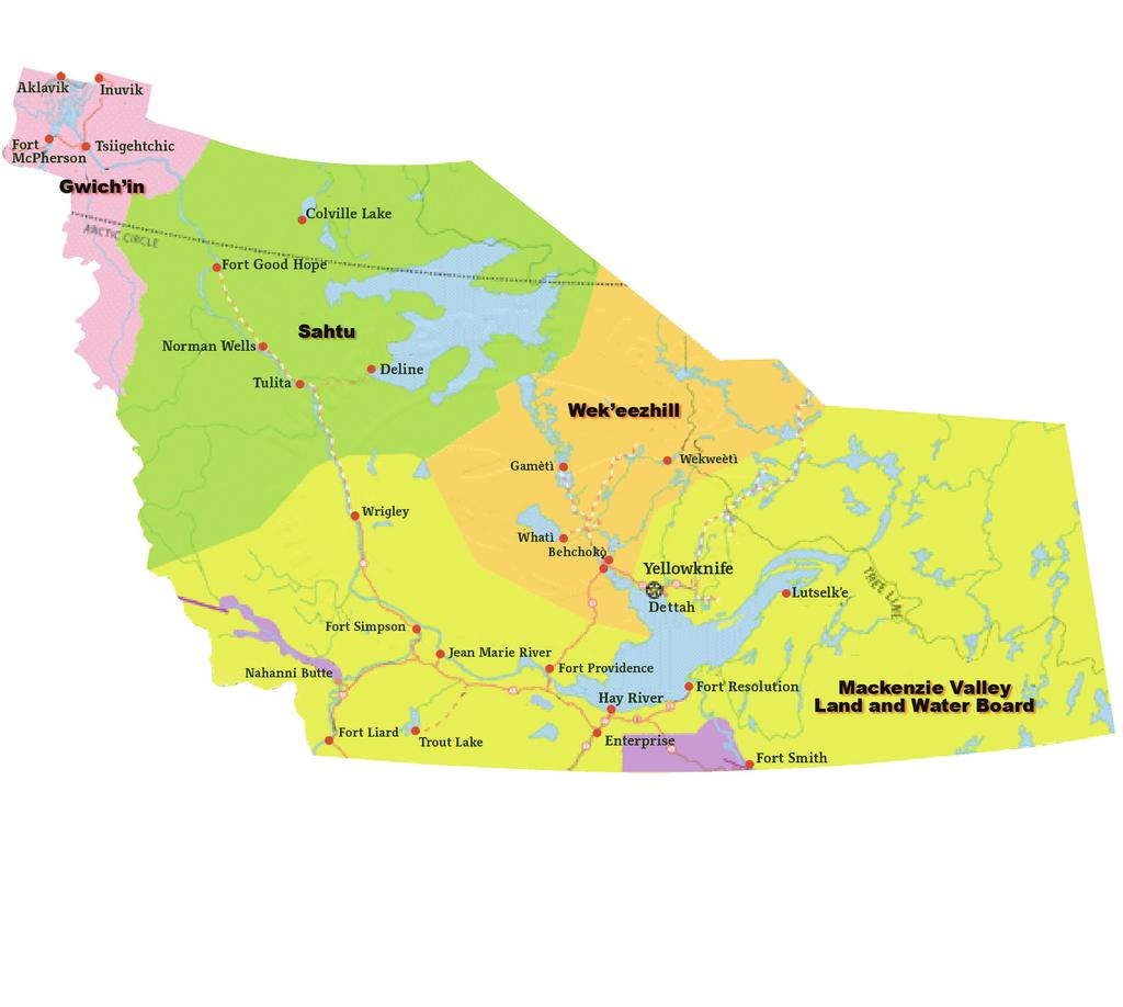
1 MVLWB Guide to the Land Use Permitting Process June 1, 2013 Mackenzie Valley Land and Water Board Gwich in Land and Water Board Sahtu Land and Water Board Wek èezhìi Land and Water Board
2


3 MVLWB
4 TABLE OF CONTENTS Definitions and Acronyms Introduction Purpose Authority How the Guide Was Developed Application of the Guide Monitoring and Performance Measurement for This Guide Introduction to Land Use Permitting Land Use Activities that Require a Land Use Permit Land Use Activities That Do Not Require a Land Use Permit Applying for a New Land Use Permit Pre-Submission Information, Gathering Pre-Application Information, and. Gaining Permission to Access Lands What Information Is Needed in an Application? Completing the Land Use Permit Application Form Engagement Record and Plan Security The Boards Process Guide to the Land Use Permitting Process
5 4.0 Post Issuance Inspections Plans and Reports Final Clearance Other Types of Requests and Applications Amendments Extensions Storage Authorizations Assignments and Name Changes Renewals Discontinuances Appendix A - Land and Water Board Contact Information Appendix B - Template for Environmental and Resource Impacts and Mitigation Measures Information Appendix C - Contact Information for Land Owners Appendix D - Other Potential Authorizations Guide to the Land Use Permitting Processs
6 Definitions and Acronyms TERM AANDC Boards complete application GNWT GLWB care and maintenance land use fees land use permit LUP MVEIRB MVLUR MVLWB MVRMA NWTWA NWT DEFINITION Aboriginal Affairs and Northern Development Canada Land and Water Boards of the Mackenzie Valley, as mandated by the Mackenzie Valley Resource Management Act. an application that has been deemed to contain the appropriate amount and type of information necessary to be considered by a Board. (See section 4.1 for more details.) Government of the Northwest Territories Gwich in Land and Water Board the status of a mine when it undergoes a temporary closure fees to be included with the application form for the proposed land use operation. The first two hectares are included in the $150 application fee, and additional hectares are $50 each. (See section 7.2 for more details.) authorization required for an activity set out in sections 4 and 5 of the Mackenzie Valley Land Use Regulations, or a land use permit (type C) required by Tłi cho law for use of Tłi cho lands for which a type A or type B land use permit is not required. land use permit Mackenzie Valley Environmental Impact Review Board (the Review Board) Mackenzie Valley Land Use Regulations Mackenzie Valley Land and Water Board Mackenzie Valley Resource Management Act Northwest Territories Waters Act Northwest Territories 6 Guide to the Land Use Permitting Process
7 Definitions and Acronyms continued TERM Permittee project proponent security SLWB WLWB DEFINITION a person who holds a land use permit issued by a Board any activity that requires a water licence or land use permit applicant for, or a holder of, a water licence and/or land use permit funds held by the Crown that can be used in the case of abandonment of an undertaking to reclaim the site or carry out any ongoing measures that may remain to be taken after the abandonment of the undertaking. The Boards set the amount based on section 32 of the MVLUR. (See section 7.3 for more details.). Sahtu Land and Water Board Wek èezhìi Land and Water Board 7 Guide to the Land Use Permitting Process
8 1.0 Introduction 1.1 Purpose The Land and Water Boards (the Boards) of the Mackenzie Valley regulate the use of land through the issuance of land use permits (LUPs) in accordance with the Mackenzie Valley Resource Management Act (MVRMA) and the Mackenzie Valley Land Use Regulations (MVLUR or the Regulations). The purpose of this Guide is to outline: When land use permits are required; How to complete an LUP application; Steps and time frames in the application process; and Other types of LUP applications and submissions. The Regulations are the authority in any case where there is a conflict or inconsistency between the Guide and the Regulations. 1.2 Authority Sections 65, 102, and 106 of the MVRMA grant the Board the authority to develop guidelines. 1.3 How The Guide Was Developed The Application Processes Working Group, one of the Standard Procedures and Consistency Working Groups established by the Land and Water Boards in 2008, developed this document. 1.4 Application of the Guide The following Boards will apply this document: Mackenzie Valley Land and Water Board Gwich in Land and Water Board Sahtu Land and Water Board Wek èezhìi Land and Water Board. This Guide applies to all projects that require an LUP. 1.5 Monitoring and Performance Measurement for this Guide Mechanisms will be required to monitor and measure performance and to evaluate the effectiveness of this Guide. In accordance with the principles of a management systems approach (e.g., plan-do-check-act), the MVLWB will develop a performance measurement framework. This Guide will be reviewed and amended as necessary within that framework. The framework will also describe how parties will be involved in the review process. 2.0 Introduction to Land Use Permitting The Boards regulate the use of land in the Mackenzie Valley, except for National Parks and National Historic Sites, which Parks Canada administers. Any person who wishes to conduct an activity that triggers the thresholds outlined in the Regulations requires an LUP (see section 2.1). For example, holders of mineral claims, leases, right-of-ways, quarry permits, timber cutting permits, etc., will most likely require an LUP to undertake land use activities in relation to their interest. Depending on the scope and magnitude of the proposed land use operation, the Boards may issue a type A or B LUP. All applications require some level of engagement. Please see the Boards Engagement and Consultation Policy and Engagement Guidelines for Applicants and Holders of Land Use Permits and Water Licences for more details. 8 Guide to the Land Use Permitting Process
9 2.1 Land Use Activities That Require a Land Use Permit On land outside the boundaries of a local government, a type A or B LUP is required for: Activity Type A Land Use Permit Type B Land Use Permit explosives use of vehicles or machines storage of fuel (single container) storage of fuel (facility) use of a quantity equal to or exceeding 150 kg in any 30-day period use of a vehicle or machine of a weight equal to or exceeding 10 tonnes, other than on a road or on a community landfill, quarry site, or airport use of a single container that has a capacity equal to or exceeding 4,000 litres establishment of a petroleum fuel storage facility with a capacity equal to or exceeding 80,000 litres use of a quantity equal to or exceeding 50 kg, but less than 150 kg, in any 30-day period use of a vehicle the net weight of which equals or exceeds 5 tonnes but is less than 10 tonnes, or the use of a vehicle of any weight that exerts a pressure on the ground equal to or exceeding 35 kpa, other than on a road or within a community landfill, quarry site, or airport use of a single container for the storage of petroleum fuel that has a capacity that equals or exceeds 2,000 litres but is less than 4,000 litres establishment of a petroleum fuel storage facility with a capacity equal to or exceeding 4,000 litres but is less than 80,000 litres 9 Guide to the Land Use Permitting Process
10 Activity Type A Land Use Permit Type B Land Use Permit machinery machinery lines, trails, or right-of-ways campsites use of a self-propelled, powerdriven machine for moving earth or clearing land use of a stationary, power-driven machine, other than a power saw, for hydraulic prospecting, earth moving, or land clearing leveling, grading, clearing, cutting, or snowplowing of a line, trail or right-of-way (other than a road or existing access trail to a building) that exceeds 1.5 metres in width and 4 hectares, for a purpose other than the grooming of recreational trails use of a campsite outside of a territorial park for a duration of or exceeding 400 person-days - - leveling, grading, clearing, cutting or snowplowing of any line, trail or right-of-way (other than a road or existing access trail to a building) that exceeds 1.5 metres in width but does not exceed 4 hectares for a purpose other than the grooming of recreational trails use of a campsite outside of a territorial park for a duration of or exceeding 200 person-days but less than 400 person-days buildings - construction of a building with a footprint of more than 100 m 2 and a height of more than 5 metres 10 Guide to the Land Use Permitting Process
11 Activity Type A Land Use Permit Type B Land Use Permit drilling use of power-driven, earth-drilling machinery the operating weight of which, excluding the weight of drill rods, stems, bits, pumps, and other ancillary equipment, equals or exceeds 2.5 tonnes for a purpose other than the drilling of holes for building piles or utility poles or the setting of explosives within the boundaries of the local government use of power-driven, earth-drilling machinery the operating weight of which, excluding the weight of drill rods, stems, bits, pumps, and other ancillary equipment, equals or exceeds 500 kg but is less than 2.5 tonnes, for a purpose other than the drilling of holes for building piles or utility poles or the setting of explosives within the boundaries of the local government On land within the boundaries of a local government, a type A or B LUP is required for: Activity Type A Land Use Permit Type B Land Use Permit drilling campsites storage of fuel (facility) machinery use of power-driven, earth-drilling machinery the operating weight of which, excluding the weight of drill rods, stems, bits, pumps, and other ancillary equipment, equals or exceeds 2.5 tonnes, for a purpose other than the drilling of holes for building piles or utility poles or the setting of explosives within the boundaries of the local government use of a campsite outside of a territorial park for a duration of or exceeding 400 person-days establishment of a petroleum fuel storage facility with a capacity equal to or exceeding 80,000 litres use of a stationary, power-driven machine, other than a power saw, for hydraulic prospecting, earth moving, or land clearing use of power-driven, earth-drilling machinery the operating weight of which, excluding the weight of drill rods, stems, bits, pumps, and other ancillary equipment, equals or exceeds 500 kg but is less than 2.5 tonnes, for a purpose other than the drilling of holes for building piles or utility poles or the setting of explosives within the boundaries of the local government use of a campsite outside of a territorial park for a duration of or exceeding 200 person-days but less than 400 person-days Guide to the Land Use Permitting Process
12 2.2 Land Use Activities That Do Not Require a Land Use Permit You do not need an LUP for: Activities in national parks and national historic sites administered by Parks Canada; or The use of previously cleared land, now authorized for grazing or for agricultural purposes, after its initial clearing. Also, you do not need an LUP for the following activities (unless these activities require the use of equipment or material listed above under section 2.1): Harvesting and the construction and occupation of cabins and camps for the purpose of harvesting as that term is defined in the Tłi cho Land Claims and Self- Government Agreement, the Sahtu Dene and Métis Comprehensive Land Claim Agreement, and the Gwich in Comprehensive Land Claim Agreement; Hunting, trapping, or fishing; or Anything done in the course of prospecting, staking, or locating a mineral claim. Where an emergency threatens life, property, or the environment, a person may carry out any land use operation as necessary to cope with the emergency. In this case, a written report describing the duration, nature, and extent of the operation must be submitted to the Board immediately after the land use operation is undertaken. 3.0 Applying for a New Land Use Permit 3.1 Pre-Submission Information, Gathering Pre-Application Information, and Gaining Permission to Access Lands Prior to submitting an application to the Boards, the proponent must: Conduct engagement and prepare an engagement record and engagement plan in accordance with the Boards Engagement and Consultation Policy and Engagement Guidelines for Applicants and Holders of Land Use Permits and Water Licences; Obtain permission from the landowner, if necessary (e.g. obtain quarry permit, licence of occupation, lease, access authorization, etc.); Contact federal, territorial, and Aboriginal governments and other parties to ensure all appropriate authorizations have been obtained or are in the process of being attained (see Appendix D); and Gather any information required to support their application. 3.2 What Information Is Needed in an Application? The amount of information that the Boards require to assess an application depends on the size, scale, and nature of the proposed project. Typically, type A LUP applications have more extensive information requirements than type B LUP applications. For example, a proponent that wants to build a mine in a sensitive area is expected to provide more information than a proponent who wants to quarry in an area that has already been impacted. The Board, however, has discretion to request more information 12 Guide to the Land Use Permitting Process
13 for any LUP application in order to complete a preliminary screening of the project and/or to set the terms and conditions for the LUP. The Boards submission standards are outlined in its Document Submission Standards. Proponents are encouraged to contact Board staff prior to submitting an application. The tables below list the information that is or may be required to assist the Board in its review of the application. The Boards will only process applications that are complete, so all relevant information must be submitted. Application Checklist Items that are required Reference in this Guide application form proof of registration or incorporation (for companies) Section and Appendix A Section (#1) maps Section (#16) appropriate fees (payable to the Receiver General for Canada) Section (#18) engagement record and plan Section Items that may be required to be submitted with the application depending on the project size, scale, and nature: Reference in this Guide waste management plan Section (#9) spill contingency plan Section (#12) GIS data Section (#16) Optional items that can be included with the application Reference in this Guide draft security estimate Section environmental impacts and mitigation measures Section (#16) and Appendix B 13 Guide to the Land Use Permitting Process
14 3.2.1 Completing the Land Use Permit Application Form The following sequence of numbered statements corresponds to specific numbered sections in the LUP application form. (See Appendix A to obtain a form.) Additional pages or supporting documents should be attached to the application form where required. 1. Indicate the full name, address, telephone number, fax number, and of the person or company applying for the LUP. Initials are not acceptable. Companies must be in good standing, registered to do business in the Northwest Territories, and provide proof of registration or incorporation (e.g., registration declaration, certificate of incorporation, or certificate of extra-territorial registration) from GNWT Corporate Registries as an attachment to the application form. 2. Indicate the full name, address, telephone number, fax number, and of the organization s head office, if not the same as in #1. 3. If available, provide the full names, addresses, and functions of all contractors and subcontractors involved in the project, along with the maximum number of people that will be on site at any time and the length of time they will be on the site. 4. Eligibility: An LUP only authorizes a Permittee to use the land. In most cases, it does not give the Permittee a legal right to access the land. Therefore, an applicant must hold an appropriate interest (e.g., a mineral claim, quarry permit, lease, or exploration licence from the Crown) or right of access (e.g., access agreement to go on private lands) for the type of operation and from the appropriate landowner. Proponents must submit confirmation of access in writing from the landowner. Appendix C lists the contact information for landowners, including the federal and territorial governments, the Tłi cho Government, the Sahtu Dene and Métis, and the Gwich in Tribal Council. After confirming a right of access, an applicant must circle the appropriate reference to section 18 of the Regulations that outlines their eligibility. Paragraph 18(a) of the Regulations applies to proposed land-use operations that are in the exercise of a right to search for, win, or exploit minerals or natural resources. Proponents should check off: (a)(i) if the proponent holds the right; (a)(ii) if the proponent jointly holds the right (with one or more people who have entered into an agreement) and has been designated as the manager of operations; or (a)(iii) if the proponent jointly holds the right (with one or more people who have entered into an exploration or operating agreement) and has not been designated as the manager of operations. Paragraph 18(b) of the MVLUR refers to all other proposed land-use operations that do not involve a right to search for, win, or exploit minerals or natural resources. For these applications, the proponent should check off: (b)(i) if the proponent has the right and who contracts out the work; or (b)(ii) if the proponent has the right and is the one who is going to carry out the operation. In certain cases, the Boards may process an LUP application (i.e. deem the application complete) while the applicant is pursuing the right of access or interest; however, the Boards cannot issue an LUP until the right of access or interest is granted. 14 Guide to the Land Use Permitting Process
15 Eligibility for roads on Crown lands: To build a new private access road on Crown lands, a lease or licence of occupation is not required, as long as an LUP is in place. However, if a lease or a licence of occupation has been issued by the Crown for a road, confirmation from Aboriginal Affairs and Northern Development Canada (AANDC) needs to be submitted with the LUP application to the Board. If a proponent wants to construct, maintain, and/or use a road that has a lease held by another party, the proponent must provide evidence showing it has an agreement with the leaseholder. This is because a lease gives the holder the exclusive right to use the road. A licence of occupation does not give the holder the exclusive right to use the road; in this case, a copy of the licence of occupation is to be submitted with the application in case there is a requirement for a user agreement. 5. (a) A complete description and summary of the land use activity is required. The purpose, nature, and location of all activities for all phases (e.g., construction, operation, modification, decommissioning, and closure) of the proposed activity must be described. Include the size of the area to be used in each phase of the operation. For mineral exploration activities: i) provide an estimated maximum number of drill holes; ii) the frequency of drilling (i.e. specify when drilling will occur during the year and throughout the life of the permit); iii) the number, type, and size of drills to be used; and iv) a description of the general locations of the drill holes. A separate project description may be attached to the application form if the space provided is inadequate. Please indicate on the application form if readers are to refer to the separate project description for further detail. (b) The following information is required if a camp may need to be set-up: i) location and distance from any water bodies; ii) number and type of structures; iii) square footage of the structures and number of personnel stationed in the camp; iv) number of person-days required to complete the operation per calendar year (number of people x number of operating days per calendar year = number of person-days per calendar year); and v) water sources and volumes (maximum volume of water to be used per day) required to support the camp. Proponents are encouraged to follow best practices, guidelines, and operational statements (e.g., AANDC Northern Land Use Guidelines and Fisheries and Oceans Canada operational statements), and are asked to reference (in the application form) which ones they plan to use. 6. Describe potential environmental and resource impacts of the proposed land use operation and proposed mitigation measures. Effects on land, water, flora and fauna, and any related socio-economic impacts need to be provided. This information is used for the preliminary screening of the project and/or to develop conditions for the LUP. Please indicate whether any of the mitigation 15 Guide to the Land Use Permitting Process
16 measures have been developed as a result of input from affected parties. The information may also be provided in table format as shown in Appendix B. Please indicate on the application form if readers are to refer to an attached table for this section. Proponents are encouraged to contact the Prince of Wales Northern Heritage Centre (PWNHC) to obtain archaeological site data prior to submitting an application to a Board. Please refer to the PWNHC s Guidelines for Developers for the Protection of Archaeological Sites in the Northwest Territories. In some cases, Boards have included the requirement of an archaeological impact assessment as a condition in an LUP; therefore, it is important that proponents become aware of the PWNHC s guidelines about how to conduct one. 7. Provide a description of the plan for restoration. In most cases, this section will outline how the area will be returned to, as near as possible, its original state. In cases where the landowner or another interested party has requested reclamation to a different standard, please provide all relevant information and documentation for the Board s consideration. For most activities on Crown land, AANDC has prepared land use guidelines for reclamation. For advanced mineral exploration and mining projects that also trigger a type A or B water licence, proponents need to submit a closure and reclamation plan as per the Guidelines for the Closure and Reclamation of Advanced Mineral Exploration and Mine Sites in the Northwest Territories. This plan is to be referenced in the proponent s application. If an activity is proposed in an area that is in the process of being reclaimed (e.g., by AANDC Contaminants and Remediation Directorate), it is important to include this information in the application. 8. Indicate other rights, licences, or permits that relate to this application (e.g. water licences, leases, licences of occupation, Fisheries Act authorizations, National Energy Board authorizations, etc.). Confirmation of rights, licences, or permits (e.g., copy of the authorization, confirmation from the regulator, or proof that the authorizations have been applied for) must be submitted with the application. (Copies of water licences and LUPs issued by the Boards are not required.) Third party interests may be identified if this information is available. It is the responsibility of the proponent to be aware of and comply with all legal requirements (e.g., applicable legislation) within the jurisdiction in which their activities will occur. Appendix D provides information about other potential authorizations that may be required to conduct a project. If applicable, indicate whether a road is to be pioneered (i.e. built for the first time) and whether it has been laid out or ground truthed. Also, please provide details regarding the route, construction, and maintenance of the road. 9. Please describe the method of disposal of: a) garbage b) sewage (sanitary and greywater) c) brush and trees d) overburden 16 Guide to the Land Use Permitting Process
17 If more space is required than that which is provided on the application form, a waste management plan for the proposed activity is to be developed in accordance with the Boards Guidelines for Developing a Waste Management Plan and submitted as an attachment to the application form. The level of detail within the waste management plan should be customized to suit the project. Most applications will require a waste management plan. Proponents are encouraged to contact the appropriate Land and Water Board staff prior to preparing their waste management plan. 10. List the type, number, weight, and proposed uses of all equipment (e.g., drills, pumps, ground pressure vehicles, etc.) to be used. Indicate whether some or all of the equipment is covered under another LUP or licence and the duration of the authorization. 11. Indicate all fuel types (e.g., diesel, gasoline, aviation fuel, propane, etc.) and for each, list the number of containers, the capacity of containers to be used, and the maximum volume that will be on site at any one time. 12. Please describe the plan for containment of a fuel spill. If more space is required than what is provided on this application form, a spill contingency plan is to be developed in accordance with AANDC s Guidelines for Spill Contingency Planning. Most applications will require a spill contingency plan. This plan is to be submitted as an attachment to the application form. 13. Indicate fuel transfer methods (e.g., pumps, gravity fed, etc.) to other tanks, vehicles, etc. 14. Indicate all periods of operation (i.e. specify the months and years) including seasonal shut down, and closure and reclamation activities. 15. Indicate duration/term for which the land use permit is required (up to five years). Later in the life of the permit (but before the expiry date), LUP holders can apply for a permit extension of up to two years. 16. Indicate the locations of land use activities by providing the minimum and maximum latitude and longitude, the map sheet number, and by circling the appropriate geodetic reference system (NAD 27 or 83). A site plan to scale (e.g., 1:50,000) with the location of structures and features and a 1:250,000 scale overview map, showing the location of the development, must also be provided. In this section of the application form, please refer to the section/page of your application which contains the maps. GIS data may also be required with the application. (See the Boards Standards for Geographical Information Systems (GIS) Submissions.) 17. Please ensure an original signature is included from a person who is authorized to sign on behalf of the applicant. Print your full name before signing and dating the application. Initials are not sufficient. Documents can be submitted electronically by scanning the signature page or by including an electronic signature as per the Boards Document Submission Standards. 18. Circle the type of LUP you are applying for (A or B). Forward the appropriate fees (payable to the Receiver General for Canada) for the use of federal lands with your application: 17 Guide to the Land Use Permitting Process
18 For land use operations that will use two hectares of land or less, the fee is $150. This is a flat fee, so for example, the fee is $150 whether you are applying to use half a hectare or two hectares. For land use operations that will use more than two hectares, the fee is $150 plus $50 per ha for any additional land disturbed by the project. So for example, an operation proposing to disturb 5 ha will submit $300 ($150 flat fee including two ha plus $50/ha x 3 ha). The assignment fee of $50 need only be paid if an LUP is being transferred to another person or company Engagement Record and Plan Engagement records and engagement plans are required with LUP applications in accordance with the Boards Engagement and Consultation Policy and Engagement Guidelines for Applicants and Holders of Land Use Permits and Water Licences. Engagement should be initiated well in advance of the submission of the application to allow affected parties sufficient time to review and discuss the information with the proponent Security The Boards may require the proponent to post security in accordance with the Regulations. The Boards use a template to calculate security. Proponents can obtain a copy of the template by contacting the Board and can submit it for consideration with their application. 3.3 The Boards Process The application is reviewed to ensure that all necessary information is included and to confirm that the right type of LUP has been applied for. Land use permit applications will be checked for conformity with approved land use plans. The application is assessed to determine if it is exempt from Part 5 of the MVRMA (see below). Meeting Part 5 of the MVRMA A Board can only issue a licence, permit, or authorization for an activity if the requirements of Part 5 have been complied with. (See section 62 of the MVRMA.) Therefore, when the Board receives an application, either for a new land use permit or an amendment, it needs to conduct a preliminary screening, unless the activity is specifically exempted because it is on the Exemption List Regulations, or it is exempt for national security or emergency purposes, or because of section of the MVRMA. (See section 2.3 of the Review Board s Environmental Impact Assessment Guidelines.) If a Board decides not to refer an application to environmental assessment, it can still be referred to environmental assessment by the Review Board or by other parties. (See section 2.9 of the Review Board s assessment guidelines.) For more information about preliminary screenings, please refer to the Review Board s assessment guidelines. The results of the completeness check are provided to the proponent within ten days of receiving the application. If the application does not contain all necessary information, the proponent is notified and provided with a list of deficiencies. If the initial application contains all necessary information and conforms to the governing land use plan (if applicable), the proponent is notified that the application has been deemed complete and has been assigned a file number. 18 Guide to the Land Use Permitting Process
19 The application and supporting documents are uploaded to the Board s website (e.g., onto the Items for Review page) and then an application package that includes the application and supporting documents, a summary comment table, a draft LUP (in some cases), and the distribution list is distributed to the following organizations: appropriate departments and agencies of the federal and territorial governments; land owners; affected communities and Aboriginal governments and organizations; Renewable Resource Boards; departments and agencies with responsibilities for heritage resources; and other interested parties. (This may include companies, businesses, or individual members of public, civic, or social organizations who have indicated an interest in a project.) A copy of the Board s distribution list is available on request. The Board also notifies the Mackenzie Valley Environmental Impact Review Board (MVEIRB) of receipt of the application. The Board has to allow a reasonable period for reviewers to provide comments to the Board with respect to the application. Review periods may vary depending on the scope, scale, and location of a proposed project. When the review is completed, comments are forwarded to the proponent for a response. For type A LUPs: Within 42 days of receiving a complete application for a type A LUP, the Board will either: (a) issue an LUP with conditions; (b) conduct a hearing under section 24 of the MVRMA or require that further studies or investigations be made; (c) refer it to the MVEIRB for environmental assessment; or (d) refuse to issue the LUP if a requirement set out in section 61 or 61.1 of the MVRMA has not been met or for any other reason as provided for in legislation. For type B LUPs: Within 15 days of receiving a complete application for a type B LUP, the Board may: (a) issue an LUP with conditions; (b) refer the application to the MVEIRB for environmental assessment; (c) notify the applicant that the Board needs more time to review the application; or (d) refuse to issue the LUP if a requirement set out in section 61 or 61.1 of the MVRMA has not been met for any reason as provided for by legislation. 19 Guide to the Land Use Permitting Process
20 4.0 Post-Issuance 4.1 Inspections Inspections are carried out by Inspectors from AANDC for all land use operations authorized by type A or type B LUPs. Inspectors report to the Boards on compliance with legislation, regulations, and conditions of the LUP. Non-compliance may result in a suspension or cancellation of the LUP by the Board or a cessation order of the land use activity by the Inspector. 4.2 Plans and Reports Conditions of an LUP may require that plans and/ or reports be submitted to the Board, either for approval by the Board or for informational purposes. Plans or reports that require approval by the Board undergo a review process. Reviewer comments and proponent responses are provided to the Board for its consideration. If the Board determines that the plan or report meets the LUP requirements, the Board approves the plan or report. If the Board determines that the plan or report does not satisfy LUP requirements or is not satisfied with the proponent s response to reviewer comments, the Board notifies the proponent that the plan or report needs to be revised or that further information is required and indicates when the revised plan or report is to be submitted. 4.3 Final Clearance Within sixty days of either the expiry of an LUP or the end of operations (whichever comes first), proponents must provide a final plan to the Board. GIS data must be submitted with the final plan as per the Boards Standards for Geographic Information Systems (GIS) Submissions. The final plan must show: (a) (b) (c) (d) The lands on which the land-use operation was conducted; The location of: lines, trails, right-of-ways, and cleared areas that were used by the Permittee during the land-use operation, specifying those that were cleared by the Permittee and those that existed before the operation began; buildings, structures, campsites, landing strips, aircraft navigation aids, fuel and supply storage sites, waste disposal sites, excavations, and other works and places that were constructed or used by the Permittee in the land use operation; and bridges, dams, ditches, railroads, roads, transmission lines, pipelines, survey lines, monuments, air landing strips, watercourses, traplines and cabins and all other features or works that were affected by the land use operation. Calculations of the area of lands used in the land use operation. This data is used to determine if land use fees are still owing or need to be refunded; and Calculation of land use fees. Clearances will not be considered until all land use fees are submitted. The final plan is then verified by the Inspector and Board. Once the Board has issued a letter of clearance, the Permittee can request AANDC to refund the security. 20 Guide to the Land Use Permitting Process
21 4.4 Other Types of Requests and Applications After the issuance of an LUP, the Permittee can apply for: Amendments to any of the conditions of an LUP; An extension to the existing term of their LUP (up to a maximum of two years) before the LUP expires; Authorization to store items required for future land use operations after the permitted land use has been completed; Assignment of their LUP to another party; An LUP renewal; or A discontinuance of the LUP. Please refer to the Boards Engagement and Consultation Policy and Engagement Guidelines for Applicants and Holders of Land Use Permits and Water Licences for engagement requirements for these applications Amendments An amendment is a change to a condition of an existing LUP, not a change to its scope. If a desired change to an operation is not within the scope of the LUP, the changed operation will require the proponent to apply for a new LUP. To amend a condition of an LUP, the Permittee must fill out an LUP application for the amendment and provide the following information, which can be included in the cover letter with the application form: 1. The conditions that the Permittee wishes to have amended; An amendment request may require a preliminary screening, unless it is exempt from Part 5 of the MVRMA (see Meeting Part 5 of the MVRMA under section 3.3). For example, Permittees must submit sufficient information in the application for reviewers to understand the impacts of the requested amendment and the proposed mitigation measures. Applicants must include applicable land use fees for any additional lands used and additional security may need to be posted if the Board approves the amendment request. An application fee is not required Extensions A Permittee may request one extension to an LUP for up to two years. If the request is for less than two years, the Permittee cannot then request a second extension for the remainder of the two years. The request for an extension should be received at least 45 days prior to the expiry of the LUP to allow time for the extension request to be processed. The Board cannot grant an extension to an LUP that has expired. To request an extension to an LUP, the Permittee must submit a letter to the Board. The letter should clearly state: 1. The reason for the extension request; 2. The length of time the Permittee is requesting for the extension; and 3. Any other information which would support the extension request, including the status of the land use operation. 2. The nature of the proposed amendment; and 3. The reasons for the proposed amendment. 21 Guide to the Land Use Permitting Process
22 4.4.3 Storage Authorizations Once a land use operation is complete, the Permittee must remove all structures, temporary buildings, machinery, equipment, materials, fuel drums, and other storage containers and any other items used in connection with the permitted operation. However, a Permittee may request authorization from the Board to store any of these items for up to one year following expiration of an LUP. The Permittee must complete the storage authorization form from the Board with enough information to adequately describe the items to be stored and the location where they will be stored. The Permittee must also provide a letter from the landowner (in the case of settlement lands, Tłi cho lands, or other private lands) agreeing to allow storage of the specified items. Storage authorizations cannot be assigned Assignments and Name Changes When the holder of an existing LUP agrees to transfer the rights (e.g., lease) associated with the LUP to a new party, the LUP holder must ensure that they are still eligible for the LUP. It is very important that the new Permittee (assignee) understands that in accepting the assignment of an LUP, they accept responsibility for: The performance of all conditions of the LUP; All liabilities incurred as a result of the assignor s actions to date under the LUP; and Payment of all security required of the assignor when the LUP was granted. The assignor needs to post security with the Minister of Aboriginal Affairs and Nothern Development Canada prior to the commencement of operations. If the LUP is not assigned, the original Permittee must understand that they are still responsible for all liabilities under the LUP. To obtain an assignment of an LUP, the assignee must: 1. Complete the application to assign a land use permit (see Appendix A) which includes a declaration by the assignor and the signature of the assignor and assignee; and 2. Enclose a cheque for the assignment fee of $50 made payable to the Receiver General for Canada. The assignee should also provide evidence (i.e. registration declaration, certificate of incorporation, or certificate of extra-territorial registration from GNWT Corporate Registries) that they have received authorization to do business in the Northwest Territories. If the Permittee is performing a simple name change, which is different from an assignment, a letter and the certificate of incorporation needs to be submitted to the Board Renewals A renewal is a new application (which requires all information listed under section 3.2 of this document) for a development that has been permitted previously and that is exempt from Part 5 of the MVRMA. When applying for a renewal, Permittees should clearly state in the cover letter attached to the application that they are applying for a preliminary screening exemption and confirm that the project has not been modified (see Exemption List Regulations made under subsection 143(1) of the MVRMA) or falls under section of the MVRMA. If information has already been submitted for a previous LUP, the applicant must reference the information including the title, date, relevant section, and page numbers of the document in the application form. The difference between a renewal and an extension is that a renewal involves the issuance of a new LUP (for a term of up to five years) for an operation that has already been permitted, whereas an extension is the addition of time (to a maximum of two years) of an existing LUP. An LUP renewal can have different 22 Guide to the Land Use Permitting Process
23 conditions than the old LUP, but the conditions remain the same for an extension, aside from a few administrative updates (e.g., changing Indian and Northern Affairs Canada to Aboriginal Affairs and Northern Development Canada) Discontinuances A Permittee who wishes to discontinue the land use operation at any time prior to the expiration date in the LUP can have the expiry date of the LUP amended to reflect this new completion date. The Permittee will give notice of the discontinuance in writing to the Board at least ten days prior to the proposed date. The Board will then amend the expiration date of the LUP accordingly and will forward a copy of the amended LUP to the Permittee and to the Inspector. 23 Guide to the Land Use Permitting Process
24 Appendix A - Land and Water Board Contact Information For information please contact: Gwich in Land and Water Board Mackenzie Valley Land and Water Board Sahtu Land and Water Board Wek èezhìi Land and Water Board Guide to the Land Use Permitting Process
25 Appendix B - Template for Environmental and Resource Impacts and Mitigation Measures Information Proponents can use the following table to describe the effects of the proposed land use operation on land, water, flora, and fauna, as well as socio-economic impacts. This list is not all-inclusive, so if other impacts have been identified, proponents are encouraged to include them. Other sources of guidance to help identify potential impacts include the: Mackenzie Valley Environmental Impact Review Board s Environmental Impact Assessment Guidelines and Socio-Economic Impact Assessment Guidelines; and Yukon Environmental and Socio-economic Assessment Board s Proponent s Guide to Project Proposal Submission to a Designated Office (see sections 6.0 and 7.0). Physical Chemical Effects IMPACT Ground Water Water table alteration Water quality changes Infiltration changes Other Surface Water Flow or level changes Water quality changes Drainage pattern changes Temperature Wetland change/loss Other Noise Noise in/near water Noise increase Other Land Geologic structure changes Soil contamination Buffer zone loss MITIGATION 25 Guide to the Land Use Permitting Process
26 Soil compaction and settling Destabilization/erosion Permafrost regime alteration Explosives/scarring Other (such as soil microbes) Non-renewable natural resources Resource depletion Other Air/climate/atmosphere Other Biological Environment Vegetation IMPACT Species composition Species introduction Toxin/heavy accumulation Other (such as species distribution, any rare species or species at risk, plant phenology, growth, and reproduction Wildlife and fish Effects on rare, threatened, or endangered species Fish population changes Waterfowl population changes Breeding disturbance Population reduction Species diversity change Health changes Behavioural changes Habitat changes/effects Game species/effects Toxins/heavy metals Forestry changes Agricultural changes Other MITIGATION 26 Guide to the Land Use Permitting Process
27 Interacting Environment IMPACT Habitat and Communities Predator-prey Wildlife habitat/ecosystem composition changes Reduction/removal of keystone or endangered species Removal of wildlife corridor or buffer zone Other Social and Economic Planning/zoning changes or conflicts Increase in urban facilities or services use Rental house Airport operations/capacity changes Human health hazard Impair the recreational use of water or aesthetic quality Affect water use for other purposes Affect other land use operations Quality of life changes Other MITIGATION 27 Guide to the Land Use Permitting Process
28 IMPACT Habitat and Communities Effects to historic property Increased economic pressure on historic properties Change to or loss of historic properties Change to or loss of historic resources Change to or loss of archaeological resources Social and Economic Increased pressure on archaeological sites Effects on Aboriginal lifestyle Other Cultural and Heritage MITIGATION 28 Guide to the Land Use Permitting Process
29 Appendix C - Contact Information for Land Owners Please contact the following organizations to obtain more information about access rights: Tłi cho Lands Sahtu Department of Culture and Lands Protection Tłi cho Government Box 412 Behchokö, NT X0E 1X0 Phone: (867) Fax: (867) Tulita District Tulita Dist. Land Corp. PO Box 108 Tulita, NT X0E 0K0 Phone: (867) Fax: (867) Gwich in Private Lands Gwich in Tribal Council Land Administration and Resource Management P.O. Box 1509 Inuvik, NT X0E 1X0 Phone: (867) Fax: (867) K asho Gotine District K asho Gotine Dist. Land Corp. PO Box 18 Fort Good Hope, NT X0E 0H0 Phone: (867) Fax: (867) Deline District Deline Land Corp. General Delivery Deline, NT X0E 0G0 Phone: (867) Fax: (867) Guide to the Land Use Permitting Process
30 Crown Lands Land Administration Office Aboriginal Affairs and Northern Development Canada P.O. Box th Floor, Bellanca Building Yellowknife, NT X1A 2R3 Phone: (867) Fax: (867) Commissioner s Lands Inuvik Region (Tsiigehtchic, Fort McPherson, Inuvik, Aklavik) Senior Lands Officer Phone: (867) Sahtu Region (Deline, Fort Good Hope, Tulita, Norman Wells, and Colville Lake) Senior Lands Officer Phone: (867) Dehcho Region (Fort Liard, Fort Simpson, Nahanni Butte, Trout Lake, Jean Marie River, Wrigley) Senior Lands Officer North Slave Region (Dettah, Gameti, Lutselk e, Behchokö, Wekweeti, Whatì, and Yellowknife) Senior Lands Officer Phone: (867) South Slave Region (Fort Smith, Hay River, Enterprise, Fort Providence, Kakisa, Fort Resolution) Senior Lands Officer Phone: (867) Guide to the Land Use Permitting Process
31 Appendix D - Other Potential Authorizations The following guidance documents or web pages list other potential authorizations for various land use activities: Activity Guidance Documents Access: Roads and Trails Northern Land Use Guidelines - Access: Roads and Trails Camp and Support Facilities Pits and Quarries (see section 2.2 Permitting) Northern Land Use Guidelines - Camp and Support Facilities (see section 2.1 Permitting) Northern Land Use Guidelines - Pits and Quarries Mineral Exploration (see section 2.2 Permitting Requirements) FAQ about Mineral Tenure in the Northwest Territories and Nunavut Oil and Gas Oil and Gas Approvals in the Northwest Territories - Sahtu Settlement Area - February 2002 Seismic Exploration Oil and Gas Approval in the Northwest Territories - Gwich in Settlement Area - February 2002 Northern Land Use Guidelines - Northwest Territories Seismic Operations (see section 2.1 Permitting) Please note that the links above may not describe all of the authorizations that are required. Proponents are encouraged to contact the following responsible authorities for more information regarding their particular project: Northern Projects Management Office: NPMO s Services Department of Fisheries and Oceans: Northwest Territories Office National Energy Board: Site Map Transport Canada: Navigable Waters Protection Program Parks Canada: Contact Page Government of the Northwest Territories Environment and Natural Resources: Permits and Licences Government of the Northwest Territories Department of Transportation: Contacts for Regional Offices for Highway Access Permit 31 Guide to the Land Use Permitting Process
32 The Mackenzie Valley Land and Water Board Box th Floor th Street Yellowknife, NT X1A 2P6 Phone: (867) Fax: (867)
The Application Process
 The Application Process This document is intended as a guide and does not constitute a legal document. For further and more detailed information, please refer to the following Acts and Regulations: The
MVLWB/INAC/GNWT. Guidelines for Closure and Reclama on Cost Es mates for Mines. November 2017
 MVLWB/INAC/GNWT Guidelines for Closure and Reclama on Cost Es mates for Mines Mackenzie Valley Land and Water Board Gwich in Land and Water Board Sahtu Land and Water Board Wek èezhìi Land and Water Board
Closing at Noon, Mountain Time on May 17, 2005
 2005 CENTRAL MACKENZIE VALLEY CALL FOR BIDS Closing at Noon, Mountain Time on May 17, 2005 The management of oil and gas resources North of 60 0 latitude offshore and in the Northwest Territories and Nunavut
Trout River Falls. Picture courtesy of the Deh Cho First Nations
 Trout River Falls. Picture courtesy of the Deh Cho First Nations THE DEH CHO FIRST NATIONS INTERIM MEASURES AGREEMENT among THE DEH CHO FIRST NATIONS as represented by the Deh Cho First Nations Grand Chief
RENTAL HOUSING IN RURAL AND REMOTE COMMUNITIES
 RENTAL HOUSING IN RURAL AND REMOTE COMMUNITIES April 2014 INTRODUCTION The Government of the Northwest Territories (GNWT) is facing increasing challenges in providing the programs and services residents
Jurisdictional Responsibilities for Land Resources, Land Use and Development in the Yukon Territory and Northwest Territories
 Jurisdictional Responsibilities for Land Resources, Land Use and Development in the Yukon Territory and Northwest Territories Book one Northwest Territories First Nations Settlement Areas Land Management
USING NEW BRUNSWICK CROWN LANDS
 Last update: November 27, 2012 LICENCE OF OCCUPATION FOR WIND EXPLORATION USING NEW BRUNSWICK CROWN LANDS What is Crown Land? Crown land includes all or any part of land (including land covered by water)
The Crown Resource Land Regulations
 CROWN RESOURCE LAND P-31 REG 17 1 The Crown Resource Land Regulations Repealed by Chapter P-31.1 Reg 2 (effective March 13, 2017). Formerly Chapter P-31 Reg 17 (effective May 19, 2004) as amended by Saskatchewan
Crown Land Use Operational Policy: Mining APPROVED AMENDMENTS: Summary of Changes: /Approval
 APPROVED AMENDMENTS: Effective Date Briefing Note /Approval Summary of Changes: June 1, 2011 BN 175892 Policy and Procedure update to reflect reorganization of resource ministries April 2011 September
Crown Land Use Policy: Industrial - General APPROVED AMENDMENTS: Summary of Changes: /Approval
 APPROVED AMENDMENTS: Effective Date Briefing Note /Approval Summary of Changes: March 22, 2011 BN175798 Amendment to clarify pricing for aquatic lands. March 31, 2011 BN 175892 Policy and Procedure update
Application for Crown Land Disposition
 PRINT CLEAR SAVE Ministry of Environment Application for Crown Land Disposition November 2018 This application form is used to obtain a disposition for a variety of purposes to ensure orderly development
This is a summary of the Northwest Territories Lands and Resources Devolution Agreement (called the Agreement in this summary).
.") NWT Lands and Resources Devolution Agreement Plain Language Summary This is a summary of the Northwest Territories Lands and Resources Devolution Agreement (called the Agreement in this summary). The Agreement
NWT Lands and Resources Devolution Agreement Plain Language Summary This is a summary of the Northwest Territories Lands and Resources Devolution Agreement (called the Agreement in this summary). The Agreement
SURFACE AND SUBSURFACE RIGHTS MANAGEMENT
 SURFACE AND SUBSURFACE RIGHTS MANAGEMENT The purpose of this fact sheet is to provide information relating to surface and subsurface rights and interests and explain how these interests can be managed
Guide to Hard Rock Prospecting, Exploration and Mining in Yukon
 Guide to Hard Rock Prospecting, Exploration and Mining in Yukon September 2009 Note: Placer mining information is regulated through the Placer Mining Act and is not covered in this guide. Disclaimer: The
Abandonment and Reclamation Policy for Inuit Owned Lands Qikiqtani Inuit Association - (Version 2.0)
") Abandonment and Reclamation Policy for Inuit Owned Lands Qikiqtani Inuit Association - (Version 2.0) 1.0 Introduction Article 19 of the Nunavut Land Claims Agreement establishes private ownership of selected
Abandonment and Reclamation Policy for Inuit Owned Lands Qikiqtani Inuit Association - (Version 2.0) 1.0 Introduction Article 19 of the Nunavut Land Claims Agreement establishes private ownership of selected
PLAR Industrial and Commercial Work Camps on Public Land Directive
 Title: Number: Program Name: PLAR Industrial and Commercial Work Camps on Public Land Directive ESRD, Public Land Management, 2014, No.5 Public Land Management Effective Date: January 30, 2014 This document
TENTATIVE PARCEL MAP APPLICATION GUIDE TENTATIVE PARCEL MAP APPLICATION REQUIREMENTS
 TENTATIVE PARCEL MAP APPLICATION GUIDE SISKIYOU COUNTY PLANNING DIVISION 806 South Main Street, Yreka CA 96097 Phone: (530) 841-2100 / Fax: (530) 841-4076 TENTATIVE PARCEL MAP APPLICATION REQUIREMENTS
THIS DECLARATION OF RESTRICTIVE COVENANTS is made this day of, 20, by ("Covenantor"). RECITALS
. RECITALS") Model for Use with Permits Without Mitigation Plans STATE OF COUNTY OF DECLARATION OF RESTRICTIVE COVENANTS THIS DECLARATION OF RESTRICTIVE COVENANTS is made this day of, 20, by ("Covenantor"). RECITALS
Model for Use with Permits Without Mitigation Plans STATE OF COUNTY OF DECLARATION OF RESTRICTIVE COVENANTS THIS DECLARATION OF RESTRICTIVE COVENANTS is made this day of, 20, by ("Covenantor"). RECITALS
UNLOCKING OUR POTENTIAL ACQUIRING MINERAL RIGHTS
 UNLOCKING OUR POTENTIAL ACQUIRING MINERAL RIGHTS IN THE NORTHWEST TERRITORIES II JULY 2016 Introduction Establishing and maintaining strong working relationships between the mineral industry and Northwest
Notice To the Reader... 2
 Contents Notice To the Reader... 2 1: DEFINITIONS... 3 2: GENERAL PROVISIONS... 4 3: ELIGIBILITY AND ENROLLMENT... 7 4: RESERVES AND LAND SET ASIDE... 10 5: TENURE AND MANAGEMENT OF SETTLEMENT LAND...
CHAPTERS 35 to 37 Reserved CHAPTER 38 PRIVATE WATER WELL CONSTRUCTION PERMITS
 , 8/18/04 Ch 38, p.1 TITLE III WITHDRAWAL, DIVERSION, STORAGE AND USE OF WATER DIVISION A WATER WELL CONSTRUCTION: GENERAL STANDARDS AND REGISTRATION OF CONTRACTORS CHAPTERS 35 to 37 Reserved, 8/18/04
COLUMBIA COUNTY SURFACE MINING ORDINANCE
 EXHIBIT 7 COLUMBIA COUNTY SURFACE MINING ORDINANCE Adopted by Ordinance No. 90-11 on June 20, 1990 Amended by Ordinance No. 92-8 on September 30, 1992 Amended by Ordinance 95-8 on November 1, 1995 Amended
Ensure community interests are protected with respect to the management and disposition of public land;
 Energy, Mines and Resources Land Management Branch 320-300 Main Street Whitehorse, Yukon Y1A 2B5 667-5215 Fax 667-3214 www.emr.gov.yk.ca WATER LOT LEASE Land Application Policy OBJECTIVE To allow for land
Ministry of Natural Resources and Forestry
 Ministry of Natural Resources and Forestry Application for Docks or Single-Storey Boathouse Authorization(s) under the Public Lands Act Instructions Use this form if you intend to construct or place any
Number Same. This document provides procedural direction to implement Policy PL Onshore Windpower Development on Crown Land.
 Ministry of Natural Resources Subject ONSHORE WINDPOWER DEVELOPMENT ON CROWN LAND NON-COMPETITIVE APPLICATION Procedure PL 4.10.04 Compiled by Renewable Energy Program Replaces Directive Title Same Number
A Guide to the Municipal Planning Process in Saskatchewan
 A Guide to the Municipal Planning Process in Saskatchewan A look at the municipal development permit and the subdivision approval process in Saskatchewan May 2008 Prepared By: Community Planning Branch
Application Procedures for Easements or Rights of Way on City of Fort Collins Natural Areas and Conserved Lands March 2012
 Application Procedures for Easements or Rights of Way on City of Fort Collins Natural Areas and Conserved Lands March 2012 IMPORTANT NOTE: This document was created to accompany the City of Fort Collins
Draft DEC Program Policy
 Temporary Revocable Permits for State Lands & Conservation Easements New York State Department of Environmental Conservation Draft DEC Program Policy Issuing Authority: Christopher Amato Title: Assistant
OBJECTIVE To facilitate provision of land for trapping cabin purposes.
 Energy, Mines & Resources Land Management Branch 320-300 Main Street Whitehorse, Yukon Y1A 2B5 667-5215 Fax 667-3214 www.emr.gov.yk.ca TRAPPING CABIN Land Application Policy OBJECTIVE To facilitate provision
COMPLETENESS OF APPLICATION:
 Community Development Department 50 Dickson Street, 3 rd Floor, P.O. Box 669 Cambridge ON N1R 5W8 Tel: (519) 621-0740 ext. 4289 Fax: (519) 622-6184 TTY: (519) 623-6691 MINOR VARIANCE Application for a
SUBJECT: CROWN RESERVED ROAD POLICY
 SUBJECT: CROWN RESERVED ROAD POLICY Policy Number: CLM 006 2003 C. R. File Number: 656-00-0001 Effective Date: July 6, 2010 To Be Reviewed: July 6, 2014 Approval: Original Signed by Phil LePage, Deputy
MINES AND MINERALS MANAGEMENT ACT 1995 CHAPTER I PRELIMINARY. 1. This Act shall be called the Mines and Minerals Management Act 1995.
 MINES AND MINERALS MANAGEMENT ACT 1995 CHAPTER I PRELIMINARY 1. This Act shall be called the Mines and Minerals Management Act 1995. 2. The Act shall come into force on the First Day of September 1995.
RATE & FEE SCHEDULE. I. Introduction 1. II. Effective Date 1. III. Implementation 1. IV. Administrative Fees 3. V. Easements 3
 OFFICE OF GENERAL COUNSEL SYSTEM REAL ESTATE OFFICE 301 Tarrow, 6 th Floor, College Station, Texas 77840 (979) 458-6350 www.tamus.edu/legal/real-estate/ RATE & FEE SCHEDULE I. Introduction 1 II. Effective
UNLOCKING OUR POTENTIAL ACQUIRING MINERAL RIGHTS
 UNLOCKING OUR POTENTIAL ACQUIRING MINERAL RIGHTS IN THE NORTHWEST TERRITORIES ITI Mining Rights 180611 (ENG).indd 1 May 2018 II ITI Mining Rights 180611 (ENG).indd 2 Introduction Establishing and maintaining
FOR OFFICE USE ONLY Date Submitted Received By Fees Paid $ Receipt No. Received By Application No. Application Complete Final Action Date
 COMMERCIAL, INDUSTRIAL, & MANUFACTURING SITE PLAN (CIM) APPLICATION Mariposa County Planning Department 5100 Bullion Street, P.O. Box 2039 Mariposa, CA 95338 Telephone (209) 966-5151 FAX (209) 742-5024
APPLICATION FOR SITE PLAN CONTROL
 APPLICATION FOR SITE PLAN CONTROL Information and material to be provided under Section 41 of the Planning Act Township of Lanark Highlands PO Box 340, 75 George Street Lanark, ON K0G 1K0 T: 613.259.2398
HERITAGE PROTECTION AREAS
 RESTRICTIONS The Restrictions listed in this document are intended as a convenience to those participating in Crown Public Offerings (land sales) and every effort has been made to ensure they are current.
Application for Draft Plan Approval of Subdivision or Condominium Updated: August 2017
 Application for Draft Plan Approval of Subdivision or Condominium Updated: August 2017 PRECONSULTATION Preconsultation with City Planning staff is required under By-law No. 2009-170. Preconsultation identifies
Licence to Take and Use Surface Water and Operate Works (Unregulated)
") APPLICATION FORM 71 Licence to Take and Use Surface Water and Operate Works (Unregulated) What is this application form for? Use this form to make application for a Licence to Take and use Surface water
APPLICATION FORM 71 Licence to Take and Use Surface Water and Operate Works (Unregulated) What is this application form for? Use this form to make application for a Licence to Take and use Surface water
CITY OF FORT COLLINS NATURAL AREAS AND CONSERVED LANDS EASEMENT POLICY
 CITY OF FORT COLLINS NATURAL AREAS AND CONSERVED LANDS EASEMENT POLICY Adopted January 3, 2012 PURPOSE: The purpose of the policy statement is to clarify the policies and procedures of the City of Fort
UNDER REVIEW: PLEASE CONTACT LAND TENURES BRANCH FOR MORE INFORMATION (Phone: )
") Land Use Operational Policy Oil and Gas NAME OF POLICY: APPLICATION: ISSUANCE: IMPLEMENTATION: Oil and Gas Applies to surface tenures for Crown land used for petroleum and natural gas purposes including
Land Use Operational Policy Oil and Gas NAME OF POLICY: APPLICATION: ISSUANCE: IMPLEMENTATION: Oil and Gas Applies to surface tenures for Crown land used for petroleum and natural gas purposes including
1. Introduction. 1. Formal Disposition 2. Authorization 3. Approval. ESRD, Public Land Management, 2014, No.2. Effective Date: January 30, 2014
 Title: Number: Program Name: ESRD, Public Land Management, 2014, No.2 Public Land Management Effective Date: January 30, 2014 This document was updated on: 1. Introduction 1.1 Purpose Environment and Sustainable
A Class Environmental Assessment for Provincial Parks and Conservation Reserves. Phase III: Submission to Ministry of the Environment
 A Class Environmental Assessment for Provincial Parks and Conservation Reserves Phase III: Submission to Ministry of the Environment II CLASS EA FOR PROVINCIAL PARKS AND CONSERVATION RESERVES 2001, Queen
Crown Land Use Policy: Agriculture - Extensive APPROVED AMENDMENTS: Summary of Changes: /Approval
 APPROVED AMENDMENTS: Effective Date Briefing Note /Approval Summary of Changes: June 1, 2011 BN 175892 Policy and Procedure update to reflect reorganization of resource ministries April 2011 September
SOIL TRANSPORT, DEPOSIT, AND REMOVAL REGULATION (2011)
") Community Governance Act SOIL TRANSPORT, DEPOSIT, AND REMOVAL REGULATION (2011) Date Enacted: 17 August 2011 Order Number: O.041-2011 Last Amended: 8 May 2015 This version of the Regulation is not the
Community Governance Act SOIL TRANSPORT, DEPOSIT, AND REMOVAL REGULATION (2011) Date Enacted: 17 August 2011 Order Number: O.041-2011 Last Amended: 8 May 2015 This version of the Regulation is not the
APPLICATION FOR CONSENT NEW LOT (SEVERANCE)
") The Corporation of the County Of Wellington APPLICATION FOR CONSENT NEW LOT (SEVERANCE) PLEASE REVIEW THE FOLLOWING APPLICATION GUIDELINES (Instruction Page 2 must be signed and returned with application
The Corporation of the County Of Wellington APPLICATION FOR CONSENT NEW LOT (SEVERANCE) PLEASE REVIEW THE FOLLOWING APPLICATION GUIDELINES (Instruction Page 2 must be signed and returned with application
CITY OF VAUGHAN POLICY AND PROCEDURES FOR DEALING WITH CONTAMINATED OR POTENTIALLY CONTAMINATED SITES
 CITY OF VAUGHAN POLICY AND PROCEDURES FOR DEALING WITH CONTAMINATED OR POTENTIALLY CONTAMINATED SITES MAY 2001 This Report should be read in conjunction with the City of Vaughan BACKGROUND REPORT ON POLICY
CONTRACT ON SUBSURFACE USE No PV-245 FOR THE PURPOSE OF MINERAL EXTRACTION. Yerevan 26 September, 2012
 CONTRACT ON SUBSURFACE USE No PV-245 FOR THE PURPOSE OF MINERAL EXTRACTION Yerevan 26 September, 2012 This contract on subsurface use (hereinafter referred to as Contract ) is made between the Ministry
RESIDENTIAL AND RECREATIONAL
 Energy, Mines & Resources Land Management Branch 320-300 Main Street Whitehorse, Yukon Y1A 2B5 667-5215 Fax 667-3214 www.emr.gov.yk.ca RESIDENTIAL AND RECREATIONAL Lot Enlargement Policy OBJECTIVE To facilitate
COMMUNITY PLAN PLANNING & URBAN DESIGN
 WHALE COVE COMMUNITY PLAN PLANNING & URBAN DESIGN WHALE COVE COMMUNITY PLAN Prepared for: Department of Community and Government Services Government of Nunavut Rankin Inlet, Nunavut Prepared by: FoTenn
Crown Land Leasing Policy
 Management Manual 25 Chapter: Section: Approved By: Implementation: 6 (Licenses, Leases, Permits, Sales, Land Exchanges) 4 () Duff Montgomerie Deputy Minister Land Administration Division Land Services
PUBLIC LANDS ADMINISTRATION REGULATION
 Province of Alberta PUBLIC LANDS ACT PUBLIC LANDS ADMINISTRATION REGULATION Alberta Regulation 187/2011 With amendments up to and including Alberta Regulation 57/2017 Office Consolidation Published by
DRAFT BY-LAW 2013-XXXX MAY 27, 2013
 DRAFT MAY 27, 2013 A BY-LAW OF THE CITY OF GREATER SUDBURY TO ADOPT AMENDMENT NO. 1 TO THE CITY OF GREATER SUDBURY BROWNFIELD STRATEGY AND COMMUNITY IMPROVEMENT PLAN WHEREAS Subsections 28(4), 28(5) and
5.0 Permit Applications
 5.0 Permit Applications A primary objective of the Toronto and Region Conservation Authority () is to prevent the loss of life and property due to flooding and erosion. Accordingly, administers a natural
Notice of Coming into Force
 Regulation to amend the Regulation respecting mineral substances, other than petroleum, natural gas and brine will come into force on December 31, 2015 Notice of Coming into Force The Regulation to amend
Date Received: Application Complete? YES / NO
 OFFICE USE ONLY Section 22 (Official Plan Amendment) Section 34 (Zoning Amendment), Section 36 (Holding Zone Removal), Section 41 (Site Plan Approval) and Section 45 (Minor Variance) of the Planning Act
Crown Land Use Operational Policy: Trapline Cabin Policy APPROVED AMENDMENTS: Summary of Changes: Note /Approval
 Crown Land Use Operational Policy: Trapline Cabin Policy APPROVED AMENDMENTS: Effective date May 3, 2014 September 22, 2015 February 29 th, 2016 Briefing Note /Approval FLNR DN #205239 BN 217947 Email
Disposition Codes, Description and Fees *
 Disposition Codes, Description and Fees * SCHEDULE 1 - ADMINISTRATIVE FEES PART 1. Application, Renewal or Amendment of Disposition or Authorization CATEGORY FEES (see note #1) Code Disposition Type Application
METALLIC AND INDUSTRIAL MINERALS TENURE REGULATION
 Province of Alberta MINES AND MINERALS ACT METALLIC AND INDUSTRIAL MINERALS TENURE REGULATION Alberta Regulation 145/2005 With amendments up to and including Alberta Regulation 174/2014 Office Consolidation
TRCA Administrative Fee Schedule for ENVIRONMENTAL ASSESSMENT and INFRASTRUCTURE PERMITTING SERVICES IMPLEMENTATION GUIDELINES May 2014
 IMPLEMENTATION GUIDELINES Introduction TRCA s Fee Schedule for Environmental Assessment and Permitting Services was adopted by Resolution #A237/13 of the Authority Board on January 31, 2014. The Fee Schedule
Larimer County Planning Dept. Procedural Guide for 1041 PERMITS
 - Larimer County Planning Dept. Procedural Guide for 1041 PERMITS PLEASE NOTE: A PRE-APPLICATION CONFERENCE IS REQUIRED PRIOR TO SUBMITTING THIS APPLICATION. PURPOSE: State Statutes allow local governments
LAND USE PROCEDURES (LUP) BYLAW NO. 1235, 2007
 BYLAW NO. 1235, 2007") TOWN OF OSOYOOS LAND USE PROCEDURES (LUP) BYLAW NO. 1235, 2007 Adopted August 13, 2007 PART 1 PART 2 PART 3 PART 4 PART 5 PART 6 PART 7 PART 8 TABLE OF CONTENTS Index provided for ease of use and was not
TOWN OF OSOYOOS LAND USE PROCEDURES (LUP) BYLAW NO. 1235, 2007 Adopted August 13, 2007 PART 1 PART 2 PART 3 PART 4 PART 5 PART 6 PART 7 PART 8 TABLE OF CONTENTS Index provided for ease of use and was not
Committee of Adjustment The Planning Act - Section 53 Application for Consent
 The Planning Act - Section 53 Please Type or Print In Ink File No. 1. (a) Registered Owner(s): Mailing Address: City: Province: Postal Code: Telephone: Fax: Email: Owner's Solicitor (if any): Mailing Address:
EXCERPTS FROM HALIFAX REGIONAL MUNICIPALITY CHARTER
 EXCERPTS FROM HALIFAX REGIONAL MUNICIPALITY CHARTER Municipal planning strategy 227 The Council may adopt a municipal planning strategy for all, or part, of the Municipality and there may be separate strategies
MEMORANDUM THE RIGHTS OF LAND OWNERS IN RELATION TO THOSE OF HOLDERS OF RIGHTS IN TERMS OF THE MINERAL AND PETROLEUM RESOURCES DEVELOPMENT ACT
 MEMORANDUM THE RIGHTS OF LAND OWNERS IN RELATION TO THOSE OF HOLDERS OF RIGHTS IN TERMS OF THE MINERAL AND PETROLEUM RESOURCES DEVELOPMENT ACT Land owners and lawful occupiers of land (jointly referred
Public Lands Formal Disposition Application Process
 April 19, 2018 List of Documents and Webpages To access the AEP documents referenced in this schedule, search one of the following document titles at aep.alberta.ca Associated Dispositions, Access Roads
GOVERNMENT CODE SECTION GOVERNMENT CODE SECTION 65302
 GOVERNMENT CODE SECTION 65300 65300. Each planning agency shall prepare and the legislative body of each county and city shall adopt a comprehensive, long-term general plan for the physical development
APPLICATION FOR A SEVERANCE CONSENT
 APPLICATION FOR A SEVERANCE CONSENT PLEASE SUBMIT YOUR COMPLETED APPLICATION TO: Liz Mitchell, Planning Assistant The Municipality of Trent Hills 66 Front Street South P.O. Box 1030 Campbellford, Ontario
LEGISLATIVE COUNSEL'S DIGEST
 Senate Bill No. 209 CHAPTER 8 An act to amend Sections 607, 2207, and 2714 of, and to add Sections 2006.5, 2770.1, and 2773.1.5 to, the Public Resources Code, relating to surface mining. [ Approved by
Instructions for Completion of the Temporary Field Authorization (TFA) or Dispositional Operational Approval (DOA) Application Form under the Public
 or Dispositional Operational Approval (DOA) Application Form under the Public") Instructions for Completion of the Temporary Field Authorization (TFA) or Dispositional Operational Approval (DOA) Application Form under the Public Lands Administration Regulation Table of Contents List
Instructions for Completion of the Temporary Field Authorization (TFA) or Dispositional Operational Approval (DOA) Application Form under the Public Lands Administration Regulation Table of Contents List
RULES OF THE TENNESSEE DEPARTMENT OF ENVIRONMENT AND CONSERVATION DIVISION OF WATER RESOURCES ABANDONED MINE LANDS RECLAMATION PROGRAM
 RULES OF THE TENNESSEE DEPARTMENT OF ENVIRONMENT AND CONSERVATION DIVISION OF WATER RESOURCES 0400-44-01 ABANDONED MINE LANDS RECLAMATION PROGRAM TABLE OF CONTENTS 0400-44-01-.01 Scope 0400-44-01-.09 Methods
LOCAL LAW NO. 2, 1987 A LOCAL LAW REGULATING EXCAVATION AND TOPSOIL REMOVAL WITHIN THE TOWN OF CAMBRIA
 LOCAL LAW NO. 2, 1987 A LOCAL LAW REGULATING EXCAVATION AND TOPSOIL REMOVAL WITHIN THE TOWN OF CAMBRIA PASSED BY TOWN OF CAMBRIA TOWN BOARD SEPTEMBER 3, 1987 Be it enacted by the Town Board of the Town
By-Law of The Corporation of the City of Oshawa
 By-Law 85-2006 of The Corporation of the City of Oshawa being a by-law to control the dumping of fill, removal of topsoil and alteration of grades. WHEREAS s. 142 of the Municipal Act, 2001, S.O. 2001,
Planning Department Permit Application
 Inyo County Planning Department 168 North Edwards Street Post Office Drawer L Independence, California 93526 Phone: (760) 878-0263 FAX: (760) 872-2712 E-Mail: inyoplanning@ inyocounty.us Planning Department
SITE DEVELOPMENT PLAN FOR WIND FARM LEASE
 SITE DEVELOPMENT PLAN FOR WIND FARM LEASE Department of Natural Resources Wind Farm Lease Site Development Plan Applicant s Name: Location of Crown Land: The Site Development Plan is required so that applicants
APPLICATION FOR PLAN OF SUBDIVISION/CONDOMINIUM
 The Corporation of the County of Wellington APPLICATION FOR PLAN OF SUBDIVISION/CONDOMINIUM Please review the following application guidelines PRE-CONSULTATION: The County of Wellington strongly encourages
Administrative Approvals : Transfers - Part 5 of the Public Lands Act and Part 4 of PLAR
 Title: Administrative Approvals : Transfers - Part 5 of the Public Lands Act and Part 4 of PLAR Number: AEP, Land Policy, 2016, No. 4 Program Name: Public Land Management Effective Date: February 2, 2016
Application for Validation Order
 Ministry of Municipal Affairs and Housing Application for Validation Order Under Section 57 of the Planning Act Note to applicants: This application form is to be used where the Minister of Municipal Affairs
WRP COMPATIBLE USE PERMITS
 WRP COMPATIBLE USE PERMITS By statute, WRP easements are acquired to protect, restore, and enhance the functions of wetland ecosystems for migratory birds and wetland dependent wildlife Reservations in
Chapter 100 Planned Unit Development in Corvallis Urban Fringe
 100.100 Scope and Purpose. Chapter 100 Planned Unit Development in Corvallis Urban Fringe (1) All applications for land divisions in the Urban Residential (UR) and Flood Plain Agriculture (FPA) zones within
Thurston County Planning Department PUBLIC HEARING DRAFT. AMENDMENTS TO THE CRITICAL AREAS REGULATIONS Chapter /18/2011 GENERAL PROVISIONS
 Thurston County Planning Department PUBLIC HEARING DRAFT AMENDMENTS TO THE CRITICAL AREAS REGULATIONS Chapter 24.01 11/18/2011 Chapter 24.01 GENERAL PROVISIONS GENERAL PROVISIONS Sections: 24.01.005 Short
Sample Baseline Documentation Report (BDR) Annotated Template for Environmentally Important Land
 Annotated Template for Environmentally Important Land") Sample Baseline Documentation Report (BDR) Annotated Template for Environmentally Important Land The baseline documentation report (BDR) provides a snap shot of the biophysical condition of a property
Sample Baseline Documentation Report (BDR) Annotated Template for Environmentally Important Land The baseline documentation report (BDR) provides a snap shot of the biophysical condition of a property
ATTACHMENT 2: CONSULTATION UPDATE NO. 3 PART 3 LANDOWNER ENGAGEMENT
 ATTACHMENT 2: CONSULTATION UPDATE NO. 3 PART 3 LANDOWNER ENGAGEMENT TABLE OF CONTENTS 1.0 INTRODUCTION... 1 Page 1.1 Purpose of Update... 1 1.2 Program Scope (May 1 to December 31, 2014)... 1 2.0 COMPONENTS
Neds Corner Station. What is a Conservation Covenant?
 Neds Corner Station What is a Conservation Covenant? www.trustfornature.org.au What is a conservation covenant? A conservation covenant (deed of covenant) is a voluntary, legal agreement made between a
Site Alteration By-law
 Site Alteration By-law C.P.-1363-381 Consolidated October 17, 2017 As Amended by: By-law No. Date Passed at Council C.P.-1363(a)-29 January 15, 2001 C.P.-1363(b)-53 February 5, 2001 C.P.-1363(c)-13 December
Vary/Transfer of a Private Works Licence
 APPLICATION FORM 131 APPLICATION FORM Vary/Transfer of a Private Works Licence For use Only on GMW s Land or Asset What is this application form for? This application should be used when a customer requests
Public Lands Formal Disposition Application Process
 February 16, 2018 List of Documents and Webpages To access the AEP documents referenced in this schedule, search one of the following document titles at aep.alberta.ca Associated Dispositions, Access Roads
Sample Interim Development Control Bylaw For a Rural Municipality
 Sample Interim Development Control Bylaw For a Rural Municipality Note: This document provides a sample of an Interim Development Control (IDC) Bylaw for use by a Rural Municipality. This sample may be
SIBLEY COUNTY. Article 330 Buffer Ordinance of the Code of Ordinances of the County of Sibley
 SIBLEY COUNTY Article 330 Buffer Ordinance of the Code of Ordinances of the County of Sibley ARTICLE 330. BUFFER ORDINANCE SECTION 330.1 STATUTORY AUTHORIZATION AND POLICY SUBD 330.1.1 Statutory Authorization
APPLICATION FOR APPROVAL OF A PLAN OF SUBDIVISION or CONDOMINIUM DESCRIPTION Under Section 51 of the Planning Act
 APPLICATION FOR APPROVAL OF A PLAN OF SUBDIVISION or CONDOMINIUM DESCRIPTION Under Section 51 of the Planning Act NOTE TO APPLICANTS: This application form is to be used if applying for approval of a proposed
Horse Gulch Management Plan Final Draft: April 18, 2013
 I. INTRODUCTION This Plan provides a framework for the sound stewardship of the City of Durango Horse Gulch open space area. The Plan includes baseline information regarding the area, management objectives
MODEL DEED RESTRICTION FOR THE PENNSYLVANIA STATE PROGRAMMATIC GENERAL PERMIT-3 (PASPGP-3) DECLARATION OF RESTRICTIVE COVENANTS FOR CONSERVATION
 DECLARATION OF RESTRICTIVE COVENANTS FOR CONSERVATION") MODEL DEED RESTRICTION FOR THE PENNSYLVANIA STATE PROGRAMMATIC GENERAL PERMIT-3 (PASPGP-3) DECLARATION OF RESTRICTIVE COVENANTS FOR CONSERVATION THIS DECLARATION OF RESTRICTIVE COVENANTS FOR CONSERVATION
MODEL DEED RESTRICTION FOR THE PENNSYLVANIA STATE PROGRAMMATIC GENERAL PERMIT-3 (PASPGP-3) DECLARATION OF RESTRICTIVE COVENANTS FOR CONSERVATION THIS DECLARATION OF RESTRICTIVE COVENANTS FOR CONSERVATION
The Provincial Lands (Agriculture) Regulations
 Regulations") PROVINCIAL LANDS (AGRICULTURE) P-31.1 REG 1 1 The Provincial Lands (Agriculture) Regulations being Chapter P-31.1 Reg 1 (effective March 13, 2017) as amended by Saskatchewan Regulations 136/2017. NOTE:
PROVINCIAL LANDS (AGRICULTURE) P-31.1 REG 1 1 The Provincial Lands (Agriculture) Regulations being Chapter P-31.1 Reg 1 (effective March 13, 2017) as amended by Saskatchewan Regulations 136/2017. NOTE:
WASHINGTON COUNTY BUFFER ORDINANCE TABLE OF CONTENTS
 WASHINGTON COUNTY BUFFER ORDINANCE TABLE OF CONTENTS SECTION 1. PURPOSE AND AUTHORITY... 2 SECTION 2. SCOPE... 2 SECTION 3 DEFINITIONS... 2 SECTION 4 JURISDICTION... 4 SECTION 5 BUFFER REQUIREMENTS...
Guide for Submitting Land Claims to Ontario
 Ministry of Aboriginal Affairs Guide for Submitting Land Claims to Ontario Ministry of Aboriginal Affairs 160 Bloor Street East Toronto, Ontario, Canada M7A 2E6 Ontario.ca/Aboriginal 1-866-381-5337 TTY
Environmental Protection Division
 Environmental Protection Division 6 Name of procedure: Establishing the Boundaries of a Site Staff affected: Ministry of Environment and Land Remediation Section staff Authority: Environmental Management
Standard for the acquisition of land under the Public Works Act 1981 LINZS15005
 Standard for the acquisition of land under the Public Works Act 1981 LINZS15005 Version date: 20 February 2014 Table of contents Terms and definitions... 5 Foreword... 6 Introduction... 6 Purpose... 6
Subdivision/Condominium Approval Procedures
 Subdivision/Condominium Approval Procedures A Guide for Applicants September 2014 555 Courthouse Road Cobourg ON K9A 5J6 T 905.372.3329 x 2238 F 905.372.1746 www.northumberlandcounty.ca Introduction Ontario
SKOKOMISH PUBLIC SEWER CONNECTION ORDINANCE TABLE OF CONTENTS
 TABLE OF CONTENTS GENERAL PROVISIONS 2.13.101 Title 2.13.102 Authority and Purpose 2.13.103 Goals 2.13.104 Sovereign Immunity 2.13.105 Severability 2.13.106 Definitions CONNECTIONS AND PERMITS 2.13.201
MINERALS AND ASSOCIATED WASTE APPLICATIONS APPLICATION FORM
 MINERALS AND ASSOCIATED WASTE APPLICATIONS APPLICATION FORM 1. Applicant Details (See guidance note 1) 2. Agent Details Please complete if the applicant has an agent (See guidance note 2) * Title: * Forename: