June 2015Note: This preliminary Site Access/Right-of-Way Documentation is presented herein
|
|
|
- Rachel Rodgers
- 6 years ago
- Views:
Transcription
1 Midnite Mine Superfund Site Percent Design Appendix N Site Access/Right-of-Way Documentation June 2015Note: This preliminary Site Access/Right-of-Way Documentation is presented herein at a 90-Percent level of detail. This documentation summary will develop along with the RD and the final Site Access/Right-of-Way Documentation will be included with the Final Basis of Design Report. July 31, 2014 Prepared for: Dawn Mining Company PO Box 250 Ford, Washington and Newmont USA Limited 6363 South Fiddler s Green Circle Greenwood Village, Colorado Prepared By: Worthington Miller Environmental, LLC 1027 W Horsetooth Road201 Linden, Suite Fort Collins, Colorado
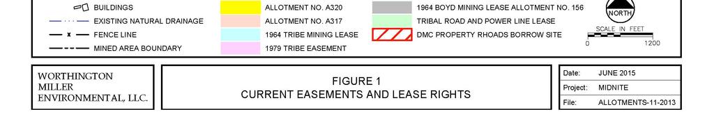
2 Worthington Miller Environmental TABLE OF CONTENTS N1.0 INTRODUCTION... 1 N2.0 MINED AREA... 1 N Tribal Mining Lease - Lease No N Allotment Mining Lease - Lease No N Tribal Easement... 1 N Tribal Lease for Operation of Pump-back System... 1 N Business Leases for Fence... 2 N Business Leases for Roads and Power Lines... 2 N3.0 MINING AFFECTED AREA - MINE DRAINAGES... 3 N4.0 BLUE CREEK PIPELINE ROUTE AND OUTFALL... 3 LIST OF FIGURES Figure 1. Figure 2. Figure 3. Current Easements and Lease Rights Midnite Mine Remediation Potential Impact Area Mine Area Midnite Mine Remediation Potential Impact Area Blue Creek Area Appendix N TribalSite Access/Right-of-Way Documentation June 2015July Percent Design i
3 Worthington Miller Environmental LIST OF ACRONYMS AMSL above mean sea level BIA BOR CFR Companies Dawn DOI Newmont ROD Tribe Bureau of Indian Affairs Bureau of Reclamation Code of Federal Regulations Dawn Mining Company LLC/Newmont USA Limited Dawn Mining Company LLC U.S. Department of the Interior Newmont USA Limited Record of Decision Spokane Tribe of Indians Appendix N TribalSite Access/Right-of-Way Documentation June 2015July Percent Design ii
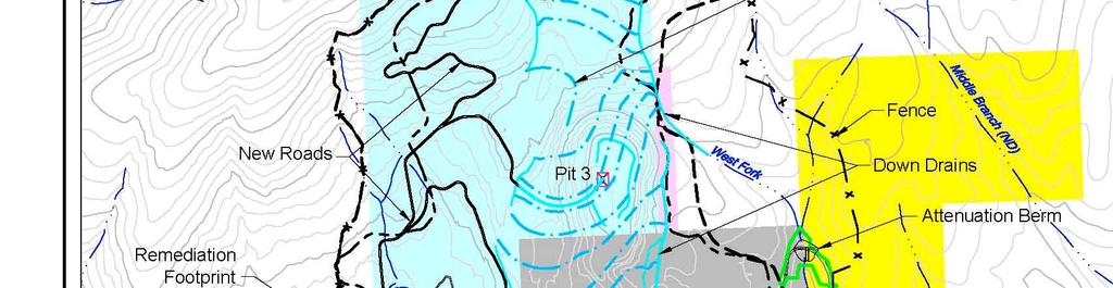
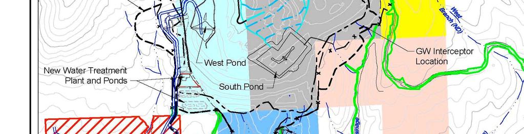
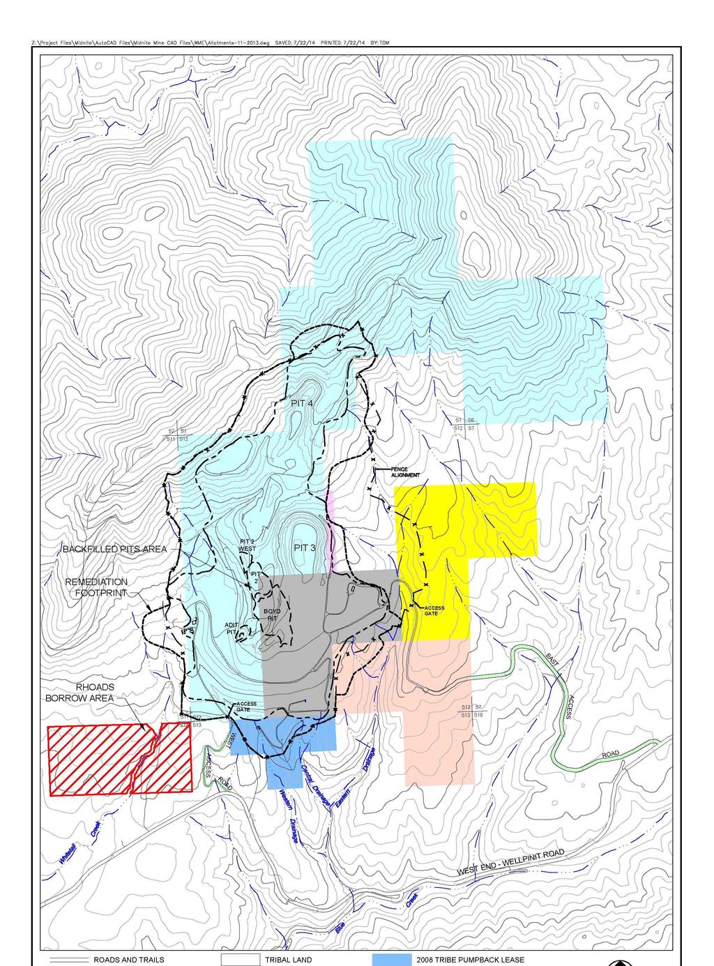
4 Worthington Miller Environmental N1.0 INTRODUCTION As described in the Record of Decision (ROD), construction of the remedy will require access to three primary areas within and adjacent to the Site: (i) the Mined Area, (ii) the mine drainages within the Mining Affected Area and (iii) the Blue Creek pipeline route and outfall location. Dawn/Newmont (Companiesy) currently has access and use rights under various leases and easements granted by the Tribe and allotment owners for most of the Mined Area. Additional access and use rights will need to be secured for limited portions of the Mined Area and for the Mining Affected Area and pipeline route. A summary of the current and anticipated access rights for each area is presented below. N2.0 MINED AREA The Mined Area includes both tribal trust lands and allotted lands. The Mined Area is enclosed by a chain link fence that was constructed in The approximate locations of the Mined Area and fence line boundaries are shown on Figure 1. The following access and use rights currently exist for areas within and adjacent to the Mined Area and fence line:. N TRIBAL MINING LEASE - LEASE NO The original Mining lease (also known as the Boyd Mining Lease), which was granted by the Spokane Tribe with Department of the Interior (DOI) approval, is dated September 18, 1964 and provided access to approximately acres in Sections 1 and 12, T. 28 N., R. 37 E., W.M. and Section 6, T. 28 N., R. 38 E., W.M. This Mining Lease was modified in 1977 and 1980 to add a total of 120 acres in Section 12, T. 28 N., R. 37 E. along the western boundary of the original leased lands. The area covered by this Mining Lease, as modified, is shown on Figure 1. DOI terminated the mining rights under this Lease in 1990 due to lack of ongoing mineral production. This Mining Lease provides a continuing right to access the subject tribal lands for an indefinite period for purposes of mine reclamation and closure. N ALLOTMENT MINING LEASE - LEASE NO This Mining Lease, which was granted by the individual allotment owners with DOI approval, is dated September 18, 1964 and covers the Boyd Allotment No. 156, as shown on Figure 1. This allotment is located in Section 12, T. 28 N., R. 37 E., W.M. DOI terminated the mining rights under this Lease in This Mining Lease provides a continuing right to access the subject allotment lands for an indefinite period for purposes of mine reclamation and closure. N TRIBAL EASEMENT In August 1979, the Spokane Tribe, with DOI approval, granted an easement across a portion of the W1/4, NE1/4 of Section 12, T. 28 N., R. 37 E., W.M. The area covered by this easement is shown on Figure 1. This easement authorizes use of the subject lands for a haul road on the east side of the mine pit areas for mining and reclamation. N TRIBAL LEASE FOR OPERATION OF PUMP-BACK SYSTEM On January 2, 2008, the Spokane Tribe, with DOI approval, granted a Lease on 40 acres in Appendix N Site Access/Right-of-Way Documentation June Percent Design 1
5 Worthington Miller Environmental Section 12, T. 28 N., R. 37 E., W.M. for the construction and maintenance of access roads, power lines and systems necessary for pump-back of drainage water into the mine impoundments. The lands covered by this Lease are shown on Figure 1. The Lease is for a term of 5 years and expired on December 31, The Companies havecompany has requested that the Tribe renew this Lease or replace it with a new Business Lease covering all additional access rights that are needed on tribal lands. The Companiesy and the Tribe have been negotiating terms for a replacement lease. N BUSINESS LEASES FOR FENCE Effective June 15, 2009, the Spokane Tribe, with DOI approval, granted a Business Lease on 100 acres for construction and maintenance of the chain link perimeter fence around the Midnite Mine Site. This Business Lease hads a term of 5 years and expired on June 15, Effective June 15, 2009, the owners of Allotments A317 and A320, with DOI approval, granted a Business Lease on acres for construction and maintenance of the chain link perimeter fence around the Midnite Mine Site. This Business Lease hads a term of 5 years and expired on June 15, The Ccompanies are currently coordinating with the Tribe, the allotment owners and the U.S. Bureau of Indian Affairs to obtain new leases. N BUSINESS LEASES FOR ROADS AND POWER LINES Effective June 15, 2009, the Spokane Tribe, with DOI approval, granted a Business Lease covering 7.61 acres along the east and west access roads (Eastern and Western Haul Roads) for construction, maintenance, and use of roads, water lines, gas lines and power lines in conjunction with mine reclamation activities and operation of the water treatment plant. This Business Lease hads a term of 5 years and expired on June 15, The Ccompanies are currently coordinating with the Tribe and the U.S. Bureau of Indian Affairs to obtain new leases. Effective June 15, 2009, the owners of Allotments A317 and A320, with DOI approval, granted a Business Lease covering 3.02 acres for construction, maintenance, and use areas along the east access road for roads, water lines, gas lines and power lines in conjunction with reclamation activities and operation of the water treatment plant. This Business Lease hads a term of 5 years and expired on June 15, The boundaries of Allotments A317 and A320 are shown on Figure 1. The companies are currently coordinating with the allotment owners to obtain new leases. Prior to construction of the remedy, additional rights will need to be obtained for access to Ttribal lands and a portion of Allotment No. A317, located within and/or immediately adjacent to the Mined Area, which are not covered by the above-described leases and easements. It is anticipated that those access and use rights would be obtained through either Business Leases granted by the Tribe and allotment owners with DOI approval., or Rights-of-Way granted by DOI with approval of the Tribe and allotment owners. These leasesgrants would be issued pursuant to the Bureau of Indian Affairs' (BIA) regulations codified at 25 CFR Part 162. (Business Leases) or 25 CFR Part 169 (Rights-of-Way). Those Leases or Rights-of-Way will need to include the right to access the Site. Access rights to the Rhoads borrow area from the western haul roadroute would need to be secured in Section 13. The Companiesy and the Tribe have been negotiating terms for a Business Lease that would cover all of the necessary access rights on tribal lands within the Mined Area, Mining Affected Area and Pipeline route. Appendix N Site Access/Right-of-Way Documentation June Percent Design 2
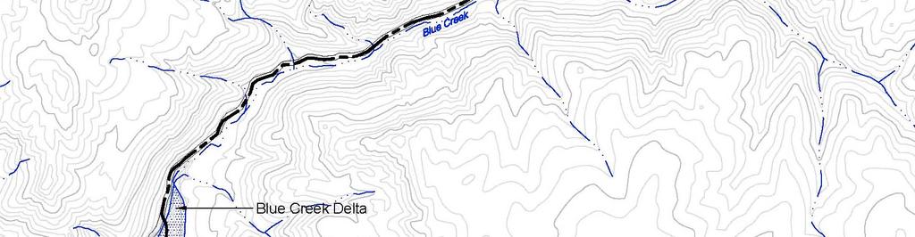
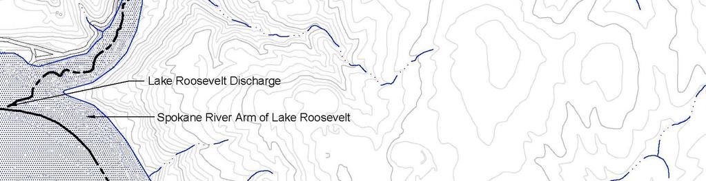
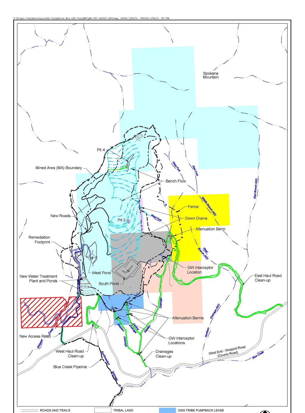
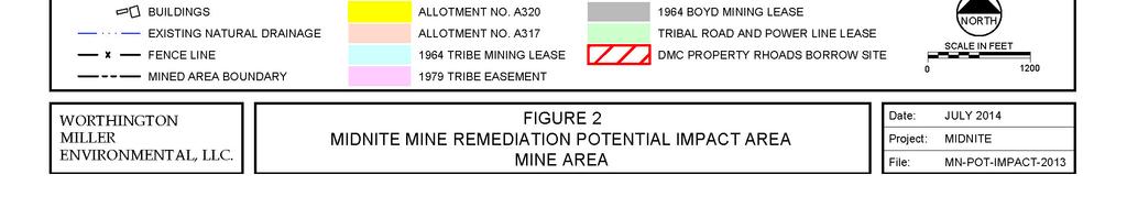
6 Worthington Miller Environmental The Company has had several meetings and discussions with Tribal representatives, including their technical and legal representatives, over the past six months. There have been comprehensive offers made that provide for the combination of access to the site, renewal of expired leases, water for construction purposes and long term institutional controls and the Company believe that these offers were well in excess of reasonable, fair market value for these specific items. Discussions are on-going and the parties representatives are continuing to prepare draft agreements addressing these matters. However, key terms have not been agreed upon, and it is unclear if definitive final agreements on these necessary elements can be obtained in time to begin implementation of the Remedy under the current schedule. N3.0 MINING AFFECTED AREA - MINE DRAINAGES Access and use rights will need to be secured for remediation of the Eastern, Central, Western and Far Western Drainages (Whitetail Drainage) within the Mining Affected Area, as shown on Figure 2. These rights will need to include the right to construct access roads, remove vegetation and sediments, revegetate and implement any other measures required to complete remedy construction and post-remedy monitoring. It is anticipated that those rights would be obtained through either Business Leases granted by the Tribe with DOI approval, or Rights-of- Way granted by DOI with Tribe approval pursuant to BIA's regulations at 25 CFR Part 162 (Business Leases) or 25 CFR Part 169 (Rights-of-Way). As noted above, the Companiesy and the Tribe have been discussing terms for a Business Lease that would grant the necessary access rights on tribal lands within the Mining Affected Area. In addition, the negotiations for the draft terms of the business agreement with the Allotees is ongoing. N4.0 BLUE CREEK PIPELINE ROUTE AND OUTFALL Access and use rights will need to be secured for construction, maintenance and monitoring of the discharge pipeline from the new water treatment plant to the outfall at the Spokane Arm of Lake Roosevelt. The pipeline route will generally follow the new access road through the Rhoads property and traverse tribal trust lands crossing Westend-Wellpinit Road to Blue Creek Road, to its outfall at the Spokane Arm of Lake Roosevelt. Lake Roosevelt is federal land below elevation 1,310 ft above mean sea level (AMSL) and the outfall will be located within the boundaries of the Spokane Indian Reservation. It is anticipated that the rights to construct, maintain and monitor the pipeline on tribal lands along this route will be obtained through either a Business Lease granted by the Tribe with DOI approval, or a Right-of-Way granted by DOI with Tribe approval pursuant to BIA regulations at 25 CFR Part 162 (Business Leases) or 25 CFR Part 169 (Rights-of-Way). Pursuant to the Act of June 29, 1940, Ch. 460, 54 Stat. 703, the United States acquired lands in the Spokane Indian Reservation that are within and adjacent to the Spokane Arm of Lake Roosevelt below the 1310 ft elevation line. An application for a Transportation and Utility Systems and Facilities on Federal Land Permit waswill be submitted to the Bureau of Reclamation for access onto federal land. The use and access rights for pipeline construction, maintenance and monitoring on these lands would be obtained from the Tribe consistent with the terms of the Lake Roosevelt Cooperative Management Agreement (commonly known as the Five Party Agreement),, dated April 5, 1990, by and between the Spokane Indian Tribe, Confederated Tribes of the Colville Reservation, BIA, Bureau of Reclamation and National Park Service. Appendix N Site Access/Right-of-Way Documentation June Percent Design 3
7 Worthington Miller Environmental In a letter dated August 5, 2013, the Bureau of Reclamation requested that an Application for Transportation and Utility System and Facilities on Federal Lands (SF ) be submitted for authorization to cross Bureau of Reclamation land. The Bureau of Reclamation manages the federal land in Lake Roosevelt below elevation 1,310 ft amsl. The application was submitted by DMC in April There has been no communication from the Bureau of Reclamation since that submittal. Westend-Wellpinit Road is a County Road maintained by Stevens County. A Stevens County Approach Permit will be obtained to construct the New Access Road for the project within the County Road Right-of-Way. A Stevens County Utility Franchise will be obtained to construct and maintain the Blue Creek Pipeline within the County Road Right-of-Way. This Permit and Utility Franchise will be applied for approximately 30 days prior to applicable construction in the County Right-of-Way. N5.0 CURRENT STATUS On May 29, 2015, as part of joint mediation efforts, the Tribe and the companies entered into a non-binding terms of agreement, which sets forth the framework for detailed definitive agreements that will provide for access to tribal lands for all purposes related to implementing the Midnite Mine remedy, including access for excavating and transporting the Rhoads borrow material. The parties are proceeding to prepare the necessary agreements and leases to implement these terms. The Companies have notified the Superintendent for the Spokane Agency BIA that they are in negotiations for business leases with both the Tribe and the Allotees. The negotiations for the draft terms of the business leases with the Allotees are ongoing. Appendix N Site Access/Right-of-Way Documentation June Percent Design 4
8


9 Appendix N Site Access/Right-of-Way Documentation June 2015July Percent Design 1
10 Appendix N Site Access/Right-of-Way Documentation Percent Design June 2015July
11
12
13
REQUEST FOR PROPOSAL
 REQUEST FOR PROPOSAL FOR Spokane Tribe of Indians LDR/COS Certificates YEPA Property And Task Order Contract PROPOSAL NO. FY2011/042 BY SPOKANE TRIBE OF INDIANS PURCHASING/PROPERTY DEPARTMENT 6195 FORD/WELLPINIT
Exploration & Production Operator s Compliance Manual for Energy Development Projects on the Southern Ute Indian Reservation
 Exploration & Production Operator s Compliance Manual for Energy Development Projects on the Southern Ute Indian Reservation The following is a brief summary of some of the most important provisions of
Christian C. Sizemore, Land Lead Newfield Exploration Company
 Christian C. Sizemore, Land Lead Newfield Exploration Company You could say that I grew up with oil and gas in my blood. I am the son of a lifelong landman, born and raised in Billings, Montana. After
THE BIA S NEW LONG-TERM LEASING REGULATIONS - 25 CFR PART 162 BUREAU OF INDIAN AFFAIRS WESTERN REGIONAL OFFICE NOVEMBER 2016
 THE BIA S NEW LONG-TERM LEASING REGULATIONS - 25 CFR PART 162 BUREAU OF INDIAN AFFAIRS WESTERN REGIONAL OFFICE NOVEMBER 2016 Long-Term Leasing The New Legal Framework The HEARTH Act was signed into law
UNITED STATES DEPARTMENT OF THE INTERIOR BUREAU OF INDIAN AFFAIRS CHICKASAW AGENCY
 Exhibit 15: State of Oklahoma, Choctaw Nation of Oklahoma, Chickasaw Nation, City of Oklahoma City Water Settlement File No. Allottee: Parcel No. AFTER RECORDING RETURN TO: City of Oklahoma City Office
Case 4:14-cv JHP-TLW Document 2 Filed in USDC ND/OK on 11/21/14 Page 1 of 10
 Case 4:14-cv-00704-JHP-TLW Document 2 Filed in USDC ND/OK on 11/21/14 Page 1 of 10 THE UNITED STATES DISTRICT COURT FOR THE NORTHERN DISTRICT OF OKLAHOMA (1) UNITED STATES OF AMERICA, ) ) Plaintiff, )
25 CFR, PART 151 LAND ACQUISITIONS
 25 CFR, PART 151 LAND ACQUISITIONS Contents 151.1 Purpose and scope. 151.2 Definitions. 151.3 Land acquisition policy. 151.4 Acquisitions in trust of lands owned in fee by an Indian. 151.5 Trust acquisitions
Ordinance 55 Hopi Planning Ordinance. Office of Community Planning and Economic Development
 Ordinance 55 Hopi Planning Ordinance 1 Introduction The Hopi Tribe finds: that unregulated growth and development on Hopi Lands may have unintended impacts that when considered cumulatively may adversely
Due Diligence & Environmental Compliance Issues for Tribal Energy Projects: Hazardous Waste
 Due Diligence & Environmental Compliance Issues for Tribal Energy Projects: Law Seminars International Seattle, WA October 23, 2007 Connie Sue Manos Martin Hazardous Waste Overview Environmental Due Diligence:
DRAFT REVISED NORTHERN CHEYENNE LAW & ORDER CODE TITLE 21 GRAZING ORDINANCE
 DRAFT REVISED NORTHERN CHEYENNE LAW & ORDER CODE TITLE 21 GRAZING ORDINANCE TITLE 21 TRIBAL GRAZING CODE TABLE OF CONTENTS DEFINITIONS CHAPTER 1 CHAPTER 2 CHAPTER 3 CHAPTER 4 CHAPTER 5 CHAPTER 6 CHAPTER
SKOKOMISH PUBLIC SEWER CONNECTION ORDINANCE TABLE OF CONTENTS
 TABLE OF CONTENTS GENERAL PROVISIONS 2.13.101 Title 2.13.102 Authority and Purpose 2.13.103 Goals 2.13.104 Sovereign Immunity 2.13.105 Severability 2.13.106 Definitions CONNECTIONS AND PERMITS 2.13.201
8. CONSTRUCTION SCHEDULE
 8. CONSTRUCTION SCHEDULE The project's authorizing legislation (PL 106-382, October 27, 2000) provides that funds for construction are to be appropriated..."over a period of 10 fiscal years..." (114 stat
JOINT PUBLIC NOTICE CORPS OF ENGINEERS STATE OF ARKANSAS Application Number: Date: December 9, 2016 Comments Due: January 3, 2017
 US Army Corps of Engineers Little Rock District JOINT PUBLIC NOTICE CORPS OF ENGINEERS STATE OF ARKANSAS Application Number: 2016-00183-1 Date: December 9, 2016 Comments Due: January 3, 2017 TO WHOM IT
Appendix F - Earth Materials Extraction, Processing and Site Reclamation
 Appendix F - Earth Materials Extraction, Processing and Site Reclamation Intent It is the purpose of this Article to establish regulations and standards for surface mining operations and to provide for
PACIFIC REGION LAND ACQUISITION REQUIREMENTS
 PACIFIC REGION LAND ACQUISITION REQUIREMENTS The following is an outline of the filing requirements for tribal land acquisition requests and timeframes involved for various steps of the process: 1) All
Appendix 4 Agency Approval Letters
 Appendix 4 Agency Approval Letters 55 Appendix4.a. Appendix 4.b. Appendix 4.c. Appendix 4.d. 3/10/2016 Clarksburg Mews, LLC c/o Michael Fisher 4938 Hampden Lane Bethesda, MD 20814 Re: Phase
Acquisition of Easements over Tribal Lands
 Acquisition of Easements over Tribal Lands Establishing an effective government-to-government relationship between the State and the Tribe. We have Executive Order #39 in effect since Governor Doyle Engaging
Subject: Ashville Park Cost Participation Term Sheet and Briefing
 OFFICE OF THE CITY MANAGER (757) 385-4242 April 27, 2018 MUNICIPAL CENTER BUILDING 1, ROOM 234 VVIRGINIA BEACH, VA 23456-9001 The Honorable Mayor William D. Sessoms, Jr. Members of City Council Subject:
Case 2:05-cv JLQ Document 290 Filed 08/21/2007 UNITED STATES DISTRICT COURT EASTERN DISTRICT OF W ASHINGTON
 Case :0-cv-0000-JLQ Document 0 Filed 0//00 0 0 UNITED STATES OF AMERICA, Plaintiff, vs. UNITED STATES DISTRICT COURT EASTERN DISTRICT OF W ASHINGTON NEW MONT USA LIMITED AND DAW N M INING COM PANY,LLC,
High Plains Economic District Southeast Wyoming Oil Exploration Seminar Series: Part II. Terms of Oil and Gas Lease and Surface Damage Agreement
 High Plains Economic District Southeast Wyoming Oil Exploration Seminar Series: Part II Terms of Oil and Gas Lease and Surface Damage Agreement Disclaimer Nothing in this presentation constitutes legal
Deerfield Township Community Development Department
 STAFF REVIEW Deerfield Township Community Development Department To: From: Hayfaa Wadih, AICP Lois McKnight, AICP Meeting Date: October 20, 2014 Continued from October 13, 2014 Re: Major PUD Modification
LEGISLATIVE COUNSEL'S DIGEST
 Senate Bill No. 209 CHAPTER 8 An act to amend Sections 607, 2207, and 2714 of, and to add Sections 2006.5, 2770.1, and 2773.1.5 to, the Public Resources Code, relating to surface mining. [ Approved by
Topics to be Covered
 CONSERVATION EASEMENTS Presented by Claire Fiegener, Greenbelt Land Trust Topics to be Covered What is a conservation easement? What is a land trust and how do they relate to conservation easements? What
Lead Agency: USDA Forest Service Santa Fe National Forest P.O. Box 3307 Española NM 87533
 , Santa Fe National Forest Los Alamos County/Rio Arriba/Santa Fe County, New Mexico Scoping Document Lead Agency: USDA Forest Service Santa Fe National Forest P.O. Box 3307 Española NM 87533 Responsible
POKAGON BAND OF POTAWATOMI INDIANS RESIDENTIAL LEASING ACT. Table of Contents
 POKAGON BAND OF POTAWATOMI INDIANS RESIDENTIAL LEASING ACT Table of Contents CHAPTER 1... 2 Section 1.01 Short Title... 2 Section 1.02 Authority... 2 Section 1.03 Purpose... 2 Section 1.04 Applicability...
For the reasons set forth in the preamble, the Department proposes to amend 25 CFR 151
 For the reasons set forth in the preamble, the Department proposes to amend 25 CFR 151 as follows: 1. Revise Part 151 of Title 25 of the Code of Federal Regulations to read as follows: PART 151 LAND ACQUISITION
UTILITY RIGHT-OF-WAY AND EASEMENT
 THE LAND TITLES ACT UTILITY RIGHT-OF-WAY AND EASEMENT I (We), Hauser Development Corp., of Buck Lake, in the Province of Alberta, Canada (hereinafter call the Grantor ) being registered owner of an estate
Project File #: SF Project Name: Jackson Ranch Filing No. 4 Parcel Nos.: , and
 COMMISSIONERS: DARRYL GLENN (PRESIDENT) MARK WALLER (PRESIDENT PRO TEMPORE) STAN VANDERWERF LONGINOS GONZALEZ PEGGY LITTLETON PLANNING AND COMMUNITY DEVELOPMENT DEPARTMENT CRAIG DOSSEY, EXECUTIVE DIRECTOR
We Appreciate Your Business and Look Forward to Serving You in the Future.
 Stewart Title Guaranty Company Commercial Services (Denver) 55 Madison Street, Suite 400 Denver, CO 80206 Date: October 31, 2017 File Number: 15000310384- Amendment No. 7 Property: Tracts A thru F Stargate
Record of Decision Mt. Hood National Forest Geothermal Leases August Record of Decision. Mt. Hood National Forest Geothermal Leases
 Summary Record of Decision Mt. Hood National Forest Geothermal Leases USDA Forest Service Mt. Hood National Forest Hood River and Barlow Ranger Districts Hood River County, Oregon It is my recommendation
United States Code Annotated Title 25. Indians Chapter 12. Lease, Sale, or Surrender of Allotted or Unallotted Lands 415. leases of restricted lands
 25 United States Code Annotated 415(e) United States Code Annotated Title 25. Indians Chapter 12. Lease, Sale, or Surrender of Allotted or Unallotted Lands 415. leases of restricted lands (a) Authorized
This permit application includes the land use/zoning and building inspection reviews.
 CONFEDERATED TRIBES OF THE UMATILLA INDIAN RESERVATION Planning Office 46411 Tímine Way, Pendleton, Oregon, 97801 541-276-3099 DEVELOPMENT/BUILDING INSPECTION: APPLICANT S NOTICE: This permit application
APPLICATION PROCEDURE
 ANTRIM PLANNING BOARD P. O. Box 517 Antrim, New Hampshire 03440 Phone: 603-588-6785 FAX: 603-588-2969 APPLICATION FORM AND CHECKLIST FOR EARTH EXCAVATION AND RECLAMATION File # Date Received By APPLICATION
PART 429 USE OF BUREAU OF RECLAMATION LAND, FACILITIES, AND WATERBODIES. Bureau of Reclamation, Interior Pt. 429
 Bureau of Reclamation, Interior Pt. 429 (b) This section does not apply if: (1) The formerly excess land becomes exempt from the acreage limitations of Federal reclamation law; or (2) The full-cost rate
JAMESTOWN S KLALLAM TRIBE TRIBAL CODE TITLE 31 - BUSINESS LEASE CODE
 JAMESTOWN S KLALLAM TRIBE TRIBAL CODE TITLE 31 - BUSINESS LEASE CODE Chapters: Chapter 31.01 General Provisions Chapter 31.02 Requirements for Business Site Leases Chapter 31.03 Business Lease Decision
Application for Individual Site Sanitation Facilities Portland Area Indian Health Services
 Application for Individual Site Sanitation Facilities Portland Area Indian Health Services PART 1 HOMEOWNER 1. Name: 2. Telephone #: 3. Site/House Address: 4. Current Mailing Address: 5. Directions to,
The University of Texas System Rules and Regulations of the Board of Regents Rule: 70301
 1. Title Matters Relating to Interests in Real Property 2. Rule and Regulation Sec. 1 Sec. 2 Authority. Texas Education Code Section 65.39 provides that The board of regents of The University of Texas
Initial Project Review
 Pierce County Department of Planning and Land Services, 2401 South 35th Street, Tacoma, WA (253) 798-7037 Initial Project Review Major Amendment to Preliminary Plat: Hawks Ridge Division 1 Application
KALISPEL RESOLUTION NO $~ Kalispel Tribe of Indians P.O. Box 39 Usk, WA RESOLUTION
 rx ~ ~~~~T "~Ci~ ~._. TRIBE OF INDIANS / '~~~ ~ KALISPEL RESOLUTION NO.2011- $~ Kalispel Tribe of Indians P.O. Box 39 Usk, WA 99180 (509) 445-1147 (509) 445-1705 fax www.kalispeltribe.com RESOLUTION WHEREAS,
SPECIAL ISSUES WHEN DEVELOPING ON NATIVE AMERICAN LAND. Nancy J. Appleby, Esq.
 SPECIAL ISSUES WHEN DEVELOPING ON NATIVE AMERICAN LAND Nancy J. Appleby, Esq. nancy@applebylawpllc.com Appleby Law PLLC 333 North Fairfax Street, Suite 302 Alexandria, VA 22314 www.applebylawpllc.com Hospitality
FSM MINERALS AND GEOLOGY WO AMENDMENT EFFECTIVE 6/1/90 CHAPTER MINERAL RESERVATIONS AND OUTSTANDING MINERAL RIGHTS.
 FSM 2800 - MINERALS AND GEOLOGY WO AMENDMENT 2800-90-1 EFFECTIVE 6/1/90 CHAPTER 2830 - MINERAL RESERVATIONS AND OUTSTANDING MINERAL RIGHTS Contents 2830.1 Authority 2830.2 Objective 2830.3 Policy 2830.4
Elko County Planning Commission ELKO COUNTY PLANNING COMMISSION MINUTES
 0 0 0 0 Elko County Planning Commission 0 COURT STREET, SUITE 0, ELKO, NV 0 PH. ()-, FAX () - ELKO COUNTY PLANNING COMMISSION MINUTES THURSDAY, FEBRUARY, 0 : P.M. CALL TO ORDER: The meeting of the Elko
SECTION 94A CONTRIBUTIONS PLAN
 SECTION 94A CONTRIBUTIONS PLAN 1.1 What is the name of this Plan? This contributions Plan is called the Lachlan Contributions Plan 2015 (Plan). 1.2 Application of this Plan This Plan applies to all land
Major Impact Review for Solar Energy System, Large River Frontage Road, New Castle - Garfield County File Number MIPA
 March 23, 2016 Clean Energy Collective c/o Richard Miller 361 Centennial Parkway, Third Floor Louisville, CO 80027 Reference: Major Impact Review for Solar Energy System, Large 35960 River Frontage Road,
RATE AND DAMAGE SCHEDULE
 THE UNIVERSITY OF TEXAS SYSTEM UNIVERSITY LANDS P.O. BOX 553 MIDLAND, TEXAS 79702-0553 (432) 684 4404 Website Link: http://www.utlands.utsystem.edu I. Well Locations and Oil & Gas Lease Appurtenances Page
Case Study. Tribal Real Estate Training Thursday, April 6 & 7, 2017 Grand Lodge Waterpark Resort Rothschild, WI April 6-7, 2017
 Case Study Tribal Real Estate Training Thursday, April 6 & 7, 2017 Grand Lodge Waterpark Resort Rothschild, WI April 6-7, 2017 Hypothetical Case Study 1 of 6 The Three Rivers Nation (TRN), a federally-recognized
Appendix A Major Federal, State, and Local Permits or Approvals
 TransWest Express EIS Appendix A Major Federal, State, and Local s or Approvals TransWest Express EIS Appendix A A-1 FEDERAL National Environmental Policy Act (NEPA) Compliance Federal action: to grant
Chapter IX Site Grading/Construction
 Chapter IX Site Grading/Construction Once an area has received the required zoning and site planning approvals, then the site may be eligible to begin construction of the necessary improvements. Construction
PEACE RIVER MANASOTA REGIONAL WATER SUPPLY AUTHORITY BOARD OF DIRECTORS MEETING February 2, 2017 REGULAR AGENDA ITEM 7
 PEACE RIVER MANASOTA REGIONAL WATER SUPPLY AUTHORITY BOARD OF DIRECTORS MEETING February 2, 2017 REGULAR AGENDA ITEM 7 Regional Integrated Loop System Phase 1 Interconnect Project [U.S. 17 to Punta Gorda]
WRITTEN DECISION OF THE HAYDEN CITY COUNCIL REGARDING MAPLE GROVE PRELIMINARY SUBDIVISION APPLICATION (SUB-0013) HAYDEN SIGNATURE, LLC
 HAYDEN SIGNATURE, LLC") WRITTEN DECISION OF THE HAYDEN CITY COUNCIL REGARDING MAPLE GROVE PRELIMINARY SUBDIVISION APPLICATION (SUB-0013) HAYDEN SIGNATURE, LLC Application of Hayden Signature, LLC, an Idaho limited liability company,
WRITTEN DECISION OF THE HAYDEN CITY COUNCIL REGARDING MAPLE GROVE PRELIMINARY SUBDIVISION APPLICATION (SUB-0013) HAYDEN SIGNATURE, LLC Application of Hayden Signature, LLC, an Idaho limited liability company,
HO-CHUNK NATION CODE (HCC) TITLE 8 HOUSING, REAL ESTATE AND PROPERTY CODE SECTION 11 RESIDENTIAL LEASING CODE
 TITLE 8 HOUSING, REAL ESTATE AND PROPERTY CODE SECTION 11 RESIDENTIAL LEASING CODE") Page 1 of 19 HO-CHUNK NATION CODE (HCC) TITLE 8 HOUSING, REAL ESTATE AND PROPERTY CODE SECTION 11 RESIDENTIAL LEASING CODE ENACTED BY LEGISLATURE: DECEMBER 17, 2013 LAST AMENDED AND RESTATED: NOVEMBER
Page 1 of 19 HO-CHUNK NATION CODE (HCC) TITLE 8 HOUSING, REAL ESTATE AND PROPERTY CODE SECTION 11 RESIDENTIAL LEASING CODE ENACTED BY LEGISLATURE: DECEMBER 17, 2013 LAST AMENDED AND RESTATED: NOVEMBER
Draft Continuing Authorities Program Section 1135 Detailed Project Report and Integrated Environmental Assessment
 Appendix G Real Estate Shorty s Island / Meander Reach Ecosystem Restoration Kootenai River, Idaho Draft Continuing Authorities Program Section 1135 Detailed Project Report and Integrated Environmental
HARLINGEN IRRIGATION DISTRICT REQUIREMENTS FOR SUBDIVISION PLAT APPROVAL
 HARLINGEN IRRIGATION DISTRICT REQUIREMENTS FOR SUBDIVISION PLAT APPROVAL Administrative Requirements 1. All assessments and outstanding invoices associated with the property to be subdivided must be current.
UNIFORM RULE 5. Administration of Williamson Act Contracts
 UNIFORM RULE 5 Administration of Williamson Act Contracts I. PROCEDURE TO ESTABLISH AN AGRICULTURAL PRESERVE AND WILLIAMSON ACT CONTRACT See Appendices 1 and 2 for the following forms: Application Form
Washoe Public Lands Management Act TITLE I FEDERAL LAND DISPOSAL
 Washoe Public Lands Management Act TITLE I FEDERAL LAND DISPOSAL SEC. 101. DEFINITIONS. (a) Secretary. The term Secretary means (1) the Secretary of Agriculture with respect to land in the National Forest
NONMETALLIC MINING LICENSE ISSUED BY THE TOWN OF HOWARD TO NORTHERN SANDS WISCONSIN, LLC RECITALS/GENERAL CONDITIONS
 NONMETALLIC MINING LICENSE ISSUED BY THE TOWN OF HOWARD TO NORTHERN SANDS WISCONSIN, LLC RECITALS/GENERAL CONDITIONS A. This Nonmetallic Mining License ( License ) is issued by the Town of Howard, Wisconsin
Bids Due and Opening Wednesday, December 7, 2016 Time 2:00 p.m.
 INVITATION TO BID Bid Package Montrose County 2017 Gravel Crushing Services Bids Due and Opening Wednesday, December 7, 2016 Time 2:00 p.m. Location Montrose County Road and Bridge Office 949 N. 2 nd Street
DoD American Indian/Alaskan Native Policy: Alaska Implementation Guidance. 11 May 2001
 DoD American Indian/Alaskan Native Policy: Alaska Implementation Guidance 11 May 2001 2 DOD AMERICAN INDIAN AND ALASKA NATIVE (AI/AN) POLICY ALASKA IMPLEMENTATION GUIDANCE I. Purpose: This Guidance is
FINAL PLAT SUBMITTAL CHECKLIST
 FINAL PLAT SUBMITTAL CHECKLIST The submission requirements for a Final Plat Review are found beginning in Section 24-4-40 of the Weld County Code. The Weld County Code is available on line at www.co.weld.co.us
ADMINISTRATIVE GUIDANCE
 11 ADMINISTRATIVE GUIDANCE ON CONTAMINATED SITES Effective date: April 1, 2013 Version 1.1 May 2013 Expectations and Requirements for Contaminant Migration Introduction This guidance focusses on the ministry
Appeals to the Board of County Commissioners Code standard as part of a project review Code standard without a project submittal $725.
 COMMUNITY DEVELOPMENT DIVISION P.O. Box 1190 Fort Collins, CO 80522-1190 Planning (970) 498-7683 Building (970) 498-7700 Planning Fax (970) 498-7711 Building Fax (970) 498-7667 http://www. larimer.org/planning
Public Notice U.S. ARMY CORPS OF ENGINEERS, GALVESTON DISTRICT AND TEXAS COMMISSION ON ENVIRONMENTAL QUALITY
 Public Notice U.S. Army Corps Permit Application No: SWG-2016-00384 Of Engineers Date Issued: 27 December 2018 Galveston District Comments Due: 29 January 2019 U.S. ARMY CORPS OF ENGINEERS, GALVESTON DISTRICT
ARCHITECTURAL CONTROL COMMITTEE SUBMITTAL REQUIREMENTS Submit to Teri Edwards at (O)
") ARCHITECTURAL CONTROL COMMITTEE SUBMITTAL REQUIREMENTS Submit to Teri Edwards at tedwards@crescentcommunities.com (O) 980-321-5180 Date Submitted Builder Community Phase / Lot# Address SPEC or CUSTOM (circle
ARCHITECTURAL CONTROL COMMITTEE SUBMITTAL REQUIREMENTS Submit to Teri Edwards at tedwards@crescentcommunities.com (O) 980-321-5180 Date Submitted Builder Community Phase / Lot# Address SPEC or CUSTOM (circle
CONSERVATION EASEMENTS & OIL AND GAS DEVELOPMENT
 CONSERVATION EASEMENTS & OIL AND GAS DEVELOPMENT HOW THE TWO CAN COEXIST Colorado Cattlemen s Agricultural Land Trust (CCALT) o Founded 1995 o First land trust founded by a livestock association o 6 other
Staff Report. Street Vacation. Salt Lake City Planning Commission. Ashley Scarff, (801) or Date: April 10 th, 2019
 or Date: April 10 th, 2019") Staff Report PLANNING DIVISION DEPARTMENT of COMMUNITY & NEIGHBORHOODS To: From: Salt Lake City Planning Commission Ashley Scarff, (801) 535-7660 or ashley.scarff@slcgov.com Date: April 10 th, 2019 Re:
Staff Report PLANNING DIVISION DEPARTMENT of COMMUNITY & NEIGHBORHOODS To: From: Salt Lake City Planning Commission Ashley Scarff, (801) 535-7660 or ashley.scarff@slcgov.com Date: April 10 th, 2019 Re:
GUIDELINES FOR SALT WATER DISPOSAL EASEMENTS
 New Mexico State Land Office Right of Way and Water Resources Bureau Patrick H. Lyons, Commissioner of Public Lands GUIDELINES FOR SALT WATER DISPOSAL EASEMENTS SECTION I. INTRODUCTION AND PURPOSE The
CITY COUNCIL AGENDA MEMORANDUM
 CITY COUNCIL AGENDA MEMORANDUM City and County of Broomfield, Colorado To: From: Prepared by: Mayor and City Council Charles Ozaki, City and County Manager Kevin Standbridge, Deputy City and County Manager
LOCAL LAW NO. 2, 1987 A LOCAL LAW REGULATING EXCAVATION AND TOPSOIL REMOVAL WITHIN THE TOWN OF CAMBRIA
 LOCAL LAW NO. 2, 1987 A LOCAL LAW REGULATING EXCAVATION AND TOPSOIL REMOVAL WITHIN THE TOWN OF CAMBRIA PASSED BY TOWN OF CAMBRIA TOWN BOARD SEPTEMBER 3, 1987 Be it enacted by the Town Board of the Town
ONEIDA INDIAN NATION TRUST LANDS RESIDENTIAL LEASING ORDINANCE
 ONEIDA INDIAN NATION TRUST LANDS RESIDENTIAL LEASING ORDINANCE Ordinance No.: 0-16-01 The Oneida Indian Nation (the "Nation") adopts and enacts this Ordinance pursuant to its inherent powers of self-government
Sketch Plan 2018 Bargersville Plan Commission Application Kit
 Sketch Plan 2018 Bargersville Plan Commission Application Kit For Commercial, Industrial, and Residential Developments At least 31 days prior to the intended filing of the Primary Plat or Development Plan
City of LaBelle Passive Recreational Park Management Plan
 City of LaBelle Passive Recreational Park Management Plan Table of Contents Park Management Plan 1-7 LIST OF APPENDICES Appendix 1 Appendix 2 Appendix 3 Appendix 4 Appendix 5 Initial Lease First amendment
Form SF298 Citation Data
 Form SF298 Citation Data Report Date ("DD MON YYYY") 17Jan2001 Report Type N/A Dates Covered (from... to) ("DD MON YYYY") Title and Subtitle Policy on Land Use Controls Associated with Environmental Restoration
Transfer and Transition: Interagency Coordination for Managing Public Lands at UMTRCA Title II Sites in Wyoming 16614
 Transfer and Transition: Interagency Coordination for Managing Public Lands at UMTRCA Title II Sites in Wyoming 16614 David S. Shafer*, Tim Vanek**, Tracy Ribeiro*, April Gil**, Cheri Bahrke*** *U.S. Department
JOINT PUBLIC NOTICE PUBLIC NOTICE
 Albuquerque District JOINT PUBLIC NOTICE PUBLIC NOTICE Application Number: SPA-2012-00299-ABQ Date: October 20, 2014 Comments Due: November 20, 2014 SUBJECT: The U.S. Army Corps of Engineers, Albuquerque
OVERVIEW OF LAWS RELATING TO MINERAL EXPLORATION, DEVELOPMENT & MINING IN COLORADO. by Mark T. Nesbitt Nesbitt & Associates LLC
 OVERVIEW OF LAWS RELATING TO MINERAL EXPLORATION, DEVELOPMENT & MINING IN COLORADO by Mark T. Nesbitt Nesbitt & Associates LLC This is a brief summary of information regarding applicable laws, permit requirements,
Environmental Management Chapter
 Environmental Management Chapter 335-5-1 ALABAMA DEPARTMENT OF ENVIRONMENTAL MANAGEMENT LAND DIVISIONS - UNIFORM ENVIRONMENTAL COVENANTS PROGRAM ADMINISTRATIVE CODE CHAPTER 335-5-1 GENERAL TABLE OF CONTENTS
Transitioning from the Farmland Preservation Program to the Working Lands Initiative
 Transitioning from the to the The table below describes differences between the Department of Agriculture, Trade and Consumer Protection s (DATCP) previous and the new. Contact: DATCPWorkingLands@wisconsin.gov
Horse Gulch Management Plan Final Draft: April 18, 2013
 I. INTRODUCTION This Plan provides a framework for the sound stewardship of the City of Durango Horse Gulch open space area. The Plan includes baseline information regarding the area, management objectives
Chapter 136. SOIL EROSION
 1 of 8 12/19/2011 4:17 PM Township of Andover, NJ Monday, December 19, 2011 Chapter 136. SOIL EROSION [HISTORY: Adopted by the Township Committee of the Township of Andover by Ord. No. 77-11 (Ch. XVII
CITY COUNCIL VOTING RESULTS
 CITY COUNCIL VOTING RESULTS July 18, 2000 ITEM 7. Consideration and approval of the Council Meeting minutes of June 6, 2000, June 20, 2000, and the adjourned meeting minutes of June 19, 2000. 8. Second
Appendix A. Definitions
 Definitions 1. Terms Defined. Words contained in this are those having a special meaning relative to the purposes of this Ordinance. Words not listed in this section shall be defined by reference to: (1)
DEED AND DEDICATION FOR PUBLIC RIGHT OF WAY
 TO : BOARD OF DIRECTORS FROM : GARY PLATT, EXEC. DIRECTOR BUSINESS AND OPERATIONS SUBJECT : CITY OF STANWOOD CONSTRUCTION EASEMENT AND RIGHT-OF-WAY DEDICATION DATE : MARCH 17, 2009 TYPE : ACTION NEEDED
DWR REAL ESTATE COORDINATION PLAN
 DWR REAL ESTATE COORDINATION PLAN Exhibit E DWR PROPERTY ACQUISTION PLAN EXHIBIT E Revised Date: 5 10 18 DWR PROPERTY ACQUISTION PLAN EXHIBIT E Revised Date: 5-10-2018 California WaterFix Real Estate Coordination
CHAPTER 5 RESIDENTIAL LAND LEASES FOR LEASEHOLD MORTGAGES
 TITLE 18 HOUSING CHAPTER 5 RESIDENTIAL LAND LEASES FOR LEASEHOLD MORTGAGES Legislative History: The Residential Land Leases for Leasehold Mortgages was enacted and codified as 18 T.O.C. Chapter 5 by Resolution
Fee $1, Property information and location (All lines applicable to this site must be filled in)
") Gravel Operations Conditional use permit Application Fee $1,000.00 Property information and location (All lines applicable to this site must be filled in) Section Township Range Parcel # Lot # You MUST
Gravel Operations Conditional use permit Application Fee $1,000.00 Property information and location (All lines applicable to this site must be filled in) Section Township Range Parcel # Lot # You MUST
CHAPTER FOUR - SPECIAL PROVISIONS. Purpose -- These provisions shall apply to all districts unless otherwise stated in the district regulations.
 CHAPTER FOUR - SPECIAL PROVISIONS Purpose -- These provisions shall apply to all districts unless otherwise stated in the district regulations. This Ordinance recognizes that certain activities, conditions
BWSR MN Public Drainage Manual Broad Users Outreach Workshop John Kolb, Attorney Lead Writer Chapter 4. MPDM Chapter 4: Viewing and Appraising
 BWSR MN Public Drainage Manual Broad Users Outreach Workshop John Kolb, Attorney Lead Writer Chapter 4 MPDM Chapter 4: Viewing and Appraising Chapter 4 Subcommittee Members 2 Sherry Enzler, MN DNR Bob
Economic Development & Housing Committee. Gas Exploration in the City of Dallas. September 5, 2006
 Economic Development & Housing Committee Gas Exploration in the City of Dallas September 5, 2006 1 Outline Purpose Background City of Dallas SUP requirements Possible Changes to current Development Code
Due Care Obligations
 Sec 324.XXXXX Due Care; duties of owner or operator, residential tenant, having knowledge of facility; compliance with section. (1) A current owner or operator of real property, or a residential tenant,
Environmental Health Technician: (303) ; Environmental Health Manager: (303) ;
 ; Environmental Health Manager: (303) ;") ON-SITE WASTEWATER TREATMENT SYSTEM PERMIT PROCESS FULL SYSTEM, UPGRADES, ALTERATIONS, REPAIRS AND VAULTS Prior to any work on an Onsite Wastewater Treatment System (OWTS), a permit needs to be obtained
ON-SITE WASTEWATER TREATMENT SYSTEM PERMIT PROCESS FULL SYSTEM, UPGRADES, ALTERATIONS, REPAIRS AND VAULTS Prior to any work on an Onsite Wastewater Treatment System (OWTS), a permit needs to be obtained
A Mining Operating Permit is used to:
 CHAPTER 400. SECTION 404. PERMIT TYPES AND APPLICATIONS OPERATING PERMITS 404.3. Mining Operating Permits A. Intent and Purpose The intent and purpose of this section is to protect the public health, safety,
Cadastral Data Content Standard - Rights and Interests
 Background Concepts Rights and Interests - Regulations and Restrictions In the Cadastral Data Content Standard Version 2 - June 30, 2014 A review of the content and background Nancy von Meyer Rights and
EXHIBIT A ENVIRONMENTAL COVENANT AND ACCESS AGREEMENT
 ENVIRONMENTAL COVENANT AND ACCESS AGREEMENT AFTER RECORDING RETURN TO: Laura Wishik, Esq. Director, Environmental Protection Section P. O. Box 94769 Seattle, WA 98124-4769 GRANTOR AND OWNER: City of Seattle
COLUMBIA COUNTY SURFACE MINING ORDINANCE
 EXHIBIT 7 COLUMBIA COUNTY SURFACE MINING ORDINANCE Adopted by Ordinance No. 90-11 on June 20, 1990 Amended by Ordinance No. 92-8 on September 30, 1992 Amended by Ordinance 95-8 on November 1, 1995 Amended
[RR , 189R5065C6, RX ] National Environmental Policy Act Implementing Procedures for the Bureau of
![[RR , 189R5065C6, RX ] National Environmental Policy Act Implementing Procedures for the Bureau of](/thumbs/95/125373881.jpg "[RR , 189R5065C6, RX ] National Environmental Policy Act Implementing Procedures for the Bureau of") This document is scheduled to be published in the Federal Register on 10/17/2018 and available online at https://federalregister.gov/d/2018-22630, and on govinfo.gov 4332-90-P DEPARTMENT OF THE INTERIOR
This document is scheduled to be published in the Federal Register on 10/17/2018 and available online at https://federalregister.gov/d/2018-22630, and on govinfo.gov 4332-90-P DEPARTMENT OF THE INTERIOR
A Minor Land Excavation Operating Permit is used to:
 CHAPTER 400. SECTION 404. PERMIT TYPES AND APPLICATIONS OPERATING PERMITS 404.1. Minor Land Excavation A. Intent and Purpose The intent and purpose of this section is to protect the public health, safety,
AGREEMENT TO ACQUIRE LANDS BETWEEN THE DEPARTMENT OF THE ARMY ST. PAUL DISTRICT, CORPS OF ENGINEERS AND. THE CITY OF City, State
 AGREEMENT TO ACQUIRE LANDS BETWEEN THE DEPARTMENT OF THE ARMY ST. PAUL DISTRICT, CORPS OF ENGINEERS AND THE CITY OF City, State FOR CONDEMNATION ON BEHALF OF THE SPONSOR BY THE CORPS OF ENGINEERS FOR THE
Application for Resource Consent (Subdivision) Section 88, Resource Management Act 1991 Form 9
 Section 88, Resource Management Act 1991 Form 9") Email: applications@waidc.govt.nz www.waikatodistrict.govt.nz Telephone (all hours) 07 824 8633 Call Free 0800 492 452 District Office 15 Galileo Street Private Bag 544 Ngaruawahia 3742 Application for
Email: applications@waidc.govt.nz www.waikatodistrict.govt.nz Telephone (all hours) 07 824 8633 Call Free 0800 492 452 District Office 15 Galileo Street Private Bag 544 Ngaruawahia 3742 Application for
DEVELOPMENT PLAN ORDINANCE
 DEVELOPMENT PLAN ORDINANCE CITY OF GLASGOW Ordinance No. 2026 SECTION A. Section 1. INTENT AND PURPOSE The purpose of this Ordinance is to establish and define development plans, which may be utilized
SAN BERNARDINO VALLEY MUNICIPAL WATER DISTRICT 380 E. Vanderbilt Way, San Bernardino, CA 92408
 SAN BERNARDINO VALLEY MUNICIPAL WATER DISTRICT 380 E. Vanderbilt Way, San Bernardino, CA 92408 SPECIAL JOINT BOARD MEETING OF THE BOARD OF DIRECTORS OF SAN BERNARDINO VALLEY MUNICIPAL WATER DISTRICT, WESTERN