Lead Agency: USDA Forest Service Santa Fe National Forest P.O. Box 3307 Española NM 87533
|
|
|
- Marilynn Morgan
- 6 years ago
- Views:
Transcription
1 , Santa Fe National Forest Los Alamos County/Rio Arriba/Santa Fe County, New Mexico Scoping Document Lead Agency: USDA Forest Service Santa Fe National Forest P.O. Box 3307 Española NM Responsible Official: Daniel J. Jiron Forest Supervisor Santa Fe National Forest 1474 Rodeo Road, P.O. Box 1689, Santa Fe, NM, For further information, contact: Sandy Hurlocker Española Ranger District. (505)
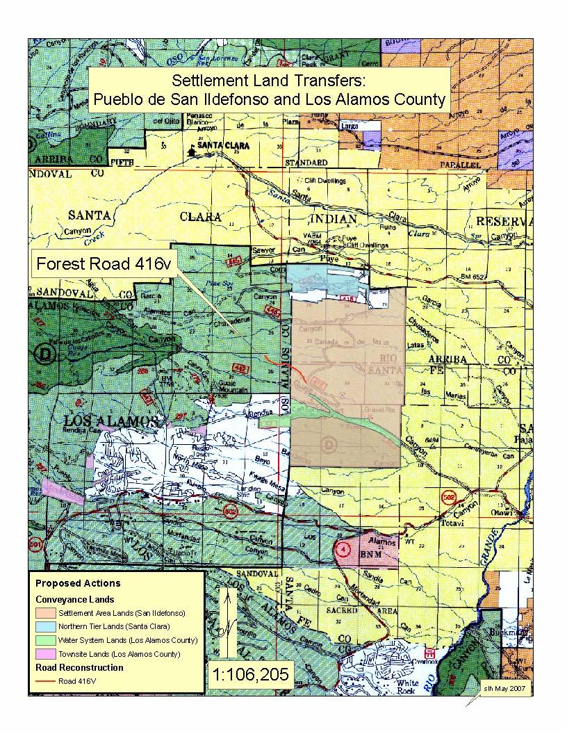
2 Summary: The US Forest Service (FS) has published a notice of intent (NOI) to prepare an environmental impact statement (EIS) on a proposed action that implements certain aspects of the Pueblo de San Ildefonso Claims Settlement Act of 2005 (PL ). Portions of the Act considered in this analysis include mandated transfer of certain National Forest System lands to the Pueblo of San Ildefonso (about 7,058 acres), the Pueblo of Santa Clara (about 740 acres), and Los Alamos County (about 631 acres). Lands would be conveyed in exchange for an appraised monetary value. The legislation also requires the Forest Service to offer for purchase six parcels of National Forest System lands to Los Alamos County near the community (totaling about 324 acres), and to reconstruct Forest Road (FR) 416v to a high-clearance, Level 2 standard. Although these proposed actions have been mandated by the Act, the Santa Fe National Forest will conduct a National Environmental Policy Act environmental analysis to disclose the impacts of these actions, and to fully describe any discretionary actions that may also be included as part of the land transfers called for in the Act. However, under the Act, discretion is limited. A map of the area is attached. Comments concerning the project must be received no later than 30 days after the notice of intent is published in the Federal Register (published June 15, 2007). The draft environmental impact statement is expected in September 2007 and the final environmental impact statement is expected in November of Please send written comments to Sandy Hurlocker, District Ranger, US Forest Service, Espanola Ranger District, P.O. Box 3307, Espanola, New Mexico, Electronic mail ( ) may be sent to comments-southwestern-santafe-espanola@fs.fed.us and FAX may be sent to (505) For further information contact: Sandy Hurlocker, District Ranger, Española, Espanola Ranger District, (505) Background: On September 27, 2006, the Pueblo de San Ildefonso Claims Settlement Act of 2005 was signed into law. The purpose of the Act is to resolve title claims asserted against the United States by the San Ildefonso Pueblo under the proceedings of the Indian Claims Act (Docket No 354). Other purposes of the Act related to this analysis are (1) the authorization of the Pueblo to acquire and the Forest Service to convey National Forest System lands as identified in the San Ildefonso Settlement Agreement (Settlement Area Lands), and (2) the authorization of the Secretary of Agriculture to convey other lands out of the National Forest System in order to comply with an inter-pueblo Agreement and the Los Alamos Agreement, which has been incorporated by the San Ildefonso Settlement Agreement and ratified by the Act. These additional lands include the Water System Lands, the Northern Tier Lands (to be acquired by the Santa Clara Pueblo), and the Los Alamos Townsite Lands. The Act provides that the Settlement Area Land and the Northern Tier Lands shall be -2-
3 held by the Secretary of the Interior in trust for the benefit of each Pueblo. Lands acquired by Los Alamos County as Water System Lands become San Ildefonso Pueblo tribal lands if they were no longer needed for Los Alamos County s water facilities. Most of the Los Alamos Townsite lands are currently used for Los Alamos County water facilities, including Los Alamos Reservoir and dam, as well as water tanks. Except for the restrictions and reservations identified above, the Secretary of Agriculture does not propose to place any restrictions on future use of the Townsite lands, Settlement Area lands, Water System lands, or Northern Tier lands. The Act also calls for reservation of a number of road easements to assure public access to lands that would otherwise be inaccessible to motorized vehicles once the conveyance takes place. For most of these reservations, existing roads provide adequate access and so only an administrative action is expected. However, as part of the Los Alamos Agreement, road improvement work must be completed to improve public access to the National Forest System lands adjoining the Settlement Area Lands prior to conveyance. The Act allows for reconstruction of FR 416v to a high clearance, Level 2 to provide this access. Even though the Act requires these actions and so discretion is limited, the Santa Fe National Forest will study and disclose in an environmental impact statement the effects of the actions described in the Act that relate to the Secretary of Agriculture s authority to transfer lands and reconstruct Road 416v. Other actions to be undertaken by the Department of Interior, the Pueblo of San Ildefonso, or Los Alamos have not been included in the scope of this proposal because they can be accomplished separately. Proposed Action: The Santa Fe National Forest proposes the following: Convey the Settlement Area lands to the Pueblo of San Ildefonso (approximately 7,058 acres) located in: Township 20 north, Range 7 east, sections 19, 20, 21, 28, 29, 30, 31, 32, 33; and Township 19 north, Range 7 east, sections 4, 5, 6, 7, 8, 9; New Mexico Principal Meridian. Convey the Water System lands to Los Alamos County (approximately 631 acres) located in Township 20 north, Range 7 east, section 31; Township 19 north, Range 7 east, sections 4, 5, 6, 7, 8, 9; Township 19 north, Range 6 east, section 1; New Mexico Principal Meridian. Convey the Northern Tier Lands to the Pueblo of Santa Clara (approximately 740 acres) located in Township 20 north, Range 7 east, sections 17, 18; New Mexico Principal Meridian. Offer for conveyance the Los Alamos Townsite lands to Los Alamos County. These six parcels total approximately 324 acres of National Forest System lands located in Township 19 north, Range 4 east, section 13; Township 19 north, Range 5 east, sections 3, 4, 5, 18; New Mexico Principal Meridian. Reconstruct FR 416v to a high clearance, Level 2, standard, following the existing route as much as practical. Reconstruction will require grading, culvert placement, and possibly relocation of short segments. Ancillary actions that may be implemented along with the land transfers and road -3-
4 reconstruction. Examples include fence construction along boundary lines and road closures where roads no longer serve a purpose to the management of National Forests. Other Information: Decision Framework: The NEPA decision to be made is limited by the Act. Transfer or offering for sale of lands is mandated. Reconstruction of FR 416v is also mandated as an action that must be completed before the land conveyance can occur. However, the Forest will evaluate effects and develop mitigation measures and best management practices to implement during the road reconstruction and, where applicable, in the land conveyance. Scoping Process: The scoping process will include appropriate public involvement activities during June/July Other appropriate public involvement will occur once the Draft EIS is available for review, which is expected to occur in the late summer of Preliminary Issues: Because the conveyance of land will not significantly change the expected land use of the transferred lands, no significant issues have been identified. Reconstruction of FR 416v has the potential to affect known cultural resource sites located within the existing roadway. Because the sites and road occupy land between a canyon wall and steep ground, options to avoid these sites are limited, and so data recovery is the likely method for mitigating impacts. No threatened or endangered species or Region 3 sensitive species of animal or plant are known in the project area. Likewise, no Region 3 sensitive species are known. Because the National Forest System lands would be closed to the general public once conveyed to the Pueblos, a change in recreational use patterns is likely. A closed pumice mine exists on the land to be conveyed to the San Ildefonso Pueblo, with reclamation underway. Any unfinished reclamation will pass to the Secretary of Interior pursuant to the Act, Section 7(f). Comment Requested: The publication of the notice of intent initiates the scoping process that guides the development of the environmental impact statement. The Forest Service invites written comments and suggestions on the proposed action, including any issues to consider, as well as any concerns relevant to the analysis. ### -4-
5 -5-
Record of Decision Mt. Hood National Forest Geothermal Leases August Record of Decision. Mt. Hood National Forest Geothermal Leases
 Summary Record of Decision Mt. Hood National Forest Geothermal Leases USDA Forest Service Mt. Hood National Forest Hood River and Barlow Ranger Districts Hood River County, Oregon It is my recommendation
13308 West Highway 160 Del Norte, CO TTY
 USDA Forest Service Divide Ranger District http://www.fs.fed.us/r2/riogrande 13308 West Highway 160 Del Norte, CO 81132 719-657-3321 TTY 657-6038 USDI Bureau of Land Management San Luis Resource Area File
Grand Mesa, Uncompahgre and Gunnison National Forests Region 2, USDA Forest Service
 Decision Memo Taylor River Land Exchange Under the General Exchange Act of March 20, 1922 as Amended, The Federal Land Policy and Management Act of 1976 as Amended and the Federal Land Exchange Facilitation
Environmental Assessment South Administrative Site Proposed Property Sale
 Department of Agriculture Forest Service June 2010 Environmental Assessment 6200 South Administrative Site Proposed Property Sale Uinta-Wasatch-Cache NF Salt Lake Ranger District Salt Lake County, Utah
[RR , 189R5065C6, RX ] National Environmental Policy Act Implementing Procedures for the Bureau of
![[RR , 189R5065C6, RX ] National Environmental Policy Act Implementing Procedures for the Bureau of](/thumbs/95/125373881.jpg "[RR , 189R5065C6, RX ] National Environmental Policy Act Implementing Procedures for the Bureau of") This document is scheduled to be published in the Federal Register on 10/17/2018 and available online at https://federalregister.gov/d/2018-22630, and on govinfo.gov 4332-90-P DEPARTMENT OF THE INTERIOR
This document is scheduled to be published in the Federal Register on 10/17/2018 and available online at https://federalregister.gov/d/2018-22630, and on govinfo.gov 4332-90-P DEPARTMENT OF THE INTERIOR
DRAFT Decision Notice and Finding of No Significant Impact
 United States Department of Agriculture Forest Service December 2014 DRAFT Decision Notice and Finding of No Significant Impact Town of Manila Land Conveyance (Manila Landfill) Flaming Gorge Ranger District,
For the reasons set forth in the preamble, the Department proposes to amend 25 CFR 151
 For the reasons set forth in the preamble, the Department proposes to amend 25 CFR 151 as follows: 1. Revise Part 151 of Title 25 of the Code of Federal Regulations to read as follows: PART 151 LAND ACQUISITION
16 USC 545b. NB: This unofficial compilation of the U.S. Code is current as of Jan. 4, 2012 (see
 TITLE 16 - CONSERVATION CHAPTER 2 - NATIONAL FORESTS SUBCHAPTER II - SCENIC AREAS 545b. Opal Creek Wilderness and Scenic Recreation Area (a) Definitions In this section: (1) Bull of the Woods Wilderness
3.23 LANDS AND SPECIAL USES
 3.23 LANDS AND SPECIAL USES Introduction This section addresses those aspects of SJPLC management relating to public land ownership and use. Special Use Permits, rights-of-way (ROW) grants, easements,
SEQRA (For Land Surveyors) Purpose of this Presentation
 Purpose of this Presentation") SEQRA (For Land Surveyors) Purpose of this Presentation Understand the basics and legal requirements of SEQRA Recognize the role that Land Surveyors play in the SEQRA Identify the problems posed by SEQRA
SEQRA (For Land Surveyors) Purpose of this Presentation Understand the basics and legal requirements of SEQRA Recognize the role that Land Surveyors play in the SEQRA Identify the problems posed by SEQRA
Dear Interested Party:
 United States Department of Agriculture Forest Service Kaibab National Forest 800 South Sixth Street Williams, AZ 86046-2899 (928) 635-8200 File Code: 1950 Date: April 24, 2015 Dear Interested Party: The
3. Adopt the Preliminary Use and Management Plan for the property granted to the District.
 R-13-119 Meeting 13-34 December 11, 2013 AGENDA ITEM AGENDA ITEM 8 Approval of an Agreement to Exchange Real Property Interests with Santa Clara County (County) Roads & Airports concerning County property
DAKOTA DEPARTMENT OF TRANSPORTATION AND THE THE FEDERAL HIGHWAY ADMINISTRATION
 USDA, Forest Service OMB 0596-0217 FS-1500-15 FS Agreement No. 17-MU-11020000-072 Cooperator Agreement No. MEMORANDUM OF UNDERSTANDING Between The SOUTH DAKOTA DEPARTMENT OF TRANSPORTATION AND THE THE
1.1 Purpose. The purpose of this chapter is to summarize guidance on those requirements generally applicable to grant programs.
 523 FW 1 Summary FWM#: 061 (new) Date: December 17, 1992 Series: State Grant Programs Part 523: Federal Aid Compliance Requirements Originating Office: Division of Federal Aid 1.1 Purpose. The purpose
DECISION MEMO FOR CATEGORICAL EXCLUSION. USDA-Forest Service Hiawatha National Forest
 DECISION MEMO FOR CATEGORICAL EXCLUSION USDA-Forest Service Hiawatha National Forest Sault Ste. Marie Administrative Site Forest Service Facility Realignment and Enhancement Act of 2005 Chippewa County,
SOUND TRANSIT RESOLUTION NO. R99-11
 SOUND TRANSIT RESOLUTION NO. R99-11 A RESOLUTION of the Board of the Central Puget Sound Regional Transit Authority authorizing the Executive Director to acquire, dispose, or lease certain real property
WATER RIGHTS LEASE AGREEMENT. This water rights lease agreement ( Agreement ) is made and entered into this day of
 is made and entered into this day of") WATER RIGHTS LEASE AGREEMENT This water rights lease agreement ( Agreement ) is made and entered into this day of, 2016, by and between the town of Silver City, ( Silver City ), a New Mexico municipal
WATER RIGHTS LEASE AGREEMENT This water rights lease agreement ( Agreement ) is made and entered into this day of, 2016, by and between the town of Silver City, ( Silver City ), a New Mexico municipal
Nevada Public Land Management Task Force Final Report, SJR 1 of the 78 th Nevada Legislature and Implementation through Federal Legislation
 Nevada Public Land Management Task Force Final Report, SJR 1 of the 78 th Nevada Legislature and Implementation through Federal Legislation Churchill County Public Meeting Churchill County Commission Chamber
CURRENT THROUGH PL , APPROVED 11/11/2009
 CURRENT THROUGH PL 111-98, APPROVED 11/11/2009 TITLE 10. ARMED FORCES SUBTITLE A. GENERAL MILITARY LAW PART IV. SERVICE, SUPPLY, AND PROCUREMENT CHAPTER 159. REAL PROPERTY; RELATED PERSONAL PROPERTY; AND
25 CFR, PART 151 LAND ACQUISITIONS
 25 CFR, PART 151 LAND ACQUISITIONS Contents 151.1 Purpose and scope. 151.2 Definitions. 151.3 Land acquisition policy. 151.4 Acquisitions in trust of lands owned in fee by an Indian. 151.5 Trust acquisitions
GUIDELINES FOR SALT WATER DISPOSAL EASEMENTS
 New Mexico State Land Office Right of Way and Water Resources Bureau Patrick H. Lyons, Commissioner of Public Lands GUIDELINES FOR SALT WATER DISPOSAL EASEMENTS SECTION I. INTRODUCTION AND PURPOSE The
Community Development Department Planning Division 1600 First Street + P.O. Box 660 Napa, CA Napa (707)
") Community Development Department Planning Division 1600 First Street + P.O. Box 660 Napa, CA 94559-0660 Napa (707) 257-9530 PLANNING COMMISSION STAFF REPORT JUNE 16, 2016 AGENDA ITEM # 6.B. 16-0056-EXT;
Community Development Department Planning Division 1600 First Street + P.O. Box 660 Napa, CA 94559-0660 Napa (707) 257-9530 PLANNING COMMISSION STAFF REPORT JUNE 16, 2016 AGENDA ITEM # 6.B. 16-0056-EXT;
SUBJECT: CROWN RESERVED ROAD POLICY
 SUBJECT: CROWN RESERVED ROAD POLICY Policy Number: CLM 006 2003 C. R. File Number: 656-00-0001 Effective Date: July 6, 2010 To Be Reviewed: July 6, 2014 Approval: Original Signed by Phil LePage, Deputy
Decision Notice and Finding of No Significant Impact
 United States Department of Agriculture Forest Service Eastern Region Decision Notice and Finding of No Significant Impact Delich Land Exchange Project Bergland, Ontonagon and Watersmeet Ranger Districts
A Guide to the Municipal Planning Process in Saskatchewan
 A Guide to the Municipal Planning Process in Saskatchewan A look at the municipal development permit and the subdivision approval process in Saskatchewan May 2008 Prepared By: Community Planning Branch
Aubrey Dunn, Commissioner of Public Lands State of New Mexico
 Aubrey Dunn, Commissioner of Public Lands State of New Mexico RECREATIONAL ACCESS PERMIT CONTRACT To apply for a Recreational Access Permit READ CAREFULLY the CONTRACT form below, complete the CONTRACT
ARTICLE XI - CONSERVATION SUBDIVISIONS
 ARTICLE XI - CONSERVATION SUBDIVISIONS Section 1101: Purpose and Intent. This Article is intended to provide for residential subdivisions that are designed based first and foremost on the preservation
This document was prepared by: Albemarle County Attorney County of Albemarle 401 McIntire Road Charlottesville, Virginia 22902
 This document was prepared by: Albemarle County Attorney County of Albemarle 401 McIntire Road Charlottesville, Virginia 22902 Tax Map and Parcel Number This deed is exempt from taxation under Virginia
IC Chapter 7. Real Property Transactions
 IC 8-23-7 Chapter 7. Real Property Transactions IC 8-23-7-0.1 Application of certain amendments to chapter Sec. 0.1. The amendments made to section 19 of this chapter by P.L.133-2007 apply only to public
Notice of Proposed Withdrawal and Opportunity for Public Meeting; Arizona. SUMMARY: The Secretary of the Interior proposes to withdraw approximately
 4310-32-P DEPARTMENT OF THE INTERIOR Bureau of Land Management Notice of Proposed Withdrawal and Opportunity for Public Meeting; Arizona AGENCY: Bureau of Land Management, Interior. ACTION: Notice. SUMMARY:
ARTICLE (SM) SURFACE MINING ZONE. 2. To allow the development and use of mineral and aggregate resources;
 SURFACE MINING ZONE. 2. To allow the development and use of mineral and aggregate resources;") ARTICLE 15.00 (SM) SURFACE MINING ZONE 15.01 PURPOSE The purposes of the Surface Mining Zone are: 1. To implement the policies of the Comprehensive Plan; 2. To allow the development and use of mineral
ARTICLE 15.00 (SM) SURFACE MINING ZONE 15.01 PURPOSE The purposes of the Surface Mining Zone are: 1. To implement the policies of the Comprehensive Plan; 2. To allow the development and use of mineral
[15XL LLIDI02000.L EO0000. LVTFD A ; IDI- Notice of Intent to Amend the Pocatello Resource Management Plan and Notice of
 This document is scheduled to be published in the Federal Register on 08/10/2015 and available online at http://federalregister.gov/a/2015-19606, and on FDsys.gov 4310-GG-P DEPARTMENT OF THE INTERIOR Bureau
FOREST SERVICE HANDBOOK NATIONAL HEADQUARTERS (WO) WASHINGTON, DC
 WASHINGTON, DC") Page 1 of 58 FOREST SERVICE HANDBOOK NATIONAL HEADQUARTERS (WO) WASHINGTON, DC Amendment No.: 5409.13-2004-1 Effective Date: February 27, 2004 Duration: This amendment is effective until superseded or
Page 1 of 58 FOREST SERVICE HANDBOOK NATIONAL HEADQUARTERS (WO) WASHINGTON, DC Amendment No.: 5409.13-2004-1 Effective Date: February 27, 2004 Duration: This amendment is effective until superseded or
The Application Process
 The Application Process This document is intended as a guide and does not constitute a legal document. For further and more detailed information, please refer to the following Acts and Regulations: The
YELLOWSTONE COUNTY BOARD OF PLANNING FINDINGS OF FACT
 YELLOWSTONE COUNTY BOARD OF PLANNING FINDINGS OF FACT The City-County Planning staff has prepared the Findings of Fact for the Aspen Ridge Subdivision, 2 nd Filing. These findings are based on the preliminary
FINAL ENVIRONMENTAL IMPACT STATEMENT AND NEBRASKA NATIONAL FOREST REVISED LAND AND RESOURCE MANAGEMENT PLAN
 FINAL ENVIRONMENTAL IMPACT STATEMENT AND NEBRASKA NATIONAL FOREST REVISED LAND AND RESOURCE MANAGEMENT PLAN Record of Decision Oil and Gas Leasing NEBRASKA NATIONAL FOREST BUFFALO GAP NATIONAL GRASSLAND
PROJECT: P 0037(129)207 PCN: 039K BROWN COUNTY. S.D. Highway 37 From Aspen Ave to U.S. Highway 12 in Groton
207 PCN: 039K BROWN COUNTY. S.D. Highway 37 From Aspen Ave to U.S. Highway 12 in Groton") Public Meeting/ Open House September 4, 2014 PROJECT: P 0037(129)207 PCN: 039K BROWN COUNTY S.D. Highway 37 From Aspen Ave to U.S. Highway 12 in Groton Grading, Storm Sewer, Curb & Gutter, Sidewalk, Roadway
Public Meeting/ Open House September 4, 2014 PROJECT: P 0037(129)207 PCN: 039K BROWN COUNTY S.D. Highway 37 From Aspen Ave to U.S. Highway 12 in Groton Grading, Storm Sewer, Curb & Gutter, Sidewalk, Roadway
Diamond Falls Subdivision PROPOSED YELLOWSTONE COUNTY BOARD OF PLANNING FINDINGS OF FACT
 Diamond Falls Subdivision PROPOSED YELLOWSTONE COUNTY BOARD OF PLANNING FINDINGS OF FACT The City/County Planning Staff has prepared the Findings of Fact for the Diamond Falls Subdivision. These findings
H.R. 2157, to facilitate a land exchange involving certain National Forest System lands in the Inyo National Forest, and for other purposes.
 STATEMENT OF GREGORY SMITH ACTING DEPUTY CHIEF OF STAFF UNITED STATES DEPARTMENT OF AGRICULTURE BEFORE THE UNITED STATES HOUSE OF REPRESENTATIVES COMMITTEE ON NATURAL RESOURCES SUBCOMMITTEE ON NATIONAL
RESOLUTION NO. R To Acquire Real Property Interests Required for the Lynnwood Link Extension
 RESOLUTION NO. R2017-40 To Acquire Real Property Interests Required for the Lynnwood Link Extension MEETING: DATE: TYPE OF ACTION: STAFF CONTACT: Capital Committee Board PROPOSED ACTION 11/09/2017 11/16/2017
MOTION NO. M Property Exchange Agreement with the University of Washington for the Northgate Link Extension
 MOTION NO. M2012-93 Property Exchange Agreement with the University of Washington for the Northgate Link Extension MEETING: DATE: TYPE OF ACTION: STAFF CONTACT: PHONE: Board 12/20/12 Final Action Ahmad
APRIL 30, ILL. ADM. CODE 2580 CH. I, SEC. 2580
 TITLE 17: CONSERVATION CHAPTER I: DEPARTMENT OF NATURAL RESOURCES SUBCHAPTER f: ADMINISTRATIVE SERVICES PART 2580 CONSERVATION STEWARDSHIP PROGRAM Section 2580.10 Definitions 2580.20 Eligibility 2580.30
Cancelled. Final Action
 MOTION NO. M2018-100 Land Exchange Agreement between Sound Transit and WSDOT MEETING: DATE: TYPE OF ACTION: STAFF CONTACT: Capital Committee Board PROPOSED ACTION 08/17/2018 08/23/2018 Cancelled Final
FSM MINERALS AND GEOLOGY WO AMENDMENT EFFECTIVE 6/1/90 CHAPTER MINERAL RESERVATIONS AND OUTSTANDING MINERAL RIGHTS.
 FSM 2800 - MINERALS AND GEOLOGY WO AMENDMENT 2800-90-1 EFFECTIVE 6/1/90 CHAPTER 2830 - MINERAL RESERVATIONS AND OUTSTANDING MINERAL RIGHTS Contents 2830.1 Authority 2830.2 Objective 2830.3 Policy 2830.4
PROJECTS: P 0083(74)56; 036E; JONES COUNTY NH 0083(79)45; 04E7; MELLETTE COUNTY NH 0083(80)44; 04E8; MELLETTE COUNTY
56; 036E; JONES COUNTY NH 0083(79)45; 04E7; MELLETTE COUNTY NH 0083(80)44; 04E8; MELLETTE COUNTY") Public Meeting/ Open House October 16, 2014 PROJECTS: P 0083(74)56; 036E; JONES COUNTY NH 0083(79)45; 04E7; MELLETTE COUNTY NH 0083(80)44; 04E8; MELLETTE COUNTY U.S. Highway 83 From White River to South
Public Meeting/ Open House October 16, 2014 PROJECTS: P 0083(74)56; 036E; JONES COUNTY NH 0083(79)45; 04E7; MELLETTE COUNTY NH 0083(80)44; 04E8; MELLETTE COUNTY U.S. Highway 83 From White River to South
NONMETALLIC MINING LICENSE ISSUED BY THE TOWN OF HOWARD TO NORTHERN SANDS WISCONSIN, LLC RECITALS/GENERAL CONDITIONS
 NONMETALLIC MINING LICENSE ISSUED BY THE TOWN OF HOWARD TO NORTHERN SANDS WISCONSIN, LLC RECITALS/GENERAL CONDITIONS A. This Nonmetallic Mining License ( License ) is issued by the Town of Howard, Wisconsin
City of Palo Alto (ID # 4882) City Council Staff Report
 City Council Staff Report") City of Palo Alto (ID # 4882) City Council Staff Report Report Type: Consent Calendar Meeting Date: 12/15/2014 Summary Title: Easements for San Francisquito Creek Joint Powers Authority Initial Flood Protection
City of Palo Alto (ID # 4882) City Council Staff Report Report Type: Consent Calendar Meeting Date: 12/15/2014 Summary Title: Easements for San Francisquito Creek Joint Powers Authority Initial Flood Protection
Project NH 0018(179)402 PCN 036L Hutchinson and Turner County. US18 From US81 to SD19. Grading, Structure (Bridge), and Interim Surfacing
402 PCN 036L Hutchinson and Turner County. US18 From US81 to SD19. Grading, Structure (Bridge), and Interim Surfacing") Public Meeting/ Open House 2/12/2015 Project NH 0018(179)402 PCN 036L Hutchinson and Turner County US18 From US81 to SD19 Grading, Structure (Bridge), and Interim Surfacing The South Dakota Department
Public Meeting/ Open House 2/12/2015 Project NH 0018(179)402 PCN 036L Hutchinson and Turner County US18 From US81 to SD19 Grading, Structure (Bridge), and Interim Surfacing The South Dakota Department
HIGHLANDS TRANSFER OF DEVELOPMENT RIGHTS PROGRAM DEED OF EASEMENT (For Non-Agricultural Property with Bonus Highlands Development Credit Allocation)
") SAMPLE DRAFT EASEMENT PREPARED BY Signature Typed or Printed Name HIGHLANDS TRANSFER OF DEVELOPMENT RIGHTS PROGRAM DEED OF EASEMENT (For Non-Agricultural Property with Bonus Highlands Development Credit
SAMPLE DRAFT EASEMENT PREPARED BY Signature Typed or Printed Name HIGHLANDS TRANSFER OF DEVELOPMENT RIGHTS PROGRAM DEED OF EASEMENT (For Non-Agricultural Property with Bonus Highlands Development Credit
State of Alaska Department of Natural Resources Division of Agriculture
 State of Alaska Department of Natural Resources Division of Agriculture Topics What is a State Grazing Authorization Types of grazing authorizations Generally allowed uses Our constitutional mandate Grazing
BUREAU OF RECLAMATION PROCESS FOR ABANDONMENT AND RELOCATION OF IRRIGATION LATERALS
 BUREAU OF RECLAMATION PROCESS FOR ABANDONMENT AND RELOCATION OF IRRIGATION LATERALS 1/2012 Pre-application Suggestions: 1. As soon as you are aware that your project may require abandonment and relocation
February 7, 2013 BOARD MATTER H-1
 February 7, 2013 BOARD MATTER H-1 ACTION: Consider issuance of Warranty Deed on behalf of the Wyoming Water Development Commission to the Platte River Recovery Implementation Foundation AUTHORITY: WYO.
INFORMATIONAL HANDOUT
 OPEN HOUSE PUBLIC INVOLVEMENT MEETING ROOTSTOWN ELEMENTARY SCHOOL 4190 STATE ROUTE 44, ROOTSTOWN, OHIO Thursday, May 11, 2017 5:00 PM to 7:00 PM ODOT Project: POR-SR44-7.71; PID 102204 Rootstown Township,
PENINSULA TOWNSHIP DONATION of DEVELOPMENT RIGHTS ORDINANCE (DDR, No. 45)
") PENINSULA TOWNSHIP DONATION of DEVELOPMENT RIGHTS ORDINANCE (DDR, No. 45) THE TOWNSHIP OF PENINSULA, GRAND TRAVERSE COUNTY, MICHIGAN ORDAINS: Section 101 General Provisions A. Title: This Ordinance shall
PENINSULA TOWNSHIP DONATION of DEVELOPMENT RIGHTS ORDINANCE (DDR, No. 45) THE TOWNSHIP OF PENINSULA, GRAND TRAVERSE COUNTY, MICHIGAN ORDAINS: Section 101 General Provisions A. Title: This Ordinance shall
18 Sale and Other Disposition of Regional Lands Policy
 Clause 18 in Report No. 7 of Committee of the Whole was adopted, without amendment, by the Council of The Regional Municipality of York at its meeting held on April 19, 2018. 18 Sale and Other Disposition
Application Procedures for Easements or Rights of Way on City of Fort Collins Natural Areas and Conserved Lands March 2012
 Application Procedures for Easements or Rights of Way on City of Fort Collins Natural Areas and Conserved Lands March 2012 IMPORTANT NOTE: This document was created to accompany the City of Fort Collins
Board of Supervisors' Agenda Items
 A. Roll Call B. Closed Session COUNTY OF SAN DIEGO BOARD OF SUPERVISORS REGULAR MEETING MEETING AGENDA WEDNESDAY, SEPTEMBER 14, 2016, 9:00 A.M. BOARD OF SUPERVISORS NORTH CHAMBER 1600 PACIFIC HIGHWAY,
MAY 1982 LAW REVIEW SURPLUS FEDERAL PROPERTY FOR PARKS PROGRAM IN REVIEW
 SURPLUS FEDERAL PROPERTY FOR PARKS PROGRAM IN REVIEW James C. Kozlowski, J.D. 1982 James C. Kozlowski Public Law 91-485 approved October 22, 1970, amended Section 203 of the Federal Property and Administrative
Cape Environmental Assessment Practitioners (Pty) Ltd
 Ltd") BACKGROUND INFORMATION DOCUMENT (BID) Introduction Cape Environmental Assessment Practitioners (Pty) Ltd Reg. No. 2008/004627/07 Telephone: (044) 874 0365 Facsimile: (044) 874 0432 17 Progress Street,
BACKGROUND INFORMATION DOCUMENT (BID) Introduction Cape Environmental Assessment Practitioners (Pty) Ltd Reg. No. 2008/004627/07 Telephone: (044) 874 0365 Facsimile: (044) 874 0432 17 Progress Street,
ARTICLE FIVE FINAL DRAFT
 ARTICLE FIVE 021218 FINAL DRAFT Sec. 503.6 Open Space Preservation Option Open Space Preservation Option Open Space Preservation developments may be approved in the AR, R-1, R-2 and R-3 zoning districts,
Skagit River Flood Risk Management General Investigation Skagit County, Washington. Draft Feasibility Report and Environmental Impact Statement
 General Investigation Skagit County, Washington Draft Feasibility Report and Environmental Impact Statement May 2014 Real Estate Requirements of Selected Plan This Real Estate Plan Summary (REP) is presented
Gulf of Mexico, Outer Continental Shelf (OCS), Oil and Gas Lease Sale 250. SUMMARY: The Bureau of Ocean Energy Management (BOEM) is announcing the
, Oil and Gas Lease Sale 250. SUMMARY: The Bureau of Ocean Energy Management (BOEM) is announcing the") This document is scheduled to be published in the Federal Register on 02/16/2018 and available online at https://federalregister.gov/d/2018-03280, and on FDsys.gov Billing Code: 4310-MR DEPARTMENT OF THE
This document is scheduled to be published in the Federal Register on 02/16/2018 and available online at https://federalregister.gov/d/2018-03280, and on FDsys.gov Billing Code: 4310-MR DEPARTMENT OF THE
RESOLUTION NO. R To Acquire Real Property Interests Required for the Downtown Redmond Link Extension
 RESOLUTION NO. R2018-07 To Acquire Real Property Interests Required for the Downtown Redmond Link Extension MEETING: DATE: TYPE OF ACTION: STAFF CONTACT: Capital Committee Board PROPOSED ACTION 03/08/2018
Submittal of the Minutes from the March 9, 2011, April 5, 2011, and April 19, 2011 Cabinet Meetings.
 AGENDA BOARD OF TRUSTEES OF THE INTERNAL IMPROVEMENT TRUST FUND JUNE 16, 2011 Attachments to the items below can be viewed at the following link: http://www.dep.state.fl.us/secretary/cab/public_notices.htm
 EXHIBIT A Everett Commuter Rail Station Order No. Owner/Contact Parcel # Site Address 500745 BURLINGTON NORTHERN AND SANTA FE RAILWAY COMPANY, A DELAWARE CORPORATION FORMERLY BURLINGTON NORTHERN RAILROAD
SEPTEMBER 7, 2017 FINAL AGENDA SENIOR CITIZEN AND DISABLED RESIDENT TRANSPORTATION ADVISORY COMMITTEE REPORT (NEXT SCHEDULED REPORT DECEMBER 2017)
") NEW JERSEY TRANSIT CORPORATION NJ TRANSIT BUS OPERATIONS, INC. NJ TRANSIT RAIL OPERATIONS, INC. NJ TRANSIT MERCER, INC. NJ TRANSIT MORRIS, INC. REGULARLY SCHEDULED BOARD OF DIRECTORS MEETINGS SEPTEMBER
NEW JERSEY TRANSIT CORPORATION NJ TRANSIT BUS OPERATIONS, INC. NJ TRANSIT RAIL OPERATIONS, INC. NJ TRANSIT MERCER, INC. NJ TRANSIT MORRIS, INC. REGULARLY SCHEDULED BOARD OF DIRECTORS MEETINGS SEPTEMBER
ARLINGTON COUNTY, VIRGINIA. County Board Agenda Item Meeting of June 17, 2017
 ARLINGTON COUNTY, VIRGINIA County Board Agenda Item Meeting of June 17, 2017 DATE: June 7, 2017 SUBJECT: Deed of Easement, Temporary Construction Easement and Construction Agreement For Parcel "A," Hurley's
Code of Federal Regulations
 Code of Federal Regulations Title 24 - Housing and Urban Development Volume: 1 Date: 2004-04-01 Original Date: 2004-04-01 Title: PART 50 - PROTECTION AND ENHANCEMENT OF ENVIRONMENTAL QUALITY Context: Title
NO ACTION ALTERNATIVE OVERSTATES THE PROBABILITY FOR DEVELOPMENT OF THE NON-FEDERAL PARCELS
 Jan 17, 2014 From: Dave Gallinger 2250 W. Old Linden Rd Show Low, AZ 85901 928-242-2457 To: Reviewing Officer Calvin Joyner, Regional Forester U. S. Forest Service 333 Broadway Southeast Albuquerque, NM
DEPARTMENT OF HOUSING AND URBAN DEVELOPMENT. [Docket No. FR-5916-N-04] 60-Day Notice of Proposed Information Collection:
![DEPARTMENT OF HOUSING AND URBAN DEVELOPMENT. [Docket No. FR-5916-N-04] 60-Day Notice of Proposed Information Collection:](/thumbs/87/95895236.jpg "DEPARTMENT OF HOUSING AND URBAN DEVELOPMENT. [Docket No. FR-5916-N-04] 60-Day Notice of Proposed Information Collection:") This document is scheduled to be published in the Federal Register on 03/01/2016 and available online at http://federalregister.gov/a/2016-04495, and on FDsys.gov Billing Code: 4210-67 DEPARTMENT OF HOUSING
This document is scheduled to be published in the Federal Register on 03/01/2016 and available online at http://federalregister.gov/a/2016-04495, and on FDsys.gov Billing Code: 4210-67 DEPARTMENT OF HOUSING
DEER RIVER COMMERCIAL PARK SUBDIVISION
 DEER RIVER COMMERCIAL PARK SUBDIVISION Engineering Comments: Must comply with the Mobile County Flood Damage Prevention Ordinance. Development shall be designed to comply with the storm water detention
1. Adopted the required findings for the project specified in Attachment A of the staff report dated February 6, 2004, including CEQA findings;
 February 19, 2004 Joan L. Jamieson P.O. Box 741 ZONING ADMINISTRATOR Solvang, CA 93441 HEARING OF FEBRUARY 17, 2004 RE: Eubanks Lot Line Adjustment, 03LLA-00000-00013 Hearing on the request of Joan Jamieson,
CHAPTER 5 RESIDENTIAL LAND LEASES FOR LEASEHOLD MORTGAGES
 TITLE 18 HOUSING CHAPTER 5 RESIDENTIAL LAND LEASES FOR LEASEHOLD MORTGAGES Legislative History: The Residential Land Leases for Leasehold Mortgages was enacted and codified as 18 T.O.C. Chapter 5 by Resolution
Citizen and Developer s Guide to the Permitting and Approval Process for Land Development in Madison Township, Columbia County, Pennsylvania
 Citizen and Developer s Guide to the Permitting and Approval Process for Land Development in Madison Township, Columbia County, Pennsylvania Contact Information Madison Township PO Box 620 Millville, PA
Appendix A Major Federal, State, and Local Permits or Approvals
 TransWest Express EIS Appendix A Major Federal, State, and Local s or Approvals TransWest Express EIS Appendix A A-1 FEDERAL National Environmental Policy Act (NEPA) Compliance Federal action: to grant
PACIFIC REGION LAND ACQUISITION REQUIREMENTS
 PACIFIC REGION LAND ACQUISITION REQUIREMENTS The following is an outline of the filing requirements for tribal land acquisition requests and timeframes involved for various steps of the process: 1) All
until amended, superseded, or rescinded.
 U.S. Department of Housing and Urban Development Community Planning and Development Special Attention of: Notice: CPD-13-05 All Regional Administrators All CPD Division Directors Issued: July 30, 2013
Emergency Watershed Program Sandy Recovery Activities and Flood Plain Easement Program
 Emergency Watershed Program Sandy Recovery Activities and Flood Plain Easement Program Greg Westfall, Resource Conservationist USDA-Natural Resources Conservation Service (NRCS) Set up by Congress to respond
BY BOARD OF COUNTY COMMISSIONERS AN ACT TO BE ENTITLED
 BY BOARD OF COUNTY COMMISSIONERS ORDINANCE NO. AN ACT TO BE ENTITLED AN ORDINANCE AMENDING THE PASCO COUNTY LAND DEVELOPMENT CODE, ARTICLE 700, BY REPEALING EXISTING SECTION 702, ENVIRONMENTALLY SENSITIVE
Pojoaque Pueblo Community Meeting. November 3, Pojoaque Pueblo
 Pojoaque Pueblo Community Meeting November 3, 2016 Pojoaque Pueblo The questions below were received from attendees at the Pojoaque Community meeting. The first 32 questions were answered orally by the
Strategic assessment scoping document - Solomon Heights, Vic
 About this document Strategic assessment scoping document - Solomon Heights, Vic Before a strategic assessment begins, it is recommended that a scoping exercise is carried out by the Department of the
STATE OF ALASKA DEPARTMENT OF NATURAL RESOURCES DIVISION OF MINING, LAND, AND WATER FINAL FINDING AND DECISION
 STATE OF ALASKA DEPARTMENT OF NATURAL RESOURCES DIVISION OF MINING, LAND, AND WATER FINAL FINDING AND DECISION of a Land Offering in the Fairbanks North Star Borough DMVA Tracts, ADL 420894 Public Access
Aug. 05, 2009 PL Ontario Municipal Board Commission des affaires municipales de l Ontario
 ISSUE DATE: Aug. 05, 2009 PL030316 Ontario Municipal Board Commission des affaires municipales de l Ontario Hamount Investment Ltd. has appealed to the Ontario Municipal Board under subsection 51(34) of
Transfer of Development Rights (TDR) in Practice
 in Practice") Transfer of Development Rights (TDR) in Practice Transfer of Development Rights (TDR) programs use market forces to simultaneously promote conservation in high value natural, agricultural, and open space
Transfer of Development Rights (TDR) in Practice Transfer of Development Rights (TDR) programs use market forces to simultaneously promote conservation in high value natural, agricultural, and open space
RESTRICTED USE EASEMENT
 RESTRICTED USE EASEMENT THIS CONSERVATION EASEMENT ("Easement") is made this day of, 2014, by, Individually and Trustee of the Trust (the "Grantor"), and the Compatible Lands Foundation, 1305 East 15 th
Environmental Assessment
 United States Department of Agriculture Forest Service September 2013 Environmental Assessment Hotchkiss Reservoir Land Exchange Norwood Ranger District Grand Mesa, Uncompahgre, and Gunnison National Forests
JOINT PUBLIC NOTICE PUBLIC NOTICE
 Albuquerque District JOINT PUBLIC NOTICE PUBLIC NOTICE Application Number: SPA-2012-00299-ABQ Date: October 20, 2014 Comments Due: November 20, 2014 SUBJECT: The U.S. Army Corps of Engineers, Albuquerque
DRAFT. Article I Background and Purpose
 Memorandum of Agreement Between the United States Department of the Interior and the United States Department of Energy for the Manhattan Project National Historical Park This Memorandum of Agreement (
Title 5: ADMINISTRATIVE PROCEDURES AND SERVICES
 Title 5: ADMINISTRATIVE PROCEDURES AND SERVICES Chapter 353: LAND FOR MAINE'S FUTURE Table of Contents Part 15-A. LAND FOR MAINE'S FUTURE... Section 6200. FINDINGS... 3 Section 6201. DEFINITIONS... 3 Section
EXTRA TERRITORIAL ZONING COMMISSION CASE ANALYSIS. Elkhorn Land & Cattle Co., Shain Sproul, Agent
 DOÑA ANA COUNTY COMMUNITY PLANNING AND ECONOMIC DEVELOPMENT DEPARTMENT Building Planning GIS 845 North Motel Boulevard Las Cruces, New Mexico 88007 (575) 647-7350 Fax: (575) 525-6131 Toll Free: 1 (877)
UNIFORM RULE 5. Administration of Williamson Act Contracts
 UNIFORM RULE 5 Administration of Williamson Act Contracts I. PROCEDURE TO ESTABLISH AN AGRICULTURAL PRESERVE AND WILLIAMSON ACT CONTRACT See Appendices 1 and 2 for the following forms: Application Form
THE REDEVELOPMENT AGENCY OF THE CITY OF SAN JOSE
 BOARD AGENDA: 4/27/10 ITEM: 8.1 THE REDEVELOPMENT AGENCY OF THE CITY OF SAN JOSE MEMORANDUM TO: HONORABLE MAYOR, CITY COUNCIL, AND AGENCY BOARD SUBJECT: SEE BELOW FROM: HARRY S. MAVROGENES EXECUTIVE DIRECTOR
DEPARTMENT OF THE ARMY U.S. Army Corps of Engineers Washington, DC Regulation No May 2015
 CEMP-CR DEPARTMENT OF THE ARMY U.S. Army Corps of Engineers Washington, DC 20314-1000 ER 405-1-19 Regulation No. 405-1-19 29 May 2015 Real Estate ACQUISITION BY CONDEMNATION PROCEEDINGS 1. Purpose. Engineer
Agreement to purchase Water Utility Easement, APN & Acceptance of Water Utility Easement on APN &
 Agenda: 01.18.07 Item: 8b TO: FROM: District Manager District Engineer DATE: January 4, 2007 SUBJECT: Agreement to purchase Water Utility Easement, APN 089-441-29 & Acceptance of Water Utility Easement
FINDINGS OF FACT. Page 1 of 8
 FINDINGS OF FACT The City/County Planning staff has prepared the Findings of Fact for the Emerald View Park Subdivision, Amended Lot 1A, Block 3. These findings are based on the preliminary plat application
CHAPTER 3: IDENTIFYING SECTION 4(f) PROPERTIES
 PROPERTIES") CHAPTER 3: IDENTIFYING SECTION 4(f) PROPERTIES Section 4(f) and its provisions state that publicly owned parks, recreation areas, wildlife and waterfowl refuges, and publicly and privately owned historic
CHAPTER 3: IDENTIFYING SECTION 4(f) PROPERTIES Section 4(f) and its provisions state that publicly owned parks, recreation areas, wildlife and waterfowl refuges, and publicly and privately owned historic
APPENDIX B COMPLIANCE WITH THE GOVERNMENT CODE
 APPENDIX B COMPLIANCE WITH THE GOVERNMENT CODE A. GENERAL PLAN AMENDMENT PROCEDURE In general, local governments may not amend any of the mandatory elements of the General Plan (e.g. Land Use, Open Space,
Forest Legacy Program Implementation Guidelines
 FINAL Forest Legacy Program Implementation Guidelines June 30, 2003 USDA Forest Service State & Private Forestry Cooperative Forestry TABLE OF CONTENTS TABLE OF CONTENTS... 1 PART 1 - GENERAL PROGRAM GUIDELINES...
SICKLERVILLE FOREST PRESERVATION INITIAL REVIEW RESULTS
 SICKLERVILLE FOREST PRESERVATION INITIAL REVIEW RESULTS Prepared By Richard D. Klein COMMUNITY & ENVIRONMENTAL DEFENSE SERVICES 811 Crystal Palace Court Owings Mills, Maryland 21117 410-654-3021 800-773-4571
Sound Wal Overview 1
 Sound Wall Overview 1 North Coast Corridor Program A 30-year comprehensive and sustainable solution for the region that integrates: Express Lanes on I-5 Double tracking the coastal rail line Integrated