CITY PLAN COMMISSION DOCKET Tuesday, November 15, :00 A.M.
|
|
|
- Shon Lucas
- 6 years ago
- Views:
Transcription
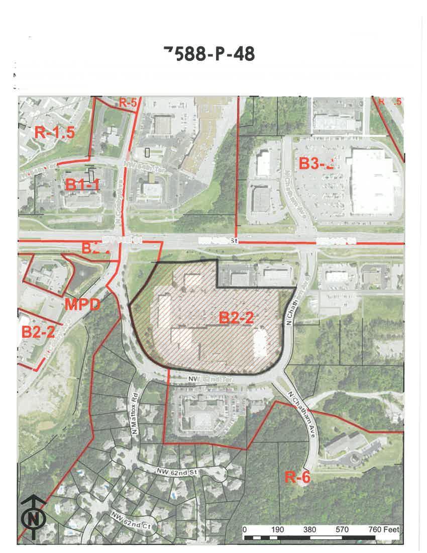
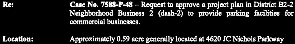
1 CITY PLAN COMMISSION DOCKET Tuesday, November 15, :00 A.M. 26 th Floor, Council Chamber Members Babette Macy, Chair Rev. Stan Archie, Vice-Chair Bobbi Baker-Hughes Margaret J. May Trish Martin Coby Crowl Diane Burnette 9:00 A.M. OTHER MATTERS A. The City Plan Commission may hold a closed session to discuss legal matters and legal advice pursuant to Section (1), RSMO. B. There may be general discussion(s) regarding current City Planning Commission issues. C. The City Plan Commission will generally take a short recess for approx. 10 minutes at approx. 10:30 a.m. and generally between 11:30 a.m. and noon for approx. 45 minutes for lunch. Council Planner Docket District No. 9:00 A.M. -- FINAL PLATS & FINAL PLANS -- CONSENT AGENDA: The applicant or the applicant s representative shall sign the consent agenda form at the podium prior to 9:00 A.M. Those cases in which the applicant or representative has signed the consent agenda form will not require that person to identify themselves as the case is called. If the applicant desires to testify, has concerns or questions regarding the Staff s recommendations or is not in agreement with the conditions, that opportunity to testify at the end of the consent agenda will be given to persons regarding those cases. 5 AW 1. SD 1546A Final Plat James A Reed Corner -- To consider approval of a final plat for one commercial lot on about 0.78 acres in District B3-2 (Community Business dash 2) and Districts B4-2 (Heavy Business/Commercial 4 dash 2) generally located at 8201 E. Bannister Rd. Applicant: KAM Design, Khalid Banday 2 PN 2. Case No P-48 Request to approve a project plan on approximately 10.8 acres generally located at the southwest corner of N.W. 64 th Street and N. Chatham Avenue in District B2-2 Neighborhood Business 2 (dash-2) to provide parking facilities for commercial businesses. (Continued from , No Testimony) Applicant: Olsson Associates 1 OA 3. SD 1261C, Final Plat Barry Brooke - To consider approval of a final plat on about 18 acres in District R-6 (Residential-6) generally located in the northwest quadrant of NE Barry Road and N. Brighton Avenue (Billings Farm), creating 44 single family lots and 6 tracts. Applicant: HSH Properties, repr Olsson Associates
2 City Plan Commission Page 2 November 15, JE 4. SD 1036A, Final Plat, Church of the Resurrection -- About 1 acre generally located between E 18 th Street, McGee Street, E 17 th Street and Grand Boulevard, to consider the approval of a final plat in District DX-10 (Downtown Mixed Use (dash 10)) for one lot. Applicant: United Methodist Church of the Resurrection, repr. Olsson Associates 2 OA 5. Case No P-26 - About 1.75 acre generally located on the west side of N. Green Hills Road, between 152 Hwy on the north and NW Barry Road on the south, to consider approval of a project plan in District B3-3 (Community Business 3 dash 3), to allow for 14 off-site parking spaces. Applicant: Warger Associates, LLC 1 JE 6. SD 0991H Final Plat, Eagle Pointe First Plat - About 46 acres generally located on the north side of Mo Route 152 between N Donnelly Avenue on the west and N Lewis Avenue on the east, to consider the approval of a final plat in District SC (Shoal Creek), for a residential and commercial plat containing one commercial lot, 60 single family lots, several private open space tracts and public right of way. (Continued from No Testimony) Applicant: Star Acquisitions, Inc., repr. Olsson Associates 1 JE 7. SD 0991I Final Plat, Eagle Pointe Second Plat - About 13 acres generally located on the north side of Mo Route 152 between N Donnelly Avenue on the west and N Booth Avenue (extended) on the east, to consider the approval of a final plat in District SC (Shoal Creek), for a residential and commercial plat containing one commercial lot, 9 single family lots, several private open space tracts and public right of way. (Continued from No Testimony) Applicant: Star Acquisitions, Inc., repr. Olsson Associates 2 PN 8. Case No P Request to approve a project plan on approximately 2.4 acres located at 6429 N.W. 70 th Street to allow construction of 63 multi-family units within two structures in District R-2.5 (minimum lot area of 2,500 sq. ft. per unit required). (Continued from No Testimony) Applicant: Warger Associates, LLC 1 OA 9. Case No P-38 - About 83 acres generally located on the north side of NE 40 th Street, the south side of NE 41 st Street and the west side of N. Norfleet Drive, to consider approval of a project plan in District M1-5 (Manufacturing 1 dash 5), to allow for a 1.2 million square foot of office/ warehouse development on three (3) lots. (Continued from No Testimony) Applicant: NP Northland Park Industrial, LLC, repr. Continental Consulting Eng. 1 OA 10. SD 0550I, Final Plat, Northpoint Northland Park - To consider approval of a final plat in District M1-5 (Manufacturing dash 5), on approximately 83 acres generally located on the north side of NE 40 th Street, the south side of NE 41 st Street and the west side of N. Norfleet Drive, creating three (3) industrial lots and two (2) tracts. (Continued from No Testimony) Applicant: NP Northland Park Industrial, LLC, repr. Continental Consulting Eng.
3 City Plan Commission Page 3 November 15, JR 11. SD 0233K Waterford 4 th Plat A request to approve a final plat in District R- 7.5 (Residential 7.5) creating 40 detached dwelling lots on about 13 acres generally located south of NE 92 nd St and east of N Indiana Ave. (Continued from No Testimony) Applicant: Beringer Homes, Inc. 2 AW 12. Case No P-16 About.936 acres generally located at N Oak Trafficway, to consider approval of a project plan in District B2-2 to allow for a retail establishment. (Continued from No Testimony) Applicant: O Reilly Automotive Stores Inc., repr. Esterly Schneider Associates 2 PN 13. SD 0864E Final Plat, Tiffany Lakes, 4 th Plat To consider approval of a final plat to allow creation of 40 residential lots and one private open space tract on approximately 17.6 acres generally located north of N. Hull Avenue and N.W. 110 th Street in District R-7.5 (Residential 7.5, requiring 7,500 minimum sq. ft. of lot area per unit). (Continued from No Testimony) Applicant: Tiffany Lakes Development, LLC, repr. Aylett Survey & Engineering END OF CONSENT AGENDA Council Planner Docket District No. 9:00 A.M. NEW CASE 1 OA 14. Case No P-10 Approximately 6 acres generally located at the southeast corner of N. Jackson Avenue and NE Parvin Road, to consider approval of a development plan in District B3-2 (Community Business dash 2), to allow for a 78 unit skilled nursing and rehabilitation facility. Applicant: NSPJ, repr. Untersee & Associates CONTINUED CASES 4 OA 15. Case No. 693-S-3 - A request to amend the Truman Plaza Area Plan by changing the recommended land use on about 0.2 acre tract of land located on the west side of N. Elmwood Avenue, approximately 175 feet north of St. John Avenue, from Residential Medium Density to Mixed Use Neighborhood. (Continued from No Testimony) (To be continued) Applicant: SK Design Group 4 OA 16. Case No P A request to rezone approximately 0.25 acre tract of land located on the west side of N. Elmwood Avenue, approximately 175 feet north of St. John Avenue, from District R-5 (Residential dash 5) to District B3-2 (Community Business dash 2). (Continued from No Testimony) (To be continued) Applicant: SK Design Group
, to allow for building")
4 City Plan Commission Page 4 November 15, OA 17. Case No P-1 About 1 acre (two tracts of land) located on the north side of St. John Avenue, on both sides of N Elmwood Avenue, to consider approval of a development plan in lieu of a Special Use Permit in District B3-2 (Community Business dash 2), to allow for building renovation and general site improvements. (Continued from No Testimony) (To be continued) Applicant: SK Design Group NEW CASES 1 JR 18. Case No SU-1 A request to approve a special use permit to permit construction of a hotel in District M1-5/US (Manufacturing 1/Underground Space) on about 14 acres generally located between N Corrington Ave and Interstate 435, south of Parvin Road. Applicant: Liberty Hotel Group, LLC, repr. White Goss 4 JR 19. Case No MPD-2 A request to approve a rezoning from District R-5 (Residential 5) and District R-6 (Residential 6) to District MPD (Master Planned Development) and to approve a preliminary development plan for the Nelson- Atkins Museum of Art to permit existing museum and administrative office uses in existing buildings and outdoor sculpture gardens on about 29 acres generally located north of Emanuel Cleaver II Blvd, east of Oak St, south of 44 th St and west of Kenwood Ave. Applicant: The Nelson Gallery Foundation, repr. Husch Blackwell, Charles Renner CONTINUED CASE 3 JR 20. Case No SU A request to approve a special use permit in District R-0.5 (Residential 0.5) to permit an administrative, professional or general office use on about 0.5 acres at 1520 E Linwood Blvd. (Continued from No Testimony) Applicant: DBL Architecture Inc. NEW CASE 2 PN 21. Case No P-7 Request to amend a previously approved development plan (also serving as a preliminary plat) on approximately 71.4 acres generally located at the southeast corner of N.W. 108 th Street and N. Congress Avenue to allow construction of a warehousing, wholesaling, and freight movement facility in District M2-3 Manufacturing 2 (dash 3). Applicant: CVS Pharmacy Inc. DB:ml Any person with a disability desiring reasonable accommodation to participate in this meeting may contact the 311 Action Center at 311 or (816) or for TTY or by at actioncenter@kcmo.org.
5 Docket Item #1 SD 1546A Case No. SD 1546A To consider approval of a final plat for one commercial lot on about 0.78 acres in District B3-2 (Community Business dash 2) and Districts B4-2 (Heavy Business/Commercial 4 dash 2) generally located at 8201 E. Bannister Rd. R-7.5 B3-2 B1-1 B4-2 F Feet
6 City Planning & Development Department Development Management Division 15th Floor, City Hall 414 East 12th Street Kansas City, Missouri Fax STAFF REPORT November 15, 2016 (1) RE: APPLICANT: PROPERTY OWNER: LOCATION: AREA: REQUESTS: REQUESTS: SURROUNDING LAND USE: LAND USE PLAN: MAJOR STREET PLAN: SD 1546A James A. Reed Corner Khalid Banday KAM Designs 9000 E Bannister Road Kansas City, MO Ocean Petroleum 8201 E Bannister Road Kansas City, MO Generally located east of NE 104 th Terr and NE 105 th Terr and N Marsh Ave acres To consider approval of a final plat in District R-7.5 (Residential 7.5) on about 16.4 acres, creating 38 singlefamily lots, 1 tract and dedicating public right-of-way. to consider approval of a Special Use Permit to expand an existing gas station and convenience store North commercial South commercial, public/civic (Truman Elementary) East commercial, single family residential West commercial, public/civic (St. Luke s Methodist Church) The Hickman Mills Plaza Area Plan is the plan of record for this location. The plan recommends Mixed Use Neighborhood Uses in this location. The Major Street Plan identifies Bannister Road as a local link. James A. Reed is identified as a local link north of Bannister Road and an established arterial to the south. PREVIOUS CASES: PREVIOUS CASES: Case No SU 8201 Bannister Road The Board of Zoning Adjustment, meeting in
7 Staff Report Case No. SD1546A November 15, 2016 Page 2 regular session on April 12, 2016 voted to APPROVE a consider approval of a Special Use Permit to expand an existing gas station and convenience store, plus any necessary variances. SD1546 James A. Reed Corner Preliminary Plat On October 19, 2016 city staff composing the Development Review Committee, met to review the above-referenced Case SD-1546 and acted to APPROVE a preliminary plat creating one commercial lot on about 0.78 acres in B3-2/B4-5 generally located at 8201 E Bannister Road. EXISTING CONDITIONS: The subject site is zoned B3-2 and located at the southeast corner of E Bannister Road and James A. Reed Road. The site is developed with a Phillips 66 gas station with two canopies, one to the north and one to the west of the convenience store building, and three pumps. The convenience store building has a gabled roof and is constructed of brick, stucco and windows. A majority of the site is paved for vehicular use. There are four curb cuts providing ingress and egress to the site. There is a digital pylon sign on the northwest corner of the site. PLAN REVIEW & ANALYSIS: The preliminary plat proposes a single 0.78 acre lot. The lot is developed with a gas station. A special use permit approving the expansion of the gas station required the lot be platted and the dedication of right-of-way along Bannister. The plan also required the closure of the western curb cut on the north property line this curb cut is still shown on the plat and shall be removed. The plat shall also show all changes to the site as approved by the special use permit. RECOMMENDATIONS: The City Planning and Development Department staff recommends that Case No. SD1546A be approved subject to the following conditions: Condition 1. per City Planning & Development, Development Management Division (Ashley Winchell, ashley.winchell@kcmo.org) 1. That the plat shall be amended to represent the plan approved by special use permit. Conditions 2. through 20. per City Planning & Development, Land Development Division (Brett Cox, Brett.Cox@kcmo.org) 2. The developer must dedicate additional right of way for Bannister Road as required by the adopted Major Street Plan and Chapter 88 so as to provide a minimum of 50 feet of right of way as measured from the centerline, and ensure right of way dedication is adequate for any proposed road improvements as required by Public Works Department adjacent to this project. 3. The developer must subordinate to the City all private interest in the area of
8 Staff Report Case No. SD1546A November 15, 2016 Page 3 any right-of-way dedication, in accordance with Chapter 88 and as required by the Land Development Division, and that the owner/developer shall be responsible for all costs associated with subordination activities now and in the future. 4. After the City Plan Commission enters its disposition for the development plan, the developer shall not enter into any agreement that would encumber or otherwise have any impact on the proposed right-of-way dedications for the planned project without the prior written consent of the Land Development Division. Respectfully submitted, Ashley Winchell Planner
9

10


11
12 Docket Item # 3 SD 1261C SD 1261C, Final Plat Barry Brooke - To consider approval of a final plat on about 18acres in District R-6 (Residential-6) generally located in the northwest quadrant of NE Barry Road and N. Brighton Avenue (Billings Farm), creating 44 single family lots and 6 tracts R-7.5 R-6 R-80 F 0 R-2.5 B4-2 B2-2 B1-1 B3-2 R Feet
13 City Planning & Development Department Development Management Division 15th Floor, City Hall 414 East 12th Street Ph: (816) Kansas City, Missouri Fax:(816) STAFF REPORT November 15, 2016 (3) RE: APPLICANT: AGENT: LOCATION: AREA: Case No. SD 1261C, Final Plat Barry Brooke, Third Plat Dennis Shriver HSH Properties 6601-A Royal Street Pleasant Valley, MO Brian Forquer Olsson Associates, Inc Burlington, #100 North Kansas City, Missouri Generally located on the north side of NE Barry Road about between N. Brighton Avenue on the east and N. Elmwood Avenue on the west. About 9 acres. REQUEST: To consider approval of a final plat in District R-6 (Residential-6), creating 44 single family lots and 6 tracts. SURROUNDING LAND USE: LAND USE PLAN: MAJOR STREET PLAN: North: zoned R-7.5, Highland Ridge subdivision. South: zoned R-2.5, B2-2 & B4-2, Brighton Wood North, US Postal Services. East: West: zoned R-6/ R-80, single family residence. zoned R-6, existing single family residence, Barry Brook First Plat. The Shoal Creek Valley Area Plan adopted by Resolution on March 26, 1992 recommends low density residential land use for this site. Northeast Barry Road and N. Brighton Avenue are classified as a four lane through street typology by the City s Major Street Plan at this location. Northeast Barry Road is a thoroughfare and N. Brighton Avenue is a
14 Staff Report Case No. SD 1261C, Final Plat Barry Brooke, Third Plat November 15, 2016 Page 2 local link with a minimum of 100 right of way. The plan shows future bike facility on both streets. ARTERIAL STREET IMPACT FEE: This site is located within Zone B, (Informational only) Impact Fee will be assessed by the administrator at the time of building permit. PREVIOUS CASES: Case No CUP-1-AA-1 On September 21, 2016, the Director of City Planning and Development approved a minor administrative amendment to the current approved Chapter 80 CUP plan pursuant to the Chapter H, allowing for modification to Phases 3 through 6. Case No. SD 1261B, Preliminary Plat, Barry Brooke - On August 24, 2016, the Development Review Committee (DRC) approved a preliminary plat on about 64 acres in District R-6 (Residential-6) generally located in the northwest quadrant of NE Barry Road and N. Brighton Avenue (Billings Farm), creating 161 single family lots and 16 tracts. Case No. SD 1261A Final Plat, Barry Brooke, Second Plat - Ordinance No passed by City Council on November 2, 2006 approved a final plat in District R-1b (one family dwellings) on acre, creating 56 single family lots, 1 private open space tract, and 2 storm water detention tracts. Case No. SD 1261 Final Plat, Barry Brooke, First Plat - Ordinance No passed by City Council on November 2, 2006 approved a final plat in District R- 1b (one family dwellings) on acre, creating 56 single family lots, 1 private open space tract, and 2 storm water detention tracts. Case No CUP-1 Ordinance passed by City Council on January 5, 2006 approved a community unit project in District R-1b (one family dwelling), to allow development of 165 single family lots, 8 private open space tracts, and 3 storm water detention tracts on about acres generally located in the northwest quadrant of NE Barry Road and N. Brighton Avenue (Billings Farm). Case No P Ordinance passed by City Council on January 5, 2006 rezoned about acres from District RA (Agricultural) to District R-1b (one family dwelling) generally located at in the northwest quadrant of NE Barry Road and N Brighton Avenue.
15 Staff Report Case No. SD 1261C, Final Plat Barry Brooke, Third Plat November 15, 2016 Page 3 Case No P On September 27, 1972 the City Plan Commission denied a zoning change from District RA to District CP-3 (regional planned business center) and District R-3 (low apartments) at a location north of and abutting State Route 152 (NE Barry Road) and west of and abutting N Brighton Avenue for a proposed regional shopping center of 1,200,000 square feet of floor space on 138 acres of land. Case No CUP On September 27, 1972 the City Plan Commission denied a community unit project for 462 dwelling units on 42 acres of land located north of and abutting State Route 152 (Barry Road) and west of and abutting North Brighton Avenue. EXISTING CONDITIONS: Ordinance No passed by City Council on January 5, 2006 approved a community unit project in District R-1b (one family dwelling), to allow for 165 single family lots, 8 private open space tracts, and 3 storm water detention tracts on about acres generally located in the northwest quadrant of NE Barry Road and N. Brighton Avenue (Billings Farm). The preliminary plat was further amended by a minor administrative amendment and a revised preliminary plat to change the overall layout and phasing of the development. This final plat covers the unplatted tract of land to the east of the existing developed portions of Barry Brooke. The resulted in a loss of 4 lots. Phase I and II have been developed and constructed with 95 lots. To the north is the recently approved Highland Ridge subdivision. The property to the south is Townhomes of Brighton Woods. The property to the west is a mixture of undeveloped land with single family residences on large tracts. PLAT REVIEW/ ANALYSIS: This final plat represents portions of the phases 3 and 4 of the approved preliminary Community Unit Project plan and proposes the creation of 44 singlefamily lots. The plat will extend NE 85 th Terrace from N. Kensington eastwards to N. Lister ending in a cul-de-sac. The plat shows future extension of NE 85 th Terrace. The plat also extends NE 84 th Terrace eastwards to a cul-de-sac. The proposed lots will have an average lot width of about feet and average lot depth of 125 feet. The plat proposes five (5) private open space tracts. As a result of the amendment to the preliminary CUP plan, the developer is required to submit a Street Naming Plan that is reflective of the updated
16 Staff Report Case No. SD 1261C, Final Plat Barry Brooke, Third Plat November 15, 2016 Page 4 development plan prior to ordinance request for this plat. City staff will recommend that this final plat not proceed to the City Council for approval until the Street Naming Plan has been submitted to the Development Management Division. The street naming plan shall be approved prior to Mylar approval of this plat. No Street Tree Planting Plan was submitted with the final plat as required by the CUP ordinance. City staff will recommend that this final plat not proceed to the City Council for approval until the Street Tree Planting Plan for this Plat has been submitted to DMD and the City Forester. The street tree planting plan shall be approved prior to Mylar approval of this plat. Chapter B-6 states that the developer must post a sign at the terminus of all stub streets indicating that the stub street is intended to be opened to through traffic when the adjacent property is developed. The sign must state "FUTURE THROUGH STREET. TO BE CONNECTED WHEN ABUTTING PROPERTY DEVELOPS." The city may provide specifications for required signs. If the final phase of the development is anticipated within the next two years, staff will not require the posting of these signs. Parkland Dedication: According to Section of the Subdivision Regulations, the developer can either dedicate land for public park, provide open space for park purposes or provide money in lieu of parkland dedication. The development is providing a need for the following: 161 single-family lots x 3.7 x = 3.57 acres The following is the updated parkland dedication requirements: The approved Development Plan required 3.66 acres, and allowed for 2.80 acres as Private Open Space in lieu of Parkland Dedication (POS-PD) and 0.86 acres payment of money in lieu of parkland dedication based upon the 2005 fees ($9,961.61). Barry Brooke 1st and 2nd Plats would require 2.1 acres of parkland dedication ((56 lots + 39 lots) x 3.7 x 0.006). Private Open Space has been provided in the 1st Plat of 2.47 acres and 2nd Plat of 0.15 acres for a total of 2.62 acres. Barry Brooke has a 0.52 acre surplus of parkland dedication for use for this 3rd Plat. Calculation based on: 44 single-family lots x 3.7 x = = 0.46 acres 0.46 acres x $9, (2005 Fee) = $4, COMMENT: This final plat is in substantial conformance with the approved preliminary development plan, Case No CUP-1-AA.
17 Staff Report Case No. SD 1261C, Final Plat Barry Brooke, Third Plat November 15, 2016 Page 5 RECOMMENDATION: City Planning and Development Staff recommends approval of Case No. SD 1261C, Final Plat, Barry Brooke, Third Plat based on the application, plans, and documents provided for review prior to the hearing and subject to the following: Condition Nos per City Planning & Development, Development Management Division (Olofu Agbaji, Olofu.Agbaji@kcmo.org) 1. That the developer post a sign at the terminus of all stub streets that states "FUTURE THROUGH STREET. TO BE CONNECTED WHEN ABUTTING PROPERTY DEVELOPS" pursuant to Chapter B-6 of the Zoning and Development Code as directed by the Public Works Department. 2. The developer shall submit a street tree planting plan with each final plat and secure the approval of the City Forester for street trees planted on right of way in front of residential lots, with a copy to be submitted to the Development Management Division prior to Mylar approval. The plan shall include size, type, species and placement of trees. The developer shall agree to plant in accordance with the plan approved by the City Forester. 3. That the developer submit a Street Naming Plan to Development Management Division with any future final plan. The Street Naming Plan shall be submitted prior to ordinance request of any final plat. Street naming plan shall be approved prior to issuance of address for this development. 4. That the developer submit a project plan to the City Plan Commission for approval including building elevations showing material for construction, plans for sidewalks, landscaping, grading, screening, berming, and fencing, including plans for private open space tracts containing detention areas, pedestrian pathways, pool/clubhouse, fencing, playground equipment, or other improvements, prior to Mylar approval. Conditions 5. & 6. per City Planning & Development, Land Development Division (Pam Powell, pam.powell@kcmo.org) 5. That plat be revised to show: a. All corrections outlined on the Final Plat PRC Checklist provided by Land Development Division.
18 Staff Report Case No. SD 1261C, Final Plat Barry Brooke, Third Plat November 15, 2016 Page 6 6. Further revisions and/or corrections as required by Land Development Division. Condition Nos per City Planning & Development, Land Development Division (Brett Cox, brett.cox@kcmo.org) 7. The developer shall submit a new, or update previously accepted Macro Storm Drainage Study from a Missouri-licensed civil engineer to the Land Development Division for the overall development in accordance with adopted standards to address development amendments or modified conveyance systems, etc., along with providing a detailed Micro study prior to final platting or issuance of a building permit (whichever occurs first), that is in general compliance with the Macro and adopted standards, including a BMP level of service analysis, and securing permits to construct any improvements as required by the Land Development Division. 8. The developer must dedicate additional right of way for NE Barry Rd as required by the adopted Chapter 88 so as to provide a minimum of 30 feet of right of way as measured from the centerline, and ensure right of way dedication is adequate for any proposed road improvements as required by Public Works Department adjacent to this project. 9. The developer must subordinate to the City all private interest in the area of any right-of-way dedication, in accordance with Chapter 88 and as required by the Land Development Division, and that the owner/developer shall be responsible for all costs associated with subordination activities now and in the future. 10. After the City Plan Commission enters its disposition for the development plan, the developer shall not enter into any agreement that would encumber or otherwise have any impact on the proposed right-of-way dedications for the planned project without the prior written consent of the Land Development Division. 11. The developer must design and construct all interior public streets to City Standards, as required by Chapter 88 and the Land Development Division, including curb and gutter, storm sewers, street lights, and sidewalks. 12. That the north half of NE Barry Rd shall be improved to Collector standards as required by Chapter 88, to current standards, including curbs and gutters, sidewalks, street lights, relocating any utilities as may be necessary and adjusting vertical grades for the road, etc., and obtaining required
19 Staff Report Case No. SD 1261C, Final Plat Barry Brooke, Third Plat November 15, 2016 Page 7 permit from Land Development Division for said improvement prior to recording the plat or prior to issuance of a Building Permit, whichever occurs first. 13. The developer must obtain the executed and recorded city approved grading, temporary construction, drainage/sewer, or any other necessary easements from the abutting property owner(s) that may be required prior to submitting any public improvements crossing properties not controlled by the developer and include said document(s) within the public improvement applications submitted for permitting. 14. The owner/developer must submit plans for grading, siltation, and erosion control to Land Development Division for review and acceptance, and secure a Site Disturbance permit for any proposed disturbance area equal to one acre or more prior to beginning any construction activities. 15. The developer must secure permits to extend public sanitary and storm water conveyance systems to serve all proposed lots within the development and determine adequacy of receiving systems as required by the Land Development Division, prior to recording the plat or issuance of a building permit whichever occurs first. 16. The developer must submit covenants, conditions and restrictions to the Land Development Division for review by the Law Department for approval and enter into covenant agreements for the maintenance of any private open space tracts or stormwater detention area tracts, prior to recording the plat. 17. The developer must submit covenants, conditions and restrictions to the Land Development Division for review by the Law Department for approval and enter into covenant agreements for the maintenance of any private open space tracts or stormwater detention area tracts, prior to recording the plat. Condition No. 18. per Water Services Department (Heather Massey, heather.massey@kcmo.org) 18. That the developer extend water mains as required by the Water Services Department.
20 Staff Report Case No. SD 1261C, Final Plat Barry Brooke, Third Plat November 15, 2016 Page 8 Condition No. 19. per Fire Marshal s Office (John Hastings, john.hastings@kcmo.org) 19. That the developer install hard surface roads and provide for fire protection as required by the Fire Department prior to construction beyond foundations. Condition No. 20. per Parks and Recreation Department ( Richard Allen, richard.allen@kcmo.org) 20. That the developer either dedicate 0.46 acres or contribute $4, in lieu of parkland dedication in satisfaction of Section of the Zoning and Development Code. Calculation based on: 44 single-family lots x 3.7 x = = 0.46 acres 0.46 acres x $9, (2005 Fee) = $4, Respectfully submitted, Olofu O. Agbaji Planner
21 R 1301 Burlington, # 100 North Kansas City, MO TEL FAX
22 R 1301 Burlington, # 100 North Kansas City, MO TEL FAX
23 R 1301 Burlington, # 100 North Kansas City, MO TEL FAX
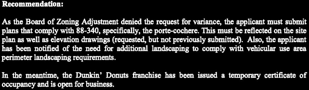
24 Docket Item # 4 UR SD 1036A SD 1036A, Final Plat, Church of the Resurrection -- About 1 acre generally located between E 18th Street, McGee Street, E 17th Street and Grand Boulevard, to consider the approval of a final plat in District DX-10 (Downtown Mixed Use (dash 10)) for one lot. DC-15 B4-5 DX-15 B4-5 DX-10 UR CX/O B4-5 M1-5 F Feet
25 City Planning & Development Department Development Management Division 15th Floor, City Hall 414 East 12th Street Kansas City, Missouri Fax STAFF REPORT November 15, 2016 ( 4 ) RE: APPLICANT: PROPERTY OWNER: REPRESENTATIVE: AREA/LOCATION: REQUEST: AREA PLAN: SD1036-A Final Plat, Church of the Resurrection Dick Cooper, The United Methodist Church of the Resurrection 1522 McGee Street Kansas City, MO Same as Applicant Olsson Associates, Attn. Brad Sonner 7301 W 133 rd Street Overland Park, KS About 1.1 acres generally located south of E 16 th Street between Grand Boulevard and McGee Street SD 1036A, Final Plat, Church of the Resurrection -- About 1 acre generally located between E 18 th Street, McGee Street, E 17 th Street and Grand Boulevard, to consider the approval of a final plat in District DX-10 (Downtown Mixed Use (dash 10)) for one lot. Greater Downtown Area Plan (GDAP), approved with CS Resolution No on March 11, 2010, recommends Downtown Mixed Use land use at this location. The proposed use is in compliance with the area plan. MAJOR STREET PLAN: * Identifies Truman Road as an Established Arterial. Identifies Grand Boulevard as a Boulevard. Identifies Oak Street as an Established Arterial Bicycle Route: Identifies Grand Boulevard as a Future Bike Facility ARTERIAL STREET IMPACT FEE: Benefit District: None (Information Only) Note, this site is within an Exempt Area and is not subject to this fee. SURROUNDING LAND USES: North Zoned DC-15, Truman Road / Interstate 670 South Zoned B 4-5, 17 th Street, commercial,
26 Staff Report SD1036-A Final Plat, Church of the Resurrection November 15, 2016 Page 2 PREVIOUS CASES: East Zoned M 1-5, Oak Street, commercial West Zoned DX-15, Grand Boulevard, commercial Case No A Granted a variance for one off-street loading space at 1527 McGee Street (Granted by the Board of Zoning Adjustment, July 14, 1992) Case No. 579-S -- CS Ordinance No , As Amended, passed October 17, 2002, approved the Oak Street "353" Development Plan for the Oak Street Redevelopment Corporation, for the redevelopment and rehabilitation of the area as provided in the Urban Redevelopment Corporation Law of the State of Missouri (Chapter 353, R.S.Mo.1978, as amended). Case No URD CS Ordinance No , passed October 17, 2002, rezoned the Kansas City Star facilities from District C-4 (Central business district), C-3a2 (Intermediate business-high buildings, district) and District M-1 (Light industrial district) to District URD (Urban redevelopment district) and approval a development plan for the new Star building. Case No URD-AA On January 23, 2004, the Director of City Development approved the URD final plan for the building and grounds for the Kansas City Star. Case No URD-AA-1 On November 18, 2005, the Director of City Development approved an amendment to the URD final plan for the building and grounds for the KC Star. Case No UR-1 -- Ordinance No , passed May 26, 2016, About 6.7 acres generally located east of Grand Avenue, south of 16th Street and Truman Road, west of Oak Street and north of 17th Street, deleted about 0.77 acres from an existing development plan currently zoned UR (Urban redevelopment district) said deleted area located about 100 feet south of E 16 th Street between Grand Boulevard and McGee Street and thereby leaving the remaining UR development plan intact. Case No P and Case No P-1 -- Ordinance No , passed May 26, 2016, rezoned and approved a development plan for a 1.2 acres site generally located south of E 16 th Street between Grand Boulevard and McGee Street from District B 4-5 (Heavy Business/Commercial (dash 5)) and District UR (Urban redevelopment district) to District DX- 10 (Downtown Mixed Use, dash 10) for a church, parking and grounds. Note: This is the approved zoning and development plan. Case No AA-2 On October 12, 2016, this case was administratively approved for Phase One of the church.
27 Staff Report SD1036-A Final Plat, Church of the Resurrection November 15, 2016 Page 3 REPORT: Existing Conditions/Past Approvals: This case included part of the Kansas City Star property which was a 353 property and zoned URD. On May 26, 2016, three ordinances were approved which removed property from the Star ownership, rezoned about 1.2 acres to District DX and approved a development plan for a church, parking and grounds (see above Previous Cases). The existing grounds include the on-surface parking lot on the block west of the Star building between McGee Street, E 16 th Street, Grand Boulevard and E 17 th Street. This parking lot currently contains about 200 parking spaces which have been improved with parking lot landscaping. The area was stated to contain excess Star parking and was then negotiated to be used for the future church. The Approved Plan: The United Methodist Church of the Resurrection, which now occupies the previous Crosstown Station building, has been experiencing large growth and wanted to expand. The church attributes much of this growth to their message and the increased population and residential construction in the urban core. The Church proposed to expand by building a new two-phased church in the parking lot that the Star currently owns. The church and Star representatives have an agreement for the church to buy some of the parking lot area west of McGee for Phase I and Phase II construction of the church and lease the remainder of the southern portion of the parking lot from the Star at those times when the Star business is less active (Sundays and nights). Initially, only about the northern one-half of the parking lot block will be removed from the Star UR plan and the Star will keep the southern one-half. The church will enter into a lease agreement with the church for alternate time -- joint use parking. Since the second phase of the church would exceed minimum building areas which would require a development plan submittal, church representatives have agreed to submit a development plan now for City Plan Commission and City Council review (Case No P- 1). Proposed Plat: The proposed plat calls for one Lot of 45,777 sf also containing a 14 foot wide utility easement. The lot will be used for the church. The church final plan was approved by the City Development Department on October 12, 2016 with Case No AA-2. The proposed plat is in compliance with the rezoning, the development plan and the administrative approval.
28 Staff Report SD1036-A Final Plat, Church of the Resurrection November 15, 2016 Page 4 RECOMMENDATION: City Planning and Development Department staff recommends in the following manner, based on the application, plans, and documents provided for review prior to the hearing and as acted upon by the Development Review Committee on December 9, 2015, subject to the following conditions: Case No. SD1036-A Conditions 1 12 per Land Development Division (Brett Cox, (brett.cox@kcmo.org) and Pam Powell, (pam.powell@kcmo.org) 1. That two (2) collated, stapled and folded copies (and a CD) of (a revised drawing /all listed sheets), revised as noted, be submitted to Development Management staff (15 th Floor, City Hall), prior to ordinance request showing: a. Further additions and recommendations as required by Land Development Division. 2. The developer shall submit a Storm Drainage analysis from a Missouri-licensed civil engineer to the Land Development Division evaluating proposed improvements and impact to drainage conditions. Since this project is within a "Combined Sewer Overflow" (CSO) district, the project shall be designed to retain rainfall of 1.5 inch depth over the entire site to simulate natural runoff conditions and reduce small storm discharge to the combined sewer system. Manage the 10-year storm and 100-year storm per currently adopted APWA standards. The analysis shall be submitted, and the developer secure permits to construct any improvements required by the Land Development Division prior to issuance of any building permits. 3. The developer submit a letter to the Land Development Division from a Licensed Civil Engineer, Licensed Architect, or Licensed Landscape Architect, who is registered in the State of Missouri, to identifying sidewalks, curbs, and gutters in disrepair as defined by Public Works Department's "OUT OF REPAIR CRITERIA FOR SIDEWALK, DRIVEWAY AND CURB revised 4/8/09" and base on compliance with Chapters 56 and 64 of the Code of Ordinances for the sidewalks, curbs, and gutters where said letter shall identify the quantity and location of sidewalks, curbs, gutters that need to be constructed, repaired, or reconstructed to remedy deficiencies and/or to remove existing approaches no longer needed by this project. The developer shall secure permits to repair or reconstruct the identified sidewalks, curbs, and gutters as necessary along all development street frontages as required by the Land Development Division and prior to issuance of any certificate of occupancy permits including temporary certificate occupancy permits. 4. The owner/developer must submit plans for grading, siltation, and erosion control to Land Development Division for review and acceptance, and secure a Site Disturbance permit for

29 Staff Report SD1036-A Final Plat, Church of the Resurrection November 15, 2016 Page 5 any proposed disturbance area equal to one acre or more prior to beginning any construction activities. 5. The developer shall submit an analysis to verify adequate capacity of the existing sewer system as required by the Land Development Division prior to issuance of a building permit to connect private system to the public sewer main and depending on adequacy of the receiving system, make other improvements may be required. 6. That the developer rezone Lot 2, as shown on Sheet A100, from District UR to District DX- 10, at such time that the ownership of this parking area is sold and no longer in the ownership controlled by owners of the Oak Street 353 Development Plan. 7. That the developer apply for an administrative approval of the site plan prior to the issuance of a building permit. 8. That the developer apply for an off-site parking approval with the City Development Department, if needed. Condition 9 per Parks and Recreation Department (Richard.allen@kcmo.org) 9. That the developer abide by the boulevard and parkway standards for all development as set forth in Section Respectfully submitted, John Eckardt Planner CSD1036A_StaffRpt_11_15_16
30
31 Docket Item # P-26 AG-R Case No P-26 - About 1.75 acre generally located on the west side of N. Green Hills Road, between 152 Hwy on the north and NW Barry Road on the south, to consider approval of a project plan in District B3-3 (Community Business 3 dash 3), to allow for 14 off-site parking spaces. B3-3 R-6 B3-3 AG-R F Feet
32 City Planning & Development Department Development Management Division 15th Floor, City Hall 414 East 12th Street Kansas City, Missouri Fax STAFF REPORT November 15, 2016 (5) RE: APPLICANT/ AGENT: OWNER: LOCATION: AREA: Case No P-26 Steve Warger RLC, LLC 3630 Briarcliff Road, Suite 100 Riverside, MO The Barry Road Nominee Realty Trust - Nick McFee 3630 Briarcliff Road Kansas City, MO Generally located on the west side of N. Green Hills Road, between 152 Hwy on the north and NW Barry Road on the south. About 1.75 acres. REQUESTS: To consider approval of a project plan in District B3-3 (Community Business 3 dash 3), to allow for 14 off-site parking spaces. SURROUNDING LAND USE: North: zoned B3-3, Undeveloped land within the Barry Plaza development. South: zoned B3-3, Undeveloped land within the Barry Plaza development. East: West: zoned AG-R, Vacant/ undeveloped. zoned B3-3, Undeveloped land within the Barry Plaza development. LAND USE PLAN: The Line Creek Valley Area Plan recommends Mixed Use Community use for the subject property.
33 Staff Report Case No P-26 November 15, 2016 Page 2 MAJOR STREET PLAN: ARTERIAL STREET IMPACT FEE: The City s Major Street Plan classifies N. Green Hills Rd as a four-lane thoroughfare with 100 feet of right-of-way. North Green Hills is Mo-DOT right of way but administered by Public Works Department. This site is located within impact fee Benefit District E and is subject to impact fees as required by Chapter 39. PREVIOUS CASES: Case No P-25 - On March 1, 2016, the City Plan Commission approved a final plan on about 1.75 acre generally located on the west side of N. Green Hills Road, between 152 Hwy on the north and NW Barry Road on the south, to consider approval of a Chapter 80 final plan in District B3-3 (Community Business 3 dash 3), to allow for a 13,000 square foot medical office building. Case No P-24 - On March 1, 2016, the City Plan Commission approved a final plan on about 1 acre generally located on the west side of N. Green Hills Road, approximately 500 feet south of 152 Hwy, to consider approval of a Chapter 80 final plan in District B3-3 (Community Business 3 dash 3), to allow for a 6,700 square foot commercial building. Case No P-23 On October 6, 2015, the City Plan Commission approved a final plan on about 1 acre, generally located on the west side of N. Green Hills Road, between 152 Hwy on the north and NW Barry Road on the south, in District B3-3 (Community Business 3 dash 3), to allow for a 7,300 square foot commercial building. Case No SU-22 On September 23, 2014, the Board of Zoning Adjustment granted a special use permit to allow a Motor Vehicle Repair, General use on about 0.57 acres in District B3-3 (Community Business (dash 3)). Case No SU-21 - On September 23, 2014, the Board of Zoning Adjustment granted a special use permit to allow a Light Equipment Sales/Rental, Outdoor use on about 0.57 acres in District B3-3 (Community Business (dash 3)). SD 0941J, Final Plat Barry Plaza, 9 th Plat- On September 15, 2015, the City Plan Commission recommended approval of a final plat on about 1 acre, in District B3-
34 Staff Report Case No P-26 November 15, 2016 Page 3 3 (Community Business 3 dash 3), generally located on the west side of N. Green Hills Road, between 152 Hwy on the north and NW Barry Road on the south, creating one (1) commercial lot. SD 0941I, Final Plat Barry Plaza, 8 th Plat- On September 15, 2015, the City Plan Commission recommended approval of a final plat on about 1.75 acres, in District B3-3 (Community Business 3 dash 3), generally located on the west side of N. Green Hills Road, between 152 Hwy on the north and NW Barry Road on the south, creating one (1) commercial lot. Case No GP-19 On May 3, 2011, the City Plan Commission approved a final plan in District GP-3 (regional business), allowing for an addition to an existing commercial building and modified detention basin. Case No GP-18 - On January 5, 2010, the City Plan Commission approved a final development plan in District GP-3 (regional business), for a detention basin and landscape buffer strip. Case No GP-6 - Ordinance No passed by City Council on August 12, 2004 rezoned about 30.5 acres generally located at the west side of N. Green Hills Road between NW Barry Road and Missouri Highway 152 from Districts GP-2 and GP-3 to District GP-3 and approved a development plan for 218,595 square feet of retail, restaurant and office uses. (current approved plan) SD 0941D Final Plat, Barry Plaza Fourth Plat Approved a final plat on about 4.01 acres generally located on the west side of N Green Hills Road about 1,500 feet north of NW Barry Road creating two commercial lots and an access tract and a landscape buffer tract in District GP-3. (Ordinance , passed February 2, 2006) Case No GP-13 On January 3, 2006, the City Plan Commission approved a final development plan in District GP-3 allowing for a 7,000 square foot office/retail building (Weber Carpet - Barry Plaza Fourth Plat, Lot 11). Case No GP Ordinance No , passed by City Council on March 13, 1981, rezoned the overall site from District GP-7 to Districts GP-2 and GP-3 and approved a development plan for 288,700 square feet of commercial space.
35 Staff Report Case No P-26 November 15, 2016 Page 4 EXISTING CONDITIONS: The subject property is located within the Barry Plaza commercial development along the west side of N. Green Hills Road between Highway 152 on the north and NW Barry Road on the south. The Barry Plaza development is a multi-building commercial development approved by Ordinance No passed by City Council on August 12, The plans approved a development plan that allowed for 218,595 square feet of retail, restaurant and office uses. The overall site has four existing shared access drives (Tract B) on N. Green Hills Road and one on the north side of NW Barry Road. Eight pad sites have been developed. The plan includes a 50 foot wide landscape buffer strip along the west property line shared with the adjacent single-family residences. The plan mandates that the buffer strips provide specific screening from the various levels of the adjacent residences. PLAN REVIEW & ANALYSIS: The applicant is proposing to construct 14 off-site parking spaces as a temporary overflow facility for the Social Security Administration offices on the west side of this parcel. The parking spaces shown on the plan will occupy about 7,000 square feet of the 1.7 acre site. These parking spaces do not count towards the number of spaces required by the Zoning and Development Code for the current office use. Access to the parking area is proposed via a driveway off the internal access tract. Because this is an overflow parking facility, the plan does not include a lighting plan or provide ADA spaces. These spaces will be removed when development of Lot 8 occurs. The landscaping plan shows 4 October Glory Maple trees and one Prairiefire Crabapple. Shrubs includes 41 Seagreen Junipers and 45 Dwarf Winged Euonymus. There is a propose rain garden to provide BMP just south of the parking area. The area is proposed to be planted with Tussock Sedge to serve as rain garden. Staff recommends that the developer provide a consent from the property owner allowing the temporary use of this parcel.
36 Staff Report Case No P-26 November 15, 2016 Page 5 COMMENT: Staff finds this final plan to be in substantial conformance with the approved preliminary plan, Case No GP-6. RECOMMENDATIONS: City Planning and Development Staff recommends approval of Case No P- 26, based on the application, plans, and documents provided for review prior to the hearing and subject to the following conditions: 1. That one (1) collated, stapled and folded copy (and a CD containing a pdf file, a georeferenced monochromatic TIF file, and CAD/GIS compatible layer of the site plan boundary referenced to the Missouri state plan coordinate system) of (a revised drawing /all listed sheets), revised as noted, be submitted to Development Management staff, prior to issuance of building permit showing: a. Title of plan to read Project Plan For Barry Plaza Lot 8. b. Consent form from the property owner. Respectfully submitted, Olofu O. Agbaji Planner
37 311.3' ' N. CONGRESS AVE NW AMBASSADOR DR N. GREENHILLS RD BARRY PLAZA LOT HWY SITE SECTION 8, TOWNSHIP 51, RANGE 33 A SUBDIVISION IN KANSAS CITY, PLATTE COUNTY, MISSOURI NW BARRY RD DEVELOPMENT PLAN S S /Users/jaderodell1/Google Drive/Warger Associates/Barry Plaza Parking Lot/Barry Plaza Development Plan.dwg, Fri Sep 16 13:45: , 1: BARRY PLAZA 6TH LOT 9D PROPERTY LINE W/L W/L W/L W/L W/L W/L W/L W/L BARRY PLAZA 4TH LOT EX-5' WALK SAN SAN BARRY PLAZA 4TH LOT 11 PROPOSED 5' SIDEWALK ' TGE 10' UE 1014 Water Easement W/L W/L W/L M W/L W/L W/L W/L W/L W/L W/L W/L W/L W/L W/L 5' WALK SAN 1014 SAN SAN SAN SAN SAN SAN SAN SAN SANSAN SAN SAN SAN SAN SAN SAN SAN TRACT B (ACCESS EASEMENT) R15.0' 50' R/W 14.0' 14.0' 28.0' R15.0' EXISTING CURB INLET 25.0' 11.0' 19.2' 45.0' ' 70.0' 18.0' 9.0' 18.0' 18.0' 76.2' 36.0' R10.0' R3.5' 25.0' 1018 R5.0'R5.0' 25.0' 50' R/W ' ' 177.0' 1024 EXISTING CURB INLET PROPERTY LINE EXISTING SANITARY 9.0' DRAINAGE FLUME 70'X24'X1' RAIN GARDEN TRACT B (ACCESS EASEMENT) BARRY PLAZA 9TH LOT 9B ' 1.5' 40.0' 20.0' 20.0' ' ER\W EXISTING WATERLINE BARRY LOT PLAZA 8 LOT 8 BMP EASEMENT PROPERTY LINE BARRY PLAZA 8TH LOT 5 W/L W/L PROPERTY LINE 1028 W/L 25' SETBACK 311.3' W/L W/L W/L W/L W/L W/L W/L W/L W/L W/L W/L W/L EW 53.8' EXISTING STORM LINE PROPERTY LINE N. GREEN HILLS ROAD ' 72.0' 28.0' 41.0' 28.0' 72.0' 16.0' ' LEGAL DESCRIPTION: A TRACT OF LAND IN THE NORTHWEST QUARTER OF SECTION 8, TOWNSHIP 51, RANGE 33, KANSAS CITY, PLATTE COUNTY, MISSOURI, BEING DESCRIBED AS FOLLOWS: COMMENCING AT THE SOUTHEAST CORNER OF THE NORTHWEST QUARTER OF SAID SECTION 8; THENCE NORTH 00 25'56" EAST, ALONG THE EAST LINE OF SAID NORTHWEST QUARTER, FEET; THENCE NORTH 89 31'49" WEST, FEET TO A POINT ON THE WESTERLY RIGHT OF WAY LINE OF NORTHWEST GREEN HILLS ROAD, AS NOW ESTABLISHED, SAID POINT BEING ALSO THE NORTHEAST CORNER OF BARRY PLAZA - FOURTH PLAT, A SUBDIVISION OF LAND IN KANSAS CITY, PLATTE COUNTY, MISSOURI, SAID POINT BEING THE TRUE POINT OF BEGINNING OF THE TRACT TO BE HEREIN DESCRIBED; THENCE NORTH 89 31'49" WEST, ALONG THE NORTH LINE OF SAID BARRY PLAZA - FOURTH PLAT, FEET TO THE SOUTHEAST CORNER OF TRACT B, BARRY PLAZA - FIFTH PLAT, A SUBDIVISION OF LAND IN SAID KANSAS CITY, PLATTE COUNTY, MISSOURI; THENCE NORTH 00 03'27" WEST, ALONG THE EAST OF SAID TRACT B, FEET TO THE NORTHEAST CORNER THEREOF; THENCE NORTH 89 56'33" EAST, ALONG THE SOUTH LINE OF LOT 9A, SAID BARRY PLAZA - FIFTH PLAT, FEET TO THE SOUTHEAST CORNER THEREOF, SAID POINT BEING ALSO THE WESTERLY RIGHT OF WAY LINE OF SAID NORTHWEST GREEN HILLS ROAD; THENCE SOUTH 00 25'56" WEST, ALONG SAID WESTERLY RIGHT OF LINE, FEET; THENCE SOUTH 01 11'01" EAST, ALONG SAID WESTERLY RIGHT OF WAY LINE, FEET TO THE TRUE POINT OF BEGINNING. CONTAINING 38, SQUARE FEET OR 0.89 ACRES, MORE OR LESS. DEVELOPMENT SUMMARY TABLE A. EXISTING ZONING B3-3 PROPOSED ZONING B3-3 B. TOTAL LAND AREA 1.28 ACRES C. NET LAND AREA 1.28 ACRES D. PARKING REQUIRED PROVIDED PROPOSED N/A 14 E. COMMENCEMENT - 10/16 COMPLETION - 2/17 NW BELVIDERE PKWY FLOODPLAIN NOTE ACCORDING TO THE FLOOD INSURANCE RATE MAP OF THE FEDERAL EMERGENCY MANAGEMENT AGENCY, PANEL NUMBER 40 OF 145, COMMUNITY-PANEL NUMBER B, EFFECTIVE DATE: AUGUST 5, 1986, THE SUBJECT PROPERTY IS IN ZONE C, AN AREA OF MINIMAL FLOODING. 9 HWY 29 HWY LOCATION MAP SURVEYOR CAMAN CONSTRUCTION CO., LLC 5004 Brighton Ave. Kansas City, Missouri, Phone DEVELOPER Nick McFee 3630 Briarcliff Road Kansas City, MO Nick@barryroad.com PROJECT NO. N. 72nd ST "=30' DATE: WARGER ASSOCIATES Consulting Engineers 1617 Swift North Kansas City Missouri, Steve@wargerassociates.com
38 W/L 311.3' 1016 /Users/jaderodell1/Google Drive/Warger Associates/Barry Plaza Parking Lot/Barry Plaza Development Plan.dwg, Fri Sep 16 13:45: , 1: ' TGE 10' UE 101 Water Easement W/L W/L W/L W/L W/L W/L W/L W/L W/L W/L SAN Shrub List SAN SAN SAN SAN SAN SAN SANSAN SAN SAN SAN SAN SAN TRACT B (ACCESS EASEMENT) PROPERTY LINE ' ' BARRY PLAZA LOT 8 W/ 25' SETBACK 311.3' W/L W/L W/L W/L W/L W/L W/L W/L W/L W/L EW PROPERTY LINE PROPERTY LINE Symbol Quantity Common Name Botanical Name Size Spacing 41 Seagreen Juniper Juniperus Chinensis 'Seagreen' 18"-24"sp. 4' o.c. 45 Dwarf Winged Euonymus Euonymus Alatus 'Compactus' 18"-24"sp. 4' o.c. 3 October Glory Maple Gleditsia Triacanthos 'Skyline' 2.5" cal BB As Shown 3 Prairiefire Crabapple Malus Sp. 'Priariefire' 1 1/2"cal BB As Shown N. GREEN HILLS ROAD Back of Curb 6" MIN 4' Min. OVERFLOW ELEV Center of Shrub Shrub Bed & Parking Setback Detail No Scale 6" MIN 1/2 existing soil, 1/2 topsoil 3" Shredded Cedar Mulch Manicured Edge Scarify soil in bottom of pit Rubber hose #12 gauge wire Tree Guard 4" Berm around saucer 6ft. Diameter Mulched Area In Lawn Areas Finished Grade Scarify soil in bottom of pit 6" Min. 6" Min. Tree Planting Detail No Scale LANDSCAPE NOTES Treated crepe tree wrap Steel fence posts 3 per tree Plant w/top of ball flush w/finished grade 0.36 ac Tussock Sedge Carex stricta Deep Cell Plugs 1.5' o.c. Native Grass Establishment Procedure: 1st Year Growth season supplemental watering should be applied which should be 1 of natural or supplemental moisture per week. 2nd Year Growth season supplemental watering should be applied as needed. Tree List 3rd Year Growth season should have a large enough root system to withstand occasional drought. Dead plants should be removed, noting location and type and replaced with approved plants at the next appropriate Symbol Quantity Common Name Botanical Name Size Condition Spacing planting season. ELEV " PONDING DEPTH 3" MULCH 6" TOP SOIL, COMPOST MIXTURE 1.5' ENGINEERED SOIL MIX (1:1 SAND AND COMPOST) RAIN GARDEN NOTE: NATIVE PLANTS RAIN GARDEN No Scale RAIN GARDEN SOIL MIXTURE: Shall be a uniform mix, free of plant residue, stones, stumps, roots or other similar objects larger than two inches No other materials or substances shall be mixed or dumped within the infiltration area that may be harmful to plant growth, or prove a hindrance to the planting or maintenance operations. Item Composition By Volume Organic Compost 50% Sand 50% ASTM C33 Fine Aggregate The rain garden facility can be excavated before final stabilization of the tributary area; however, the rain garden soil mixture shall not be placed until the entire tributary area has been stabilized. Any sediment from construction operations deposited in the rain garden facility shall be completely removed from the facility after all vegetation, including landscaping within the tributary area to the rain garden facility, has been established. The excavation limits shall then be final graded to the dimensions, side slopes, and final elevations as specified. Low ground-contact pressure equipment, such as excavators and backhoes, is preferred on rain garden facilities to minimize disturbance to established areas around the perimeter of the cell. No heavy equipment shall operate within the perimeter of the rain garden facility during underdrain placement, backfilling, or planting, of the facility. POLLUTED RUNOFF CURB FLUME UNDISTURBED EARTH Mowing First growing season - mow native areas to height of 6-8. Mow additionally every four weeks or as needed to prevent buildup of cuttings and prevent weeds from shading natives. Second and additional growing seasons: mow once at a height of 6 during May to June and once during dormant period (Jan.) mow with a bag or mow and rake off all excess 1" Shredded mulch over 2" deep well-rotted manure 1/2 Existing soil, 1/2 topsoil Fold back burlap from Top 1/3 of root ball LANDSCAPE DATA: REQUIRED INTERIOR 35sf LANDSCAPE AREA/STALL =560sf 1 TREE / 5 STALLS = 3 1 SHRUB / STALLS = 16 PROVIDED LANDSCAPE AREA = 2,858sf SHADE TREES = 3 ORNAMENTAL TREES = 3 SHRUBS = CONTRACTOR REQUIRED TO LOCATE ALL UTILITIES BEFORE INSTALLATION TO BEGIN. 2. Contractor shall verify all landscape material quantities and shall report any discrepancies to the Landscape Architect prior to installation. 3. No plant material substitutions are allow without Landscape Architect or Owners approval. 4. Contractor shall guarantee all landscape work and plant material for a period of one year from date of acceptance of the work by the Owner. Any plant material which dies during the one year guarantee period shall be replaced by the contractor during normal planting seasons. 5. Contractor shall be responsible for maintenance of the plants until completion of the job and acceptance by the Owner. 6. Successful landscape contractor shall be responsible for design that complies with minimum irrigation requirements, and installation of an irrigation system. Irrigation system to be approved by the owner before starting any installation. 7. All plant material shall be specimen quality stock as determined in the "American Standards For Nursery Stock" published by The American Association of Nurseryman, free of plant diseases and pest, of typical growth of the species and having a healthy, normal root system. 8. Sizes indicated on the plant list are the minimum, acceptable size. In no case will sizes less than specified be accepted. 9. All shrub beds within lawn areas to receive a manicured edge. 10. All shrub beds shall be mulched with 3" of shredded cedar mulch. 11. All sod areas to be fertilized & sodded with a Turf-Type-Tall Fescue seed blend. 12. All seed areas shall be hydro-seeded with a Turf-Type-Tall Fescue seed blend "=30' DATE REVISIONS S GARRETT OCHS MO. LICENSE NO ROUTE E T A T DISTRICT O L A ND S CA P E F A RC H IT E C T DATE PREPARED: COUNTY JOB NO. CONTRACT ID. PROJECT NO. BRIDGE NO. SHEET 7 OF 7 STATE MO SHEET NO. WARGER ASSOCIATES Consulting Engineers 1617 Swift North Kansas City Missouri, Steve@wargerassociates.com BARRY PLAZA LOT 8 PRIVATE GRADING LANDSCAPE PLAN M I S S O U R GARRETT OCHS NUMBER LA I
39 Docket Item # 6 SD 0991H Case No. SD 0991H Final Plat, Eagle Pointe First Plat - About 46 acres generally located on the north side of Mo Route 152 between N Donnelly Avenue on the west and N Lewis Avenue on the east, to consider the approval of a final plat in District SC (Shoal Creek), for a residential and commercial plat containing one commercial lot, 60 single family lots, several private open space tracts and public right of way. R-7.5 R-80 R-80 SC F ,110 1,480 Feet
40 Docket Item # 7 SD 0991I Case No. SD 0991I Final Plat, Eagle Pointe Second Plat - About 13 acres generally located on the north side of Mo Route 152 between N Donnelly Avenue on the west and N Booth Avenue (extended) on the east, to consider the approval of a final plat in District SC (Shoal Creek), for a residential and commercial plat containing one commercial lot, 9 single family lots, several private open space tracts and public right of way. SC R-80 SC F Feet
41 City Planning & Development Department Development Management Division 15th Floor, City Hall 414 East 12th Street Kansas City, Missouri Phone STAFF REPORT November 15, 2016 ( 6 ) RE: APPLICANT: AGENT: LOCATION: AREA: REQUEST: SD 0991H Final Plat, Eagle Pointe First Plat Star Development Corporation 244 W. Mill Street, Suite 101 Liberty, MO Lutjen Inc. / Olsson Associates Attn: Michael Ballard 1301 Bulington, Ste 100 North Kansas City, MO Generally located on the north side of Mo Route 152 between N Donnelly Avenue on the west and N Lewis Avenue on the east located on either side of NE Shoal Creek Valley Drive, about 1000 feet west of NE Flintlock Road. About 46 acres SD-0991 H Final Plat, Eagle Pointe First Plat, about 46 acres generally located on the north side of Mo Route 152 between N Donnelly Avenue on the west and N Lewis Avenue on the east, to consider the approval of a final plat in District SC (Shoal Creek), for a residential and commercial plat containing one commercial lot, 60 single family lots, several private open space tracts and public right of way. MAJOR STREET PLAN: Not Applicable ARTERIAL STREET IMPACT FEE: Benefit District: North Benefit District C Discounted Rate: $715, Single-family detached. PREVIOUS CASES: Case No CP -- Ordinance No , passed June 8, 1973, rezoned about 161 acres 1500 and 5050 feet south of M-152 and north of NE 76 th Street and Willis Road from District RA to District CP-3. Along with the following companion ordinances-- Case No CP -- Ordinance No , passed January 1974; Case No P -- Ordinance No , passed September 6, 1974; Case No CP --
42 Staff Report SD 0991H Final Plat, Eagle Pointe First Plat November 15, 2016 Page 2 Ordinance No , passed September 6, 1974; Case No CP -- Ordinance No , passed September 6, 1974; Case No CP -- Ordinance No , passed September 6, 1974; Case No CP -- Ordinance approved September 6, 1974; Case No CUP -- Ordinance No , passed September 6, 1974; Case No. 254-S Ordinance No , passed August 31, 2000, amended Chapter 80, Code of Ordinances of the City of Kansas City, Missouri, commonly known as the zoning ordinance, by creating a new zoning district to be known as District MPC ("Master planned community") and establishing a new section number for said district. Case No P Ordinance No , passed August 31, 2000, rezoned 1,508 acres from Districts RA, R-1b, CPO-1, CP-1, CP-2 and CP-3 to District MPC (Master Planned Community) and approved a community master plan for same. Case No P-AA Shoal Creek Valley The Preserve Neighborhood Plan administratively approved by the four required department directors on October 3 and 4, Note: The Neighborhood Plan was further administratively approved by the Director of City Development on 5/31/07 to include a general lot and street layout of Parcel F (containing this final plat). SD 0991 The Preserve First Plat, Ordinance No , passed December 20, 2001, approved this plat for 41 single family lots and private open space on about 46.5 acres generally located in the northeast quadrant of Missouri Route 152 and Shoal Creek Parkway.. Case No P-1 C.S. Ordinance No , passed December 20, 2001, approved an amendment to the Shoal Creek Valley Community Master Plan by specifically amending The Preserve Neighborhood Plan portion of the MPC on about acres to revise Condition Twenty (20) of Ordinance Number by changing the required approved noise level contour on all final plats where no residential uses will be allowed from 65 dba to 70 dba. Case No. 254-S-202 C.S. Ordinance No , passed January 9, 2003, amended Chapter 80, Code of Ordinances of the City of Kansas City, Missouri, commonly known as the zoning ordinance, by repealing Sections , Neighborhood plan in district MPC, , Final plat and final plan required in district MPC, and , Amendments to plans in district MPC and enacting in lieu thereof new sections. This amendment allows for minor modifications by the CPC to bulk and area standards of the Land Use Categories. Case No P-AA-1 Shoal Creek Valley The Village Neighborhood Plan (south of M-152, west of Flintlock) administratively approved by the four required department directors on February 26, SD 0991A The Preserve Second Plat, Ordinance No , passed December 19, 2002, approved this plat for 43 single family lots and private open space on about 22 acres. Case SD 1040 Final Plat, The Shoppes at Shoal Creek About 35 acres generally located at the northwest corner of M-152 and NE Flintlock Road, to consider the approval of a final plat in District MPC-6 (Master Planned Community Neighborhood Commercial for 5 commercial lots and 4 tracts.
43 Staff Report SD 0991H Final Plat, Eagle Pointe First Plat November 15, 2016 Page 3 Not approved by City Council as of this writing. SD 0991B The Preserve Third Plat, A final plat in District MPC-2 for 16 single family residential lots and two private open space tracts and a common area on about 6 acres located south of NE Shoal Creek Valley Drive, approved by Ordinance No on March 4, Case No P-3 Ordinance No , passed January 7, 2004, approved an amendment to the Shoal Creek Valley Community Master Plan to: 1) allow banks with drive-up facilities and veterinary clinics in District MPC-6, 2) Revise MPC-7 to also allow banks with drive-up facilities and require a minimum of three stacking spaces and 3) Revise condition #20 in Ordinance No by changing the required approved noise level contour on all final plats along state highways where no residential uses will be allowed, from 65 dba to 70 dba. SD 0991C The Preserve Fourth Plat, A final plat in District MPC-2 for two residential lots, two tracts and road right of way was approved with Ordinance No on July 1, SD 0991B The Preserve Fifth Plat, A final plat in District MPC-2 for forty-two residential lots, nine tracts and road right of way was approved with Ordinance No on March 2, SD 0991E -- Final Plat, The Preserve Fourth Plat Single Family, A final plat in District MPC-3 (Master Planned Community--Residential High 1) for 10 single family residential lots, and a tract was approved with Ordinance No on October 13, SD 1218 Final Plat, Carrington Place at Shoal Creek To consider the approval of a final plat in District MPC-4 (Master Planned Community Residential High 2, 0-24 du/ac), MPC-5, (Residential High 3, 0-48 du/ac) and MPC-14 (Parks and Open Space) for two (2) multifamily residential lots, four (4) tracts and roadway, to allow for the construction of 270 luxury apartment units within twenty-five buildings on acres was approved with Ordinance No on August 17, Case No. 405-S-45 Resolution No passed November 19, 2015, amended the Shoal Creek Valley Area Plan for an approximately 23 acre tract located on the north side of Mo Route 152 between N Donnelly Avenue on the west and N Lewis Avenue on the east by changing the recommended land use from Residential to Retail uses. Case No P-9 Ordinance No passed November 19, 2015, about 1,756 acres generally located between I-435 on the west, NE 96 th Street on the north, N Flintlock Road on the east and Shoal Creek Parkway and NE 76 th Street on the south amended the community master plan and pertinent aspects of the plan, to allow for the sub-zone on a 23 acre tract located on the north side of Mo Route 152 between N Donnelly Avenue on the west and N Lewis Avenue on the east to change from MPC-2 to MPC-6 and further to allow the remaining and adjacent acres located to the north, east and west of the tract to be identified as sub-zone MPC-2, and changing a portion on the east side from MPC-4 to MPC-2. Case No. 405-S Resolution No passed February 18, 2016 amending the Shoal Creek Valley Area Plan for an approximately 7 acre tract located south of NE 82 nd Terrace, between N Booth Avenue
44 Staff Report SD 0991H Final Plat, Eagle Pointe First Plat November 15, 2016 Page 4 and N Farley Avenue by changing the recommended land use from Residential to Mixed Use. Case No P-10 Ordinance No , passed February 18, 2016, about 1,756 acres generally located between I-435 on the west, NE 96 th Street on the north, N Flintlock Road on the east and Shoal Creek Parkway and NE 76 th Street on the south approved and amendment to the community master plan and pertinent aspects of the plan, to allow for the sub-zone on a 7 acre tract located south of NE 82 nd Terrace, between N Booth Avenue and N Farley Avenue to change from MPC-2 to MPC-9. Note: this is the most recently approved community master plan. RECOMMENDATION: City Planning and Development Department staff recommends that Case No. SD 0991H Final Plat, Eagle Pointe First Plat be continued to the December 6, 2016 City Plan Commission meeting with no continuance fee to allow the applicant s representative time to revise and submit a Neighborhood Plan update, obtain a status of the bicycle path, confirm the parkland open space tracts for the neighborhood, confirm the trip budget, submit a street tree planting plan and discuss the use and design of all proposed tracts. Respectfully submitted, John Eckardt Planner CSD0991H_Staffrpt_11_15_16.doc
45 City Planning & Development Department Development Management Division 15th Floor, City Hall 414 East 12th Street Kansas City, Missouri Phone STAFF REPORT November 22, 2016 ( 7 ) RE: APPLICANT: AGENT: LOCATION: AREA: REQUEST: SD 0991I Final Plat, Eagle Pointe Second Plat Star Development Corporation 244 W. Mill Street, Suite 101 Liberty, MO Lutjen Inc. / Olsson Associates Attn: Michael Ballard 1301 Burlington, Ste 100 North Kansas City, MO Generally located on the north side of Mo Route 152 between N Donnelly Avenue on the west and N Booth Avenue (extended) on the east About 13 acres SD-0991 I Final Plat, Eagle Pointe Second Plat, about 13 acres generally located on the north side of Mo Route 152 between N Donnelly Avenue on the west and N Booth Avenue (extended) on the east, to consider the approval of a final plat in District SC (Shoal Creek), for a residential and commercial plat containing one commercial lot, 9 single family lots, several private open space tracts and public right of way. MAJOR STREET PLAN: Not Applicable ARTERIAL STREET IMPACT FEE: Benefit District: North Benefit District C Discounted Rate: $715, Single-family detached. PREVIOUS CASES: Case No CP -- Ordinance No , passed June 8, 1973, rezoned about 161 acres 1500 and 5050 feet south of M-152 and north of NE 76 th Street and Willis Road from District RA to District CP-3. Along with the following companion ordinances-- Case No CP -- Ordinance No , passed January 1974; Case No P -- Ordinance No , passed September 6, 1974; Case No CP -- Ordinance No , passed September 6, 1974; Case No CP -- Ordinance No , passed
46 Staff Report SD 0991I Final Plat, Eagle Pointe Second Plat November 22, 2016 Page 2 September 6, 1974; Case No CP -- Ordinance No , passed September 6, 1974; Case No CP -- Ordinance approved September 6, 1974; Case No CUP -- Ordinance No , passed September 6, 1974; Case No. 254-S Ordinance No , passed August 31, 2000, amended Chapter 80, Code of Ordinances of the City of Kansas City, Missouri, commonly known as the zoning ordinance, by creating a new zoning district to be known as District MPC ("Master planned community") and establishing a new section number for said district. Case No P Ordinance No , passed August 31, 2000, rezoned 1,508 acres from Districts RA, R-1b, CPO-1, CP-1, CP-2 and CP-3 to District MPC (Master Planned Community) and approved a community master plan for same. Case No P-AA Shoal Creek Valley The Preserve Neighborhood Plan administratively approved by the four required department directors on October 3 and 4, Note: The Neighborhood Plan was further administratively approved by the Director of City Development on 5/31/07 to include a general lot and street layout of Parcel F (containing this final plat). SD 0991 The Preserve First Plat, Ordinance No , passed December 20, 2001, approved this plat for 41 single family lots and private open space on about 46.5 acres generally located in the northeast quadrant of Missouri Route 152 and Shoal Creek Parkway.. Case No P-1 C.S. Ordinance No , passed December 20, 2001, approved an amendment to the Shoal Creek Valley Community Master Plan by specifically amending The Preserve Neighborhood Plan portion of the MPC on about acres to revise Condition Twenty (20) of Ordinance Number by changing the required approved noise level contour on all final plats where no residential uses will be allowed from 65 dba to 70 dba. Case No. 254-S-202 C.S. Ordinance No , passed January 9, 2003, amended Chapter 80, Code of Ordinances of the City of Kansas City, Missouri, commonly known as the zoning ordinance, by repealing Sections , Neighborhood plan in district MPC, , Final plat and final plan required in district MPC, and , Amendments to plans in district MPC and enacting in lieu thereof new sections. This amendment allows for minor modifications by the CPC to bulk and area standards of the Land Use Categories. Case No P-AA-1 Shoal Creek Valley The Village Neighborhood Plan (south of M-152, west of Flintlock) administratively approved by the four required department directors on February 26, SD 0991A The Preserve Second Plat, Ordinance No , passed December 19, 2002, approved this plat for 43 single family lots and private open space on about 22 acres. Case SD 1040 Final Plat, The Shoppes at Shoal Creek About 35 acres generally located at the northwest corner of M-152 and NE Flintlock Road, to consider the approval of a final plat in District MPC-6 (Master Planned Community Neighborhood Commercial for 5 commercial lots and 4 tracts. Not approved by City Council as of this writing.
47 Staff Report SD 0991I Final Plat, Eagle Pointe Second Plat November 22, 2016 Page 3 SD 0991B The Preserve Third Plat, A final plat in District MPC-2 for 16 single family residential lots and two private open space tracts and a common area on about 6 acres located south of NE Shoal Creek Valley Drive, approved by Ordinance No on March 4, Case No P-3 Ordinance No , passed January 7, 2004, approved an amendment to the Shoal Creek Valley Community Master Plan to: 1) allow banks with drive-up facilities and veterinary clinics in District MPC-6, 2) Revise MPC-7 to also allow banks with drive-up facilities and require a minimum of three stacking spaces and 3) Revise condition #20 in Ordinance No by changing the required approved noise level contour on all final plats along state highways where no residential uses will be allowed, from 65 dba to 70 dba. SD 0991C The Preserve Fourth Plat, A final plat in District MPC-2 for two residential lots, two tracts and road right of way was approved with Ordinance No on July 1, SD 0991B The Preserve Fifth Plat, A final plat in District MPC-2 for forty-two residential lots, nine tracts and road right of way was approved with Ordinance No on March 2, SD 0991E -- Final Plat, The Preserve Fourth Plat Single Family, A final plat in District MPC-3 (Master Planned Community--Residential High 1) for 10 single family residential lots, and a tract was approved with Ordinance No on October 13, SD 1218 Final Plat, Carrington Place at Shoal Creek To consider the approval of a final plat in District MPC-4 (Master Planned Community Residential High 2, 0-24 du/ac), MPC-5, (Residential High 3, 0-48 du/ac) and MPC-14 (Parks and Open Space) for two (2) multifamily residential lots, four (4) tracts and roadway, to allow for the construction of 270 luxury apartment units within twenty-five buildings on acres was approved with Ordinance No on August 17, Case No. 405-S-45 Resolution No passed November 19, 2015, amended the Shoal Creek Valley Area Plan for an approximately 23 acre tract located on the north side of Mo Route 152 between N Donnelly Avenue on the west and N Lewis Avenue on the east by changing the recommended land use from Residential to Retail uses. Case No P-9 Ordinance No passed November 19, 2015, about 1,756 acres generally located between I-435 on the west, NE 96 th Street on the north, N Flintlock Road on the east and Shoal Creek Parkway and NE 76 th Street on the south amended the community master plan and pertinent aspects of the plan, to allow for the sub-zone on a 23 acre tract located on the north side of Mo Route 152 between N Donnelly Avenue on the west and N Lewis Avenue on the east to change from MPC-2 to MPC-6 and further to allow the remaining and adjacent acres located to the north, east and west of the tract to be identified as sub-zone MPC-2, and changing a portion on the east side from MPC-4 to MPC-2. Case No. 405-S Resolution No passed February 18, 2016 amending the Shoal Creek Valley Area Plan for an approximately 7 acre tract located south of NE 82 nd Terrace, between N Booth Avenue and N Farley Avenue by changing the recommended land use from Residential to Mixed Use.
48 Staff Report SD 0991I Final Plat, Eagle Pointe Second Plat November 22, 2016 Page 4 Case No P-10 Ordinance No , passed February 18, 2016, about 1,756 acres generally located between I-435 on the west, NE 96 th Street on the north, N Flintlock Road on the east and Shoal Creek Parkway and NE 76 th Street on the south approved and amendment to the community master plan and pertinent aspects of the plan, to allow for the sub-zone on a 7 acre tract located south of NE 82 nd Terrace, between N Booth Avenue and N Farley Avenue to change from MPC-2 to MPC-9. Note: this is the most recently approved community master plan. RECOMMENDATION: City Planning and Development Department staff recommends that Case No. SD 0991H Final Plat, Eagle Pointe First Plat be continued to the December 6, 2016, City Plan Commission meeting with no continuance fee to allow the applicant s representative time to revise and submit a Neighborhood Plan update, obtain a status of the bicycle path, confirm the parkland open space tracts for the neighborhood, confirm the trip budget, submit a street tree planting plan and discuss the use and design of all proposed tracts. Respectfully submitted, John Eckardt Planner CSD0991H_Staffrpt_11_22_16.doc
 513-8801 STAFF REPORT November 15, 2016 (8) Re: Case No.")
49 City Planning and Development Department Development Management Division kcmo.gov/planning 15th Floor, City Hall 414 East 12th Street Kansas City, Missouri (816) STAFF REPORT November 15, 2016 (8) Re: Case No P Applicant: Property Owner: Location: Request: Steve Warger, Warger Associates, LLC Woodsmoke Apartments, LLC Approximately 2.4 acres located at 6429 N.W. 70 th Street Request to approve a project plan to allow construction of 63 multi-family units within two structures in District R-2.5 (minimum lot area of 2,500 sq. ft. per unit required.) Existing Conditions and Surrounding Land Uses: The property is developed with one multi-family structure, parking (some covered), and a swimming pool.


50 City Plan Commission Staff Report Case No P November 15, 2016 Page 2 of 8 Surrounding land uses include public parkland (Woodsmoke Park) to the south and east; multifamily and attached four-plex structures on the north side of N.W. 70 th Street; and attached duplex and tri-plex structures to the west. View looking east on N.W. 70 th Street View of the existing three-level, garden style multi-family structure, looking southeasterly View looking northeasterly, across N.W. 70 th Street

51 City Plan Commission Staff Report Case No P November 15, 2016 Page 3 of 8 View looking northwesterly, across N.W. 70 th Street Prior Hearing: The case was continued by the City Plan Commission, without fee, on October 1, 2016 to allow submission of revised site plan and elevation drawings. Prior Cases: City Council passed Ordinance on August 7, 1970, rezoning the property from District R1 to District R2b. Case No CUP: Ordinance was passed on August 21, 1970, approving a community unit project plan on 54.2 acres to allow 708 multifamily units. Ordinance was passed in April of 1978, approving an amendment to Phase 3 (23.2 acres) to allow 84 multi-family units and 37 duplex lots. Ordinance passed on November 22, 1978, approve the plat of Woodsmoke (for Phase 3). Ordinance passed April 12, 1979, amended the community unit project on acres to allow 34 duplex structures, 5 triplex structures, 16 four-plex structures, and 84 multi-family units. City Plan Commission on October 17, 1980 approved a final plan for 72 residential units (12 less than previously approved) within three multi-family structures on 2.44 acres in District R2b. This was platted as Tract A, Woodsmoke. Tract B, consisting of 8.26 acres, was platted and accepted by the City as public parkland.
52 City Plan Commission Staff Report Case No P November 15, 2016 Page 4 of 8 Ordinance was passed on September 28, 1982, approving the final plat of Woodsmoke Park A Condominium. Approved Plan and Current Zoning: With enaction of Chapter 88, Zoning & Development Code, the property s R2-b zoning was converted to R-2.5. A multi-unit building is not an allowable building type in District R-2.5. As noted by the case history, a final plan was approved in 1980 for 72 multi-family units within three structures, of which only one has been constructed. The applicant was informed earlier this year that the two structures approved with the 1980 final plan could be constructed without rezoning to a district that would permit multi-family structures (District R-1.5). Project Plan Review: Referred to as Woodsmoke or Wood Haven, the site contains a 17,700 sq. ft. multi-family structure, a three level garden-style with 18 units. Parking is provided by 31 spaces, of which 10 are covered. Access is via a drive off N.W. 70 th Street. The applicant proposes to construct two three-story, multi-family residential structures in essentially the same configuration as approved in The structure adjacent to the east property line would contain 28 units, while 35 units would be within the structure adjacent to the west property line.

53 City Plan Commission Staff Report Case No P November 15, 2016 Page 5 of 8 For a total of 81 residential units, 81 parking spaces would be required. The plan proposes construction of 91 additional stalls, for a resulting 122 spaces available. Bicycle parking requirements are met by provision of long-term bicycle parking within the buildings and short term spaces within Building 1 (12 spaces) and Building 2 (9 spaces.). As the project was first approved and platted prior to requirement for sidewalks, no sidewalks existing along the property s N.W. 70 th Street frontage. There is minimal space available between the property line and the existing curb line. Therefore, staff and the developer have agreed that the developer will construct sidewalks to commercial standards, meaning the sidewalks will be adjacent to the curb, without provision of the grassy area (boulevard) between the sidewalk and the curb. Ranging from 5.7 to 7.7 ft., setbacks for parking from the south and west property lines are less than the currently required ten ft. Again, this was a situation approved in To provide an adequate buffer between the project and adjacent residential, the landscaping plan proposes planting of 34 Perfecta Juniper, 5 Tam Juniper, and a Red Oak. Additionally, the landscaping plans propose planting of 12 Pacific Sunset Maple street trees along the N.W. 70 th Street frontage and trees and shrubbery within the parking lot. As discussed with the applicant and representatives, the plan should be revised to show planting of additional shrubbery between the edge of the existing parking lot (east of the drive) and the

54 City Plan Commission Staff Report Case No P November 15, 2016 Page 6 of 8 property line. While there is a slight slope downward from the right of way to the edge of parking, serving as somewhat of a buffer, and street trees will be planted, the existing parking could be better screened from residential land uses across the street by provision of additional shrubbery. Regarding elevations, the applicant has submitted revised drawings that show masonry on the front, lower levels of the proposed structures and some variation of materials on the gables.

55 City Plan Commission Staff Report Case No P November 15, 2016 Page 7 of 8 Parkland Requirement: The final plat of Woodsmoke approved in 1980 included 8.26 acre Tract B. Parks and Recreation Department agrees that that this met the parkland requirement for all 81 units within this development. Recommendation: Staff recommends approval of the project plan, subject to the following conditions: Conditions 1 and 2 per Patty Noll (patty.noll@kcmo.org) (816) That the plan sheets be revised as follows: a) Label width of existing right of way of N.W. 70 th Street; b) Portray ADA required parking stalls and reflect in the table (Note: requirement is that one van accessible space be provided for every four (or fraction thereof) handicapped stalls require; c) Remove reference to construction of a gate at the entrance to the property; d) Provide additional shrubbery between the edge of the existing vehicular use area and N.W. 70 th Street right of way line. 2. That the developer construct sidewalks along the property s frontage with N.W. 70 th Street. Conditions 3 through 7 per Brett Cox (brett.cox@kcmo.org) (816) The developer shall submit a storm drainage analysis from a Missouri-licensed civil engineer to the Land Development Division, in accordance with adopted standards, including a BMP level of service analysis prior to approval and issuance of any building permits, and that the developer secure permits to construct any improvements as required by the Land Development
56 City Plan Commission Staff Report Case No P November 15, 2016 Page 8 of 8 Division prior to issuance of any certificate of occupancy. 4. The developer must pay impact fees as required by Chapter 39 of the City's Code of ordinances as required by the Land Development Division. 5. The developer submit plans to Land Development Division and obtain permits to construct sidewalks along the property frontage, and construct associated ADA ramps at the proposed entrance drive as necessary for the type of drive approach. 6. The owner/developer must submit plans for grading, siltation, and erosion control to Land Development Division for review and acceptance, and secure a Site Disturbance permit for any proposed disturbance area equal to one acre or more prior to beginning any construction activities. 7. The developer must grant a BMP Easement to the City as required by the Land Development Division, prior to recording the plat or issuance of any building permits. Condition 8 per Joseph Calzarano, KC Water (joseph.calzarano@kcmo.org) (816) That the developer convert the existing water main that is currently on this property from a public water main to a private water main by adding a flow fire meter. Items 9 through 12 per John Hastings, Fire Marshal s Office (John.hastings@kcmo.org) (816) The expectation is the project will meet the fire flow requirements as set forth in Appendix B of the International Fire Code (IFC-2012: 507.1) 10. Fire hydrant(s) are required within 400 feet on a fire access road following an approved route established by the Authority Having Jurisdiction (AHJ) of any exterior portion of a building. The use of existing fire hydrant(s) may be used to satisfy this requirement otherwise a private fire hydrant(s) or hydrant system may be required. This distance may be increased to 600 feet for R-3 and U occupancy(s) or the building(s) is fully protected by an approved automatic fire sprinkler system(s). (IFC-2012: ) 11. Fire hydrants shall be installed and operable prior to the arrival of any combustible building materials onto the site. (IFC-2012: ; NFPA : 8.7.2) 12. Buildings equipped with a fire standpipe system shall have an operable fire hydrant within 100 feet of the Fire Department Connection (FDC). (IFC2012: ) Respectfully Submitted, Patricia A. Elbert Noll, Planner Patty.Noll@kcmo.org; (816)
57 Docket Item # P Case No P-38 - About 83 acres generally located on the north side of NE 40th Street, the south side of NE 41st Street and the west side of N. Norfleet Drive, to consider approval of a project plan in District M1-5 (Manufacturing 1 dash 5), to allow for a 1.2 million square foot of office/ warehouse development on three (3) lots M1-5 F 0 R ,200 1,600 Feet
58 Docket Item # 10 SD 0550I SD 0550I, Final Plat, Northpoint Northland Park - To consider approval of a final plat in District M1-5 (Manufacturing dash 5), on approximately 83 acres generally located on the north side of NE 40th Street, the south side of NE 41st Street and the west side of N. Norfleet Drive, creating three (3) industrial lots and two (2) tracts M1-5 F 0 R ,275 1,700 Feet
59 City Planning & Development Department Development Management Division 15th Floor, City Hall 414 East 12th Street Ph: (816) Kansas City, Missouri Fax:(816) STAFF REPORT November 15, 2016 (9 & 10) RE: a) Case No P-38 b) SD 0550I, Final Plat, Northpoint Northland Park APPLICANT/ OWNER: AGENT: LOCATION: AREA: REQUESTS: Eric Watts/ Nathaniel Hagedorn NorthPoint Development 5015 NW Canal Street, Suite 200 Riverside, MO Brett Haugland Continental Consulting Engineers, Inc State Line Road Leawood, KS Generally located on the north side of NE 40 th Street, the south side of NE 41 st Street and the west side of N. Norfleet Drive. Approximately 83 acre. a) Case 8121-P-38 - To consider approval of a project plan in District M1-5 (Manufacturing 1 dash 5), to allow for 1.2 million square foot of office/ warehouse development on three (3) lots. b) SD 0550I, Final Plat, Northpoint Northland Park - To consider approval of a final plat in District M1-5 (Manufacturing dash 5), on approximately 83 acres, creating three (3) industrial lots and two (2) tracts.. SURROUNDING LAND USE: North: zoned M1-5, Triple Crown Intermodal facility. South: zoned M1-5, FedEx Grounds. East: zoned M1-5, FedEx Freight/ Musician Friends. West: zoned M1-5, Bishop s Storehouse/ vacant.
60 Staff Report Case No P-38 & SD 0550I, Final Plat, Northpoint Northland Park November 15, 2016 Page 2 LAND USE PLAN: MAJOR STREET PLAN: The Birmingham Area Plan recommends industrial uses for this site. Northeast 40 th Street, NE 41 st Street and N. Norfleet Drive are not identified on the City s major street plan. ARTERIAL STREET IMPACT FEE: Benefit District: D (Informational only) Discounted Rate: $719/ 1,000 per sq. ft. (x 1.2 mil sq. ft.) Estimated Total: $862, RECOMMENDATIONS: City Planning and Development Staff recommends continuance of the above cases to the December 6, 2016, City Plan Commission docket without a fee to allow the applicant to finalize roadway improvements on NE 41 st Street with the Department of Public Works. Respectfully submitted, Olofu O. Agbaji Planner
61 City Planning & Development Department Development Management Division 15th Floor, City Hall 414 East 12th Street Kansas City, Missouri Fax STAFF REPORT November 15, 2016 (11) RE: OWNER/APPLICANT: AGENT: LOCATION: Case SD-0233K Waterford, 4 th Plat Robert Wooldridge Beringer Homes, Inc. PO Box Kansas City, MO Jed Baughman, PLS Olsson Associates 1301 Burlington #100 North Kansas City, MO Generally located east of N Indiana Ave and south of NE 92 nd St. REQUESTS: To consider approval of a final plat creating 40 residential lots, 1 private open space tract, and 1 stormwater detention tract. AREA: About 13 acres. ZONING: R-7.5 (Residential 7.5). SURROUNDING LAND USE: LAND USE PLAN: MAJOR STREET PLAN: ARTERIAL STREET IMPACT FEE: (Informational only) PREVIOUS CASES: North East South West NE 92 nd St beyond which is Northview Elementary zoned R-7.5. Highlands of Northview residential subdivision zoned R-7.5. Remainder of Waterford subdivision, zoned R-7.5. N Indiana Ave beyond which is Pembrooke Estates residential subdision zoned R-7.5. The Gashland Nashua Area Plan recommends residential lowdensity land uses for the subject property. N Indiana Ave is classified as a four-lane local link with 100 feet of right-of-way required. The subject property is within Benefit District B and is subject to impact fees as required by Chapter 39. Case No CUP-1 Committee Substitute for Ordinance passed by the City Council on December 14, 2000 approved a community unit project plan on the subject property. Current approved plan. Case SD-0233G Waterford 1 st Plat Ordinance passed by the City Council on July 14, 2004, approved a final plat creating
62 Docket Item # 11 SD 0233K SD 0233K Waterford 4th Plat A request to approve a final plat in District R-7.5 (Residential 7.5) creating 40 detached dwelling lots on about 13 acres generally located south of NE 92nd St and east of N Indiana Ave R-80 R-80 R-7.5 R-7.5 F 0 R Feet
63 City Plan Commission Staff Report November 15, 2016 Case No. SD-0233K Page 2 40 residential lots. Case SD-0233I Waterford 2 nd Plat Ordinance passed by the City Council on January 17, 2008 approved a final plat creating 24 residential lots. Case SD-0233J Waterford 3 rd Plat Ordinance passed by the City Council on January 17, 2008 approved a final plat creating 17 residential lots. RECOMMENDATION: City Planning and Development Staff RECOMMENDS CONTINUACE of Case No. SD-0233K to the December 6 meeting without fee to permit time for the applicant to secure approval of a minor development plan amendment. Respectfully submitted, Joseph C. Rexwinkle, AICP Planner
64 Docket #12 B P Case No P-16 About.936 acres generally located at N Oak Trafficway, to consider approval of a project plan in District B2-2 to allow for a retail establishment. B2-2 R-10 F 0 R Feet
65 City Planning & Development Department Development Management Division 15th Floor, City Hall 414 East 12th Street Kansas City, Missouri Fax STAFF REPORT November 1, 2016 (2) RE: APPLICANT: AGENT: LOCATION: REQUESTS: AREA: Case No P-16 Sheldon Jennings O Reilly Automotive Stores, Inc 233 S Patterson Springfield, MO Tim Guillot Esterly Schneider and Associates 1736 E Sunshine Street Springfield, MO N Oak Trafficway to consider approval of a project plan in District B2-2 to allow for a retail establishment. About.936 acres. ZONING: B2-2 SURROUNDING LAND USE: LAND USE PLAN: MAJOR STREET PLAN: ARTERIAL STREET IMPACT FEE: North: Casey s General Store (zoned B2-2) South: Mullin s Plaza commercial (zoned B2-2), multi-residential Townhomes at Mullin s Corner (zoned R-5) East: single family residences Auburn Hills Subdivision (zoned R- 7.5) West: single family residences Meadowbrook Heights Subdivision (zoned R-10) The Gashland/Nashua Area Plan recommends Mixed Use Community uses for this area. The proposed use is in compliance with the area plan recommendations. E N Oak Trafficway, which border the site to the west, is classified as a Local Link on the Major Street Plan. District B PREVIOUS CASES: Case No CP-2 City Plan Commission on March 4, 1997, recommended approval of a request to rezone acres located on the southeast corner of N.E. Shoal Creek Parkway and North Oak Trafficway from District RA (Agricultural) to District CP2 (Local Planned Business Center) and further recommended approval of a plan for construction of a gas
66 City Plan Commission Staff Report Case No P-16 November 1, 2016 Page 2 station with car wash and 86,713 sq. ft. of retail/commercial use, with 495 parking spaces. Ordinance No was passed June 26, Case No. SD0823B Final plat of Mullins Plaza, creating one commercial lot and two private open space tracts for stormwater detention and ingress/egress on approximately 2.71 acres generally located on the southeast corner of N.E. 108 th Street (future Shoal Creek Parkway) and N. Oak Trafficway District CP2 (Local planned business center) was recommended for approval by City Plan Commission on October 7, The plat did not receive City Council approval within two years of City Plan Commission action so must be resubmitted to the commission. Case No CP-6 On September 16, 2003, the City Plan Commission dismissed without prejudice a proposed amendment to a previously approved development plan on approximately acres generally located at the southeast corner of N.E. 108 th Street (future Shoal Creek Parkway) and N. Oak Trafficway to allow development of 89,132 sq. ft. of retail commercial space, including a gasoline station/car wash and a retail building in District CP2 (Local planned business center). The plan proposed to increase the size of the convenience store/car wash approved with Case CP-2 in Case No CP-8 City Plan Commission on June 6, 2006, recommended approval of a request to amend a previously approved development plan to permit development of 58,982 sq. ft. of commercial space including a convenience store with gasoline sales and car wash, fast food restaurant, bank, office, and retail center on approximately acres generally located on the east side of N. Oak Trafficway, north of N.E. 107th Street and south of future Shoal Creek Parkway in District CP-2 (Local planned business center) This is the currently approved preliminary development plan plan amended by CP- 8-AA. EXISTING CONDITIONS: The subject site is a.936-acre site located in the Mullin s Plaza development. The site is directly south of the access drive that connects to N Oak Trafficway. Directly north of the site is Casey s General Store and south of the site is a commercial pad site with a Montessori School and dentist office as tenants. The overall Mullin s Plaza development shows the gas station to the north and the office/retail building to the south. The plan also shows a strip retail development to the east and a stormwater detention basin. The plan does not show an internal pedestrian circulation plan. Staff is conditioning the addition of internal sidewalks on the proposed and future developments to insure pedestrian accessibility in accordance with PLAN REVIEW: The application proposes a 7,453 square foot O Reilly s Auto Parts store. The elevations show a red brick building with yellow brick pilasters and an E.I.F.S. parapet. Green metal awnings are shown over the main entrance. The west façade will also include a large glass storefront. Pursuant to Section E, as a condition of approval of a development plan, project plan review and approval may be required to allow review of any information required by not available during the development plan review and approval process. The proposed use, an O Reilly s Auto Parts, is allowed by zoning. The overall design of the building is generally compatible with the requirements of the zoning and development code. Staff is recommending several improvements to the site and building elevations to bring the proposal into compliance with the Mullin s Plaza preliminary development plan and the Gashland/Nashua Area Plan.
67 City Plan Commission Staff Report Case No P-16 November 1, 2016 Page 3 Section provides that, in order to be approved, project plans must comply with the following criteria: A. The plan must comply with all standards of this zoning and development code and all other applicable city ordinances and policies. The plan complies with a majority of the applicable standards of the Zoning and Development Code. The building elevations and site plan need to be amended to better comply with the Mullin s Plaza preliminary plan and the Gashland/Nashua Area Plan as detailed in the conditioned plan corrections. Specific improvements include extending the parapet around the entire building to shield the rooftop mechanical equipment which is required by A window is required on the north side of the building facing the access drive. This side of the building is very visible to traffic on N Oak Trafficway and as people enter and exit the site. The window shall be a real window. The window may be frosted or may be a display window. An awning similar to those shown on the front façade would also bring architectural interest to this façade. Finally, the loading dock door shall be moved to the east façade to improve the presentation of the north façade to public areas of the development. The plan proposes 35 parking spaces 19 parking spaces are required. Wheel stops need to be shown along the parking spaces on the west side of the site to prevent vehicles from damaging required landscaping. Two accessible parking spaces are provided directly adjacent to the store entrance. Short- and long-term bicycle parking shall be shown. The site plan does not show a sidewalk between the parking spaces on the north and east of the building a sidewalk shall be added to allow customers to safely get to the building. A sidewalk shall be added along the north property line of the site to create pedestrian connectivity. A sidewalk will be required when the strip mall to the east is developed. Pedestrian crossings shall be marked with stamped concrete or brick to delineate pedestrian traffic from vehicular traffic. The landscape plan shows Soft Touch Holly for screening of vehicular use areas. Soft Touch Holly does not grow tall enough to provide the required screening. These shrubs shall be replaced with Sea Green Junipers to match the Casey s to the north. The Eastern Red Cedars shown on the plan shall be a minimum of 5 feet tall at the time of planting. Additionally, Eastern Red Cedars may not be used as a street tree off of N Oak Trafficway these need to be replaced with street trees approved by the City Forester B. The proposed use must be allowed in the district in which it is located. The subject property is zoned B2-2. The proposed use is classified by the zoning and development code as retail and allowed within the district C. Vehicular ingress and egress to and from the site, and circulation within the site, must provide for safe, efficient and convenient movement of traffic not only within the site but on adjacent roadways. Vehicular access is provided from the access drive to the north. The parking lot also connects to the pad retail/office site to the south D. The plan must provide for safe, efficient, and convenient non-motorized travel opportunities, being pedestrian and bicycle movement, on the subject site. Staff is conditioning the addition of a sidewalk on the north side of the site that links to the sidewalk off of N Oak Trafficway.
68 City Plan Commission Staff Report Case No P-16 November 1, 2016 Page E. The plan must provide for adequate utilities based on City standards for the particular development proposed. The site is served by utilities F. The location, orientation, and architectural features, including design and material, of buildings and other structures on the site must be designed to be compatible with adjacent properties. Adjacent properties were developed as a part of the overall Mullin s Plaza development. These buildings have four-sided architecture and are constructed of higher quality materials such as brick and stone G. Landscaping, berms, fences and/or walls must be provided to buffer the site from undesirable views, noises, lighting or other off-site negative influences and to buffer adjacent properties from negative influences that may be created by the plan. Overall, the landscaping with the plan corrections listed in the conditions will effectively shield undesirable view, noises, and lighting from the right-of-way and adjacent properties H. The design of streets, drives, and parking areas within the project should result in a minimum of area devoted to asphalt or other impervious surfaces consistent with the needs of the project and city code requirements. The parking areas and drives are consistent with the needs of the project and the code I. The plan must identify trees to be removed and trees to be preserved during the development of the subject property with the goal of saving trees that are not required to be removed for the development of the property. There are no existing trees on site. RECOMMENDATION: City Planning and Development Staff recommends approval of Case P-16, subject to the following conditions. 1. That the plan be revised as follows: C2 corrections a. A sidewalk shall be constructed on the north side of the site and shall connect to the existing sidewalk in the public right-of-way. b. Curb cuts shall be marked with stamped colored concrete or pavers. c. Pedestrian walkways within the parking lot shall be provided and marked with stamped colored concrete or pavers. d. The monument sign shall be setback 10 feet from all property lines. e. A sidewalk shall be constructed on the north and east sides of the building to provide safe pedestrian circulation to the main building entrance. f. Dealer door shall be moved to east side of the building. g. Show short- and long-term bicycle parking. L1 corrections h. A sidewalk shall be constructed on the north side of the site and shall connect to the existing sidewalk in the public right-of-way. i. Curb cuts shall be marked with stamped colored concrete or pavers. j. Pedestrian walkways within the parking lot shall be provided and marked with stamped colored concrete or pavers. k. The monument sign shall be setback 10 feet from all property lines. l. A sidewalk shall be constructed on the north and east sides of the building to provide safe pedestrian circulation to the main building entrance.
69 City Plan Commission Staff Report Case No P-16 November 1, 2016 Page 5 m. Dealer door shall be moved to east side of the building. n. On the planting schedule the following corrections shall be made: Silver Eastern Red Cedar evergreen trees shall be a minimum of 5 feet tall when planted. Update planting column. Silver Eastern Red Cedar trees may not be used as street trees. Please choose trees approved by the City Forester. Soft Touch Holly this shrub does not meet the screening requirements. Replace with Sea Green Junipers to match Casey s development to north. Additionally, all shrubs shall be 5 gallons in size when planted. Update planting column for both Soft Touch Holly and Sky Pencil Holly. CE1 corrections o. Mechanical equipment on roof shall be totally screened. Extend the parapet around the entire building to screen. p. Downspouts shall be internal. Revise to show downspouts internal to façade. q. Overhead door shall be relocated to east side of the building. r. Add a window to the north façade. A display window is appropriate. No spandrel windows allowed. s. Provide elevations of dumpster enclosure. Materials shall match building. Condition 2 per Development Management, City Planning and Development (Ashley Winchell, ashley.winchell@kcmo.org) 2. Prior to issuance of a final certificate of occupancy, all landscaping as shown on the approved landscape plan, including trees, plant material and structural elements, must be in place and healthy, as certified by a sealed letter submitted by a registered landscape architect licensed in the State of Missouri. Conditions 3-6 per Land Development Division, City Planning and Development (Brett Cox, brett.cox@kcmo.org) 3. The developer shall submit a storm drainage analysis from a Missouri-licensed civil engineer to the Land Development Division, in accordance with adopted standards, including a BMP level of service analysis prior to approval and issuance of any building permits, and that the developer secure permits to construct any improvements as required by the Land Development Division prior to issuance of any certificate of occupancy. 4. The developer must pay impact fees as required by Chapter 39 of the City's Code of ordinances as required by the Land Development Division. 5. The owner/developer must submit plans for grading, siltation, and erosion control to Land Development Division for review and acceptance, and secure a Site Disturbance permit for any proposed disturbance area equal to one acre or more prior to beginning any construction activities. 6. The developer must grant a BMP Easement to the City as required by the Land Development Division, prior to recording the plat or issuance of any building permits. Respectfully submitted, Ashley Winchell Planner
70
71
72
73
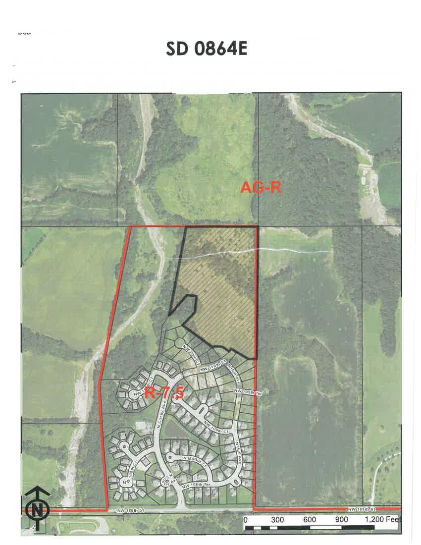
74


75


76


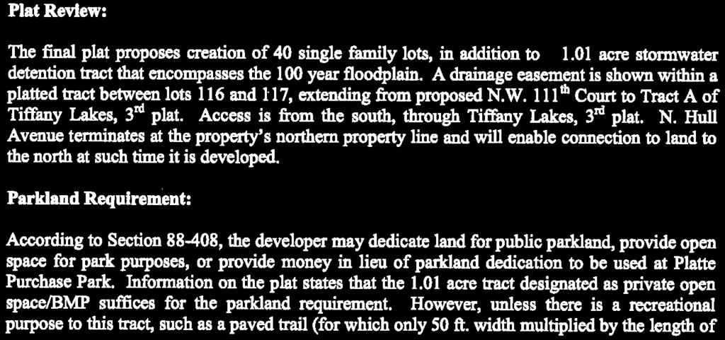
77
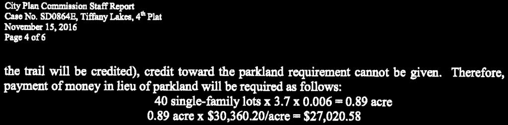
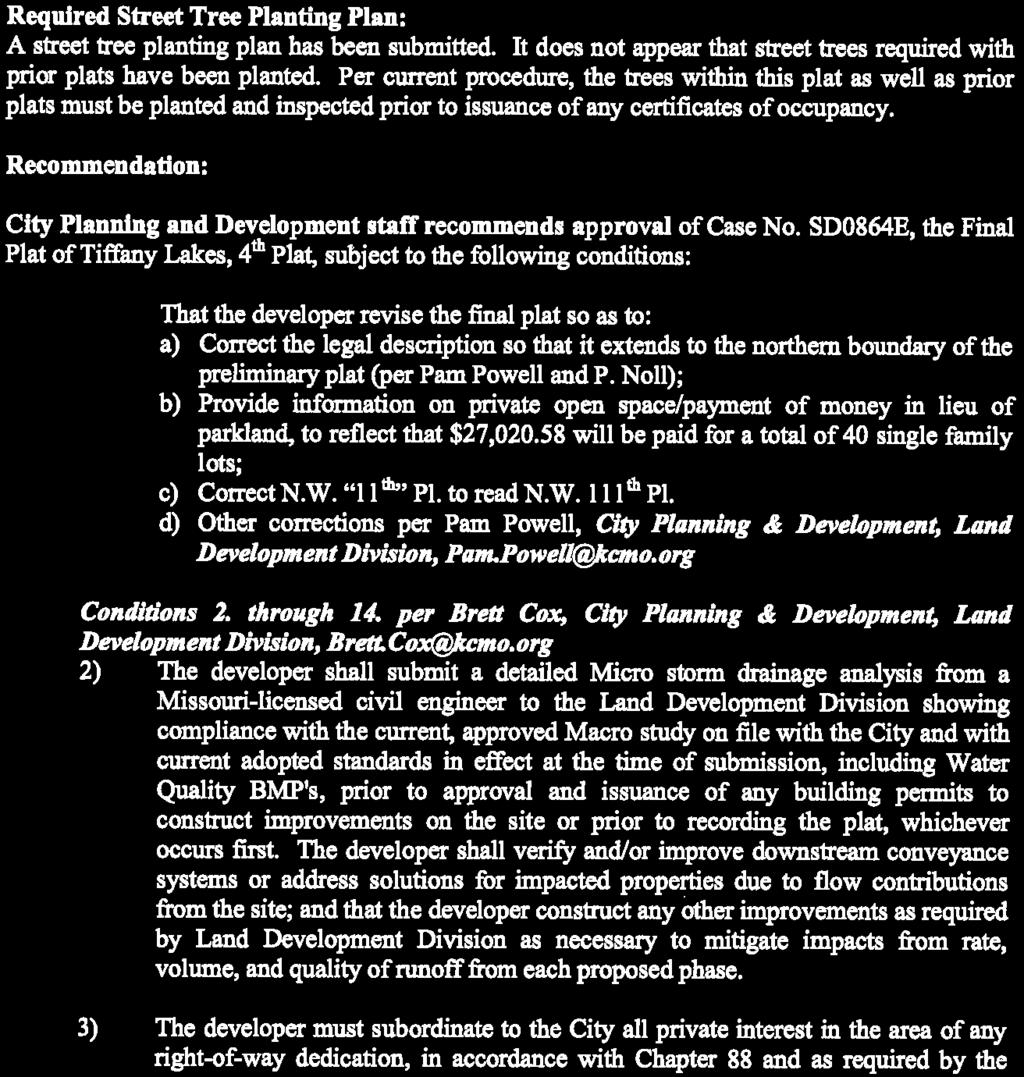
78

79
80
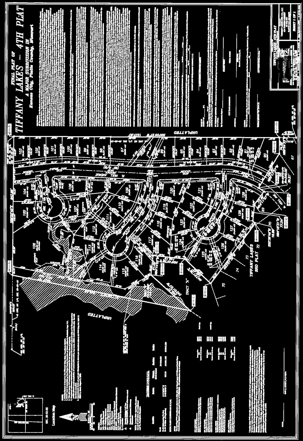
81
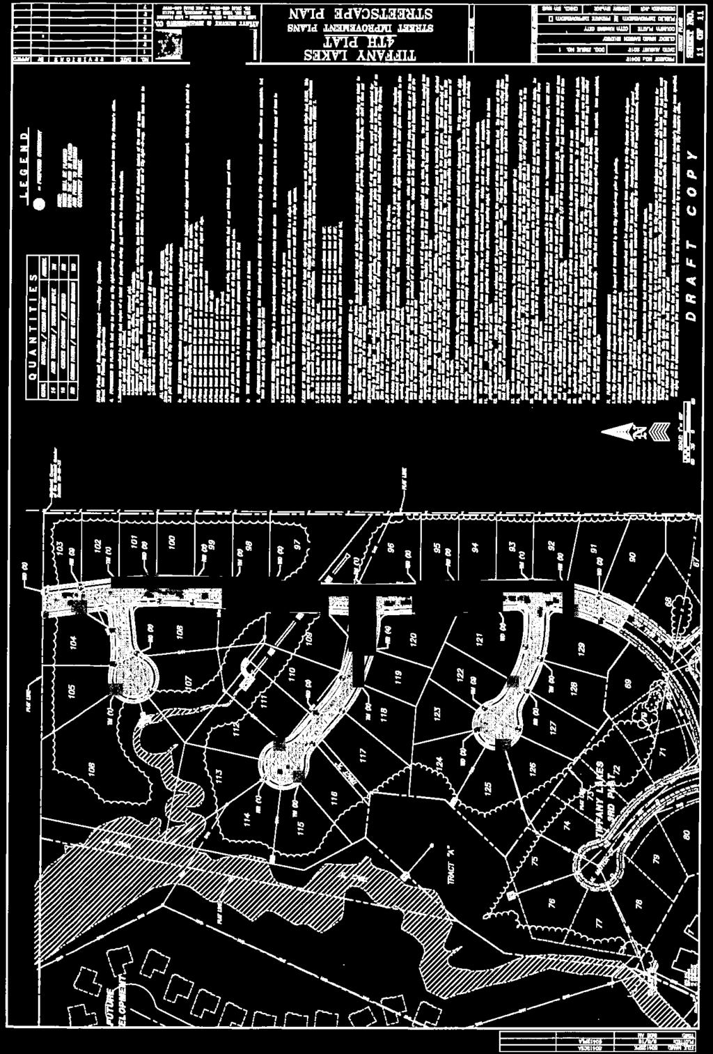
82
83 Docket # P Case No P-10 Approximately 6 acres generally located at the southeast corner of N. Jackson Avenue and NE Parvin Road, to consider approval of a development plan in District B3-2 (Community Business dash 2), to allow for a 78 unit skilled nursing and rehabilitation facility. B1-1 B1-1 B2-2 R-2.5 B3-2 R-2.5 B1-1 B3-2 B2-2 B3-2 R-1.5 R-6 F Feet
84 City Planning & Development Department Development Management Division 15th Floor, City Hall 414 East 12th Street Ph: (816) Kansas City, Missouri Fax:(816) STAFF REPORT November 15, 2016 (14) RE: APPLICANT: OWNER: AGENT: Case No P-10 Jason Toye NSPJ 3515 W. 74 th Street Prairie Village, KS Central Bank of Kansas City (c/o Curt Scoville) 2301 Independence Blvd. Kansas City, MO Mark Untersee Untersee & Associates, P.C N. Broadway, Suite 1209 Kansas City, Mo LOCATION: Generally located at the southeast corner of N. Jackson Avenue and NE Parvin Road. AREA: REQUESTS: SURROUNDING LAND USE: LAND USE PLAN: MAJOR STREET PLAN: Approximately 6 acres. To consider approval of a development plan in District B3-2 (Community Business dash 2), to allow for a 78 unit skilled nursing and rehabilitation facility. North: zoned B3-2, Open Door Bible Baptist Church. South: zoned R-1.5, Chouteau Village. East: zoned R-6, Single Family Residences. West: zoned B2-2, vacant/ undeveloped. The project site is within the Briarcliff/ Winnwood Area Plan boundaries. The plan recommends Commercial land use at this location. The proposed plan is in conformance with the area plan. North Jackson Avenue is not classified by the City s Major Street Plan, but serves as a collector street with a 60 feet right of way. The City s Major Street Plan
85 Staff Report Case No P-10 November 15, 2016 Page 2 classifies NE Parvin Road as a Boulevard under the jurisdiction of the Parks and Recreation Department. This development is subject to the requirements of Chapter , Boulevard and Parkway Standards of the Zoning and Development Code. ARTERIAL STREET IMPACT FEE: Benefit District: Exempt (Informational only) Fees will be calculated by the administrator. PREVIOUS CASE: Case No CP-9 On June 16, 2009, the City Plan Commission approved a final plan in District CP-3 (regional planned business center), on about 6 acres generally located at the southeast corner of NE Parvin Road and N. Jackson Avenue, to allow for 358 mini storage units. Case No. SD-1402, On April 21, 2009, the City Plan Commission approved a final plat in District CP-3 (regional planned business center) on approximately 6 acres, creating one commercial lot and one tract. Council action still pending. Case No CP-8 Ordinance No was passed by City Council on April 30, 2008, rezoned approximately 6 acres from District CP-2 (local planned business center) to District CP-3 (regional planned business center) and approved a preliminary development plan to allow for an 18,639 square feet retail building and 358 mini storage units. RECOMMENDATION: City Planning and Development Staff recommends that case No P-10 be continued to the January 3, 2017, CPC docket without a fee to allow the applicant to submit revised plans that are in substantial conformance to the Boulevard and parkway standards. Respectfully submitted, Olofu O. Agbaji Planner
86 Docket # S Case No. 693-S-3 - A request to amend the Truman Plaza Area Plan by changing the recommended land use on about 1.5 acre tract of land located on the side of St. John Avenue on both sides of N. Elmwood Avenue, from Residential Medium Density and Mixed Use Neighborhood to Commercial. R-5 R-2.5 B3-2 F Feet
87 Docket # P Case No P A request to rezone approximately 0.25 acre tract of land located on the west side of N. Elmwood Avenue, approximately 175 feet north of St. John Avenue, from District R-5 (Residential dash 5) to District B3-2 (Community Business dash 2). R-5 R-2.5 B3-2 F Feet
88 Docket # P-1 Case No P-1 About 1 acre (two tracts of land) located on the north side of St. John Avenue, on both sides of N Elmwood Avenue, to consider approval of a development plan in lieu of a Special Use Permit in District B3-2 (Community Business dash 2), to allow for building renovation and general site improvements R-5 R-2.5 B3-2 F Feet
89 City Planning & Development Department Development Management Division 15th Floor, City Hall 414 East 12th Street Kansas City, Missouri Fax STAFF REPORT November 15, 2016 (15, 16 & 17) RE: APPLICANT: OWNER: AGENT: LOCATION: AREA: REQUESTS: a) Case No. 693-S-3 b) Case No P c) Case No P-1 John Chamberlin S.K. Design Group 4600 College Blvd, Suite 100 Overland Park, KS The Healing House 4400 St. John Avenue Kansas City, MO Greg Finkle Finkle & Williams Architecture 7007 College Boulevard Overland Park, Ks Two tracts of land, generally located on the north side of St. John Avenue, on both sides of N. Elmwood Avenue. Approximately 1 acre a) Case No. 693-S-3 - A request to amend the Truman Plaza Area Plan by changing the recommended land use on about 1.5 acre tract of land located on the side of St. John Avenue on both sides of N. Elmwood Avenue, from Residential Medium Density and Mixed Use Neighborhood to Commercial. b) Case No P A request to rezone approximately 0.25 acre tract of land located on the west side of N. Elmwood Avenue, approximately 175 feet north of St. John Avenue, from District R-5 (Residential dash 5) to District B3-2 (Community Business dash 2).
90 Staff Report Cases No. 693-S-3, P & P-1 November 15, 2016 Page 2 c) Case No P-1 About 1 acre (two tracts of land) located on the north side of St. John Avenue, on both sides of N Elmwood Avenue, to consider approval of a development plan in lieu of a Special Use Permit in District B3-2 (Community Business dash 2), to allow for building renovation and general site improvements. SURROUNDING LAND USE: North: zoned R-5, single family residences. South: zoned B3-2, mixed use. East: zoned B3-2/ R-2.5, single family residences/ mixed use. West: zoned B3-2/ R-5, single family residences/ mixed use. LAND USE PLAN: The Gashland/ Nashua Area Plan adopted by Resolution No on January 5, 2012, recommends Mixed Use Community and Mixed Use Neighborhood at this location. The proposed use is consistent with the future land use plan. RECOMMENDATIONS: City Planning and Development Staff recommends continuance of the above case to the December 6, 2016, CPC docket without a fee to allow the applicant to submit revised plans as required by the Development Review Committee. Respectfully submitted, Olofu O. Agbaji Planner
91 City Planning & Development Department Development Management Division 15th Floor, City Hall 414 East 12th Street Kansas City, Missouri Fax STAFF REPORT November 15, 2016 (18) RE: APPLICANT: OWNER: AGENT: Case No SU-1 Liberty Hotel Group, LLC 115 Blue Jay Dr Liberty, MO Hunt Midwest Real Estate Development Inc NE Underground Dr, Suite 100 Kansas City, MO Patricia R. Jensen, Esq. White Goss 4510 Belleview, Suite 300 Kansas City, MO LOCATION: Generally located between N Corrington Ave and Interstate 435, south of Parvin Rd. REQUEST: AREA: SURROUNDING LAND USE: LAND USE PLAN: MAJOR STREET PLAN: ARTERIAL STREET IMPACT FEE: (Informational only) To approve a special use permit to permit construction of a hotel in District M1-5/US (Manufacturing 1/Underground Space). About 14 acres. North Vatterott College and contractor s office, both zoned M1-5/US. & West East Interstate 435. South Undeveloped land beyond which is Bennington Park Townhomes, zoned R-1.5. (Residential 1.5). The Briarcliff-Winnwood Area Plan recommends light industrial uses for the property. Corrington Ave is not on the Major Street Plan. The subject property is within benefit district D and is subject to impact fees as required by Chapter 39. PREVIOUS CASES: Case P - EXISTING CONDITIONS: The subject property is a 14-acre site located on the west side of Interstate 435 about 1,000 feet south of Parvin Rd. It is located at the end of N Corrington Ave which is a cul-de-sac south of Parvin Rd. Much of the property is graded flat for development, however there are two
92 Docket Item # SU Case No SU-1 A request to approve a special use permit to permit construction of a hotel in District M1-5/US (Manufacturing 1/Underground Space) on about 14 acres generally located between N Corrington Ave and Interstate 435, south of Parvin Road. M1-5/US R-1.5/US M1-5/US R-1.5 F 0 R Feet
93 City Plan Commission Staff Report Case No SU-1 November 15, 2016 Page 2 regulated streams and floodplain along the south and east edges of the property. The same areas are also heavily vegetated. PLAN REVIEW: The plan proposes construction of a 94,500 square foot, four-story, 115-room Holiday Inn hotel. The use is permitted in District M1-5 with a special use permit. The plan depicts the hotel located in the northwestern portion of the property adjacent to N Corrington with parking located on all sides of the building. The hotel will be oriented toward Corrington with a porte-cochere over a drop-off lane at the front. A sidewalk must be installed along N Corrington across the subject property with a sidewalk connecting to the hotel s main entrance. A total of 128 parking spaces are proposed (36 are required). The grading plans indicate a 1 to 4 slope south of the parking lot. Staff is concerned this will be too steep to safely maintain grass or other landscaping and recommends the plan be revised to reduce the slope or propose a retaining wall in lieu. ANALYSIS: Special Use Permit Review Criteria ( ) Special Use Permits must be found to be in conformance with five criteria in Chapter No special use application may be approved unless the board of zoning adjustment finds that the proposed use in its proposed location: A: complies with all applicable standards of the zoning and development code; The request complies with the applicable standards of the zoning and development code B: Is in the interest of the public convenience and will not have a significant adverse impact on the general welfare of the neighborhood or community; The proposed use is not expected to have an adverse impact on the general welfare of the neighborhood or community C: Is compatible with the character of the surrounding area in terms of site planning and building scale and project; The building is a four-story building and adjacent buildings are both one-story, however there are additional hotels in the vicinity that are multiple-stories and the property lies adjacent to Interstate 435. Staff finds that the project is compatible in character, site planning, and scale with the surrounding area D: Is compatible with the character of the surrounding area in terms of operating characteristics, such as hours of operation, outdoor lighting, noise, and traffic generation; There are other hotels in the area as well as restaurants and gas stations all of which have similar impacts to the proposed hotel. Staff believes the proposed use is compatible E: Will not have a significant adverse impact on pedestrian safety or comfort. There use will improve pedestrian safety and comfort by extending a public sidewalk along N Corrington. It will not have an adverse impact on pedestrian safety or comfort. RECOMMENDATION: City Planning and Development Staff recommends approval of Case No SU-1, based upon the application, plans and documents provided for review prior to the hearing and subject to the following conditions as provided by the Development Review Committee at the October 19, 2016 meeting: 1. That one (1) collated, stapled and folded copy (and a CD containing a pdf file, a georeferenced monochromatic TIF file, and CAD/GIS compatible layer of the plan boundary referenced to the Missouri state plan coordinate system) of the plans, revised as noted, be
94 City Plan Commission Staff Report Case No SU-1 November 15, 2016 Page 3 approved by the Development Management staff (15 th Floor, City Hall) prior to building or occupancy permit showing: a. Color renderings with all proposed materials labeled. b. Revised lighting plan in compliance with c. Proposed materials for the trash enclosure on the face of the plan. The material shall match the building materials. d. A detailed cross section of the proposed retaining wall, showing proposed material for construction, top and bottom elevations of all proposed walls. The plans should be accompanied by a structural data to be submitted to DMD prior to issuance of building permit. e. Proposed barrier material for the retaining walls. f. A landscape plan prepared by a landscape architect licensed in the State of Missouri and demonstrating full compliance with The plan shall include a landscape material schedule and landscape requirement table listing the applicable requirements and stating how they are satisfied. g. Revise grading to reduce the slope along the south side of the parking lot to no greater than 1 to 8. h. Details on all proposed signage demonstrating conformance with or a note stating that all signage will conform to and is subject to a sign permit. i. Show sidewalk a minimum of 5 feet in width and where sidewalks abut parking areas show them a minimum width so as to provide 5 feet of horizontal clearance. Show all crosswalks designed in conformance with B. j. Demonstrate compliance with short-term bicycle parking design standards of B-2. Also demonstrate compliance with long-term bicycle parking design standards of C-2 or provide a note specifying the bike parking location and stating that design standards will be demonstrated on construction drawings. The following plan corrections are offered by the Land Development Division of the City Planning & Development Department. Please contact Brett Cox at brett.cox@kcmo.org or k. Show standard sidewalk within the Right-of-Way of N Corrington Ave. l. Show existing public sanitary sewers within the property boundary. The following plan corrections are offered by the Long Range Planning Division of the City Planning & Development Department. Please contact Chase Johnson at chase.johnson@kcmo.org or m. The proposed plan is utilizing the effective FIRMs dated August 5, Currently, there are preliminary FIRMs with updated FEMA floodplains and delineated floodway that should be used as best available information. 2. That the developer shall submit a street tree planting plan to the Development Management Division and City Forester and shall secure the approval of the City Forester for street trees to be planted in the right of way prior to issuance of a building permit and plant said trees as required by the plan prior to certificate of occupancy. The following comments are offered by the Land Development Division of the City Planning & Development Department. Please contact Brett Cox at brett.cox@kcmo.org or The developer shall submit a detailed storm drainage analysis from a Missouri-licensed civil engineer to the Land Development Division showing compliance with the current, approved Macro study on file with the City and with current adopted standards in effect at the time of submission, including Water Quality BMP's, prior to approval and issuance of any building permits to construct improvements on the site or prior to recording the plat, whichever occurs first. The developer shall verify and/or improve downstream conveyance systems or address solutions for impacted properties due to flow contributions from the site; and that
95 City Plan Commission Staff Report Case No SU-1 November 15, 2016 Page 4 the developer construct any other improvements as required by Land Development Division as necessary to mitigate impacts from rate, volume, and quality of runoff from each proposed phase. 4. The developer must pay impact fees as required by Chapter 39 of the City's Code of ordinances as required by the Land Development Division. 5. The developer submit plans to Land Development Division and obtain permits to construct sidewalks along the platted frontage, as shown on the approved street plans for N Corrington Ave., and construct associated ADA ramps at the proposed entrance drives as necessary for the type of drive approach. 6. The developer must grant a city approved pedestrian right-of-way easement, for the portions of the public sidewalks approved to be outside of the street right-of-way, to the City as required by the Land Development Division, prior to issuance of any certificate of occupancy. 7. The owner/developer must submit plans for grading, siltation, and erosion control to Land Development Division for review and acceptance, and secure a Site Disturbance permit for any proposed disturbance area equal to one acre or more prior to beginning any construction activities. 8. The developer must grant a BMP Easement to the City as required by the Land Development Division, prior to issuance of any certificate of occupancy. The following comments are offered by the Fire Department. Please contact Brett Cox at john.hastings@kcmo.org or Fire Department access roads shall be provided prior to construction/demolition projects begin. (IFC-2012: ; NFPA : 7.5.5) 10. The expectation is the project will meet the fire flow requirements as set forth in Appendix B of the International Fire Code (IFC-2012: 507.1) 11. Fire hydrant(s) are required within 400 feet on a fire access road following an approved route established by the Authority Having Jurisdiction (AHJ) of any exterior portion of a building. The use of existing fire hydrant(s) may be used to satisfy this requirement otherwise a private fire hydrant(s) or hydrant system may be required. This distance may be increased to 600 feet for R-3 and U occupancy(s) or the building(s) is fully protected by an approved automatic fire sprinkler system(s). (IFC-2012: ) 12. Buildings equipped with a fire standpipe system shall have an operable fire hydrant within 100 feet of the Fire Department Connection (FDC). (IFC2012: ) Respectfully submitted, Joseph C. Rexwinkle, AICP Planner
96
97
98 PLANT SCHEDULE
99
100 PRELIMINARY PLANS - NOT FOR CONSTRUCTION BIEBERLY ARCHITECTS 126 ROOM HOLIDAY INN - FULL SERVICE WORLDS OF FUN, KC, MO
101 PRELIMINARY PLANS - NOT FOR CONSTRUCTION BIEBERLY ARCHITECTS 126 ROOM HOLIDAY INN - FULL SERVICE WORLDS OF FUN, KC, MO
102
103
104
105
106 City Planning & Development Department Development Management Division 15th Floor, City Hall 414 East 12th Street Kansas City, Missouri Fax STAFF REPORT November 15, 2016 (19) RE: APPLICANT/OWNER: AGENT: LOCATION: AREA: REQUESTS: LAND USE PLAN: SURROUNDING LAND USE: Case No MPD-2 The Nelson Gallery Foundation 4525 Oak St Kansas City, MO Charles Renner Husch Blackwell 4801 Main St, Suite 100 Kansas City, MO Generally located north of Emanuel Cleaver II Blvd, east of Oak St, south of 44 th St and west of Kenwood Ave. About 29 acres. To approve a rezoning from District R-5 (Residential 5) and District R-6 (Residential 6) to District MPD (Master Planned Development) and to approve a preliminary development plan for the Nelson- Atkins Museum of Art to permit existing museum and administrative office uses in existing buildings and outdoor sculpture gardens. The Midtown Plaza Area Plan recommends residential low-density and institutional land uses for the subject property; however, it also encourages flexibility in the reuse of historic buildings. North: Residential uses, zoned R-1.5 and R-5. South: Emanuel Cleaver II Blvd, beyond which is Thies Park, zoned R-6 and R-5. East: Rockhill neighborhood zoned R-10. West: Kansas City Art Institute and Southmoreland Park zoned R- 5. ARTERIAL STREET IMPACT FEE: The subject property is within benefit district H and is subject to (Informational only) impact fees as required by Chapter 39. EXISTING CONDITIONS: The subject property consists of three blocks totaling 29 acres. The largest of the three blocks is the site of the museum bound by 45 th on the north, Oak on the west, Cleaver on the south and Rockhill on the east (museum block). Immediately to the north between 44 th and 45 th Streets is a block consisting of five parcels, four developed with historic structures constructed as residences and one developed as a surface parking lot (north block). The third block lies immediately to the east of the museum across Rockhill Rd and is the site of the former Rockhill Tennis Club (east block), also a historic property. The museum owns all 29 acres.
107 12557-MPD Case MPD-2 A request to approve a rezoning from District R-5 (Residential 5) and District R-6 (Residential 6) to District MPD (Master Planned Development) and to approve a preliminary development plan for the Nelson-Atkins Museum of Art to permit existing museum and administrative office uses in existing buildings and outdoor sculpture gardens on about 29 acres generally located north of Emanuel Cleaver II Blvd, east of Oak St, south of 44th St and west of Kenwood Ave. R-1.5 R-2.5 R-1.5 R-1.5 R-5 R-1.5 UR R-0.5 R-5 R-6 R-10 R-1.5 R-0.5 R-6 R-1.5 F 0 UR R-0.5 R-5 R Feet
108 City Plan Commission Staff Report Case No MPD-2 November 15, 2016 Page 2 PLAN AND REZONING REVIEW: The applicant is proposing to rezone the subject property (all three blocks) to District MPD and has submitted a preliminary development plan as required. The plan proposes four phases, however, proposed uses are identified only for Phases I and II. Phases III and IV will require subsequent approval of a major amendment to the MPD plan and corresponding public notice/public hearing before the City Plan Commission and City Council prior to approving any uses or development in these phases. The phases are described as follows: Phase I This phase proposes retaining the four existing residential structures on the northern block as well as their landscaping and modifying their interiors for use as museum offices. Use of these four structures for museum offices would allow approximately 12,000 square feet of floor area in the museum currently serving as offices to be converted to gallery space. All four structures are listed on the local register of historic places. Staff Comment: Subsequent to approval of this request, an MPD final plan must be submitted and approved by the City Plan Commission for this phase. It must comply with the proposed phasing details including demonstrating that no exterior modifications are proposed. Staff is supportive to limiting the use of the properties in this phase to administrative offices for the museum. Phase II This phase proposes removal of the existing tennis courts and fencing, re-grading and relandscaping of the property. The existing building and parking lot would be retained as would the historic rock walls that border the property. An outdoor sculpture park would be developed on the property. The property is also listed on the local register of historic places. Staff Comment: Subsequent to approval of this request, an MPD final plan must be submitted and approved by the City Plan Commission for this phase. It must comply with the proposed phasing details and include a grading plan, landscape plan, site plan and demonstrate that no exterior modifications to the existing building is proposed. Staff believes the parking lot should conform to existing zoning code requirements, which might require revising it with regard to parking space and drive-aisle dimensions as well as required landscaping associated with parking lots. Phase III The plan notes that this phase would comprehensively document the museum s program needs. The phase is dependent upon fundraising. Phase IV This phase would build upon the results from a national/international competition by selecting architects and firms that specialize in taking program needs and translating them into concepts and solutions. This phase is also dependent on fundraising. Staff Comment: Staff recommends these phases be combined into one. No uses or physical development for these phases is proposed or approved with this request. Approval of a major amendment to identify uses and physical development shall be required at such time that they are proposed. The major amendment must be approved by the City Plan Commission and City Council. Lot and Building Standards The plans do propose lot and building standards regulating the placement and height of
109 City Plan Commission Staff Report Case No MPD-2 November 15, 2016 Page 3 outdoor sculptures. Staff is not recommending a formal approval process of individual art pieces that may be placed outdoors in the proposed sculpture parks however we do recommend lot and building standards to provide some assurance to the public as to where the art may be located and how tall it can be. The sculpture parks are proposed only for the museum block and east block. In the case of the east block, the plan proposes the following: In the case of the museum block, the following is proposed: ANALYSIS: The applicant is seeking approval of a rezoning to MPD that would permit: 1. The existing museum use and outdoor sculpture park on the museum block. No exterior modifications to the building or site are proposed. 2. Conversion of the interior of the residential structures to allow transition from residential use to administrative offices for the museum on the north block. No exterior modifications to the buildings or site are proposed. (Phase I) 3. Removal of tennis courts, re-grading, re-landscaping and installation of a sculpture park, and retaining the existing structure and parking lot on the east block. No exterior modifications to the structure or parking lot are proposed. (Phase II). While the plan does propose a Phase III and IV for informational purposes, it does not seek approval of any aspect of these phases. Approval of any aspect of these phases including any proposed physical development or change in use will require amending the MPD zoning and preliminary plan to propose such development or uses at that time. Such an amendment would be a major amendment requiring City Plan Commission and City Council approval and requiring public notice and public hearings before both the Commission and Council. According to the applicant, because these phases require additional fundraising, they are not prepared to propose any development or uses for these phases. Staff has heard some concern with this approach expressed by residents in the area, however, staff cannot compel the applicant to propose something in future phases if the applicant contends they do not know what their needs or desires for those phases will be. One could argue that these phases should be left out of the MPD request, however, in staff s opinion they should be included since they are a part of the campus, they provide some information about the future intent of the museum, and the MPD zoning would ensure any proposed use or development in these phases would require public input (as opposed to current zoning which may or may not depending upon the particular use proposed or the scale of development proposed).
110 City Plan Commission Staff Report Case No MPD-2 November 15, 2016 Page 4 Rockhill Neighborhood Comments: Staff has received the following comments from the Rockhill Neighborhood and advised the neighborhood to contact the applicant to discuss (see attached). Staff understands that the the applicant plans to meet with the neighborhood prior to City Plan Commission but as of this writing this meeting has not yet occurred and the applicant contends they have not been contacted by the applicant in response to their comments or in regard to a meeting. For the benefit of the Commission, staff is providing the comments, plan corrections and conditions provided by the neighborhood to staff with our responses. The following comments apply to all phases: 1. A note stating that amendments to the MPD, during all phases, shall not be completed administratively, but shall only be amended by the same procedures as rezoning, necessitating appropriate notice and hearing procedures. Staff Response: MPD zoning requires approval of a final plan from the City Plan Commission regardless of whether a note is added. In the case of Phases I and II, the applicant is proposing land uses, setbacks, height, etc. all typical aspects established with MPD zoning and preliminary development plan and in these cases staff believes the standard process for plan approval is appropriate; the standard process being MPD final plan approval from the City Plan Commission for these phases. Should the applicant propose something which does not conform to the preliminary development plan and MPD zoning on the subsequent MPD final plan, such proposal may be considered a major amendment (see below) as defined by the zoning and development code, in which case approval from the City Council would also be required AMENDMENTS TO DEVELOPMENT PLANS OR PROJECT PLANS A. MAJOR AMENDMENTS 1. Major amendments to approved development plans or project plans must be reviewed and approved in accordance with the development plan or project plan review procedures of this ordinance. Major amendments to development plans or project plans include one or more changes, in cumulative total (when compared to the original plan approval), that would: a. increase building coverage by more than 10%; b. increase the total floor area by more than 10% or 5,000 square feet, whichever is less; c. increase building height by more than 10% or 6 feet, whichever is less; d. increase the total impervious surface coverage by more than 10% or 2,000 square feet, whichever is less; e. result in extensive site modification involving location of buildings, razing, and reconstruction of approved uses; f. increase the number of dwelling units by more than 10%; or g. result in any other change that the city planning and development director determines will have impacts that warrant full review of the application in accordance with the development plan review procedures. With regard to Phases III and IV, staff agrees that a major amendment requiring City Plan Commission and City Council approval shall be required at such time that the museum identifies its long-term needs and is able to submit a plan depicting such. As opposed to Phases I and II, a major amendment is necessary due to the lack of information regarding land uses, setbacks, height, scale, etc. all typical aspects established with MPD zoning and preliminary development plan. (See Condition #1e)
111 City Plan Commission Staff Report Case No MPD-2 November 15, 2016 Page 5 2. A note stating that the MPD shall be incompliance with Parks and Recreation Guidelines. Staff Response: Staff believes this is in reference to Parks and Boulevard Standards, which the application must conform to as the streets in the vicinity of the project are the jurisdiction of the Parks Department. The current proposal conforms to the standards and staff agrees that later phases must also be reviewed for conformance regardless of whether a note is added, however, staff supports revising the plan to state such. (See Condition #1a) 3. A note stating that the Foundation shall create a Preservation Advisory Committee (PAC), similar to the model used by Union Station. In consultation with the City, the Foundation will appoint to the PAC one representative each from: the Rockhill Homes Association, the Southmoreland Neighborhood Association; the Landmarks Commission; Historic Kansas City; and three other individuals with preservation/restoration/planning expertise not associated with the Foundation. The PAC will be staffed by the Foundation. Representatives on the PAC shall be selected by his/her respective association. The PAC shall remain in existence in perpetuity and will hold meetings at least on a quarterly basis. The major focus of the PAC will be the planning and restoration process and its impact on the community. Staff Response: The applicant and neighborhood can pursue a private agreement to this effect, however, staff does not believe this is a land use or zoning issue and therefore does not recommend a note or condition related to it. If the Commission elects to add such a note, staff recommends that clarity with regard to the City s role be provided. 4. That a note stating that the Foundation shall convey conservation easements to the Landmarks Historic Trust Corporation for all five historic residences along 45 th Street and for the Kirkwood property. The City s Historic Preservation Officer provided the following response: Having a third party, such as the Landmarks Historic Trust Corp or other entity retain an easement would help insure the preservation of the buildings. Would need a letter from an entity stating that they would accept an easement. The following comments apply to Phase I only: 5. A note stating that the five residential structures that are the subject of this MPD will never be destroyed. The buildings will always be maintained in a good, physical condition and be periodically inspected by the City of Kansas City, Missouri to assure that the condition is maintained. The City s Historic Preservation Officer provided the following response: The city has a minimum maintenance code that the Property Preservation Division of the Neighborhoods & Housing Department administers. If a structure does not meet the code, any citizens can call in to have the property inspected. There properties are listed on the Kansas City Register of Historic Places, which requires demolition review and approval, but would only delay a demolition. A conservation easement would be a better approach to ensure the properties are not demolished. 6. A note stating that special uses will be limited to office uses. Staff Response: No proposed uses are special uses but would instead become permitted uses if this MPD is approved; however, staff supports such a note and a condition as there are different uses proposed (museum on the main property and offices in Phases I
112 City Plan Commission Staff Report Case No MPD-2 November 15, 2016 Page 6 and II). (See Conditions #1b, 1c, 1d, and 2) 7. Depiction and labeling of existing conditions and specific improvements to the Feingold House, Bishop s House, and 414 and th Street. Staff Response: Only interior improvements are proposed. Interior improvements or modifications are not regulated with this plan or with zoning; therefore staff does not recommend this as a plan correction or condition. The following comments apply to Phase II only: 8. A note stating that a sculpture park setting and landscape plan shall be submitted for approval. It shall define the design for the 5 acre site, including detailed information for the replacement of the existing tennis courts, surface parking lot, security, art locations, pathways, lighting, irrigation, signage, parking, and retention of mature trees, new grass, trees, shrubs, and the Kirkwood building. Staff Response: Staff recommends these details be approved through the MPD final plan process and is recommending a condition related to such. (See Conditions #1f, and #4) a. A note stating that the Foundation shall create Kirkwood Sculpture Park Committee, including neighborhood representatives, city staff, and others to develop the above stated plan. Staff Response: The applicant and neighborhood can pursue a private agreement to this effect, however, staff does not believe this is a land use or zoning issue and therefore does not recommend a note or condition related to it. If the Commission elects to add such a note, staff recommends that clarity with regard to the City s role be provided. 9. A note stating that the Kirkwood house structure will never be demolished. The structure will always be maintained in a good, physical condition and be periodically inspected by the City of Kansas City, Missouri to assure that the condition is maintained. The City s Historic Preservation Officer provided the following response: The city has a minimum maintenance code that the Property Preservation Division of the Neighborhoods & Housing Department administers. If a structure does not meet the code, any citizens can call in to have the property inspected. There properties are listed on the Kansas City Register of Historic Places, which requires demolition review and approval, but would only delay a demolition. A conservation easement would be a better approach to ensure the properties are not demolished. 10. A note stating that the Kirkwood surface parking lot shall be removed, with work beginning within 30 days of the approval of this MPD. Immediately following removal of the surface parking lot, a sprinkler system shall be installed and grass planted in the former parking lot area. Staff Response: Staff understands the applicant desires to retain this lot to provide parking for the future administrative office use of the structure on this property. With that understanding, staff does not recommend a note requiring its removal. 11. A note stating that the Kirkwood property tennis court fencing and the tennis courts will be immediately removed with work beginning within 30 days of the approval of this MPD. Immediately following removal of the fencing and tennis courts, a sprinkler system shall be installed and grass planted in the former tennis court area.
113 City Plan Commission Staff Report Case No MPD-2 November 15, 2016 Page 7 Staff Response: Staff understands the applicant also intends to remove the courts and the applicant has advised us that they would prefer to remove them at such time they grade and re-landscape the property for the proposed sculpture park, which cannot occur until after the City Plan Commission approves an MPD final plan. Staff believes this can be address with the MPD final plan. 12. A note stating that a signage plan shall be submitted that defines the placement and measurement of all signage. 13. A note stating that a lighting plan, with photometric study, be submitted per City Standards. All outdoor lighting must be reflected away from residences and streets. Staff Response: Such information is required by the zoning and development code with approval of MPD final plans. Staff recommends conditions related to this. (See Conditions #1f and #1g) 14. A note stating that as required by the Settlement Agreement by and between the Trustees of the Nelson Gallery Foundation, the University Trustees of the William Rockhill Nelson Trust, and the City of Kansas City, Missouri, the Kirkwood house property will be immediately inspected by the City of Kansas City, Missouri, and the property will be repaired so that it is in good, physical condition. Staff Response: If there is a settlement agreement to this effect then there is no need for a condition or note. a. The Kirkwood Property: The Foundation will continue to maintain and secure the grounds of the Kirkwood Property consistent with the zoning of the Kirkwood Property and its location within the Rockhill Homes Association. Staff Response: Staff is unclear on what is being requested. The following comments apply to Phases III and IV only: 15. A note stating that Phases III and IV (shall) were withdrawn from this application, and shall be resubmitted at such time when sufficient detail can be provided regarding the location, program, uses, height, density, setbacks and other components of zoning are established by the site plan itself, etc for future gallery space, parking, storage, and multi-purpose areas. Any description regarding future development shall be deemed as for information purposes only, not regulatory. Staff Response: For clarity, staff is recommending these phases be condensed into one (See Condition #1e). Staff agrees there is a lack of detail provided, which is why we recommend that this phase require approval of a major amendment from the City Plan Commission and City Council. We understand that the future phase is only referenced for informational purposes and has been proposed by the applicant as a means of clearly stating that the applicant understands a major amendment will be required for this phase. All that is being requested at this time is approval of new uses in Phases I and II and in the case of Phase II, specified site improvements. 16. If Phases III and IV remain, add a note stating that the Foundation shall create an Infill Compatibility Standards Committee, including neighborhood representatives, city staff, and others to develop appropriate new sites where development would be compatible within the overall neighborhood, etc
114 City Plan Commission Staff Report Case No MPD-2 November 15, 2016 Page 8 Staff Response: The applicant and neighborhood can pursue a private agreement to this effect, however, staff does not believe this is a land use or zoning issue and therefore does not recommend a note or condition related to it. If the Commission elects to add such a note, staff recommends that clarity with regard to the City s role be provided. 17. A note stating that if Phases III and IV remain as a part of this MPD, that: a. A note stating that, as described in the Envisioning a Cultural District, prepared for the Nelson-Atkins Museum of Art, east/west connections shall be extended through the planning area to enhance connectivity between the Kemper Art Gallery, Kansas City Art Institute, Nelson-Atkins Gallery, and to UMKC. Staff Response: Staff believes this can and should be addressed with review of the later phase. b. A note stating that the Nelson-Atkins Gallery shall commit, during the pendency of this plan, to establish strong facilities to the east of the Nelson-Atkins Gallery on Troost Avenue, and elsewhere, to further support the mission of the Nelson-Atkins Gallery. Staff Response: Staff believes this is vague and open-ended. needed. More information is c. A note stating that every effort will be made by the Nelson-Atkins Gallery to identify exhibit space within a 2 mile radius of the Nelson-Atkins property to lessen the impact of the museum s, mission and program to the adjacent historic neighborhoods. Staff Response: Staff believes this is vague and open-ended. needed. More information is d. A note stating that, should the site of the existing 45 th and Rockhill Road surface parking lot be identified for infill development, the Nelson-Atkins Gallery shall efficiently locate the building not-to-exceed 15,000 sq. ft. per floor area, and notto-exceed three-stories in height, with basement below. The façade shall complement and be compatible with the adjacent historic district, utilizing the Secretary of the Interiors Standards for guidelines. Staff Response: Unless the proposed building is less than 5,000 square feet, it would require approval of a major amendment. For clarity, supports a note on the plan and a condition which would require any development of this property less than 5,000 square feet be approved as an MPD final plan from the City Plan Commission and any development exceeding this amount is approved as a major amendment from the City Plan Commission and City Council. (See Condition #1h and #5) In reviewing and making decisions on proposed zoning map amendments, the city planning and development director, city plan commission, and city council must consider at least the following factors: A. Conformance with adopted plans and planning policies; The Midtown Plaza Area Plan recommends Residential Low Density and Institutional land use for the Nelson and surrounding properties. However, the plan also encourages flexibility in the reuse of historic buildings (Page 25):
115 City Plan Commission Staff Report Case No MPD-2 November 15, 2016 Page 9 a. This Plan encourages the preservation and adaptive re-use of historic buildings. Historic buildings (whether designated or not) contribute to the area identity and should be preserved and integrated into new development. Even if the original intent of the structures is obsolete, reusing the buildings in new ways may be the best solution to retain the structure. b. When a historic building (designed or potentially eligible for historic designation) is part of a redevelopment, the Recommended Land Use map s recommendations should be flexible, in order to retain historic resources, while achieving the goals of this Plan. Any impacts should be minimized and the physical attributes of the structure should remain and appear to fit within the character of the Recommended Land Use and surrounding neighborhood. Since the proposal is for the reuse of these historic structures Long Range Planning staff believes it generally complies with the land use recommendations, subject to the recommended conditions B. Zoning and use of nearby property; Properties to the north and west are zoned R-5 and consist of park land, a college and residential uses. Properties to the east are zoned R-10 and consist of single-family residential uses. Property to the south is park land, zoned R-6 and R C. Physical character of the area in which the subject property is located; The property is located in an area surrounded by public parks on two sides, the Kansas City Art Institute to the west and residential uses to the north and east. The greater area consists of several large institutional users as well. The physical character in the immediate vicinity is residential and park like D. Whether public facilities (infrastructure) and services will be adequate to serve development allowed by the requested zoning map amendment; Adequate public facilities are available E. Suitability of the subject property for the uses to which it has been restricted under the existing zoning regulations; The subject property is currently zoned R-5 and R-6, neither of which permits a museum use. Given that the use is a museum and has been for many years, that portion of the property containing the existing museum is no longer suitable for the uses to which it is restricted. The remaining properties were originally developed as residences with some still used for this purpose. These properties remain suitable for such uses, however, they are also all historic properties and the zoning and development code encourages reuse of historic properties for any use by special use permit. Therefore these properties may be suitable for uses compatible with the reuse of the structures and their historic integrity F. Length of time the subject property has remained vacant as zoned; Only one of the structures is currently vacant and has been for several years G. The extent to which approving the rezoning will detrimentally affect nearby properties; and Approval of the rezoning will permit the existing museum use on the main property, administrative office uses on the remaining properties, and a sculpture garden (also considered a museum use) on the site of the former tennis club. The proposed uses will occupy historic properties developed as residences with no exterior modifications proposed which will help retain the residential character. For this reason, staff does not believe the rezoning and the currently proposed uses will detrimentally affect nearby properties.
116 City Plan Commission Staff Report Case No MPD-2 November 15, 2016 Page H. The gain, if any, to the public health, safety, and welfare due to denial of the application, as compared to the hardship imposed upon the landowner, if any, as a result of denial of the application. Denial of the application would preclude the museum s ability to use the residential structures for offices and use the site of the former tennis club for a sculpture garden. The landowner currently uses about 12,000 square feet within the museum for office space which they believe would be better used for art display. It is not clear whether denial would result in a gain to the public health, safety and welfare or hardship to the landowner. RECOMMENDATION: City Planning and Development Staff recommends approval of Case No MPD-2, based upon the application, plans and documents provided for review prior to the hearing and subject to the following conditions as provided by the Development Review Committee at the October 18, 2016 meeting: 1. That one (1) collated, stapled and folded copy (and a CD containing a pdf file, a georeferenced monochromatic TIF file, and CAD/GIS compatible layer of the plan boundary referenced to the Missouri state plan coordinate system) of the plans, revised as noted, be approved by the Development Management staff (15 th Floor, City Hall) prior to ordinance request showing: a. A note stating that this plan, subsequent amendments, and final plans shall conform to the Boulevard and Parkway standards of of the Zoning and Development Code. b. State that the permitted use for Phase I (north block) is administrative or professional office related to the museum and that no other use (other than the surface parking lot which exists) shall be permitted. c. State that the permitted use for Phase II (east block) is administrative or professional office related to the museum and library, museum and cultural exhibit and that no other uses shall be permitted. The note shall also state that the building shall be used only for administrative or professional office uses. d. State that the permitted use for the museum block is library, museum and cultural exhibit and that no other uses shall be permitted. e. Consolidate Phases III and IV into one phase as a future phase with a narrative description of the intent of the phase and stating that such phase shall require approval of a major amendment from the City Council following City Plan Commission recommendation including public hearings at both. f. A note stating that Phase II shall require MPD final plan approval from the City Plan Commission and stating that said plan shall include detailed information for the replacement of the existing tennis courts, surface parking lot, security, art locations, pathways, lighting, irrigation, signage, parking, and retention of mature trees, new grass, trees, shrubs, and the Kirkwood building. Said plan shall also include a site plan, landscape plan, sign plan and lighting plan. g. A note stating that Phase I shall require MPD final plan approval from the City Plan Commission and stating that said plan shall include a site plan, landscape plan, sign plan, and lighting plan. h. A note stating that development of the parking lot in Phase I shall require approval of an MPD final plan from the City Plan Commission if the development proposed consists of a building with 4,999 square feet in floor area or less and also stating that if the building is 5,000 square feet or more in floor area it shall require approval of a major amendment from the City Plan Commission and City Council. i. Lot and building standard notes revised to clearly state that they apply to any structure including outdoor art or sculptures. j. Graphically depict the extent of the sculpture gardens.
117 City Plan Commission Staff Report Case No MPD-2 November 15, 2016 Page 11 k. The height of existing structures, including museum and building on east block, and distinguishing between allowed building height for these buildings and allowed art/sculpture height for the sculpture parks proposed for these blocks. (The proposed height of 35 feet would make the existing museum and possibly the existing structure on the east block nonconforming with regard to building height). l. Provide the number of varied parking spaces on Sheet G001. The following plan correction is recommended by the Long Range Planning Division of the City Planning & Development Department. Please contact Gerald Williams at or m. Guidelines for districts and neighborhoods should be incorporated into the MPD plan to guide future MPD amendments and future master planning process (see guidelines beginning on page 130). 2. That the permitted uses shall be limited to library, museum and cultural exhibit, and administrative or professional office uses. No other uses shall be permitted. Library, museum and cultural exhibit uses shall be limited to the existing museum and outdoor sculpture parks as depicted on approved plans. The buildings depicted in Phases I and II shall be used for administrative or professional offices only. 3. That the applicant secures approval of an MPD final plan for Phase I from the City Plan Commission prior to certificates of occupancy for administrative office uses of any of the buildings in Phase I. 4. That the applicant secures approval of an MPD final plan for Phase II from the City Plan Commission prior to permits for any work in Phase II. Said plans shall include detailed information for the replacement of the existing tennis courts, surface parking lot, security, art locations, pathways, lighting, irrigation, signage, parking, and retention of mature trees, new grass, trees, shrubs, and the Kirkwood building. 5. That the applicant secures approval of development of the parking lot in Phase I prior to building permit. If the development proposed consists of a building 4,999 square feet in floor area or less it shall be approved as a MPD final plan. If it proposes a building of 5,000 square feet or more it shall be approved as a major amendment requiring approval from the City Plan Commission and City Council. The remaining conditions are recommended by the Land Development Division of the City Planning and Development Department. Please contact Brett Cox at or brett.cox@kcmo.org with questions. 6. The developer shall submit a Storm Drainage analysis from a Missouri-licensed civil engineer to the Land Development Division evaluating proposed improvements and impact to drainage conditions. Since this project is within a "Combined Sewer Overflow" (CSO) district, the project shall be designed to retain rainfall of 1.5 inch depth over the project site to simulate natural runoff conditions and reduce small storm discharge to the combined sewer system. Manage the 10-year storm and 100-year storm per currently adopted APWA standards. The analysis shall be submitted, and the developer secure permits to construct any improvements required by the Land Development Division prior to issuance of any certificate of occupancy. 7. The developer shall submit verification of vertical and horizontal sight distance for the drive connection to public right-of-way to the Land Development Division and make improvements to ensure local jurisdiction and/or minimum AASHTO adequate sight distance standards are met, prior to issuance of any certificate of occupancy. 8. The developer must pay impact fees as required by Chapter 39 of the City's Code of ordinances as required by the Land Development Division. 9. The owner/developer must submit plans for grading, siltation, and erosion control to Land Development Division for review and acceptance, and secure a Site Disturbance permit for
118 City Plan Commission Staff Report Case No MPD-2 November 15, 2016 Page 12 any proposed disturbance area equal to one acre or more prior to beginning any construction activities. Respectfully submitted, Joseph C. Rexwinkle, AICP Planner

119
120
121
122
123
124 Rockhill Neighborhood - Nelson-Atkins Master Plan District (MPD) Plan Review MPD Application Summary The Nelson-Atkins Gallery Foundation seeks to establish a Master Plan District (MPD) to use Foundation-owned property for museum purposes. The footprint of the MPD would include the 45 th Street block north of the museum and the 5 acres referred to as the Kirkwood Property, across Rockhill Road and just east of the museum. MPD Application: The Nelson-Atkins Gallery Foundation has requested the rezoning to an MPD district to place the entire campus under a single development MPD plan. This Plan is proposed to be constructed over four phases. o Phase I, (1 3 Years), would retain the four existing homes and their residential landscaping, with slightly modified interiors, for use as museum offices. The use of the properties for museum offices would transition roughly 12,000 sq. ft. in the Nelson-Atkins Building, currently serving as offices, back to gallery space. o Phase II, (Estimated to be a 3-5 year project), would require a study to align a design for the Kirkwood Property with that of the Donald J. Hall Sculpture Park Plan. Tennis courts and fencing would be removed, the property would be re-graded and re-landscaped, the existing building would be retained, and the parking lot would remain as it currently is. Throughout the MPD the historic rock walls that border the properties and define the Rockhill neighborhood would be maintained. o Phase III, (Estimated to be a 5- to 10-year project), and Phase IV, (Estimated to be a 10- to 15-year project), both considered long-range, would move the Nelson-Atkins toward a solution for future needs of more gallery space, parking, storage, and multi-purpose areas. An architectural competition would be launched, to create a Nelson- Atkins for the 21st century. Use of MPD: The Midtown\Plaza Area Plan states on page 24 Major property owners and institutions are encouraged to work with adjacent neighborhoods to create master plans that coordinate future expansions within this Area Plan s policy framework. For physical development and / or where appropriate, major property owners and institutions should apply to the City for Master Planned Development (MPD) zoning to provide more certainty as to future development. MPD Ambiguities: Final drafting of the MPD must avoid ambiguities to provide more certainty as to future development. The use of conceptual plans and illustrations is helpful in gaining an understanding of what can be done; however, unless the MPD clearly identifies the extent to which the conceptual plan identifies clear intent, the development proposed in subsequent phases may differ considerably from that shown on drawings at the time the MPD is approved, particularly if considerable time has elapsed since the original approval. This MPD Application includes four phases of construction and planning over 1 15 years. Phases I and II provide a general level of detail. Phase III and IV are vague. To avoid ambiguities, notes are recommended on the following issues at the conclusion of this analysis: o The addition of notes and the depiction of the concepts for development plan Phases I and II. o The addition of notes for Phases III and IV. The intent of these Phases is vague and geographic areas are not delineated. The implied development has potentially significant impacts on the existing adjacent neighborhoods 1
125 because it may involve partial or complete demolition of existing buildings and/or significant changes to site layouts. One of the most important considerations is whether the proposed unidentified development for Phases III and IV fits into the fabric of the existing neighborhood. Require that vague project phases, without clear intent, be postponed until such time as intent is fully defined. MPD Procedures & Community Input: In MPD Plans, uses, height, density, setbacks and other components of zoning are established by the site plan itself. Procedurally, preliminary MPD plans are approved by the City Council following recommendation by the City Plan Commission. Final MPD development plans, for individual phases or even individual buildings, are approved by the Development Review Committee, which will determine their conformance with the preliminary plan. To better assure who decides and an open process, notes are recommended on the following issues at the conclusion of this analysis: o The addition of notes to clarify the level of interpretation and enforcement to be applied at later phases of the development. The problems of interpretation and enforcement will likely grow as the time between MPD approval and development lengthens and is further compounded by changes in property leadership and city staff. o Require that subsequent MPD phases necessitate appropriate notice and hearing procedures. MPD Review Criteria ( F.) In reviewing and making decisions on proposed MPD rezoning and preliminary development plans, review and decision-making bodies must consider at least the following factors: The preliminary development plan s consistency with any adopted land use plans for the area. o The Midtown/Plaza Area Plan (MPAP) is the area plan of record, being approved by Committee Substitute for Resolution No on January 7, The preliminary development plan s consistency with the MPD district provisions of , for which the applicant has submitted an MPD Application. The sufficiency of the terms and conditions proposed to protect the interest of the public and the residents of the MPD in the case of a plan that proposed development over a long period of time. o This Plan identifies four phases of construction and planning over 1 15 years. MPD Project Analysis The Midtown\Plaza Area Plan provides guidance through use of a series of maps, and are intended to be used in tandem. The following is an analysis of the compliance of the project with the recommendations of the Plan. MPD Plan recommendations are listed at the conclusion. 2
126 Midtown Plaza Area Plan The Midtown/Plaza Area Plan (MPAP) is the area plan of record. As stated on page 36: The goal before the City remains as it was in the original Plaza Urban Design and Development Plan: to conserve the outstanding amenities of the Plaza area such as the charm of the shopping area, the stability of nearby residential neighborhoods, and the beauty of the parks and boulevards while accommodating growth and change. Providing updated and new strategies for future development are outlined within this section of the Plan so that new development will contribute to the existing environment. It is essential that future development in the Plaza area take place in a comprehensively well planned manner. It is also very important that anticipation of potential future development does not cause neglect and blight of sound properties when the real-estate market will not support redevelopment of properties for another generation or more. Future Land Use: The Midtown\Plaza Area Plan recommends the following land uses at these locations: 45 th Street properties Low Density Residential Primarily intended for single family detached residential building types up to 7.2 units per acre. This land use classification generally corresponds with the R-6, R-7.5, and R-10 zoning categories within the zoning ordinance. o The MPD proposes a change in use of three of four properties from residential to office for museum offices. o The Bishop House already serves this function. See history below. Permitted by, the Board of Zoning Adjustment, the Foundation may use the Bishop House, located at 400 E. 45 th Street, for administrative and office purposes for a period of five years. At any point during the Five Year Period, the Foundation may seek approval (and any necessary permits and/or variances) from the Board of Zoning Adjustment to use the Bishop House for administrative and office purposes for a period of time extending beyond the Five Year Period. During the Five Year Period, the Foundation will not make use of any other residential properties located north of 45th Street for museum use (including administrative and office purposes), without seeking and obtaining approval for such use (including any necessary permits and/or variances) from the Board of Zoning Adjustment. Kirkwood property Low Density Residential Primarily intended for single family detached residential building types up to 7.2 units per acre. This land use classification generally corresponds with the R-6, R-7.5, and R-10 zoning categories within the zoning ordinance. o The MPD proposes the transition of the 5-acres property into an extension of the Donald J. Hall sculpture Park. The Kirkwood building and parking lot would remain. No use is identified for the Kirkwood building. o Implies a change in use to Institutional. Nelson-Atkins grounds Institutional Areas designated as Institutional include a variety of public and quasi-public uses and facilities including but not limited to: schools, churches, and public facilities that are government owned. Institutional uses are allowed in a variety of zoning categories, depending on their specific use and intensity. 3
127 o o The MPD description is vague stating to move the Nelson-Atkins toward a solution for future needs of more gallery space, parking, storage, and multi-purpose areas The MPD plan does not identify the location of any of the above stated needs. Planning Recommendations Map and Matrix: The MPAP Planning Recommendations Map and Matrix directs redevelopment, rezoning, height, and form of redevelopment. The Plan recommends that development be limited and directed toward sites identified as Potential Redevelopment Areas and Potential Redevelopment Within Existing Zoning. Neither of these two categories are recommended for this planning area. The Plan defines the recommend level of redevelopment by category as follows: 45 th Street Residential properties and the Kirkwood property are identified as Determined Historic Resource o These properties are those which have been designated a National Historic Landmark; are listed on the National Register of Historic Places; are listed on the Kansas City Register of Historic Places, contribute to a national or local historic district; or have been determined eligible by the U.S. Department of the Interior or the Missouri State Preservation Office as eligible for listing on the National Register of Historic Places. These properties should be protected in accordance with well-established preservation standards that apply to properties recognized as historically significant. As properties in the future area determined eligible for listing or designated to the national or local registers (including contributing to national or local historic districts), they are subject to this Determined Historic Resource designation and the Plan should be amended expressly to recognize that effect. Redevelopment that will result in demolition or significant exterior change of the structure on this site is not recommended. Maintain the structure(s) existing character.follow the Secretary of the Interior s Standards for the Treatment of Historic Properties. o Areas around the Nelson-Atkins Museum exhibit visual qualities and special character that collectively make up the Plaza area. The MPD project lies within the Rockhill National Historic District and the Kansas City Register of Historic Places. The Plan seeks to maintain the quality and character of the Plaza area and to ensure that new development respects the important design features that already exist in the Plaza area. The existing buildings are significant contributors to the architectural identity and character of the Plaza area. The Plan states It is this collective value of the urban design character that this plan seeks to protect and to reinforce as the Plaza continues to grow and evolve. The preservation of this historic character is critical to the long-term viability and ambiance of the Plaza. 45 th Street parking lot is identified as Maintain Predominant Form o The predominate form of these properties and/or neighborhoods is consistent with good design practices and adds a unique character to the area. Properties should be maintained and rehabilitated. Redevelopment should fit within the existing urban form of the area. 4
128 The intent of this classification is to maintain existing urban form in the area, specifically the 45 th Street streetscape. Retention of the existing surface parking lot does no additional harm to the existing historic context of the area. Nelson-Atkins grounds No Increase in Zoning Intensity o These properties were determined less likely for redevelopment however redevelopment is not discouraged from occurring on these properties. An increase in zoning intensity on these properties; however, would be inconsistent with the Recommended Land Use Map, and therefore not recommended. If redevelopment occurs, it is acceptable to the existing, or lesser, development intensity as per the zoning district requirement (R-5). Traffic and Parking Traffic and parking issues already occur. The ability of perimeter and neighborhood streets surrounding the Kirkwood property to handle traffic generated by the use of the existing 76-space parking lot during periods of high visitor demand is of concern. On-street parking by employees and visitors in the area, as well as residents, constricts movement of traffic and often results in resident s driveways being blocked. Although parking is restricted on certain sides of streets, there is minimal enforcement. Access from Rockhill Road is regulated by the Parks & Boulevard Standards, restricting curb cuts on Rockhill Road. The level of new traffic generators in Phase II may not warrant a staff recommendation for a traffic study. Instead, staff may defer a study until such time as any parts of Phase III or IV are proposed for development. MPD Application Recommendations The following list includes methods to prevent, mitigate, or manage issues and concerns throughout the life of this MPD project. That the MPD Plan shall include the following: General Phases I IV 1. A note stating that amendments to the MPD, during any and all phases, shall not be completed administratively, but shall only be amended by the same procedure as rezoning, necessitating appropriate notice and hearing procedures. 2. A note stating that the MPD shall be in compliance with the Parks and Recreation Design Guidelines. 3. A note stating that the Foundation shall create a Preservation Advisory Committee (PAC), similar to the model used by Union Station. In consultation with the City, the Foundation will appoint to the PAC one representative each from: the Rockhill Homes Association, the Southmoreland Neighborhood Association; the Landmarks Commission; Historic Kansas City; and three other individuals with preservation/restoration/planning expertise not associated with the Foundation. The PAC will be staffed by the Foundation. Representatives on the PAC shall be selected by his/her respective association. The PAC shall remain in existence in perpetuity and will hold meetings at least on a quarterly basis. The major focus of the PAC will be the planning and restoration process and its impact on the community. 4. That a note stating that the Foundation shall convey conservation easements to the Landmarks Historic Trust Corporation for all five historic residences along 45 th Street and for the Kirkwood property. Phase I 5
129 5. A note stating that the five residential structures that are the subject of this MPD will never be destroyed. The buildings will always be maintained in a good, physical condition and be periodically inspected by the City of Kansas City, Missouri to assure that the condition is maintained. 6. A note stating that special uses will be limited to office uses. 7. Depiction and labeling of existing conditions and specific improvements to the Feingold House, Bishop s House, and 414 and th Street. Phase II 8. A note stating that a sculpture park setting and landscape plan shall be submitted for approval. It shall define the design for the 5 acre site, including detailed information for the replacement of the existing tennis courts, surface parking lot, security, art locations, pathways, lighting, irrigation, signage, parking, and retention of mature trees, new grass, trees, shrubs, and the Kirkwood building. a. A note stating that the Foundation shall create Kirkwood Sculpture Park Committee, including neighborhood representatives, city staff, and others to develop the above stated plan. 9. A note stating that the Kirkwood house structure will never be demolished. The structure will always be maintained in a good, physical condition and be periodically inspected by the City of Kansas City, Missouri to assure that the condition is maintained. 10. A note stating that the Kirkwood surface parking lot shall be removed, with work beginning within 30 days of the approval of this MPD. Immediately following removal of the surface parking lot, a sprinkler system shall be installed and grass planted in the former parking lot area 11. A note stating that the Kirkwood property tennis court fencing and the tennis courts will be immediately removed with work beginning within 30 days of the approval of this MPD. Immediately following removal of the fencing and tennis courts, a sprinkler system shall be installed and grass planted in the former tennis court area. 12. A note stating that a signage plan shall be submitted that defines the placement and measurement of all signage. 13. A note stating that a lighting plan, with photometric study, be submitted per City Standards. All outdoor lighting must be reflected away from residences and streets. 14. A note stating that as required by the Settlement Agreement by and between the Trustees of the Nelson Gallery Foundation, the University Trustees of the William Rockhill Nelson Trust, and the City of Kansas City, Missouri, the Kirkwood house property will be immediately inspected by the City of Kansas City, Missouri, and the property will be repaired so that it is in good, physical condition. a. The Kirkwood Property: The Foundation will continue to maintain and secure the grounds of the Kirkwood Property consistent with the zoning of the Kirkwood Property and its location within the Rockhill Homes Association. Phase III and IV 15. A note stating that Phases III and IV (shall) were withdrawn from this application, and shall be resubmitted at such time when sufficient detail can be provided regarding the location, program, uses, height, density, setbacks and other components of zoning are established by the site plan itself, etc for future gallery space, parking, storage, and multi-purpose areas. Any description regarding future development shall be deemed as for information purposes only, not regulatory. 6
130 16. If Phases III and IV remain, add a note stating that the Foundation shall create an Infill Compatibility Standards Committee, including neighborhood representatives, city staff, and others to develop appropriate new sites where development would be compatible within the overall neighborhood, etc 17. A notes stating that if Phases III and IV remain as a part of this MPD, that: a. A note stating that, as described in the Envisioning a Cultural District, prepared for the Nelson-Atkins Museum of Art, east/west connections shall be extended through the planning area to enhance connectivity between the Kemper Art Gallery, Kansas City Art Institute, Nelson-Atkins Gallery, and to UMKC. b. A note stating that the Nelson-Atkins Gallery shall commit, during the pendency of this plan, to establish strong facilities to the east of the Nelson-Atkins Gallery on Troost Avenue, and elsewhere, to further support the mission of the Nelson-Atkins Gallery. c. A note stating that every effort will be made by the Nelson-Atkins Gallery to identify exhibit space within a 2- mile radius of the Nelson-Atkins property to lessen the impact of the museum s, mission and program to the adjacent historic neighborhoods. d. A note stating that, should the site of the existing 45 th and Rockhill Road surface parking lot be identified for infill development, the Nelson-Atkins Gallery shall efficiently locate the building not-to-exceed 15,000 sq. ft. per floor area, and not-to-exceed three-stories in height, with basement below. The façade shall complement and be compatible with the adjacent historic district, utilizing the Secretary of the Interiors Standards for guidelines. The Midtown / Plaza Area Plan at page 12 refers to "Other Plans to Reference. Other Plans provide a greater level of specificity than the Area Plan and are still valid plans. Therefore, they are not replaced with the Midtown / Plaza Area Plan, and stakeholders should reference these plans in addition to the Midtown /Plaza Area Plan. These plans are: Cultural Heritage District Plan (2012) General goals and development principles are established for the district, and specific recommendations are made for the following properties: o 4347 Oak Street o East 45th Street o 4520 Kenwood Avenue 7
131 Docket item # SU Case No SU A request to approve a special use permit in District R 0.5 (Residential 0.5) to permit an administrative, professional or general office use on about 0.5 acres at 1520 E Linwood Blvd. B3-2 R-1.5 R-0.5 F 0 R Feet
132 City Planning & Development Department Development Management Division 15th Floor, City Hall 414 East 12th Street Kansas City, Missouri Fax STAFF REPORT November 15, 2016 (20) RE: APPLICANT: OWNER: LOCATION: REQUEST: AREA: SURROUNDING LAND USE: LAND USE PLAN: Case No SU Dana Blay DBL Architecture 8031 Wenonga Rd Leawood, KS Kirk Anderson 7299 W 96 th Ter Overland Park, KS Generally located at 1520 E Linwood Blvd. To consider approval of a special use permit in District R-0.5 (Residential 0.5) to allow an administrative office and any necessary variances. About 0.44 acres. North Residential uses and vacant land zoned R-1.5 (Residential 1.5). East Wayne Ave beyond which is vacant land zoned R-0.5. South Linwood Blvd beyond which is the Mohart Center, zoned R-0.5. West Vacant land zoned R-0.5. The Heart of the City Area Plan recommends residential mediumhigh density land uses, corresponding to the R-2.5 district. MAJOR STREET PLAN: Linwood Blvd is classified as a four-lane established boulevard. ARTERIAL STREET IMPACT FEE: (Informational only) PREVIOUS CASES: The subject property is exempt from impact fees as required by Chapter 39. None. EXISTING CONDITIONS: The subject property is a 0.44-acre tract located at the northwest corner of Linwood Blvd and Wayne Ave. It is developed with a small one-story building at the southeast corner of the property with a parking lot to the west and north of the building. The parking lot is accessed from both Wayne Ave north of the building and Linwood Blvd west of the building. The building is currently vacant but was previously used for religious assembly purposes.
133 City Plan Commission Staff Report Case No SU November 15, 2016 Page 2 PLAN REVIEW: The applicant is proposing reuse of the site for Operation Outreach, which would lease free space on the site and within the building to social service providers for a minimum of five years. Some services offered would include health screening, job search assistance and resume writing, counseling, insurance advice, financial advice, medical advice, and a farmers market. A portion of the parking area north of the building adjacent to Wayne Ave will be removed and replaced with a community garden. The parking area west of the building is proposed to remain. It does not conform with the boulevard standards in terms of the width of its frontage along the boulevard (maximum of 30% permitted, existing condition is around 35%) and in terms of its setback from the property line (10 feet behind the front building line or 30 feet from property line whichever is greater is required, existing condition is about 2 feet behind the front building line or about 24 feet from the property line). ANALYSIS: The applicant is planning on removing the northern portion of the parking lot north of the building, with the remainder being resurfaced. Because the remainder is not being excavated the interior parking lot landscaping requirements are not triggered. For the same reasons, the boulevard standards referenced above are not triggered. Because this is an existing condition which should come into compliance if the parking lot is excavated and rebuilt, staff does not recommend variances from these standards. The proposed use is similar to a social service agency and administrative office is the most similar use classification available in the zoning code. This use is permitted in District R-0.5 with a special use permit only. Special Use Permit Review Criteria ( ) Special Use Permits must be found to be in conformance with five criteria in Chapter No special use application may be approved unless the board of zoning adjustment finds that the proposed use in its proposed location: A: complies with all applicable standards of the zoning and development code; The request complies with the applicable standards of the zoning and development code B: Is in the interest of the public convenience and will not have a significant adverse impact on the general welfare of the neighborhood or community; The applicant contends that the proposed use will provide needed services to the surrounding community, thus contributing to its general welfare. Subject to the recommended conditions it is not expected to have an adverse impact. Two bus routes provide service to the area with stops on Linwood adjacent to the subject property and 31 st St one block north of the property C: Is compatible with the character of the surrounding area in terms of site planning and building scale and project; No new construction is proposed and the proposed use is compatible with the character of the surrounding area D: Is compatible with the character of the surrounding area in terms of operating characteristics, such as hours of operation, outdoor lighting, noise, and traffic generation; The subject property is located on a major street, proposes reuse of a vacant nonresidential property and is located across the street from the Mohart Center which provides similar services to the community. The proposed use is compatible with the surrounding area.
134 City Plan Commission Staff Report Case No SU November 15, 2016 Page E: Will not have a significant adverse impact on pedestrian safety or comfort. There are existing sidewalks along both Wayne and Linwood. The proposal does not propose any modifications which would have an adverse impact on pedestrian safety or comfort. RECOMMENDATION: City Planning and Development Staff recommends approval of Case No SU, based upon the application, plans and documents provided for review prior to the hearing and subject to the following conditions as provided by the Development Review Committee at the September 21, 2016 meeting: 1. That one (1) collated, stapled and folded copy (and a CD containing a pdf file, a georeferenced monochromatic TIF file, and CAD/GIS compatible layer of the plan boundary referenced to the Missouri state plan coordinate system) of the plans, revised as noted, be approved by the Development Management staff (15 th Floor, City Hall) prior to building or occupancy permit showing: a. A note stating that the use is a an administrative office use and listing all proposed social services and the hours of operation. b. Provision of ADA accessible parking in compliance with c. Compliance with parking area design standards of d. A landscape plan prepared by a landscape architect licensed in the State of Missouri and revised to show perimeter parking lot landscaping in compliance with , , , and e. A street tree planting plan, prepared in compliance with and prepared by a landscape architect licensed in the State of Missouri shall be submitted to Alice Hannon in the Parks Department for approval and approval shall be secured prior to building or occupancy permit. f. A note stating that any building expansion or new structure may be constructed without prior approval as required of g. That the photometric plan is revised to comply with maximum illumination level of 0.18 footcandles at all property lines. h. A note is added to the plan stating that all signage shall conform to and is subject to approval of a sign permit. 2. That the use of the property is limited to a special use permit for an administrative office use providing social services with hours of operation limited to 8 am to 8 pm. The social services offered shall be limited to life skills classes including parenting and job skills classes, legal advice and counseling, tax advice and counseling, insurance advice and counseling, social security advice and counseling, medicare/medicaid advice and counseling, food pantry, community garden and farmers market. Any other social service shall require approval of a major amendment to this special use permit subject to the provisions of If a trash dumpster is required at any point, the applicant shall submit and secure approval of a minor amendment application for administrative approval to the Development Management Division staff to ensure that the dumpster is properly sited and screened as required by the zoning and development code. Respectfully submitted, Joseph C. Rexwinkle, AICP Planner
135
136
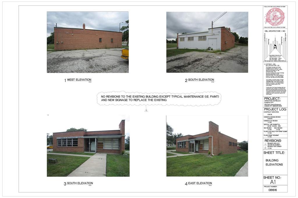
137
138

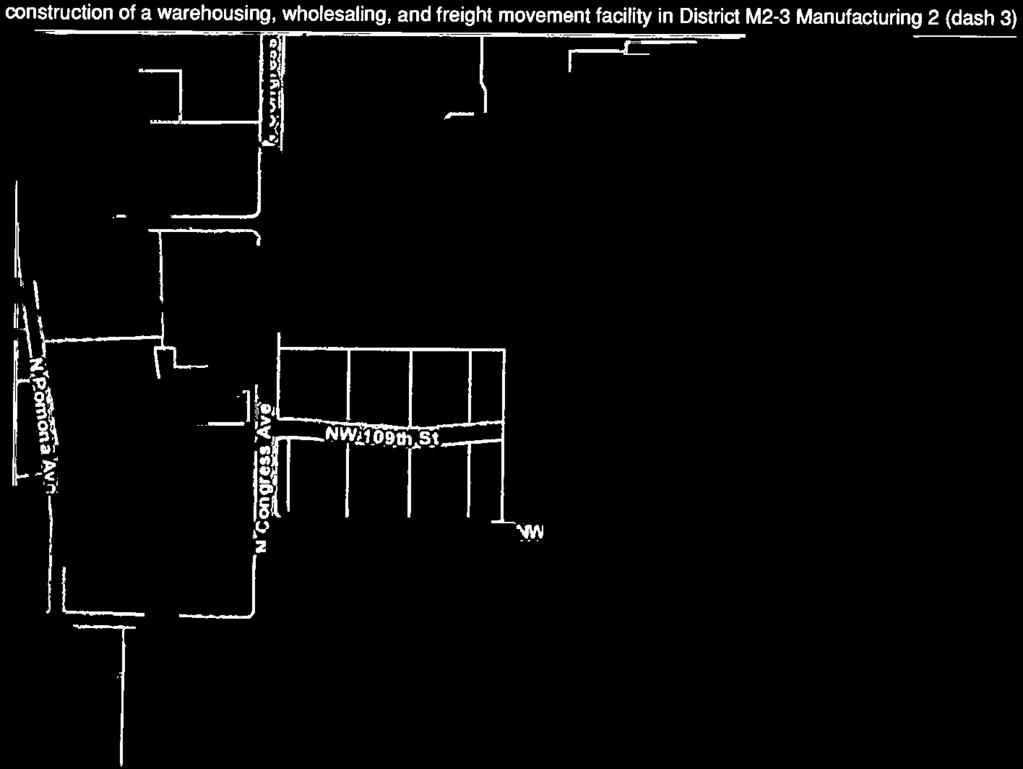


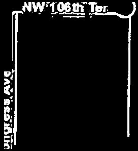
139
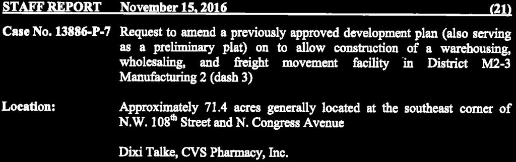
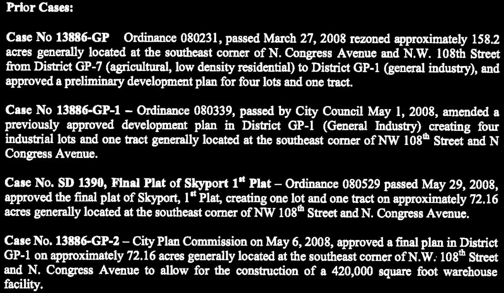


140
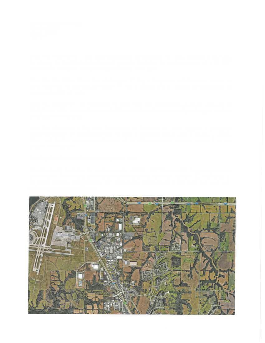
141


142
143
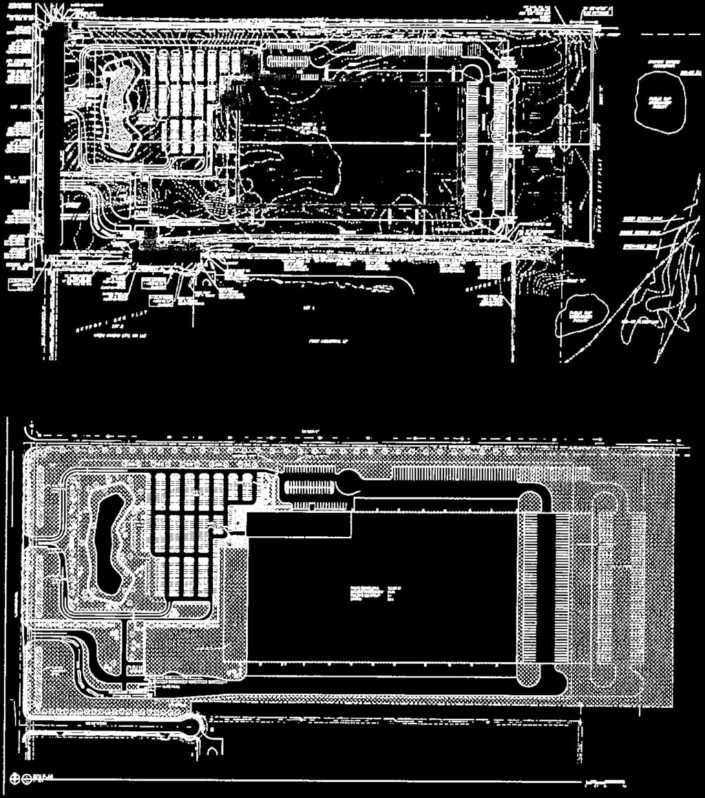
144
145
146

147


148
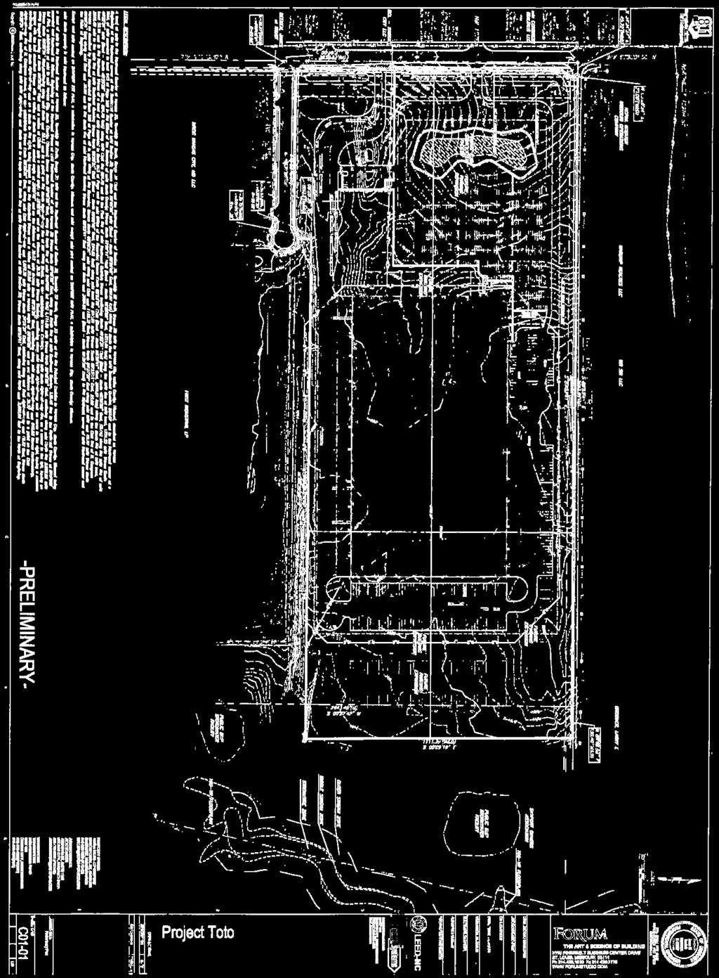
149
CITY PLAN COMMISSION DOCKET. Tuesday, October 17, :00 A.M.
 CITY PLAN COMMISSION DOCKET Tuesday, 9:00 A.M. 26 th Floor, Council Chamber Members Babette Macy, Chair Bobbi Baker-Hughes Coby Crowl Margaret J. May Rev. Stan Archie, Vice-Chair Diane Burnette Matthew
SPECIAL USE PERMIT APPLICATION CITY PLAN COMMISSION AND BOARD OF ZONING ADJUSTMENT
 SPECIAL USE PERMIT APPLICATION CITY PLAN COMMISSION AND BOARD OF ZONING ADJUSTMENT City Planning & Development Department City Hall, 414 E. 12 th Street, 15 th floor; Kansas City, MO 64106-2795 Phone (816)
Date: March 16, Jake Centers ERD, LLC P.O. Box 1610 Eagle, ID Elevation Ridge Subdivision (SUB & PUD ) Street Address
 Street Address") Rebecca W. Arnold, President Sara M. Baker, Vice President John S. Franden, Commissioner Carol A. McKee, Commissioner David L. Case, Commissioner Date: March 16, 2012 To: Jake Centers ERD, LLC P.O. Box
Rebecca W. Arnold, President Sara M. Baker, Vice President John S. Franden, Commissioner Carol A. McKee, Commissioner David L. Case, Commissioner Date: March 16, 2012 To: Jake Centers ERD, LLC P.O. Box
ZONING AMENDMENT, PLANNED UNIT DEVELOPMENT & SUBDIVISION STAFF REPORT Date: August 8, 2013
 ZONING AMENDMENT, PLANNED UNIT DEVELOPMENT & SUBDIVISION STAFF REPORT Date: August 8, 2013 NAME SUBDIVISION NAME PV-Magnolia, LLC Twelve Trees Subdivision LOCATION 2860, 2862 and 2866 Pleasant Valley Road
O-I (Office-Institutional) and AG-1(Agricultural)
 and AG-1(Agricultural)") PROPERTY INFORMATION ADDRESS 3503 and 3505 Bethany Bend DISTRICT, LAND LOTS 2/1 973 and 974 OVERLAY DISTRICT State Route 9 PETITION NUMBERS EXISTING ZONING O-I (Office-Institutional) and AG-1(Agricultural)
PROPERTY INFORMATION ADDRESS 3503 and 3505 Bethany Bend DISTRICT, LAND LOTS 2/1 973 and 974 OVERLAY DISTRICT State Route 9 PETITION NUMBERS EXISTING ZONING O-I (Office-Institutional) and AG-1(Agricultural)
PLANNING COMMISSION REPORT REGULAR AGENDA. PC Staff Report 08/25/10 ITEM NO 6: PRELIMINARY PLAT; HALLMARK ADDITION; ACRES; 151 MCDONALD DR (MKM)
") PP-6-6-10 Item No. 6-1 PLANNING COMMISSION REPORT REGULAR AGENDA PC Staff Report 08/25/10 ITEM NO 6: PRELIMINARY PLAT; HALLMARK ADDITION; 5.252 ACRES; 151 MCDONALD DR (MKM) PP-6-6-10: Consider a Preliminary
PP-6-6-10 Item No. 6-1 PLANNING COMMISSION REPORT REGULAR AGENDA PC Staff Report 08/25/10 ITEM NO 6: PRELIMINARY PLAT; HALLMARK ADDITION; 5.252 ACRES; 151 MCDONALD DR (MKM) PP-6-6-10: Consider a Preliminary
PRELIMINARY PLATS. The following documents are provided as required by the City of Conroe for use in the above titled platting submittals:
 Public Works Engineering Division CITY OF CONROE PRELIMINARY PLATS The following documents are provided as required by the City of Conroe for use in the above titled platting submittals: Submittal Questionnaire
Urban Planning and Land Use
 Urban Planning and Land Use 701 North 7 th Street, Room 423 Phone: (913) 573-5750 Kansas City, Kansas 66101 Fax: (913) 573-5796 Email: planninginfo@wycokck.org www.wycokck.org/planning To: From: City Planning
SECTION 7000 LAND DEVELOPMENT REQUIREMENTS
 SECTION 7000 LAND DEVELOPMENT REQUIREMENTS 7000 LAND DEVELOPMENT REQUIREMENTS... 1 7001 LEGISLATIVE AUTHORITY... 1 7001.1 LAND DEVELOPMENT... 1 7001.1.1 Title 40, Idaho Code... 1 7001.1.2 Idaho Code 40-1415
Memphis and Shelby County Office of Planning and Development CITY HALL 125 NORTH MID AMERICA MALL MEMPHIS, TENNESSEE (901)
") Memphis and Shelby County Office of Planning and Development CITY HALL 125 NORTH MID AMERICA MALL MEMPHIS, TENNESSEE 38103-2084 (901) 576-6619 M E M O R A N D U M TO: FROM: Agnes Martin, City Real Estate
Memphis and Shelby County Office of Planning and Development CITY HALL 125 NORTH MID AMERICA MALL MEMPHIS, TENNESSEE 38103-2084 (901) 576-6619 M E M O R A N D U M TO: FROM: Agnes Martin, City Real Estate
ARTICLE 143. PD 143.
 ARTICLE 143. PD 143. SEC. 51P-143.101. LEGISLATIVE HISTORY. PD 143 was established by Ordinance No. 17685, passed by the Dallas City Council on February 2, 1983. Ordinance No. 17685 amended Ordinance No.
RE: 6. GILL/GREEN COMPREHENSIVE PLAN AMENDMENT, REZONING AND PRELIMINARY PLAT
 commission memo DATE: Thursday - August 9, 2018 TO: Marion Planning & Zoning Commission FROM: David N. Hockett, AICP Principal Planner RE: 6. GILL/GREEN COMPREHENSIVE PLAN AMENDMENT, REZONING AND PRELIMINARY
WESTMINSTER PARK SUBDIVISION
 WESTMINSTER PARK SUBDIVISION Engineering Comments: FINAL PLAT COMMENTS (should be addressed prior to submitting the FINAL PLAT for review and/or signature by the City Engineer): A. Provide all of the required
9. REZONING NO Vicinity of the northwest corner of 143 rd Street and Metcalf Avenue
 9. REZONING NO. 2002-15 Vicinity of the northwest corner of 143 rd Street and Metcalf Avenue 1. APPLICANT: Andrew Schlagel is the applicant for this request. 2. REQUESTED ACTION: The applicant is requesting
STAFF REPORT FOR MAJOR SUBDIVISION
 STAFF REPORT FOR MAJOR SUBDIVISION FINAL PLAT CASE NO. FA-13-001 HEARING DATE: November 6, 2013 CASE NAME: Solterra Subdivision Filing No. 14 PROCEDURE: Planning Commission ADDRESS OF MAJOR SUBDIVISION
Section Preliminary Plat Checklist and Application Forms
 Section 201 - Preliminary Plat Checklist and Application Forms PRELIMINARY SUBDIVISION PLAT REVIEW PROCESS CHART PRELIMINARY SUBDIVISION PLAT APPLICATION PRELIMINARY PLAT REVIEW CHECKLIST CITY OF NAMPA
WRITTEN DECISION OF THE HAYDEN CITY COUNCIL REGARDING MAPLE GROVE PRELIMINARY SUBDIVISION APPLICATION (SUB-0013) HAYDEN SIGNATURE, LLC
 HAYDEN SIGNATURE, LLC") WRITTEN DECISION OF THE HAYDEN CITY COUNCIL REGARDING MAPLE GROVE PRELIMINARY SUBDIVISION APPLICATION (SUB-0013) HAYDEN SIGNATURE, LLC Application of Hayden Signature, LLC, an Idaho limited liability company,
WRITTEN DECISION OF THE HAYDEN CITY COUNCIL REGARDING MAPLE GROVE PRELIMINARY SUBDIVISION APPLICATION (SUB-0013) HAYDEN SIGNATURE, LLC Application of Hayden Signature, LLC, an Idaho limited liability company,
City of East Orange. Department of Policy, Planning and Development LAND USE APPLICATION & SITE PLAN REVIEW CHECKLIST
 Department of Policy, Planning and Development LAND USE APPLICATION & SITE PLAN REVIEW CHECKLIST COMPLETE: Applicant Information: Type of Proposal: OFFICE USE ONLY: New Residential Case #: Date: New Accessory
STAFF REPORT FOR MAJOR SUBDIVISION
 STAFF REPORT FOR MAJOR SUBDIVISION FINAL PLAT CASE NO. FA-12-002 HEARING DATE: September 5, 2012 CASE NAME: Solterra Subdivision Filing No. 12 PROCEDURE: Planning Commission ADDRESS OF MAJOR SUBDIVISION
STAFF REPORT FOR MAJOR SUBDIVISION
 STAFF REPORT FOR MAJOR SUBDIVISION FINAL PLAT CASE NO. FA-12-003 HEARING DATE: November 6, 2013 CASE NAME: Solterra Subdivision Filing No. 13 PROCEDURE: Planning Commission ADDRESS OF MAJOR SUBDIVISION
PLANNING BOARD AGENDA
 PLANNING BOARD AGENDA Public Hearing and Administrative Meeting Wednesday,, 1:30 P.M. Omaha/Douglas Civic Center 1819 Farnam Street Legislative Chamber DISPOSITION AGENDA This document states the disposition
Condominium Unit Requirements.
 ARTICLE 19 CONDOMINIUM REGULATIONS Section 19.01 Purpose. The purpose of this Article is to regulate projects that divide real property under a contractual arrangement known as a condominium. New and conversion
Memphis City Council Summary Sheet. S.D Roland Road Street Right-of-Way Dedication
 Memphis City Council Summary Sheet S.D. 16-01 Roland Road Street Right-of-Way Dedication Resolution requesting a Street Dedication south of U.S. Hwy 64 at the southern terminus of Roland Road to extend
Clearcreek Township Zoning Staff Report Soraya Farms Section 6 Stage 3 Review Page 1 of 8
 Staff Report: Completed by Jeff Palmer Director of Planning & Zoning Report Date: September 10, 2018 Meeting Date: October 1, 2018 Applicant: Shery Oakes, agent for Soraya Farms Requested Action: Soraya
Approval of a conditional use to allow construction of a rehabilitation hospital at 5115 N. Biltmore Lane in the American Center.
 Department of Planning & Community & Economic Development Planning Division Katherine Cornwell, Director Madison Municipal Building, Suite LL-100 215 Martin Luther King, Jr. Boulevard P.O. Box 2985 Madison,
Community Development
 Land Use Petition RZ-15-010 Concurrent Variance VC-15-010-01 Date of Staff Recommendation Preparation: August 14, 2015 Date of Planning Commission Recommendation: September 1, 2015 PROJECT LOCATION: DISTRICT/SECTION/LANDLOT(S):
REPORT TO THE SHELBY COUNTY PLANNING COMMISSION From the Department of Development Services Planning Services. February 4, 2019
 REPORT TO THE SHELBY COUNTY PLANNING COMMISSION From the Department of Development Services Planning Services February 4, 2019 Case No. Request for Rezoning Approval From E-1 to E-2 SD This is a request
ZONING AMENDMENT & SUBDIVISION STAFF REPORT Date: July 9, 2015
 ZONING AMENDMENT & SUBDIVISION STAFF REPORT Date: July 9, 2015 APPLICANT NAME 2513 Dauphin Street, Inc. SUBDIVISION NAME Audubon Place Extension No. 3, Resubdivision of Lots 1-5 LOCATION 2513 Dauphin Street
PLANNING COMMISSION REPORT Regular Agenda Non Public Hearing Item
 PC Staff Report 3/23/15 FDP-14-00551 Item No. 2-1 PLANNING COMMISSION REPORT Regular Agenda Non Public Hearing Item PC Staff Report 3/23/15 ITEM NO. 2: FINAL DEVELOPMENT PLAN FOR HUTTON FARMS WEST PHASE
DAUPHIN CREEK ESTATES SUBDIVISION
 # 12 SUB-000076-2017 DAUPHIN CREEK ESTATES SUBDIVISION Engineering Comments: FINAL PLAT COMMENTS (should be addressed prior to submitting the FINAL PLAT for review and/or signature by the City Engineer):
Residential Major Subdivision Review Checklist
 Residential Major Subdivision Review Checklist Plan Submittal Requirements: 2 full sets of stamped plans Electric submittal - all plans contained in a single PDF 3 full sets if commercial kitchen or dining
Residential Minor Subdivision Review Checklist
 Residential Minor Subdivision Review Checklist Plan Submittal Requirements: 2 full sets of stamped plans Electric submittal - all plans contained in a single PDF 3 full sets if commercial kitchen or dining
SUBDIVISION, PLANNED UNIT DEVELOPMENT, ZONING AMENDMENT, & SIDEWALK WAIVER STAFF REPORT Date: July 19, 2018
 SUBDIVISION, PLANNED UNIT DEVELOPMENT, ZONING AMENDMENT, & SIDEWALK WAIVER STAFF REPORT Date: July 19, 2018 NAME SUBDIVISION NAME LOCATION West Mobile Properties, LLC U.S. Machine Subdivision 556, 566,
ZONING AMENDMENT, PLANNED UNIT DEVELOPMENT & SUBDIVISION STAFF REPORT Date: September 15, 2011
 ZONING AMENDMENT, PLANNED UNIT DEVELOPMENT & SUBDIVISION STAFF REPORT Date: September 15, 2011 NAME SUBDIVISION NAME LOCATION Stratford, L.L.C. Grelot Office Park Subdivision North side of Grelot Road,
ZONING AMENDMENT & SUBDIVISION STAFF REPORT Date: November 3, 2016
 ZONING AMENDMENT & SUBDIVISION STAFF REPORT Date: November 3, 2016 APPLICANT NAME SUBDIVISION NAME David Shumer 5955 Airport Subdivision CITY COUNCIL DISTRICT District 6 5955 Airport Boulevard, 754 Linlen
CITY OF SANTA ROSA COMMUNITY DEVELOPMENT DEPARTMENT STAFF REPORT FOR PLANNING COMMISSION SEPTEMBER 10, 2015 APPLICANT FILE NUMBER MJP
 ITEM NO. 9 CITY OF SANTA ROSA COMMUNITY DEVELOPMENT DEPARTMENT STAFF REPORT FOR PLANNING COMMISSION SEPTEMBER 10, 2015 PROJECT TITLE Yogurt Time Center ADDRESS/LOCATION 3093 Marlow Road ASSESSOR S PARCEL
BYRON TOWNSHIP ZONING APPLICATION
 BYRON TOWNSHIP ZONING APPLICATION Phone: (616) 878-9104 * Fax: (616) 878-3980 * Website: www.byrontownship.org This application will not be accepted if incomplete. APPLICATION FOR & REQUIRED COPIES Private
URBANDALE PLANNING AND ZONING COMMISSION MINUTES. July 9, 2018
 URBANDALE PLANNING AND ZONING COMMISSION MINUTES The Urbandale Planning and Zoning Commission met in regular session on Monday,, at the Urbandale City Hall, 3600 86th Street. Chairperson Jeff Hatfield
BETTA STOR-IT SUBDIVISION
 BETTA STOR-IT SUBDIVISION Engineering Comments: Must comply with all storm water and flood control ordinances. Any increase in impervious area in excess of 4,000 square feet will require detention. Any
MONTGOMERY COUNTY PLANNING DEPARTMENT THE MARYLAND-NATIONAL CAPITAL PARK AND PLANNING COMMISSION
 MONTGOMERY COUNTY PLANNING DEPARTMENT THE MARYLAND-NATIONAL CAPITAL PARK AND PLANNING COMMISSION MCPB Item No.: Date: 06-21-12 The Plantations, Preliminary Plan -120090240 Benjamin Berbert, Senior Planner,
APPLICATION PROCEDURE
 ANTRIM PLANNING BOARD P. O. Box 517 Antrim, New Hampshire 03440 Phone: 603-588-6785 FAX: 603-588-2969 APPLICATION FORM AND CHECKLIST FOR MINOR OR MAJOR SITE PLAN REVIEW File Date Received By APPLICATION
Initial Project Review
 Pierce County Department of Planning and Land Services, 2401 South 35th Street, Tacoma, WA (253) 798-7037 Initial Project Review Major Amendment to Preliminary Plat: Hawks Ridge Division 1 Application
Parkland-Spanaway-Midland LUAC - Agenda
 1. 6:30 P.M. Parkland-Spanaway-Midland LUAC - Agenda Documents: 8 2 17 PSMAC Agenda.pdf 2. Parkland-Spanaway-Midland LUAC Initial Project Review Documents: Lincoln Court PP IPR PSMAC-RJ.pdf Department
Planning Commission 16 February 4, 2014 EDMOND PLANNING COMMISSION MEETING. Tuesday, February 4, 2014
 Planning Commission 16 EDMOND PLANNING COMMISSION MEETING Tuesday, 5:30 P.M. The Edmond Planning Commission Meeting was called to order by Chairperson Barry K. Moore at 5:30 p.m., Tuesday,, in the City
BEFORE THE HEARINGS EXAMINER FOR THE CITY OF BREMERTON
 BEFORE THE HEARINGS EXAMINER FOR THE CITY OF BREMERTON In the Matter of the Application of ) NO. PL03-0017 ) Rainier Vista Bill Bakker ) ) FINDINGS, CONCLUSIONS For Approval of a Preliminary Plat. ) AND
PLANNING COMMISSION REPORT Regular Agenda -Public Hearing Item
 PDP-13-00518 Item No. 3B- 1 PLANNING COMMISSION REPORT Regular Agenda -Public Hearing Item PC Staff Report 2/24/14 ITEM NO. 3B PRELIMINARY DEVELOPMENT PLAN FOR HERE @ KANSAS; 1101 INDIANA ST (SLD) PDP-13-00518:
Rezoning Petition Pre-Hearing Staff Analysis February 19, 2018
 Rezoning Petition 2017-178 Pre-Hearing Staff Analysis February 19, 2018 REQUEST Current Zoning: I-1 (light industrial) Proposed Zoning: I-2(CD) (general industrial, conditional) LOCATION Approximately
SUBDIVISION, PLANNING APPROVAL, & REZONING STAFF REPORT Date: June 4, 2015
 SUBDIVISION, PLANNING APPROVAL, & REZONING STAFF REPORT Date: June 4, 2015 APPLICANT NAME SUBDIVISION NAME DEVELOPMENT NAME LOCATION Board of Water & Sewer Commissioners of the City of Mobile MAWSS MLK
THE AREA PLAN COMMISSION OF ST. JOSEPH COUNTY, IN AGENDA
 THE AREA PLAN COMMISSION OF ST. JOSEPH COUNTY, IN AGENDA Tuesday, January 17, 2017 Fourth-Floor Council Chambers 3:30 p.m. County-City Building, South Bend, IN EXECUTIVE SESSION: A. Election of Officers
The petition proposes to allow a for-sale townhouse community located in Southwest Charlotte, across from the McDowell Nature Preserve.
 Rezoning Petition 2018-110 Pre-Hearing Staff Analysis April 15, 2019 REQUEST LOCATION Current Zoning: R-3 (single family residential) Proposed Zoning: R-8MF(CD) (multi-family residential, conditional)
City of Grand Island Tuesday, July 26, 2016 Council Session
 City of Grand Island Tuesday, July 26, 2016 Council Session Item E-2 Public Hearing on Request to Rezone Property located at 415 South Cherry Street from RD Residential Development to Amended RD Residential
City of Grande Prairie Development Services Department
 City of Grande Prairie Development Services Department COUNTRYSIDE SOUTH OUTLINE PLAN Prepared by: GPEC Consulting Ltd. #202, 10712-100th Street Grande Prairie, AB Council Resolution of August 20, 2001
Development Plan DP13-3 (Arlington Lofts) Planning and Zoning Meeting Date: Document Being Considered: Ordinance
 Planning and Zoning Meeting Date: Document Being Considered: Ordinance") Staff Report Development Plan DP13-3 (Arlington Lofts) Planning and Zoning Meeting Date: 6-19-13 Document Being Considered: Ordinance RECOMMENDATION Following the public hearing, consider Development Plan
Staff Report Development Plan DP13-3 (Arlington Lofts) Planning and Zoning Meeting Date: 6-19-13 Document Being Considered: Ordinance RECOMMENDATION Following the public hearing, consider Development Plan
E L M E R B O R O U G H L A N D U S E B O A R D APPLICATION COVER SHEET (to be completed for all applications and appeals)
") E L M E R B O R O U G H L A N D U S E B O A R D APPLICATION COVER SHEET (to be completed for all applications and appeals) 1. Name(s): 2. Address: 3. Telephone Number(s): 4. E-mail: 5. Owner Name(s) (if
E L M E R B O R O U G H L A N D U S E B O A R D APPLICATION COVER SHEET (to be completed for all applications and appeals) 1. Name(s): 2. Address: 3. Telephone Number(s): 4. E-mail: 5. Owner Name(s) (if
APPLICANT NAME SUBDIVISION NAME DEVELOPMENT NAME LOCATION. CITY COUNCIL DISTRICT Council District 4 PRESENT ZONING PROPOSED ZONING
 SUBDIVISION, PLANNED UNIT DEVELOPMENT, PLANNING APPROVAL, ZONING AMENDMENT, & SIDEWALK WAIVER REQUEST STAFF REPORT Date: February 17, 2010 APPLICANT NAME SUBDIVISION NAME DEVELOPMENT NAME LOCATION David
AGENDA. EDMOND PLANNING COMMISSION 20 S. Littler, Edmond, Oklahoma Tuesday, February 18, :30 p.m. CITY COUNCIL WORKSHOP
 City of Edmond NOTICE OF PUBLIC MEETING The City of Edmond encourages participation from all its citizens. If participation at any Public meeting is not possible due to a disability, notification to the
City of Brooklyn Park Planning Commission Staff Report
 City of Brooklyn Park Planning Commission Staff Report Agenda Item: 6D Meeting Date: August 9, 2017 Originating Agenda Section: Public Hearing Department: Community Development Resolution: X Ordinance:
Town of Cary, North Carolina Rezoning Staff Report 14-REZ-31 Cary Park PDD Amendment (Waterford II) Town Council Meeting January 15, 2015
 Town Council Meeting January 15, 2015") Town of Cary, North Carolina Rezoning Staff Report 14-REZ-31 Cary Park PDD Amendment (Waterford II) Town Council Meeting January 15, 2015 REQUEST To amend the Town of Cary Official Zoning Map by amending
Town of Cary, North Carolina Rezoning Staff Report 14-REZ-31 Cary Park PDD Amendment (Waterford II) Town Council Meeting January 15, 2015 REQUEST To amend the Town of Cary Official Zoning Map by amending
FINAL DRAFT 12/1/16, Rev. to 7/18/17
 FINAL DRAFT 12/1/16, Rev. to 7/18/17 (As Adopted 8/8/17 Effective 9/1/17) SHELTON PLANNING AND ZONING COMMISSION Proposed Amendments to Zoning Regulations I. Amend Section 23 PERMITTED USES by inserting
PLANNED UNIT DEVELOPMENT & SUBDIVISION STAFF REPORT August 18, 2016
 PLANNED UNIT DEVELOPMENT & SUBDIVISION STAFF REPORT August 18, 2016 DEVELOPMENT NAME SUBDIVISION NAME Mullinax Ford Subdivision Mullinax Ford Subdivision LOCATION CITY COUNCIL DISTRICT District 6 Southeast
EDMOND PLANNING COMMISSION 20 S. Littler, Edmond, Oklahoma Tuesday, May 6, :30 p.m.
 City of Edmond NOTICE OF PUBLIC MEETING The City of Edmond encourages participation from all its citizens. If participation at any Public meeting is not possible due to a disability, notification to the
Rezoning Petition Final Staff Analysis July 16, 2018
 Rezoning Petition 2018-041 Final Staff Analysis July 16, 2018 REQUEST LOCATION Current Zoning: R-5 (single family residential, and UR-2(CD) (urban residential, conditional) Proposed Zoning: UR-2(CD) (urban
1. APPLICANT: Polsinelli, Shalton & Welte is the applicant for this request.
 5. REVISED PRELIMINARY PLAN APPROVAL - THE RETREAT AT MAPLECREST - Vicinity of the northeast corner of 159 th Street and U.S. 69 Highway 1. APPLICANT: Polsinelli, Shalton & Welte is the applicant for this
Planning Commission Review ZONING ANNEXATION SUBDIVISION STREET NAMING
 Planning Commission Review ZONING ANNEXATION SUBDIVISION STREET NAMING I. Requested Action Zoning Change Annexation Street Naming/Renaming Preliminary Subdivision Approval General Subdivision Approval
CHECKLIST FOR DEVELOPMENT REVIEW
 CHECKLIST FOR DEVELOPMENT REVIEW Petitions and related documents and plans for land development or other proposals regulated by Title 16 of the Municipal Code (Development Ordinance) and Title 17 of the
May 21, ACHD Board of Commissioners Stacey Yarrington, Planner II DRH /DRH
 Development Services Department May 21, 2013 TO: FROM: SUBJECT: ACHD Board of Commissioners Stacey Yarrington, Planner II DRH13-00106/DRH13-00108 Executive Summary: This is a design review application
PLANNED UNIT DEVELOPMENT & SUBDIVISION STAFF REPORT Date: July 20, 2017
 PLANNED UNIT DEVELOPMENT & SUBDIVISION STAFF REPORT Date: July 20, 2017 DEVELOPMENT NAME SUBDIVISION NAME LOCATION Rangeline Crossing III Subdivision Rangeline Crossing III Subdivision 5289 Halls Mill
Cobb County Community Development Agency Zoning Division 1150 Powder Springs St. Marietta, Georgia 30064
 Cobb County Community Development Agency Zoning Division 1150 Powder Springs St. Marietta, Georgia 30064 Case # Z-63 Public Hearing Dates: PC: 11-06-18 BOC: 11-20-18 SITE BACKGROUND Applicant: Loyd Development
PORT CITY COMMERCE PARK SUBDIVISION
 # 4 SUB2015-00019 PORT CITY COMMERCE PARK SUBDIVISION Engineering Comments: Must comply with the Mobile County Flood Damage Prevention Ordinance. Development shall be designed to comply with the storm
ZONING AMENDMENT & SUBDIVISION STAFF REPORT Date: March 1, 2018
 #13 SUB-000406-2018 & ZON-000407-2018 ZONING AMENDMENT & SUBDIVISION STAFF REPORT Date: March 1, 2018 NAME SUBDIVISION NAME LOCATION Creekside @ Kooiman Dairy Creekside @ Kooiman Dairy Subdivision (South
PLANNED DEVELOPMENT DISTRICT STANDARDS. Cadence Site
 PLANNED DEVELOPMENT DISTRICT STANDARDS Cadence Site A Planned Development District 1. Statement of General Facts, Conditions and Objectives Property Size: Approximately 57.51 Acres York County Tax Map
Community Development Department 333 Broadalbin Street SW, P.O. Box 490 Albany, OR 97321
 SUMMARY Community Development Department 333 Broadalbin Street SW, P.O. Box 490 Albany, OR 97321 STAFF REPORT Application for Tentative Partition Plat Review Planning File PA-06-17 Phone: 541-917-7550
UPPER MOUNT BETHEL TOWNSHIP NORTHAMPTON COUNTY, PENNSYLVANIA
 UPPER MOUNT BETHEL TOWNSHIP NORTHAMPTON COUNTY, PENNSYLVANIA JOINDER DEED / LOT CONSOLIDATION TOWNSHIP REVIEW PROCESS When accepting proposed Joinder Deeds / Lot Consolidations, review the Joinder Deed
PLANNING BOARD AGENDA
 PLANNING BOARD AGENDA Public Hearing and Administrative Meeting Wednesday,, 1:30 P.M. Omaha/Douglas Civic Center 1819 Farnam Street Legislative Chamber DISPOSITION AGENDA This document states the disposition
1.94 acres. Gwinnett Prado, L.P. c/o Brogdon Consulting Duluth, GA Contact: Ted Sandler
 Land Use Petition RZ-15-006 Date of Staff Recommendation Preparation: April 21, 2015 Revised to Incorporate Planning Commission Recommendations: 5/6/15 PROJECT LOCATION: 10800 Block of State Bridge Road
Planning Department st Avenue East Kalispell, MT Phone: (406) Fax: (406)
 Fax: (406)") Planning Department 201 1 st Avenue East Kalispell, MT 59901 Phone: (406) 758-7940 Fax: (406) 758-7739 www.kalispell.com/planning April 1, 2015 Doug Russell, City Manager City of Kalispell 201 1 st Ave
Planning Department 201 1 st Avenue East Kalispell, MT 59901 Phone: (406) 758-7940 Fax: (406) 758-7739 www.kalispell.com/planning April 1, 2015 Doug Russell, City Manager City of Kalispell 201 1 st Ave
Approved 58 Unit Residential Condo Development for Sale. For Sale: Price Upon Request
 Approved 58 Unit Residential Condo Development for Sale 185 Thorpe Street Fairfield, 06824 For Sale: Price Upon Request u u u u Approved 58 Unit Residential Condo Development For Sale on 6.7 Acres in Fairfield
STAFF REPORT. Raymond Management Company 8333 Greenway Blvd, Suite 2000 Middleton, WI 53562
 STAFF REPORT Planning and Zoning Case 16-26FDP Staff: Katherine Sharp, Assistant Director of Planning & Development Date: June 27, 2016 GENERAL INFORMATION Application: Applicant: Location: Site Acreage:
PLANNING COMMISSION REPORT REGULAR AGENDA
 PP-4-4-11 Item No. 9-1 PLANNING COMMISSION REPORT REGULAR AGENDA PC Staff Report 06/22/11 ITEM NO 9: PRELIMINARY PLAT; KASOLD WATER TOWER ADDITION; SE OF TAM O SHANTER & KASOLD DR (MKM) PP-4-4-11: Consider
Rezoning Petition Pre-Hearing Staff Analysis April 17, 2017
 Rezoning Petition 2017-041 Pre-Hearing Staff Analysis April 17, 2017 REQUEST Current Zoning: R-5 (single family residential), R-22MF (multifamily residential), and I-1 (light industrial) Proposed Zoning:
DENTON Developer's Handbook
 DENTON Developer's Handbook A guide for land development in the City of Denton Department of Development Services 2017 2 Table of Contents 1. City of Denton Development Process...5 Role of the Development
Committed to Service
 Committed to Service Paul Woods, President Rebecca W. Arnold, Vice President Sara M. Baker, Commissioner Jim D. Hansen, Commissioner Kent Goldthorpe, Commissioner August 25, 2017 Development Services TO:
Bowie Marketplace Residential Detailed Site Plan Statement of Justification January 13, 2017 Revised February 2, 1017
 Bowie Marketplace Residential Detailed Site Plan Statement of Justification January 13, 2017 Revised February 2, 1017 Submitted on behalf of: BE Bowie LLC 5410 Edson Lane, Suite 220 Rockville, MD 20852
MEMORANDUM. DATE: November 9, 2016 PC Agenda Item 3.C
 MEMORANDUM DATE: November 9, 2016 PC Agenda Item 3.C TO: FROM: SUBJECT: Planning Commission Eric Zweber, AICP, Interim City Planner Planning Case #16-029 Public Hearing Required Applicant: Bremer Bank,
EDGERTON CITY HALL PLANNING COMMISSION MEETING REGULAR SESSION March 12, 2019
 EDGERTON CITY HALL PLANNING COMMISSION MEETING REGULAR SESSION The met in regular session with Chair John Daley calling the meeting to order at 7:00 p.m. All present participated in the Pledge of Allegiance.
If you have any questions, please feel free to contact me at (208)
") Sara M. Baker, President John S. Franden, Vice President Rebecca W. Arnold, Commissioner Mitchell A. Jaurena, Commissioner Jim Hansen, Commissioner Date: March 21, 2013 To: Subject: Hornet Construction
Sara M. Baker, President John S. Franden, Vice President Rebecca W. Arnold, Commissioner Mitchell A. Jaurena, Commissioner Jim Hansen, Commissioner Date: March 21, 2013 To: Subject: Hornet Construction
Executive Summary: This is a preliminary plat to construct 8 residential lots and 2 commons lots with a private road on 3.87-acres in Meridian, Idaho.
 Development Services Department DATE: July 7, 2015 TO: FROM: SUBJECT: ACHD Board of Commissioners Stacey Yarrington, Planner III Kentucky Villas/ MPP15-0012/ PP15-009 Executive Summary: This is a preliminary
LINCOLN COUNTY PLANNING & INSPECTIONS DEPARTMENT
 LINCOLN COUNTY PLANNING & INSPECTIONS DEPARTMENT 302 NORTH ACADEMY STREET, SUITE A, LINCOLNTON, NORTH CAROLINA 28092 704-736-8440 OFFICE 704-736-8434 INSPECTION REQUEST LINE 704-732-9010 FAX To: Board
REPORT TO THE PLANNING COMMISSION
 Agenda Number: PC14-50 MEETING DATE: February 5, 2015 REPORT TO THE PLANNING COMMISSION SUBJECT: Villas of Tara Oaks Request approval of a Preliminary Subdivision Plat for 29 lots, on 9.14 acres located
PLANNING BOARD AGENDA
 PLANNING BOARD AGENDA Public Hearing and Administrative Meeting Wednesday,, 1:30 P.M. PLANNING OMAHA Omaha/Douglas Civic Center 1819 Farnam Street Legislative Chamber DISPOSITION AGENDA This document states
STAFF REPORT FOR MAJOR SUBDIVISION
 STAFF REPORT FOR MAJOR SUBDIVISION FINAL PLAT CASE NO. FA-14-001 HEARING DATE: January 6, 2016 CASE NAME: Solterra Subdivision Filing No. 16 PROCEDURE: Planning Commission ADDRESS OF MAJOR SUBDIVISION
CITY OF CEDAR HILL CITY COUNCIL AGENDA ITEM
 Public Hearing #2 Agenda Date: September 9, 2014 CITY OF CEDAR HILL CITY COUNCIL AGENDA ITEM Agenda Item Wording: Case No. 2014-26 CONDUCT A PUBLIC HEARING and consider a request for Conditional Use Permit
Urban Planning and Land Use
 Urban Planning and Land Use 701 North 7 th Street, Room 423 Phone: (913) 573-5750 Kansas City, Kansas 66101 Fax: (913) 573-5796 Email: planninginfo@wycokck.org www.wycokck.org/planning To: From: City Planning
Time Extension Staff Report
 Time Extension Staff Report Subdivision Name Lunara Subdivision File Number SUB07-00019 Approval Time Extension for Lead Agency Boise City Certification Signature of Boise City Engineer Annexation Date
LINCOLN COUNTY PLANNING & INSPECTIONS DEPARTMENT
 LINCOLN COUNTY PLANNING & INSPECTIONS DEPARTMENT 30 NORTH ACADEMY STREET, SUITE A, LINCOLNTON, NORTH CAROLINA 809 704-736-8440 OFFICE 704-736-8434 INSPECTION REQUEST LINE 704-73-900 FAX To: Board of Commissioners
II. What Type of Development Requires Site Plan Review? There are five situations where a site plan review is required:
 I. What is a Site Plan Review? Site Plan Review is a process where the construction of new buildings, new additions, and certain types of canopies and/or tax-exempt institutions are reviewed by the City
PALM BEACH COUNTY PLANNING, ZONING AND BUILDING DEPARTMENT ZONING DIVISION
 PALM BEACH COUNTY PLANNING, ZONING AND BUILDING DEPARTMENT ZONING DIVISION Application No.: CA-2012-00688 Control No.: 2011-00552 Applicant: Garry Bernardo Owners: Garry Bernardo Agent: Frogner Consulting,
MINUTES SALEM HEARINGS OFFICER MEETING December 20, 2017
 MINUTES SALEM HEARINGS OFFICER MEETING December 20, 2017 Hearings Officer Jim Brewer Staff Present Pamela Cole, Planner II Bryce Bishop, Planner II Sally Long, Recorder Hearings Officer Jim Brewer called
Rezoning Petition Zoning Committee Recommendation June 29, 2017
 Rezoning Petition 2017-076 Zoning Committee Recommendation June 29, 2017 REQUEST Current Zoning: MUDD-O (mixed use development, optional) and R-4 (single family residential) Proposed Zoning: UR-2(CD) (urban
REPORT TO PLANNING & ZONING COMMISSION - CITY OF MARYLAND HEIGHTS
 APPLICATION NUMBER APPLICATION (PROJECT) NAME APPLICANT NAME PROPERTY OWNER NAME CUP16-0003 CENTRAL POWER SYSTEMS & SERVICES, INC. Central Power Systems & Services, Inc. 900 Liberty Drive, Liberty, MO