Parks & Open Space 5201 St. Vrain Road Longmont, Colorado Fax:
|
|
|
- Barbara McBride
- 6 years ago
- Views:
Transcription
1 Parks & Open Space 5201 St. Vrain Road Longmont, Colorado Fax: MINUTES AND PROCEEDINGS OF THE PARKS AND OPEN SPACE ADVISORY COMMITTEE February 22, 2018 The meeting was called to order at 6:30 p.m. by John Nibarger in the Hearing Room of the Board of Commissioners, Third Floor, Boulder County Courthouse, Boulder, Colorado. POSAC Members in Attendance Present: Sue Anderson, Jenn Archuleta, Cathy Comstock, Jim Krug, James Mapes [arrived 6:36], Scott Miller, John Nibarger, Gordon Pedrow, and Heather Williams Excused: Staff in Attendance Sandy Duff, Mel Stonebraker, Craig Sommers, Janis Whisman, Renata Frye, Conrad Lattes, Therese Glowacki, and Eric Lane Approval of the January 25, 2018 Meeting Minutes Action Taken: Jenn Archuleta moved to accept the January 25 minutes. Scott Miller seconded the motion. Motion carried unanimously. Public Participation - Items not on the Agenda Neshama Abraham, 1460 Quince Ave., Boulder. She is Chair for the Sierra Club Beyond Oil and Gas Team and she represents a citizen group called Hold Our Ground. She spoke about their opposition to oil and gas activity on county open space and asked for POSAC make a recommendation to the BOCC to fund a motion for a preliminary injunction to stop permitting for oil and gas extraction on open space. Response: Conrad Lattes, Assistant County Attorney, offered to advise POSAC members on how to address the request in a closed executive session. Jim Krug moved to enter into executive session later in the meeting, before the Director s Update. Jenn Archuleta seconded the motion. The motion carried 5-4. Brand 2 Acquisition Boulder County proposes acquiring approximately 116 acres located east of Rabbit Mountain, immediately adjacent to the Brand Open Space property. Staff Presenter: Sandy Duff Sr. Land Officer Cindy Domenico County Commissioner Deb Gardner County Commissioner Elise Jones County Commissioner
2 Public Comments None Action Taken: Motion 1: Jim Krug moved to accept staff recommendation for the purchase plan as presented, and Cathy Comstock seconded the motion. After discussion, motion carried 8-1. Motion 2: Gordon Pedrow moved to require staff to bring a more detailed update on the Rabbit Mountain Management Plan, including other potential property purchases. Cathy Comstock seconded the motion. After discussion, motion was withdrawn in lieu of a request for a future update. Swanson (Adelia)-Lot Line Adjustment It is proposed that for certain financial compensation and changes to an existing conservation easement the county agree to a small lot line adjustment on the Adelia Swanson open space property. Staff Presenter: Mel Stonebraker Sr. Land Officer Public Comments None Action Taken: Scott Miller moved to accept staff recommendation for the lot line adjustment as presented, and Jim Krug seconded the motion. After discussion, motion carried unanimously. Volunteer Work Projects Update Staff Presenter: Craig Sommers - Volunteer Coordinator Public Comments None Action Taken: Information only Resource Management Division 2017 Summary Staff Presenter: Therese Glowacki - Manager, Resource Management Division Public Comments None Action Taken: Information only
3 At approximately 8:32 p.m. POSAC entered into executive session to receive legal advice related to public comments about oil and gas activity at the start of the meeting. The meeting resumed after the executive session. Director s Update Youth Corps is looking for teens years old corps members, and adult team leaders, for their program this summer. More information can be found here: Forestry staff is working on a forest stand improvement project on the countyowned Williams (Merlin) property just off the Peak-to-Peak Highway. This is to enhance forest health and wildlife habitat. It will also provide POS with poles for fencing projects. Elk trapping is underway to attach new radio collars, because so far four collars have failed and we expect others to fail. POS had good attendance for two of our e-bike open houses. So far we ve received over 300 public comments and 76 online surveys were completed. Adjournment The meeting adjourned at 9:06 p.m. The full audio, available staff memos, and related materials for this meeting can be found on our website:
4 Parks & Open Space 5201 St. Vrain Road Longmont, Colorado Fax: PARKS AND OPEN SPACE ADVISORY COMMITTEE MEETING DATE: Thursday, February 22, 2018 TIME: 6:30 pm PLACE: Commissioners Hearing Room, 3rd Floor, Boulder County Courthouse, 1325 Pearl Street, Boulder, CO Suggested Timetable AGENDA 6:30 1. Approval of the January 25, 2018 Meeting Minutes 6:35 2. Public Participation - Items not on the Agenda 6:40 3. Brand 2 Acquisition Boulder County proposes acquiring approximately 116 acres located east of Rabbit Mountain, immediately adjacent to the Brand Open Space property. Staff Presenter: Sandy Duff Sr. Land Officer Action Requested: Recommendation to BOCC 6:50 4. Swanson (Adelia)-Lot Line Adjustment It is proposed that for certain financial compensation and changes to an existing conservation easement the county agree to a small lot line adjustment on the Adelia Swanson open space property. Staff Presenter: Mel Stonebraker Sr. Land Officer Action Requested: Recommendation to BOCC 7:10 5. Volunteer Work Projects Update Staff Presenter: Craig Sommers - Volunteer Coordinator Action Requested: Information Only 7:25 6. Resource Management Division 2017 Summary Staff Presenter: Therese Glowacki - Manager, Resource Management Division Action Requested: Information Only 7:55 7. Director s Update 8:00 8. Adjourn Cindy Domenico County Commissioner Deb Gardner County Commissioner Elise Jones County Commissioner


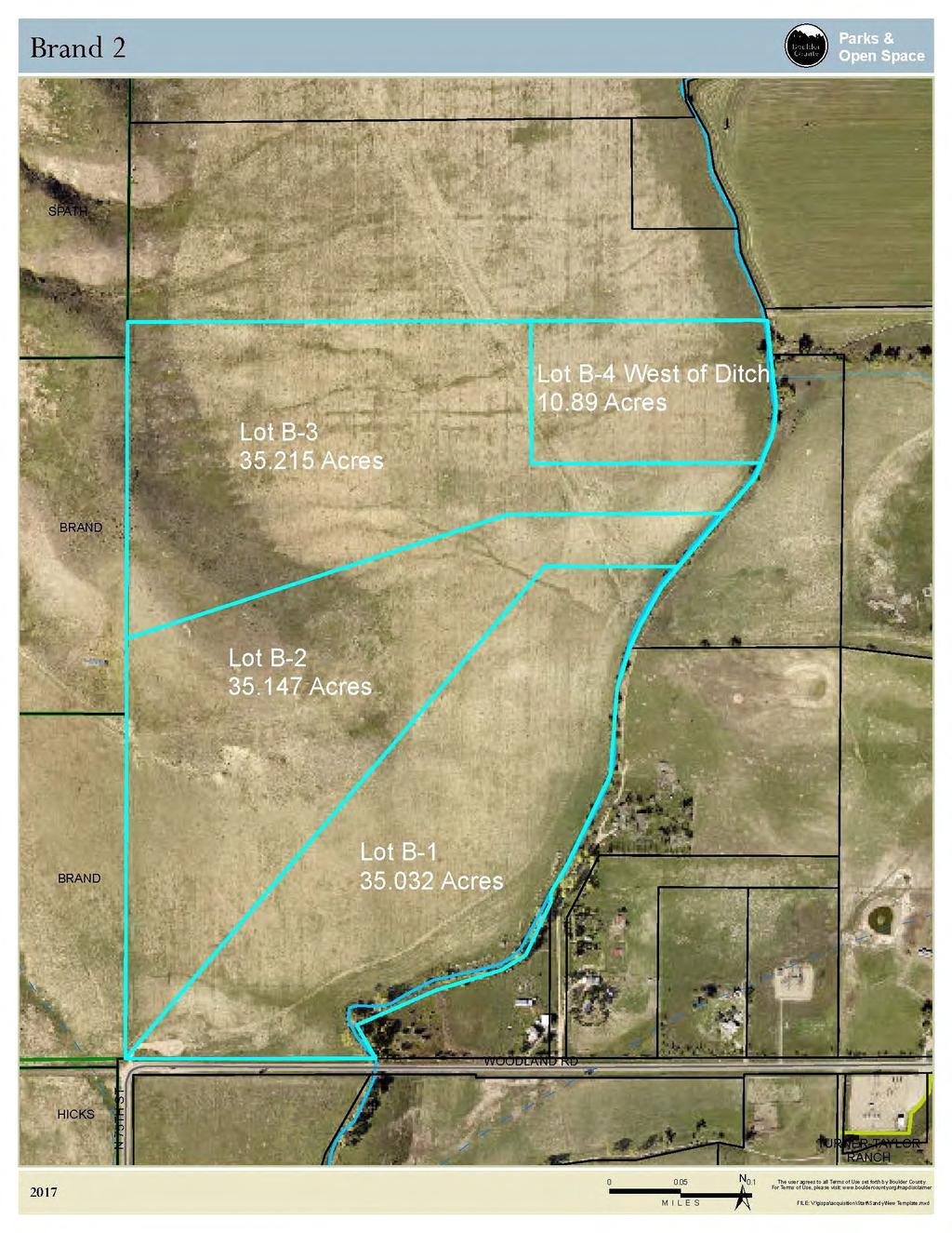
5 Parks & Open Space 5201 St. Vrain Road Longmont, Colorado Fax: PARKS & OPEN SPACE ADVISORY COMMITTEE MEETING TO: TIME/DATE: LOCATION: AGENDA ITEM: PRESENTER: ACTION REQUESTED: Parks & Open Space Advisory Committee Thursday, February 22, 6:30 p.m. Commissioners Hearing Room, 3rd floor, Boulder County Courthouse, 1325 Pearl Street, Boulder, CO Brand 2-Acquisition of approximately 116 acres of dryland agricultural land east of the Ron Stewart Preserve at Rabbit Mountain Sandy Duff, Sr. Land Officer Recommendation to the BOCC Summary Boulder County proposes to invest $1,953,687 to acquire fee title to approximately 116 acres of dryland agricultural land, in the vicinity of North 75th Street and Woodland Road. Background The property lies east of the Ron Stewart Preserve at Rabbit Mountain (Rabbit Mountain) and immediately adjacent to the Brand Open Space property in north Boulder County. It is owned by the Bar D Ranch LLC and the Vance and Beverly Brand Family Trust. The property is vacant, and it has four building rights and a Longs Peak Water District domestic water tap. The property does not have any associated irrigation water rights. Mineral rights are intact and have not been leased out for oil and gas exploration. The property has been used for agriculture, and so it will be closed for agricultural purposes. If the future update to the Rabbit Mountain Management Plan identifies the property as being appropriate for public use, it may be opened to public use at a later date. Deal Terms The purchase price for the property is $1,953,687 ($16,80llacre) for the land, mineral rights, water tap, and four building rights. The property is also within the Brand Family Subdivision Exemption Plat, which will be revised as part of the transaction, because the county is coordinating with the landowner to carve off the western portion of one of the lots on the west side of the Supply Ditch, leaving the remainder as a non-buildable outlot in the subdivision on the east side of the ditch. Since the property is already platted, the division of land will be done pursuant to the Community Facility Lot Split process through Boulder County Land Use. A cqu,sz/lon S umma,y Acres Water # Building Price per Water Right Total Purchase Rights Rights Acre Value Price County Will Acquire NIA 4 $16,801 NIA $1,953,687 Cindy Domenico County Commissioner Deb Gardner County Commissioner Elise Jones County Commissioner

6

7
8 Parks & Open Space 5201 St. Vrain Road Longmont, Colorado Fax: PARKS & OPEN SPACE ADVISORY COMMITTEE MEETING TO: TIME/DATE: LOCATION: AGENDA ITEM: PRESENTER: ACTION REQUESTED: Parks & Open Space Advisory Committee Thursday, February 22, 2018, 6:30 p.m. Commissioners Hearing Room, 3 rd floor, Boulder County Courthouse, 1325 Pearl Street, Boulder, CO Swanson (Adelia)-Lot Line Adjustment Proposed small lot line adjustment on the Swanson (Adelia) open space property Mel Stonebraker, Sr. Land Officer Recommendation to the BOCC Summary Landowners John Roberts and Bren Frisch of Prospect Road, located southeast of Longmont, approached the county with the request to purchase an approximate 0.8-acre sliver of land from the adjacent Swanson (Adelia) open space (see attached map). The landowners propose combining this acreage with their adjacent 50-acre property, which is encumbered by a county-held conservation easement (Swanson (Adelia) conservation easement). The landowners would pay the county $6,000/acre for the purchase and amend the conservation easement over their property to include the increased acreage. They would also restrict all structures to a seven-acre building envelope that encompasses all existing structures, and they would limit agricultural storage areas to a total of four acres in two locations, leaving approximately 40 acres for open agricultural use. Staff supports the proposal. Background John Roberts and Bren Frisch have owned and operated Sunflower Farm on their conservation easement property for many years and are currently undergoing a Limited Impact Special Use Review (LISUR) process to permit their demonstration farm. In the process of seeking the necessary approvals, they learned that the easternmost edge of their property where they have allowed visitors to park their vehicles for years is in fact part of the Swanson (Adelia) open space. They have been unable to move forward with their LISUR without resolving this encroachment issue. The landowners have considered grading a new parking area elsewhere on their property, but because that would require disturbance of irrigated land that is currently under agricultural production, they decided to approach the county to discuss other options. The resulting proposal is for the county to sell the approximately 0.8-acre sliver of county land to John and Bren so that they can combine it with their conservation easement property and continue using it as a parking and agricultural storage area. This sliver of land lies west of the lateral that runs north from the Leggett Ditch and is not being farmed by the tenant of the Swanson (Adelia) open space. Staff has determined that sale of the 0.8 acres would not impact the agricultural production of Swanson (Adelia) open space. Cindy Domenico County Commissioner Deb Gardner County Commissioner Elise Jones County Commissioner
9 Deal Terms Acquisition Summary Acres Water Rights Appro x0.8 acres* # Building Rights County Will Acquire Price per Bldg. Right Water Right Value Total Purchase Price N/A None N/A N/A $6,000/acre* * Area to be determined by survey In this disposition process, the county would sell approximately 0.8 acres of land to John Roberts and Bren Frisch for $6,000/acre. The county would retain an access easement over the parcel and all of the mineral rights. The landowner would pay for the survey of this parcel of land. No water or building rights will be included in the sale of this parcel. The existing conservation easement over the landowners adjacent property would be amended to incorporate this 0.8-acre parcel and require that the land remain together and cannot be further divided. The conservation easement would be strengthened by the creation of a building envelope around the existing structures, requiring that all agricultural and residential structures remain within. Additionally, two agricultural storage areas would be created in the amendment, defining the areas where agricultural material can be stored (see attached map). Together, these defined envelopes/areas would prevent the spread of high impact areas onto land that is currently in agricultural production. Public Process The resolution language creating the sales tax that was used to purchase the property requires specific procedures be followed to sell any portion of the property, including adjacent property owner notification of the county commissioners public hearing, newspaper notice, and a 60-day waiting period following county commissioner approval. The notices included an invitation to attend and comment at this meeting. No public comments have been received to date. Any additional comments we receive will be shared with you at the meeting. Staff Discussion and Recommendation Although 0.8 acres of the Swanson (Adelia) open space property would be sold and no longer owned in fee by the county, it would be subject to a county-held conservation easement. The strip of land is not currently farmed nor used by the tenant of the Swanson (Adelia) open space, and it would not be practical to do so. From a management perspective, it makes more sense to combine this sliver of land with the adjacent conservation easement property because it is physically separated from the Swanson (Adelia) open space by the ditch lateral and is naturally used together with the adjacent conservation easement property. Additionally, the opportunity to amend the conservation easement to create a building envelope and agricultural storage areas on the property will create significant added benefit
10 to the county by preventing the spread of high impact areas and structures. Lastly, if the landowners own and continue to use the strip of land for a parking lot and agricultural storage area, they will not need to disturb other pristine agricultural land for the creation of a new parking lot. Because this 0.8-acre sliver of property will remain a part of the county s open space properties as a conservation easement, and the existing conservation easement will be amended to strengthen the terms, staff supports this proposal. POSAC Action Requested Recommendation to the Boulder County Commissioners for approval of the disposition of approximately 0.8-acre of the Swanson (Adelia) open space and approval to amend to the Swanson (Adelia) conservation easement as described above. Suggested motion language: I move approval of the amendment to the Conservation Easement over the Adelia Swanson project as staff has described.
11 Swanson Adelia Conservation Easement Parks & Open Space PROSPECT RD Building Envelope Approx. 7 Acres legend Building Envelope Agricultural Storage Areas 2017 Miles ± The user agrees to all Terms of Use set forth by Boulder County For Terms of Use, please visit: FILE: V:\gispa\acquisition\Staff\Melissa\Swanson (Adelia)\85x11_Port Swanson (Adelia) Building Envelope.mxd
12 Swanson (Adelia) Proposed Sale of Land Parks & Open Space PROSPECT RD Approx 0.8 Acre Sliver of Land Proposed Sale Swanson (Adelia) Conservation Easement Swanson (Adelia) Open Space 2017 Miles ± The user agrees to all Terms of Use set forth by Boulder County For Terms of Use, please visit: FILE: V:\gispa\acquisition\Staff\Melissa\Swanson (Adelia)\Swanson (Adelia) Proposed Sale of Land Strip.m
13 Parks and Open Space 5201 St. Vrain Road Longmont, Colorado Fax: PARKS AND OPEN SPACE ADVISORY COMMITTEE MEETING TO: Parks & Open Space Advisory Committee DATE AND LOCATION: Thursday, February 22, 2018, 6:30 p.m. Commissioners Hearing Room, 3 rd floor Boulder County Courthouse, 1325 Pearl Street, Boulder, CO AGENDA ITEM TITLE: Resource Management 2017 Summary PRESENTER: Therese Glowacki, Resource Management Manager ACTION REQUESTED: Information Only Background: The Resource Management Division consists of Education and Outreach, Forestry, Plant Ecology, Resource Protection, Weeds, and Wildlife. Below are some of the 2017 accomplishments we will discuss. Wildlife Critter Snap is a volunteer Citizen Science project created to invite the public to view and help categorize wildlife photo data gathered with game cameras on Parks and Open Space. Currently in the project s initial launch, we have 118 registered volunteers who have completed the task on nearly 1000 photos. Weeds Staff continued a collaborative research study at Rabbit Mountain on cheat grass control using Esplanade. The results show it to be extremely effective therefore we have begun a large scale control on our valuable grasslands like Ruth Roberts. Resource Protection During the past year, Resource Protection staff and trained canines provided crucial public service to the community. They worked search and rescue missions in Boulder, Aurora, Denver, and Jefferson County. This program also serves as an important educational resource helping kids of all ages understand what to do if they become lost or disoriented in the outdoors. In 2017, the program expanded with the inclusion of park deputy Katie Tkach and K9 Scout. Plant Ecology Work continued on flood restoration. We completed the Bielins-Hock project along the Diagonal Highway and the South St. Vrain River project near Lyons. The St. Vrain Reach 3 project, Lyons to Longmont, began construction in Webster Pond Wetland Restoration: Two volunteer projects with Wildland Restoration Volunteers, a local youth group, Hygiene volunteers, and Boulder County Cindy Domenico County Commissioner Deb Gardner County Commissioner Elise Jones County Commissioner
14 Youth Corps, planted nearly 16,000 wetland plants into Webster Pond to create an emergent wetland as part of the flood restoration. Forestry Forestry staff and Sheriff s Office fire crews completed a 185 acre prescribed burn at Ron Stewart Preserve. Forestry staff completed a major forest health improvement project thinning 35 acres along the northern boundary at Heil Valley Ranch. This had the duel goal of forest health and fire mitigation for neighbors. Education and Outreach We had over 300 volunteers providing education and outreach programs to the public in natural and cultural history. We had a 20% increase in visitors to the Agricultural Heritage Center. Overall our museums hosted almost 20,000 visitors!


15 Work Outdoors & Get Paid All Ages All Interests Join Us! Now Hiring Seasonal Positions: * Rangers * Youth Corps * Trails * Forestry * Facilities * Plant Ecology * Education & Outreach * Wildlife Open Sp ploymen * Grounds
Parks & Open Space 5201 St. Vrain Road Longmont, Colorado Fax:
 Parks & Open Space 5201 St. Vrain Road Longmont, Colorado 80503 303.678.6200 Fax: 303.678.6177 www.bouldercountyopenspace.org MINUTES AND PROCEEDINGS OF THE PARKS AND OPEN SPACE ADVISORY COMMITTEE April
MINUTES AND PROCEEDINGS OF THE PARKS AND OPEN SPACE ADVISORY COMMITTEE January 28, 2016
 MINUTES AND PROCEEDINGS OF THE PARKS AND OPEN SPACE ADVISORY COMMITTEE January 28, 2016 The meeting was called to order at 6:30 p.m. by Eric Hozempa in the Hearing Room of the Board of Commissioners, Third
Conservation Easement Stewardship
 Conservation Easements are effective tools to preserve significant natural, historical or cultural resources. Conservation Easement Stewardship Level of Service Standards March 2013 The mission of the
Conservation Easement Best Management Practices
 Conservation Easement Best Management Practices Natural Resources Department April 2013 The mission of the Larimer County Natural Resources Department is to establish, protect and manage significant regional
Summary of the Tejon Ranch Conservation and Land Use Agreement
 Summary of the Tejon Ranch Conservation and Land Use Agreement EXECUTIVE SUMMARY The Tejon Ranch Company (TRC) and Audubon California, the Endangered Habitats League, Natural Resources Defense Council,
Wetland Mitigation Bank Settlement Agreement Fact Sheet
 Background: Wetland Mitigation Bank Settlement Agreement Fact Sheet Nearly 3 years after Clear Valley, LLC, (Clear Valley) filed its first permit application for the construction of a wetland mitigation
Tejon Ranch Conservation and Land Use Agreement Executive Summary
 Tejon Ranch Conservation and Land Use Agreement Executive Summary The Tejon Ranch Company (TRC) and Audubon California, the Endangered Habitats League, Natural Resources Defense Council, Planning and Conservation
Claudia Stuart, Williamson Act Program Manager and Nick Hernandez, Planning Intern
 Land Conservation (Williamson) Act Advisory Committee STAFF REPORT September 15, 2014 Prepared by: Claudia Stuart, Williamson Act Program Manager and Nick Hernandez, Planning Intern Subject: Discussion:
Community Development Committee
 Community Development Committee For the Metropolitan Council meeting of February 13, 2013 Committee Report Business Item 2013-29 ADVISORY INFORMATION Date Prepared: January 25, 2013 Subject: Rice Creek
Diamond Falls Subdivision PROPOSED YELLOWSTONE COUNTY BOARD OF PLANNING FINDINGS OF FACT
 Diamond Falls Subdivision PROPOSED YELLOWSTONE COUNTY BOARD OF PLANNING FINDINGS OF FACT The City/County Planning Staff has prepared the Findings of Fact for the Diamond Falls Subdivision. These findings
The Ranches Sketch Plan
 The Ranches Sketch Plan APPLICATION: RURAL LAND USE PROCESS (AKA CLUSTER DEVELOPMENT) HEARING DATES: Planning Commission: 12 July 2017 at 6:30 pm Board of County Commissioners: TBD APPLICANT: REQUEST:
CITY OF FORT COLLINS NATURAL AREAS AND CONSERVED LANDS EASEMENT POLICY
 CITY OF FORT COLLINS NATURAL AREAS AND CONSERVED LANDS EASEMENT POLICY Adopted January 3, 2012 PURPOSE: The purpose of the policy statement is to clarify the policies and procedures of the City of Fort
LIVING IN THE COUNTRY ELKO COUNTY, NEVADA. A few things to consider when moving into rural areas of Elko County.
 LIVING IN THE COUNTRY IN ELKO COUNTY, NEVADA A few things to consider when moving into rural areas of Elko County. Endorsed by the Elko County Association of Realtors August 10, 2010 as written Adapted
MS MINOR SUBDIVISION TREVITHICK
 MS-02-015 341.12 MINOR SUBDIVISION TREVITHICK A request by Danny Trevithick for a one-lot Minor Subdivision on five acres. The property is zoned A-35 (Agricultural) District and is located ¼ mile south
Land Trust of Santa Cruz County. Strategic Plan. July 2012 to June This is a public version of a more detailed internal plan.
 Land Trust of Santa Cruz County Strategic Plan July 2012 to June 2015 This is a public version of a more detailed internal plan. Over the next three years the Land Trust will pursue four critical strategies.
FINAL REVIEW: Seigfreid Conservation Easement non-ownership interest Date: October 22, 2015 Staff Assigned: Castino
 DEPARTMENT OF NATURAL RESOURCES Parks & Visitor Services Open Lands Weed Management & Forestry 1800 South County Road 31 Loveland, CO 80537 (970) 679-4570/ (970) 679-4574 FAX www.larimer.org/naturalresources
Finnerty, Shawn & Lori Water Front Setback
 BONNER COUNTY PLANNING DEPARTMENT PLANNING AND ZONING COMMISSION STAFF REPORT FOR NOVEMBER 2, 2017 Project Name: Finnerty, Shawn & Lori Water Front Setback File Number, Type: FILE #V492-17, Variance Request
SKAMANIA COUNTY PLANNING COMMISSION
 SKAMANIA COUNTY PLANNING COMMISSION AGENDA Tuesday, February 20, 2018 @ :00 PM LITTLE CHURCH IN THE VALLEY 41 TROUT CREEK ROAD, STABLER, WA 9810 I. CALL TO ORDER II. III. IV. ROLL CALL AGENDA ITEMS 1.
CITY OF ALBERT LEA PLANNING COMMISSION ADVISORY BOARD
 CITY OF ALBERT LEA PLANNING COMMISSION ADVISORY BOARD 9/1/2015, 5:30 p.m. City Council Chambers AGENDA A. CALL TO ORDER AND ROLL CALL B. APPROVAL OF THE AGENDA C. APPROVAL OF MINUTES 1. PC Minutes from
Wildlife Habitat Conservation and Management Program
 EXHIBIT 1 PC-2015-4106 ODFW Guide Wildlife Habitat Conservation and Management Program Manual for Counties and Cities Oregon Department of Fish and Wildlife March 2006 Table of Contents 1. Introduction
Town of Silverthorne Agenda Memorandum
 Town of Silverthorne Agenda Memorandum TO: Planning Commission THRU: Matt Gennett, Planning Manager FROM: Lina Lesmes, Senior Planner DATE: June 5, 2018 SUBJECT: Smith Ranch Final Plat, Filing No. 1 Town
Sample Baseline Documentation Report (BDR) Annotated Template for Environmentally Important Land
 Annotated Template for Environmentally Important Land") Sample Baseline Documentation Report (BDR) Annotated Template for Environmentally Important Land The baseline documentation report (BDR) provides a snap shot of the biophysical condition of a property
Sample Baseline Documentation Report (BDR) Annotated Template for Environmentally Important Land The baseline documentation report (BDR) provides a snap shot of the biophysical condition of a property
WHEREAS, the staff of The Maryland-National Capital Park and Planning Commission recommended APPROVAL of the application with conditions; and
 R E S O L U T I O N WHEREAS, Redeemed Christian Church of God is the owner of a 2.83-acre parcel of land known as Lot 9, Lot 19, P/O Lot 1 and P/O Lot 18, Block B, Plat Book A, Plat 5, said property being
City Recorder s Office
 City Recorder s Office PUBLIC NOTICE Notice is Hereby Given that the Tooele City Council & Tooele City Redevelopment Agency will meet in a Work Session, on Wednesday, September 19, 2018 at the hour of
Preserving Rural Landscapes Using Transferable Development Rights and Other Open Land Preservation Tools. December Alberta, Canada
 Boulder County, Colorado Preserving Rural Landscapes Using Transferable Development Rights and Other Open Land Preservation Tools December 2010 - Alberta, Canada Our mission to conserve natural, cultural
292 West Beamer Street Woodland, CA (530) FAX (530)
 FAX (530)") - County of Yolo PLANNING AND PUBLIC WORKS DEPARTMENT John Bencomo DIRECTOR 292 West Beamer Street Woodland, CA 95695-2598 (530) 666-8775 FAX (530) 666-8728 www.yolocounty.org PLANNING COMMISSION STAFF
- County of Yolo PLANNING AND PUBLIC WORKS DEPARTMENT John Bencomo DIRECTOR 292 West Beamer Street Woodland, CA 95695-2598 (530) 666-8775 FAX (530) 666-8728 www.yolocounty.org PLANNING COMMISSION STAFF
Siskiyou Land Trust. Strategic Plan Update
 Siskiyou Land Trust Strategic Plan Update 2018-2023 Issued by the Board of Directors of Siskiyou Land Trust, May 2018 Our Mission: The Siskiyou Land Trust is dedicated to long-term stewardship of agricultural,
SUBDIVISION EXEMPTION (SUBX) SUBMITTAL CHECKLIST
 SUBMITTAL CHECKLIST") APPLICATION REQUIREMENTS: SUBDIVISION EXEMPTION (SUBX) SUBMITTAL CHECKLIST The applicant shall submit the Subdivision Exemption application fee and the required application materials as follows: One original
APPLICATION REQUIREMENTS: SUBDIVISION EXEMPTION (SUBX) SUBMITTAL CHECKLIST The applicant shall submit the Subdivision Exemption application fee and the required application materials as follows: One original
Mower County Planning Commission
 Mower County Planning Commission Minutes of the Mower County Planning Commission June 26, 2007 Members Present: Members Absent: Others Present: Tolly Tollefson, Myles Bendtsen, Jim Risius, Margaret Kirchner
BOARD OF SUPERVISORS MEETING MINUTES April 8, 2013
 1562 BOARD OF SUPERVISORS MEETING MINUTES April 8, 2013 A Regular Meeting of the New Britain Township Board of Supervisors was held on April 8, 2013 at the Township Administration Building, 207 Park Avenue,
Application Procedures for Easements or Rights of Way on City of Fort Collins Natural Areas and Conserved Lands March 2012
 Application Procedures for Easements or Rights of Way on City of Fort Collins Natural Areas and Conserved Lands March 2012 IMPORTANT NOTE: This document was created to accompany the City of Fort Collins
OPEN SPACE PRESERVATION. Reflections on the Value of Acquiring Property for Preservation Purposes
 OPEN SPACE PRESERVATION Reflections on the Value of Acquiring Property for Preservation Purposes What is open space and what does it do? The Town Plan of Conservation and Development defines it as follows:
MEETING MINUTES. Commission Members Absent: Amanda Azous at large, position 6, Christa Campbell, at large, position 7
 MEETING MINUTES Land Bank Commission Meeting September 21, 2018 Craft Room @ Mullis Community Senior Center San Juan Island, WA Commission Members in Attendance: Jim Skoog, District 1, position 1 Brian
Staff Report. Street Vacation. Salt Lake City Planning Commission. Ashley Scarff, (801) or Date: April 10 th, 2019
 or Date: April 10 th, 2019") Staff Report PLANNING DIVISION DEPARTMENT of COMMUNITY & NEIGHBORHOODS To: From: Salt Lake City Planning Commission Ashley Scarff, (801) 535-7660 or ashley.scarff@slcgov.com Date: April 10 th, 2019 Re:
Staff Report PLANNING DIVISION DEPARTMENT of COMMUNITY & NEIGHBORHOODS To: From: Salt Lake City Planning Commission Ashley Scarff, (801) 535-7660 or ashley.scarff@slcgov.com Date: April 10 th, 2019 Re:
IV. REVIEW PROCEDURES FOR MINOR SUBDIVISIONS
 IV. REVIEW PROCEDURES FOR MINOR SUBDIVISIONS IV-A. General Minor subdivisions create five or fewer lots from a tract of record, each lot of which has legal and physical access. If the tract of record proposed
Finnerty, Shawn & Lori Water Front Setback
 BONNER COUNTY PLANNING DEPARTMENT BOARD OF COUNTY COMMISSIONERS STAFF REPORT FOR JANUARY 10, 2018 Project Name: Finnerty, Shawn & Lori Water Front Setback File Number, Type: FILE #V492-17, Variance Request
Lessard Sams Outdoor Heritage Council
 Lessard Sams Outdoor Heritage Council MEMO: Agenda Item # 10 DATE: December 11, 2014 SUBJECT: PRESENTER: 2015 Legislative Appropriation Recommendation Bill Heather Koop, LSOHC staff Background: On October
RENITA HURDSMAN BEAR RIVER STATE PARK LAND EXCHANGE PROPOSAL
 DETAILED ANALYSIS RENITA HURDSMAN BEAR RIVER STATE PARK LAND EXCHANGE PROPOSAL June 1, 2006 Prepared by the Office of State Lands and Investments Herschler Building, 3W 122 West 25 th Street Cheyenne,
APRIL 30, ILL. ADM. CODE 2580 CH. I, SEC. 2580
 TITLE 17: CONSERVATION CHAPTER I: DEPARTMENT OF NATURAL RESOURCES SUBCHAPTER f: ADMINISTRATIVE SERVICES PART 2580 CONSERVATION STEWARDSHIP PROGRAM Section 2580.10 Definitions 2580.20 Eligibility 2580.30
PLANNING & ZONING COMMISSION CITY OF PALMER, ALASKA REGULAR MEETING THURSDAY, JULY 17, :00 P.M. - COUNCIL CHAMBERS
 PLANNING & ZONING COMMISSION CITY OF PALMER, ALASKA REGULAR MEETING THURSDAY, JULY 17, 2014 7:00 P.M. - COUNCIL CHAMBERS A. CALL TO ORDER: The regular meeting of the Planning and Zoning Commission was
Grand Mesa, Uncompahgre and Gunnison National Forests Region 2, USDA Forest Service
 Decision Memo Taylor River Land Exchange Under the General Exchange Act of March 20, 1922 as Amended, The Federal Land Policy and Management Act of 1976 as Amended and the Federal Land Exchange Facilitation
Two Paths Which Bring Real Estate. Work to CPW
 Presented to the Parks and Wildlife Commission March 4, 2015 Two Paths Which Bring Real Estate RFP application and evaluation process Work to CPW Field staff fills out REAP form PWC approves list of RFP
Project File #: SF Project Name: Jackson Ranch Filing No. 4 Parcel Nos.: , and
 COMMISSIONERS: DARRYL GLENN (PRESIDENT) MARK WALLER (PRESIDENT PRO TEMPORE) STAN VANDERWERF LONGINOS GONZALEZ PEGGY LITTLETON PLANNING AND COMMUNITY DEVELOPMENT DEPARTMENT CRAIG DOSSEY, EXECUTIVE DIRECTOR
Spirit Lake North, LLC
 BONNER COUNTY PLANNING DEPARTMENT PLANNING AND ZONING COMMISSION STAFF REPORT FOR March 1, 2018 Project Name: Amendment & Zone Change: Spirit Lake North, LLC File Number,Type: AM 162-18/ZC365-18 Request:
METROPOLITAN COUNCIL 390 North Robert Street, St. Paul, MN Phone (651) TDD (651)
 TDD (651)") METROPOLITAN COUNCIL 390 North Robert Street, St. Paul, MN 55101 Phone (651) 602-1000 TDD (651) 291-0904 DATE: December 26, 2012 TO: Metropolitan Parks and Open Space Commission FROM: Jan Youngquist, AICP;
METROPOLITAN COUNCIL 390 North Robert Street, St. Paul, MN 55101 Phone (651) 602-1000 TDD (651) 291-0904 DATE: December 26, 2012 TO: Metropolitan Parks and Open Space Commission FROM: Jan Youngquist, AICP;
MINUTE ORDER BONNER COUNTY COMMISSIONERS PUBLIC HEARING MINUTES AUGUST 6, 2015
 MINUTE ORDER BONNER COUNTY COMMISSIONERS PUBLIC HEARING MINUTES AUGUST 6, 2015 CALL TO ORDER: Chair Cary Kelly called the Bonner County Commissioners hearing to order at 1:00 p.m. in the 3rd floor meeting
River Rock Estates Sketch Plan, a proposed major subdivision in S24, T35N R2W NMPM on County Rd 119 (PLN18-336)
") MEMORANDUM Archuleta County Development Services Planning Department 1122 HWY 84 P. O. Box 1507 Pagosa Springs, Colorado 81147 970-264-1390 Fax 970-264-3338 TO: Archuleta County Planning Commission FROM:
MEMORANDUM Archuleta County Development Services Planning Department 1122 HWY 84 P. O. Box 1507 Pagosa Springs, Colorado 81147 970-264-1390 Fax 970-264-3338 TO: Archuleta County Planning Commission FROM:
Official Minutes of MARION COUNTY BOARD OF COUNTY COMMISSIONERS. December 20, 2017
 Official Minutes of MARION COUNTY BOARD OF COUNTY COMMISSIONERS December 20, 2017 CALL TO ORDER: The Marion County Board of County Commissioners met in a special session in Commission Chambers at 2:02
Proposed DNR Acquisition to add to the Cannon River Turtle Preserve Scientific and Natural Area (SNA)
") Proposed DNR Acquisition to add to the Cannon River Turtle Preserve Scientific and Natural Area (SNA) Cannon River Turtle Preserve SNA consists of 900 acres of primarily floodplain forest along the Cannon
Proposed DNR Acquisition to add to the Cannon River Turtle Preserve Scientific and Natural Area (SNA) Cannon River Turtle Preserve SNA consists of 900 acres of primarily floodplain forest along the Cannon
AGENDA OF THE COUNCIL OF THE CITY OF FORT COLLINS, COLORADO. March 21, Proclamations and Presentations 5:30 p.m
 AGENDA OF THE COUNCIL OF THE CITY OF FORT COLLINS, COLORADO March 21, 2000 Proclamations and Presentations 5:30 p.m A. Proclamation Proclaiming the Month of March as Census 2000 Awareness Month. B. Proclamation
CHAPTER 35 PARKS AND RECREATION
 35.01 INTRODUCTION CHAPTER 35 PARKS AND RECREATION Latest Revision 1994 Local park and recreation activities are becoming more important in the lives of Ohioans. Many residents are "rediscovering" the
A Comparison of Swainson s Hawk Conservation Easements. County of Sacramento City of Elk Grove. Summary Report
 A Comparison of Swainson s Hawk Conservation Easements County of Sacramento City of Elk Grove Summary Report Shannon McClure Summer 2010 Purpose Sacramento County and its cities have implemented Swainson
Yolo Habitat Conservancy County of Yolo City of Davis City of Winters City of West Sacramento City of Woodland University of California, Davis
 Yolo Habitat Conservancy County of Yolo City of Davis City of Winters City of West Sacramento City of Woodland University of California, Davis Science & Technical Advisory Committee (STAC) Operational
AGENDA BOARD OF TRUSTEES OF THE INTERNAL IMPROVEMENT TRUST FUND MAY 13, 2009 Substitute Page
 AGENDA BOARD OF TRUSTEES OF THE INTERNAL IMPROVEMENT TRUST FUND MAY 13, 2009 Substitute Page * Substitute Item 1 Guana Tolomato Matanzas National Estuarine Research Reserve Management Plan REQUEST: Consideration
AGENDA HAYDEN PLANNING COMMISSION
 AGENDA HAYDEN PLANNING COMMISSION THURSDAY, DECEMBER 14, 2017 7:00 P.M. HAYDEN TOWN HALL 178 WEST JEFFERSON AVENUE REGULAR MEETING 1. CALL TO ORDER, MOMENT OF SILENCE & PLEDGE OF ALLEGIANCE 2. ROLL CALL
REGULAR PLANNING COMMISSION MEETING FOR AUGUST 26, 2015, 6
 Archuleta County Development Services Department ARCHULETA COUNTY PLANNING COMMISSION AGENDA Commissioners Meeting Room, 398 Lewis St, Pagosa Springs, CO Public is welcome and encouraged to attend. PM
COUNCIL ACTION FORM. 1. The City Council can approve the Preliminary Plat for Menards Ames Subdivision
 ITEM #: 49 DATE: 03-27-18 COUNCIL ACTION FORM SUBJECT: PRELIMINARY PLAT FOR MENARDS BACKGROUND: Menards Ames Subdivision is a proposed 41-acre development on SE 16 th Street just west of the Skunk River.
American Tree Farm System Eligibility Requirements and Guidance for Certification
 American Tree Farm System Eligibility Requirements and Guidance for Certification American Tree Farm System (ATFS) eligibility requirements were developed to ensure that ATFS certification remains consistent
LaBelle Nature Park Support Center Purchase Proposal
 LaBelle Nature Park Support Center Purchase Proposal John C. Capece, Ph.D. January 27, 2008 Table of Contents o Proposal o Purpose o Property Description o Programs & Activities o Appendix 1 Park House
You have a special connection to your land.
 FINK RANCH 188 acres of pristine wetland habitat along the Madison River protected You have a special connection to your land. Whether your family has been farming here for generations or you recently
Steamboat Fireworks for Free Special Use Permit
 Steamboat Fireworks for Free Special Use Permit ACTIVITY #: PL-18-167 HEARING DATES: Planning Commission: 09/20/18 at 6:00pm Board of County Commissioners: 10/02/18 at 1:30pm PETITIONER: PETITION: LEGAL:
Otter Tail County Drainage Authority. for County Ditch 58.
 Otter Tail County Drainage Authority County Ditch 58 Benefit Redetermination Hearing Perham City Hall 125 2 nd Ave NE., Perham, MN 56573 Monday, July 25, 2016 The Otter Tail County Board of Commissioners
Kitsap County Department of Community Development
 Kitsap County Department of Community Development Staff Report and Recommendation Annual Comprehensive Plan Amendment Process for 2018 George s Corner LAMIRD Boundary Adjustment Report Date 7/16/2018 Hearing
Anyone speaking to the Planning Commission shall state their name and address for the record. Thank you.
 Blue Earth County Planning Commission Members: Chair Lyle Femrite, Kurt Anderson, Bill Anderson, Kip Bruender, Charles Grams, Barry Jacques and Joe Smentek. 1. CALL TO ORDER AGENDA Blue Earth County Planning
Planning Commission Staff Report
 Development Services Current Planning 410 E 5 th Street Loveland, CO 80537 (970) 962-2523 Fax (970) 962-2945 TDD (970) 962-2620 www.cityofloveland.org Planning Commission Staff Report November 14, 2016
TRENDS IN QUALIFIED CONSERVATION EASEMENTS. By: Melinda M. Beck, Esq.
 TRENDS IN QUALIFIED CONSERVATION EASEMENTS By: Melinda M. Beck, Esq. What is a Conservation Easement? An easement interest granted by a landowner to a land trust or governmental entity that voluntarily
AGENDA STATEMENT NO BUSINESS OF THE PLANNING COMMISSION City of Victoria, Minnesota STAFF REPORT. Casco Ventures (Developer)
") AGENDA STATEMENT NO. 17-1 BUSINESS OF THE PLANNING COMMISSION City of Victoria, Minnesota STAFF REPORT TO: Planning Commission PREPARED BY: Erin Smith, Senior Planner RE: Waterford Landing Project Rezoning
AGENDA STATEMENT NO. 17-1 BUSINESS OF THE PLANNING COMMISSION City of Victoria, Minnesota STAFF REPORT TO: Planning Commission PREPARED BY: Erin Smith, Senior Planner RE: Waterford Landing Project Rezoning
Substitute Item 1 BOT Delegations Additions/Revisions/Chapter 18-21, F.A.C., Rule Development/Delegation of Authority
 AGENDA BOARD OF TRUSTEES OF THE INTERNAL IMPROVEMENT TRUST FUND APRIL 5, 2011 Attachments to the items below can be viewed at the following link: http://www.dep.state.fl.us/secretary/cab/public_notices.htm
Pipelines & Eminent Domain THE PROPOSED KINDER MORGAN PERMIAN HIGHWAY PIPELINE OCTOBER 29, 2018 JIM BRADBURY JAMES D.
 Pipelines & Eminent Domain THE PROPOSED KINDER MORGAN PERMIAN HIGHWAY PIPELINE OCTOBER 29, 2018 JIM BRADBURY JAMES D. BRADBURY, PLLC The Kinder Morgan Permian Highway Pipeline Project Permian Highway
MINERAL COUNTY PLANNING STAFF FINDINGS OF FACT Proposed Elk Run at St. Regis. February 12, 2017
 MINERAL COUNTY PLANNING STAFF FINDINGS OF FACT Proposed The proposed is a five-lot subdivision and is located approximately one mile east of St. Regis on Old Highway 10 East. The property is located in
City of Lake Elmo Planning Commission Meeting Minutes of January 26, 2015
 City of Lake Elmo Planning Commission Meeting Minutes of January 26, 2015 Chairman Williams called to order the meeting of the Lake Elmo Planning Commission at 7:00 p.m. COMMISSIONERS PRESENT: Williams,
LOCAL WEED INSPECTOR'S GUIDE FOR ENFORCEMENT OF THE MINNESOTA NOXIOUS WEED LAW PRODUCED BY THE
 LOCAL WEED INSPECTOR'S GUIDE FOR ENFORCEMENT OF THE MINNESOTA NOXIOUS WEED LAW PRODUCED BY THE SEED AND NOXIOUS WEED UNIT PLANT PROTECTION DIVISION MINNESOTA DEPARTMENT OF AGRICULTURE 625 ROBERT STREET
BOARD OF ADJUSTMENT AGENDA
 PLANNING DEPARTMENT 970.668.4200 0037 Peak One Dr. PO Box 5660 www.summitcountyco.gov Frisco, CO 80443 BOARD OF ADJUSTMENT AGENDA January 17, 2018-5:30p.m. Buffalo Mountain Room County Commons 0037 Peak
Rough River Lake Flowage Easement Encroachment Resolution:
 Rough River Lake Flowage Easement Encroachment Resolution: Rough River Lake Louisville District LRD November 2017 US Army Corps of Engineers Why are we here? Summarize the Flowage Easement Encroachment
MINUTES of the Vernal City PLANNING COMMISSION Vernal City Council Chambers 447 East Main Street August 13, 2009
 MINUTES of the Vernal City PLANNING COMMISSION Vernal City Council Chambers 447 East Main Street Members Present: Freida Parker, Shirley Wilkins, Gordon Seitz, Eric Olsen, Sonja Norton, Troy Allred Alternates
Wood River Land Trust Staff Report
 Wood River Land Trust Staff Report Date: July 9, 2014 To: Board of Directors From: Staff, Keri York Regarding: MacConnell Agricultural Lands Easement Action Item Action Item: The item for consideration
Establishing a Wetland Bank in Minnesota
 Establishing a Wetland Bank in Minnesota Updated February 1, 2018 This document provides a general summary of the key steps in establishing an individual wetland bank site within the state wetland banking
CONSERVATION EASEMENTS FREQUENTLY ASKED QUESTIONS
 CONSERVATION EASEMENTS FREQUENTLY ASKED QUESTIONS CCALT Founder and Steamboat rancher, Jay Fetcher notes, You shouldn t even be considering a conservation easement unless two things have happened: (1)
CHARLOTTE PLANNING COMMISSION FINDINGS OF FACT AND DECISION IN RE APPLICATION OF. George R. Aube 1450 Dorset Street
 CHARLOTTE PLANNING COMMISSION FINDINGS OF FACT AND DECISION IN RE APPLICATION OF George R. Aube 1450 Dorset Street Final Plan Review For A Two-Lot Subdivision Application # PC-13-19 Background The Planning
Easement Program Guidelines for Water Resources and Stream Work
 Easement Program Guidelines for Water Resources and Stream Work The following guidelines are established by the Easement Committee to create standards for reviewing requests by landowners to conduct stream
Ricker - PH / Planning and Zoning Commission Staff Report
 / Planning and Zoning Commission Staff Report Ricker - PH2018-20 Hearing Date: April 19, 2018 Development Services Department Applicant: Don Ricker Staff: Dan Lister, Planner II dlister@canyonco.org Tax
LLC & MLLC Property Bismark Meadows Bonner County, Idaho
 Vital Ground Property Management Plan LLC & MLLC Property Bismark Meadows Bonner County, Idaho December 10, 2009 (updated 2/12/13) Ryan Lutey The Vital Ground Foundation Building T-2, Fort Missoula Road
PLANNING DIVISION COMMUNITY & ECONOMIC DEVELOPMENT. To: Salt Lake City Planning Commission. PLNPCM John Glenn Road Zoning Map Amendments
 Staff Report PLANNING DIVISION COMMUNITY & ECONOMIC DEVELOPMENT To: Salt Lake City Planning Commission From: John Anderson, 801-535-7214, john.anderson@slcgov.com Date: March 22, 2017 Re: PLNPCM2017-00063
MONTGOMERY COUNTY PLANNING BOARD THE MARYLAND-NATIONAL CAPITAL PARK AND PLANNING COMMISSION
 MONTGOMERY COUNTY PLANNING BOARD THE MARYLAND-NATIONAL CAPITAL PARK AND PLANNING COMMISSION APPROVED MINUTES The Montgomery County Planning Board met in regular session on Thursday, February 19, 2015,
Chapter HABITAT CONSERVATION PLAN / NATURAL COMMUNITY CONSERVATION PLAN IMPLEMENTATION ORDINANCE
 Chapter 15.108 HABITAT CONSERVATION PLAN / NATURAL COMMUNITY CONSERVATION PLAN IMPLEMENTATION ORDINANCE Sections: 15.108.010 Purpose. 15.108.020 Definitions. 15.108.030 Applicability 15.108.040 Responsibility
Connecting Conservation and Community
 1 Executive Summary: Jackson Hole Land Trust Community Assessment with Flitner Strategies Connecting Conservation and Community Background & History: Six years ago, the Jackson Hole Land Trust (JHLT) partnered
AGENDA SHEET FOR COMMISSIONER S MEETING OF: December 7th, 2010
 AGENDA SHEET FOR COMMISSIONER S MEETING OF: December 7th, 2010 SUBMITTING DEPARTMENT: Parks, Recreation & Golf CONTACT PERSON: Doug Chase PHONE NUMBER: 477-2720 CHECK TYPE OF MEETING ITEM BELOW: BELOW
Conservation Design Subdivisions
 Conservation Design Subdivisions An excerpt from the Rules and Regulations Governing Division of Land in Sheridan County, Wyoming, November 5, 2010 Sheridan County Public Works Department 224 S. Main Street
Dennis Bordeaux Inspections Manager NOTICE OF PUBLIC HEARING NEW HANOVER COUNTY PLANNING BOARD MARCH 7, 2013
 NEW HANOVER COUNTY PLANNING & INSPECTIONS DEPARTMENT 230 GOVERNMENT CENTER DRIVE, SUITE 110 WILMINGTON, NORTH CAROLINA 28403 TELEPHONE (910) 798-7165 FAX (910) 798-7053 Chris O Keefe, AICP Planning & Inspections
Chapter XX Purchase of Development Rights Program
 Chapter XX Purchase of Development Rights Program Short Title. This ordinance is to be known and may be cited as the Purchase of Development Rights ( PDR ) Program. Purpose Pursuant to the authority granted
550 North 800 West West Bountiful, Utah Phone (801) FAX (801) PLANNING COMMISSION MEETING
 FAX (801) PLANNING COMMISSION MEETING") Mayor Kenneth Romney City Council James Ahlstrom James Bruhn Kelly Enquist Debbie McKean Mark Preece WEST BOUNTIFUL CITY 550 North 800 West West Bountiful, Utah 84087 Phone (801) 292-4486 FAX (801) 292-6355
Mayor Kenneth Romney City Council James Ahlstrom James Bruhn Kelly Enquist Debbie McKean Mark Preece WEST BOUNTIFUL CITY 550 North 800 West West Bountiful, Utah 84087 Phone (801) 292-4486 FAX (801) 292-6355
AGENDA ITEM SUMMARY BUSINESS OF THE CITY COUNCIL CITY OF GOLDEN, COLORADO. Quasi Judicial Matter
 AGENDA ITEM SUMMARY BUSINESS OF THE CITY COUNCIL CITY OF GOLDEN, COLORADO Quasi Judicial Matter MEETING DATE: July 10, 2014 REPORT DATE: June 30, 2014 CASE NO: PC 14-26 DEPT. OF ORIGIN: Community and Economic
SKAMANIA COUNTY PLANNING COMMISSION
 SKAMANIA COUNTY PLANNING COMMISSION AGENDA Tuesday, December 18, 2018 @ 6:00 PM SKAMANIA COUNTY COURTHOUSE ANNEX, LOWER MEETING ROOM 170 NW VANCOUVER AVENUE, STEVENSON, WA 98648 I. CALL TO ORDER II. III.
Antelope Ridge Wind Farm Habitat Mitigation Plan November 2011
 Antelope Ridge Wind Farm Habitat Mitigation Plan November 2011 I. Introduction The Antelope Ridge Wind Farm will be constructed in two phases, in the locations as shown on the attached map, Exhibit A.
How Georgia Helped A Fast Growth County Capture Pristine Forest Land While Creating a Model for Other Communities
 How Georgia Helped A Fast Growth County Capture Pristine Forest Land While Creating a Model for Other Communities Fast growing communities face at least two major challenges: ensuring that infrastructure
Storey County Planning Department
 Storey County Planning Department Storey County Courthouse 26 South B Street, PO Box 176, Virginia City, Nevada 89440 Phone 775-847-1144 Fax 775-847-0949 planning@storeycounty.org To: From: Meeting Date:
HERON LANDING SUBDIVISION
 HERON LANDING SUBDIVISION Engineering Comments: Per FEMA guidelines, any development greater than 5 acres in size or subdivision 50 lots in size, requires a flood study. Width of drainage easement to be
FUNDING the STEWARDSHIP RESERVE and LEGAL DEFENSE FUNDS
 LTA S&P Reference: 6F, 6G, 11A, 12A Procedure No. 6.3.2.A Procedure No. 6.3.3.A FUNDING the STEWARDSHIP RESERVE and LEGAL DEFENSE FUNDS This procedure provides details about funding the Stewardship Reserve
Minnesota Board of Water and Soil Resources Wetland Conservation Act 2017 Annual Reporting Form
 Minnesota Board of Water and Soil Resources Wetland Conservation Act 2017 Annual Reporting Form Use the tab key to navigate between fields. Local Government Unit (LGU): Becker SWCD Organization Type: SWCD
Planning and Zoning Staff Report Meholchick Juniper Ranch, CU
 Applicant: Stan and Jeanie Meholchick Juniper Ranch Staff: Deb Root droot@canyonco.org Tax ID, Acres: R34083 (10.09 acres) Current Zone: A (Agriculture) Current Use: Rural Residential home site Impact