NORTHAMPTON BOROUGH COUNCIL PLANNING COMMITTEE
|
|
|
- Richard Greene
- 6 years ago
- Views:
Transcription
1 NORTHAMPTON BOROUGH COUNCIL PLANNING COMMITTEE Your attendance is requested at a meeting to be held at the Guildhall on Wednesday, 5 January 2005 at 6:00 pm. M McLean Chief Executive 1. APOLOGIES 2. MINUTES AGENDA 3. DEPUTATIONS / PUBLIC ADDRESSES 4. MATTERS OF URGENCY WHICH BY REASON OF SPECIAL CIRCUMSTANCES THE CHAIR IS OF THE OPINION SHOULD BE CONSIDERED LIST OF CURRENT APPEALS AND INQUIRIES Report of Head of Planning, Transportation & Regeneration (copy herewith) D Simpson FRINGE AREA APPLICATIONS None NORTHAMPTONSHIRE COUNTY COUNCIL APPLICATIONS N. Matta
2 (A) N/2004/1583-PART DEMOLITION OF EXISTING BUILDINGS, PROVISION OF NEW SCHOOL AND ASSOCIATED FACILITIES AT CASTLE PRIMARY SCHOOL, ST GEORGES CAMPUS, BARRACK ROAD x Report of Head of Planning, Transportation and Regeneration (copy herewith) Ward: Castle (B) N/2004/1631- PROVISION OF NEW SCHOOL WITH ASSOCIATED FACILITES AT WOODVALE PRIMARY SCHOOL, CRESTWOOD ROAD. Report of Head of Planning, Transportation and Regeneration (copy herewith) Ward: Thorplands (C) N/2004/1686- PART DEMOLITION OF EXISTING BUILDINGS AND ERECTION OF NEW SCHOOL WITH ASSOCIATED FACILITIES AT THE DUSTON SCHOOL, BERRYWOOD ROAD. Report of Head of Planning, Transportation and Regeneration (copy herewith) Ward: Old Duston 8. NORTHAMPTON BOROUGH COUNCIL APPLICATIONS None PRINCIPAL ITEMS N/2004/1530- EXTENSION TO SOUTH STAND OF STADIUM AND ADDITIONAL SEATING TO NORTH END OF STADIUM WITH ASSOCIATED INTERNAL ALTERATIONS TO THE STURTRIDGE PAVILION AT FRANKLIN S GARDENS, WEEDON ROAD G. Jones x Report of Head of Planning, Transportation and Regeneration (copy herewith) Ward: St. James SCHEDULE OF PLANNING APPLICATIONS FOR CONSIDERATION Report of Head of Planning, Transportation & Regeneration (copy herewith) R Fox ENFORCEMENT MATTERS None OTHER REPORTS D.
3 (A) Statement of Community Involvement (For Information) (copy herewith) (B) Affordable Housing Supplementary Guidance (For Information) (copy herewith) Blandamer x & G. Maslin x (C) Street Naming- Upton (copy herewith) 13. LISTS OF DELEGATED APPLICATIONS... (A) LIST OF DELEGATED APPLICATIONS APPROVED Report of Head of Planning, Transportation & Regeneration (copy herewith)... (B) LIST OF DELEGATED APPLICATIONS REFUSED Report of Head of Planning, Transportation & Regeneration (copy herewith) LIST OF DEFERRED APPLICATIONS Report of Head of Planning, Transportation & Regeneration (copy herewith) D Simpson D Simpson R Fox EXCLUSION OF PUBLIC AND PRESS THE CHAIR TO MOVE: THAT THE PUBLIC AND PRESS BE EXCLUDED FROM THE REMAINDER OF THE MEETING ON THE GROUNDS THAT THERE IS LIKELY TO BE DISCLOSURE TO THEM OF SUCH CATEGORIES OF EXEMPT INFORMATION AS DEFINED BY SECTION 100(1) OF THE LOCAL GOVERNMENT ACT 1972 AS LISTED AGAINST SUCH ITEMS OF BUSINESS BY REFERENCE TO THE APPROPRIATE PARAGRAPH OF SCHEDULE 12A TO SUCH ACT.
4 SUPPLEMENTARY AGENDA Exempted Under Schedule 12A of L.Govt Act 1972 Para No:- <TRAILER_SECTION> A4112
5 Agenda Item 5 NORTHAMPTON BOROUGH COUNCIL PLANNING COMMITTEE 5 JANUARY 2005 LIST OF CURRENT APPEALS AND INQUIRIES PLANNING APPEALS RN/2003/1254 Demolition of offices and erection of flats - outline application at 173 Bridge Street To be dealt with by Public Inquiry (APP/V2825/A/04/ ) Inquiry Date 11 th January 2005 N/2003/1294 New block of 6no. apartments at land East of Lowood House, The Avenue, Cliftonville, Northampton Dealt with by written representations (APP/V2825/A/04/ ) N/2003/1458 Demolition of disused church and erection of 12no. one-bedroom flats at St. Margarets Gardens, Dallington Dealt with by Local Hearing (APP/V2825/A/04/ ) N/2003/1575 Change of use from office to hostel with ancillary offices and internal alterations at Derngate. Dealt with by Written Representations (APP/V2825/A/04/ ) Appeal Allowed on 29 th November 2004 N/2003/1608 Change of use from residential to warden controlled student accommodation at Bosworth Independent College, Barrack Road, Northampton Dealt with by Written Representations (APP/V2825/A/04/ ) N/2003/1660 Erection of 106 no. two and three storey dwellings with associated garages, roads, sewers and ancillary works - at former Ventolite Site, Kettering Road North, Boothville Dealt with by Public Inquiry (APP/V2825/A/04/ ) Inquiry Date 19 th October 2004 N/2004/79 Removal of condition no.2 (no music to be played outside the hours of 09:00-23:00) of Permission N/2003/0387 at The Workhouse Public House, Wellingborough Road Dealt with by Written Representations (APP/V2825/A/04/ ) Appeal Allowed on 29 th November 2004 N/2004/359 Temporary change of use from lairage to vehicle storage at former Auction Centre, Liliput Road, Brackmills Industrial Estate To be dealt with by Written Representations (APP/V2825/A/04/ ) N/2004/461 Change of use from residential to offices at Gough Lodge, Main Road Dealt with by written representations (APP/V2825/A/04/ ) RN/2004/547 Change of use of first and second floors to eight residential apartments at 173 Bridge Street To be dealt with by Public Inquiry (APP/V2825/A/04/ ) - Inquiry Date 11 January 2005 N/2004/639 Erection of 12no. one-bedroom, two-person flats - Outline Application at land off Sharman Road & Spencer Street, St James To be dealt with by Written Representations (APP/V2825/A/04/ ) N/2004/681 Two storey rear extension at 42 Brunel Drive To be dealt with by Written Representations (APP/V2825/A/04/ N/2004/821 Change of use from office (Class A2) to restaurant (Class A3) at 188/190 Wellingborough Road To be dealt with by Written Representations (APP/V2825/A/04/ ) C:/winnit/profiles/dsimpson/personal/appealslist 16/12/04
6 ENFORCEMENT APPEALS E/2003/159 Without planning permission, the erection of a wooden close boarded fence & 9/2004 approximately 1.8 metres high, adjacent to a highway used by vehicular traffic at 597 Obelisk Rise To be dealt with by Written Representations (APP/V2825/C/04/ ) The Address for Planning Appeals is Mr K Pitchers, The Planning Inspectorate, Temple Quay House, 2 The Square, Temple Quay, Bristol BS1 6PN. Local Government (Access to Information) Act 1985 Background Papers The Appeal Papers for the appeals listed. Author and Contact Officer Mr D W Simpson, Support Services Manager Telephone Extension Planning Transportation and Regeneration Division Cliftonville House, Bedford Road, Northampton, NN417NR. C:/winnit/profiles/dsimpson/personal/appealslist 16/12/04
7
8

9
10
11
12
13
14
15
16 Agenda Item 7 Planning Committee Item No 5 January 2005 Report of Head of Planning, Transportation and Regeneration Author/Contact Officer: Nathan Matta Tel: Planning Application N/2004/1583 Part demolition of existing buildings, provision of new school and associated facilities Castle Primary School, St Georges Campus, Barrack Road. Recommendation NO OBJECTION IN PRINCIPLE to the proposal subject to: (i) Sport England and the Secretary of State (if necessary) being satisfied about the loss of existing playing fields and the adequacy of their replacement (ii) Comments from Highway Engineers and Environmental Health Officers being forwarded to the County Council.
17 1. Background 1.1. The application site currently accommodates Military Road Lower School. The buildings are currently in use by a number of education and community organisations. The majority of buildings on the site were built in 1908 and are an attractive example of red-brick school buildings. The buildings themselves are not listed, but there is grade II listed wall and set of gates to the north-east of the site. The application proposes the retention of these. The proposed school site is surrounded by a mix of predominantly commercial uses The site is designated as a school site in the Northampton Local Plan. 2. The Proposal 2.1. The application is part of the Northampton Schools Review and is to be determined by the County Council (who are the applicants). The proposal is for the demolition of the existing buildings and the erection of a new primary school (Castle Primary School) The planning application contains the following supporting documentation: Flood Risk Assessment, Accessibility Statement, Travel Plan, Ecological and Environmental Assessment and an Archaeological Assessment. 3. Planning Policies 3.1. Section 38(6) of the Planning and Compulsory Purchase Act 2004 requires a planning application to be determined in accordance with the Development Plan unless material considerations indicate otherwise. The current Development Plan comprises the Regional Spatial Strategies, Northamptonshire County Structure Plan and the Northampton Local Plan The current Development Plan comprises the Northamptonshire County Structure Plan and the Northampton Local Plan. Policies GS5, T3 and T8 of the Structure Plan and Policies L2, E20, H20 and T22 of the Local Plan are considered relevant. 4. Representations 4.1. Any representations will be made to the County Council. 5. Consultations 5.1. Environmental Health Manager The site is potentially contaminated. There is potential for noise from fixed plant or equipment to cause a nuisance at nearby residential properties. There is potential for disturbance to nearby residential properties from any floodlighting. 6. Observations 6.1. The principle of developing a new school on this site is considered acceptable Whilst the loss of the existing buildings is regrettable, these buildings are not listed and the proposed new school is of a fairly innovative and interesting design which will not detract from the visual amenities of the street scene The school would be located a sufficient distance from any residential properties so as not to impact on the residential amenities of the occupiers of nearby dwellings The applicants will need to demonstrate to Sport England that the new school meets their playing pitch requirements The new school proposes 2no. pedestrian accesses into the site, one from Barrack Road and one from St Georges Street. This is considered acceptable and consistent with the existing arrangements at the school.
18 6.6. Vehicular access into the site is from St Georges Street, Highway Engineers suggest that the new vehicular entrance gates should be set back 5 metres with pedestrian visibility splays provided. It is recommended that these comments as well as those from the Environmental Health Department be forwarded to the County Council The FRA contained with the application suggests that the redevelopment will reduce the flooding risk on downstream environments. The Archaeological Assessment concludes that further investigation may be necessary to determine the exact nature and depth of archaeological deposits. 7. Social Impact 7.1. As set out in the report. 8. Background Papers 8.1. N/2004/1583
19
20 Planning Committee Item No 5 January 2005 Report of Head of Planning, Transportation and Regeneration Author/Contact Officer: Nathan Matta Tel: Planning Application N/2004/1631 Provision of new school with associated facilities Woodvale Primary School, Crestwood Road. Recommendation The Borough Council OBJECTS to the proposal for the following reasons: (i) There are insufficient safe pedestrian and cycle links into the site (ii) The proposed continued use of the existing access to serve the new school would prejudice any redevelopment of surplus land.
21 1. Background 1.1. The application site is based on land previously belonging to Goldings Middle School. The new school is proposed to be built on existing playing fields. The proposed school site is surrounded by residential roads and dwellings and also by an area which may be redeveloped in the future The site is designated as a school site in the Northampton Local Plan. 2. The Proposal 2.1. The application is part of the Northampton Schools Review and is to be determined by the County Council (who are the applicants). The proposal is for the erection of a new primary school (Woodvale Primary School). This school currently exists as Vale Mead Lower School The planning application contains the following supporting documentation: Flood Risk Assessment, Accessibility Statement, Travel Plan, Ecological and Environmental Assessment and an Archaeological Assessment. 3. Planning Policies 3.1. Section 38(6) of the Planning and Compulsory Purchase Act 2004 requires a planning application to be determined in accordance with the Development Plan unless material considerations indicate otherwise. The current Development Plan comprises the Regional Spatial Strategies, Northamptonshire County Structure Plan and the Northampton Local Plan The current Development Plan comprises the Northamptonshire County Structure Plan and the Northampton Local Plan. Policies GS5, T3 and T8 of the Structure Plan and Policies L2, E20, H20 and T22 of the Northampton Local Plan are considered relevant. 4. Representations 4.1. Any representations will be made to the County Council. 5. Consultations 5.1. Environmental Health Manager There is potential for noise from fixed plant or equipment to cause a nuisance at nearby residential properties. 6. Observations 6.1. The principle of developing a new school on this site is considered acceptable The proposed new school is of a fairly innovative and interesting design which will not detract from the visual amenities of the street scene The school would be located a sufficient distance from any residential properties so as not to impact on the residential amenities of the occupiers of nearby dwellings The applicants will need to demonstrate to Sport England that the new school meets their playing pitch requirements The new school proposes only 1no. pedestrian access into the site, from Crestwood Road. This is considered unacceptable especially as it is to be shared with the vehicular access road into the site. It is therefore likely to lead to conflict between vehicles and pedestrians, to the detriment of both pedestrian and highway safety. Furthermore there exists a logical secondary pedestrian access point from Watermeadow Drive.
22 6.6. The FRA contained with the application suggests that the redevelopment will reduce the flooding risk on downstream environments. The Archaeological Assessment concludes that further investigation may be necessary to determine the exact nature and depth of archaeological deposits. 7. Social Impact 7.1. As set out in the report. 8. Background Papers 8.1. N/2004/1631
23
24 Planning Committee Item No 5 January 2005 Report of Head of Planning, Transportation and Regeneration Author/Contact Officer: Nathan Matta Tel: Planning Application N/2004/1686 Part demolition of existing buildings and erection of new school with associated facilities The Duston School, Berrywood Road. Recommendation NO OBJECTION IN PRINCIPLE to the proposal subject to: (i) Further consideration being given to providing additional, safe pedestrian and cycle links into the site (ii) Additional cycle storage being provided (iii) Comments from Highway Engineers and Environmental Health Officers being forwarded to the County Council (iv) A full assessment of the impact of the proposed floodlighting being carried out by the County Council. (v) Sport England and the Secretary of State (if necessary) being satisfied about the playing field provision
25 1. Background 1.1. The application site is presently the site of Duston Upper School. The majority of the existing school is proposed to be demolished, with the new school erected predominantly on existing playing fields. The site is surrounded by residential roads and dwellings The site is designated as a school site in the Northampton Local Plan. 2. The Proposal 2.1. The application is part of the Northampton Schools Review and is to be determined by the County Council (who are the applicants). The proposal is for the erection of a new secondary school (The Duston School). This school will accommodate additional pupils from Ryelands Middle School which has closed The planning application contains the following supporting documentation: Flood Risk Assessment, Accessibility Statement, Travel Plan, Ecological and Environmental Assessment and an Archaeological Assessment. 3. Planning Policies 3.1. Section 38(6) of the Planning and Compulsory Purchase Act 2004 requires a planning application to be determined in accordance with the Development Plan unless material considerations indicate otherwise. The current Development Plan comprises the Regional Spatial Strategies, Northamptonshire County Structure Plan and the Northampton Local Plan. Policies GS5, T3 and T8 of the Northamptonshire County Structure Plan and Policies L2, E20, H20 and T22 of the Northampton Local Plan. 4. Representations 4.1. Any representations will be made to the County Council. 5. Consultations 5.1. Environmental Health Manager there is no objection to the principle of the proposal. There are some concerns in relation to noise and it is recommended that conditions are imposed to limit the hours of use of the all weather pitch as outlined in the application information. It is also recommended that a condition is imposed to require the submission and implementation of a noise control scheme. Given the sensitive use of the site it is recommended that an appropriate intrusive site investigation, risk assessment and any necessary remedial work be required by an appropriate condition. 6. Observations 6.1. The principle of developing a new school on this site is considered acceptable The school is set back from Berrywood Road and whilst fairly uninspiring the design of the school is considered acceptable bearing in mind its purpose The school buildings themselves would be located further away from nearby residential properties. Whilst the majority of the school buildings and associated facilities would be unlikely to adversely impact on the residential amenities of nearby dwellings, a new all weather floodlit pitch is proposed to the southeast of the site opposite existing residential dwellings. There are concerns that the glare from the new floodlights may impact on residential amenity and it is considered that the County Council should carry out further assessment of this issue The applicants will need to demonstrate to Sport England that the new school meets their playing pitch requirements.
26 6.5. The new school proposes 2no. pedestrian accesses into the site and although this is consistent with the existing arrangements, given the large scale nature of the site and the increase in pupil numbers, the provision of further safe links should be considered by the County Council. There are also concerns that the location and number of spaces for cycle parking is unacceptable Vehicular access into the site will continue to come from Berrywood Road, with new entrance and exit points as well as a new car park to the front of the school The FRA contained with the application suggests that the site is at minimal risk from flooding. The Archaeological Assessment concludes that further investigation may be necessary to determine the exact nature and depth of archaeological deposits. 7. Social Impact 7.1. As set out in the report. 8. Background Papers 8.1. N/2004/1686
27
28 Agenda Item 9 Planning Committee Item No 5 January 2005 Report of Head of Planning, Transportation and Regeneration Author/Contact Officer: Gareth Jones Principal Planning Officer Tel: Planning Application N/2004/1530 Extension to south stand of stadium and additional seating to north end of stadium with associated internal alterations to the Sturtridge Pavilion Franklin's Gardens, Weedon Road Recommendation That the application be APPROVED subject to the conditions appended and for the following reason: The proposed development would provide an important addition to a valuable local facility without substantial harm to interests of acknowledged importance in accordance with Development Plan Policies particularly Policies H20, L1 and L14.
29 1 Background and Proposals 1.1 Planning permission for the redevelopment of the Franklin's Gardens including the erection of new south, west and east stands was granted in The development permitted was completed in 2001 and resulted in the 12,181 capacity stadium currently in situ. The rugby club now seek to enlarge the stadium. It is understood that this is in response to an RFU directive that all Premier League Rugby Clubs will be required to have stadia capable of holding 15,000 spectators by The principal elements of the current proposals are to: Extend the existing south stand to the rear (increasing its net capacity by 1,498); and Introduce two new blocks of seating at the northern end of the ground to the front of the Sturtridge Pavilion (increasing the net capacity by 581). This would result in the loss of hospitality boxes in the ground floor of the Pavilion, which would be compensated for by new boxes proposed in the extended south stand. 2 Planning Policies Development Plan 2.1 Section 38(6) of the Planning and Compulsory Purchase Act 2004 requires a planning application to be determined in accordance with the Development Plan unless material considerations indicate otherwise. The current Development Plan comprises the Regional Spatial Strategies, Northamptonshire County Structure Plan and the Northampton Local Plan. 2.2 The Northamptonshire County Structure Plan ( ) was adopted in March Relevant policies are: GS2 Best use of brownfield land within urban area GS3 Land use and transportation GS5 Design RT1 Recreation & Tourism T1 & T3 Transportation Strategy & Requirements T6 & T8 Provision for the Bus, Walking and cycling T9 Parking 2.3 The Northampton Local Plan was adopted on 5 th June Relevant Local Plan Policies are: E3 - Water Environment E11, E12 & E13 - Hedgerows, Trees & Woodland E20 New Development E40 Crime and Vandalism H20 - Residential Amenity T17 - Parking T21 Pedestrian Movement T22 - Provision for People with Disabilities
30 L1 - Existing Recreational Facilities L14 Provision of New Entertainment, Cultural and Community Facilities National Government Guidance 2.4 The following Government guidance is relevant: PPG1 General Policy & Principles PPG6 Town Centres & Retail Developments PPG13 Transport PPG17 Planning for Open Space and Recreation PPG25 Development and Flood Risk SPG 2.5 The following Supplementary Planning Guidance is also relevant: Parking Planning Out Crime in Northamptonshire Development and Flooding 3 Representations & Consultations 3.1 Environment Agency - no objection. 3.2 Licensing Sergeant, Northants Police advises that he has discussed the proposals with the Force's Event Planning Officer and comments: CCTV linked to the NBC system would be ideal; The ground will have to obtain the normal Safety Certificate following Fire Service inspection; There will be a need for increased stewarding and; Emergency evacuation of disabled persons from the upper stands will need 'e-vac' training. The club's Safety Officer is fully aware of his responsibilities in this area. 3.3 Home Housing Association (developers of part of the former Express Lifts site, which is to the west of the application site) - the drawings supplied do not appear to show any encroachment to the proposed Home Housing dwellings. 3.4 NBC Environmental Health Manager no objection to the principle of the proposal subject to the imposition of a condition to control noise from any fixed plant or machinery. 3.5 NBC Access Officer - has been involved in pre-application discussions with the applicant and invited to further meetings as the project progressed. Is confident of the applicant's commitment to provide good access to this facility for disabled people.
31 4 Observations 4.1 PPG17 paragraph 22 states Planning permission for stadia and major sports developments which will accommodate large numbers of spectators, or which will also function as a facility for community based sports and recreation, should only be granted when they are to be located in areas with good access to public transport. Planning permission for additional facilities (such as retail and leisure uses) should not be granted for any out-of-centre developments unless they comply with the policy set out in PPG The current proposals are to enlarge an existing stadium. The stadium is located adjacent to an existing centre identified in the Local Plan (St James). It is located on a bus route (Weedon Road), close to other bus services (St James) and within walking distance of Castle Station. The Local Plan identifies Franklin Gardens as an Existing Recreational / Leisure site that should be retained. For these reasons officers consider that the principle of the proposed development is acceptable. Therefore it is considered that the determining issues relate to the impact of the development on residential amenity, transportation / parking matters, trees and security / CCTV surveillance. Residential Amenity 4.3 Given that the existing use of the site as a sports venue is well established and that the proposed additional seating would represent a relatively small increase on the existing capacity it is not considered that the intensification of the use would bring about any unacceptable impact on the amenities of neighbouring land-users. 4.4 Due to its siting and limited size only very limited views of the proposed new seating adjacent to the Sturtridge Pavilion would be available from outside the stadium. As such it would have no visual impact. 4.5 The extension to the south stand would project some 17m from the rear of the existing stand and increase the height of its roof by approximately 6.2m to some 17.7m. A large portion of the extension would be overhanging to protect the pond to the rear of the stand. Given the bulk of the existing stadium and that the enlarged stand would be located over 45m from the nearest existing dwelling it is not considered that this operational development would be harmful to the amenity of the occupants of existing dwellings. 4.6 The enlarged south stand would stand only 24m from new dwellings that are proposed at the former Express Lifts site to the west of the stand. Although, the construction of these two-storey houses has not yet commenced they benefit from planning permission and it is reasonable to assume that they will be built. Based on the details submitted by the applicant, three of the proposed dwellings would face directly on to the enlarged stand and these would have a floor level some 1.5m higher than that of the stand. Bearing this relationship in mind, combined with the visual impact of the existing stand and
32 having regard to the fact that these dwellings have not yet been built (i.e. future occupiers would have the opportunity find out about proposed development at Franklins Gardens) it is considered that this relationship is acceptable. Transportation and Parking 4.7 As set out in paragraph 4.2 above the site is relatively well served by public transport. It is also located adjacent to a District Centre and within walking distance of the town centre. 4.8 The details submitted with the application refer to additional parking to the south of the stadium as planned for construction during summer It is understood that this refers to the car parking proposed as part of the Joint Initiative planning applications submitted by English Partnerships as reported to Planning Committee on 21 July and 18 August PPG13 provides guidance on the maximum requirements for the provision of parking associated with sports stadia and there is existing off-street parking provision at Franklin s Gardens. Based on the information available at the time of drafting the report Officers are of the view that the increase in ground capacity will necessitate the provision of additional appropriate car parking to supplement existing off-street parking in the vicinity of the stadium. With this in mind, in the event that Members are minded to grant planning permission it is recommended that a condition should be imposed to ensure that the additional capacity proposed will not be brought into use prior to the completion and first use of the additional parking referred to and on the understanding that the applicants have made arrangements for this car parking to be available for use by rugby spectators. Trees 4.10 A group of trees that are the subject of Tree Preservation Order No. 83 are located to the south of the proposed extension to the south stand. The applicant has submitted an arboricultural report, which recommends the removal of four trees (a western red cedar, two cherry plum and a beech) and the re-siting of five weeping willows to a more appropriate location. The report concludes that there is no arboricultural reason why the proposed development cannot proceed as the trees which would be lost are generally of low quality and the six proposed to be retained should not suffer during construction The Council s arboricultural officer has confirmed his agreement with the contents of the arboricultural report subject to the imposition of conditions in the event that planning permission is granted. Security and CCTV Surveillance 4.12 Northamptonshire Police Licensing Sergeant has advised that it would be ideal for there to be CCTV coverage of the site linked to the Borough s
33 network. Officers have queried with the Sergeant whether there is any history of disorder / policing problems associated with events at Franklin s Gardens. His response does not suggest there have been any such problems nor that he anticipates any in the event that the development were go ahead The applicant has advised that it currently has 13 CCTV cameras around Franklin s Gardens both inside the stadium and within its curtilage. These are monitored from the existing stadium control tower in the northwest corner of the ground, which is accessible to the Police, Safety Officer and Stadium Steward Staff during matches / events. A further CCTV camera is proposed to supplement this network There is an existing NBC CCTV camera located on Weedon Road opposite the stadium. There are also numerous cameras to be provided along the Southern Development Link Road and car parks to the south of the ground proposed as part of the Joint Initiative regeneration scheme, amongst other things, to improve access and parking for rugby spectators Bearing in mind that the proposal will increase capacity by only some 2200, along with the apparently very low levels of disorder at Franklin s Gardens, combined with existing and proposed CCTV coverage and its accessibility to the Police, Council officers do not feel that additional NBC CCTV coverage can reasonably be insisted upon. Summary and Conclusions 4.16 The principle of enlarging the stadium is in line with both national and local planning guidance. Whilst giving rise to a number of issues, subject to the imposition of conditions, it is considered that the proposed development would not result in substantial harm to interests of acknowledged importance and would bring about an important addition to a valuable local facility. 5 Social Implications 5.1 As set out in the report. 6 Background Papers (Local Government (Access to Information) Act , N/2004/496, N/2004/930 and N/2004/1530.
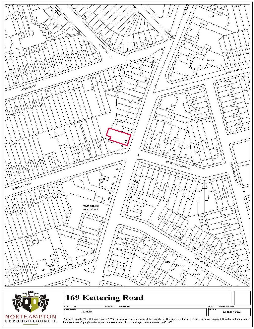
34 CONDITIONS (1) The development hereby permitted shall be begun before the expiration of five years from the date of this permission. Reason: To comply with Section 91 of the Town and Country Planning Act (2) Details and/or samples of all proposed external facing materials shall be submitted to and approved in writing by the Local Planning Authority. Development shall be carried out in accordance with the approved details prior to the commencement of construction work on site. Reason: In the interests of visual amenity and to ensure that the development will harmonise with its surroundings. (3) All trees identified to be retained in the arboricultural report by Bruce Hutton & Associates received on 24 November 2004 and as amended by details received on 3 December 2004 shall be protected for the duration of the development by stout fences to be erected and maintained on alignments to be approved in writing by the Local Planning Authority before any development works shall take place. Within the fenced area no development works shall take place on, over or under the ground, no vehicles shall be driven, nor plant sited, no materials nor waste shall be deposited, no bonfires shall be lit nor the ground level altered during the periods of development. Reason: In order to ensure adequate protection of existing trees on the site in the interests of achieving a satisfactory standard of development and maintaining the amenity of the locality. (4) Unless otherwise agreed in writing by the Local Planning Authority, a scheme for the replacement and / or relocation of trees that would be lost as a result of the development shall be submitted to and approved in writing by the Local Planning Authority prior to the commencement of the development. The approved scheme shall be implemented in the first planting season following the first use of the development, and which shall be maintained for a period of five years; such maintenance to include the replacement in the current or nearest planting season whichever is the sooner or trees that may die are removed or become seriously damaged or diseased with others of similar size and species, unless the Local Planning Authority gives written consent to any variation. Reason: In order to ensure the appropriate replacement of trees in the interests of amenity and to secure a satisfactory standard of development. (5) Access shall be provided to the development hereby approved and facilities provided, for people with disabilities in accordance with the details shown on the approved plans, implemented concurrently with the development, completed prior to the development being first brought into use and be retained thereafter. Reason: To ensure satisfactory access for people with disabilities to the development.
35 (6) A scheme shall be submitted to and approved in writing by the Local Planning Authority which specifies the sources of noise on the site whether from fixed plant or equipment generated within the operational development and the provisions to be made for its control and the approved scheme shall be implemented prior to the commencement of the use hereby permitted and retained thereafter. Reason: To protect the amenities of nearby occupants from noise and vibration. (7) A scheme to prevent overlooking of residential properties to the west of the south stand shall be submitted to and approved in writing by the Local Planning Authority prior to the commencement of the development. Unless otherwise agreed in writing by the Local Planning Authority, the approved scheme shall be implemented concurrently with the development, completed prior to the first use of the enlarged south stand and retained thereafter. Reason: To safeguard the privacy of adjoining properties. (8) Unless otherwise agreed in writing by the Local Planning Authority, the additional seating / capacity hereby permitted shall not be brought into use prior to the completion and first use of the parking permitted by planning permission N/2004/930. Reason: To ensure adequate provision of car parking in the interests of highway safety, the free-flow of traffic and general amenity.
36
37 Agenda Item 10 SCHEDULE OF PLANNING APPLICATIONS FOR CONSIDERATION BY THE PLANNING COMMITTEE 5 JANUARY 2005 SUMMARY SHEET Items Application No. Address Recommendation A N/2004/1332 Land rear of Barratts Factory, Kingsthorpe Road REFUSAL B N/2004/ Kettering Road APPROVAL C N/2004/ Woodford Street APPROVAL D N/2004/ Hardingstone Lane APPROVAL E N/2004/ Abington Avenue APPROVAL F N/2004/1640 Grass Verge on Booth Lane South APPROVAL G N/2004/ Abington Street (former Mirror Image) REFUSAL H N/2004/1647 The Old White Hart Inn, Cotton End, Far Cotton APPROVAL I N/2004/1659 Albion Works, Commercial Street APPROVAL J N/2004/ Falcutt Way REFUSAL K N/2004/1690 Tesco Store, Clannell Road APPROVAL
38 NORTHAMPTON BOROUGH COUNCIL HEAD OF PLANNING, TRANSPORTATION AND REGENERATION PLANNING COMMITTEE - 5 JANUARY 2005 Application No: N/2004/1332 Location : Land rear of Barratts Factory, Kingsthorpe Road Proposal : Erection of car wash centre Officer : Geoff Wyatt Recommendation: REFUSAL for the following reasons: (1) The proposal would result in a piecemeal development which would prejudice the comprehensive redevelopment of an existing business area resulting in potential loss of benefits to the local community and employment opportunities contrary to Policy B14 of the Northampton Local Plan. (2) By reason of its siting and design the proposed car wash centre would represent a visually intrusive feature within the curtilage of a listed building contrary to Policies E23 and E25 of the Northampton Local Plan. Site Description and History: The site is a vacant piece of land situated to the rear of the former Barratts Shoe Factory. Planning permission has already been approved for 16 office units (ref: N/2000/1215) and 3 industrial units (ref: N/2003/1622) on the larger parcel of land to the rear of the former factory. This proposal which includes a single storey car wash centre and valeting bays, takes up approximately 25% of the larger site. Planning Policy: Northampton Local Plan Policies B14, E23 and E25. PPG15 (Planning and the Historic Environment) Consultations: Environmental Health: no objection subject to the imposition of a planning condition to restrict opening hours. Representations: None. Appraisal: The proposed use as a car wash centre is considered unacceptable as it would prejudice the total redevelopment of an existing vacant business area. The car wash would only take up approximately hectare whereas the previously approved schemes for the office and industrial units covered the majority of the site i.e hectare. Furthermore, it is proposed to locate the car wash centre at the front of the vacant site making the land behind less attractive and more difficult to develop.
39 The application site is located within the curtilage of a Grade II Listed Building i.e. the former Barratts Shoe Factory. As the car wash centre is located at the front of the business area it would be highly visible from Kinsgthorpe Road which is a principal traffic route to and from the Town Centre. The car wash would be constructed of a steel frame with polycarbonate dividers which is totally unsympathetic with the design of the listed building. Therefore, the proposed car wash would represent a visually intrusive feature detrimental to the setting of the Listed Building.
40
41 NORTHAMPTON BOROUGH COUNCIL HEAD OF PLANNING, TRANSPORTATION AND REGENERATION PLANNING COMMITTEE 5 JANUARY 2005 Application No: Location: Proposal: Officer: N/2004/ Kettering Road Proposed 4 no flats above existing retail units Gerri Smith Recommendation: APPROVAL subject to conditions and for the following reason: The siting and design of the development and its impact on visual amenities are considered acceptable and in accordance with Policies R9, H7, H12, H15,and H26 of the Northampton Local Plan. Site Description and History: The application site forms the first and second floors above a small supermarket within the Kettering Road Local Shopping Centre. The area is characterised by a range of shop uses and take away food shops consistent with a local shopping area. To the west is a residential area of primarily terraced houses. The application seeks consent to convert the first and second floors to provide four self contained, one-bed flats. Entrance to the flats is proposed from the front of the building. An entrance staircase is to be provided and a hallway at first floor level. This will allow access to the first and second floor units and contains one bin store to serve each flat. The application involves some minor alterations to the rear of the building to create windows by bricking up door openings at first and second floor level and enlarging a window. Planning Policy: Northampton Local Plan Policies R9, H7, H12, H15 and H26. PPG1 General Policy and Principles PPG3- Housing Representations: External Neighbours No comments received Internal Health and Environmental Housing Makes detailed comments about the size of accommodation but no objection in principle
42 Appraisal: This is a brownfield site in an urban area where residential development is encouraged by planning policy and PPG3 Housing. In addition, the use of upper floors of retail premises for residential use is supported by Policy H26 of the Northampton Local Plan where this serves to bring back upper floors into productive use and provide an acceptable living environment. As the existing building covers the whole site, no on site parking has been provided. However, given that this is a conversion rather than new build and the site is conveniently close to public transport links and within walking distance of the town centre, the lack of parking is not considered to be unacceptable in this location. The proposal satisfies Policy H26 of the local plan. Policy R9 of the local plan relates to changes of use from retail use in local and district centres. Provided that any change does not detract from the character of the shopping area, adversely affect residential amenity or lead to unacceptable traffic problems, this policy is satisfied. Conditions (1) The development hereby permitted shall be begun before the expiration of five years from the date of this permission. Reason: To comply with Section 91 of the Town and Country Planning Act (2) The proposed bin stores as shown on the submitted plan shall be provided prior to the first occupation of the flats hereby permitted and retained thereafter. Reason: In the interests of residential amenities.
43
44 NORTHAMPTON BOROUGH COUNCIL HEAD OF PLANNING, TRANSPORTATION AND REGENERATION PLANNING COMMITTEE - 5 JANUARY 2005 Application No: N/2004/1489 Location : 15 Woodford Street Proposal : Alterations to provide self-contained units 3 no. flats and 1 no. office suite Officer : Miss Mary Baynham Recommendation: APPROVAL subject to conditions and for the following reason: It is considered that the proposed development is acceptable as the site lies within a primarily residential area and is not detrimental to residential amenity. The development is therefore considered to comply with policy H19 of the Northampton Local Plan. Site Description and History: Terraced building lies at junction of Woodford Street and Edith Street. Currently used as offices and 3 no. bedsits. The submitted plans show a reduction in office floorspace from 90 to 60sqm, and 3 x 1- bed self-contained flats. External alterations are shown to the street frontages these involve either doors being converted into windows, or vice versa. There is a backyard which is shown to be used for the secure storage of cycles and for refuse storage. The area which is currently used for refuse has no direct access to the street and will rely on the occupiers putting refuse out on collection day. In front of the building itself there are double yellow lines, with a mixture of parking spaces for permit holders or 2-hour parking, beyond. History: 254/48 change of use of house to business 36/52 renewal of above 477/63 manufature of electronic components 98/0711 change of use from commercial office and storage to commercial office/storage and residential Planning Policy: Development Plan: Northampton Local Plan Policies H19 National Policy: Planning Policy Guidance Notes (PPG) 3 (Housing), 13 (Transport)
45 Consultations: Environmental Health Noise transmission problems may arise between proposed office accommodation and the residential proposals adjacent to and above it. Recommend condition. Health & Housing: flat 2 kitchen scales as 3.64sqm, not 5.5sqm as noted on plan revised plans required. Representations: 11 Edith Street objects. Building adjoins their house. Existing parking problems not enough permit bays. There would be highway danger if cars parked on the double yellow lines outside the property. It would be more noisy already problems with existing residents. Concerned about potential building noise. The remainder of the building could be converted to more flats. Queries tenure of flats. Would wish bathrooms to have obscured glass. Requests that soundproofing is provided and compensation for disruption during building works. 16 Edith Street No objection, apart from the problem of on-street parking. Parking permits do not guarantee a parking space, and additional permit holders will only add to the problem. 14 Woodford Street concern relates to lack of parking. Currently there are 10 houses and only 5 resident parking spaces. With the proposed alterations there could potentially be another six cars that need to park in the Street (2 cars per flat), plus any cars used by people working/visiting the business premises. This would certainly increase the parking problem for the current residents. Appraisal: Deferred from December s Committee with delegated authority to secure separate external entrances to both the offices and flats. The applicants wish to retain the shared entrance to enable them to supervise access to the flats. However, the ground floor layout has been revised to include an internal door with a controlled entry to the flats. There will also be entry control to the offices, and entry control to the building itself. It is considered that this is an acceptable solution from all points of view. For ease of reference, the appraisal of the proposal that was considered by the committee in December is reproduced below. Although the building is currently used as offices and three bedsits, the 1998 permission stipulated that the residential part of the building should only be used as one unit of residential accommodation. In principle it is considered that the upgrading of the (albeit unlawful) bedsits to selfcontained accommodation is to be welcomed. The concern of the residents about lack of on-street parking is acknowledged. However, in view of guidance contained in PPG3, a SPG which specifies maximum parking provision, and the fact that the site is close to the town centre, it is considered that the proposal could not be refused on highway grounds.
46 The concerns expressed about noise by the occupiers of 11 Edith Street are noted. However, the submitted plans show a bedroom and kitchen on the ground floor, and a bedroom and shower room on the first floor, adjoining No.11. I consider that this would cause no more disturbance than an adjoining terraced house. Conditions: (1) The development hereby permitted shall be begun before the expiration of five years from the date of this permission. Reason: To comply with Section 91 of the Town and Country Planning Act (2) All alterations to existing elevations shall be made good using materials of the same type, texture and colour as the external walls and roof of the existing building. Reason: In the interests of visual amenity and to ensure that the development will harmonise with its surroundings. (3) Full details of facilities for the secure and covered parking of bicycles shall be submitted to and approved in writing by the Local Planning Authority before the development hereby approved is commenced, provided prior to the development being first brought into use and thereafter maintained. Reason: To ensure the provision of adequate facilities. (4) Works to implement the development hereby approved shall not commence until a noise and sound insulation scheme, protecting residential uses from the proposed office accommodation, is submitted to and approved in writing by the Local Planning Authority. The scheme shall be implemented in full before the first occupation of the building in the form as shown on the approved plans. Reason: In the interests of the amenity of occupiers of adjoining residential property. (5) The provision for bin storage as shown on the approved plans shall be provided prior to the development being first brought into use and thereafter maintained. Reason: To ensure the provision of adequate facilities. (6) Before any of the flats are first occupied the entry control system shall be installed and shall remain fully operational at all times. Reason: In the interests of the security and safety of the occupiers of the flats and offices.
47
48 NORTHAMPTON BOROUGH COUNCIL HEAD OF PLANNING, TRANSPORTATION AND REGENERATION PLANNING COMMITTEE 5 JANUARY 2005 Application No: N/2004/1585 Location : 17 Hardingstone Lane, Hardingstone Proposal : Erection of two-storey side and rear extensions Officer : Mrs Rita Bovey Recommendations: APPROVAL subject to conditions for the following reason: The siting, size and design of the extensions and their impact on residential amenity are considered acceptable and in accordance with Policy H18 of the Northampton Local Plan. Site Description and History: The application site is located on the south side of Hardingstone Lane. It contains a twostorey semi-detached dwellinghouse with a flat roof single garage to the side. The area is predominantly residential in character. In October 2004, planning application N/2004/1184 for a two storey side/rear extension with games room in the roof space was refused on the grounds that the proposed development would be out of scale and character with the existing and adjacent dwellings affecting the amenity of the occupiers of the adjacent property. The current proposal, which is a much reduced scheme, relates to the erection of a twostorey extension to the side and also the rear of the property. The existing garage would be rebuilt together with the provision of new utility, kitchen, dining and garden rooms. Planning Policy: Northampton Local Plan Policy H18. Consultations: Hardingstone Parish Council no objection in principle to this application but there are concerns about this type of extension would price out any young people wishing to stay within the Hardingstone Parish. Representations: 15 Hardingstone Lane the new building is not in keeping with the street scene and would have an overbearing, overlooking, loss of outlook and overshadowing effect on neighbours property. The building work may well affect the shared boundaries/walls and boundary hedge of the neighbouring house. The extension is not related in size to the existing building and the neighbours will be inconvenienced for months/years by the noise, disturbance, pollution, smells and mess of the building works. Any further extension to the rear will adversely affect the neighbours rear outlook. 19 Hardingstone Lane object to the application; the proposed side extension is overdominant and would create a terracing effect harming the look and character of my house and street scene giving a feeling of being cramped in. The vast side extension will affect the value of my house.
49 Appraisal: The application site is sited within a relatively spacious plot with a wide frontage. The proposed extension is not considered to be out-of-keeping with the existing dwelling bearing in mind a similar first floor extension, albeit with a flat roof, has been added to the adjoining property at no.15 Hardingstone lane. The siting of the proposed extensions is such that it is not considered that the outlook of the adjoining properties would be affected. Conditions: (1) The development hereby permitted shall be begun before the expiration of five years from the date of this permission. Reason: To comply with Section 91 of the Town and Country Planning Act (2) Notwithstanding the provisions of the Town and Country Planning (General Permitted Development) Order 1995 (or any order revoking and re-enacting that Order with or without modification), no additional windows shall be installed in the east and west elevations of the proposed extensions without the prior written consent of the Local Planning Authority. Reason: To safeguard the privacy of adjoining properties. (3) The external walls and roof of the extensions shall be constructed with materials of the same type, texture and colour as the external walls and roof of the existing building. Reason: In the interests of visual amenity.
50
51 NORTHAMPTON BOROUGH COUNCIL HEAD OF PLANNING, TRANSPORTATION AND REGENERATION Application No: N/2004/1619 Location : 48 Abington Avenue Proposal : Retention of 4 flats Officer : Geoff Wyatt Recommendation: PLANNING COMMITTEE - 5 JANUARY 2005 APPROVAL subject to conditions and for the following reason: The use of the building for four flats will provide residential accommodation to the required standards following consideration of Policies H6, H22 and H23 of the Northampton Local Plan. Site Description and History: The building is situated on the southern side of Abington Avenue and was used for 7 bedsits until recently. The bedsit use did not have the benefit of a planning permission. Planning Policy: Northampton Local Plan Policy H6. Representations: None. Appraisal: The conversion to the four flats has recently been carried out. This is a less intense use and will not only provide a higher standard of residential accommodation but also improve the quality of life of nearby residents by way of reduced noise and disturbance and less demand for on street parking. Conditions: (1) The accommodation shall be used solely in accordance with the approved drawing(s), unless otherwise agreed in writing by the Local Planning Authority. Reason: To ensure that a satisfactory standard and layout of accommodation is provided in the interests of the amenity of occupants and nearby residents. (2) Details of the provision for the storage of refuse and materials for recycling shall be submitted to and approved in writing by the Local Planning Authority and implemented within one month of the date of this consent. Reason: In the interests of amenity and to secure a satisfactory standard of development. (3) Full details of the facilities for the secure and covered parking of bicycles shall be submitted to and approved in writing by the Local Planning Authority and implemented within one month of the date of this consent. Reason: To ensure satisfactory parking facilities for people with disabilities.
52
53 NORTHAMPTON BOROUGH COUNCIL HEAD OF PLANNING, TRANSPORTATION AND REGENERATION PLANNING COMMITTEE - 5 JANUARY 2005 Application No: N/2004/1640 (Prior Notification Application) Location : Grass verge on Booth Lane South Proposal : Installation of 12m high parallel column with 3 no. antennae, 1 no. equipment cabinet and 1 no. electrical meter cabinet on a concrete base Officer : Miss Mary Baynham Recommendation: APPROVAL. Site Description and History: West side of Booth Lane, approximately 100m south of its junction with St. Gregorys Road. To be sited on grass verge between footpath and fence to school grounds. This prior notification submission has been made because when work started on a site 100m to the north, subject of application N2004/0713, (considered by Planning Committee on 23 June 2004) it was found that a gas main ran under the agreed site. The relocated site brings it to 50m from the nearest residential dwelling. The 12m column is grey in colour, and has the antennae in a casing 1.6m on top total height of 13.6m. There are two equipment cabins, each to be coloured olive green. Both cover a ground area of 1.3m by 0.925m, 1.623m in height; plus a small electrical meter cabinet coloured olive green. Nearby masts St Marys RC school (94/PN28) Northampton College, Booth Lane (N2001/798 and 96PN07)(16m mast) Opp 426 Birchfield Road East (8m mast) At junction of St Gregorys Road and Booth Lane South (N2004/1093)(12.5m monopole) Planning Policy: Northamptonshire County Structure Plan Policy - Tel1 Northampton Local Plan Policy - E32 National Policy: Planning Policy Guidance Note (PPG) No.8 (Telecommunications) Consultations: Environmental Health No objections provided mast can be shown to comply with ICNIRP Public Exposure Guidelines. Representations: St Gregorys Primary School: Installation will be very close to site of our new Primary School currently under construction. A totally inappropriate siting. Hope that efforts will be made to seek an alternative site and the proposal proceeds no further.
54 The Arbours Primary School: Should be taking into account the intensity of RF radiation falling on our site from the proposed installation. There must be a more suitable site when this one is surrounded by educational establishments. Will not the choice of this site severely limit options for major road improvements much needed in the area? Appraisal: This proposal is a prior notification for approval of siting and appearance of the equipment. The sharing of existing masts is encouraged by government advice and Local Plan policy. The agents had undertaken prior consultation on their aborted scheme with surrounding schools, including Northampton College and Weston Favell Upper School. Both were unwilling to accommodate any further telecom operators. The applicants state that this mast is needed as their existing site at St Marys RC Middle School is to be removed due to redevelopment. Government advice and Local Plan policy E32 also indicate that telecoms apparatus should be sited on existing buildings if mast sharing is not feasible. However, the nearest appropriate buildings are the education establishments that have already indicated their unwillingness to accommodate any more telecom equipment. The mast would be seen amidst the mass of existing lighting columns on Booth Lane that are 8m in height. It would also be set against the trees on the boundary with St Marys RC school (currently being redeveloped). Therefore in visual terms it is considered to be acceptable. An ICNIRP certificate has been submitted with the notification, confirming that the proposal fully conforms with the Public Exposure guidelines regarding health issues.
55
56 NORTHAMPTON BOROUGH COUNCIL HEAD OF PLANNING, TRANSPORTATION AND REGENERATION PLANNING COMMITTEE - 5 JANUARY 2005 Application No: N/2004/1646 Location : 69 Abington Street (former Mirror Image) Proposal : Change of use from retail (Class A1) to professional and financial services (Class A2) Officer : Geoff Wyatt Recommendation: REFUSAL for the following reason: The proposed change of use represents an avoidable loss of a retail unit and would increase the concentration of non-retail uses within a secondary shopping frontage which would be detrimental to the retail character and vitality of Abington Street and the town centre contrary to Policy TCR1 of the Northamptonshire County Structure Plan, Policies R5 and R7 of the Northampton Local Plan and the aims and objectives of PPG6 (Town Centres and Retail Developments). Site Description and History: The building is situated in the northern side of Abington Street and is now vacant but was previously used as a hairdressers. Planning Policy: Northampton Local Plan Policies R5 and R7. Northamptonshire County Structure Plan Policy TCR1. PPG6 (Town Centres and Retail Developments). Representations: None. Appraisal: The secondary retail frontage of this part of Abington Street amounts to 46% at present with an extant planning permission (ref: N/2004/1315) for an additional A2 use at No. 75a, which would reduce the frontage to 41% if implemented. The application site has a frontage of 4% which would further reduce the length to only 37%. Policy R7 of the Northampton Local Plan states that a change of use from retail should be refused if the length of a secondary frontage is reduced significantly below 60% in order to help retain the viability and vitality of the town centre. As the total length of retail frontage is already down to 46% and could fall to only 37%, it is considered that this application is unacceptable as it would erode into the retail base of the town centre.
57
58 NORTHAMPTON BOROUGH COUNCIL HEAD OF PLANNING, TRANSPORTATION AND REGENERATION PLANNING COMMITTEE - 5 JANUARY 2005 Application No: N/2004/1647 Location : The Old White Hart Inn, Cotton End, Far Cotton Proposal : Change of use from social club (sui generis) to public house (class A3) Officer : Miss Mary Baynham Recommendation: APPROVAL subject to conditions and for the following reason: The site lies within Development Site D17 where planning permission will be granted for a mix of residential, business and leisure uses, subject to the necessary infrastructure being provided. The proposal is considered to comply with this policy and will have a similar impact on adjoining residential properties as the existing use. Site Description and History: Site lies at the junction of Cotton End and New South Bridge Road. To the east lies Thomas Chapman Grove, new housing development. The three storey building lies on the main road frontage. There is a large parking area to the rear, with access off the main road in Cotton End. The new access onto New South Bridge Road (N2003/1507) has yet to be implemented. 534/69 Conversion of public house to brewery social club. N/2003/1507 Creation of vehicular access. Planning Policy: Development Plan: Northampton Local Plan Policies: D17, E21 National Policy: Planning Policy Guidance Note PPG24 planning and noise Consultations: Environmental Health: suggests conditions relating to noise generation and cooking smells. Crime Prevention Design Adviser: no comments to make at this time. Licensing Sergeant will comment when applicant applies for an on-licence. Representations: None received to date.
59 Appraisal: The site lies within area of Development Site 17 where planning permission will be granted for a mix of residential, business and leisure uses, subject to the necessary infrastructure being provided. The use is considered to be a good one and will provide social infrastructure for this rapidly growing new residential areas. It should have a similar impact on neighbouring properties as the existing social club use. Conditions: (1) The development hereby permitted shall be begun before the expiration of five years from the date of this permission. Reason: To comply with Section 91 of the Town and Country Planning Act (2) A scheme shall be submitted to and approved in writing by the Local Planning Authority which specifies the sources of noise on the site whether from fixed plant or equipment or noise generated within the building and the provisions to be made for its control and the approved scheme shall be implemented prior to the commencement of the use hereby permitted and retained thereafter. Reason: To protect the amenities of nearby occupants from noise and vibration. (3) Before the development hereby permitted is occupied a scheme shall be agreed with the Local Planning Authority that specifies the provision to be made for the collection, treatment and dispersal of cooking odours. The agreed scheme shall be implemented prior to the development first coming into use and shall be maintained thereafter. Reason: In the interests of amenities of occupiers of adjoining properties. (4) Before the use commences, details of a sign to be erected at the New South Bridge Road entrance advising that the entrance shall be for exit only, shall be agreed in writing with the Local Planning Authority. This sign shall be displayed before the use commences and shall be permanently retained, unless otherwise agreed in writing by the Local Planning Authority. Reason: In the interests of highway safety
60
61 NORTHAMPTON BOROUGH COUNCIL HEAD OF PLANNING, TRANSPORTATION AND REGENERATION PLANNING COMMITTEE 5 JANUARY 2005 Application No: N/2004/1659 Location : Former Albion Works, Commercial Street Proposal : Third floor extension to proposed casino building to provide staff facilities Officer : Mrs Rita Bovey Recommendations: APPROVAL subject to conditions and for the following reasons: The design and layout of the proposed extension is considered acceptable and inkeeping with the proposed building and the area in general in accordance with Policy E20 of the Northampton Local Plan. Site Description and History: The application site is located on Commercial Street and was previously occupied by the former Northampton Auction Galleries. It is adjoined by the King William IV Public House to the east, Trade Appliances Electrical Store to the west, Viscount Garage and MAS Fireplace Services to the north. In January 1999, planning application ref.98/0735 for the redevelopment of the site for assembly and leisure use (Class D2) was approved in principle by the then Development Control Sub-Committee subject to the completion of legal agreements to secure the provision of a CCTV camera and highway improvement works. The legal agreements were completed and planning permission was issued in February In April 2003, a revised planning application ref.n/2003/0088 for the erection of a 3- storey casino building (Class D2) was approved in principle by the Committee subject to the completion of legal agreements to secure the provision of CCTV camera and highway improvement works. The legal agreements were completed in October 2003 and planning permission issued. Demolition works on site have recently commenced. The current application proposes to extend the roof space of the proposed building to provide additional staff facilities and meeting rooms. The height of the building would be similar to what was previously approved. There would be minor alterations to the elevations in terms of the proportion of windows and doors and stone banding details. Planning Policy: Northampton Local Plan Policies E20 and L14. PPG1 (General Policies and Principles). PPG6 (Town Centres and Retail Developments). PPG13 (Transport). PPG24 (Planning and Noise). Consultations: Northamptonshire Police no objections. Environmental Health no objections.
62 Representations: None. Appraisal: The proposed extension is considered acceptable and would not be out of keeping with the proposed building and the nearby premises. The proposal would provide improved facilities for the staff working in the casino. Conditions: (1) The development hereby permitted shall be begun before the expiration of five years from the date of this permission. Reason: To comply with Section 91 of the Town and Country Planning Act (2) Details and/or samples of all proposed external facing materials shall be submitted to and approved by the Local Planning Authority prior to the commencement of construction work on site. Reason: In the interests of visual amenity and to ensure that the development will harmonise with its surroundings. (3) Details of the provision for the storage of refuse shall be submitted to and approved by the Local Planning Authority, implemented before the premises are used for the permitted purpose and thereafter maintained. Reason: In the interests of amenity and to secure a satisfactory standard of development. (4) A scheme for the collection, treatment and dispersal of cooking smells and fumes shall be submitted to and approved by the Local Planning Authority and the approved scheme shall have been implemented before the premises are used for the permitted purpose and thereafter maintained. Reason: In the interests of amenity and to secure a satisfactory standard of development. (5) The development shall be constructed to allow access to and circulation in all public areas by people with disabilities, details of which shall be submitted to and approved by the Local Planning Authority, implemented concurrently with the development, completed before the premises are used for the permitted purpose and thereafter maintained. Reason: To ensure that the premises are easily accessible to people with disabilities. (6) Full details of any external lighting of the building shall be first submitted to and approved by the Local Planning Authority. Reason: To secure a satisfactory standard of development. (7) A scheme shall be submitted to and approved by the Local Planning Authority which specifies the sources of noise on site, whether from fixed plant or equipment and measures for its control. Such measures shall be implemented before the premises are used for the permitted purpose and thereafter maintained.
63 Reason: To protect the amenities of nearby occupants from noise and vibration. (8) Details of the scheme for the treatment of all walls exposed by demolition of the existing building which will not be concealed by the erection of the development shall be submitted to and approved by the Local Planning Authority and the approved scheme thereafter shall be implemented concurrently with the development. Reason: To secure a satisfactory standard of development. (9) If excavation works are required within the existing courtyard of the application site, prior notice shall be given to the Council s nominated archaeologists (Built and Natural Environment of Northamptonshire County Council) PO Box 163, County Hall, Northampton NN1 1AX (Tel: ) of the exact date on which it is proposed that construction of the development hereby permitted is to begin. During the construction period representatives of the Council s nominated archaeologists (Built and Natural Environment of Northamptonshire County Council) shall be allowed access to the site in order to observe and inspect all excavation works and record all findings of archaeological interest. If required they shall be allowed to excavate such remains, provided that this shall not interfere unreasonably with the progress of the development. Reason: In the interests of archaeological research.
64
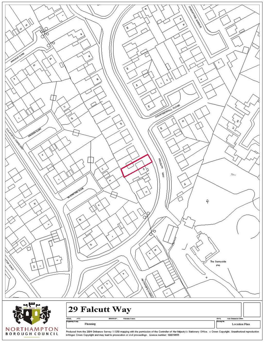
65 NORTHAMPTON BOROUGH COUNCIL HEAD OF PLANNING, TRANSPORTATION AND REGENERATION PLANNING COMMITTEE - 5 JANUARY 2005 Application No: N/2004/1664 Location : 29 Falcutt Way Proposal : Two storey side extension Officer : Miss Mary Baynham Recommendation: REFUSAL for the following reasons: The proposed extension, by reason of its design, size and siting would represent a cramped appearance, which if repeated elsewhere in the street would create a terracing effect, detrimental to the appearance of the existing building and the character of the street scene contrary to Policy H18 of the Northampton Local Plan. Site Description and History: Semi-detached house on west side of Falcutt Way. The extensions over and to the rear of the existing garage, abut the site boundary. To provide an enlarged kitchen, plus utility room and playroom with en-suite bedroom over. The first floor element is set back 4m from the main front wall of the house. Materials to match the existing. N2003/0382 two storey side extension appeal dismissed. N2004/0527 two storey side extension appeal lodged. Decision pending. Planning Policy: Development Plan: Northampton Local Plan Policies H18 SPG residential design guide National Policy: Planning Policy Guidance Notes (PPG) Appraisal: The main issues in this case are the impact of the extensions on neighbouring properties and the impact on the street scene, in particular, whether the extensions result in the creation of a terracing effect with adjoining properties. In this case, as with the previous applications, it is not considered that the extensions adversely affect the residential amenities of adjoining residential properties. With regard to the question of the terracing effect, the starting point for the appraisal of this proposal is the inspectors decision letter dated February 2004, relating to N2003/382. He considered that the area s character is a mix of dwellings, including 2- storey detached and semi-detached houses and semi-detached dormer bungalows. The openness between buildings maintained largely by side drives or by attached single
66 storey garages. He was concerned that if No.31 were also to be extended at 2-storey level this would further reduce the open space between buildings, and although Nos. 29 and 31 are staggered in alignment, would make the building appear to coalesce producing a terracing effect. The proposal that was subject of the appeal showed the 2-storey element projecting 1m in front of the main front wall of the house. The current proposal shows it set back 4m behind the main front wall of the house, approximately 2.5m behind the front wall of No.31. Although this is a vast improvement from the proposal dismissed at appeal, it is still considered that the extension will reduce the open space between the buildings, which was the concern of the inspector.
67
68 NORTHAMPTON BOROUGH COUNCIL HEAD OF PLANNING, TRANSPORTATION AND REGENERATION PLANNING COMMITTEE 5 JANUARY 2005 Application No: Location: Proposal: Officer: N/2004/1690 Tesco Store, Clannell Road Change of use of car parking area for erection of a marquee for display and retailing of horticultural products Gerri Smith Recommendation: APPROVAL subject to conditions and for the following reason: The development is small scale retailing within an existing District Centre and its impact is considered acceptable and in accordance with Policy R1of the Northampton Local Plan. Site Description and History: The application site is situated within the car park area of the Tesco Supermarket and currently comprises a small area laid to grass with a small group of trees. The application seeks consent to use this small part of the site for the sale of horticultural products from a marquee for a temporary period of five years from 2005 to It is proposed to erect the marquee on a seasonal basis between 1st March and 31 October of each year during which the project runs. The proposed marquee covers an area 9.1m by 9.1m and has an overall height of 5m to the apex of the roof and will have associated signage which forms the subject of a separate application for advertisement consent. Planning Policy: Northampton Local Plan Policies: R1, R12 National Policy - PPG1 General Policy and Principles PPG6 Town Centres and Retail Developments Representations: Neighbours No comments received. Appraisal: The application proposes a minor increase in the retail floor space of the Hunsbury District Centre and is considered to be consistent with Policy R1 of the Northampton Local Plan, which permits new shopping development, or changes of use to retail within recognised shopping areas of an appropriate scale and where parking and traffic requirements can be met. PPG6 urges local planning authorities to encourage a wise range of facilities in district and local centres to meet day-to-day needs and to reduce the need to travel. It is considered that the proposal satisfies this objective.
69 In visual terms the marquee is a small low-key structure, which would be seen against a backdrop of the larger supermarket building from within the car park and would not be visible from outside the site. The marquee would only be erected for part of the year between April and October and for a temporary period of five years. This can be controlled by condition. Conditions: (1) The development hereby permitted shall be begun before the expiration of five years from the date of this permission. Reason: To comply with Section 91 of the Town and Country Planning Act (2) The marquee shall only be erected on the site on a seasonal basis between 1st March and 31 October of each year. The marquee shall be permanently removed and the site reinstated to its former condition by 31 October 2009 or otherwise as may be agreed with the Local Planning Authority Reason:- To comply with the terms of the application and to enable the local planning authority to retain control of the site.
70
71
72 Agenda Item 12 EXECUTIVE 22 November 2004 Portfolio: Planning, Transportation and Regeneration Directorate: Chief Executive and Town Clerk Item No STATEMENT OF COMMUNITY INVOLVEMENT Author/Contact Officer: David Blandamer Principal Planning Officer Ext 8907 Recommendation(s) That the Statement of Community Involvement (attached at Appendix A) be approved for pre-submission consultation. Summary The Planning and Compulsory Purchase Act brings into force the new system of Local Development Frameworks (LDFs). Those parts of the Planning and Compulsory Purchase Act relating to the LDF commenced on the 28 September Local planning authorities are required to prepare a Statement of Community Involvement (SCI), which sets out the local planning authority s policy for involving the community, both in the preparation of Local Development Documents and in consulting on planning applications. Consultation was undertaken on a draft SCI during April-June 2004, and a revised version has now been prepared. The new Planning Act requires that consultation is undertaken on a pre-submission Draft SCI, in accordance with the Town and Country Planning (Local Development) (England) Regulations Authority is sought from Executive to undertake pre-submission consultation on the draft SCI attached at Appendix A.
73 1. Introduction 1.1 The Planning and Compulsory Purchase Act brings into force the new system of Local Development Frameworks (LDFs). Those parts of the Act relating to the LDF commenced on the 28 September PPS12 Local Development Frameworks and The Town and Country Planning (Local Development) (England) Regulations 2004 have now been published. Together with the Planning Act, PPS12 and the Regulations will provide the statutory basis for the operation of the new LDF system. 1.2 The Statement of Community Involvement (SCI) sets out the local planning authority s policy for involving the community, both in the preparation of Local Development Documents (LDDs) and in development control decisions. 1.3 A draft version of the SCI (available to view on the Council s website) was the subject of consultation during April-June A total of 30 responses were received from a range of organisations and individuals, including the Government Office for the East Midlands (GOEM), East Midlands Regional Assembly, Daventry District Council, and Northamptonshire County Council. Key issues raised by respondents were thresholds for requiring community involvement on planning applications, and the role of the UDC. The results of the consultation exercise can be viewed in the modern.gov section of the Council s website. 2. Draft Statement of Community Involvement 2.1 An amended version of the Statement of Community Involvement (SCI) has been prepared (Appendix A), which takes account of: The results of the consultation exercise on the draft SCI; The ODPM publication Community Involvement in Planning: The Government s Objectives ; and PPS12 and the Regulations. 3. Procedures 3.1 The Town and Country Planning (Local Development) (England) Regulations 2004 set out the procedures that must be undertaken as part of the process of adopting the SCI. The first stage in the process is the Pre-submission Draft stage. 3.2 The local planning authority is required to publish a notice and invite representations within a six-week period on the Pre-Submission Draft SCI. Certain specified bodies, including the Regional Assembly, adjoining authorities, parish councils, County Council and the Highways Agency, must be consulted. A copy of the draft SCI, and other related information, are to be published on the Council s website and made available for public inspection at Council offices and other appropriate locations (e.g. libraries). 3.3 Once the Council has considered representations received on the Presubmission, it can then submit the SCI to the Secretary of State. The Submission Draft SCI will be the subject of an independent examination held by a Planning Inspector, who will prepare a report on the soundness of the SCI. The SCI will then be amended in accordance with the Inspector s recommendations and adopted by the Council.
74 4. Resource Implications 4.1 The undertaking of community involvement will have resource implications. The existing budget for local plan/local development framework contains resources to undertake relevant publicity and consultation on local planning documents. 5. Social Impacts 5.1 The Statement of Community Involvement sets out the Council s policy with regard to community engagement both in the preparation of Local Development Documents (LDDs) and in development control decisions. The Statement seeks to involve hard-to-reach groups and to ensure that equalities issues are taken into account in providing access to information. 5.2 The measures included in the Statement of Community Involvement will assist the local planning authority to comply with the Race Relations (Amendment) Act 2000 and Disability Discrimination Act Background Papers 6.1 Creating Local Development Frameworks (ODPM, November 2003) PPS12: Local Development Frameworks (ODPM, September 2004) Town and Country Planning (Local Development) (England) Regulations 2004 (HMSO, September 2004) Community Involvement in Planning: The Government s Objectives (ODPM, 2004) 7. Directorates Consulted None
75 Statement of Community Involvement in Planning November 2004 Contents Title Page 1. Introduction 3 The Statement of Community Involvement 3 Purpose and Benefits of Community Engagement 3 2. Local Development Documents 4 Introduction 4 Continuous Community Involvement 4 Resolving Conflicts 6 Links with Northampton Community Strategy 6 Target Groups 7 Development Plan Document Production 8 Supplementary Planning Document Production 10 Resources and Management of the Process Consultation on Planning Applications 11 Community involvement exercises Planning Aid Monitoring and Review Procedure for Adoption of Statement of Community Involvement Useful Websites 18 Appendix A: Glossary of Terms 19 Appendix B: Consultation as Specified by Planning Regulations 22 Appendix C: Consultation and Involvement Methods 23 Appendix D: Consultation Method Matrix 25 1
76 Statement of Community Involvement November 2004 Appendix E: Community Involvement Exercise 26 Appendix F: DPD Process 32 Appendix G: SPD Process 33 2
77 Statement of Community Involvement November INTRODUCTION The Statement of Community Involvement 1.1 The Planning and Compulsory Purchase Act came into force in September The previous system of Local Plans has been replaced by a new Local Development Framework (LDF) process, consisting of a suite of Local Development Documents (LDDs). A key objective of the new planning system is to encourage more meaningful community involvement. 1.2 The Statement of Community Involvement (SCI) is a LDD which sets out the local planning authority s policy for involving the community, both in the preparation and revision of Local Development Documents (LDDs) and in significant development control decisions. A glossary of technical terms is included at Appendix A. 1.3 The Borough Council will tailor its community involvement to local circumstances, building upon existing networks and good practice. For example, the enquiry by design approach adopted in the development of proposals for Upton can be applied to the preparation of both site-specific LDDs and planning applications. The Council has prepared corporate consultation guidance, and is currently working towards the preparation of a Community Involvement Strategy. When involving the community in the planning process, account will be taken of any corporate guidance and/or strategies adopted by the Borough Council. Purpose and Benefits of Community Engagement 1.4 Community engagement represents a continuum of processes in which the general public and other interested parties are invited to contribute to particular proposals or policy changes. Within the constraints of the UK planning system, there are four categories of engagement (see table below). The methods employed to engage the public will vary upon the objective of the engagement process. INFORM CONSULT INVOLVE Objective To provide the public with balanced and objective information to assist them in understanding the problem, alternatives or solutions. Objective To obtain public feedback on analysis, alternatives, or decisions. Objective To work directly with the public throughout the process to ensure that public and private concerns are consistently understood and considered. 3
78 Statement of Community Involvement November Benefits of community engagement: Resolve potential conflicts between parties up-front; Introduce local skills, knowledge, experience and resources; Feelings of local ownership; Avoid frustration of decide-announce-defend ; Introduce stakeholder skills, knowledge, experience and resources; Greater understanding of community and stakeholder needs and aspirations. 2. LOCAL DEVELOPMENT FRAMEWORK Introduction 2.1 Local planning authorities should involve the community at an early stage in the preparation of LDDs. This is essential to achieve local ownership and legitimacy for the policies that will shape the future distribution of uses and development in an authority s area. Techniques should be tailored to engage the appropriate parts of the community at the stages when their involvement is relevant and of value. A key objective of the LDF process is to work towards achieving consensus, through continuous community involvement and resolving conflicts. 2.2 For community involvement to be effective, there will need to be a clear understanding of the purpose of the exercise and the limits to what can be achieved within the legislative and budgetary framework set by Government. Continuous Community Involvement 2.3 Specific consultation methods (see appendix C) will be used to obtain feedback at different stages in the LDF process, relating to specific types of LDD (see appendix D). There will also be a process of continuous involvement which will: inform and update the community and other bodies with regard to the LDF process; maintain a dialogue with stakeholders and participants in the LDF process; and promote the fact that comments and proposals are welcome at any time. 2.4 The community is likely to be made up of many different groups, some of which are communities of place, and others which are communities of interest. Communities of place will focus on the places where they live and work, whilst communities of interest will focus on specific issues and topics. 4
79 Statement of Community Involvement November The Borough Council will use existing networks (e.g. forums, meetings) and contacts, wherever possible, to informally involve the community and stakeholders at an early stage. Where appropriate, an ongoing dialogue will be maintained, in order to inform the preparation of LDDs and to resolve any potential conflicts. Area Partnerships 2.6 Northampton Borough is split into 8 Area Partnerships: 1. Northampton Central (Abington, Castle, St Crispins wards); 2. Northampton East (Billing, Ecton Brook, Lumbertubs & Thorplands wards); 3. (Kingsthorpe, St Davids, Boughton Green wards); 4. (Delapre, St James & Spencer wards); 5. (Eastfield, Headlands & Weston wards); 6. (East Hunsbury, Nene Valley & West Hunsbury wards); 7. (Kingsley & Parklands wards); 8. (New Dustin & Old Duston wards). These will be used as a key mechanism to engage local communities. Further information on the Area Partnerships can be obtained from the Council s Meeting Services Section, or through the modern.gov section of the Council s website. Forums 2.7 There are a number of established Forums covering the following groups: disabled people; lesbian, gay and bisexual people; pensioners; race equality; transport users; women; and youth. These will be used as a key mechanism to engage hard to reach groups. Further information can be obtained from the Council s Meeting Services Section or through the modern.gov section of the Council s website. Citizens Panel 2.8 The Borough Council currently has a People s Panel, which is used primarily for large-scale consultation exercises and the recruitment of ad hoc focus groups. It is proposed to refresh the current panel as a Citizens Panel during the first half of The Citizens Panel, and any focus groups, recruited from within the panel will be used, where appropriate, to engage with the community. Access to information 2.9 Information relating to the LDF process will be made widely available through a variety of methods: Wherever possible, information will be made available both in paper and electronic formats; Copies of all documents will be made available to view at local libraries and local authority offices; All information will be available upon request in Braille, large print, translations or in audio format; 5
80 Statement of Community Involvement November The planning policy address localplans@northampton.gov.uk and a LDF hotline telephone number will offer a single point of contact; Newsletter/leaflets and s raising awareness and providing updates on progress; Using existing networks and contacts to disseminate information; Anyone who makes a comment will be included on an electronic database and will automatically be kept informed at subsequent stages of the process The measures outlined above will assist the local planning authority to comply with the Race Relations (Amendment) Act 2000 and Disability Discrimination Act Resolving conflicts 2.11 The Government has indicated that it wishes LDDs to be developed with the community to achieve a strong measure of consensus. In this way it is hoped to reduce the length and adversarial nature of Public Examinations. Resolving conflicts can be achieved through: engagement process of dialogue; negotiation process of exchanging information, bargaining and compromise between parties involved; planning authority-led mediation (process of intervention into dispute by impartial third party) between other parties; and mediation by a neutral third party when the planning authority is a party to the dispute. The Borough Council will employ appropriate methods to work towards achieving a consensus It is recognised that consensus may not always be possible. Where this cannot be achieved, the community should at least feel that the process has been legitimate, and that it has been delivered in a fair and transparent manner. Links with Northampton Community Strategy 2.13 The Government identifies LDFs as one of the key mechanisms for delivering Community Strategy objectives. Many of the elements of the Community Strategy will have spatial aspects that can be addressed using the land use planning system The Northampton Community Strategy (March 2000) was prepared by the Northampton LSP. One of the themes of the Community Strategy is Engaging with Communities, and the opportunity exists to closely integrate the work of the Community Strategy and the Local Development Framework. The LSP has a number of Panels which develop the themes of the Community Strategy: Community Safety, Environment, Education, Health, Homes and Social Well-being, Economic, Leisure & Culture.
81 Statement of Community Involvement November 2004 These Panels will act as detailed focus/reference groups for different aspects of the LDDs. Local Strategic Partnership (LSP) groups provide regular points of access with a range of key stakeholders and will be involved in each stage of document preparation A full review of the Community Strategy is programmed for The results of that review will be fed into the LDF process. The Team Leader (Policy and Conservation), who is chair of the Environment Panel and a member of the LSP Working Group, is well placed to ensure that the LDF and Community Strategy are linked There is also a Northamptonshire Community Strategy. This is intended to inform and support Community Strategies prepared by LSPs for individual Boroughs and Districts. Target Groups 2.17 If involvement is to be effective, then those groups that make up the community need to be identified. It is considered that the key target groups are: General public o Hard to reach groups Councillors o Ward members Businesses Parish Councils Developers/agents/landowners/Registered Social Landlords Providers of community infrastructure o Healthcare o Education o Other community groups Central, regional & local government o Other Northampton Borough Council Departments o MKSM Growth Implementation Group West Northamptonshire Urban Development Corporation Statutory bodies and groups Interest groups Resident associations/ community groups Voluntary sector 2.18 A database of community bodies and stakeholders is being established to include the above groups, as well as other interested bodies and individuals. Development within the Borough can have impacts on neighbouring settlements, and therefore the Council will positively engage with these communities as well. 7
82 Statement of Community Involvement November It is important to tailor consultation arrangements to the needs of the particular target group. In particular, methods should be devised to involve so-called hard to reach groups, such as the elderly, the young, disabled, ethnic minorities, and residents of deprived areas. These groups have tended to be excluded from traditional consultation exercises, and more innovative approaches need to be explored in order to engage them Minimum standards for community involvement are set out by the Town and Country Planning (Local Development) (England) Regulations Certain bodies must be consulted if the LPA considers that body will be affected by what is proposed to be covered in a LDD (see appendix B). Other general consultation bodies may be consulted as appropriate. Sustainability Appraisal 2.21 Local planning authorities are required to undertake Sustainability Appraisals of Development Plan Documents and Supplementary Planning Documents. The Sustainability Appraisal will incorporate the requirements of the Strategic Environmental Assessment Directive Local planning authorities should involve the public in the Sustainability Appraisal preparation process. In particular, the Council will use the Local Strategic Partnership (LSP) Environment Panel as both a sounding board and steering group for the Sustainability Appraisal process. Development Plan Document Production 2.23 Appendix F sets out the process for preparing Development Plan Documents (DPDs). Early community engagement will be followed by the publication of a Draft Preferred Options and Proposals document. The results of this pre-submission involvement will be taken into account when the Council submits its Draft DPD to the Secretary of State. There will be a six-week period in which representations can be made, and then the DPD will be the subject of independent examination by a Planning Inspector. The purpose of the examination is to consider the soundness of the DPD There are, therefore, two stages at which community involvement takes place, (i) pre-submission: involving initial engagement, followed by consultation on Preferred Options and Proposals, and (ii) post-submission: representations invited on Submission Draft DPD. Pre-submission Involvement 2.25 The initial engagement stage is not prescribed in Regulations and it is for the local planning authority to determine the most appropriate means of community involvement. Different techniques will be employed and 8
83 Statement of Community Involvement November 2004 different groups targeted depending on the type of LDD document (see appendix C) For the Preferred Options stage, the Regulations require the Council to publish their proposals and seek comments over a 6-week period. All relevant documentation will be placed on the Council s website and will be made available for inspection at the Council s offices and local libraries. Notice will be given in the local newspaper of where and when the relevant material can be inspected, how copies can be obtained, the closing date for representations and where to send any representations. Copies of the draft DPD will be sent to those bodies referred in Appendix B, which the local authority considers will be affected by the DPD. Post-submission Involvement 2.27 When the DPD is submitted to the Secretary of State, the local planning authority must publish a notice and invite representations to be made within a specified period of six weeks. Where representations have been made which include proposals for alternative site allocations, the authority must publish these and invite representations. Core Strategy 2.28 The Core Strategy DPD will set out the Council s vision for the development of the Borough Initial stakeholder and community engagement on the Core Strategy has taken place through the preparation of a Local Plan Issues Report. In June 2001, the Borough Council undertook a consultation exercise, over a four-month period, on an Issues Report for the Local Plan Review. A seminar, exhibitions and meetings took place The vision for the Core Strategy should be developed in partnership with the community as a whole, using the Local Strategic Partnership. The Northampton Community Strategy has been developed following an extensive period of consultation. This included a stakeholder day, householder, voluntary group and business questionnaires, and consultation with the Borough Council s Peoples Panel and Community Forums. Future revisions to the Core Strategy s vision will take reviews of the Community Strategy into account Further community involvement will take place through the publication of a Draft Preferred Options and Proposals Document. Development Control Policies 2.32 Development control policies should be developed through informal discussion with interest groups, statutory bodies, and government bodies 9
84 Statement of Community Involvement November 2004 (both local, regional and central). Consultation should also take place with the main users of the policies, i.e. developers and agents. Site Specific Allocations 2.33 Housing sites will form a major component of the site-specific allocations. Consultation has been undertaken on the Urban Housing Capacity Study. However, the Study is essentially a technical document, which assesses the potential capacity for additional housing within the built-up area of the town. It does not make policy decisions regarding the relative merits of sites or consider sites outside the existing built-up area. Ongoing engagement will take place with developers and landowners who wish to promote sites for inclusion in the LDF. The Options and Proposals stage will provide the opportunity for the community and stakeholders to debate the suitability of potential allocations. Area Action Plans 2.34 These LDDs will involve the greatest level of detail and provide the opportunity for greater community involvement and input. Involvement should be targeted at landowners, statutory bodies and the local community. Participatory techniques, such as Enquiry by Design, may be appropriate. Supplementary Planning Document Production 2.35 Appendix G sets out the process for preparing Supplementary Planning Documents (SPDs). A process of early and continuous community involvement will lead to the preparation of a draft SPD. The SPD will be made available for inspection at the Council s offices and local libraries, and will be placed on the website. Notice will be given in the local newspaper and comments on the draft SPD will be invited over a six-week period. Copies of the draft SPD will be sent to those bodies referred in Appendix B, which the local authority considers will be affected by the SPD. Once the Borough Council has considered representations on the draft SPD and made any changes as a result, it will adopt the document SPDs will take one of two forms, either site specific (e.g. conservation appraisals, development briefs), or topic-based (e.g. design guidance, parking standards). The type of consultation and the groups to be consulted will vary accordingly (see appendix C). Resources and management of the process 2.37 The majority of the work involved in undertaking community involvement will be the responsibility of the Planning Policy and Conservation Team. The Health and Community Involvement Division (area partnerships), and 10
85 Statement of Community Involvement November 2004 the Community Leadership Division (Community Strategy and Local Strategic Partnership) will also have a role to play. Executive 2.38 The results of community involvement and key decisions relating to the LDF process will be taken by the Council s Executive. Local Development Document Steering Group 2.39 The Borough Council has established a LDD Steering Group. The Group has no decision-making powers, reporting directly to the Council s Executive. The Steering Group will meet periodically as and when different stages of LDD preparation are reached, ensuring that Members are fully involved in the process. The Steering Group includes the Chairman of Planning Committee, the Portfolio Holder for Planning, Transport and Regeneration (PTR), and the Chairman and two other members of the PRT Overview and Scrutiny Committee. Standards for acknowledging and reporting back on representations 2.40 All responses, received by fax, letter or , will be acknowledged within 10 working days of receipt. All responses should include a contact postal address and telephone number, where possible Representations received will be reported to the Council s Executive. Responses will be accepted up until the deadline for reports to the relevant Executive meeting. Respondents will be informed of the result of the Executive meeting. 3. CONSULTATION ON PLANNING APPLICATIONS 3.1 The Statement of Community Involvement is required to set out the Council s policy for consulting the community on planning applications. It also encourages developers to undertake pre-application discussions and early community consultation on significant applications. The Council will not be able to refuse to accept a valid application because it disagrees with the way in which a developer has consulted the community, but failure by the developer to consult could lead to objections being made which could be material to the determination. The aim of the process should be to encourage discussion before a formal application is made and therefore to avoid unnecessary objections being made at a later stage. 3.2 The Borough Council will not be responsible for determining all planning applications within the Borough. The County Council are responsible for determining certain categories of planning applications, including waste and minerals developments, and operational developments on land in their 11
86 Statement of Community Involvement November 2004 ownership. Early in the new year, an Urban Development Corporation (UDC) will be established for West Northamptonshire. The UDC will have powers to determine significant applications within specific strategic locations. The exact details of the thresholds defining significant applications and the strategic locations are still to be agreed. Publicity required by law 3.3 The Council is required by law to give publicity to all planning applications. The following table sets out the required publicity for various categories of applications: Type of Development Development where the application is accompanied by an Environmental Statement Publicity required Notice in local newspaper and site notice Departure from the Development Plan Development affecting a public right of way Major development* Other development Development affecting the setting of a listed building Development affecting the character or appearance of a conservation area Notice in local newspaper and either site notice or neighbour notification Site notice or neighbour notification Notice in local newspaper and either site notice or neighbour notification Notice in local newspaper and either site notice or neighbour notification *Major development is defined as: a) For residential development, 10 or more dwellings, or if the number of dwellings is not known where the site area is 0.5 hectares or more; b) For other uses, where the floorspace is 1000 square metres or more, or the site area is 1 hectare or more. 3.4 Applications for listed building consent and conservation area consent are also subject to mandatory publicity by notice in a local newspaper and a site notice. 12
87 Statement of Community Involvement November Developers are required to publicise applications in the following situations; a) Where an environmental statement is submitted after the application; b) Where a developer may apply in advance for a determination as to whether the Council s prior approval is required for certain details of the development. At the present time this includes certain types of development for agriculture, forestry and for the demolition of dwellings. In case (b), the Council requires that a site notice is posted. In both cases, developers have to complete a certificate to confirm that appropriate publicity has been carried out. 3.6 To notify neighbours for all applications the Council must either put up a site notice or notify adjoining owners/occupiers. The Council has decided that neighbour notification is the best means of publicising applications. It is the most effective method where small numbers of residents are likely to be affected by a development and it enables those who are unable to see a notice, such as the housebound, to express their views. As all applications must be given publicity, the adjoining owners/occupiers will not always be local residents. Adjoining factory owners, schools and so on may need to be notified at some time. 3.7 In addition, parish councils and local community groups are notified on individual applications in their areas. Procedures Period of Notice 3.8 It is a statutory requirement that the following periods of notice be given: Method of Publicity Notice in a local newspaper Site notice Neighbour notification Period of Notice 21 days from date of publication (statutory requirement is 14 days) 21 days beginning with the date that the notice was first displayed 21 days beginning with the day on which the notification was delivered 13 How to reply to notifications 3.9 Planning applications are available for inspection at the Northampton Borough Council offices at Cliftonville and the Guildhall. The offices are open between 8.30 a.m. and 5.00 p.m. from Mondays to Thursdays and
88 Statement of Community Involvement November am to 4.30 p.m. on Fridays. From early next year all new applications will be available to view online on the Council s website ( The Council is working towards providing online access to all applications submitted prior to As the parish council clerk is sent a copy of every application in their parish, local viewing may be possible by arrangement The Council operates a duty rota system, whereby an officer from the Development Control section will be available to offer advice or answer questions. The officer dealing with the case may not always be available without prior appointment As a general rule planning applications are approved unless there are sound planning reasons for refusal. However, permission can be granted subject to conditions to make the development more acceptable Any comments that are made in response to a planning application will be placed on the application file. The file is available for public inspection and the applicant will be able to see what comments have been made Comments on a planning application should be made in writing or by e- mail within the timescale indicated. Respondents will be encouraged to submit comments by where they have this facility. All representations (whether for or against the development) will be taken into account when the decision is taken. Anonymous letters will not however be considered. All letters that comment on applications will be acknowledged Some development is permitted by the government under the General Permitted Development Order. A Council cannot control this type of development, no matter how strong or valid a neighbour s objection may be to it. Examples of permitted development include some extensions to dwellings and the erection of boundary walls and fences below certain heights. How the decision is taken 3.16 A decision whether or not to grant planning permission can be taken either by the Planning Committee, or by the Head of Planning, Transportation and Regeneration under delegated powers given by the Committee The Planning Committee meets every four weeks on Wednesday evenings, starting at 6.00 p.m. The Councillors have a written report on each application that is being considered, which includes details of how many letters have been received, and a précis of the main points they raise. Should a letter be received after the written report has been prepared, the main points will be summarised within a late addendum. 14
89 Statement of Community Involvement November To increase opportunities for public involvement in the planning process the Council allows the Committee to be addressed by members of the public - a maximum of two people in favour of the application, two against, together with the relevant ward councillor(s). After the decision 3.19 Everyone who has written to the Council about a planning application will be informed of the decision as soon as possible normally within a week. The applicant/agent will receive a decision notice dealing conditions and reasons for approval or reasons for refusal. Everyone else who has written to the Council will be informed of the decision only. A copy of the decision notice is kept on file and is available to view at the Council s offices An applicant does have a right of appeal to the Secretary of State against either a refusal of planning permission or against conditions. An appeal by the applicant must be lodged within 3 months of the decision. If there is an appeal we will write to you to inform you, and you will then have the chance to make further representations to the Inspector who is handling the appeal. We will also inform all individuals/organisations that wrote in on the original application that an appeal has been submitted. Community Involvement Exercises 3.21 The Council considers that developers have a key role to play in engaging with local communities and helping them to understand what is proposed, listening to concerns and engaging in dialogue to seek to resolve these. Carrying out a Community Involvement Exercise is not a mandatory requirement when submitting a planning application, but the Council sincerely believes that genuine engagement with the surrounding community before the submission of a formal application can be beneficial for all those involved. Developers should contact the Council before commencing a Community Involvement Exercise to agree the scope of the exercise and the methods that will be employed Community involvement is the process of: a) explaining proposals to residents, workers and users of the area around the site of the proposed development; b) requesting the views of people in the community; c) considering those views; d) where appropriate, amending the proposals to take the views of the community into account The Council considers that a genuine Community Involvement Exercise can: 15
90 Statement of Community Involvement November 2004 a) provide an ideal opportunity for an explanation of proposals before minds are up on the basis of possibly inaccurate information; b) potentially save time in obtaining a decision on a planning application; c) produce more certainly about the outcome; d) increase transparency; e) create a more acceptable development; f) avoid appeals and call-in procedures A large range of proposals could benefit from Community Involvement. These are set out below along with the thresholds beyond which a Community Involvement Exercise should be completed. Type of Proposal Industrial and commercial development Threshold 1500 square metres or above New build and change of use in or adjacent to residential areas Residential development 100 dwellings or sites of 3 hectares or above Major infrastructure projects such as roads, pipelines or overhead power lines New educational or institutional buildings Mineral extraction proposals Waste processing All proposals All proposals for new sites Extensions of 1000 square metres or above All proposals All proposals NB. Not all applications will be determined by the Borough Council. The County Council and the Urban Development Corporation will have responsibility for certain types of applications (see paragraph 3.2 of SCI) The Council considers that there are three stages to completing a Community Involvement Exercise: 1) Carry out a Community Involvement Appraisal to determine the nature and extent of the Exercise 2) Carry out the Community Involvement Exercise 3) Complete a Community Involvement Submission to record the Community Involvement Exercise and the outcome. 16
91 Statement of Community Involvement November PLANNING AID 4.1 East Midlands Planning Aid (contact details below) is a voluntary service linked to the RTPI offering free, independent and professional advice on town planning matters to community groups. Planning Aid enables local communities, particularly those with limited resources, to participate effectively in planning matters. The current remit of Planning Aid involves advising community groups in negotiations with the local planning authority, and, if necessary, representing the groups at Examination. As part of the expansion of Planning Aid promoted by the Government, a proactive community planning service is being developed within the East Midlands. This will target hard to reach groups and might include training on aspects of the planning system ( capacity building ), and assisting communities to develop their own strategies for shaping their areas. The Borough Council will work with East Midlands Planning Aid to explore ways in which they can assist in facilitating community engagement. EAST MIDLANDS PLANNING AID Penny Gregory Regional Co-ordinator East Midlands Planning Aid Service 15 Wheeler Gate Nottingham NG1 2NA Tel: Fax: penny.gregory@planningaid.rtpi.org.uk 5. MONITORING AND REVIEW 5.1 The Borough Council will monitor the success of community involvement techniques and use the results to review methods to be used in the future. After consultation exercises, the Council will seek feedback from participants about the process and the ways in which they could be involved in the future. In addition, an analysis will be undertaken of those who responded to the consultation to see whether there are any patterns or obvious gaps. This may help to pinpoint any groups that were not reached by the methods used. 6. PROCEDURE FOR ADOPTION OF STATEMENT OF COMMUNITY INVOLVEMENT 6.1 The Town and Country Planning (Local Development) (England) Regulations 2004 set out the procedures that must be undertaken as part 17
92 Statement of Community Involvement November 2004 of the process of adopting the SCI. The first stage in the process is the Pre-submission Draft stage. 6.2 The local planning authority is required to publish a notice and invite representations within a six-week period on the Pre-Submission Draft SCI. Certain specified bodies, including the Regional Assembly, adjoining authorities, parish councils, County Council and the Highways Agency, must be consulted. A copy of the draft SCI, and other related information, is to be published on the Council s website and made available for public inspection at Council offices and other appropriate locations (e.g. libraries). 6.3 A revised version (the Submission SCI ) will be submitted to the Secretary of State. There will be a six-week period in which representations can be made. The SCI will be the subject of independent examination by a Planning Inspector. The purpose of the examination is to consider the soundness of the SCI. Further details of the examination process are contained in Planning Policy Statement 12 Local Development Frameworks. This can be viewed on the Office of the Deputy Prime Minister s website ( 7. USEFUL WEBSITES Guidance on the planning system in general at the UK Planning Portal: National planning policy, including Planning Policy Statements (PPSs), at the Office of the Deputy Prime Minister: Draft Revised Regional Planning Guidance for the East Midlands to 2021 at the East Midlands Regional Assembly and the Milton Keynes South Midlands Sub-regional Strategy, at the East Midlands Regional Assembly: Guidance on regional planning matters, at the Government Office for the East Midlands: wwww.go-em.gov.uk Information on the planning system and on Planning Aid at the Royal Town Planning Institute: Information on rural issues: 18
93 Statement of Community Involvement November 2004 APPENDIX A GLOSSARY OF TERMS Area Action Plan (AAP) Provide a planning framework for areas of change and areas of conservation. Annual Monitoring Report (AMR) Assesses the implementation of the LDS and extent to which the policies in LDDs are being achieved. Community Strategy The Local Government Act 2000 requires local authorities to prepare a Community Strategy. It sets out the broad vision for the future of the local authority s area and proposals for delivering that vision. Core Strategy Sets out the long-term spatial vision for the local planning authority area and the strategic policies and proposals to deliver that vision. Development Control Policies A suite of criteria-based policies which are required to ensure that all development within the area meets the vision and strategy set out in the core strategy. Development Plan Document (DPD) Spatial planning documents that are subject to independent examination. There will be a right for those making representations seeking change to be heard at an independent examination. Engagement Entering into a deliberative process of dialogue with others, actively seeking and listening to their views and exchanging ideas, information and opinions. Unlike mediation or negotiation engagement can occur without there being a dispute to resolve. Enquiry by Design This process helps reach agreement between groups that would normally hold differing aspirations by bringing them together and focusing on the sustainability and quality of the urban environment itself. All concerns - technical, political, environmental and social - are tested and challenged by the design itself, so that the design leads the process and doesn't follow it. Local Development Framework (LDF) Comprises a portfolio of local development documents which will provide the framework for delivering the spatial planning strategy for the area. Local Development Document (LDD) A document that forms part of the Local Development Framework. Can either be a Development Plan Document or a Supplementary Planning Document. Local Development Scheme (LDS) Sets out the programme for the preparation of the local development documents. Must be submitted to Secretary of State for approval within six months of the commencement date of the Act regardless of where they are in terms of their current development plan 19
94 Statement of Community Involvement November 2004 Local Strategic Partnership (LSP) Non-statutory, non-executive body bringing together representatives of the public, private and voluntary sectors. The LSP is responsible for preparing the Community Strategy. Mediation Intervention into a dispute by an acceptable impartial neutral person whose role it is to assist the parties in dispute to reach their own mutually acceptable settlement. It is essentially a voluntary procedure, its proceedings are confidential to the participants; any settlement however can be made public with the agreement of all parties. Negotiation Process of reaching consensus by exchanging information, bargaining and compromise that goes on between two or more parties with some shared interests and conflicting interests. Negotiation is likely to be part of the process of mediation, but can also happen outside of any formal mediation and without the assistance of a neutral person. Office of the Deputy Prime Minister (ODPM) The Government department with responsibility for planning and local government. Public participation - Public participation is a process led by the planning authority. The planners try to anticipate the needs of the public and to synthesise them into a plan that meets the needs of everyone, while also conforming to national policy. It involves a series of formal stages beginning with exploration of issues and ending with a plan. The flow of information is mainly from the planners to the public, who are given opportunities to comment. Planning Aid Voluntary provision by planners of free and independent professional advice on planning to individuals or groups unable to afford to pay for the full costs of such advice. Planning Aid includes the provision of training so that its clients can be empowered through better understanding of how the planning system works and the development of skills that enable them to present their own case more effectively. Proposals Map Illustrates the policies and proposals in the development plan documents and any saved policies that are included in the local development framework. Public consultation A process through which the public is informed about proposals fashioned by a planning authority or developer and invited to submit comments on them. Strategic Environmental Assessment (SEA) A generic term used internationally to describe environmental assessment as applied to policies, plans and programmes. The European SEA Directive (2001/42/EC) requires a formal environmental assessment of certain plans and programmes, including those in the field of planning and land use. Supplementary Planning Document (SPD) Policy guidance to supplement the policies and proposals in development plan documents. They will not form part of 20
95 Statement of Community Involvement November 2004 the development plan or be subject to independent examination. (Formally known as Supplementary Planning Guidance SPG) Sustainability Appraisal An Appraisal to ensure that all policies and proposals in Development Plan Documents (DPD) reflect sustainable development objectives. This will be carried out at the same time as the Strategic Environmental Assessment (SEA). Site specific allocations and policies Allocations of sites for specific or mixed uses or development. Policies will identify any specific requirements for individual proposals. 21
96 Statement of Community Involvement November 2004 APPENDIX B CONSULTATION AS SPECIFIED BY PLANNING REGULATIONS The Town and Country Planning (Local Development) (England) Regulations 2004 state that certain bodies must be consulted if the LPA considers that body will be affected by what is proposed to be covered in a LDD. In Northampton Borough, these bodies will comprise: East Midlands Regional Assembly; East Midlands Development Agency; Northamptonshire County Council; South Northamptonshire Council; Wellingborough Borough Council; Daventry District Council; Parish Councils; Environment Agency; Countryside Agency; English Nature; Historic Buildings and Monuments Commission for England (English Heritage) Strategic Rail Authority; Strategic Health Authority; Highways Agency; Owners or controllers of electronic communication apparatus in the area or to whom the Electronic Communication Code applies Relevant electricity and gas companies Relevant sewerage and water undertakers The Borough Council must also consult, as they consider appropriate: Voluntary bodies, some or all of whose activities benefit any part of the authority s area Bodies representing the interests of: Different racial, ethnic or national groups in the area; Different religious groups in the area; Disabled persons in the area; Persons carrying on business in the area. 22
97 Statement of Community Involvement November 2004 APPENDIX C CONSULTATION AND INVOLVEMENT METHODS These techniques will need to be tailored to engage appropriate members of the community. Area Partnerships Make presentation and/or hold meeting at Area Partnerships. Distribution of Draft Documents Distribution to key identified groups and organisations. Existing networks There are a range of existing meetings and forums, which can be tapped into, including LSP Panels, Parish Councils/Community Forums. There are a number of Forums covering particular sections of the community (e.g. disabled, pensioners) which can be used to engage hard to reach groups. Focus Groups Made up of local people to discuss planning issues, focus groups need not be representative of the general population, perhaps involving a particular citizen group only. LSP Environment Panel could be used as a detailed focus/reference group. In addition, focus groups could be recruited from the Council s Citizens Panel. Full media briefing Press releases, newspaper articles and advertisements and briefings for local radio/tv and Northampton Chronicle. Internet All information relating to the LDF process will be made available on the Council s website ( The website can also be used as an interactive medium to invite responses from members of the public. Meetings A traditional method of informing the public usually with a platform of councillors and/or officers and based on an open invitation to members of the public to attend. 23
98 Statement of Community Involvement November 2004 Newsletter To ensure that the whole community is informed at key stages of LDD preparation, we will distribute in paper form newsletters that will explain the LDF process and set out progress in the preparation of LDDs. Articles will be placed in Northampton Now! the Council s newsletter for local residents. Concordia, intranet and Core Brief will be used for internal Borough Council consultation. Parish Plans Parish Plans are an initiative of the Countryside Agency. They are prepared by parish councils and are a statement of how the community sees itself developing over the next few years. Public exhibitions Public exhibition of proposals at appropriate locations, with officers on hand at to answer questions. Quality of Life Assessment Quality of Life Assessment is a tool for maximising environmental, economic and social benefits as part of any land-use planning or management decision. Promoted by the Countryside Agency, English Heritage, English Nature, and the Environment Agency, it reflects the Government s integrated approach to sustainable development. Village Design Statements Village Design Statements are an initiative of the Countryside Agency. They are produced by communities to identify local character and set out design guidance to help guide new development. Workshops/seminars Key stakeholder workshop to discuss key issues of Core Strategy or single issue LDDs (e.g. phasing, affordable housing, flood risk). Enquiry by Design type workshops to consider detailed site-specific proposals. 24
99 Statement of Community Involvement November 2004 APPENDIX D CONSULTATION METHOD MATRIX TYPE OF LDD TARGET GROUPS General Public Hard to reach groups Councillors Ward members Businesses Parish councils Developers/ landowners/ agents Central, regional & local government Other NBC Departments Statutory bodies Interest groups Resident associations Core Strategy TYPE OF LDD Site specific DPD/ allocations/ Development policies DPD Control DPD Website Media Public exhibitions Focus group Forums Public exhibitions Stakeholder workshop Scrutiny committee Stakeholder workshop Stakeholder workshop Stakeholder workshop Stakeholder workshop Draft documents Stakeholder workshop Draft documents Concordia Intranet/ Core Brief Informal discussion Stakeholder workshop Draft documents Stakeholder workshop Stakeholder workshop Website Media Area Partnerships Forums Public exhibitions Scrutiny committee Draft documents Area Partnerships Draft documents Meetings Meetings Draft documents Concordia Intranet/ Core Brief Informal discussion Draft documents Meetings Area Partnerships Action Area Plan DPD Website Media Area Partnerships Forums Public exhibitions Scrutiny committee Enquiry by Design workshops Enquiry by Design workshops Enquiry by Design workshops Enquiry by Design workshops Draft documents Concordia Intranet/ Core Brief Informal discussion Enquiry by Design workshops Enquiry by Design workshops Enquiry by Design workshops Topic SPD Website Media Forums Scrutiny committee Draft documents Draft documents Draft documents Concordia Intranet/ Core Brief Informal discussion Draft documents Draft documents Meetings Site-specific SPD Website Media Forums Public exhibitions Scrutiny committee Enquiry by Design workshops Meetings Public exhibitions Meetings Draft documents Concordia Intranet/ Core Brief Informal discussion Draft documents Meetings Enquiry by Design workshops Enquiry by Design workshops 25
100 Statement of Community Involvement November 2004 APPENDIX E: COMMUNITY INVOLVEMENT EXERCISE Stage One: Community Involvement Appraisal Details of the proposed development Description of proposed development Location of proposed development Size of site/ floor area of development Name of person completing this form Address Phone number address Effects of the proposed development on the surrounding area Possible effect Access arrangements Positive/ negative effect Explain briefly what the effect will be Car parking Nature conservation Listed buildings Conservation Area Protected species 26
101 Statement of Community Involvement November 2004 Scale of development Effect on trees Traffic generation Public right of Way Noise and disturbance Use in unsocial hours Odours Height/mass or density of development Attraction of crowds Pollution potential Employment potential Ground conditions Disruption during construction Surface water drainage or flooding problems 27
102 Statement of Community Involvement November 2004 Other Significant effects (please state) Defining the extent of the community that may be affected. 1. The immediate area List of streets/roads: 2. The wider area List settlements: 3. Particular community interest (e.g. important views, public transport, school places, employment etc.) Please list: 28
103 Statement of Community Involvement November 2004 Identification of the best ways of informing the community about the proposals (Tick appropriate boxes) Circulate letter and statement in the locality explaining proposals with plans or diagrams Circulate specially prepared leaflet Arrange exhibition and invite local people Arrange press release/advertisement in local newspapers Arrange public meetings Arrange meetings with particular groups in community Arrange a Citizens workshop/forum Additional measures (please specify) Council ward members, parish councils and residents associations It is important that Council ward members, parish councils and residents associations are made aware of development proposals in their area. Members of the Council s Planning Committee could also be informed of development proposals in the same way as their ward colleagues, but they should not be requested to discuss or give their views on proposals because this would prevent them taking part in determining the subsequent planning application. Note that development proposals any affect more than one ward. For example a site may cross or adjoin ward boundaries, or the site may be in one ward but the community likely to be affected is in the adjoining ward. Ward members should be informed of proposals no later than the community and preferably in advance. Information on ward boundaries and representatives can be obtained from the Council s Planning, Transportation and Regeneration Division. 29
104 Statement of Community Involvement November 2004 Details of the Council Members you have informed Name of Councillor Name of Ward Date Informed Details of Parish Councils, and Residents Associations you have informed Name of Contact Name of Parish Council/Residents Association Date Informed 30
105 Statement of Community Involvement November 2004 Stage Two: The nature and extent of the Community Involvement Exercise Carry out the Exercise you have decided on. Remember to: a) give adequate advance publicity to exhibitions, meetings or events) keep a record of which addresses contacted and the information sent; b) keep a copy of all press advertisements, press releases and notices; c) keep a record of those attending exhibitions and (if possible) meetings; d) retain all comments slips filled in by people attending exhibitions or meetings; e) advise local planning authority of dates of meetings. Stage Three: Complete a Community Involvement Submission The purpose of this submission is to record what you did and what the outcome was. Please complete: 1. How was the Community informed about the proposals? 2. Summary of responses received from community: Number of responses Number generally in favour Number of objections (please provide copies of comments and addresses of respondents) Main points of objection: Other matters raised: 31
106 Statement of Community Involvement November 2004 Your comments on the responses received: Amendments made as a result of Community response What to do next Send in a completed copy of your Community Involvement Report with your planning application. This will enable those deciding your application to understand the steps you have taken to engage with the local community. 32
107 Statement of Community Involvement in Planning November 2004 APPENDIX F - DPD Process Pre Production Evidence gathering SCI Production Examination Adoption Pre submission community involvement Representations On submitted DPD Pre-Exam Meeting LOCAL DEVELOPMENT SCHEME ISSUES/ OPTIONS Consultation On preferred Options SUBMISSION TO SofS EXAMINATION BINDING REPORT ADOPTION Sustainability Appraisal Conformity/ Soundness of DPD DPD ENTRY IN LDF 33
108 Statement of Community Involvement November 2004 APPENDIX G - SPD Process Pre Production SCI Production Adoption Evidence gathering Community Involvement LOCAL DEVELOPMENT SCHEME Parent DPD Consultation on Draft SPD ADOPTION Sustainability Appraisal SPD ENTRY IN LDF 34
109 EXECUTIVE 6 December 2004 Portfolio: Housing Planning, Transport and Regeneration Directorate: Business and Housing Services Chief Executive and Town Clerk Item No AFFORDABLE HOUSING SUPPLEMENTARY PLANNING GUIDANCE Author/Contact Officer: David Blandamer Principal Planning Officer Ext 8907 Karina Wearmouth Head of Housing Strategy & Enabling Ext 7194 Recommendation(s) That: 1) the document, attached at appendix A, be adopted as a Council Planning Policy Statement on Affordable Housing; 2) the document be kept under review. Summary At the 13 September 2004 Executive meeting, it was resolved to undertake consultation on a draft SPG (Supplementary Planning Guidance) on affordable housing. Copies of the Draft SPG were sent to a range of interested parties including neighbouring local authorities, parish councils, registered social landlords, house builders, and relevant national and regional Government bodies. In addition, the draft SPG was considered by both the Housing, and Planning, Transportation and Regeneration Overview and Scrutiny Committees. A revised version of the SPG has been produced taking into account the comments received as a result of the consultation exercise. The new Planning Act does not make provision for the preparation of Supplementary Planning Guidance (SPG). It is proposed that the document attached at Appendix A be adopted as a Council Planning Policy Statement.
110 1. Introduction 1.1 At the 13 September 2004 Executive meeting it was resolved to undertake consultation on the draft Affordable Housing Supplementary Planning Guidance (SPG). 1.2 The agreed consultation programme was as follows: Consultation Period 24 th September to 5 th November 2004 (With all Stakeholders) Housing Overview and Scrutiny Committee Planning Overview and Scrutiny Committee Executive (for approval and implementation) 14 th October 21 st October 6 th December 1.3 The following consultation measures were undertaken to supplement the above programme during the six-week consultation period: A copy of the Draft SPG was posted in the Have your say section of the Council s website; A press release was issued; Copies of the Draft SPG were sent to relevant Borough Council officers, neighbouring local authorities, parish councils, registered social landlords, house builders, the Housing Corporation, East Midlands Regional Assembly, English Partnerships, Government Office for the East Midlands, Northampton PCT, Northampton General Hospital NHS Trust, and the Housebuilders Federation; A report was presented to the Housing and to the Planning, Transportation and Regeneration Overview & Scrutiny Committees. 1.4 A total of 18 responses, consisting of a large number and wide range of comment. The responses along with officer s comments and proposed changes can be viewed, as a background paper to this report, in the modern.gov section of the Council s website. A revised version of the SPG document has been prepared which incorporates the proposed changes (see Appendix A). 1.5 The draft SPG was considered by members of the Housing and Planning, Transportation & Regeneration Overview & Scrutiny Committees. The minutes of these meetings are included at Appendix B. 2. Status of Document 2.1 The Government Office for the East Midlands (GOEM) have provided advice, in their response to the consultation, regarding the status of the document, in
111 the light of the commencement of the Planning and Compulsory Purchase Act The new Act does not make provision for Supplementary Planning Guidance (SPG), but rather for Supplementary Planning Documents (SPD). The preparation of SPD is covered by Regulations, which require amongst other things, the undertaking of a Sustainability Appraisal. 2.2 The options that exist for taking the SPG forward are as SPD or as a Council planning policy statement. Given the urgency of adopting the SPG and implementing the revised thresholds and percentages, it is considered that the most appropriate course is to adopt the SPG as a Council Planning Policy Statement. It is accepted that it will not carry the statutory weight of a SPD, but further delay in adopting the guidance would result in considerable numbers of affordable homes being lost. 3. Key Issues 3.1 The key issues that have emerged from the consultation exercise and consideration by the Overview & Scrutiny Committees are: (i) Thresholds (ii) Target Percentage of Affordable Housing (iii) Commuted sums for sites below 15 dwellings (iv) Split between tenures (v) Mobility standards Thresholds 3.2 Although the majority of respondents favoured a reduction in the threshold, there were a number of objections, primarily from the development industry. Objectors to the reduction of the threshold to 15 dwellings have argued that this is contrary to Government guidance in Circular 6/ Whilst the reduction from 40 dwellings (as stated in Local Policy H32) to 25 is justified by Circular 6/98, further reduction to 15 dwellings should normally be addressed in the context of a Local Plan review. However, the threshold of 15 dwellings reflects emerging Government policy in the Proposed Changes to PPG3 (published July 2003). The Ministerial statement, which accompanied the Proposed Changes, states that emerging Government policy, in the form of draft policy guidance, can be regarded as a material consideration, depending on the context. It is considered that a reduction to 15 dwellings can therefore be justified, particularly in the light of the recommendations of the Housing Needs Survey. Target Percentage of Affordable Housing 3.4 Responses were split between those that considered 35% was a reasonable target, and those, primarily from the development industry, who felt it was too high. There were no suggestions that the percentage should be raised higher. The comments made at the 14 October 2004 meeting of Housing Overview & Scrutiny Committee (see Appendix B) seem to support the adoption of this
112 target. Members considered that 35% was reasonable. They recognised that if targets were too stringent it could stifle development, and that an achievable balance was needed. It is therefore considered that, given the level of need for affordable housing in the Borough, the target should be set at 35%. 3.5 The draft SPG stated that a target of at least 35% affordable housing should apply on all residential development sites above the threshold... It is considered that there could be delivery problems if phrases such as 'at least' or 'a minimum' of 35% are used, particularly if grant is not available. In such situations, 35% of the total may result in forms of housing being provided which may contribute relatively little to meeting the Council's priority needs, which is for social rented housing. The Council could also be open to more challenges if negotiations to provide social rented housing are unsuccessful. Commuted sums for sites below 15 dwellings 3.6 It is acknowledged that Members have been keen to introduce a requirement for developers to pay a commuted sum to help with the provision of affordable housing on sites below 15 dwellings or 0.5ha. This proposal was welcomed by Housing Overview & Scrutiny Committee at its 14 October 2004 meeting. Opinion on this issue is very polarised. There have been objections from the development industry and serious reservations have been expressed by the Council s Assistant Head of Planning, Transportation and Regeneration (Development Control). 3.7 Objectors to this aspect of the SPG raise some strong arguments. Firstly, they point to Government guidance that states that new policy should not be introduced through SPG. Any aspect of the SPG which does not supplement Local Plan Policy H32 is unlikely to carry significant weight as a material consideration in the determination of planning applications and therefore is likely to be challenged at appeal. Secondly, they have questioned whether this proposal accords with Government policy. Circular 1/97 sets out Government policy with regard to planning obligations. Whilst this Circular cites the securing of affordable housing in larger residential developments as an appropriate use of planning obligations, it does not provide support for requiring commuted sums on sites below the agreed threshold. 3.8 On reflection, therefore, it is considered that this aspect of the SPG should be withdrawn. Split between tenures 3.9 The proposed 75:25 split between social rented and other tenures generated a number of objections. It is considered that this may be contrary to the provisions of Circular 6/98. Consequently, it is proposed to amend the draft SPG such that the composition of affordable housing will be negotiated on a site-by-site basis.
113 Wheelchair access standards 3.10 Policy H17 of the Local Plan requires that 10% of dwellings on sites of 10 or more dwellings are built to mobility standards. It is not appropriate for the SPG to seek a higher level of provision, than that set out in the Local Plan. As part of the preparation of the Council s Local Development Framework (LDF), the whole issue of mobility housing, lifetime homes and wheelchair access across all residential schemes (not just affordable housing) will be considered. The LDF is the appropriate forum for taking forward these issues, and for revising planning policy. Consequently, it is proposed to amend the draft SPG such that the proportion of wheelchair access housing will be negotiated on a site-by-site basis However, the Council has published a protocol with RSLs it currently works with, which refers to the way housing which is suitable for wheelchair users will be provided. The Council s Housing Strategy and Enabling Division will continue to work with its partner RSLs to ensure suitable provision is made for wheelchair users. 4. Resource Implications 4.1 An independent housing consultant, Richard Broomfield of Portfolio Development Consultancy, was commissioned to work with the Council with the aim of developing the revised SPG. The cost of the engagement of the consultancy work will be met from existing budgets. 5. Social Impacts 5.1 The Council has a commitment to promoting the social, economic and wellbeing of our communities. As such we continue to build a detailed picture of the developing local, sub-regional housing markets through the use of different surveys and census trend data. This approach has also focussed on particular needs groups and communities, in consultation with the Countywide supporting people team and community groups. 5.2 The need to revise the SPG has been highlighted by the recent survey and subsequent work and this revised SPG will contribute to providing inclusive and sustainable communities. It will assist the Council to enable the provision of an increased number and type of affordable homes across a range of tenures to allow people greater choice. 6. Background Papers 6.1 Northampton Borough Council Housing Needs Survey (2002) (Fordham Research) Consultants Brief Supplementary Planning Guidance Affordable Housing (1998) PPG3 Housing (March 2000) Circular 6/98 Affordable Housing and Planning
114 Proposed Changes to PPG3 (July 2003) (ODPM) 7. Directorates Consulted Borough Solicitor Financial Strategy
115 APPENDIX A Final Draft following public consultation Council Planning Policy Statement on Affordable Housing November 2004
116 CONTENTS Summary... 9 Definition of Affordable Housing Policy Context Development Plan Policy Housing Need in Northampton Proportion of affordable housing to be provided Other considerations Housing mix and tenure Securing affordable housing for the future Special Needs Housing Housing for Black and Minority Ethnic (BME) households Housing for Key Workers Affordable housing standards and design On-site and off-site provision Section 106 Planning Agreements Monitoring and Review Further Information... 20
117 Planning Policy Statement: Affordable Housing Summary This Policy Statement was approved by Northampton Borough Council on xxxx. It builds on the policy contained in the Adopted Local Plan, and is intended to provide a framework for negotiations with developers for the provision of affordable housing. Its main provisions are as follows: Affordable housing in Northampton is defined as: housing of an adequate standard which is cheaper than that which is generally available in the local housing market. This can comprise a combination of subsidised rented housing and subsidised low cost home ownership (LCHO), including shared ownership The main types of affordable housing that meet this definition are: o affordable rented accommodation; o shared ownership provided with or without grant; o sub-market or intermediate rented housing; o shared or fixed equity housing. On all residential development sites above the site size threshold a target of 35% affordable housing should be provided; The site size threshold is set at 15 dwellings, or sites measuring 0.5 hectare or above; The ratio of homes for affordable rent and other tenures will be negotiated on a site by site basis Non-affordable rented tenures are taken to cost no more than 70% of the equivalent cost of market housing; The need to provide affordable housing is irrespective of grant being available; Any affordable housing that is provided must cater for the needs of people with disability and those from the black and minority ethnic communities; Housing aimed at key workers will be explored on a site-by-site basis;
118 The Council will seek to secure the affordable housing by means of a Section 106 Agreement. Developers are advised to follow the Council s standard clauses in such agreements; This statement will be reviewed in the light of experience, changes in national or regional planning guidance or the introduction of the new Local Development Framework. STATUS OF THIS POLICY STATEMENT 1 This statement supplements the planning policies contained in the Adopted Northampton Local Plan. It describes the way in which the Council will seek to provide affordable housing when considering applications for residential development, and is intended to provide developers with guidance that will assist their negotiations and the preparation of development proposals. 2 The statement has been developed by the Council following a consultation process involving Registered Social Landlords (RSLs), housebuilders and members of the Council s Housing and Planning Committees. The recent experience of negotiating affordable housing in the town also informed the drafting of the statement. 3 The Council is concerned to maximise the supply of new affordable homes in the town, but also needs to strike the right balance between the availability and price of different types of housing. It recognises that the market price of housing is now excluding an increasing number of people from being able to afford a suitable home. It is committed to creating a balanced social and economic community, and will seek to influence this by enabling the provision of housing to meet the various accommodation needs throughout the community. 4 The Council accepts that negotiating affordable housing can be a timeconsuming and difficult process. In order to maximise the numbers of new affordable homes provided, it has set out its intention in this statement to be as proactive and flexible as planning policies and the availability of public grant allow. 5 Developers who adopt a positive approach to negotiations, including for example the use of the Council s preferred Heads of Terms or standard Section 106 agreement, are likely to find that agreement is achieved earlier. 6 The provision of affordable housing has in the past been inextricably linked to the availability of public grant. However, following the ending of Local Authority Social Housing Grant, Northampton, like all authorities, is
119 dependent upon the Housing Corporation for grant. It is not in a position to guarantee grant for any particular development. Developers should note therefore that the need to provide affordable housing is irrespective of grant being available. Definition of Affordable Housing 7 Circular 6/98 Affordable Housing and Planning states that local authorities should define what should be regarded as affordable. The Borough Council has agreed to follow a slightly amended version of the definition contained in the Local Housing Needs Assessment: A Guide to Good Practice: Affordable housing is housing of an adequate standard which is cheaper than that which is generally available in the local housing market. This can comprise a combination of subsidised rented housing and subsidised low cost home ownership (LCHO), including shared ownership. 8 The Council recognises that the Circular 6/98 refers to low cost market housing in its definition of affordable housing. This is taken to be housing sold below the price of housing sold on the open market, usually where a discount has been provided by the developer. 9 The Council considers that the high house prices within Northampton are such that this form of housing is unlikely to be affordable by people in housing need, a point reiterated by Fordham Research in their 2002 Housing Needs Survey. Low cost market housing is therefore excluded from the Council s definition of affordable housing. 10 The Council considers the main types of affordable housing that does meet this definition are as follows: affordable rented accommodation, that complies with Housing Corporation's prevailing guidance on affordable rents; shared ownership provided with or without grant (if it is provided with grant, this is known as subsidised low cost home ownership); sub-market or intermediate rented housing (i.e. providing a discount of at least 20% below current local market rents, or at rent levels affordable by such groups as key workers); shared or fixed equity, where land value is retained to provide housing for sale at below market levels and where control of the equity discount can be retained in perpetuity. 11 Other forms of affordable housing that are designed to meet the needs of key workers and other groups are discussed below.
120 12 The Housing Needs Survey provided definitions as to what is affordable in Northampton, in terms of monthly costs to purchasers or renters (see Appendix A). On page 29 of the report, it gave an illustration of the relationship between incomes and affordable house prices, using a 2 bedroom property priced at 63, However, as mentioned in Appendix A, property prices in Northampton have risen significantly since The price of a typical terraced property has risen from 73,711 in Oct-Dec 2001 to 110,907 in Jan-Mar 2004 (Land Registry data), a rise of over 50%. The income required to buy the same two bedroom property is likely therefore to have risen from 19,000 in the Report to 28,000 in Based on the above assumptions, the following table provides a further example of the price properties would have to be if they were to be affordable by households on average incomes: Average household income 2002 (Table 4.1 HNS) 20,050 Average household income 2004 (typically at 4% pa - Office for National Statistics) 21,686 Typical deposit required (at c. 5%) 3,500 Typical affordable purchase price 70,000 Typical monthly cost to buyer 405 Policy Context 15 Planning Policy Guidance Note 3 (PPG3) and Circular 6/98 Planning and Affordable Housing set out the Government s planning policy relating to affordable housing. These documents recognise that the community s need for affordable housing is a material planning consideration, which should be taken into account in formulating development plan policies and in determining planning applications involving housing. The advice also refers to the need to address a community s need for a mix of housing types including affordable housing, and where there is a demonstrable lack of affordable housing, local plans should seek affordable housing from suitable developments. 16 Proposed Changes to PPG3 were published by the Office of the Deputy Prime Minister (ODPM) in July It is anticipated that a revised version of PPG3, incorporating these changes, will be published by the end of It is proposed that affordable housing should not normally be sought on sites of less than 15 dwellings. 17 RPG 8 (Regional Planning Guidance for the East Midlands) was published by the Secretary of State in It emphasised the importance of meeting the need for affordable housing and sought to strengthen the role
121 of Northampton in the region. RPG8 has recently been the subject of an Examination in Public, and it is anticipated that the final version will be approved in March Any changes in regional policy will be taken into account when this Policy Statement is next reviewed, when it will become part of the new Development Plan Framework. As the Sub Regional Strategy and housing growth figures have been challenged, the figures mentioned above may alter. 18 The Proposed Changes (October 2004) to the Milton Keynes South Midlands (MKSM) Sub-Regional Strategy (which covers RPG8 East Midlands, RPG9 South East, and RPG14 East of England) proposes a total of 30,000 dwellings to be built in Northampton during the period The development proposals imply annual housing development rates around 50% above what is currently being achieved. 19 The Sustainable Communities Plan (ODPM, February 2003) describes the challenge of tackling the housing shortage, especially in London and the wider South East, by addressing immediate and urgent needs for more affordable housing, both for key workers and those who would otherwise be homeless. It called on Local Authorities will take a pro-active role in identifying and responding to housing needs, by not just to operating the planning system but also to ensure that the necessary levels of quality development happen. 20 The Sustainable Communities Plan also affirmed the Government s aim to improve the contribution made by good planning to securing affordable homes in our communities, by the development of well-integrated mix of decent homes of different types and tenures to support a range of household sizes, ages and incomes. 21 The Council s support for these goals is encompassed in this statement and it will seek to maximise additional housing investment that is being made available through the Plan, including funding for Key Worker housing and intermediate forms of tenure. Development Plan Policy 22 The adopted affordable housing policy is set out in Policy H32 of the Northampton Local Plan - In granting planning permission for residential developments of 40 or more dwellings, the Council will negotiate an element of affordable housing. The level of provision will depend upon the identified need for such housing in the vicinity and site/market conditions.
122 23 This policy was drafted to reflect the guidance contained in Circular 13/96. The site threshold of 40 dwellings was subsequently reduced to 25, as advised in Circular 6/ The Housing Needs Survey (see below and Appendix A) identified an acute shortage of affordable homes in Northampton. The Council considers this position is very likely to have deteriorated in the last two years, which have seen acceleration in house prices in the town and a corresponding increase in the numbers of people unable to afford to buy a home. 25 Circular 6/98 states that where exceptional local constraints exist, a lower threshold than 25 dwellings may be applied. The Council believes the local constraints on the supply of new affordable housing and the level of extant consents on allocated sites are such that a lower threshold is justified. It concurs with the conclusion in Fordham Research s report that a site threshold of 15 dwellings, or 0.5 ha or more should apply throughout the Borough. This reflects emerging Government policy in the Proposed Changes to PPG3 (July 2003). 26. As stated in the adopted policy, the Council will take account of site and market conditions when negotiating affordable housing. This could include factors relating to other material planning considerations as well as financial viability. If such factors are used to substantiate a particular proposal, the Council will expect developers to provide full justification to enable a detailed assessment to be made. Subdivision of sites or other devices that seek to avoid the site or numbers thresholds will not be acceptable. Housing Need in Northampton 27. The Council commissioned Fordham Research to undertake a Housing Needs Survey in A summary of the main findings is included in Appendix A of this statement. The methodology employed in this study was consistent with the Government's "Local Housing Needs Assessment: A Guide to Good Practice". 28. The study concluded that there is a need for 736 new affordable homes a year and in order to address such a target, the Council should try to secure as much affordable housing as possible, by attempting to secure a reasonable proportion of all allocated (housing) sites as affordable. Proportion of affordable housing to be provided 29. The Borough Council accepts that the planning system is unlikely to satisfy all the housing need identified in the Housing Needs Survey. But
123 given the extent of the shortage of affordable housing in the town, it considers a significant contribution can be made. The Council is also mindful of the recommendation from Fordham Research that a target of 50% would be fully justified (Housing Needs Survey Final Report, Section 13.2, page 107). 30. The Council recognises that increasing the target from 22% to 50%, at the same time as it confirms a lowering of the site size threshold, may result in some developments being unviable, unless sustained and generous levels of public subsidy can be made available. This is an unreasonable prospect upon which to pin such a critical target. Setting it a high level could therefore become counter-productive in the long term. 31. The Council has decided that a target of at least 35% affordable housing should apply on all residential development sites, including both allocations and windfall sites, above the threshold identified above. This proportion is considered an appropriate minimum starting point for negotiations. On suitable sites the Council may negotiate for a greater proportion of affordable housing. This is particularly relevant in cases where the affordable housing offered is aimed at people who are not in the greatest housing need (where the available subsidy can provide more homes). Other considerations Housing mix and tenure 32. The Council is keen to ensure that new developments cater for a range of housing needs (including family housing as well as homes for smaller households), so as to encourage the development of mixed and balanced communities. In line with paragraph 17 of PPG3, the affordable housing is expected to be provided on site as part of the proposed development, so as to ensure a more balanced range of housing types and tenures. 33. The Council is aware that planning policy should not be expressed in favour of any particular form of tenure. However, in order to ensure that provision is actually affordable and meet the majority of needs identified Housing Needs Survey, the Council s first priority is that the majority of affordable housing should be for renting at Housing Corporation target rent levels. 34. The Council appreciates that affordable rented housing normally requires considerable amounts of public subsidy. Although the starting point for all negotiations is that public grant should not be assumed (see paragraph 6), the more grant that is available for a particular scheme, the higher the proportion of affordable rented housing can be provided. The Council
124 looks to developers and RSLs to work together and to be proactive in maximising the numbers of homes that meet the needs of people in the greatest housing need. 35. To meet other housing needs, and to address the Council s sustainable communities agenda, other forms of affordable housing may also be provided. These are likely to comprise low cost home ownership (LCHO) and sub market housing, including shared ownership, intermediate renting and shared equity, provided that the cost to the purchasers or tenants are appreciably lower than the minimum cost of market housing. 36. As a guide to negotiations, this is taken to be no more than 70% of the equivalent cost of market housing, while the Council s preferred ratio of homes for affordable rent and other tenures will be negotiated on a site by site basis. Securing affordable housing for the future 37. The involvement of a Registered Social Landlord (RSL) in the provision of affordable housing is considered by the Council to be the most effective way of developing a successful affordable housing scheme. This will also ensure that the benefit of the affordable housing that is produced is secured for future occupants. 38. The Council works with a number of RSLs in the area and developers are advised to contact the Council s Housing Strategy and Enabling Division to discuss possible RSL partners and to help determine what grant can be secured for the proposed scheme. Special Needs Housing 39. The Housing Needs Survey showed that households containing a member with a special need were more likely to have lower incomes and levels of savings than non-special needs households, but were likely to have the highest relative level of housing need of all groups. It also identified a significant need for aids and adaptations for people with physical disabilities. 40. In the light of these findings, the Council must aim to compensate for the shortage of affordable homes that are accessible to people with physical disabilities, and will therefore seek to negotiate on a site by site basis for a proportion of affordable dwellings as suitable for wheelchair access. Housing for Black and Minority Ethnic (BME) households
125 41. The Council is aware that BME households are more likely to live in unsuitable housing. The Housing Needs Survey provided evidence that BME households tend to live in overcrowded conditions, in expensive private rented housing where there were likely to be major problems with disrepair or unfitness, resulting in families being unable to live together. 42. Many of these housing needs will be met through the mainstream affordable housing programme, but there is an additional need to cater for large and extended family households, particularly from the Asian community. Apart from encouraging conversions of existing properties, the Council intends, when it discusses proposals for particular developments, to ensure that large 4 and 5 bedroom properties are included as part of the overall mix of new housing being provided. Housing for Key Workers 43. The Housing Needs Survey highlighted the need for the definition of key workers to be more closely defined. The Survey found there to be a considerable number of key workers in the Borough, but that no specific type of housing ought to be provided for them. 44. Since 2002, the difficulties associated with attracting and retaining key staff has become an increasingly significant issue throughout the South East. The Council acknowledges that the housing needs of key workers may be growing, particularly for public sector employees who may no longer be able to afford market priced housing. Without further evidence of this being a significant problem in Northampton, the Council has accepted the conclusion provided by the Needs Survey, but is willing to explore proposals aimed at addressing identified needs. 45. But the housing needs of key workers is an area that needs to be kept under review. The Council is committed to ensuring that all housing sites meet a range of needs and offer a range of solutions, and aim to avoid the creation of sites that accommodate only a single type of household group. 46. The Council s definition of key workers are those included in the current definition by ODPM as people employed or taking up employment in the following employment categories: nurses and other NHS staff; teachers in schools and in further education and sixth form colleges; police officers and some civilian staff in some police forces; prison service and probation service staff; social workers, educational psychologists and occupational therapists employed by local authorities; and
126 whole-time junior fire officers and retained fire fighters (all grades) in some fire and rescue services 47. Research on the need for key worker housing in Northamptonshire has been commissioned. The results of that research will inform the Council's approach to key worker housing in the Borough. Key workers will therefore include groups identified in the Keyworker Study, and such other groups that may be nominated from time to time by the Council s Housing Strategy and Enabling Department. Preference will be given to key workers who work or are taking up employment within Northampton Borough. 48. Key workers who fall into the above categories are likely to have annual incomes of between 17,000 and 25,000 for single applicants and up to 30,000 for a couple/family. Any proposals affordable housing that is provided should permit people with these incomes to part purchase or rent. The levels will be reviewed annually in line with public sector pay awards. Affordable housing standards and design 49. As a minimum, all affordable housing schemes provided by RSLs (however they are funded) will be expected to meet: the essential requirements set out in the Housing Corporation's Scheme Development Standards (and other requirements as may be introduced by the Housing Corporation from time to time); 'Secured by Design' certification; any local design guidance contained in the Council s other Supplementary Planning Guidance, development briefs or design guides; any particular design or specification requirements laid down by the RSL involved in providing or managing the scheme. 50. The Council encourages developers to work closely with RSLs to ensure compliance with these areas. Opportunities for innovative construction, which can improve quality and reduce build costs, should also be considered. Developments that are environmentally sustainable and utilise modern methods of construction (off site manufacturing) will also be supported and are likely to increase the potential for maximising public grant. 51. The Housing Needs Surveys looked at preferred dwelling sizes and mix for new developments. Further guidance is provided in Appendix A.
127 52. Developers are expected to incorporate good designs, where affordable homes are located in small clusters or groups throughout the development. The Council will expect designers to ensure that the affordable housing is integrated into the overall development, in terms of their built form and external appearance, such that affordable homes are indistinguishable from those intended for sale. Less desirable positions within a site should not be used for locating any particular tenure. Involving RSLs (or other organisations involved in the long term management of the scheme) in the design process will enable this to be achieved more quickly and with better outcomes than if the design is developed in isolation. On-site and off-site provision 53. Planning Policy Guidance refers to a general presumption that affordable housing should be provided as part of proposed housing developments. The Council considers that integrating different housing types and tenures will help to develop balanced and sustainable communities, where people want to live. 54. Where housing need can be effectively met on-site (even if this involves pursuing a different design approach) the Council considers there is little justification for an off-site solution to be pursued. However, there may be exceptional circumstances where even though an element of affordable housing is appropriate in principle, provision on the site itself would not be the best solution. In considering such circumstances, the Council will not regard the marketability of private housing as a factor that should result in affordable housing being provided off site. 55. Any financial contribution or commuted sum payment would be used by the Council towards the provision of affordable housing on other sites. The terms agreed would include the period of time that the Council had to spend such commuted sum payments, following which it would be returned to the developer with interest. Section 106 Planning Agreements 56. The Council will seek to secure the affordable housing and control its future occupation by means of a Section 106 Agreement. These agreements should ideally be negotiated and agreed prior to any application being submitted. This will to enable the progression of the planning application within required Development Control timescales and allow sufficient time for other divisions of the Council (including Housing Strategy and Enabling) to be consulted. 57. Such Section 106 Agreements are likely to cover the following:
128 how completed dwellings or land are to be transferred to an RSL or other provider, including costs and phasing of handover; how the occupancy of the affordable housing is to be reserved for people in housing need, according to the Council s criteria; the number, size and tenure of affordable housing or the area of land to be made available; or the level of financial contribution if it is to be provided off site; pre-emption clauses that require that no more than a specific proportion of the site will be sold or occupied before the affordable housing has been contractually secured; where applicable, the means of restricting staircasing to full ownership on non-grant funded low cost home ownership properties. 58. Individual Section 106 Agreements will need to be tailored to meet the specific requirements of the site and circumstances. The Council is developing standard Heads of Terms for S106 Agreements, and these will be available from the Housing Strategy and Enabling Division once they are completed. 59. Developers are encouraged to follow the principles contained in these Heads of Terms, which have been agreed through joint working as good practice. Their use is likely to result in agreement being reached sooner. Monitoring and Review 60. Northampton s Planning and Housing Strategy and Enabling Divisions will closely monitor how this policy statement is affecting the delivery of affordable housing throughout the town. The need for further surveys of the assessment of housing need within the area will be kept under review. 61. The Council will review this policy statement in the light of: Significant changes to the planning policy and the affordable housing funding framework; Significant changes to the housing needs situation; Emerging changes to the planning system and approaches to planning obligations nationally; The provisions of the Planning and Compulsory Purchase Act 2004, which introduces Local Development Documents (LDDs) as part of the Local Development Framework (LDF). Further Information 62. Further information about the provision of affordable housing can be obtained from:
129 Housing Strategy and Enabling Division Tel: Sustainable Communities Planning Team Planning, Transportation & Regeneration Division Tel: APPENDIX A - AFFORDABLE HOUSING NEEDS IN NORTHAMPTON The key findings of the Housing Needs Study 2002 by Fordham Research were: The minimum cost of housing to buy in Northampton varied between 50,500 and 98,000, while minimum private sector rent levels ranged from 350 to 640 per month. Prices for new build properties typically ranged from 85,000 to 166,000. The study found that there were wide variations in the income levels of different tenure groups. Council tenants had very low average incomes of around 6,100 (mainly due to the high proportion of elderly tenants), and housing association tenants earned an average of 9,720. Fordham s measures of affordability were a household income of at least a third of the mortgage required to purchase a property, and a rent of no more than 30% of net household income. The total annual shortfall for affordable housing is 736 homes. This takes account of 1,653 re-lets of existing stock, completions by housing associations and vacant properties that could be brought back into use. A need for 736 additional homes each year represents a very large (and growing) problem for Northampton. It led to the conclusion in Fordham s report the the practical outcome of this analysis is simple: build more affordable housing. Property prices in Northampton have risen by between 28.8% and 52.1% between 2002 and 2004 (Land Registry data). The above figures should therefore be adjusted by a considerable margin. As average incomes have not risen by the same amount during this period, the affordability of market housing is now much worse that it was in Estimated Annual Need and Supply The calculation of need can be summarised in the table below Existing Need 1,310 Eliminated over 5 years (as per Government advice) 262 Newly arising need 2,065 Total gross affordable housing requirement 2,327
130 Total Supply from re-lets / new delivery 1,591 Net annual outstanding need (households) 736 The housing needs survey provides a considerable amount of detailed information about the nature of the affordable housing need in the Borough. It looks at the various sections of the community including those with special needs, the elderly and also those from the ethnic minority backgrounds. As for the supply of affordable housing, the most important source of new affordable housing is from Council and housing association relets, which have been broadly static (with a slight decline) over the past 3 years. The loss of properties through the right to buy has doubled in 5 years to 2002 (Table 8.7), while the numbers of new homes being provided was running at between about 100 and 300 a year. As can be seen from the above table, the supply is insufficient to meet newly arising need, let alone the backlog of existing need. Dwelling Mix Table 12.3 of the Housing Needs Survey provided information about the size of accommodation that needs to be provided, broken down between various tenures. Based on this data, the mix of affordable dwellings the Council will be seeking for new developments are as follows: No. of Bedrooms Shared ownership Social Rented Intermediate rented 1 50% 40% 30% 2 40% 10% 40% 3 10% 35% 20% % 10% The shared ownership figures in the above table do not reflect the requirement in the Housing Needs Survey, which showed a greater need for 3 and 4 bedroom properties. However, these larger properties are less likely to be affordable than smaller ones, owing to the disproportionately higher values that larger properties possess. In addition, very few shared ownership 4 bedroom houses are provided by RSLs, for this reason. The Council will seek a mixture of both dwelling types and sizes within each development but will negotiate this on a site by site basis. Those sites which are closer to the town centre and transport facilities would obviously be more suited to flat/apartment type of dwellings.
131
132 Appendix B Housing Overview & Scrutiny Committee 14 October 2004 Minutes: Steve Pointer referred to the circulated report on the consultation draft for affordable housing, and expressed the view for a clear case for around 400 affordable properties, and the aim to agree a percentage for affordable housing in all schemes. This draft sought a large increase in the percentage currently negotiated by Planners (35%) He explained the detailed calculations for increasing the scope and supply. The Executive wished to see that further scope for negotiating for applications below 15 dwellings was reflected in the guidance, for planners to seek financial sums for schemes. The draft would go to Executive in December and the closing date for comment was 5 November A clear Council resolution for updated guidance by December 2004 was needed therefore comment from Scrutiny is being gathered at this meeting Comments were made and recorded: If targets were too stringent, applicants would withdraw An achievable balance was needed Ensure not only affordable, but appropriate size The commutation of a sum for small developments was very welcome Take care that plots were not split to avoid percentage Speed up process to ensure targets were met 35% seemed reasonable and achievable Architects needed to be innovative partition walls that could be moved to accommodate family growth Basic starter homes for new households who could jump up when they can afford it Discuss options with developers, estate agents, and potential buyers Steve Pointer commented that the points made were all useful and advised that the government was promoting pre-fabricated units on smaller sites. The Committee commented on the lack of tradespeople for traditional build and the need for modern construction methods. The desperate need for affordable housing in Northampton was discussed, community on original housing stock (of houses) at 19,000 and now down to 12,500. The Committee acknowledged the target to have the planning guidance in place by 1 January 2005 and that a review date would be set, linking with the Recovery Plan.
133 Planning, Transportation and Regeneration Overview and Scrutiny Committee - 21 October 2004 Minutes: S Pointer reported that a Housing Needs Assessment had been carried out in 2002, and had made it clear the Northampton Borough Council needed to provide 736 affordable units per year - the Borough Council was not meeting this target. Consultants were engaged to review the situation and draft guidance was prepared and issued. The guidance was on course to receive approval by the end of the year, and would include a proposed increase of affordable units required on developments of 15 or more to 35%. K Wearmouth emphasised that this changed target would be only part of the efforts to deliver the target number. A lot of work with Registered Social Landlords and the Housing Corporation was being done to contribute to meeting the target. In answer to Members questions regarding the proposed increase, K Wearmouth reported that the Consultant had recommended that those proposed would be a reasonable level to request. Comparisons had been made with other neighbouring local authorities and others in one of the other identified major growth areas. S Pointer reiterated that there should be other ways of achieving affordable housing in addition to asking developers to contribute. Conclusion: 1. Members requested that the wording of the guidance be changed to "at least 35%" and "at least 5%". 2. Members understood the aspiration for a higher target. 3. The Committee agreed to review the Policy after one year. 4. Members requested that K Wearmouth circulates copied of the ODPM report to them.

134 Planning Committee Item No 5 th January2005 Report of Head of Planning, Transportation and Regeneration Street Naming: New development at Upton Author/Contact Officer: Gillian Maslin Tel: Recommendation That the proposed names be APPROVED.
135 1. Background: The Council has a statutory duty to name new streets, roads, footpaths etc within the Borough. This service is delegated to the Head of Planning, Transportation and Regeneration, however, Members have requested that they be informed of all future street naming. 2. Requests for Naming: The Council propose that the new roads comprising the development known as Site A,Upton are named as follows; Street Name Derivation Ashby Wood Drive Ashby Wood Mews Barring Mews Barring Street Bassett-Lowke Drive Black Cat Drive Black Cat Street Boswell Street Bristle Street Clickers Drive Clickers Mews Clickers Place Clover Street Gifford Lane Harrington Drive High Street Jack Pin Lane Kiltie Mews Kiltie Street Knot Tiers Drive Knot Tiers Mews Lacing Lane Mile Iron Lane Mill Pond Drive Mill Street Moorcut Drive Locality / directional name Locality / directional name Word / expression used in the traditional shoe industry Word / expression used in the traditional shoe industry Illustrious Person Local ghost story origin Local ghost story origin Illustrious Person Word / expression used in the traditional shoe industry Word / expression used in the traditional shoe industry Word / expression used in the traditional shoe industry Word / expression used in the traditional shoe industry Field / Field tenant s name Illustrious Person Illustrious Person Locality / directional name Word / expression used in the traditional shoe industry Word / expression used in the traditional shoe industry Word / expression used in the traditional shoe industry Word / expression used in the traditional shoe industry Word / expression used in the traditional shoe industry Word / expression used in the traditional shoe industry Local ghost story origin Field / Field tenant s name Locality / directional name Word / expression used in the traditional shoe industry
136 Padding Lane Parkside Rounding Lane Rounding Mews Rounding Street Samwell Lane Saxon Lane Scribers Drive Scribers mews Strobel Drive Strobel Mews Telford Street The Square Upton Hall Lane Webb Drive West Street White Peacock Lane Word / expression used in the traditional shoe industry Locality / directional name Word / expression used in the traditional shoe industry Word / expression used in the traditional shoe industry Word / expression used in the traditional shoe industry Illustrious Person Locality / directional name Word / expression used in the traditional shoe industry Word / expression used in the traditional shoe industry Word / expression used in the traditional shoe industry Word / expression used in the traditional shoe industry Locality / directional name Locality / directional name Locality / directional name Word / expression used in the traditional shoe industry Locality / directional name Local ghost story origin The attached plans show the roads. 3. Consultations: The names have been approved by the Upton Steering Group, which includes Councillor McCutcheon, members of Upton Parish Council and representatives of local residents The Councillors for West Hunsbury Ward, Cllr Jill Hope and Cllr Richard Matthews have been consulted. 3.3 The emergency services have been consulted and have raised no objections 4. Community Safety Implications: -. None 5. Sustainability Implications: - None 6. Background Papers: FP/04/1007

137
Simon Court 2-4 Neeld Crescent London NW4 3RR
 Location Simon Court 2-4 Neeld Crescent London NW4 3RR Reference: 17/1019/FUL Received: 20th February 2017 Accepted: 23rd February 2017 Ward: West Hendon Expiry 20th April 2017 Applicant: Proposal: Mr
Flat 3 43 Sunny Gardens Road London NW4 1SL
 Location Flat 3 43 Sunny Gardens Road London NW4 1SL Reference: 17/5349/FUL Received: 16th August 2017 Accepted: 22nd August 2017 Ward: Hendon Expiry 17th October 2017 Applicant: Proposal: Sunny Trio Limited
SOUTH CAMBRIDGESHIRE DISTRICT COUNCIL. S/1744/05/F Thriplow House and Garage on land Adjacent 22 Middle Street for S Hurst
 SOUTH CAMBRIDGESHIRE DISTRICT COUNCIL REPORT TO: Development and Conservation Control Committee 2 nd November 2005 AUTHOR/S: Director of Development Services S/1744/05/F Thriplow House and Garage on land
AT Land Adjacent to Tollgate Cottage, Broughton Grounds Lane, Milton Keynes. Parish: Broughton & Milton Keynes Parish Council
 APPLICATION 06 Application Number: 13/00553/FUL Major Revision to plans approved under 11/01760/MKPC for Plots 59-71 to provide 16 affordable one, two and three bedroom apartments with associated parking
108 Holders Hill Road London NW4 1LJ
 Location 108 Holders Hill Road London NW4 1LJ Reference: 16/4234/FUL Received: 28th June 2016 Accepted: 7th July 2016 Ward: Finchley Church End Expiry 1st September 2016 Applicant: Proposal: Mr b menahem
CA//15/02526/FUL. Canterbury City Council Military Road Canterbury Kent CT1 1YW. Crown copyright and database rights 2016 Ordnance Survey
 O Scale 1:1,250 Map Dated: 08/07/2016 CA//15/02526/FUL Crown copyright and database rights 2016 Ordnance Survey 100019614 Canterbury City Council Military Road Canterbury Kent CT1 1YW AGENDA ITEM NO 9
Team Leader: Alex Harrison Minor Applications Team Leader Contact Details:
 APP 04 Application Number: 14/01203/FUL Minor Retrospective change of use from bed and breakfast (use class C1) to 13 bedroom house in multiple occupancy (use class Sui Generis) divided between 2 buildings
Report of: DEVELOPMENT MANAGEMENT SECTION HEAD. 19 Cassiobury Park Avenue PARK
 PART A Report of: DEVELOPMENT MANAGEMENT SECTION HEAD Date of Committee: 26 th January 2012 Site address: 19 Cassiobury Park Avenue Reference Number : 11/01079/FULH Description of Development: Erection
1 Cumbrian Gardens London NW2 1EB
 Location 1 Cumbrian Gardens London NW2 1EB Reference: 16/0469/FUL Received: 25th January 2016 Accepted: 29th January 2016 Ward: Golders Green Expiry 25th March 2016 Applicant: Mr REZA FARD Proposal: Conversion
APPLICATION No. 17/01532/MNR APPLICATION DATE: 29/06/2017
 COMMITTEE DATE: 11/10/2017 APPLICATION No. 17/01532/MNR APPLICATION DATE: 29/06/2017 ED: APP: TYPE: RIVERSIDE Full Planning Permission APPLICANT: Mr PROTHERO LOCATION: 49 DESPENSER STREET, RIVERSIDE, CARDIFF,
Mr P. Spong Collingtree C of E Primary School. Concerned regarding the level of noise and disruption residential amenity
 PLANNING COMMITTEE: 12 th January 2010 DIRECTORATE: Planning and Regeneration HEAD OF PLANNING: Susan Bridge N/2009/0955: Variation of Condition 7 of Planning Application 94/0442 requesting four yearly
Committee Date: 17/07/2014 Application Number: 2014/02247/PA Accepted: 23/04/2014 Application Type: Full Planning Target Date: 18/06/2014
 Committee Date: 17/07/2014 Application Number: 2014/02247/PA Accepted: 23/04/2014 Application Type: Full Planning Target Date: 18/06/2014 Ward: Selly Oak 99 Hubert Road, Selly Oak, Birmingham, B29 6ET
CA/15/01198/FUL. Canterbury City Council Military Road Canterbury Kent CT1 1YW. Crown copyright and database rights 2015 Ordnance Survey
 Scale 1:1,250 Map Dated: 28/10/2015 CA/15/01198/FUL Crown copyright and database rights 2015 Ordnance Survey 100019614 Canterbury City Council Military Road Canterbury Kent CT1 1YW AGENDA ITEM NO 13 PLANNING
Committee Date: 17/07/2014 Application Number: 2014/02259/PA Accepted: 28/04/2014 Application Type: Full Planning Target Date: 23/06/2014
 Committee Date: 17/07/2014 Application Number: 2014/02259/PA Accepted: 28/04/2014 Application Type: Full Planning Target Date: 23/06/2014 Ward: Selly Oak 101 Hubert Road, Selly Oak, Birmingham, B29 6ET
PLANNING COMMITTEE 22/02/2006 SCHEDULE ITEM:- 11..Site Location; SOUTHALL COURT LADY MARGARET ROAD SOUTHALL MIDDLESEX UB1 2RG.
 PLANNING COMMITTEE 22/02/2006 SCHEDULE ITEM:- 11.Site Location; SOUTHALL COURT LADY MARGARET ROAD SOUTHALL MIDDLESEX UB1 2RG Form Letters49 PLANNING APPLICATION REPORT DATE: 22 February 2006 PLANNING COMMITTEE
INTRODUCTION This application is brought before committee as Councillor Howell has submitted a red card due to residents concerns.
 APPLICATION NO. APPLICATION TYPE SITE ADDRESS APP/15/00608/F Full 41 Green Road, Poole, BH15 1QH PROPOSALS Alterations and extensions to form a flat unit REGISTERED 13 May, 2015 APPLICANT DWP Housing Partnership
LOCATION: LAND ADJOINING 10 BEDWELL CRESCENT CROSS LANES WREXHAM LL13 0TT
 APPLICATION NO: P/2014 /0708 COMMUNITY: Sesswick WARD: Marchwiel LOCATION: LAND ADJOINING 10 BEDWELL CRESCENT CROSS LANES WREXHAM LL13 0TT DESCRIPTION: OUTLINE PLANNING APPLICATION FOR RESIDENTIAL DEVELOPMENT
CHESHIRE WEST AND CHESTER COUNCIL
 Item No. 10 CHESHIRE WEST AND CHESTER COUNCIL Planning Committee 1 st April 2014 APPLICATION NUMBER: 13/05410/FUL DESCRIPTION OF DEVELOPMENT: Residential development of 17 affordable dwellings and associated
Description: Change of use from job centre (A1) to 15 bedroom sui generis HMO (C4)
 to 15 bedroom sui generis HMO (C4)") 2018/0656 Applicant: Job Centre Plus, c/o Andrew Bailey Architects Description: Change of use from job centre (A1) to 15 bedroom sui generis HMO (C4) Site Address: Job Centre Plus, High Street, Goldthorpe,
2018/0656 Applicant: Job Centre Plus, c/o Andrew Bailey Architects Description: Change of use from job centre (A1) to 15 bedroom sui generis HMO (C4) Site Address: Job Centre Plus, High Street, Goldthorpe,
NORTHAMPTON BOROUGH COUNCIL PLANNING COMMITTEE
 NORTHAMPTON BOROUGH COUNCIL PLANNING COMMITTEE Your attendance is requested at a meeting to be held at the Guildhall on Wednesday, 12 April 2006 at 6:00 pm. M McLean Chief Executive 1. APOLOGIES 2. MINUTES
CA/15/2006/OUT. Canterbury City Council Military Road Canterbury Kent CT1 1YW. Crown copyright and database rights 2015 Ordnance Survey
 Scale 1:1,250 Map Dated: 28/10/2015 CA/15/2006/OUT Crown copyright and database rights 2015 Ordnance Survey 100019614 Canterbury City Council Military Road Canterbury Kent CT1 1YW AGENDA ITEM NO 10 PLANNING
Brondesbury Cricket Tennis And Squash Club 5A Harman Drive London NW2 2EB
 Location Brondesbury Cricket Tennis And Squash Club 5A Harman Drive London NW2 2EB Reference: 17/0239/FUL Received: 16th January 2017 Accepted: 16th January 2017 Ward: Childs Hill Expiry 13th March 2017
Subdivision of existing dwellinghouse to create 1x one bedroom flat and 1x two bedroom flat
 APP 12 Application Number: 16/00335/FUL Minor Subdivision of existing dwellinghouse to create 1x one bedroom flat and 1x two bedroom flat AT 67 Ashfield, Stantonbury, Milton Keynes FOR Mr Matthew Barnes
Canterbury City Council Military Road Canterbury Kent CT1 1YW. Title: CA//16/02739/FUL. Author: Planning and Regeneration.
 O Crown copyright and database rights 2017 Ordnance Survey 100019614 Title: CA//16/02739/FUL Author: Planning and Regeneration Scale 1:1,250 Map Dated: 22/02/2017 Canterbury City Council Military Road
The site is located within the area forming phase 2 of the Town Centre redevelopment scheme. The relevant previous planning history is as follows:-
 2017/1601 Applicant: Barnsley Metropolitan Borough Council, C/o IBI Group Description: Erection of an electrical substation. Site Address: Land at Kendray Street, Barnsley, S70 2JL No comments have been
REFERENCE: F/04452/12 Received: 23 November 2012 Accepted: 23 November 2012 WARD(S): Woodhouse Expiry: 18 January 2013 Final Revisions:
: Woodhouse Expiry: 18 January 2013 Final Revisions:") LOCATION: 70 Granville Road, London, N12 0HT REFERENCE: F/04452/12 Received: 23 November 2012 Accepted: 23 November 2012 WARD(S): Woodhouse Expiry: 18 January 2013 Final Revisions: APPLICANT: PROPOSAL:
LOCATION: 70 Granville Road, London, N12 0HT REFERENCE: F/04452/12 Received: 23 November 2012 Accepted: 23 November 2012 WARD(S): Woodhouse Expiry: 18 January 2013 Final Revisions: APPLICANT: PROPOSAL:
3 Accommodation Road London NW11 8ED
 Location 3 Accommodation Road London NW11 8ED Reference: 17/1179/FUL Received: 15th February 2017 Accepted: 28th February 2017 Ward: Childs Hill Expiry 25th April 2017 Applicant: Mr Proposal: Creation
16 Sevington Road London NW4 3SB
 Location 16 Sevington Road London NW4 3SB Reference: 18/5641/FUL Received: 19th September 2018 Accepted: 19th September 2018 Ward: West Hendon Expiry 14th November 2018 Applicant: Proposal: Hussaini Conversion
1323 High Road London N20 9HR. Reference: 18/0709/FUL Received: 1st February 2018 Accepted: 1st February 2018 Ward: Totteridge Expiry 29th March 2018
 Location 1323 High Road London N20 9HR Reference: 18/0709/FUL Received: 1st February 2018 Accepted: 1st February 2018 Ward: Totteridge Expiry 29th March 2018 Applicant: Proposal: Mr M Shah Partial demolition
UNIT 1 and 2, 23 SALISBURY GROVE, MYTCHETT, CAMBERLEY, GU16 6BP
 2014/0764 Reg Date 15/08/2014 Mytchett/Deepcu t LOCATION: PROPOSAL: TYPE: APPLICANT: OFFICER: UNIT 1 and 2, 23 SALISBURY GROVE, MYTCHETT, CAMBERLEY, GU16 6BP Change of Use from Class B1 (Offices) to Class
Land at East Bay Close, Cardiff. Planning Statement Proposed Redevelopment to Provide Student Accommodation.
 Land at East Bay Close, Cardiff. Planning Statement Proposed Redevelopment to Provide Student Accommodation. 1. Introduction. 1.1. This Planning Statement is submitted in support of a detailed planning
Strategy DPD (2012) and 7.4, 7.5, 7.6 and 7.21 of the London Plan Before the development hereby permitted is occupied the parking
 and 7.4, 7.5, 7.6 and 7.21 of the London Plan Before the development hereby permitted is occupied the parking") LOCATION: 62-64 Brent Street, London, NW4 2ES REFERENCE: H/04830/11 Received: 01 December 2011 Accepted: 23 January 2012 WARD(S): Hendon Expiry: 19 March 2012 APPLICANT: Heichal Leah Charity Final Revisions:
LOCATION: 62-64 Brent Street, London, NW4 2ES REFERENCE: H/04830/11 Received: 01 December 2011 Accepted: 23 January 2012 WARD(S): Hendon Expiry: 19 March 2012 APPLICANT: Heichal Leah Charity Final Revisions:
Change of use of former shop (Class A1 retail) to drinking establishment (Class A4 Drinking Establishment) Approval with Conditions.
 to drinking establishment (Class A4 Drinking Establishment) Approval with Conditions.") Application Number 07/2018/3291/FUL Address Unit 3 143 Station Road Bamber Bridge Preston Lancashire PR5 6LA Applicant Development Officer Recommendation Officer Name Mr Mark Bentham Change of use of former
Application Number 07/2018/3291/FUL Address Unit 3 143 Station Road Bamber Bridge Preston Lancashire PR5 6LA Applicant Development Officer Recommendation Officer Name Mr Mark Bentham Change of use of former
16 May 2017 PLANNING COMMITTEE. 5i 16/1244 Reg d: Expires: Ward: HE. of Weeks on Cttee Day:
 5i 16/1244 Reg d: 19.11.16 Expires: 14.01.17 Ward: HE Nei. Con. Exp: 08.02.17 BVPI Target Minor Number of Weeks on Cttee Day: 24/8 On Target? No LOCATION: PROPOSAL: TYPE: Belfairs, Pond Road, Woking, Surrey,
SOUTH CAMBRIDGESHIRE DISTRICT COUNCIL. Director of Development Services
 SOUTH CAMBRIDGESHIRE DISTRICT COUNCIL REPORT TO: Development and Conservation Control Committee 6 th July 2005 AUTHOR/S: Director of Development Services S/6297/05/F - Cambourne Extension Over Garage and
905 Aldridge Road, Great Barr, Birmingham, B44 8NS
 Committee Date: 24/07/2014 Application Number: 2014/00125/PA Accepted: 02/06/2014 Application Type: Full Planning Target Date: 28/07/2014 Ward: Oscott 905 Aldridge Road, Great Barr, Birmingham, B44 8NS
Tudor Court 2 Crewys Road London NW2 2AA
 Location Tudor Court 2 Crewys Road London NW2 2AA Reference: 18/3299/S73 Received: 30th May 2018 Accepted: 30th May 2018 Ward: Childs Hill Expiry 25th July 2018 Applicant: Mr Jack Frankel Proposal: Variation
The application is being presented to the planning committee as Brentwood Borough Council is the applicant.
 COMMITTEE REPORT ITEM 09 Reference: 17/00682/FUL Ward: Brentwood South Site: Land Adjacent 3 King Edward Road Brentwood Essex Proposal: Construction of two x 2 bedroomed semi-detached dwellings. Plan Number(s):
57 Foscote Road London NW4 3SE
 Location 57 Foscote Road London NW4 3SE Reference: 16/0572/FUL Received: 28th January 2016 Accepted: 1st February 2016 Ward: West Hendon Expiry 28th March 2016 Applicant: Mr Dan Tamir Proposal: Part single,
Britannia House High Road London N12 9RY
 Location Britannia House 958-964 High Road London N12 9RY Reference: 16/2602/FUL Received: 20th April 2016 Accepted: 24th May 2016 Ward: Woodhouse Expiry 19th July 2016 Applicant: Aga Sleczka Proposal:
Land at Sheldon Heath Road and Platt Brook Way, Sheldon, Birmingham, B26 2DS
 Committee Date: 06/02/2014 Application Number: 2013/08937/PA Accepted: 03/12/2013 Application Type: Full Planning Target Date: 04/03/2014 Ward: Sheldon Land at Sheldon Heath Road and Platt Brook Way, Sheldon,
Holford Drive, Land Opposite No's 94 & 96, Perry Barr, Birmingham. Erection of a police custody suite together with associated car parking
 Committee Date: 14/11/2013 Application Number: 2013/06789/PA Accepted: 06/09/2013 Application Type: Full Planning Target Date: 06/12/2013 Ward: Perry Barr Holford Drive, Land Opposite No's 94 & 96, Perry
69 Cumbrian Gardens London NW2 1ED. Reference: 17/3513/FUL Received: 1st June 2017 Accepted: 1st June 2017 Ward: Golders Green Expiry 27th July 2017
 Location 69 Cumbrian Gardens London NW2 1ED Reference: 17/3513/FUL Received: 1st June 2017 Accepted: 1st June 2017 Ward: Golders Green Expiry 27th July 2017 Applicant: Mrs Heather Meyer Proposal: Conversion
an Inspector appointed by the Secretary of State for Communities and Local Government
 Appeal Decisions Site visit made on 20 March 2018 by A A Phillips BA (Hons) DipTP MTP MRTPI an Inspector appointed by the Secretary of State for Communities and Local Government Decision date: 20 July
Proposed Demolition of Existing Shop & Erection of New Build Development to Form 11 Flats
 Proposed Demolition of Existing Shop & Erection of New Build Development to Form 11 Flats Wern Goch Hirani Stores, 56 Wern Goch West, Cardiff CF23 7AB Design & Access Statement for Pre-Application Consultation
CHANGE OF USE FROM A RESIDENTIAL DWELLING TO HOUSE IN MULTIPLE OCCUPANCY WITH 7 LETTABLE ROOMS (RETROSPECTIVE)
") Application Number: 10/00433/FUL CHANGE OF USE FROM A RESIDENTIAL DWELLING TO HOUSE IN MULTIPLE OCCUPANCY WITH 7 LETTABLE ROOMS (RETROSPECTIVE) AT: 5 Rowton Heath, Oakhill, Milton Keynes FOR: Mr Michael
Application Number: 10/00433/FUL CHANGE OF USE FROM A RESIDENTIAL DWELLING TO HOUSE IN MULTIPLE OCCUPANCY WITH 7 LETTABLE ROOMS (RETROSPECTIVE) AT: 5 Rowton Heath, Oakhill, Milton Keynes FOR: Mr Michael
Newlands Planning Application - Public Consultation Frequently Asked Questions
 Newlands Planning Application - Public Consultation Frequently Asked Questions 5 th April 2017 We have collated the most frequently raised issues and queries following the latest stage of consultation.
39-41 Neeld Crescent, London, NW4 3RP
 LOCATION: 39-41 Neeld Crescent, London, NW4 3RP REFERENCE: H/00538/13 Received: 07 February 2013 Accepted: 13 March 2013 WARD(S): West Hendon Expiry: 08 May 2013 Final Revisions: APPLICANT: PROPOSAL: Mr
Assistant Director of Housing and Built Environment. 109 St Helens Park Road, Hastings, TN34 2JW
 AGENDA ITEM NO: 6 (d) Report to: PLANNING COMMITTEE Date of Meeting: 10 October 2018 Report from: Assistant Director of Housing and Built Environment Application Address: Proposal: Application No: 109
SOUTH CAMBRIDGESHIRE DISTRICT COUNCIL. Executive Director (Operational Services)/ Corporate Manager (Planning and New Communities)
/ Corporate Manager (Planning and New Communities)") SOUTH CAMBRIDGESHIRE DISTRICT COUNCIL REPORT TO: Planning Committee 3 November 2010 AUTHOR/S: Executive Director (Operational Services)/ Corporate Manager (Planning and New Communities) Notes: S/0244/10/F
SOUTH CAMBRIDGESHIRE DISTRICT COUNCIL REPORT TO: Planning Committee 3 November 2010 AUTHOR/S: Executive Director (Operational Services)/ Corporate Manager (Planning and New Communities) Notes: S/0244/10/F
Development of a temporary grass multisport pitch and associated works (in addition to the previously approved park - Phase A).
.") To the Lord Mayor and Report No. 163/2018 Members of Dublin City Council Report of the Chief Executive (a) Planning and Development Act 2000 (as amended) & Planning and Development Regulations 2001 (as
To the Lord Mayor and Report No. 163/2018 Members of Dublin City Council Report of the Chief Executive (a) Planning and Development Act 2000 (as amended) & Planning and Development Regulations 2001 (as
Former Selly Oak Industrial Estate, Elliott Road, Selly Oak, Birmingham,
 Committee Date: 17/10/2013 Application Number: 2013/04225/PA Accepted: 18/09/2013 Application Type: Full Planning Target Date: 18/12/2013 Ward: Selly Oak Former Selly Oak Industrial Estate, Elliott Road,
H4. Residential Mixed Housing Suburban Zone
 H4. Residential Mixed Housing Suburban Zone H4.1. Zone description The Residential Mixed Housing Suburban Zone is the most widespread residential zone covering many established suburbs and some greenfields
DEVELOPMENT CONTROL COMMITTEE. 18th June 2002
 DEVELOPMENT CONTROL COMMITTEE 18th June 2002 PRESENT:- Labour Group Councillor Brooks (Chair), Councillor Dunn (Vice-Chair) and Councillors Bambrick, Richards (substitute for Councillor Rose), Shepherd,
Change of use from therapeutic community residential use (Sui Generis) to 20 bed HMO (Sui Generis)
 to 20 bed HMO (Sui Generis)") Committee Date: 16/04/2015 Application Number: 2015/00751/PA Accepted: 04/02/2015 Application Type: Full Planning Target Date: 01/04/2015 Ward: Moseley and Kings Heath 19-21 Park Road, Moseley, Birmingham,
Committee Date: 16/04/2015 Application Number: 2015/00751/PA Accepted: 04/02/2015 Application Type: Full Planning Target Date: 01/04/2015 Ward: Moseley and Kings Heath 19-21 Park Road, Moseley, Birmingham,
PLANNING COMMITTEE REPORT
 PLANNING COMMITTEE REPORT TO: BY: Planning Committee North Head of Development DATE: 05 September 2017 DEVELOPMENT: SITE: WARD: APPLICATION: APPLICANT: Variation to condition 1 of previously approved application
Kensington House, 136 Suffolk Street Queensway, City Centre, Birmingham, B1 1LN. Display of 1 no. internally illuminated freestanding digital sign.
 Committee Date: 08/01/2015 Application Number: 2014/08565/PA Accepted: 25/11/2014 Application Type: Advertisement Target Date: 20/01/2015 Ward: Ladywood Kensington House, 136 Suffolk Street Queensway,
Application No : 14/03502/FULL1 Ward: Copers Cope. Applicant : Mr J Sales Objections : YES
 SECTION 2 Applications meriting special consideration Application No : 14/03502/FULL1 Ward: Copers Cope Address : 61 The Avenue Beckenham BR3 5EE OS Grid Ref: E: 538603 N: 169870 Applicant : Mr J Sales
Single storey side and single storey rear extensions. Withdrawn
 8(1) Site Address: 84 Church Road, Hayling Island, PO11 0NX Proposal: Change of use from residential dwelling to residential institution and construction of two single storey extensions. Application No:
Rawlinson House, Lewisham, London SE13 5EL
 Rawlinson House, Lewisham, London SE13 5EL Client: Lewisham Homes Old Town Hall Catford London SE6 4RU Date: 18 February 2016 Job No: 2540-MA-N-RP-0001-D00 Martin Arnold Ltd 4 Gunnery Terrace The Royal
Zone 8B Park Central, Spring Street, Birmingham, B15 2GD
 Committee Date: 08/05/2014 Application Number: 2014/01127/PA Accepted: 18/02/2014 Application Type: Full Planning Target Date: 20/05/2014 Ward: Ladywood Zone 8B Park Central, Spring Street, Birmingham,
How do I Object to Flats and Apartments in my Area?
 Guide How do I Object to Flats and Apartments in my Area? January 2017 Background This is an introduction to objecting to proposals for flats or apartments in your area. For more detailed information and
77 And 79 Devonshire Road London NW7 1DR
 Location 77 And 79 Devonshire Road London NW7 1DR Reference: 17/1375/FUL Received: 6th March 2017 Accepted: 22nd March 2017 Ward: Mill Hill Expiry 17th May 2017 Applicant: Proposal: Mr Kenton Demolition
Appeal Ref: APP/J3720/W/18/ Land off The Burrows, Newbold-on-Stour, Stratford-on-Avon, Warwickshire CV37 8UP
 Appeal Decision Site visit made on 24 July 2018 by I Radcliffe BSc(Hons) MRTPI MCIEH DMS an Inspector appointed by the Secretary of State Decision date: 30 August 2018 Appeal Ref: APP/J3720/W/18/3197338
Report of: DEVELOPMENT MANAGEMENT SECTION HEAD
 PART A Report of: DEVELOPMENT MANAGEMENT SECTION HEAD Date of Committee: 16 th October 2014 Site address: 885 St Albans Road Reference Number: 14/00668/FUL Description of Development: Part retrospective
The Horizon, 54 New Coventry Road, Sheldon, Birmingham, B26 3BB
 Committee Date: 17/07/2014 Application Number: 2014/02479/PA Accepted: 22/04/2014 Application Type: Full Planning Target Date: 22/07/2014 Ward: Sheldon The Horizon, 54 New Coventry Road, Sheldon, Birmingham,
UTT/17/2725/FUL (FELSTED) (Minor Councillor application)
 (Minor Councillor application)") UTT/17/2725/FUL (FELSTED) (Minor Councillor application) PROPOSAL: LOCATION: APPLICANT: AGENT: Proposed demolition of bungalow, outbuildings and workshop buildings and erection of 1 no. 5 bedroomed house
UTT/17/2725/FUL (FELSTED) (Minor Councillor application) PROPOSAL: LOCATION: APPLICANT: AGENT: Proposed demolition of bungalow, outbuildings and workshop buildings and erection of 1 no. 5 bedroomed house
241 Tiverton Road, Selly Oak, Birmingham, B29 6DB
 Committee Date: 03/04/2014 Application Number: 2014/00776/PA Accepted: 04/02/2014 Application Type: Full Planning Target Date: 01/04/2014 Ward: Selly Oak 241 Tiverton Road, Selly Oak, Birmingham, B29 6DB
Application No: Location: Northfields (Formally Turner Village), Turner Road, Colchester. Scale (approx): 1:1250
, Turner Road, Colchester. Scale (approx): 1:1250") Application No: 152268 Location: Northfields (Formally Turner Village), Turner Road, Colchester Scale (approx): 1:1250 The Ordnance Survey map data included within this publication is provided by Colchester
Application No: 152268 Location: Northfields (Formally Turner Village), Turner Road, Colchester Scale (approx): 1:1250 The Ordnance Survey map data included within this publication is provided by Colchester
OUTLINE PLANNING PERMISSION
 Correspondence Address: G L Hearn Mr Phil Robinson 1 St James' Square Manchester M2 6DN Applicant: Telereal Trillium 140 London Wall London EC2Y 5DN OUTLINE PLANNING PERMISSION Town and Country Planning
9-15 Gambrel Road. The Conditions set out in section 9 below and for the following reason:
 PLANNING COMMITTEE: 9 th May 2017 DIRECTORATE: Regeneration, Enterprise and Planning HEAD OF PLANNING: Peter Baguley APPLICATION REF: LOCATION: DESCRIPTION: WARD: N/2016/1050 9-15 Gambrel Road Demolition
Proposed Development at Ajax Plaza Windcorp Grand Harwood Place Ltd.
 Proposed Development at Ajax Plaza Windcorp Grand Harwood Place Ltd. Presentation to Ajax Council July 4, 2013 Introduction 1. Background 2. Planning Policies and Regulations 3. Downtown Community Improvement
State Environmental Planning Policy No 53 Metropolitan Residential Development
 1999 No 523 New South Wales State Environmental Planning Policy No 53 Metropolitan Residential Development under the Environmental Planning and Assessment Act 1979 His Excellency the Governor, with the
PLANNING DECISION NOTICE
 PLANNING DECISION NOTICE Full Planning Permission GRANTED SUBJECT TO CONDITION(S) IN RESPECT OF APPLICATION 13/02777/DC Erection of 6 dwellinghouses. AT Site To The Rear Of 1749 Cumbernauld Road Glasgow
ST. TERESA S GARDENS REGENERATION PARTNERSHIP
 ST. TERESA S GARDENS REGENERATION PARTNERSHIP ST. TERESA S GARDENS REGENERATION - Dublin City Council / DoECLG / Residents / St. Teresa s Regeneration Board St. Teresa s Gardens was initially designed
Change of use from residential (C3) to 7 bedroom HMO (Sui Generis) and insertion of new rooflight at rear.
 to 7 bedroom HMO (Sui Generis) and insertion of new rooflight at rear.") Committee Date: 25/06/2015 Application Number: 2015/02360/PA Accepted: 02/04/2015 Application Type: Full Planning Target Date: 28/05/2015 Ward: Lozells and East Handsworth 53 Thornhill Road, Handsworth,
Committee Date: 25/06/2015 Application Number: 2015/02360/PA Accepted: 02/04/2015 Application Type: Full Planning Target Date: 28/05/2015 Ward: Lozells and East Handsworth 53 Thornhill Road, Handsworth,
Notice of Intention by Rob Huntley, a Reporter appointed by the Scottish Ministers
 Appeal: Notice of Intention T: 01324 696 400 F: 01324 696 444 E: dpea@scotland.gsi.gov.uk Notice of Intention by Rob Huntley, a Reporter appointed by the Scottish Ministers Planning appeal reference: PPA-250-2242
P. H. Robinson Consulting Urban Planning, Consulting and Project Management
 PLANNING RATIONALE REPORT FOR SITE PLAN AND DRAFT PLAN OF CONDOMINIUM APPLICATIONS 73-75 HARVEY STREET CITY OF OTTAWA PREPARED BY: P H ROBINSON CONSULTING AUGUST 2012 1 This report has been prepared on
Masshouse Plot 3, Land at Masshouse Lane/Park Street, Masshouse Plaza, City Centre, Birmingham, B5
 Committee Date: 21/08/2014 Application Number: 2014/02950/PA Accepted: 07/05/2014 Application Type: Full Planning Target Date: 06/08/2014 Ward: Nechells Masshouse Plot 3, Land at Masshouse Lane/Park Street,
Pre-Applica on Design Statement : Residen al Development, The Gas Works, 113 Bury Road, The ord, Norfolk 1
 13-188 Pre-Applica on Design Statement: Residen al Development, The Gas Works, 113 Bury Road, The ord, Norfolk Prepared by: Gary Johns Architects Date: October 2015 15-311 Pre-Applica on Design Statement
H6 Residential Terrace Housing and Apartment Buildings Zone
 H6. Residential Terrace Housing and Apartment Buildings Zone [CIV-2016-404-002333: Franco Belgiorno-Nettis]-Note: The properties affected by this appeal are identified on the Auckland Unitary Plan viewer.
WELCOME TIMESCALES. Thank you for attending Anthology s final public exhibition on the emerging plans for Kennington Stage. ANTHOLOGY S COMMITMENTS
 WELCOME Thank you for attending Anthology s final public exhibition on the emerging plans for Kennington Stage. Since the second consultation in October 2018, which asked your views on the preferred approach,
Agenda Item 14 REPORT TO CABINET
 Agenda Item 14 REPORT TO CABINET 15 November 2017 Subject: Presenting Cabinet Member: Director: Contribution towards Vision 2030: Regeneration opportunity - Junction Two Councillor Paul Moore - Cabinet
Controls over HMOs. Legislative Controls
 Controls over HMOs Legislative Controls There are a number of approaches that can be taken to address issues caused by Houses in Multiple Occupations (HMOs) some of which are informal in nature and others
ERECTION OF 42 NO. HOUSING UNITS (OUTLINE) AT Reserve Sites A And D, Hindhead Knoll, Walnut Tree FOR English Partnerships
 AT Reserve Sites A And D, Hindhead Knoll, Walnut Tree FOR English Partnerships") 05/01386/OUT ERECTION OF 42 NO. HOUSING UNITS (OUTLINE) AT Reserve Sites A And D, Hindhead Knoll, Walnut Tree FOR English Partnerships INTRODUCTION The 13 Week Date for the determination of this major
05/01386/OUT ERECTION OF 42 NO. HOUSING UNITS (OUTLINE) AT Reserve Sites A And D, Hindhead Knoll, Walnut Tree FOR English Partnerships INTRODUCTION The 13 Week Date for the determination of this major
c/o Agent Gurmukhi Building Design Ltd The Old School House, School Road, Moseley, Birmingham, B13 9SW
 Committee Date: 21/08/2014 Application Number: 2014/03677/PA Accepted: 28/05/2014 Application Type: Full Planning Target Date: 23/07/2014 Ward: Moseley and Kings Heath 124 Billesley Lane, Moseley, Birmingham,
An Bord Pleanála. Inspector s Report. Single storey extension to rear at 26 Fitzroy Avenue, Drumcondra, Dublin 3.
 An Bord Pleanála Inspector s Report Appeal Reference No. Development: Planning Application Planning Authority: PL29N.245590 Single storey extension to rear at 26 Fitzroy Avenue, Drumcondra, Dublin 3. Dublin
Both these conditions are still applicable to the application property.
 08/00717/FUL CHANGE OF USE FROM LIGHT INDUSTRIAL (MIXED USE B1 & B8) TO MOT TESTING CENTRE (SUI GENERIS) AT 14 Horwood Court, Bletchley, Milton Keynes FOR Mr Narinder Kangura INTRODUCTION The application
Regeneration and Property Committee. 16 March 2017
 Regeneration and Property Committee 16 March 2017 Subject: Director/Head of Service: Access rights relating to the compulsory purchase of land to the rear of 7-10 St Margaret's Street, Canterbury, CT1
Multi-unit residential uses code
 9.3.11 Multi-unit residential uses code 9.3.11.1 Application (1) This code applies to assessable development identified as requiring assessment against the Multi-unit residential uses code by the tables
H Benchmark Review of
 HBenchmark Review of 1.0 Other Policy Approaches Review 1.1 This section provides a review of six other local planning authorities in Wales and England, strategies and policy frameworks for houses in multiple
UTT/16/1519/NMA (NEWPORT) (UDC Application)
 (UDC Application)") UTT/16/1519/NMA (NEWPORT) (UDC Application) PROPOSAL: LOCATION: APPLICANT: AGENT: Non Material Amendment to UTT/14/3655/FUL - Minor alterations to doors windows and, balconies, relocation of bin store
UTT/16/1519/NMA (NEWPORT) (UDC Application) PROPOSAL: LOCATION: APPLICANT: AGENT: Non Material Amendment to UTT/14/3655/FUL - Minor alterations to doors windows and, balconies, relocation of bin store
ROYAL BOROUGH OF WINDSOR & MAIDENHEAD PLANNING COMMITTEE
 ROYAL BOROUGH OF WINDSOR & MAIDENHEAD PLANNING COMMITTEE MAIDENHEAD DEVELOPMENT CONTROL PANEL 15 March 2017 Item: 3 Application 16/02416/FULL No.: Location: Brill House Mercia Road Maidenhead SL6 3DU Proposal:
PUBLIC RIGHTS OF WAY. Guidance for Planners and Developers
 PUBLIC RIGHTS OF WAY Guidance for Planners and Developers 1. Introduction Public rights of way (PROW) are significant highway assets, highly valued by local people. They are a material consideration in
DRAFT LOCAL VALIDATION CHECKLIST FOR ALL APPLICATIONS
 DRAFT LOCAL VALIDATION CHECKLIST FOR ALL APPLICATIONS For public consultation 9 February to 9 March 2015 February 2015 1 NATIONAL REQUIREMENTS Application Form Design & Access Statement (DAS) If major
Land at corner of Longfellow Road and Popes Lane, Kings Norton, Birmingham, B30 1BH
 Committee Date: 11/12/2014 Application Number: 2014/06961/PA Accepted: 08/10/2014 Application Type: Full Planning Target Date: 28/01/2015 Ward: Bournville Land at corner of Longfellow Road and Popes Lane,
an Inspector appointed by the Secretary of State for Communities and Local Government
 Appeal Decision Hearing held on 25 March 2014 Site visit made on 25 March 2014 by Lesley Coffey BA (Hons) BTP MRTPI an Inspector appointed by the Secretary of State for Communities and Local Government
Planning Committee 4 March 2014
 Planning Committee 4 March 2014 Agenda Item No: 9 Planning application no. Site Proposal Ward Applicant Cabinet Member with lead responsibility Accountable director 13/01262/FUL Former Sunbeam Factory,
H5. Residential Mixed Housing Urban Zone
 H5. Residential Mixed Housing Urban Zone [ENV-2016-AKL-000197: Robert Adams] Addition sought H5.1. Zone description The Residential Mixed Housing Urban Zone is a reasonably high-intensity zone enabling
CONSULTATION STATEMENT
 October 2016 LB BIR.4109 BLOOR HOMES CONSULTATION STATEMENT Tanworth Lane, Cheswick Green PHASES 2 & 2A TOWN & COUNTRY PLANNING ACT 1990 (AS AMENDED) PLANNING AND COMPULSORY PURCHASE ACT 2004 Pegasus Group