LYON COUNTY PLANNING COMMISSION TUESDAY, JANUARY 09, :00 AM LYON COUNTY ADMINISTRATIVE COMPLEX 27 S. MAIN STREET YERINGTON, NV AGENDA
|
|
|
- Alexis Barnett
- 6 years ago
- Views:
Transcription
 (No action will be take n on any ite m until it is prope rly age ndize d).")
1 LYON COUNTY PLANNING COMMISSION TUESDAY, JANUARY 09, :00 AM LYON COUNTY ADMINISTRATIVE COMPLEX 27 S. MAIN STREET YERINGTON, NV AGENDA (Action will be taken on all items unless otherwise noted) (No action will be take n on any ite m until it is prope rly age ndize d). To avoid meeting disruptions, please place cell phones and beepers in the silent mode or turn them off during the meeting. The Board reserves the right to take items in a different order to accomplish business in the most e fficie nt manne r. Ite ms may be combine d for conside ration and ite ms may be pulle d or re move d from the agenda at anytime. Re strictions on comme nts by the ge ne ral public: Any such re strictions must be re asonable and may restrict the time, place and manner of the comments, but may not restrict comments based upon vie wpoint. 1. Roll Call 2. Pledge of Allegiance 3. Public Participation (no action will be take n on any ite m until it is prope rly age ndize d) - Members of the public who wish to address the Planning Commission may approach the podium and speak on matters related to the Lyon County Planning Commission, but not on items appearing on the Agenda. Speakers are asked to state their name for the record and to sign and print their name on the form at the lectern. Comments are limited to three minutes per person or topic. The Commission reserves the right to reduce this three minute time limit, as well as limit the total time for public comment. If your item requires extended discussion, please request the Chair to calendar the matter for a future Planning Commission meeting. The Planning Commission will not restrict comments based on viewpoint. The same applies to public testimony on each Agenda item. The Chair may reopen public participation at any time during the meeting. No action may be taken upon a matter raised under this 1
2 item of the Agenda until the matter itself has been specifically included on an agenda as an item upon which action may be taken. 4. Re vie w and Adoption of Age nda (for possible action) 5. For Possible Action: Approval of Minute s 5.a. (For Possible Action) Approve Draft Minutes December 12, 2017 Draft Minutes 6. For Possible Action: Election of the 2018 Planning Commission Officers 7. Pre se ntation and Re ading of Misce llane ous Corre sponde nce 8. Public Hearing Items 8.a. (For Possible Action) THE HIGHLANDS INDUSTRIAL PARK DEVELOPMENT AGREEMENT (continued from the December 12, 2017 Planning Commission meeting) Request for a Development Agreement to guide development requirements for The Highlands Project on approximately 12, acres; located approximately 3.62 miles west from the Highway 50/USA Parkway intersection and continuing to the Storey County/Lyon County line (APNs ; ; ; ; and ) PLZ Continuance Memo 8.b. (For Possible Action) TESTA, ANTHONY & JUDITH REVERSION TO ACREAGE MAP - Request to revert a 1.5 acre parcel and a 1.37 acre parcel, both under common ownership, to 2.87 total acre parcel through the Reversion to Acreage Map process; located at 27 Upper Colony Rd., Wellington (APNs & PLZ Continuance Memo 8.c. 8.d. (For Possible Action) BALSAMO, JEFFERY REVERSION TO ACREAGE MAP - Request to revert a 2.09 acre parcel and a 2.05 acre parcel, both under common ownership, to 4.14 total acre parcel through the Reversion to Acreage Map process; located at 178 & 180 Highway 339, Yerington (APNs & PLZ Staff Report (For Possible Action) COPPER CANYON ESTATES 2016, LLC PARCEL MAP Request for a Parcel Map to divide a total acre parcel into two (2) parcels, the smallest being acres, for the purpose of creating a separate parcel for future sale and development; located off of Bryce Street, Dayton, NV (APN ) PLZ Staff Report RECESS TO CONVENE AS THE LYON COUNTY PUBLIC LANDS MANAGEMENT ADVISORY BOARD 9. Public Participation (no action will be take n on any ite m until it is prope rly age ndize d) 10. Action Items 10.a. (Discussion and Possible Action) The annual review of the Lyon County Public Lands Policy with comments and recommendations to be forwarded to the Board of Commissioners APPROVED PUBLIC LANDS POLICY
3 11. Board Me mbe r Comme nts 12. Future Age nda Ite ms 13. Public Participation (no action will be take n on any ite m until it is prope rly age ndize d) ADJOURN TO RECONVENE AS THE LYON COUNTY PLANNING COMMISSION 14. Staff Comme nts and Commissione r Comme nts 15. Public Participation (no action will be take n on any ite m until it is prope rly age ndize d) - Members of the public who wish to address the Planning Commission may approach the podium and speak on matters related to the Lyon County Planning Commission but not on items appearing on the Agenda. Comments are limited to three minutes per person or topic and will not be restricted based on viewpoint. No action may be taken upon a matter raised under this item of the Agenda until the matter itself has been specifically included on an Agenda as an item upon which action may be taken. 16. ADJOURNMENT This agenda has been posted in accordance with the open meeting law at the following locations: Lyon County Courthouse, Lyon County Administrative Comple x, Ye rington City Hall, Ye rington Post Office, Silve r Springs Human Se rvice s, Dayton Utilitie s, City of Fe rnle y. Lyon County recognizes the needs and civil rights of all persons regardless of age, race, color, religion, se x, handicap, family status, or national origin. In accordance with Fe de ral civil rights law and U.S. Department of Agriculture (USDA) civil rights regulations and policies, the USDA, its agencies, offices, and e mploye e s, and institutions participating in or administe ring USDA programs are prohibite d from discriminating base d on race, color, national origin, re ligion, se x, ge nde r ide ntity (including ge nde r e xpre ssion), se xual orie ntation, disability, age, marital status, family/pare ntal status, income de rive d from a public assistance program, political beliefs, or reprisal or retaliation for prior civil rights activity, in any program or activity conducted or funded by USDA (not all bases apply to all programs). Remedies and complaint filing de adline s vary by program or incide nt. Pe rsons with disabilitie s who re quire alte rnate me ans of communication for program information (e.g., Braille, large print, audiotape, American Sign Language, etc.) should contact the responsible agency or USDA s TARGET Center at (202) (voice and T) or contact USDA through the Federal Relay Se rvice at (800) Additionally, program information may be made available in language s othe r than English. To file a program discrimination complaint, comple te the USDA Program Discrimination Complaint Form, AD-3027, found on-line at and at any USDA office or write a letter addressed to USDA and provide in the letter all of the information requested in the form. To request a copy of the complaint form, call (866) Submit your completed form or letter to USDA by: (1) Mail: U.S. Department of Agriculture, Office of the Assistant Secretary for Civil Rights, 1400 Inde pe nde nce Ave nue, SW, Washington, DC ; Fax: (202) ; or program.intake@usda.gov 3
4 T.D.D. services available through or or 911 (emergency services) notice to persons with disabilitie s: me mbe rs of the public who are disable d and re quire spe cial assistance or accommodations at the me e ting are re que ste d to notify the Commissione rs'/manage r's office in writing at 27 S. Main Street, Yerington, NV 89447, or by calling (775) at least 24 hours in advance Lyon County is an equal opportunity provider. Agenda and Backup Material is Available at 4
5 Lyon County Planning Commission Agenda Summary Meeting Date: January 9, 2018 Agenda Item Number: 5.a Subject: (For Possible Action) Approve Draft Minutes December 12, 2017 Summary: Financial Department Comments: Approved As To Legal Form: County Manager Comments: Recommendation: ATTACHMENTS Draft Minutes 5
6 LYON COUNTY PLANNING COMMISSION MEETING MINUTES DECEMBER 12, 2017 The Lyon County Planning Commission met this day with a quorum. The following members were present: Betty Retzer, Mike Hardcastle, Rick Jones, Audrey Allan, Doug Bennett, Leonard Lake and Harold Ritter. Attending staff were Rob Pyzel, Planner, Tammy Kinsley, Senior Planner, Kerry Page, Planning Technician, and Erin Lopez, Administrative Assistant to the County Manager. 1. Roll call All members were present and a quorum was acknowledged. 2. Pledge of allegiance Leonard Lake led the Pledge of Allegiance 3. Public participation None 4. Review and Adoption of Agenda Audrey Allan made a motion to adopt the agenda, as presented. Doug Bennett seconded and the motion passed unanimously (7 ayes; 0 nay; 0 abstention) 5. For Possible Action: Approval of Minutes Leonard Lake made a motion to approve the minutes of November 14, 2017, as corrected. Mike Hardcastle seconded and the motion passed unanimously (7 ayes; 0 nay; 0 abstention) 6. Presentation and Reading of Miscellaneous Correspondence None 7. Public Hearing Items 7a. THE HIGHLANDS INDUSTRIAL PARK DEVELOPMENT AGREEMENT Request for a Development Agreement to guide development requirements for The Highlands Project on approximately 12, acres; located approximately 3.62 miles west from the Highway 50/USA Parkway intersection and continuing to the Storey County/Lyon County line (APNs ; ; ; ; and ) PLZ Rob Pyzel, Planner, stated that the details within this agreement have not yet been finalized and are still being reviewed. The applicant and staff are recommending an additional 30-day continuance. Betty Retzer asked if 30 days is sufficient as this is the second 30 day continuance which apparently wasn t enough time. Mr. Pyzel said that 30 days is sufficient. Mike Hardcastle made a motion to continue the request for a Development Agreement, with the applicant s concurrence, for 30 days. Rick Jones seconded and the motion passed unanimously (7 ayes; 0 nay; 0 abstentions). 7.b. (For Possible Action) CASEY, MICHAEL A & CLAUDIA C ZONE CHANGE - Request to change the zoning from RR-5 (Rural Residential - 20 acre minimum) to 6 1
7 E-2 (Single Family, Non-Rural Residential One-Half Acre minimum) on an approximately total acre parcel; located at 117 Quilici Rd., Dayton (APN ) PLZ Rob Pyzel, Planner, reminded the Commission that this applicant was previously before us with a similar request to rezone the parcel to a higher density. That request was ultimately denied. The motion for denial was without prejudice which allows an applicant the ability to resubmit the item. Mr. Pyzel presented the staff report and addressed access to the site; and the close proximity to water and sewer connections; school access, library and senior center. Mr. Pyzel explained how the various flood zones will affect this parcel with a large portion, approximately 30 acres, of the parcel being located within the Floodway which will restrict development in that area. He said that a portion of the remainder of the property is also within a flood zone which will require any development to comply with Title 12 of the Lyon County Code. Mr. Pyzel proceeded to explain how the proposed zone change promotes the goals, objectives and actions of the 2010 Comprehensive Master Plan. Rick Jones asked if it is possible to include findings of positive impact to a community such as, the increase in utility availability in a particular area. Mr. Pyzel said it is possible and provided a couple more areas where there could be positive impact provided by this development. Mr. Jones asked about the possibility of a second bridge across the Carson River. Mr. Pyzel said that there are ongoing talks on this matter and a lengthy discussion followed. Doug Bennett asked if the only difference between this application and the one that was recently denied, is that they are now requesting E-2 rather than E-1. Mr. Pyzel said yes, any additional changes would have been evident if a tentative map was presented at the same time. He mentioned that the Dayton Regional Advisory Board recommended approval. Discussion followed regarding how this request differs from the previous application that was denied and the reasons for that denial. Harold Ritter said he could not, in good conscience, recommend approval of this zone change as he has difficulty in making the Finding D as stated in the staff report. He feels that the area is already at full capacity that is acceptable for one bridge especially in an area that is susceptible to natural disasters. He agrees that a property owner should be allowed to develop their land although not at the risk of current residents in an over-developed area. Doug Bennett said the zoning approval doesn t, by itself, put people on the other side of the bridge but merely allows the development process to continue. Betty Retzer said that she is also concerned with the lack of sufficient access to the current and proposed residents in that area but if additional development does not occur then there will be no need and no further discussion on an additional bridge. Audrey Allan reminded the commission that they, and the board, recently approved a similar zone change request, and at a higher density, on an adjacent parcel which puts the county in a tight situation. A lengthy discussion followed regarding the potential impact from all of the development currently occurring. Audrey Allan said that at some time in the future, the Planning Commission and the Board of Commissioners need to have a serious discussion regarding access in that area but said she doesn t feel that they can penalize one developer because of the sins of the past. 7 2
8 Greg Evangelatos, applicant s representative, said that a large portion of this development is not developable due to it being within the floodway which leaves a portion of land that would allow approximately 75 units. The property owner is trying to develop a housing product that is reflective of the market forces and is consistent with the existing Master Plan. He said the zoning is consistent with the surrounding areas and is in fact, less intense than the adjoining property and surrounding, developed subdivisions. Mike Hardcastle made a motion recommending approval of the rezone request for Michael A. & Claudia C. Casey to change the current zoning designation from RR-5 (Fifth Rural Residential 20 acre minimum) to E-2 (Second Estates Residential ½ acre minimum) on approximately acres; generally located on the north side of Dayton Valley and the west side of Quilici Road, Dayton, NV (APN ) PLZ , based on the following findings: A. The zone change is in substantial compliance with and promotes the Master Plan goals, objectives and actions. B. The proposed zoning promotes development that is commensurate with the character and current use of the surrounding land and will not have detrimental impacts to other properties in the vicinity. C. The proposed zoning is timely and contributes to the orderly and efficient arrangement of transportation and other public facilities and services. D. The proposed zoning will not negatively impact existing or planned public services or facilities and will not adversely impact the public health, safety and welfare. Leonard Lake seconded and the motion passed by majority vote (6 ayes; 1 nay - Harold Ritter; 0 abstentions). 7.c. REIDO FARMS, LLC DIVISION OF LAND INTO LARGE PARCELS - TENTATIVE MAP WAIVER Request to waive the requirement for a Tentative Map for a Division of Land into Large Parcels map to divide approximately total acres into 2 parcels, the smallest being approximately acres in size; located at 121 Bowman Lane, Yerington, NV (APN ) PLZ d. REIDO FARMS, LLC DIVISION OF LAND INTO LARGE PARCELS - FINAL MAP - Request for a Division of Land into Large Parcels Final Map pursuant to Chapter of the Lyon County Code and NRS et seq. The proposed map would divide the approximately total acre property into 2 parcels, the smallest being approximately acres in size; located at 121 Bowman Lane, Yerington, NV (APN ) PLZ Audrey Allan made a motion to hear items 7.c. & 7.d. together and vote on each item separately. Doug Bennett seconded and the motion passed unanimously (7 ayes; 0 nay; 0 abstention) Tammy Kinsley, Senior Planner, presented the staff report for these items. She explained that the applicant wishes to divide the property into two 40+ acre parcels to separate the two homes that are currently on the parcel. Some technical revisions need to be made to the map but those corrections can be made at the time of final review by the County Engineer. 8 3
9 Mrs. Kinsley said that staff is recommending approval of this request as a final map. Rick Christian, Denson Surveying, represented the applicant. He explained that this is a simple request and complies with the existing zoning and master plan. Mr. Christian said there is an existing cell tower located on the northerly parcel and with this map, we are increasing the lease area for the facility, with new lease agreements having already been recorded. Jim Dunlap, Mason Valley resident, said these applicant s should not have to go through this process for a land division. Harold Ritter made a motion to approve the requested waiver of the requirement to submit a tentative map for a division of land into large parcels on APN (PLZ ), after finding that the request: A. is a reasonable action in that necessary access improvements are in place and the proposed map can be reasonably considered as being ready for recordation without extensive changes or corrections; B. is consistent with the applicable provisions of Lyon County Code and the Nevada Revised Statutes C. will not be detrimental to the public health, safety, convenience and welfare; and D. will not result in material damage or prejudice to other property in the vicinity. Audrey Allan seconded and the motion passed unanimously (7 ayes; 0 nay; 0 abstentions) Audrey Allan made a motion to recommend approval of the Final Map of Division into Large Parcels for Reido Farms, LLC (APN ) (PLZ ), based on the findings in the staff report and subject to the following conditions: 1. The applicant shall comply with all Federal, State, County and special purpose district regulations. 2. The applicant shall make corrections of any engineering or drafting errors and other technical map corrections to the satisfaction of the County Engineer and Planning Director prior to submitting the map for recordation. 3. The applicant shall pay the actual costs for County Engineer plan and map checking and County Inspector site improvement inspection fees, in accordance with the adopted County fee resolution in effect at the time, and provide proof of payment to the Planning Department prior to map recordation. 4. The final map shall identify the following: a. All roads or easements that exist or as they may be proposed by the person who plans to divide the land; b. Any easements for public utilities that exist or are proposed; c. Any existing easements for irrigation or drainage; and d. Any normally continuously flowing watercourses, specifically the West Hyland Ditch located on Parcel A; and any easements and rights-of-way or other property interests necessary to implement and maintain any water conveyance and 9 4
10 delivery system required by any rule or regulation of the local Irrigation District; and e. Any existing road or easement that the owner does not intend to dedicate. 5. The corners of each lot are set by a professional land surveyor. 6. The form and content of the final map shall be in accordance with Title The applicant shall obtain all necessary approvals and encroachment permits, and coordinate and comply with any requirements placed on this division of land into large parcels map by the Lyon County Public Works Department. 8. The following items are required of all development and are provided for informational purposes: a. All septic systems must be inspected and approved by the State Health Department or appropriate agency. b. All construction shall comply with all applicable building and fire code requirements. Building permits shall be issued in compliance with Title 10 and 11 of the Lyon County Code. c. Structures placed on these parcels shall adhere to the County s site and setback standards for the RR-5 zoning district as it applies to each parcel. d. Distinct and legible temporary addresses are required of any structures under construction until such time as permanent address numbers are installed and posted. e. No lot shall be offered for sale or sold until the final map has been approved and recorded. f. All debris on construction sites must be contained and removed periodically as required for safety and cleanliness to the satisfaction of the Lyon County Building Department. 9. All property taxes must be paid in full through the end of the fiscal year (June 30) prior to recordation of any final map. 10. All agricultural deferred taxes must be paid, prior to recordation of any final map, at the discretion of the Lyon County Assessor. 11. Required recording fees to be paid at time of recording map. 12. The applicant shall provide the final map of division of land into large parcels to the Lyon County GIS Coordinator in form and format compatible with the County geographical information system (GIS) pursuant to of the Lyon County Code. The scale of the site plan, improvements, monuments and other items shall be in model space correctly oriented to coordinate system as established by the GIS Coordinator. Cover sheet and standard details need not be included. Leonard Lake seconded and the motion passed unanimously (7 ayes; 0 nay; 0 abstentions) RECESS TO CONVENE AS THE LYON COUNTY PUBLIC LANDS MANAGEMENT ADVISORY BOARD 8. Public participation 10 5
11 Jeff Wilson, Vice President of Lincoln Resource Group of Carson City, NV, announced he was asked to attend this meeting by the United States Forest Service to provide information on the Pine Grove Gold Project, currently located in the Pine Grove area of Lyon County. Mr. Wilson gave an extensive description of the project and its progress over the previous 7 years. Jim Dunlap provided each member of the board a document entitled Unraveling the Federal Jurisdiction which he recommended they all read. 9. Action Items 9.a. Discussion and possible action regarding an invitation from the Bureau of Land Management (BLM) for Lyon County to participate as a Cooperating Agency in the amendment process relating to Secretarial Order 3353 (Greater Sage Grouse Conservation and cooperation with Western States) Audrey Allan asked who will be representing the county and attending these meetings, throughout this process. Harold Ritter feels the County Commissioners should decide who will be participating in this, and similar processes. Rob Pyzel said the PLMAB will make recommendations to the Board of Commissioners and they will appoint either a member of staff or one of the PLMAB members. Harold Ritter said that the BOCC members have a larger presence with the pertinent agencies and feels one of the Commissioners should take on that responsibility. Betty Retzer said this board has been a cooperating agency on other items so how would this be different from those issues. Ms. Retzer expressed a concern that no one on this board has any expertise in this particular topic. Mr. Pyzel said the role in this instance is for the PLMAB to act as a recommending body with the BOCC making the final determinations. Don Alt, County Commissioner, stressed the importance of a county having a solid public lands policy in place. He said that our plan was developed to allow the county to have a voice when dealing with the federal government on public lands issues and is the only reason why we are invited to be a cooperating agency on any of those issues that affect our county. Audrey Allan asked if the BOCC are considering contracting this out to an outside entity. Mr. Alt said he would suggest it just so someone with experience is addressing these issues. Floyd Rathbun, explained his background and expertise in public lands issues. Mr. Rathbun said that the new federal administration has basically ordered the federal agencies to revisit certain issues that affect public lands which includes the Greater Bi- State Sage Grouse. Mr. Rathbun further explained the purpose and importance of counties becoming a cooperating agency. A lengthy discussion followed. Jeff Wilson, Lincoln Resource Group, said his operation is currently having to deal with the Sage Grouse policies in the area of their mine. He agreed with everything stated by Mr. Rathbun and continued to detail some of the outlandish issues and requirements brought up by the federal agencies during their review process for the mine. He said they rely on the regulations on their books rather than the common sense reality on the ground. 11 6
12 Harold Ritter made a motion recommending that the Board of Commissioners enter into an agreement with the United States Forest Service as a cooperating agency and that they determine which staff or resources they might need to implement or accomplish that. Mike Hardcastle seconded. Prior to the vote, Audrey Allan offered discussion regarding the need for proper expertise regarding these issues as it allows the county to have greater coordination with the federal agencies. Mrs. Allan said she likes the idea that we have recommended to the Board of Commissioners that they make a decision on this and also wants to mention that, since we sit as the Public Lands Management Advisory Board, that there be some coordination between the decisions made by the BOCC and this board. The motion passed unanimously (7 ayes; 0 nay; 0 abstentions). 9.b. Discussion and possible action to develop comments and make recommendations to the Board of Commissioners regarding the Proposed Mineral Exploration activities for the B2Gld Rockland Exploration Drilling Project, located approximately 23 miles south of Yerington on the western margin of the Pine Grove Hills in Lyon County. Audrey Allan wasn t sure what type of recommendation should be made regarding this request. She suggested just making a motion to provide support for the project. Harold Ritter suggested a motion be made that the Public Lands Management Advisory Board encourages the exploration and environmentally sensitive development of mining projects in Lyon County. Floyd Rathbun said that the area in question is an area where equine and sheep trail through and he hopes that, in keeping with the public lands policy, this board will recommend to the Board of Commissioners that any exploration work will not interfere with the existing ranching activities in that area. Mr. Ritter feels that by including environmentally sensitive development in the motion, that this is already covered. Jeff Wilson added that he has read the scoping document and said that this is a very early stage, routine exploration program. He said that the company promoting this is one of the best environmentally oriented companies around. He recommended that this project be encouraged. Jim Dunlap said that the mineral exploration is the first step in developing a mine which promotes economic growth. He said that this area is a highly mineralized area and the county can benefit from this because with copper comes other mineral opportunities. Harold Ritter made a motion to recommend the Public Lands Management Advisory Board encourages the exploration of mining activities and the environmentally sensitive and responsible development of mining projects which do not affect the multiple use opportunities in Lyon County. Rick Jones seconded and the motion passed unanimously (7 ayes; 0 nay; 0 abstentions) None 9.c. Board Member Comments 9.d. Future agenda items 12 7
13 Audrey Allan mentioned the upcoming review of the Public Lands Policy as is required by the policy. None 9.e. Public participation ADJOURN TO RECONVENE AS THE LYON COUNTY PLANNING COMMISSION 14. STAFF COMMENTS AND COMMISSIONER COMMENTS Rob Pyzel informed the Commissioners that the Board of Commissioners approved both Planning Commission items heard at their last meeting. He added that the State Engineer gave a very informative presentation at the Silver Springs Advisory Board meeting which addressed concerns about proposed development in regards to the impact to the existing water system and the concern the state has regarding the perennial yield. The State Engineer acknowledged that the area is an overappropriated basin and they know they have a lot of paper water rights but actual wet water is a concern. He said there are options available such as transporting water into the basin from other areas which has been done successfully in other areas. Mr. Pyzel said they have had discussions with NDOT regarding the new round-a-bout in Silver Springs, particularly in the area of Opal Avenue. Staff will be working closely with NDOT on all development projects in that area. Mr. Pyzel said we have been getting inquiries on medical marijuana and the BOCC has directed staff to begin looking at that issue but so far, no ordinances have been proposed and such facilities remain prohibited in Lyon County. Tammy Kinsley informed the Commission that the Lyon County Hazard Mitigation Plan s 5-year update is due to the State by September 18, She provided a proposed schedule for completion adding that she will be reaching out to the EOCC group as well as the public, for input. 13. PUBLIC PARTICIPATION None 14. ADJOURNMENT At approximately 14:45 P.M. it was unanimously motioned that the meeting be adjourned. Betty Retzer, Chairperson Kerry Page, Planning Technician 13 8
14 Lyon County Planning Commission Agenda Summary Meeting Date: January 9, 2018 Agenda Item Number: 8.a Subject: (For Possible Action) THE HIGHLANDS INDUSTRIAL PARK DEVELOPMENT AGREEMENT (continued from the December 12, 2017 Planning Commission meeting) Request for a Development Agreement to guide development requirements for The Highlands Project on approximately 12, acres; located approximately 3.62 miles west from the Highway 50/USA Parkway intersection and continuing to the Storey County/Lyon County line (APNs ; ; ; ; and ) PLZ Summary: Financial Department Comments: Approved As To Legal Form: County Manager Comments: Recommendation: ATTACHMENTS Continuance Memo 14
15 LYON COUNTY COMMUNITY DEVELOPMENT DEPARTMENT 2 7 S O U T H M A I N S T R E E T Y E R I N G T O N, N E V A D A P H O N E : ( ) F A X : ( ) R O B E R T D. P Y Z E L P L A N N E R MEMORANDUM TO: Lyon County Planning Commission FROM: Rob Pyzel. Planner SUBJECT: The Highlands Development Agreement DATE: December 29, 2017 Dear Planning Commissioners; As noted previously, staff and the District Attorney have reviewed the development agreement and have concerns regarding the proposals included in the document. Due to the holiday season, staff has been unable to schedule a meeting with the applicants to go through these concerns with the County Manager and the District Attorney. We do expect to have the issues worked out at some point in the near future, but still have several important issues that need resolution before the development agreement is ready for review by the Planning Commission. Therefore, staff is recommending The Highlands Development Agreement application (PLZ ) be tabled. When we have resolved the issues and are ready for a hearing before the Planning Commission, we will schedule an agenda item to move the item from the table and schedule it for the next available Planning Commission meeting for a public hearing. 15
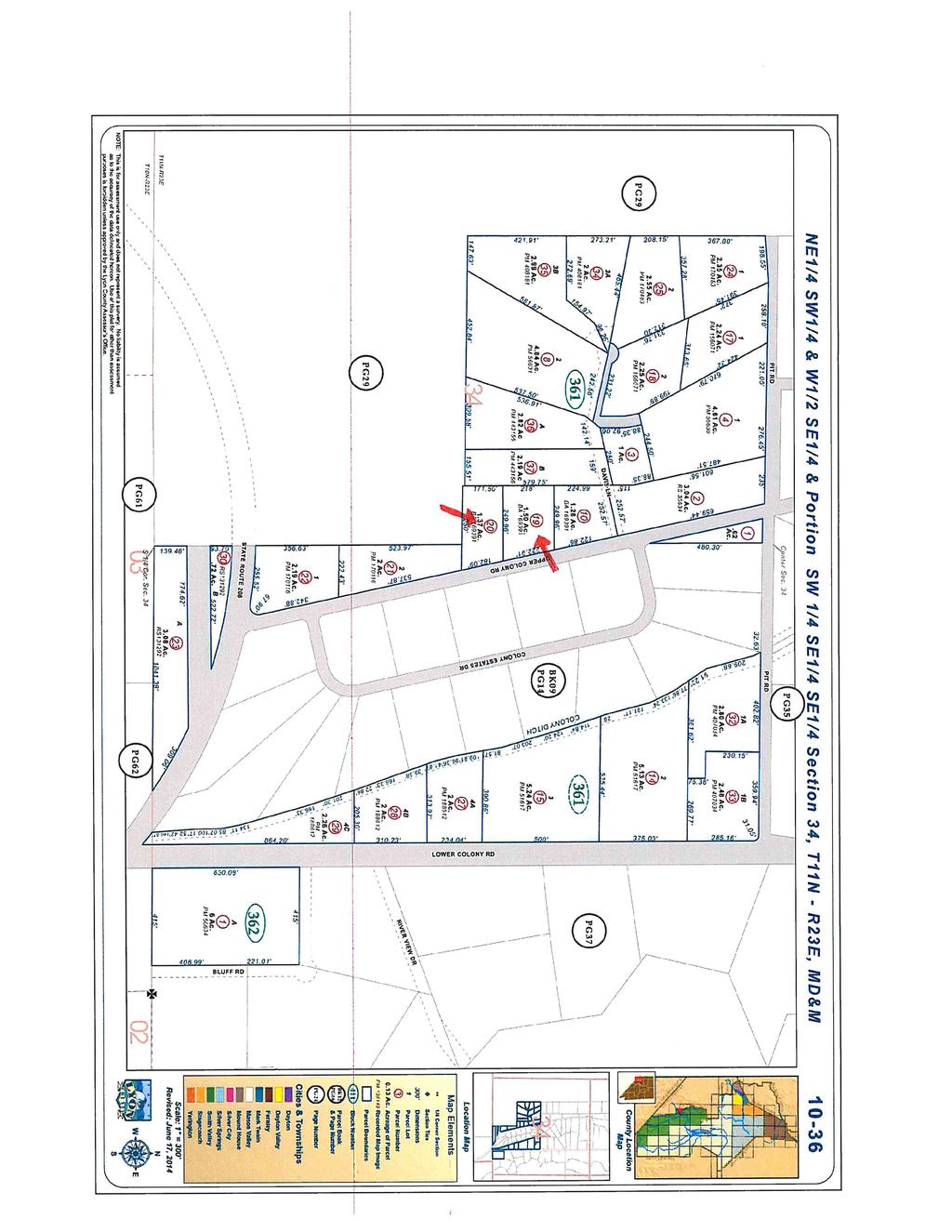
16 Lyon County Planning Commission Agenda Summary Meeting Date: January 9, 2018 Agenda Item Number: 8.b Subject: (For Possible Action) TESTA, ANTHONY & JUDITH REVERSION TO ACREAGE MAP - Request to revert a 1.5 acre parcel and a 1.37 acre parcel, both under common ownership, to 2.87 total acre parcel through the Reversion to Acreage Map process; located at 27 Upper Colony Rd., Wellington (APNs & PLZ Summary: Financial Department Comments: Approved As To Legal Form: County Manager Comments: Recommendation: ATTACHMENTS Continuance Memo 16
17 LYON COUNTY COMMUNITY DEVELOPMENT DEPARTMENT 27 S O U T H M A I N S T R E E T Y E R I N G T O N, N E V A D A P H O N E : ( ) F A X : ( 7 7 5) R O B E R T D. P Y Z E L P L A N N E R MEMORANDUM TO: FROM: SUBJECT: Lyon County Planning Commission Tammy Kinsley, Planner Anthony & Judith Testa Reversion to Acreage DATE: January 2, 2018 Dear Planning Commissioners; Staff has reviewed the reversion to acreage application submittal and materials, and have concerns with the provided information. We have contacted the applicant/owner and he is in concurrence of continuing this item, in order to work through these items and revise the map accordingly. Therefore, staff is recommending The Testa Reversion to Acreage application (PLZ ) be continued for thirty (30) days. 17
18 18
19 19

20 20
21 21
22 22
23 23
24 Lyon County Planning Commission Agenda Summary Meeting Date: January 9, 2018 Agenda Item Number: 8.c Subject: (For Possible Action) BALSAMO, JEFFERY REVERSION TO ACREAGE MAP - Request to revert a 2.09 acre parcel and a 2.05 acre parcel, both under common ownership, to 4.14 total acre parcel through the Reversion to Acreage Map process; located at 178 & 180 Highway 339, Yerington (APNs & PLZ Summary: Financial Department Comments: Approved As To Legal Form: County Manager Comments: Recommendation: ATTACHMENTS Staff Report 24
 463-6591 F AX: (775) 463-5305 34 L AKES BOULE V ARD D AYTON, N EVAD A 89403 (775) 246-6135 F AX: (775) 246-6147 Lyon County Planning Commission")
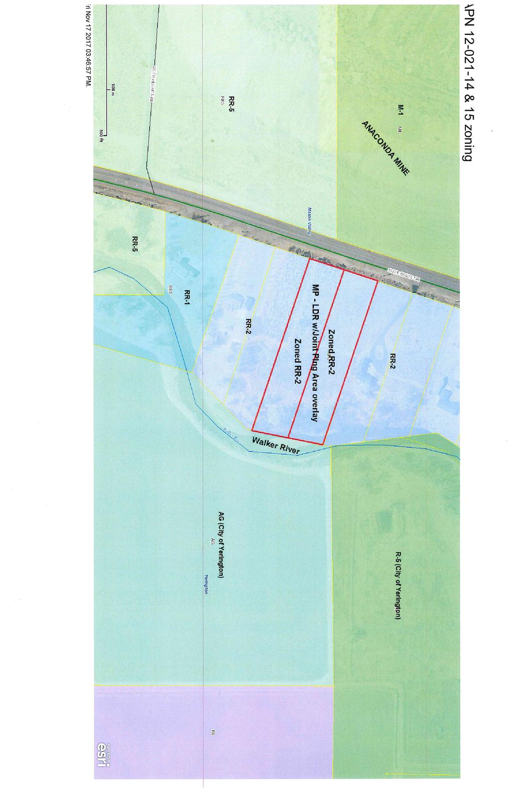
25 LYON COUNTY COMMUNITY DEVELOPMENT DEPARTMENT B U I L D I N G D E V E L O P M E N T E N G I N E E R I N G P L A N N I N G 27 S. M AIN STREET YER INGTON, N E VAD A (775) F AX: (775) L AKES BOULE V ARD D AYTON, N EVAD A (775) F AX: (775) Lyon County Planning Commission PLZ Reversion to Acreage Meeting Date: January 9, 2018 Owner(s): Jeffery Balsamo Applicant(s)/ Surveyor: Sierra Surveying; Charles Dan Church Location: 178 & 180 Hwy 339, Mason Valley Yerington, NV Parcel Number: (APNs) and Master Plan: Zoning: Flood Zone(s): Case Planner: Low Density Residential RR-2 Second Rural Residential two (2) acre minimum) X Unshaded (areas determined to be outside of the 500-year floodplain) and AE Flood zone (areas determined to be within the Special Flood Hazard Area) Tammy J. Kinsley Request: The owner/applicant, Jeffery Balsamo is requesting to revert two parcels into one parcel for the benefit of reducing the number of driveways on to Hwy 339, for future improvements constructed on the parcel. Location: The subject parcels are located at 178 and 180 Hwy 339, on the east side of Hwy 339, approximately 530 feet north of the intersection at Weed Heights Road, in the Mason Valley area of Yerington, Nevada. The parcels are currently vacant and have no other improvements. Page 1 of 8 Planning Commission Public Hearing January 9, 2018 Balsamo RTA Planning-tjk 25

26 Size: The subject parcels are sized as follows: APN = 2.09 Acres APN = 2.05 Acres The two parcels total approximately 4.14 acres in size. Assessor s Parcel Page Background: The action to combine parcels through the Reversion to Acreage process is found in NRS The statues afford an owner the opportunity to revert any recorded subdivision map, parcel map, map of division into large parcels, or part thereof to acreage or to revert the map or portion thereof, or to revert more than one map if the parcels are contiguous. These two parcels were originally created as Parcel A and Parcel B of A Parcel Map and Boundary Line Adjustment for Nevada West Packing (Doc# ) recorded in Lyon County on the 15 th day of July Page 2 of 8 Planning Commission Public Hearing January 9, 2018 Balsamo RTA Planning-tjk 26
 two (2) acre minimum.")

27 Document # Parcel Map and Boundary Line Adjustment dated July 15, 1993 Staff Review and Comments: Zoning: The subject site is zoned RR-2 (Second Rural Residential District) two (2) acre minimum. The Reversion to Acreage map will incorporate two contiguous parcels, increasing the size of the parcel to approximately 4.14 acres. This exceeds the minimum parcel size for this RR-2 zoning district. RR-2 Page 3 of 8 Planning Commission Public Hearing January 9, 2018 Balsamo RTA Planning-tjk 27
28 Access: Access to the newly created parcel will be from Hwy 339. This State highway is classified as a Major Collector and the speed limit at this area of the project site is set at 55 miles per hour (mph). Further the NDOT standard for driveway spacing on a major collector and at this speed limit is 2,640 feet between driveways. Currently there is an existing driveway to the north of the site approximately 131 feet from the north property line and a driveway to the south of the site, approximately151 feet from the south property line. Per NDOT based on their standards and the existing driveways in place, the owner would be allowed only one access on to HWY 339. Further per, Section , Subsection 3 and 4 (P.34) of the NDOT Access Standards (2017 Edition) one access is recommended for contiguous parcels under the same ownership. If the access spacing cannot be achieved because of the existing access driveways in place, a design deviation request (variance request) can be submitted by the property owner to NDOT; as per Section 2.2.5(P.20) of the NDOT Access Standards document. Location of site Currently there are two addresses assigned to the two separate parcels, 178 and 180 Hwy 339. At the time a building permit or site improvement permit is applied for and issued by the Lyon County Building Department, one address will be assigned to the one parcel created by this Reversion to Acreage map process. Page 4 of 8 Planning Commission Public Hearing January 9, 2018 Balsamo RTA Planning-tjk 28
 as per the Lyon County GIS and the FEMA FIRM Panel 32019C0858E dated January 16, 2009.")
.")
29 Flood Zone designations: The parcels have flood zone designations of X Unshaded (areas determined to be outside of the 500 year floodplain) and AE Flood zone (areas determined to be within the Special Flood Hazard Area) as per the Lyon County GIS and the FEMA FIRM Panel 32019C0858E dated January 16, Being that these two parcels have portions of the property located in the AE Special Flood Hazard Area (SFHA), combining the parcels into one parcel, reduces the number of parcels located in a SFHA.; a requirement for Lyon County s participation in the National Flood Insurance Program (NFIP). Lyon County GIS Exhibit FEMA FIRM Panel 32019C0858 E; Dated January 16, 2009 Page 5 of 8 Planning Commission Public Hearing January 9, 2018 Balsamo RTA Planning-tjk 29
30 STAFF RECOMMENDATION: Staff is in favor of the proposed reversion to acreage map as per any necessary conditions of approval. The proposed reversion to acreage conforms to requirements in both Nevada Revised Statutes and Lyon County Code. This action will not cause the new parcel to become non-conforming. A new parcel number will be assigned by the assessor s office once the map is recorded, provided it is approved by the Planning Commission. Staff s recommendation is based on the three findings and recommended conditions as listed in this staff report and substantiated in the public record. FINDNGS: A. The requested Reversion to Acreage map is consistent with the applicable provisions of Lyon County Code and the Nevada Revised Statures; B. The requested Reversion to Acreage map will not be detrimental to the public health, safety, convenience and welfare; and C. The requested Reversion to Acreage map will not result in material damage or prejudice to other property in the vicinity. Alternative Findings and Motions: The Planning Commission is authorized to take final action on Reversion to Acreage. alternative motions suggested below are offered for Planning Commission consideration. Alternative for Approval: If the Commission determines that there is sufficient reason to grant the Reversion to Acreage to this applicant, the Commission should make findings in support of the request and move for approval of the Reversion to Acreage map subject to the conditions listed below. The Planning Commission may wish to consider a motion similar to the following: The The Lyon County Planning Commission finds that: A. The requested Reversion to Acreage map is consistent with the applicable provisions of Lyon County Code and the Nevada Revised Statures; B. The requested Reversion to Acreage map will not be detrimental to the public health, safety, convenience and welfare; and C. The requested Reversion to Acreage map will not result in material damage or prejudice to other property in the vicinity. Based on the aforementioned findings, the Lyon County Planning Commission approves the Reversion to Acreage for Jeffery Balsamo on APN s and (PLZ ), subject to the following conditions: 1. The applicant shall pay the actual costs for County Engineer plan review and map checking and County Inspector site improvement inspection fees, in accordance with the adopted County fee resolution in effect at the time, and provide proof of payment to the Planning Department prior to map recordation. 2. The applicant shall provide the legal description and deed for the new parcel to record subsequent to the map. Page 6 of 8 Planning Commission Public Hearing January 9, 2018 Balsamo RTA Planning-tjk 30
31 3. The applicant shall comply with the map requirements as prescribed by NRS et seq. and Title 11 of the Lyon County code. 4. Should any public utility easement require abandonment as part of this action, documentation of the release of interest by all affected utility purveyors with interest shall be obtained prior to recording any abandonment or vacation documents. 5. The final map shall be conspicuously marked under the title The purpose of this map is to Revert to Acreage. 6. Structures placed on this newly created parcel shall adhere to the County s site and setback requirement standards for the zoning district. 7. The applicant shall provide the map of reversion to the Lyon County Planning Department for inclusion on the Lyon count GIS data base in a form compatible with the county geographic information system (GIS) pursuant to of the Lyon County Code. The scale of the site plan, improvements, monument and other items shall be in model space correctly oriented to the coordinate system as established by Lyon County. Cover Sheet and standard details need not be included. Alternative for Continuance If the Planning Commissioners determine that there is insufficient information with which to make a decision on the application before them, that additional information, discussion and public comment are necessary to have a more complete and thorough review of the proposed reversion to acreage map, then the Planning Commission should make the appropriate findings and move to continue the Public Hearing for the parcel map application. If so, then the Planning Commission may wish to consider a motion similar to the following: The Lyon County Planning Commission finds that: A. Additional information, discussion and public review are necessary for a more thorough review of the proposed reversion to acreage. Based on the finding listed above and the applicant s concurrence, the Planning Commission continues the Reversion to Acreage for Jeffery Balsamo on APN s and (PLZ ), for days. Alternative Motion for Denial: If the Planning Commission determines that they should deny the reversion to acreage application, then the Planning Commission may wish to consider a motion similar to the following: The Lyon County Planning Commission finds that: A. The requested reversion to acreage is not consistent with the applicable provisions of Lyon County Code and the Nevada Revised Statutes; B. The requested reversion to acreage will be detrimental to the public health, safety, convenience and welfare; and C. The requested reversion to acreage will result in material damage or prejudice to other properties in the area. Based on the aforementioned findings, the Lyon County Planning Commission denies the Reversion to Acreage for Jeffery Balsamo on APN s and (PLZ ). Page 7 of 8 Planning Commission Public Hearing January 9, 2018 Balsamo RTA Planning-tjk 31
32 LCC C: An applicant aggrieved by a decision of the planning commission may appeal to the Board of County Commissioners within thirty (30) days of the mailing of the decision. The Board of County Commissioners shall render their decision within forty five (45) days after filing of the appeal and payment of fees. Page 8 of 8 Planning Commission Public Hearing January 9, 2018 Balsamo RTA Planning-tjk 32
33 33
34 34
35 35
36 36
37 37

38 38

39 39
40 40
41 41
42 Lyon County Planning Commission Agenda Summary Meeting Date: January 9, 2018 Agenda Item Number: 8.d Subject: (For Possible Action) COPPER CANYON ESTATES 2016, LLC PARCEL MAP Request for a Parcel Map to divide a total acre parcel into two (2) parcels, the smallest being acres, for the purpose of creating a separate parcel for future sale and development; located off of Bryce Street, Dayton, NV (APN ) PLZ Summary: Financial Department Comments: Approved As To Legal Form: County Manager Comments: Recommendation: ATTACHMENTS Staff Report 42
43 LYON COUNTY COMMUNITY DEVELOPMENT DEPARTMENT B U I L D I N G D E V E L O P M E N T E N G I N E E R I N G P L A N N I N G 27 S. M AIN STREET YER INGTON, N E VAD A (775) F AX: (775) L AKES BOULE V ARD D AYTON, N EVAD A (775) F AX: (775) Lyon County Planning Commission PLZ Parcel Map to subdivide an existing gross acre property into two (2) parcels Meeting Date: January 9, 2018 Owner(s): Applicant(s): Surveyor: Location: Stonefield, Inc. Copper Canyon 2016, LLC Manhard Consulting/Karen Downs, Land Planner Bryce Street and Snow Lane, Dayton Parcel Number: (APN) Master Plan: Zoning: Flood Zone(s): Case Planner: Request: Suburban Residential E-1 (First Estates Residential 12,000 square foot minimum) X Unshaded (areas determined to be outside of the 500-year floodplain) Tammy J. Kinsley The applicant proposes that the above-referenced acre parcel be subdivided into two (2) parcels through the parcel map land division process. Proposed parcel A-1 would be approximately acres and propose Parcel A-2 would be approximately acres. The property is currently zoned E-1 (First Estates Residential 12,000 square foot minimum). As such, both of the proposed parcels would be in conformance with the minimum lot size requirement for the E-1 zoning district. STAFF RECOMMENDATION: Staff is in favor of the proposed parcel map if it is subject to the necessary conditions of approval. The parcel map is in compliance with the 2010 Comprehensive Master Plan land use designation as well as the minimum lot size requirements of the E-1 zoning district. As conditioned, adequate access will be provided and secured. Staff s recommendation is based on the findings and recommended conditions as listed in this staff report and substantiated in the public record. RECOMMENDED MOTION: I move that the Lyon County Planning Commission approves the parcel map consisting of two (2) parcels, the smallest being acres, within the total acre subject site for Copper Canyon 2016 LLC, APN (PLZ ), based on the following findings and subject to the conditions of approval: Page 1 of 12 Planning Commission Public Hearing January 9, 2018 Copper Canyon 2016 LLC Parcel Map Planning-tjk 43
44 Findings: A. The proposed parcel map conforms to the requirements set forth for the E-1, First Estates Residential (12,000 square foot) zoning district in Title 10 of the Lyon County Code, or such requirements can be met with the imposition of reasonable conditions of approval. B. The proposed parcel map conforms to the requirements set forth in Title 11 of the Lyon County Code or such requirements can be met with the imposition of reasonable conditions of approval. Conditions of Approval: 1. The applicant shall comply with all Federal, State, County and special purpose district regulations. 2. The water rights relinquishment for proposed Parcels A-1 and A-2 would be required prior to recordation the parcel map. 3. The applicant shall make corrections of any engineering or drafting errors and other technical map corrections to the satisfaction of the County Engineer and Planning Director prior to submitting the map for recordation. 4. The applicant shall pay the actual costs for County Engineer plan and map checking and County Inspector site improvement inspection fees, in accordance with the adopted County fee resolution in effect at the time, and provide proof of payment to the Planning Department prior to map recordation. 5. The applicant shall comply with Lyon County s 1996 drainage guidelines, as revised. 6. The applicant shall comply with Lyon County improvement requirements as set forth in Chapter of the Lyon County Code. 7. The applicant shall comply with all applicable fire code requirements to the satisfaction of the Central Lyon County Fire Protection District. 8. No lot shall be offered for sale or sold and no building permits shall be accepted for processing until the final parcel map has been approved and recorded. 9. The applicant shall comply with dedication or relinquishment of water rights necessary to insure an adequate water supply for residential use of the newly created parcels prior to recordation of the final parcel map. 10. The final parcel map will comply with the current County 7.5-foot and 5-foot public utility easement standards on all parcels prior to recordation. 11. The following items are required of all development: a. All construction shall comply with all applicable building and fire code requirements. b. Building permits shall be issued in compliance with Titles 10 and 11 of the Lyon County Code. c. Site development work will require a grading permit(s) in accordance with Title (F). d. Structures placed on these parcels shall adhere to the County s site and setback standards for the zoning district as it applies to each parcel at the time of development. e. Distinct and legible temporary addresses are required of any structures under construction until such time as permanent address numbers are installed and posted. f. All debris on construction sites must be contained and removed periodically as required for safety and cleanliness to the satisfaction of the Lyon County Building Department. Page 2 of 12 Planning Commission Public Hearing January 9, 2018 Copper Canyon 2016 LLC Parcel Map Planning-tjk 44
 and any applicable agricultural deferred taxes prior to recordation of the final parcel map. 13.")
45 g. Prior to any combustible materials being brought on site street name signage shall be installed, if applicable. 12. The applicant shall pay in full all property taxes through the end of the fiscal year (June 30) and any applicable agricultural deferred taxes prior to recordation of the final parcel map. 13. The applicant shall pay required recording fees at time of final parcel map recordation. 14. Any further division may be subject to the imposition of subdivision improvement standards as may be legally imposed at the time. The applicant shall place a note to this effect on the final parcel map prior to recordation. 15. Approval of the tentative parcel map shall not constitute acceptance of the final parcel map. Approval of the tentative parcel map shall lapse unless a final parcel map based thereon is submitted within two (2) years from the date of such approval. No extension may be granted after receiving approval of the tentative parcel map. 16. The applicant shall provide the parcel map to the Lyon County GIS Coordinator in form and format compatible with the County geographical information system (GIS) pursuant to of the Lyon County Code. The scale of the site plan, improvements, monuments and other items shall be in model space correctly oriented to coordinate system as established by the GIS Coordinator. Cover sheet and standard details need not be included. General Information Property Location: The project site is located on the north side of Highway 50 and accessed off of Bryce Street, then west on future access and P.U.E. Snow Lane in Dayton, NV. Page 3 of 12 Planning Commission Public Hearing January 9, 2018 Copper Canyon 2016 LLC Parcel Map Planning-tjk 45

46 Size: Background: The subject site is acres in size. The original tentative map for Copper Canyon Estates was approved by the Board of Commissioners on October 14, 2003 to allow the subdivision of approximately 320 acres into 687 single family residential lots. No final subdivision map has been approved and recorded since Copper Canyon Estates Phase 1 Unit 1 on March 19, 2007 (Document #402690). As such the original approval for the tentative subdivision map for Copper Canyon Estates expired. Per Nevada Revised Statutes, in order to move further in development of the Copper Canyon Subdivision, the developer was required to come back through the tentative subdivision map process. In order to accomplish this task, the developer was approved through the merger and re-subdivision approval of 2016 to merge the acres of the adjusted Remainder Parcel of the Record of Survey in support of a Boundary Line Adjustment for Reynen & Bartis (Copper Canyon), LLC and MW Housing Partners III, LP (Document #401403) and the acres Remainder Parcel of the Copper Canyon Estates Phase 1 Unit 1 Final Map (Document #402690) into one approximately acre parcel and resubdivision of the merged acre parcel via a tentative subdivision map for 585 single family residential lots. This merger and resubdivision action created a single parcel that makes up the remaining area covered in the original Copper Canyon Estates tentative map approval granted in The developer requested to re-establish a property line that was relocated through a Boundary Line Adjustment (Doc. #561448) through this parcel map request. As indicated below, the Boundary Line Adjustment relocated the formerly east-west running property line (highlighted in yellow) to a new alignment running north-south (also highlighted in yellow). This proposal can be seen when comparing the below Boundary Line Adjustment map to the proposed parcel map with the new property line highlighted in yellow below: Page 4 of 12 Planning Commission Public Hearing January 9, 2018 Copper Canyon 2016 LLC Parcel Map Planning-tjk 46
.")

47 Most recently on October 10, 2017 a Final Parcel Map (Doc # ) was recorded creating the Parcels B-1 and B-2. Staff Review and Comments: Zoning: The subject site is zoned E-1 (First Estates Residential District). Both the resulting parcels to be created through the proposed parcel map are in excess of 12,000 square feet in size. Proposed Parcel A-1 would be approximately acres in size and proposed Parcel A-2 would be approximately acres in size. E-1 Page 5 of 12 Planning Commission Public Hearing January 9, 2018 Copper Canyon 2016 LLC Parcel Map Planning-tjk 47

48 While the site has been partially mass-graded and there is some of the required infrastructure installed for the future further subdivision of the subject site, there are no above-ground structures that must comply with the required E-1 building setbacks from property lines. The proposed parcel map would be in compliance with the E-1 minimum 12,000-square foot minimum lot size. Any new development on the two parcels being created through the parcel map process would have to comply with the E-1 development standards and land use regulations. Floodplain: The property is designated on the County s FEMA Flood Insurance Rate Map (FEMA Panel 32019C0305E dated 1/16/2009) and through the Geographic Information System ( GIS ) as Zone X Unshaded. The X Unshaded Zone are areas that are located outside of the 500-year floodplain. Limits of Floodplain (SFHA) Improvement Requirements and Water Rights Dedication: The proposed parcel map must meet the minimum discretionary requirements and mandatory water rights requirements set forth in Lyon County Code ( LCC ) Section Requirements: Discretionary requirements and mandatory water rights requirements are as follows: A. Discretionary Requirements: Requirements which may be imposed by the planning commission are as follows: 1. Street grading, drainage provisions and lot designs as are reasonably necessary. Page 6 of 12 Planning Commission Public Hearing January 9, 2018 Copper Canyon 2016 LLC Parcel Map Planning-tjk 48
49 2. Off-site access, street alignment, surfacing and width, water quality and sewage provisions as are reasonably necessary and consistent with the existing use of any land zoned for similar use which is within six hundred sixty feet (660') of the proposed parcel. The planning commission may require additional improvements that are reasonably necessary and consistent with the use of land if it is developed as proposed. 3. For a second or subsequent parcel map with respect to a single parcel, or contiguous tract of land under the same ownership, any reasonable improvement, but not more than would be required if the parcel was developed as a subdivision. B. Mandatory Water Rights Dedication or Relinquishment Requirements: All parcel maps submitted for approval must dedicate or relinquish water rights as follows: 1. If the parcel map is not within the existing boundaries of a municipal or private water system and the newly created parcels are to be served by domestic well: (a) The parcel owner shall relinquish to the State Engineer water rights necessary to insure an adequate water supply for the domestic use of the newly created parcels from within the water basin in which the parcel is located; and (b) Relinquishment of water rights in paragraph 1(A) shall be at the applicant s cost; and (c) For purposes of this section, necessary water rights required by paragraph 1(a) shall be 2.00 acre feet per year valid underground water rights; and (d) No parcel map shall be recorded by the County until the requirements in paragraph 1 have been satisfied. 2. If the parcel map is within the existing boundaries of a municipal or private water system: (a) The dedication or relinquishment of water rights necessary to ensure an adequate water supply for the domestic use of the newly created parcels shall follow the rules and requirements of that system, or a written statement from the municipal or private water system that no dedication or relinquishment requirements exist, or that dedication or relinquishment requirements have been satisfied, must be submitted before any map may be recorded; and (b) Dedication or relinquishment of the water rights shall be at the applicant's cost; and (c) For purposes of this section, necessary water rights required by subsection B2a of this section shall be determined by the rules and requirements of the municipal or private water system. (Ord. 520, Page 7 of 12 Planning Commission Public Hearing January 9, 2018 Copper Canyon 2016 LLC Parcel Map Planning-tjk 49
50 Access: LCC Chapter (A) (2)(c) requires a minimum road easement width of 50 feet with an improved section of not more than 36 feet width if the local road has the future potential to provide access for more than forty (40) lots. The overall site is accessed by a 60-foot wide road (Bryce Street). This parcel map proposes the 60-foot wide access and P.U.E. per F.M. # (Snow Lane) be utilized as access to the proposed parcel A-2. Within parcel A-2, a 60-foot wide access and P.U.E. will be granted with this parcel map request to provide access to parcel A Access and P.U.E. Hereby granted with this parcel map. 60 Access and P.U.E. Per F.M. # (Snow Lane) LCC D.6 details the standards for roadway improvement required for county roads existing or proposed at the time of subdivision. The table included in LCC Section D.6 requires that subdivisions and subsequent parcel maps in the E-1 zoning district are subject to urban street improvement road standards (asphalt-concrete streets, curbs, gutters and sidewalks). Bryce Street currently has these improvements installed to the boundary of the subject site. As further subdivision occurs, the same urban development standards will be required to be installed as the street system moves into the subject site as part of the final map/site improvement permit processes. Additionally, a 60-foot wide access and public utility easement running roughly parallel to the southern property line of proposed Parcel B-2 is shown in conformance with an access and public utility easement recorded per a previous subdivision map (Doc. #402690). Fire Protection: The property is within the Central Lyon County Fire Protection District ( CLCFPD ). Given that future final subdivision maps will be forthcoming on the subject site, CLCFPD did not forward any comments regarding the parcel map. Page 8 of 12 Planning Commission Public Hearing January 9, 2018 Copper Canyon 2016 LLC Parcel Map Planning-tjk 50
51 Public Utility Easements: Lyon County s current standard for public utility easements listed in Chapter (E) requires a minimum 7.5-foot utility easement in the front yard of a parcel and a minimum 5-foot utility easement along all other property lines. The parcel map will need to be revised to comply with the current County 7.5-foot and 5-foot public utility easement standards. Water Rights: LCC Chapter (B) states that: B. Mandatory Water Rights Dedication Or Relinquishment Requirements: All parcel maps submitted for approval must dedicate or relinquish water rights as follows: 1. If the parcel map is not within the existing boundaries of a municipal or private water system and the newly created parcels are to be served by domestic well: a. The parcel owner shall relinquish to the state engineer water rights necessary to ensure an adequate water supply for the domestic use of the newly created parcels from within the water basin in which the parcel is located; and b. Relinquishment of water rights in subsection B1a of this section shall be at the applicant's cost; and c. For purposes of this section, necessary water rights required by subsection B1a of this section shall be 2.00 acre-feet per year valid underground water rights; and d. No parcel map shall be recorded by the county until the requirements in this subsection B1 have been satisfied. LCC Chapter sets out the mandatory and discretionary requirements for Parcel Maps. County Code and Nevada Revised Statutes permits the imposition of reasonable requirements as part of the approval of a parcel map. The subject site is located within the existing boundaries of a municipal or private water system Lyon County Utility Department. The water rights relinquishment for proposed Parcels A-1 and A-2 would be required prior to recordation the parcel map. Page 9 of 12 Planning Commission Public Hearing January 9, 2018 Copper Canyon 2016 LLC Parcel Map Planning-tjk 51
52 Water Supply and Sewer Service: As noted above, the subject site is currently served by Lyon County Utility Department for both domestic water service and domestic sewer service. Water: Sewer: Page 10 of 12 Planning Commission Public Hearing January 9, 2018 Copper Canyon 2016 LLC Parcel Map Planning-tjk 52
53 Drainage: The existing drainage on the subject site is illustrated below: The developer has submitted a Preliminary Drainage Study dated October 17, 2016 with the parcel map application materials originally submitted as a part of the tentative subdivision map which included the subject site. The preliminary drainage study was conducted to evaluate drainage impacts for the acres comprising the remaining residential portion of the Copper Canyon Estates subdivision. As a part of the tentative subdivision map application, the drainage study recommended construction of a series of trapezoidal channels, either 24 or 48 feet in width which will capture and direct off-site and some on-site flows into existing drainage channels and the existing detention basin (designated as Pond No.3 constructed with Copper Canyon Estates Phase 1, Unit 1) as well as two new detention basins to be constructed with the building of the remaining tentative map project area. The preliminary drainage report states that the new detention basins, culverts and channels were designed to mitigate the 100-year event peak flows to pre-development (or existing) flows. The project site will also tie into existing storm drainage facilities with curb and gutter, storm drain inlets, storm drain pipes and swales. After detaining the flows, the discharge on the east side of the project will flow into the existing eastern ditch channel located adjacent to Copper Canyon Estates Phase 1, Unit 1 and into an existing storm drain pipe located under Highway 50 while the discharge from the west side of the project will flow into the culvert located under Wells Fargo Avenue and then on to the natural drainage ways south of the subject site. The developer must comply with Lyon County s adopted 1996 storm drainage guidelines to include the preparation of a final drainage report to be submitted with the final map(s) for the project in accordance with the County s storm water standards for onsite retention/detention of storm water for the entire development that may occur from the addition of impervious surfaces. The report must address offsite flows, and how they will be routed through the site and discharged without additional impact to downstream properties. Drainage facilities, including off-site facilities and easements necessary to carry and process stormwater generated by the project, must be included in subdivision improvement plans that are required to be submitted to and approved by the County Engineer prior to recording a final map(s) for the project. As such, staff is of the opinion that the drainage of the subject site and surrounding properties has been properly considered and will be dealt with as the subject site develops. Page 11 of 12 Planning Commission Public Hearing January 9, 2018 Copper Canyon 2016 LLC Parcel Map Planning-tjk 53
54 Alternatives to the Staff Recommendations: Alternative for Continuance If the Planning Commissioners determine that there is insufficient information with which to make a decision on the application before them, that additional information, discussion and public comment are necessary to have a more complete and thorough review of the proposed parcel map, then the Planning Commission should make the appropriate findings and move to continue the Public Hearing for the parcel map application. If so, then the Planning Commission may wish to consider a motion similar to the following: The Lyon County Planning Commission finds that: A. Additional information, discussion and public review are necessary for a more thorough review of the proposed parcel map. Based on the finding listed above and the applicant s concurrence, the Planning Commission continues the parcel map consisting of two (2) parcels, the smallest being acres, within the total acre subject site for Copper Canyon 2016 LLC, APN (PLZ ), for days. Alternative Motion for Denial: If the Planning Commission determines that they should deny the parcel map application, then the Planning Commission may wish to consider a motion similar to the following: The Lyon County Planning Commission finds that: A. The parcel map is not in substantial compliance with the Master Plan goals, objectives and actions. B. The parcel map is not in substantial compliance with the requirements of Title 11 of the Lyon County Code. C. The proposed use will be detrimental to the public health, safety, convenience and welfare, D. The proposed use will result in material damage or prejudice to other properties in the area. Based on the aforementioned findings, the Lyon County Planning Commission denies the parcel map consisting of two (2) parcels, the smallest acres, within the total acre subject site for Copper Canyon 2016 LLC, APN (PLZ ). LCC C: An applicant aggrieved by a decision of the planning commission may appeal to the Board of County Commissioners within thirty (30) days of the mailing of the decision. The Board of County Commissioners shall render their decision within forty five (45) days after filing of the appeal and payment of fees. Page 12 of 12 Planning Commission Public Hearing January 9, 2018 Copper Canyon 2016 LLC Parcel Map Planning-tjk 54

55 November 13 th, 2017 Mr. Rob Pyzel Lyon County Planning Department 27 S. Main Street Yerington, NV Civil Engineering Surveying Water Resources Management Water & Wastewater Engineering Supply Chain Logistics Construction Management Environmental Sciences Landscape Architecture Land Planning RE: COPPER CANYON PARCEL MAP REQUEST (APN ) Dear Rob, On behalf of Copper Canyon 2016 LLC, Manhard Consulting, is pleased to submit the enclosed Parcel Map Application request for APN , a portion of Copper Canyon Estates. The following application materials are included: Parcel Map Application Fee ($2,000) Development Application Project Description & Justification (included as part of this letter) Parcel Map Reduced Map Vicinity Map Title Report (including Legal Description) Site Photographs Drainage Report Traffic Study Geotechnical Report Will Serve Letters Street Name Request Form (from 2016 Tentative Map Application) Project Description & Justification A Tentative Map was approved by the Lyon County Board of County Commissioners on January 3, 2017 to subdivide the project site into 585 residential lots (consistent with the Tentative Map for Copper Canyon Estates approved on October 14, 2003). The property included in this request is located in the Mark Twain area of Dayton, Nevada approximately one mile northeast of the junction of US Highway 50 and Six Mile Canyon. It has a current Lyon County master plan designation of Suburban Residential (SUB) and a current Lyon County zoning designation of First Estate Residential District (E-1). 55
56 This intent of this Parcel Map application (APN ; ) is to create a separate parcel for sale that will allow the developer to implement the approved Tentative Map. The Parcel Map request is consistent with the goals and policy outlined in the Lyon County Master Plan and is designed in accordance with the applicable Lyon County Municipal Code requirements. As required by the approved Tentative map, the necessary infrastructure required to service the proposed project is currently in place, or planned to be in place, prior to the recordation of the residential lots. Based on the proposed project s consistency with the Lyon County master plan and zoning designations and the property s previous Tentative Map approval history, Manhard Consulting believes the enclosed Parcel Map application requested is justified. Thank you for your consideration of the enclosed request and your continued assistance with this project. If you have any questions or require any additional information, please feel free to contact me or Jerry Juarez, Survey Manager. Sincerely, Manhard Consulting Karen Downs Land Planner 56
57 57 PARCEL MAP FOR STONEFIELD, INC. LYON COUNTY A DIVISION OF PARCEL A-1 OF PM SITUATE IN SECTION 22, T.17N., R.22E., MDM TM DRAWN BY: DATE: PROJ. CODE: PROJ. #: SHEET OF NEVADA 1 3
58 58 NORTH PARCEL MAP FOR STONEFIELD, INC. LYON COUNTY A DIVISION OF PARCEL A-1 OF PM SITUATE IN SECTION 22, T.17N., R.22E., MDM TM DRAWN BY: DATE: PROJ. CODE: PROJ. #: SHEET OF NEVADA 2 3
59 59 PARCEL MAP FOR STONEFIELD, INC. LYON COUNTY A DIVISION OF PARCEL A-1 OF PM SITUATE IN SECTION 22, T.17N., R.22E., MDM TM DRAWN BY: DATE: PROJ. CODE: PROJ. #: SHEET OF NEVADA 3 3
60 Lyon County Planning Commission Agenda Summary Meeting Date: January 9, 2018 Agenda Item Number: 10.a Subject: (Discussion and Possible Action) The annual review of the Lyon County Public Lands Policy with comments and recommendations to be forwarded to the Board of Commissioners Summary: Financial Department Comments: Approved As To Legal Form: County Manager Comments: Recommendation: ATTACHMENTS APPROVED PUBLIC LANDS POLICY

61 LYON COUNTY PUBLIC LANDS POLICY Original adopted by BOC - May 16, st revision adopted by BOC - August 12, nd revision adopted by BOC March 10, rd revision adopted by BOC April 21,
LYON COUNTY PLANNING COMMISSION TUESDAY, FEBRUARY 13, :00 AM LYON COUNTY ADMINISTRATIVE COMPLEX 27 S. MAIN STREET YERINGTON, NV AGENDA
 LYON COUNTY PLANNING COMMISSION TUESDAY, FEBRUARY 13, 2018 9:00 AM LYON COUNTY ADMINISTRATIVE COMPLEX 27 S. MAIN STREET YERINGTON, NV 89447 AGENDA (Action will be taken on all items unless otherwise noted)
LYON COUNTY COMMUNITY DEVELOPMENT DEPARTMENT
 LYON COUNTY COMMUNITY DEVELOPMENT DEPARTMENT B UILDING D EVELOPMENT E NGINEERING P LANNING 27 S. MAIN S TREET Y ERINGTON, NEVADA 89447 (775) 463-6591 F AX: (775) 463-5305 34 LAKES B OULEVARD D AYTON, NEVADA
LYON COUNTY PLANNING COMMISSION TUESDAY, APRIL 09, :00 AM LYON COUNTY ADMINISTRATIVE COMPLEX 27 S. MAIN STREET YERINGTON, NV AGENDA
 LYON COUNTY PLANNING COMMISSION TUESDAY, APRIL 09, 2019 9:00 AM LYON COUNTY ADMINISTRATIVE COMPLEX 27 S. MAIN STREET YERINGTON, NV 89447 AGENDA (Action will be taken on all items unless otherwise noted)
LYON COUNTY PLANNING COMMISSION TUESDAY, SEPTEMBER 12, :00 AM LYON COUNTY ADMINISTRATIVE COMPLEX 27 S. MAIN STREET YERINGTON, NV AGENDA
 LYON COUNTY PLANNING COMMISSION TUESDAY, SEPTEMBER 12, 2017 9:00 AM LYON COUNTY ADMINISTRATIVE COMPLEX 27 S. MAIN STREET YERINGTON, NV 89447 AGENDA (Action will be taken on all items unless otherwise noted)
Parcel Map Review Committee Staff Report
 Parcel Map Review Committee Staff Report Meeting Date: October 11, 2018 Agenda Item: 7A TENTATIVE PARCEL MAP CASE NUMBER: (Larkins) BRIEF SUMMARY OF REQUEST: Request to divide one parcel of ±1.084-acres
LYON COUNTY PLANNING COMMISSION REGULAR AGENDA COMMISSIONERS MEETING ROOM LYON COUNTY ADMINISTRATIVE COMPLEX 27 SOUTH MAIN STREET YERINGTON, NEVADA
 LYON COUNTY PLANNING COMMISSION REGULAR AGENDA COMMISSIONERS MEETING ROOM LYON COUNTY ADMINISTRATIVE COMPLEX 27 SOUTH MAIN STREET YERINGTON, NEVADA July 8, 2008 Due to mechanical failure, these minutes
LYON COUNTY PLANNING COMMISSION MEETING MINUTES SEPTEMBER 10, 2013 The Lyon County Planning Commission met this day with a quorum.
 LYON COUNTY PLANNING COMMISSION MEETING MINUTES SEPTEMBER 10, 2013 The Lyon County Planning Commission met this day with a quorum. The following members were present: Larry Wahrenbrock, Betty Retzer, Harold
Parcel Map Review Committee Staff Report Meeting Date: October 8, 2015
 Parcel Map Review Committee Staff Report Meeting Date: October 8, 2015 Subject: Applicant: Agenda Item Number: Project Summary: Recommendation: Parcel Map Case Number Reeves Business Ventures 7D Divide
LYON COUNTY TITLE 15 LAND USE AND DEVELOPMENT CODE LAND DIVISION REGULATIONS CHAPTERS October 19, 2017 Ordinance Draft DRAFT
 DRAFT LYON COUNTY TITLE 15 LAND USE AND DEVELOPMENT CODE LAND DIVISION REGULATIONS CHAPTERS 15.600 15.607 October 19, 2017 Ordinance Draft This page left blank intentionally DRAFT DRAFT Lyon County Contents
Parcel Map Review Committee Staff Report Meeting Date: March 12, 2015
 Subject: Applicant(s): Agenda Item Number: Parcel Map Review Committee Staff Report Meeting Date: March 12, 2015 Parcel Map Case Number William and Maryanne Paganetti 7B Project Summary: Dividing a 14.2
NRCS Floodplain Easement Program Sheffield Brook Floodplain Restoration. Lesley R. Sweeney, PE USDA Natural Resources Conservation Service
 NRCS Floodplain Easement Program Sheffield Brook Floodplain Restoration Lesley R. Sweeney, PE USDA Natural Resources Conservation Service Natural Resources Conservation Service (NRCS) A Voluntary Federal
All items include discussion and possible action to approve, modify, deny, or continue unless marked otherwise.
 Storey County Planning Commission Meeting and Public Workshop Agenda Thursday April 18, 2019 6:00 p.m. Lockwood Senior/Community Center 800 Peri Ranch Road, Lockwood, NV Jim Hindle Chairman Jim Collins
All items include discussion and possible action to approve, modify, deny, or continue unless marked otherwise.
 Jim Hindle Chairman Jim Collins Planning Commissioner Larry Prater Planning Commissioner Summer Pellett- Planning Commissioner Storey County Planning Commission Meeting Agenda Thursday November 1, 2018
Elko County Planning Commission ELKO COUNTY PLANNING COMMISSION MINUTES
 0 0 0 0 Elko County Planning Commission 0 COURT STREET, SUITE 0, ELKO, NV 0 PH. ()-, FAX () - ELKO COUNTY PLANNING COMMISSION MINUTES THURSDAY, FEBRUARY, 0 : P.M. CALL TO ORDER: The meeting of the Elko
MINUTES OF THE TOWN OF LADY LAKE REGULAR PLANNING AND ZONING BOARD MEETING LADY LAKE, FLORIDA. May 8, :30 p.m.
 MINUTES OF THE TOWN OF LADY LAKE REGULAR PLANNING AND ZONING BOARD MEETING LADY LAKE, FLORIDA May 8, 2017 5:30 p.m. The Planning and Zoning Board Meeting was held in the Town Hall Commission Chambers at
Parcel Map Review Committee Staff Report Meeting Date: May 12, 2016
 Subject: Applicant: Agenda Item Number: Project Summary: Recommendation: Parcel Map Review Committee Staff Report Meeting Date: May 12, 2016 Tentative Parcel Map Case Number TL Mt. Rose Estates, LP 7C
Parcel Map Review Committee Staff Report Meeting Date: October 13, 2016
 Subject: Applicant: Agenda Item Number: Project Summary: Recommendation: Parcel Map Review Committee Staff Report Meeting Date: October 13, 2016 Parcel Map Case Number Spanish Springs Associates Ltd. Ptsp.
DRAFT. 1. Determination of Quorum Eric Young called the meeting to order at 1:31 p.m. The following members and staff were present:
 WASHOE COUNTY PARCEL MAP REVIEW COMMITTEE Meeting Minutes Parcel Map Review Committee Members Thursday, December 8, 2016 1:30 p.m. James Barnes, Planning Commission James English, Health District Tim Simpson,
LINCOLN COUNTY PLANNING COMMISSION PO Box 329, Pioche, NV Phone , Fax
 LINCOLN COUNTY PLANNING COMMISSION PO Box 329, Pioche, NV 89043 Phone 775-962-5345, Fax 775-962-5347 Approved Minutes for January 14, 2008, 7:00 P.M. 1. Roll Call, Open Meeting Law: The Board met in regular
HOW TO APPLY FOR A USE PERMIT
 HOW TO APPLY FOR A USE PERMIT MENDOCINO COUNTY PLANNING AND BUILDING SERVICES What is the purpose of a use permit? Throughout the County, people use their properties in many different ways. They build
STOREY COUNTY PLANNING COMMISSION MEETING Thursday, April 7, :00 p.m. 500 Sam Clemens Ave., Mark Twain Estates Mark Twain, NV 89403
 STOREY COUNTY PLANNING COMMISSION MEETING Thursday, April 7, 2016 6:00 p.m. 500 Sam Clemens Ave., Mark Twain Estates Mark Twain, NV 89403 MEETING MINUTES CHAIRMAN: Larry Prater VICE-CHAIRMAN: Jim Hindle
Tentative Map Application Review Procedures
 FOR REFERENCE ONLY This page is not part of the application. Tentative Map Application Review Procedures The tentative map process in Churchill County is designed to provide a mechanism in order to divide
1. Roll Call. 2. Minutes a. September 24, 2018 Special Joint Meeting with Clay County Planning Commission. 3. Adoption of the Agenda
 1. Roll Call City of Vermillion Planning Commission Agenda 5:30 p.m. Regular Meeting Tuesday, October 9, 2018 City Council Chambers 2 nd Floor City Hall 25 Center Street Vermillion, SD 57069 2. Minutes
AGENDA PLANNING COMMISSION Tuesday, April 18, :00 PM City Council Chambers 125 East Avenue B, Hutchinson, Kansas
 AGENDA PLANNING COMMISSION Tuesday, April 18, 2017 5:00 PM City Council Chambers 125 East Avenue B, Hutchinson, Kansas 1. ROLL CALL Macklin Woleslagel Bisbee (Chair) Hamilton Peirce Vacant Carr Hornbeck
FERNLEY PLANNING COMMISSION MEETING MINUTES JULY 11, 2018
 FERNLEY PLANNING COMMISSION MEETING MINUTES JULY 11, 2018 Mayor Edgington called the meeting to order at 5:02 p.m. at Fernley City Hall, 595 Silver Lace Blvd, Fernley, NV. 1. ROLL CALL Present: Chairman
BOARD OF COUNTY COMMISSIONERS ARCHULETA COUNTY, COLORADO RESOLUTION 2018-
 BOARD OF COUNTY COMMISSIONERS ARCHULETA COUNTY, COLORADO RESOLUTION 2018- ARCHULETA COUNTY IMPROPERLY DIVIDED PARCELS EXEMPTION INTERIM RESOLUTION - A RESOLUTION ADDRESSING PARCELS UNDER THE SIZE OF 35
Community Dev. Coord./Deputy City Recorder
 1 2 3 4 5 6 7 8 9 10 11 12 13 14 15 16 17 18 19 20 21 22 23 24 25 26 27 28 29 30 31 32 33 34 35 36 37 38 39 40 41 42 43 44 45 46 NORTH OGDEN PLANNING COMMISSION MEETING MINUTES December 18, 2013 The North
A G E N D A. Minutes of the September 13, 2016, special meeting.
 CITY OF GALESBURG Community Development Memo Operating Under Council Manager Government Since 1957 TO: FROM: Planning and Zoning Commission Members Steve Gugliotta, AICP, Acting Planning Manager DATE:
MINOR SUBDIVISION INFORMATION
 A. POINTS OF CONTACT: MINOR SUBDIVISION INFORMATION Surveyor: Address: Phone #: Fax # E-Mail Address: Representative (If different from applicant): Address: Phone #: Fax # E-Mail Address: B. GENERAL INFORMATION:
Reference Document Do Not Copy
 Parcel Map, Division Into Large Parcels, and Reversion to Acreage Map Review Procedures The parcel map process in Churchill County is designed to provide a mechanism in order to divide a parcel or parcels
LAND USE AND ZONING OVERVIEW
 OVERVIEW OF PLANNING POLICIES LAND USE AND ZONING OVERVIEW The Minneapolis Plan for Sustainable Growth and Other Adopted Plans Community Planning and Economic Development Development Services Division
DEPARTMENT OF FISH AND WILDLIFE ENVIRONMENTAL FILING FEES (Fish and Game Code 711.4)
") PARCEL MAP PROCESS DEPARTMENT OF PLANNING AND BUILDING SERVICES 707 Nevada Street, Suite 5 Susanville, CA 96130-3912 (530) 251-8269 (530) 251-8373 (fax) www.co.lassen.ca.us A subdivision is any division
PARCEL MAP PROCESS DEPARTMENT OF PLANNING AND BUILDING SERVICES 707 Nevada Street, Suite 5 Susanville, CA 96130-3912 (530) 251-8269 (530) 251-8373 (fax) www.co.lassen.ca.us A subdivision is any division
PLANNING & ZONING COMMISSION CITY OF PALMER, ALASKA REGULAR MEETING THURSDAY, JULY 17, :00 P.M. - COUNCIL CHAMBERS
 PLANNING & ZONING COMMISSION CITY OF PALMER, ALASKA REGULAR MEETING THURSDAY, JULY 17, 2014 7:00 P.M. - COUNCIL CHAMBERS A. CALL TO ORDER: The regular meeting of the Planning and Zoning Commission was
MINUTES OF THE TOWN OF LADY LAKE REGULAR PLANNING AND ZONING BOARD MEETING LADY LAKE, FLORIDA. February 8, :30pm
 MINUTES OF THE TOWN OF LADY LAKE REGULAR PLANNING AND ZONING BOARD MEETING LADY LAKE, FLORIDA 5:30pm The Planning and Zoning Board Meeting was held in the Town Hall Commission Chambers at 409 Fennell Blvd.,
Catherine Dreher; Gerry Prinster; Kevin DeSain; David Bauer; and Vicki LaRose
 MINUTES OF REGULAR MEETING ST. CHARLES COUNTY BOARD OF ZONING ADJUSTMENT DATE: June 1, 2017 TIME: PLACE: 7:00 P.M. COUNTY ADMINISTRATIVE BUILDING 201 NORTH SECOND ST. FIRST FLOOR MULTI-PURPOSE ROOM 116
Article 6: Planned Unit Developments
 LUDC 2013 GARFIELD COUNTY, COLORADO Article 6: Planned Unit Developments ARTICLE 6 PLANNED UNIT DEVELOPMENTS TABLE OF CONTENTS DIVISION 1. GENERAL.... 1 6-101. GENERAL PROVISIONS.... 1 A. Purpose....
Certified Survey Map (CSM) Submittal Updated: 6/29/18
 Submittal Updated: 6/29/18") Certified Survey Map (CSM) Submittal Updated: 6/29/18 Town of Middleton 7555 W. Old Sauk Road Verona, WI 53593-9700 Phone: 608-833-5887 Fax: 608-833-8996 info@town.middleton.wi.us The Town of Middleton
Certified Survey Map (CSM) Submittal Updated: 6/29/18 Town of Middleton 7555 W. Old Sauk Road Verona, WI 53593-9700 Phone: 608-833-5887 Fax: 608-833-8996 info@town.middleton.wi.us The Town of Middleton
City of San Juan Capistrano Agenda Report
 City of San Juan Capistrano Agenda Report TO: FROM: DATE: Planning Commission Development Services Department Submitted and Reviewed by,s~r9j9 Klotz, AICP, Assistant Development Services Director ~ Prepared
Certified Survey Review Instructions
 DEARBORN COUNTY PLAN COMMISSION County Administration Building, 165 Mary St., Lawrenceburg, IN 47025 Phone (812) 537-8821 Fax (812) 532-2029 Website: www.dearborncounty.org/planning Certified Survey Review
UPPER ALLEN TOWNSHIP PLANNING COMMISSION REGULAR MEETING August 27, :00 P.M.
 UPPER ALLEN TOWNSHIP PLANNING COMMISSION REGULAR MEETING August 27, 2018 7:00 P.M. PC MEMBERS TOWNSHIP OFFICIALS - PRESENT R. Wayne Willey, Chairperson Jennifer Boyer, Comm. Dev. Director Philip Cerveny,
All items include discussion and possible action to approve, modify, deny, or continue unless marked otherwise.
 Storey County Planning Commission Meeting Agenda Thursday, October 6, 2016 6:00 p.m. Storey County Courthouse, District Courtroom 26 South B Street, Virginia City, Nevada Larry Prater Chairman Virgil Bucchianeri
CONTRA COSTA LOCAL AGENCY FORMATION COMMISSION EXECUTIVE OFFICER'S REPORT August 12, 2015 (Agenda)
") CONTRA COSTA LOCAL AGENCY FORMATION COMMISSION EXECUTIVE OFFICER'S REPORT PROPONENTS ACREAGE & LOCATION Laurel Place/Pleasant View Annexation to the City of Concord Curt Blomstrand, Lenox Homes landowner/petitioner
CONTRA COSTA LOCAL AGENCY FORMATION COMMISSION EXECUTIVE OFFICER'S REPORT PROPONENTS ACREAGE & LOCATION Laurel Place/Pleasant View Annexation to the City of Concord Curt Blomstrand, Lenox Homes landowner/petitioner
Cape Coral Planning & Zoning Commission/Local Planning. Agency AGENDA. Wednesday, October 5, :00 AM Council Chambers
 Cape Coral Planning & Zoning Commission/Local Planning Agency 1. CALL TO ORDER A. Chair Read 2. MOMENT OF SILENCE AGENDA Wednesday, October 5, 2016 9:00 AM Council Chambers 3. PLEDGE OF ALLEGIANCE TO THE
CITY OF ALBERT LEA PLANNING COMMISSION ADVISORY BOARD
 CITY OF ALBERT LEA PLANNING COMMISSION ADVISORY BOARD 9/1/2015, 5:30 p.m. City Council Chambers AGENDA A. CALL TO ORDER AND ROLL CALL B. APPROVAL OF THE AGENDA C. APPROVAL OF MINUTES 1. PC Minutes from
DRAFT Decision Notice and Finding of No Significant Impact
 United States Department of Agriculture Forest Service December 2014 DRAFT Decision Notice and Finding of No Significant Impact Town of Manila Land Conveyance (Manila Landfill) Flaming Gorge Ranger District,
APPLICATION FOR LOT SPLIT
 APPLICATION FOR LOT SPLIT ELIGIBILITY Section 12.09.01 of the Land Development Code provides for review and approval of lot split, which shall include any of the following: 1. The division of a single
Understanding the Conditional Use Process
 Understanding the Conditional Use Process The purpose of this document is to explain the process of applying for and obtaining a conditional use permit in the rural unincorporated towns of Dane County.
LAFCO APPLICATION NO LINDE CHANGE OF ORGANIZATION TO KEYES COMMUNITY SERVICES DISTRICT
 EXECUTIVE OFFICER S AGENDA REPORT MARCH 27, 2019 TO: FROM: SUBJECT: LAFCO Commissioners Javier Camarena, Assistant Executive Officer LAFCO APPLICATION NO. 2019-01 LINDE CHANGE OF ORGANIZATION TO KEYES
WEBSTER TOWNSHIP LAND DIVISION ORDINANCE. Summary Table of Amendments
 WEBSTER TOWNSHIP LAND DIVISION ORDINANCE Ordinance No. 2012 02 As Adopted 04-17-12 Summary Table of Amendments Adoption Date Affected Sections Summary October 10, 3 Added definition of Township Engineer
TOWN OF ORO VALLEY PLANNING & ZONING COMMISSION MEETING DATE: December 6, 2011
 PLANNING & ZONING COMMISSION MEETING DATE: December 6, 2011 TO: FROM: SUBJECT: PLANNING & ZONING COMMISSION Matt Michels, Senior Planner mmichels@orovalleyaz.gov; tel. 229-4822 Public Hearing: Rancho de
ROSEMEAD CITY COUNCIL STAFF REPORT
 ROSEMEAD CITY COUNCIL STAFF REPORT TO THE HONORABLE MAYOR AND CITY COUNCIL FROM JEFF ALLRED CITY MANAGER DATE JUNE 9 2015 6 SUBJECT MUNICIPAL CODE AMENDMENT 15 02 AMENDING CHAPTERS 17 04 AND 17 72 OF TITLE
CITY OF FERNLEY PLANNING COMMISSION STAFF REPORT. Melinda Bauer, Assistant Planner. Tim Thompson, Planning Director
 Meeting Date: 05/10/2017 Agenda Item: # Mission Statement To provide our growing dynamic community excellent municipal services to make Fernley a great place to live, work, and play. Together, we enhance
CITY OF MONTROSE PLANNING COMMISSION AGENDA City Council Chambers, 107 S Cascade Ave., Montrose, Colorado 5:00 p.m.
 CITY OF MONTROSE PLANNING COMMISSION AGENDA City Council Chambers, 107 S Cascade Ave., Montrose, Colorado 5:00 p.m., October 24, 2018 The 11:00 rule will be enforced. All public hearings scheduled and
Richard Williams, Chairman of the Town of Peru Planning Board, called the meeting of Wednesday, February 14, 2018 at 7:00 p.m. to order.
 Richard Williams, Chairman of the Town of Peru Planning Board, called the meeting of Wednesday, February 14, 2018 at 7:00 p.m. to order. PLEDGE OF ALLEGIANCE. ROLL CALL: RICHARD WILLIAMS, CHAIR BENJAMIN
CITY PLANNING AND ZONING COMMISSION ABBREVIATED MEETING MINUTES. October 23, 2018
 CITY PLANNING AND ZONING COMMISSION ABBREVIATED MEETING MINUTES A regular meeting of the City Planning and Zoning Commission was held this date at 4:00 p.m. in the City Council Chambers, 5th Floor, City
Storey County Planning Department
 Storey County Planning Department Storey County Courthouse 26 South B Street, PO Box 176, Virginia City, Nevada 89440 Phone 775-847-1144 Fax 775-847-0949 planning@storeycounty.org To: From: Meeting Date:
 APPLICATION FOR APARTMENT Town Preference ---------------------------------- List all persons who will occupy the apartment: Last Name First Name M.I. Social Security Number Date of Birth 1. 2. 3. 4. -----------
MINUTES PLANNING COMMISSION CITY OF CHINO HILLS FEBRUARY 5, 2008 REGULAR MEETING
 MINUTES PLANNING COMMISSION CITY OF CHINO HILLS FEBRUARY 5, 2008 REGULAR MEETING Chairman Braun called the Regular Meeting of the Planning Commission of the City of Chino Hills to order at 7:00 p.m. ROLL
NYE COUNTY, NV PAHRUMP REGIONAL PLANNING COMMISSION REGULAR MEETING DECEMBER 14, 2016
 NYE COUNTY, NV PAHRUMP REGIONAL PLANNING COMMISSION REGULAR MEETING DECEMBER 14, 2016 Staff Report Agenda Item No. 14 CASE DESCRIPTION(S): LOCATION: For possible action ZC-2016-000011: Public hearing,
LYON COUNTY TITLE 15 LAND USE AND DEVELOPMENT CODE AGREEMENTS AND INCENTIVES CHAPTERS October 19, 2017 Ordinance Draft DRAFT
 DRAFT LYON COUNTY TITLE 15 LAND USE AND DEVELOPMENT CODE AGREEMENTS AND INCENTIVES CHAPTERS 15.100 15.125 October 19, 2017 Ordinance Draft This page left blank intentionally DRAFT DRAFT Lyon County Contents
STAFF REPORT #
 STAFF REPORT #15-6000-0001 VARIANCE PLANNING COMMISSION MEETING DATE: May 21, 2015 1. APPLICATION: An application submitted by requesting a variance to allow for a front yard setback reduction to twenty
TENTATIVE PARCEL MAP APPLICATION GUIDE TENTATIVE PARCEL MAP APPLICATION REQUIREMENTS
 TENTATIVE PARCEL MAP APPLICATION GUIDE SISKIYOU COUNTY PLANNING DIVISION 806 South Main Street, Yreka CA 96097 Phone: (530) 841-2100 / Fax: (530) 841-4076 TENTATIVE PARCEL MAP APPLICATION REQUIREMENTS
ELKO COUNTY PLANNING COMMISSION MEETING MINUTES
 ELKO COUNTY PLANNING COMMISSION MEETING MINUTES MEETING DATE: October 16, 2008 Members Present...David Hough, Chairman Dave Galyen, Vice Chairman Jack D. Larason Absent... Dena Hartley-Excused Kristian
Bethel Romanian Church - Rezone, RZ
 / Planning and Zoning Staff Report Bethel Romanian Church - Rezone, RZ2018-0023 Hearing Date: November 15, 2018 Development Services Department Owners: Bethel Romanian Church, Corp. Applicant: Viorel Botos
COUNTY OF SONOMA PERMIT AND RESOURCE MANAGEMENT DEPARTMENT 2550 Ventura Avenue, Santa Rosa, CA (707) FAX (707)
 FAX (707)") COUNTY OF SONOMA PERMIT AND RESOURCE MANAGEMENT DEPARTMENT 2550 Ventura Avenue, Santa Rosa, CA 95403 (707) 565-1900 FAX (707) 565-1103 MEMO Date:, 1:05 p.m. To: Sonoma County Planning Commission From:
COUNTY OF SONOMA PERMIT AND RESOURCE MANAGEMENT DEPARTMENT 2550 Ventura Avenue, Santa Rosa, CA 95403 (707) 565-1900 FAX (707) 565-1103 MEMO Date:, 1:05 p.m. To: Sonoma County Planning Commission From:
5. The suitability of the Applicant s property for the zoned purpose. The property was formerly used as a bank and a hardware store was next door.
 Piatt County Zoning Board of Appeals November 16, 2017 Minutes The Piatt County Zoning Board of Appeals met at 1:00 p.m. on Thursday, November 16, 2017 in Room 104 of the Courthouse. Chairman Loyd Wax
Conditional Use Permit / Standard Subdivision Application
 Conditional Use Permit / Standard Subdivision Application Name of Proposed Subdivision: Total Area (Acres) Is Proposed Subdivision to be built in phases? Number of Lots If yes, how many phases? Applicant/Owner
ITEMS MAY BE REMOVED OR ADDRESSED OUT OF SEQUENCE. ACTION MAY BE TAKEN ON ALL ITEMS EXCEPT WHERE NOTED.
 Todd Cutler, Mayor Elayne Logue, Ward 1 Joe Mortensen, Ward 2 Monte Martin, Ward 3 Curt Chaffin, Ward 4 Cal Eilrich, Ward 5 FERNLEY CITY COUNCIL MEETING AGENDA Fernley City Hall 595 Silver Lace Blvd. Fernley,
Subdivision Ordinance Update
 Title 17-2010 Update Chapter Index Division I - General Provisions and Administration 17.04 General Provisions 17.08 Definitions 17.12 Maps Required 17.16 Enforcement, Remedies, Certificates of Compliance,
PORTER COUNTY PLAN COMMISSION Regular Meeting Minutes April 26, 2017
 PORTER COUNTY PLAN COMMISSION Regular Meeting Minutes April 26, 2017 The regular meeting of the was held at 5:30 p.m. on Wednesday, April 26, 2017 in the Porter County Administrative Center, 155 Indiana
CHAPTER 3 PRELIMINARY PLAT
 10-3-1 10-3-3 SECTION: CHAPTER 3 PRELIMINARY PLAT 10-3-1: Consultation 10-3-2: Filing 10-3-3: Requirements 10-3-4: Approval 10-3-5: Time Limitation 10-3-6: Grading Limitation 10-3-1: CONSULTATION: Each
ZONING BOARD OF APPEALS APPLICATION
 ZONING BOARD OF APPEALS APPLICATION Town of Westbrook ZBA Appeal No. Land Use Department Mulvey Municipal Center, 866 Boston Post Road, Connecticut 06498 (860)-399-3047 Fax (860)-399-2084 ZBA App. Fee
LEMOORE PLANNING COMMISSION Regular Meeting AGENDA Lemoore Council Chamber 429 C Street. May 14, :00 p.m.
 LEMOORE PLANNING COMMISSION Regular Meeting AGENDA Lemoore Council Chamber 429 C Street May 14, 2018 7:00 p.m. 1. Pledge of Allegiance 2. Call to Order and Roll Call 3. Public Comment This time is reserved
Napa County Planning Commission Board Agenda Letter
 Agenda Date: 2/7/2018 Agenda Placement: 8C Napa County Planning Commission Board Agenda Letter TO: FROM: Napa County Planning Commission Charlene Gallina for David Morrison - Director Planning, Building
292 West Beamer Street Woodland, CA (530) FAX (530)
 FAX (530)") - County of Yolo PLANNING AND PUBLIC WORKS DEPARTMENT John Bencomo DIRECTOR 292 West Beamer Street Woodland, CA 95695-2598 (530) 666-8775 FAX (530) 666-8728 www.yolocounty.org PLANNING COMMISSION STAFF
- County of Yolo PLANNING AND PUBLIC WORKS DEPARTMENT John Bencomo DIRECTOR 292 West Beamer Street Woodland, CA 95695-2598 (530) 666-8775 FAX (530) 666-8728 www.yolocounty.org PLANNING COMMISSION STAFF
OATH OF OFFICE Elizabeth Polling AGENDA. 1. Call to Order. 2. Roll Call. 3. Additions/Changes to the Agenda
 Regular Meeting of the Planning Commission Tuesday, November 14, 2017, 2017 7 pm Regular Meeting 1307 Cloquet Ave, Cloquet, MN 55720 OATH OF OFFICE Elizabeth Polling AGENDA 1. Call to Order 2. Roll Call
, Assistant County Attorney. when the following proceedings, among others were had and done, to-wit: RESOLUTION NO.
 STATE OF COLORADO ) )ss County of Garfield ) At a regular meeting of the Board of County Commissioners for Garfield County, Colorado, held in the Commissioners' Meeting Room, Garfield County Administration
STAFF REPORT # CONDITIONAL USE PLANNING COMMISSION MEETING DATE: July 20, 2017
 STAFF REPORT #17-4000-0005 CONDITIONAL USE PLANNING COMMISSION MEETING DATE: July 20, 2017 1. APPLICATION: An application submitted by Stephanie Moye requesting a conditional use permit to allow for a
Project File #: SF Project Name: Jackson Ranch Filing No. 4 Parcel Nos.: , and
 COMMISSIONERS: DARRYL GLENN (PRESIDENT) MARK WALLER (PRESIDENT PRO TEMPORE) STAN VANDERWERF LONGINOS GONZALEZ PEGGY LITTLETON PLANNING AND COMMUNITY DEVELOPMENT DEPARTMENT CRAIG DOSSEY, EXECUTIVE DIRECTOR
City of Leavenworth DEPARTMENT OF DEVELOPMENT SERVICES MAJOR SUBDIVISION APPLICATION 1
 Proposed Name of Subdivision: City of Leavenworth DEPARTMENT OF DEVELOPMENT SERVICES MAJOR SUBDIVISION APPLICATION 1 FOR PRELIMINARY SUBDIVISION APPROVAL This application must be filled out legibly, in
Sig Zvejnieks, Karen Hall, Lori Litzen, Jim Coleman, Barbara Landers, Bill McCollam, and Nancy Trautman.
 MINUTES PENNINGTON COUNTY PLANNING COMMISSION December 8, 2014 @ 9:00 a.m. County Commissioners Meeting Room - Pennington County Administration Building MEMBERS PRESENT: STAFF PRESENT: Sig Zvejnieks, Karen
RESOLUTION NO. P15-07
 RESOLUTION NO. P15-07 A RESOLUTION OF THE PLANNING COMMISSION OF THE CITY OF SANTA CLARITA APPROVING MASTER CASE 15-035, CONDITIONAL USE PERMIT 15-002, TO ALLOW FOR THE SALES OF LIQUOR AND SPIRITS WITHIN
River Rock Estates Sketch Plan, a proposed major subdivision in S24, T35N R2W NMPM on County Rd 119 (PLN18-336)
") MEMORANDUM Archuleta County Development Services Planning Department 1122 HWY 84 P. O. Box 1507 Pagosa Springs, Colorado 81147 970-264-1390 Fax 970-264-3338 TO: Archuleta County Planning Commission FROM:
MEMORANDUM Archuleta County Development Services Planning Department 1122 HWY 84 P. O. Box 1507 Pagosa Springs, Colorado 81147 970-264-1390 Fax 970-264-3338 TO: Archuleta County Planning Commission FROM:
A-G-E-N-D-A REGULAR MEETING PLANNING BOARD CITY HALL CONFERENCE ROOM 308 E. STADIUM DRIVE TUESDAY, AUGUST 23, :30 P.M.
 A-G-E-N-D-A REGULAR MEETING PLANNING BOARD CITY HALL CONFERENCE ROOM 308 E. STADIUM DRIVE TUESDAY, AUGUST 23, 2016 5:30 P.M. 1. Meeting called to order. 2. Roll Call. 3. Set Meeting Agenda. 4. Approval
REPRESENTATIVE: Centerline Solutions Table Mountain Parkway Golden, CO 80403
 COMMISSIONERS: DARRYL GLENN (PRESIDENT) MARK WALLER (PRESIDENT PRO TEMPORE) STAN VANDERWERF LONGINOS GONZALEZ PEGGY LITTLETON PLANNING AND COMMUNITY DEVELOPMENT DEPARTMENT CRAIG DOSSEY, EXECUTIVE DIRECTOR
DEWITT CHARTER TOWNSHIP 1401 W. HERBISON ROAD, DeWITT, MI PLANNING COMMISSION MINUTES TUESDAY, SEPTEMBER 5, 2006
 DEWITT CHARTER TOWNSHIP 1401 W. HERBISON ROAD, DeWITT, MI PLANNING COMMISSION MINUTES TUESDAY, SEPTEMBER 5, 2006 The regularly scheduled meeting of the DeWitt Charter Township Planning Commission was called
CONCEPT PLAN SUBMISSION REQUIREMENTS:
 STAFF STRONGLY RECOMMENDS A PRE-DEVELOPMENT MEETING BEFORE THE SUBMITTAL OF ANY APPLICATION FOR ZONING, REZONING, CONDITIONAL USE PERMIT (CUP), OR FOR A TEXT AMENDMENT TO A PROVISION(S) OF THE ZONING ORDINANCE.
NYE COUNTY, NV PAHRUMP REGIONAL PLANNING COMMISSION REGULAR MEETING December 14, 2016
 NYE COUNTY, NV PAHRUMP REGIONAL PLANNING COMMISSION REGULAR MEETING December 14, 2016 Staff Report Agenda Item No. 13 CASE DESCRIPTION(S): LOCATION: For Possible Action CU-2016-000023: Public hearing,
City of Pass Christian Municipal Complex Auditorium 105 Hiern Avenue. Zoning Board of Adjustments Meeting Minutes Tuesday, July 11, 2017, 6pm
 1 2 3 4 5 6 7 8 9 10 11 12 13 14 15 16 17 18 19 20 21 22 23 24 25 26 27 28 29 30 31 32 33 34 35 36 37 38 39 40 41 42 43 44 45 46 47 48 49 50 51 City of Pass Christian Municipal Complex Auditorium 105 Hiern
CITY OF VALDEZ APPLICATION FOR SUBDIVISION
 CITY OF VALDEZ APPLICATION FOR SUBDIVISION The subdivision of any land within the city limits of the City of Valdez is regulated by Title 16 of the Valdez Municipal Code. 16.04.020 Definitions. Subdivision
STAFF REPORT. Lee County School Board APPLICANT/PROPERTY OWNER DOCKET/CASE/APPLICATION NUMBER
 STAFF REPORT ZA17-0012 DOCKET/CASE/APPLICATION NUMBER Wyatt Daltry, AICP, Planning Team Coordinator (239) 573-3160, wdaltry@capecoral.net STAFF PLANNER Lee County School Board APPLICANT/PROPERTY OWNER
PLANNING AND ZONING DEPARTMENT
 Town of Minturn Development Review Process: Guide To Planned Unit Developments (Concept Plan) This guide describes the Planned Unit Development Process. This guide should be utilized in conjunction with
MS MINOR SUBDIVISION TREVITHICK
 MS-02-015 341.12 MINOR SUBDIVISION TREVITHICK A request by Danny Trevithick for a one-lot Minor Subdivision on five acres. The property is zoned A-35 (Agricultural) District and is located ¼ mile south
Planning Commission Staff Report August 6, 2015
 Commission Staff Report August 6, 2015 Project: Capital Reserve Map File: EG-14-008A Request: Tentative Parcel Map Location: 8423 Elk Grove Blvd. APN: 116-0070-014 Staff: Christopher Jordan, AICP Sarah
MINUTES JOINT MEETING LINCOLN COUNTY and SIOUX FALLS PLANNING COMMISSIONS 7:00 pm July 14, 2010
 MINUTES JOINT MEETING LINCOLN COUNTY and SIOUX FALLS PLANNING COMMISSIONS 7:00 pm July 14, 2010 Commissioners Room - Lincoln County Court House A joint meeting of Lincoln County and Sioux Falls Planning
Ordinance Page 1
 ORDINANCE NO. 671 (AS AMENDED THROUGH 671.20) AN ORDINANCE OF THE COUNTY OF RIVERSIDE AMENDING ORDINANCE NO. 671 ESTABLISHING CONSOLIDATED FEES FOR LAND USE AND RELATED FUNCTIONS The Board of Supervisors
AGENDA BURLESON PLANNING AND ZONING COMMISSION February 10, 2015 BURLESON CITY HALL 141 W. RENFRO BURLESON, TX 76028
 AGENDA BURLESON PLANNING AND ZONING COMMISSION BURLESON CITY HALL 141 W. RENFRO BURLESON, TX 76028 REGULAR SESSION 6:00 p.m. Call to Order Invocation Pledge of Allegiance 1. Consent Agenda All items listed
CHAPTER FINAL AND PARCEL MAPS
 CHAPTER 19.48 FINAL AND PARCEL MAPS Section Page 19.48.010 General... IV-25 19.48.020 Phasing... IV-25 19.48.030 Survey Required... IV-26 19.49.040 Form... IV-26 19.48.050 Contents... IV-27 19.48.060 Preliminary
TOWN OF ELIOT PLANNING BOARD SUBDIVISION APPLICATION
 TOWN OF ELIOT PLANNING BOARD SUBDIVISION APPLICATION This application shall conform in all respects to the Land Subdivision Standards of Chapter 41 of the Planning Board of the Town of Eliot code of ordinances.
MEMORANDUM. TERESA McCLISH, COMMUNITY DEVELOPMENT DIRECTOR
 MEMORAND MEMORANDUM TO: FROM: BY: PLANNING COMMISSION TERESA McCLISH, COMMUNITY DEVELOPMENT DIRECTOR MATTHEW DOWNING, PLANNING MANAGER SUBJECT: CONSIDERATION OF LOT LINE ADJUSTMENT NO. 17-005; LOCATION