Sanctuary North Ltd Cove Rd - Mangawhai Proposed Subdivisions, Changes to Consent Conditions and Consent Notice
|
|
|
- Percival Cook
- 6 years ago
- Views:
Transcription

1 Sanctuary North Ltd Cove Rd - Mangawhai Proposed Subdivisions, Changes to Consent Conditions and Consent Notice Resource Consent Applications Assessment of Environmental Effects August 2016


2 REPORT INFORMATION AND QUALITY CONTROL Prepared for: Sanctuary North Ltd Max Dunn Principal Planning and Policy Consultant Reviewer: Cassandra Ng Planning and Policy Consultant Approved for Release: Max Dunn Principal Planning and Policy Consultant Document Name Sanctuary Subdivision: Mangawhai: Resource Consent Applications: Assessment of Environmental Effects: Version History: Final August 2016
3 CONTENTS Page 1 INTRODUCTION Basis of the Report The Site and Applicant Details Kaipara District Plan Details The Applications Supporting Plans and Reports DESCRIPTION OF THE PROPOSAL The Sanctuary Subdivision The Surrounding Area Existing Resource Consents Basis of the Proposed Subdivisions Proposed Subdivision of Lot Proposed Subdivision of Lot Proposed Subdivision of Lots 15, 16 & Proposed Change to the Consent Notice Application to Change Land Use Consent Conditions Relationship of Proposed Subdivisions to Land Covenants COUNCIL PLAN RULES Kaipara District Plan Zoning and Overlays Rules on Rural Zone Subdivision Relationship of the Proposed Subdivisions to the Activity Based Rules Rural Land Use Performance Standards Subdivision Performance Standards Road, Private Way and Property Access Performance Standards Wastewater Disposal Performance Standards District Plan Parking Standards Regional Plan Rules Wastewater Discharge Permit and Related Considerations Activity Status of the Applications and Reasons for Consent ASSESSMENT OF ENVIRONMENTAL EFFCTS Environmental Effects Overview Archaeological and Cultural Values Ecological Values Soil and Water Values Traffic Landscape, Natural Character and Visual Amenities NOTIFICATION ASSESSMENT Notification Overview Public Notification Test Limited Notification Test Special Circumstances Consideration Consultation Request for Non-Notification RESOURCE CONSENT ASSESSMENT RMA Overview Kaipara District Plan Objectives and Policies Northland Regional Policy Statement Objectives and Policies Part 2 Considerations Section 127 Considerations Consent Terms and Conditions Sanctuary : Mangawhai: Proposed Subdivision AEE: i
4 6.7 Non Complying Activity Assessment SUMMARY Appendices Appendix A: Resource Consent Application & Other Forms Appendix B: Existing District Council Resource Consents Appendix C: Existing Regional Council Resource Consents Appendix D: Consent Notice Appendix E: Property Titles Appendix F: Letters of Support from Mangawhai Real Estate Agents Appendix G: Hawthorn Geddes Engineering Report Appendix H: Land Covenant Appendix I: Time Depth Enterprises Archaeological Assessment Appendix J: Written Approvals Figures (Separate A3 folio) 4Sight Figure 1: Location Plan Figure 2: Sanctuary Survey Plan Figure 3: Aerial Photograph of the Site and Surrounding Area Figure 4: Cadastral Plan of the Site and Surrounding Area Figure 5: Cadastral Plan Showing the Proposed Subdivisions Figure 6: Photographs of the Lots to be Subdivided Figure 7: Survey Plan Showing Existing Lots 1 & 10 Figure 8: Survey Plan Showing Existing Lots 15, 16 & 24 Figure 9: District Plan Map Series 1 Showing the Site Figure 10: District Plan Map Series 2 Showing the Site Figure 11: Plan of the Site and Adjacent Land Figure 12: Mangawhai Structure Plan Map Showing the Site Terra Consultants Plan TC01: Proposed Subdivision of Lot 1 Plan TC02: Proposed Subdivision of Lot 10 Plan TC03: Proposed Subdivision of Lots 15, 16 & 24 Hawthorn Geddes Plan C01: Engineering Plan of Lot 1 Plan C02: Engineering Plan of Lot 10 Plan C03: Engineering Plan of Lots 15, 16 & 24 Figure 02: Commercial Development of Lot 1 DP Approved Parking Layout Plan CO1: Revised Parking Layout for Proposed Lot 1 Plan CO1: Vehicle Access Plan for Proposed Lots 1 & 3 Sanctuary : Mangawhai: Proposed Subdivision AEE: ii
5 1 INTRODUCTION 1.1 Basis of the Report This report has been prepared for Sanctuary North Ltd in support of resource consent applications to the Kaipara District Council (Council hereafter) for a change to an existing consent notice condition, changes to two of the land use consent conditions for a café and commercial building on one of the lots and the subdivision of some additional lots at their Cove Rd property in Mangawhai. The application to change a consent notice condition concerns one that effectively prevents further subdivision of the individually owned lots for a period of ten years, six of which have passed. It is being made in accordance with the provisions in Section 221(3) of the Resource Management Act 1991 (RMA) that enable any consent holder or Council to change any such consent notice by following a procedure similar to that for any resource consent application. The application to change two of the land use consent conditions attached to the café and commercial building arises from a slight change in development plans for the lot and interest in part of it for a residential dwelling. A commercial building is no longer proposed with any such facilities in the future, e.g. the sale of local produce, being incorporated into the café building. As a result a revised building and parking layout is possible land made available for another small rural lot. The subdivision consent application relates to three separate subdivisions that will result in the creation of five (5) additional individually owned lots in the current fifty-nine (59) lot development. As outlined later the Sanctuary subdivision contains a number of commonly owned lots containing roads, lakes, bush and other facilities that are managed by the developers in conjunction with representatives of the owners. No subdivision of these lots is proposed, although some changes to the number of common owners with interests in them will result from the process. The report has been prepared in accordance with the provisions of Section 88 of the Resource Management Act 1991 (Act) and the related Fourth Schedule. Section 88 of the Act requires that an Assessment of Environmental Effects (A.E.E.), outlining any actual or potential effects the activity proposed might have on the environment and the ways in which any adverse effects may be mitigated, accompany each resource consent application. The assessment is also expected to cover various related matters listed in the Fourth Schedule, including a description of the proposal, consultation with affected parties, and monitoring. This report addresses these matters. The report covers in some detail the relevant Rural zone rules and other provisions in the Operative Kaipara District Plan (District Plan) that apply to the site and primarily trigger the need for the applications. The report also covers key provisions of the Act, Northland Regional Policy Statement and other planning documents that the Council is expected to use in assessing the applications. The report is to be read in conjunction with the attached appendices and plans. The appendices contain the completed resource consent application forms, the existing subdivision and other resource consents in place, the certificates of titles for the lots, an engineering report and other relevant documents. The plans are primarily those of the three proposed subdivisions and in a separate A3 folio. 1.2 The Site and Applicant Details Site Address: Owners: Cove Rd, Mangawhai Sanctuary North Ltd & Others Legal Descriptions: Lots 1, 10, 15, 16 & 24 DP Applicant: Sanctuary North Ltd 1.3 Kaipara District Plan Details Map Series 1: Zone: Map Series 1: Overlay: Map Series 2: Site Features & Units: Rural Harbour (Mangawhai) None Sanctuary: Mangawhai: Proposed Subdivision: AEE:
6 Outstanding Natural Landscape 14 Bream Tail Brynderwyn Ranges affects other parts of the site Relevant District Plan Changes: None 1.4 The Applications The subdivision consent application seeks consent for the following activities: Subdivision of Lot 1 DP into two lots of approximately 1.29ha, and 0.23ha; Subdivision of Lot 10 DP into two lots of approximately 0.4ha and 0.24ha; Subdivision of Lots 15, 16 and 24 DP into six lots of approximately 0.4ha, 0.4ha, 0.4ha, 0.4ha, 0.62ha and 1.35ha. The respective bases of three applications are outlined in Section 2 of this report. The application to change the consent notice seeks to delete altogether the restriction on further subdivision of the 59 individually owned lots for a 10 year period from the date of registration of the notice, which was 16 June This application seeks to change two (2) of the conditions twenty two (22) conditions attached to the land use consent. They are Condition 1 Development in Accordance with Plans, Condition 19- On -site Loading & Parking Facilities. The basis of the application is explained in Section 2 of this report Appendix A contains copies of the three completed Council application forms. 1.5 Supporting Plans and Reports The application and this AEE are supported by site investigations, reports and plans from the following consultants: Civil, geotechnical and traffic engineering Hawthorn Geddes Engineers and Architects Ltd Subdivision design and surveying Terra Consultants Ltd The key findings of the engineering report are highlighted within this AEE. A full copy of the report is in the appendices. Sanctuary: Mangawhai: Proposed Subdivision: AEE:
7 2 DESCRIPTION OF THE PROPOSAL 2.1 The Sanctuary Subdivision The Sanctuary subdivision is located on the north-western edge of the Mangawhai Heads settlement. It comprises a variety of individually owned rural lots set amongst areas of commonly owned and managed land. There are 59 individually owned lots, ranging from approximately 3000m 2 to over 6.3ha. The commonly owned lots include a large bush area, a planted olive grove, two lakes and several internal roads. Collectively, they add up to approximately 97a and equate to 55% of the original 177ha property. They are manged by the Incorporated Society made up of the owners, being the Sanctuary Residents Association Inc. The location plan in 4Sight Figure 1 shows the extent and general nature of the subdivision. Sheet 1 of the survey plan (DP ) in 4Sight Figure 2 shows the layout of the subdivision. Most of the individually owned lots (49) are accessed from Robert Hastie Drive, which runs between the two lakes (Lots 101 & 102), and along the northern side of the olive grove (Lot 104). Woodleigh Lane, which is located approximately 700m to the north, serves the remaining 11 individually owned lots. None of the individually owned lots have direct access onto Cove Rd. The olive grove contains a package wastewater treatment plant and disposal facility that serves a number of the lots in the subdivision. The large bush covered area along the northern edge (Lot 105) contains a number of walking tracks. It is protected under a conservation covenant, as are other much smaller bush and wetland features on some of the other common and individually owned lots. 2.2 The Surrounding Area The nature of the surrounding area is shown in 4Sight Figure 3 aerial photograph and 4Sight Figure 4 cadastral plan. The land to the west has been similarly developed into small rural lots (generally 1-5ha) as part of a subdivision accessed of Barrier View. To the east on the opposite side of Cove Rd are a number of larger rural lots (generally 4-20ha), some of which are part of the Bream Tail Farm subdivision. To the south on the western side of Cove Rd adjacent to the Sanctuary is a Northpower electricity substation. 2.3 Existing Resource Consents The following resource consents are in place for the Sanctuary subdivision: Subdivision consent issued by the District Council in April 2006 for the subdivision of 59 individually owned lots and several commonly owned lots containing proposed lakes, conservation and recreation areas (RM ) Land use consent, discharge permit and water permit issued by the Northland Regional Council in October 2005 for the earthworks, vegetation clearance, dam/lake formation, stormwater and wastewater discharges for the subdivision (CON ) Subdivision consent issued by the District Council in November 2009 for a boundary relocation and alterations to consent conditions (RM ) Variation to subdivision consent conditions from the District Council in February 2010 (RM A) Land use consent for a commercial development including a café and retail unit, issued by the District Council in February 2016, and with a 10 year lapse date (RM ). Appendix B contains copies of the subdivision and land use consents issued by the District Council, whilst Appendix C contains copies of the discharge permit issued by the Regional Council. The principal (2006) subdivision consent has a number of conditions attached to it. Condition 2 (qq) places a consent notice restriction on the subdivision of all (individually owned) lots for a ten year period from the date of registration. Appendix D contains a copy of the consent notice which was registered on 16 June As such it expires in approximately less than four years time. Sanctuary: Mangawhai: Proposed Subdivision: AEE:
8 2.4 Basis of the Proposed Subdivisions Sanctuary North Ltd own thirty four (34) of the fifty nine (59) individually owned lots in the subdivision. The remainder have been sold, and of these six (6) contain residential dwellings and another one (1) lot contains a dwelling under construction. The company are proposing to re-subdivide five (5) of the lots they own into ten (10) lots, i.e. an additional five lots (5) individually owned lots will be created. This will bring the total number of individually owned lots in the subdivision to sixty four (64), which is approximately a 9% increase. The additional lots are proposed in two different areas of the subdivision. Two additional lots are proposed in the Robert Hastie Drive area and three additional lots are proposed in the Woodleigh Lane area. The additional lots in the Robert Hastie Drive area are to be created from the subdivision of two lots (Lots 1 and 10) that are adjacent to Cove Rd and towards the front of the subdivision, nearest to the Mangawhai Heads settlement. The additional lots in the Woodleigh Lane area are likewise adjacent to Cove Rd, and involve the re-subdivision of three lots (Lots 15, 16 and 24). The locations of the lots proposed to be subdivided, and their approximate extent, relative to the rest of the subdivision, are shown in the 4Sight Figure 5 cadastral plan. Appendix E contains copies of the existing titles for the lots. The proposed subdivisions are based around the demand for more additional smaller lots within the subdivision. Sanctuary North Ltd has, through their real estate agents, had a number of enquiries from people wanting to purchase small lots (i.e. 5,000m 2 or less). Three of the additional lots will be 0.4ha (4,000m 2 ) and the other two approximately 0.23ha (2,300m 2 ), and 0.29ha (2,900m 2 ). One of the current lots will also be reduced from approximately 0.74ha to 0.4ha. Appendix F contains letters of support for the proposed subdivision from Mangawhai real estate agents. Most of the existing lots in the subdivision are in the 0.5ha-2ha range as shown in the following Table 1. Although Sanctuary North Ltd advises that there is good demand for such lots, some of the people making enquiries want less land. This is because there are restrictions on the keeping of livestock in the subdivision and having a smaller lot limits the amount of mowing and associated property upkeep. The proposed lots in the 2000m m 2 range are still large enough for people wanting to have small orchard and/or pursue other rural interests. Table 1: Sanctuary Subdivision: Existing and Proposed Lots Lot Area Existing Lots % Proposed Lots % Less than 5,000m % 13 20% 5,000m 2-1ha 28 47% 27 42% ha 16 27% 16 25% ha 4 7% 4 6% More than 4ha 4 7% 4 6% Total % % The proposed subdivisions will significantly increase the number of lots in the 5,000m 2 or less range, i.e. from 7 currently to 13 in the future, as shown in Table 1 above. As such it will meet some of the market demand. However in terms of the total number, the smallest lots (i.e. less than 5,000m 2 ) will amount to only 20% of the total. Also they will be in two quite different locations. As such the overall rural character of the subdivision will be retained. This matter is covered in more detail in Section 4 of this report. 2.5 Proposed Subdivision of Lot 1 Lot 1 of approximately 1.52ha is located on the western or inland side of Cove Rd just to the north of the Mangawhai Heads Rd intersection. It borders the southern lake in the subdivision. Access to the lot is restricted to Robert Hastie Drive as part of the subdivision consent. Sanctuary: Mangawhai: Proposed Subdivision: AEE:
9 Figure 6 contains a photograph of the lot. It is generally in grass. The lot contains some landscape plantings along Cove Rd and adjacent to the lake, where there is a deck structure. The southern end of the lot contains a protected wetland, which is the subject of a conservation covenant. The land slopes gently from the north-east corner towards the lake. Around the lake edge the slopes are steeper. The security gates to the subdivision adjoin the northern boundary as shown on the site plan. The landscape plantings and wetland are the subject of protective covenants. A right of way providing Incorporated Society access to the southern lake dam structure affects the property. Terra Consultants Plan SC103 shows the layout of the proposed subdivision. It shows the existing conservation and landscape covenants, which will be unaffected by the proposed subdivision. The plan also shows the existing building areas that will be utilised by the new lots. Proposed Lot 1 (containing the approved café and commercial building) will be approximately 1.29ha. Proposed Lot 3 (being the additional lot) will be approximately 2,300m 2 and contains a suitable building site for a dwelling. Hawthorn Geddes Plan C01 shows how the proposed subdivision relates to the layout of the proposed café and retail unit, along with the associated parking and utility services, approved as part of the 2006 land use consent. The Hawthorn Geddes engineering report in Appendix F explains the basis of the new lot boundary and the rearrangement of approved parking. As outlined earlier a Section 127 application is being made to amend the approved parking plan and other related conditions in the land use consent. The Hawthorn Geddes Engineering Report in Appendix G explains the existing and proposed access arrangements for the two lots. It notes the following in respect of the proposed subdivision: The soils on the lots are of a clayey silty nature; A borehole investigation encountered no groundwater The subdivision is based around each of the lots containing parts of the existing approved Lot 1 building site; The existing lots have connections to the subdivision wastewater scheme and there is a spare connection that can be used to connect the additional lot (Lot 1 of approximately 2900m 2 ). Stormwater from the impermeable surfaces (e.g. driveways) will require attenuation before discharge into the swale drain adjacent to the private roadway; The vehicle crossing serving existing Lot 1 (and proposed Lot 1 contained the consented café) will remain just outside the subdivision gates and be unaffected by the proposed subdivision; The vehicle crossing serving Proposed Lot 3 will be located approximately 40m to the west and inside the subdivision gates. It will be directly opposite the private way that serves Lots 8, 9, 12 and 13 to the north and in this regard not comply with a Council engineering standard. Consent is being sought for this aspect of the subdivision. The existing building sites on the two lots are shown on Sheet 3 of the survey plan in 4Sight Figure 7. The vehicle crossing arrangements for the subdivision are shown on Hawthorn Geddes Plan C01 Vehicle Access Plan. 2.6 Proposed Subdivision of Lot 10 Lot 10 is a rectangular shaped property of approximately 6400m 2 immediately north of the Robert Hastie Drive entrance/exit. It lies between Cove Rd and an internal subdivision road that also serves four adjacent lots (Lots 8, 9, 12 & 13). The photograph in Figure 6 shows the existing nature of the lot and adjacent land and roads. It is predominantly in and relatively flat and open. There is a strip of plantings along the Cove Rd frontage that are protected by a covenant. Terra Consultants Plan SC102 shows the proposed subdivision of the property into two lots of approximately 4,200m 2 (proposed Lot 10) and 2,200m 2 (Proposed Lot 11). The engineering basis of the proposed subdivision is explained in the Hawthorn Geddes engineering report. It notes the following: The soils are of a silty clay nature; A borehole investigation indicated groundwater at a depth of approximately 1.5m; Sanctuary: Mangawhai: Proposed Subdivision: AEE:
10 The subdivision is based around each of the lots containing parts of the existing approved building site; The smaller Proposed Lot 11 (2200m 2 ) will be connected to the subdivision wastewater system; The larger Proposed Lot 10 (4200m 2 ) will rely on on-site wastewater treatment and disposal facilities, including a disposal field of at least 1,500m 2 ; Stormwater from the impermeable surfaces (e.g. driveways) will require attenuation before discharge into the swale drain adjacent to the private roadway; and The vehicle crossings from the roadway to the two building sites can be provided at several points and do not require specific control or design as part of the subdivision. Sheet 3 of the survey plan in 4Sight Figure 7 shows the extent of the existing approved building site on the lot. Hawthorn Geddes Plan C02 shows the two proposed building sites and wastewater disposal area for the larger lot. 2.7 Proposed Subdivision of Lots 15, 16 & 24 Lots 15, 16 and 24 are located in Woodleigh Lane at the northern end of the subdivision. Lot 16 is approximately 0.74ha, whilst Lot 24 is approximately 1.26ha and Lot 24 is approximately 1.57ha. Lots 15 and 16 contain two contiguous areas of native bush adjacent to Cove Rd, which are the subject of conservation covenants. Lot 24 contains an area of planting adjacent to the northern lake, which is also protected by a covenant. The existing nature of the three lots is shown in the 4Sight Figure 6 photograph. The grassed areas are generally flat, with some small slight to moderately sloping areas and adjacent to the lake and road. The photograph also shows the formed nature of Woodleigh Lane, which serves eight other lots in the area. Lots 15 and 24 border the lake. Lots 15 and 16 contain areas of covenanted bush adjacent to Cove Rd. Terra Consultants Plan SC101 shows the proposed subdivision of these three lots. The proposed subdivision will create four lots each of approximately 4,000m 2 (Proposed Lots 14-18), along with lots of approximately 6,245m 2 (Proposed Lot 24) and 1.35ha (Proposed Lot 61). The plan shows the existing bush conservation and landscape covenants, which will be unaffected by the proposed subdivision. It also shows the existing approved building areas that will be utilised by the new lots, along with the proposed wastewater disposal areas. The new lots, like the current ones, will have access onto Woodleigh Lane. Proposed Lot 24 will be accessed from a pan handle shaped leg off the southern end of Woodleigh Lane. Proposed Lot 61 will also be served by an access leg similar to the current Lot 15. The Hawthorn Geddes report outlines the engineering aspects of the proposed subdivision. It notes the following: The soils on the lots are of a clayey gravel nature; Borehole investigations found groundwater at depths of approximately 0.6m, indicating a perched water table; The subdivision is based around each of the lots containing parts of the existing approved building sites; All of the lots will rely on on-site wastewater treatment and disposal facilities. Because of the observed perched groundwater table raised disposal beds and reduced irrigate rates are proposed for these lots; Stormwater from the impermeable surfaces (e.g. driveways) will require attenuation before discharge into the swale drain adjacent to the private roadway; The pan-handle access strips and associated vehicle crossings serving Proposed Lots 24 and 61 will provided by the future owners and do not need to be formed as part of the subdivision; The vehicle crossings from the roadway to the building sites on Proposed Lots can be provided at several points and do not require specific design or formation as part of the subdivision. Sheet 2 of the survey plan in 4Sight Figure 8 shows the extent of the existing approved building site on the lot. Hawthorn Geddes Plan C03 shows the two proposed building sites and wastewater disposal area for the larger lot. 2.8 Proposed Change to the Consent Notice Clause 16 of the consent notice states: In relation to lots 1, 4-6 (inclusive), 8-10 (inclusive), 12, 13, (inclusive), 19-27a (inclusive), 28, 28a, (inclusive), 35, 35a, (inclusive), 69 and 70 on DP of the subdivision Sanctuary: Mangawhai: Proposed Subdivision: AEE:
11 16. The owner of each lot acknowledges that no further subdivision of the lot shall be permitted for a period of 10 years from the date of registration of this consent notice. The lots mentioned are all those that are individually owned. This includes Lots 1, 10, 15, 16 and 24, subject of the subdivision consent application. Sections 221(3) and (3A) of the RMA states: (3) At any time after the deposit of the survey plan, (a) the owner may apply to a territorial authority to vary or cancel any condition specified in a consent notice: (b) the territorial authority may review any condition specified in a consent notice and vary or cancel the condition. (3A) Sections 88 to 121 and 127(4) to 132 apply, with all necessary modifications, in relation to an application made or review conducted under subsection (3). The application to amend Clause 16 of the consent notice is being made in accordance with Section 221 (3)(a). Under Section 221 (3A) and associated case law, the application is subject to the same information, assessment and notification processes as the subdivision consent application. Case law indicates that the application falls for consideration as a discretionary activity. Sanctuary North Ltd are proposing to delete the consent notice in its entirety. This will mean that in the future other subdivision consent applications may be made to create further lots, although none are planned in the foreseeable future, i.e. over the next four years of the consent notice term. Appendix A contains the completed Council application form to vary or cancel a consent notice. The completed form simply requests that Clause 16 of the consent notice be deleted. 2.9 Application to Change Land Use Consent Conditions The proposed subdivision of Lot 1 will affect the parking associated with the approved café and commercial building, the latter of which is also no longer proposed. The approved café and commercial building layout is shown on Hawthorn Geddes Plan 8065 Figure 02 in the folio of figures. The proposed lot boundary for the café lot (Proposed Lot 1) runs through the northern end of the approved parking area. The parking area is to be revised to accommodate this, as shown on Hawthorn Geddes Plan Sheet C01 in the folio of figures. The revised parking layout results in two consequential changes to the consent conditions. Firstly the list of approved plans in Condition 1 requires amendment to refer to the amended building and parking layouts. Secondly Condition 19 requires amendment to account for the number of car parks being proposed, which are more than originally proposed and consented by the Council. Condition 19 requires the 42 spaces shown on the approved parking plan (HG 8065 Figure 02) be provided. As shown on the Hawthorn Geddes Plan Sheet C01 45 parking spaces are being proposed. The basis of the revised parking layout and number of spaces is explained in Section 3.7 of this report. It relates to the additional land available for parking with effective removal of the commercial building and the parking standards in the 1997 district plan under which the consent was granted and the current 2011 district plan. Appendix A contains the completed Council Section 127 application form. Attached to the application form is a list of the two consent conditions and the proposed wording changes to them Relationship of Proposed Subdivisions to Land Covenants All of the individually owned lots in the Sanctuary are subject to a land covenant that contains a number of requirements. They include the following matters that are relevant to the proposed subdivisions and related proposals: Building and Landscaping Guidelines (Clause 4); Subdivision of the Land (Clause 9); Wastewater Treatment (Clause 13); and Owners Not to Object Subdivision of Lots (Clause 15). Sanctuary: Mangawhai: Proposed Subdivision: AEE:
12 Appendix H contains a copy of the land covenant ( ). Clause 4 and the associated building and landscaping guidelines are relevant when considering the effects of built development on the lots. Under Clause 4 all buildings are required to be designed in accordance with the guidelines and approved by a Design Committee. Clause 9.1 requires that no lot less than 1ha be subdivided. However Clause 9.2 specifically excludes Lot 10 from this requirement. As such there is no land covenant restriction on the subdivision of Lot 10. Lot 1, along with Lots 15, 16 and 24 are above 1ha and the proposed subdivisions of these lots is not affected by Clause 9.1. Clause 13 places particular requirements on lots connected to the communal wastewater system and lots relying on on-site wastewater systems. Both of these requirements will be met as outlined in the Hawthorn Geddes engineering report. Clause 15 effectively prevents the individual lot owners objecting to any resource consent application by any other party for subdivision of Lots 1, 10, 15, 16, Also it requires the individual lot owners to approve any resource consent application for the subdivision of these same lots. This matter is relevant when considering the notification provisions in the RMA and potentially affected adjacent landowners. It is explained in more detail in Section 5 of this report. Sanctuary: Mangawhai: Proposed Subdivision: AEE:
13 3 COUNCIL PLAN RULES 3.1 Kaipara District Plan The Operative Kaipara District Plan (ODP) covers the site and surrounding area. The Council has notified two plan changes since the ODP was made operative in Neither plan change is relevant to the proposals. 3.2 Zoning and Overlays The site is zoned Rural and has a Harbours (Mangawhai) overlay. 4Sight Figure 9 contains a copy of the relevant Map Series 1- Map 17, showing the site. The northern part of the site is subject to an Outstanding Natural Landscape (ONL). 4Sight Figure 10 contains a copy of the relevant Map Series 2 Map 17, showing the site. The district plan map is quite dated and does not show the Sanctuary subdivision layout. However investigations show that the ONL notation, primarily covers the large Lot 105 protected bush area of approximately 77ha to the northwest of Lots 15, 16 and 24. The ONL does not affect any of the lots subject of the proposed subdivisions. 3.3 Rules on Rural Zone Subdivision Chapter 12 - Rural, has a set of objectives policies and methods, including rules on subdivision. This next part of the report simply covers the rules that are applicable to the proposed subdivisions. The objectives and policies applicable to the subdivisions are assessed in Section 5 of this report. Section explains the basis of the Rural zone subdivision rules in the ensuing Sections The rules provide for the following types of subdivision: Controlled activities (Section 12.12) General Rural Subdivision Preservation of Natural and Cultural Heritage Boundary Adjustment Restricted discretionary activities (Section 12.13) Environmental Benefit Rural Amenity Lot Small Lot Development Integrated Development Discretionary activities (Section 12.14) Small Lot Development Integrated Development Subdivision of a Site within an Outstanding Landscape Section has a set of performance standards that apply to all subdivisions. 3.4 Relationship of the Proposed Subdivisions to the Activity Based Rules The three proposed subdivisions do not fall within any of the ten types of Rural zone subdivision provided for as either controlled, restricted discretionary or discretionary activities. As such, and with reference to the diagram based users guide to subdivision in Section 12.11, they require consideration as non-complying activities. The diagram refers to Section for a simple explanation of a non-complying activity. The proposed subdivisions meet some of the conditions attached to the rules for rural amenity lots, small lot development and integrated development. Sanctuary: Mangawhai: Proposed Subdivision: AEE:
14 The conditions met are: None of the lots are within an Outstanding Natural Landscape identified on the planning maps. This condition applies to all three forms of subdivision; Nine of the twelve lots (Proposed Lots 1, 10, 14, 15, 16, 18, 24 & 61) are above the minimum 4000m 2 net site area. This condition also applies to all three forms of subdivision; and Less than ten additional lots (i.e. six) are being proposed. This condition applies only to integrated developments. However the proposed subdivisions do not comply with the following conditions attached to the rules for rural amenity lots, small lot development and integrated development : The number of lots for rural amenity lots (2 per parent title) and the balance areas (at least 20ha in the Mangawhai Harbour Overlay ); The number of lots for small lot development (3 per parent title) and the size of the parent title (at least 5ha); and The number of lots for integrated development (1 per 6ha of parent title) where there has not been mapping of valued natural environments by an ecologist. In the latter regard comprehensive ecological mapping of all natural environments was carried out at the time of the original subdivision and all significant bush, wetland and other habitats formally protected by covenants. 3.5 Rural Land Use Performance Standards The three subdivisions will comply with the relevant Section Rural Land Use Performance Standards. No earthworks or indigenous vegetation clearance is involved. The standards relating to buildings, contaminated land, hazardous substances, signage lighting/glare and several other matters are not applicable. The subdivision has been designed so that the vehicle access and driveway standards will also generally be met by the future lot owners when they build and develop them. As outlined earlier in Section 3.5, and below, the vehicle crossing serving Proposed Lot 3 will not comply with one of the Council engineering standards. 3.6 Subdivision Performance Standards The three subdivisions will comply with Section Performance Standards for All Subdivisions as set out in the following table. Only standards 1-9 are applicable. Standards are not applicable. Table 2: Sanctuary Subdivision Subdivision Performance Standard Assessment Performance Standard Lot 1 Subdivision Lot 10 Subdivision Lots 15, 16 & 24 Subdivision 1. Suitable Building Area Complies. The building areas recorded on the HG plans are at least 600m 2 and well above the minimum 150m 2. Complies. The building areas shown on the HG plans are at least 600m 2 and well above the minimum 150m 2. Complies. The building areas recorded on the HG plans are at least 600m 2 and well above the minimum 150m 2. 2.Road, Private Way Formation & Property Access Does not comply with standard on number of lots served by private access ways. The existing private road (Robert Hastie Drive) serves 48 lots and as a result of the subdivision will serve 50 lots. The standard requires 8 or more lots be served by a public road. Complies. The existing private road (unnamed) serves 5 lots and as a result of the subdivision serve 6 lots, which is less than 7 permitted. Does not comply with standard on number of lots served by private access ways. The existing private road (Woodleigh Lane) serves 11 lots and as a result of the subdivision will serve 15 lots. The standard requires 8 or more lots be served by a public road. Sanctuary: Mangawhai: Proposed Subdivision: AEE:
15 3. Provision for the Extension of Services Complies. See HG report Complies. See HG report Complies. See HG report 4. Water Supply Complies. See HG report Complies. See HG report Complies. See HG report 5.Stormwater Disposal Complies See HG report Complies. See HG report Complies. See HG report 6. Wastewater Disposal Complies. Proposed Lots 1 and 3 are to be connected to the communal system. See HG report. Complies. Proposal Lot 10 has at least 1,500m 2 and Proposed Lot 11 will be connected to the communal system. See HG report. Does not comply. Proposed Lots 10, 14, 15, 16, 18 & 61 have least 1,500m 2 of land for wastewater disposal but Proposed Lot 24 has only 1,150m 2. See HG report. 7.Energy Supply Complies. See HG report Complies. See HG report Complies. See HG report 8.Telecommunications Complies. See HG report Complies. See HG report Complies. See HG report 9.Esplanade Management for Lots of Less than 4ha Not applicable as adjacent lake is less than 8ha. Not applicable as adjacent lake is less than 8ha. Not relevant. 3.7 Road, Private Way and Property Access Performance Standards Vehicle Crossing Standards Rule (c) requires all vehicle access and driveways comply with Rule This rule in turn requires all vehicle crossings be designed in accordance with the Councils (2011) engineering standards. As outlined in Section 3.5 the vehicle crossing serving Proposed Lot 3 will be directly opposite an existing RoW and be within the 30m separation distance required in the Council engineering standards. The Hawthorn Geddes engineering report (page 7) sets out the Council engineering standard concerned and explains the basis of the proposed vehicle crossing and its effects, which are considered to be of an acceptable nature (page 8). Discretionary activity land use consent is being sought for the proposed siting of the vehicle crossing on Proposed Lot 3. A condition of consent is being proposed requiring this vehicle crossing be formed as part of the subdivision (Ref. Section 6.6). Number of Private Ways Users Rule (d) requires no more than seven (7) lots be served by a private way. As outlined earlier in this AEE and the Hawthorn Geddes engineering report (page 6) Woodleigh Lane already serves fourteen (14) lots and this will increase to seventeen (17) as a result of the proposed subdivision in this area. Also as outlined in the two reports Robert Hastie Drive serves all forty five (45) lots directly and all of the Woodleigh Lane lot owners (14) have rights to use it and access the tennis courts and other commonly owned facilities in this part of the Sanctuary. Rule deems any proposal that does not comply with the RoW user and any other performance standard to be a discretionary activity and require land use consent. Land use consent is accordingly being sought for the number of lots in both Robert Hastie Drive and Woodleigh Lane to exceed the number (7) specified in the district plan rule. Private Way Formation Standards Rule (2) requires that the design of all roads, private ways and driveways be designed in accordance with the Councils current (2011) engineering standards. If they do not, then land use consent for a discretionary activity is required under this same rule. The private ways at the Sanctuary were designed in accordance with a previous set of Council engineering standards (2000 draft version), as referenced in Condition 2(g) of the 2006 subdivision consent. Sanctuary: Mangawhai: Proposed Subdivision: AEE:
16 The previous 2000 Council engineering standards had no limit on the number of rural lots served by private ways. The current 2011 engineering standards do have such limits. They also contain different RoW width, carriageway formation and other standards. The Hawthorn Geddes engineering report (page 6) explains how the existing private ways at the Sanctuary relate to the 2011 Council engineering standards. It notes that the last part of Robert Hastie Drive (past RoW B) is 6.0m wide, rather than the required 6.5m, whilst the all of Woodleigh Lane is 5.0m wide, rather than the required 5.5m. The report considers the existing carriageway formations more than adequate for the existing and future users and no upgrading is necessary as part of the proposed subdivisions. As such discretionary activity consent is being sought for the two parts of the private ways under consideration to remain as they are. The Hawthorn Geddes engineering report notes that RoW B, that serves proposed Lots 1 and 11, and RoW I that serves proposed Lots 14, 15, 16, 18, 24 and 61, comply with the current Council engineering standards. 3.8 Wastewater Disposal Performance Standards Proposed Lot 24, as noted in Table 2, will have an on-site wastewater disposal area of approximately 1,150m 2, rather than the minimum 1,500m 2 required. Rule deems any wastewater servicing arrangement that does not comply with the minimum 1,500m 2 wastewater disposal performance standard to be discretionary activity. As such a discretionary activity land use consent is being sought for the wastewater servicing arrangements on Proposed Lot District Plan Parking Standards The Council decision on the land use consent (Ref page 4 in Appendix B) records that the café was approved on the basis of catering for up to 50 people inside the building and up to 70 people in outdoor areas, including the existing deck. As noted earlier 42 parking spaces are required to be provided for the café and commercial building. The Council decision does not outline the breakdown expected for the two activities based on the rules in the former 1997 district plan. However an August 2011 letter from the applicants planning consultants contained the following breakdown: The proposed café/restaurant requires a total of 33 spaces based on the restaurant and tearoom standard in the ODP of 1 space for every 4 customers and up to 120 customers (30 spaces) and up to six staff at 1 space for every 2 staff (3 spaces). The commercial building requires another 5 spaces based on the commercial services and shops standard of 1 space for every 40m 2 gross floor area and a building of approximately 215m 2 (5 spaces). The total proposed number of parking spaces (42 spaces) is four more than the number required under the ODP (38 spaces) and is primarily related to the shape of the parking area layout. However it does also recognise the slightly different standards in the PDP that will at some point in the future come into effect. With deletion of the approved commercial proposed the consent holders could reasonably expect to not provide the 5 allocated parking spaces for this use, i.e. 37 spaces for the café. However some consideration of the parking standards in the more recent 2012 district plan is required. Appendix 25C of the district plan contains the following parking standard for restaurants, bars and café s: 1 space/10m 2 GFA, plus 1 space per 15m 2 outdoor area or every 4 persons designed to be accommodated, whichever is the greater. The August 2011 letter referred to above contained the following application flor area breakdown of the café: The new café/restaurant building of approximately 270m 2 has verandahs and/or canopies to the southwest (lakeside) and northeast (roadside) of approximately 117m 2 and 45m 2 respectively. Along with the existing deck of approximately 190m 2, this makes a total building footprint of approximately 622m 2. Under the floor area method then 27 spaces could be expected for the indoor café area (270m 2 ) and 23 spaces for the outdoor area (352m 2 ), i.e. a total of 50 spaces. However under the people capacity method only 30 spaces could be expected for 120 diners. The two expected parking space numbers are quite different, with the floor area method being largely unrelated to use by people and therefore excessive. As outlined earlier Hawthorn Geddes have investigated how the car park area is best laid out without a commercial building and prepared a plan showing 45 parking spaces fits the site well. Sanctuary: Mangawhai: Proposed Subdivision: AEE:
17 The proposed 45 space car park layout is approximately mid-way between the 37 spaces that could be expected under the 1997 district plan rules that in place at the time at the land use consent was granted ODP plan and the 50 spaces that could be expected under the 2012 district plan rules Regional Plan Rules The Hawthorn Geddes engineering report (page 8) sets out how the proposed wastewater disposal systems, including the disposal fields, for the lots have been designed to comply with the relevant rules in the Northland Regional Water and Soil Plan. As such they will be permitted activities and not require discharge permits Wastewater Discharge Permit and Related Considerations The Hawthorn Geddes engineering report outlines the key components of the Regional Council discharge permit for the communal wastewater scheme discharge to ground. It notes that discharge permit provides for the discharge to ground of up to 19,200litres/day from the subdivision. This is on the basis of the approved Hawthorn Geddes design of the communal wastewater scheme serving 24 lots, each with a dwelling and discharging on average at 800 litres/day. The Hawthorn Geddes report (page 6) notes that currently 21 lots are connected to the system. As such there is sufficient capacity for Proposed Lot 3 and Proposed Lot 11, both of which will contain dwellings, to be connected to the communal system. However the report notes that communal system is unlikely to have sufficient capacity to cater for the café (and commercial building) subsequently consented for the Proposed Lot 1 and it will require some redesign and expansion (and additional consenting) in the future. Condition 2(u) of the subdivision consent only requires 22 lots to be connected to the communal system. The lots concerned are generally those adjacent to the lakes. They include existing Lot 1, which is proposed to be further subdivided. Section 127 of the RMA only makes provision for subdivision consent conditions to be changed before the survey plan is approved. As such Condition 2 (u) of the current consent is not able to be amended to include Proposed Lot 3 and Proposed Lot 11, amongst the lots required to be connected to the communal wastewater system. However a condition can be attached to the new subdivision consent for these lots and this is being proposed (see Section 6.6 of this report) Activity Status of the Applications and Reasons for Consent The activity status of the three different applications are summarised in Table 4. The application for subdivision consent is a non-complying activity by reference to the rules in Section 12 of the district plan and in particular Rule The application to change some of the land use consent conditions is a discretionary activity with reference to Section 127 (3) of the RMA. The activity status of the application to change the subdivision consent notice condition is not entirely clear as set out below, but is expected to be discretionary. Section 221 of the RMA does not specify the activity status of application to change subdivision consent notice conditions, like Section 127 does for consent conditions generally. Subsection 3A simply says that the Sections 88 to 121 and 127(4) to 132 apply, with all necessary modifications, in relation to an application made or review conducted under subsection (3). However a review of case law on this matter indicates that such applications similarly fall for consideration as discretionary activities. Table 4: Sanctuary North Ltd: Resource Consent Applications Application Act and Plan Section or Rule Activity Status Subdivision Consent Kaipara District Plan Rule Change to Notice Subdivision Consent Changes to Land Use Consent Conditions Rule Rule Non-complying Discretionary Discretionary RMA Section 221 Discretionary RMA Section 127 Discretionary Sanctuary: Mangawhai: Proposed Subdivision: AEE:
18 The reasons for the subdivision consent are as follows: The subdivision of Lot 1 DP into two lots of approximately 1.29ha, and 0.23ha, not complying with the Rural zone subdivision lot area standards in Rules of the Kaipara District Plan, and being a non complying activity under Rule 12.11; The subdivision of Lot 10 DP into two lots of approximately 0.4ha and 0.24ha, not complying with the Rural zone subdivision lot area standards in Rules of the Kaipara District Plan, and being a non complying activity under Rule 12.11; The subdivision of Lots 15, 16 and 24 DP into six lots of approximately 0.4ha, 0.4ha, 0.4ha, 0.4ha, 0.62ha and 1.35ha, not complying with the Rural zone subdivision lot area standards in Rules of the Kaipara District Plan, and being a non complying activity under Rule 12.11; The subdivision of one proposed lot (Lot 24) with a wastewater disposal area of less than the minimum 1,500m2 required under Rule of the Kaipara District Plan, and being a discretionary activity under Rule ; The subdivision of one proposed lot (Lot 3) which does not comply with the Council engineering standard on a vehicle crossing separation distance from a local road intersection and Rule (1)(c) of the Kaipara District Plan, and being a discretionary activity under Rule ; The number of private ways users of Robert Hastie Drive and Woodleigh Lane following the proposed subdivisions to exceed the maximum seven specified in Rule (d) of the Kaipara District Plan, and being a discretionary activity under Rule ; and The carriageway widths of Robert Hastie Drive and Woodleigh Lane following the proposed subdivisions to remain as they are and not comply with the minimum widths specified in the Council engineering standards and Rule (2) of the Kaipara District Plan, and being a discretionary activity under Rule The subdivision of Lot 1 DP into two lots of approximately 1.29ha, and 0.23ha, not complying with the Rural zone subdivision lot area standards in Rules of the Kaipara District Plan, and being a non complying activity under Rule Sanctuary: Mangawhai: Proposed Subdivision: AEE:
19 4 ASSESSMENT OF ENVIRONMENTAL EFFCTS 4.1 Environmental Effects Overview The environmental effects of the proposed subdivision and dwelling primarily relate to the following matters: Archaeological and cultural values, in terms of the effects of the proposed subdivision on recorded sites; Soil and water values, in terms of the effects of additional earthworks, stormwater and wastewater discharges; Ecological values, similarly in terms of the effects of earthworks and building development on the lots; Traffic, in terms of the creation of additional vehicle crossings and traffic generated from the developed lots; and Landscape, natural character and amenity values, in terms of the resultant building development on the additional lots. The effects assessment that follows has been undertaken in light of the notification provisions in the Act that are addressed in Section 5 of this report. These provisions and related case law focus on effects, that are of a positive nature and of a negative (adverse) nature and fall into the categories of de minimus, less than minor, minor and more than minor. The term de minimus refers to adverse effects that are of an inconsequential or trifling nature. 4.2 Archaeological and Cultural Values The original subdivision consent application was accompanied by an archaeological assessment undertaken by Don Prince of Time Depth Enterprises. A copy of the report is in Appendix I. Ten sites associated with early Maori occupation of the farm property and two sites associated with European occupation were recorded. Most were in bush and other areas that at the time were proposed to be, and now formally are, protected by conservation covenants. All of the recorded sites are protected under the Heritage NZ Act and there is an advice note to this effect attached to the subdivision consent. In addition, Condition 2 (pp) required consent notices be registered against the titles for Lots 52 and 70 formally drawing attention to two recorded sites that are not within conservation covenant areas. This was done, as evident from the copy of the consent notice in Appendix D. The local iwi (Te Uri o Hau) were provided with a copy of the Time Depth Enterprises report at the time of the original subdivision and consulted with regarding the report findings and recommendations. It is not considered necessary to consult Te Uri o Hau on the proposed subdivisions because as none of the six lots concerned have any recorded archaeological sites. Also consultation is not required under the Environs Holdings Ltd Cultural Monitoring Protocols and Policies recorded on the Councils website. The effects of the proposed subdivisions and related activities on archaeological and cultural values are assessed as being of a de minimus nature. 4.3 Ecological Values Three of the lots (Lots 1, 15 and 16) contain conservation covenant protected bush and wetland areas. However as outlined earlier no changes are proposed to the covenanted areas. The building areas within the Lot 1 subdivision are the same as those already approved and well removed from the protected wetland area at the southern end of Lot 1. A similar situation applies to the building areas in the Lot 10 subdivision, along with the on- site wastewater area for one of the proposed lots (Proposed Lot 10). This lot contains no protected bush or wetland areas. The proposed building areas for the lots in the Lots 15, 16 and 24 subdivision are also the same as the approved subdivision. On one of the lots (Proposed Lot 61) it extends up to the protected bush area. The only change is that, as shown on the Terra and Hawthorn Geddes plans (SC 101 and HG C03) the wastewater disposal areas on Proposed Lots 14, 24 and 61 extend in part or whole into the protected bush areas. As outlined in the Hawthorn Geddes report the location of wastewater dripper lines within the bush areas is expected to provide additional nutrients and have a positive effect on the health of the vegetation and indirectly the wildlife. The effects of the proposed subdivisions and related activities on ecological values are assessed as being of a less than minor nature. Sanctuary: Mangawhai: Proposed Subdivision: AEE:
20 4.4 Soil and Water Values The Hawthorn Geddes civil and geotechnical engineering report covers the effects of the additional earthworks, stormwater and wastewater discharges on the soil and water resources. In summary, the effects are considered to be of a less than minor nature for the following reasons: The areas identified for building platforms are consistent and considered suitable for construction of timber framed buildings; The two artificial lakes created during the original subdivision of the existing lots significantly reduces outflow from the property and additional attenuation is not required; and Proposed on-site effluent disposal in accordance with the recommendations outlined in the Hawthorn Geddes report (attached at Appendix G) will ensure any adverse effects upon soil or water resources as a result of wastewater discharges will be less than minor. 4.5 Traffic The Hawthorn Geddes civil/geotechnical engineering and traffic reports assess the effects of the additional lots on traffic safety and efficiency within the private roads within the Sanctuary subdivision and the adjacent public Cove Rd. They are considered to be of a less than minor nature for the following reasons: Effects of Additional Use of Robert Hastie Drive The Hawthorn Geddes report describes the formation standard and current state of Robert Hastie Drive. It notes it capacity to serve the additional traffic from the proposed subdivisions. The proposed subdivision of Lots 1 and Lot 10 is expected to only marginally increase the amount of traffic using Robert Hastie Drive. This is because this roadway directly serves forty eight (48) lots and indirectly all fifty nine (59) individually owned lots in the subdivision. As only two (2) additional lots are being created, the numerical increase is only 3-4%, and assessed as being of a less than minor nature. The proposed subdivision of Lots 15, 16 and 24 will result in another three (3) lot owners also indirectly being able to access Robert Hastie Drive. However as outlined in the Hawthorn Geddes report the number of additional traffic movements from these users is expected to be minimal, being of an indirect nature, i.e. confined to visiting their neighbours and accessing the common tennis court and refuse/recycling facilities off this roadway. The effects of this additional traffic use (i.e. from the three additional Woodleigh Lane lots) is also assessed as being of a less than minor nature. Effects of Additional Use of Woodleigh Lane The Hawthorn Geddes report describes the formation standard and current state of Woodleigh Lane Drive. It notes it capacity to serve the additional traffic from the proposed subdivisions. The proposed subdivision of Lots 15, 16 and 24 is expected to significantly increase the amount of traffic using Woodleigh Lane. It directly serves eleven (11) lots and with the proposed subdivision it will serve fourteen (14) lots, i.e. a 27% increase. Although all other lot owners in the Sanctuary have rights to use this roadway, in reality few do, or will in the future. This is because Woodleigh Lane does not serve any common facilities, other than the northern end of one of the lakes. The effects of the additional traffic on the adjacent largely undeveloped lots are assessed as being of a minor nature. This matter is addressed in Section 5 of this report in relation to potentially adversely affected parties. 4.6 Landscape, Natural Character and Visual Amenities Landscape Assessment The landscape values of the Sanctuary were assesses in some detail as part of the 2006 application process. The AEE submitted and the time and other supporting reports noted three fairly distinct landscape units. The most notable landscape unit is the generally bush covered part of the Brynderwyn Hills, now formally recognised as an ONL and protected by a conservation covenant. The hills vary considerably in height and contain a series of localised peaks or ridges and associated gully systems. As outlined earlier no subdivision or development is proposed within or adjacent to the ONL. Sanctuary: Mangawhai: Proposed Subdivision: AEE:
21 The second, and largest, landscape unit consists of the Robert Hastie Drive and Woodleigh Lane main subdivision on the flat gently rolling land that is primarily in grass, along with the associated lake and wetland areas adjacent to Cove Rd. This area comprises a series of low knolls, rising in places m above mean seal level. The knolls tend to rise towards the west with the highest points being around the former farmhouse on Lot 52. The land generally has a south-easterly aspect and looks towards Mangawhai Village. The three proposed subdivisions and associated development proposals are all located within this unit. The third landscape unit is a small wedge shaped area adjacent to the western boundary. It has a westerly aspect similar to the land in the adjacent Kapawhiti Rd area. The proposed subdivisions are well removed from this unit. The proposed subdivisions will in themselves not directly affect the landscape values of the Sanctuary or surrounding area. No additional internal roading or significant servicing is required, so the landscape effects will be of an indirect nature associated with the subsequent building development over a period of several years. As outlined in the Hawthorn Geddes engineering report only small scale earthworks involving limited depth cuts and fills will be involved and they will not be in visually prominent areas. Also all of the resultant building development will be subject to the Sanctuary building and landscaping guidelines that have worked well to date. Natural Character Considerations The Sanctuary subdivision is located within the district plan based Mangawhai Harbour Overlay. The rationale for the overlay boundaries is not explained in any detail in the district plan. However their existence indicates that the subdivision is within the coastal environment and subject to the provisions on natural character in Section 6 of the RMA. The coastal environment connections of the lower lying main part of the subdivision adjacent to Cove Rd under consideration here are fairly tenuous. However this same area does contain streams and two lakes (albeit man made ) that have some natural character values. The proposed subdivision of Lot 1 involves land bordering a lake. As shown on Terra Consultants Plan SC 103 the building sites for Proposed Lots 1 and 3 are very similar to the current approved building sites and no closer to the lake. The proposed subdivision will result in one additional dwelling and accessory building being built in this lakeside area, the effects on natural character will be limited. The context here is important, notably that ten lots (Lots 1, 4, 5, 6, 33, 35, 35a, 36, 37 & 38) already border the lake. In addition Lot 1 has and approved café and commercial building. On this basis the additional lot will have less than minor effects on the natural character of the lake and its margins. The proposed subdivision of Lots 15, 16 and 24 involves one lot (Lot 24) that also borders a lake. As shown on Terra Consultants Plan SC 101 the proposed building site on proposed Lot 24 is no closer to the lake than one of the current approved building sites. Although as a result of the subdivision three additional lots will be created in the area the proposed building sites are 70m-170m from the lake. As such their development, along with the associated driveways and services will have less than minor effects on the natural character of the lake and its margins. Visual Amenity Considerations Visual amenity effects result from natural or man-made changes in the components, character or quality of the landscape. Usually these are the result of landform or vegetation modification or the introduction of new structures, activities or facilities into the landscape. The impacts are different from other environmental factors because their assessment involves evaluating the viewing audience, their likely perceptions and responses to changes in the landscape. They are, to this extent, much more subjective. The Sanctuary subdivision has four main viewing audiences. These are People in the Sanctuary and adjacent Barrier View Rd, Cove Rd and Mangawhai Heads Rd lifestyle subdivisions to the south and east; People driving along Cove Rd; and People using the Bynderwyn Hills walkway to the north of the large protected bush area (Lot 105). The views of the proposed subdivisions and subsequent built development from the Brynderwyn Hills walkway will be distant (over 2km away) and of a momentary nature. They will also be within the context of the existing partially built subdivision and considerable built development to the south and east on the fringes of Mangawhai Heads. Sanctuary: Mangawhai: Proposed Subdivision: AEE:
22 The landscape context is also an important consideration in the views obtained by people driving along Cove Rd. They will view the subdivision and the proposed additional lots/development either having passed through, or about to enter, the large built up Mangawhai Heads settlement area. Also the views will be at a relatively low level and (for Lots 1 and 10) partially screened by the roadside plantings vegetation or (for Lots 15, 16 and 24) almost completely screened by the roadside bush and plantings. The views of the proposed lots from properties within the Sanctuary and adjacent subdivisions will vary considerably according to their relative location, elevation and outlook. In terms of the properties in Barrier View Rd to the additional lots in Robert Hastie Drive area will be 400m 600m away and in two different locations. The resultant building development will not will not significantly change the rural residential character of the Sanctuary and raise any visual amenity concerns. The properties to the east are closer at 150m-300m, but separated by a busy arterial road (Cove Rd), with views largely screened by plantings on the subject site and neighbouring properties. The resultant level of built development will likewise have less than minor effects on visual amenities. Sanctuary: Mangawhai: Proposed Subdivision: AEE:
23 5 NOTIFICATION ASSESSMENT 5.1 Notification Overview The Resource Management (Simplifying and Streamlining) Amendment Act of October 2009 substantially amended the notification provisions for resource consent applications. There is no longer a presumption that a Council should publicly notify a resource consent application. Section 95A requires an application be publicly notified only if: the activity will have, or is likely to have, adverse effects on the environment that are more than minor; the applicant requests public notification of the application; or a rule or national environment standard requires public notification. The Council also has discretion to publicly notify an application if it decides there are special circumstances in relation to the application. Section 95B provides that if an application is not publicly notified, Council must decide if there are any affected persons in relation to the activity. If there are such affected persons then limited notification of the application to them must be undertaken unless a rule or environmental standard precludes limited notification, or their written approval has been obtained, or it is unreasonable to require this. 5.2 Public Notification Test Section 95D requires that in determining whether to publicly notify an application the Council must decide whether an activity will have, or is likely to have, adverse effects on the environment that are more than minor. In making this decision, the Council: (a) (b) (c) (d) (e) must disregard any effects on persons who own or occupy: (i) the land in, on or over which the activity will occur; or (ii) any land adjacent to that land; may disregard an adverse effect of the activity if a rule or national environmental standard permits an activity with that effect (i.e. council may consider the permitted baseline ); in the case of a controlled or restricted discretionary activity, must disregard an adverse effect of the activity that does not relate to a matter for which a rule or national environmental standard reserves control or restricts discretion; must disregard trade competition and the effects of trade competition; must disregard any effect on a person who has given written approval to the relevant application. Subdivision Consent Application The subdivision consent application relates to five different lots (Lots 1, 10, 15, 16 & 24) and such consideration is required of the land adjacent to them. In terms of Section 95D Clause (a) the land considered to be adjacent to the six lots is identified in Table 4 and shown in Figure 11. Under Clause (a) the effects of the proposal on the owners and occupiers in Table 4 should be disregarded for the purposes of determining whether Council should publicly notify the application pursuant to Section 95D(a). Clauses (b), (c) and (d) in Section 95 are of no particular relevance to notification of the subject applications. Clause (e) is also not relevant. Clause (e) is not none of the adjacent land owners are affected in a minor or more manner are being sought, as set out in the next part of this report. Sanctuary: Mangawhai: Proposed Subdivision: AEE:
24 Table 4: Lot 1 Proposed Subdivision and Adjacent Land Address Legal Description Owner 5 Robert Hastie Drive (Site) Lots 1 DP Sanctuary North Ltd 11 Robert Hastie Drive Lot 4 DP Sanctuary North Ltd Robert Hastie Drive Lot 202 DP K Russell, S Bloxwich & Others (Sanctuary Residents Association Inc) Southern lake Lot 100 DP Sanctuary Residents Association Inc 2 Robert Hastie Drive Lot 10 DP Sanctuary North Ltd 10 Robert Hastie Drive Lot 8 DP J Palmer, R McLennan, Kippenberger & Others 148 Cove Rd Lot 1 DP N Nathan 146 Cove Rd Lot 3 DP G & S Renall Table 5: Lot 10 Proposed Subdivision and Adjacent Land Address Legal Description Owner 2 Robert Hastie Drive (Site) Lot 10 DP Sanctuary North Ltd Robert Hastie Drive Lot 202 DP Sanctuary Residents Association Inc 5 Robert Hastie Drive Lot 1 DP Sanctuary North Ltd 11 Robert Hastie Drive Lot 4 DP Sanctuary North Ltd 10 Robert Hastie Drive Lot 8 DP J Palmer, R McLennan, & Hokonui Drive Trustees Ltd 8 Robert Hastie Drive Lot 9 DP J & M Knox 6 Robert Hastie Drive Lot 12 DP Sanctuary North Ltd 4 Robert Hastie Drive Lot 13 DP M Kippenberger & Others Sanctuary: Mangawhai: Proposed Subdivision: AEE:
25 Table 6: Lots 15, 16 & 24 Proposed Subdivision and Adjacent Land Address Legal Description Owner 1, 4 & 11 Woodleigh Lane (Site) Lots 15, 16 & 24 DP Sanctuary North Ltd 2 Woodleigh Lane Lot 17 DP Sanctuary North Ltd 14 Woodleigh Lane Lot 20 DP Sanctuary North Ltd 16 Woodleigh Lane Lot 19 DP Sanctuary North Ltd 18 Woodleigh Lane Lot 21 DP Sanctuary North Ltd 22 Woodleigh Lane Lot 22 DP Sanctuary North Ltd 16 Woodleigh Lane Lot 22 DP Sanctuary North Ltd 24 Woodleigh Lane Lot 23 DP D Kent & L Grant 30 Woodleigh Lane Lot 26 DP Sanctuary North Ltd 34 Woodleigh Lane Lot 25 DP R & M Dixon Woodleigh Lane Lot 200 DP Sanctuary Residents Association Inc Common area at end of lane Lot 106 DP Sanctuary Residents Association Inc Northern lake Lot 101 DP Sanctuary Residents Association Inc Section 4 of this report showed that the effects of the proposed subdivisions will have adverse effects of either a less than minor or de minimus nature beyond the site and adjacent properties (i.e. on the wider environment ). As the effects will be of a no more than minor nature, public notification of the applications is not required. Table 7 summarises the findings on the wider environment (Mangawhai North area) in terms of the matters covered in Section 4 and the associated categorisation of adverse effects outlined in Section 4.1. Table 7: Proposed Subdivisions: Wider Environment Effects Summary Effect Type Archaeological & Cultural Soil & Water Ecological Traffic Landscape, Natural Character & Visual Amenities Categorisation De minimus De minimus De minimus Less than minor Less than minor The proposed subdivisions will have de minimus effects on the archaeological, cultural, ecological, soil and water resources of the wider environment. The traffic effects will be of a less than minor nature as no changes are proposed to the existing Cove Rd access arrangements the road has more than sufficient capacity to handle the very small increase in traffic. The effects on the landscape, natural character and visual amenities of the wider environment are also assessed as being of a less than minor nature. Sanctuary: Mangawhai: Proposed Subdivision: AEE:
26 This is because, as outlined earlier, no additional internal roads or the like are involved and the resultant dwellings will not be visually prominent or particularly noticeable within the wider built context of the Sanctuary and surrounding subdivisions. Changes to Land Use Consent Conditions The effects of the changes to land use consent conditions will be of a less than minor nature. There will be a significant reduction in built form (one building, rather than two) and a marginal increase in on-site parking (3 extra spaces). The traffic movements from potentially up to 3 vehicles will likewise have very marginal ( less than minor ) effects on the safety and efficiency of Robert Hastie Drive and Cove Rd. Changes to Subdivision Consent Conditions (Consent Notice) The change to the consent notice may at first glance appear to have traffic and landscape/natural character/visual amenity related effects on the wider environment that are minor, or possibly even more. This is because it will provide an opportunity for Sanctuary North Ltd of future owners to apply for similar subdivisions of other lots over the next four years, i.e. until the consent notice condition effectively expires in June However in reality removal of the consent notice will not change the actual situation, because any similar form of subdivision will require Council consent as either a non-complying activity (like proposed), or possibly as a restricted discretionary or discretionary activity (if it could be designed to fully comply with one of the district plan rules on environmental benefit, rural amenity, small lot or integrated development ). In other words removal of the consent notice will not result in any from or subdivision suddenly occurring without reference to the Council or potentially affected parties, either within the Sanctuary or wider area. Subdivision consent will still be required for any further subdivision and removal of the current restriction is simply being brought forward by approximately four years. 5.3 Limited Notification Test Under Section 95B if an application is not publicly notified, the Council must decide if there are any affected persons and undertake limited notification of those persons. Under Section 95E(1) a person is considered affected if the adverse effects of the activity on that person are minor or more than minor. Under Section 95E (2) the Council is required, in making its decision, to disregard certain matters, similar to those outlined above in respect of the public notification decision. Under Section 95E (3) the Council must also disregard the effects on a party that has provided a written approval or it is unreasonable in the circumstances to require such an approval. Subdivision Consent Application The adverse effects of the proposed subdivisions on the adjacent properties are effectively confined to traffic and landscape/natural character and visual amenities as outlined in Section 4 of this report. Adjacent Sanctuary Landowners The Lot 1 and Lot 10 subdivisions will result in a very small (3-4%) increase in traffic on Robert Hastie Drive and have less than minor effects on traffic safety, efficiency and other matters. The Lot 15, 16 and 24 subdivision will have a greater impact on Woodleigh Lane in terms of additional traffic movements (potentially around 27%). Although as outlined in the Hawthorn Geddes the road is well designed and has the capacity to handle the additional traffic the effects on the adjacent properties is potentially minor, rather than less than minor. As such further consideration of the landowners in this area is required. Table 6 identifies the landowners with that are adjacent to, or have interests in, Woodleigh Lane. Nearly all of the lots are owned by Sanctuary North Ltd. No. 24 (Lot 23) is owned by D Kent and L Grant, whilst No 34 (Lot 35) is owned by M & R Dixon. The lane itself (Lot 200) is held in undivided shares by all of the individual lot owners as represented by the Sanctuary Residents Association Inc. As outlined in Section 2.10 of this report under the terms of the land covenant lot owners at the Sanctuary are not able to object to any subdivision of specified lots, including Lots 15, 16 and 24. Also the owners of these same lots, being Sanctuary North Ltd, is able to require the written approval of any other land owner to any resource consent application, including subdivision of them. Mr David Nathan, one of the Directors of Sanctuary North Ltd, has Sanctuary: Mangawhai: Proposed Subdivision: AEE:
27 discussed the proposed subdivision of Lots 15, 16 and 24 with the three owners who have provided their respective approvals. They are in Appendix J. The landscape, natural character and visual amenity effects of the Lot 15, 16 and 24 subdivision are also considered to be minor, rather than less than minor. This is because the level of built development on the lots is expected with time to effectively double, i.e. from three to six dwellings and possibly some accessory buildings. The residential character of this part of the subdivision will intensify and the associated views from the Dixon and Kent/Grant properties cannot be effectively mitigated by landscaping or other means. As outlined above both of the affected landowners have provided their written approval. The landscape, natural character and visual amenity effects of the Lot 1 subdivision are considered to be less than minor. This is because no site earthworks or other potentially adverse activities are required to create the additional lot. The resultant additional dwelling will be well removed from the adjacent Lot 4 building site to the north and that on Lot 10 on the opposite side of Robert Hastie Drive to the north. The landscape, natural character and visual amenity effects of the Lot 10 subdivision on adjacent Sanctuary landowners are considered to be less than minor. This is because no site earthworks or other potentially adverse activities are required to create the additional lot. The resultant additional dwelling will be well removed from the adjacent Lot 13 building site to the north and those on Lots 8, 9 and 12 on the opposite side of the roadway to the west. The components of the subdivision consent application relating to location of the Proposed Lot 3 vehicle crossing, retention of the current formed carriageway widths on Robert Hastie Drive and Woodleigh Lane and the number of lots served by the two private ways are also assessed as having less than minor effects on the adjacent landowners. The reasons for these findings were set out in Section 4 of this AEE. Other Adjacent Landowners The proposed subdivisions will have less than minor effects on the landscape, natural character and visual amenities on the adjacent properties in Barrier View Drive and Cove Rd for the reasons outlined in Section 4 of this report, i.e. relative separation, screening and visibility. The traffic effects in relation to additional use of Cove Rd will likewise be of a less than minor effects nature. Changes to Land Use Consent Conditions The effects of the changes to land use consent conditions on the adjacent landowners, including those within the Sanctuary and other subdivisions, will be of a less than minor nature. As outlined earlier there will be a significant reduction in built form (one building, rather than two). The parking and traffic effects from potentially up to three additional vehicles at the café will not affect users of Robert Hastie Drive or the access to any other lot in the Sanctuary. Also they will not have significant effects on the safety and efficiency of Cove Rd. Change to Subdivision Consent Conditions (Consent Notice) The effects of the proposed change to the consent notice regarding subdivision on the Sanctuary and other adjacent landowners will the same as those outlined in Section 5.3 in respect of the wider environment. They will be less than minor because any further subdivision, will be a restricted discretionary, discretionary or non complying activity and be subject to the assessment and notification provisions in the RMA and require Council approval. 5.4 Special Circumstances Consideration Section 95A (4) of the RMA states that an application may be publicly notified if special circumstances exist, notwithstanding the satisfaction of the statutory tests that would allow for non-notification. With the subject applications there is nothing unusual or exceptional about the site or proposals. As such there are no special circumstances that would warrant notification of the applications. 5.5 Consultation Schedule 4 to the RMA lists amongst the matters that is must be included in an AEE identification of the parties affected by the proposal, the consultation undertaken, if any, and any response to the views of the any person consulted. (Ref. Clause 6 (1) (f)). Sanctuary: Mangawhai: Proposed Subdivision: AEE:
28 As outlined earlier, David Nathan of Sanctuary North Ltd has consulted the three affected landowners in Woodleigh Lane and obtained their respective written approvals. 5.6 Request for Non-Notification Sanctuary North Ltd request that the applications be processed on a non-notified basis (i.e. without public notification or limited notification) for the following reasons: The effects of the proposals on adjacent landowners and occupiers will be less than minor, other than from three landowners in Woodleigh Lane from whom written approvals have been obtained; The effects of the proposals on the wider environment will be no more than minor ; There are no special circumstances to warrant public notification. Sanctuary: Mangawhai: Proposed Subdivision: AEE:
29 6 RESOURCE CONSENT ASSESSMENT 6.1 RMA Overview Section 104 of the RMA establishes the statutory framework within which all applications are to be considered. First and foremost they are subject to the purpose and principles in Part 2 (Sections 5-8). Secondly, they have to be considered having regard to the matters listed in Section 104(1). Of the matters listed, the following are considered relevant to the proposals, these being: the Northland Regional Policy Statement; the Kaipara District Plan; and the actual or potential environmental effects of the activities. The environmental effects of the proposals were assessed in Section 4 of this report. Section 3 addressed the relevant district plan rules, so the following subsections focus on the different plan and policy statement objectives and policies. Section 127 of the RMA set out particular matters that have to be considered in respect of the application to change some of the land use consent conditions for the café. They are covered later in Section 6.5 of this report. 6.2 Kaipara District Plan Objectives and Policies The District Plan is made up of six (6) parts, along with appendices and maps. The following parts contain objectives and policies that are relevant to the proposals: Part A: District Wide Strategy: Chapter 2: District Wide Resource Management Issues, Chapter 3: Land Use and Development Strategy, and Chapter Section 3A: Mangawhai Growth Area; Part B: Land Use: Chapter 12: Rural; and Part C: Sites Features and Units: Chapter 18: Landscapes and Natural Features Chapter 2- District Wide Resource Management Issues Chapter 2 identifies a number of issues facing the district and sets out a number of associated objectives, policies and methods. They are of a general nature and only one policy (2.5.2) mentions subdivision. Policy effectively backgrounds the environmental benefit and other provisions that are directed at providing incentives for land use and subdivision where these include environmental benefits over and above those required to avoid, remedy or mitigate adverse effects. As outlined earlier the proposed subdivisions and other proposals have been developing with reference to these provisions, even though they do not comply with them. As such there is a degree of policy consistency. Chapter 3- Land Use and Development Strategy Chapter 3 likewise sets out a number of issues, objectives, policies and methods. Objective 2, along with policy 2, are the most relevant to the proposals. Objective 2 seeks to minimise the ad-hoc expansion of business and residential activities in the rural heartland where such activities have the potential to give rise to adverse effects on sensitive receiving environments, whilst Policy 2 aims to do this by establishing standards for minimum site sizes for each zone in the district. The proposed subdivisions and associated proposals do not comply with some of the minimum site sizes. However they are part of an already approved well planned development and in this regard far from being of an ad-hoc nature. Also they will not give rise to any adverse effects on sensitive receiving environments, such as the adjacent protected bush, lake and wetland features. Chapter 3A - Mangawhai Growth Strategy & Related Matters The Sanctuary is located within on the north-eastern edge of the Mangawhai Greater Growth Area Catchment as shown in the district plan Appendix A map in Figure 12. As such the provisions in Chapter 3A are applicable to the proposals. Sanctuary: Mangawhai: Proposed Subdivision: AEE:
30 Chapter 3A contains seven objectives and nine policies. Several of them refer to the Mangawhai Structure Plan and Mangawhai Design Guidelines. The Mangawhai Design Guidelines in Appendix 25A refer to the structure plan and contain a map that appears to show much of the Sanctuary being within a rural-residential policy area, although part also has a conservation policy area notation. The map (not dated) must be quite old, because it does not show the 2006 approved Sanctuary subdivision layout. Notwithstanding this the proposed subdivision layouts and servicing, including low impact stormwater and wastewater designs, have been developed with reference to the Mangawhai Design Guidelines. Chapter 12- Rural Land Use Chapter 12 contains ten objectives and twenty one policies. Several are applicable to the proposals. Objective 2-6 and Policies 3a- 8 refer to land subdivision and are the most applicable. Objective 2 aims to maintain rural character and amenity, whilst Policy 4 requires all subdivision contribute to the retention of rural character and amenity. Policy 6 promotes the integration of subdivision with the protection and enhancement of natural features and vegetation, whilst Policy 8 is directed at avoiding, remedying or mitigating the adverse effects on rural amenities, such as vegetation clearance, excavation and bulk/location of buildings. The proposals have been designed to achieve this with no vegetation clearance and minimal building/driveway related earthworks. As outlined earlier all buildings in the subdivision are subject to a set of building and landscaping guidelines. Chapter 18 - Landscapes and Natural Features The Chapter 18 provisions are directed at ONL s and ONF s. As outlined earlier although some of the lots are adjacent to the recorded Brynderwyn Hills ONL they do not affect any protected land. Also the proposed building sites are on relatively flat land well removed from the bush covered hills and any associated public viewing points. As such the proposals are consistent with the objectives and policies on these matters, which are directed at avoiding, remedying or mitigating any adverse effects. 6.3 Northland Regional Policy Statement Objectives and Policies The Regional Council have recently reviewed their Regional Policy Statement (NRPS) and was made on 9 may 2016, apart from three provisions related to genetic engineering that are not relevant to the proposals. The Proposed NRPS has ten parts and some appendices and maps, some of which are relevant to the project. Appendix 4- identifies a number of Outstanding Natural Features (ONF s) which are recorded on the associated maps. The maps record the northern bush covered part of the Sanctuary as being part of the Brynderwyn Range and Bush Fringes Outstanding Natural Landscape (ONL), which is in Appendix 4 to the NRPS. The boundaries of the ONL appear to be similar to those in the district plan. As outlined earlier the proposed subdivision does not involve any lots that are within or adjacent to the ONF/ONL. Part 3 Objectives contains fifteen sets of objectives on topics ranging from integrated catchment management to active management. Land subdivision is not a topic heading and there appear to be few, if any, particular objectives on subdivision of direct relevance to the proposals. The Part 3.14 objectives on natural character, outstanding natural features outstanding natural landscapes and historic heritage are the most pertinent, although land subdivision is not particularly mentioned. Part 4- Policies and Methods contains eight sets of policies and methods. Likewise land subdivision is not a topic heading. However there a few policies in Part 4.6- Managing the Effects on Natural Character, Features/Landscapes and Heritage, that mention subdivision and of some relevance to the proposals. Policy (which stretches to half a page), is like the some policies in the district plan. It is directed at avoiding, remedying or mitigating any adverse effects, of which there are none. The location, intensity, scale and form of subdivision and resultant built development will be such as to achieve this. It will simply reinforce the rural residential character of the Sanctuary and surrounding fringe urban area. 6.4 Part 2 Considerations The application is subject to Part 2 of the Act, which means it needs to satisfy the requirements in Sections 5, 6, 7 and 8. Sanctuary: Mangawhai: Proposed Subdivision: AEE:
31 Section 5 The purpose of the RMA as stated in Section 5 is to promote the sustainable management of natural and physical resources. The proposals do this and meet the purpose of the Act. They involve proving a small number of additional lots within an existing rural-residential environment in a manner that avoids adverse effects on the environment. Section 6 Section 6 of the RMA is the most directive and requires seven matters of national importance be met. Three of them, being Clauses (a), (b) and (c) are applicable to the proposals, although in a limited manner. Clause (a) requires the preservation of the natural character of the coastal environment (including the coastal marine area), wetlands, and lakes and rivers and their margins, and the protection of them from inappropriate development, The Sanctuary contains two man-made lakes that are connected to small streams. Also the district plan map series 2 show the subdivision as being within the Harbour (Mangawhai) overlay area. The basis of the overlay boundaries is not clear from the district plan, but all land within it, like the Sanctuary could be considered by the Council to be part of the coastal environment. As such Clause (a) is applicable. However in practical terms the lake and stream margins within the Sanctuary are modified and the wider area also contains a number of houses and does not have significant natural character values. The proposed subdivisions and associated consent notice and land use condition proposals will not alter this and Clause (a) will be met. Clause (b) requires the protection of outstanding natural features and landscapes from inappropriate subdivision, use, and development. As noted earlier the proposed subdivisions are adjacent to a recorded outstanding natural feature, (the Brynderwyn Hills), but do not impinge on it. Also Sanctuary North Ltd have through the 2010 approved subdivision and conservation covenanting made a substantial contribution to actual protection of the bush covered hills. This clause is also met. Clause (c) requiring the protection of areas of significant indigenous vegetation and significant habitats of indigenous flora. As outlined earlier although Lots 15 and 16 contain significant indigenous vegetation it will all remain covenanted and be unaffected by the proposals. This clause is also met. Section 7 Section 7 identifies a number of matters that all parties are to have regard to. Several matters are relevant to the project, particularly the maintenance and enhancement of amenity values. As outlined earlier the proposed subdivisions and associated consent notice and land use condition proposals will maintain and enhance the rural amenity values of the subdivision and surrounding area. Section 8 Section 8 requires all persons to take into account the principles of the Treaty of Waitangi (Te Tiriti o Waitangi). As outlined earlier the subject lots have no known sites cultural values so no consultation with the local iwi (Te Uri o Hau) is required. 6.5 Section 127 Considerations The application to change the land use consent conditions for the café require particular consideration under Section 127 of the RMA. It reads as follows: (1) The holder of a resource consent may apply to a consent authority for a change or cancellation of a condition of the consent, subject to the following: (a) the holder of a subdivision consent must apply under this section for a change or cancellation of the consent before the deposit of the survey plan (and must apply under section 221 for a variation or cancellation of a consent notice after the deposit of the survey plan); and (b) no holder of any consent may apply for a change or cancellation of a condition on the duration of the consent. (2) [Repealed] (3) Sections 88 to 121 apply, with all necessary modifications, as if (a) the application were an application for a resource consent for a discretionary activity; and Sanctuary: Mangawhai: Proposed Subdivision: AEE:
32 (b) the references to a resource consent and to the activity were references only to the change or cancellation of a condition and the effects of the change or cancellation respectively. (3A) If the resource consent is a coastal permit authorising aquaculture activities to be undertaken in the coastal marine area, no aquaculture decision is required in respect of the application if the application is for a change or cancellation of a condition of the consent and does not relate to a condition that has been specified under section 186H(3) of the Fisheries Act 1996 as a condition that may not be changed or cancelled until the chief executive of the Ministry of Fisheries makes a further aquaculture decision. (4) For the purposes of determining who is adversely affected by the change or cancellation, the consent authority must consider, in particular, every person who (a) made a submission on the original application; and (b) may be affected by the change or cancellation. Subsection (1) is generally relevant to the application, although clauses (a) and (b) are not applicable. Subsections (3) and (4) are also relevant to the proposal. Subsection 3A is not relevant. The Section 127 case law generally indicates that if an application involves a materially different activity, or one that seeks to expand or extend the original activity, or involves one that will have materially different adverse effects, i.e. worse adverse effects, then it should be the subject of a fresh application. None of the above circumstances exist with the subject application. The Sanctuary application falls within the ambit of Section 127 for the following reasons: The total building footprint is reduced and no new or fundamentally different activities to those already approved are involved; The revised parking layout involves a similar sized footprint and similar depth/volume of earthworks as set out in the Hawthorn Geddes engineering report; The case law on Section 127 also assists with the assessment of effects for such applications, with reference to the notification provisions in Sections 95-95F. The requirements in Sections 127 3(a) and (b) have been held to be cumulative. In assessing the effects of the proposal, the case law directs that a comparison be made between any adverse effects of the activity in its original form (i.e. the approved building and parking layout) and any adverse effects that would arise from the proposal in its varied form (i.e. the revised building and parking layout). As outlined earlier, the Section 4 assessment has been undertaken on this comparative effects basis. The slight increase in the number of proposed parking spaces (three more) simply arise from the consideration of the parking standards in the new district plan and the available space on site with removal of the approved commercial building. 6.6 Consent Terms and Conditions Consent Terms The existing subdivision consent has an unlimited term in accordance with Section 123(3) of the RMA. The same term is expected for the consent being sought. The land use consent for the café and commercial building also has an unlimited term in accordance with Section 123(3) of the RMA. However Condition 22 sets a lapse date of 10 years from the date of consent (29 February 2012). This effectively means that in terms of the consent being given effect to café construction has to commence within approximately the next 5.5 years, or the lapse date be extended. Consent Conditions Conditions are expected to be attached to the application for subdivision consent to ensure that effects identified in this AEE report and the supporting engineering report are appropriately addressed. Sanctuary: Mangawhai: Proposed Subdivision: AEE:
33 The following is a summary of the effects proposed to be addressed through consent conditions. Communal wastewater connections for Proposed Lots 3 and 11; On site wastewater design on Proposed Lots 10, 14, 15, 16,18, 24 and 61; Stormwater design on all proposed lots; Electricity and telecommunication connections to all proposed lots. Formation of Proposed Lot 3 vehicle crossing as part of the subdivision. The above list only covers particular effects raised in this AEE and the Hawthorn Geddes engineering report. A number of other standard conditions of an administrative nature, related to survey plans, conditions certificates, and other matters are expected to be imposed by the Council. 6.7 Non Complying Activity Assessment The subdivision consent application is for three subdivisions, each of which is a non-complying activity. Section 104D (1) of the RMA imposes a special gateway test on all non-complying applications. They must meet either limb (a) or limb (b). Limb (a) requires that the adverse effects of the activity on the environment be minor, whilst limb (b) requires the activity not be contrary to the objectives or policies of the relevant plan. If a non complying application does not meet one of the alternate tests in Section 104D then it must be declined and does not fall for wider consideration under Section 104 B, Part 2 and the other provisions of the RMA. The proposed subdivision, will, subject to the proposed conditions outlined above, have no more than minor effects. Also the proposals will not be clearly contrary to any district plan objectives or policies. Both limbs of Section 104D(1) will be met. Sanctuary: Mangawhai: Proposed Subdivision: AEE:
34 7 SUMMARY Sanctuary North Ltd are seeking a subdivision consent, along with change to an existing subdivision consent notice condition, and changes to two of the land use consent conditions for a café and commercial building on one of the lots, at their Cove Rd property in Mangawhai. The subdivision consent application is of a non-complying activity nature, whilst the other two applications are discretionary activities. This assessment shows that the environmental effects of the proposals on the adjacent properties will generally be less than minor, other than from three landowners within the Sanctuary and from whom written approvals have been obtained. The effects on the wider environment will also be less than minor. The assessment shows that the proposals are not clearly contrary to any of the objectives and policies in the district plan. Consent conditions are being proposed to cover matters raised in this assessment and the attached engineering report, mainly relating to access and servicing of the additional lots. Sanctuary: Mangawhai: Proposed Subdivision: AEE:
35 Name <Tag Line>
36 Appendix A: Resource Consent Application & Other Forms
37
38
39
40
41
42
43
44
45
46
47
48
49
50
51
52 Appendix B: Existing District Council Resource Consents
53
54
55
56
57
58
59
60
61
62
63
64
65
66
67
68
69
70
71
72
73
74
75
76
77
78
79
80
81
82
83
84
85
86
87
88
89
90
91
92
93
94 Appendix C: Existing Regional Council Resource Consents
95
96
97
98
99
100
101
102
103
104
105
106
107 Appendix D: Consent Notice
108
109
110
111
112
113
114
115 Appendix E: Property Titles
116 COMPUTER FREEHOLD REGISTER UNDER LAND TRANSFER ACT 1952 Search Copy North Auckland Identifier Land Registration District Date Issued 06 July 2010 Prior References Estate Fee Simple Area hectares more or less Legal Description Lot 1 Deposited Plan Proprietors Sanctuary North Limited Estate Fee Simple - 1/59 share Area hectares more or less Legal Description Lot , , 200, 202 Deposited Plan and Lot 1 Deposited Plan Proprietors Sanctuary North Limited Interests Subject to a water supply right over parts marked B, C & CF on DP specified in Easement Certificate at am Appurtenant hereto are rights of way specified in Easement Certificate C (affects parts Lot 105 & Lot 202 DP herein formerly contained in CFR NA133C/596) Transaction Id Client Reference jgraham009 Search Copy Dated 12/08/16 9:45 am, Page 1 of 35 Register Only
117 Identifier Appurtenant hereto is a right of way specified in Easement Certificate D at am (affects parts Lot 105 & Lot 202 DP herein formerly contained in CFR NA133C/596) The easements specified in Easement Certificate D are subject to Section 351E (1) (a) Municipal Corporations Act 1954 Subject to a right (in gross) to a right of way over part marked BY and a right to convey electricity over parts marked BY and BZ on DP in favour of Vodafone New Zealand Limited created by Transfer at 9:00 am Subject to drain sewage over part marked BJ on DP created by Easement Instrument at 9:12 am Appurtenant as to Lot 100 DP herein is a right of way and as to Lot 1 DP herein is a right to convey stormwater and drain sewage created by Easement Instrument at 9:12 am The easements created by Easement Instrument are subject to Section 243 (a) Resource Management Act 1991 Subject to a right (in gross) to convey telecommunications and computer media over parts marked BN & BP on DP in favour of Telecom New Zealand Limited created by Easement Instrument at 9:12 am The easements created by Easement Instrument are subject to Section 243 (a) Resource Management Act 1991 Subject to a right (in gross) to convey electricity over parts marked BN, BP & CA on DP in favour of Northpower Limited created by Easement Instrument at 9:12 am The easements created by Easement Instrument are subject to Section 243 (a) Resource Management Act Conservation Covenant pursuant to Section 77 Reserves Act at 9:12 am Conservation Covenant pursuant to Section 77 Reserves Act at 9:12 am Consent Notice pursuant to Section 221 Resource Management Act at 3:48 pm (affects Lots 1, 100, 101 &103 DP and Lot 1 DP herein) Subject to Section 241(2) Resource Management Act 1991 (affects DP ) Land Covenant in Easement Instrument at 10:51 am Encumbrance to The Sanctuary Residents Association Incorporated at 10:51 am Lease of Area 1 & 2 Deposited Plan Term 35 years commencing CT issued at 12:23 pm (affects Lot 105 DP ) Land Covenant in Easement Instrument at 12:23 pm (affects Lot 105 DP ) Mortgage to Commissioner of Inland Revenue at 10:30 am Transaction Id Client Reference jgraham009 Search Copy Dated 12/08/16 9:45 am, Page 2 of 35 Register Only
118 Identifier Transaction Id Client Reference jgraham009 Search Copy Dated 12/08/16 9:45 am, Page 3 of 35 Register Only
119 Identifier Transaction Id Client Reference jgraham009 Search Copy Dated 12/08/16 9:45 am, Page 4 of 35 Register Only
120 Identifier Transaction Id Client Reference jgraham009 Search Copy Dated 12/08/16 9:45 am, Page 5 of 35 Register Only
121 Identifier Transaction Id Client Reference jgraham009 Search Copy Dated 12/08/16 9:45 am, Page 6 of 35 Register Only
122 Identifier Transaction Id Client Reference jgraham009 Search Copy Dated 12/08/16 9:45 am, Page 7 of 35 Register Only
123 Identifier Transaction Id Client Reference jgraham009 Search Copy Dated 12/08/16 9:45 am, Page 8 of 35 Register Only
124 Identifier Transaction Id Client Reference jgraham009 Search Copy Dated 12/08/16 9:45 am, Page 9 of 35 Register Only
125 Identifier Transaction Id Client Reference jgraham009 Search Copy Dated 12/08/16 9:45 am, Page 10 of 35 Register Only
126 Identifier Transaction Id Client Reference jgraham009 Search Copy Dated 12/08/16 9:45 am, Page 11 of 35 Register Only
127 Identifier Transaction Id Client Reference jgraham009 Search Copy Dated 12/08/16 9:45 am, Page 12 of 35 Register Only
128 Identifier Transaction Id Client Reference jgraham009 Search Copy Dated 12/08/16 9:45 am, Page 13 of 35 Register Only
129 Identifier Transaction Id Client Reference jgraham009 Search Copy Dated 12/08/16 9:45 am, Page 14 of 35 Register Only
130 Identifier Transaction Id Client Reference jgraham009 Search Copy Dated 12/08/16 9:45 am, Page 15 of 35 Register Only
131 Identifier Transaction Id Client Reference jgraham009 Search Copy Dated 12/08/16 9:45 am, Page 16 of 35 Register Only
132 Identifier Transaction Id Client Reference jgraham009 Search Copy Dated 12/08/16 9:45 am, Page 17 of 35 Register Only
133 Identifier Transaction Id Client Reference jgraham009 Search Copy Dated 12/08/16 9:45 am, Page 18 of 35 Register Only
134 Identifier Transaction Id Client Reference jgraham009 Search Copy Dated 12/08/16 9:45 am, Page 19 of 35 Register Only
135 Identifier Transaction Id Client Reference jgraham009 Search Copy Dated 12/08/16 9:45 am, Page 20 of 35 Register Only
136 Identifier Transaction Id Client Reference jgraham009 Search Copy Dated 12/08/16 9:45 am, Page 21 of 35 Register Only
137 Identifier Transaction Id Client Reference jgraham009 Search Copy Dated 12/08/16 9:45 am, Page 22 of 35 Register Only
138 Identifier Transaction Id Client Reference jgraham009 Search Copy Dated 12/08/16 9:45 am, Page 23 of 35 Register Only
139 Identifier Transaction Id Client Reference jgraham009 Search Copy Dated 12/08/16 9:45 am, Page 24 of 35 Register Only
140 Identifier Transaction Id Client Reference jgraham009 Search Copy Dated 12/08/16 9:45 am, Page 25 of 35 Register Only
141 Identifier Transaction Id Client Reference jgraham009 Search Copy Dated 12/08/16 9:45 am, Page 26 of 35 Register Only
142 Identifier Transaction Id Client Reference jgraham009 Search Copy Dated 12/08/16 9:45 am, Page 27 of 35 Register Only
143 Identifier Transaction Id Client Reference jgraham009 Search Copy Dated 12/08/16 9:45 am, Page 28 of 35 Register Only
144 Identifier Transaction Id Client Reference jgraham009 Search Copy Dated 12/08/16 9:45 am, Page 29 of 35 Register Only
145 Identifier Transaction Id Client Reference jgraham009 Search Copy Dated 12/08/16 9:45 am, Page 30 of 35 Register Only
146 Identifier Transaction Id Client Reference jgraham009 Search Copy Dated 12/08/16 9:45 am, Page 31 of 35 Register Only
147 Identifier Transaction Id Client Reference jgraham009 Search Copy Dated 12/08/16 9:45 am, Page 32 of 35 Register Only
148 Identifier Transaction Id Client Reference jgraham009 Search Copy Dated 12/08/16 9:45 am, Page 33 of 35 Register Only
149 Identifier Transaction Id Client Reference jgraham009 Search Copy Dated 12/08/16 9:45 am, Page 34 of 35 Register Only
150 Identifier Transaction Id Client Reference jgraham009 Search Copy Dated 12/08/16 9:45 am, Page 35 of 35 Register Only
151 COMPUTER FREEHOLD REGISTER UNDER LAND TRANSFER ACT 1952 Search Copy North Auckland Identifier Land Registration District Date Issued 06 July 2010 Prior References Estate Fee Simple Area 6426 square metres more or less Legal Description Lot 10 Deposited Plan Proprietors Sanctuary North Limited Estate Fee Simple - 1/59 share Area hectares more or less Legal Description Lot , , 200, 202 Deposited Plan and Lot 1 Deposited Plan Proprietors Sanctuary North Limited Interests Subject to a water supply right over part marked B on DP specified in Easement Certificate at am Appurtenant hereto are rights of way specified in Easement Certificate C (affects parts Lot 105 & Lot 202 DP herein formerly contained in CFR NA133C/596) Transaction Id Client Reference jgraham009 Search Copy Dated 12/08/16 9:46 am, Page 1 of 35 Register Only
152 Identifier Appurtenant hereto is a right of way specified in Easement Certificate D at am (affects parts Lot 105 & Lot 202 DP herein formerly contained in CFR NA133C/596) The easements specified in Easement Certificate D are subject to Section 351E (1) (a) Municipal Corporations Act 1954 Subject to a right (in gross) to a right of way over part marked BY and a right to convey electricity over parts marked BY and BZ on DP in favour of Vodafone New Zealand Limited created by Transfer at 9:00 am Subject to drain sewage over part marked BJ on DP created by Easement Instrument at 9:12 am Appurtenant as to Lot 100 DP herein is a right of way and as to Lot 10 DP herein is a right to convey stormwater created by Easement Instrument at 9:12 am The easements created by Easement Instrument are subject to Section 243 (a) Resource Management Act 1991 Subject to a right (in gross) to convey telecommunications and computer media over parts marked BN & BP on DP in favour of Telecom New Zealand Limited created by Easement Instrument at 9:12 am The easements created by Easement Instrument are subject to Section 243 (a) Resource Management Act 1991 Subject to a right (in gross) to convey electricity over parts marked BN, BP & J on DP in favour of Northpower Limited created by Easement Instrument at 9:12 am The easements created by Easement Instrument are subject to Section 243 (a) Resource Management Act Conservation Covenant pursuant to Section 77 Reserves Act at 9:12 am Conservation Covenant pursuant to Section 77 Reserves Act at 9:12 am Consent Notice pursuant to Section 221 Resource Management Act at 3:48 pm (affects Lots 10, 100, 101 &103 DP and Lot 1 DP herein) Subject to Section 241(2) Resource Management Act 1991 (affects DP ) Land Covenant in Easement Instrument at 10:51 am Encumbrance to The Sanctuary Residents Association Incorporated at 10:51 am Lease of Area 1 & 2 Deposited Plan Term 35 years commencing CT issued at 12:23 pm (affects Lot 105 DP ) Land Covenant in Easement Instrument at 12:23 pm (affects Lot 105 DP ) Mortgage to Commissioner of Inland Revenue at 10:30 am Transaction Id Client Reference jgraham009 Search Copy Dated 12/08/16 9:46 am, Page 2 of 35 Register Only
153 Identifier Transaction Id Client Reference jgraham009 Search Copy Dated 12/08/16 9:46 am, Page 3 of 35 Register Only
154 Identifier Transaction Id Client Reference jgraham009 Search Copy Dated 12/08/16 9:46 am, Page 4 of 35 Register Only
155 Identifier Transaction Id Client Reference jgraham009 Search Copy Dated 12/08/16 9:46 am, Page 5 of 35 Register Only
156 Identifier Transaction Id Client Reference jgraham009 Search Copy Dated 12/08/16 9:46 am, Page 6 of 35 Register Only
157 Identifier Transaction Id Client Reference jgraham009 Search Copy Dated 12/08/16 9:46 am, Page 7 of 35 Register Only
158 Identifier Transaction Id Client Reference jgraham009 Search Copy Dated 12/08/16 9:46 am, Page 8 of 35 Register Only
159 Identifier Transaction Id Client Reference jgraham009 Search Copy Dated 12/08/16 9:46 am, Page 9 of 35 Register Only
160 Identifier Transaction Id Client Reference jgraham009 Search Copy Dated 12/08/16 9:46 am, Page 10 of 35 Register Only
161 Identifier Transaction Id Client Reference jgraham009 Search Copy Dated 12/08/16 9:46 am, Page 11 of 35 Register Only
162 Identifier Transaction Id Client Reference jgraham009 Search Copy Dated 12/08/16 9:46 am, Page 12 of 35 Register Only
163 Identifier Transaction Id Client Reference jgraham009 Search Copy Dated 12/08/16 9:46 am, Page 13 of 35 Register Only
164 Identifier Transaction Id Client Reference jgraham009 Search Copy Dated 12/08/16 9:46 am, Page 14 of 35 Register Only
165 Identifier Transaction Id Client Reference jgraham009 Search Copy Dated 12/08/16 9:46 am, Page 15 of 35 Register Only
166 Identifier Transaction Id Client Reference jgraham009 Search Copy Dated 12/08/16 9:46 am, Page 16 of 35 Register Only
167 Identifier Transaction Id Client Reference jgraham009 Search Copy Dated 12/08/16 9:46 am, Page 17 of 35 Register Only
168 Identifier Transaction Id Client Reference jgraham009 Search Copy Dated 12/08/16 9:46 am, Page 18 of 35 Register Only
169 Identifier Transaction Id Client Reference jgraham009 Search Copy Dated 12/08/16 9:46 am, Page 19 of 35 Register Only
170 Identifier Transaction Id Client Reference jgraham009 Search Copy Dated 12/08/16 9:46 am, Page 20 of 35 Register Only
171 Identifier Transaction Id Client Reference jgraham009 Search Copy Dated 12/08/16 9:46 am, Page 21 of 35 Register Only
172 Identifier Transaction Id Client Reference jgraham009 Search Copy Dated 12/08/16 9:46 am, Page 22 of 35 Register Only
173 Identifier Transaction Id Client Reference jgraham009 Search Copy Dated 12/08/16 9:46 am, Page 23 of 35 Register Only
174 Identifier Transaction Id Client Reference jgraham009 Search Copy Dated 12/08/16 9:46 am, Page 24 of 35 Register Only
175 Identifier Transaction Id Client Reference jgraham009 Search Copy Dated 12/08/16 9:46 am, Page 25 of 35 Register Only
176 Identifier Transaction Id Client Reference jgraham009 Search Copy Dated 12/08/16 9:46 am, Page 26 of 35 Register Only
177 Identifier Transaction Id Client Reference jgraham009 Search Copy Dated 12/08/16 9:46 am, Page 27 of 35 Register Only
178 Identifier Transaction Id Client Reference jgraham009 Search Copy Dated 12/08/16 9:46 am, Page 28 of 35 Register Only
179 Identifier Transaction Id Client Reference jgraham009 Search Copy Dated 12/08/16 9:46 am, Page 29 of 35 Register Only
180 Identifier Transaction Id Client Reference jgraham009 Search Copy Dated 12/08/16 9:46 am, Page 30 of 35 Register Only
181 Identifier Transaction Id Client Reference jgraham009 Search Copy Dated 12/08/16 9:46 am, Page 31 of 35 Register Only
182 Identifier Transaction Id Client Reference jgraham009 Search Copy Dated 12/08/16 9:46 am, Page 32 of 35 Register Only
183 Identifier Transaction Id Client Reference jgraham009 Search Copy Dated 12/08/16 9:46 am, Page 33 of 35 Register Only
184 Identifier Transaction Id Client Reference jgraham009 Search Copy Dated 12/08/16 9:46 am, Page 34 of 35 Register Only
185 Identifier Transaction Id Client Reference jgraham009 Search Copy Dated 12/08/16 9:46 am, Page 35 of 35 Register Only
186 COMPUTER FREEHOLD REGISTER UNDER LAND TRANSFER ACT 1952 Search Copy North Auckland Identifier Land Registration District Date Issued 06 July 2010 Prior References Estate Fee Simple Area hectares more or less Legal Description Lot 15 Deposited Plan Proprietors Sanctuary North Limited Estate Fee Simple - 1/59 share Area hectares more or less Legal Description Lot , , 200, 202 Deposited Plan and Lot 1 Deposited Plan Proprietors Sanctuary North Limited Interests Subject to a water supply right over part marked B on DP specified in Easement Certificate at am Appurtenant hereto are rights of way specified in Easement Certificate C (affects parts Lot 105 & Lot 202 DP herein formerly contained in CFR NA133C/596) Transaction Id Client Reference jgraham009 Search Copy Dated 12/08/16 9:48 am, Page 1 of 35 Register Only
187 Identifier Appurtenant hereto is a right of way specified in Easement Certificate D at am (affects parts Lot 105 & Lot 202 DP herein formerly contained in CFR NA133C/596) The easements specified in Easement Certificate D are subject to Section 351E (1) (a) Municipal Corporations Act 1954 Subject to a right (in gross) to a right of way over part marked BY and a right to convey electricity over parts marked BY and BZ on DP in favour of Vodafone New Zealand Limited created by Transfer at 9:00 am Subject to drain sewage over part marked BJ on DP created by Easement Instrument at 9:12 am Appurtenant as to Lot 100 DP herein is a right of way and as to Lot 15 DP herein is a right to convey stormwater created by Easement Instrument at 9:12 am The easements created by Easement Instrument are subject to Section 243 (a) Resource Management Act 1991 Subject to a right (in gross) to convey telecommunications and computer media over parts marked BN & BP on DP in favour of Telecom New Zealand Limited created by Easement Instrument at 9:12 am The easements created by Easement Instrument are subject to Section 243 (a) Resource Management Act 1991 Subject to a right (in gross) to convey electricity over parts marked BN, BP, Q & M on DP in favour of Northpower Limited created by Easement Instrument at 9:12 am The easements created by Easement Instrument are subject to Section 243 (a) Resource Management Act Conservation Covenant pursuant to Section 77 Reserves Act at 9:12 am Conservation Covenant pursuant to Section 77 Reserves Act at 9:12 am Consent Notice pursuant to Section 221 Resource Management Act at 3:48 pm (affects Lots 15, 100, 101 &103 DP and Lot 1 DP herein) Subject to Section 241(2) Resource Management Act 1991 (affects DP ) Land Covenant in Easement Instrument at 10:51 am Encumbrance to The Sanctuary Residents Association Incorporated at 10:51 am Lease of Area 1 & 2 Deposited Plan Term 35 years commencing CT issued at 12:23 pm (affects Lot 105 DP ) Land Covenant in Easement Instrument at 12:23 pm (affects Lot 105 DP ) Mortgage to Commissioner of Inland Revenue at 10:30 am Transaction Id Client Reference jgraham009 Search Copy Dated 12/08/16 9:48 am, Page 2 of 35 Register Only
188 Identifier Transaction Id Client Reference jgraham009 Search Copy Dated 12/08/16 9:48 am, Page 3 of 35 Register Only
189 Identifier Transaction Id Client Reference jgraham009 Search Copy Dated 12/08/16 9:48 am, Page 4 of 35 Register Only
190 Identifier Transaction Id Client Reference jgraham009 Search Copy Dated 12/08/16 9:48 am, Page 5 of 35 Register Only
191 Identifier Transaction Id Client Reference jgraham009 Search Copy Dated 12/08/16 9:48 am, Page 6 of 35 Register Only
192 Identifier Transaction Id Client Reference jgraham009 Search Copy Dated 12/08/16 9:48 am, Page 7 of 35 Register Only
193 Identifier Transaction Id Client Reference jgraham009 Search Copy Dated 12/08/16 9:48 am, Page 8 of 35 Register Only
194 Identifier Transaction Id Client Reference jgraham009 Search Copy Dated 12/08/16 9:48 am, Page 9 of 35 Register Only
195 Identifier Transaction Id Client Reference jgraham009 Search Copy Dated 12/08/16 9:48 am, Page 10 of 35 Register Only
196 Identifier Transaction Id Client Reference jgraham009 Search Copy Dated 12/08/16 9:48 am, Page 11 of 35 Register Only
197 Identifier Transaction Id Client Reference jgraham009 Search Copy Dated 12/08/16 9:48 am, Page 12 of 35 Register Only
198 Identifier Transaction Id Client Reference jgraham009 Search Copy Dated 12/08/16 9:48 am, Page 13 of 35 Register Only
199 Identifier Transaction Id Client Reference jgraham009 Search Copy Dated 12/08/16 9:48 am, Page 14 of 35 Register Only
200 Identifier Transaction Id Client Reference jgraham009 Search Copy Dated 12/08/16 9:48 am, Page 15 of 35 Register Only
201 Identifier Transaction Id Client Reference jgraham009 Search Copy Dated 12/08/16 9:48 am, Page 16 of 35 Register Only
202 Identifier Transaction Id Client Reference jgraham009 Search Copy Dated 12/08/16 9:48 am, Page 17 of 35 Register Only
203 Identifier Transaction Id Client Reference jgraham009 Search Copy Dated 12/08/16 9:48 am, Page 18 of 35 Register Only
204 Identifier Transaction Id Client Reference jgraham009 Search Copy Dated 12/08/16 9:48 am, Page 19 of 35 Register Only
205 Identifier Transaction Id Client Reference jgraham009 Search Copy Dated 12/08/16 9:48 am, Page 20 of 35 Register Only
206 Identifier Transaction Id Client Reference jgraham009 Search Copy Dated 12/08/16 9:48 am, Page 21 of 35 Register Only
207 Identifier Transaction Id Client Reference jgraham009 Search Copy Dated 12/08/16 9:48 am, Page 22 of 35 Register Only
208 Identifier Transaction Id Client Reference jgraham009 Search Copy Dated 12/08/16 9:48 am, Page 23 of 35 Register Only
209 Identifier Transaction Id Client Reference jgraham009 Search Copy Dated 12/08/16 9:48 am, Page 24 of 35 Register Only
210 Identifier Transaction Id Client Reference jgraham009 Search Copy Dated 12/08/16 9:48 am, Page 25 of 35 Register Only
211 Identifier Transaction Id Client Reference jgraham009 Search Copy Dated 12/08/16 9:48 am, Page 26 of 35 Register Only
212 Identifier Transaction Id Client Reference jgraham009 Search Copy Dated 12/08/16 9:48 am, Page 27 of 35 Register Only
213 Identifier Transaction Id Client Reference jgraham009 Search Copy Dated 12/08/16 9:48 am, Page 28 of 35 Register Only
214 Identifier Transaction Id Client Reference jgraham009 Search Copy Dated 12/08/16 9:48 am, Page 29 of 35 Register Only
215 Identifier Transaction Id Client Reference jgraham009 Search Copy Dated 12/08/16 9:48 am, Page 30 of 35 Register Only
216 Identifier Transaction Id Client Reference jgraham009 Search Copy Dated 12/08/16 9:48 am, Page 31 of 35 Register Only
217 Identifier Transaction Id Client Reference jgraham009 Search Copy Dated 12/08/16 9:48 am, Page 32 of 35 Register Only
218 Identifier Transaction Id Client Reference jgraham009 Search Copy Dated 12/08/16 9:48 am, Page 33 of 35 Register Only
219 Identifier Transaction Id Client Reference jgraham009 Search Copy Dated 12/08/16 9:48 am, Page 34 of 35 Register Only
220 Identifier Transaction Id Client Reference jgraham009 Search Copy Dated 12/08/16 9:48 am, Page 35 of 35 Register Only
221 COMPUTER FREEHOLD REGISTER UNDER LAND TRANSFER ACT 1952 Search Copy North Auckland Identifier Land Registration District Date Issued 06 July 2010 Prior References Estate Fee Simple Area 7401 square metres more or less Legal Description Lot 16 Deposited Plan Proprietors Sanctuary North Limited Estate Fee Simple - 1/59 share Area hectares more or less Legal Description Lot , , 200, 202 Deposited Plan and Lot 1 Deposited Plan Proprietors Sanctuary North Limited Interests Subject to a water supply right over part marked B on DP specified in Easement Certificate at am Appurtenant hereto are rights of way specified in Easement Certificate C (affects parts Lot 105 & Lot 202 DP herein formerly contained in CFR NA133C/596) Transaction Id Client Reference jgraham009 Search Copy Dated 12/08/16 9:49 am, Page 1 of 35 Register Only
222 Identifier Appurtenant hereto is a right of way specified in Easement Certificate D at am (affects parts Lot 105 & Lot 202 DP herein formerly contained in CFR NA133C/596) The easements specified in Easement Certificate D are subject to Section 351E (1) (a) Municipal Corporations Act 1954 Subject to a right (in gross) to a right of way over part marked BY and a right to convey electricity over parts marked BY and BZ on DP in favour of Vodafone New Zealand Limited created by Transfer at 9:00 am Subject to drain sewage over part marked BJ on DP created by Easement Instrument at 9:12 am Appurtenant as to Lot 100 DP herein is a right of way and as to Lot 16 DP herein is a right to convey stormwater created by Easement Instrument at 9:12 am The easements created by Easement Instrument are subject to Section 243 (a) Resource Management Act 1991 Subject to a right (in gross) to convey telecommunications and computer media over parts marked BN & BP on DP in favour of Telecom New Zealand Limited created by Easement Instrument at 9:12 am The easements created by Easement Instrument are subject to Section 243 (a) Resource Management Act 1991 Subject to a right (in gross) to convey electricity over parts marked BN & BP on DP in favour of Northpower Limited created by Easement Instrument at 9:12 am The easements created by Easement Instrument are subject to Section 243 (a) Resource Management Act Conservation Covenant pursuant to Section 77 Reserves Act at 9:12 am Conservation Covenant pursuant to Section 77 Reserves Act at 9:12 am Consent Notice pursuant to Section 221 Resource Management Act at 3:48 pm (affects Lots 16, 100, 101 &103 DP and Lot 1 DP herein) Subject to Section 241(2) Resource Management Act 1991 (affects DP ) Land Covenant in Easement Instrument at 10:51 am Encumbrance to The Sanctuary Residents Association Incorporated at 10:51 am Lease of Area 1 & 2 Deposited Plan Term 35 years commencing CT issued at 12:23 pm (affects Lot 105 DP ) Land Covenant in Easement Instrument at 12:23 pm (affects Lot 105 DP ) Mortgage to Commissioner of Inland Revenue at 10:30 am Transaction Id Client Reference jgraham009 Search Copy Dated 12/08/16 9:49 am, Page 2 of 35 Register Only
223 Identifier Transaction Id Client Reference jgraham009 Search Copy Dated 12/08/16 9:49 am, Page 3 of 35 Register Only
224 Identifier Transaction Id Client Reference jgraham009 Search Copy Dated 12/08/16 9:49 am, Page 4 of 35 Register Only
225 Identifier Transaction Id Client Reference jgraham009 Search Copy Dated 12/08/16 9:49 am, Page 5 of 35 Register Only
226 Identifier Transaction Id Client Reference jgraham009 Search Copy Dated 12/08/16 9:49 am, Page 6 of 35 Register Only
227 Identifier Transaction Id Client Reference jgraham009 Search Copy Dated 12/08/16 9:49 am, Page 7 of 35 Register Only
228 Identifier Transaction Id Client Reference jgraham009 Search Copy Dated 12/08/16 9:49 am, Page 8 of 35 Register Only
229 Identifier Transaction Id Client Reference jgraham009 Search Copy Dated 12/08/16 9:49 am, Page 9 of 35 Register Only
230 Identifier Transaction Id Client Reference jgraham009 Search Copy Dated 12/08/16 9:49 am, Page 10 of 35 Register Only
231 Identifier Transaction Id Client Reference jgraham009 Search Copy Dated 12/08/16 9:49 am, Page 11 of 35 Register Only
232 Identifier Transaction Id Client Reference jgraham009 Search Copy Dated 12/08/16 9:49 am, Page 12 of 35 Register Only
233 Identifier Transaction Id Client Reference jgraham009 Search Copy Dated 12/08/16 9:49 am, Page 13 of 35 Register Only
234 Identifier Transaction Id Client Reference jgraham009 Search Copy Dated 12/08/16 9:49 am, Page 14 of 35 Register Only
235 Identifier Transaction Id Client Reference jgraham009 Search Copy Dated 12/08/16 9:49 am, Page 15 of 35 Register Only
236 Identifier Transaction Id Client Reference jgraham009 Search Copy Dated 12/08/16 9:49 am, Page 16 of 35 Register Only
237 Identifier Transaction Id Client Reference jgraham009 Search Copy Dated 12/08/16 9:49 am, Page 17 of 35 Register Only
238 Identifier Transaction Id Client Reference jgraham009 Search Copy Dated 12/08/16 9:49 am, Page 18 of 35 Register Only
239 Identifier Transaction Id Client Reference jgraham009 Search Copy Dated 12/08/16 9:49 am, Page 19 of 35 Register Only
240 Identifier Transaction Id Client Reference jgraham009 Search Copy Dated 12/08/16 9:49 am, Page 20 of 35 Register Only
241 Identifier Transaction Id Client Reference jgraham009 Search Copy Dated 12/08/16 9:49 am, Page 21 of 35 Register Only
242 Identifier Transaction Id Client Reference jgraham009 Search Copy Dated 12/08/16 9:49 am, Page 22 of 35 Register Only
243 Identifier Transaction Id Client Reference jgraham009 Search Copy Dated 12/08/16 9:49 am, Page 23 of 35 Register Only
244 Identifier Transaction Id Client Reference jgraham009 Search Copy Dated 12/08/16 9:49 am, Page 24 of 35 Register Only
245 Identifier Transaction Id Client Reference jgraham009 Search Copy Dated 12/08/16 9:49 am, Page 25 of 35 Register Only
246 Identifier Transaction Id Client Reference jgraham009 Search Copy Dated 12/08/16 9:49 am, Page 26 of 35 Register Only
247 Identifier Transaction Id Client Reference jgraham009 Search Copy Dated 12/08/16 9:49 am, Page 27 of 35 Register Only
248 Identifier Transaction Id Client Reference jgraham009 Search Copy Dated 12/08/16 9:49 am, Page 28 of 35 Register Only
249 Identifier Transaction Id Client Reference jgraham009 Search Copy Dated 12/08/16 9:49 am, Page 29 of 35 Register Only
250 Identifier Transaction Id Client Reference jgraham009 Search Copy Dated 12/08/16 9:49 am, Page 30 of 35 Register Only
251 Identifier Transaction Id Client Reference jgraham009 Search Copy Dated 12/08/16 9:49 am, Page 31 of 35 Register Only
252 Identifier Transaction Id Client Reference jgraham009 Search Copy Dated 12/08/16 9:49 am, Page 32 of 35 Register Only
253 Identifier Transaction Id Client Reference jgraham009 Search Copy Dated 12/08/16 9:49 am, Page 33 of 35 Register Only
254 Identifier Transaction Id Client Reference jgraham009 Search Copy Dated 12/08/16 9:49 am, Page 34 of 35 Register Only
255 Identifier Transaction Id Client Reference jgraham009 Search Copy Dated 12/08/16 9:49 am, Page 35 of 35 Register Only


256 COMPUTER FREEHOLD REGISTER UNDER LAND TRANSFER ACT 1952 Search Copy North Auckland Identifier Land Registration District Date Issued 06 July 2010 Prior References Estate Fee Simple Area hectares more or less Legal Description Lot 24 Deposited Plan Proprietors Sanctuary North Limited Estate Fee Simple - 1/59 share Area hectares more or less Legal Description Lot , , 200, 202 Deposited Plan and Lot 1 Deposited Plan Proprietors Sanctuary North Limited Interests Subject to a water supply right over part marked B on DP specified in Easement Certificate at am Appurtenant hereto are rights of way specified in Easement Certificate C (affects parts Lot 105 & Lot 202 DP herein formerly contained in CFR NA133C/596) Transaction Id Client Reference jgraham009 Search Copy Dated 12/08/16 9:50 am, Page 1 of 35 Register Only
257 Identifier Appurtenant hereto is a right of way specified in Easement Certificate D at am (affects parts Lot 105 & Lot 202 DP herein formerly contained in CFR NA133C/596) The easements specified in Easement Certificate D are subject to Section 351E (1) (a) Municipal Corporations Act 1954 Subject to a right (in gross) to a right of way over part marked BY and a right to convey electricity over parts marked BY and BZ on DP in favour of Vodafone New Zealand Limited created by Transfer at 9:00 am Subject to drain sewage over part marked BJ on DP created by Easement Instrument at 9:12 am Appurtenant as to Lot 100 DP herein is a right of way and as to Lot 24 DP herein is a right to convey stormwater created by Easement Instrument at 9:12 am The easements created by Easement Instrument are subject to Section 243 (a) Resource Management Act 1991 Subject to a right (in gross) to convey telecommunications and computer media over parts marked BN & BP on DP in favour of Telecom New Zealand Limited created by Easement Instrument at 9:12 am The easements created by Easement Instrument are subject to Section 243 (a) Resource Management Act 1991 Subject to a right (in gross) to convey electricity over parts marked BN & BP on DP in favour of Northpower Limited created by Easement Instrument at 9:12 am The easements created by Easement Instrument are subject to Section 243 (a) Resource Management Act Conservation Covenant pursuant to Section 77 Reserves Act at 9:12 am Conservation Covenant pursuant to Section 77 Reserves Act at 9:12 am Consent Notice pursuant to Section 221 Resource Management Act at 3:48 pm (affects Lots 24, 100, 101 &103 DP and Lot 1 DP herein) Subject to Section 241(2) Resource Management Act 1991 (affects DP ) Land Covenant in Easement Instrument at 10:51 am Encumbrance to The Sanctuary Residents Association Incorporated at 10:51 am Lease of Area 1 & 2 Deposited Plan Term 35 years commencing CT issued at 12:23 pm (affects Lot 105 DP ) Land Covenant in Easement Instrument at 12:23 pm (affects Lot 105 DP ) Mortgage to Commissioner of Inland Revenue at 10:30 am Transaction Id Client Reference jgraham009 Search Copy Dated 12/08/16 9:50 am, Page 2 of 35 Register Only
258 Identifier Transaction Id Client Reference jgraham009 Search Copy Dated 12/08/16 9:50 am, Page 3 of 35 Register Only
259 Identifier Transaction Id Client Reference jgraham009 Search Copy Dated 12/08/16 9:50 am, Page 4 of 35 Register Only
260 Identifier Transaction Id Client Reference jgraham009 Search Copy Dated 12/08/16 9:50 am, Page 5 of 35 Register Only
261 Identifier Transaction Id Client Reference jgraham009 Search Copy Dated 12/08/16 9:50 am, Page 6 of 35 Register Only
262 Identifier Transaction Id Client Reference jgraham009 Search Copy Dated 12/08/16 9:50 am, Page 7 of 35 Register Only
263 Identifier Transaction Id Client Reference jgraham009 Search Copy Dated 12/08/16 9:50 am, Page 8 of 35 Register Only
264 Identifier Transaction Id Client Reference jgraham009 Search Copy Dated 12/08/16 9:50 am, Page 9 of 35 Register Only
265 Identifier Transaction Id Client Reference jgraham009 Search Copy Dated 12/08/16 9:50 am, Page 10 of 35 Register Only
266 Identifier Transaction Id Client Reference jgraham009 Search Copy Dated 12/08/16 9:50 am, Page 11 of 35 Register Only
267 Identifier Transaction Id Client Reference jgraham009 Search Copy Dated 12/08/16 9:50 am, Page 12 of 35 Register Only
268 Identifier Transaction Id Client Reference jgraham009 Search Copy Dated 12/08/16 9:50 am, Page 13 of 35 Register Only
269 Identifier Transaction Id Client Reference jgraham009 Search Copy Dated 12/08/16 9:50 am, Page 14 of 35 Register Only
270 Identifier Transaction Id Client Reference jgraham009 Search Copy Dated 12/08/16 9:50 am, Page 15 of 35 Register Only
271 Identifier Transaction Id Client Reference jgraham009 Search Copy Dated 12/08/16 9:50 am, Page 16 of 35 Register Only
272 Identifier Transaction Id Client Reference jgraham009 Search Copy Dated 12/08/16 9:50 am, Page 17 of 35 Register Only
273 Identifier Transaction Id Client Reference jgraham009 Search Copy Dated 12/08/16 9:50 am, Page 18 of 35 Register Only
274 Identifier Transaction Id Client Reference jgraham009 Search Copy Dated 12/08/16 9:50 am, Page 19 of 35 Register Only
275 Identifier Transaction Id Client Reference jgraham009 Search Copy Dated 12/08/16 9:50 am, Page 20 of 35 Register Only
276 Identifier Transaction Id Client Reference jgraham009 Search Copy Dated 12/08/16 9:50 am, Page 21 of 35 Register Only
277 Identifier Transaction Id Client Reference jgraham009 Search Copy Dated 12/08/16 9:50 am, Page 22 of 35 Register Only
278 Identifier Transaction Id Client Reference jgraham009 Search Copy Dated 12/08/16 9:50 am, Page 23 of 35 Register Only
279 Identifier Transaction Id Client Reference jgraham009 Search Copy Dated 12/08/16 9:50 am, Page 24 of 35 Register Only
280 Identifier Transaction Id Client Reference jgraham009 Search Copy Dated 12/08/16 9:50 am, Page 25 of 35 Register Only
281 Identifier Transaction Id Client Reference jgraham009 Search Copy Dated 12/08/16 9:50 am, Page 26 of 35 Register Only
282 Identifier Transaction Id Client Reference jgraham009 Search Copy Dated 12/08/16 9:50 am, Page 27 of 35 Register Only
283 Identifier Transaction Id Client Reference jgraham009 Search Copy Dated 12/08/16 9:50 am, Page 28 of 35 Register Only
284 Identifier Transaction Id Client Reference jgraham009 Search Copy Dated 12/08/16 9:50 am, Page 29 of 35 Register Only
285 Identifier Transaction Id Client Reference jgraham009 Search Copy Dated 12/08/16 9:50 am, Page 30 of 35 Register Only
286 Identifier Transaction Id Client Reference jgraham009 Search Copy Dated 12/08/16 9:50 am, Page 31 of 35 Register Only
287 Identifier Transaction Id Client Reference jgraham009 Search Copy Dated 12/08/16 9:50 am, Page 32 of 35 Register Only
288 Identifier Transaction Id Client Reference jgraham009 Search Copy Dated 12/08/16 9:50 am, Page 33 of 35 Register Only
289 Identifier Transaction Id Client Reference jgraham009 Search Copy Dated 12/08/16 9:50 am, Page 34 of 35 Register Only
290 Identifier Transaction Id Client Reference jgraham009 Search Copy Dated 12/08/16 9:50 am, Page 35 of 35 Register Only
291 Appendix F: Letters of Support From Mangawhai Real Estate Agents
292
293
294
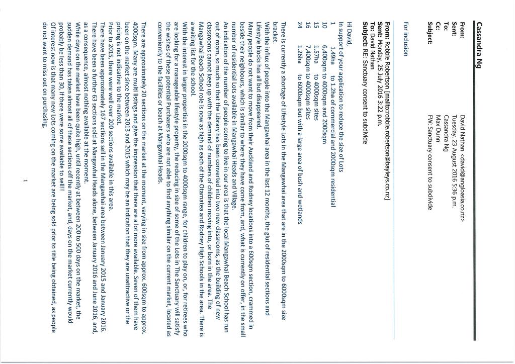
295
296
297 Appendix G: Hawthorn Geddes Engineering Report
298
299
300
301
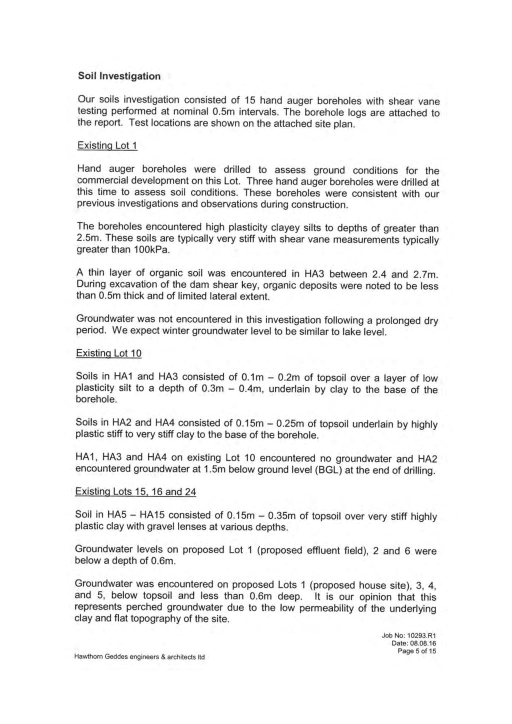
302
303
304
305
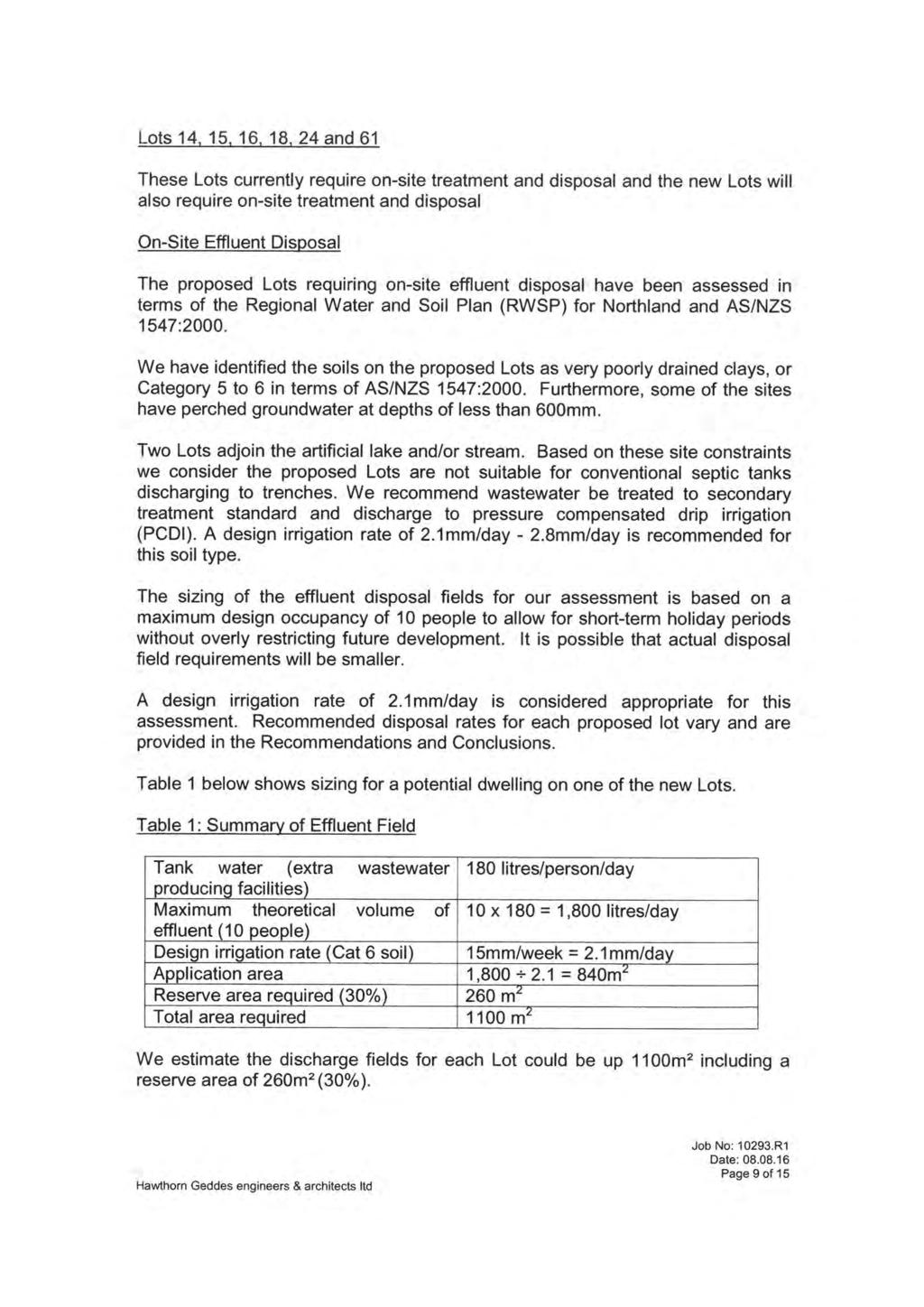
306
307
308
309
310
311
312
313
314
315
316
317
318
319
320
321
322
323
324
325
326
327
328 Appendix H: Land Covenant
329
330
331
332
333
334
335
336
337
338
339
340
341
342
343
344
345
346
347
348
349
350
351
352
353
354
355
356
357
358
359
360
361
362
363
364 Appendix I: Time Depth Enterprises Archaeological Assessment
365
366
367
368
369
370
371
372
373
374
375
376
377
378
379

380 Appendix J: Written Approvals
Resource Consent Application Form
 Resource Consent Application Form Section 88 of the Resource Management Act 1991. This form provides us with your contact information and details about your proposal. Please print clearly and complete
Longreach Developments Limited
 1 APPLICATION FOR RESOURCE CONSENT UNDER SECTION 88 OF THE RESOURCE MANAGEMENT ACT 1991 TO: THAMES COROMANDEL DISTRICT COUNCIL Longreach Developments Limited c/- Brown and Company, PO Box 91-839, Auckland
DRAFT PROPOSED CHAPTER 21 SPECIFIC PURPOSE - FLAT LAND RECOVERY ZONE
 DRAFT PROPOSED CHAPTER 21 SPECIFIC PURPOSE - FLAT LAND RECOVERY ZONE Note: The Specific Purpose (Flat Land Recovery) Zone is a "holding" zone that will be subject to a later plan change to confirm the
Riverton Properties Ltd Proposed Special Housing Area
 Riverton Properties Ltd Proposed Special Housing Area Housing Accords and Special Housing Areas Act 2013 Expression of Interest 1 This Expression of Interest is made on behalf of Riverton Properties Ltd,
Volume Three Appendix 7. Scheme Plan and other subdivision requirements
 Volume Three Appendix 7 Appendix 7 Scheme Plan and other subdivision requirements Any application for subdivision consent must be accompanied by a Scheme Plan that contains the information set out in this
Section 11 Land Subdivision #
 Section 11 Land Subdivision # 11.1 General Features 11-1 11.1.1 Land Ownership 11-1 11.1.2 Subdivision Patterns 11-1 11.2 Legislative Considerations 11-2 11.2.1 Resource Management Act 11-2 11.3 Management
SECTION B - GUIDELINES
 SECTION B - GUIDELINES APPLICATION KIT FOR SUBDIVISION RESOURCE CONSENT UNDER SECTION 88 OF THE RESOURCE MANAGEMENT ACT 1991 CONTENTS: PLEASE READ AND COMPLETE 1. Making an Application for a Subdivision
Development of a temporary grass multisport pitch and associated works (in addition to the previously approved park - Phase A).
.") To the Lord Mayor and Report No. 163/2018 Members of Dublin City Council Report of the Chief Executive (a) Planning and Development Act 2000 (as amended) & Planning and Development Regulations 2001 (as
To the Lord Mayor and Report No. 163/2018 Members of Dublin City Council Report of the Chief Executive (a) Planning and Development Act 2000 (as amended) & Planning and Development Regulations 2001 (as
Flinders Avenue, Lara Planning Scheme Amendment Combined Application for Rezoning and Multi-Lot Subdivision Reference : Decembe
 143-179 Flinders Avenue, Lara Planning Scheme Amendment Combined Application for Rezoning and Multi-Lot Subdivision Reference: 14134-03 TGM Group Geelong Melbourne Ballarat 1/27-31 Myers Street (PO Box
Form 10 APPLICATION FOR CHANGE OR CANCELLATION OF RESOURCE CONSENT CONDITION. Section 127, Resource Management Act 1991
 Form 10 APPLICATION FOR CHANGE OR CANCELLATION OF RESOURCE CONSENT CONDITION To Far North District Council : Section 127, Resource Management Act 1991 We, Bruce Robin Ansley and Justine Anne Marra, apply
P & L Anderson PROPOSED SUBDIVISION. 71 Keri Downs Road, Kerikeri PLANNERS REPORT & ASSESSMENT OF ENVIRONMENTAL EFFECTS
 Thomson Survey Limited Subdivision Proposal Nov-18 P & L Anderson PROPOSED SUBDIVISION 71 Keri Downs Road, Kerikeri PLANNERS REPORT & ASSESSMENT OF ENVIRONMENTAL EFFECTS Thomson Survey Ltd Kerikeri 1.0
Application for Outline Plan / Outline Plan Waiver Section 176A, Resource Management Act
 Email: applications@waidc.govt.nz www.waikatodistrict.govt.nz Telephone (all hours) 07 824 8633 Call Free 0800 492 452 District Office 15 Galileo Street Private Bag 544 Ngaruawahia 3742 Application for
Conceptual Scheme SE W4
 December 2012 1. PURPOSE 1.1. The purpose of a Conceptual Scheme (CS) is as follows: a) To provide a framework for the subsequent subdivision and/or development of land within the Country Residential Policy
Letter of Intent May 2017 (Revised November 2017)
") THE BEACH AT WOODMOOR LETTER OF INTENT MAY 2017 (REVISED NOVEMBER 2017) OWNER/APPLICANT: CONSULTANT: Lake Woodmoor Holdings LLC N.E.S. Inc. 1755 Telstar Drive, Suite 211 619 North Cascade Avenue Colorado
THE BEACH AT WOODMOOR LETTER OF INTENT MAY 2017 (REVISED NOVEMBER 2017) OWNER/APPLICANT: CONSULTANT: Lake Woodmoor Holdings LLC N.E.S. Inc. 1755 Telstar Drive, Suite 211 619 North Cascade Avenue Colorado
15.1 Introduction. Waipa District Plan. Section 15 - Infrastructure, Hazards, Development and Subdivision. Page Version - 1 November 2016 Page 1 of 56
 15.1 Introduction 15.1.1 How and where development and subdivision occurs is critical to the sustainable management of the District s natural and physical resources. This section of the Plan focuses on
Gisborne District Council
 12.0 SUBDIVISION... 1 12.1 INTRODUCTION... 1 12.2 ISSUE... 1 12.3 OBJECTIVE (SUBDIVISION)... 1 12.4 POLICIES (SUBDIVISION)... 2 12.5 METHODS OF IMPLEMENTATION... 4 12.5.1 REGULATION... 4 12.6 RULES FOR
City of Grande Prairie Development Services Department
 City of Grande Prairie Development Services Department COUNTRYSIDE SOUTH OUTLINE PLAN Prepared by: GPEC Consulting Ltd. #202, 10712-100th Street Grande Prairie, AB Council Resolution of August 20, 2001
SUBDIVISION BY-LAW MUNICIPALITY OF THE COUNTY OF INVERNESS
 SUBDIVISION BY-LAW MUNICIPALITY OF THE COUNTY OF INVERNESS APPROVED BY COUNCIL: JUNE 15, 1998 EFFECTIVE DATE: SEPTEMBER 23, 1998 Page 2 TABLE OF CONTENTS PART 1: SHORT TITLE... 5 PART 2: INTERPRETATION...
Application for Resource Consent (Subdivision) Section 88, Resource Management Act 1991 Form 9
 Section 88, Resource Management Act 1991 Form 9") Email: applications@waidc.govt.nz www.waikatodistrict.govt.nz Telephone (all hours) 07 824 8633 Call Free 0800 492 452 District Office 15 Galileo Street Private Bag 544 Ngaruawahia 3742 Application for
Email: applications@waidc.govt.nz www.waikatodistrict.govt.nz Telephone (all hours) 07 824 8633 Call Free 0800 492 452 District Office 15 Galileo Street Private Bag 544 Ngaruawahia 3742 Application for
Section 12A Purpose of Subdivision Provisions
 Section 12A 12A Purpose of Subdivision Provisions Subdivision is primarily about creating land parcels that define and redefine property rights and, in most instances, the creation of new parcels of land
March 26, Sutter County Planning Commission
 March 26, 2003 To: Re: Sutter County Planning Commission Agenda Item #12: Public hearing on Rezoning #03-04 to change the zoning classification of two parcels totaling 324+ acres from the AG (General Agricultural)
Explanation The policies ensure that land is suitable for subdivision and will not increase risks to people, the environment and property.
 23 Subdivision 23.1 Purpose a) Subdivision is essentially the process of dividing a parcel of land or a building into one or more further parcels, or changing an existing boundary location. Subdivision
CHAPTER 3 PRELIMINARY PLAT
 10-3-1 10-3-3 SECTION: CHAPTER 3 PRELIMINARY PLAT 10-3-1: Consultation 10-3-2: Filing 10-3-3: Requirements 10-3-4: Approval 10-3-5: Time Limitation 10-3-6: Grading Limitation 10-3-1: CONSULTATION: Each
A. Preserve natural resources as identified in the Comprehensive Plan.
 1370.08 Conservation Residential Overlay District. Subd. 1 Findings. The City finds that the lands and resources within the Conservation Residential Overlay District are a unique and valuable resource
PART SIXTEEN - SUBDIVISION AND DEVELOPMENT
 16.1 24 July 2010 PART SIXTEEN - SUBDIVISION AND DEVELOPMENT 1. INTRODUCTION Council has the statutory responsibility to control subdivision of land and the effects of land use throughout the District.
16.1 Introduction Resource Management Issues Objectives And Policies Rules: Permitted Activities 3
 SECTION 16: CACCIA BIRCH CONTENTS 16.1 Introduction 1 16.2 Resource Management Issues 1 16.3 Objectives And Policies 1 16.5 Rules: Permitted Activities 3 R16.5.1 Permitted Activities 3 16.6 Rules: Controlled
H4. Residential Mixed Housing Suburban Zone
 H4. Residential Mixed Housing Suburban Zone H4.1. Zone description The Residential Mixed Housing Suburban Zone is the most widespread residential zone covering many established suburbs and some greenfields
H5. Residential Mixed Housing Urban Zone
 H5. Residential Mixed Housing Urban Zone [ENV-2016-AKL-000197: Robert Adams] Addition sought H5.1. Zone description The Residential Mixed Housing Urban Zone is a reasonably high-intensity zone enabling
ENVIRONMENT CANTERBURY S WEB-BASED CONTAMINATED LAND INFORMATION TRANSFER SYSTEM
 ENVIRONMENT CANTERBURY S WEB-BASED CONTAMINATED LAND INFORMATION TRANSFER SYSTEM Davina McNickel 1, Helen Davies 2, Vincent Salomon 2 1 Environment Canterbury, PO Box 345, Christchurch. Telephone: 03 365
Chapter Planned Residential Development Overlay
 Chapter 19.29 Planned Residential Development Overlay Sections 010 Purpose 020 Scope 030 Definitions 030 Minimum Size 040 Allowable Uses 050 Minimum Development Standards 060 Density Bonus 070 Open Space
3. DISTRICT PLAN GENERAL PROVISIONS
 3. DISTRICT PLAN GENERAL PROVISIONS 3.1 Guide to the District Plan 3.1.1 Introduction Section 3.1 simplifies the task of finding out what you wish to know from the District Plan. It describes the steps
5. That the Owner shall agree that all development Blocks shown within the Draft Plan will be connected to full municipal services.
 Conditions Relating to Draft Plan of Subdivision Approval East Fonthill 26T 01014 (Draft Plan dated December 1, 2013, and revised August 28, 2014), the Town of Pelham 1. This approval applies to the Draft
1 Extraordinary Council meeting Doc No.: RDC March 2018 NOTICE OF AN EXTRAORDINARY MEETING OF COUNCIL
 1 Extraordinary Council meeting File No: 01-15-010\25 NOTICE OF AN EXTRAORDINARY MEETING OF COUNCIL to be held on Thursday, 15 March 2018 at 2pm in the Council Chamber, Rotorua Lakes Council Chairperson:
Section Three, Part 9 - Subdivision
 PART 9 SUBDIVISION SUBDIVISION AND DEVELOPMENT OF LAND 9.1 INTRODUCTION This part of the District Plan sets out the provisions in respect of the subdivision and development of land in the urban part of
Landuse Consent Subdivision Consent Certificate of Compliance Variation/Cancellation of Consent Conditions Outline Plan Waiver
 Resource Consent Application for resource consent Form 9, Resource Management Act 1991 All sections of this form must be completed before your application can be assessed. Information required to accompany
Request for Development Land in the Palm Springs Subdivision to be Granted Special Housing Area Status under the Tauranga Housing Accord
 Request for Development Land in the Palm Springs Subdivision to be Granted Special Housing Area Status under the Tauranga Housing Accord Development Proposal Overview of proposal This request is lodged
MUNICIPALITY OF THE DISTRICT OF CLARE SUBDIVISION BY-LAW
 MUNICIPALITY OF THE DISTRICT OF CLARE SUBDIVISION BY-LAW 1 Table of Contents PART 1 - TITLE... 4 PART 2 - INTERPRETATION... 4 PART 3 - DEFINITIONS... 4 PART 4 - PROCEDURE FOR APPROVAL OF PLANS OR INSTRUMENTS
Richmond County Subdivision By-law
 Richmond County Subdivision By-law SHORT TITLE 1. This By-law may be cited as the "Subdivision By-law" and shall apply to all lands within the Municipality of the County of Richmond. INTERPRETATION 2.
RULE C2 ZONE STANDARDS - SUBDIVISION
 RULE C SUBDIVISION 1 RULE C2 ZONE STANDARDS - SUBDIVISION NB Words outlined in bold type below have a specific definition contained in Chapter 2 (Definitions). 2.1 STANDARDS RESIDENTIAL ZONE (Refer Part
E38. Subdivision - Urban
 E38. Subdivision - Urban E38.1. Introduction Subdivision is the process of dividing a site or a building into one or more additional sites or units, or changing an existing boundary location. Objectives,
PLANNING RATIONALE ONTARIO LTD. APLLICATION FOR PLAN OF SUBDIVISION APPROVAL
 PLANNING RATIONALE 1384341 ONTARIO LTD. APLLICATION FOR PLAN OF SUBDIVISION APPROVAL PART OF LOTS 18 & 19, CONCESSION 1 GEOGRAPHIC TOWNSHIP OF MARCH NOW IN CITY OF OTTAWA FEBRUARY 2013 1 Planning Rationale
M E M O R A N D U M. Meeting Date: October 23, Item No. F-1. Planning and Zoning Commission. Daniel Turner, Planner I
 M E M O R A N D U M Meeting Date: October 23, 2017 Item No. F-1 To: From: Subject: Planning and Zoning Commission Daniel Turner, Planner I PUBLIC HEARING: Consider a recommendation of a of Planned Development
CHARLOTTE PLANNING COMMISSION FINDINGS OF FACT AND DECISION IN RE APPLICATION OF. George R. Aube 1450 Dorset Street
 CHARLOTTE PLANNING COMMISSION FINDINGS OF FACT AND DECISION IN RE APPLICATION OF George R. Aube 1450 Dorset Street Final Plan Review For A Two-Lot Subdivision Application # PC-13-19 Background The Planning
MS MINOR SUBDIVISION TREVITHICK
 MS-02-015 341.12 MINOR SUBDIVISION TREVITHICK A request by Danny Trevithick for a one-lot Minor Subdivision on five acres. The property is zoned A-35 (Agricultural) District and is located ¼ mile south
Draft Zoning Changes for the 2nd Planning Board Public Hearing, January 22, 2018.
 Draft Zoning Changes for the 2nd Planning Board Public Hearing, January 22, 2018. No changes were made at the 1st Public Hearing. Proposed wording for the 1 st Public Hearing in red, eliminated text in
ERECTION OF 42 NO. HOUSING UNITS (OUTLINE) AT Reserve Sites A And D, Hindhead Knoll, Walnut Tree FOR English Partnerships
 AT Reserve Sites A And D, Hindhead Knoll, Walnut Tree FOR English Partnerships") 05/01386/OUT ERECTION OF 42 NO. HOUSING UNITS (OUTLINE) AT Reserve Sites A And D, Hindhead Knoll, Walnut Tree FOR English Partnerships INTRODUCTION The 13 Week Date for the determination of this major
05/01386/OUT ERECTION OF 42 NO. HOUSING UNITS (OUTLINE) AT Reserve Sites A And D, Hindhead Knoll, Walnut Tree FOR English Partnerships INTRODUCTION The 13 Week Date for the determination of this major
H5. Residential Mixed Housing Urban Zone
 H5. Residential Mixed Housing Urban Zone H5.1. Zone description The Residential Mixed Housing Urban Zone is a reasonably high-intensity zone enabling a greater intensity of development than previously
Activities which do not satisfy the General Rules and are not provided for as Restricted Discretionary activities... 9
 16.0 PAPAKAINGA AND MARAE SETTLEMENTS... 1 16.1 INTRODUCTION... 1 16.2 ISSUES... 1 16.3 OBJECTIVE (PAPAKAINGA)... 2 16.4 POLICIES (PAPAKAINGA)... 2 16.5 OBJECTIVE (SURROUNDING ENVIRONMENT)... 2 16.6 POLICIES
Residential Project Convenience Facilities
 Standards for Specific Land Uses 35.42.220 E. Findings. The review authority shall approve a Land Use Permit in compliance with Subsection 35.82.110.E (Findings required for approval) or a Conditional
REPORT HUTT CITY COUNCIL. Preliminary Land Development Assessment 8 Harold Grove, Stokes Valley. Report prepared for: HUTT CITY COUNCIL
 REPORT HUTT CITY COUNCIL Preliminary Land Development Assessment 8 Harold Grove, Stokes Valley Report prepared for: HUTT CITY COUNCIL Report prepared by: TONKIN & TAYLOR LTD Distribution: HUTT CITY COUNCIL
SECTION 900 PARKS AND SCHOOLS
 SECTION 900 PARKS AND SCHOOLS Page 901.00 GENERAL POLICY 901.01 Reservations of Land for Public Use...................... 900-1 902.00 PARKS AND RECREATION 902.01 Parks in General.......................................
SUBDIVISION, DEVELOPMENT AND EARTHWORKS
 PROPOSED CHAPTER 8 SUBDIVISION, DEVELOPMENT AND EARTHWORKS Chapter 8 Subdivisions - Proposed Changes to delete all draft provisions under the Residential Established New Neighbourhood Zone and replace
Section SKETCH PLAN REVIEW
 Section 210 - SKETCH PLAN REVIEW 1. Within 30 days of receiving a complete application for a subdivision involving three or more lots, the Zoning Administrator shall refer the matter to the first available
building or renovating your home?
 Thinking about... building or renovating your home? What you should know before you start. What you should know before you start... Building or renovating your home can be a very exciting time. You need
H6 Residential Terrace Housing and Apartment Buildings Zone
 H6. Residential Terrace Housing and Apartment Buildings Zone [CIV-2016-404-002333: Franco Belgiorno-Nettis]-Note: The properties affected by this appeal are identified on the Auckland Unitary Plan viewer.
H4. Residential Mixed Housing Suburban Zone
 H4. Residential Mixed Housing Suburban Zone H4.1. Zone description The Residential Mixed Housing Suburban Zone is the most widespread residential zone covering many established suburbs and some greenfields
Chapter 8 Transportation
 Chapter 8 Transportation Introduction 1. Chapter 8 of the PDP contains provisions concerning the development, maintenance and use of the transport network and associated activities. It recognises that
Division 5 Residential Low Density Zone: Assessment Criteria and Assessment Tables
 Division 5 Residential Low Density Zone: Assessment Criteria and Assessment Tables 4.5.1 Residential Low Density Zone The provisions in this division relate to the Residential Low Density Zone as follows
Figure 1 below shows the subdivision process. [Ministry for the Environment Quality Planning website]
![Figure 1 below shows the subdivision process. [Ministry for the Environment Quality Planning website]](/thumbs/87/97093311.jpg "Figure 1 below shows the subdivision process. [Ministry for the Environment Quality Planning website]") 13 SUBDIVISION CONTEXT The Far North District Council is responsible for issuing two types of resource consents land use consents and subdivision consents. In many cases both types of consents must be
13 SUBDIVISION CONTEXT The Far North District Council is responsible for issuing two types of resource consents land use consents and subdivision consents. In many cases both types of consents must be
Staff Report for Council Public Meeting
 Agenda Item 3.3 a Staff Report for Council Public Meeting Date of Meeting: April 11, 2018 Report Number: SRPRS.18.087 Department: Division: Subject: Planning and Regulatory Services Development Planning
Chapter 100 Planned Unit Development in Corvallis Urban Fringe
 100.100 Scope and Purpose. Chapter 100 Planned Unit Development in Corvallis Urban Fringe (1) All applications for land divisions in the Urban Residential (UR) and Flood Plain Agriculture (FPA) zones within
TENTATIVE MAP INFORMATION SHEET
 TENTATIVE MAP INFORMATION SHEET GENERAL INFORMATION This information sheet explains how your Tentative Map application will be processed, what fees you must pay, and what plans you must submit. If you
SCHEDULE 12 TO THE URBAN GROWTH ZONE. Shown on the planning scheme map as UGZ12. Kororoit Precinct Structure Plan
 SCHEDULE 12 TO THE URBAN GROWTH ZONE Shown on the planning scheme map as UGZ12. Kororoit Precinct Structure Plan 1.0 The plan Map 1 below shows the future urban structure proposed in the Kororoit Precinct
Resource consent application/ Fast-Track resource consent
 Resource consent application/ Fast-Track resource consent Under Sections 87AAC, 88, Resource Management Act 1991 Notes for the applicant Use this form to apply for resource consent. It gives us your contact
PLANNING RATIONALE REPORT
 PLANNING RATIONALE REPORT Zoning By-law Amendment Application 2920 Danbury Way Prepared for: Bravar Custom Builders Inc. and Village View Estates Ltd. by: 6393 Roslyn Street Ottawa (Orleans), Ontario K1C
Prepared for: Ontario Limited
 Application for Zoning By-law Amendment and Plan of Subdivision 1353 Scharfgate Drive Planning Rationale Report Prepared for: 1384341 Ontario Limited November 28, 2014 Planning Rationale Report Introduction
6040 Bathurst Street and 5 Fisherville Road Zoning Bylaw Amendment Application Preliminary Report
 STAFF REPORT ACTION REQUIRED 6040 Bathurst Street and 5 Fisherville Road Zoning Bylaw Amendment Application Preliminary Report Date: January 24, 2017 To: From: Wards: Reference Number: North York Community
SECTION 822 "R-1-A" AND "R-1-AH" - SINGLE FAMILY RESIDENTIAL DISTRICTS
 SECTION 822 "R-1-A" AND "R-1-AH" - SINGLE FAMILY RESIDENTIAL DISTRICTS The "R-1-A" and "R-1-AH" Districts are intended to provide for the development of single family residential homes at urban standards
4027 and 4031 Ellesmere Road Zoning Amendment and Draft Plan of Subdivision Applications - Request for Direction Report
 STAFF REPORT ACTION REQUIRED 4027 and 4031 Ellesmere Road Zoning Amendment and Draft Plan of Subdivision Applications - Request for Direction Report Date: August 22, 2013 To: From: Wards: Reference Number:
NORTH LEEDS MATTER 2. Response to Leeds Sites and Allocations DPD Examination Inspector s Questions. August 2017
 NORTH LEEDS MATTER 2 Response to Leeds Sites and Allocations DPD Examination Inspector s Questions August 2017 CLIENT: TAYLOR WIMPEY, ADEL REFERENCE NO: CONTENTS 1.0 INTRODUCTION 2.0 TEST OF SOUNDNESS
Community Occupancy Guidelines
 Community Occupancy Guidelines Auckland Council July 2012 Find out more: phone 09 301 0101 or visit www.aucklandcouncil.govt.nz Contents Introduction 4 Scope 5 In scope 5 Out of scope 5 Criteria 6 Eligibility
MUNICIPALITY OF THE COUNTY OF PICTOU SUBDIVISION BY-LAW. Act means the Municipal Government Act, Stats. N.S., 1998, c. 18 and amendments thereto;
 MUNICIPALITY OF THE COUNTY OF PICTOU SUBDIVISION BY-LAW SHORT TITLE 1. This by-law may be cited as the Pictou County Subdivision By-Law and shall apply to all lands within the Municipality of the County
I Te Koti Taiao o Aotearoa Ōtautahi Rohe ENV-2018-CHC-
 In the Environment Court of New Zealand Christchurch Registry I Te Koti Taiao o Aotearoa Ōtautahi Rohe ENV-2018-CHC- Under In the matter of Between the Resource Management Act 1991 (RMA) An appeal under
Land Use Planning Analysis. Phase 2 Drayton Valley Annexation Proposal
 Land Use Planning Analysis Phase 2 Drayton Valley Annexation Proposal Prepared for Town of Drayton Valley Prepared by Mackenzie Associates Consulting Group Limited March, 2011 TABLE OF CONTENTS 1.0 INTRODUCTION...
Charter Township of Plymouth Zoning Ordinance No. 99 Page 208 Article 21: Residential Unit Developments Amendments: ARTICLE XXI
 Charter Township of Plymouth Zoning Ordinance No. 99 Page 208 ARTICLE XXI RESIDENTIAL UNIT DEVELOPMENTS PURPOSE The purpose of the Residential Unit Development (RUD) is to permit two (2) optional methods
Appendix 5 - Track Changed Ordinance
 SCHEDULE 1 TO THE URBAN GROWTH ZONE Shown on the planning scheme map as UGZ1 1.0 The Plan Shepparton North East Plan 1 shows the future urban structure proposed in the Shepparton North East Precinct Structure
RURAL SETTLEMENT ZONE - RULES
 Chapter 38 RURAL SETTLEMENT ZONE - RULES INTRODUCTION This Chapter contains rules managing land uses in the. The boundaries of this zone are shown on the planning maps. There is limited opportunity for
CITY PLAN COMMISSION STAFF REPORT
 CITY PLAN COMMISSION STAFF REPORT SUBJECT: Request for a Change of Zoning and Preliminary Development Plan FROM: Mara Perry, Director of Planning & Development MEETING DATE: November 6, 2017 PETITION:
I. Requirements for All Applications. C D W
 108-16.1. Application checklists. Checklist for Required Submissions to the Planning Board or Zoning Board of Adjustment of Monroe Township All required submissions are to be made to the Administrative
PART 4 - GENERAL PROVISIONS AND PROCEDURES
 CONTENTS... PAGE 4.1 CONTENT AND STRUCTURE OF PARTS 4, 4A, AND 4B...3 4.2 ACTIVITIES...3 4.3 RESOURCE CONSENTS...4 4.4 FINANCIAL CONTRIBUTIONS...16 4.5 SIGNS...16 4.6 ARTIFICIAL LIGHTING...17 Plan change
BY THE CITY COMMISSION ORDINANCE NO.:
 BY THE CITY COMMISSION ORDINANCE NO.: 2005-0868 AN ORDINANCE BY THE CITY COMMISSION OF THE CITY OF DADE CITY, FLORIDA CREATING A DEVELOPMENT REVIEW PROCEDURES ORDINANCE; PROVIDING FOR INTENT, PURPOSE,
UPPER HUTT CITY COUNCIL HEARING ON PROPOSED (PRIVATE) PLAN CHANGE 40: WALLACEVILLE. IN THE MATTER of the Resource Management Act 1991 AND
 PLAN CHANGE 40: WALLACEVILLE. IN THE MATTER of the Resource Management Act 1991 AND") UPPER HUTT CITY COUNCIL HEARING ON PROPOSED (PRIVATE) PLAN CHANGE 40: WALLACEVILLE IN THE MATTER of the Resource Management Act 1991 AND IN THE MATTER a private plan change request ( Proposed (Private)
UPPER HUTT CITY COUNCIL HEARING ON PROPOSED (PRIVATE) PLAN CHANGE 40: WALLACEVILLE IN THE MATTER of the Resource Management Act 1991 AND IN THE MATTER a private plan change request ( Proposed (Private)
New Victorian Residential Zones 2013
 Clause 1 Planning Page 1 of 35 Clause 1 is a town planning consultancy. We specialise in assisting property developers, architects and building designers meet the increasingly complex requirements of State
Multi-family dwellings (including assisted living facilities), Public buildings, facility or land; and,
, Public buildings, facility or land; and,") 607. General Residential District (GR) Intent. It is the intent of this section that the General Residential District be established for medium-to-high density residential purposes. These areas need to
607. General Residential District (GR) Intent. It is the intent of this section that the General Residential District be established for medium-to-high density residential purposes. These areas need to
SCHEDULE 3 TO THE URBAN GROWTH ZONE. Shown on the planning scheme map as UGZ3 QUARRY HILLS PRECINCT STRUCTURE PLAN. 1.0 The Plan
 SCHEDULE 3 TO THE URBAN GROWTH ZONE 1.0 The Plan Shown on the planning scheme map as UGZ3 QUARRY HILLS PRECINCT STRUCTURE PLAN Map 1 to Schedule 3 to Clause 37.07 shows the Future Urban Structure for Quarry
APPLICATION FOR RESOURCE CONSENT OR FAST-TRACK RESOURCE CONSENT
 Office Use Only Application Number: APPLICATION FOR RESOURCE CONSENT OR FAST-TRACK RESOURCE CONSENT (Or Associated Consent Pursuant to the Resource Management Act 1991 (RMA)) (If applying for a Resource
Proposed Variation to Stage 1 Proposed District Plan VISITOR ACCOMMODATION DRAFT
 Proposed Variation to Stage 1 Proposed District Plan VISITOR ACCOMMODATION Prepared by Ian Johnson, Mitchell Daysh Ltd For Bookabach Ltd Version 0.4 Residential Visitor Accommodation The Variation Alternative
The Application Process
 The Application Process This document is intended as a guide and does not constitute a legal document. For further and more detailed information, please refer to the following Acts and Regulations: The
Guide to Subdivision and Land Development
 Guide to Subdivision and Land Development Fraser Thomas Ltd......is an engineering and surveying consulting firm based in Highbrook which has provided Surveying, Engineering, Planning and Resource Management
PALMERSTON NORTH CITY SECTIONAL DISTRICT PLAN REVIEW PROPOSED PLAN CHANGE 2: CLIFF PROTECTION LINE
 PALMERSTON NORTH CITY SECTIONAL DISTRICT PLAN REVIEW PROPOSED PLAN CHANGE 2: CLIFF PROTECTION LINE PART I DESCRIPTION OF PROPOSED PLAN CHANGE This proposed Plan Change seeks to amend the Cliff Protection
A. Maintenance. All legally established, nonconforming structures can be maintained (e.g., painting and repairs);
;") Chapter 24.50 NONCONFORMING USES, STRUCTURES AND LOTS Sections: 24.50.010 Nonconforming uses, structures, and lots Purpose. 24.50.020 Nonconforming uses, structures, and lots Alteration or expansion of
Chapter 24.50 NONCONFORMING USES, STRUCTURES AND LOTS Sections: 24.50.010 Nonconforming uses, structures, and lots Purpose. 24.50.020 Nonconforming uses, structures, and lots Alteration or expansion of
M-43 CORRIDOR OVERLAY ZONE
 ARTICLE 26.00 M-43 CORRIDOR OVERLAY ZONE Section 26.01 Findings A primary function of the M-43 state highway is to move traffic through the Township and to points beyond. As the primary east-west arterial
TABLE OF CONTENTS MORAN TOWNSHIP ZONING ORDINANCE
 TABLE OF CONTENTS MORAN TOWNSHIP ZONING ORDINANCE INTRODUCTION ARTICLE ONE ARTICLE TWO ARTICLE THREE ARTICLE FOUR TITLE PREAMBLE ENACTING CLAUSE SHORT TITLE & THE ORDINANCE PROGRAM DEFINTIONS Sec.2.01
STAFF REPORT. Financial Impact Statement There are no immediate financial impacts associated with the adoption of this report.
 STAFF REPORT Planning and Development Department Subject: Cottage Country Unsubstantial Amendment to Development Agreement To: CAO for Planning Advisory Committee, December 13, 2016 Date Prepared: December
Napa County Planning Commission Board Agenda Letter
 Agenda Date: 9/20/2017 Agenda Placement: 8C Napa County Planning Commission Board Agenda Letter TO: FROM: Napa County Planning Commission Charlene Gallina for David Morrison - Director Planning, Building
PROVINCIAL SUBDIVISION REGULATIONS. Municipal Government Act
 PROVINCIAL SUBDIVISION REGULATIONS Made under Section 270 of the Municipal Government Act Chapter 18 of the Statutes of Nova Scotia, 1998 Service Nova Scotia and Municipal Relations April 1, 1999 (with
APPLICATION PROCEDURE
 ANTRIM PLANNING BOARD P. O. Box 517 Antrim, New Hampshire 03440 Phone: 603-588-6785 FAX: 603-588-2969 APPLICATION FORM AND CHECKLIST FOR MINOR OR MAJOR SITE PLAN REVIEW File Date Received By APPLICATION
Planning Justification Report
 Planning Justification Report 103 and 105 Toronto Street Town of Markdale, Municipality of Grey Highlands Maverick Developments November 5, 2016 Zelinka Priamo Ltd. Page i TABLE OF CONTENTS Page No. 1.0
WILLIAMSON ACT CONTRACTS GUIDELINES
 NEVADA COUNTY COMMUNITY DEVELOPMENT AGENCY PLANNING DEPARTMENT ERIC ROOD ADMINISTRATION BUILDING 950 Maidu Avenue Nevada City, California 95959-8617 Phone: (530) 265-1222 FAX : (530) 265-9851 WILLIAMSON
Guide to Preliminary Plans
 Guide to Preliminary Plans Introduction The Douglas County is committed to providing open, transparent application processes to the public. This Guide is provided to assist anyone interested in the procedures