APPLICATION FOR RESOURCE CONSENT OR FAST-TRACK RESOURCE CONSENT
|
|
|
- Cecil Hamilton
- 6 years ago
- Views:
Transcription
 Prior to, and during, completion of this application form, please refer to")
1 Office Use Only Application Number: APPLICATION FOR RESOURCE CONSENT OR FAST-TRACK RESOURCE CONSENT (Or Associated Consent Pursuant to the Resource Management Act 1991 (RMA)) (If applying for a Resource Consent pursuant to Section 87AAC or 88 of the RMA, this form can be used to satisfy the requirements of Form 9) Prior to, and during, completion of this application form, please refer to Resource Consent Guidance Notes and Schedule of Fees and Charges both available on the Council s web page. 1. Pre-Lodgement Meeting Have you met with a Council Resource Consent representative to discuss this application prior to lodgement? Yes / No 2. Type of Consent being applied for (more than one circle can be ticked): O Land Use O Fast Track Land Use* O Subdivision O Discharge O Extension of time (s.125) O Change of conditions (s.127) O Change of Consent Notice (s.221(3)) O Consent under National Environmental Standard (e.g. Assessing and Managing Contaminants in Soil) O Other (please specify) *The fast track for simple land use consents is restricted to consents with a controlled activity status and requires you provide an electronic address for service. 3. Would you like to opt out of the Fast Track Process? Yes / No 4. Applicant Details: Name/s: Electronic Address for Service ( ): Phone Numbers: Postal Address: (or alternative method of service under section 352 of the Act) Work: Home: Post Code: 5. Address for Correspondence: Name and address for service and correspondence (if using an Agent write their details here). Name/s: Electronic Address for Service ( ): Phone Numbers: Work: Home: Postal Address: (or alternative method of service under section 352 of the Act) Post Code: All correspondence will be sent by in the first instance. Please advise us if you would prefer an alternative means of communication.
2 6. Details of Property Owner/s and Occupier/s: Name and Address of the Owner/Occupiers of the land to which this application relates (where there are multiple owners or occupiers please list on a separate sheet if required) Name/s: Property Address/: Location 7. Application Site Details: Location and/or Property Street Address of the proposed activity: Site Address/ Location: Legal Description: Val Number: _ Certificate of Title: Please remember to attach a copy of your Certificate of Title to the application, along with relevant consent notices and/or easements and encumbrances (search copy must be less than 6 months old) Site Visit Requirements: Is there a locked gate or security system restricting access by Council staff? Yes / No Is there a dog on the property? Yes / No Please provide details of any other entry restrictions that Council staff should be aware of, e.g. health and safety, caretaker s details. This is important to avoid a wasted trip and having to re-arrange a second visit. 8. Description of the Proposal: Please enter a brief description of the proposal here. Attach a detailed description of the proposed activity and drawings (to a recognized scale, e.g. 1:100) to illustrate your proposal. Please refer to Chapter 4 of the District Plan, and Guidance Notes, for further details of information requirements. If this is an application for an Extension of Time (s.125); Change of Consent Conditions (s.127) or Change or Cancellation of Consent Notice conditions (s.221(3)), please quote relevant existing Resource Consents and Consent Notice identifiers and provide details of the change(s) or extension being sought, with reasons for requesting them. 9. Would you like to request Public Notification Yes/No
3
4 12. Important Information: Note to applicant You must include all information required by this form. The information must be specified in sufficient detail to satisfy the purpose for which it is required. You may apply for 2 or more resource consents that are needed for the same activity on the same form. You must pay the charge payable to the consent authority for the resource consent application under the Resource Management Act Fast-track application Under the fast-track resource consent process, notice of the decision must be given within 10 working days after the date the application was first lodged with the authority, unless the applicant opts out of that process at the time of lodgement. A fast-track application may cease to be a fast-track application under section 87AAC(2) of the RMA. Privacy Information: Once this application is lodged with the Council it becomes public information. Please advise Council if there is sensitive information in the proposal. The information you have provided on this form is required so that your application for consent pursuant to the Resource Management Act 1991 can be processed under that Act. The information will be stored on a public register and held by the Far North District Council. The details of your application may also be made available to the public on the Council s website, These details are collected to inform the general public and community groups about all consents which have been issued through the Far North District Council. Declaration: The information I have supplied with this application is true and complete to the best of my knowledge. Name: (please print) Signature: (signature) Date: (A signature is not required if the application is made by electronic means) Checklist (please tick if information is provided) o o o o o o o o o o o o o Payment (cheques payable to Far North District Council) A current Certificate of Title (Search Copy not more than 6 months old) Copies of any listed encumbrances, easements and/or consent notices relevant to the application Applicant / Agent / Property Owner / Bill Payer details provided Location of property and description of proposal Assessment of Environmental Effects Written Approvals / correspondence from consulted parties Reports from technical experts (if required) Copies of other relevant consents associated with this application Location and Site plans (land use) AND/OR Location and Scheme Plan (subdivision) Elevations / Floor plans Topographical / contour plans Please refer to Chapter 4 of the District Plan for details of the information that must be provided with an application. Please also refer to the RC Checklist available on the Council s website. This contains more helpful hints as to what information needs to be shown on plans. 13. Only one copy of an application is required, but please note for copying and scanning purposes, documentation should be UNBOUND SINGLE SIDED NO LARGER THAN A3 in SIZE
5 14213 PAUL HEMI 22 JUNE 2018 PROPOSED SUBDIVISION 539 MARTIN ROAD, KAEO PG 1 Paul Hemi PROPOSED SUBDIVISION & CANCELLATION OF EASEMENTS, AMALGAMATION CONDITION AND CONSENT NOTICE 535 & 539 Martin Road, Kaeo PLANNING REPORT INCLUDING AN ASSESSMENT OF ENVIRONMENTAL EFFECTS to Far North District Council Von Sturmers A Division of Survey & Planning Solutions (2010) Ltd Surveyors, Planners, Resource Managers - Kerikeri and Kaitaia PO Box 128 Kaitaia Phone (09) kaitaia@saps.co.nz
6 14213 PAUL HEMI 22 JUNE 2018 PROPOSED SUBDIVISION 539 MARTIN ROAD, KAEO PG 2 1. Summary Applicant: Location: Consent for: Paul Hemi 535 & 539 Martin Road, Kaeo Subdivision and Cancellation of Easements pursuant to Section 243e, Cancellation of Amalgamation Condition pursuant to Section 240 and Cancellation of Consent Notice pursuant to Section 221(3) of the RMA 1991 Legal Description: CFRs & Lots 1 to 3 DP Zone: Resource Features: Activity Status: Consultation: Rural Production None Non-complying Boundary Adjustment Chorus Network Services Top Energy Ltd FNDC & NRC re.hail Supporting Reports: Pre-lodgment Discussions: Other Resource Consents: Address of Service: Report from Bay of Islands Plumbing & Drainage (re. Wastewater) None None required Brett King PO Box 128, Kaitaia Ph king@saps.co.nz This assessment accompanies the Resource Consent Application made by our clients, and is provided in accordance to Section 88 of the Resource Management Act It is intended to provide the necessary information for an understanding of the proposal and any actual or potential effects the proposed activity may have on the environment.
 with Lot 1 being held in one title and Lots 2 & 3 being held together in the other title.")
7 14213 PAUL HEMI 22 JUNE 2018 PROPOSED SUBDIVISION 539 MARTIN ROAD, KAEO PG 3 2. Description of Proposal 2.1 Purpose of the Proposal Currently the subject property is made up of three lots (Lots 1 3 DP ) with Lot 1 being held in one title and Lots 2 & 3 being held together in the other title. This office, and our client, do not know why these lots were arranged in this manner. The proposal is to now effectively amalgamate Lots 1 & 2 DP (becomes proposed Lot 1) into a single title and Lot 3 DP becomes proposed Lot 2 with its own title. Proposed Lot 2 has been enlarged slightly, at proposed easement B, so that it is in excess of 2ha with a corresponding decrease in area to proposed Lot 1. A Scheme Plan and a QuickMap Record Sheet are attached in Appendix 1. The proposal seeks to subdivide the application site to create Lots 1 and 2, with areas of 3.65ha and 2.01ha respectively. All areas and dimensions are subject to final survey. 2.2 Site Description Location The application site is located on the western side of Martin Road, approximately 1km from its intersection with Spains Road. A location map is presented in Figure 1 and an aerial photograph in Figure 2(below). Figure 1: Location Map

8 14213 PAUL HEMI 22 JUNE 2018 PROPOSED SUBDIVISION 539 MARTIN ROAD, KAEO PG 4 Figure 2: Aerial Photograph Legal Description The application site is legally described as Lot 1 DP (CFR ) issued in July 2007 and Lots 2 & 3 DP held together in CFR see Appendix 2. The titles are subject to many easements which were mainly created to hold Lots 2 & 3 DP together. Easement documentation is also included in Appendix 2. It is intended that all subject easements are to be cancelled except for the easement labelled A electricity supply over proposed Lot 2 in favour of Lot 1. The following easements are required to be cancelled: Easement Purpose Document Easement labelled A on DP Easements labelled A, E & D on DP Right of way, water & electricity Right of way, rights to convey electricity, telecommunications and computer media The following is a suggested resolution pursuant to Section 241(3) Resource Management Act 1991; That amalgamation condition which affects CFRs and (see DP ) be cancelled.
9 14213 PAUL HEMI 22 JUNE 2018 PROPOSED SUBDIVISION 539 MARTIN ROAD, KAEO PG 5 Consent Notice should also be cancelled because it covers areas identified as X and Y on Lot 1 DP As mentioned previously, a small portion of Lot 1 DP has now been included in proposed Lot 2 (represented by easement B on the scheme plan) and if this Consent Notice continued in its present form then it would incorrectly come down onto proposed Lot 2 s title. A new Consent Notice should be issued, with the same wording, for proposed Lot 1 only. The only existing easement required to be retained is labelled A on the scheme plan ( B on DP ) for a right to convey electricity. New easements are required for a right of way and right to convey electricity ( B ), telecommunications & computer media ( C ) and an electricity easement in gross in favour of Top Energy Ltd ( D ) Existing Uses, Structures & Topography There is an existing dwelling on both proposed lots except that the cottage on Lot 2 is no longer used because it was deemed that the electricity supply was suspect within the building so it was disconnected. Most of the sheds associated with the dwelling on Lot 1 have been shown. These are visible on the aerial photo in Figure 2 previous. Note that the shed shown on the northern side of the property boundary is wholly contained within Lot 1 DP (also owned by our client, P Hemi). Currently it is accessed via the drive to proposed Lot 1 but will have to have its own independent access when, and if, Lot 1 DP is sold out of the family. The topography of the site can be described as rolling hills with grass and vegetation as shown on the aforementioned aerial photo Access The property has access off Martin Road via existing a metalled vehicle crossing. It has excellent sight distances. Proposed Lot 2 currently does not have an independent access from Martin Road Services The application site is not serviced with reticulated water, wastewater or stormwater systems. Both houses have existing separate connections for telecommunications and electricity although, as mentioned previously, electricity is currently turned off to the cottage on proposed Lot 2. Telecommunications reticulation to proposed Lot 1 is buried within easement C as shown on the scheme plan. Its precise location will be determined on survey Natural & Recorded Features The site is not subject to any Resource Features. No part of the property is recorded as a Protected Natural Area (PNA).
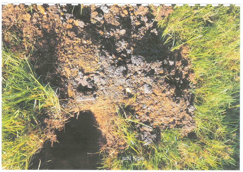
10 14213 PAUL HEMI 22 JUNE 2018 PROPOSED SUBDIVISION 539 MARTIN ROAD, KAEO PG 6 The site does not contain high quality soils (classified as 1, 2 or 3 in the Land Resource Inventory Worksheets). Soil classifications include 4s2 (lower half of property) and 6e2 (balance) as obtained from Far North Maps. The Far North Maps indicate that the site has Kiwi present but not in any concentration. We suggest that an appropriate Advice Note be added to a consent. There are no District Plan heritage features recorded on the property. There are no NZAA registered sites in the vicinity. There are no parts of the property recorded as being susceptible to flooding in Flooding Map 3 and the site is not known to be subject to any other natural hazards. Mature native vegetation, within the areas identified as X and Y was protected by Consent Notice at the time of the last subdivision, however, see my comments in s2.2.2 previous concerning cancelling and re-issuing the Consent Notice. 2.3 Details of Proposal Boundaries & Titles Boundaries are essentially the same as those created at the last subdivision (see DP ) except for the slight adjustment between the two proposed lots as described previously. The subdivision does not create any additional CFRs Access Access for proposed Lot 1 is existing and it is not anticipated that any upgrading work is required Independent access for proposed Lot 2 will have to be constructed to Council s standards Hazards The property is not subject to any natural hazards Water Supply and Stormwater Water supply for domestic use is currently, or can be, sourced from rainwater collected off roofs. There is also a water supply for farming purposes available to both lots which is sourced, and protected by appurtenant easements, on the property directly across Martin Road. Both resulting CFRs have existing houses, so no consent notices for firefighting supply will be required although this could be debatable for proposed Lot 2 because it is envisaged that a new house will be constructed on a more elevated position. Stormwater will run away via the natural contours of the land to formed drains on the properties.
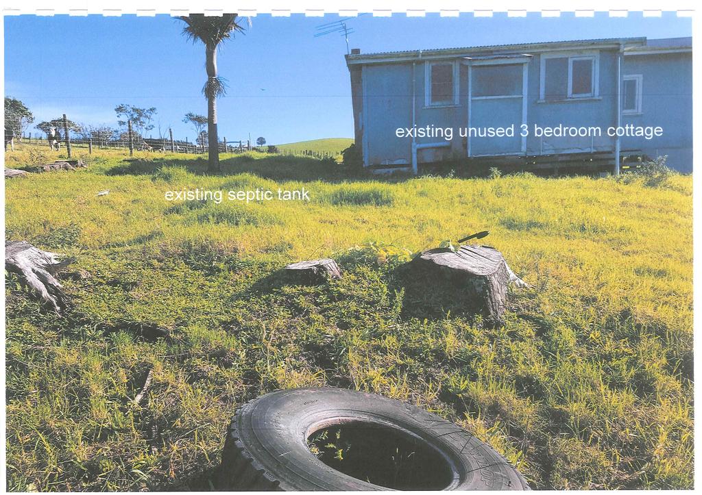
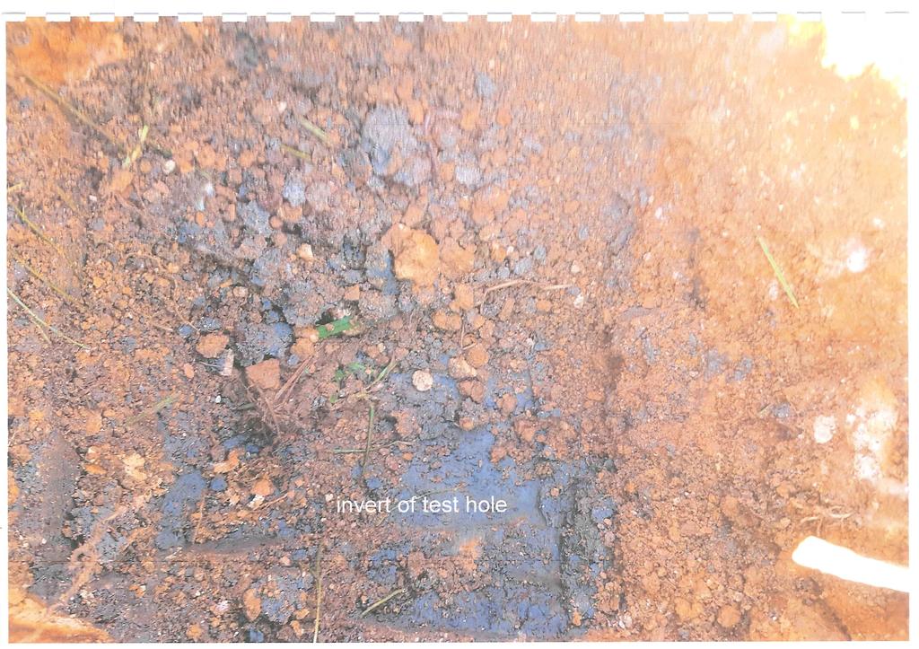
11 14213 PAUL HEMI 22 JUNE 2018 PROPOSED SUBDIVISION 539 MARTIN ROAD, KAEO PG Wastewater Wastewater from the existing dwelling on proposed Lot 1 is currently disposed of via functioning septic tank and effluent field as shown on the scheme plan and is functioning adequately. The effluent disposal currently on proposed Lot 2 is of the old traditional septic tank and clay pipe disposal system. Bay of Islands Drainage was engaged to prepare a TP 58 report for a new system. This report is contained in Appendix Services No additional connections for power and telecommunications are required. Chorus and Top Energy were contacted for their comments and these are included in Appendix Easements New and existing easements were discussed in s2.2.2 previous including a request for cancellation of some of the existing easements Heritage There are no recorded archaeological sites in the vicinity and the application involves no change of land use and no earthworks beyond minor excavation for an access to proposed Lot 2. Therefore Heritage NZ s comments have not been sought. However, we suggest that the standard Accidental Discovery Protocol be attached to the consent Ecology No vegetation clearance is required for the subdivision. According to Far North Maps kiwi are present but not in any concentration. We have suggested that an advice note be added to the consent. A replacement Consent Notice condition protecting the mature native vegetation on the property has been discussed in s Earthworks No earthworks are required, other than for the formation of an independent access from Martin Road to proposed Lot 2.
12 14213 PAUL HEMI 22 JUNE 2018 PROPOSED SUBDIVISION 539 MARTIN ROAD, KAEO PG 8 3. Activity Status 3.1 Far North District Plan ( District Plan ) The application site is zoned Rural Production and is not subject to any Resource Features in the District Plan. Refer to zone and resource maps 21. Our assessment of relevant District Plan Rules is summarised as follows: Subdivision The proposal cannot meet any of the rules for a complying subdivision so it must be considered as being a non-complying boundary adjustment essentially because Rule (c) cannot be met (the degree of non-compliance for proposed Lot 2 has been increased because Lot 3 DP is currently amalgamated with Lot 2 DP ). Rule (a) also cannot be met a new access is required for proposed Lot Rural Production Zone Proposed Lots 1 and 2 are already, or can be, developed consistent with the permitted standards of the zone Natural and physical resources Relevant sections of Chapter 12 [Natural and Physical Resources] have been considered. Section 12.1 Landscapes & Natural Features N/A - The site is not an outstanding landscape feature. Section 12.2 Indigenous Flora and Fauna N/A - No indigenous vegetation clearance is required. Section 12.3 Soils and Minerals Can be complied with, as the volume and depth of any earthworks required to upgrade the entrance to proposed Lot 2 will be well within the permitted activity limits. Section 12.4 Natural Hazards N/A No natural hazards have been identified. Section 12.5 Heritage N/A - The site contains no heritage features. Section 12.7 Lakes, Rivers, Wetlands and the Coastline N/A The site is not in the vicinity of notable water areas. Therefore the proposal complies with the permitted rules of Chapter 12.
13 14213 PAUL HEMI 22 JUNE 2018 PROPOSED SUBDIVISION 539 MARTIN ROAD, KAEO PG Transportation The lots are of sufficient size and proportions to accommodate the required parking. Construction of the access to proposed Lot 2 should be a condition of subdivision Overall activity status Overall, the proposal has been assessed as a non-complying boundary adjustment activity. An Assessment of Environmental Effects has been addressed later in this report. Assessment Criteria under the District Plan relating to the proposal: The criteria that are relevant to the Non-Complying Activity breach of the subdivision rules of the District Plan are those specified under section of the District Plan. Much of the following is repeated in this report Allotment sizes and Dimensions The subject site is located within the Rural Production Zone and is considered to have a rural residential character. There are other rural residential allotments in the area.. Over time cumulative effects can arise. These effects can be created through incremental changes that are created by activities, however potential cumulative effects are considered to be avoided as the character of the locality is considered to be rural with rural residential allotments as well Water Supply The proposed allotments do not have a reticulated water supply. The proposed Lot 2 will have tank water supply to provide water for any future residential unit. It is considered that the standard consent notice for fire-fighting (outlined below) is appropriate to be registered against proposed Lot 2 to avoid and mitigate any potential fire hazard risks. In conjunction with the construction of any dwelling, and in addition to a potable water supply, a water collection system with sufficient supply for fire-fighting purposes is to be provided by way of tank or other approved means and to be positioned so that it is safely accessible for this purpose. These provisions will be in accordance with the New Zealand Fire Fighting Water Supply Code of Practice SNZ PAS Stormwater Disposal Any excess stormwater runoff currently drains away via the natural contour of the property to the various drains on the property. Both proposed lots are greater than 2ha Sanitary Sewage Disposal Proposed Lot 1 has a functioning effluent disposal system and a replacement system has been recommended for proposed Lot 2 see Appendix Energy Supply Both houses have existing separate connections for electricity although, as mentioned previously, electricity is currently turned off to the cottage on proposed Lot 2.
14 14213 PAUL HEMI 22 JUNE 2018 PROPOSED SUBDIVISION 539 MARTIN ROAD, KAEO PG Telecommunications Both houses have existing separate connections for telecommunications. Reticulation to proposed Lot 1 is buried within easement C as shown on the scheme plan. Its precise location will be determined on survey Easements for any Purpose New and existing easements were discussed in s2.2.2 previous including a request for cancellation of some of the existing easements Provision of Access Access for proposed Lot 1 is existing and it is not anticipated that any upgrading work is required. Independent access for proposed Lot 2 will have to be constructed to Council s standards Effect of Earthworks and Utilities There will be a minor effect on earthworks at proposed entrance to Lot 2 and no effects associated with servicing which is existing Building Locations Both lots currently have existing dwellings, however, a future owner of Lot 2 may build a bit further away from the road on a more elevated site Preservation and Enhancement of Heritage Resources, Vegetation, Fauna and Landscape, and Land Set Aside for Conservation Purposes Soil No part of the property is recorded as a Protected Natural Area (PNA). The Far North Maps indicate that the site has Kiwi present but not in any concentration. We have suggested that an appropriate Advice Note be added to a consent. There are no recorded archaeological sites in the vicinity and the application involves no change of land use and no earthworks beyond minor excavation for an access to proposed Lot 2. Therefore Heritage NZ s comments have not been sought. However, we suggest that the standard Accidental Discovery Protocol be attached to the consent. Mature native vegetation, within the areas identified as X and Y was protected by Consent Notice at the time of the last subdivision, however, see my comments in s2.2.2 previous concerning cancelling and re-issuing the Consent Notice. The site does not contain high quality soils (classified as 1, 2 or 3 in the Land Resource Inventory Worksheets). Soil classifications include 4s2 (lower half of property) and 6e2 (balance) as obtained from Far North Maps.
15 14213 PAUL HEMI 22 JUNE 2018 PROPOSED SUBDIVISION 539 MARTIN ROAD, KAEO PG Assessment of Relevant District Plan Objectives and Policies The relevant objectives and policies of the District Plan are those related to the Rural Environment, the Rural Production Zone and Subdivision. The proposal is not considered to create any adverse effects on the Rural environment. The proposal is considered to be consistent with the character of the surrounding area and where both rural and rural residential activities co-exist and form an area with a distinctive character. The proposal is considered to be consistent with the objectives and policies of the Far North Operative District Plan. The proposal is a Non-Complying Activity, however it is considered to be generally consistent with the objectives and policies of the Plan. Assessment of the objectives and policies within the Rural Environment OBJECTIVES To promote the sustainable management of natural and physical resources of the rural environment while enabling activities to establish in the rural environment. The proposed allotments allow for the property to continue to be utilised for rural lifestyle use and in a manner that has less than minor effects upon the existing activities occurring on nearby rural lifestyle sites. The resultant allotment sizes are considered to be consistent with the character of the locality and therefore not erode the amenity values of the area. The proposal will not compromise the sustainable management of natural and physical resources of the environment. To ensure that the life supporting capacity of soils is not compromised by inappropriate subdivision, use or development. The site does not contain high quality soils (classified as 1, 2 or 3 in the Land Resource Inventory Worksheets). Soil classifications include 4s2 (lower half of property) and 6e2 (balance) as obtained from Far North Maps. To avoid, remedy or mitigate adverse effects of activities on the rural environment. The proposal is considered to be consistent with the landuse activities in the locality being rural lifestyle and production. The proposal is considered to result in less than minor adverse effects on the rural environment. To protect areas of significant indigenous vegetation and significant habitats of indigenous fauna. The proposal is not considered to have any known effects on flora or fauna. Covenants already exist to protect native vegetation on proposed Lot 1. No vegetation clearance is proposed. To avoid actual and potential conflicts between land use activities in the rural environment. There will be no change to the current land use and therefore no conflicts are envisaged. To promote the amenity values of the rural environment. The amenity of the rural environment is not considered to be compromised by the proposal, as activities will remain unchanged and the development is considered to be consistent with the character of the surrounding area.
16 14213 PAUL HEMI 22 JUNE 2018 PROPOSED SUBDIVISION 539 MARTIN ROAD, KAEO PG 12 To facilitate the sustainable management of natural and physical resources in an integrated way to achieve superior outcomes to more traditional forms of subdivision, use and development through management plans and integrated development. As noted above, it is considered that the continued rural lifestyle use of the proposed lots is consistent with the existing character and use of development in the locality. POLICIES That activities which will contribute to the sustainable management of the natural and physical resources of the rural environment are enabled to locate in that environment. As noted above, it is considered that the continued rural lifestyle use of the proposed lots is consistent with the existing character and use of sites in the locality. That any new infrastructure for development in rural areas be designed and operated in a way that safeguards the life supporting capacity of air, water, soil and ecosystems while protecting areas of significant indigenous vegetation and significant habitats of indigenous fauna, outstanding natural features and landscapes. The subject site does not contain any known high productive soils and is utilised for rural lifestyle purposes. This use will continue within the proposed rearranged lots. That development which will maintain or enhance the amenity value of the rural environment and outstanding natural features and outstanding landscapes be enabled to locate in the rural environment. The amenity of the rural environment is not considered to be compromised by the proposal. The property does not contain any outstanding landscapes or natural features. The amenity of the locality is considered to be maintained by the proposal. Assessment of the objectives and policies within the Rural Production Zone OBJECTIVES To promote the sustainable management of natural and physical resources in the Rural Production Zone. The proposal is considered to be sustainable considering that effectively there is no change. To enable the efficient use and development of the Rural Production Zone in a way that enables people and communities to provide for their social, economic, and cultural wellbeing and for their health and safety. The proposal satisfies this objective considering that effectively there is no change. To promote the maintenance and enhancement of the amenity values of the Rural Production Zone to the level that is consistent with the productive intent of the zone. Uses are already established and will not change. POLICIES That the type, scale and intensity of development allowed shall have regard to the maintenance and enhancement of the amenity values of the Rural Production Zone to a level that is consistent with the productive intent of the zone. Uses and intensity are already established and will not change.
17 14213 PAUL HEMI 22 JUNE 2018 PROPOSED SUBDIVISION 539 MARTIN ROAD, KAEO PG 13 That although a wide range of activities that promote rural productivity are appropriate in the Rural Production Zone, an underlying goal is to avoid the actual and potential adverse effects of conflicting land use activities. There will be no actual and potential adverse effects of conflicting land use activities because they are already established there will be no change. Assessment of the objectives and policies within the Subdivision Rules OBJECTIVES To provide for the subdivision of land in such a way as will be consistent with the purpose of the various zones in the Plan, and will promote the sustainable management of the natural and physical resources of the District, including airports and roads and the social, economic and cultural well-being of people and communities. The uses of sites within the locality is consistent with the proposal. The proposal is considered to allow for people and the community to provide for their social, economic, and cultural well-being and for their health and safely. To ensure that subdivision of land is appropriate and is carried out in a manner that does not compromise the life-supporting capacity of air, water, soil or ecosystems, and that any actual or potential adverse effects on the environment which result directly from subdivision, including reverse sensitivity effects and the creation or acceleration of natural hazards, are avoided, remedied or mitigated. The proposal is considered to be consistent with the landuse activities in the locality. The existing use of the site is for rural lifestyle purposes, and this proposal will be consistent with that existing use and therefore avoiding any potential reserve sensitivity effects. To ensure that all new subdivisions provide a reticulated water supply and/or on-site water storage and include storm water management sufficient to meet the needs of the activities that will establish all year round. The proposal is not considered to result in any increase in stormwater overflow from site into the surrounding drainage catchment. No physical changes are anticipated as a result of the proposed subdivision. The sites are both greater than 2ha. To ensure the relationship between Maori and their ancestral lands, water, sites, wahi tapu and other taonga is recognised and provided for. No physical changes or are anticipated as a result of the proposed subdivision. To ensure that all new subdivisions provide an electricity supply sufficient to meet the needs of the activities that will establish on the new lots created. Each lot already has an electrical supply. POLICIES That the sizes, dimensions and distribution of allotments created through the subdivision process be determined with regard to the potential effects including cumulative effects, of the use of those allotments on: (a) natural character, particularly of the coastal environment; (b) ecological values; (c) landscape values; (d) amenity values; (e) cultural values; (f) heritage values; and (g) existing land uses.
18 14213 PAUL HEMI 22 JUNE 2018 PROPOSED SUBDIVISION 539 MARTIN ROAD, KAEO PG 14 We believe there are no cumulative effects on the matters mentioned. That standards be imposed upon the subdivision of land to require safe and effective vehicular and pedestrian access to new properties. That access to, and servicing of, the new allotments be provided for in such a way as will avoid, remedy or mitigate any adverse effects on neighbouring property, public roads (including State Highways), and the natural and physical resources of the site caused by silt runoff, traffic, excavation and filling and removal of vegetation. Access to Lot 1 exists. An independent access id required for Lot 2. Martins Road has sufficient sight distances, left and right, for these accesses. The Lot 2 access can be constructed to Council s standards with very little disturbance. That natural and other hazards be taken into account in the design and location of any subdivision. The subject site does contain any mapped hazard including known natural flood hazard, as shown previously on the NRC Hazards Map. That in any subdivision where provision is made for connection to utility services, the potential adverse visual impacts of these services are avoided. Services, electricity and telecommunications, already exist for both lots. That any subdivision proposal provides for the protection, restoration and enhancement of heritage resources, areas of significant indigenous vegetation and significant habitats of indigenous fauna, threatened species, the natural character of the coastal environment and riparian margins, and outstanding landscapes and natural features where appropriate. Mature native vegetation on the property has already been protected by Consent Notice. That the provision of water storage be taken into account in the design of any subdivision. Water supply for domestic use is currently, or can be, sourced from rainwater collected off roofs. There is also a water supply for farming purposes available to both lots which is sourced, and protected by appurtenant easements, on the property directly across Martin Road. Subdivision, use and development shall preserve and where possible enhance, restore and rehabilitate the character of the applicable zone in regards to s6 matters. In addition subdivision, use and development shall avoid adverse effects as far as practicable by using techniques including: (a) clustering or grouping development within areas where there is the least impact on natural character and its elements such as indigenous vegetation, landforms, rivers, streams and wetlands, and coherent natural patterns; (b) minimising the visual impact of buildings, development, and associated vegetation clearance and earthworks, particularly as seen from public land and the coastal marine area; (c) providing for, through siting of buildings and development and design of subdivisions, legal public right of access to and use of the foreshore and any esplanade areas; (d) through siting of buildings and development, design of subdivisions, and provision of access that recognise and provide for the relationship of Maori with their culture, traditions and taonga including concepts of mauri, tapu, mana, wehi and karakia and the important contribution Maori culture makes to the character of the District (refer Chapter 2 and in particular Section 2.5 and Council s Tangata Whenua Values and Perspectives (2004); (e) providing planting of indigenous vegetation in a way that links existing habitats of indigenous fauna and provides the opportunity for the extension, enhancement or creation of habitats for indigenous fauna, including mechanisms to exclude pests; (f) protecting historic heritage through the siting of buildings and development and design of subdivisions. (g) achieving hydraulic neutrality and ensuring
19 14213 PAUL HEMI 22 JUNE 2018 PROPOSED SUBDIVISION 539 MARTIN ROAD, KAEO PG 15 that natural hazards will not be exacerbated or induced through the siting and design of buildings and development. The subject site is zoned Rural Production, it is not located within the Coastal Environment under the Regional Policy Statement. The proposal is considered to be consistent with these aspects. That the objectives and policies of the applicable environment and zone and relevant parts of Part 3 of the Plan will be taken into account when considering the intensity, design and layout of any subdivision. The character of the locality is rural and rural lifestyle. The proposed size of the lots is considered to be consistent with the character of the area. 3.3 Regional Planning Documents Regional Water and Soil Plan for Northland The site is not recorded as being flood susceptible. The property is not recorded as Erosion Prone or as being subject to any other hazards in the Northland Regional Water and Soil Plan ( RWSP ) Maps. The existing wastewater disposal system for proposed Lot 1 is contained within the property and is functioning well. A TP 58 Report has been completed for a new system on proposed Lot 2 with an effluent disposal system being recommended. We therefore believe that on-site wastewater disposal will be sustainable in compliance with the permitted activity rules of the RWSP Regional Policy Statement for Northland The Regional Policy Statement for Northland, whilst not directly considered, its Policies have been used to help form the Operative District Plan, of which the Objectives, Policies and Rules are discussed in this application. 3.4 Other Legislation & National Policy Documents National Environmental Standard for Contaminants in Soil In regard to the National Environmental Standard for Assessing and Managing Contaminants in Soil to Protect Human Health Regulations 2011, we have been advised by the applicant that to the best of their knowledge, the application site is not currently, or has not historically been, used for an activity on the Hazardous Activities and Industries List (HAIL). NRC has confirmed that the property is not listed on the Northland Regional Council Selected Land-Use Register and there have not been any environmental incidents recorded on the property. FNDC has confirmed that the property is not registered on the FNDC Hazardous Activities and Industries List (HAIL) and there have not been any environmental incidents recorded there. The owner of the property, who has lived there for many years, confirms that there have not been any non-domestic orchards nor have any perennial crops been planted. See Appendix 4 for FNDC and NRC correspondence.
20 14213 PAUL HEMI 22 JUNE 2018 PROPOSED SUBDIVISION 539 MARTIN ROAD, KAEO PG 16 The proposed subdivision activity is therefore not considered to be affected by the above National Environmental Standard. 3.5 Other Consents Required No other consents are required in association with this proposal.
21 14213 PAUL HEMI 22 JUNE 2018 PROPOSED SUBDIVISION 539 MARTIN ROAD, KAEO PG Environmental effects and mitigation 4.1 Traffic and Property Access It is considered that the proposed subdivision can provide safe and efficient vehicle access to each lot and that effects on the environment will be nil. 4.2 Natural and Other Hazards The site is not known to be affected by any natural hazards, there are no evident issues with slippage or erosion and thus it is considered that effects on the environment will be nil. Natural or other hazards will not adversely affect any future development of either lot, and nor will the development exacerbate any natural hazards, if they exist, in the vicinity. 4.3 Stormwater, Wastewater and Water Quality Rainwater tanks are/will be used on both lots to collect and store water from roof surfaces. Bore water is also available to both lots for farming purposes. Any excess stormwater runoff currently drains away via the natural contour of the property to the various drains on the property. Both proposed lots are greater than 2ha. Proposed Lot 1 has a functioning effluent disposal system and a replacement system has been recommended for proposed Lot 2 see Appendix 5. Overall, it is considered that the effect of the proposal resulting from disposal of stormwater and wastewater will be minor, and will not result in any significant off-site environmental effects or effects on water quality. 4.4 Earthworks Minimal earthworks will be required to create a vehicle crossing for proposed Lot 2. The effect of this work will be less than minor. 4.5 Conservation of Flora, Fauna and Habitats The area has kiwi present but not in any concentration. No vegetation clearance is required as part of this proposal. There are no PNAs on the property but existing mature native vegetation has been/will be protected by Consent Notice. With there being no change in the land-use, we consider the adverse effect on ecological values will be nil. 4.6 Sites of archaeological, cultural and historical significance There are no recorded heritage sites within the application site and no earthworks are proposed as part of the subdivision, apart from constructing an access for proposed Lot 2.
22 14213 PAUL HEMI 22 JUNE 2018 PROPOSED SUBDIVISION 539 MARTIN ROAD, KAEO PG 18 This does not necessarily mean that such sites do not exist on the property, and we suggest that the normal advice note is applied to the resource consent, outlining the procedures to be followed should there be any archaeological find, or suspected find. 4.7 Land Use Compatibility The surrounding environment mainly consists of rural and rural residential allotments, some of which have been developed and others that are vacant. No additional sites are being created and no incompatibility or reverse sensitivity issues are anticipated. 4.8 Visual landscape, character and amenity The application site is not recorded as an Outstanding Landscape. It is located within a rural environment that contains a number of lifestyle/rural residential sites, with associated development including houses, accessory buildings, fencing, driveways and other infrastructure. The new lots are already developed in a way that is complementary to the existing landscape and settlement pattern in this area. Overall, it is considered that the visual effects of the proposal, including effects on landscape, natural character and amenity values, will be nil. 4.9 Summary of environmental effects As discussed in Sections above, the actual and potential adverse effects of the proposal are minimal with there no change in the existing land use. Overall, the adverse effects of the proposal are considered to be less than minor.
23 14213 PAUL HEMI 22 JUNE 2018 PROPOSED SUBDIVISION 539 MARTIN ROAD, KAEO PG RMA 1991 Considerations 5.1 Part II Matters Sustainable Management (Section 5) The purpose of the RMA is the sustainable management of natural and physical resources by managing the use, development, and protection of natural and physical resources in a way, or at a rate, which enables people and communities to provide for their social, economic, and cultural well-being and for their health and safety. The proposal achieves this purpose by allowing the applicant to adjust his titles so that that tenure is more logical Matters of National Importance (Section 6) The matters of national importance relevant to this application are: (c) the protection of areas of significant indigenous vegetation and significant habitats of indigenous fauna The proposal achieves this by: Re-imposing the existing Consent Notice to protect the mature native vegetation on the property Other Matters (Section 7) Other matters relevant to this application are: (c) the maintenance and enhancement of amenity values It has been shown in this application that the proposal achieves these aims by creating no change in land use Treaty of Waitangi (Section 8) The principles of the Treaty of Waitangi are to be taken into account in the consideration of this application. These principles are integrated into the other planning documents that have been discussed in this application in relation to the proposal, the District Plan in particular. The site does not contain any Maori heritage sites Part II Considerations Summary It is considered that the proposal has given due consideration to the Purpose and Principles in Part II of the RMA. In addition, the planning documents relevant to this application (including the Far North District Plan) have been developed such that adequate controls are in place to ensure that the matters in Part II of the RMA 1991 are adequately addressed. Therefore, the matters
24 14213 PAUL HEMI 22 JUNE 2018 PROPOSED SUBDIVISION 539 MARTIN ROAD, KAEO PG 20 in Part II of the RMA 1991 have also been addressed earlier in this application where the proposal has been assessed in relation to these documents. 5.2 Section 104 Other Matters No other matters are considered relevant or reasonably necessary to the determination of this application. 5.3 Section 95 - Notification and Consultation As the proposal results in no change to land use and positive changes and reinforces the protection of flora and fauna, we consider the effects to be less than minor. We therefore respectfully request that the application not be publically-notified. We believe that there are no parties affected by the proposal. 5.4 Section 106 Refusal of consent A consent authority may refuse to grant a subdivision consent, or may grant a subdivision consent subject to conditions, if it considers that: (a) the land in respect of which a consent is sought, or any structure on the land, is or is likely to be subject to material damage by erosion, falling debris, subsidence, slippage, or inundation from any source; or (b) any subsequent use that is likely to be made of the land is likely to accelerate, worsen, or result in material damage to the land, other land, or structure by erosion, falling debris, subsidence, slippage, or inundation from any source; or (c) sufficient provision has not been made for legal and physical access to each allotment to be created by the subdivision. There is no evidence that the site is subject to any instability, and all lots can be provided with legal and physical access. 5.5 Section 220 Conditions of Consent No consent conditions beyond the usual are suggested. It would be greatly appreciated if draft conditions of consent could be forwarded to king@saps.co.nz prior to confirming the final resource consent wording.
25 14213 PAUL HEMI 22 JUNE 2018 PROPOSED SUBDIVISION 539 MARTIN ROAD, KAEO PG Conclusion In terms of sections 104 and 104D of the Act, we consider that: The matters over which Council must give regard to have been considered; and The effects of the proposal in relation to those matters are considered to be less than minor. Sufficient information has been provided for Council to assess the application. For these reasons it is requested that this application be considered as a being non-notified and that the Council grant consent to the proposal, under delegated authority, as detailed in the application and supporting information.
26 14012 DAVID DAVAN 9 MAY 2018 PROPOSED SUBDIVISION 98 KUNICICH RD & 413 SPAINS RD, AWANUI Appendix 1: Scheme Plan & Record Sheet
27
28 Lot 2 DP Pt Te Touwai Pt Te Touwai B35B ( ) Lot 1 DP ! ! Lot 1 DP Huia Road Lot 2 DP B35B 5) Lot 1 DP Lot 1 DP Lot 2 DP Lot 3 17 DP Pt Te Touwai B35C2B Pt Te Touwai B35C Te Touwai B35D Martin Road 576 Te Touwai B35D1! ! DP DP NORTH AUCKLA! 539!! Lot 2 DP Lot 3 DP Lot 1 DP Lot 1! DP ! Te Touwai B35P ( ) Te Touwai B35P ( )!! Te Touwai B35J ! Pt Te Touwai B35E Martin Road Pt Te Touwai B35E Lot 1 DP ! 447 Pt Te Touwai B35G (8.7202) Q uickmap Custom Software Ltd m Any person wishing to rely on the information shown on this map must independently verify the information Scale 1:5000 Topographical and Cadastral map derived from LINZ data. Printed: 11/04/18 11:14. Pt Te Touwai B35G
29 14012 DAVID DAVAN 9 MAY 2018 PROPOSED SUBDIVISION 98 KUNICICH RD & 413 SPAINS RD, AWANUI Appendix 2: Computer Freehold Register & Relevant Encumbrances
30
31
32
33
34
35
36
37
38
39
40
41 14012 DAVID DAVAN 9 MAY 2018 PROPOSED SUBDIVISION 98 KUNICICH RD & 413 SPAINS RD, AWANUI Appendix 3: Chorus & Top Energy Correspondence

42 Chorus Network Services PO Box 9405 Waikato Mail Centre Hamilton 3200 Telephone: Sub Div Ref: KAO April 2018 Serv. Co ref: Your Ref: Paul Hemi Attention: Brett King Dear Sir / Madam TELEPHONE NETWORK PROVISIONING Subdivision Name: KAO: 535 Martin Road, Kaeo. 2 Lot Boundary adjustment (lots 1 & 2 ) Subdivision Location: 535 Martin Road Kaeo DP/Lot #: Lots 2 & 3 DP Chorus is pleased to advise that, as at the date of this letter and based on the subdivision plans you provided to us on 13/04/2018 no new telecommunications infrastructure is required to be installed to reticulate the proposed subdivision. The Chorus network will be available to provide connections from 17 April We note that our ability to connect the subdivision to the Chorus network may change if your subdivision plans change and also over time depending on the availability of Chorus network in the relevant area and other matters. Since no new telecommunications infrastructure is required Chorus does not require you to enter into a subdivision contract or pay a contribution. Yours faithfully Francina Koegelenberg Network Services Coordinator
43
44 14012 DAVID DAVAN 9 MAY 2018 PROPOSED SUBDIVISION 98 KUNICICH RD & 413 SPAINS RD, AWANUI Appendix 4: HAIL Correspondence
45 Brett King From: Sent: To: Cc: Subject: Follow Up Flag: Flag Status: Categories: Gary Young Wednesday, 11 April :13 p.m. Brett King James Mitchell RE: Hemi & 539 Martin Road, Kaeo Follow up Completed Blue Category Hi Brett, 535 & 539 Martin Road, Kaeo being Lots 1, 2 & 3 DP The property that you have enquired about is not listed on the NRC Selected Land-use Register (SLR) for any current or historical Hazardous Activities and Industries List (HAIL) activities. There are no recorded environmental incidents shown on the property. Regards, Gary Gary Young Waste Monitoring Officer, Water and Wastes Northland Regional Council DDI M A 36 Water Street, Whangārei 0110 P HR ENVIRONMENTAL HOTLINE Disclaimer: The information provided in this is information from the Selected Land Use Register and Northland Regional Council Incident Records only. Council may hold information about the site in other registers or databases. A full search of council records will need to be undertaken to determine if this is the case, and which the requestor must cover councils reasonable costs. The information supplied in this should not be solely relied upon for determining whether there is contamination at a site, for remediation of the site or any other purpose. Compliance with R6.2 of the Resource Management (National Environmental Standard for Assessing and Managing Contaminants in Soil to Protect Human Health) Regulations 2011 ( NES ) requires that territorial authority records are searched, and any information supplied in this is required to form part of that search. If contamination is confirmed, there may be contaminant guideline values that apply to the land, in addition to the NES soil contamination guidelines. We cannot accept any liability arising from the absence of information from our registers. We advise clients to engage the services of a suitably qualified and experienced contaminated land specialist where uncertainty exists. From: Brett King [mailto:king@saps.co.nz] Sent: Wednesday, 11 April :58 AM 1
46 To: Contamination Duty Planner Subject: Hemi & 539 Martin Road, Kaeo Hi there Could you supply us with any information Council may have regarding any hazardous activities in relation to the property located at the above address and described as Lots 1 3 DP The proposed scheme plan and QuickMap record sheet are attached. This is for the purpose of determining whether the NES applies to a proposed subdivision of this particular property. Note that this request has been sent to NRC & FNDC. Regards Brett King Registered Professional Surveyor Licensed Cadastral Surveyor VON STURMERS in Kaitaia WILLIAMS & KING in Kerikeri P (Kaitaia) P (Kerikeri) Survey & Planning Solutions (2010) Ltd This is intended solely for the use of the addressee and may contain information that is confidential or subject to legal privilege. If you receive this in error please immediately notify the sender and delete the . 2


47 Brett King From: Sent: To: Subject: Follow Up Flag: Flag Status: Categories: Duty Planner Wednesday, 11 April :03 p.m. Brett King RE: Hemi & 539 Martin Road, Kaeo Follow up Completed Blue Category Hi Brett The named allotments are not registered on the FNDC HAIL list and neither are they shown as being sites that may have historically been used for HAIL activities, for example orchards or other perennial crops. Notwithstanding this it would be a good idea to have a look at any historical photos and enquire with the land owner as to the history of the land. Kind regards Esther Powell Resource Planner District Services, Far North District Council 24-hour Contact Centre ddi Esther-Amy.Powell@fndc.govt.nz Website Facebook LinkedIn Careers From: Brett King [mailto:king@saps.co.nz] Sent: Wednesday, 11 April :58 a.m. To: contamination@nrc.govt.nz; Duty Planner Subject: Hemi & 539 Martin Road, Kaeo Hi there Could you supply us with any information Council may have regarding any hazardous activities in relation to the property located at the above address and described as Lots 1 3 DP The proposed scheme plan and QuickMap record sheet are attached. This is for the purpose of determining whether the NES applies to a proposed subdivision of this particular property. Note that this request has been sent to NRC & FNDC. Regards Brett King Registered Professional Surveyor Licensed Cadastral Surveyor VON STURMERS in Kaitaia WILLIAMS & KING in Kerikeri P (Kaitaia) Survey & Planning Solutions (2010) Ltd 1
48 14012 DAVID DAVAN 9 MAY 2018 PROPOSED SUBDIVISION 98 KUNICICH RD & 413 SPAINS RD, AWANUI Appendix 5: Drainlayer s Report
49
50
51
52
53
54
55
56
57
58
59
60
61
62
63
64
65
66
67
68
69
70
71

72

73
74

75

76
77
78
79
80
Figure 1 below shows the subdivision process. [Ministry for the Environment Quality Planning website]
![Figure 1 below shows the subdivision process. [Ministry for the Environment Quality Planning website]](/thumbs/87/97093311.jpg "Figure 1 below shows the subdivision process. [Ministry for the Environment Quality Planning website]") 13 SUBDIVISION CONTEXT The Far North District Council is responsible for issuing two types of resource consents land use consents and subdivision consents. In many cases both types of consents must be
13 SUBDIVISION CONTEXT The Far North District Council is responsible for issuing two types of resource consents land use consents and subdivision consents. In many cases both types of consents must be
Resource Consent Application Form
 Resource Consent Application Form Section 88 of the Resource Management Act 1991. This form provides us with your contact information and details about your proposal. Please print clearly and complete
ThoMSON. SURVE LI MI re D. 8844*ati,J{ 5 ; 2 '. r 1
 Z 0 n. *013* ThoMSON SURVE LI MI re D 2(9062-4 Our reference: 9310.1(FNDC) 30 April 2018 Resource Consents Department Far North District Council JB Centre Kerikeri Road 8844*ati,J{ 5 ; 2 '. r 1 RE: Potter
Section 12A Purpose of Subdivision Provisions
 Section 12A 12A Purpose of Subdivision Provisions Subdivision is primarily about creating land parcels that define and redefine property rights and, in most instances, the creation of new parcels of land
Volume Three Appendix 7. Scheme Plan and other subdivision requirements
 Volume Three Appendix 7 Appendix 7 Scheme Plan and other subdivision requirements Any application for subdivision consent must be accompanied by a Scheme Plan that contains the information set out in this
P & L Anderson PROPOSED SUBDIVISION. 71 Keri Downs Road, Kerikeri PLANNERS REPORT & ASSESSMENT OF ENVIRONMENTAL EFFECTS
 Thomson Survey Limited Subdivision Proposal Nov-18 P & L Anderson PROPOSED SUBDIVISION 71 Keri Downs Road, Kerikeri PLANNERS REPORT & ASSESSMENT OF ENVIRONMENTAL EFFECTS Thomson Survey Ltd Kerikeri 1.0
Application for Outline Plan / Outline Plan Waiver Section 176A, Resource Management Act
 Email: applications@waidc.govt.nz www.waikatodistrict.govt.nz Telephone (all hours) 07 824 8633 Call Free 0800 492 452 District Office 15 Galileo Street Private Bag 544 Ngaruawahia 3742 Application for
15.1 Introduction. Waipa District Plan. Section 15 - Infrastructure, Hazards, Development and Subdivision. Page Version - 1 November 2016 Page 1 of 56
 15.1 Introduction 15.1.1 How and where development and subdivision occurs is critical to the sustainable management of the District s natural and physical resources. This section of the Plan focuses on
Gisborne District Council
 12.0 SUBDIVISION... 1 12.1 INTRODUCTION... 1 12.2 ISSUE... 1 12.3 OBJECTIVE (SUBDIVISION)... 1 12.4 POLICIES (SUBDIVISION)... 2 12.5 METHODS OF IMPLEMENTATION... 4 12.5.1 REGULATION... 4 12.6 RULES FOR
Resource consent application/ Fast-Track resource consent
 Resource consent application/ Fast-Track resource consent Under Sections 87AAC, 88, Resource Management Act 1991 Notes for the applicant Use this form to apply for resource consent. It gives us your contact
Landuse Consent Subdivision Consent Certificate of Compliance Variation/Cancellation of Consent Conditions Outline Plan Waiver
 Resource Consent Application for resource consent Form 9, Resource Management Act 1991 All sections of this form must be completed before your application can be assessed. Information required to accompany
DRAFT PROPOSED CHAPTER 21 SPECIFIC PURPOSE - FLAT LAND RECOVERY ZONE
 DRAFT PROPOSED CHAPTER 21 SPECIFIC PURPOSE - FLAT LAND RECOVERY ZONE Note: The Specific Purpose (Flat Land Recovery) Zone is a "holding" zone that will be subject to a later plan change to confirm the
PART SIXTEEN - SUBDIVISION AND DEVELOPMENT
 16.1 24 July 2010 PART SIXTEEN - SUBDIVISION AND DEVELOPMENT 1. INTRODUCTION Council has the statutory responsibility to control subdivision of land and the effects of land use throughout the District.
PAPAKAINGA DISTRICT WIDE ACTIVITY
 SECTION 13.1 PAPAKAINGA DISTRICT WIDE ACTIVITY 13.1.1 INTRODUCTION The Resource Management Act 1991 introduced specific and new obligations for those exercising functions and powers under the Act to provide
E38. Subdivision - Urban
 E38. Subdivision - Urban E38.1. Introduction Subdivision is the process of dividing a site or a building into one or more additional sites or units, or changing an existing boundary location. Objectives,
Application for Resource Consent (Subdivision) Section 88, Resource Management Act 1991 Form 9
 Section 88, Resource Management Act 1991 Form 9") Email: applications@waidc.govt.nz www.waikatodistrict.govt.nz Telephone (all hours) 07 824 8633 Call Free 0800 492 452 District Office 15 Galileo Street Private Bag 544 Ngaruawahia 3742 Application for
Email: applications@waidc.govt.nz www.waikatodistrict.govt.nz Telephone (all hours) 07 824 8633 Call Free 0800 492 452 District Office 15 Galileo Street Private Bag 544 Ngaruawahia 3742 Application for
Activities which do not satisfy the General Rules and are not provided for as Restricted Discretionary activities... 9
 16.0 PAPAKAINGA AND MARAE SETTLEMENTS... 1 16.1 INTRODUCTION... 1 16.2 ISSUES... 1 16.3 OBJECTIVE (PAPAKAINGA)... 2 16.4 POLICIES (PAPAKAINGA)... 2 16.5 OBJECTIVE (SURROUNDING ENVIRONMENT)... 2 16.6 POLICIES
SUBDIVISION, DEVELOPMENT AND EARTHWORKS
 PROPOSED CHAPTER 8 SUBDIVISION, DEVELOPMENT AND EARTHWORKS Chapter 8 Subdivisions - Proposed Changes to delete all draft provisions under the Residential Established New Neighbourhood Zone and replace
SECTION B - GUIDELINES
 SECTION B - GUIDELINES APPLICATION KIT FOR SUBDIVISION RESOURCE CONSENT UNDER SECTION 88 OF THE RESOURCE MANAGEMENT ACT 1991 CONTENTS: PLEASE READ AND COMPLETE 1. Making an Application for a Subdivision
Section Three, Part 9 - Subdivision
 PART 9 SUBDIVISION SUBDIVISION AND DEVELOPMENT OF LAND 9.1 INTRODUCTION This part of the District Plan sets out the provisions in respect of the subdivision and development of land in the urban part of
Explanation The policies ensure that land is suitable for subdivision and will not increase risks to people, the environment and property.
 23 Subdivision 23.1 Purpose a) Subdivision is essentially the process of dividing a parcel of land or a building into one or more further parcels, or changing an existing boundary location. Subdivision
RESERVE REVOCATION FOR HUNDERTWASSER PROJECT Ruben Wylie - Manager - Infrastructure Planning
 MEETING: COUNCIL - 10 AUGUST 2017 Name of item: Author: Date of report: 09 June 2017 Document number: Executive Summary RESERVE REVOCATION FOR HUNDERTWASSER PROJECT Ruben Wylie - Manager - Infrastructure
Form 10 APPLICATION FOR CHANGE OR CANCELLATION OF RESOURCE CONSENT CONDITION. Section 127, Resource Management Act 1991
 Form 10 APPLICATION FOR CHANGE OR CANCELLATION OF RESOURCE CONSENT CONDITION To Far North District Council : Section 127, Resource Management Act 1991 We, Bruce Robin Ansley and Justine Anne Marra, apply
RURAL SETTLEMENT ZONE - RULES
 Chapter 38 RURAL SETTLEMENT ZONE - RULES INTRODUCTION This Chapter contains rules managing land uses in the. The boundaries of this zone are shown on the planning maps. There is limited opportunity for
Riverton Properties Ltd Proposed Special Housing Area
 Riverton Properties Ltd Proposed Special Housing Area Housing Accords and Special Housing Areas Act 2013 Expression of Interest 1 This Expression of Interest is made on behalf of Riverton Properties Ltd,
Guide to Subdivision and Land Development
 Guide to Subdivision and Land Development Fraser Thomas Ltd......is an engineering and surveying consulting firm based in Highbrook which has provided Surveying, Engineering, Planning and Resource Management
Section 7 Subdivision
 78 Section 7 Subdivision 79 Palmerston North City Council District Plan March 2010 Proposed Draft Amendments to Section 7: Subdivision Note: new text to be added to the District Plan is shown as coloured
Guide to Preliminary Plans
 Guide to Preliminary Plans Introduction The Douglas County is committed to providing open, transparent application processes to the public. This Guide is provided to assist anyone interested in the procedures
GUIDE TO SUBDIVISION & LAND DEVELOPMENT
 GUIDE TO SUBDIVISION & LAND DEVELOPMENT The Fraser Thomas Difference: Fraser Thomas Ltd is an engineering and surveying consulting firm based in Highbrook, and has been providing; Surveying, Engineering,
Section 11 Land Subdivision #
 Section 11 Land Subdivision # 11.1 General Features 11-1 11.1.1 Land Ownership 11-1 11.1.2 Subdivision Patterns 11-1 11.2 Legislative Considerations 11-2 11.2.1 Resource Management Act 11-2 11.3 Management
building or renovating your home?
 Thinking about... building or renovating your home? What you should know before you start. What you should know before you start... Building or renovating your home can be a very exciting time. You need
Environmental Planning and Assessment Act 1979
 New South Wales State Environmental Planning Policy (Major Development) Amendment (State Significant Sites South Wallarah Peninsula) 2010 under the Environmental Planning and Assessment Act 1979 His Excellency
Longreach Developments Limited
 1 APPLICATION FOR RESOURCE CONSENT UNDER SECTION 88 OF THE RESOURCE MANAGEMENT ACT 1991 TO: THAMES COROMANDEL DISTRICT COUNCIL Longreach Developments Limited c/- Brown and Company, PO Box 91-839, Auckland
Larimer County Planning Dept. Procedural Guide for 1041 PERMITS
 - Larimer County Planning Dept. Procedural Guide for 1041 PERMITS PLEASE NOTE: A PRE-APPLICATION CONFERENCE IS REQUIRED PRIOR TO SUBMITTING THIS APPLICATION. PURPOSE: State Statutes allow local governments
Guide to Minor Developments
 Guide to Minor Developments Introduction The Douglas County (DCD) is committed to providing open, transparent application processes to the public. This Guide is provided to assist anyone interested in
Standard for the acquisition of land under the Public Works Act 1981 LINZS15005
 Standard for the acquisition of land under the Public Works Act 1981 LINZS15005 Version date: 20 February 2014 Table of contents Terms and definitions... 5 Foreword... 6 Introduction... 6 Purpose... 6
Sanctuary North Ltd Cove Rd - Mangawhai Proposed Subdivisions, Changes to Consent Conditions and Consent Notice
 Sanctuary North Ltd Cove Rd - Mangawhai Proposed Subdivisions, Changes to Consent Conditions and Consent Notice Resource Consent Applications Assessment of Environmental Effects August 2016 REPORT INFORMATION
R16.01a Motiti Avocados Ltd - Report Pursuant to Section 42A RMA
 R16.01a Motiti Avocados Ltd - Report Pursuant to Section 42A RMA 1. Background Beca Ltd has been commissioned by the Department of Internal Affairs (DIA) to process a Resource Consent for the subdivision
9.3.5 Dual occupancy code
 9.3.5 Dual occupancy code 9.3.5.1 Application (1) This code applies to accepted development and assessable development identified as requiring assessment against the Dual occupancy 1 code by the tables
Waseca County Planning and Zoning Office
 Waseca County Planning and Zoning Office 300 North State Street Waseca, Minnesota 56093 Phone: 507-835-0650 Fax: 507-837-5310 Form no. PZ 081009 Web Site: www.co.waseca.mn.us FEES: 1) CUP FEE- $400.00
Residential Project Convenience Facilities
 Standards for Specific Land Uses 35.42.220 E. Findings. The review authority shall approve a Land Use Permit in compliance with Subsection 35.82.110.E (Findings required for approval) or a Conditional
Municipality of Northern Bruce Peninsula Planning Report Application: Minor Variance
 Municipality of Northern Bruce Peninsula Planning Report Application: Minor Variance File No.: A-05-2010.62 Date: June 14, 2010 -------------------------------------------------------------------------------------------------------------------------------------------------------
Guide to Combined Preliminary and Final Plats
 Guide to Combined Preliminary and Final Plats Introduction The Douglas County is committed to providing open, transparent application processes to the public. This Guide is provided to assist anyone interested
APPLICATION PROCEDURE
 ANTRIM PLANNING BOARD P. O. Box 517 Antrim, New Hampshire 03440 Phone: 603-588-6785 FAX: 603-588-2969 APPLICATION FORM AND CHECKLIST FOR MINOR OR MAJOR SITE PLAN REVIEW File Date Received By APPLICATION
4. If any perennial surface water passes through or along the property lines of the acreage, a minimum of 200 feet or frontage should be required.
 b. Provide adequate acreage for appropriate productive use of rural residential land, such as small numbers of livestock, large gardens, etc. 3. Minimum of 200 feet of frontage on an improved county or
Chapter 100 Planned Unit Development in Corvallis Urban Fringe
 100.100 Scope and Purpose. Chapter 100 Planned Unit Development in Corvallis Urban Fringe (1) All applications for land divisions in the Urban Residential (UR) and Flood Plain Agriculture (FPA) zones within
BEFORE THE HEARING EXAMINER FOR THURSTON COUNTY
 COUNTY COMMISSIONERS Cathy Wolfe District One Diane Oberquell District Two Robert N. Macleod District Three HEARING EXAMINER BEFORE THE HEARING EXAMINER FOR THURSTON COUNTY In the Matter of the Application
APPLICATION SUBMITTAL REQUIREMENTS FOR Tentative Parcel or Subdivision Maps
 CITY OF EL CERRITO Community Development Department Planning and Building Division 10890 San Pablo Avenue, El Cerrito, CA 94530 (510) 215-4330 FA (510) 233-5401 planning@ci.el-cerrito.ca.us APPLICATION
Special Use Permit - Planned Unit Development Checklist. Property Address:
 Special Use Permit - Planned Unit Development Checklist Special Use Permit Number. Parcel Code/s #28-11- - - Property Address: Applicant: ARTICLE VIII Ordinance Reference - Section 8.1.2 Permit Procedures:
APPLICATION FOR SUBDIVISION APPROVAL OF A SKETCH PLAN with checklist
 Prior to filing any application for SUBDIVISION approval, the applicant shall request in writing that the zoning administrator schedule a pre-submission conference. APPLICATION TO THE PLANNING BOARD TOWN
STAFF REPORT. Financial Impact Statement There are no immediate financial impacts associated with the adoption of this report.
 STAFF REPORT Planning and Development Department Subject: Cottage Country Unsubstantial Amendment to Development Agreement To: CAO for Planning Advisory Committee, December 13, 2016 Date Prepared: December
LIM Application for 1/ 240 Hurstmere Road Takapuna 0622
 21 October 2015 G Bogiatto and B J Malcolm 23B Riverside Road OREWA 0931 LIM Application for 1/ 240 Hurstmere Road Takapuna 0622 This Land Information Memorandum (LIM) details information known to Council
RESIDENTIAL AND RECREATIONAL
 Energy, Mines & Resources Land Management Branch 320-300 Main Street Whitehorse, Yukon Y1A 2B5 667-5215 Fax 667-3214 www.emr.gov.yk.ca RESIDENTIAL AND RECREATIONAL Lot Enlargement Policy OBJECTIVE To facilitate
AIRPORT LESSEE COMPANY CONSENT FORM
 AIRPORT LESSEE COMPANY CONSENT FORM All building activities as described under Airports Act 1996, Part 5, Division 5 - Building Control, require Airport Lessee Company (ALC) Consent. Bankstown Airport
Nga Potiki is a Treaty Settlement tribe with mana whenua over the Te Maunga, Mangatawa, Rangataua and Papamoa areas.
 THE NGA POTIKI HOUSING DEVELOPMENT PROPOSAL SPECIAL HOUSING AREA PROPOSAL 6 October 2014 Overview of proposal Nga Potiki plan to develop approximately 27 hectares of land in Papamoa for residential housing.
COUNTY OF BRANT DEVELOPMENT SERVICES DEPARTMENT COMMITTEE OF ADJUSTMENT. Chair and Members of the Committee of Adjustment
 COUNTY OF BRANT DEVELOPMENT SERVICES DEPARTMENT COMMITTEE OF ADJUSTMENT TO: FROM: Chair and Members of the Committee of Adjustment Ruchika Angrish, Senior Planner DATE: January 23, 2014 REPORT: CA-14-06
Guide to Replats. Step 1. Step 2. Step 3. Step 4. Step 5. Step 6. Step 7. Step 8. Step 9. Step 10
 Guide to Replats Introduction Douglas County is committed to providing open, transparent application processes to the public. This Guide is provided to assist anyone interested in the procedures and expectations
LAND USE AND ZONING OVERVIEW
 OVERVIEW OF PLANNING POLICIES LAND USE AND ZONING OVERVIEW The Minneapolis Plan for Sustainable Growth and Other Adopted Plans Community Planning and Economic Development Development Services Division
Build Over Easement Guidelines
 Build Over Easement Guidelines Document Owner Creation Date 13/04/2015 Revision Date 20/04/2015 Manager Engineering Services Engineering Services Please check Council s Intranet to ensure this is the latest
H5. Residential Mixed Housing Urban Zone
 H5. Residential Mixed Housing Urban Zone [ENV-2016-AKL-000197: Robert Adams] Addition sought H5.1. Zone description The Residential Mixed Housing Urban Zone is a reasonably high-intensity zone enabling
Application for Draft Plan Approval of Subdivision or Condominium Updated: August 2017
 Application for Draft Plan Approval of Subdivision or Condominium Updated: August 2017 PRECONSULTATION Preconsultation with City Planning staff is required under By-law No. 2009-170. Preconsultation identifies
Hearings Committee. Councillor Carmine
 REPORT To: From: Date: File reference: Hearings Committee Report by Veronica Hoeberechts Graduate Planner 28 th January 2011 Document: Planner s Report (Doc # 640121) Appendix A: GIS Maps and Cadastral
This Land Information Memorandum (LIM) details information known to Council about this property.
 details information known to Council about this property.") Rhonda G. Evans Solicitor DX DP96502 Avondale LIM for 11 Woods Ridge Road, South Cove This Land Information Memorandum (LIM) details information known to Council about this property. Changes to legislation,
Rhonda G. Evans Solicitor DX DP96502 Avondale LIM for 11 Woods Ridge Road, South Cove This Land Information Memorandum (LIM) details information known to Council about this property. Changes to legislation,
A. ARTICLE 16 - STEEP SLOPE CONSERVATION DISTRICT
 1600. 1601.A. ARTICLE 16 - STEEP SLOPE CONSERVATION DISTRICT SECTION 1600 PURPOSE The purpose of this Article is to expand upon the Community Development Objectives associated with environmental protection
ADMINISTRATIVE GUIDANCE
 11 ADMINISTRATIVE GUIDANCE ON CONTAMINATED SITES Effective date: April 1, 2013 Version 1.1 May 2013 Expectations and Requirements for Contaminant Migration Introduction This guidance focusses on the ministry
CHAPTER XVIII SITE PLAN REVIEW
 CHAPTER XVIII SITE PLAN REVIEW Section 18.1 Section 18.2 Description and Purpose. The purpose of this chapter is to provide standards and procedures under which applicants would submit, and the Township
A.3. ARTICLE 7 PLAN REQUIREMENTS FOR MINOR SUBDIVISION AND/OR LAND DEVELOPMENT
 700. 701.A.3. ARTICLE 7 PLAN REQUIREMENTS FOR MINOR SUBDIVISION AND/OR LAND DEVELOPMENT SECTION 700 PURPOSE The purpose of this Article is to set forth a streamlined set of Plan Requirements for minor
TOWN OF ELIOT PLANNING BOARD SUBDIVISION APPLICATION
 TOWN OF ELIOT PLANNING BOARD SUBDIVISION APPLICATION This application shall conform in all respects to the Land Subdivision Standards of Chapter 41 of the Planning Board of the Town of Eliot code of ordinances.
Subdivision & Development Subdivision and Development Explanatory Statement Significant Issues... 3
 Section Contents Subdivision & Development... 2 12. Subdivision and Development... 2 Explanatory Statement... 2 12.1 Significant Issues... 3 12.2 Objectives and Policies... 4 12.3 Rules... 6 12.4 Activity
Application for Validation Order
 Ministry of Municipal Affairs and Housing Application for Validation Order Under Section 57 of the Planning Act Note to applicants: This application form is to be used where the Minister of Municipal Affairs
UPPER MOUNT BETHEL TOWNSHIP NORTHAMPTON COUNTY, PENNSYLVANIA
 UPPER MOUNT BETHEL TOWNSHIP NORTHAMPTON COUNTY, PENNSYLVANIA JOINDER DEED / LOT CONSOLIDATION TOWNSHIP REVIEW PROCESS When accepting proposed Joinder Deeds / Lot Consolidations, review the Joinder Deed
Financial Impact Statement There are no immediate financial impacts associated with the adoption of this report.
 STAFF REPORT Planning and Development Department Subject: Application by RYC Property to rezone a portion of lands on John Murray Dr. and Megan Lynn Dr. from R2 to R3 and to enter into a Development Agreement
610 LAND DIVISIONS AND PROPERTY LINE ADJUSTMENTS OUTSIDE A UGB
 ARTICLE VI: LAND DIVISIONS AND PROPERTY LINE ADJUSTMENTS VI-21 610 LAND DIVISIONS AND PROPERTY LINE ADJUSTMENTS OUTSIDE A UGB 610-1 Property Line Adjustments (Property Line Relocation) A property line
APPLICATION FOR APPROVAL OF A PLAN OF SUBDIVISION or CONDOMINIUM DESCRIPTION Under Section 51 of the Planning Act
 APPLICATION FOR APPROVAL OF A PLAN OF SUBDIVISION or CONDOMINIUM DESCRIPTION Under Section 51 of the Planning Act NOTE TO APPLICANTS: This application form is to be used if applying for approval of a proposed
H4. Residential Mixed Housing Suburban Zone
 H4. Residential Mixed Housing Suburban Zone H4.1. Zone description The Residential Mixed Housing Suburban Zone is the most widespread residential zone covering many established suburbs and some greenfields
APPLICATION FOR PLAN OF SUBDIVISION/CONDOMINIUM
 The Corporation of the County of Wellington APPLICATION FOR PLAN OF SUBDIVISION/CONDOMINIUM Please review the following application guidelines PRE-CONSULTATION: The County of Wellington strongly encourages
fact sheet INFORMATION REGARDING 1(A) RURAL LAND IN NORTH ARM COVE, PINDIMAR, BUNDABAH, CARRINGTON AND HAMILTON VILLAGE LOCALITIES
 RURAL LAND IN NORTH ARM COVE, PINDIMAR, BUNDABAH, CARRINGTON AND HAMILTON VILLAGE LOCALITIES") fact sheet Breese Parade Forster PO Box 450 Forster NSW 2428 phone 02 6591 7222 fax 02 6591 7200 email council@greatlakes.nsw.gov.au website www.greatlakes.nsw.gov.au INFORMATION REGARDING 1(A) RURAL LAND
fact sheet Breese Parade Forster PO Box 450 Forster NSW 2428 phone 02 6591 7222 fax 02 6591 7200 email council@greatlakes.nsw.gov.au website www.greatlakes.nsw.gov.au INFORMATION REGARDING 1(A) RURAL LAND
Development Control Policy Subdivision of rural land
 Development Control Policy 3.4 - Subdivision of rural land January 2011 Draft for public comment This policy supersedes Development Control Policy 3.4 Subdivision of Rural Land (February 2008). The Western
Division 4 Large Lot Residential Zone: Assessment Criteria and Assessment Tables
 Division 4 Large Lot Residential Zone: Assessment Criteria and Assessment Tables 4.4.1 Large Lot Residential Zone The provisions in this division relate to the Large Lot Residential Zone as follows overall
1 Extraordinary Council meeting Doc No.: RDC March 2018 NOTICE OF AN EXTRAORDINARY MEETING OF COUNCIL
 1 Extraordinary Council meeting File No: 01-15-010\25 NOTICE OF AN EXTRAORDINARY MEETING OF COUNCIL to be held on Thursday, 15 March 2018 at 2pm in the Council Chamber, Rotorua Lakes Council Chairperson:
FEE The staff will let you know the current cost of filing an application. Make checks payable to the San Joaquin County Treasurer.
 VARIANCE 1810 E. HAZELTON AVENUE, STOCKTON CA 95205 BUSINESS PHONE: (209) 468-3121 Business Hours: 8:00 a.m. to 5:00 p.m. (Monday through Friday) STEP 1 STEP 2 APPLICATION PROCESSING STEPS CHECK WITH STAFF
H6 Residential Terrace Housing and Apartment Buildings Zone
 H6. Residential Terrace Housing and Apartment Buildings Zone [CIV-2016-404-002333: Franco Belgiorno-Nettis]-Note: The properties affected by this appeal are identified on the Auckland Unitary Plan viewer.
H18. Future Urban Zone
 H18. Future Urban Zone H18.1. Zone description The Future Urban Zone is applied to greenfield land that has been identified as suitable for urbanisation. The Future Urban Zone is a transitional zone. Land
PALMERSTON NORTH CITY SECTIONAL DISTRICT PLAN REVIEW PROPOSED PLAN CHANGE 2: CLIFF PROTECTION LINE
 PALMERSTON NORTH CITY SECTIONAL DISTRICT PLAN REVIEW PROPOSED PLAN CHANGE 2: CLIFF PROTECTION LINE PART I DESCRIPTION OF PROPOSED PLAN CHANGE This proposed Plan Change seeks to amend the Cliff Protection
APPLICATION PROCESSING
 MAJOR SUBDIVISION 1810 E. HAZELTON AVENUE, STOCKTON CA 95205 BUSINESS PHONE: (209) 468-3121 BUSINESS HOURS: 8:00 A.M. TO 5:00 P.M..(Monday through Friday) APPLICATION PROCESSING STEPS STEP 1 STEP 2 CHECK
Residential Strata Title Conversion Policy, 2010
 Policy No. 8.6 Adopted by Council: October 25, 2010 Residential Strata Title Conversion Policy, 2010 Policy Statement: The District of Sooke Strata Title Conversion Policy is designed to outline the various
Initial Subdivision Applications Shall Include the Following:
 Initial Subdivision Applications Shall Include the Following: 1) Subdivision Application Form: completely filled out (12 copies) 2) Plat: The Plat must adhere to the requirements set forth in the Town
MAJOR SUBDIVISION PRELIMINARY PLAT CHECKLIST
 TOWNSHIP OF EGG HARBOR PLANNING BOARD/ZONING BOARD OF ADJUSTMENT 3515 BARGAINTOWN ROAD EGG HARBOR TOWNSHIP, NJ 08234 MAJOR SUBDIVISION PRELIMINARY PLAT CHECKLIST The following checklist is designed to
COMMUNITY DEVELOPMENT DEPARTMENT 333 Broadalbin Street SW, P.O. Box 490 Albany, OR 97321
 COMMUNITY DEVELOPMENT DEPARTMENT 333 Broadalbin Street SW, P.O. Box 490 Albany, OR 97321 STAFF REPORT Application for Site Plan Review (SP-02-18) Residential Accessory Building Ph: 541-917-7550 Fax: 541-917-7598
COMMERCIAL SITE DEVELOPMENT GUIDE FOR UNINCORPORATED ST. CHARLES COUNTY
 COMMERCIAL SITE DEVELOPMENT GUIDE FOR UNINCORPORATED ST. CHARLES COUNTY GENERAL INFORMATION: This brochure is to be used as a guide and is not intended to amend or supersede the corresponding County ordinances
Town of Lisbon, Maine SUBDIVISION REVIEW APPLICATION
 Date Received: Fee Paid (amount): Applicant: Town of Lisbon, Maine SUBDIVISION REVIEW APPLICATION Subdivision Name/Title: This application must be received at the Town Office by close of business on the
SUBURBAN AND URBAN RESIDENTIAL LAND USE
 SUBURBAN AND URBAN RESIDENTIAL LAND USE GOAL 1 DISCOURAGE URBAN AND SUBURBAN DEVELOPMENT OUTSIDE INCORPORATED AREAS IN WHITMAN COUNTY, EXCEPT WITHIN DESIGNATED UNINCORPORATED COMMUNITIES, AND THOSE AREAS
COMPLETENESS OF APPLICATION:
 Community Development Department 50 Dickson Street, 3 rd Floor, P.O. Box 669 Cambridge ON N1R 5W8 Tel: (519) 621-0740 ext. 4289 Fax: (519) 622-6184 TTY: (519) 623-6691 MINOR VARIANCE Application for a
PLANNING PROPOSAL. Reclassification of Community Land to Operational Land at. 2C T C Frith Avenue BOOLAROO. (Part Lot 2 DP )
") PLANNING PROPOSAL Version for Final Report to DoPE Reclassification of Community Land to Operational Land at 2C T C Frith Avenue BOOLAROO (Part Lot 2 DP 1183441) Amendment to Lake Macquarie Local Environmental
PLANNING PROPOSAL Version for Final Report to DoPE Reclassification of Community Land to Operational Land at 2C T C Frith Avenue BOOLAROO (Part Lot 2 DP 1183441) Amendment to Lake Macquarie Local Environmental
Umatilla County Department of Land Use Planning
 Umatilla County Department of Land Use Planning 216 SE 4 th ST, Pendleton, OR 97801, (541) 278-6252 Property Line Adjustment, Type V Application & Information Packet PROCESSING THE APPLICATION The application
H4. Residential Mixed Housing Suburban Zone
 H4. Residential Mixed Housing Suburban Zone H4.1. Zone description The Residential Mixed Housing Suburban Zone is the most widespread residential zone covering many established suburbs and some greenfields
APPLICATION PROCESSING. CHECK WITH STAFF - Development Services Staff will explain the requirements and procedures to you.
 PLANNED DEVELOPMENT ZONE 1810 E. HAZELTON AVENUE, STOCKTON CA 95205 BUSINESS PHONE: (209) 468-3121 Business Hours: 8:00 a.m. to 5:00 p.m. (Monday through Friday) STEP 1 STEP 2 FEE FORM DEED SERVICES APPLICATION
Use permitted by: Right Special Exemption
 CENTER TOWNSHIP 150 Henricks Road Butler, PA 16001-8472 Phone (724) 282-7805 Fax (724) 282-6550 Application Number: FEE COLLECTED: Application for: Preliminary Final Land Development Location: Map and
H5. Residential Mixed Housing Urban Zone
 H5. Residential Mixed Housing Urban Zone H5.1. Zone description The Residential Mixed Housing Urban Zone is a reasonably high-intensity zone enabling a greater intensity of development than previously
A. Preserve natural resources as identified in the Comprehensive Plan.
 1370.08 Conservation Residential Overlay District. Subd. 1 Findings. The City finds that the lands and resources within the Conservation Residential Overlay District are a unique and valuable resource