Annexation Study of Upper and Lower Valley
|
|
|
- Herbert Doyle
- 6 years ago
- Views:
Transcription
1 City of Spearfish Annexation Study of Upper and Lower Valley Pursuant to the City of Spearfish Annexation Policy Spearfish City Staff with review of information by the Black Hills Council of Local Governments 4/2/2012
2 Table of Contents Introduction and Review... 4 The Case for Annexation... 6 Equitable Sharing of the Local Tax Burden... 6 Efficient Provision of Municipal Services... 7 One Municipal Government Representing the Urban Area... 7 Orderly Growth and Development... 8 General Description of Area... 9 Land Use Governmental Layers Availability of Urban Services and Facilities General Fund Mayor/Council Contingency City Administrator Finance Human Resources Government Buildings Information Systems Public Works Administration Police Police Communications Animal Control Fire Department Streets Snow Removal Storm Water Drainage and Floodplain Management P age
3 Cemetery Historic Preservation/Community Support Recreation/Aquatic Center Spectator Recreation Parks Library Planning and Zoning Building Inspection Motor Pool Municipal Highway and Bridge Fund Second Penny Sales Tax Enterprise Funds Water Sanitary Sewer Solid Waste Other Services Road Districts Irrigation Districts Annexation Impacts Property Values and Taxes Financial Condition Analysis Joint service efforts with the City of Spearfish and Lawrence County Additional Development Fees Special Assessments Estimated Infrastructure Improvement Costs Fiscal Cost and Benefits Capital Improvement Projects for Annexation Area Environmental Impacts Land Use Natural Environment P age
4 Social and Political Impact Economic Development Other items Public Education Actions and Policies Extend Municipal Services City Services City Water Services City Sewer Services City Street Improvements City Storm water Drainage Services Existing Liens or Assessment Growth Management Plan and Zoning Regulations Study Formula Option 2: Annexation Sub Review Option 3: Annexation Sub Review Appendix P age
5 Introduction and Review The City of Spearfish continues to grow in physical size and population, and now encompasses areas along I-90 from exit 8 to exit 17. In order to achieve efficient and orderly growth of the urban area and tax equity among all urban area residents, timely and well planned annexations are required. Over the past 25 years, the North Spearfish area has become a significantly populated area with business and residential growth. In 2007 and 2008 the annexation of the Higgins Creek Addition (The Reserve) and McGuigan Ranch respectively created a narrow connection between land within the study area and the remaining unincorporated lands lying west of it. With these annexations, concern has grown regarding the short and long term issues associated with the continued urbanization of this enclave. Although there remain several large tracts of land that are undeveloped or in agricultural production, these lands have development potential and with that development come the need for coordinated infrastructure. For the suburban neighborhoods that exist, the maintenance responsibility for streets and water systems range widely from neighborhoods that have no organized group to care for the infrastructure, to neighborhoods where a homeowners association or small governmental entity such as a road district have been established. The 2010 census shows that Lawrence County has 27 persons per sq. mile and North Spearfish has 557 persons per sq. mile. This is 20X denser than the rest of county managed areas. This density suggests that the North Spearfish area has become a more urban area. Its proximity to the City of Spearfish impacts the level of service provided to the City residents due to this urban growth area. Over time, the City has assumed responsibilities for various services without the benefit of property tax revenue to assist in the cost. It has created an inequity in how services are funded and who should pay for them. The entire area between McGuigan and North Avenue is included in the 2011 Transportation Plan and is discussed in the Spearfish Comprehensive Plan as predominately a current and future multiuse area. With this extensive growth, there has been significant change and impact to the entire city. In addition, some property owners in this area have expressed desire for annexation and access to municipal services, while there remains a significant population that does not favor annexation for a variety of reasons. Based on the analysis presented in this study, the area shown on Appendix A is being studied for the potential of annexation. It includes representation of the parcels within the study area. The City Council has requested that the study encompass a three tier approach. The primary study will include the entire Upper and Lower Valley area from North Avenue to McGuigan Road and from I- 90 to Hillsview. 4 P age
6 Within the study, a second tier will only look at the Lower Valley area along Evans Lane between Hillsview and I-90 and the third tier will include property located on the East side of Evans Lane and the Business Park and Legion Field. These will be summarized at the end of the primary study. In order to justify the continued expenditure of city funds that support the area, it is recommended that the proposed area be studied for annexation. Approximately 1,799 people, 782 platted lots, and seven hundred eighty two (782.36) acres of land would be annexed into the city limits if the decision is to annex. Appendix B is a representation of the area with acreage calculations that is addressed within this study. The following information presents the rationale for the potential annexation; a discussion of existing conditions; planned land uses, utilities, and services; and an analysis of the impact on the city, businesses and residents affected by the proposed annexation. The financial data utilized in the study with regards to property tax comes from both the 2010 payable 2011 mill levy and the 2011 payable This study was prepared in conformance with South Dakota state law on the change of municipal boundaries (SDCL 9-4). 5 P age
7 The Case for Annexation The proposed updated Spearfish Comprehensive Plan and corresponding documents such as the 2011 Master Transportation Plan identifies Spearfish s urban growth area boundary projections based on future extension of urban services. In order to accommodate this development in an orderly manner, an annexation study and plan for the Upper and Lower Valley area has been developed. This plan is based on the adopted policy of encouraging urban development into locations where adequate urban services and facilities exist or are planned. A city exists to provide necessary services and political representation to its residents. Without timely and properly planned annexations, developing cities will be burdened with tax inequities, municipal service inefficiencies, political fragmentation, and a disorderly sprawling growth pattern. The following discussion will present a general rationale for the recommended annexation proposal. Spearfish is growing in population and physical size. According to census evidence and a review of previous annexation patterns, the city shows a trend in growth that will continue to grow in both population and land area. Recent annexations over the past 10 years are included for reference as Appendix C. Presently, the 2010 population of Spearfish is 10,494. In the next 10 years, the population is projected to increase over 20%. The Upper and Lower valley area is well within the development growth area of the city of Spearfish. The annexation of the fringe rural developments will cause short-term adjustments for residents and property owners of this area. The costs involving increased taxes and potential assessments for future street and utility improvements are of significant concern to existing residents. Despite these concerns, annexation will provide overriding benefits to all residents of the Spearfish area. Principal among these benefits are: Equitable Sharing of the Local Tax Burden People residing just outside of city limits often enjoy many of the services of the municipality without providing tax monies to support their cost. The high density of the Upper and Lower valley area has a significant impact on the service provided within the city. These services include police and fire protection, the city parks, the transportation system and recreation programs as some prime examples. 6 P age
8 The tax burden can be shared more equitably when urban development on the fringe of Spearfish is annexed and contributes a fair share toward the tax base of the city. The South Dakota Supreme Court in Smith v. City of Rapid City, 1981, reasoned that the people and property owners of an area proposed for annexation have neither the moral nor legal right to stand aloof from the incorporated community of which they are a de facto part, enjoying most of the benefits, but disclaiming their duty to participate in providing these essential services. Efficient Provision of Municipal Services Urban services will inevitably be required by all residents of the Spearfish urban area. Historically, as fringe development continues, residents will increasingly demand more urban services, such as access to the city s water supply, police and fire protection, city maintenance and upgrade of street improvements, and continued access to parks and recreation. With timely annexation of existing and planned urban development, the city can provide services to the entire urban area. Without annexation, special water and sewer districts, and other special purpose governmental entities will continue to proliferate in order to provide these necessary services. The City of Spearfish, with its economy of scale, can provide these urban services more economically and efficiently than service delivery by special purpose governments. One Municipal Government Representing the Urban Area One local government can best serve the urban residents of the Spearfish community. If the urban area becomes politically fragmented by special districts, unincorporated subdivisions, and other government entities, problems can result. These problems would include divisiveness, competition, and confused governmental representation. The inability of larger metropolitan areas to effectively address area-wide urban problems, such as tax equity, orderly growth, transportation, and pollution control is fundamentally due to the fragmentation of local political jurisdiction. Orderly annexation will provide the residents of Spearfish with an effective municipal government to address its urban problems. At present, it is common for any property owner within the study area to be governed by at least 4, and often 5 different service providers. A detailed analysis of the different entities and the costs associated with them are explained more fully on page P age
9 Orderly Growth and Development The growth opportunities within the study area can be best described as being scattered, local infill and redevelopment scenarios. The largest tracts of land with any reasonable development potential are no larger than 15 acres. There are numerous, smaller parcels of land ranging from 1 to 5 acres in size and these are scattered throughout the study area. There are roughly 233 acres of land that are presently undeveloped. These parcels are controlled by roughly 52 individual owners and of those 52, there are family members also involved in land decisions. For any realistically cohesive development to occur in this area, it will require the assemblage and organization of these varying interests. The primary growth control element that has precluded haphazard land division since the late 1970 s is the prohibition of subdividing property into densities greater than one home per two acres unless a public water system is provided. While the county zoning for the area anticipates a residential density of 3 to 4 units per acre, it cannot be achieved in the actual platting because of this restriction. Another limit to growth in this area is the road layouts that do not connect to other parcels; or streets that have local maintenance agreements that sometimes create questionable legal scenarios, essentially barring what is otherwise legally permitted access. The 2011 transportation plan identifies important local street connections that need to be made if further infill of the lower valley is to take place in the future. The most significant is the upgrading of Evans Lane s driving surface as well as the provision of safe non-motorized pathways adjacent to it. Also, the completion of local and collector streets will need to take place within parcels that today, are undeveloped. These new connections will undoubtedly cause concern when streets that were once dead ends, would have connection to new areas. It is important to understand that street connections are of significant benefit to everyone and for every type of transportation. Without the annexation of fringe areas, orderly and planned growth of Spearfish is impossible. Extension of streets and utilities to the new growth areas can be obstructed by unincorporated land areas. Inefficient and costly extension of city utilities will occur if new fringe growth areas are not annexed and provided with municipal utilities and services. The annexation of fringe urban-type development and agricultural lands located for future urban growth will benefit the long-range development of the Spearfish area. 8 P age
10 General Description of Area The description of the area is the Upper and Lower Valley. More specifically, the annexation area is contiguous along three sides of the City s current boundaries. It is a fairly urbanized developed area with residential and commercial properties. It includes some land available for future development as well as some land currently owned by the City. The topography has rolling hills and trees. The current land use includes residential, some subdivisions, commercial, and agricultural. The current development would be considered in progress as much of the property is developed. The current zoning is mixed and is shown on Appendix D. The lands adjacent to Evans Lane have long been valued for their agricultural production. The Lower Valley is still known for its outstanding corn production and was the primary local food source for most of the northern hills starting with early settlement of the area in the 1800 s and continuing on until grocery store chains arrived in Spearfish. Presently, the agricultural production of the area remains an important local food source; however it does not have the same market share it once had. Still, consumers rely on the reputation of the local growers and are willing to pay higher prices for the quality of the produce found here. The first change from agricultural to suburban residential was the platting of the Nickel Place neighborhood in the 1950 s and 60 s. This was followed by the formation of several other suburban neighborhoods in the late 1970 s and early 1980 s such as Pearson, Swan Lane, Tom Ral, Apple Valley and Lourie Lane. Some of these neighborhoods were platted under the regulations which required the public water and sewer supplies, but some were platted prior to that ordinance taking effect. The current population of the primary annexation study area as established through the 2010 census is 1,799. The estimated population increase from future development of annexation area upon build-out is not expected to change more than 1-2%. Utility services currently provided (water, sewer, electric, gas) for the annexation area is through the following sources. Water According to the records of the State of South Dakota, there are 78 individual private well logs on record within the study area. This information does not indicate if the well is currently in use. 9 P age
11 It is not possible to determine exactly how many private wells may exist in the study area since domestic wells are not required to secure a water right and therefore no records exist on them. There are 10 public water supply systems in the study area according to State records. These systems serve mostly residential users although some are for commercial and industrial water users. Water System Name # connections Sewer Industrial park 30 D&E Water Company (Pearson Neighborhood) 40 KOA Campground 82 Spearfish Valley Mobile Home Court 62 Bi Centennial Trailer Court 32 Guadalajara Restaurant 1 Kens Trailer Court 48 Lantern Estates 78 Lourie Lane Neighborhood 30 Walnut Park Trailer Court 72 Total connections on public water supplies 475 The sanitary sewer system serving the study area is owned by the Spearfish Valley Sanitary District (SVSD), which is a separate taxing and governing body charged with the operation of this special purpose district. The SVSD contracts with the City of Spearfish to send its flows to the City s wastewater treatment plant. This contract is currently under legal review in order to renew the terms of what the SVSD is charged for use of the City s system. Electric, Gas, and Telecommunications Black Hills Power and Butte Electric are the electric companies serving this area. There is one small wind energy system in the study area and is located on a private residential lot and is generating for that parcel only. Montana Dakota Utilities is the natural gas provider. Telecommunications are primarily provided by Century Link (Qwest), Knology, and MidContinent. Wireless and broadband is primarily provided by AT&T and Verizon. The total acreage of the annexation area is approximately P age
12 The approximate average selling price of residences is $157, The total assessed value of the area is currently estimated at $72,857, or 11.6% of the city s assessed value at $628,261, Land Use Land uses within the study area include residential, commercial and some industrial uses. The residential areas include mobile home parks, single family homes and various subdivision developments. Residential development has occurred throughout and around the annexation area and is expected to continue. Current land uses are shown in Appendix E. The Upper and Lower valley area is projected to have a significant amount of redevelopment and public infrastructure needs over the next 20 years. The rural character of the area has changed to a more suburban character. As costs rise for extending new infrastructure to serve outlying reaches of the city lying several miles beyond this study area, the infill lands will have greater value for development. Thus, the annexation of this area would provide an available supply of land for growth opportunities within the context of existing public services. Governmental Layers There are a significant number of political and pseudo-political layers crisscrossing the annexation study area. At present, it is common for any property owner within the study area to be governed by at least 4, and often 5 different service providers. The following illustrates the primary function of each and the annual costs based on $150,000 of taxable valuation for an owner occupied structure: County Tax Collection, Law Enforcement, Snow Removal (Arterial Streets Only, does not include local street maintenance) $ 647 Sewer District - $ 300 Road District or similar for street maint. (cost varies widely)? Trash Collection (Private Hauler) $ 295 +/- Water Association or Well Share Fees (cost varies widely)? These multiple layers of governance formed around one purpose are not economically efficient. For example, private snow removal contractors charge by the hour, with the minimum charge of one hour per service call as a fair and reasonable fee. 11 P age
13 A twenty minute pass through a neighborhood allows the contractor to move on to his next customer, and charge the minimum of one hour again and theoretically complete it in less than an hour, before moving on again to the next customer. By combining the tax dollars, one entity can provide and pay for these services much more efficiently. 12 P age
14 Availability of Urban Services and Facilities The feasibility of annexing fringe urban areas is significantly dependent on the ability of the municipality to provide urban services and facilities. South Dakota state law requires that ample and suitable resources exist to accommodate the orderly growth or development of the contiguous territory and that a definite timetable for extension of municipal services be prepared. This does not require that all services must be in place upon annexation, but rather that municipal services should be physically expandable into the area as development occurs. The City of Spearfish has established the following definite timetable and policy for extension of the municipal utilities and street improvements. Upon annexation, the City of Spearfish will establish and undertake a 20- year improvement plan for the study area. Broken into phases that are based on new revenues, the following is a general timeline of how and when city utilities would be extended to the area: Phase 1 Phase 2 Phase 3 Assess all existing streets within the study area for pavement quality, geometrics, and need for upgrading. Project timeline 4 to 6 months after annexation Assess routes for extension of key city water mains along major arterials. Project timeline 6 to 12 months after annexation. Determine scope of major upgrades for streets and water infrastructure and create capital plans to phase accordingly. Project timeline 12 to 18 months after annexation Phase 4 through completion Design and construct projects identified in Phases 1 through 3 starting design in 2014/2015, and construction in Upon receipt of a petition signed by 55% or more property owners within an area, the city could, by special assessment, provide improvements as requested by the neighborhood. These improvements could include water, sewer, curb and gutter, street grading and/or graveling, driveway approaches, street pavement, sidewalk, pathways, streetlights, and storm sewer. The desired improvements will be constructed within the City Council approved timeframe after acceptance of the petition. The timeframe of the extension of municipal utilities and street improvements will be determined based on the availability and method of funding sources for said improvements. The affected residents will be involved in the determination and establishment of the timeframe for when the assessments would start. 13 P age
15 New capital projects that may be funded through 2 nd penny sales tax will be added to the current capital improvement list beginning 3 years from annexation. Each project is ranked by its overall impact to the City as a whole. All current and future projects are based upon multiple criteria which include the basis of health and safety necessity; overall extension, improvement and replacement plans; and funding sources. Projects are adjusted on an annual basis during the budget process. This allows for public input into the process which assists the City Council and City staff in balancing the available funds with each worthwhile project. When public improvements require use of special assessments for funding, planning for those improvements takes place on a two year cycle. The first year is for design and establishment of the assessment; year two is the construction itself. The installation of all utility and street improvements at one time will reduce cost and disruption to neighborhood residents. State law does provide for a legal protest mechanism to prevent construction of street improvements through the use of special assessments and the City provides for that mechanism. If the owners of more than 55 percent of the frontage of property liable to assessment petition against the street improvements, the proposed improvements are then not completed. For this reason, rather than consider a petition with a few owners involved, the city prefers to use the 55% number as a minimum in support so that time is not wasted on appeals and delays. For the purpose of this study, the City s services are detailed under two categories named by their funding sources. The public facility and service plans that are funded in part through property tax are explained in the General Fund category. The smaller embedded charts show the 3-year average budget for the General Fund and the impact of the annexation study area. Appendix F provides an overall look at the 3- year average of revenue and expenditures. The Enterprise Fund category will cover all user fee and utility plans for the annexation area. General Fund The General Fund budget is made up of 26 separate sub-budgets. It is the operational budget for all city services that are supported in part by property taxes. Combined, it is anticipated that the annual General Fund expenses will increase approximately $141, with General Fund revenue increasing approximately $277, The following narrative is provided as explanation where the expenses will come from. Mayor/Council There is no anticipated change to the Mayor/Council budget with the annexation for either operational or capital expenses. Any additional revenue generated would adjust the current division of revenue. 14 P age
16 At this time, it is determined that the elected body will not be increased from its present number. The annexation study area will be redistricted into the current 3 wards. Appendix G shows the current city wards. In order to allow representation of the Upper/Lower valley area in the city activities, the City Council will create an advisory committee position for both the Legal/Finance and Public Works committees until the next series of elections. At that time, the advisory position will end and representation will have been provided through the decision of the majority of voters from that ward. The following chart shows the effect that annexation will have on this expense. 3 year % % estimated net Expenditure average property tax sales tax increase change Mayor/Council $ 152, $ 35, $ 62, $ $ Contingency The contingency budget shall be increased proportionally depending on the use of the contingency. The City budgets for two types of contingencies, weather and other. Weather Based upon the increase in miles of public streets, the weather contingency fund will be increased proportionally to provide funding for unforeseen weather contingencies. It is anticipated that the additional public streets will increase the weather contingency needs by approximately 5% or $3, Other Contingency Other contingency funds are considered for expenditures that are either unforeseen or emergency in nature. The amount is calculated at the time of budget approvals and is partially based on expenditures from the previous 3 years % % estimated net Expenditure Expense property tax sales tax increase change Contigency $ 75, $ 17, $ 30, $ 3, $ 3, There is a minimal increase necessary for contingencies due to the increase in public roads in the event of annexation. This will be reviewed annually during the budget process. 15 P age
17 City Administrator There is no anticipated change to the City Administrator budget with the annexation for either operational or capital expenses. An increase in this area would be affected by an increase in population but at this time, there is no change necessary to the City Administrator budget with the annexation. The following chart shows the effect that annexation will have on this expense. 3 year % % estimated net Expenditure average property tax sales tax increase change City Administrator $ 141, $ 32, $ 57, $ $ Finance There is no anticipated change to the Finance budget with the annexation for either operational or capital expenses. An increase in this area would be affected by an increase in utility customers. At this time, there is no change necessary to the Finance budget with the annexation. The following chart shows the effect that annexation will have on this expense. 3 year % % estimated net Expenditure average property tax sales tax increase change Finance $ 219, $ 50, $ 89, $ $ Human Resources There is no anticipated change to the Human Resource budget with the annexation for either operational or capital expenses. An increase in this area would be affected by an increase in employee base. At this time, there is no change necessary to the Human Resource budget with the annexation. The following chart shows the effect that annexation will have on this expense. 3 year % % estimated net Expenditure average property tax sales tax increase change Human Resource $ 77, $ 17, $ 31, $ $ 16 P age
18 Government Buildings There is no anticipated change to the Government Buildings budget with the annexation for either operational or capital expenses. An increase in this area would be affected by an increase in service structure. At this time, there is no change necessary to the Government Buildings budget with the annexation. The following chart shows the effect that annexation will have on this expense. 3 year % % estimated net Expenditure average property tax sales tax increase change Government Buildings $ 392, $ 91, $ 160, $ $ Information Systems There is no anticipated change to the Information Systems budget with the annexation for either operational or capital expenses. An increase in this area would be affected by an increase in services and/or employee base. At this time, there is no change necessary to the Information Systems budget with the annexation. The following chart shows the effect that annexation will have on this expense. 3 year % % estimated net Expenditure average property tax sales tax increase change Information Systems $ 77, $ 18, $ 31, $ $ Public Works Administration There is no anticipated change to the Public Works Administration budget with the annexation for either operational or capital expenses. An increase in this area would be affected by an increase in services and/or employee base. At this time, there is no change necessary to the Public Works Administration budget within the scope of the annexation study. The following chart shows the effect that annexation will have on this expense. 3 year % % estimated net Expenditure average property tax sales tax increase change Public Works Administration $ 354, $ 82, $ 144, $ $ 17 P age
19 Police At the present time, the Spearfish Police Department provides occasional first responder service and mutual aid for the annexation area. The mutual aid call volume to the Lawrence County Sheriff s department is one of the highest needs requiring an immediate response for the City Police force. The proposed annexation may require additional police officers in the future but it will be based on any increase on call volumes. The City Police Department will provide police protection and response to emergency calls that is currently provided by the county sheriff s department. The location of a patrol officer within the patrol district which includes the annexation area will significantly reduce the response time to emergency calls. In addition, the city s police force, with its detectives, crime prevention, and other police protection services, will provide added benefits to the residents of the area. An increase in this area would be affected by an increase in population, call volume and/or crime rate. Based on the statistical analysis of one officer to 1,000 in populations, it has been determined that 1 full time equivalent or FTE officer will be necessary to provide equivalent service to the annexed area. A secondary statistical criterion that is utilized by the Spearfish Police Department in determining adequate personnel is the call volume. The addition of the FTE position will occur within three years of the annexation or earlier if the City sees a more than 3% increase in call volume from the previous 3-year average. The tentative expense is determined by the current average wage of the Police department which is approximately $18.08 per hour excluding benefits. The anticipated increase to the Police budget will be $52, annually. 3 year % % estimated net Expenditure average property tax sales tax increase change Police $ 1,508, $ 350, $ 615, $ 52, $ 52, Police Communications An increase in this area would be affected by an increase in call volume. At this time, there is an anticipated increase to the Police Communications budget of $12, P age
20 2011 % % estimated net Expenditure Expense property tax sales tax increase change Police Communications $ 322, $ 74, $ 131, $ 12, $ 12, Animal Control An increase in this area would be affected by an increase in the population. At this time, there is an anticipated increase to the Animal Control budget of $1, % % estimated net Expenditure Expense property tax sales tax increase change Animal Control $ 48, $ 11, $ 19, $ 1, $ 1, Fire Department There is no anticipated change to the Fire Department budget with the annexation for either operational or capital expenses. The City of Spearfish essentially contracts with the Spearfish Volunteer Fire Department, Inc. (SVFD) to provide fire service for the City. They are considered a pseudo department of the City due to a majority of their funding being received from the City. The area served by the SVFD is larger than the City limits as shown on the attached map. The City makes up 58% of the total assessed value of the fire service area but provides 92.5% of the funding. The SVFD provides fire protection for the annexation area. Appendix H shows the area recognized by Lawrence County and served by the SVFD. The City built Fire Station #3 along US Highway 14 in 2011.This location will provide primary coverage to the unincorporated area as well as future growth within the City limits. The SVFD has provided superior fire protection and also a comprehensive fire prevention program for the entire community. Map #3 shows the service area that the SVFD supports and the following chart shows that the City carries over 90% of the financial responsibility for this study area. 19 P age
21 2011 Assessment Value $ 1,082,481, % Total assessed value of territory $ 628,261, % Total assessed value of City $ 454,220, % Total assessed value in County Territory Information Financial $ 356, Total average cost of operation of fire department $ 331, Total average expense to the City of Spearfish $ 207, Equitable avg expense City of Spearfish should pay $ 124, City contributes additional funds to Fire Protection The operation and capital expenditures for the Fire Department over the past 10 years has averaged approximately $356, The call volume of the SVFD for the City and the service territory was 193 calls in This is an area of public services where the City has provided more than its fair share of funding to the entire service area. There is no change necessary to the Fire Department budget with the annexation as the area is already covered. Further, the financial support of the City of Spearfish, the City Communications Center and the response of the Spearfish Volunteer Fire Department for fire protection allows residents in the unincorporated area to enjoy the benefits of a lower ISO rating. This allows the property owner to receive reduced expense to their property insurance costs. Based upon the assessed value formula for fire protection, the annexation study area impacts the City $26, annually. There will be no new impact to expenses with an annexation. Future capital plans will include a looping of the water system throughout the area with the installation of fire hydrants. This will further improve the ability to serve the area with fire protection. Cost for these improvements can be through water utility user fees and/or special assessments. The following chart shows the effect that annexation will have on this expense. 3 year % % estimated net Expenditure average property tax sales tax increase change Fire Department $ 165, $ 38, $ 67, $ $ 20 P age
22 Streets An increase in this area would be affected by an increase in miles of streets. There are approximately 6 miles of streets within the annexation area and the City currently has 82 miles. At this time, an increase to the Street budget would be necessary in the amount of $42, % % estimated net Expenditure Expense property tax sales tax increase change Streets $ 577, $ 133, $ 235, $ 42, $ 42, The annexation study areas are expected to be well served by the arterial and collector street system. Street construction projects are either planned or completed and bound and bisect the area. The major street system for the annexation area is identified in the Spearfish Transportation Plan shown on Appendix I. Also included are the pedestrian, bicycle plans and the publicly funded projects draft, identified as Appendix J and K, respectively. New local streets in the annexation area will likely be built to City standards by developers as they build their projects. Streets within this area will be maintained by the City Street Department. Street maintenance costs include signage and lighting. Snow Removal The City utilizes both city personnel and contracted service providers to complete the duty of snow removal. The city snow removal policy has established a priority route system for removal. Priority route 1 is the main arterial system throughout the City. Priority route 2 is predominantly the school bus routes and priority 3 routes are in residential areas. Each route is cleaned before the next route is tackled. In any case, snow removal is completed within hours for normal events. An increase in this area would be affected by an increase in miles of streets. There are approximately 6 miles of public streets within the annexation area and the City currently has 82 miles. At this time, an increase to the Snow Removal budget would be necessary in the amount of $19, for regular service of the area % % estimated net Expenditure Expense property tax sales tax increase change Snow Removal $ 272, $ 63, $ 111, $ 19, $ 19, P age
23 The City is able to utilize the current contractors to continue snow removal service in the area, provided that each contractor maintains proper insurance and registration as a contractor. Storm Water Drainage and Floodplain Management The City currently administers the Floodplain management plan for Lawrence County in the annexation study area. There is a need for an updated study of the floodplain area. An increase in this area would be affected by an increase in the floodplain management area. This would be determined based on the most up-todate information regarding the floodplain zoning and the age of any past studies that have resulted in letters of map revisions. Further, a windshield review of the current drainage system within the area was done in-house by engineering personnel. At this time, an increase to the Storm Water budget would be necessary in the amount of $ % % estimated net Expenditure Expense property tax sales tax increase change Storm Water $ 9, $ 2, $ 3, $ $ This would provide a 10 year plan for floodplain review and a plan for improvement of the current drainage system within the study area. With an annexation, the City would assume responsibility for assisting in the updating and improvements to the floodplain management plan. The drainage area is described in the following drainage studies: Higgins Gulch Spearfish Creek The drainage studies in the study area have not been updated since Conversely, the drainage study updates for the City were completed in 2003 and are under review for another update by These studies have an impact on how improvements to buildings can be made within the study area. A recent example was a request for a variance from the FEMA rules that would have allowed the property owner to rebuild their home at a lower elevation. This, in turn, would have reduced their personal costs of the rebuilding. Further, there are a number of irrigation drainage systems in the area. These are private systems paid for through dues by its users. 22 P age
24 The City would not be responsible for these system and they would remain in effect as private systems. Cemetery Curb and Gutter While this is not a line item in the budget, it has an impact on both the Street and Storm Water operations. The current city policy states that all Streets shall also have a curb and gutter. It is further stated that with regards to installation of curb and gutter that they will be installed only when conditions warrant their use. The City will extend curb and gutter only at the same time that a public street gets reconstructed and only if it can be demonstrated that the curb and gutter is needed to resolve drainage problems. Further guidelines for this service were covered under the availability of urban services and facilities section which preceded the general fund section. Sidewalks While this is not a line item in the budget, it has an impact on the safety of pedestrian mobility. The current city policy requires for all newly constructed streets to include sidewalks. It is further stated that with regards to installation of sidewalks that they will be installed when conditions warrant their use. The City will extend sidewalks only at the same time that a public street gets reconstructed. Further guidelines for this service were covered under the availability of urban services and facilities section which preceded the general fund section. There is no anticipated change to the Cemetery budget with the annexation for either operational or capital expenses. An increase in this area could be affected by an increase in population. The in-town rate for purchasing a burial site at the Rose Hill Cemetery is $ and an out of town rate is $ There is a difference of $ At this time, there is no change necessary to the Cemetery budget with the annexation. The following chart shows the effect that annexation will have on this expense. 3 year % % estimated net Expenditure average property tax sales tax increase change Cemetery $ 107, $ 24, $ 43, $ $ 23 P age
25 Historic Preservation/Community Support There is no anticipated change to the Historic Preservation/Community Support budget with the annexation for either operational or capital expenses. An increase in this area would be affected by an increase in the population. At this time, there is no change necessary to the Historic Preservation/Community Support budget with the annexation. The following chart shows the effect that annexation will have on this expense. 3 year % % estimated net Expenditure average property tax sales tax increase change Historic Preservation/Community $ 171, $ 39, $ 70, $ $ Recreation/Aquatic Center There is no anticipated change to the Recreation/Aquatic Center budget with regards to an annexation for either operational or capital expenses. An increase in this area would be affected by an increase in the population. The rates established by the City do not provide a preference for in-town or out-of-town. Due to this, it is not anticipated that memberships will increase. At this time, there is no change necessary to the Recreation/Aquatic Center budget with the annexation. The City of Spearfish does not charge out-of-town persons differently for recreation services than in-town persons. The following chart shows the effect that annexation will have on this expense. 3 year % % estimated net Expenditure average property tax sales tax increase change Recreation/Aquatics Center $ 1,107, $ 256, $ 451, $ $ Spectator Recreation There is no anticipated change to the Spectator Recreation budget with the annexation for either operational or capital expenses. An increase in this area would be affected by an increase in the population. This area also includes the availability of the City park system. The Park System is maintained without any fees except shelter rentals. The rates for Spectator Recreation are established by the community partner organizations, not the City and the shelter rentals do not provide a preference for in-town or out-of-town. 24 P age
26 The City of Spearfish does not charge out-of-town persons differently for recreation services than in-town persons. At this time, there is no change necessary to the Spectator Recreation budget with the annexation. The following chart shows the effect that annexation will have on this expense. Parks 3 year % % estimated net Expenditure average property tax sales tax increase change Spectator Recreation $ 147, $ 34, $ 60, $ $ There is no anticipated change to the Parks budget with the annexation for either operational or capital expenses. The City of Spearfish has many neighborhood, community, and regional parks. The Upper and Lower valley annexation sites has the City sports field and neighborhood park within close proximity. A future acre sports park is being proposed in close proximity to the North and/or the West of the annexation area. Other park sites are located throughout the Northwestern area of Spearfish. Appendix L shows the current park sites near the annexation area. An increase in this area would be affected by an increase in the population and an increase in parkland. The City s long term plans for additional parkland already take into account the population of the annexation area. Generally, the park land development will be accomplished through the 2 nd penny sales tax. At this time, there is no change necessary to the Parks budget with the annexation. The following chart shows the effect that annexation will have on this expense. Library 3 year % % estimated net Expenditure average property tax sales tax increase change Parks $ 314, $ 73, $ 128, $ $ There is no anticipated change to the Library budget with the annexation for either operational or capital expenses. An increase in this area would be affected by an increase in the population. In a joint venture between Lawrence County and the City, the rates established by the Library system do not provide a preference of in-town or out-of- town. 25 P age
27 Spearfish City/County Library Total Cost of Service $ 341, County contribution $ 230, % City Contribution $ 111, % * Total Cost of Service includes annual operating costs plus average capital expenses for past 3 years The total cost of service for the operation of the City/County Library includes both operational costs and the average capital improvements. City's Tax Rate paid to County for Library Services City's tax to County $ 141, % County's proration $ 88, % * County's proration share is from the funds that come from outside of the City. In a more detailed review of this joint service, the City s property taxes contribute 43% of the total tax revenue of Lawrence County. Lawrence County contributes 3.84% of their funds to the County Library System. Based on this formula, the City s property tax revenue paid to the County for the County s portion to support the library is $142, This equates to the City of Spearfish contributing 74.2% of the overall cost of this service. Due to the annexation, it is not anticipated that memberships will increase. At this time, there is no change necessary to the Library budget with the annexation. The following chart shows the effect that annexation will have on the general fund expense. 3 year % % estimated net Expenditure average property tax sales tax increase change Library $ 309, $ 71, $ 126, $ $ Planning and Zoning The City is responsible for the 3 mile jurisdiction area surrounding the current city limits. The annexation area is within this jurisdiction. 26 P age
28 At this time, there is no change necessary to the Planning and Zoning budget with the annexation. Code enforcement duties will be absorbed by current staffing, however, there needs to be an expectation for how proactive the city should become within the annexation area since the city standards for blight, junk, and debris are much more restrictive than what is permitted within the annexation area today. The following chart shows the effect that annexation will have on this expense % % estimated net Expenditure Expense property tax sales tax increase change Planning and Zoning $ 125, $ 29, $ 51, $ $ Building Inspection There is no anticipated change to the Building Inspection budget with the annexation for either operational or capital expenses. An increase in this area would be affected by an increase in the number of permits received. At this time, there is no change necessary to the Building Inspection budget with the annexation. The following chart shows the effect that annexation will have on this expense. 3 year % % estimated net Expenditure average property tax sales tax increase change Building Inspection $ 142, $ 33, $ 58, $ $ Motor Pool There is no anticipated change to the Motor Pool budget with the annexation for either operational or capital expenses. An increase in this area would be affected by an increase in employee base. The availability of usable equipment must increase with employee base. At this time, there is no change necessary to the Motor Pool budget with the annexation. The following chart shows the effect that annexation will have on this expense. 3 year % % estimated net Expenditure average property tax sales tax increase change Motor Pool $ 336, $ 77, $ 137, $ $ 27 P age
29 Municipal Highway and Bridge Fund The municipal highway and bridge fund is the City s primary capital fund for streets and bridges. On average the city has expended approximately $956, per year on capital improvements. This includes the State highway bridge fee and the STP funds from the State. The City maintains approximately 82 miles of streets. This equates to approximately $11, per mile of streets is expended from this fund each year. The annexation study area has plus or minus 6 miles of public rights of way (ROW). Expenditures in this fund would be expected to increase by approximately $6, Current 3-year average for the City s State Highway Bridge Fee is $85, New revenue for this fund would increase in relation to an annexation as these funds come from license plate fees collected by the County. Without a complete accounting of vehicles in this area, it is difficult to determine an actual increase in revenue. To generate an estimate based on population, we divide the $85, average by our current population of 10,494. This equates to $8.16 per person and this number is multiplied by the 1,799 persons located in the annexation study area. Total estimated new revenue for the municipal highway and bridge fund is $14, Utilizing these formulas, annexation would provide an increase in revenue after expenses in funding for municipal highway and bridge of $8, As a condition of annexation, the City plans to assist Lawrence County in the reconstruction of Evans Lane for the total estimated sum of $2,400, This will occur within 3 years after annexation. Second Penny Sales Tax The second penny sales tax fund would increase approximately in line with the City s 1 st penny. It is not expected that annexation will provide any increase in the spending habits as the area is considerably developed. The increase for this fund would come primarily from the sales already occurring at the approximate 35 businesses located in the area. A conservative estimate in 2 nd Penny sales tax would be an increase of $47, Expenditures from the fund are for capital outlay including land, debt service and other expenditures. Capital projects are determined during the budget process each year and expenditures are maintained in line with available revenue. 28 P age
30 Enterprise Funds Water Water service to the annexation area is planned to be provided in a phased manner. The service will be extended for two purposes. The first will be to provide high quality water that is reliable with adequate supply to protect public health and second to improve fire protection. The provision of safe drinking water is a primary concern for the City of Spearfish as annexation is reviewed and considered in its growth area. Standards established through Environmental Protection Agency (EPA) and American Waterworks Association (AWWA) provides a solid foundation in the city s regulations and desire to maintain, sustain and improve the health and safety of its population. To that end, it is the City s policy that water systems be combined or consolidated as the City s system is extended. Service will be provided or improved to support development as it occurs. Appendix M displays existing water mains. Water mains are located nearby for all annexation sites and will be extended as outlined in this section. The City s updated Water Model includes the annexation study area within its review. A new water storage facility will be constructed in 2013 to improve supply and can provide service throughout the study area. The City will fund the expansion of water lines through its capital plan either using current dollars and/or low interest loans Unless provided for in a development agreement, mobile home parks, commercial and community systems, will connect to City water. The City will require one (1) meter on the supply line. A single account may be set up and billed directly to property owner or homeowner s association. Any pressure reducing will be the responsibility of the property owner or homeowner s association. All backflow prevention will be the responsibility of the City. All users will be subject to City Ordinance 18. Residences will be required to connect to City water by City Council resolution. Adequate time will be given to property owner to make connection, if not completed, City can utilize special assessments. The City will install water mains and fire hydrants according to approved, phased capital plans. Private wells will continue to be owner owned and operated until City Council approved resolution takes effect. After connection to City water, the use of private wells will be allowed for irrigation only. 29 P age
31 Separation of plumbing for private well use must be done by a licensed plumber and a certificate of cross connection prevention provided to the City. In a review of the identified water systems reports on the EPA s public water system, there are a number of violations identified throughout the area. One of the primary concerns involves the reporting of coliform contamination with some of the systems. This type of violation can be indicative of shallow and/or small operation systems where on-going preventative maintenance does not occur on a regular basis. Connection costs to the water system vary depending upon customer type and size of meter. For those rates, please contact the appropriate city personnel. The rate sheet is included as Appendix N. The current typical costs to connect to the City s water system for a residential customer include: Tap fee $ for less than 1 inch connection Meter charge $ for less than 1inch connection Remote reader $ In addition to the above-stated tap fees, there shall be a one-time charge as set forth herein for all entities who tap into water lines previously constructed at city expense: Size of Tap (inches) Fee 1 $1, , , , , Current monthly user rates for the City water service for up to a 1-inch meter is: $12.50 Base Rate, minimum charge $1.00 First 2,000 gallons, per 1,000 gallons $2.50 2,001-8,000 gallons, per 1,000 gallons $2.90 8,001-30,000 gallons, per 1,000 gallons $ ,001 and up, per 1,000 gallons 30 P age
32 The average bill with household consumption of 6,000 gallons per month is $ Sanitary Sewer The City s Wastewater Map (see Appendix O) shows portions of the annexation area which lie within the current Spearfish sewer availability area and the Spearfish Valley Sanitary District. In both cases, the City provides waste treatment for both collection entities. The annexation study area has sanitary sewer adjacent to it or will have sanitary sewer adjacent to it in the near future. Much of the area is within the Spearfish Valley Sanitary District boundaries and those main lines are shown on Appendix P. The City Council may choose to handle this service under two methods. Through annexation, the City has the right to incorporate the study area into its sewer collection responsibility as stated in State Statute or allow the Sanitary District to continue its service of the area for collection purposes. It would be the most appropriate method for the City to take over the responsibility of the District duties rather than have overlapping jurisdictional regulation. The first method may be accomplished through dissolving or condemnation of the Sanitary District. It is recommended that upon annexation, the Sanitary District dissolve and turn over full responsibility to the City s sanitary utility. This allows for more stable rates, regulations and operation of this public service. Sewer improvements to the annexation area would be completed as development occurs, regular upgrades and/or landowner petition for sewer improvements. Any properties within 200 feet of the city sanitary sewer may be required to connect to the city sanitary sewer, at the landowners cost, and abandon their septic tank. Connection costs to the sanitary system may vary depending upon customer type and size of meter. For those rates, please contact the appropriate city personnel. The current rate sheet for sanitary service is included as Appendix Q. The current costs to connect to the City s water system for a typical residential customer include: Tap fee $ Current monthly user rates for the City sewer service is: $29.00 SW-Wastewater First 6,000 gallons 31 P age
33 Along with the user rates collected by the Sanitary District, there is also a mill levy charged to properties within the district. The 2011 payable 2012 mill levy is $0.056 per 1,000 of assessed value. With the average home price established at $160,000.00, this equates to $8.96 per year. With an annexation and the removal of a property from the Sanitary District, this expense would be removed. Solid Waste As established by City ordinance, all domestic units (residential) may be required to receive trash collection from the City. This may be done through City or contractual service. Present city rates appear to be less than the two primary private companies currently serving the area. This may result in a savings to the residential customers in the study area. The following chart shows the current estimated difference: Monthly Annual City Rate $ $ Private Estimate $ $ Difference $ $ One of the challenges within this service will be accessing residential homes that are along private roads. It has been a policy of the City to not pick up along private roads due to the inconsistency in road construction. This may create some adjustments with the pick-up process. Areas designated as commercial, multi-family and non-residential in nature shall be allowed to receive their trash collection services either through the City or any private company. Based upon the estimated 782 housing units in the area, the City will receive approximately $121, annually in user fees. These funds would be utilized for purchase of additional equipment and the necessary personnel to serve the increased area. Other Services Upon annexation, many additional municipal services will be available to the residents and property owners of the annexation area, without additional staffing needs on the part of the City. 32 P age
34 Road Districts Upon annexation, road districts that serve public rights of way may be dissolved within the annexation area. The City maintains its street system through the use of its general funding, which is partially covered through property tax. In order to dissolve a road district, the City will complete an in-depth inspection of the right of way including core samples. If the road meets the City s minimum standard of condition, the City will begin maintenance and upkeep of that road. The increase in property taxes to the city will cover all maintenance and upkeep of the public streets. Snow removal will be completed by the City or through private contractor to ensure similar level of service that is currently received. Irrigation Districts Irrigation districts will be continued as a subscriber service and the City will not regulate or maintain upon annexation. 33 P age
35 Annexation Impacts Annexation of the Upper and Lower Valley may mean some major changes for the residents and governmental jurisdictions involved. The following sections examine these changes in detail. Economic Impacts The economic impacts of annexation can be measured in three areas: 1) Changes in property taxes and their distribution; 2) Changes in costs of development; and 3) Balance of fiscal costs and benefits. These measurements are made as follows: Property Values and Taxes As property within the annexation area develops and redevelops over the next 10 to 20 years, significant property tax revenue increases will be accrued by all political entities having jurisdiction over this area. These additional property taxes will help fund efficient, cost-effective services. Based on the most current data, the property tax valuations and revenue are outlined in the following table for the proposed annexation area. Assessed County School - OO City Value $4.18 $8.82 $ Annual $ 50, $ $ $ $ 100, $ $ $ $ 125, $ $ 1, $ $ 150, $ $ 1, $ $ 160, $ $ 1, $ $ 175, $ $ 1, $ $ 200, $ $ 1, $ $ 225, $ $ 1, $ $ 250, $ 1, $ 2, $ $ 300, $ 1, $ 2, $ $ 500, $ 2, $ 4, $ 1, Highlighted line is approximate median house value. Median house value for annexation study area is $157, P age
36 Residents, businesses and other landowners in the study area will see their property taxes rise slightly. The total assessed value of the annexation study area is $72,857, These additional taxes will go to the City to support additional City services. As a concurrent benefit, property, and agricultural land in particular, will see higher values as developers seek to convert land to commercial, office, and residential uses. New General Fund revenue generated and expenses caused from the annexation area have been estimated and is shown on the following chart. Current New Total Revenue $ 147, $ 283, $ 430, Expenses $ 156, $ 143, $ 299, Difference $ (9,347.73) $ 140, $ 130, Further, the current revenue and expenses have been estimated in the 2 nd column of this chart. The final column serves to show the total revenue and expenses from both of the preceding columns. Attached as Appendix R.1 R.2 is a copy of the Assessed Value for each option and the effect of the Rural Service District zoning which allows for undeveloped property to be effected differently with property taxes until the land develops. Table 1 Taxing District County City Net Changes Mill Levy Mill Levy in Mills % change in Tax Owner Occupied % Non-Ag % Ag % * - The City Mill Levy for Ag will not change with the use of the Rural Service District. This is discussed in this study. 35 P age
37 Financial Condition Analysis The following ratios were completed to assist in the determination of the impact that this annexation study would have on the City of Spearfish. It looked at the current revenue and expenses and the anticipated revenue and expenses from an annexation. These ratios have been adopted for this study as described by Wang in Financial Management in the Public Sector: Tools, Applications and Cases (2006, pp ). The first indicator utilized is the operating ratio. The formula utilized is total revenues/total expenditures. This commonly used indicator measures the ratio of total revenues to total expenses. Operating ratios greater than 1.00 indicates a budget surplus less than 1.00 a deficit. Since the ratio is important to shortterm financial condition and directly affects budgeting, spending and allocations. Additionally, declining ratios over time can provide feedback and opportunities to make corrections to prevent deficits over the long-term. 3-year with average annexation Operating Ratio The annexation of the study area actually improves the operating ratio for the City of Spearfish. The next three indicators are used to measure service solvency. Service solvency measures the government s ability to pay and sustain existing service levels. Tax per capita and revenue per capita measure the tax burden and revenue burden of residents whereas expenditure per capita is an indication of the cost of services per resident. The tax per capita indicator measures the relationship between taxes paid per resident of the population. This indicator provides a calculation to determine how much tax burden per resident is collected to cover liabilities and expenses in a year. No citizen wants to pay more in taxes. 3-year with average annexation Tax per Capita The annexation of the study area actually reduces the tax burden on its residents. The revenue per capita indicator also measures taxes but includes all other revenues such as fees and fines and relates them to the population. 36 P age
38 This indicator provides a calculation determining how much total revenue was collected per resident to cover liabilities and expenses in a year. 3 year with average annexation Revenue per Capita The annexation of the study area reduces the amount of revenue collected to cover expenses. The expenditure per capita indicator measures the resident s burden in relation to the total expenses. Many of the City s primary expenses are the result of providing services to its citizens. Measuring the amount of expenses paid per resident provides an indication on how well services are managed the higher the contribution per resident, the lower the service solvency level. 3 year with average annexation Expenditure per Capita The annexation of the study area shows a reduction in expenses paid per resident. Appendix S.1 S.2 shows the ratios for each Annexation Study option. Joint service efforts with the City of Spearfish and Lawrence County An evaluation of equitable burden on joint efforts of public services that are provided together by Lawrence County and the City of Spearfish must be completed to determine an equitable involvement between every entity. This will assist the City Council in the determination of how the study area receives benefit for city services without payment. It should be noted that the citizens of the City of Spearfish contribute 43% of the Lawrence County tax levy. This equates to approximately $3.6 million of the $12 million dollar Lawrence County budget and comes from the assessed value of Spearfish. Through a simple calculation of the Lawrence County budget, it is shown that the County contributes 3.8% of their budget to supporting the county library system and less than 1/2% to the Fire Service area The County contributes $492, to the overall library system. Of that, $250, goes to the operations of the Spearfish Library. The County also contributes $25,000 directly to the Spearfish Volunteer Fire Department, Inc. 37 P age
39 While this contribution does not go to the City to cover actual operation expenses; the SVFD, Inc. has maintained a good partnership with the City to assist in funding overhead and variable expenses. The final observation to be made is that of the $275,000 provided for these two joint services, 43% or $118, comes from the taxes paid by the citizens of the City of Spearfish. There have been discussions with the Lawrence County Commissioners regarding potential future reductions in their financial support for the Library system in future years. This is due to the increases in their financial commitments and could place more of the burden for this service on the City s funding. Additional Development Fees The City has adopted fees that may be assessed against development property to help defray the cost of providing additional services. Currently, all city property owners are assessed a street maintenance fee entitled Front Foot Assessment (FFA) and much of the city including the Southwest area also has a sanitary cost recovery assessment and a drainage cost recovery assessment. Each fee is described below. 1. Street maintenance assessment fee The City currently uses a public street maintenance fee or FFA to assist with regular and extraordinary expenses for streets maintained by the municipality. The current fee is established through State Statute and is $.40 per foot of street frontage to a maximum of $40.00 per year. Owners of undeveloped land in the annexation area may opt to form a rural service district in which they maintain current utility service and pay at rural tax rates, even though they have been annexed into the city. The rural service district will stay in effect until the property develops to urban uses and is served by City services. Special Assessments Local street and utility improvements may be assessed as necessary to the adjacent benefiting property owners. Current estimated costs for these special assessments are shown in the table below. 38 P age
40 2012 Estimated Infrastructure Improvement Costs 2 Asphalt Mill and overlay surfacing $55 per lineal foot for 38 street Complete new Street with Curb/Gutter $ per lineal foot for 38 street Curb and gutter $25 per foot Driveway approaches $75 per square yard Grading $25 per lineal foot Graveling $30 per lineal foot 5 Sidewalk $30.00 per lineal foot Water main $65 per lineal foot, average bid price includes 6,8,10 mainline with valves and hydrants Street lighting $10,000 each, 1 light/200 Sanitary sewer $40 per lineal foot mainline with manhole and casting The exact cost of installation will vary according to specific topographical and local conditions. State law allows the City to spread the cost of special assessments over a period of time not to exceed 15 years through the use of tax exempt revenue bonds. In addition to these City-installed services, the property owner is responsible for the sewer and water service connections from the tap to the building. Appendix T shows additional information regarding infrastructure improvement costs. Fiscal Cost and Benefits Individual property owners will pay additional property taxes due to annexation. They in turn will benefit from increased property values and greater development potential for undeveloped lands, made possible by the City s orderly provision of services. The City will realize relatively small benefits at first, but as new development and/or redevelopment occurs it will take in more revenue to offset the phased service growth. Immediate benefits of annexation to the City are comprised mainly of some additional property taxes. The City already sees the benefit of sales tax spent by the residents within the annexation study area so any increase in benefit is negligible due to current spending habits. There will be new sales tax revenue created for the City through the annexation of businesses located in the study area. 39 P age
41 Any new sales tax received from those businesses is difficult to determine. It is estimated that the City will receive an increase of approximately $45, to $125, annually in 1 st penny sales tax. For the benefit of this report, the City will utilize an extremely conservative estimate of $47, in new sales tax revenue in the 1 st penny. Statistically, there is a low confidence ratio due to an assumption that the businesses located in the study area are similar to the businesses within the current city limits. In order to adjust for the lower confidence ratio, 80% of the total estimated revenue will be utilized as the estimate. This is more conservative and should be a closer estimate to the amount generated from those businesses. The formula utilized to determine the estimate is based upon the number of businesses located within the city divided by the amount of sales tax that is utilized in the general fund. This equates to approximately $4, per business annually. There are approximately 691 businesses listed in our city water utility billing program. Within the annexation area, there are an estimated 35 businesses. The annual amount of sales tax was derived by taking 80% of the total amount from multiplying the number of businesses and the amount of sales tax anticipated per business. Longer term benefits of property tax and sales tax increases will occur as the annexation area is built out further. Long-term, annexation costs to the City consist of staffing costs associated with General Fund needs. Some of these are capital costs and may be amortized over several years. Other services may be provided in the very short term with existing resources. The following identified projects have been outlined in the Capital Improvement Program (CIP) and shown below. In the future, the City will provide considerable improvements to streets, water, sewer, and drainage systems. The City will also have plans to provide new parks for use by the annexation area. Appendix U.1 U.4 provides the worksheets necessary to determine the effect of the annexation. 40 P age
42 Capital Improvement Projects for Annexation Area Reconstruct Evans Lane between Old US 14 and Hillsview Road. Construct on-street bicycle facilities along St. Joe Street/Evans Lane $2,528, short term Construct bicycle and pedestrian path north from Existing path south of I- 90 and east of US 85 $883, long term Purchase and construct regional park space for youth/adult athletics and to increase park land needs. $300, short term $2,000, long term Extension of water mains for the purpose of potable water supply and fire protection. $1,235, (estimated based on $65.00 per linear foot price for 3 miles) 41 P age
43 Environmental Impacts Land Use Annexation of the study area will encourage a compact development pattern and allow the City to direct development to conform to the City s land use plans. Industrial building activity is expected to continue in the area and landowners in the area are interested in developing residential, office, and commercial land uses within it. Spearfish has planned for this growth and needs the ability, through annexation, to implement those plans for optimum land use. Because of the limits imposed by public water systems, and the condition of Evans Lane, intensification of this area is not anticipated until these two issues are addressed. At that time, it is likely that there will be renewed interest in subdivisions for residential, duplex/townhouse and multifamily projects. The mobile home parks that now exist are both an opportunity and constraint to redevelopment. From the view of opportunity, they provide an affordable housing choice for many. From the view of constraint, the upkeep of many units is below what is currently acceptable in the city s property maintenance code. Some of these areas are technically blighted and could be redeveloped. Tax Increment Financing tools could assist in this redevelopment and relocation costs are eligible for reimbursement through TIF funding. Currently, the City administers the 3 mile subdivision platting regulations in this area. A similar document is the joint powers agreement with Lawrence County. The terms of this agreement puts the city in an administrative role pertaining to floodplain administration, building plan review and inspections and code enforcement. Appendix V shows the current 3-mile and joint powers overlay area. Upon annexation, consideration should be given to applying a special overlay zone to this area that will not subject the property in this area to the provisions of city code that preclude keeping of animals within 100 feet of an occupied structure. Valley residents indicated that this is an aspect of their rural neighborhoods that they wished to retain if annexation were to take place. This overlay would be in addition to the rural service district, which is a tax protection for properties that are still in agricultural production, but do not benefit from city services the same way other urban properties do. 42 P age
44 Natural Environment Development in the annexation area, if made in conformance with the City s existing plans, will be deterred from encroachment on environmentally sensitive areas, such as flood plains and wetlands and utilizing natural drainage ways for storm water runoff. City services, provided after annexation, will also intervene in current practices that threaten the environment. Bringing the annexation area within the city will give the City the opportunity to influence development to protect the environment. Social and Political Impact Current development pressures indicate that considerable industrial development will be undertaken in the annexation area soon after annexation occurs and infrastructure services are installed. The development will take place in the most efficient, orderly manner as directed by City plans and served by City services. The least amount social upset will come from planned, efficient growth. Once annexed, residents of the annexation area will have the legal right to vote and influence the delivery of City services on which they depend. Their political influence will be more closely aligned with their political residence. The annexation study area will be split between existing Wards 1 and 2. While the division of the area will follow the census blocks, it is intended to make the division line a North to South split approximately between Upper Valley Road and Evans Lane. Ward 1 would gain the east side of the split and Ward 2 would gain the west side of the split. Appendix W shows the tentative Ward map for the Annexation Study area. In the event that the chosen annexation is option 2 or 3, all annexed parcels will be placed in Ward 1. Economic Development Spearfish Economic Development Corporation The City provides SERF loans to businesses within the City and within the annexation area. This is a benefit received by companies within the business park located in Upper/Lower Valley. 43 P age
45 Visit Spearfish The City provides funding to Visit Spearfish through its Business Improvement District (BID) board and City hospitality funds. The businesses located within Upper/Lower Valley receive a benefit from this advertisement as shown through their listing on the Visit Spearfish website. This is funded through the City. Other items Public Education The annexation area is located within one school district, Spearfish School District. Additional growth in the area will provide important financial support to the school district. 44 P age
46 Development Agreements Pursuant to State Statute , a municipality is authorized to enter into annexation and development agreements with the landowners. To assist with the implementation of items within the agreements, the following matrix was created to maintain agreed upon conditions for the public purpose. The following agreements have been prepared and upon annexation will be considered in full force. In discussions with various Homeowner Associations (HOA s) and individual property owners, the City has established no specific development agreements for this annexation at the completion of this study. The items of merit have been included in the study rather than identified as an individual agreement. The City Council would consider negotiating development agreements for specific purposes until the annexation is fully in effect. 45 P age
47 Actions and Policies After consideration of the preceding analysis, the annexation sites in the annexation study are recommended for annexation to the City of Spearfish. This area is within the planned future expansion of the City of Spearfish and can be served by existing and future municipal streets and utilities. Upon annexation, the appropriate City departments will work with landowners to assure that growth occurs in a planned, orderly manner. Specifically, the City of Spearfish agrees to the following actions and policies: Extend Municipal Services 1. City Services Essential City services, especially police, fire, health protection, library, parks and recreation, building inspection, street maintenance, and snow removal shall be continued or provided immediately upon annexation, unless otherwise specified in the attached development agreements. 2. City Water Services The City water system shall be extended according to a 20 year implementation plan. It shall be extended for the purpose of providing high quality water to its customers and for fire protection. Within the plan, landowners within the study area will be allowed to maintain their private wells for personal use such as irrigation. Any public or private water districts will be phased out over the plan period, upon the extension or connection to city main lines or as specified in any development agreements. Landowners will be required to hook-up to city water when available. All current rates, fees and charges will be charged for this service. Landowners who have more immediate needs for this service outside of the plan will be assessed for the full cost of the project expense when they connect. The cost of water from tap to the house shall be at the cost of the homeowner; however, if the landowner has a private connection line that is compatible with the City water distribution system, then the landowner may utilize the existing private connection line and the total cost would be reduced proportionally. 46 P age
48 3. City Sewer Services The City will provide all sewer services according to a 20 year implementation plan. More directly, the Spearfish Valley Sanitary District shall be acquired through condemnation or dissolution within 5 years of the annexation date. Any other private or public districts shall be phased out over the plan timeline or as specified in any development agreements. Pursuant to State Statute , all annexed properties will be removed from the SVSD and automatically be included with the City sewer utility. 4. City Street Improvements There are no immediate plans for street improvements outside of the individual projects listed in the CIP plan section. No expenses will be incurred by the landowner as long as no new access points are requested. If new access points are requested it must be consistent with arterial street standards. Public sidewalks and pathways will eventually be placed along Hillsview, Old 14, Evans Lane, Upper Valley Road and McGuigan Road utilizing funding methods consistent with the arterial street standards. 5. City Storm water Drainage Services The City has storm water facilities available within improved public rightof-way. Any new development will need to obtain approval of drainage plans as a part of the subdivision review process. Storm water drainage will need to be evaluated as a part of each street project. The City will add or improve storm water infrastructure in conjunction with street improvement projects. The City will review and determine the necessity of the continued use of the open ditch system with surface drainage or the addition and use of curb and gutter and more intensive drainage systems. Updates to the Floodplain Management studies shall be completed within 10 years of the annexation date. These studies will include any FEMA updates or subsequent letters of map revisions. 6. Existing Liens or Assessment Any existing liens or delayed assessments that conflict with above policies should be changed to accurately reflect the Annexation Study actions and policies. 47 P age
49 Growth Management Plan and Zoning Regulations Future development of the area is expected to be consistent with the policies and future land use map within the 2012 Comprehensive Plan. Rural Service Districts may be established for all undeveloped properties pursuant to landowner s request. This will assist in protecting the remaining rural qualities of the area and reduce any negative impacts to areas that will not receive tax supported services. It is estimated that there is approximately $1,287, of assessed value that could be affected and reviewed for the rural service district zoning. This equates to a reduction in available revenue of $3, P age
50 Study Formula In order to study the impact of annexation, there are a number of formulas utilized to assist in determination of service level. These formulas include the following factors: Assessed Value Population Miles and/or Linear lengths of infrastructure 3-year expenditure averages Revenue projections Sales tax projections To determine the City s cost of service, we will take the last three years of actuals and average the expense. We will then apply one of the two formulas described in the next paragraph. The first formula is based on assessed value. This is the value of each property in the scope of service levels. Assessed value is a prime determinate for services such as Fire Services because Fire Services provides for property safety. The second formula is based on population. This is the value of service levels divided by population base or the number of people. A conservative estimate will be utilized for sales tax estimates based on the number of new businesses annexed. Based upon the SD Department of Revenue, the total taxable sales for the Spearfish zip code for Fiscal Year 2011 is $277,058, Current sales tax generated from the citizens within the annexation study area is established for the purpose of current impact to revenue and expenses. A conservative estimate of 5% has been determined as an adequate declaration of impact for the purpose of this study. Other methods may be introduced as alternatives to this formula if new information is provided. Linear lengths of infrastructure such as water line, sewer line and sidewalk will be a determinant for calculations of that nature. 49 P age
51 Option 2: Annexation Sub Review The City Council requested that a sub review of an annexation study be accomplished for the area located on the East and West sides of Evans Lane known in this review as Lower Valley. It also includes the area on the North side of US Highway 14 known as the Business Park past the land owned by the City of Spearfish including the Black Hills Corporation Sports Complex. Appendix X and AA listed as Option 2 and 3 provide the area listed in this sub review. Within the Appendix section of the annexation study is the analysis worksheets for this area. It is a fairly densely populated area abutting Evans Lane and includes some commercial property. Many of the mobile home parks connect onto Evans Lane. Fiscally, the statistics show that this area costs the City of Spearfish less than leaving it unincorporated but the ratios are somewhat reduced in their overall benefit. Appendix Y provides the 3 year average budget worksheet for Option 2. Appendix Z.1 through Z.4 shows the fiscal cost and benefits worksheets. 50 P age
52 Option 3: Annexation Sub Review The City Council further requested that a sub review of an annexation study be accomplished for the area located on the East side of Evans Lane known in this review as Exit 10. It also includes the area on the North side of US Highway 14 known as the Business Park down past the land owned by the City of Spearfish including the Black Hills Corporation Sports Complex. Appendix AA listed as Option 3 provide the area listed in this sub review. Within the Appendix section of the annexation study is the analysis worksheets for this area. It is a fairly densely populated area abutting Evans Lane and includes commercial property and the KOA campground area. Fiscally, the statistics show that this area costs the City of Spearfish less than leaving it unincorporated but the ratios are somewhat reduced in their overall benefit. Appendix BB provides the 3 year average budget worksheet for Option 3. Appendix CC.1 through CC.4 shows the fiscal cost and benefits worksheets. 51 P age
53 Appendix The following pages include maps, statistical data and financial analysis of the annexation study. Here is an index of those documents: A Parcel map B Map of Annexation Study Area with acreage C Recent annexations for City of Spearfish D Current Zoning Map of Annexation Study Area E Current Land Uses of Annexation Study Area F 3 year average budget worksheet G Current Ward Map H Lawrence County Fire Districts I Spearfish Transportation Plan - Major Street Plan J Spearfish Transportation Plan Pedestrian, Bicycle and Transit Master Plan K Spearfish Transportation Plan Prioritized Publicly Funded Projects, draft L Location of Parks M Water Main Map N Water Rates - current O Sewer Main Map P Sanitary District Main Map Q Sewer Rates current R.1 R.2 Assessed Value, Rural Service District and per parcel value comparison S.1 S.2 Financial condition analysis T Infrastructure Improvement Costs U.1 U.4 Fiscal cost and benefits worksheets V 3-mile jurisdictional and joint powers area W Ward Map of Annexation Study Area X Map of Annexation Study Area with acreage for Option 2 Y 3 year average budget worksheet for Option 2 Z.1 Z.4 Fiscal cost and benefits worksheets for Option 2 AA Map of Annexation Study Area with acreage for Option 3 BB 3 year average budget worksheet for Option 3 CC.1 CC.4 Fiscal cost and benefits worksheets for Option 3 52 P age

54
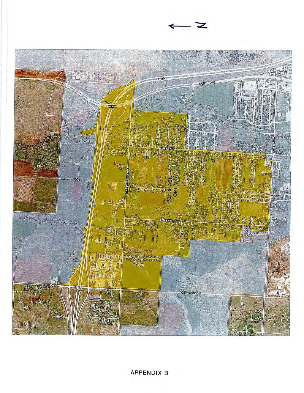
55
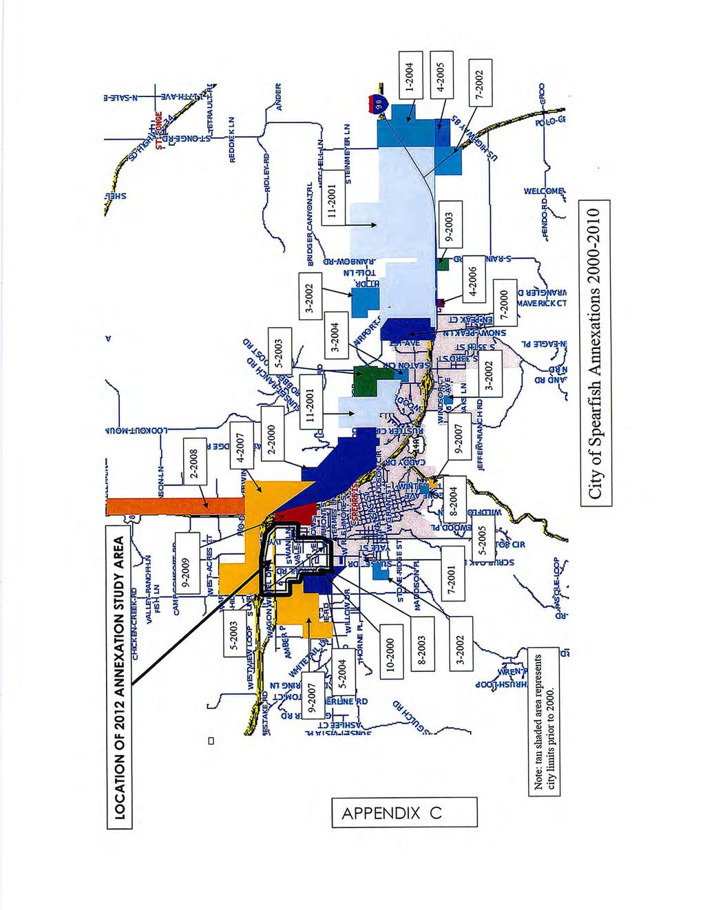
56
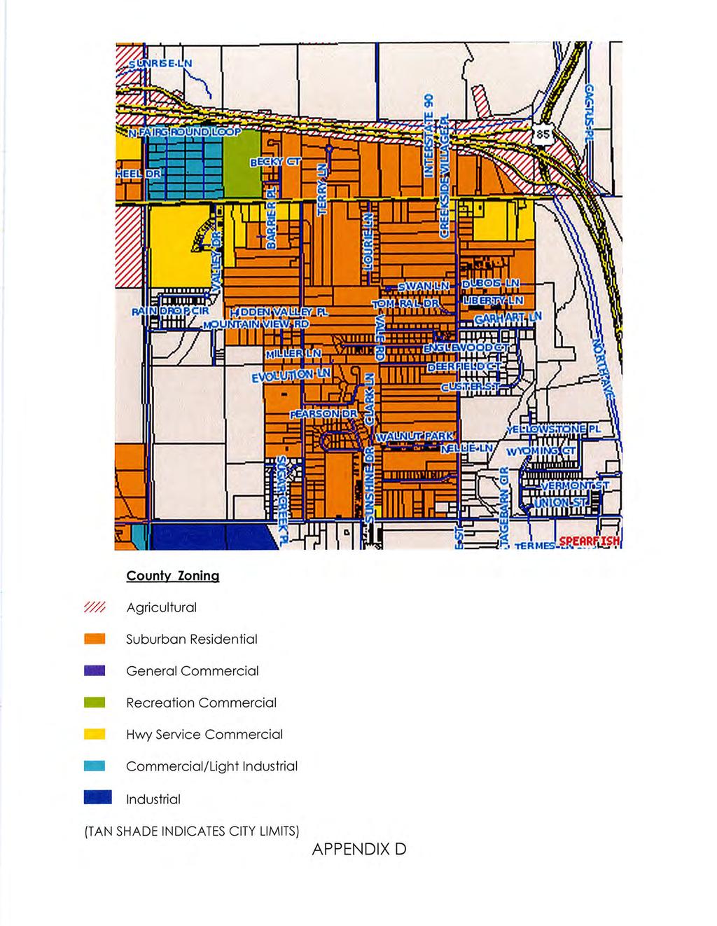
57
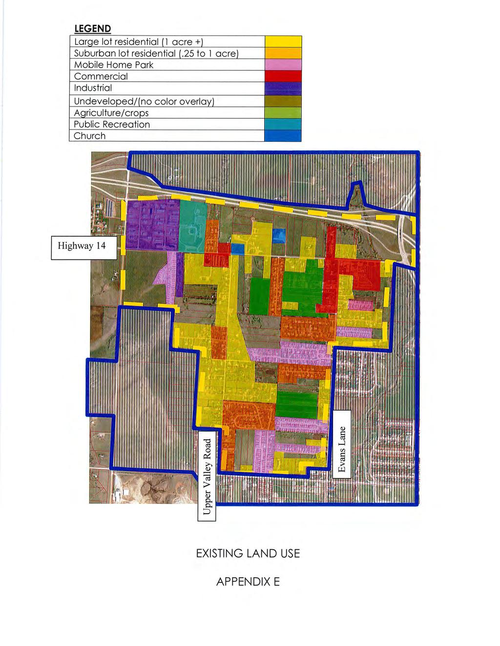
58
59
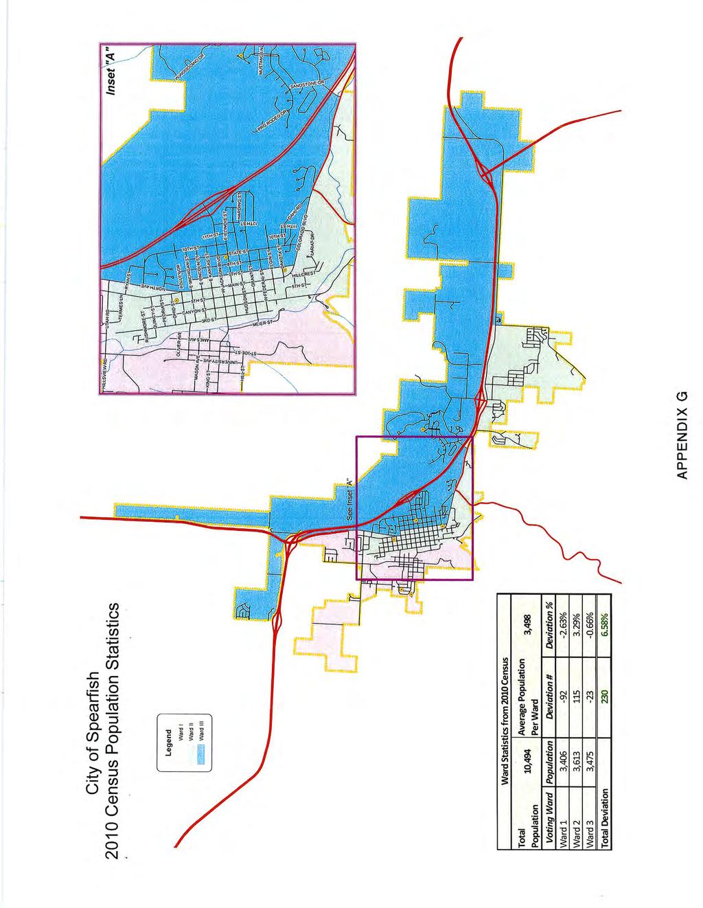
60

61
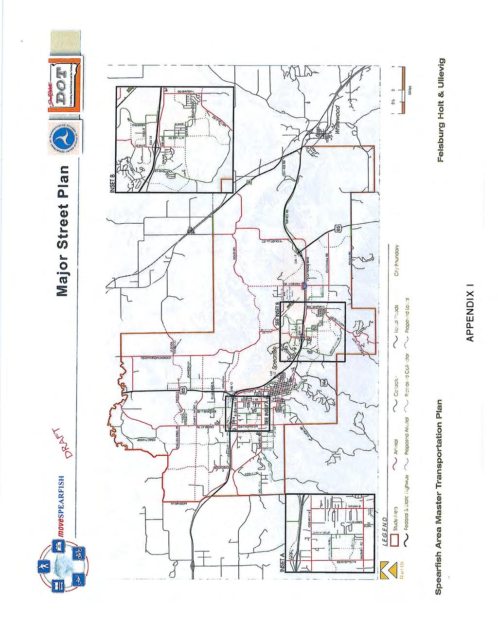
62
63
64
65
66
67
68
69
70
71
72
73
74
75
76
77
78
79

80

81
82
83
84
85
86
87
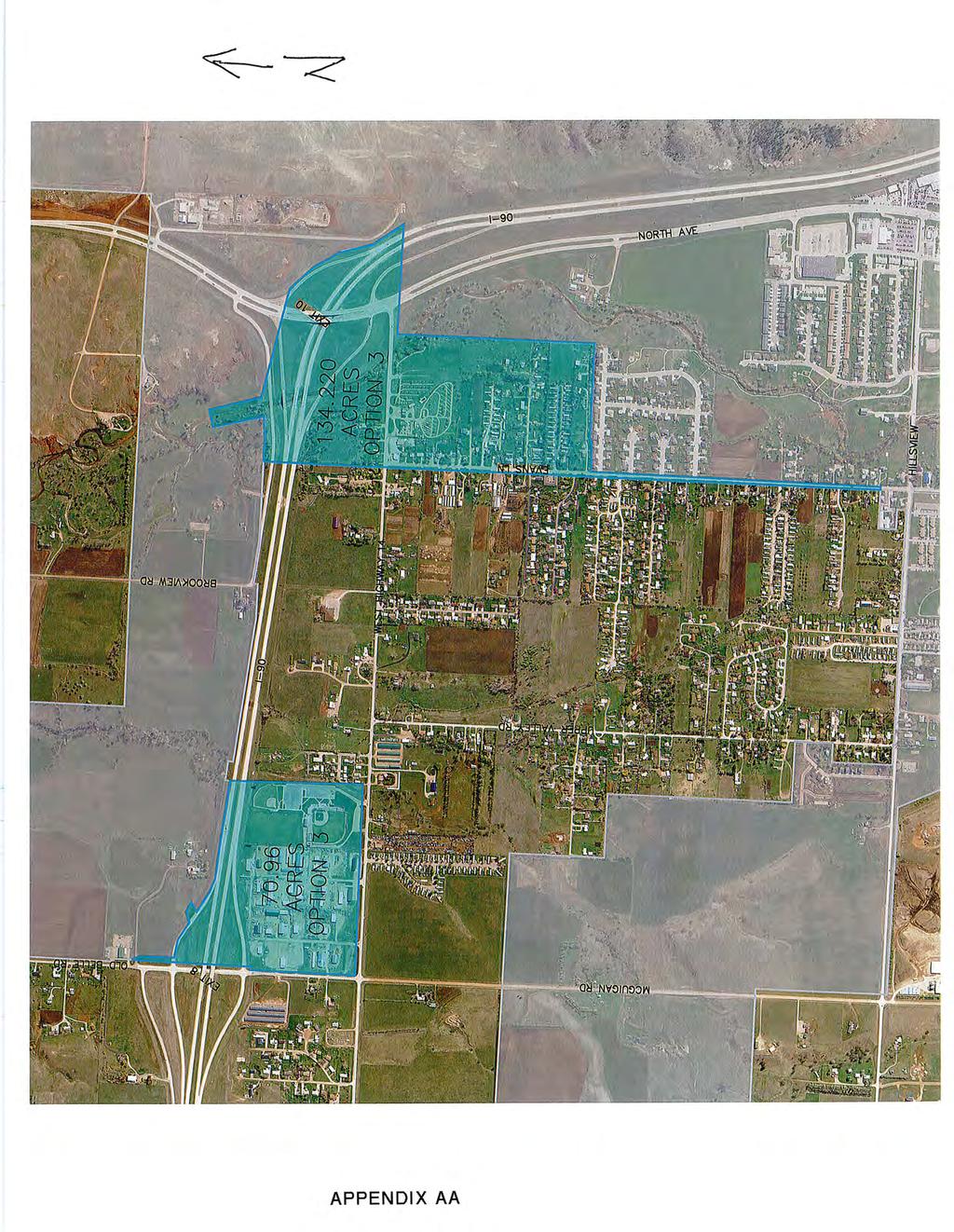
88
EXHIBIT A. City of Corpus Christi Annexation Guidelines
 City of Corpus Christi Annexation Guidelines Purpose: The purpose of this document is to describe the City of Corpus Christi s Annexation Guidelines. The Annexation Guidelines provide the guidance and
RESOLUTION RESOLUTION DECLARING INTENT TO EXTEND THE BOUNDARIES OF THE CITY OF RAPID CITY BY ANNEXING THE WITHIN DESCRIBED TERRITORY
 RESOLUTION - 2016-103 RESOLUTION DECLARING INTENT TO EXTEND THE BOUNDARIES OF THE CITY OF RAPID CITY BY ANNEXING THE WITHIN DESCRIBED TERRITORY WHEREAS, the City Council of the City of Rapid City has conducted
WOODLAND AREA GENERAL PLAN URBAN DEVELOPMENT POLICY
 APPENDIX A WOODLAND AREA GENERAL PLAN URBAN DEVELOPMENT POLICY The following text indicates proposed amendments to the Woodland Area General Plan Urban Development Policy currently adopted and included
Chapter 100 Planned Unit Development in Corvallis Urban Fringe
 100.100 Scope and Purpose. Chapter 100 Planned Unit Development in Corvallis Urban Fringe (1) All applications for land divisions in the Urban Residential (UR) and Flood Plain Agriculture (FPA) zones within
SECTION 7000 LAND DEVELOPMENT REQUIREMENTS
 SECTION 7000 LAND DEVELOPMENT REQUIREMENTS 7000 LAND DEVELOPMENT REQUIREMENTS... 1 7001 LEGISLATIVE AUTHORITY... 1 7001.1 LAND DEVELOPMENT... 1 7001.1.1 Title 40, Idaho Code... 1 7001.1.2 Idaho Code 40-1415
PLANNING COMMISSION REPORT Regular Agenda Public Hearing Item
 PC Staff Report 11/12/12 Item No. 2B- 1 PLANNING COMMISSION REPORT Regular Agenda Public Hearing Item ITEM NO. 2B: A TO GPI; 110 ACRES; E OF K-10 & N OF W 6 TH ST (MKM) : Consider a request to rezone approximately
FINDINGS OF FACT. Page 1 of 8
 FINDINGS OF FACT The City/County Planning staff has prepared the Findings of Fact for the Emerald View Park Subdivision, Amended Lot 1A, Block 3. These findings are based on the preliminary plat application
3. FISCAL IMPACT ANALYSIS FISCAL IMPACT ANALYSIS 29
 3. FISCAL IMPACT ANALYSIS FISCAL IMPACT ANALYSIS 29 The purpose of fiscal impact analysis is to estimate the impact of a development or a land use change on the budgets of governmental units serving the
ESTES VALLEY STORMWATER MANAGEMENT PROGRAM
 ESTES VALLEY STORMWATER MANAGEMENT PROGRAM Phase I. Stormwater Master Plan Phase II. Stormwater Utility Feasibility Study Board of Realtors Meeting May 3, 2018 Stormwater Master Plan Summary Stormwater
APPENDIX A FACTORS INFLUENCING COUNTY FINANCES
 APPENDIX A FACTORS INFLUENCING COUNTY FINANCES Appendix A Factors Influencing County Finances The finances of counties are affected by many different factors. Some of the variation results from decisions
APPENDIX A FACTORS INFLUENCING CITY FINANCES
 APPENDIX A FACTORS INFLUENCING CITY FINANCES This page left blank intentionally Appendix A Factors Influencing City Finances The finances of cities are affected by many different factors. Some of the variation
URBANIZATION ELEMENT. PREPARED BY CITY OF MEDFORD PLANNING DEPARTMENT 200 SOUTH IVY STREET MEDFORD, OREGON
 PREPARED BY CITY OF MEDFORD PLANNING DEPARTMENT 200 SOUTH IVY STREET MEDFORD, OREGON 97501 plnmed@ci.medford.or.us ROBERT O. SCOTT, AICP, PLANNING DIRECTOR COMPREHENSIVE PLANNING SECTION MARK GALLAGHER,
MIDWAY CITY Municipal Code
 MIDWAY CITY Municipal Code TITLE 9 ANNEXATION CHAPTER 9.01 PURPOSE CHAPTER 9.02 GENERAL REQUIREMENTS CHAPTER 9.03 PROPERTY OWNER INITIATION OF ANNEXATION CHAPTER 9.04 PROCEDURES FOR CONSIDERATION OF PETITION
YELLOWSTONE COUNTY BOARD OF PLANNING FINDINGS OF FACT
 YELLOWSTONE COUNTY BOARD OF PLANNING FINDINGS OF FACT The City-County Planning staff has prepared the Findings of Fact for the Aspen Ridge Subdivision, 2 nd Filing. These findings are based on the preliminary
City of Bartlett, Tennessee Annexation Plan of Services
 City of Bartlett, Tennessee Annexation Plan of Services 1 ANNEXATION PLAN OF SERVICES PROPOSAL TO THE PLANNING COMMISSION Monday, October 1, 2012 2 Bartlett Board of Mayor and Aldermen A. Keith McDonald,
Town of Bristol Rhode Island
 Town of Bristol Rhode Island Subdivision & Development Review Regulations Adopted by the Planning Board September 27, 1995 (March 2017) Formatted: Highlight Formatted: Font: 12 pt Table of Contents TABLE
SUBDIVISION DESIGN PRINCIPLES AND STANDARDS
 SECTION 15-200 SUBDIVISION DESIGN PRINCIPLES AND STANDARDS 15-201 STREET DESIGN PRINCIPLES 15-201.01 Streets shall generally conform to the collector and major street plan adopted by the Planning Commission
DRAFT REPORT. Boudreau Developments Ltd. Hole s Site - The Botanica: Fiscal Impact Analysis. December 18, 2012
 Boudreau Developments Ltd. Hole s Site - The Botanica: Fiscal Impact Analysis DRAFT REPORT December 18, 2012 2220 Sun Life Place 10123-99 St. Edmonton, Alberta T5J 3H1 T 780.425.6741 F 780.426.3737 www.think-applications.com
SUBDIVISION REGULATIONS
 CHAPTER 14 SUBDIVISION REGULATIONS 14-100 Provisions 14-200 Preliminary Plat 14-300 Final Plat 14-400 Replat 14-500 Minor Subdivision 14-600 Administrative Replat 14-700 Vacation of Roadways, Public Easements,
M-43 CORRIDOR OVERLAY ZONE
 ARTICLE 26.00 M-43 CORRIDOR OVERLAY ZONE Section 26.01 Findings A primary function of the M-43 state highway is to move traffic through the Township and to points beyond. As the primary east-west arterial
STANDARDS FOR EVALUATING PROPOSALS
 STANDARDS FOR EVALUATING PROPOSALS Amended by Resolution No. 2011-1; February 2, 2011 Pursuant to Government Code Section 56375, Santa Cruz LAFCO has established standards for the evaluation of proposals.
ANNEXATION. The Handbook for Georgia Mayors and Councilmembers 1
 ANNEXATION Growing and prosperous Georgia cities create a growing and prosperous Georgia. Although cities comprise only 6.8% of Georgia s land area, approximately 40% of the state s population lives in
Goals and Policies Concerning Use of MELLO-ROOS COMMUNITY FACILITIES ACT OF 1982
 Goals and Policies Concerning Use of MELLO-ROOS COMMUNITY FACILITIES ACT OF 1982 Section TABLE OF CONTENTS Page Introduction 1 1 Policy & Goals 1 2 Definitions 2 3 Eligible Public Facilities 3 4 Value-to-Lien
CITY AND COUNTY OF HONOLULU DEPARTMENT OF BUDGET & FISCAL SERVICES ADMINISTRATIVE GUIDELINES FOR COMMUNITY FACILITIES DISTRICTS
 Working Draft of May 14, 2004 Working Draft of August 11, 2004 Working Draft of September 8, 2004 CITY AND COUNTY OF HONOLULU DEPARTMENT OF BUDGET & FISCAL SERVICES ADMINISTRATIVE GUIDELINES FOR COMMUNITY
Annexation Policy Plan of the City of Logan, Utah
 Annexation Policy Plan of the City of Logan, Utah July 2007 In order to provide a geographical boundary to permit long term, comprehensive planning and growth for the City of Logan, this plan establishes
Draft Model Access Management Overlay Ordinance
 Draft Model Access Management Overlay Ordinance This model was developed using the City of Hutchinson and the Trunk Highway 7 corridor. The basic provisions of this model may be adopted by any jurisdiction
Community Development Department 333 Broadalbin Street SW, P.O. Box 490 Albany, OR 97321
 SUMMARY Community Development Department 333 Broadalbin Street SW, P.O. Box 490 Albany, OR 97321 STAFF REPORT Application for Tentative Partition Plat Review Planning File PA-06-17 Phone: 541-917-7550
Section Preliminary Plat Checklist and Application Forms
 Section 201 - Preliminary Plat Checklist and Application Forms PRELIMINARY SUBDIVISION PLAT REVIEW PROCESS CHART PRELIMINARY SUBDIVISION PLAT APPLICATION PRELIMINARY PLAT REVIEW CHECKLIST CITY OF NAMPA
CITY OF COLLEGE STATION SERVICE PLAN FOR THE AREA TO BE ANNEXED EFFECTIVE 14 APRIL 2011
 CITY OF COLLEGE STATION SERVICE PLAN FOR THE AREA TO BE ANNEXED EFFECTIVE 14 APRIL 2011 I. ANNEXATION AREA The annexation area is located on the southwest side of the City of College Station, in the City
Administration and Calculation of Servicing Agreement Fees and Development Levies
 Administration and Calculation of Servicing Agreement Fees and Development Levies Policy Title: Applies to: Reference # Administration and Calculation of Servicing Agreement Fees and City of Regina ###-XXX-##
Appendix A. Factors Affecting City Current Expenditures
 Appendix A Factors Affecting City Current Expenditures Factors Affecting City Current Expenditures Every city faces a unique situation based upon its demographic composition, location, tax base, and many
8Land Use. The Land Use Plan consists of the following elements:
 8Land Use 1. Introduction The Land Use Plan consists of the following elements: 1. Introduction 2. Existing Conditions 3. Opportunities for Redevelopment 4. Land Use Projections 5. Future Land Use Policies
Diamond Falls Subdivision PROPOSED YELLOWSTONE COUNTY BOARD OF PLANNING FINDINGS OF FACT
 Diamond Falls Subdivision PROPOSED YELLOWSTONE COUNTY BOARD OF PLANNING FINDINGS OF FACT The City/County Planning Staff has prepared the Findings of Fact for the Diamond Falls Subdivision. These findings
Lincolnton, NC Code of Ordinances CHAPTER 53: WATER AND SEWER EXTENSIONS AND AVAILABILITY CHARGES
 Lincolnton, NC Code of Ordinances CHAPTER 53: WATER AND SEWER EXTENSIONS AND AVAILABILITY CHARGES Section 53.01 General principles of water and sewer line extension 53.02 Explanation of terms and requirements
From Policy to Reality
 From Policy to Reality Updated ^ Model Ordinances for Sustainable Development 2000 Environmental Quality Board 2008 Minnesota Pollution Control Agency Funded by a Minnesota Pollution Control Agency Sustainable
4.2 LAND USE INTRODUCTION
 4.2 LAND USE INTRODUCTION This section of the EIR addresses potential impacts from the Fresno County General Plan Update on land use in two general areas: land use compatibility and plan consistency. Under
Washington County, Minnesota Ordinances
 Washington County, Minnesota Ordinances Ordinance No. 153 Text Amendment to the Washington County Development Code - Chapter One, Section 2 and Chapter Two, Part 1, Part 2, Part 3, of the Development Code
CONTRA COSTA LOCAL AGENCY FORMATION COMMISSION EXECUTIVE OFFICER'S REPORT. January 8, 2014 (Agenda)
") CONTRA COSTA LOCAL AGENCY FORMATION COMMISSION EXECUTIVE OFFICER'S REPORT : Rodeo Marina Annexation to Rodeo Sanitary District (RSD) PROPONENT: RSD by Resolution No. 2011-01 adopted April 12, 2011 ACREAGE
CONTRA COSTA LOCAL AGENCY FORMATION COMMISSION EXECUTIVE OFFICER'S REPORT : Rodeo Marina Annexation to Rodeo Sanitary District (RSD) PROPONENT: RSD by Resolution No. 2011-01 adopted April 12, 2011 ACREAGE
13-2 SUBDIVISION PLANS AND PLATS REQUIRED EXCEPTIONS Subdivision Plats Required To be Recorded
 ARTICLE XIII SUBDIVISIONS 13-1 INTENT AND PURPOSE 13-1-1 Intent: It is the intent of the County Commission through the adoption of this Article to more fully avail itself of the power granted under 17-27-601
PROVO CITY MUNICIPAL ANNEXATION GUIDE
 COMMUNITY DEVELOPMENT PROVO CITY MUNICIPAL ANNEXATION GUIDE This guide has been prepared to outline the procedures and requirements of annexing unincorporated territory into Provo City. Annexations are
Community Occupancy Guidelines
 Community Occupancy Guidelines Auckland Council July 2012 Find out more: phone 09 301 0101 or visit www.aucklandcouncil.govt.nz Contents Introduction 4 Scope 5 In scope 5 Out of scope 5 Criteria 6 Eligibility
Eastern Corridor Planning Area Workshop No April 2016
 Eastern Corridor Planning Area Workshop No. 3 28 April 2016 Agenda 1. Visual Aids 2. Guiding Principles 3. Preferred Alternative Concept Plan 4. Fiscal Impact Analysis 5. Findings 6. Recommendations 7.
Business Item Community Development Committee Item:
 Business Item Community Development Committee Item: 2008-124 C Meeting date: July 21, 2008 ADVISORY INFORMATION Date: May 21, 2008 Subject: Flexible Residential Development Ordinance Guidelines District(s),
BUSINESS INCENTIVES POLICY June 17, 2008
 BUSINESS INCENTIVES POLICY June 17, 2008 The City of Starkville, Mississippi recognizes the need for encouraging appropriate commercial growth in our community. Through the use of tax abatements, the City
APPENDIX A FACTORS INFLUENCING COUNTY FINANCES
 APPENDIX A FACTORS INFLUENCING COUNTY FINANCES This page left blank intentionally Appendix A Factors Influencing County Finances The finances of counties are affected by many different factors. Some of
To achieve growth, property development, redevelopment and an improved tax base in the cities and boroughs in the Lehigh Valley.
 Most growth in property valuation is in townships. Between 1991 and 2004, the assessed valuation of the townships in the Lehigh Valley increased by more than $2.8 billion, an increase of 41%. At the same
CHAPTER URBAN TRANSITION - UT ZONE
 CHAPTER 16.13 URBAN TRANSITION - UT ZONE Section Title Page 16.13.000 Purpose 1 16.13.010 Uses 1 16.13.020 Conditional Uses 2 16.13.030 Conditional Use Criteria 3 16.13.040 Prohibited Uses 4 16.13.100
Implementation TOWN OF LEON COMPREHENSIVE PLAN 9-1
 9 Implementation 9.1 Implementation Chapter Purpose and Contents This element includes a compilation of regulatory and non-regulatory measures to implement the objectives of this comprehensive plan. The
ORDINANCE NO AN ORDINANCE AMENDING THE CODE OF ORDINANCES OF THE CITY OF PORT ARANSAS, TEXAS, BY ADOPTING A NEW CHAPTER
 ORDINANCE NO. 2008-09 AN ORDINANCE AMENDING THE CODE OF ORDINANCES OF THE CITY OF PORT ARANSAS, TEXAS, BY ADOPTING A NEW CHAPTER TWENTY-SIX CONCERNING IMPACT FEES FOR ROADWAY FACILITIES; INCORPORATING
STORMWATER MANAGEMENT SYSTEM AND FACILITIES
 152.01 Purpose 152.09 Nonresidential Unit 152.02 Findings 152.10 Rate Determinations; Compliance with Bond 152.03 Scope and Responsibility for Stormwater Utility Covenants 152.04 Definitions 152.11 Billing,
Urban Services Report For Annexation of East Lake Area
 Urban Services Report For Annexation of East Lake Area Prepared Pursuant to: Chapter 171.044 Florida Statutes And Pinellas Planning Council Resolution No.98-2 And meeting the Guidelines and Procedures
Sterling Meadow Subdivision
 Sterling Meadow Subdivision Proposal: A pre-application conference was held on November 7, 2017, with the applicant and City staff to discuss the development. The applicant took staff s recommendations
Downtown Meridian Urban Renewal Area URBAN RENEWAL ELIGIBILITY REPORT. Prepared for The City of Meridian and The Meridian Development Corporation
 Downtown Meridian Urban Renewal Area URBAN RENEWAL ELIGIBILITY REPORT Prepared for The City of Meridian and The Meridian Development Corporation by McKibben + Cooper Architects June 19, 2002 Authorization
Walworth County Farmland Preservation Plan Update, Chapter 1 Plan Summary (Cover Document)
") Background Walworth County Farmland Preservation Plan Update, 2012 Chapter 1 Plan Summary (Cover Document) For over 30-years, the Wisconsin Farmland Preservation Program has served to preserve Walworth
Background Walworth County Farmland Preservation Plan Update, 2012 Chapter 1 Plan Summary (Cover Document) For over 30-years, the Wisconsin Farmland Preservation Program has served to preserve Walworth
ANNEXATION POLICY, PROGRAM, AND PLAN. Presented to the City Council By the Planning and Development Department
 ANNEXATION POLICY, PROGRAM, AND PLAN Presented to the City Council By the Planning and Development Department August 2, 2011 1 Purpose Review the following: Annexation policy Annexation program Annexation
ARTICLE VI. SUBDIVISION STANDARDS, PUBLIC
 ARTICLE VI. SUBDIVISION STANDARDS, PUBLIC IMPROVEMENTS, AND DESIGN REQUIREMENTS ARTICLE VI. SUBDIVISION STANDARDS, PUBLIC IMPROVEMENTS, AND DESIGN REQUIREMENTS DIVISION 1. GENERAL PROVISIONS Sec. 21-6100.
Short Title: Performance Guarantees/Subdivision Streets. (Public) April 28, 2016
 April 28, 2016") GENERAL ASSEMBLY OF NORTH CAROLINA SESSION S SENATE BILL Transportation Committee Substitute Adopted // House Committee Substitute Favorable // Fourth Edition Engrossed // Short Title: Performance Guarantees/Subdivision
GENERAL ASSEMBLY OF NORTH CAROLINA SESSION S SENATE BILL Transportation Committee Substitute Adopted // House Committee Substitute Favorable // Fourth Edition Engrossed // Short Title: Performance Guarantees/Subdivision
Public Improvement District (PID) Policy
 Policy") Public Improvement District (PID) Policy OVERVIEW Public Improvement Districts ( PIDs ), per the Texas Local Government Code Chapter 372 ( the code or PID Act ), provide the City of Marble Falls ( the
Public Improvement District (PID) Policy OVERVIEW Public Improvement Districts ( PIDs ), per the Texas Local Government Code Chapter 372 ( the code or PID Act ), provide the City of Marble Falls ( the
Burlington Unincorporated Community Plan
 Burlington Unincorporated Community Plan June 30, 2010 Meeting Page 1 of 24 Table of Contents (Page numbers to be inserted) I. Background a. Location and Community Description b. Planning of Unincorporated
Development Opportunity: Priority Development Site
 Development Opportunity: Priority Development Site NORTHBRIDGE, MASSACHUSETTS Super Wal Mart National Grid Distribution Facility Route 146 Subject property: Assessor Map 1 Parcels 113, 114, 115, (117),
PLANNED UNIT DEVELOPMENTS (Ordinance No.: 3036, 12/3/07; Repealed & Replaced by Ordinance No.: 4166, 10/15/12)
") 159.62 PLANNED UNIT DEVELOPMENTS (Ordinance No.: 3036, 12/3/07; Repealed & Replaced by Ordinance No.: 4166, 10/15/12) A. PURPOSE 1. General. The Planned Unit Development (PUD) approach provides the flexibility
159.62 PLANNED UNIT DEVELOPMENTS (Ordinance No.: 3036, 12/3/07; Repealed & Replaced by Ordinance No.: 4166, 10/15/12) A. PURPOSE 1. General. The Planned Unit Development (PUD) approach provides the flexibility
ARTICLE IX. DEVELOPMENT FEES
 ARTICLE IX. DEVELOPMENT FEES ARTICLE IX. DEVELOPMENT FEES DIVISION 1: GENERAL PROVISIONS Sec. 21-9100. Purpose Sec. 21-9110. Methods of Satisfaction Sec. 21-9120. Development Fee Accounts Sec. 21-9130.
Medical Marijuana Special Exception Use Information
 Medical Marijuana Special Exception Use Information The Special Exception Use information below is a modified version of the Unified Development Code. It clarifies the current section 5:104 Special Exceptions
SCHOOL FINANCE: IMPACT FEES and a COUPLE OF OTHER THINGS. First Things. How Do We Pay? What Are We Talking About? How Do We Pay?
 SCHOOL FINANCE: IMPACT FEES and a COUPLE OF OTHER THINGS Theodore B. DuBose Haynsworth Sinkler Boyd, P.A. Presented to: SC School Boards Association 2016 School Law Conference Charleston, South Carolina
Land Use. Land Use Categories. Chart 5.1. Nepeuskun Existing Land Use Inventory. Overview
 Land Use State Comprehensive Planning Requirements for this Chapter A compilation of objectives, policies, goals, maps and programs to guide the future development and redevelopment of public and private
Open Space Model Ordinance
 Open Space Model Ordinance Section I. Background Open space development has numerous environmental and community benefits, including: 1) Reduces the impervious cover in a development. Impervious cover
CHAPTER V: IMPLEMENTING THE PLAN
 CHAPTER V: IMPLEMENTING THE PLAN A range of resources is available to fund the improvements included in the Action Plan. These resources include existing commitments of County funding, redevelopment-related
CITY SERVICES PLAN ALTAMONT COMMUTER EXPRESS MAINTENANCE FACILITY PROJECT SAN JOAQUIN REGIONAL RAIL COMMISSION. Project File No: P09-002
 CITY SERVICES PLAN FOR THE ALTAMONT COMMUTER EXPRESS MAINTENANCE FACILITY PROJECT FOR THE SAN JOAQUIN REGIONAL RAIL COMMISSION Stockton, CA Project File No: P09-002 September 15, 2010 Prepared for: CITY
Chapter 3 FINANCE, TAXATION, AND PUBLIC RECORDS
 Chapter 3 FINANCE, TAXATION, AND PUBLIC RECORDS 3.01 Preparation of Tax Roll and Receipts 3.02 Fiscal Year 3.03 Allowance of Claims 3.04 Budget 3.05 Village Borrowing 3.06 Monthly Reports of Receipts 3.07
GREENWAY BUSINESS IMPROVEMENT DISTRICT IMPROVEMENT PLAN
 Final Proposed Draft for Boston City Council Submission GREENWAY BUSINESS IMPROVEMENT DISTRICT IMPROVEMENT PLAN This is the improvement plan (the improvement plan ), as that term is defined pursuant to
Settlement Pattern & Form with service costs analysis Preliminary Report
 Settlement Pattern & Form with service costs analysis Preliminary Report Prepared for Regional Planning Halifax Regional Municipality by Financial Services, HRM May 15, 2004 TABLE OF CONTENTS INTRODUCTION...
Okaloosa County BCC. Okaloosa County BCC. MSBU / MSTU Policy. Municipal Service Benefit Units Municipal Service Taxing Units.
 Okaloosa County BCC Okaloosa County BCC MSBU / MSTU Policy Municipal Service Benefit Units Municipal Service Taxing Units Revised 5/6/2014 Table of Contents INTRODUCTION... 1 MSBU CALENDAR YEAR SCHEDULE...
Comprehensive Plan /24/01
 IV The is a central component of the Comprehensive Plan. It is an extension of the general goals and policies of the community, as well as a reflection of previous development decisions and the physical
Appendix A. Factors Affecting City Expenditures
 Appendix A Factors Affecting City Expenditures Factors Affecting City Expenditures The finances of cities are affected by many different factors. Some of the variation results from decisions made by city
Drainage Impact Fee AB 1600 Nexus Study Update to the Thermalito Master Drainage Plan
 Prepared for The City of Oroville and Butte County Prepared by Keyser Marston Associates, Inc. May 2010 I. INTRODUCTION This Nexus Study presents the maximum development impact fees related to the Update
CITY OF EAU CLAIRE, WISCONSIN. SPECIAL ASSESSMENT POLICY (Dated: November 8, 2016)
") CITY OF EAU CLAIRE, WISCONSIN SPECIAL ASSESSMENT POLICY (Dated: November 8, 2016) (Adopted by reference by Ordinance No. 7207 adopted November 8, 2016) PURPOSE The purpose of this Policy is to assure fair
CITY OF EAU CLAIRE, WISCONSIN SPECIAL ASSESSMENT POLICY (Dated: November 8, 2016) (Adopted by reference by Ordinance No. 7207 adopted November 8, 2016) PURPOSE The purpose of this Policy is to assure fair
TOTTENHAM SECONDARY PLAN
 TOTTENHAM SECONDARY PLAN AMENDMENT NO. 11 TO THE OFFICIAL PLAN OF THE TOWN OF NEW TECUMSETH The following text and schedules to the Official Plan of the Town of New Tecumseth constitute Amendment No. 11
City of Astoria Comprehensive Plan URBAN GROWTH
 URBAN GROWTH CP.110 CP.110. Background Summary. Astoria has a population of 9,477 (2010 US Census). The total land area within the Urban Growth Boundary (UGB) is 3,474.2 acres with total land area of 4,450
I. Requirements for All Applications. C D W
 108-16.1. Application checklists. Checklist for Required Submissions to the Planning Board or Zoning Board of Adjustment of Monroe Township All required submissions are to be made to the Administrative
City of Edwardsville, Kansas Special Benefit District Policy
 City of Edwardsville, Kansas Special Benefit District Policy Date Adopted: September 12, 2011 Section 1. Objective The objective is to establish a policy to finance public streets, sanitary sewers, water
BYLAW 5781 ****************
 BYLAW 5781 **************** A BYLAW OF THE CITY OF LETHBRIDGE PROVIDING FOR THE IMPOSITION OF AN OFF-SITE LEVY IN RESPECT OF LAND TO BE DEVELOPED OR SUBDIVIDED FOR THE YEARS 2013, 2014, 2015 and 2016 ************************************************************
MUNICIPAL SERVICE BENEFIT UNIT (MSBU) CREATION AND ADMINISTRATION POLICY 16-01
 CREATION AND ADMINISTRATION POLICY 16-01") MUNICIPAL SERVICE BENEFIT UNIT (MSBU) CREATION AND ADMINISTRATION POLICY 16-01 PURPOSE: POLICY: The purpose of this policy is to provide an orderly and efficient method for utilizing the statutory authority
MUNICIPAL SERVICE BENEFIT UNIT (MSBU) CREATION AND ADMINISTRATION POLICY 16-01 PURPOSE: POLICY: The purpose of this policy is to provide an orderly and efficient method for utilizing the statutory authority
RECITALS. WHEREAS, the GMA requires counties to adopt county-wide planning policies in cooperation with cities within the County; and
 AN INTERLOCAL AGREEMENT FOR THE IMPLEMENTATION OF A DEMONSTRATION PROJECT TO TRANSFER DEVELOPMENT RIGHTS FROM RURAL UNINCORPORATED KING COUNTY TO THE DENNY TRIANGLE IN DOWNTOWN SEATTLE This Agreement is
RATE STUDY IMPACT FEES PARKS
 RATE STUDY FOR IMPACT FEES FOR PARKS CITY OF KENMORE, WASHINGTON May 15, 2001 TABLE OF CONTENTS Executive Summary................................................... 1 1. Statutory Basis and Methodology
WHITEHAWK RANCH MUTUAL WATER COMPANY
 1. The Development WHITEHAWK RANCH MUTUAL WATER COMPANY (Offering Circular) WHITEHAWK RANCH is located in Eastern Plumas County, 230 miles from San Francisco and 150 miles from Sacramento via Interstate
(c) County board of commissioners means 1 of the following, as applicable: (ii) In all other counties, 1 of the following:
 County board of commissioners means 1 of the following, as applicable: (ii) In all other counties, 1 of the following:") TOWNSHIP PLANNING Act 168 of 1959, as amended, (including 2001 amendments, 2006 amendments) AN ACT to provide for township planning; for the creation, organization, powers and duties of township planning
TOWNSHIP PLANNING Act 168 of 1959, as amended, (including 2001 amendments, 2006 amendments) AN ACT to provide for township planning; for the creation, organization, powers and duties of township planning
APPENDIX A FACTORS INFLUENCING COUNTY FINANCES
 APPENDIX A FACTORS INFLUENCING COUNTY FINANCES This page left blank intentionally Appendix A Factors Influencing County Finances The finances of counties are affected by many different factors. Some of
APPENDIX C-1 DEVELOPING FINDINGS OF FACT & CONCLUSIONS OF LAW FOR PLANNING AND ZONING
 APPENDIX C-1 DEVELOPING FINDINGS OF FACT & CONCLUSIONS OF LAW FOR PLANNING AND ZONING Amended: 9/2011; 9/2014; Page! i DEVELOPING FINDINGS OF FACT, AND CONCLUSIONS OF LAW 1. Developing the following information
CITY OF ESCONDIDO ANNEXATION GUIDE
 CITY OF ESCONDIDO ANNEXATION GUIDE A. PURPOSE The purpose of this document is to provide information on the process and procedure of annexation to the City of Escondido and to answer basic questions regarding
CHAPTER Committee Substitute for Committee Substitute for Senate Bill No. 2188
 CHAPTER 2004-372 Committee Substitute for Committee Substitute for Senate Bill No. 2188 An act relating to land development; amending s. 197.502, F.S.; providing for the issuance of an escheatment tax
SECTION WATER SYSTEM EXTENSION
 SECTION 10.00 WATER SYSTEM EXTENSION 10.01 General Statement: The Board shall make or cause to be made such extension, or replacements, to the water transmission and distribution system of the Board as
Residential Major Subdivision Review Checklist
 Residential Major Subdivision Review Checklist Plan Submittal Requirements: 2 full sets of stamped plans Electric submittal - all plans contained in a single PDF 3 full sets if commercial kitchen or dining
Chapter 5: Testing the Vision. Where is residential growth most likely to occur in the District? Chapter 5: Testing the Vision
 Chapter 5: Testing the Vision The East Anchorage Vision, and the subsequent strategies and actions set forth by the Plan are not merely conceptual. They are based on critical analyses that considered how
ARTICLE 15. RULES, REGULATIONS AND DEFINITIONS
 ARTICLE 15. RULES, REGULATIONS AND DEFINITIONS Section 1. Interpretation and Construction: The following rules and regulations regarding interpretation and construction of the Ulysses-Grant County, Kansas,
Panama City Beach Fire Service Assessment Information
 Panama City Beach Fire Service Assessment Information On November 9, 2017, the City of Panama City Beach scheduled a public hearing for January 11, 2018 to consider the adoption of a special assessment
Rule 80. Preservation of Primary Agricultural Soils Revised and approved by the Land Use Panel during its public meeting on January 31, 2006.
 Rule 80. Preservation of Primary Agricultural Soils Revised and approved by the Land Use Panel during its public meeting on January 31, 2006. (A) Purpose. In accordance with 10 V.S.A. Sections 6025(b)
CHAPTER IV IMPLEMENTATION
 CHAPTER IV IMPLEMENTATION Chapter Outline IV. Implementation Page A. Public Works Projects/Public Infrastructure IV-1 1. Facilities Master Plan Overview IV-1 2. Facilities Master Plan Service Standards
CITY OF DEL RIO PLANNING & ZONING COMMISSION COUNCIL CHAMBERS - CITY HALL 109 WEST BROADWAY ST. WEDNESDAY, MAY 20, :30 P.M.
 CITY OF DEL RIO PLANNING & ZONING COMMISSION COUNCIL CHAMBERS - CITY HALL 109 WEST BROADWAY ST. WEDNESDAY, MAY 20, 2015 5:30 P.M. AGENDA 1. CALL TO ORDER 2. ROLL CALL 3. APPROVAL OF MINUTES a. Approve
CITY OF LAFAYETTE ENGINEER S REPORT LANDSCAPE AND LIGHTING DISTRICT NO (RESIDENTIAL LIGHTING) FISCAL YEAR 2017/2018
 FISCAL YEAR 2017/2018") CITY OF LAFAYETTE ENGINEER S REPORT LANDSCAPE AND LIGHTING DISTRICT NO. 1979-2 (RESIDENTIAL LIGHTING) FISCAL YEAR 2017/2018 INTENT MEETING: APRIL 10, 2017 PUBLIC HEARING: MAY 22, 2017 27368 Via Industria
CITY OF LAFAYETTE ENGINEER S REPORT LANDSCAPE AND LIGHTING DISTRICT NO. 1979-2 (RESIDENTIAL LIGHTING) FISCAL YEAR 2017/2018 INTENT MEETING: APRIL 10, 2017 PUBLIC HEARING: MAY 22, 2017 27368 Via Industria
BARROW COUNTY, GEORGIA
 BARROW COUNTY, GEORGIA Application For Rezoning, Special Use, and Change in Conditions BARROW COUNTY DEPARTMENT OF PLANNING AND DEVELOPMENT 30 North Broad Street Winder, Georgia 30680 770-307-3034 APPLICATION