ADA TOWNSHIP DOWNTOWN DEVELOPMENT AUTHORITY AMENDED AND RESTATED DEVELOPMENT PLAN AND TAX INCREMENT FINANCING PLAN
|
|
|
- Nathaniel Mills
- 6 years ago
- Views:
Transcription

1 ADA TOWNSHIP DOWNTOWN DEVELOPMENT AUTHORITY AMENDED AND RESTATED DEVELOPMENT PLAN AND TAX INCREMENT FINANCING PLAN March 7, 2016 Draft Approved by Ada Township Downtown Development Authority Board: March 7, 2016 Approved by Ada Township Board:
2 ADA TOWNSHIP DOWNTOWN DEVELOPMENT AUTHORITY AMENDED AND RESTATED DEVELOPMENT PLAN AND TAX INCREMENT FINANCING PLAN TABLE OF CONTENTS Page Section I. DEVELOPMENT PLAN 1 A. Creation of the Ada Township Downtown Development Authority and District 1 B. History of the Ada Township Downtown Development Plan Objectives 2 C. Land Use 4 D. Description of Proposed Improvements 13 E. Disposal, Conveyance or Acquisition of Interests in Real Property 16 F. Development Cost Estimates and Financing 16 G. Other Planned Activities of the Authority 19 H. Amendments to Plan 19 Section II. TAX INCREMENT FINANCING PLAN FOR DEVELOPMENT DISTRICT 20 A. Tax Increment Financing Procedures 20 B. Estimates of Captured Assessed Values and Tax Increment Revenues; Amount to be Captured 21 C. Use of Tax Increment Revenue 21 D. Indebtedness to be Incurred 22 E. Duration of Program 22 F. Estimated Impact on all Taxing Jurisdictions 22 Exhibit EXHIBIT LIST A. Ordinance No. O , creating the Ada Township Downtown Development Authority, adopted November 10, B. Ordinance No. O approving the initial Development Plan and Tax Increment Financing Plan, adopted May 11, 2009 C. Ordinance No. O-, approving this Amended and Restated Development Plan and Tax Increment Financing Plan, adopted, 2016 D. Ordinance No. O-, amending the Downtown Development Authority Ordinance to authorize the DDA to levy ad valorem taxes not to exceed 2.0 mills on real and property within the DDA District E. Legal Description of Properties Included Within the Development District F. Map of Development District Boundary G. Map of Existing Land Use, Existing Streets, Public Land and Undeveloped Land. H. Map of Planned Future Land Use Within the Development District I. Map of Current Zoning Within the Development District I-2. Map of Current Optional PVM Overlay Zoning Sub-district Boundaries J. Map Depicting Development Plan Public Improvements K. Concept Plan for Headley Street Community Space L. Concept Plan for Settlers Grove Park M. Schedule of the Initial Assessed Value of all real and personal property in the Development District as finally equalized in May of 2008.
3 Ada Township Downtown Development Authority Amended and Restated Development Plan and Tax Increment Financing Plan Adopted, 2016 N-1. History of Assessed and Taxable Value in the Development District N-2. Millage Rates Subject to Capture N-3. Tax Increment Revenue Projections O. Impact on Taxing Jurisdictions ii
4 Ada Township Downtown Development Authority Amended and Restated Development Plan and Tax Increment Financing Plan Adopted, 2016 SECTION I DEVELOPMENT PLAN A. Creation of the Ada Township Downtown Development Authority and District; Preparation and Adoption of Initial Development Plan and Tax Increment Financing Plan; Preparation of Amended and Restated Plan On November 10, 2008, the Ada Township Board adopted Ordinance No. O , which created the Ada Township Downtown Development Authority (the Authority ). Ordinance No. O is attached to this Plan as Exhibit A. The Authority was given all of the powers and duties prescribed for a Downtown Development Authority pursuant to Act 197 of the Public Acts of 1975, as amended (Act 197), also known as the Downtown Development Authority Act, with the exception of the authority to levy an ad valorem tax on property located within the Development District, and with the exception of taking private property for public purposes. On January 19, 2009, the Township Board approved the appointment of the Authority Board of Directors. The Board has since held monthly meetings, with its initial efforts focused on organizational matters, as well as the preparation and adoption of the Authority s initial Development Plan and Tax Increment Financing Plan (the Initial Plan ). On February 9 and February 23, 2009, the Township Board approved the appointment of 9 members to a Development Area Citizens Council, which is comprised entirely of persons whose residence is located within the Development District. In accordance with Act 197, the Citizens Council is charged with advising the Authority Board and the Township Board on the development and implementation of a Development Plan and Tax Increment Financing Plan. The Citizens Council held several meetings during the development of the Initial Plan, and submitted a report to the DDA Board and the Township Board recommending the adoption of the Initial Plan. On May 11, 2009, the Township Board adopted Ordinance No. O approving the Initial Plan, a copy of which ordinance is attached as Exhibit B. In 2013, the DDA initiated a major planning study of potential redevelopment in the Village area of the DDA District, referred to as the Envision Ada Planning process. The Envision Ada Final Report, dated January 13, 2014, contains recommendations for significant public facility improvements in the following areas: re-construction of existing streets and construction of new streets in the Village, along with associated public water and sewer facilities and streetscape improvements. acquisition and improvement of land for public park, civic space and civic buildings. It is intended and anticipated that these public improvements will incentivize and be accompanied by major private investment in new development and redevelopment, for retail, restaurant, office and residential use in the Ada Village area. Much of this investment and redevelopment is to consist of the demolition and re-development of the Thornapple Village Shopping Center, located along the southeast side of Ada Drive, south of Fulton Street The Envision Ada Plan encourages new development and redevelopment to be in accordance with traditional urban design principles and form, to reinforce and expand upon the existing traditional downtown character that exists in the historical heart of the Village on Ada Drive between Bronson Street and Thornapple River Drive The primary purpose of this Amended and Restated Development Plan and Tax Increment Financing Plan (the Restated Plan ) is to update the plans, schedule, estimated costs and proposed methods of financing - 1 -
5 Ada Township Downtown Development Authority Amended and Restated Development Plan and Tax Increment Financing Plan Adopted, 2016 for public improvements in the District, and to incorporate proposed improvements identified in the Envision Ada Plan. In addition, the Restated Plan identifies potential future public parking improvements in the District, based on analysis of future parking needs. A significant revision to the proposed methods of financing public improvements that is included in the Restated Plan is the proposed levying of an ad valorem property tax by the Authority, as authorized in the Downtown Development Authority Act. Consultation with the Development Area Citizens Council regarding the Amended and Restated Plan took place at meetings of the Council held on February 24, 2016 and March 16, On, 2016, the Township Board adopted Ordinance No. O-, approving this Restated Plan for the Development District, a copy of which ordinance is attached as Exhibit C. On the same date, the Township Board adopted Ordinance No. O-, which amended Ordinance No. O and removed the prohibition on the ability of the Authority to levy an ad valorem tax on real and personal property located within the Development District. A copy of this Ordinance is attached as Exhibit D. The intent of Act 197 is to provide a means for municipalities to address property value deterioration and economic decline within downtown business districts. The Act authorizes the establishment of downtown development authorities and the use of tax increment financing to finance and encourage the revitalization of and economic growth within business districts. Act 197 specifically authorizes local units of government to establish a downtown development authority to correct and prevent deterioration in business districts; to encourage historic preservation; to authorize the acquisition and disposal of interests in real and personal property; to authorize the creation and implementation of development plans and development areas in the districts; to promote the economic growth of the districts; to create a board and prescribe its powers and duties; to authorize the levy and collection of taxes; to authorize the issuance of bonds and other evidences of indebtedness; to authorize the use of tax increment financing; and to provide for rule promulgation. In addition to an ad valorem levy, a second financing tool available to local governments to revitalize their downtown business districts is tax increment financing. Through tax increment financing, a portion of the increase in the tax base resulting from the economic growth and development of facilities, structures or improvements within a development area is reinvested in the area and used for infrastructure improvements and facilities enhancement, thereby reinvigorating the development area and facilitating economic growth and development. Act 197 seeks to accomplish its goals by providing local units of government with the necessary legal, monetary and organizational tools to eliminate property value deterioration and to promote economic growth through publicly initiated projects undertaken cooperatively with privately initiated projects. B. History of the Ada Downtown Area and Development Plan Objectives The Ada Township Downtown Development Authority Development District is legally described in Exhibit E and shown on the map attached as Exhibit F. The Development District is comprised of predominantly commercial and industrial-zoned lands along the Fulton Street (M-21) corridor within Ada Township, as well as the historic, unincorporated traditional town center and adjacent residential neighborhood known as the Ada Village area. In the summer of 2006, the Township undertook an extensive, Township-wide planning process focusing on the Village area the Ada Village Design Charrette process. This facilitated process engaged hundreds of citizens from the entire Township in a week-long design exercise for the Village. In this process, community members were engaged in defining the desired and valued physical characteristics of - 2 -
6 Ada Township Downtown Development Authority Amended and Restated Development Plan and Tax Increment Financing Plan Adopted, 2016 the Village, including both the public and private built environments, as well as the natural environment. The most negatively-perceived aspects of the Village were also identified. Based on the results of this exercise, a physical plan for the Village was developed that reinforces and builds upon the valued characteristics of the Village, and lessens or removes the negatively-perceived features. The basic structure of potential new zoning regulations for the Village was also developed, based on form-based coding principles that encourage desired urban form in new development and redevelopment. Following the completion of the Ada Village Design Charrette, the Township Board initiated the creation of the Ada Township Downtown Development Authority to facilitate implementation of plans for public improvements and redevelopment in the Village area and along the M-21 corridor. The public improvements recommended in the Ada Village Design Charrette Final Report became the basis for the planned public infrastructure improvements and expenditures identified in the Initial Plan approved in In 2011, street re-construction, public parking and streetscape improvements were completed on the segment of Bronson Street west of Ada Drive, as called for in both the original 1990 s Village Restoration Plan and the Initial Plan. Funding sources for this project included Township general funds and utility system enterprise funds. Although no DDA funds were expended on the project, the DDA Board served a leadership role in the design and implementation of the project. The only public improvement project that has been completed by the DDA with use of DDA funds has been the installation in 2013 of two small pedestrian plazas consisting of benches, trash receptacles, a bicycle rack and brick pavers on Ada Drive between Bronson Street and Thornapple River Drive, with a cost of approximately $15,000. Following the adoption of the Initial Plan, there was relatively little progress made in implementing the public improvement and private redevelopment activities called for in that plan, other than the Ada Drive streetscape improvements mentioned above. To a large extent, the lack of plan implementation resulted from an unwillingness of several property owners to incur debt or otherwise take financial risk in making new capital investment in their properties. Fragmented ownership of property contributed to this condition, as did the national economic decline known as the Great Recession that began in late This condition changed significantly in late-2012 when a single property owner, an entity created by Amway Corp., consolidated ownership of 22 acres of land in 7 parcels, primarily in the portion of the Ada Village area bordered by Ada Drive, Thornapple River Drive and the Thornapple River, including both developed property and vacant land. The largest of these acquisitions was the 34,500 square foot Thornapple Village Shopping Center, on 7.9 acres of land. In January, 2013, the new property owner, Geld, LLC, requested that the DDA undertake a public planning process to generate new design ideas for how the newly-acquired properties might be redeveloped. After recruiting and retaining an urban design consultant, the DDA initiated the Envision Ada urban design planning process for the Village area, with approximately 75% of the cost of consulting services paid for by Amway Corp., and the remaining 25% paid by the DDA. The scope of the planning process called for building upon the 10 Design Principles that resulted from the Village Design Charrette planning process in 2006, in creating a refined design plan for the Village. Through the summer and fall of 2013, the DDA involved the public in the planning process through a variety of stakeholder engagement methods. The final report for the Envision Ada Planning process, completed in January, 2014 (the Envision Ada Plan ), serves as the basis for many of the public infrastructure improvements, private redevelopment activities and financing methods contained in this Restated Plan
7 Ada Township Downtown Development Authority Amended and Restated Development Plan and Tax Increment Financing Plan Adopted, 2016 Following completion of the Envision Ada Plan, Ada Township, the Ada Township DDA and the Amway-affiliated real estate entity Geld, LLC negotiated and entered into an agreement (the Development Agreement ) which sets forth the respective financial commitments of Ada Township, the Ada Township DDA and Geld, LLC, to complete certain public improvements as called for in the Envision Ada Plan. Pursuant to the Development Agreement, Geld, LLC and Ada Township have each committed $6.5 million toward the cost of public improvements in the Village. In addition, the Development Agreement commits Geld, LLC to convey to the Township, at no cost, ownership of specified parcels of land in the Village for public park, greenspace and civic facility use. The Development Agreement may be modified in the future by agreement of the parties to address financing of additional public improvements identified in this Restated Plan. If so modified, such modifications shall be incorporated herein by reference. In 2015, the first phase of public improvements as called for in the Envision Ada Plan and the Development Agreement were completed. This phase of improvements included the re-location and reconstruction of a portion of Headley Street, from Ada Drive extending west to a new intersection of Headley Street, with Fulton Street/M-21. The alignment of much of the street was shifted approximately 100 feet to the north, on a new right-of-way. Both the former street right-of-way and privately-owned land located between the former right-of-way and new right-of-way were conveyed to adjoining property owners on the south side of the street, to provide those adjoining property owners with frontage on and access to the new street. In Spring, 2016, Headley Street will be extended across Ada Drive to the southeast, to connect to Thornapple River Drive at a location immediately west of the Thornapple River Drive bridge on the Thornapple River. The estimated $3.0 million cost of the Headley Street improvements completed in 2015 and 2016 is being financed entirely by funding from Geld, LLC, as provided in the Development Agreement. Additional public improvements are proposed to be completed by the Township and DDA in 2016 and future years, as provided in this Restated Plan. The Authority and Ada Township intend to improve retail and commercial areas located within the Development District through the public improvements described in Section I.D., below, to stimulate economic growth, encourage redevelopment and private investment in existing buildings and businesses, and improve both vehicular and pedestrian access to businesses located within the Development District. This Restated Plan identifies improvement needs and considers how those needs will be implemented and financed. C. Land Use 1. Existing Land Use A map of the Development District showing existing streets, existing land uses, rivers and streams, public land and undeveloped land is shown in Exhibit G. Residential, commercial, industrial and public land uses and facilities are included. Existing use of land in the Development District covers a broad range, from the large manufacturing, distribution and office complexes of Amway Corporation on the north side of Fulton Street and on Spaulding Avenue to small, cottage-style homes on small lots in the Village residential area. Spaulding Avenue Area: At the west end of the Development District, the most significant land uses include the 210-unit Stone Falls of Ada apartment community, on the east side of Spaulding Ave, south of Fulton Street, and the - 4 -
8 Ada Township Downtown Development Authority Amended and Restated Development Plan and Tax Increment Financing Plan Adopted, 2016 former Amway s Catalog Distribution Center, with over 600,000 square feet of floor area, on the west side of Spaulding Avenue. A portion of the former Amway Catalog Distribution Center has been converted by Amway to manufacturing use, for production of nutritional supplements under the Nutrilite brand. Approximately 245,000 square feet of the building is currently vacant. A large, visually prominent use of land is the Consumers Energy electrical substation at the southeast corner of Fulton Street and Spaulding Avenue. Other uses in this area include a manufacturing facility, Perforated Tube, Inc., on the south side of Fulton Street, at the west edge of the Development District, a computer network systems integration and distribution business on the east side of Spaulding Ave., north of the Stone Falls of Ada apartment community and an auto body repair shop on the north side of Fulton Street. Significant vacant parcels include approximately 35 acres of industrial-zoned land southwest of Fulton Street and Spaulding Avenue, and about 25 acres of land zoned Rural Residential on the north side of Fulton, east of Spaulding Avenue Fulton Street Corridor: The Development District includes all of the industrial-zoned land on the south side of Fulton Street, between Alta Dale Avenue and Kulross Avenue, as well as commercially-zoned land between Kulross Avenue and Grand River Drive This area contains a mix of manufacturing/processing, distribution, heavy commercial and office uses. In addition to office uses, the corridor land uses include a specialty meat processing, packaging and sales business, a specialty metal forming facility, an offset printing business, several general contractors and construction trade contractors, a paper distribution company, a book publisher and wholesaler, a church congregation housed in a converted office building, two auto repair facilities and a lumber yard. There is also one single-family home located along the south side of the Fulton Street corridor. There are no retail businesses located in this industrially-zoned area, other than the retail business conducted by the lumber yard. Commercial uses located east of Kulross Avenue include a small grocery store/cafe at the Fulton Street/Kulross Avenue intersection, and a variety of retail, office and restaurant uses in the Ada Hillside Center, on the north side of Fulton, west of Grand River Drive. There is little vacant land in this part of the Development District. The approved design for the Ada Hillside Center calls for one additional building to be constructed. There is also infill development potential on the vacant land east of O Brien s Market, on the south side of Fulton Street. There is also potential for redevelopment of a number of the small, industrial-zoned parcels along the south side of Fulton Street East Ada Area: This part of the Development District includes the commercially-zoned parcels located east of the Fulton Street bridge over the Grand River, on Fulton Street and Pettis Avenue. Land uses in this area include several office buildings, miscellaneous commercial/service businesses, a self-service storage center, an auto repair business and a restaurant. A second former restaurant at the corner of Pettis Avenue and Honey Creek Avenue is currently vacant on the main level, with the upper level recently converted to office use. A multi-tenant commercial center with is located at the corner of Fulton Street and Pettis Avenue, with access off Pettis Avenue Existing uses are primarily office use and a pizza parlor. On the south side of the Fulton Street bridge, adjacent to the east bank of the Grand River, is approximately 5 acres of permanent open space land owned by Ada Township, most of which is located in the Grand River floodplain
9 Ada Township Downtown Development Authority Amended and Restated Development Plan and Tax Increment Financing Plan Adopted, 2016 Ada Village Area: Amway Corporation s world headquarters and manufacturing facilities are located on the north side of Fulton Street, across from the historic Ada Village area, on approximately 300 acres of land adjacent to the Grand River. Land use in the Village includes a variety of businesses that serve the local area, including several banks, a credit union, several cafes, restaurants and coffee shops, a hardware store, dry cleaners, hair salons and barber shop, veterinary office, dental offices, a florist, gas station/convenience stores and an auto repair facility. There are also a few specialty retail shops in the Village, including a pottery studio, yarn shop and a bicycle shop. A building permit was recently issued for remodeling of a vacant storefront for a new liquor store on Ada Drive, and work is underway in converting a former small retail shop to a restaurant, with a new kitchen addition and outdoor seating area. On the Ada Drive frontage to the south of the railroad trestle lies the former Ada High School. In 2013, the 11,000 square foot building was redeveloped for office space and an upper floor dwelling unit. Public facilities in the Village include a post office, the Township government offices, a fire station and the Averill Historical Museum, which is owned by the Township and operated by the Ada Historical Society. One corner of the Ada Drive/Thornapple River Drive intersection is occupied by an AT&T switching station. There are several large vacant sites with significant development potential in the Village, including a 5- acre site on the south side of Fulton Street, east of Ada Drive, and approximately 10 acres, on a site located south of the Grand Rapids Eastern rail line, between Ada Drive and the Thornapple River. This site recently received zoning approval for development of a 50-unit housing community called Riverpoint of Ada, consisting of 25 detached single family homes and 25 attached townhomes. Construction is expected to begin in Zoning approval has also been granted for a 2-story, 10,000 square foot mixed use commercial building, to be constructed at the northwest intersection of re-located Headley Street and Ada Drive. This building will have office space on the 5,000 square foot upper floor, and 5,000 square feet of retail space on the first floor. Construction is expected to begin in spring Redevelopment is also underway on approximately 5 acres of land owned by Amway Corp. on the south side of Fulton Street, west of the new Fulton Street/Headley Street intersection. Construction was recently completed on a 5,000 square foot salon/day space, and construction is imminent on new buildings to be occupied by the River Valley Credit Union and the Ortez State Farm Insurance agency. Zoning review and approval submittals are also anticipated soon for a proposed 20,000 square foot medical office building in this area. There are approximately 35 single family homes located in the Village, on Ada Drive, Bronson Street, Thornapple River Drive, Headley Street, River Street and Teeple Avenue There are also a small number of dwelling units located on the upper floors of 2-story buildings on Ada Drive in the heart of the Village. Open space uses include Leonard Field Park, owned and operated by Ada Township, a Michigan DNR public boat launch site on the Grand River, north of the Fulton Street bridge, and approximately 20 acres of natural floodplain land owned by Ada Township at the confluence of the Grand and Thornapple rivers. 2. Planned Future Land Use - 6 -
10 Ada Township Downtown Development Authority Amended and Restated Development Plan and Tax Increment Financing Plan Adopted, 2016 A map showing planned Future Land Use for the Development District is included in Exhibit H. The most significant changes in future land use that are contemplated within the DDA District are concentrated in the Ada Village area, on land that has been acquired by the Amway affiliated entity, Geld, LLC, including the existing Thornapple Village Shopping Center. In addition, new development and redevelopment are projected to occur on currently-vacant land along the south side of recentlyreconstructed Headley Street, on land that was formerly the right-of-way of Headley Street and that was conveyed to adjacent property owners on the south side of the street after it was abandoned by the Kent County Road Commission. Following is a description of the land use categories shown on the Proposed Land Use Map, and a description of new development anticipated in selected areas. Rural Development Area: The Rural Development Area is intended to accommodate new residential development and population growth in a rural setting. In this area, a premium is placed on designing new development to minimize impacts on site natural features, and be harmonious with a rural environment. Development density designated for this area is a maximum of 1 unit per 2 acres of land, as provided in both the Rural Residential (RR) Zoning District. The only land within the DDA District designated in this category is approximately 20 acres on the north side of Fulton Street, near the Spaulding Avenue intersection. Medium Density Residential: This category is intended to provide land for multiple-family residential use, compact single family development designs, or mixed single- and multiple-family development at higher densities up to 12 units per acre. Two sites are designated in this land use category the Stone Falls of Ada apartment community, on Spaulding Avenue, and vacant land on the north side of Fulton Street, between the Country Homes of Ada condominium development and the Ada Cemetery. Public/Semipublic: Includes governmental facilities such as the US Post Office, Township offices, Fire Station, the Averill Historical Museum, utility facilities, churches and cemeteries. General Commercial: The General Commercial land use category applies to C-2-zoned commercial areas located outside of the Village area along the Fulton Street corridor, most of which is currently developed. Land in this category includes the Ada Hillside Center commercial development on the north side of Fulton Street at Grand River Drive, and the nearby O Brien s Market at the corner of Fulton Street and Kulross Avenue. The remaining land in this category is all located east of the Grand River, along Pettis Avenue between Honey Creek Avenue and Fulton Street, and on the south side of Fulton Street east of the river. A broad range of commercial and office uses are accommodated in this land use category. Office/Service/Light Warehouse: This land use designation is applied to the existing Industrially-zoned lands on the south side of Fulton St., from Kulross Avenue west to Alta Dale Ave. This land use designation is intended to recognize the increasingly non-industrial nature of the land uses that are located in this corridor, and the Township s desire to encourage uses that are least likely to create conflicts with the adjoining residential neighborhood located - 7 -
11 Ada Township Downtown Development Authority Amended and Restated Development Plan and Tax Increment Financing Plan Adopted, 2016 directly to the south, across the rail line. A transition to new zoning regulations for this area which classify manufacturing as a special land use is anticipated. In addition, the Township does not wish for this segment of the M-21 corridor to become a linear retail commercial strip. Appropriate land uses in this area include professional and administrative offices, health care services, child care centers, small warehouse and distribution facilities, light fabrication, assembly and packaging operations and places of worship. New or expanded light manufacturing may also be located in this area. Light Industrial: The Light Industrial land use category designates a large area of vacant land located west of Spaulding Ave., between M-21 and the Grand Rapids Eastern rail line, in addition to the former Amway Catalog Distribution Facility on Spaulding Avenue, a portion of which has been converted to manufacturing of nutritional supplements. This area is suited to light industrial uses by virtue of the open and moderately sloped land in the area, availability of public utilities, proximity to the State trunk line highway, and proximity to I-96 to the west. The intent of the Light Industrial category is to provide for industrial uses that do not involve operations likely to create objectionable noise or odors or are visually objectionable. This land use category corresponds to the Light Industrial (LI) Zoning District on the Zoning Map. Industrial: The Industrial land use category designates existing, large manufacturing facilities which are not in close proximity to residential areas. Amway Corp's manufacturing facilities between M-21 and the Grand River is the only property designated in the Industrial category. Appropriate zoning is the Industrial (I) District for this area. The remaining land use categories contained on the Proposed Land Use Map apply to land in the Ada Village area, where significant redevelopment is anticipated to occur in the future, with new private development and public facility improvements based on urban form standards contained in the Planned Village Mixed Use (PVM) overlay district contained in the zoning regulations, and in accordance with the following design principles identified in the Envision Ada Plan: 1. Take full advantage of Ada Village s natural assets - specifically the Thornapple River. Consider a riverwalk and potential trail connections. Identify ways for nearby commercial areas to engage the riverbank environment. 2. Create a focal point in the heart of the Village that can serve as a community hub and gathering place, and expand opportunities for civic buildings. 3. Endure roadway corridors complement Ada s distinctive, intimate village feeling, resulting in slower traffic and improved safety. 4. Improve walkability throughout the village, and create attractive, safe, contiguous pedestrian connections between the Village core and surrounding areas. 5. Encourage building types that preserve the quaint, historic, small-scale feeling of the village. 6. Reconfigure the Thornapple Village shopping center in order to reduce the prominence of parking, provide for more trees and green spaces, reconnect to the river, and encourage pedestrian access and activity
12 Ada Township Downtown Development Authority Amended and Restated Development Plan and Tax Increment Financing Plan Adopted, 2016 Village Edge: 7. Strike a balance between residential and commercial uses within the Village, and encourage pedestrian access and activity. 8. Encourage shared parking and provide appropriate village-scale parking options. 9. Expand outdoor recreation opportunities and enhance existing parks and green spaces, connecting them with a regional network of trails and open spaces. 10. Establish standards that ensure the implementation of the community s vision for Ada Village. The Village Edge category is intended for detached single family homes that are similar in scale to adjoining neighborhoods with suburban character. Attached forms of housing may also be located in this area. Land designated for this use is located south of the rail line and east of Ada Drive, extending to the Thornapple River immediately downstream of the Ada dam. Zoning approval was recently given for the Riverpoint of Ada development, consisting of 25 detached homes and 25 attached townhomes. Village Proper 1: This land use category is comprised largely of the existing single family residential area between Bronson and Thornapple river Drive, west of Ada Drive and 3 new development areas - one at the west end of Headley Street, west of the Post Office, one on the south side of Fulton Street at the east end of the Village, designated in the Envision Ada Plan as the east residential hamlet and land along the south side of relocated Headley Street. The land use category is intended to support the full range of residential building types, including rowhouses, upper and lower level apartments and attached multi-family apartment homes, duplexes and detached single family village houses. With the exception of live/work situations that could be permitted with a special use permit in certain transitional locations, the Village Proper 1 planning area is not intended for business activity. The land designated in this category on the south side of Headley Street is intended to transition from exclusively residential use at its west end, to mixed use commercial/residential use at its east end, depending upon market demand, as shown by the irregular boundary between the Village Proper 1 land use category and the Village Core designation located at the east end of Headley Street. Multiple story buildings are anticipated on this stretch of Headley Street frontage, with ground floor commercial space at the east end, and multi-story residential buildings at the west end, and a zone of mixed-use live-work type buildings serving as a transition between these areas. Village Proper 2: Areas designated Village Proper 2 are intended to be exclusively single-family residential use. Land designated in this category includes the single family residential areas south of Thornapple River Dr. and north of Bronson St., extending from the Thornapple River at the easterly end, and extending to the corner of Bronson Street and Headley Street at the westerly end
13 Ada Township Downtown Development Authority Amended and Restated Development Plan and Tax Increment Financing Plan Adopted, 2016 Village Center: The Village Center area will have the broadest mixture of land uses and a wide variety of building types. Buildings may be attached or detached and are separated from the street with small street yards. Included are the following: Mixed Use buildings. Buildings fronting main streets are envisioned to be two to three stories in height and will accommodate offices or dwellings on upper stories and various commercial uses on the ground story. Ground floors will contain retail uses and internal access to the upper floors, with commercial, office or residential uses on upper floors. Building facades will have ample window space on the ground and upper floors. Little or no side yard and minimal front yard setbacks, will combine to create a continuous street wall. Short term parking is expected to be available on the street but because individual lots are not large enough large enough to accommodate on-site parking for each use, shared parking arrangements are necessary. Village shops. As described above and also assigned to the Village Core. Village houses. The village house is a single family residential building developed in compact and walkable blocks on narrow lots. The village house building can be up to three stories if the third story is located within the roof structure. The base of the building may be slightly elevated above grade. The buildings are also slightly set back from the property line and street. These buildings often have a pitched roof or a pitched roof with dormers. Parking is located in the rear of the lot. Private garages and accessory dwelling units are located so they cannot be visible from the street. Access is from an alley or a shared driveway from the street. On-street parking can serve as visitor parking. The intended lot size range for village houses is from 4,000 square feet to as high as 8,400 square feet. Rowhouses. Rowhouses are residential buildings with common walls on both side lot lines and a private garden to the rear. The lot sizes used to accommodate rowhouses range from 1,800 square feet to just approximately 4,000 square feet. Apartment houses and lots designed to accommodate a detached building which resembles a large house but which contains multiple dwellings above and beside each other. Apartment house lots range from 4,800 square feet to as large as 18,000 square feet. Duplexes. Detached building with small side yards and a large front yard and containing two dwellings. Duplex lots range from 5,000 square feet to approximately 11,000 square feet. Village Core: The Village Core is intended to be the most intensely occupied area, with predominately attached buildings that create a continuous street façade. The core is within walking distance of surrounding, primarily residential areas. As embodied in the Envision Ada Plan and the PVM District zoning provisions the Village Core is planned to consist of the following: Mixed Use buildings. Within this transect, the majority of buildings fronting Ada Drive, Thornapple River Drive and Headley Street (relocated) are envisioned to be two to three stories in height and designed to accommodate offices or dwellings on upper stories and various commercial uses on the ground story. Ground floors will contain retail uses and internal access to the upper floors, with commercial, office or residential uses on upper floors. Building facades will have ample window space on the ground and upper floors. Little or no side yard and minimal front yard setbacks, will combine to create a continuous street wall. Short term parking is expected to be available on the street but because individual lots are not large enough large enough to accommodate on-site parking for each use, shared parking
14 Ada Township Downtown Development Authority Amended and Restated Development Plan and Tax Increment Financing Plan Adopted, 2016 arrangements may be necessary. Lots sizes in support of mixed use buildings will range from between 5,000 and 25,000 square feet. Village shops. Village shops resemble a residential building but house commercial uses. Village shop buildings are intended to be two stories in height, slightly set back from the sidewalk. Parking is expected to be located in the rear and can be accessed from an alley or a front drive. Short term parking is available on the street but centrally located shared parking will also be needed to serve long term parking needs of these businesses. Sidewalk pedestrian access will be universal and block design may or may not have an alley system for vehicle access. The typical lot size for the village shop type of building will range between 4,000 to 8,400 square feet. Park/Recreation/Open Space: In addition to existing public parks and open space, such as Leonard Field Park and Township owned natural area at the confluence of the Grand and Thornapple Rivers, land designated in this category includes two additional sites that are planned to be developed for public park, recreation and civic use. These include land between re-located Headley Street and Fulton Street, and land along the northwest bank of the Thornapple River, extending north and east from Thornapple River Drive. Both of these sites are scheduled to be conveyed to Ada Township at no cost by Geld, LLC, pursuant to the terms of the Development Agreement entered into between Geld, LLC and Ada Township. Concept plans have been developed for both of these sites, with improvements proposed as described in Section D, below. A third area designated for future park/recreation/open space use is the triangular area bounded by Ada Drive, Thornapple River Drive and the planned extension of Headley Street between these two streets. This area is proposed to be acquired in the future and converted to a central Village pedestrian plaza. 3. Existing and Proposed Zoning Existing zoning is shown on the Current Zoning map, Exhibit I. Within the Ada Village Area, an additional overlay zoning district, the Planned Village Mixed Use (PVM) district, provides an optional set of form-based zoning standards that may be applied to property instead of the conventional zoning district standards, at the option of the property owner. This district contains a set of sub-districts that are depicted in Exhibit I-2. At the time of the adoption of this Restated Plan, a comparison between the sub-district boundaries in the PVM overlay zoning map shown on Exhibit I-2 to the planned future land use pattern depicted on Exhibit H indicates a lack of conformity between the current zoning and the desired future land use pattern. Specifically, the current zoning designation of the residential neighborhood located both east and west of Teeple Street, between Thornapple River Drive and Bronson Street, which allows for a broad range of housing types, ranging from detached single family homes to townhomes and apartments, is inconsistent with the goal of maintaining this area as a neighborhood of single-family dwellings on compact lots. This plan recommends that the zoning regulations be modified to correct this mismatch between current zoning and the desired future land use pattern, by re-designating this neighborhood in the Village Proper 2 PVM sub-district, rather than the current Village Proper 1 zoning designation., The only other zoning change contemplated within the Development District is minor revisions to the existing form-based zoning rules for the Village area, to reflect the planned street network changes and other zoning standard recommendations contained in the Appendix to the Envision Ada Plan. It is anticipated these revisions will be completed in
15 Ada Township Downtown Development Authority Amended and Restated Development Plan and Tax Increment Financing Plan Adopted, 2016 No zoning changes are contemplated or proposed for lands along the M-21 (Fulton Street) corridor, other than those lands adjacent to the Village core, along the south side of Fulton Street, between the Grand River and Bronson Street 4. Proposed Changes in Street, Traffic Flow or Utilities. The Restated Plan includes several proposed changes to the street layout and traffic flow in the Development District. These include the following: Completion of the balance of the Headley Street project, to extend the street southeast from its new intersection with Ada Drive to connect with Thornapple River Drive, just west of the bridge over the Thornapple River. As noted earlier, the first phase of this street re-construction, between M-21 and Ada Drive, was completed in 2015, with the balance of the project scheduled for completion in spring, Re-construction of Ada Drive on its current alignment between Headley Street and M-21, to elevate it above the 100-year floodplain elevation. The scope of the project will include installation of new public water, sanitary sewer and storm sewers within the public right-of-way, as well as aboveground streetscape improvements including sidewalks, lighting, street trees and irrigated planting beds. This project is to be undertaken and financed by Ada Township and the Ada Township DDA. Construction of several new private streets in the area located north of Headley Street, east of Ada Drive and south of Fulton Street is also proposed as part of private redevelopment of the Thornapple Village Shopping Center. The major new private street, paralleling the west bank of the Thornapple River and referred to as River Street, will be constructed and financed by Geld, LLC. An access easement for use of this street by the public will be granted by the developer. Installation of a landscaped median on Fulton Street (M-21). These changes to the street network are intended to improve traffic flow and reduce vehicular and pedestrian conflicts, calm traffic and reduce traffic speeds on M-21, distribute traffic over a greater number of traffic routes, and increase facilities for safe pedestrian and non-motorized access to and within the Development District. The Authority may also undertake installation of new public water and sewer facilities to serve existing undeveloped parcels within the Development District that do not currently have access to these services. Extension of utility services to these parcels will facilitate and incentivize the development of these properties and thereby increase the property tax base within the Development District. The proposed street and utility system improvements are identified on the Development Plan Map, Exhibit J, and are described in more detail in Section D., Description of Proposed Improvements. 5. Residential Uses and Number of Residents Residential uses within the Development District consist of approximately 45 detached single-family residences adjacent to the Village center, as well as 210 multiple family dwelling units in 21 apartment buildings on the east side of Spaulding Avenue, south of Fulton Street (M-21). There are also approximately 5-8 residential units located on the upper floors of 2-story commercial buildings in the Ada Village center. At the time of the adoption of this Restated Plan, it is estimated that there are approximately 400 persons residing within the Development District
16 Ada Township Downtown Development Authority Amended and Restated Development Plan and Tax Increment Financing Plan Adopted, 2016 There is no plan to displace or relocate residents from the Development District as part of the Restated Plan and as such, the Authority has not adopted a plan for establishing priority in the relocation of residents or costs associated with such relocation. If relocation is necessary during the term of this Restated Plan, the Authority will amend the Restated Plan to include those requirements set forth in Act 197, including the preparation of a plan for compliance with Act 227 of the Public Acts of Michigan of 1972, as amended. D. Description of Proposed Improvements The following is a description of the general improvements the Authority plans to undertake, with respect to the Development District. These improvements are graphically depicted on the Development Plan Map, attached as Exhibit J. It should be noted that most of the public improvements included in this Restated Plan originated from the Envision Ada Plan, as documented in the Envision Ada Final Report dated January 13, The proposed improvements and their relative timing and priorities are also based on input from the Development Area Citizens Council. 1. Expansion of Local Street Network / Street Re-Construction / Traffic Controls. The Restated Plan proposes to expand the local street network in the Ada Village area, to distribute traffic over a larger number of streets and provide greater connectivity in the street network. New streets proposed include the following: Extension of Headley Street southeast from the recently-completed Ada Drive intersection, to connect to Thornapple River Drive just west of the bridge over the Thornapple River. Reconstruction of Ada Drive between Headley Street and Fulton Street (M-21), including placement of fill to raise the street above the 100-year flood elevation. A secondary street connection is also proposed between Thornapple River Drive and Headley Street, west of The Community Church. This connection would likely be a private street subject to a public access easement. Reconfiguration of Fulton St (M-21) to incorporate a landscaped median, between Bronson Street and the Grand River. 2. Pedestrian Access Improvements. Proposed pedestrian access improvements in the District include installation of sidewalks meeting (Americans with Disabilities Act (ADA) accessibility requirements on all newly-constructed public and private streets, construction of additional non-motorized trails, construction of a pedestrian/bicycle bridge over the Thornapple River, and construction of paved trails and boardwalks along the Thornapple River frontage. Non-motorized trails proposed to be installed include the following: a trail along the Thornapple River between Thornapple River Drive and the Fulton Street bridge over the Grand River. This trail will pass underneath the M-21 bridge over the Grand River, and connect to the dedicated pedestrian/bicycle lane located on the north side of the bridge. a pedestrian/bicycle bridge across the Thornapple River, located behind the current Thornapple Village Shopping Center. This bridge will create a non-motorized connection between the future public green space along the northwest bank of the river and a Township-planned trail located outside of the
17 Ada Township Downtown Development Authority Amended and Restated Development Plan and Tax Increment Financing Plan Adopted, 2016 Development District boundary. This trail would extend to the existing Grand River Nature Preserve owned by Ada Township, upstream on the Grand River. It should be noted that Ada Township has not yet acquired property on the opposite bank of the Thornapple River from the Development District boundary that would permit construction of the non-motorized bridge and trail. a trail and boardwalk that would extend from the west end of the Covered Bridge south underneath the Grand Rapids Eastern Railroad trestle along the west bank of the Thornapple River, to a river overlook on the site of the planned Riverpoint of Ada residential development. 3. Public Parking Facilities A parking study was conducted for the Village area in 2015 by Rich & Associates, Inc., from Southfield, MI. The Parking Study Preliminary Report dated January, 2016 shows that there is currently a total parking supply of 892 spaces within the area that was studied. Of that total, only 24% is public parking. If the 80 parking spaces in a privately-owned lot that are available for public use through a short-term license agreement with the Township are excluded, this percentage falls to 15%. This is in contrast to the parking consultant s recommendation that in order to effectively manage parking and obtain efficiency in the use of the total parking supply, at least 50% of the parking supply should be publicly-accessible and under municipal control and management. The parking study findings include a conclusion that there is currently an overall surplus of parking within the study area, but that a deficit of parking exists during the peak daytime period in the area between Bronson Street and Thornapple River Drive In addition, based on projected future growth in building square footage and overall higher levels of economic activity in the Village, an overall parking supply deficit will exist in the future. To address future parking needs, the DDA may undertake public parking improvements based on evaluation of future parking demand in relation to supply, both in the DDA District overall and in targeted subareas of the District. Future parking improvements may include the following: installation of signage and development/distribution of printed media (brochures and display maps) to identify and direct the public to public parking facilities. developing additional public surface parking that is committed to long-term public use. Alternatives for providing additional surface public parking supply that are being evaluated include the following: 1) Expansion of head-in parking on Bronson Street adjacent to the railroad right-of-way, extending further west to Teeple Street. 2) Acquisition of land for development of new surface public parking in the Village, in a location that will effectively serve the commercial area between Thornapple River Drive and Bronson Street. 3) Securing a long-term public parking easement for public use of the existing parking area at The Community Church site on Thornapple River Drive. construction of a multi-level parking structure on land currently owned by Geld, LLC, on property currently occupied by the Thornapple Village Shopping Center. As part of the planned redevelopment of the shopping center, consideration is being given to construction of a parking structure. At the time of adoption of this Restated Plan, it is not known whether the structure, if constructed, would be privately owned and operated, or whether it would be owned and operated by the DDA or Ada Township. In either case, the DDA and/or Township may participate in the costs of developing a parking structure, provided that a specified number of spaces in the structure are available for use by the public, subject to reasonable rules and restrictions
18 Ada Township Downtown Development Authority Amended and Restated Development Plan and Tax Increment Financing Plan Adopted, Parks and Civic Spaces Acquisition of several properties for park and civic space is proposed in the following areas: A Township civic space and building are proposed on land located between M-21 and Headley Street This site is currently privately-owned and used for several annual civic events by Ada Township, through a license agreement with the owner. Under the terms of the Development Agreement with the Township, Geld, LLC has committed to convey this land to Ada Township, at no cost. Proposed improvements include a combined civic building/farmers Market pavilion, with public restrooms and adjacent public parking. Specific uses of the civic building will be determined through stakeholder input as part of the building design process. Among the potential uses under consideration in addition to a Market pavilion are the following: - multi-purpose meeting/event space. - public restrooms - a public library Site improvements to this public open space are planned to include landscaping, lighting, paved paths and public gathering space, a plaza for re-location of the Rix Robinson monument that was formerly located on the south side of M-21 and a portable refrigerated ice system for a seasonal ice rink. A concept plan for proposed improvements to this site is attached as Exhibit K. Land along the west bank of the Thornapple River, east of the planned River Street, is proposed to be acquired for public open space use, extending north from Thornapple River Drive to connect to existing publicly-owned open space land at the confluence of the Grand and Thornapple Rivers. Improvements planned for this space include an informal gathering space that may be used for small outdoor performances, public restrooms, children s playground, a river overlook, and paved trails. This land is also currently owned by Geld, LLC. Pursuant to the Development Agreement, Geld, LLC has agreed to convey the land to the Township at no cost. A concept plan for the above improvements is attached as Exhibit L. Acquisition of the site of the Speedway gas station/convenience store and two adjacent properties is proposed, for a planned civic plaza in the triangular space bounded by Ada Drive, Thornapple River Drive and the new extension of Headley Street. All 3 of these parcels are currently privately owned. A proposed improvements plan has not yet been developed for this site, but could include benches, landscaping, a sculpture or fountain plaza, decorative lighting and other pedestrian amenities. 5. Utility Improvements. New public water, sanitary sewer and storm sewer infrastructure will be installed as part of all new street construction and existing street re-construction proposed in this Restated Plan. Private redevelopment will also require installation of new utility infrastructure on public easements across private property, particularly in the Thornapple Village Shopping Center area, which is anticipated to be completely redeveloped with new private streets. The DDA may consider paying for some or all of these costs on a case-by-case basis, as a means of encouraging new investment and re-development in the District, and the incorporation of desired design features in new development and redevelopment. 6. Streetscape Improvements and Landscaping
19 Ada Township Downtown Development Authority Amended and Restated Development Plan and Tax Increment Financing Plan Adopted, 2016 Installation of new and replacement of existing landscaping and irrigation, installation of street furniture, trash receptacles, decorative street lighting, directional signage (wayfinding signs) and other streetscape furnishings planned at multiple locations in the Development District are included in the Restated Plan. Design, installation, construction and maintenance of gateway improvements at entrance points within the Development District are proposed, to provide a stronger identity and more attractive appearance to the major entrances to the Development District. Planned locations for these improvements are near the intersection of Fulton Street and Spaulding Avenue, and near the Fulton Street/Pettis Avenue intersection. Gateway improvements may include landscaping, signage and public art or sculpture. At the Spaulding Avenue gateway, landscaping may be used to provide visual screening of the Consumers Energy electrical substation. Additional signage may include directory signs, identification of major public destinations within the Development District, lighting of such signage and landscaping associated with it; design and installation of other entry-point features to assist in identifying the Development District and to promote public awareness of the District as a destination for shopping and other commercial activity. 7. Site Acquisition and Redevelopment. The Authority may participate with the Township to acquire real property for use as public park land, public open space land and land for public parking facilities within the Development District, as described in Section D.3., above, or to acquire interests in land and/or easements for road right-of-way and/or utility purposes or for the construction of publicly-accessible non-motorized trails. Other than the above, the Authority does not expect to acquire real property within the Development District for redevelopment purposes. E. Disposal, Conveyance or Acquisition of Interests in Real Property In accordance with Act 197, the Authority may acquire real property in furtherance of this Restated Plan, however, consistent with Section 9 of Ordinance No , which established the Authority, the Authority cannot acquire property by eminent domain. If the Authority acquires any real property in furtherance of this Restated Plan, the Authority will do so by negotiated purchase, exchange or donation. However, at the time of adoption of this Restated Plan and except as otherwise provided in Section D.3 and Section D.6 of this Restated Plan, the Authority does not propose to either: (a) acquire from or convey to the Township any specific real property located within the Development District; or (b) lease, sell or convey any specific property to private entities or individuals. In the event that the Authority determines that it is in the best interest of the Authority and/or the Township to dispose or convey interests in real property in the Development District in furtherance of the achievement of the purposes set forth in this Restated Plan and Act 197, the Restated Plan will be amended by the Authority in accordance with Act 197 and such amendment will set forth the means by which such property interests will be disposed of or conveyed and any bidding procedures to be used for the lease or sale of such property interests. If real property is to be acquired by the Authority in furtherance of this Restated Plan and Act 197 other than through negotiated purchase, exchange or donation, the Restated Plan will be amended to set forth the means by which the real property is to be acquired. F. Development Cost Estimates and Financing. The total cost of completing all activities, projects and improvements proposed in the Restated Plan as set forth in Section I.D. above and to be undertaken and financed by the Authority is estimated to be approximately $24,375,000, which includes administrative expenses, reimbursement of preliminary costs incurred by the Township to prepare this Restated Plan, and contingencies. A breakdown of the estimated cost and estimated schedule for completion for each of those activities and projects is set forth
20 Ada Township Downtown Development Authority Amended and Restated Development Plan and Tax Increment Financing Plan Adopted, 2016 in Table 1. Map reference numbers for each line item correspond to label numbers on the Development Plan Map, Exhibit J. The Authority expects to finance the activities and projects set forth in the Restated Plan including, but not limited to, the Authority s operating and planning expenditures, and any Authority-related expenditures by the Township, from any one or more of the following sources: Future tax increment revenues Interest on investments Donations received by the Authority Proceeds from State and Federal Grants

21 Ada Township Downtown Development Authority Amended and Restated Development Plan and Tax Increment Financing Plan Adopted,
22 Ada Township Downtown Development Authority Amended and Restated Development Plan and Tax Increment Financing Plan Adopted, 2016 Proceeds from any property, building or facility that may be owned, leased, licensed, operated or sold by the Authority Special assessments as may be approved by the Township Board Proceeds of bonds issued by Ada Township Proceeds of bonds issued by the Authority, including revenue bonds or tax increment bonds Proceeds of tax sharing agreements with affected taxing jurisdictions. Proceeds of ad valorem taxes levied by the Authority in accordance with Act 197 and Ordinance No. O , as amended by Ordinance No. O-. It is anticipated that the costs to prepare, adopt, and implement the Restated Plan will be paid from tax increment revenues and ad valorem taxes levied by the Authority as received. Projections of future tax increments revenues (including tax increment revenues paid to the Authority pursuant to tax sharing agreements with the various taxing jurisdictions) are contained in Section II of this Plan. In comparing these projected revenues to the total cost of planned public improvements as set forth in Table 1, it is clear, based upon the conservative assumptions underlying the projections, that tax increment revenues alone will generate only a portion of the total funds needed to implement this Restated Plan, recognizing also that a portion of the tax increment revenues generated will be used to finance the ongoing operational costs of the Authority (including, but not limited to, staffing costs (either through direct employment or contracting for services), marketing and promotion of the District, and other costs of operation of the District), thereby reducing the amount of tax increment revenues available to finance planned public improvements. The difference between projected tax increment revenues and estimated public improvement costs underscores the need for the Authority to establish partnerships with key property owners within the District and with other parties, including Ada Township, the Kent County Road Commission, Michigan Department of Transportation, public and private foundations, corporations and individuals, to provide supplemental sources of funding for various public improvement projects in the District. Efforts will also be needed to identify sources of State and Federal grant funds that can be used to leverage locallygenerated funds for these projects. The timeframe, estimated costs, prioritization of projects, and potential funding sources for the projects identified in Table 1 are all tentative at the time of adoption of this Restated Plan and subject to revision by the Authority Board without further amendment to this Restated Plan. The Authority Board reserves the right to modify the timeframe, estimated cost, prioritization and potential funding sources for those projects based upon various factors including, but not limited to, tax increment and ad valorem tax revenues, construction bids, new developments within the District, and other improvement projects by other governmental entities (i.e., the Township, Kent County, Kent County Road Commission or the State of Michigan). G. Other Planned Activities of the Authority In addition to undertaking and financing the public improvements identified in this Restated Plan, the Authority may develop and carry out programs, studies and projects of a non-capital nature for the overall improvement of the living conditions, business conditions and property tax base in the District. Among the programs of this type that the Authority may develop and implement are the following: studies of the existing retail market and potential growth of the retail market in the District. development and implementation of marketing, promotion and business recruitment plans for the District. studies of the market demand for various types of residential, commercial and industrial development in the District
23 Ada Township Downtown Development Authority Amended and Restated Development Plan and Tax Increment Financing Plan Adopted, 2016 organization, promotion and carrying out of special events in the District, with the goal of attracting customer traffic to the businesses within the District. operating and maintaining public facilities within the District, to include such functions as: - maintenance of parking space striping within on-street parking areas within the District. - removal of snow from public sidewalks and public parking areas within the District. - operation and maintenance of public off-street parking facilities within the District, including surface parking and structured parking. - maintenance of landscaping, decorative lighting and streetscape furnishings within the District. In addition, the financing sources identified in this Restated Plan may be used to pay ongoing administrative and operational costs of the DDA, including the cost of part-time or full-time staff, either employed directly by the DDA or through contracted staff services from Ada Township. The costs of these potential ongoing activities and programs of the Authority are unknown at this time, but will be included in the annual operating budget of the Authority. H. Amendments to Plan In accordance with Act 197, the Authority reserves the right to amend this Plan to add new improvement projects, extend the duration of the Plan, or for other lawful purposes. Any amendments to the Plan shall be approved by the Authority and the Township Board in accordance with the requirements of Act
24 Ada Township Downtown Development Authority Amended and Restated Development Plan and Tax Increment Financing Plan Adopted, 2016 SECTION II TAX INCREMENT FINANCING PLAN FOR THE DEVELOPMENT DISTRICT Tax increment financing, under Act 197, is a funding technique which employs the increase in taxes on real and personal property within a specific development area to secure and pay the cost of public improvements or bonds issued by a municipality or Downtown Development Authority to finance the costs of an approved development plan, to pay the Authority s costs of operation, and to finance portions of an approved development plan which do not involve the issuance of bonds. A. Tax Increment Financing Procedures. The tax increment financing procedure as outlined in the Act requires the adoption a development plan and a tax increment financing plan by Township ordinance. When the Authority determines that it is necessary for the purpose of Act 197, the Authority prepares and submits a tax increment financing plan to the Township Board. The plan must include a development plan as provided in Section 17 of the Act, and include a detailed explanation of the tax increment procedure, the maximum amount of bonded indebtedness to be incurred and the duration of the program, and a statement of the estimated impact of the tax increment financing on the assessed values of all taxing jurisdictions in which the Development District is located. The plan may provide for the use of part or all of the captured assessed value, but the portion intended to be used by the Authority shall be clearly stated in the plan. The tax increment financing plan may be included as part of the development plan. When combined into one plan document, only one hearing and approval procedure is required to adopt both the development plan and the tax increment financing plan. Once a development plan and tax increment financing plan have been approved and recommended by the Authority Board, the Township Board conducts a public hearing on the proposed plan after providing notice of such public hearing by mail, posting and publication in accordance with Act 197. If required by Act 197, a development area citizens council must be established and appointed and be provided an opportunity to review and comment on the development plan and tax increment financing plan prior to adoption of the plan by ordinance. Following the adoption of the ordinance to approve the Plan, the Township Treasurer and the County Treasurer are required by law to transmit to the Authority that portion of the tax levy of all taxing bodies paid each year of the Captured Assessed Value, defined in Act 197 as the amount in any one year by which the current assessed value of the development area, including the assessed value of the property for which specific taxes are paid in lieu of property taxes, exceeds the Initial Assessed Value of the Development District. Initial Assessed Value is defined as the assessed value of all taxable property within the boundaries of the Development District at the time the ordinance establishing the tax increment financing plan is approved, as shown by the most recent assessment roll of the Township for which equalization has been completed at the time the ordinance is adopted; provided, however, that the initial assessed value of property subject to a specific tax is equal to the quotient of the specific tax paid divided by the ad valorem millage rate. Presented in Exhibit M is a schedule showing the initial assessed value of all real and personal property in the Development District as finally equalized in May, Exhibit N-1 provides the historical growth in state equalized value and taxable value of the properties in the Development District, between 2003 and Data for 2016 is prior to Board of Review determinations
25 Ada Township Downtown Development Authority Amended and Restated Development Plan and Tax Increment Financing Plan Adopted, 2016 B. Estimates of Captured Assessed Values and Tax Increment Revenues; Amount to be Captured The schedules in Exhibit N-2 through Exhibit O demonstrate the estimated dollar amounts of captured assessed values and tax increment revenues to be realized from projected increases in the assessed value during the 20-year duration of this Restated Plan. Increases in assessed values within a development area, which result in the generation of tax increment revenues, can result from any of the following: Construction of new developments occurring after the date establishing the initial assessed value. Construction of new rehabilitation, remodeling alterations, or additions occurring after the date establishing the initial assessed value. Increases in property values which occur for any other reason. C. Use of Tax Increment Revenue. Tax increment revenues transmitted to the Authority must be deposited in a separate Authority fund (the Project Fund ) and used as funds accrue annually in the following manner and with the following order of priority: First, to pay the administrative, auditing, legal and operating costs of the Authority and the Township pertaining to the Restated Plan and the Development District, including planning, promotion and operations, to the extent provided in the annual budget of the Authority. Second, to repay amounts advanced by the Township for project costs, including costs for preliminary plans, projects, fees, and for other professional services. Third, to pay, or to set aside in a reserve account for the purpose of paying when feasible, the cost of undertaking, completing and reimbursing the Township for any public improvements as set forth in the Restated Plan, to the extent those costs are not financed from other sources (the Project Reserve Fund ). Fourth, to pay the cost of any additional improvements identified in the Restated Plan that are determined necessary by the Authority and approved by the Township Board in accordance with the Act. In accordance with Act 197, and to the extent that the Authority and the Township deem it necessary and in the best interests of the Authority, the Development District, and the Township and its residents and property owners, the Authority may enter into new tax sharing agreements or extend or amend existing tax sharing agreements with affected taxing jurisdictions to share all or a portion of tax increment revenues on such terms as the Authority and the Township Board determine to be most equitable for the Authority, the Development District and the Township. At the time of the adoption of this Restated Plan, the Authority and Township have entered into a tax sharing agreement with each other, and with Kent County. The Authority reserves the right to enter into other tax sharing agreements with other affected taxing jurisdictions or amend existing tax sharing agreements without the need to amend this Restated Plan
26 Ada Township Downtown Development Authority Amended and Restated Development Plan and Tax Increment Financing Plan Adopted, 2016 D. Indebtedness to be Incurred. Revenues to support these costs and projects included within the Restated Plan shall be derived from any of the following sources, or a combination of these sources: 1. The issuance of one or more series of revenue bonds by the Authority which may be supported by a limited tax pledge if authorized by resolution of the Township Board or, if authorized by the voters of the Township, the unlimited tax, full faith and credit of the Township. 2. General obligation bonds of the Township, subject to approval of Township electors. 3. Tax increment bonds which are secured by tax increment revenue generated by and received from property within the Development District, or other revenues of the Authority. 4. Funds borrowed from the Township at rates and terms to be agreed upon or as set forth elsewhere in the Restated Plan; 5. The levy of an ad valorem tax on applicable real and personal property within the District as authorized by Act 197 and Ordinance No. O- (the Authority Millage ). 6. Grant funds from federal, state or local sources; and/or 7. Cash or donations to the Authority. Tax increment revenues expected to be generated by the captured assessed value of property within the Development District and proceeds from the levy of the Authority Millage are expected to be adequate to provide for payment of principal and interest on bonds issued by the Authority or the Township, or funds borrowed from the Township. The amounts of bonded indebtedness or indebtedness to be incurred by the Authority and/or the Township for all bond issues or loans, including payments of capitalized interest, principal and required reserve, shall be determined by the Township Board, upon the recommendations of the Authority. While the Authority intends to pay for many of the improvements and projects identified in this Restated Plan on a pay as you go basis utilizing the resources identified in Sections I.F. and II.D. of this Restated Plan, consistent with Act 197 and this Tax Increment Financing Plan, the Authority reserves the right to issue the types of bonds specified in Act 197 and this Restated Plan (or request the Township issue bonds for the Authority s purposes), in a principal amount not to exceed that which is necessary to undertake and complete the improvements and projects described in this Restated Plan. As of the adoption of this Restated Plan, the maximum estimated principal amount of bonded indebtedness which may be issued during the term of this Restated Plan is approximately $7,000,000, including preliminary costs, project costs and financing expenses. E. Duration of Program. The duration of this Tax Increment Finance Plan is 20 years. F. Estimated Impact on all Taxing Jurisdictions. Based on the projects and estimates of cost included in Section I of the Restated Plan, the Authority anticipates that all revenues derived from increases in assessed value of the real and personal property
27 Ada Township Downtown Development Authority Amended and Restated Development Plan and Tax Increment Financing Plan Adopted, 2016 located within the Development District will be utilized for the development program set forth herein. At such time as adequate increments have been generated to pay for the development projects and operations of the Authority, excess tax increment will be returned to the taxing jurisdictions in accordance with Act 197. Exhibits N-2, N-3 and O demonstrate the current millage levied by each jurisdiction, the anticipated growth in assessed value and the resulting tax increment revenues to be generated during the life of the Restated Plan, and the estimated fiscal and economic implications on taxing jurisdictions resulting from the implementation of the Restated Plan and capture of millage by the Authority. In preparing such schedules and projections, the Authority has assumed that any millages expiring during the duration of the Restated Plan will be renewed at the rates set forth in the Exhibits. The Authority proposes to strengthen the Development District and arrest the current stagnation and deterioration in property values. This is to be accomplished by using the additional tax revenues generated in the Development District to make public improvements and induce private redevelopment. Several taxing bodies currently receive property tax revenue from the property within the Development District. They will continue to receive tax revenues on the initial assessed value of this property throughout the duration of the Restated Plan. When this Restated Plan is terminated, these taxing jurisdictions will receive property tax revenues from all taxable property located within the Development District, including new development and appreciation in value stimulated by the development projects and inflation
28 Ada Township Downtown Development Authority Amended and Restated Development Plan and Tax Increment Financing Plan Adopted, 2016 EXHIBIT A ORDINANCE NO. O , (creating the Ada Township Downtown Development Authority)
29
30
31
32
33
34

35
36 Ada Township Downtown Development Authority Amended and Restated Development Plan and Tax Increment Financing Plan Adopted, 2016 EXHIBIT B ORDINANCE NO. O-, approving the initial Development Plan and Tax Increment Financing Plan, adopted,
37
38
39
40
41
42 Ada Township Downtown Development Authority Amended and Restated Development Plan and Tax Increment Financing Plan Adopted, 2016 EXHIBIT C ORDINANCE NO. O-, approving the Amended and Restated Development Plan and Tax Increment Financing Plan, adopted,
43 Ada Township Downtown Development Authority Amended and Restated Development Plan and Tax Increment Financing Plan Adopted, 2016 EXHIBIT D Ordinance No. O-, amending the Downtown Development Authority Ordinance to authorize the DDA to levy ad valorem taxes not to exceed 2.0 mills on real and property within the DDA District
44 Ada Township Downtown Development Authority Amended and Restated Development Plan and Tax Increment Financing Plan Adopted, 2016 EXHIBIT E LEGAL DESCRIPTION OF PROPERTIES INCLUDED WITHIN THE DEVELOPMENT DISTRICT
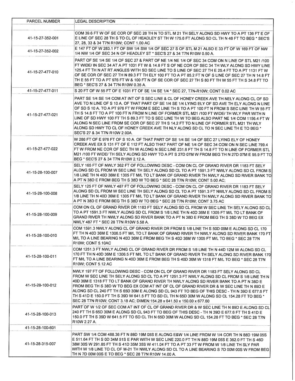
45

46

47
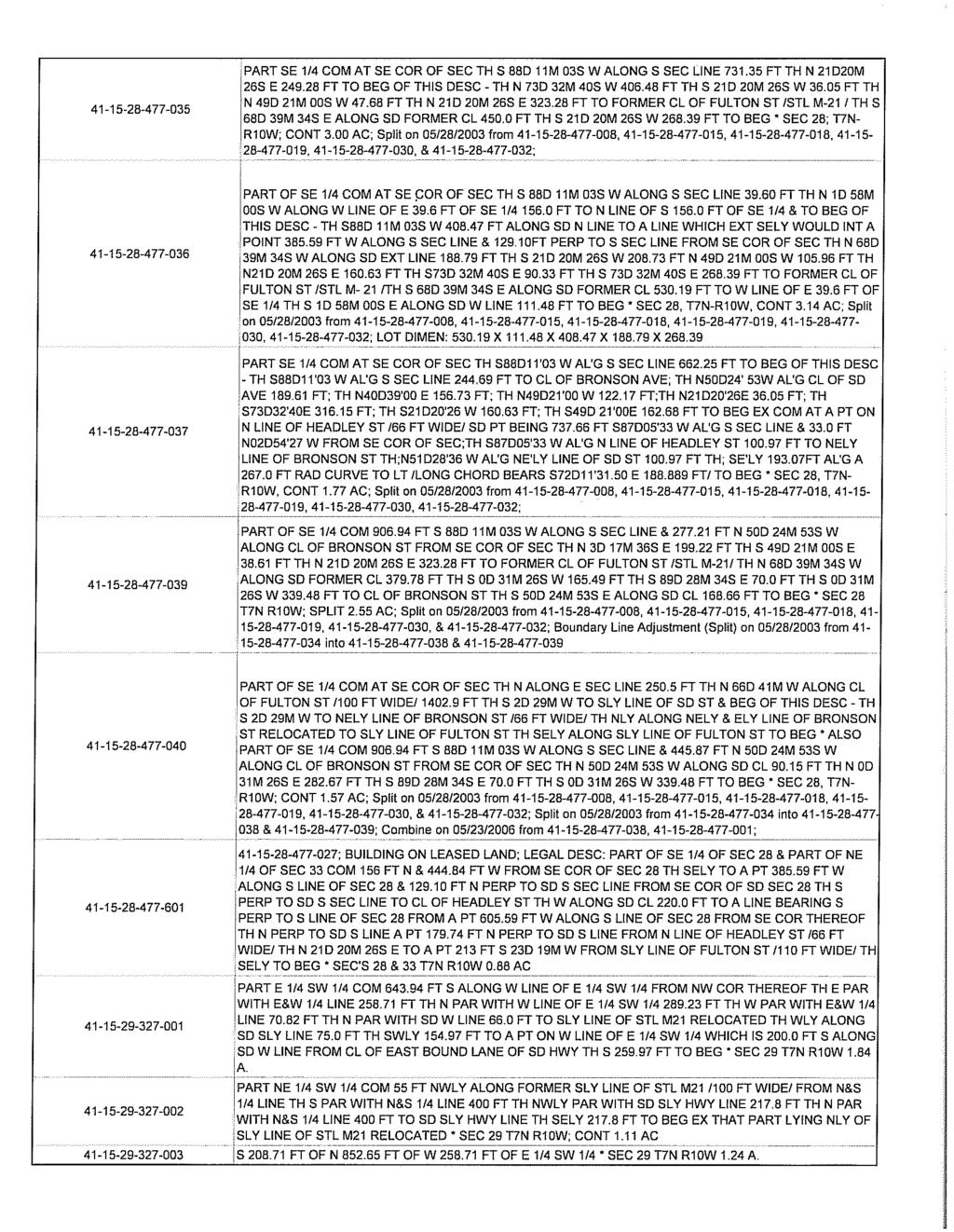
48

49
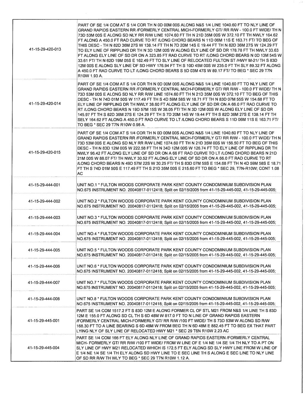
50
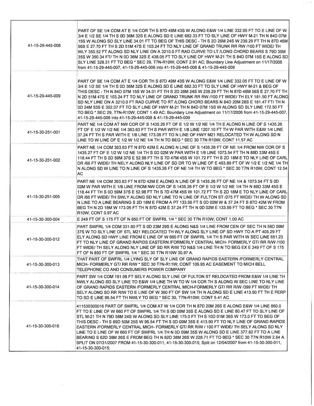
51
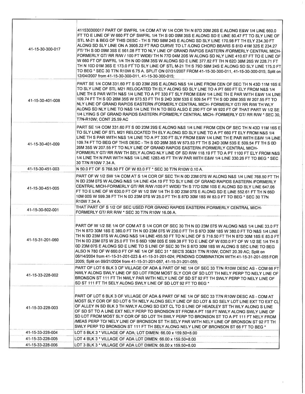
52
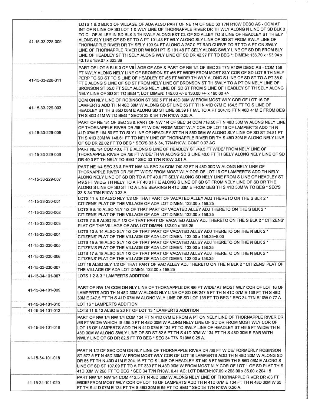
53

54

55

56

57

58

59
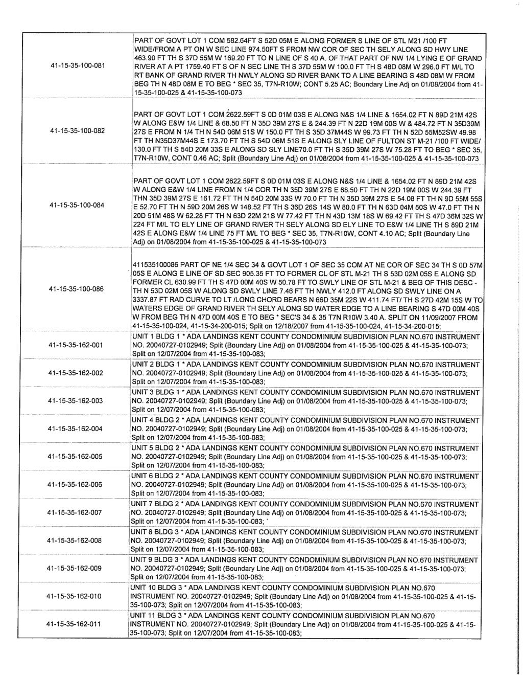
60
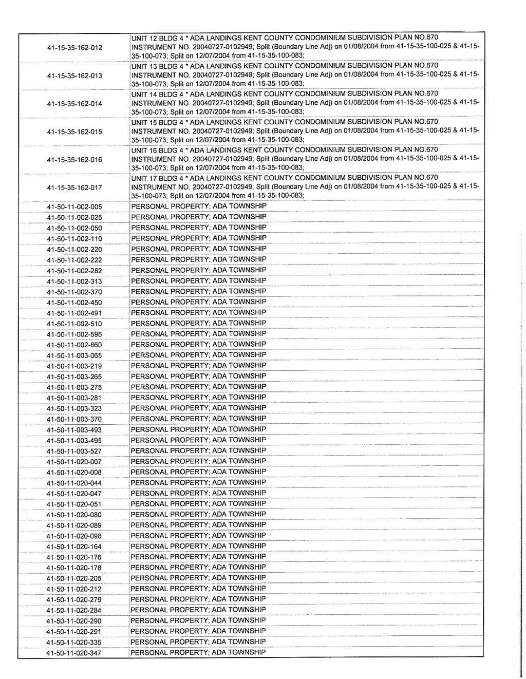
61

62
63
64

65 CLIFFORD AVE BYERLY AVE GRAYFIELD CT MICHIGAN ST L ANE S END PINNACLE POINT DR SANCTU A RY DR DOGWO O D AVE WILDERNESS TRL VILLAGE SPRINGS DR SARASOTA AVE ARGO AVE TAOS CT TAOS AVE WEST VILLAGE TRL MEADO W SPRING TRL CASCADE RD LUXEMB URG ST UNNA MED WEST VILLAGE CT SPAULDING PLAZA SPAULDING AVE CLEAR SPRINGS DR PUGLIESE DR SPAULDI N G HILLS CIR ADA DR E FULTON ST CARL DR MAPLE HILL A VE FOREST BEND DR LONGWOOD DR HARTFIELD CT BRIDGE WALK CT HI G RIDERS TRL FORES T GLEN DR CLEMENTS MILL DR Y DR HBUR AUTUMN DR PRESERVATION DR FAR HILL DR ALTA DALE AVE UNNA MED UNNA MED GRAND RIVER DR RIPPLING DR WINTHROP CT ADAWAY AVE ROOKWAY AVE W INTER RUN DR REDINGTON DR S CAR BOROU GH DR DUXBURY DR DUNBARTON DR LEHIG H CT FOX HOLLOW AVE LEHI GH DR KULROSS AVE CREEKRUN DR ADAPOINT E DR A DARI DGE DR RIX ST ADASIDE DR ELLERY AVE BRONSON ST BRADFIELD ST WINDY HILL DR BITTERSWEET LN PETTIS AVE HEADLEY ST DRIFTWOOD DR RIVER ST THORNAPPLE RIVER DR DEER R UN DR FASE ST BUTTRICK AVE BAER DR HONEY CREEK AVE ALTEN OAKS DR UNNAM ED THOR N APPL E CLUB DR CRANCREEK DR BAILEY DR VERGENNES ST UNN A MED PINE LAND DR ADA TOWNSHIP DOWNTOWN DEVELOPMENT AUTHORITY AMENDED AND RESTATED DEVELOPMENT PLAN AND TAX INCREMENT FINANCING PLAN EXHIBIT F- DDA DISTRICT BOUNDARY DDA District Boundary
66 FERNRIDGE AVE GRAYFIELD CT SADDLEBROOK DR OAKWRIGHT DR CATALPA DR BRAEBURN ST EASTMONT DR KIRK DR CUTTER PKWY STEKETEE AVE SYCAMORE WAY DR ORLANDO AVE PATTERSON AVE ST EKETEE AVE ARGO AVE LUXEMBURG ST MICHIGAN ST TAOS CT TAOS AVE MEADOW SPRING TRL BURRWOOD ST CLIFFORD AVE CASCADE RD U N NAMED CLEAR SP RINGS DR WEST VILLAGE TRL LA ROLLINGBR OOK DR SPAULDING AVE ADA DR NES E ND PUGLIESE DR SPAULDIN G HILLS CIR MEADOWMEADE DR PINNACLE POI NT DR CARL DR MAPLE HILL A VE FOREST BEND DR CLEMWOO D CT HARTFIELD DR BRIDGE WALK CT GROS VENTRE DR SANCTUARY CT SA N C T UARY DR RIDERS TRL FOREST G LEN DR CLEMENTS MILL DR HIGHBURY DR H ASKI N S CT AUTUMN DR FAR HI L L DR HALL ST ALTA DALE AVE HIGH BLUFFS CT GRAND RIVER DR RIPPLING DR WINTHROP CT ADAWAY CT ADAWAY AVE SCOTTHILLE DR ADACROFT DR WINTER RUN DR REDINGTON DR S CAR BOROU GH DR EDGEWORTHE DR MARBURY DR FOX HOLLOW AVE LEH LEHIG H CT DUXBURY DR IGH DR KULROSS AVE CREEKRUN DR ADAPOINT E DR ADARI FOX MEADOW LN DGE DR CAMERON WOODS DR RIX ST ADASIDE DR F AIR HILL DR BRO NSO N ST E FULTON ST BRONSON ST BRADFIELD ST WINDY HILL DR BITTERSWEET LN PETTIS AVE DRIFTWOOD DR THORNAPPLE RIVER DR DOGW O O D AVE HEADLEY ST STOREYBOOK LN RIVER ST DEER RUN DR DEER R UN DR FASE ST UN NAMED BUTTRICK AVE UV 21 GRAND RIVER DR BAER DR HONEY CREEK AVE ALTEN OAKS DR THO R N APPL E CLUB DR OLD ELM CT WILDERNESS TRAIL ST CRANCREEK DR BAILEY DR DOGWO OD MEADOWS DR VERGENNES ST ROUNDTREE LN WILDERNES S TRL BAILEAU OAKS DR PINE LAND DR LO N GLE AF DR ADA TOWNSHIP DOWNTOWN DEVELOPMENT AUTHORITY AMENDED AND RESTATED DEVELOPMENT PLAN AND TAX INCREMENT FINANCING PLAN EXHIBIT G- EXISTING LAND USE, STREETS, AND PUBLIC LAND FEBRUARY, 2016 DDA Boundary Recreation Vacant Rural Residential Low Density Residential Public/Semi-Public Multiply Family Residential Commercial Agriculture Industrial Office/Service Mixed Use

67 Ada Village Area ADA TOWNSHIP DOWNTOWN DEVELOPMENT AUTHORITY AMENDED AND RESTATED DEVELOPMENT PLAN AND TAX INCREMENT FINANCING PLAN EXHIBIT H- PROPOSED LAND USE DDA Boundary Rural Development Med. Density Res. Public/Semi Public General Commercial Office/Service/Light Warehouse Light Industrial Industrial Village Edge Village Proper-1 Village Proper-2 Village Center Village Core Park/Rec./Open Space
68 CLIFFORD AVE BYERLY AVE GRAYFIELD CT MICHIGAN ST L ANE S END SANCTU A RY DR DOGWOOD A VE WILDERNESS TRL PATTERSON AVE VILLAGE SPRINGS DR SARASOTA AVE ARGO AVE TAOS CT TAOS AVE WEST VILLAGE TRL MEADO W SPRING TRL CASCADE RD LUXEMB URG ST UNNA MED WEST VILLAGE CT CLEAR SPRINGS DR SPAULDING AVE PUGLIESE DR STONE FALLS DR SPAULDI N G HILLS CIR ADA DR E FULTON ST CARL DR MAPLE HILL A VE FOREST BEND DR LONGWOOD DR HARTFIELD CT BRIDGE CREST DR RIDERS TRL FORES T G LEN DR CLEMENTS MILL DR HIGHBURY DR AUTUMN DR FAR H PRESERVATION DR I LL DR ALTA DALE AVE UNNA MED UNNA MED GRAND RIVER DR RIPPLING DR WINTHROP CT ADAWAY AVE ROOKWAY AVE WINTER RUN DR REDINGTON DR S CAR BOROU GH DR DUXBURY DR DUNBARTON DR LEHIG H CT FOX HOLLOW AVE LEHI GH DR KULROSS AVE CREEKRUN DR ADAPOINT E DR A DARI DGE DR RIX ST ADASIDE DR ELLERY AVE BRONSON ST BRADFIELD ST WINDY HILL DR BITTERSWEET LN PETTIS AVE HEADLEY ST DRIFTWOOD DR RIVER ST THORNAPPLE RIVER DR DEER R UN DR FASE ST BUTTRICK AVE BAER DR HONEY CREEK AVE ALTEN OAKS DR THOR N APPL E CLUB DR GRAND RIVER DR UNNAM ED CRANCREEK DR BAILEY DR VERGENNES ST E FULTON CROSSOVER ADA TOWNSHIP DOWNTOWN DEVELOPMENT AUTHORITY AMENDED AND RESTATED DEVELOPMENT PLAN AND TAX INCREMENT FINANCING PLAN EXHIBIT I - CURRENT ZONING DDA Boundary DDA Current Zoning Industrial Light Industrial I-PUD VR R-2 R-3 R-4 C-1 C-1 PUD C-2 C-2 PUD RR


69 ADA TOWNSHIP DOWNTOWN DEVELOPMENT AUTHORITY AMENDED AND RESTATED DEVELOPMENT PLAN AND TAX INCREMENT FINANCING PLAN EXHIBIT I-2 MAP OF CURRENT OPTIONAL PVM OVERLAY ZONING SUB-DISTRICT BOUNDARIES

70 4 Landscaped Boulevard Median on Fulton Street (M-21) 7 Community Green/Civic Building/Farmers Market Pavilion 1 Extend Headley St. from Ada Drive to Thornapple River Drive 2 Reconstruct Ada Drive to elevate above floodplain 12 3 Parking structure with designated public spaces Private Streets with Public Access Easement and Public Utilities 8 Develop Settlers Grove Riverfront Park Ada Township Acquire property and develop green space/public plaza 9 Open Space Gateway Landscaping and Sign (and at Fulton St./Spaulding Ave Intersection) 5 Non-Motorized trail connection to M-21 bridge deck 6 Pedestrian bridge across Thornapple River (with future trail connection to Grand River Nature Preserve) Grand River Nature Preserve (Township-owned)

71 ADA TOWNSHIP DOWNTOWN DEVELOPMENT AUTHORITY AMENDED AND RESTATED DEVELOPMENT PLAN AND TAX INCREMENT FINANCING PLAN EXHIBIT K CONCEPT PLAN FOR HEADLEY STREET COMMUNITY SPACE

72 ADA TOWNSHIP DOWNTOWN DEVELOPMENT AUTHORITY AMENDED AND RESTATED DEVELOPMENT PLAN AND TAX INCREMENT FINANCING PLAN EXHIBIT L CONCEPT PLAN FOR SETTLERS GROVE PARK
AGENDA. Review/Action - Amended and Restated Development Plan and Tax Increment Financing Plan.
 ADA TOWNSHIP DOWNTOWN DEVELOPMENT AUTHORITY BOARD OF DIRECTORS MONDAY, FEBRUARY 29, 2016 SPECIAL MEETING, 8:00 A.M. ADA TOWNSHIP OFFICES, 7330 THORNAPPLE RIVER DR. SE ADA, MICHIGAN I. Call to Order/Roll
Appendix A: Guide to Zoning Categories Prince George's County, Maryland
 Appendix A: Guide to Zoning Categories Prince George's County, Maryland RESIDENTIAL ZONES 1 Updated November 2010 R-O-S: Reserved Open Space - Provides for permanent maintenance of certain areas of land
Village of Port Jefferson Urban Renewal Plan
 Urban Renewal Plan Village of Port Jefferson Urban Renewal Plan Port Jefferson, New York PREPARED FOR Village of Port Jefferson Village Board 121 West Broadway Port Jefferson, NY 11777 631.473.4724 PREPARED
Bylaw No , being "Official Community Plan Bylaw, 2016" Schedule "A" DRAFT
 Bylaw No. 2600-2016, being "Official Community Plan Bylaw, 2016" Schedule "A" Urban Structure + Growth Plan Urban Structure Land use and growth management are among the most powerful policy tools at the
DIVISION 1 PURPOSE OF DISTRICTS
 ARTICLE 2 ZONING DISTRICTS AND MAP DIVISION 1 PURPOSE OF DISTRICTS Section 2.101 Zoning Districts. For the purpose of this Ordinance, the City of Richmond is hereby divided into districts as follows: DISTRICT
APPENDIX D: DEFINITIONS
 D APPENDIX D: DEFINITIONS Terms used throughout the 2040 Comprehensive Plan should be interpreted using the definitions provided in this appendix. For interpretation of any term not defined, defer to the
THE REDEVELOPMENT PLAN
 PAGE 37 THE REDEVELOPMENT PLAN FUTURE LAND USE The Silver Terrace Redevelopment Area is currently designated as Redevelopment Area #4 on the City of Delray Beach Future Land Use Map (FLUM). This designation
Place Type Descriptions Vision 2037 Comprehensive Plan
 Place Type Descriptions Vision 2037 Comprehensive Plan The Vision 2037 Comprehensive Plan establishes a range of place types for Oxford, ranging from low intensity (limited development) Rural and Natural
13 Sectional Map Amendment
 13 Sectional Map Amendment Introduction This chapter reviews land use and zoning policies and practices in Prince George s County and presents the proposed zoning in the sectional map amendment (SMA) to
Planning Justification Report
 Planning Justification Report Kellogg s Lands City of London E&E McLaughlin Ltd. June 14, 2017 Zelinka Priamo Ltd. Page i TABLE OF CONTENTS Page No. 1.0 2.0 2.1 2.2 3.0 4.0 5.0 5.1 5.2 5.3 5.4 5.5 5.6
From Policy to Reality
 From Policy to Reality Updated ^ Model Ordinances for Sustainable Development 2000 Environmental Quality Board 2008 Minnesota Pollution Control Agency Funded by a Minnesota Pollution Control Agency Sustainable
Summary. Draft Redevelopment Plan Summary Flowery Branch Tax Allocation District # 1:
 Summary Draft Redevelopment Plan Summary Flowery Branch Tax Allocation District # 1: Flowery Branch Tax Allocation District Old Town and Commercial Gateways 1 Public Hearing Presentation November 21, 2007
PLANNING COMMISSION STAFF REPORT
 PLANNING COMMISSION STAFF REPORT REZONING CASE: RZ-16-001 REPORT DATE: March 8, 2016 CASE NAME: Trailbreak Partners Rezoning PLANNING COMMISSION DATE: March 16, 2016 ADDRESSES OF REZONING PROPOSAL: 5501
8.5.1 R1, Single Detached Residential District
 8.5.1 R1, Single Detached Residential District The purpose of this district is to provide for residential development in the form of single detached dwellings. Dwelling, Single Detached Home Business,
Coding For Places People Love Main Street Corridor District
 Coding For Places People Love Main Street Corridor District 1) Scope a) District boundaries are assigned according to the District Boundary Map. b) The Primary Retail Corridor is assigned according to
AMENDED AND RESTATED DEVELOPMENT PLAN AND TAX INCREMENT FINANCING PLAN
 Kalamazoo County, Michigan AMENDED AND RESTATED DEVELOPMENT PLAN AND TAX INCREMENT FINANCING PLAN December 15, 2014 APPROVED Downtown Development Authority Development & Tax Increment Finance Plan Village
PLANNED UNIT DEVELOPMENT & SUBDIVISION STAFF REPORT Date: April 18, 2019
 PLANNED UNIT DEVELOPMENT & SUBDIVISION STAFF REPORT Date: April 18, 2019 DEVELOPMENT NAME SUBDIVISION NAME Springhill Village Subdivision Springhill Village Subdivision LOCATION 4350, 4354, 4356, 4358,
4 LAND USE 4.1 OBJECTIVES
 4 LAND USE The Land Use Element of the Specific Plan establishes objectives, policies, and standards for the distribution, location and extent of land uses to be permitted in the Central Larkspur Specific
74af ANTELOPE VALLEY REDEVELOPMENT PLAN
 74af T. Telegraph District Phase 2: Telegraph Flats & Telegraph Lofts East 1. Project Area Description Phase 2 will include two building subphase areas with connecting streetscape enhancements: The Telegraph
Hennepin County Department of. Housing, Community Works and Transit. Transit Oriented Development (TOD) Guidelines
 Guidelines") Hennepin County Department of Housing, Community Works and Transit 2007 Transit Oriented Development (TOD) Guidelines Hennepin County Transit Oriented Development (TOD) Bond Funds Hennepin County Housing,
Hennepin County Department of Housing, Community Works and Transit 2007 Transit Oriented Development (TOD) Guidelines Hennepin County Transit Oriented Development (TOD) Bond Funds Hennepin County Housing,
PLANNING COMMISSION REPORT Regular Agenda - Public Hearing Item
 Z-11-25-09; Z-11-26-09; Z-11-28-09 Item No. 2-1 PC Staff Report 3/28/11 PLANNING COMMISSION REPORT Regular Agenda - Public Hearing Item ITEM NO. 2A RM32 TO MU;.19 ACRES; 1340 TENNESSEE ST (MJL) Z-1-1-11:
SECTION CLASSIFICATION OF ZONES For the purpose of this Code the following primary land use zoning districts are hereby established:
 ARTICLE 4 ZONING DISTRICTS SECTION 4.010 CLASSIFICATION OF ZONES For the purpose of this Code the following primary land use zoning districts are hereby established: Primary Zones Abbreviated Designation
Draft Model Access Management Overlay Ordinance
 Draft Model Access Management Overlay Ordinance This model was developed using the City of Hutchinson and the Trunk Highway 7 corridor. The basic provisions of this model may be adopted by any jurisdiction
PLANNING & ZONING DEPARTMENT Town Hall Annex, 66 Prospect St., Ridgefield, CT Fax
 PLANNING & ZONING DEPARTMENT Town Hall Annex, 66 Prospect St., Ridgefield, CT 06877 203-431-2766 Fax 203-431-2737 ADOPTED AMENDMENT TO THE ZONING REGULATIONS NEW Section 5.6 Neighborhood Business Zone
ZONING ORDINANCE: OPEN SPACE COMMUNITY. Hamburg Township, MI
 ZONING ORDINANCE: OPEN SPACE COMMUNITY Hamburg Township, MI ARTICLE 14.00 OPEN SPACE COMMUNITY (Adopted 1/16/92) Section 14.1. Intent It is the intent of this Article to offer an alternative to traditional
2015 Downtown Parking Study
 2015 Downtown Parking Study City of Linden Genesee County, Michigan November 2015 Prepared by: City of Linden Downtown Development Authority 132 E. Broad Street Linden, MI 48451 www.lindenmi.us Table of
SECTION 7000 LAND DEVELOPMENT REQUIREMENTS
 SECTION 7000 LAND DEVELOPMENT REQUIREMENTS 7000 LAND DEVELOPMENT REQUIREMENTS... 1 7001 LEGISLATIVE AUTHORITY... 1 7001.1 LAND DEVELOPMENT... 1 7001.1.1 Title 40, Idaho Code... 1 7001.1.2 Idaho Code 40-1415
City of Grande Prairie Development Services Department
 City of Grande Prairie Development Services Department COUNTRYSIDE SOUTH OUTLINE PLAN Prepared by: GPEC Consulting Ltd. #202, 10712-100th Street Grande Prairie, AB Council Resolution of August 20, 2001
M-43 CORRIDOR OVERLAY ZONE
 ARTICLE 26.00 M-43 CORRIDOR OVERLAY ZONE Section 26.01 Findings A primary function of the M-43 state highway is to move traffic through the Township and to points beyond. As the primary east-west arterial
TOTTENHAM SECONDARY PLAN
 TOTTENHAM SECONDARY PLAN AMENDMENT NO. 11 TO THE OFFICIAL PLAN OF THE TOWN OF NEW TECUMSETH The following text and schedules to the Official Plan of the Town of New Tecumseth constitute Amendment No. 11
Implementation. Approved Master Plan and SMA for Henson Creek-South Potomac 103
 Implementation Approved Master Plan and SMA for Henson Creek-South Potomac 103 104 Approved Master Plan and SMA for Henson Creek-South Potomac Sectional Map Amendment The land use recommendations in the
Generic Environmental Impact Statement. Build-Out Analysis. City of Buffalo, New York. Prepared by:
 Generic Environmental Impact Statement Build-Out Analysis City of Buffalo, New York 2015 Prepared by: TABLE OF CONTENTS 1.0 INTRODUCTION 1 2.0 METHODOLOGY 2 3.0 EXISTING LAND USE 3 4.0 EXISTING ZONING
DAUPHIN CREEK ESTATES SUBDIVISION
 # 12 SUB-000076-2017 DAUPHIN CREEK ESTATES SUBDIVISION Engineering Comments: FINAL PLAT COMMENTS (should be addressed prior to submitting the FINAL PLAT for review and/or signature by the City Engineer):
TOOELE COUNTY LAND USE ORDINANCE CHAPTER 31 Page 1
 CHAPTER 31 PLANNED COMMUNITY ZONE (P-C) Section 31-1 Definitions. 31-2 Purpose. 31-3 Land use districts. 31-4 P-C zone area minimum requirements. 31-5 Permitted uses. 31-6 Conditional uses. 31-7 Planning
Chapter 10: Implementation
 Chapter 10: Introduction Once the Comprehensive Plan has been adopted by the City of Oakdale, the City can begin to implement the goals and strategies to make this vision a reality. This chapter will set
Comprehensive Plan /24/01
 IV The is a central component of the Comprehensive Plan. It is an extension of the general goals and policies of the community, as well as a reflection of previous development decisions and the physical
2.2.2 The Land Use Setting
 2-6 Planning Area pearance varies dramatically from season to season. The absence of significant topographic or man-made features within the District contributes to a very open visual character that allows
Chapter 7 Riverfront District
 Chapter 7 Riverfront District Downtown Capital District Master Plan Trenton, New Jersey Riverfront District Trenton will reclaim its connection with the Delaware River to enhance the experience of living,
O-I (Office-Institutional) and AG-1(Agricultural)
 and AG-1(Agricultural)") PROPERTY INFORMATION ADDRESS 3503 and 3505 Bethany Bend DISTRICT, LAND LOTS 2/1 973 and 974 OVERLAY DISTRICT State Route 9 PETITION NUMBERS EXISTING ZONING O-I (Office-Institutional) and AG-1(Agricultural)
PROPERTY INFORMATION ADDRESS 3503 and 3505 Bethany Bend DISTRICT, LAND LOTS 2/1 973 and 974 OVERLAY DISTRICT State Route 9 PETITION NUMBERS EXISTING ZONING O-I (Office-Institutional) and AG-1(Agricultural)
DRAFT Plan Incentives. Part A: Basic Discount
 DRAFT 2030 Plan Incentives July 26, 2006 Part A: Basic Discount In order for a development to be eligible for any 2030 Land Resource Management Plan Discounts it must be located in the Urban Corridor and
PRELIMINARY PROJECT PLAN AND REINVESTMENT ZONE FINANCING PLAN FOR PROPOSED TAX INCREMENT REINVESTMENT ZONE NO. 1, CITY OF OAK RIDGE NORTH
 PRELIMINARY PROJECT PLAN AND REINVESTMENT ZONE FINANCING PLAN FOR PROPOSED TAX INCREMENT REINVESTMENT ZONE NO. 1, CITY OF OAK RIDGE NORTH DECEMBER 15, 2014 TABLE OF CONTENTS 1. Overview 1.1 Background...
RESIDENTIAL DISTRICTS
 RESIDENTIAL DISTRICTS RESIDENTIAL DISTRICTS The residential district standards have been revised to reflect on-the-ground development conditions, while continuing to respect the use patterns established
PIN , Part 1, Plan SR-713 in Lot 2, Concession 5, Township of McKim (1096 Dublin Street, Sudbury)
") STAFF REPORT Applicant: Dalron Construction Limited Location: PIN 02124-0103, Part 1, Plan SR-713 in Lot 2, Concession 5, Township of McKim (1096 Dublin Street, Sudbury) Official Plan and Zoning By-law:
STAFF REPORT Applicant: Dalron Construction Limited Location: PIN 02124-0103, Part 1, Plan SR-713 in Lot 2, Concession 5, Township of McKim (1096 Dublin Street, Sudbury) Official Plan and Zoning By-law:
Table of Contents ARTICLE 5A CHARACTER-BASED ZONING 1
 Table of Contents ARTICLE 5A CHARACTER-BASED ZONING 1 SECTION 10.5A10 GENERAL... 1 10.5A11 Purpose and Intent... 1 10.5A12 Applicability... 1 10.5A13 Compliance with Regulating Plan... 1 10.5A14 Relationship
CITY OF LEBANON RUSSELL DRIVE AREA MIXED USE NEIGHBORHOOD CENTER FINAL IMPLEMENTATION PLAN
 CITY OF LEBANON RUSSELL DRIVE AREA MIXED USE NEIGHBORHOOD CENTER FINAL IMPLEMENTATION PLAN TGM Contract 2G-01 #22425 Deliverable 15.5 Prepared by: Satre Associates, P.C. Planners, Landscape Architects,
GOALS, OBJECTIVES, AND STRATEGIES
 GOALS, OBJECTIVES, AND STRATEGIES What follows is a series of goals, recommendations and actions that reflect the themes outlined in the Mineral Springs Vision Plan (incorporated into this document as
ZONING AMENDMENT & SUBDIVISION STAFF REPORT Date: November 3, 2016
 ZONING AMENDMENT & SUBDIVISION STAFF REPORT Date: November 3, 2016 APPLICANT NAME SUBDIVISION NAME David Shumer 5955 Airport Subdivision CITY COUNCIL DISTRICT District 6 5955 Airport Boulevard, 754 Linlen
Rezoning Petition Pre-Hearing Staff Analysis April 17, 2017
 Rezoning Petition 2017-041 Pre-Hearing Staff Analysis April 17, 2017 REQUEST Current Zoning: R-5 (single family residential), R-22MF (multifamily residential), and I-1 (light industrial) Proposed Zoning:
Section 1: US 19 Overlay District
 Section 1: US 19 Overlay District Section 1.1 Intent and Purpose The purpose of the US Highway 19 Overlay District is to manage access to land development along US Highway 19 in a manner that preserves
ORDINANCE NO (As Amended)
") ORDINANCE NO. 01-2015 (As Amended) To Amend the Official Zoning Map of the City of Worthington, Ohio, to Change Zoning of Certain Land from the C-3 District (Institutions and Office), AR-4.5 District (Low
ORDINANCE NO. 01-2015 (As Amended) To Amend the Official Zoning Map of the City of Worthington, Ohio, to Change Zoning of Certain Land from the C-3 District (Institutions and Office), AR-4.5 District (Low
ARTICLE 23 CONDOMINIUM STANDARDS
 ARTICLE 23 CONDOMINIUM STANDARDS Section 23.01 Intent. The intent of this Article is to provide regulatory standards for condominiums and site condominiums similar to those required for projects developed
ARTICLE 3: Zone Districts
 ARTICLE 3: Zone Districts... 3-1 17.3.1: General...3-1 17.3.1.1: Purpose and Intent... 3-1 17.3.2: Districts and Maps...3-1 17.3.2.1: Applicability... 3-1 17.3.2.2: Creation of Districts... 3-1 17.3.2.3:
FIRST AMENDMENT TO THE AMENDED AND RESTATED DEVELOPMENT PLAN FOR THE OFFICE BUILDINGS / SPORTS PROJECT WITHIN PLANNED DEVELOPMENT AREA NO.
 FIRST AMENDMENT TO THE AMENDED AND RESTATED DEVELOPMENT PLAN FOR THE OFFICE BUILDINGS / SPORTS PROJECT WITHIN PLANNED DEVELOPMENT AREA NO. 87 BOSTON LANDING GUEST STREET, LIFE STREET AND ARTHUR STREET
REGULATING PLAN for the Plaza Saltillo TOD Station Area Plan (SAP)
") REGULATING PLAN for the Plaza Saltillo TOD Station Area Plan (SAP) Adopted: December 11, 2008 Effective: March 1, 2009 REGULATING PLAN for the Plaza Saltillo TOD Station Area Plan (SAP) CONTENTS BACKGROUND...iv
REGULATING PLAN for the Plaza Saltillo TOD Station Area Plan (SAP) Adopted: December 11, 2008 Effective: March 1, 2009 REGULATING PLAN for the Plaza Saltillo TOD Station Area Plan (SAP) CONTENTS BACKGROUND...iv
City of Valdosta Land Development Regulations
 Chapter 206 Section 206-1 Base Zoning Districts Standards for Uses, Structures, and Property Development (B) (C) Principal Uses and Structures. Principal uses and structures permitted in each base zoning
Residential-1 District
 Residential-1 District City of Barnum, Minnesota Zoning District Information Sheet It is the purpose of the R-1 District to encourage the establishment and the preservation of residential neighborhoods
A. Districts Concept
 L A N D U S E 6 This chapter discusses the land use concept and provides land use designations for Downtown, including associated development intensities that will apply in Downtown. In order to support
CITY OF CHARLOTTESVILLE DEPARTMENT OF NEIGHBORHOOD DEVELOPMENT SERVICES STAFF REPORT APPLICATION FOR A SPECIAL USE PERMIT
 CITY OF CHARLOTTESVILLE DEPARTMENT OF NEIGHBORHOOD DEVELOPMENT SERVICES STAFF REPORT APPLICATION FOR A SPECIAL USE PERMIT PLANNING COMMISSION AND CITY COUNCIL JOINT PUBLIC HEARING DATE OF HEARING: December
Downtown & East Town CRA Expansion Plan City of Eustis
 Downtown & East Town CRA Expansion Plan City of Eustis May 2018 Contents 1 Introduction... 1 CRA Overview/History... 1 2 Existing Conditions... 2 Downtown & East Town Community Redevelopment Area Expansion...
PLANNING COMMISSION WILLIAMSBURG, VIRGINIA WORK SESSION AGENDA Wednesday, May 23, 2012
 PLANNING COMMISSION WILLIAMSBURG, VIRGINIA WORK SESSION AGENDA Wednesday, May 23, 2012 The meeting will be called to order in the third floor Conference Room (Room 310), Williamsburg Municipal Building,
ADA TOWNSHIP PLANNING COMMISSION MINUTES OF THE JANUARY 17, 2019 MEETING
 ADA TOWNSHIP PLANNING COMMISSION MINUTES OF THE JANUARY 17, 2019 MEETING A meeting of the was held on Thursday, January 17, 2019, at 7:00 p.m. at the Ada Township Offices, 7330 Thornapple River Dr., Ada,
9. REZONING NO Vicinity of the northwest corner of 143 rd Street and Metcalf Avenue
 9. REZONING NO. 2002-15 Vicinity of the northwest corner of 143 rd Street and Metcalf Avenue 1. APPLICANT: Andrew Schlagel is the applicant for this request. 2. REQUESTED ACTION: The applicant is requesting
ARTICLE FIVE FINAL DRAFT
 ARTICLE FIVE 021218 FINAL DRAFT Sec. 503.6 Open Space Preservation Option Open Space Preservation Option Open Space Preservation developments may be approved in the AR, R-1, R-2 and R-3 zoning districts,
Article 3. SUBURBAN (S-) NEIGHBORHOOD CONTEXT
 NEIGHBORHOOD CONTEXT") Article 3. SUBURBAN (S-) NEIGHBORHOOD CONTEXT this page left intentionally blank Contents ARTICLE 3. SUBURBAN (S-) NEIGHBORHOOD CONTEXT DIVISION 3.1 NEIGHBORHOOD CONTEXT DESCRIPTION...3.1-1 Section 3.1.1
Article 3. SUBURBAN (S-) NEIGHBORHOOD CONTEXT this page left intentionally blank Contents ARTICLE 3. SUBURBAN (S-) NEIGHBORHOOD CONTEXT DIVISION 3.1 NEIGHBORHOOD CONTEXT DESCRIPTION...3.1-1 Section 3.1.1
Chapter 1107: Zoning Districts
 Chapter 1107: Zoning Districts 1107.01 Establishment of Zoning Districts (a) Districts Established In order to carry out the purpose of this code, the City is hereby divided into the zoning districts established
Land Use, Transportation, and Infrastructure Committee of Denver City Council FROM: Scott Robinson, Senior City Planner DATE: December 6, 2018 RE:
 Community Planning and Development Planning Services 201 W. Colfax Ave., Dept. 205 Denver, CO 80202 p: 720.865.2915 f: 720.865.3052 www.denvergov.org/cpd TO: Land Use, Transportation, and Infrastructure
Table of Contents ARTICLE 5A CHARACTER-BASED ZONING 1
 Table of Contents ARTICLE 5A CHARACTER-BASED ZONING 1 SECTION 10.5A10 GENERAL... 1 10.5A11 Purpose and Intent... 1 10.5A12 Applicability... 1 10.5A13 Compliance with Regulating Plan... 1 10.5A14 Relationship
891941, , : COMPREHENSIVE PLAN AMENDMENT, COMMUNITY PLAN AMENDMENT, AND AREA-WIDE MAP AMENDMENT
 Application Nos. 891941, 891909, 891940: COMPREHENSIVE PLAN AMENDMENT, COMMUNITY PLAN AMENDMENT, AND AREA-WIDE MAP AMENDMENT Amendments to designate five parcels as Rural Industrial Center in the Alderton
NORTHWEST QUADRANT NEIGHBORHOOD STUDY
 City of Novato General Plan 2035 Focus Area NORTHWEST QUADRANT NEIGHBORHOOD STUDY May, 2015 Why a Neighborhood Study? The Northwest Quadrant Neighborhood, north of the Grant Avenue business district,
Figure 5-1, Land Use Plan, establishes the boundaries of each land use districts in the Boronda Community
 APPENDIX A DEVELOPMENT STANDARDS This Appendix provides development standards and regulations for the majority of the land use districts within the Community of Boronda. This section describes the allowed
PC Staff Report 11/18/2013 Z Item No. 1-1
 Z-13-00401 Item No. 1-1 PLANNING COMMISSION REPORT Regular Agenda - Public Hearing Item PC Staff Report 11/18/2013 ITEM NO. 1: Z-13-00401 IG (General Industrial) District TO CS (Strip Commercial) District;
Truax Park Apartments
 Truax Park Apartments Master Planning and Site Development Study Prepared by The Community Development Authority of the City of Madison In association with SMITH & SMITH ASSOCIATES, Inc CONSTRUCTION COST
COMMERCIAL ELEMENT AND CODE ENFORCEMENT
 COMMERCIAL ELEMENT AND CODE ENFORCEMENT The Commercial Element identifies and describes the existing characteristics that are desired by the neighborhood. The existing conditions will determine appropriate
Richardson s TOD Experience From ULI Panel Report to Breaking Ground. September 8, 2011
 Richardson s TOD Experience From ULI Panel Report to Breaking Ground Presented to ULI Minnesota District Council Presented By: Gary Slagel President and CEO CapitalSoft Former Mayor, City of Richardson,
Proposed Future Land Use Plan Open House
 City of Port August Aransas, 30 th, 2006 Texas Proposed Future Plan Open House Wednesday, Background The City of Port Aransas does not have an adopted Future Plan (FLUP). The last Future Plan for the City
Rapid City Planning Commission Rezoning Project Report
 Rapid City Planning Commission Rezoning Project Report April 21, 2016 Item #9 Applicant Request(s) Case # 16RZ011; a request to rezone property from Central Business District to General Commercial District
HOUSING ELEMENT GOALS, OBJECTIVES, & POLICIES
 HOUSING ELEMENT GOALS, OBJECTIVES, & POLICIES GOAL H-1: ENSURE THE PROVISION OF SAFE, AFFORDABLE, AND ADEQUATE HOUSING FOR ALL CURRENT AND FUTURE RESIDENTS OF WALTON COUNTY. Objective H-1.1: Develop a
Glendale Housing Development Project Plan
 Glendale Housing Development Project Plan Draft for Public Review May 29, 2015 Table of Contents I. Introduction... 1 II. Description of Project... 1 A. Boundary of Housing Development Project... 1 B.
Mohave County General Plan
 63 64 65 66 67 68 69 70 71 The Land Use Diagram is not the County's zoning map. 13 It is a guide to future land use patterns. Zoning and area plan designations may be more restrictive than the land use
3.1. OBJECTIVES FOR RESIDENTIAL LAND USE DESIGNATIONS GENERAL OBJECTIVES FOR ALL RESIDENTIAL DESIGNATIONS
 3. RESIDENTIAL LAND USE DESIGNATIONS INTRODUCTION The Residential land use designations provide for housing and other land uses that are integral to, and supportive of, a residential environment. Housing
PLANNING COMMISSION REPORT Regular Agenda Public Hearing Item
 PC Staff Report 11/12/12 Item No. 2B- 1 PLANNING COMMISSION REPORT Regular Agenda Public Hearing Item ITEM NO. 2B: A TO GPI; 110 ACRES; E OF K-10 & N OF W 6 TH ST (MKM) : Consider a request to rezone approximately
Town of Yucca Valley GENERAL PLAN 1
 Town of Yucca Valley GENERAL PLAN 1 This page intentionally left blank. 3 HOUSING ELEMENT The Housing Element is intended to guide residential development and preservation consistent with the overall values
COMMERCIAL AND MIXED USE zones COMMERCIAL AND MIXED USE ZONES. Zoning By-law PLANNING & ECONOMIC DEVELOPMENT PLANNING DEPARTMENT DIVISION
 Zoning By-law 05-200 COMMERCIAL AND MIXED USE zones PLANNING & ECONOMIC DEVELOPMENT PLANNING DEPARTMENT DIVISION CONTENTS CONTEXT... 1 URBAN HAMILTON OFFICIAL PLAN... 2 COMMERCIAL AND MIXED USE ZONES...
PLANNING COMMISSION REPORT Regular Agenda -Public Hearing Item
 PDP-13-00518 Item No. 3B- 1 PLANNING COMMISSION REPORT Regular Agenda -Public Hearing Item PC Staff Report 2/24/14 ITEM NO. 3B PRELIMINARY DEVELOPMENT PLAN FOR HERE @ KANSAS; 1101 INDIANA ST (SLD) PDP-13-00518:
ARTICLE C. ZONING TEXT, DISTRICT CLASSIFICATIONS AND BOUNDARIES
 ARTICLE C. ZONING TEXT, DISTRICT CLASSIFICATIONS AND BOUNDARIES Sec. 10-2054. ZONING TEXT, DISTRICT CLASSIFICATIONS AND BOUNDARIES. In order to regulate the location of structures, the height and bulk
COMMUNICATION URBAN DESIGN REVIEW BOARD CITY OF DES MOINES, IOWA NOVEMBER 1, 2016, 2016 MEETING
 COMMUNICATION URBAN DESIGN REVIEW BOARD CITY OF DES MOINES, IOWA NOVEMBER 1, 2016, 2016 MEETING Subject: Recommendation Prepared by: PRELIMINARY DESIGN AND FINANCIAL REVIEW 401 SE 6 TH STREET- CONNOLLY
CASCADE CHARTER TOWNSHIP 2865 Thornhills SE Grand Rapids, Michigan
 CASCADE CHARTER TOWNSHIP 2865 Thornhills SE Grand Rapids, Michigan 49546-7140 On Wednesday, October 7 th the Cascade Township Board held their regularly scheduled Township Board meeting at the Wisner Center.
Lawrence SmartCode Infill Plan
 HORIZON 2020 THE COMPREHENSIVE PLAN FOR LAWRENCE AND UNINCORPORATED DOUGLAS COUNTY Lawrence SmartCode Infill Plan Incorporated By Reference Pursuant to K.S.A. 12-3009, et seq. K.S.A. 12-3301 et seq. and
2. LAND USE DESIGNATIONS AND PRINCIPLES FOR DEVELOPMENT
 2. LAND USE DESIGNATIONS AND PRINCIPLES FOR DEVELOPMENT General areas have been designated for specific types of land use on the Future Land Use Map and are described in this section. In order to satisfy
COOPERATIVE AGREEMENT BETWEEN THE REDEVELOPMENT AGENCY OF THE CITY OF RIO VISTA AND THE CITY OF RIO VISTA
 COOPERATIVE AGREEMENT BETWEEN THE REDEVELOPMENT AGENCY OF THE CITY OF RIO VISTA AND THE CITY OF RIO VISTA This Cooperative Agreement (this Agreement ) is entered into effective as of March 17, 2011 ( Effective
Existing Land Use. Typical densities for single-family detached residential development in Cumberland County: 1
 Existing Land Use A description of existing land use in Cumberland County is fundamental to understanding the character of the County and its development related issues. Economic factors, development trends,
Indicates Council-recommended changes Introduced by: Mr. Tackett Date of introduction: June 14, 2016 SUBSTITUTE NO. 1 TO ORDINANCE NO.
 Indicates Council-recommended changes Introduced by: Mr. Tackett Date of introduction: June 14, 2016 SUBSTITUTE NO. 1 TO ORDINANCE NO. 16-067 TO AMEND NEW CASTLE COUNTY CODE CHAPTER 40 (ALSO KNOWN AS THE
United States Post Office and Multi-Family Residential; and, Single- Family Residence with an Apartment
 Planning Commission File No.: AME2013 0009 January 9, 2014 Page 2 of 9 Existing Land Use: United States Post Office and Multi-Family Residential; and, Single- Family Residence with an Apartment Surrounding
Land Use Planning Analysis. Phase 2 Drayton Valley Annexation Proposal
 Land Use Planning Analysis Phase 2 Drayton Valley Annexation Proposal Prepared for Town of Drayton Valley Prepared by Mackenzie Associates Consulting Group Limited March, 2011 TABLE OF CONTENTS 1.0 INTRODUCTION...
Town of Jamestown Planning Board Zoning Staff Report June 14, 2010
 Town of Jamestown Planning Board Zoning Staff Report June 14, 2010 The information provided in this staff report has been included for the purpose of reviewing proposed zoning changes. Since the zoning
Downtown 2025 Sector Development Plan
 Existing Sector / Corridor / Design Overlay Zone Summary Sheet 2025 Sector Web Address: https://www.cabq.gov/planning/documents/copy_of_2025_dec14r.pdf Joint plan with Bernalillo County No Date Adopted/Amended
Community Development
 Land Use Petition RZ-16-002 Date of Staff Recommendation Preparation: April 15, 2016 (CEL) Date of Planning Commission Recommendation: May 3, 2016 PROJECT LOCATION: DISTRICT/SECTION/LANDLOT(S): ACREAGE
Midwest City, Oklahoma Zoning Ordinance
 2010 Midwest City, Oklahoma Zoning Ordinance 9/2/2010 Table of Contents Section 1. General Provisions... 5 1.1. Citation... 5 1.2. Authority... 5 1.3. Purpose... 5 1.4. Nature and Application... 5 1.5.
CITY OF FORT COLLINS NATURAL AREAS AND CONSERVED LANDS EASEMENT POLICY
 CITY OF FORT COLLINS NATURAL AREAS AND CONSERVED LANDS EASEMENT POLICY Adopted January 3, 2012 PURPOSE: The purpose of the policy statement is to clarify the policies and procedures of the City of Fort
Development Plan and Tax Increment Financing Plan
 Amended and Restated Development Plan and Tax Increment Financing Plan City of Lathrup Village Oakland County, Michigan Downtown Development Authority Adopted January 24, 2011 Amended and Restated DEVELOPMENT