ALTA/ACSM Land Title Surveys ~An Introduction to the 2011 Standards~
|
|
|
- Dominic Edwards
- 6 years ago
- Views:
Transcription
1 ~An Introduction to the 2011 Standards~ Massachusetts Association ~of~ Land Surveyors and Civil Engineers Westborough, Massachusetts April 29, 2011
2 A Brief History of the ALTA/ACSM Standards st version 1986 Min. Angle & Dist. Req Table A 1992 Misc. revisions 1997 Positional Tolerance 1999 Table A changes, etc Effective 1/1/ Effective February 23, 2011
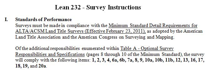
3 2011 Minimum Standard Detail Requirements for ALTA/ACSM Land Title Surveys Section 1 Purpose Section 2 Request for Survey Section 3 Surveying Standards & Standards of Care Section 4 Records Research Section 5 Field work Section 6 Plat or Map Section 7 Certification Section 8 Deliverables Table A - Optional/NegotiableItems
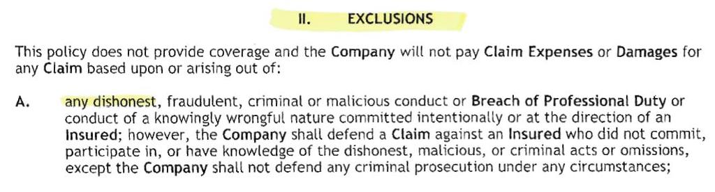
4 Section 1 -Purpose The Standard Survey Exception Rights or claims of parties in possession, boundary line disputes, overlaps, encroachments, and any matters not shown by the public records which would be disclosed by an accurate survey and inspection of the land described in Schedule A.
5 Section 1 -Purpose What comprises a complete ALTA/ACSM Land Title Survey? Field work Section 5 Plat or Map Section 6 Relationship to Record Docs Any selected Table A items Certification Section 7
6 Section 2 Request for Survey Written authorization Title Company not responsible for payment Request shall include desired Table A items Discuss scope of work with client on atypical properties Client to secure access where necessary
7 Section 3 Surveying Standards and Standards of Care 3.A.- Effective Date 2/23/2011. Previous versions superseded 3.B.- Other standards and requirements 3.C.- Recognizing the Normal Standard of Care
8 Section 3.D. Boundary Resolution The boundary lines and corners of any property being surveyed as part of an ALTA/ACSM Land Title Survey shall be established and/or retraced in accordance with appropriate boundary law principles governed by the set of facts and evidence found in the course of performing the research and survey.
9 3.E.i.- Relative Positional Precision the length of the semi-major axis, expressed in feet or meters, of the error ellipse representing the uncertainty due to random errors in measurements in the location of the monument, or witness, marking any corner of the surveyed property relative to the monument, or witness, marking any other corner of the surveyed property at the 95 percent confidence level (two standard deviations).
10 3.E.ii.- Uncertainties in boundary corners and lines occur as a result of (1) the availability, condition, history and integrity of reference or controlling monuments
11 3.E.ii.- Uncertainties in boundary corners and lines occur as a result of (2) ambiguities in the record descriptions or plats of the surveyed property or its adjoiners
12 3.E.ii.- Uncertainties in boundary corners and lines occur as a result of (3) occupation or possession lines as they may differ from the written title lines
13 3.E.ii.- Uncertainties in boundary corners and lines occur as a result of (4) Uncertainties in measurement (Relative Positional Precision) Angles Distances GPS
14 3.E.iii.- 4 Types of Uncertainty The first 3 relate to evidence How do we interpret the evidence and where do we want to place the lines and corners?
15 3.E.iii.- 4 Types of Uncertainty Measurement Uncertainty (Relative Positional Precision) has to do with how precisely surveyors can mark and describe those locations Precise measurements do not necessarily equate to an accurate survey
16 1962 ATA/ACSM Standards Positional Tolerance measurement standard: 0.02 feet in urban areas where buildings can be erected along the property line 0.04 feet in urban or suburban areas 1 foot per 5000 feet of perimeter in rural areas The surveyor shall note on the plat or map of survey the following: Maximum positional tolerance of corners is.
17 1962 ATA/ACSM Standards When the surveyor has doubt as to the location on the ground of street or lot lines for such reasons as street and lot lines being undefinable or indefinite because of insufficient monuments or where errors are found to exist in the descriptions, the surveyor shall clearly indicate the nature of the difficulty or discrepancy and give his professional opinion as to [the] range and scope of differences possibly involved and the effect, under the circumstances, of same on surveyed positions.
18 1962 ATA/ACSM Standards It is expected that the exercise of professional judgment by the surveyor will minimize differences of opinions with other professional surveyors exercising equally prudent judgment in such situation.
19
20 Section 4 Records Research Order to include record description Complete copies of record documents to be provided: Most recent title commitment Adjoiner descriptions Easements (benefitting and burdening) Cross-referenced documents Documents to ascertain Jr/Sr relationships where necessary (See 6.B.vii.)
21 Section 5 Field Work On the Ground (except per Table A item 15)
22 Section 5.A. Monuments 5.A.i.- Location and descriptions of controlling monuments 5.A.ii.- Location, size, and type of monuments found or set
23 Section 5.B. Rights of Way & Access 5.B.i.- Distance to nearest right of way line if no abutting right of way 5.B.ii.- Name, width and location of traveled way for abutting streets
24 Section 5.B. Rights of Way & Access 5.B.iii.- Visible evidence of physical access to abutting streets 5.B.iv.- Location & character of all forms of access by other than the apparent occupants
25 Section 5.B. Rights of Way & Access (continued) 5.B.v.- Encroaching ways of access onto the surveyed property 5.B.vi.- Parcel corners that might indicate the width or location of right of way lines 5.B.vii.-Access to/from waters
26 Section 5.C. Lines of Possession & Improvements along Boundaries 5.C.i.- Possession or occupation 5.C.ii.- Improvements within 5 feet of boundary lines 5.C.iii.- Encroaching structural appurtenances and projections
27 Section 5.D. Buildings Location of all buildings expressed to the appropriate degree of precision
28 Section 5.E. Easements and Servitudes 5.E.i.- Evidence of easements disclosed in Record Documents 5.E.ii.- Evidence of easements not disclosed in Record Documents, but observed

29 Utilities vs. Evidence of Easements
30 Section 5.E. Easements and Servitudes 5.E.iii.- Surface indications of underground easements 5.E.iv.- Evidence of use by other than apparent occupants
31 Section 5.F. Cemeteries Location of cemeteries, gravesites, and burial grounds (i) disclosed in the Record Documents provided to the surveyor, or (ii) observed in the process of conducting the survey.
32 Section 5.G. Water Features 5.G.i.- Location of springs; location of water features bordering on or running through the property 5.G.ii.- Location of any water boundary Attribute located should be congruent with described water boundary
33 Section 6 Plat or Map 6.A.- Evidence and locations gathered in field work outlined in Section 5
34 Section 6.B. Boundaries, Descriptions, Dimensions & Closure 6.B.i.- Record description and any new description prepared Avoid new descriptions unless necessary Avoid new descriptions of lots/blocks in platted subdivisions 6.B.ii.- Location & description of elements that control boundaries or that were relied upon
35 Section 6.B. Boundaries, Descriptions, Dimensions & Closure 6.B.iii.- All distances and directions in record description and in any new description Where a measured/calc dimension differs from record show both
36 Section 6.B. Boundaries, Descriptions, Dimensions & Closure 6.B.iv.- Dimensional data necessary to compute a mathematical closure of the surveyed boundary. A note if record description does not mathematically close Basis of bearings and difference from record
37 Section 6.B. Boundaries, Descriptions, Dimensions & Closure 6.B.v.- Show remainder of surveyed tract where it is part of a larger existing parcel 6.B.vi.- A note regarding the nature of water boundaries. A note on any changes in water boundaries
38 Section 6.B. Boundaries, Descriptions, Dimensions & Closure 6.B.vii.- Relationship of boundaries to adjoiners Gaps and overlaps between parcels where surveyed property is composed of multiple parcels Disclosure of gaps/overlaps to title company and client prior to completion of plat or map
39 Section 6.B. Boundaries, Descriptions, Dimensions & Closure 6.B.viii.- Notes on face of plat or map When results differ significantly from the record When a fundamental decision cannot be clearly reflected graphically
40 Section 6.B. Boundaries, Descriptions, Dimensions & Closure 6.B.ix.- Note on face of plat or map Explaining site conditions that resulted in R.P.P. exceeding 2 cm and 50 ppm
41 Section 6.B. Boundaries, Descriptions, Dimensions & Closure 6.B.x.- Note on face of plat or map Identifying title commitment number, date and company
42 Section 6.C. Easements, Servitudes, Rights of Way, Access and Record Documents 6.C.i.- Information on plottable rights of way, easements and servitudes Width Recording information
43 Section 6.C. Easements, Servitudes, Rights of Way, Access and Record Documents 6.C.ii.- Notes regarding rights of way, easements and servitudes Location cannot be determined No observed evidence Blanket easement Not on or touching the subject property Limits access Which parcels are affected, when multiple parcels
44 Section 6.C. Easements, Servitudes, Rights of Way, Access and Record Documents 6.C.iii.- Note on face of plat or map When no physical access to a public way observed
45 Section 6.C. Easements, Servitudes, Rights of Way, Access and Record Documents 6.C.iv.- Width of abutting rights of way and source of information Where available from jurisdiction Where disclosed in record documents provided
46 Section 6.C. Easements, Servitudes, Rights of Way, Access and Record Documents 6.C.v.- Identifying information of documents which the survey represents. e.g.- Recorded plats Filed maps Right of way maps Etc.
47 Section 6.C. Easements, Servitudes, Rights of Way, Access and Record Documents 6.C.vi.- Names and recording information for non-platted adjoiners Recording data of subdivision where adjoiner is platted
48 Section 6.C. Easements, Servitudes, Rights of Way, Access and Record Documents 6.C.vii.- Platted setback or building restriction lines Which appear on recorded subdivision plats Which were disclosed in Record Documents provided
49 Section 6.D. Presentation 6.D.i.- Drafting standards Not less than 8½ by 11 Legible, standard scale Scale in words and graphically Produced in recordable form when required Boundary distinguishable North arrow Legend Vicinity Map
50 Section 6.D. Presentation 6.D.ii.- Detail/supplemental diagrams when necessary 6.D.iii.- Note when no buildings
51 Section 6.D. Presentation 6.D.iv.- Surveyor s Information Project number Name Registration/License Number Signature and seal Address, telephone number address Dates of revisions
52 Section 6.D. Presentation 6.D.v.- Sheet numbers, if multiple sheets 6.D.vi.- Captioned ALTA/ACSM Land Title Survey
53 Section 7. Certification Only the unaltered certificate contained in Section 7 Except as may be required by, for example, state rules (See Section 3.B.) Date of Field work Date of Plat or Map
54 Lenders Certificates Do NOT invalidate your E & O coverage Make ONLY factual statements What did you observe? What do you know as fact? Negotiate or contract ahead of time to use specified certificate
55 Lenders Certificates
56 Lenders Certificates Successors and Assigns? Only for Lender Additional fee? C:\users\grk\Liability_Joe_Jones_ doc
57 Lenders Certificates
58 Lenders Certificates
59 Lenders Certificates
60 Sent: To: Subject: Wednesday, October 07, :51 AM Gary Kent RE: ALTA/ACSM Certifications Gary, Surveyors 1, Lenders 0. The bank has relented. The actual reply from the lender s attorney was The Lender will accept your short-form ALTA Survey certification as currently written. As to my reply, I sent them a copy of your article from the August 2006 ACSM Bulletin to help explain my opinion on the matter. Thanks for the support! Darrell
61 He called last night demanding Rick R. make all these changes he said no. So he called me this morning. His comments were: Add certain Table A items we only added what we did. New certified party we did that He thought Kyle might be a moron and not know how to plot flood zone that was funny. We were right. He wanted language changed on Item 5 in report I said no He wanted his own certificate. I threw your name out and told him NO. Let s just say he never looked at the survey and I think he opened it for the 1st time this morning.
62 Section 8. Deliverables Copies to the title company and client Other copies as negotiated Durable, dimensionally stable Digital copies allowed Produced in recordable form and recorded when required or requested
63 Table A Optional Items Requested with order Negotiated Surveyor may need to qualify Items 5 and 11b do not equate to an engineering design survey
64 Table A Item 1 (Monuments) Monumentation Required in most states (see introductory paragraph to the standards)
65 Table A Item 2 (Addresses) Address(es) If disclosed in Record Documents If observed
66 Table A Item 3 (Flood zone) Flood zone by graphic plotting
67 Table A Item 4 (Land area) Gross land area Other areas if specified by client
68 Table A Item 5 (Elevations) Vertical relief Source Contour interval Datum Originating benchmark
69 Table A Item 6 (Zoning) 6(a)- Zoning classification as provided by title company 6(b)- Zoning classification and setback, height, floor space area restrictions as provided by title company
70 Table A Item 7 (Bldg dimensions) 7(a) - Building dimensions 7(b) Square footage of buildings 7b(1) exterior footprint 7b(2) other areas as specified 7(c) Measured height at a defined location
71 Table A Item 8 (Other features) Substantial features in addition to those required in Section 5 Parking lots Billboards Signs Swimming pools Landscaped areas
72 Table A Item 9 (Parking spaces) Striping Number of parking spaces Types of parking spaces
73 Table A Item 10 (Party walls) 10(a)- Information on party walls as designated by client 10(b)- Plumbness of certain walls as designated by client Client to provide for access
74 Table A Item 11 (Utilities) Location of utilities 11(a) Based on observed evidence 11(b) Based on observed evidence together with plans and markings obtained from utility companies or provided by client A note to clients qualifying what surveyors can depict

75 Table A Item 11 (Utilities)
76 Table A Item 12 (other requirements) Governmental agency requirements as specified by the client. e.g HUD BLM leases
77 Table A Item 13 (Platted adjoiners) Names of adjoining owners of platted lands
78 Table A Item 14 (Nearest Intersecting street) Distance to nearest intersecting street as specified by client
79 Table A Item 15 (use of other technologies) Use of alternative technologies and tools Parameters of use (a) Prior discussion with client, title company and lender (b) Note on face of survey explaining source, date, precision, etc.
80 Table A Item 16 (HUD) Current earth moving, building construction or building additions
81 Table A Item 17 (HUD) Proposed changes in street right of way lines, if info available from jurisdiction Observed evidence of recent street or sidewalk construction or repairs
82 Table A Item 18 (HUD) Observed evidence of site use as a solid waste dump, sump or sanitary landfill
83 Table A Item 19 (Wetlands) Location of wetland areas as delineated by appropriate authorities
84 Table A Item 20 (Offsite Easements) 20(a)- Locate improvements within appurtenant easements 20(b)- Monument appurtenant easements Client to provide access
85 Table A Item 21 (Insurance) Client may require professional liability (E & O) insurance in a specified amount Certificate of Insurance may be requested
86 3.E.i. - Relative Positional Precision We know that every point located on a survey has an uncertainty in its location that can be represented by an error ellipse.
87 Relative Positional Precision Target Measured angle and distance Occupied Station
88 Relative Positional Precision Target Occupied Station Uncertainty in the angle measurement (exaggerated)
89 Relative Positional Precision Target Occupied Station Uncertainty in the distance measurement (exaggerated)
90 Relative Positional Precision
91 Relative Positional Precision
92 Relative Positional Precision
93 3.E.i. - Relative Positional Precision The size (length of the semi-major and semi-minor axes), and orientation of the error ellipse is a function of: (1) the uncertainties in the measurements that were made and, (2) the confidence level we are using (95%).
94 3.E.i. - Relative Positional Precision Think about the Bell Curve If we want a high probability (confidence) in our measurements, our uncertainty will be larger
95 3.E.i. - Relative Positional Precision 95% Probability, but large uncertainty
96 3.E.i. - Relative Positional Precision Think about the Bell Curve If we want a lower amount of uncertainty, we can accomplish that, but with a lower probability (i.e. a lower percentage of the time)
97 3.E.i. - Relative Positional Precision Smaller Uncertainty, but only with 5% probability
98 3.E.i.- R.P.P. defined the length of the semi-major axis, expressed in feet or meters, of the error ellipse representing the uncertainty due to random errors in measurements in the location of the monument, or witness, marking any corner of the surveyed property relative to the monument, or witness, marking any other corner of the surveyed property at the 95 percent confidence level (two standard deviations).
99 Relative Positional Precision The length of the semi-major axis in this error ellipse
100 3.E.v.- Relative Positional Precision The maximum allowable Relative Positional Precision [the maximum length of the semimajor axis] for an ALTA/ACSM Land Title Survey is 2 cm (0.07 feet) plus 50 parts per million (based on the direct distance between the two corners being tested)
101 Relative Positional Precision Note that R.P.P. is not expressed at a point, but rather it is related to the relationship between the two points being tested The size of the error ellipse is a function of the error ellipses at each of the two end points of that line.
102 Relative Positional Precision
103 Relative Positional Precision The RPP for the line is compared to the allowable RPP (0.07 feet (2 cm) plus 50 ppm). The 50 ppm is based on the length of the line connecting the two points being tested.
104 Relative Positional Precision Example: If the line being tested is 1,000 feet long, the allowable RPP for that line is: 0.07 feet+(50*1,000)/1,000,000 = 0.12 feet Can we achieve this?
105 3.E.iv.- Measurement Procedures To achieve a low level of random error uncertainty, the surveyor must: (1) use appropriately trained personnel (2)compensate for systematic errors, including those associated with instrument calibration
106 3.E.iv.- Measurement Procedures The surveyor shall: (3) use appropriate error propagation and measurement design theory (selecting the proper instruments, geometric layouts, and field and computational procedures) to control random errors such that the maximum allowable Relative Positional Precision is not exceeded.
107 Relative Positional Precision If the RPA for the line being tested exceeds the allowable 0.07 feet and 50 ppm, we can make redundant measurements use higher precision equipment develop a different survey design to decrease the size of the error ellipses at the endpoints of the line
108 3.E.v.- Relative Positional Precision It is recognized that in certain circumstances, the size or configuration of the surveyed property, or the relief, vegetation or improvements on the surveyed property will result in survey measurements for which the maximum allowable Relative Positional Precision may be exceeded. This must be explained (see Section 6.B.ix)
109 Relative Positional Precision A simple 3-step process to address R.P.P. on your survey: 1. Understand: What are the primary sources of random errors in your measurements?
110 Relative Positional Precision 2. Develop reliable estimates of the magnitude of those random errors from each of those sources
111 Relative Positional Precision 3. Use a correctly weighted Least Squares adjustment to process your data
112 Estimating R.P.P. 1. What are the primary sources of random errors in your measurements?
113 Estimating R.P.P. What are the primary sources of random errors in your measurements? In an angle (with electronic total station): Pointing Centering the instrument Centering the target Reading (straight out of the manual)
114 Estimating R.P.P. What are the primary sources of random errors in your measurements? In a distance (with EDM): Centering the instrument Centering the target Reading (straight out of the manual)
115 Estimating R.P.P. What are the primary sources of random errors in your measurements? With GPS: Centering the instrument Centering the target Reading (this is a function of the quality of your observation (PDOP, SNR, length of observation, etc.) and the length of your baseline)
116 Estimating R.P.P. 2. Develop reliable estimates of the magnitude of the random errors from each of those sources.
117 Estimating R.P.P. Develop reliable estimates of the magnitude of the random errors from each of those sources These cannot be WAGs They need be statistically based (Note that random reading errors for angles and distances come directly from the equipment manual; and random reading errors for GPS will be generated by the processing software)
118 Estimating R.P.P. 3. These uncertainties are used in the least squares program for a weighted (best fit) solution.
119 Uncertainty in Conventional Measurements Following is an example of the determination of the magnitude of significant random errors in a conventional measurement
120 Uncertainty in Conventional Measurements Analyze the angular measurement at station 2 (BS station 1 and FS station 3). Analyze the distance measurement from 2 to 3
121 Uncertainty in Conventional Measurements Significant sources of Uncertainty (random error) in Angle Measurements Significant sources of Uncertainty (random error) in Distance Measurements
122 Significant Sources of Uncertainty in Angular Measurements Pointing* Centering the instrument Centering the target Reading * * These two are a function of how many pointings & readings we make. Let s assume we are turning 1 direct & 1 reverse (or turning the angle and closing the horizon) with an electronic total station (where the standard deviation is 2 DIN from the manual). This is 4 pointings & 4 readings.
123 Develop reliable estimates of the magnitude of the random errors in Angular Measurements Pointing Ed Mikhail and Gordon Gracie in their book Analysis and Adjustments of Survey Measurements, estimate the standard deviation of a single pointing (σ p ) to be 1 to 4 seconds. We will assume σ p = 2 seconds. But we need the standard deviation for 4 pointings (n = 4). σ for 4 pointings = σ p /(n) 1/2 = 2/(4) 1/2 = 1.0
124 Develop reliable estimates of the magnitude of the random errors in Angular Measurements Centering the instrument Mikhail and Gracie estimate the standard deviation of the instrument centering (σ c ) to be 0.5 to 3 mm. We will assume σ c = 1 mm ( feet). But we need to know how this impacts the angle. (Where D 1 = length of backsight. D 2 = length of foresight. D 3 = Distance between backsight) σ = (σ c D 3 )/(D 1 D 2 ) =( )/( ) = 5.65 X 10 6 rads = 1.2
125 Develop reliable estimates of the magnitude of the random errors in Angular Measurements Centering the target What is the standard deviation of your target centering (σ T )? If the target is on a tripod, it should be the same as the standard deviation of your instrument centering. But what if your target is a prism on 8 feet of range pole on a windy day? What is σ T then?! We will assume the target is on a tripod (σ T = 1 mm). Again, we need to know how this impacts the angle.
126 Develop reliable estimates of the magnitude of the random errors in Angular Measurements Centering the target (where D 1 = length of backsight. D 2 = length of foresight and σ T is 1mm ( feet)(target is on tripod) σ = σ T (D 12 + D 22 ) 1/2 /(D 1 D 2 ) = ( ) 1/2 /( ) = 4.69 X 10 6 rads = 1.0
127 Develop reliable estimates of the magnitude of the random errors in Angular Measurements Centering the target But what if our target was on 8 feet of range pole on a windy day? Estimate σ T is 2 cm (0.066 feet) [Is this even a reliable estimate??] (Where D 1 = length of backsight. D 2 = length of foresight and σ T is 2 cm (0.066 feet) σ = σ T (D 12 + D 22 ) 1/2 /(D 1 D 2 ) = ( ) 1/2 /( ) = 9.39X 10 5 rads = 20.0
128 Develop reliable estimates of the magnitude of the random errors in Angular Measurements Reading From manufacturer the Standard Deviation is 2 for one D&R (2 DIN). Remember, we turned a direct and reverse (or turned the angle and closed the horizon) either way, we had 4 readings, so the DIN out of the manual is the number we need. The equation (which we do not need to solve in our case, is): σ= σ R /(n) 1/2 (where n = number of readings)
129 Develop reliable estimates of the magnitude of the random errors in Angular Measurements Pointing = 1.0 Centering the Instrument = 1.2 Centering the Target (on a tripod) = 1.0 Reading = 2.0
130 Develop reliable estimates of the magnitude of the random errors in Angular Measurements σ = ( ) 1/2 = 2.7 seconds standard deviation in our angle measurement
131 Develop reliable estimates of the magnitude of the random errors in Angular Measurements But what if we used 8 feet of range pole? Pointing = 1.0 Centering the Instrument = 1.2 Centering the Target = 20.0 Reading = 2.0
132 Develop reliable estimates of the magnitude of the random errors in Angular Measurements σ = ( ) 1/2 = 20.2 seconds standard deviation in our angle measurement
133 Significant Sources of Uncertainty in Distance Measurements Centering the instrument Centering the target Instrument error
134 Develop reliable estimates of the magnitude of the random errors in Distance Measurements Centering the instrument If our instrument is on a tripod, remember we already estimated the standard deviation as 1 mm ( feet). There is no equation to use; the impact of the standard deviation of the instrument centering on the distance is simply that number (1 mm or feet)
135 Develop reliable estimates of the magnitude of the random errors in Distance Measurements Centering the target If our target is on a tripod, remember we already estimated the standard deviation as 1 mm ( feet). There is no equation to use; the impact of the standard deviation of the instrument centering on the distance is simply that number (1 mm or feet)
136 Develop reliable estimates of the magnitude of the random errors in Distance Measurements Centering the target But what if our target was on 8 feet of range pole on a windy day? We estimated (guessed) the standard deviation as 2 cm (0.066 feet). Again, there is no equation to use; the impact of the standard deviation of the instrument centering on the distance is simply that number (2 cm or feet)
137 Develop reliable estimates of the magnitude of the random errors in Distance Measurements Instrument Error From the manufacturer, Standard Deviation is 2 mm and 2 ppm
138 Develop reliable estimates of the magnitude of the random errors in Distance Measurements Centering the Instrument = 1 mm Centering the Target (on a tripod) = 1 mm Instrument Error = 2 mm + 2 ppm
139 Develop reliable estimates of the magnitude of the random errors in Distance Measurements σ = ( ( *2) 2 /1,000,000 2 ) 1/2 σ = feet standard deviation in our distance measurement
140 Develop reliable estimates of the magnitude of the random errors in Distance Measurements But what if we used 8 feet of range pole? Centering the Instrument = 1 mm Centering the Target = 2 cm Instrument Error = 2 mm + 2 ppm
141 Develop reliable estimates of the magnitude of the random errors in Distance Measurements σ = ( ( *2) 2 /1,000,000 2 ) 1/2 σ = feet standard deviation in our distance measurement
142 Total Uncertainty in this Conventional Measurement (1σ) Using the semi-major axis as the defining factor for Relative Positional Precision, we check to see which is greater, the angular error or the distance error (target on tripod) Angular: X sin 2.7 = feet Distance: feet Therefore, angular error is greater
143 Total Uncertainty in this Conventional Measurement (1σ) But this is for 1σ. What about 95% or 2σ? 1σ = feet 95% C.I. (1σ) = feet for course 2-3 (target on tripod)
144 Total Uncertainty in this Conventional Measurement (1σ) Using the semi-major axis as the defining factor for Relative Positional Precision, we check to see which is greater, the angular error or the distance error (target on 8 feet of range pole) Angular: X sin 20.2 = feet Distance: feet Therefore, angular error is greater
145 Total Uncertainty in this Conventional Measurement (1σ) But this is for 1σ. What about 95% or 2σ? 1σ = feet 95% C.I. (1σ) = feet for course 2-3 (target on 8 feet of range pole)
146 Allowable Relative Positional Precision in this Conventional Measurement 2σ = ppm (from the Standards) 2σ = *50/1,000,000 2σ = = 0.13 feet for course 2-3
147 Questions and Answers

148 The Schneider Corporation Gary R. Kent, L.S. Director, Integrated Services 8901 Otis Avenue Indianapolis, IN Phone Fax gkent@schneidercorp.com
The ALTA/ACSM (NSPS) Standards. The 2016 ALTA/NSPS Standards. Section 1 - Purpose February 23, 2016
 Standards. The 2016 ALTA/NSPS Standards. Section 1 - Purpose February 23, 2016") The ALTA/ACSM (NSPS) Standards 1962 1986 1988 1992 1997 1999 2005 2011 2016 February 23, 2016 The 2016 ALTA/NSPS Standards Section 1- Purpose Section 2- Request for Survey Section 3 Survey Standards &
The ALTA/ACSM (NSPS) Standards 1962 1986 1988 1992 1997 1999 2005 2011 2016 February 23, 2016 The 2016 ALTA/NSPS Standards Section 1- Purpose Section 2- Request for Survey Section 3 Survey Standards &
Exploring the 2016 ALTA/ACSM NSPS Land Title Survey Standards
 Exploring the 2016 ALTA/ACSM NSPS Land Title Survey Standards Ian Wilson, PLS Central Valley Chapter 2016 Ian Wilson 2/25/2016 Purpose of the LTS History of the Standards What a Land Title Survey is and
MINIMUM STANDARD DETAIL REQUIREMENTS FOR ALTA / NSPS LAND TITLE SURVEYS (Effective February 23, 2016)
") MINIMUM STANDARD DETAIL REQUIREMENTS FOR ALTA / NSPS LAND TITLE SURVEYS (Effective February 23, 2016) NOTE: Attention is directed to the fact that the National Society of Professional Surveyors, Inc. (NSPS)
MINIMUM STANDARD DETAIL REQUIREMENTS FOR ALTA / NSPS LAND TITLE SURVEYS (Effective February 23, 2016) NOTE: Attention is directed to the fact that the National Society of Professional Surveyors, Inc. (NSPS)
These requirements are:
 MINIMUM STANDARD DETAIL REQUIREMENTS for ALTA/ACSM LAND TITLE SURVEYS as adopted by American Land Title Association American Congress on Surveying and Mapping and National Society of Professional Surveyors
MINIMUM STANDARD DETAIL REQUIREMENTS FOR ALTA/ACSM LAND TITLE SURVEYS
 MINIMUM STANDARD DETAIL REQUIREMENTS FOR ALTA/ACSM LAND TITLE SURVEYS as adopted by American Land Title Association American Congress on Surveying & Mapping and National Society of Professional Surveyors
SECTION SITE SURVEYS
 PART 1 - GENERAL 1.1 DESCRIPTION SECTION 02 21 00 SPEC WRITER NOTES: 1. Use this section only for NCA projects. 2. Delete between //---// if not applicable to project. Also delete any other item or paragraph
Land Surveys and Real Property Boundaries
 Land Surveys and Real Property Boundaries There are primarily 5 types of surveys performed on real property in the State of Indiana: Original, Retracement, Route, and Surveyor Location Report (SLR). Lenders
HANDBOOK FOR COMMERCIAL REAL ESTATE DUE DILIGENCE. Zoning Reports Environmental Assessment
 HANDBOOK FOR COMMERCIAL REAL ESTATE DUE DILIGENCE ALTA Surveys Zoning Reports Environmental Assessment Handbook For Commercial Real Estate Due Diligence: ALTA Surveys, Zoning Reports, Environmental and
Standards of Practice for Surveying in the State of Alabama
 Standards of Practice for Surveying in the State of Alabama Effective January 1, 2017 RULE NO. 1.01 PURPOSE The purpose of these rules is to establish standards for the practice of surveying in the State
New 2016 ALTA/NSPS Land Title Survey Standards: What Attorneys Need to Know
 Presenting a live 90-minute webinar with interactive Q&A New 2016 ALTA/NSPS Land Title Survey Standards: What Attorneys Need to Know Leveraging the Feasibility Assessment Tool for Land Development Deals
Montana Land Title Association (MLTA) 2015 Spring Education Seminar ALTA/ACSM Land Title Surveys Speaker Outline Handout
 2015 Spring Education Seminar ALTA/ACSM Land Title Surveys Speaker Outline Handout") Montana Land Title Association (MLTA) 2015 Spring Education Seminar ALTA/ACSM Land Title Surveys Speaker Outline Handout A. What is an ALTA/ACSM Land Title Survey? a. Four different kinds of land title
Montana Land Title Association (MLTA) 2015 Spring Education Seminar ALTA/ACSM Land Title Surveys Speaker Outline Handout A. What is an ALTA/ACSM Land Title Survey? a. Four different kinds of land title
Surveying It s All in The Details!
 END TO ENDLESS KNOWLEDGE Surveying It s All in The Details! A Guide Designed To Help You Understand Surveys, Including Types Of Surveys And What To Expect On Your Survey First American Commercial Due Diligence
ALTA/NSPS Land Title Survey Standards: What Real Estate Counsel Need to Know
 Presenting a live 90-minute webinar with interactive Q&A ALTA/NSPS Land Title Survey Standards: What Real Estate Counsel Need to Know Survey Exceptions and Survey Endorsements in Title Insurance Policies
250 CMR: BOARD OF REGISTRATION OF PROFESSIONAL ENGINEERS AND LAND SURVEYORS DRAFT FOR DISCUSSION PURPOSES ONLY
 250 CMR 6.00: LAND SURVEYING PROCEDURES AND STANDARDS Section 6.01: Elements Common to All Survey Works 6.02: Survey Works of Lines Affecting Property Rights All land surveying work is considered work
RULES OF THE GEORGIA STATE BOARD OF REGISTRATION FOR PROFESSIONAL ENGINEERS AND LAND SURVEYORS CHAPTER APPLICATIONS TABLE OF CONTENTS
 RULES OF THE GEORGIA STATE BOARD OF REGISTRATION FOR PROFESSIONAL ENGINEERS AND LAND SURVEYORS CHAPTER 180-7 APPLICATIONS TABLE OF CONTENTS 180-7-.07 Maps and Plats. All maps, plats and similar documents
The 2011 ALTA/ACSM LAND TITLE SURVEY STANDARDS
 The 2011 ALTA/ACSM LAND TITLE SURVEY STANDARDS [This article is prepared for the exclusive use of the employees and agents of Fidelity National Title Group, Inc. Please do not distribute in whole or in
DAWSON COUNTY MINOR PLAT REVIEW CHECKLIST $50.00 FEE PER PLAT REVIEW, $5.00 FEE FOR SCAN & CD FOR RECORDING
 DAWSON COUNTY MINOR PLAT REVIEW CHECKLIST $50.00 FEE PER PLAT REVIEW, $5.00 FEE FOR SCAN & CD FOR RECORDING NAME ON PLAT: CONTACT/PHONE #: NAMED STREET/ADDRESS: LAND LOT: DISTRICT: SECTION: ZONING: SETBACKS:
Minimum Standard Detail Requirements
 Minimum Standard Detail Requirements for ALTAjACSM LAND TITLE SURVEYS, as adopted by American Land Title Association and American Congress on Surveying & Mapping 1988 dance with the "Classification and
SKETCH OF BOUNDARY SURVEY ALTA / ACSM LAND TITLE SURVEY
 SKETCH OF BOUNDARY SURVEY ALTA / ACSM LAND TITLE SURVEY SURVEYOR'S NOTES: All distances as shown hereon are based on the US Survey foot. Subject property lies inside the UBD (Urban Development Boundary),
New Jersey Society ~of~ Professional Land Surveyors
 ALTA/ACSM Land Title Surveys ~ the 2011 Standards ~ and ~ an Update on 2016 Version ~ New Jersey Society ~of~ Professional Land Surveyors Atlantic City, New Jersey February 4, 2015 Presented by Gary R.
UTAH COUNCIL OF LAND SURVEYORS STANDARDS OF PRACTICE FOR BOUNDARY SURVEYS
 UTAH COUNCIL OF LAND SURVEYORS STANDARDS OF PRACTICE FOR BOUNDARY SURVEYS By the Utah Council of Land Surveyors Committee on Boundary Survey Standards Adopted by the Utah Council of Land Surveyors Executive
Rule 21 STANDARDS OF PRACTICE FOR SURVEYING
 Rule 21 STANDARDS OF PRACTICE FOR SURVEYING 21.1 Whenever a survey is performed, it shall comply with Section 73-13-71 (4) and Section 73-13- 73 and the Standards of Practice for Surveying in Mississippi
New 2016 ALTA/NSPS Land Title Survey Standards: What Attorneys Need to Know
 Presenting a live 90-minute webinar with interactive Q&A New 2016 ALTA/NSPS Land Title Survey Standards: What Attorneys Need to Know Leveraging the Feasibility Assessment Tool for Land Development Deals
201 KAR 18:150. Standards of practice.
 201 KAR 18:150. Standards of practice. RELATES TO: KRS 322.290(1)(a), (2)(f) STATUTORY AUTHORITY: KRS 322.290(2)(f) NECESSITY, FUNCTION, AND CONFORMITY: KRS 322.290(1)(a) authorizes the board to administer
 Page 1 of 6 Office of the Professions Land Surveying Practice Guidelines - February 2000 The State Board for Engineering and Land Surveying issued the first draft of its proposed Land Surveying Practice
GENESEE VALLEY LAND SURVEYORS ASSOCIATION MINIMUM STANDARDS FOR A MAP OF A SURVEY. Effective Date: February 15, 2017
 GENESEE VALLEY LAND SURVEYORS ASSOCIATION MINIMUM STANDARDS FOR A MAP OF A SURVEY Effective Date: February 15, 2017 1. The Land Surveyor shall perform due diligence in their research, maintain proper documentation
ALTA/ACSM Land Title Surveys
 Presenting a live 90-minute webinar with interactive Q&A ALTA/ACSM Land Title Surveys Maximizing the Potential of the Feasibility Assessment Tool for Development Deals WEDNESDAY, MARCH 21, 2012 1pm Eastern
CODE OF PRACTICE FOR LAND SURVEYORS
 CODE OF PRACTICE FOR LAND SURVEYORS PREPARED BY DELAWARE-HUDSON PROFESSIONAL LAND SURVEYORS ASSOCIATION P.O. BOX 502 HIGHLAND MILLS, NY 10930 ADOPTED DECEMBER 9, 1987 REVISED FEBRUARY 9, 1988 Preamble
PRELIMINARY PLAT CHECK LIST
 PRELIMINARY PLAT CHECK LIST Name of Proposed Subdivision: The following items must be included with the initial submittal of a Preliminary Plat: Application, filled out completely Project Narrative Pre-application
OHIO ADMINISTRATIVE CODE CHAPTER Minimum Standards for Boundary Surveys in the State of Ohio
 OHIO ADMINISTRATIVE CODE CHAPTER 4733-37 Minimum Standards for Boundary Surveys in the State of Ohio Note: Chapter 4733-37 of the Administrative Code was filed pursuant to Chapter 119 of the Revised Code.
Part 901 Chapter 19: REINSTATEMENT OF LICENSURE OR CERTIFICATION AFTER REVOCATION
 Rule 18.12 - Any person aggrieved by the action of the Board as a result of disciplinary proceedings conducted hereunder may appeal therefrom as provided for in Section 73-13-37(10) Mississippi Code Annotated
Kansas Minimum Standards For Boundary Surveys and Mortgagee Title Inspections Standards of Practice
 5/28/2010 9:28 PM 1 Kansas Minimum Standards For Boundary Surveys and Mortgagee Title Inspections Standards of Practice PREFACE These standards were first adopted by the Kansas Society of Land Surveyors
Enforcement of Minimum Survey Standards
 Presented By: F. Anthony Rettke, P.S., Tax Map Supervisor, Franklin County John Greenhalge, Executive Director, State Board of Registration n the Ohio Revised Code, Section 315.251: If a deed conveying
TITLE INSURANCE OVERVIEW. November 16, 9 a.m. Eastern Presented by: Jessica Mullen
 TITLE INSURANCE OVERVIEW November 16, 2017 @ 9 a.m. Eastern Presented by: Jessica Mullen Instructor Jessica Mullen Licensed Title Insurance Agent Jessica Mullen is President of CREATE Land Transfer Solutions,
VOLUME 21 NUMBER 2 MARCH 2005
 published by the american law institute-american bar association committee on continuing professional education six times a year VOLUME 21 NUMBER 2 MARCH 2005 What You Need To Know About Title Insurance
CHECK LIST FOR REVIEW OF SURVEY PLATS FOR COMPLIANCE WITH MISSOURI MINIMUM STANDARDS FOR PROPERTY BOUNDARY SURVEYS NAME OF SURVEYOR: DATE OF SURVEY:
 CHECK LIST FOR REVIEW OF SURVEY PLATS FOR COMPLIANCE WITH MISSOURI MINIMUM STANDARDS FOR PROPERTY BOUNDARY SURVEYS NAME OF SURVEYOR: DATE OF SURVEY: REVIEWED BY: DATE: DESCRIPTION OF SURVEY: GENERAL LAND
ALTA/NSPS Land Title Surveys
 ALTA/NSPS Land Title Surveys ~ the 2016 Standards ~ New Jersey Society ~ of ~ Professional Land Surveyors Atlantic City, New Jersey February 1, 2017 Presented by Gary R. Kent, PS The Schneider Corporation
MINOR SUBDIVISION APPLICATION
 Planning and Development 510 N. Baker St. Mount Dora, FL 32757 352-735-7112 Fax: 352-735-7191 plandev@cityofmountdora.com Date: Project Name: MINOR SUBDIVISION APPLICATION 1. Applicant s Name: 2. Property
STANDARDS GOVERNING CONVEYANCES OF REAL PROPERTY IN SENECA COUNTY OHIO
 STANDARDS GOVERNING CONVEYANCES OF REAL PROPERTY IN SENECA COUNTY OHIO EFFECTIVE July 8, 1996 Seneca County Auditor FIRST HEARING June 14, 1996 SECOND HEARING June 26, 1996 Seneca County Engineer TABLE
STONE COUNTY PRELIMINARY PLAT CHECKLIST. Note: Applications need to be in the office by 2 p.m. on the cutoff day.
 STONE COUNTY PRELIMINARY PLAT CHECKLIST Note: Applications need to be in the office by 2 p.m. on the cutoff day. JOY WILSON, DIRECTOR Return form to: Planning & Zoning Administrator PO Box 301, Galena,
PLANNING COMMISSION SUBDIVISION PLAT APPLICATION
 PLANNING COMMISSION SUBDIVISION PLAT APPLICATION Economic Development Department 3468 North Fulton Avenue Hapeville, Georgia 30354 Phone - 404.669.8269 Fax 404.669.3302 Rev. 09/23/16 1 The following information
APPLICATION FOR FINAL PLAT APPROVAL (Major Subdivision)
") APPLICATION FOR FINAL PLAT APPROVAL (Major Subdivision) CITY OF HOSCHTON, GA PLANNING AND DEVELOPMENT 79 City Square Hoschton, GA 30548 706-654-3034 Applicant Information: Name: Address: City, State, Zip:
APPLICATION FOR FINAL PLAT APPROVAL (Major Subdivision) CITY OF HOSCHTON, GA PLANNING AND DEVELOPMENT 79 City Square Hoschton, GA 30548 706-654-3034 Applicant Information: Name: Address: City, State, Zip:
Secret and Forgotten Elements of Rule 12
 Secret and Forgotten Elements of Rule 12 Indiana Society of Professional Land Surveyors Indianapolis, Indiana January 18, 2017 Presented by Gary R. Kent, PS The Schneider Corporation Indianapolis, Indiana
Site Plan Application
 Site Plan Application City of St. Pete Beach Community Development Department 155 Corey Avenue St. Pete Beach, Florida 33706 (727) 367-2735 www.stpetebeach.org Case Number: PROPERTY OWNER: Name: Address:
CITY OF FAYETTEVILLE, ARKANSAS FINAL PLAT FOR STAFF USE ONLY FINAL PLAT FEE: $ $ Date Application Submitted: Date Accepted as Complete:
 CITY OF FAYETTEVILLE, ARKANSAS FINAL PLAT FOR STAFF USE ONLY FINAL PLAT FEE: $200.00-$800.00 Date Application Submitted: Date Accepted as Complete: Project Number: Public Hearing S-T-R: PP#: Zone: Please
Plats and subdivisions; mapping requirements. (a) Size Requirements. All land plats presented to the register of deeds for recording in the
 Size Requirements. All land plats presented to the register of deeds for recording in the") 47-30. Plats and subdivisions; mapping requirements. (a) Size Requirements. All land plats presented to the register of deeds for recording in the registry of a county in North Carolina after September
47-30. Plats and subdivisions; mapping requirements. (a) Size Requirements. All land plats presented to the register of deeds for recording in the registry of a county in North Carolina after September
APPENDIX B. SUBMISSION REQUIREMENTS
 Master Major Site Minor Site Landscape Section B.1 Table of /Plat Requirements Proposed or approved name of development, project, subdivision, and/or phase. Location, including township, county, and state.
Operating Standards Attachment to Development Application
 Planning & Development Services 2255 W Berry Ave. Littleton, CO 80120 Phone: 303-795-3748 Mon-Fri: 8am-5pm www.littletongov.org Operating Standards Attachment to Development Application 1 PLANNED DEVELOPMENT
Easements, Establishments, Abandonments and Vacations
 Easements, Establishments, Abandonments and Vacations A highway easement conveys, in perpetuity, the right to construct and maintain a highway facility on the land of the fee holder. (Property owner) The
I. Requirements for All Applications. C D W
 108-16.1. Application checklists. Checklist for Required Submissions to the Planning Board or Zoning Board of Adjustment of Monroe Township All required submissions are to be made to the Administrative
APPROVAL REQUIREMENTS
 APPROVAL REQUIREMENTS FOR INSTRUMENTS OF CONVEYANCE IN ERIE COUNTY, OHIO DRAFT Requirements for all instruments of Conveyance in Erie County, revised and effective, 2014. An Erie County policy governing
2018 EASEMENT DEDICATION PACKET
 2018 EASEMENT DEDICATION PACKET (INCLUDES PARCELS OF LAND, EASEMENTS, AND RIGHTS-OF-WAY FOR PUBLIC USE) Information Packet There are various situations in which easements, rights-of-way, and parcels of
Chapter 29. Standards of Practice for Boundary Surveys Scope and Purpose Definitions
 Chapter 29. Standards of Practice for Boundary Surveys 2901. Scope and Purpose A. The following standards of practice for boundary surveying in the state of Louisiana have been adopted to help ensure that
Conveyance Standards. Boundary Survey Requirements. Adams County, Ohio
 Conveyance Standards And Boundary Survey Requirements Adams County, Ohio OFFICE OF THE ADAMS COUNTY AUDITOR DAVID GIFFORD 110 WEST MAIN STREET WEST UNION, OH 45693 OFFICE OF THE ADAMS COUNTY ENGINEER DAVID
SUBDIVISION APPLICATION
 SUBDIVISION APPLICATION Preliminary Plat Minor Plat Final Plat Amended Plat Applicant Name: Owner (if different from applicant) Name: Company: Company: Address: Address: City, State, Zip City, State, Zip
MINOR SUBDIVISION PLAT CHECKLIST
 MINOR SUBDIVISION PLAT CHECKLIST Project Name: Tax ID #: Project Number: Date: _ Reviewed By: Telephone: NOTES: All lots on septic systems must comply with the Fulton County Health Department requirements
SUBDIVISION APPLICATION CHECKLIST SKETCH PLAN PRELIMINARY PLAT FINAL PLAT
 RECEIVED STAMP SUBDIVISION APPLICATION CHECKLIST SKETCH PLAN PRELIMINARY PLAT FINAL PLAT A checklist of background information and submission requirements for processing of a sketch plan, preliminary plat
Easements, Establishments, Abandonments and Vacations
 Easements, Establishments, Abandonments and Vacations Highway Easements: Where there is a right to construct and maintain a highway facility SH - Standard Highway easement LA - Limited Access Easement
CHAPTER FINAL AND PARCEL MAPS
 CHAPTER 19.48 FINAL AND PARCEL MAPS Section Page 19.48.010 General... IV-25 19.48.020 Phasing... IV-25 19.48.030 Survey Required... IV-26 19.49.040 Form... IV-26 19.48.050 Contents... IV-27 19.48.060 Preliminary
FINAL MAP PLAN CHECK
 Engineering Division 201 North Broadway, Escondido, CA 92025 (760) 839-4651, FAX (760) 839-4597 FINAL MAP PLAN CHECK To: Date: Project: Address: Check No: Attn: VIA: The attached FINAL MAP has been reviewed
Department of Development Services Engineering; Survey Plat Review Group SPRG
 Department of Development Services Engineering; Survey Plat Review Group SPRG CITY OF DALLAS LEGAL DESCRIPTION PREPARATION GUIDELINE AND CHECKLIST The following guideline and checklist are provided to
of Professional Surveyors
 Mississippi Association of Professional Surveyors Standards of Practice for Surveying in the State of Mississippi Exam Answer all questions. Sign and date the statement on last page. Send completed exam
PRELMINARY PLAT CHECKLIST
 PRELMINARY PLAT CHECKLIST A. All preliminary plat submitted for approval shall be prepared by a Registered Professional Land Surveyor. B. Preliminary plats must be drawn to a scale of XXX with such accuracy
Minor Subdivision Application
 FOR PLANNING USE ONLY Application # SD Application Fee $1,000.00 Receipt No. Filing Date Completeness Date Minor Subdivision Application A. PROJECT INFORMATION 1. Project Name: 2. Address of Subject Property:
Why have an ALTA/ACSM Land Title Survey? Northeast Indiana Commercial Brokers Presentation May 14, 2008
 Why have an ALTA/ACSM Land Title Survey? Northeast Indiana Commercial Brokers Presentation May 14, 2008 , Inc. www.dabrownengineering.com Normal Participants in Process Lender Lender s Counsel - Typically
Survey and Recording Requirements
 Article C: Sec. 14-1-40 Survey and Recording Requirements Survey Requirements. (a) (b) (c) Prior to the final approval of land divisions to which this Chapter applies, the owner of the land shall have
Title 46 PROFESSIONAL AND OCCUPATIONAL STANDARDS Part LXI. Professional Engineers and Land Surveyors
 Title 46 PROFESSIONAL AND OCCUPATIONAL STANDARDS Part LXI. Professional Engineers and Land Surveyors Chapter 29. Standards of Practice for Boundary Surveys 2901. Scope and Purpose A. The following standards
SUBDIVISION AND LAND DEVELOPMENT. 185 Attachment 20
 185 Attachment 20 APPENDIX S Plat No. Date of Submission Twp. Fee $ Dauphin Co. Fee $ TOWNSHIP OF DERRY SUBDIVISION OR LAND DEVELOPMENT PLAN SUBMISSION APPLICATION This block for Twp. use only 1. Title
A. Appropriate agency responsible for transportation review for the subject property.
 7.8.10 Procedure Any person desiring to create a minor subdivision shall submit to the Commission for approval an application on forms provided by the Division, and a record plat in conformance with the
FINAL PLAT APPLICATION
 FINAL PLAT APPLICATION (Page 1 of 3) LEGAL OWNER(s): NAME: STREET ADDRESS OWNER(s): CITY, STATE, ZIP CODE: PHONE NUMBER: BILLING ADDRESS: NAME OF ENGINEER/SURVEYOR: Engineer/Surveyor Address, Phone: PROPERTY
Preliminary Plat/Final Plat Application
 Melissa Municipal Center 3411 Barker Avenue Melissa, Texas 75454 Phone: (972) 838-2036 Applicant: Date: Address: Phone: Contact: Fax: E-mail: Propose Addition Name: Acres: Existing Zoning: Propose Zoning:
APPLICATION PROCEDURE
 ANTRIM PLANNING BOARD P. O. Box 517 Antrim, New Hampshire 03440 Phone: 603-588-6785 FAX: 603-588-2969 APPLICATION FORM AND CHECKLIST FOR MINOR OR MAJOR SITE PLAN REVIEW File Date Received By APPLICATION
MINOR PLAT. The following documents are provided as required by the City of Conroe for use in the above titled platting submittals:
 Public Works - Engineering Division CITY OF CONROE MINOR PLAT The following documents are provided as required by the City of Conroe for use in the above titled platting submittals: Submittal Questionnaire
MINNESOTA ASSOCIATION OF COUNTYSURVEYORS MANUAL OF MINIMUM GUIDELINES FOR THE PREPARATION OF COUNTY HIGHWAY RIGHT-OF-WAY PLATS
 MINNESOTA ASSOCIATION OF COUNTYSURVEYORS MANUAL OF MINIMUM GUIDELINES FOR THE PREPARATION OF COUNTY HIGHWAY RIGHT-OF-WAY PLATS MARCH,1994 j RECOMMENDED BY: MINNESOTA ASSOCIATION OF COUNTY SURVEYORS MINNESOTA
Oakland County Michigan Register of Deeds Plat Engineering, GIS, & Remonumentation Dept. Ph: (248) Fax (248)
 Fax (248)") Oakland County Michigan Register of Deeds Plat Engineering, GIS, & Remonumentation Dept. Ph: (248)-858-1447 Fax (248)-858-7466 Requirements Needed for Final Plat Approval No. General Requirements. 1 Routing
Oakland County Michigan Register of Deeds Plat Engineering, GIS, & Remonumentation Dept. Ph: (248)-858-1447 Fax (248)-858-7466 Requirements Needed for Final Plat Approval No. General Requirements. 1 Routing
MAJOR RESIDENTIAL AND NONRESIDENTIAL SUBDIVISIONS
 Lawrence-Douglas County MAJOR RESIDENTIAL AND NONRESIDENTIAL SUBDIVISIONS Preliminary Plats The applicant shall schedule a Pre-Application meeting with Planning Staff at least seven (7) working days prior
CITY OF LEE S SUMMIT MINOR PLAT PROCESS. Purpose of Minor Plats
 MINOR PLAT PROCESS Purpose of Minor Plats The City of Lee s Summit requires that all property be platted before a building permit is issued. Platting involves the subdivision of land into lots or tracts.
WYANDOT COUNTY BASIC STANDARDS FOR THE APPROVAL OF REAL ESTATE DEED TRANSFERS & LAND CONTRACT AGREEMENTS
 GENERAL In compliance with Section 315.251 of the Ohio Revised Code, the County Auditor and the County Engineer have adopted these written standards governing the conveyance of real property in Wyandot
Rules for Cadastral Survey 2010
 Rules for Cadastral Survey 2010 LINZS65000 24 May 2010 www.linz.govt.nz Under section 49 of the Cadastral Survey Act 2002, I hereby make the Rules for Cadastral Survey 2010 These Rules are effective from
ARTICLE 900 PLAT AND PLAN REQUIREMENTS
 ARTICLE 900 PLAT AND PLAN REQUIREMENTS SEC. 900.1 ITEMS TO BE SHOWN ON PLAT OR PLAN General (1) Property lines of all property owners adjacent to the exterior boundaries of the project shall be located
Preliminary Subdivision Application (Major) (Four (4) lots or more)
 (Four (4) lots or more)") Gunnison City Offices www.gunnisoncity.org 38 West Center Gunnison, Utah 84634 (435) 528 7969 Date of Application: Preliminary Subdivision Application (Major) (Four (4) lots or more) APPLICANT INFORMATION
Gunnison City Offices www.gunnisoncity.org 38 West Center Gunnison, Utah 84634 (435) 528 7969 Date of Application: Preliminary Subdivision Application (Major) (Four (4) lots or more) APPLICANT INFORMATION
BOSSIER CITY PARISH METROPOLITAN PLANNING COMMISSION 620 Benton Rd. Bossier City, LA Phone: Fax: PRELIMINARY PLAT
 (OFFICE USE ONLY) Application Fee: Paid: Date: CASE # Project Information BOSSIER CITY PARISH METROPOLITAN PLANNING COMMISSION 620 Benton Rd. Bossier City, LA 71111 Phone: 318-741-8824 Fax: 318-741-8827
INSTRUCTIONS FINAL PLAT APPROVAL APPLICATION
 INSTRUCTIONS FINAL PLAT APPROVAL APPLICATION 1. The applicant/agent shall fill out the attached application. The attached application form must be completely filled in before it can be filed. Portions
Gates County Planning and Zoning
 Gates County Planning and Zoning PO Box 411, 200 Court Street, Gatesville, NC 27938 phone: 252-357-2411 fax: 252-357-0073 Application for Technical Review Committee For Staff Use Only: Date: Application
Township of Little Egg Harbor Planning Board 665 Radio Road Little Egg Harbor, New Jersey Phone: ext. 221 Fax:
 BLOCK(S) LOT(S) Township of Little Egg Harbor Planning Board 665 Radio Road Little Egg Harbor, New Jersey 08087 Phone: 609-296-7241 ext. 221 Fax: 609-294-3040 Development Application Amended Development
Surveyor-General's Rules for Cadastral Survey 2002/2. Office of the Surveyor-General
 Surveyor-General's Rules for Cadastral Survey 2002/2 17 October 2002 Surveyor-General's Rules For Cadastral Survey 2002/2 Page 2 of 36 Pursuant to Sec 49 Cadastral Survey Act 2002, I hereby make the Surveyor-General
CHAPTER 26 PLANNING AND ZONING ARTICLE VII. MOBILE HOMES AND RECREATIONAL VEHICLE (RV) PARKS. Recreational Vehicle (RV) Park Development Standards
 PARKS. Recreational Vehicle (RV) Park Development Standards") CHAPTER 26 PLANNING AND ZONING ARTICLE VII. MOBILE HOMES AND RECREATIONAL VEHICLE (RV) PARKS. Section 26-VII-1. Section 26-VII-2. Section 26-VII-3. Section 26-VII-4. Section 26-VII-5. Purpose Permitted
CHAPTER 26 PLANNING AND ZONING ARTICLE VII. MOBILE HOMES AND RECREATIONAL VEHICLE (RV) PARKS. Section 26-VII-1. Section 26-VII-2. Section 26-VII-3. Section 26-VII-4. Section 26-VII-5. Purpose Permitted
CITY OF FAYETTEVILLE, ARKANSAS PROPERTY LINE ADJUSTMENT
 CITY OF FAYETTEVILLE, ARKANSAS PROPERTY LINE ADJUSTMENT FOR STAFF USE ONLY FEE: $200.00 Date Application Submitted: Date Accepted as Complete: S-T-R: Project Number: PP#: Public Hearing Zone: Please fill
MAJOR RESIDENTIAL AND NONRESIDENTIAL SUBDIVISIONS
 MAJOR RESIDENTIAL AND NONRESIDENTIAL SUBDIVISIONS Final Plats The applicant shall schedule a Pre-Application meeting with Planning Staff at least seven (7) working days prior to submittal of the application.
SUBDIVISION APPLICATION
 SUBDIVISION APPLICATION City of Horn Lake Planning Department 3101 Goodman Road, W Horn Lake, MS 38637 662-342-3559 Fax: 662-342-3485 Applications due the 1st working day of the month. Submit application
STANDARDS GOVERNING CONVEYANCES OF REAL PROPERTY
 STANDARDS GOVERNING CONVEYANCES OF REAL PROPERTY Hancock County, Ohio Charity A. Rauschenberg, Hancock County Auditor Steven C. Wilson, Hancock County Engineer Revised: March 1, 2007 TRANSFER AND CONVEYANCE
Initial Subdivision Applications Shall Include the Following:
 Initial Subdivision Applications Shall Include the Following: 1) Subdivision Application Form: completely filled out (12 copies) 2) Plat: The Plat must adhere to the requirements set forth in the Town
FINAL PLAT GUIDE TO SUBDIVIDING PROPERTY. Background
 FINAL PLAT GUIDE TO SUBDIVIDING PROPERTY Background A final plat is the second step in the process of subdividing land into separate parcels for future sale or lease. Once a preliminary plat has been approved
CITY OF BEVERLY HILLS Department of Public Works and Transportation Civil Engineering Division FINAL MAP SUBMITTAL PROCESS Transmitted
 CITY OF BEVERLY HILLS Department of Public Works and Transportation Civil Engineering Division FINAL MAP SUBMITTAL PROCESS Transmitted From To* Planning Department Civil Engineering Division RKA Consulting
CHAPTER 30: SHORT TERM RENTALS (STR) AND RESIDENTIAL HOSTING FACILITIES (RHF)
 AND RESIDENTIAL HOSTING FACILITIES (RHF)") CHAPTER 30: SHORT TERM RENTALS (STR) AND RESIDENTIAL HOSTING FACILITIES (RHF) 30.1 SHORT TERM RENTAL (STR) PURPOSE: The purpose of Section 30.1 of this Chapter is to describe the process and set forth
CHAPTER 30: SHORT TERM RENTALS (STR) AND RESIDENTIAL HOSTING FACILITIES (RHF) 30.1 SHORT TERM RENTAL (STR) PURPOSE: The purpose of Section 30.1 of this Chapter is to describe the process and set forth
SUBDIVISION PLAT CHECKLIST. The following information shall be include on the plat:
 SUBDIVISION PLAT CHECKLIST Subdivision Name: Land Surveyor: Owner/Developer: Date Submitted: The following information shall be include on the plat: The plat shall be drawn at a scale of one inch equals
Preliminary Subdivision Application (Minor) (Three (3) lots or less)
 (Three (3) lots or less)") Gunnison City Offices www.gunnisoncity.org 38 West Center Gunnison, Utah 84634 (435) 528 7969 Date of Application: Preliminary Subdivision Application (Minor) (Three (3) lots or less) APPLICANT INFORMATION
Gunnison City Offices www.gunnisoncity.org 38 West Center Gunnison, Utah 84634 (435) 528 7969 Date of Application: Preliminary Subdivision Application (Minor) (Three (3) lots or less) APPLICANT INFORMATION
CITY OF SARALAND PRELIMINARY SUBDIVISION PLAT REVIEW
 PRELIMINARY SUBDIVISION PLAT REVIEW Application Number: Date Plat Submitted: Name of Subdivision: Name of Owner: Owner Address: (Street or P.O. Box) Telephone #: (City) (State) (Zip) E-mail: Name of Authorized
TOWNSHIP OF EGG HARBOR ZONING BOARD ADJUSTMENT CHECK LIST
 TOWNSHIP OF EGG HARBOR ZONING BOARD ADJUSTMENT CHECK LIST Schedule A - General Requirements 1. Where the application involves only a variance one (1) original and nineteen (19) copies of the appropriate
The Filing Fee for a Minor Plat is $ PLUS $20.00 per lot created
 DEPARTMENT OF COMMUNITY DEVELOPMENT MINOR PLAT PROCEDURE The Filing Fee for a Minor Plat is $250.00 PLUS $20.00 per lot created Description: The purpose of a Minor Plat is to allow property to be platted