Town Village HLAA Land north of Copcut Lane Droitwich Spa TOWN Wychavon 48 PLANNING PERMISSION
|
|
|
- Imogene Evans
- 6 years ago
- Views:
Transcription


1
2 Summary of all SHLAA sites in Site Ref Submitted Location Town Village Village Category Site area ha HLAA Hampton Lovett Wychavon ELR HLAA Willow Court Westwood Road Wychavon HLAA Chawson Lane Wychavon HLAA Land north of Copcut Lane Wychavon 48 PLAIG PERMISSIO HLAA & PO Pulley Farm, Pulley Lane Wychavon DUPLICATE/GREEBELT HLAA & 2011 Girl Guides, Acre Lane Wychavon HLAA & 2011 Boxing Club Kidderminster Road Wychavon HLAA Canal Basin Project Wychavon HLAA & 2008/9 Vines Lane Wychavon HLAA Site rear of U-WAL Ltd Wychavon 0.55 DUP/ELR HLAA Friar Street Wychavon 0.16 PLAIG PERMISSIO HLAA & PO Rear of Pridzor Road Wychavon 3.21 DUP/GREEBELT HLAA Land off Pridzor Road Wychavon 0.71 DUP/ GREEBELT HLAA & I&O & 2014 Land off Bromsgrove Road Wychavon 3.58 DUPLICATE/GREEBELT HLAA & 2010 Tagwell Road Wychavon HLAA Rear of ewland Road Wychavon 1.55 PLAIG PERMISSIO
3 32-26 HLAA & I&O & 2011 ew Tree Hill Wychavon PLAIG PERMISSIO HLAA ewlands Road / Isaacs Way Wychavon 3.25 PLAIG PERMISSIO HLAA Pulley Lane Wychavon 6 PLAIG PERMISSIO HLAA ew Tree Hill (part) Wychavon PLAIG PERMISSIO HLAA Copcut Lane (A) Wychavon DUPLICATE /9 & 2013/14 Land adjacent to ew Tree Hill Wychavon 2.99 Land between Kidderminster Road and Railway PO & 2014 (Doverdale Park), Hampton Lovett Wychavon 7.09 TOO REMOVED 32-32a 2014 Land between Kidderminster Road and the railway Wychavon 5.27 DUP/FLOOD /9 & 2014 Land north of Roman Way Wychavon LOCT/ GB /9 Land east of George Baylis Road Wychavon 1.97 EMPLOMET /9 Land east of Salwarpe Road, between canal & river Salwarpe Wychavon 1.26 FLOOD Copcut Golf Centre & Driving Range, south of Copcut Lane Wychavon 3.77 GREEBELT Land to the rear of 75 Street Wychavon 0.02 FLOOD/SIZE Land to the rear of 11 Queen Street Wychavon 0.02 FLOOD/SIZE Land to the rear of 69 Street Wychavon FLOOD/SIZE Land between Mayflower Road & Cockshute Hill (Scout Hut) Wychavon Land off Oakham Place Wychavon Land off Steynors Avenue Wychavon 1.4 PPG17
4 Land off St. Peters Church Lane Wychavon 0.99 PPG Land off ewland Road Wychavon 0.63 PLAIG PERMISSIO DUP/PLAIG Land to the orth and East of ewland Road Wychavon PERMISSIO /14 Farm Buildings off ewland Road Wychavon Ombersley Way Wychavon 0.95 POS Church Farm, Salwarpe Wychavon LOCATIO Land off Vines Lane Wychavon Land at Bays Meadow Wychavon DUPLICATE/LOCT/GB Land at Chawson Lane Wychavon DUPLICATE Land off Pridzor Road Wychavon 0.27 DUP/GREEBELT 32-55a 2014 Land off Pridzor Road Wychavon Land at Pulley Farm, Pulley Lane Wychavon GREEBELT Land south of Copcut Lane Wychavon DUP/OPE COUTRSIDE 32-58a 2014 Land south of Copcut Lane Wychavon 1.44 DUP/OPE COUTRSIDE HLAA & I&O & 2014 Land off Bromsgrove Road Wychavon 5.63 DUPLICATE/GREEBELT HLAA & I&O & 2014 Land off Bromsgrove Road Wychavon 9.94 GREEBELT /14 Winslow Avenue Wychavon 0.5
5 Site Ref Location Chawson Lane Site Ref Location Land north of Copcut Lane Assessment date 08/10/2007 Panel ame/valuation Office Droitwich Assessment date 08/10/2007 Panel ame/valuation Office Droitwich Multiple Assumed Dwelling Mixed Dwelling info Assumed Dwelling Mixed Dwelling info To include Extra Care home one one Obligation Obligation Roundabout required constraint Brine run to be checked es Location of sewer tbc Appropriate Density (dws/ha) 30 Size of site 10 Total potential Dwellings 270 Financial Viability for housing Availability Within 5 years constraint 15% steep slope to north. Brine run tbc es Sewerage capacity to be checked Appropriate Density (dws/ha) 30 Size of site 48 Total potential Dwellings 1433 Financial Viability for housing Availability Within 5 years Only 10 hectares available between Salwarpe Road and railway line. Dwellings netted down to allow landscaping etc. In urban design terms it would look inappropriate without Small areas of site poor economic viability. 30 dph less 30% for landscape constraint etc.
6 Site Ref Location Pulley Farm, Pulley Lane Site Ref Location Vines Lane Assessment date 08/10/2007 Panel ame/valuation Office Droitwich Land Owners Attitude 3 Assessment date 08/10/2007 Panel ame/valuation Office Droitwich Land Owners Attitude 3 Assumed Dwelling Mixed Dwelling info Assumed Dwelling Mixed Dwelling info Mixed use one Obligation poor urban design Obligation constraint Brine run tbc es sewerage /water unknown Appropriate Density (dws/ha) 30 Size of site 40 Total potential Dwellings 792 Financial Viability for housing Availability Within 5 years constraint Steep slopes off Vines Lane. es Sewers unknown Appropriate Density (dws/ha) 60 Size of site 3.3 Total potential Dwellings 90 Financial Viability for housing Availability Within 5 years Close to Martin Hussingtree. 30 dph less 33% for landscaping etc. Brine run tbc
7 Site Ref Location Land off Bromsgrove Road Site Ref Location Tagwell Road Assessment date 08/10/2007 Panel ame/valuation Office Droitwich Multiple Assessment date 08/10/2007 Panel ame/valuation Office Droitwich one Obligation Ground conditions poor from M5 construction Obligation constraint Steep 50% or more. Brine tbc es Sewers tbc Appropriate Density (dws/ha) 30 Size of site 8.36 Total potential Dwellings 125 Financial Viability for housing Availability Within 5 years constraint noise, brine tbc es Sewerage and water tbc Appropriate Density (dws/ha) 30 Size of site 7.1 Total potential Dwellings 168 Financial Viability for housing Availability Within 5 years 30 dph less 50%.Financial viability depends on how much the existing access can take. 30 dph less 20% for mitigation etc.
8 Site Ref Location Rear of ewland Road Site Ref Location ew Tree Hill Assessment date 08/10/2007 Panel ame/valuation Office Droitwich Land Owners Attitude 3 Assessment date 08/10/2007 Panel ame/valuation Office Droitwich Multiple Assumed Dwelling Dwelling info Assumed Dwelling Mixed Dwelling info Housing, extra care & apartments. Store one Obligation Brine tbc? Obligation Pulley Lane needs improving constraint Appropriate Density (dws/ha) 0 Size of site Total potential Dwellings 0 Financial Viability for housing Availability constraint Visually intrusive es sewers tbc Appropriate Density (dws/ha) 30 Size of site 32.6 Total potential Dwellings 135 Financial Viability for housing Availability Within 5 years Likely to have been developed by pre-app and within GD1 Only part of site developable due to landscape value and visual impact. Sites adjoining existing settlement boundary and within the lower part of the site. See Study on site. Studied in conjunction with PP
9 Site Ref Location ewlands Road / Isaacs Way Site Ref Location Pulley Lane Assessment date 08/10/2007 Panel ame/valuation Office Droitwich Multiple Land Owners Attitude 3 Assessment date 08/10/2007 Panel ame/valuation Office Droitwich Multiple Land Owners Attitude 3 Housing - possibly single storey, care home Assumed Dwelling Mixed Dwelling info Housing - possibly single storey, care home one one Brine tbc? Obligation Pulley Lane needs improving Brine tbc. Obligation Pulley Lane needs improving constraint Visually intrusive es sewers tbc Appropriate Density (dws/ha) 30 Size of site 3.25 Total potential Dwellings 98 Financial Viability for housing Availability Within 5 years constraint Visually intrusive es sewers capacity? Appropriate Density (dws/ha) 30 Size of site 6 Total potential Dwellings 144 Financial Viability for housing Availability Within 5 years Studied in conjunction with 32-26, and Landscape value
10 Site Ref Location ew Tree Hill (part) Site Ref Location Land adjacent to ew Tree Hill Assessment date 08/10/2007 Panel ame/valuation Office Droitwich Land Owners Attitude Assessment date 12/10/2009 Panel ame/valuation Office Wychavon Assumed Dwelling Mixed Dwelling info Housing - possibly single storey, care home one Brine tbc. Obligation Pulley Lane needs improving Obligation Access main road from A38. constraint Visual impact es sewer capacity? Appropriate Density (dws/ha) 30 Size of site Total potential Dwellings 312 Financial Viability for housing Availability Within 5 years constraint es Appropriate Density (dws/ha) 30 Size of site 2.62 Total potential Dwellings 78 Financial Viability for housing Availability 5-10 years 30dph less 20% landscaping etc Could work with rest of surrounding land TPOs? - Pulley Laneaccess onto A38.
11 Site Ref Location Land between Kidderminster Road and Railway (Doverdale Park), Hampton Lovett Assessment date 12/10/2009 Panel ame/valuation Office Wychavon Site Ref Location Land north of Roman Way Assessment date 20/10/2009 Panel ame/valuation Office Wychavon Assumed Dwelling Mixed Dwelling info Assumed Dwelling Mixed Dwelling info Obligation Obligation constraint Don't know Appropriate Density (dws/ha) 0 Size of site Total potential Dwellings 0 Financial Viability for housing Availability Within 5 years constraint o Appropriate Density (dws/ha) 30 Size of site 31.5 Total potential Dwellings 900 Financial Viability for housing Availability Available ow Peripheral location, too removed from Droitwich, within Hampton Lovett. Site is situated within the greenbelt. Difficult connections to Droitwich town centre. South of site is more developable as north of site rises and is prominent. ot a large enough site to have a local centre. Unsustainable location. TOO REMOVED LOCATIO
12 Site Ref Location Land east of George Baylis Road Site Ref Location Land east of Salwarpe Road, between canal & river Salwarpe Assessment date 20/10/2009 Panel ame/valuation Office Wychavon Assessment date Panel ame/valuation Office Planning Officer Land Owners Attitude 3 Assumed Dwelling Mixed Dwelling info one Obligation Obligation constraint o Appropriate Density (dws/ha) 30 Size of site 1.97 Total potential Dwellings 55 Financial Viability for housing Availability Unknown constraint Flood/drainage. Possible land. es Appropriate Density (dws/ha) 0 Size of site Total potential Dwellings 34 Financial Viability for housing Availability Available ow ext to railway line. Would result in loss of employment land. A mixed use development may be more suitable than purely residential. Environment Agency objected prior to site being included in pre submission SWDP. Current planning application that sets out flood mitigation scheme and SUDs etc. EMPLOMET
13 Site Ref Location Land between Mayflower Road & Cockshute Hill (Scout Hut) Site Ref Location Land off Oakham Place Assessment date 16/04/2012 Panel ame/valuation Office Wychavon Assessment date 16/04/2012 Panel ame/valuation Office Wychavon one one Obligation noise Obligation one one constraint flat o Appropriate Density (dws/ha) 30 Size of site 0.56 Total potential Dwellings 16 Financial Viability for housing Availability Within 5 years constraint o Appropriate Density (dws/ha) 30 Size of site 0.22 Total potential Dwellings 6 Financial Viability for housing Availability Within 5 years oise issues - possible s involved. Central Location
14 Site Ref Location Land off ewland Road Site Ref Location Land to the orth and East of ewland Road Assessment date 16/04/2012 Panel ame/valuation Office Wychavon Assessment date 16/04/2012 Panel ame/valuation Office Wychavon n y one one Obligation Obligation one constraint es Appropriate Density (dws/ha) 30 Size of site 0.63 Total potential Dwellings 18 Financial Viability for housing Availability Within 5 years constraint - if in Brine Zone? es to high Appropriate Density (dws/ha) 30 Size of site Total potential Dwellings 367 Financial Viability for housing Availability Within 5 years in viewing site in isolation ot suitable as stand alone development - would need to come forward with larger surrounding sites - doesn't work on its own. LOCATIO LOCATIO / SCALE
15 Site Ref Location Land off Vines Lane Site Ref Location Land south of Copcut Lane Assessment date 2014 VO Rep Panel ame/valuation Office Valuation Office Assessment date Panel ame/valuation Office Planning Officer Assumed Dwelling Dwelling info one Obligation Obligation constraint Appropriate Density (dws/ha) 30 Size of site 0.19 Total potential Dwellings 6 Financial Viability for housing Availability Within 5 years constraint o Appropriate Density (dws/ha) 0 Size of site Total potential Dwellings 0 Financial Viability for housing Availability Available ow able location in Droitwich. Site density, infrastructure s and proximity to railway line are to be considered, and may impact on viability of site. South of Copcut Lane, adjacent Salwarpe which is not a categorised village.
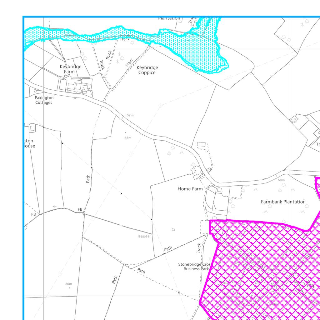
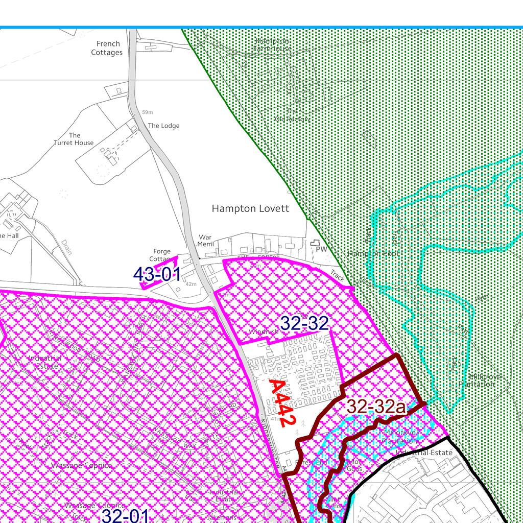
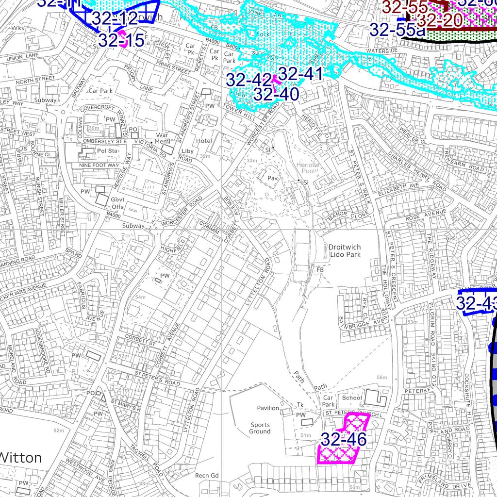
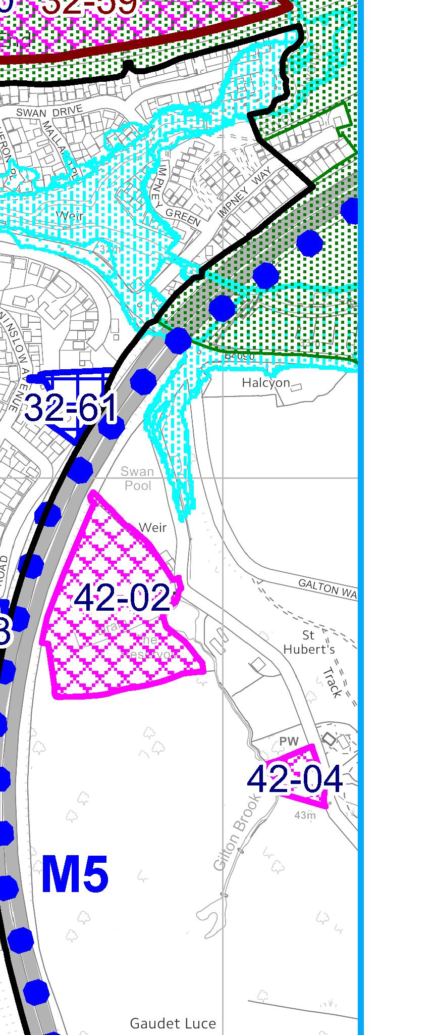
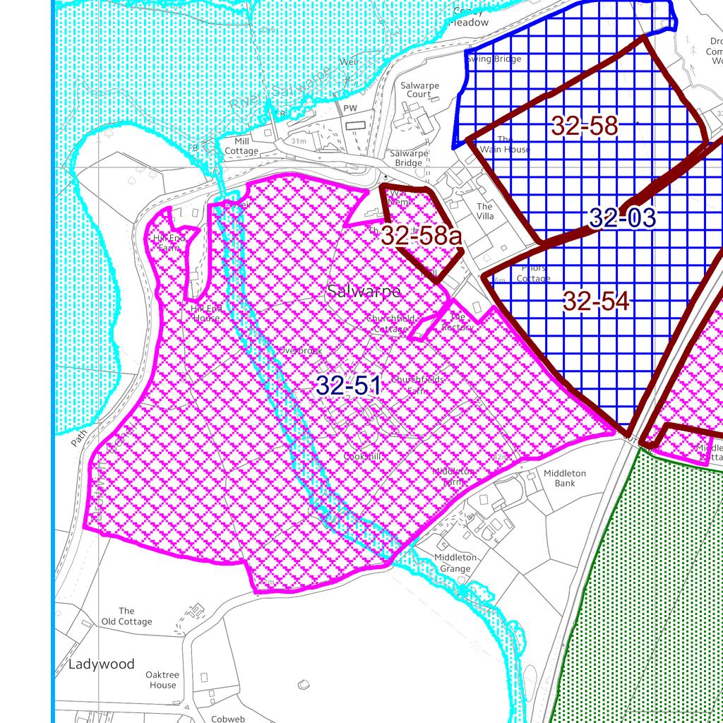
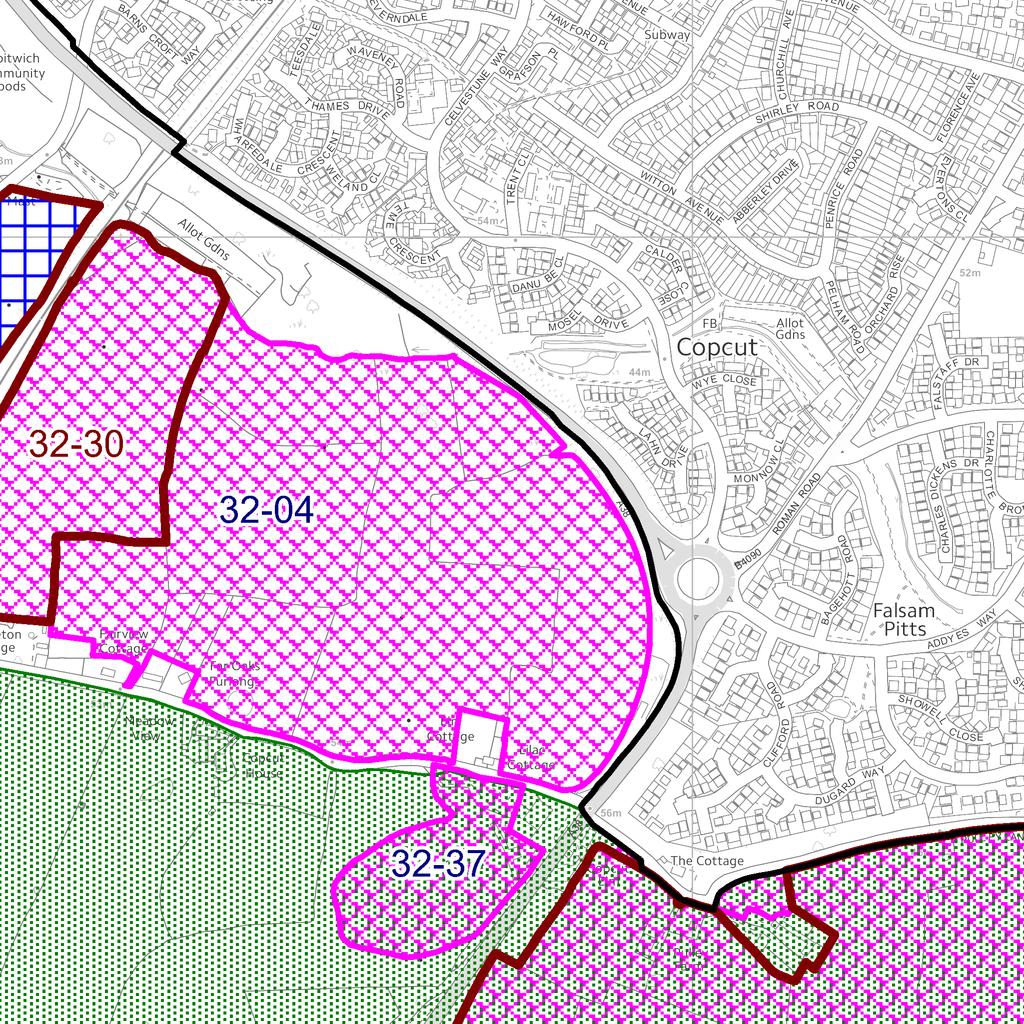
MAP 2 MAP 2 STRATEGIC HOUSING LAND AVAILABILITY ASSESSMENT. Sites within Droitwich Spa M Sites within Wychavon DC A442 Sites ruled out
 STRATEGIC HOUSIG LAD AVAILABILIT ASSESSMET MAP 2 43-01 43-01 Sites within 32-32 32-32 Sites within Wychavon DC A442 Sites ruled out Duplicate sites Settlement boundary 32-01 32-01 Green Belt Flood Risk
Town Village. SHLAA Update/2010/2012 Land south of Stourport Road Great Witley 1 Malvern Hills 4.28
 Summary of all SHLAA sites in Category 1 Villages: Site Ref Submitted Location Town Village Site Village Category area ha GW01 HLAA Former Coal ard adjacent Primary School with adj land 1 Malvern Hills
MHLS02 MHLS02 MHLS01 MHLS01 MHLS07 MHLS07 MHLS12 MHLS12 MHLS06 MHLS06 MHMT115 MHMT115 MHMT072 MHMT072 MHMT117 MHMT117 MHMT116 MHMT116 MHMT085 MHMT085
 STRATEGIC HOUSIG LAD AVAILABILIT ASSESSMET: Category 2 Villages MAP 41 1:10,000 1:10,000 LS04 LS04 LS09 LS09 LS02 LS02 LS03a LS03a LS03b LS03b LS10a LS10a LS01 LS01 LS05 LS05 LS08 LS08 LS10b LS10b LS07
MAP 9. Category 1 Villages : MAP 9. STRATEGIC HOUSING LAND AVAILABILITY ASSESSMENT: Category 1 Villages. Abberley Common 1:7,500 1:7,500 1:7,500
 STRATEGIC HOUSIG LAD AVAILABILIT ASSESSMET: Category 1 Villages # Abberley Common Contains Ordnance Survey data Crown copyright and database rights 2012 Licence umber 100024324. ou are not permitted to
1:10,000. Uphampton. Pond. The. Holllies Nash Inning. Tanks. Bennett's Hill. Lodge. 47.2m. Cubbold. House. Ombersley Park
 urseries Caravan Site A 46 urseries C.E First School urseries ursery MATT MATT ROAD Recreation Ground urseries ursery Cricket Ground urseries ursery urseries ursery ursery AVEUE urseries ursery OFFEHAM
Proposed Strategic Housing and Employment Land Availability Assessment (SHELAA) Methodology 2018
 Methodology 2018") Proposed Strategic Housing and Employment Land Availability Assessment (SHELAA) Methodology 2018 1.1 This section of the report sets out the methodology to be used in preparing the three South Worcestershire
Proposed Strategic Housing and Employment Land Availability Assessment (SHELAA) Methodology 2018 1.1 This section of the report sets out the methodology to be used in preparing the three South Worcestershire
Previous Use. Not Started at April 2014
 s With Permission with Officer on Delivery 13/00138 Land Adjacent, 90 Bretforton Road, Badsey, WR11 BADSEY Outline application for 11 new dwelling houses of which 36% are affordable houses. New Access.
54.3m. Tks. Tks. Tks. Factory 1:10,000. Tks WO14. Two Ways. Tank. Two Ways. 50.0m. Graylands. Stoneacr. Fircroft. Hillside. Littleoff.
 A 44 A 44 Depot Crown East Home Farm Aymestrey River Teme St Thomas's Church Broadmore Green A 44 CLAPHILL LAE CHRISTIE AVEUE A 44 Two Ways Fircroft Well Stoneacr Erica Tank Two Ways Littleoff Hillside
MAKING THE MOST EFFECTIVE AND SUSTAINABLE USE OF LAND
 165 SOC146 To deliver places that are more sustainable, development will make the most effective and sustainable use of land, focusing on: Housing density Reusing previously developed land Bringing empty
Rochford Core Strategy Schedule of Changes
 Rochford Core Strategy Schedule of Changes The changes below are expressed either in the conventional form of strikethrough for deletions and underlining for additions of text, or by specifying the change
Site Reference: 18 Site Address: Off Spa Terrace, Station Road, Askern Hierarchy Status: Principal Town Settlement:
 Site Reference: 18 Site Address: Off Spa Terrace, Station Road, Askern Hierarchy Status: Principal Town Settlement: Askern Site Area (Ha.): 2.22 Representation: JVH Town Planning (on behalf of Gladedale
Site Reference: 25 Site Address: Land off Rosehill Rise, Bessacarr Hierarchy Status: Main Urban Area Settlement:
 Site Reference: 25 Site Address: Land off Rosehill Rise, Bessacarr Hierarchy Status: Main Urban Area Settlement: Bessacarr Site Area (Ha.): 6.71 Representation: No Site Origin: UDP Urban Potential Site:
BIRMINGHAM DEVELOPMENT PLAN EXAMINATION 2014 MATTER E: GREEN BELT POLICY & THE LANGLEY SUE
 BIRMINGHAM DEVELOPMENT PLAN EXAMINATION 2014 MATTER E: GREEN BELT POLICY & THE LANGLEY SUE STATEMENT BY SAVILLS ON BEHALF OF THE LANGLEY SUE CONSORTIUM SEPTEMBER 2014 Question 1.Does policy TP10 set out
Riverton Properties Ltd Proposed Special Housing Area
 Riverton Properties Ltd Proposed Special Housing Area Housing Accords and Special Housing Areas Act 2013 Expression of Interest 1 This Expression of Interest is made on behalf of Riverton Properties Ltd,
Wigan Core Strategy Examination Additional Hearing Sessions
 Wigan Core Strategy Examination Additional Hearing Sessions Morris Homes & Persimmon Homes Session on Specific Proposals to Meet the Identified Shortfall in Housing Land Golborne & Lowton 6 th March 2013
 South Worcestershire Development Plan Examination Representation Form Additional Pages Consultation on Proposed Modifications to SWDP: 6 October 14 November 2014 South Worcestershire Councils Additional
PLANNING COMMITTEE 22/02/2006 SCHEDULE ITEM:- 11..Site Location; SOUTHALL COURT LADY MARGARET ROAD SOUTHALL MIDDLESEX UB1 2RG.
 PLANNING COMMITTEE 22/02/2006 SCHEDULE ITEM:- 11.Site Location; SOUTHALL COURT LADY MARGARET ROAD SOUTHALL MIDDLESEX UB1 2RG Form Letters49 PLANNING APPLICATION REPORT DATE: 22 February 2006 PLANNING COMMITTEE
Inverness Area Planning Advisory Committee Inverness County Planning Advisory Committee Inverness County Council Planning Staff (EDPC)
") STAFF REPORT To: From: Inverness Area Planning Advisory Committee Inverness County Planning Advisory Committee Inverness County Council Planning Staff (EDPC) Date: January 18, 2018 Reference: Request for
STAFF REPORT To: From: Inverness Area Planning Advisory Committee Inverness County Planning Advisory Committee Inverness County Council Planning Staff (EDPC) Date: January 18, 2018 Reference: Request for
Derry City and Strabane District Council Planning Committee Report. into 5 no. apartments/change of use.
 Derry City and Strabane District Council Planning Committee Report COMMITTEE DATE: 1 st July 2015 APPLICATION No: APPLICATION TYPE: PROPOSAL: LOCATION: APPLICANT: AGENT: A/2014/0437/LBC Listed Building
CHESHIRE WEST AND CHESTER COUNCIL
 Item No. 10 CHESHIRE WEST AND CHESTER COUNCIL Planning Committee 1 st April 2014 APPLICATION NUMBER: 13/05410/FUL DESCRIPTION OF DEVELOPMENT: Residential development of 17 affordable dwellings and associated
Simon Court 2-4 Neeld Crescent London NW4 3RR
 Location Simon Court 2-4 Neeld Crescent London NW4 3RR Reference: 17/1019/FUL Received: 20th February 2017 Accepted: 23rd February 2017 Ward: West Hendon Expiry 20th April 2017 Applicant: Proposal: Mr
Division 5 Residential Low Density Zone: Assessment Criteria and Assessment Tables
 Division 5 Residential Low Density Zone: Assessment Criteria and Assessment Tables 4.5.1 Residential Low Density Zone The provisions in this division relate to the Residential Low Density Zone as follows
Colchester Borough Council - Local Plan Part 2 Viability Study: Summary of Emerging Findings
 Appendix 1 Colchester Borough Council - Local Plan Part 2 Viability Study: Summary of Emerging Findings 1. The Colchester Borough Council Viability Study provides the Council with evidence to assist it
How do I Object to Flats and Apartments in my Area?
 Guide How do I Object to Flats and Apartments in my Area? January 2017 Background This is an introduction to objecting to proposals for flats or apartments in your area. For more detailed information and
Maple Coppice Droitwich Spa, Worcestershire. A collection of 1, 2, 3, 4 & 5 bedroom homes
 Maple Coppice Droitwich Spa, Worcestershire A collection of 1, 2, 3, 4 & 5 bedroom homes Rebekah Hill open space *ah/so 100 *ah/so 125 147 146 149 148 145 144 149 149 147 146 145 147 146 145 148 148 127127
Financial Impact Statement There are no immediate financial impacts associated with the adoption of this report.
 STAFF REPORT Planning and Development Department Subject: Application by RYC Property to rezone a portion of lands on John Murray Dr. and Megan Lynn Dr. from R2 to R3 and to enter into a Development Agreement
East Herts District Plan Part 1: Strategy Sieve 5: Strategy Testing. Land Owner/Developer Questionnaire
 East Herts District Plan Part 1: Strategy Sieve 5: Strategy Testing Land Owner/Developer Questionnaire ugust 2012 rea of Search: 20. Ware East Sub-rea Call for Sites Ref: 05/020 (as subsection of larger
Division 6 Residential Medium Density Zone: Assessment Criteria and Assessment Tables
 Division 6 Residential Medium Density Zone: Assessment Criteria and Assessment Tables 4.6.1 Residential Medium Density Zone The provisions in this division relate to the Residential Medium Density Zone
Division 16 Bundamba Racecourse Stables Area Zone: Assessment Criteria and Assessment Tables
 Division 16 Bundamba Racecourse Stables Area Zone: Assessment Criteria and Assessment Tables 4.16.1 Bundamba Racecourse Stables Area Zone The provisions in this division relate to the Bundamba Racecourse
York Neighbourhood Area Structure Plan
 York Neighbourhood Area Structure Plan Office Consolidation March 2006 Prepared by: Planning and Policy Services Branch Planning and Development Department City of Edmonton Bylaw 7064 was adopted by Council
PIP practice note 1 planning assumptions. How to use this practice note. Planning assumptions. What are planning assumptions? Type.
 PIP PRACTICE NOTE 1 How to use this practice note This practice note has been prepared to support in the preparation or amending of planning assumptions within a priority infrastructure plan (PIP). It
Unit 2B, The Tack Room Top Barn Business Centre Worcester Road Holt Heath Worcester WR6 6NH
 Stage 2 of the Examination Hearings Hearing Statement Matter X3: Category 1 Villages Wychavon (SWDP 59 & PM 209-217) On behalf of: CALA Homes (Midlands) Ltd (612691) Thursday 4 th June 2015, AM & PM Unit
FOR SALE. 200 dwellings residential development site. with a resolution to grant planning permission THE STEEDS, GREAT COXWELL, OXFORDSHIRE SN7 7NN
 FOR SALE 200 dwellings residential development site with a resolution to grant planning permission THE STEEDS, GREAT COXWELL, OXFORDSHIRE SN7 7NN Outline Planning permission for up to 130 Private and 70
LAND SOUTH OF ST.FREMUND WAY, SYDENHAM, LEAMINGTON SPA
 LAND SOUTH OF ST.FREMUND WAY, SYDENHAM, LEAMINGTON SPA Introduction A C Lloyd is currently completing the final phase of development under the current planning consent at Millpool Meadows in Sydenham and
RESIDENTIAL DEVELOPMENT DEMOLITION OF EXISTING HOTEL AND ERECTION OF 29 FLATS SITE AREA APPROX HECTARES (0.99 ACRES)
") RESIDENTIAL DEVELOPMENT DEMOLITION OF EXISTING HOTEL AND ERECTION OF 29 FLATS SITE AREA APPROX - 0.4 HECTARES (0.99 ACRES) Normanton Park Hotel, 34-36 Normanton Road, South Croydon, Surrey, CR2 7AR FOR
RESIDENTIAL DEVELOPMENT DEMOLITION OF EXISTING HOTEL AND ERECTION OF 29 FLATS SITE AREA APPROX - 0.4 HECTARES (0.99 ACRES) Normanton Park Hotel, 34-36 Normanton Road, South Croydon, Surrey, CR2 7AR FOR
Pre-Applica on Design Statement : Residen al Development, The Gas Works, 113 Bury Road, The ord, Norfolk 1
 13-188 Pre-Applica on Design Statement: Residen al Development, The Gas Works, 113 Bury Road, The ord, Norfolk Prepared by: Gary Johns Architects Date: October 2015 15-311 Pre-Applica on Design Statement
SALP Main Modifications proposed by the Council April 2018
 SALP Main Modifications proposed by the Council April 2018 The main modifications below are described in italics and expressed either in the form of strikethrough for deletions and bold for additions of
Core Strategy Topic Paper 1. PPS25 Sequential Test
 Core Strategy Topic Paper 1 PPS25 Sequential Test Core Strategy Topic Paper 1 PPS25 sequential test Introduction 1.1 This document has been prepared in response to a representation submitted by the Environment
SUBDIVISION AND DEVELOPMENT REGULATION
 Province of Alberta MUNICIPAL GOVERNMENT ACT SUBDIVISION AND DEVELOPMENT REGULATION Alberta Regulation 43/2002 With amendments up to and including Alberta Regulation 188/2017 Office Consolidation Published
Identifying brownfield land suitable for new housing
 Building more homes on brownfield land Identifying brownfield land suitable for new housing POS consultation response Question 1: Do you agree with our proposed definition of brownfield land suitable for
Planning Reform and Housing Viability
 Planning Reform and Housing Viability Colin Wiles colin@wilesconsulting.co.uk National Planning Policy Framework 1,000 pages reduced to 52 Framework for all future development Plan-led Golden thread of
1.4 The vast majority of all development proposed in the Core Strategy can be accommodated within Flood Zone 1.
 Core Strategy Topic Paper 1 PPS25 sequential test Introduction 1.1 This document has been prepared in response to a representation submitted by the Environment Agency in respect to Rochford District Council
Decision Database
 Our Ref Date rec'd Address Details TBC Ref BCPC Mtg date Objection Neutral Support TBC Decision Variation 669 25/04/2014 Yew Tree Farm, Woodmancote residential development of 41 homes 14/00318/OUT 08/05/2014
SOUTH CAMBRIDGESHIRE DISTRICT COUNCIL. S/1744/05/F Thriplow House and Garage on land Adjacent 22 Middle Street for S Hurst
 SOUTH CAMBRIDGESHIRE DISTRICT COUNCIL REPORT TO: Development and Conservation Control Committee 2 nd November 2005 AUTHOR/S: Director of Development Services S/1744/05/F Thriplow House and Garage on land
Request for Development Land in the Palm Springs Subdivision to be Granted Special Housing Area Status under the Tauranga Housing Accord
 Request for Development Land in the Palm Springs Subdivision to be Granted Special Housing Area Status under the Tauranga Housing Accord Development Proposal Overview of proposal This request is lodged
Planning and Building Department
 Page 1 of Report PB-83-13 TO: Development and Infrastructure Committee Planning and Building Department SUBJECT: OP & Rezoning 5001 Corporate Drive Appleby Gardens LJM Developers Report Number: PB-83-13
Stephen Davy Peter Smith Architects
 Stephen Davy Peter Smith Architects Stephen Davy Peter Smith Architects 21 Stephen Davy Peter Smith Architects Stephen Davy Peter Smith Architects 23 FIFTH FLOOR FOURTH FLOOR FIFTH FLOOR FOURTH FLOOR THIRD
PART SIXTEEN - SUBDIVISION AND DEVELOPMENT
 16.1 24 July 2010 PART SIXTEEN - SUBDIVISION AND DEVELOPMENT 1. INTRODUCTION Council has the statutory responsibility to control subdivision of land and the effects of land use throughout the District.
9.3.6 Dwelling house code
 9.3.6 Dwelling house code 9.3.6.1 Application (1) This code applies to accepted development assessable development identified as requiring assessment against the Dwelling house 3 code by the tables of
apply sustainability principles to all residential developments in Ardee;
 3. Housing 3.1 Introduction Ardee is currently experiencing considerable pressure for residential development as improved road infrastructure, together with the availability of serviced land, makes the
Kassner Goodspeed Architects Ltd.
 Kassner Goodspeed Architects Ltd. 11 March 2015 Ms Jillian MacLellan, Planner 1 Planning Application, Community Development Halifax Regional Municipality P.O. Box 1749 Halifax, NS B3J 3A5 Re: Case 19281,
Woodground Farm, Stock Green, Redditch, Worcestershire, B96 6TA
 Woodground Farm, Stock Green, Redditch, Worcestershire, B96 6TA 01562 820880 WOODGROUND FARM STOCK GREEN, REDDITCH, WORCESTERSHIRE, B96 6TA Droitwich 7 miles Worcester 12 miles - Birmingham 24 miles (All
Planning Rationale in Support of an Application for Site Plan Control Approval
 Planning Rationale in Support of an Application for Site Plan Control Approval Block 8, 4401 Fallowfield Road Subdivision, O keefe Court Prestige Business Park, South Nepean City of Ottawa Prepared by:
Another Road, Somewhere, Oxfordshire. Site Development Feasibility Report. Prepared for ABC Developments Ltd
 Another Road, Somewhere, Oxfordshire Site Development Feasibility Report Prepared for ABC Developments Ltd 16 November 2011 JLDA sustainable building design (Note: this sample report contains sections
For Vintages of Four Mile Creek Town of Niagara on the Lake, Ontario
 Planning Impact Analysis For Vintages of Four Mile Creek Town of Niagara on the Lake, Ontario Prepared by: Upper Canada Consultants 261 Martindale Road Unit #1 St. Catharines, Ontario L2W 1A1 Prepared
Examination into Cheshire East Local Plan
 Examination into Cheshire East Local Plan Matter 14.8 Middlewich Representation Ref: 649516 on behalf of Persimmon Homes August 2014 Mosaic Town Planning Lowry House 17 Marble Street Manchester M2 3AW
RUSSELL WAY, CRAWLEY, WEST SUSSEX, RH10 1UH. Development Opportunity
 1 RUSSELL WAY, CRAWLEY, WEST SUSSEX, RH10 1UH Development Opportunity OVERVIEW Under the jurisdiction of Crawley Borough Council. Total site area of 0.49 hectares (1.2 acres). Redevelopment opportunity
Matter 2 Duty to Co-operate
 EXAMINATION OF THE SOUTH WORCESTERSHIRE DEVELOPMENT PLAN Matter 2 Duty to Co-operate Main issues: Whether or not the legal requirements imposed by S33A of the Planning and Compulsory Purchase Act 2004
FOR SALE. Prime Residential Development Opportunity Cowplain, Waterlooville, Hampshire Hectares (6.3 acres) Features
 Features") FOR SALE Prime Residential Development Opportunity Cowplain, Waterlooville, Hampshire 2.55 Hectares (6.3 acres) Cherry Tree Avenue Waterlooville Golf Course Padnell Road Features Prime residential development
FOR SALE Prime Residential Development Opportunity Cowplain, Waterlooville, Hampshire 2.55 Hectares (6.3 acres) Cherry Tree Avenue Waterlooville Golf Course Padnell Road Features Prime residential development
(b) each living unit shall have a minimum floor area of 27 m 2 (290.6 sq.ft.). (B/L No ) (a) the zoning designations R4, R5, R9, or
 each living unit shall have a minimum floor area of 27 m 2 (290.6 sq.ft.). (B/L No ) (a) the zoning designations R4, R5, R9, or") 104. RESIDENTIAL DISTRICT (R4) This District provides for the use and development of two-family dwellings on larger lots in medium density residential areas. 104.1 Uses Permitted: (1) Single family dwellings
104. RESIDENTIAL DISTRICT (R4) This District provides for the use and development of two-family dwellings on larger lots in medium density residential areas. 104.1 Uses Permitted: (1) Single family dwellings
MIDWAY CITY Municipal Code
 MIDWAY CITY Municipal Code TITLE 9 ANNEXATION CHAPTER 9.01 PURPOSE CHAPTER 9.02 GENERAL REQUIREMENTS CHAPTER 9.03 PROPERTY OWNER INITIATION OF ANNEXATION CHAPTER 9.04 PROCEDURES FOR CONSIDERATION OF PETITION
The Horizon, 54 New Coventry Road, Sheldon, Birmingham, B26 3BB
 Committee Date: 17/07/2014 Application Number: 2014/02479/PA Accepted: 22/04/2014 Application Type: Full Planning Target Date: 22/07/2014 Ward: Sheldon The Horizon, 54 New Coventry Road, Sheldon, Birmingham,
SOUTH CAMBRIDGESHIRE DISTRICT COUNCIL. Development and Conservation Control Committee Director of Development Services
 SOUTH CAMBRIDGESHIRE DISTRICT COUNCIL REPORT TO: AUTHOR/S: Development and Conservation Control Committee Director of Development Services 1 st September 2004 S/1476/04/F - Willingham Siting of Mobile
Equality and Access Plan The Abbey School, Reading
 Equality and Access Plan 2017-2020 The Abbey School, Reading , Reading Accessibility Plan Scope The School recognises the benefits of a diverse School Community, with individuals who value one another
Dwelling house guide
 Dwelling house guide Contents 1.0 Introduction... 1 2.0 What is a dwelling house?... 1 3.0 What building assessment provisions apply to dwelling houses?... 1 4.0 What category of development and category
The Saloon, (Apartment 4) Westwood House, Westwood Park, Droitwich, WR9 0AD
 Westwood House, Westwood Park, Droitwich, WR9 0AD") The Saloon, (Apartment 4) Westwood House, Westwood Park, Droitwich, WR9 0AD THE SALOON, APARTMENT 4, WESTWOOD HOUSE, WESTWOOD PARK, DROITWICH, WR9 0AD Premier Apartment Within Historic Grade I Listed House,
The Saloon, (Apartment 4) Westwood House, Westwood Park, Droitwich, WR9 0AD THE SALOON, APARTMENT 4, WESTWOOD HOUSE, WESTWOOD PARK, DROITWICH, WR9 0AD Premier Apartment Within Historic Grade I Listed House,
Planning Policy Report for the Proposed Residential Development at The Old Sorting Office
 Planning Policy Report for the Proposed Residential Development at The Old Sorting Office Greenwich Unitary Development Plan UDP 1. Status of the UDP The current UDP was adopted on 20 July 2006. The UDP
RM-7, RM-7N and RM-7AN Districts Schedules
 1 Intent Districts Schedules The intent of this schedule is to encourage development of ground-oriented stacked townhouses or rowhouses, while continuing to permit lower intensity development. In RM-7AN,
THE CORPORATION OF THE TOWNSHIP OF KING THE CERTIFICATE PAGE FOR AMENDMENT NO. 89 TO THE OFFICIAL PLAN OF THE TOWNSHIP OF KING
 THE CORPORATION OF THE TOWNSHIP OF KING THE CERTIFICATE PAGE FOR AMENDMENT NO. 89 TO THE OFFICIAL PLAN OF THE TOWNSHIP OF KING (KING CITY COMMUNITY PLAN) The attached text and schedules constituting Amendment
SOUTH WORCESTERSHIRE DEVELOPMENT PLAN REVIEW (SWDPR) STRATEGIC HOUSING AND EMPLOYMENT LAND AVAILABILITY ASSESSMENT (SHELAA) Call for Sites
 STRATEGIC HOUSING AND EMPLOYMENT LAND AVAILABILITY ASSESSMENT (SHELAA) Call for Sites") SOUTH WORCESTERSHIRE DEVELOPMENT PLAN REVIEW (SWDPR) STRATEGIC HOUSING AND EMPLOYMENT LAND AVAILABILITY ASSESSMENT (SHELAA) Call for Sites SITE SUGGESTION FORM MAY 2018 Potential sites for housing and/or
SOUTH WORCESTERSHIRE DEVELOPMENT PLAN REVIEW (SWDPR) STRATEGIC HOUSING AND EMPLOYMENT LAND AVAILABILITY ASSESSMENT (SHELAA) Call for Sites SITE SUGGESTION FORM MAY 2018 Potential sites for housing and/or
FOR SALE. 515 dwelling residential development site HIGHWORTH ROAD, SHRIVENHAM, OXFORDSHIRE, SN6 8BL. with outline planning permissions
 FOR SALE 515 dwelling residential development site with outline planning permissions HIGHWORTH ROAD, SHRIVENHAM, OXFORDSHIRE, SN6 8BL Two separate outline planning consents being: Phase A Planning Permission
Chapter 210 CONDITIONAL USES
 Chapter 210 CONDITIONAL USES 210.01 Purpose 210.02 Authorization 210.03 Process Type 210.04 Determination of Major or Minor Conditional Use Review 210.05 Approval Criteria 210.06 Conditions of Approval
DEVELOPMENT PROFILE. Main Street North and Nelson Street East City of Brampton W E S T O N C O N S U L T I N G. planning + urban design
 W E S T O N C O N S U L T I N G planning + urban design DEVELOPMENT PROFILE Main Street North and Nelson Street East City of Brampton Vaughan Office 201Millway Avenue, Suite 19, Vaughan, Ontario L4K5KB
Subdivision of existing dwellinghouse to create 1x one bedroom flat and 1x two bedroom flat
 APP 12 Application Number: 16/00335/FUL Minor Subdivision of existing dwellinghouse to create 1x one bedroom flat and 1x two bedroom flat AT 67 Ashfield, Stantonbury, Milton Keynes FOR Mr Matthew Barnes
Glades County Staff Report and Recommendation Unified Staff Report for Small Scale Plan Amendment and Rezoning
 Glades County Staff Report and Recommendation Unified Staff Report for Small Scale Plan Amendment and Rezoning CASE NUMBERS: COMP17-02 and RZ17-02 DATE of STAFF REPORT: May 1, 2017 CASE TYPE: Application
ADMINISTRATION RECOMMENDATION(S) 2017 July 27. That Calgary Planning Commission recommends APPROVAL of the proposed Land Use Amendment.
 2017 July 27. That Calgary Planning Commission recommends APPROVAL of the proposed Land Use Amendment.") Page 1 of 9 EXECUTIVE SUMMARY This land use amendment application seeks to redesignate a single residential parcel from a Residential Contextual One Dwelling (R-C1) District to a Residential Contextual
Page 1 of 9 EXECUTIVE SUMMARY This land use amendment application seeks to redesignate a single residential parcel from a Residential Contextual One Dwelling (R-C1) District to a Residential Contextual
[2010] VSC (2004) 18 VPR 229
![[2010] VSC (2004) 18 VPR 229](/thumbs/74/70555400.jpg "[2010] VSC (2004) 18 VPR 229") MOOT COURT 2017 PREPARED BY TIM RETROT VICTORIAN CIVIL AND ADMINISTRATIVE TRIBUNAL PLANNING PERMIT APPLICATION NO. TP418/2016 OUTLINE OF SUBMISSIONS ON BEHALF OF LIONHEART HOMES 93-95 VICTORIA STREET,
MOOT COURT 2017 PREPARED BY TIM RETROT VICTORIAN CIVIL AND ADMINISTRATIVE TRIBUNAL PLANNING PERMIT APPLICATION NO. TP418/2016 OUTLINE OF SUBMISSIONS ON BEHALF OF LIONHEART HOMES 93-95 VICTORIA STREET,
Flinders Avenue, Lara Planning Scheme Amendment Combined Application for Rezoning and Multi-Lot Subdivision Reference : Decembe
 143-179 Flinders Avenue, Lara Planning Scheme Amendment Combined Application for Rezoning and Multi-Lot Subdivision Reference: 14134-03 TGM Group Geelong Melbourne Ballarat 1/27-31 Myers Street (PO Box
MIXED USE RETAIL & RESIDENTIAL INVESTMENT PLANNING CONSENT FOR 2 NEW MAISONETTES TO THE REAR
 67 Western Road, Brighton, East Sussex BNI 2HA FOR SALE MIXED USE RETAIL & RESIDENTIAL INVESTMENT PLANNING CONSENT FOR 2 NEW MAISONETTES TO THE REAR Agency Lease Advisory Management Valuation Investment
57 Foscote Road London NW4 3SE
 Location 57 Foscote Road London NW4 3SE Reference: 16/0572/FUL Received: 28th January 2016 Accepted: 1st February 2016 Ward: West Hendon Expiry 28th March 2016 Applicant: Mr Dan Tamir Proposal: Part single,
collective property auction
 collective property auction Wednesday 20 July 2011 at 5 00pm Golf Club Stratford Road Worcestershire B60 1LD 01905 453275 www.fishergerman.co.uk Building plot between 41a and 45 The Flats FOR SALE BY PUBLIC
P. H. Robinson Consulting Urban Planning, Consulting and Project Management
 PLANNING RATIONALE REPORT 351 CROYDON - SITE PLAN APPLICATION CITY OF OTTAWA PREPARED BY: P H ROBINSON CONSULTING JULY 2017 This report has been prepared on behalf of Urban Structure Properties Ltd in
Planning Justification Report
 Planning Justification Report 103 and 105 Toronto Street Town of Markdale, Municipality of Grey Highlands Maverick Developments November 5, 2016 Zelinka Priamo Ltd. Page i TABLE OF CONTENTS Page No. 1.0
Draft London Plan Review
 Draft London Plan Review Briefing Note Date: 04/12/2017 Ref No: 283 Introduction On the 29th November the Mayor of London, Sadiq Khan, published his draft London Plan for consultation (Regulation 19).
New Residential Zones their application and implications. Elizabeth Lewis David Vorchheimer
 New Residential Zones their application and implications Presented by Paul Buxton Elizabeth Lewis David Vorchheimer 14 June 2013 Outline Background / context MAC recommendations, Minister s response, work
GENERIC LAND VALUATIONS
 GENERIC LAND VALUATIONS Sunshine Coast Council Local Authority Area Client Sunshine Coast Council Date of Valuation June 2015 Prepared by: CBRE Valuations Pty Limited PO Box 407 MOOLOOLABA QLD 4557 Tel:
Council Meeting Wednesday, 6 April 2016
 [NOT PROTECTIVELY MARKED] Council Meeting Wednesday, 6 April 2016 Dear Councillor COUNCIL - WEDNESDAY, 6 APRIL, 2016 I am now able to enclose, for consideration at next Wednesday, 6 April, 2016 meeting
Residential Building Land
 Residential Building Land at Halton, Nr Chirk, Wrexham People Property Places Residential Development Opportunity 9.55 acres (3.7 hectares) at Ley Farm, Halton, Nr Chirk, Wrexham LL14 5BG A potential scheme
PLANNING SUBMISSION & CLAUSE 56 ASSESSMENT RESIDENTIAL SUBDIVISION OF LAND 1525 POUND ROAD, CLYDE NORTH (LOT 2 PS F, SIENNA PARK ESTATE)
") PLANNING SUBMISSION & CLAUSE 56 ASSESSMENT RESIDENTIAL SUBDIVISION OF LAND 1525 POUND ROAD, CLYDE NORTH (LOT 2 PS 327975F, SIENNA PARK ESTATE) DFC (PROJECT MANAGEMENT) PTY LTD (A DENNIS FAMILY CORPORATION
PLANNING SUBMISSION & CLAUSE 56 ASSESSMENT RESIDENTIAL SUBDIVISION OF LAND 1525 POUND ROAD, CLYDE NORTH (LOT 2 PS 327975F, SIENNA PARK ESTATE) DFC (PROJECT MANAGEMENT) PTY LTD (A DENNIS FAMILY CORPORATION
For and on behalf of Redrow Homes Ltd
 For and on behalf of Redrow Homes Ltd Sheffield Additional Site Allocations Document Local Development Framework Consultation Representations Prepared by DLP Planning Ltd February 2012 Contents Page 1.0
CA/15/2006/OUT. Canterbury City Council Military Road Canterbury Kent CT1 1YW. Crown copyright and database rights 2015 Ordnance Survey
 Scale 1:1,250 Map Dated: 28/10/2015 CA/15/2006/OUT Crown copyright and database rights 2015 Ordnance Survey 100019614 Canterbury City Council Military Road Canterbury Kent CT1 1YW AGENDA ITEM NO 10 PLANNING
Subdivision Application Package RURAL MUNICIPALITY
 Subdivision Application Package RURAL MUNICIPALITY Oldman River Regional Services Commission 3105 16 th Avenue North Lethbridge AB T1H 5E8 Phone: 403-329-1344 or 1-844-279-8760 Website: www.orrsc.com Email:
Safe Waterfront Access, PID Council Report -2 - May 10, 2016 BACKGROUND
 14.3.1 Safe Waterfront Access, PID 00560789 Council Report -2 - May 10, 2016 BACKGROUND A staff information report dated April 11, 2016 regarding safe waterfront access at PID 00560789 was before the Halifax
Council Public Meeting
 Agenda 3.1 a Council Public Meeting Department: Division: Subject: Planning and Regulatory Services Development Planning Request for Comments Zoning By-law Amendment and Draft Plan of Subdivision Applications
Group Sewer Only** 80 Ft Frontage* 20,000 Sq. Ft. (.46 acre) Minimum** 120 Ft Frontage* 20,000 Sq. Ft. (.46acre) Minimum** 150 Ft Frontage*
 Minimum** 120 Ft Frontage* 20,000 Sq. Ft. (.46acre) Minimum** 150 Ft Frontage*") Residential Lots Minimum Chart The minimum lot size of any minor subdivision where there is no public sewers shall be as shown below or as required by township zoning and/or the Tuscarawas General Health
Residential Lots Minimum Chart The minimum lot size of any minor subdivision where there is no public sewers shall be as shown below or as required by township zoning and/or the Tuscarawas General Health
DCLG consultation on proposed changes to national planning policy
 Summary DCLG consultation on proposed changes to national planning policy January 2016 1. Introduction DCLG is proposing changes to the national planning policy framework (NPPF) specifically on: Broadening
Chair and Members Planning and Economic Development Committee
 TO: FROM: Chair and Members Planning and Economic Development Committee Melissa Halford Manager of Planning DATE: June 23, 2016 SUBJECT: Amendment No. 6 to Draft Approval Subdivision File No. S2006-3 (Loon
Multi-unit residential uses code
 9.3.11 Multi-unit residential uses code 9.3.11.1 Application (1) This code applies to assessable development identified as requiring assessment against the Multi-unit residential uses code by the tables
RM 4 and RM 4N Districts Schedule
 Districts Schedule 1 Intent The intent of this Schedule is to permit medium density residential development, including a variety of multiple dwelling types, to encourage the retention of existing buildings
TARIFF OF FEES FOR PROCESSING OF PLANNING APPLICATIONS GENERAL TERMS
 Page 2 SCHEDULE A TO BY-LAW 2016-149 TARIFF OF FEES FOR PROCESSING OF PLANNING APPLICATIONS GENERAL TERMS 1.0. Fee Acceptance 1.1. Fees shall only be accepted in conjunction with the filing of an application