SALP Main Modifications proposed by the Council April 2018
|
|
|
- Henry Stephens
- 5 years ago
- Views:
Transcription
1 SALP Main Modifications proposed by the Council April 2018 The main modifications below are described in italics and expressed either in the form of strikethrough for deletions and bold for additions of text, or by specifying the modification in words. Ref. Policy / MM1 Para. 2.4 Amend to read: Forest Heath s Core Strategy Between 2011 and , more homes have been approved and/or built leaving to be planned for across the district by Appendix 3 shows the sites which contribute to the SIR additional provision and those allocated in the SALP. The number of dwellings allocated in the SALP sometimes exceeds the SIR additional provision, as it is appropriate to allocate sites which already have planning permission. Delivering Forest Heath Housing need Requirement Sites with planning permission and/or completed at 31 st March Additional homes required MM2 Para. 3.3 Amend last sentence of paragraph to read: So, while the potential to provide additional employment land is limited, Additional employment land is planned for Newmarket. This, alongside opportunities for expanding the This paragraph and table has been amended to reflect the updated housing position at 31 st March 2017 and to be consistent with SIR modification MM2. A note is added to clarify the difference between the additional provision to be planned for in the SIR and the sites allocated in the SALP, updated to the position at 31 st March Amended to reflect post hearing additional allocation and deallocation of sites. A consequential change from changes to Policies SA6 (MM17) and SA17 (MM41) to reflect the proposed allocation of 5ha employment land at 1
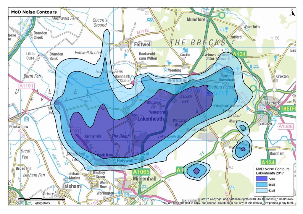
2 economic advantages of the race horse industry, will bring economic advantages to the town. Hatchfield Farm as a post hearing modification. MM3 MOD Noise Contours 2015 Map Delete map following paragraph 3.9 and replace with: Military Aviation Noise Contour Map of aircraft activity at RAF Lakenheath January 2017 MM4 Para Insert new paragraph 3.12 after 3.11 and re-number subsequent paragraphs: At a local level, and to inform this local plan, a cumulative traffic impact study has identified locations where mitigation will be required to address the cumulative impacts of growth in the plan period. At the planning application stage, and in line with the Planning Practice Guidance on Travel Plans, Transport Assessments and Statements, developers may be required to assess not only highway impacts of their own proposals on these locations but to include the cumulative impacts from other permitted and allocated development in the locality. Where it is necessary to negate the transport impacts of development, developers will be required to ensure provision of necessary improvements in line with Policy DM45 (of the adopted JDMP document Development Management Policies Document 2015). To update the plan with the latest noise constraint map (attached). See signed Statement of Common Ground between Forest Heath District Council and the DIO ( ). Supporting text to clarify evidence base and requirements of developers (as set out in PPG). (See Statement of Common Ground between Suffolk County Council and Forest Heath District Council.) 2
3 MM5 Page 21 and 22 SA2(a) site plans MM6 Page 30 and 33 SA5(a) site plans MM7 Page 30 and 33 SA5(b) site plans MM8 Page 31, after para Amend site boundary of site SA2(a) on Brandon maps as shown on attached plan. Amend site boundary of site SA5(a) on Mildenhall maps as shown on attached plan. Amend site boundary of site SA5(b) on Mildenhall map as shown on attached plan. Insert new paragraph after and renumber subsequent paragraphs: Existing water mains and sewers cross this site and the site layout should be designed to take these into account. This existing infrastructure is protected by easements and should not be built over or located in private gardens where access for maintenance and repair could be restricted. The existing water mains and sewers should be located in highways or public open space. If this is not possible a formal application to divert Anglian Water s existing assets may be required. Officer identified. To reflect land ownership. Officer identified. To reflect land ownership as stated in representation To reflect land ownership. This is a consequential change to supporting text as a result of the proposed modification which inserts a new criteria in Policy SA4 for safeguarding water supply and foul water drainage. (See Statement of Common Ground between Anglian Water and Forest Heath District Council ( ) MM9 Policy SA4 Add the word land under Indicative Capacity: Mixed use to include 1300 dwellings with a local centre, a minimum of 5ha employment land, schools, leisure facilities and public services. Typographical error: word omitted. Add requirement H): 3
4 H) that suitable access is safeguarded for the maintenance of water supply and foul drainage infrastructure. Add sentence to * footnote: See Statement of Common Ground between Anglian Water and Forest Heath District Council ( ). For the avoidance of doubt the 5ha of employment land is in addition to the Public Services Hub. MM10 Policy SA5 Add * to table after indicative capacity of 23 units to site SA5 (a). Add sentence after the policy: *Part of site SA5 (a) has planning permission for 6 dwellings, these dwelling numbers count as an existing commitment rather than contributing to the additional provision required. Amend final line to read: Site (a) (b) requires pre determination desk based archaeological evaluation. MM11 Para Delete second sentence of 15 th bullet point and replace with new text to read: For clarification. A note is added to clarify that part of the site allocated in the SALP has planning permission, updated to the position at 31 st March See Statement of Common Ground between Suffolk County Council and Forest Heath District Council. A factual update to provide greater clarity. There is sufficient capacity to accommodate planned growth within the town s primary schools/school sites Planned growth will require expansion/provision of additional pre-school settings and primary and secondary school places. 4
5 MM12 Para Delete 321 and replace with 771 in the second sentence to read: For Newmarket, this means a total of dwellings are allocated in the town up to MM13 Para Delete paragraph and renumber subsequent paragraphs accordingly. Following the Secretary of State s decision in August 2016 to refuse planning permission for 400 dwellings on a site at Hatchfield Farm to the north east of the town, this site has not been included as a housing allocation in this Plan. MM14 Para Reword paragraph to read: MM15 Page 40, Newmarket map In the context of the above, five residential sites and two mixed use sites have been identified as being suitable for allocation in Newmarket to meet the distribution needs set out in the Single Issue Review. An additional site for mixed use has also been identified, with housing numbers to be confirmed through a development brief at a later date. Add in site boundary for SA6(g) Land at Hatchfield Farm and amend settlement boundary accordingly. MM16 Para Delete all after the first three sentences in paragraph and replace with the following: This site comprises the historic Queensbury Lodge Stables, former swimming pool, White Lion public house Supporting text to clarify the updated housing positon as set out in SIR modification MM3 that re-balances the distribution between the towns and key service centres. Supporting text deleted as a consequence of the updated housing position as set out in SIR modification MM3 and SALP modification MM17 (Policy SA6). Supporting text deleted as a consequence of the updated housing position as set out in SIR modification MM3 and SALP modification MM17 (Policy SA6). Amended as a consequence of the changes to Policy SA6 (SALP MM17). Reword supporting text para as a consequence of the insertion of capacity for Black Bear Lane and Rowley Drive junction and 5
6 MM17 After page 46, SA6 (f) and Fitzroy Paddocks. The grade II listed stables, cottage and lodge are all identified as listed buildings at risk in the Suffolk Register. There are tree belts on the paddocks and around the periphery of the site and it is identified as an important open space in the Newmarket Conservation Area Appraisal. The site fronts the High Street in the south and extends to Rowley Drive in the north. The site has been vacant for some time and has a complex planning history. Any development on this site must facilitate the sympathetic restoration and viable reuse of the listed buildings, retain a horse racing industry related use on the site, and preserve or enhance the character and appearance of the conservation area. The potential uses and capacity of the site will be explored by the council and other stakeholders through the preparation of a development brief in line with Policy DM4 of the Joint Development Management Policies Document (2015). Insert new page before policy SA6 to include a location plan and supporting text for allocation SA6(g) to read: Site SA6(g) - Land at Hatchfield Farm The site is an area of grades 3 & 4 agricultural land bound by the A14 trunk road to the north, the Studlands Park housing area to the west and open field and paddocks to the south and east. following further consultation with HE and the site owners To reflect an extant permission granted on 10 th March 2016 on part of the site. It was considered necessary to reflect this permission to be consistent with how other sites are dealt with in the SALP. Supporting text to clarify the updated housing position as set out in SIR modification MM3 and SALP MM17. 6
7 Hatchfield Farm is relatively unconstrained, adjacent to the settlement and offers the opportunity for growth that is well related to existing services and facilities, and the development will secure improvements to the A14 / A142 junction and horse crossings. Hatchfield Farm can deliver a mixed use development to include some 400 dwellings, 5ha of employment land, a new primary school, areas of public open space and the enhancement and promotion of cycling and walking routes. The site will be the subject of a masterplan prepared by the developer, subject to public consultation and agreed by the Local Planning Authority prior to the submission of any application for outline or detailed consent (as appropriate). The site has been the subject of planning application DC/13/0408/OUT for 400 dwellings. This has an agreed masterplan and was recommended for approval by the council. At the time of writing this application is awaiting determination by the Secretary of State. This application will deliver a 1.5ha school site which provides for more primary aged children than will be generated by the development. Should continued pupil growth in Newmarket lead to the need for further educational provision a further 0.7ha is safeguarded for this use within the allocation. MM18 Policy SA6 In the Indicative capacity column of the table for Site (b) delete the words TBC (Design brief required) and replace with: Amended to re-balance the distribution between the towns and key service centres and to provide greater clarity. 7
8 Mixed use TBC (Design brief required) to include some 50 dwellings, a racehorse training yard and paddock**. Add footnote to policy: **Part of site SA6 (b) has planning permission for 7 flats, these dwelling numbers count as an existing commitment rather than contributing to the additional provision required. Add a new row and footnote to table after allocation SA6(f) to read: SA6(g) : Land at Hatchfield Farm : 26ha : Mixed use to include 400 dwellings, 5ha of employment land and a 2.2ha school site.*** ***The school site comprises 1.5ha to cater for current planned growth and 0.7ha for any future growth in the towns pupil numbers should it be required. (see para ) Insert new requirement B) after A): Permission will only be granted for development proposals where applicants can demonstrate that the transport impact of each proposal (including cumulative impacts where appropriate) on horse movements in the town, together with impacts on other users of the Deletion of Design brief to correct a typographical error in the original text and consistency. A note is added to clarify that part of the site allocated in the SALP has planning permission, updated to the position at 31 st March Following discussion at the hearings. 8
9 highway, has been assessed to: (i) determine whether the proposal results in material adverse impacts; and (ii) where necessary, to identify any measures necessary to mitigate the individual (and, where appropriate, cumulative) transport impacts of development (which may include contributions to upgrading horse crossings and measures to raise awareness of the special circumstances and highway safety issues in Newmarket where appropriate). Delete existing paragraph (b) and replace with the following: Site (b) will be the subject of a development brief that will be prepared and approved by the council prior to any planning permission being granted. The exact amount and type of development will be set out in the development brief. The site allocation will not adversely impact on the listed buildings or their setting. Any scheme for development of the site must be comprehensive and facilitate the restoration and appropriate reuse of the listed buildings and preserve or enhance the character and appearance of the conservation area. It should reflect the highly significant contribution Fitzroy Paddocks makes to the conservation area owing to its openness, historic character and importance to the horse racing industry, and these attributes should be incorporated in any proposed scheme. A horse racing related use should be retained on Amended to re-balance the distribution between the towns and key service centres and to provide greater clarity. Also see Statement of Common Ground between Historic England and Forest Heath District Council. Updated following discussions during the SALP Examination on 18/10/17 to remove highly. 9
10 the site. Any application for planning permission should be in accordance with the approved development brief. A legal agreement will be required to secure the restoration of the listed buildings and development of the horse racing use at the earliest possible stage having regard to viability and delivery of an appropriate and comprehensive scheme. Delete reference to archaeology under Site (c) to read: The brief should include any mitigation measures required to make the development acceptable in social, economic and environmental terms. Archaeological evaluation of this site will be required at an early stage. Add new paragraph after Site (d) text to read: Site (g) will provide 400 dwellings, 5ha of employment land and a 2.2ha school site. Precise numbers and the distribution of uses and access arrangements will be informed by a detailed masterplan for the site. The site must, notwithstanding (B) above, provide for the signalisation of the A14 / A142 junction, or other agreed measure and the signalisation of Rayes Lane horse crossing. Strategic landscaping and open space must have particular regard to the relationship between the site and designated nature conservation sites in the vicinity. The development must provide measures for influencing recreation in the surrounding area to avoid a See Statement of Common Ground between Suffolk County Council and Forest Heath District Council. Amended to re-balance the distribution between the towns and key service centres and to provide greater clarity. 10
11 damaging increase in visitors to sensitive ecological sites. MM19 Para Reword first sentence: The existing employment area to the north of the town is confirmed in Policy SA16 and a two new sites, land off St Leger Drive and Hatchfield Farm site is are allocated in Policy SA17. MM20 Para Amend to read: MM21 Page 51, Lakenheath map The Core Strategy.For Lakenheath, this means a total of dwellings are allocated up to Delete site SA8(d) from plan and change settlement boundary accordingly. Amend boundary of site SA8(c) on the Lakenheath plan and site plan to reflect planning application as shown on attached plan. MM22 Para Delete paragraph, heading and map and renumber subsequent paragraph (following Policy SA8): Site SA8(d) Land north of Burrow Drive and Briscoe Way To reflect the allocation of 5 ha employment land at Hatchfield Farm, Newmarket. To reflect the updated housing position at 31 st March 2017 and include the 13 dwellings permitted under planning permission F/2010/0337/OUT on site SA7(a), and amended to re-balance the distribution between the towns and key service centres and to include deletion of site SA8(d). Amended to reflect the post hearing proposed de-allocation of site SA8(d) in Policy SA8. To reflect planning application DC/13/0660/FUL. Amended to reflect the posthearing proposed de-allocation of site SA8(d) in Policy SA8. 11
12 This area comprises two parcels of land under separate ownership and adjoins sites B and C above. Parts of the northern boundary of the site fall within flood zone and appropriate mitigation would be required, This site will require archaeological evaluation. It is understood that the landowners are committed to bringing forward a comprehensive scheme for both sites. MM23 Policy SA8 Delete the final line of the table in Policy SA8 and under the heading In addition: delete the following: SA8(d) - Land to the north of Burrow Drive and Briscoe Way In addition: Amended to reflect the post hearing proposed de-allocation of site SA8(d) in Policy SA8, and updated following discussions during the SALP Examination on 19/10/17 to avoid repetition. Provision will be made for a new primary school on Site (b) Pre determination archaeological evaluation will be required on Site (d) to allow for preservation in situ where appropriate of any currently unknown sites of importance and to allow archaeological strategies to be designed. MM24 Para Amend para to read as follows: MM25 SA9(a) location Plan The Core Strategy Single Issue Review distributes housing across the district. For Red Lodge this means that a total of dwellings are proposed for allocation up to The reasons for this are summarised below:. Amend boundary of site SA9(a) Land off Turnpike Road and Coopers Yard as shown on attached plan. Amended to reflect the post hearing modified indicative capacity of the allocation in Policy SA10. To reflect correct land ownership and availability. 12
13 Pages 63 and 65 MM26 Policy SA9 Add * to table after indicative capacity of 382 units to site SA9 (c): Add footnote after the policy: *Part of site SA9 (c) has planning permission for 374 dwellings, these dwelling numbers count as an existing commitment rather than contributing to the additional provision required. Amend bullet A) as follows: A) Development on all sites must provide measures for influencing recreation in the surrounding area, to avoid a damaging increase in visitors to Red Lodge Heath SSSI and Breckland SPA. Measures should include the enhancement and promotion of a dog friendly access routes in the immediate vicinity of the development(s), and/or other agreed measures. Measures to avoid an increase in recreational activity in adjacent farmland, such as barriers to access, should also be considered for sites SA9 (b) and (c). Amend point (C) to read: C) Necessary archaeological evaluation should be carried out prior to decisions on site layout and determination, to allow preservation in situ where appropriate and to allow archaeological strategies to be defined; A note is added to clarify that part of the site allocated in the SALP has planning permission, updated to the position at 31 st March To meet Natural England s concerns in representation See statement of common ground between FHDC and Natural England. Updated to reintroduce Red Lodge Heath SSSI following discussions during the SALP Examination on 19/10/17. See Statement of Common Ground between Suffolk County Council and Forest Heath District Council. 13
14 Include additional sentence at end of policy: Any future amendments, reserved matters or new planning application to site (c) would require a project level Habitats Regulations Assessment. MM27 Para Amend 3 rd sentence: This part of the settlement can deliver a mixed use development to include approximately dwellings, together with 8ha of employment land, a new primary school, areas of public open space and the enhancement and promotion of walking routes.. MM28 Policy SA10 Amend the table, under Indicative Capacity, and requirement J): Mixed use to include dwellings, 8ha of employment land and 3ha for a new primary school. J) Provision should be made for a minimum of 3ha for a new primary school, 8ha of employment land, houses and other appropriate uses. Precise numbers and the distribution of uses and access arrangements will be informed by a detailed masterplan for this site. To meet Natural England s concerns in representation See statement of common ground between FHDC and Natural England. Amended to reflect the modified indicative capacity of the allocation in Policy SA10. Indicative capacity reduced by 50 to 300 homes with the site area remaining the same due to the high number of constraints, including a gas pipeline which requires a substantial sterilisation buffer; the A11 to the west of the site limits the types of uses on that part of the site; an existing employment use in the central part of the site and a primary school which is under construction. All of which constrains areas of the site that are available for residential use. 14
15 Delete existing (B) and replace with the following: The masterplan and any future planning applications will require a project level Habitats Regulations Assessment. The development must also provide measures for influencing recreation in the surrounding area, to avoid a damaging increase in visitors to Breckland SPA and an increase in recreational activity in adjacent farmland. Measures should include the provision of suitable alternative natural greenspace which is well connected and the enhancement, and promotion of dog friendly access routes in the immediate vicinity of the development, barriers to access and/or other agreed measures. To meet Natural England s concerns in representation See statement of common ground between FHDC and Natural England. Amend point (F) to read: F) Archaeological evaluation should be carried out prior to decisions on site layout and determination to allow preservation in situ where appropriate and to allow appropriate archaeological strategies to be defined; MM29 Para Amend para to read: The Core Strategy Single Issue Review identifies an overall figure of additional homes to be distributed between the districts four primary villages. A total of 660 dwellings are allocated in the primary villages up to 2031, which includes sites with planning permission which are already counted as commitments. See Statement of Common Ground between Suffolk County Council and Forest Heath District Council. To reflect the updated housing position at 31 st March This is consistent with the updated table at appendix 3. 15
16 MM30 Policy SA11 Amend the first line of the paragraph under In addition: to read: Proposals for sites (a) and (c b) must ensure that MM31 Para Amend para to read: The Core Strategy Single Issue Review identifies an overall figure of additional homes to be distributed between the district s four primary villages. A total of 660 dwellings are allocated in the primary villages up to 2031, which includes sites with planning permission which are already counted as commitments. MM32 Policy SA12 Amend requirement C) to read: C) There is an identified need for a dedicated cross county boundary cycle route between Burwell and the site. The site shall provide land and Land shall be provided within the site for a cycle path and an appropriate off-site contribution funding shall be provided for the delivery of the cycle path; Insert new point E at end of policy: E) In advance of determination, initial archaeological field evaluation must be carried out in order to identify the significance of any archaeological assets. MM33 Para Amend para to read: The Core Strategy Single Issue Review identifies an overall figure of additional homes to be distributed between To correct a typographical error. To reflect the updated housing position at 31 st March This is consistent with the updated table at appendix 3. To clarify the extent of land required from the site, to ensure the wording and funding requirements complies with CIL Regulations. See Statement of Common Ground between Suffolk County Council and Forest Heath District Council. To reflect the updated housing position at 31 st March This is consistent with the updated table at appendix 3. 16
17 MM34 Page 89 Kentford settlement map the district s four primary villages. A total of 660 dwellings are allocated in the primary villages up to 2031, which includes sites with planning permission which are already counted as commitments. Amend settlement map: Proposed amendment to the settlement boundary. To better reflect the built form and planning application (F/2013/0061 HYB) boundary and maintain the strategic gap. MM35 Policy SA13 Add * to table after indicative capacity of 34 units to site SA13 (a) and 63 to site SA13 (b) Add footnote after the policy: *These sites are included as allocations to confirm their land use, however the dwelling numbers count as an existing commitment rather than contributing to the additional provision required. MM36 Para Amend para to read: The Core Strategy Single Issue Review identifies an overall figure of additional homes to be distributed between the district s four primary villages. A total of 660 dwellings are allocated in the primary villages up to 2031, which includes sites with planning permission which are already counted as commitments. A note is added to clarify that the sites allocated in SALP Policy SA13 have planning permission, updated to the position at 31 st March To reflect the updated housing position at 31 st March This is consistent with the updated table at appendix 3. MM37 Policy SA14 Insert new criteria (A) and renumber other criteria accordingly: To ensure a consistent approach to the application of 17
18 The site will be the subject of a development brief for the whole site that will be prepared in consultation with the landowner(s) and the public and approved by the council prior to any planning permission being granted. Any application for planning permission should be in accordance with the approved development brief. Add the following text after the last sentence: 1ha of land to the south of The Green as identified on the Policies Map is required for expansion of the existing primary school. Proportionate archaeological evaluation will be required to allow archaeological strategies to be designed. Policy DM4 Development Briefs (Joint Development Management Policies document 2015) throughout the SALP. See Statement of Common Ground between Suffolk County Council and Forest Heath District Council. MM38 Para 6.11 Amend third and fourth sentences: Whilst sufficient land is allocated in this plan at Newmarket, Red Lodge and Mildenhall the joint West Suffolk Local Plan, to be prepared in late 2017/early 2018, will further exploit the potential for economic growth by identifying additional sites. The council will work with its neighbours to attract investment and promote infrastructure improvements (particularly to improve the junction of the A14 and A142 at Newmarket, the east to west/north to east link to/from the A11 and A14, and capacity/safety at the A11 Fiveways/Barton Mills roundabout) to ensure the advantages of this corridor are fully realised. 18 To reflect the additional post hearings mixed use allocation at Newmarket, and the revised timetable for preparing the joint West Suffolk Local Plan. MM39 Policy SA16 Amend Policy SA16 to read: To correct a typographical error.
19 Use Classes B1, B2, & B8 are as defined in the Town and Country Planning (Use Classes) Order 1987 (as amended). MM40 Para 6.15 Amend para 6.15 to read: The mixed use allocations at Newmarket, Mildenhall and Red Lodge in Policies SA4, SA6 and SA10 are included in Policy SA167 below, as they make an important contribution to overall employment provision. In total the new employment allocations and the employment element of the mixed use allocations can deliver a minimum of hectares of additional employment land. The Mildenhall Hub element of site SA4(a) is not included.. MM41 Policy SA17 In the table add/amend: SA17(b) St Leger, Newmarket, B2 and B8 Under heading Employment element of mixed use allocations add a new line for SA6(g) and amend SA10(a) and the total to read: SA6(g) : Hatchfield Farm, Newmarket : B1, B2 and B8 : 5.0 SA10(a) : Land north of Acorn Way, Red Lodge : unspecified B1, B2 and B8 : Total land allocated for employment uses To reflect the additional post hearings mixed use allocation at Newmarket, and the revised timetable for preparing the joint West Suffolk Local Plan. To be consistent with planning permission reference DC/16/0465/FUL. Additional post-hearing mixed use allocation at Newmarket To be consistent with the mixed use allocation at Mildenhall SA4(a) and provide clarity. Additional post-hearing mixed use allocation at Newmarket 19
20 Add at end of policy: Development of site SA10(a) will need to have regard to the advice of the Health and Safety Executive which may limit the type and/or location of employment use that would be acceptable near the major hazard pipeline. To draw attention to this constraint on the site. 20
21 Main Modification MM3 21
22 Main Modification MM5 22
23 Main Modification MM6 23
24 Main Modification MM7 24

25 Main Modifications MM15 and MM17 25
26 Main Modification MM21 26
27 Main Modification MM25 27
28 Main Modification MM34 28
Rochford Core Strategy Schedule of Changes
 Rochford Core Strategy Schedule of Changes The changes below are expressed either in the conventional form of strikethrough for deletions and underlining for additions of text, or by specifying the change
BIRMINGHAM DEVELOPMENT PLAN EXAMINATION 2014 MATTER E: GREEN BELT POLICY & THE LANGLEY SUE
 BIRMINGHAM DEVELOPMENT PLAN EXAMINATION 2014 MATTER E: GREEN BELT POLICY & THE LANGLEY SUE STATEMENT BY SAVILLS ON BEHALF OF THE LANGLEY SUE CONSORTIUM SEPTEMBER 2014 Question 1.Does policy TP10 set out
NORTH LEEDS MATTER 2. Response to Leeds Sites and Allocations DPD Examination Inspector s Questions. August 2017
 NORTH LEEDS MATTER 2 Response to Leeds Sites and Allocations DPD Examination Inspector s Questions August 2017 CLIENT: TAYLOR WIMPEY, ADEL REFERENCE NO: CONTENTS 1.0 INTRODUCTION 2.0 TEST OF SOUNDNESS
1.4 The vast majority of all development proposed in the Core Strategy can be accommodated within Flood Zone 1.
 Core Strategy Topic Paper 1 PPS25 sequential test Introduction 1.1 This document has been prepared in response to a representation submitted by the Environment Agency in respect to Rochford District Council
MAKING THE MOST EFFECTIVE AND SUSTAINABLE USE OF LAND
 165 SOC146 To deliver places that are more sustainable, development will make the most effective and sustainable use of land, focusing on: Housing density Reusing previously developed land Bringing empty
DEVELOPMENT OPPORTUNITY LAND EAST OF NEW ROAD MELBOURN, CAMBRIDGESHIRE, SG8 6BX
 DEVELOPMENT OPPORTUNITY LAND EAST OF NEW ROAD MELBOURN, CAMBRIDGESHIRE, SG8 6BX Illustrative Masterplan - Not to Scale An excellent opportunity to acquire a development site benefitting from outline planning
Core Strategy Topic Paper 1. PPS25 Sequential Test
 Core Strategy Topic Paper 1 PPS25 Sequential Test Core Strategy Topic Paper 1 PPS25 sequential test Introduction 1.1 This document has been prepared in response to a representation submitted by the Environment
RYEDALE SITES LOCAL PLAN MATTER 3 PROPOSED HOUSING SITE OPTION REF. 116 LAND AT MIDDLETON ROAD, PICKERING BARRATT HOMES & DAVID WILSON HOMES
 RYEDALE SITES LOCAL PLAN MATTER 3 PROPOSED HOUSING SITE OPTION REF. 116 LAND AT MIDDLETON ROAD, PICKERING BARRATT HOMES & DAVID WILSON HOMES REPRESENTOR ID: 1064 INTRODUCTION 1.1 We write on behalf of
RYEDALE SITES LOCAL PLAN MATTER 4 PROPOSED HOUSING SITE OPTION REF. 116 LAND AT MIDDLETON ROAD, PICKERING BARRATT HOMES & DAVID WILSON HOMES
 RYEDALE SITES LOCAL PLAN MATTER 4 PROPOSED HOUSING SITE OPTION REF. 116 LAND AT MIDDLETON ROAD, PICKERING BARRATT HOMES & DAVID WILSON HOMES REPRESENTOR ID: 1064 INTRODUCTION 1.1 We write on behalf of
Persimmon Homes Severn Valley comment St Cuthbert (Out) Neighbourhood Plan Pre-Submission Consultation
 Neighbourhood Plan Pre-Submission Consultation") 150408 Persimmon Homes Severn Valley comment St Cuthbert (Out) Neighbourhood Plan Pre-Submission Consultation On Wednesday, 8 April 2015, 16:54, "Davis, Paul" wrote: See
150408 Persimmon Homes Severn Valley comment St Cuthbert (Out) Neighbourhood Plan Pre-Submission Consultation On Wednesday, 8 April 2015, 16:54, "Davis, Paul" wrote: See
Hurstpierpoint & Sayers Common Neighbourhood Plan. Habitats Regulations Assessment Screening Report. 4 th April 2014
 Hurstpierpoint & Sayers Common Neighbourhood Plan Habitats Regulations Assessment Screening Report 4 th April 2014 1.0 Introduction 1.1 This Habitats Regulations Assessment (HRA) screening report has been
Wigan Core Strategy Examination Additional Hearing Sessions
 Wigan Core Strategy Examination Additional Hearing Sessions Morris Homes & Persimmon Homes Session on Specific Proposals to Meet the Identified Shortfall in Housing Land Golborne & Lowton 6 th March 2013
AT Land Adjacent to Tollgate Cottage, Broughton Grounds Lane, Milton Keynes. Parish: Broughton & Milton Keynes Parish Council
 APPLICATION 06 Application Number: 13/00553/FUL Major Revision to plans approved under 11/01760/MKPC for Plots 59-71 to provide 16 affordable one, two and three bedroom apartments with associated parking
Proposed Strategic Housing and Employment Land Availability Assessment (SHELAA) Methodology 2018
 Methodology 2018") Proposed Strategic Housing and Employment Land Availability Assessment (SHELAA) Methodology 2018 1.1 This section of the report sets out the methodology to be used in preparing the three South Worcestershire
Proposed Strategic Housing and Employment Land Availability Assessment (SHELAA) Methodology 2018 1.1 This section of the report sets out the methodology to be used in preparing the three South Worcestershire
CITY OF FORT COLLINS NATURAL AREAS AND CONSERVED LANDS EASEMENT POLICY
 CITY OF FORT COLLINS NATURAL AREAS AND CONSERVED LANDS EASEMENT POLICY Adopted January 3, 2012 PURPOSE: The purpose of the policy statement is to clarify the policies and procedures of the City of Fort
Assistant Director of Housing and Built Environment. 109 St Helens Park Road, Hastings, TN34 2JW
 AGENDA ITEM NO: 6 (d) Report to: PLANNING COMMITTEE Date of Meeting: 10 October 2018 Report from: Assistant Director of Housing and Built Environment Application Address: Proposal: Application No: 109
an Inspector appointed by the Secretary of State for Communities and Local Government
 Appeal Decision Hearing held on 25 March 2014 Site visit made on 25 March 2014 by Lesley Coffey BA (Hons) BTP MRTPI an Inspector appointed by the Secretary of State for Communities and Local Government
DRAFT LOCAL VALIDATION CHECKLIST FOR ALL APPLICATIONS
 DRAFT LOCAL VALIDATION CHECKLIST FOR ALL APPLICATIONS For public consultation 9 February to 9 March 2015 February 2015 1 NATIONAL REQUIREMENTS Application Form Design & Access Statement (DAS) If major
PROPOSED DRAFT VARIATION NO. 5 MEATH COUNTY DEVELOPMENT PLAN
 PROPOSED DRAFT VARIATION NO. 5 MEATH COUNTY DEVELOPMENT PLAN 2013-2019 21 st NOVEMBER 2018 1.0 INTRODUCTION The Meath County Development Plan 2013-2019 was adopted on the 17 th December 2012 and came
LAND SOUTH OF ST.FREMUND WAY, SYDENHAM, LEAMINGTON SPA
 LAND SOUTH OF ST.FREMUND WAY, SYDENHAM, LEAMINGTON SPA Introduction A C Lloyd is currently completing the final phase of development under the current planning consent at Millpool Meadows in Sydenham and
GEDLING BOROUGH ALIGNED CORE STRATEGY. Publication Version Proposals Map including those changes arising from the Main Modifications
 CD/EX/67 GEDLING BOROUGH ALIGNED CORE STRATEGY Publication Version Proposals Map including those changes arising from the Main Modifications March 2014 Part of the Gedling Borough Local Plan 1 Contents
INTRODUCTION This application is brought before committee as Councillor Howell has submitted a red card due to residents concerns.
 APPLICATION NO. APPLICATION TYPE SITE ADDRESS APP/15/00608/F Full 41 Green Road, Poole, BH15 1QH PROPOSALS Alterations and extensions to form a flat unit REGISTERED 13 May, 2015 APPLICANT DWP Housing Partnership
Site Reference: 18 Site Address: Off Spa Terrace, Station Road, Askern Hierarchy Status: Principal Town Settlement:
 Site Reference: 18 Site Address: Off Spa Terrace, Station Road, Askern Hierarchy Status: Principal Town Settlement: Askern Site Area (Ha.): 2.22 Representation: JVH Town Planning (on behalf of Gladedale
UNIT 1 and 2, 23 SALISBURY GROVE, MYTCHETT, CAMBERLEY, GU16 6BP
 2014/0764 Reg Date 15/08/2014 Mytchett/Deepcu t LOCATION: PROPOSAL: TYPE: APPLICANT: OFFICER: UNIT 1 and 2, 23 SALISBURY GROVE, MYTCHETT, CAMBERLEY, GU16 6BP Change of Use from Class B1 (Offices) to Class
PART 1 EAST HAMPSHIRE DISTRICT COUNCIL SECTION 1 SCHEDULE OF APPLICATION RECOMMENDATIONS
 PART 1 EAST HAMPSHIRE DISTRICT COUNCIL PLANNING COMMITTEE REPORT OF THE HEAD OF PLANNING Applications to be determined by the Council as the Local Planning Authority SECTION 1 SCHEDULE OF APPLICATION RECOMMENDATIONS
Housing White Paper Summary. February 2017
 Housing White Paper Summary February 2017 On Tuesday 7 February, the government published the Housing White Paper, aimed at solving the housing crises in England through increasing the supply of homes
 South Worcestershire Development Plan Examination Representation Form Additional Pages Consultation on Proposed Modifications to SWDP: 6 October 14 November 2014 South Worcestershire Councils Additional
an Inspector appointed by the Secretary of State for Communities and Local Government
 Appeal Decision Inquiry held on 19, 20 and 22 January 2016 Site visit made on 21 January 2016 by Anne Napier BA(Hons) MRTPI AIEMA an Inspector appointed by the Secretary of State for Communities and Local
JOINT CORE STRATEGY FOR BROADLAND, NORWICH AND SOUTH NORFOLK EXAMINATION MATTER 3A GENERAL STRATEGY FOR THE GROWTH LOCATIONS
 Matter 3A General Strategy for the Growth Locations Representor No. 8826 JOINT CORE STRATEGY FOR BROADLAND, NORWICH AND SOUTH NORFOLK EXAMINATION MATTER 3A GENERAL STRATEGY FOR THE GROWTH LOCATIONS SUBMISSION
North Northamptonshire Authorities Monitoring Report (AMR) 2015/16. Assessment of Housing Land Supply ( )
 2015/16. Assessment of Housing Land Supply ( )") North Northamptonshire Authorities Monitoring Report (AMR) 2015/16 Assessment of Housing Land Supply (2017-22) April 2017 1.0 Introduction Purpose of Report 1.1 The National Planning Policy Framework (NPPF)
North Northamptonshire Authorities Monitoring Report (AMR) 2015/16 Assessment of Housing Land Supply (2017-22) April 2017 1.0 Introduction Purpose of Report 1.1 The National Planning Policy Framework (NPPF)
East Herts District Plan Part 1: Strategy Sieve 5: Strategy Testing. Land Owner/Developer Questionnaire
 East Herts District Plan Part 1: Strategy Sieve 5: Strategy Testing Land Owner/Developer Questionnaire ugust 2012 rea of Search: 20. Ware East Sub-rea Call for Sites Ref: 05/020 (as subsection of larger
Simon Court 2-4 Neeld Crescent London NW4 3RR
 Location Simon Court 2-4 Neeld Crescent London NW4 3RR Reference: 17/1019/FUL Received: 20th February 2017 Accepted: 23rd February 2017 Ward: West Hendon Expiry 20th April 2017 Applicant: Proposal: Mr
LAND OFF THETFORD ROAD WATTON, NORFOLK
 LAND OFF THETFORD ROAD WATTON, NORFOLK An exceptional opportunity to acquire a greenfield site benefitting from outline planning permission for the development of up to 180 dwellings. Approximately 7.4
FOR SALE. 200 dwellings residential development site. with a resolution to grant planning permission THE STEEDS, GREAT COXWELL, OXFORDSHIRE SN7 7NN
 FOR SALE 200 dwellings residential development site with a resolution to grant planning permission THE STEEDS, GREAT COXWELL, OXFORDSHIRE SN7 7NN Outline Planning permission for up to 130 Private and 70
Land at East Bay Close, Cardiff. Planning Statement Proposed Redevelopment to Provide Student Accommodation.
 Land at East Bay Close, Cardiff. Planning Statement Proposed Redevelopment to Provide Student Accommodation. 1. Introduction. 1.1. This Planning Statement is submitted in support of a detailed planning
Site Allocations Plan
 Site Allocations Plan Leeds Local Plan Development Plan Document Note of clarification for Inspector on Matter 2 and inclusion of UDP allocations as HG1 sites July 2018 Page 1 of 6 Note of clarification
Housing & Residential Intensification Study Discussion Paper Township of King
 Housing & Residential Intensification Study Discussion Paper Prepared by Planning Department January 2011 1.0 Background 1.1 Provincial Policies (Greenbelt and Growth Plan) Since 2001, the Province of
Development of a temporary grass multisport pitch and associated works (in addition to the previously approved park - Phase A).
.") To the Lord Mayor and Report No. 163/2018 Members of Dublin City Council Report of the Chief Executive (a) Planning and Development Act 2000 (as amended) & Planning and Development Regulations 2001 (as
To the Lord Mayor and Report No. 163/2018 Members of Dublin City Council Report of the Chief Executive (a) Planning and Development Act 2000 (as amended) & Planning and Development Regulations 2001 (as
Riverton Properties Ltd Proposed Special Housing Area
 Riverton Properties Ltd Proposed Special Housing Area Housing Accords and Special Housing Areas Act 2013 Expression of Interest 1 This Expression of Interest is made on behalf of Riverton Properties Ltd,
ITEM REFERENCE LOCATION PAGE. 1 DM/16/3651 Phoenix House, Lingfield Road, East Grinstead, West Sussex, RH19 2EU
 DOCUMENT B MID SUSSEX DISTRICT COUNCIL PLANNING COMMITTEE B 2 FEB 2017 INDEX TO ITEMS REPORTED PART I - RECOMMENDED FOR APPROVAL ITEM REFERENCE LOCATION PAGE 1 DM/16/3651 Phoenix House, 53-59 Lingfield
Rochford District Council Rochford Core Strategy - Statement on housing following revocation of East of England Plan
 Rochford District Council Rochford Core Strategy - Statement on housing following revocation of East of England Plan I write with reference to your letter of 14 th June 2010, seeking Rochford District
Notice of Intention by Rob Huntley, a Reporter appointed by the Scottish Ministers
 Appeal: Notice of Intention T: 01324 696 400 F: 01324 696 444 E: dpea@scotland.gsi.gov.uk Notice of Intention by Rob Huntley, a Reporter appointed by the Scottish Ministers Planning appeal reference: PPA-250-2242
Test Valley Borough Council Southern Area Planning Committee 12 December 2017
 ITEM 7 APPLICATION NO. 17/02335/FULLS APPLICATION TYPE FULL APPLICATION - SOUTH REGISTERED 25.09.2017 APPLICANT Mr S Dugdale SITE Upper Eldon Farm, Eldon Road, Kings Somborne, SO20 6QN KINGS SOMBORNE PROPOSAL
Appendix 5 - Track Changed Ordinance
 SCHEDULE 1 TO THE URBAN GROWTH ZONE Shown on the planning scheme map as UGZ1 1.0 The Plan Shepparton North East Plan 1 shows the future urban structure proposed in the Shepparton North East Precinct Structure
SCOTTISH BORDERS COUNCIL PLANNING AND BUILDING STANDARDS COMMITTEE 6 MARCH 2017
 SCOTTISH BORDERS COUNCIL PLANNING AND BUILDING STANDARDS COMMITTEE 6 MARCH 2017 APPLICATION FOR PLANNING PERMISSION AND APPLICATION FOR DISCHARGE OF A PLANNING OBLIGATION ITEM: OFFICER: WARD: PROPOSAL:
Paragraph 47 National Planning Policy Framework. rpsgroup.com/uk
 To boost significantly the supply of housing, local planning authorities should use their evidence base to ensure that their Local Plan meets the full, objectively assessed needs for market and affordable
REPRESENTATIONS TO SHEPWAY DISTRICT COUNCIL (SDC) PLACES AND POLICIES LOCAL PLAN SUBMISSIONS DRAFT SDC/COZUMEL ESTATES LIMITED
 PLACES AND POLICIES LOCAL PLAN SUBMISSIONS DRAFT SDC/COZUMEL ESTATES LIMITED") REPRESENTATIONS TO SHEPWAY DISTRICT COUNCIL (SDC) PLACES AND POLICIES LOCAL PLAN SUBMISSIONS DRAFT SDC/COZUMEL ESTATES LIMITED OTTERPOOL PARK 19 MARCH 2018 Quod Limited Contents 1 Introduction 3 2 Site
REPRESENTATIONS TO SHEPWAY DISTRICT COUNCIL (SDC) PLACES AND POLICIES LOCAL PLAN SUBMISSIONS DRAFT SDC/COZUMEL ESTATES LIMITED OTTERPOOL PARK 19 MARCH 2018 Quod Limited Contents 1 Introduction 3 2 Site
Draft London Plan Review
 Draft London Plan Review Briefing Note Date: 04/12/2017 Ref No: 283 Introduction On the 29th November the Mayor of London, Sadiq Khan, published his draft London Plan for consultation (Regulation 19).
an Inspector appointed by the Secretary of State for Communities and Local Government
 Appeal Decision Hearing held on 16 September 2015 Site visit made on 16 September 2015 by Michael Boniface MSc MRTPI an Inspector appointed by the Secretary of State for Communities and Local Government
108 Holders Hill Road London NW4 1LJ
 Location 108 Holders Hill Road London NW4 1LJ Reference: 16/4234/FUL Received: 28th June 2016 Accepted: 7th July 2016 Ward: Finchley Church End Expiry 1st September 2016 Applicant: Proposal: Mr b menahem
Application No: Location: Northfields (Formally Turner Village), Turner Road, Colchester. Scale (approx): 1:1250
, Turner Road, Colchester. Scale (approx): 1:1250") Application No: 152268 Location: Northfields (Formally Turner Village), Turner Road, Colchester Scale (approx): 1:1250 The Ordnance Survey map data included within this publication is provided by Colchester
Application No: 152268 Location: Northfields (Formally Turner Village), Turner Road, Colchester Scale (approx): 1:1250 The Ordnance Survey map data included within this publication is provided by Colchester
RESIDENTIAL AND RECREATIONAL
 Energy, Mines & Resources Land Management Branch 320-300 Main Street Whitehorse, Yukon Y1A 2B5 667-5215 Fax 667-3214 www.emr.gov.yk.ca RESIDENTIAL AND RECREATIONAL Lot Enlargement Policy OBJECTIVE To facilitate
Land at Sheldon Heath Road and Platt Brook Way, Sheldon, Birmingham, B26 2DS
 Committee Date: 06/02/2014 Application Number: 2013/08937/PA Accepted: 03/12/2013 Application Type: Full Planning Target Date: 04/03/2014 Ward: Sheldon Land at Sheldon Heath Road and Platt Brook Way, Sheldon,
Perth and Kinross Council Development Management Committee 24 January 2013 Report of Handling by Development Quality Manager
 Perth and Kinross Council Development Management Committee 24 January 2013 Report of Handling by Development Quality Manager 4(1)(iv) 13/30 Modification of existing consent 12/00230/AMM to revise the on-site
Town and Country Planning Act 1990
 Town and Country Planning Act 1990 Notice of Decision Application No. WD/2016/1677/MAO ASP Old Bank Chambers London Road Crowborough East Sussex TN6 2TT Council Offices Vicarage Lane Hailsham East Sussex
Item No: 1 Reference: 5007/16 Case Officer: John Pateman-Gee Ward: Stowmarket Central Ward Member/s: Cllr Paul Ekpenyong.
 Committee Report Item No: 1 Reference: 5007/16 Case Officer: John Pateman-Gee Ward: Stowmarket Central Ward Member/s: Cllr Paul Ekpenyong. Cllr Lesley Mayes Description of Development Application for Outline
Appendix 1 2 nd Modifications to the Deposit Local Plan
 Appendix 1 2 nd Modifications to the Deposit Local Plan Page/para reference Amended wording Reason for change Page 5, para 1.16, 3 rd sentence Page 6, additional final para Page 7, para 2.1, from 2 nd
Planning Reform and Housing Viability
 Planning Reform and Housing Viability Colin Wiles colin@wilesconsulting.co.uk National Planning Policy Framework 1,000 pages reduced to 52 Framework for all future development Plan-led Golden thread of
PUBLIC RIGHTS OF WAY. Guidance for Planners and Developers
 PUBLIC RIGHTS OF WAY Guidance for Planners and Developers 1. Introduction Public rights of way (PROW) are significant highway assets, highly valued by local people. They are a material consideration in
Andrew Cormie s comments on Policies from the BPNDP Draft of May 2015
 Read in conjunction with AC_BPNDP_Comment.doc / pdf Policy as in the BPNDP Draft May 2015 As amended by Andrew Cormie. AC PROPOSED POLICY - This Bray Parish Neighbourhood Development Plan excludes from
Draft Neighbourhood Plan for the former Land Settlement Association Estate at Great Abington March 2017
 Draft Neighbourhood Plan for the former Land Settlement Association Estate at Great Abington March 2017 1 Neighbourhood Plan Contents 1 Why a Neighbourhood Plan for the former Abington Land Settlement
Matter 2 Duty to Co-operate
 EXAMINATION OF THE SOUTH WORCESTERSHIRE DEVELOPMENT PLAN Matter 2 Duty to Co-operate Main issues: Whether or not the legal requirements imposed by S33A of the Planning and Compulsory Purchase Act 2004
Development and. Public Rights of Way. Advice note for developers and development management officers
 Development and Public Rights of Way Advice note for developers and development management officers January 2010 Advice note for developers and development management officers Development and Public Rights
Development Opportunity at Station Road, Kennett, Cambridgeshire
 Development Opportunity at Station Road, Kennett, Cambridgeshire For Sale Land at Station Road, Kennett, Cambridgeshire An opportunity to acquire a single block of brownfield land with significant development
Yorkshire Dales National Park. Local Plan
 Yorkshire Dales National Park Local Plan 2015-2030 Adopted 20th December 2016 C1 Housing in settlements Community Yorkshire Dales Local Plan Adopted version The sites listed in Appendix 4 are allocated
Agenda Item 14 REPORT TO CABINET
 Agenda Item 14 REPORT TO CABINET 15 November 2017 Subject: Presenting Cabinet Member: Director: Contribution towards Vision 2030: Regeneration opportunity - Junction Two Councillor Paul Moore - Cabinet
Community Infrastructure Levy & S106 Workshop
 Community Infrastructure Levy & S106 Workshop Introduction Changes to the planning system in both England and Wales over recent years. Means of securing planning contributions or infrastructure improvements
18/00994/FUL Land at Newton Grange Farm, Sadberge, Darlington
 18/00994/FUL Land at Newton Grange Farm, Sadberge, Darlington Proposal Erection of 25 dwellings. NPPF (2018) Core Strategy 2011 CS1: Darlington s Sub-Regional Role and Locational Strategy CS2: Achieving
DEVELOPMENT OPPORTUNITY LAND AT GOSMORE PADDOCK, BENINGTON, HERTFORDSHIRE, SG2 7DD
 DEVELOPMENT OPPORTUNITY LAND AT GOSMORE PADDOCK, BENINGTON, HERTFORDSHIRE, SG2 7DD Development summary Outline planning permission for the development of up to 13 dwellings (up to 5 dwellings for affordable
Briefing paper A neighbourhood guide to viability
 Briefing paper A neighbourhood guide to viability 2 Introduction Community Led Design and Development is a programme funded by the Department for Communities and Local Government s Tenant Empowerment Programme
Draft National Planning Practice Guidance (August 2013)
") October 2013 Draft National Planning Practice Guidance (August 2013) Planning Representations Prepared by Savills UK on behalf of Thames Valley Housing Savills UK 33 Margaret Street London W1G 0JD Introduction
October 2013 Draft National Planning Practice Guidance (August 2013) Planning Representations Prepared by Savills UK on behalf of Thames Valley Housing Savills UK 33 Margaret Street London W1G 0JD Introduction
15.1 Introduction. Waipa District Plan. Section 15 - Infrastructure, Hazards, Development and Subdivision. Page Version - 1 November 2016 Page 1 of 56
 15.1 Introduction 15.1.1 How and where development and subdivision occurs is critical to the sustainable management of the District s natural and physical resources. This section of the Plan focuses on
Whitby Business Park Area Action Plan. Joint Meeting of Members from North York Moors National Park Authority and Scarborough Borough Council
 Whitby Business Park Area Action Plan Joint Meeting of Members from North York Moors National Park Authority and Scarborough Borough Council Helmsley Town Hall 27 th July 2011 10am AGENDA 1. Appointment
16 Sevington Road London NW4 3SB
 Location 16 Sevington Road London NW4 3SB Reference: 18/5641/FUL Received: 19th September 2018 Accepted: 19th September 2018 Ward: West Hendon Expiry 14th November 2018 Applicant: Proposal: Hussaini Conversion
Examination into Cheshire East Local Plan
 Examination into Cheshire East Local Plan Matter 14.8 Middlewich Representation Ref: 649516 on behalf of Persimmon Homes August 2014 Mosaic Town Planning Lowry House 17 Marble Street Manchester M2 3AW
East Lothian Local Development Plan Main Issues Report. Proposed Residential Allocation Land at Glenkinchie. On behalf of Aithrie Estates
 East Lothian Local Development Plan Main Issues Report Proposed Residential Allocation Land at Glenkinchie On behalf of Aithrie Estates February 2015 PPCA Limited Job no: 916.11 East Lothian Local Development
PROJECT SCORING GUIDANCE. Introduction: National Proiect Selection:
 FOREST LEGACY PROGRAM PROJECT SCORING GUIDANCE Introduction: This document provides guidance to the National Review Panel on how to score individual Forest Legacy Program (FLP) projects, including additional
Doncaster MBC. Planning Application Requirements & Validation Checklist
 Doncaster MBC Planning Application Requirements & Validation Checklist Consultation Draft April 2008 Doncaster MBC Planning Applications Requirements Contents 1. Introduction 2. Pre-application discussions
DCLG consultation on proposed changes to national planning policy
 Summary DCLG consultation on proposed changes to national planning policy January 2016 1. Introduction DCLG is proposing changes to the national planning policy framework (NPPF) specifically on: Broadening
APPLICATION No. 17/01532/MNR APPLICATION DATE: 29/06/2017
 COMMITTEE DATE: 11/10/2017 APPLICATION No. 17/01532/MNR APPLICATION DATE: 29/06/2017 ED: APP: TYPE: RIVERSIDE Full Planning Permission APPLICANT: Mr PROTHERO LOCATION: 49 DESPENSER STREET, RIVERSIDE, CARDIFF,
Frinton Gate Essex Coast Frinton-on-Sea Town Centre 1 Mile, CO14 8TE. Development site with Outline Permission for 210 Dwellings.
 Frinton Gate Essex Coast Frinton-on-Sea Town Centre Mile, CO4 8TE Development site with Outline Permission for 0 Dwellings. Frinton Gate Up to.6 Hectares / 8.73 Acres Land with Outline Planning Permission
Guide to Combined Preliminary and Final Plats
 Guide to Combined Preliminary and Final Plats Introduction The Douglas County is committed to providing open, transparent application processes to the public. This Guide is provided to assist anyone interested
Additional Policies & Objectives for Local Area Plans Dunshaughlin LAP. Dunshaughlin
 Dunshaughlin Strategic Policies SP 1 To operate an Order of Priority for the release of residential lands in compliance with the requirements of CS OBJ 6 of the County Development Plan as follows: i) The
FOR SALE. 515 dwelling residential development site HIGHWORTH ROAD, SHRIVENHAM, OXFORDSHIRE, SN6 8BL. with outline planning permissions
 FOR SALE 515 dwelling residential development site with outline planning permissions HIGHWORTH ROAD, SHRIVENHAM, OXFORDSHIRE, SN6 8BL Two separate outline planning consents being: Phase A Planning Permission
Hertsmere Local Plan Development Plan Document Site Allocations and Development Management Policies Plan
 Hertsmere Local Plan Development Plan Document Site Allocations and Development Management Policies Plan Document Ex108: Suggested changes (at 29 February 2016) This schedule suggests some limited changes
2. Draft Settlement Boundaries Planning Policy and local principles
 Housing Information 1. Cornwall Local Plan policy position: Cornwall Local Plan sets down key targets for the provision of homes where they can best meet need and sustain the role and function of local
Dear Mr Nairn HIA is pleased to provide comments on the recently released Draft Alice Springs Regional Land Use Plan (Draft Plan).
.") 17 December 2015 Mr G Nairn Chair Northern Territory Planning Commission GPO Box 1680 DARWIN NT 0801 Submitted via email: ntpc@nt.gov.au Dear Mr Nairn HIA is pleased to provide comments on the recently
17 December 2015 Mr G Nairn Chair Northern Territory Planning Commission GPO Box 1680 DARWIN NT 0801 Submitted via email: ntpc@nt.gov.au Dear Mr Nairn HIA is pleased to provide comments on the recently
MINTO COMMUNITIES INC. AVALON WEST STAGE 4 PLANNING RATIONALE. July Prepared for:
 MINTO COMMUNITIES INC. AVALON WEST STAGE 4 PLANNING RATIONALE July 2015 Prepared for: MINTO COMMUNITIES INC. 200 180 Kent Street Ottawa, Ontario K1P 0B6 Prepared by: J.L. RICHARDS & ASSOCIATES LIMITED
Gisborne District Council
 12.0 SUBDIVISION... 1 12.1 INTRODUCTION... 1 12.2 ISSUE... 1 12.3 OBJECTIVE (SUBDIVISION)... 1 12.4 POLICIES (SUBDIVISION)... 2 12.5 METHODS OF IMPLEMENTATION... 4 12.5.1 REGULATION... 4 12.6 RULES FOR
Appeal Ref: APP/J3720/W/18/ Land off The Burrows, Newbold-on-Stour, Stratford-on-Avon, Warwickshire CV37 8UP
 Appeal Decision Site visit made on 24 July 2018 by I Radcliffe BSc(Hons) MRTPI MCIEH DMS an Inspector appointed by the Secretary of State Decision date: 30 August 2018 Appeal Ref: APP/J3720/W/18/3197338
Application for Planning Permission. Town and Country Planning Act 1990
 Application for Planning Permission. Town and Country Planning Act 1990 Publication of applications on planning authority websites. Please note that the information provided on this application form and
RICS property measurement 2nd edition: Basis for conclusions. Purpose
 RICS property measurement 2nd edition: Basis for conclusions Purpose This document has been prepared to accompany publication of the RICS property measurement 2nd edition in order to explain the rationale
CHESHIRE WEST AND CHESTER COUNCIL
 Item No. 10 CHESHIRE WEST AND CHESTER COUNCIL Planning Committee 1 st April 2014 APPLICATION NUMBER: 13/05410/FUL DESCRIPTION OF DEVELOPMENT: Residential development of 17 affordable dwellings and associated
AFFORDABLE HOUSING SUPPLEMENTARY PLANNING DOCUMENT
 Report of Meeting Date Director of Development, Preston City Council Central Lancashire Strategic Planning Joint Advisory Committee 30 January 2017 AFFORDABLE HOUSING SUPPLEMENTARY PLANNING DOCUMENT PURPOSE
Hardwick St Neots Road (S/3064/16/OL) Hardwick St Neots Road (S/3064/16/OL)
 Hardwick St Neots Road (S/3064/16/OL)") Heads of terms for the completion of a Section 106 agreement South Cambridgeshire District Council (Affordable Housing) Affordable housing percentage 40% 70% affordable rent and 30% Affordable housing
Heads of terms for the completion of a Section 106 agreement South Cambridgeshire District Council (Affordable Housing) Affordable housing percentage 40% 70% affordable rent and 30% Affordable housing
LAND FORMING PART OF TRAYNE FARM, ROBOROUGH ROAD, BARNSTAPLE, DEVON EX31 4JB
 Your Ref: Our Ref: MC/sap Date: 19 th September 2016 Dear Sir / Madam Taunton Office: Development Land & Planning Winchester House Deane Gate Avenue Taunton Somerset TA1 2UH LAND FORMING PART OF TRAYNE
The site is located within the area forming phase 2 of the Town Centre redevelopment scheme. The relevant previous planning history is as follows:-
 2017/1601 Applicant: Barnsley Metropolitan Borough Council, C/o IBI Group Description: Erection of an electrical substation. Site Address: Land at Kendray Street, Barnsley, S70 2JL No comments have been
Delivering the defence estate
 Ministry of Defence Delivering the defence estate Appendix Four NOVEMBER 2016 2 Appendix Four Delivering the defence estate Appendix Four 1 This document sets out our review of the disposals by the Ministry
TOWN AND COUNTRY PLANNING ACT 1990 (SECTION 78) APPEAL BY HALLAM LAND MANAGEMENT LTD LAND AT BLACKFIELD END FARM, CHURCH ROAD, WARTON APPLICATION REF:
 APPEAL BY HALLAM LAND MANAGEMENT LTD LAND AT BLACKFIELD END FARM, CHURCH ROAD, WARTON APPLICATION REF:") Sebastian Tibenham Pegasus Group Barnett House 53 Fountain Street Manchester M2 2AN Our ref: APP/M2325/A/14/2217060 Your ref: 13/0674 24 September 2015 Dear Sir TOWN AND COUNTRY PLANNING ACT 1990 (SECTION
Sebastian Tibenham Pegasus Group Barnett House 53 Fountain Street Manchester M2 2AN Our ref: APP/M2325/A/14/2217060 Your ref: 13/0674 24 September 2015 Dear Sir TOWN AND COUNTRY PLANNING ACT 1990 (SECTION
Tudor Court 2 Crewys Road London NW2 2AA
 Location Tudor Court 2 Crewys Road London NW2 2AA Reference: 18/3299/S73 Received: 30th May 2018 Accepted: 30th May 2018 Ward: Childs Hill Expiry 25th July 2018 Applicant: Mr Jack Frankel Proposal: Variation