RICHLAND TOWNSHIP CAMBRIA COUNTY, PENNSYLVANIA COMPREHENSIVE STORMWATER STUDY JULY 2014
|
|
|
- Cecily Burke
- 6 years ago
- Views:
Transcription
1 RICHLAND TOWNSHIP CAMBRIA COUNTY, PENNSYLVANIA COMPREHENSIVE STORMWATER STUDY JULY 2014 I. INTRODUCTION Richland Township has authorized an evaluation of the drainage and stormwater collection systems within the Township limits and in adjacent surrounding areas in order to plan for infrastructure needs to reduce stormwater flooding. Developments throughout the community approached stormwater from various perspectives. Much of the development occurred with no provisions for stormwater conveyance or management. Over the years some commercial and residential development has provided for stormwater management; however, older facilities cannot meet current regulations or may be causing other issues downstream. Richland Township has requested The EADS Group, Inc. to gather available information and make recommendation for remediation of known flooding conditions experienced through the Township. This report documents the surface water problems identified by the evaluation, assesses alternative solutions, and outlines a recommended capital improvement program (CIP) to solve the problems. It also includes an assessment of the Township s stormwater rate structure to ensure that there will be adequate funds into the future to finance the identified improvements. The recommended CIP projects are prioritized to help guide the effective use of the Township s limited funding resources. II. PHYSICAL CHARACTERISTICS A. Vicinity, History and Population Richland Township is located in Cambria County, Pennsylvania. The Township is located in the Allegheny Mountains approximately 60 miles south east of the Township of Pittsburgh. State Route 0056 crossed the Township in and East-West direction and generally bisects the Township, north and south. State Route 0219 also crossed the Township, but in a North-South direction, and generally bisects the Township, east and west. Richland is a combination of residential and commercial communities. Commercial and industrial use is primarily located along the intersection of State Routes 0056 and Properties along these roads generally exist as a business corridor, since the roads provide easy access for retail and deliveries. Formed from Conemaugh Township in 1833, Richland Township was named "for the quality of the land therein." With the opening of the Pennsylvania Canal three years earlier, merchandising in the Johnstown area increased and farmers in the surrounding locales such as Richland found it quite profitable to sell in the Township. This economic expansion brought more sawmills and more land cleared for farming. In the following decade, the booming iron manufacturing industry brought slow-but-steady growth to Richland as more merchants and businessmen arrived in the area to provide supplies, furnishings and housing to the growing workforce. The era following the Civil War was 1 P a g e
2 one of innovation and improvement. Telephone service, streetcar lines and the first gas station were among the technological advances arriving in the region during this time; however, the establishment of a strong school system had the most far-reaching impact on the young people in Richland Township. More than eight elementary schools were built from 1900 to 1914 and the first high school classes were held in the election house in Geistown in 1917 and The last 80 years have borne witness to many changes in Richland. The rise of the steel industry following World War II turned Richland into a comfortable middle-class suburb of Johnstown as well as a thriving retail and commercial district to meet the needs of the new residents. In advance of the steel industry's decline, the Township once again benefitted from its rich lands and advantageous location. The airport and Route 219 enabled people and products to move in and out of the region more easily, while the construction of the University of Pittsburgh branch campus and the Johnstown-Cambria County Industrial Park demonstrated a commitment to improving education and expanding employment. Today, Richland continues to lead the Johnstown region in growing opportunities for the future. B. Drainage Basins and Inventory For the purpose of this Study, the Township was separated into several individual Study Areas. The most useful way to delineate areas for a stormwater study is by the drainage areas of the several watercourses within the township. Therefore, without any other clear delineations of areas within the township, the individual Study areas were separated by and based on the multiple watercourse drainage areas throughout the township. This study area delineation also allows the Township to determine if the watercourse itself is of a concern. Concentrated clusters of similar reported incidents are grouped together and evaluated as a sub area. Sub areas within each Study area are identified below. The main Study Areas are as follows (Refer Appendix for a map of these areas): C. Topography Table 1 Summary of Main Study Areas Study Area Name 1 Bear Run 2 Clapboard Run 3 Sandy Run 4 Solomon Run 5 Falls Run Sams Run Little Paint Creek Paint Creek Stony Creek Per the United States Census Bureau, the Township has a total area of approximately 20 square miles. The Township is situated in the Allegheny Mountain Range and is generally located on a hillside, above the downstream community of Johnstown. Elevations in the Township range from approximately 1,250 feet near the Stonycreek River downstream of 2 P a g e
3 the Ingleside Sewer Treatment Plant to approximately 2,320 feet near Hunter s Ridge, sloping towards the Little Conemaugh and Stonycreek Rivers. D. Climate The climate of the Township is heavily influenced by the adjacent mountain ranges. The mountains moderate the climate by shielding the area from cold arctic air masses and increasing rainfall incidents. Precipitation within the area is higher in volume in the summer and lower in volume during winter. The annual average precipitation level is approximately 48 inches. Table 2 summarizes the historical average climate and rainfall data for Richland Township area, according to Weather Channel records from the station at Johnstown. Table 2 Average Monthly Climate Data Month High Temp. Low Temp. Precipitation (in) Jan 37 F 21 F 3.81 Feb 41 F 23 F 3.54 Mar 51 F 30 F 3.87 Apr 64 F 39 F 3.81 May 74 F 49 F 4.31 Jun 83 F 57 F 4.86 Jul 87 F 61 F 5.11 Aug 85 F 59 F 4.10 Sep 77 F 65 F 4.15 Oct 65 F 41 F 3.27 Nov 53 F 34 F 3.65 Dec 42 F 25 F 3.33 Total On average, the warmest month is July, and the coolest month is January. The maximum precipitation occurs in July. E. Geology/Soils Richland Township contains a wide variety of soil types throughout the municipality. Generally, the Township contains clay-type soils which do not infiltrate well. Several factors are considered when analyzing soils types for stormwater management. One rating for soil types, per the National Resources Conservation Service, or NRCS, is known as Surface Water Management, System. The ratings for Surface Water Management, System are based on the soil properties that affect the capacity of the soil to convey surface water across the landscape. Water conveyances include graded ditches, grassed waterways, terraces, and diversions. Of the soils found within the Township, more than 66% of the soils are rating as having very limited capability in conveying surface water across the landscapes of the Township. Twenty-four percent of the soils are rating as 3 P a g e
4 having a somewhat limited capability to convey the surface water, while the remaining 10% were found to be not limited or not rated. Another rating for soil types, per the National Resources Conservation Service, or NRCS, is known as Surface Water Management, System Performance. The ratings for Subsurface Water Management, System Performance are based on the soil properties that affect the capacity of the soil to be drained. The properties that affect the subsurface system performance include depth to a water table, salinity, flooding, sodicity, sand content, soil reaction, hydraulic conductivity, soil density, gypsum content, and subsidence. Of the soils found within the Township, more than 75% of the soils are rating as having somewhat limited capability of the soils to be drained. Fifteen percent of the soils are rating as having a very limited capability to drain, while the remaining 11% were found to be not rated. Hydrologic properties of the soils may also be considered. Hydrologic soil groups are based on estimates of runoff potential. Soils are assigned to one of four groups according to the rate of water infiltration when the soils are not protected by vegetation, are thoroughly wet, and receive precipitation from long duration storms. The Township primarily includes soils of the hydrologic group C. These soils typically include soils having a slow infiltration rate when thoroughly wet. These consist chiefly of soils having a layer that impedes the downward movement of water or soils of moderately fine texture or fine texture. These soils have a slow rate of water transmission. "Drainage class (natural)" refers to the frequency and duration of wet periods under conditions similar to those under which the soil formed. Alterations of the water regime by human activities, either through drainage or irrigation, are not a consideration unless they have significantly changed the morphology of the soil. Seven classes of natural soil drainage are recognized-excessively drained, somewhat excessively drained, well drained, moderately well drained, somewhat poorly drained, poorly drained, and very poorly drained. These classes are defined in the "Soil Survey Manual." A majority of the soils are classified as Moderately Well Drained, covering approximately 42 of the Township s soils. More than 22% of the soils are classified as Well Drained, while 27% of the soils are classified as Poorly drained or Somewhat Poorly Drained, and the remaining 9% of the soils are classified as Excessively Drained. F. Surface Water Features As indicated in Section II.b, above, there are nine main streams traversing the Township. The total length of streams within the Township is approximately 50 miles. In addition to streams, or watercourses, there are numerous open water features throughout the Township, which occupy approximately 14 acres of the Township, or 0.1% of the total surface area of the Township. The largest open water feature is approximately 2.4 acres in area and is located near Engbert Road. The second largest open water feature is approximately 1.9 acres in area and is located behind the University of Pittsburgh at Johnstown campus, also behind the MetLife building. The remaining open water features in the Township are less than one acre in area. 4 P a g e
5 G. Wetlands Wetlands and riparian corridors perform valuable functions within the ecosystem. Clearing of vegetation, grading, filling, draining, and other activities associated with land development may decrease the ability of the riparian zone to provide drainage, stabilize stream banks, provide wildlife habitat, and filter pollutants from runoff. Wetlands receiving surface water from surrounding areas can filter entering pollutants by a combination of physical, chemical, and biological processes. Wetlands also play a major role in flood control. During flooding, rivers and streams overflow their banks and spread out across the flood plain. Wetlands attenuate the peak flows from storm events by storing water during wet periods and discharging this stored water later during drier periods. Wetlands also provide habitat and a source of food for fish and wildlife. Smaller wetlands throughout the Township continue to provide varying degrees of ecological functions such as peak flow attenuation, natural water quality treatment, and wildlife habitat. When development proposals are submitted to the Township, it is required wetlands (and other critical areas) are identified. H. Land Use and Vegetation Table 3 - Land Use by Zoning Designation Zoning Designation Land Use Area (Acres) Land Use Percentage (%) Single Family 7, Light Industrial 2, General Commercial 1,221 9 Manufacturing University Airport Multi-Family Office Commercial Total 12, III. DRAINAGE PROBLEMS A. Public Meetings Four public meetings were conducted to provide residents an opportunity to document any stormwater related problems experienced at their properties. A stenographer was present at the meetings to formally document statements and evidence presented by the residents. B. Website Development The Township's available storm sewer maps were input into ESRI GIS Software. This software enabled maps to be generated with system facilities shown on aerial photography background. This mapping was customized for the Township s website. Criteria were developed providing residents the ability to accurately submit a drainage problem concern to the Township. Aerial photography and addressing information allowed the residents to accurately map stormwater incidents throughout the Township. The use of the GIS based 5 P a g e
6 website then allowed the engineer to quickly and accurately organize incident reports with specific criteria. C. Field Investigations EADS met with Township officials and gathered field information as needed to discuss known issues by the Township. EADS also met with individual property owners who reported stormwater incidents via the Township website. While on site EADS made contact with the property owners, or the residents who submitted the incident, to understand the nature of the problem. Information gathered during the investigation included the type of problems encountered, location of existing stormwater facilities, topography of the area contributing to the incident area, and documentation provided by the owners. All incident information gather during the investigation phase has been complied into a stand-alone reference document, titled Documented Incident Reports dated July The information contains information regarding private properties, therefore, due to the sensitive nature of the information, it has been separated from the narrative of the comprehensive study. IV. CAPITAL IMPROVEMENT PROGRAM A. Project Evaluation The storm water capital improvement projects (CIPs) developed through the data assessment are prioritized according to a ranking system developed through coordination with Township staff. The ranking system was used to assess the relative severity of the identified drainage problems. The CIP ranking will assist the Township in distinguishing between projects of various priorities and will be useful for budgeting purposes. The system is also intended to be a living document with which future projects can be added and prioritized. 1. Criteria Weighting EADS coordinated with Township staff to determine weights for nine different ranking criteria: life safety, street flooding, infrastructure damage, structures flooding, frequency of flooding maintenance, project cost, funding available, and right-of-way availability. EADS generated a comparison table, which allowed the staff to weigh each criterion against the other. Ranking elements are detailed below. a. Potential Safety Risk: Is there a public safety risk due to the stormwater incident? The greater the risk to the public; the higher the ranking. Examples of Potential Safety Risk Ranking Loss of life / Evacuation Necessary 5 6 P a g e
7 Contributes to Ice Accumulation 4 Roadway Flooding - Single Lane Closure 3 Roadway Flooding Roadway Closure / Detour 2 No threat to public safety 0 b. Effectiveness of New/Upgraded Facilities: What is the anticipated effectiveness of the proposed solution or upgraded collection system? The greater the anticipated effectiveness; the higher the ranking. Effectiveness of New/Upgraded Stormwater Facilities Ranking Will Solve the Problem for Most Events (Up to 50 yr.) 10 Will Solve the Problem for Minor Events (1-10 yr.) 7 May Help Resolve the Problem for Minor Events (1-10 yr.) 4 Reported Issue is Not Stormwater Related 0 c. Property Damage Description: Has stormwater runoff caused property damage? Structural damage was given a higher ranking. Property Damage Description Ranking Building Collapse / Basement Wall Cracking 10 Basement Flooding 9 Pavement (Concrete/Asphalt) Damage 7 Landscape Damage 5 Debris Accumulation 3 Water Ponding (Inhibiting Access) 2 Water Ponding 1 No Property Damage 0 d. Number of Properties Affected: How many individual properties will be positively affected by the project? The greater the number of properties; the higher the ranking. Number of Properties Affected Ranking P a g e
8 e. Ratio (Individual/Downstream): What is the ratio of the individual project cost to the downstream cost? The individual project cost (numerator) is the cost necessary to address the reported stormwater incidents. The downstream cost (denominator) is the cost necessary to increase capacity of an existing downstream system to allow it to handle the additional stormwater from the individual project. The higher the ratio; the higher the ranking. Ratio (Individual/Downstream) Ranking > f. Cost Per Property: What is the cost of the individual project divided by the number of properties affected? The lower the cost per property; the higher the ranking. Cost per Property Ranking <$2, $2,000 $3,999 9 $4,000 $5,999 8 $6,000 $7,999 7 $8,000 $9,999 6 $10,000 $11,999 5 $12,000 $13,999 4 $14,000 $15,999 3 $16,000 $17,999 2 $18,000 $19,999 1 >$20,000 0 g. Frequency of Occurrences Per year: How often does the reported incident occur? The more often the incident occurs; the higher the ranking. Number of Occurrences per Year Ranking Every Time it Rains Times per Year 7 Annually 5 Every Couple of Years 1 8 P a g e
9 h. Documentation Type: Did the property owner, Richland Township or Engineer provide documentation (photos or video) of the reported incident? If documentation is provided; the higher the ranking Documentation Type Ranking Multiple Pictures or Video of Different Events Pictures Provided 2 No Evidence Provided 0 i. Easement/Right-of-way Acquisition: Will rights-of-way be required to be obtained in order to complete the project? If land acquisition is required; the lower the ranking because land acquisition will add cost and time to the project. Anticipated No. of Easements/Property Acquisitions Ranking > j. O&M Costs (Annually): What is the anticipated operations and maintenance cost budgeted for the project? The greater the O&M cost that should be budgeted; the lower the ranking. O&M Yearly Budget Ranking >$10,000 0 $9,000 $10,000 1 $8,000 $8,999 2 $7,000 $7,999 3 $6,000 $6,999 4 $5,000 $5,999 5 $4,000 $4,999 6 $3,000 $3,999 7 $2,000 $2,999 8 $1,000 $1,999 9 <$1, P a g e
10 B. Project Summaries This section includes proposed projects, which have been prepared to address documented incidents within the Township. As directed by the Township, drainage problems resulting from excess flows in Township right-of-way have been considered for projects. Some incidents were determined to be a conflict between private property owners, and not resulting from excess flows in Township right-of-way. Incidents not caused by excess Township flow are not included within the proposed projects. 1. Clapboard Run Basin a. CBR-1 Frankstown Road The Frankstown Road Project consists of the construction of approximately 215 LF rolled curbing. The proposed project will not impact downstream facilities. The total project cost is $4, The anticipated yearly O&M cost is estimated at $ Land acquisition is not required to complete this project. The construction of this project will resolve one (1) of the incidents submitted to the Township. The cost per property involved with this project is $4, There is no evidence of one or more of the incidents involved. This project does not propose a public safety threat. Also, there is structural damage such as basement flooding is associated with these incidents. 2. Falls Run Basin a. FLR-1 Bertmin Street Area The Bertmin Street Area Project consists of the construction of approximately 550 LF 15 main, 2,200 LF concrete curbing, 300 LF bituminous curbing, 19 catch basins, 19 connections to existing lines, 85,515 CF detention pond storage, 890 SY municipal restoration, 340 SY unpaved restoration, and 180 CY select backfill. The proposed project will not impact downstream facilities. The total project cost is $315, The anticipated yearly O&M cost is estimated at $7, Land acquisition is required to complete this project. The construction of this project will resolve nine (9) of the incidents submitted to the Township. The cost per property involved with this project is $35, There is evidence of one or more of the incidents involved. None of these incidents propose a public safety threat. However, there is structural damage associated with these incidents. b. FLR-2 Dravis Street The Dravis Street Project consists of the construction of approximately 3 catch basins, 350 LF 15 main, 350 LF bituminous curbing, 1 connection to existing, 55 SY gravel drive restoration, 330 SY municipal restoration, 330 SY unpaved restoration, and 90 CY select backfill. The proposed project will not impact downstream facilities. The total project cost is $81, The anticipated yearly O&M cost is estimated at $1, Land acquisition is not required to complete this project. The construction of this project will resolve one (1) of the incidents submitted to the Township. The cost per property involved with this project is $81, There is no evidence of one or more of the incidents involved. None of these incidents propose a public safety threat. However, there is structural damage associated with these incidents. 10 P a g e
11 c. FLR-3 Leventry Road The Leventry Project consists of the construction of approximately 780 LF concrete curbing. The proposed project will not impact downstream facilities. The total project cost is $26, The anticipated yearly O&M cost is estimated at $ Land acquisition is not required to complete this project. The construction of this project will resolve three (3) of the incidents submitted to the Township. The cost per property involved with this project is $8, There is evidence of one or more of the incidents involved. None of these incidents propose a public safety threat. Also, there is no structural damage associated with these incidents. d. FLR-4 Nees Avenue (North) The Nees Ave. North Project consists of the construction of approximately 410 LF rolled curbing. The proposed project will not impact downstream facilities. The total project cost is $8, The anticipated yearly O&M cost is estimated at $ Land acquisition is not required to complete this project. The construction of this project will resolve one (1) of the incidents submitted to the Township. The cost per property involved with this project is $8, There is evidence of one or more of the incidents involved. None of these incidents propose a public safety threat. However, there is structural damage associated with these incidents. e. FLR-5 Nees Avenue (South) The Nees Ave. South Project consists of the construction of approximately 2 catch basins, 200 LF 15 main, 210 LF rolled curbing, 1 existing connection, 220 SY municipal highway restoration, 220 SY unpaved restoration, and 45 CY select backfill. The proposed project will not impact downstream facilities. The total project cost is $49, The anticipated yearly O&M cost is estimated at $1, Land acquisition is not required to complete this project. The construction of this project will resolve one (1) of the incidents submitted to the Township. The cost per property involved with this project is $49, There is no evidence of one or more of the incidents involved. None of these incidents propose a public safety threat. However, there is structural damage associated with these incidents. f. FLR-6 Oakridge Drive (East) The Oakridge Drive East Project consists of the construction of approximately 14 CB, 780 LF 15 main, 625 LF 18 main, 175 LF 24 main, 92 LF 30 main, 5,430 LF concrete curb, 550 SY unpaved rest, 50 SY gravel drive rest, 70 SY bit. Drive rest, 750 SY municipal rest, 70 SY concrete drive rest, and 1 concrete headwall/50 SY rip rap apron. The proposed project will not impact downstream facilities. The total project cost is $446, The anticipated yearly O&M cost is estimated at $10, Land acquisition is not required to complete this project. The construction of this project will resolve three (3) of the incidents submitted to the Township. The cost per property involved with this project is $268, There is evidence of one or more of the incidents involved. None of these incidents propose a public safety threat. However, there is structural damage associated with these incidents. g. FLR-7 Oakridge Drive (West) The Oakridge Drive West Project consists of the construction of approximately 3 catch basins, 290 LF 15 main, 260 LF concrete curb, 330 SY unpaved restoration, 30 SY gravel drive restoration, 220 SY 11 P a g e
12 municipal restoration, 60 CY select backfill, and 1 concrete headwall/40 LF rip rap apron. The proposed project will not impact downstream facilities. The total project cost is $68, The anticipated yearly O&M cost is estimated at $1, Land acquisition is not required to complete this project. The construction of this project will resolve one (1) of the incidents submitted to the Township. The cost per property involved with this project is $68, There is evidence of one or more of the incidents involved. None of these incidents propose a public safety threat. However, there is structural damage associated with these incidents. h. FLR-8 Radcon Street The Radcon Street Project consists of the construction of approximately 535 LF rolled curbing. The proposed project will not impact downstream facilities. The total project cost is $10, The anticipated yearly O&M cost is estimated at $ Land acquisition is not required to complete this project. The construction of this project will resolve four (4) of the incidents submitted to the Township. The cost per property involved with this project is $2, There is evidence of one or more of the incidents involved. None of these incidents propose a public safety threat. However, there is structural damage associated with these incidents. 3. Little Paint Creek Basin a. LPC-1 Macridge Avenue The Macridge Ave. Project consists of the construction of 1,700 LF rolled curbing, 310 LF 18 storm main, 300 LF 24 storm main, 20,000 CF storage, 90 SY gravel drive restoration, 45 SY bituminous drive restoration, 670 SY municipal restoration, 560 SY unpaved restoration, and 160 CY select backfill. The proposed project will not impact downstream facilities. The total project cost is $209, The anticipated yearly O&M cost is estimated at $5, Land acquisition is required to complete one (1) property. The construction of this project will resolve three (3) of the incidents submitted to the Township. The cost per property involved with this project is $20, There is evidence of one or more of the incidents involved. Contributing to ice accumulation proposes a public safety threat. However, there is no structural damage associated with these incidents. b. LPC-2 Thistle Lane The Thistle Lane Project consists of the construction of approximately 2 catch basins, 4 existing connections, and 90 SY municipal restorations. The proposed project will not impact downstream facilities. The total project cost is $25, The anticipated yearly O&M cost is estimated at $ Land acquisition is not required to complete this project. The construction of this project will resolve one (1) of the incidents submitted to the Township. The cost per property involved with this project is $12, There is evidence of one or more of the incidents involved. None of these incidents propose a public safety threat. Also, there is no structural damage associated with these incidents. 12 P a g e
13 4. Sam s Run Basin a. SMR-1 Arbutus Avenue - The Arbutus Ave. Project consists of the construction of approximately 700 linear feet (LF) of rolled curb, 500 LF of 15 storm sewer, 50 LF of 18 storm sewer, 6 catch basins, and 1 existing connection. Anticipated restoration as a result of this project includes 550 square yards (SY) of unpaved, 110 SY of bituminous driveway, 830 SY of state highway, and 130 CY of select backfill. A retention facility with an estimated storage capacity of 55,000 cubic feet (CF) will be included with this project. The total project cost is $332,364. The anticipated yearly O&M cost is estimated at $9,970. The acquisition of one property for the location of the retention facility will also be required. The construction of this project will resolve one (1) of the incidents submitted to the Township. The cost per property involved with this project is $36,929. There is no evidence of the incident involved. The incident does not propose a public safety threat. Also, there is basement flooding associated with the incident. b. SMR-2 Cherry Lane The Cherry Lane Project consists of the construction of approximately 190 LF re-grading riprap protection. The proposed project will not impact downstream facilities. The total project cost is $8, The anticipated yearly O&M cost is estimated at $ Land acquisition is not required to complete this project. The construction of this project will resolve one (1) of the incidents submitted to the Township. The cost per property involved with this project is $8, There is no evidence of one or more of the incidents involved. None of these incidents propose a public safety threat. Also, there is no structural damage associated with these incidents. c. SMR-3 Dowling Road The Dowling Road Project consists of the construction of approximately 8 catch basins, 5 existing connections, 630 LF 15 main, 60 LF 18 main, 2,000 LF rolled curb, 450 SY municipal restoration, and 400 SY unpaved restoration. The proposed project will not impact downstream facilities. The total project cost is $170, The anticipated yearly O&M cost is estimated at $4, Land acquisition is not required to complete this project. The construction of this project will resolve two (2) of the incidents submitted to the Township. The cost per property involved with this project is $7, There is evidence of one or more of the incidents involved. Some of these incidents propose a public safety threat such as ponding water and ice. Also, there is no structural damage associated with these incidents. d. SMR-4 Grambling Street The Grambling Street Project consists of the construction of approximately 370 LF 30 main, 2 catch basins, 3 existing connections, 65 SY gravel drive restoration, 755 SY municipal restoration, and 755 SY unpaved restoration. The proposed project will not impact downstream facilities. The total project cost is $148, The anticipated yearly O&M cost is estimated at $3, Land acquisition is not required to complete this project. The construction of this project will resolve one (1) of the incidents submitted to the Township. The cost per property involved with this project is $49, There is no evidence of one or more of the incidents involved. None of these incidents propose a public safety threat. Also, there is no structural damage associated with these incidents. 13 P a g e
14 e. SMR-5 Hoyt Street (East) The Hoyt Street East Project consists of the construction of approximately re-grading and adding rip-rap protection to 80 LF channel, add retention structures upstream below 219, and an estimated 80,000 CF of required storage. The proposed project will not impact downstream facilities. The total project cost is $91, The anticipated yearly O&M cost is estimated at $2, Land acquisition is required to complete three (3) properties for this project. The construction of this project will resolve one (1) of the incidents submitted to the Township. The cost per property involved with this project is $6, There is evidence of one or more of the incidents involved. Some of these incidents propose a public safety threat such as roadway closure. Also, there is structural damage associated with these incidents such as basement flooding. f. SMR-6 Hoyt Street (West) The Hoyt Street West Project consists of the construction of approximately regarding and adding rip-rap protection to 100 LF channel and 80,000 CF storage. The proposed project will not impact downstream facilities. The total project cost is $93, The anticipated yearly O&M cost is estimated at $2, Land acquisition is required to complete one (1) property in this project. The construction of this project will resolve one (1) of the incidents submitted to the Township. The cost per property involved with this project is $6, There is evidence of one or more of the incidents involved. None of these incidents propose a public safety threat. However, there is structural damage associated with these incidents. g. SMR-7 Lakewood Ave. The Lakewood Ave. Project consists of the construction of approximately 2,500 LF rolled curbing, 800 LF 15 main/500 LF 18 main/1,200 LF 24 main, 200 LF 30 main/200 LF 36 main, 19 catch basins/6 existing connections, estimated combined storage required of the proposed to be 80,000 CF, 650 SY state/2,900 SY municipal/325 SY gravel drive restoration, 325 SY bituminous/2,200 SY unpaved restoration, and 850 CY select backfill. The proposed project will not impact downstream facilities. The total project cost is $972, The anticipated yearly O&M cost is estimated at $23, Land acquisition is required to complete three (3) properties in this project. The construction of this project will resolve eight (8) of the incidents submitted to the Township. The cost per property involved with this project is $24, There is evidence of one or more of the incidents involved. None of these incidents propose a public safety threat. However, there is structural damage associated with these incidents such as basement flooding. h. SMR-8 Luther Road The Luther Road Project consists of the construction of approximately 1 catch basin, 1 existing connection, 190 LF 12 main, 210 SY municipal restoration, 110 SY unpaved restoration, 45 SY gravel drive restoration, 45 SY bituminous drive restoration, and 60 CY select backfill. The proposed project will not impact downstream facilities. The total project cost is $48, The anticipated yearly O&M cost is estimated at $1, Land acquisition is not required to complete this project. The construction of this project will resolve one (1) of the incidents submitted to the Township. The cost per property involved with this project is $24, There is evidence of one or more of the 14 P a g e
15 incidents involved. Some of these incidents propose a public safety threat such as ponding water or ice. Also, there is no structural damage associated with these incidents. i. SMR-9 Mayluth Road The Mayluth Road Project consists of the construction of approximately 290 LF swale, 80 LF 36 storm pipe, 110 LF bituminous curbing, and 90 SY municipal/90 SY unpaved restoration. The proposed project will not impact downstream facilities. The total project cost is $23, The anticipated yearly O&M cost is estimated at $ Land acquisition is not required to complete this project. The construction of this project will resolve one (1) of the incidents submitted to the Township. The cost per property involved with this project is $7, There is no evidence of one or more of the incidents involved. None of these incidents propose a public safety threat. Also, there is no structural damage associated with these incidents. j. SMR-10 Merchant Avenue The Merchant Ave. Project consists of the construction of approximately 250 LF riprap stabilization. The proposed project will not impact downstream facilities. The total project cost is $11, The anticipated yearly O&M cost is estimated at $ Land acquisition is not required to complete this project. The construction of this project will resolve one (1) of the incidents submitted to the Township. The cost per property involved with this project is $11, There is evidence of one or more of the incidents involved. None of these incidents propose a public safety threat. Also, there is structural damage associated with these incidents. k. SMR-11 Nadona Avenue Area The Nadona Ave. Project consists of the construction of approximately 4,200 LF rolled curbing, 18 catch basins/2 existing connections, 600 LF swale re-grading/riprap protection, 650 LF 15 storm main/1,400 LF 18 storm main, 800 LF 24 storm main/800 LF 30 storm main, 70,900 CF retention, 280 SY gravel drive restoration/280 SY bituminous drive, 4,000 SY municipal restoration/450 SY state highway, and 4,450 SY unpaved restoration/1,130 CY select backfill. The proposed project will not impact downstream facilities. The total project cost is $1,098, The anticipated yearly O&M cost is estimated at $26, Land acquisition is required to complete one (1) property this project. The construction of this project will resolve seven (7) of the incidents submitted to the Township. The cost per property involved with this project is $21, There is evidence of one or more of the incidents involved. Some of these incidents propose a public safety threat such as single lane closure. Also, there is structural damage associated with these incidents such as basement flooding. l. SMR-12 Ottawa Street West The Ottawa Street West Project consists of the construction of approximately 420 LF rolled curbing. The proposed project will not impact downstream facilities. The total project cost is $8, The anticipated yearly O&M cost is estimated at $ Land acquisition is not required to complete this project. The construction of this project will resolve one (1) of the incidents submitted to the Township. The cost per property involved with this project is $2, There is no evidence of one or more of the incidents involved. None of these incidents propose a public safety threat. However, there is structural damage associated with these incidents such as 15 P a g e
16 basement flooding. m. SMR-13 Revere Street Area The Revere Street Area Project consists of the construction of approximately 400 LF 15 main, 350 LF 18 main, 500 LF 24 main, 1,500 LF rolled curbing, 150 LF swale with riprap, 20,200 CF retention, 11 catch basins, 1 existing connection, 1,400 SY municipal restoration, 220 SY bituminous restoration, 220 SY gravel restoration, 750 SY unpaved restoration, and 365 CY select backfill. The proposed project will not impact downstream facilities. The total project cost is $400, The anticipated yearly O&M cost is estimated at $9, Land acquisition is required to complete two (2) properties in this project. The construction of this project will resolve one (1) of the incidents submitted to the Township. The cost per property involved with this project is $21, There is evidence of one or more of the incidents involved. None of these incidents propose a public safety threat. However, there is structural damage associated with these incidents. n. SMR-14 Robert Lane The Robert Lane Project consists of the construction of approximately 45 LF 15 main, 1 catch basin, 1 existing connection, 120 SY municipal restoration, and 20 CY select backfill. The proposed project will not impact downstream facilities. The total project cost is $21, The anticipated yearly O&M cost is estimated at $ Land acquisition is not required to complete this project. The construction of this project will resolve one (1) of the incidents submitted to the Township. The cost per property involved with this project is $21, There is no evidence of one or more of the incidents involved. None of these incidents propose a public safety threat. However, there is structural damage associated with these incidents such as basement flooding. o. SMR-15 Sioux Street The Sioux Street Project consists of the construction of approximately 550 LF rolled curbing. The proposed project will not impact downstream facilities. The total project cost is $11, The anticipated yearly O&M cost is estimated at $ Land acquisition is not required to complete this project. The construction of this project will resolve one (1) of the incidents submitted to the Township. The cost per property involved with this project is $8, There is no evidence of one or more of the incidents involved. None of these incidents propose a public safety threat. However, there is structural damage associated with these incidents such as basement flooding. p. SMR-16 Terrace Drive The Terrace Drive Project consists of the construction of approximately 450 LF grading / riprap protection. The proposed project will not impact downstream facilities. The total project cost is $8, The anticipated yearly O&M cost is estimated at $ Land acquisition is required to complete four (4) properties in this project. The construction of this project will resolve three (3) of the incidents submitted to the Township. The cost per property involved with this project is $1, There is evidence of one or more of the incidents involved. None of these incidents propose a public safety threat. However, there is structural damage associated with these incidents such as basement flooding. 16 P a g e
17 5. Sandy Run Basin a. SAR-1 Naugle Drive The Naugle Drive Project consists of the construction of approximately 1 catch basin and 1,600 LF swale. The proposed project will impact downstream facilities, resulting in the need for the replacement of a 40 LF 24 culvert with 40 LF 30 culvert. The total project cost is $32, The anticipated yearly O&M cost is estimated at $ Land acquisition is required to complete 3 properties in this project. The construction of this project will resolve three (3) of the incidents submitted to the Township. The cost per property involved with this project is $11, There is evidence of one or more of the incidents involved. Single lane flooding proposes a public safety threat for the project. However, there is structural damage associated with these incidents such as basement flooding. b. SAR-2 Oakridge Dr. / Galleria The Oakridge Dr. / Galleria Project consists of the construction of approximately 240 LF concrete curbing, 65 LF 18 storm main, 1 catch basin, 80 SY unpaved restoration, and 65 SY municipal restoration. The proposed project will not impact downstream facilities. The total project cost is $23, The anticipated yearly O&M cost is estimated at $ Land acquisition is not required to complete this project. The construction of this project will resolve one (1) of the incidents submitted to the Township. The cost per property involved with this project is $15, There is no evidence of one or more of the incidents involved. None of these incidents propose a public safety threat. Also, there is no structural damage associated with these incidents. 6. Stonycreek River Basin a. SR-1 Annette Street Discharge The Annette Street Discharge Project consists of the construction of approximately 110 LF channel re-grading and 82,000 CF retention. The proposed project will not impact downstream facilities. The total project cost is $94, The anticipated yearly O&M cost is estimated at $2, Land acquisition is not required to complete this project. The construction of this project will resolve one (1) of the incidents submitted to the Township. The cost per property involved with this project is $94, There is evidence of one or more of the incidents involved. None of these incidents propose a public safety threat. However, there is structural damage associated with these incidents such as basement flooding. b. SR-2 Arbutus-Hostetler-Parker Area The Arbutus-Hostetler-Parker Area Project consists of the construction of approximately 930 LF rolled curbing, 10 catch basins/4 existing connections, 100 LF 15 main/410 LF 18 main/600 LF 24 main, 265 LF 30 main/200 LF 36 storm main, 710 SY municipal/955 SY state highway restoration, 310 SY bituminous drive/1,330 SY unpaved restoration, 90 SY gravel drive restoration/400 CY select backfill, and 64,000 CF retention. The proposed project will not impact downstream facilities. The total project cost is $638, The anticipated yearly O&M cost is estimated at $15, Land acquisition is required to complete one (1) property in this project. The construction of this project will resolve six (6) of the incidents submitted to the 17 P a g e
18 Township. The cost per property involved with this project is $21, There is evidence of one or more of the incidents involved. None of these incidents propose a public safety threat. However, there is structural damage associated with these incidents such as basement flooding. c. SR-3 Beechspring Belmont Krings Area The Beechspring-Belmont-Krings Area Project consists of the construction of approximately 1,500 LF 18 storm main, 700 LF 24 storm main, 350 LF 30 storm main, 600 LF 36 storm main, 1,500 LF rolled curbing, 1,000 LF concrete curbing, 20 catch basins/1 existing connection, 1,500 SY state highway/400 SY gravel drive restoration, 400 SY bituminous drive/3,300 SY unpaved restoration, 1,300 SY municipal restoration/465 CY select backfill, and 60,000 CF storage volume. The proposed project will not impact downstream facilities. The total project cost is $989, The anticipated yearly O&M cost is estimated at $24, Land acquisition is required to complete three (3) properties in this project. The construction of this project will resolve five (5) of the incidents submitted to the Township. The cost per property involved with this project is $23, There is evidence of one or more of the incidents involved. None of these incidents propose a public safety threat. However, there is structural damage associated with these incidents such as basement flooding. d. SR-4 Carwyn Drive The Carwyn Drive Project consists of the construction of approximately 175 LF rolled curbing. The proposed project will not impact downstream facilities. The total project cost is $3, The anticipated yearly O&M cost is estimated at $ Land acquisition is not required to complete this project. The construction of this project will resolve one (1) of the incidents submitted to the Township. The cost per property involved with this project is $3, There is no evidence of one or more of the incidents involved. None of these incidents propose a public safety threat. However, there is structural damage associated with these incidents such as garage flooding. e. SR-5 Chancellor Street South The Chancellor Street South Project consists of the construction of approximately 225 LF rolled curbing. As a result of the proposed project, 350 LF of the existing swale will need added riprap protection and re-graded. The total project cost is $21, The anticipated yearly O&M cost is estimated at $ Land acquisition is required to complete one (1) property in this project. The construction of this project will resolve one (1) of the incidents submitted to the Township. The cost per property involved with this project is $7, There is no evidence of one or more of the incidents involved. None of these incidents propose a public safety threat. Also, there is no structural damage associated with these incidents. f. SR-6 Eisenhower East The Eisenhower East Project consists of the construction of approximately 1,200 LF grading/riprap protection, 1 catch basin, 1 existing connection, 110,000 CF storage. The proposed project will not impact downstream facilities. The total project cost is $175, The anticipated yearly O&M cost is estimated at $4, Land acquisition is required to complete one (1) property in this project. The construction of this project will resolve three (3) of the incidents submitted to the Township. The cost per 18 P a g e
19 property involved with this project is $10, There is evidence of one or more of the incidents involved. None of these incidents propose a public safety threat. However, there is structural damage associated with these incidents. g. SR-7 Erickson Drive North The Erickson Drive North Project consists of the construction of approximately 5 catch basins, 2 existing connections, 800 LF rolled curbing, 400 LF 18 storm main, 300 LF 24 storm main, 780 SY municipal/700 SY unpaved, 40 SY gravel drive/40 SY bituminous drive, and 180 CY select backfill. The proposed project will impact downstream facilities, resulting in the need for the replacement of a 30 LF of 18 main with SY unpaved. The total project cost is $181, The anticipated yearly O&M cost is estimated at $4, Land acquisition is not required to complete this project. The construction of this project will resolve two (2) of the incidents submitted to the Township. The cost per property involved with this project is $22, There is evidence of one or more of the incidents involved. None of these incidents propose a public safety threat. However, there is structural damage associated with these incidents such as basement flooding. h. SR-8 Freeman Drive The Freeman Drive Project consists of the construction of approximately 2 catch basins, 185 LF 15 main, 1 existing connection, 220 SY municipal restoration, 45 SY bituminous drive, 180 SY unpaved restoration, and 50 CY select backfill. The proposed project will not impact downstream facilities. The total project cost is $56, The anticipated yearly O&M cost is estimated at $1, Land acquisition is not required to complete this project. The construction of this project will resolve one (1) of the incidents submitted to the Township. The cost per property involved with this project is $28, There is evidence of one or more of the incidents involved. None of these incidents propose a public safety threat. However, there is structural damage associated with these incidents such as garage flooding. i. SR-9 Hostetler Road (East) The Hostetler Road East Project consists of the construction of approximately 250 LF concrete curbing. The proposed project will not impact downstream facilities. The total project cost is $8, The anticipated yearly O&M cost is estimated at $ Land acquisition is not required to complete this project. The construction of this project will resolve one (1) of the incidents submitted to the Township. The cost per property involved with this project is $2, There is no evidence of one or more of the incidents involved. None of these incidents propose a public safety threat. However, there is structural damage associated with these incidents such as basement flooding. j. SR-10 Hostetler Road (West) The Hostetler Road West Project consists of the construction of approximately 65 SY state highway restoration, 45 SY unpaved restoration, 15 CY select backfill, and replacing the 50 LF 30 culvert with 48. The proposed project will not impact downstream facilities. The total project cost is $21, The anticipated yearly O&M cost is estimated at $ Land acquisition is not required to complete this project. The construction of this project will resolve two (2) of the incidents submitted to the Township. The cost 19 P a g e
20 per property involved with this project is $5, There is evidence of one or more of the incidents involved. Some of these incidents propose a public safety threat such as a roadway closure. However, there is structural damage associated with these incidents such as basement flooding. k. SR-11 Kenneth Avenue The Kenneth Ave. Project consists of the construction of approximately 2 existing connections, 20 SY unpaved restoration, replacing the existing catch basin at the end of the swale and increase the entrance conditions, also ensuring the homeowner wanting the swale removed and piped. However, this open swale is currently functioning properly and slowing down the water speed before entering the main channel. Piping this section may have a negative outcome downstream. They also wanted to ensure maintenance is performed annually on the open swale. The proposed project will not impact downstream facilities. The total project cost is $7, There is no anticipated yearly O&M cost in this project. Land acquisition is not required to complete this project. The construction of this project will resolve one (1) of the incidents submitted to the Township. The cost per property involved with this project is $1, There is evidence of one or more of the incidents involved. Some of these incidents propose a public safety threat such as an open side of a catch basin with no grate. However, there is structural damage associated with these incidents such as basement flooding. l. SR-12 Kinamrok Street The Kinamrok Street Project consists of the construction of approximately 2 catch basins, 250 LF 15 storm main, 2 existing connections, 110 SY bituminous drive restoration, 110 SY municipal restoration, 330 SY unpaved restoration, and 45 CY select backfill. The proposed project will not impact downstream facilities. The total project cost is $66, The anticipated yearly O&M cost is estimated at $1, Land acquisition is not required to complete this project. The construction of this project will resolve one (1) of the incidents submitted to the Township. The cost per property involved with this project is $22, There is evidence of one or more of the incidents involved. None of these incidents propose a public safety threat. Also, there is no structural damage associated with these incidents. m. SR-13 Lillie Drive The Lillie Drive Project consists of the construction of approximately 4 catch basins/1 existing connection, 400 LF 18 main, 400 LF rolled curbing, 330 SY municipal/550 SY unpaved restoration, 65 CY select backfill, and 8,000 CF storage. The proposed project will not impact downstream facilities. The total project cost is $104, The anticipated yearly O&M cost is estimated at $2, Land acquisition is required to complete two (2) properties in this project. The construction of this project will resolve one (1) of the incidents submitted to the Township. The cost per property involved with this project is $26, There is no evidence of one or more of the incidents involved. Some of these incidents propose a public safety threat such as ponding water and ice. However, there is no structural damage associated with these incidents. 20 P a g e
21 n. SR-14 Norwood Street The Norwood Street Project consists of the construction of approximately 2 catch basins, 450 LF 18 main, 390 SY municipal restoration, 390 SY unpaved restoration, 110 SY gravel drive, 110 SY bituminous drive, and 90 select backfill. The proposed project will impact downstream facilities, resulting in the need to replace the 70 LF 18 discharge main with 36, replace 1 catch basin, 45 SY municipal/65 SY unpaved restoration, and 10 CY select backfill is needed. The total project cost is $134, The anticipated yearly O&M cost is estimated at $2, Land acquisition is not required to complete this project. The construction of this project will resolve one (1) of the incidents submitted to the Township. The cost per property involved with this project is $16, There is no evidence of one or more of the incidents involved. None of these incidents propose a public safety threat. However, there is structural damage associated with these incidents such as basement flooding. o. SR-15 Pawnee Road The Pawnee Road Project consists of the construction of approximately 420 LF grading/riprap. The 30 culvert downstream is adequately sized, therefore the proposed project will not impact downstream facilities. The total project cost is $19, The anticipated yearly O&M cost is estimated at $ Land acquisition is required to complete one (1) property in this project. The construction of this project will resolve two (2) of the incidents submitted to the Township. The cost per property involved with this project is $3, There is evidence of one or more of the incidents involved. Some of these incidents propose a public safety threat such as single lane flooding. However, there is no structural damage associated with these incidents. p. SR-16 Rachel Street The Rachel Street Project consists of the construction of approximately 2 catch basins, 160 LF 18 main, 1 existing connection, 180 SY municipal restoration, 140 SY unpaved restoration, 40 SY gravel drive restoration, and 45 CY select backfill. The proposed project will not impact downstream facilities. The total project cost is $44, The anticipated yearly O&M cost is estimated at $1, Land acquisition is not required to complete this project. The construction of this project will resolve one (1) of the incidents submitted to the Township. The cost per property involved with this project is $14, There is no evidence of one or more of the incidents involved. None of these incidents propose a public safety threat. However, there is structural damage associated with these incidents such as basement flooding. q. SR-17 Seminole Street The Seminole Street Project consists of the construction of approximately 650 LF rolled curbing, 650 LF 15 storm main, 2 existing connections, 4 catch basins, 720 SY municipal restoration, 620 SY unpaved restoration, and 100 SY bituminous drive restoration. Due to the downstream facilities being adequately sized, the proposed project will not impact downstream facilities. The total project cost is $170, The anticipated yearly O&M cost is estimated at $4, Land acquisition is not required to complete this project. The construction of this project will resolve one (1) of the incidents submitted to the Township. The cost per property involved with this project is $28, There is no evidence of one or more of the incidents involved. None of these incidents propose a public safety threat. Also, there is no structural damage associated with these incidents. 21 P a g e
22 r. SR-18 Tener Street The Tener Street Project consists of the construction of approximately 2 catch basins, 150 LF 18 storm main, 1 existing connection, 160 LF rolled curbing, 165 SY municipal restoration, 20 SY bituminous restoration, 145 SY unpaved restoration, and 40 CY select backfill. The proposed project will not impact downstream facilities. The total project cost is $46, The anticipated yearly O&M cost is estimated at $1, Land acquisition is not required to complete this project. The construction of this project will resolve one (1) of the incidents submitted to the Township. The cost per property involved with this project is $9, There is no evidence of one or more of the incidents involved. None of these incidents propose a public safety threat. Also, there is no structural damage associated with these incidents. s. SR-19 Wineland Street The Wineland Street Project consists of the construction of approximately 30 LF 15 main, 50 LF rolled curbing, 1 catch basin, and 55 SY municipal/10 SY unpaved/10 CY select backfill. The proposed project will not impact downstream facilities. The total project cost is $11, The anticipated yearly O&M cost is estimated at $ Land acquisition is not required to complete this project. The construction of this project will resolve one (1) of the incidents submitted to the Township. The cost per property involved with this project is $11, There is evidence of one or more of the incidents involved. None of these incidents propose a public safety threat. However, there is structural damage associated with these incidents such as basement flooding. C. Planning Level Cost Estimate This paragraph will be utilized to summarize the cost estimates following receipt of review comments. A preliminary list of estimated project costs is attached to this Draft Narrative D. CIP Schedule This paragraph will be utilized to determine a schedule of projects based on priority ranking and funding availability. V. FINANCIAL ANALYSIS A. Existing Program Financial information, including annual budgets for stormwater improvements, is requested from the Township in order to appropriately address the existing program. Existing financials will be reviewed for costs per dwelling B. Financial Analysis 1. Use of a Stormwater Utility A stormwater utility is a method of collecting revenue for stormwater management system improvements under which property owners are charged a user fee based on the amount of stormwater runoff produced on their property. Stormwater utilities have become increasingly popular throughout the country in recent years. Many major cities 22 P a g e
23 fund their stormwater management programs through stormwater utilities. The fee structure for a stormwater utility is typically based on the amount of impervious area on a parcel of land. A large commercial parcel, which may be 80 to 90 percent impervious, produces a larger amount of stormwater runoff than a residential parcel of equal area, which may be only 30 to 40 percent impervious. With a stormwater utility, the commercial property owner pays a proportionally higher fee than a residential property owner because the impact of his land use on the stormwater system is greater than that of the residential property owner. Therefore, a commercial establishment having eight times the amount of impervious area of a typical residential property would pay a user fee eight times higher than that of a residential property owner. Benefits of a stormwater utility include the following: a. A stormwater utility more equitably allocates stormwater system costs to property owners than does the present property tax-based system. Under a property taxbased system, an individual property owner s contribution is based on property value alone. A stormwater utility will allocate costs based on estimated amounts of runoff and, therefore, impacts to the Township drainage system. Another benefit of creating a stormwater utility is that it would reduce the need for increasing property taxes or annual general fund borrowing to finance future stormwater management system improvements. b. A stormwater utility increases the number of properties contributing to funding of the stormwater management system. Under a property tax-based system, a large tax-exempt stormwater runoff producer such as a hospital may not contribute to the cost of constructing or maintaining a stormwater management system. Under a stormwater utility system, costs from such sites could be recovered through the user fee. c. A stormwater utility provides a dedicated source for funding stormwater management improvements. Development and implementation of a stormwater utility typically involves the following steps: 1. Educate administration, elected officials, and the public. This may involve formation of a steering committee consisting of various sectors of the public, mailings to homeowners and businesses, and public meetings. 2. Develop a stormwater management plan to estimate costs and revenue needs to be recovered through the stormwater utility. The stormwater plan should identify short-term and long-term priorities and establish a preliminary short-term budget (one to two years). 3. Develop a conceptual stormwater utility rate structure. This will require the following information: 23 P a g e
24 a. Land use identification, estimation of acreage under each land use, and determination of the number of parcels under each land use. b. Determination of appropriate factors to apply to different land use categories. This is based on hydrologic characteristics of each land use category. c. Revenue needs as determined in the stormwater management plan. d. The relationship between estimated amounts of runoff per parcel to parcel charges. There are a number of alternative methods to assess these charges. The most common method is based on ERU. ERUs represent runoff from a parcel. These units calculate and levy stormwater charges by multiplying a rate factor by a parcel area. A common application is to establish a typical single-family residential lot as having one ERU. The ERUs assigned to a land use of a different type are based on the amount of stormwater runoff produced in comparison with a typical single-family residential site. 4. Prepare a stormwater utility and user charge ordinance. This ordinance establishes the legal authority for the utility and establishes criteria in determining the user charge. 5. Determine billing procedures. Most municipalities include the stormwater user charge on monthly utility bills. Other options include developing a separate billing statement or including on property tax bills. C. Other Funding Options 1. Property Tax Stormwater management system costs in Richland have historically been funded by property taxes. Property taxes are paid into the Township s general fund that is also used for other public works improvements, public safety, and other related programs. There is often a great deal of competition with other programs for funding. As a result, stormwater management improvements are typically given a low priority, unless the Township is reacting to a recent storm event or regulatory requirements. Property taxes are based exclusively on assessed property value. The Township s cost of stormwater service to individual properties is typically more related to physical characteristics of the property served than to the assessed value of the property. Therefore, in many cases, property taxes may not be an equitable means of recovering stormwater management system costs. 2. Fees Fees are another common means of funding stormwater management improvements. Fees are charges for services rendered. Many municipalities recover costs of constructing, designing, reviewing, and/or inspecting new developments through fees assessed to developers. Impact fees and special assessments transfer the cost of infrastructure improvements needed for private development directly to developers or property owners. User fees recover costs over the life of a project. An increasingly common type of user fee related to stormwater management is a stormwater utility. 24 P a g e
25 3. Bonds Large capital improvement projects such as major storm sewers or detention facilities may be funded through bonds or grants. Bonds are a mechanism to borrow capital for a project and distribute repayment over the life span of the project. Since a storm water utility has its own fund, separate from the municipality s general fund, and its own dedicated source of revenues, it may also issue revenues bonds secured by service charges and any other dedicated revenues. Revenue bonds do not count against the limit on general obligation borrowing, so their use has the effect of increasing the total amount of bonds that a municipality can issue. However, in order to issue revenue bonds, a municipality must demonstrate to potential bondholders that the utility will be able to generate sufficient revenues to repay the bonds and maintain adequate reserves. Revenue bonds and interest may be paid from any municipal revenues, including property taxes, special assessments, impact fees, and service charges. 4. Grants/Loans A variety of financing methods may be available for design and construction of stormwater collection facilities. These include public bond issues, tap fees, PennVEST Grants and/or low interest loans. Rural Utilities Service (old Farmers Home Administration) loans/grants, Community Development Grants and other funding administered through the Commonwealth of Pennsylvania. Project financing packages are typically created utilizing a combination of grant, loan and bonding sources. For budgetary consideration, the following monthly debt services are calculated per $1,000,000 borrowed: Length of Term Interest Rate Monthly Debt Service 30-year 1% $3,216 2% $3,696 3% $4, year 1% $4,599 2% $5,059 3% $5,546 D. Level of Service Analysis In the public drainage system the Township provides inspections and prioritizes and makes necessary repairs. In private drainage systems, the Township provides regulatory enforcement and may provide emergency response in isolated instances. A Township representative may respond to a stormwater concern and provide a determination of whether the system is public or private. Concerns identified and reviewed within this Study were limited to stormwater concerns that involve excess water being contributed from a Township roadway or right-of-way. VI. PROGRAMMATIC ELEMENTS OF STORMWATER MANAGEMENT A. Current Status of Richland s Stormwater Program The majority of the Township is developed in urban land uses, however there are some undeveloped areas within the Township. The Township provides for the engineering, 25 P a g e
26 construction and maintenance of its storm water management system, for the enforcement of storm water management and erosion control regulations, and for public education regarding storm water quality issues. Township staff, including the Inspector/zoning administrator and the Public Works Supervisor review subdivision and development plans. The Township also contracts for engineering and planning services to review storm water facilities. Staff and contracted engineers and planners review development plans for the location of floodplains and wetlands, and assists with responding to and developing solutions for drainage complaints. In addition all development plans are reviewed and approved by the Township Planning Commission. The Department of Public Works is also responsible for stormwater management activities including: regular cleaning and repair of catch basins; minor repairs of curb and gutter; maintaining ditches and culverts; sweeping of streets; and collection of brush. The Township contracts out for storm sewer construction. The Township currently maintains and repairs its storm water management system on an as-needed basis and performs some basic activities to control the amount of pollutants in storm water runoff, such as street cleaning and leaf collection. Erosion and sedimentation activities are enforced by the Cambria County Conservation District. B. NPDES Phase II 1. Federal Stormwater Management Policy On December 8, 1999 the federal government as part of the Clean Water Act issued final regulations for stormwater management in smaller communities known as the National Pollutant Discharge Elimination System (NPDES) Phase II Rule. This rule is designed to comply with the requirements of the Clean Water Act (CWA) to further protect our nation s streams, rivers and beaches from polluted stormwater runoff. Proposed Phase II regulations follow the 1990 NPDES Phase I Rule, which addressed priority sources of pollutant runoff, including stormwater pollution from medium and large municipal separate storm sewer systems (MS4s), industrial sources, and construction sites disturbing at least five acres. 2. NPDES Phase II Objectives The United States Environmental Protection Agency s (EPA s) objectives in developing the Phase II regulations include: a. Provide a comprehensive stormwater program that designates and controls additional sources of stormwater discharges to protect water quality, pursuant to CWS Section 402 (p)(6) b. Address discharges of stormwater activities not addressed by Phase I, including: i. All construction site activities involving clearing, grading and excavating land equal to or greater than one acre (including projects that are comprised of several sites of less than one acre each) ii. Light industrial activities not exposed to stormwater iii. Municipal Separate Stormwater Sewer Systems (MS4s) located in urbanized areas not covered under Phase I iv. Municipally owned industrial facilities that were addressed under Phase I but granted an extension under ISTEA (Intermodal Surface Transportation 26 P a g e
27 Efficiency Act) c. Facilitate and promote watershed planning as a framework for implementing water quality programs wherever possible EPA aims to achieve these objectives by balancing nationwide automatic designation and locally based designation. EPA will designate on a nationwide basis: a. Stormwater discharges from small MS4s located in urbanized areas b. Construction activities that result in land disturbance equal to or greater than one acre EPA believes that this designation criteria addresses the main sources of stormwater pollution causing significant degradation of surface waters. Permitting authorities (see subsequent definition of permitting authority) may designate additional small MS4s, categories or individual sources of stormwater discharges that are problematic in specific communities. 3. NPDES Phase II Rules The NPDES Phase II Rules covers the following: a. Small MS4s (serving a population of less than 100,000 and located in an urbanized area or designated by the permitting authority) b. Construction activities disturbing between one and five acres c. Industrial sources designated by the permitting authority d. ISTEA sources (including municipally-owned/operated industrial facilities) 4. Stormwater Management Requirements Under NPDES Phase II a. For MS4s, the EPA requires, under the Phase II regulation, that all owners/operators of small MS4s reduce the discharge of pollutants from a regulated system to the maximum extent practicable to protect water quality (Federal Register Vol. 63, p. 1574). At a minimum, jurisdictions regulated under Phase II must: i. Specify BMPs for six minimum control measures and implement them to the maximum extent practicable. ii. Identify measurable goals for control measures. iii. Show an implementation schedule of activities or frequency of activities. iv. Define the entity responsible for implementation. b. For Construction and Other Activities Construction activities that disturb one to five acres must also be regulated under an NPDES Phase II permit. The NPDES permitting authority may also require that other facilities and industrial and construction activities, as well as small MS4s outside urbanized areas, be designated on a case-by-case or categorical basis. 27 P a g e
28 5. BMPs For Six Minimum Control Measures Municipal stormwater management programs must specify best management practices (BMPs) for the following six minimum control measures: 1) Public Education and Outreach on Stormwater Impacts a. A public education program must be implemented to distribute educational materials to the community. b. The community should be made aware about the impacts of stormwater discharges to waterbodies and the steps needed to decrease stormwater pollution c. Municipalities are encouraged to work with their state and Phase I communities to develop an education/ outreach program more efficiently. 2) Public Involvement/Participation a. The public must be involved in developing the municipality s stormwater program by following state, tribal and local public notice requirements. b. All economic and ethnic groups should be included. c. Examples of public involvement/participation that should be considered include public hearings, citizen advisory boards, and working with citizen volunteers. 3) Illicit Discharge Detection and Elimination a. The owner or operator of a regulated small MS4 must demonstrate awareness of their system, using maps or other existing documents. b. They also must develop a storm sewer system map that shows major pipes, outfalls, and topography. c. A Phase II community must effectively prohibit illicit discharges into the separate storm sewer system. d. Appropriate enforcement procedures must be implemented. e. A Phase II community must develop and implement a plan to detect and address illicit discharges (including illegal dumping) to the system. f. Public employees, businesses, and the general public must be informed of the hazards associated with illegal discharges and improper disposal of waste. 4) Construction Site Stormwater Runoff Control a. The owner or operator of a regulated small MS4 must develop, implement, and enforce a program to reduce nonpoint source pollution from construction sites of more than one acre. b. A regulatory mechanism must be used to control erosion and sediment to the maximum extent practicable and allowable under state, tribal or local law. c. Existing erosion and sediment control ordinances may suffice, if approved by the NPDES permitting authority. 5) Post-Construction Stormwater Management in New Development and Redevelopment a. Owners or operators of regulated small MS4s must develop, implement, and enforce a program that addresses stormwater runoff 28 P a g e
29 from new development and redevelopment projects that result in land disturbances of at least an acre and that discharge to their MS4. b. Appropriate structural and non-structural BMPs must be used. c. Controls must ensure that water quality impacts are minimized. d. Adequate long-term operation and maintenance of BMPs connected to a regulated MS4 must be addressed. e. The goal, at a minimum, should be to maintain pre-development runoff conditions. f. EPA encourages the use of preventive measures, including nonstructural BMPs, which are usually thought to be more costeffective. 6) Pollution Prevention/Good Housekeeping for Municipal Operations a. Owners or operators of small MS4s must develop and implement cost-effective operation and maintenance, as well as training programs, with the goal of preventing or reducing pollutant runoff from municipal operations. 6. NDPES Phase II Ongoing Requirements Under the Phase II rule, regulated communities must conduct periodic evaluations and assessments of their stormwater management practices, maintain records, and prepare required reports according to the following table. C. Low Impact Development/Green Building Water quality concerns have intensified and storm water management practices have come under scrutiny as development occurs on an increasing percentage of the available land area in the United States. With more stringent design requirements, costs for traditional collection and conveyance systems have risen sharply. Organizations from community groups, to regional watershed authorities, to state and federal agencies have become involved in this issue. Subsequent changes in storm water regulations could strongly impact builders and communities as more new regulations and practices are implemented. Low Impact Development (LID) techniques can offer developers a more cost effective way to address storm water management through site design modifications and "Best Management Practices" (BMPs). These strategies allow land to be developed in an environmentally responsible manner to create a more "Hydrologically Functional" landscape. Less developed land areas allow a larger portion of storm water to seep gradually into soils, remove contaminants, replenish soil moisture, and recharge groundwater aquifers. As areas become developed, a much larger percentage of rainwater hits impervious surfaces including roofs, sidewalks, parking lots, driveways, and streets, and must be controlled through storm water management techniques. Traditional approaches have focused on collection and conveyance to prevent property damage. Local building code requirements often require developers to take an "end of pipe" approach, using gutters and piping systems to carry rainwater into ponds or detention basins. As new requirements have attempted to address water quality, erosion, flow volume, and other problems created by common conveyance methods, the cost and complexity of these engineered systems has increased. 29 P a g e
30 Low Impact Development (LID) strategies strive to allow natural infiltration to occur as close as possible to the original area of rainfall. By engineering terrain, vegetation, and soil features to perform this function, costly conveyance systems can be avoided, and the landscape can retain more of its natural hydrological function. Pollution from storm water runoff can also be a major concern, especially in urban areas. Rainwater washing across streets and sidewalks can pick up spilled oil, detergents, solvents, de-icing salt, pesticides, fertilizer, and bacteria from pet waste. Storm water drains do not typically channel water to treatment facilities, but carry runoff directly into streams, rivers, and lakes. Most surface pollutants are collected during the first one-half inch of rainfall in any "storm event". This is the period when the majority of pathogens, sediment, waste, and debris are picked up by flow across lawns and roadways. Carried untreated into streams and waterways, these materials become "non-point source pollutants" which can increase algae content and potentially reduce aquatic life. D. Community Rating System The National Flood Insurance Program (NFIP) Community Rating System (CRS) was implemented in 1990 as a voluntary program for recognizing and encouraging community floodplain management activities exceeding the minimum NFIP standards. Any community in full compliance with the minimum NFIP floodplain management requirements may apply to join the CRS. The following information is provided from the FEMA Fact Sheet, dated March 2014, regarding the Community Rating System: Under the CRS, flood insurance premium rates are discounted to reward community actions that meet the three goals of the CRS, which are: (1) reduce flood damage to insurable property; (2) strengthen and support the insurance aspects of the NFIP; and (3) encourage a comprehensive approach to floodplain management. The CRS uses a Class rating system that is similar to fire insurance rating to determine flood insurance premium reductions for residents. CRS Classes are rated from 9 to 1. Today, most communities enter the program at a CRS Class 9 or Class 8 rating, which entitles residents in Special Flood Hazard Areas (SFHAs) to a 5 percent discount on their flood insurance premiums for a Class 9 or a 10 percent discount for Class 8. As a community engages in additional mitigation activities, its residents become eligible for increased NFIP policy premium discounts. Each CRS Class improvement produces a 5 percent greater discount on flood insurance premiums for properties in the SFHA. A community accrues points to improve its CRS Class rating and receive increasingly higher discounts. Points are awarded for engaging in any of 19 creditable activities, organized under four categories: 1. Public information 2. Mapping and regulations 3. Flood damage reduction 4. Warning and response 30 P a g e
31 Lower cost flood insurance rates are only one of the rewards a community receives from participating in the CRS. Other benefits include: 1. Citizens and property owners in CRS communities have increased opportunities to learn about risk, evaluate their individual vulnerabilities, and take action to protect themselves, as well as their homes and businesses. 2. CRS floodplain management activities provide enhanced public safety, reduced damage to property and public infrastructure, and avoidance of economic disruption and loss. 3. Communities can evaluate the effectiveness of their flood programs against a nationally recognized benchmark. 4. Technical assistance in designing and implementing some activities is available to community officials at no charge. 5. CRS communities have incentives to maintain and improve their flood programs over time. E. Recommended Actions This paragraph will be utilized to make recommendations following review by the Township and additional discussion of the projects and/or anticipated policies. VII. NONSTRUCTURAL MEASURES A. Administration Update and expand the Township s database of all public and private stormwater management facilities. Although an enhancement of the database is currently underway, this effort should be sustained on a longterm basis. The first step to enhancing the inspection program is to expand the database of stormwater management facilities to include all facilities in the Township. This recommendation will involve research into development plans and stormwater management computations to build a GIS database of stormwater management facilities and the information needed to carry out inspections and estimate their effectiveness. A requirement should be included with the Township s land development regulations, requiring a developer to provide detailed electronic files containing as-built records of installed facilities, which could be incorporated with the Township s GIS database for record keeping. Enhance stormwater management inspection, maintenance and enforcement programs. This action item involves reviewing current inspection standards and improving the Township s procedures to increase the frequency of inspections, change the way inspections are performed, create maintenance agreements, educate residential and property owners, or provide other assistance in maintaining the existing stock of stormwater management facilities. Conduct a drainage study and develop an improvement plan for the area. The drainage study would include hydrologic, hydraulic and water quality modeling to determine the frequency and cause of stream erosion and flooding, and propose solutions for upstream stormwater management. Upon completion of the study and the section of feasible 31 P a g e
32 alternatives, improvement projects would be initiated to mitigate the existing drainage problems. B. Operation and Maintenance The expense of maintaining most stormwater best management practices (BMPs) is relatively small compared to the original construction cost. BMP maintenance is often not completed, particularly when the BMP is privately owned. Improper maintenance can decrease the efficiency of BMPs and can also detract from the aesthetic qualities of the practice. The operation and maintenance language within a stormwater ordinance can ensure that designs facilitate easy maintenance and that regular maintenance activities are completed. Some important elements of effective stormwater operation and maintenance ordinance language are the specification of a specific entity responsible for long-term maintenance and reference to regular inspection visits. The ordinance should also address design guidelines that can help ease the maintenance burden, such as the inclusion of maintenance easements. C. Program Monitoring The Township should consider implementing a monitoring program of the stormwater collection system. The purpose of this program is to evaluate the effective of stormwater practices within the municipality relating to TMDL pollutants of concern. The primary objectives of the Monitoring Program include, but are not limited to: 1. Assessing compliance with this Order; 2. Measuring and improving the effectiveness of the SWMPs; 3. Assessing the chemical, physical, and biological impacts of receiving waters resulting from urban runoff; 4. Characterization of storm water discharges; 5. Identifying sources of pollutants; and 6. Assessing the overall health and evaluating long-term trends in receiving water quality. Evaluation of the stream characteristics also assists the Township in maintaining compliance with the MS-4 program, which regulates the quality of water discharged from the Township s collection system to surface waters. D. Illicit Discharge The Township should enhance their illicit discharge and sewer infiltration / inflow removal program to eliminate potential sewer leaks, overflows and illegal cross-connections. This program will help reduce leaks and overflows through a more intensive program to find the sources. E. Public Education Informing and educating the public about the importance of stormwater management can facilitate support for and compliance with the stormwater management program, therefore increasing its success. As the public gains a better understanding of stormwater 32 P a g e
33 management and recognizes the positive impacts they can personally have on the water quality in the area, then they are more likely to support and comply with the program. The following section covers three objectives: 1. Recommend public outreach steps to get support for a stormwater program 2. Identify elements of Education and Outreach plan for a stormwater program 3. Education and outreach elements that would be part of, and consistent with, the MS4 permit VIII. CONCLUSION AND RECOMMENDATIONS This section will summarize the above discussions and make recommendation to the Township. R:\6655 Richland Twp Supers\13461 Comprehensive Stormwater\05 Reports\20 MS\Report\ Richland Twp - Storm Water Study - DRAFT.docx 33 P a g e
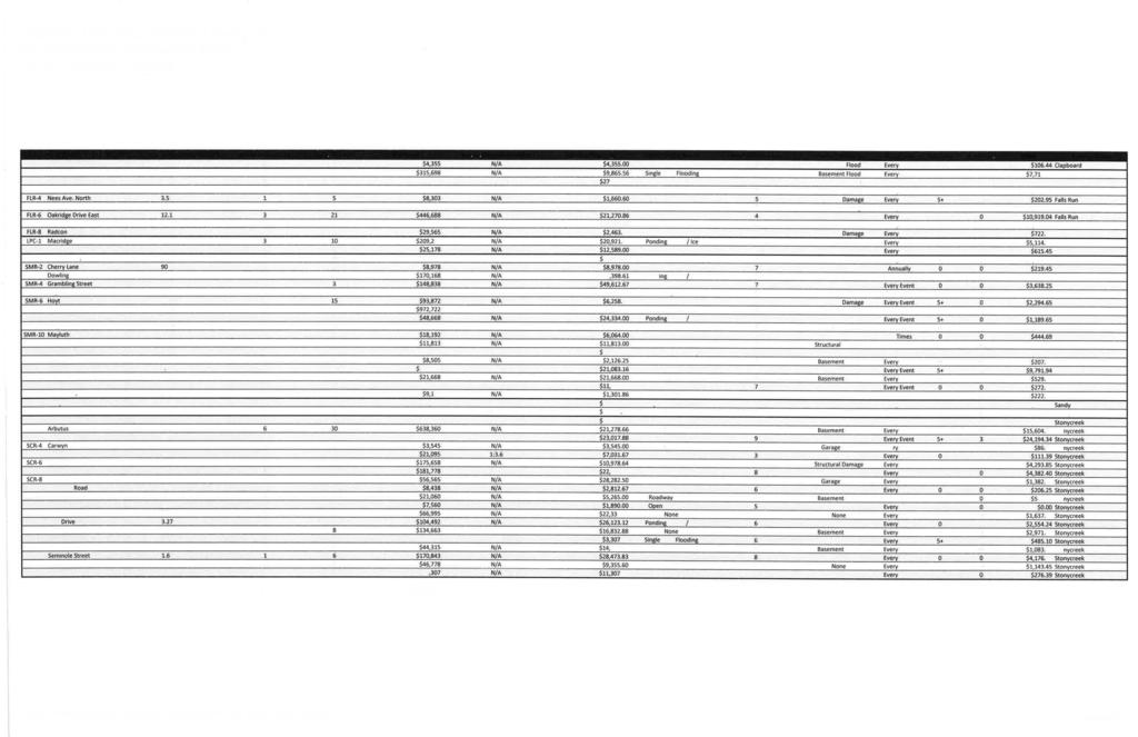
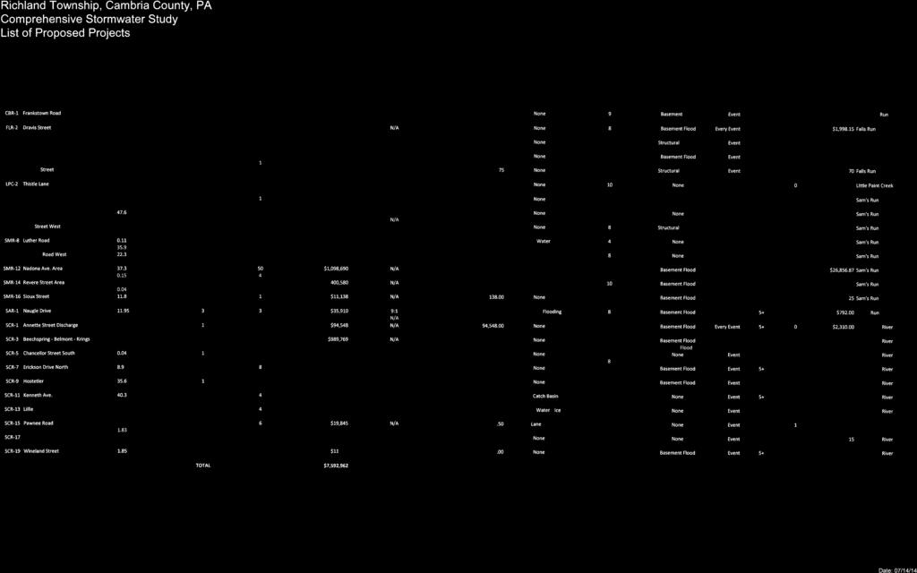

34
Frequently Asked Questions for: Drainage, Watershed and Water Quality Property Owners Near Creeks Developers and Engineers and Definitions of Terms
 FREQUENTLY ASKED QUESTIONS Draft DEFINITIONS OF TERMS Last Revised July 2, 2008 Introduction: The following questions have been organized in the categories below. We have attempted to group the questions
610 LAND DIVISIONS AND PROPERTY LINE ADJUSTMENTS OUTSIDE A UGB
 ARTICLE VI: LAND DIVISIONS AND PROPERTY LINE ADJUSTMENTS VI-21 610 LAND DIVISIONS AND PROPERTY LINE ADJUSTMENTS OUTSIDE A UGB 610-1 Property Line Adjustments (Property Line Relocation) A property line
Drainage Maintenance Policy
 Drainage Maintenance Policy The purpose of this Drainage Maintenance Policy is to clarify how the City of McKinney may address various drainage and stormwater related concerns of residents. BACKGROUND
Drainage Study. Report Description. Prepared for: City of Minnetonka Beach. Prepared by: Phillip Elkin, P.E. Darren Amundsen, P.E.
 Drainage Study Report Description Prepared for: City of Minnetonka Beach Prepared by: Phillip Elkin, P.E. Darren Amundsen, P.E. November 12, 2013 DRAINAGE STUDY Table of Contents 1.0 STUDY GOALS... 1.1
VILLAGE OF ASHVILLE DEPARTMENT OF PUBLIC UTILITIES DIVISION OF STORMWATER MANAGEMENT STORMWATER MANAGEMENT PROGRAM STORMWATER CREDIT MANUAL
 VILLAGE OF ASHVILLE DEPARTMENT OF PUBLIC UTILITIES DIVISION OF STORMWATER MANAGEMENT STORMWATER MANAGEMENT PROGRAM STORMWATER CREDIT MANUAL SECTION I. OVERVIEW AND GENERAL INSTRUCTIONS INTRODUCTION A stormwater
Chapter 5. Floodplain Management. 5.0 Introduction. 5.1 Floodplain Management and Regulation
 5.0 Introduction This chapter summarizes the Town s rules and regulations regarding floodplain management and development. The requirements presented in this chapter should be used by the design engineer
Chapter 5. Floodplain Management. 5.0 Introduction. 5.1 Douglas County Comprehensive Master Plan. 5.2 Floodplain Management and Regulation
 5.0 Introduction This chapter summarizes the County s rules and regulations regarding floodplain management and development. The requirements presented in this chapter should be used by the design engineer
SECTION 10: FLOOD HAZARD EVALUATION 10-1
 10) SECTION 10: FLOOD HAZARD EVALUATION A. General. Land subject to being flooded by a Flood of 100-Year Frequency as defined by Title 76, Chapter 5, MCA, or land subject to flooding pursuant to these
Comprehensive Plan /24/01
 IV The is a central component of the Comprehensive Plan. It is an extension of the general goals and policies of the community, as well as a reflection of previous development decisions and the physical
City Of Attleboro Conservation Commission
 City Of Attleboro Conservation Commission GOVERNMENT CENTER, 77 PARK STREET ATTLEBORO, MASSACHUSETTS 02703 (508) 223 2222 FAX 222 3046 GENERAL INSTRUCTIONS AND CHECKLIST FOR COMPLETING STORMWATER MANAGEMENT
CHAPTER 3 PRELIMINARY PLAT
 10-3-1 10-3-3 SECTION: CHAPTER 3 PRELIMINARY PLAT 10-3-1: Consultation 10-3-2: Filing 10-3-3: Requirements 10-3-4: Approval 10-3-5: Time Limitation 10-3-6: Grading Limitation 10-3-1: CONSULTATION: Each
CITY OF FORT COLLINS NATURAL AREAS AND CONSERVED LANDS EASEMENT POLICY
 CITY OF FORT COLLINS NATURAL AREAS AND CONSERVED LANDS EASEMENT POLICY Adopted January 3, 2012 PURPOSE: The purpose of the policy statement is to clarify the policies and procedures of the City of Fort
FRESHWATER WETLANDS PROTECTION IN NEW JERSEY Tools for Municipal Action
 FRESHWATER WETLANDS PROTECTION IN NEW JERSEY Tools for Municipal Action The Freshwater Wetlands Protection Act INTENT OF FRESHWATER WETLANDS LAW The New Jersey legislature passed the Freshwater Wetlands
Request to Advertise: Chesapeake Bay Preservation Area (CBPA) Map Update. June 20, 2017
 Map Update. June 20, 2017") Request to Advertise: Chesapeake Bay Preservation Area (CBPA) Map Update June 20, 2017 Outline Context Past County Board actions Why update the CBPA Map? What and Why - Resource Protection Areas Property
Request to Advertise: Chesapeake Bay Preservation Area (CBPA) Map Update June 20, 2017 Outline Context Past County Board actions Why update the CBPA Map? What and Why - Resource Protection Areas Property
Open Space Model Ordinance
 Open Space Model Ordinance Section I. Background Open space development has numerous environmental and community benefits, including: 1) Reduces the impervious cover in a development. Impervious cover
CHECKLIST FOR DEVELOPMENT REVIEW
 CHECKLIST FOR DEVELOPMENT REVIEW Petitions and related documents and plans for land development or other proposals regulated by Title 16 of the Municipal Code (Development Ordinance) and Title 17 of the
SUBCHAPTER 02C - SECONDARY ROADS SECTION SECTION SECONDARY ROADS
 SUBCHAPTER 02C - SECONDARY ROADS SECTION SECTION.0100 - SECONDARY ROADS Note: The Department of Transportation publishes a volume entitled "Minimum Design and Construction Criteria for Subdivision Streets"
STORMWATER MANAGEMENT SYSTEM AND FACILITIES
 152.01 Purpose 152.09 Nonresidential Unit 152.02 Findings 152.10 Rate Determinations; Compliance with Bond 152.03 Scope and Responsibility for Stormwater Utility Covenants 152.04 Definitions 152.11 Billing,
COMMUNITY DEVELOPMENT DEPARTMENT 333 Broadalbin Street SW, P.O. Box 490 Albany, OR 97321
 COMMUNITY DEVELOPMENT DEPARTMENT 333 Broadalbin Street SW, P.O. Box 490 Albany, OR 97321 STAFF REPORT Application for Site Plan Review (SP-02-18) Residential Accessory Building Ph: 541-917-7550 Fax: 541-917-7598
FINAL SUBDIVISION AND LAND DEVELOPMENT PLAN CHECKLIST. Plan Name. Applicant's Name:
 TOWNSHIP OF UPPER ST. CLAIR FINAL SUBDIVISION AND LAND DEVELOPMENT PLAN CHECKLIST Date Filed Plan Name PLC Applicant's Name: Phone Filing Date for Final Application Final Plat 114.22. FINAL APPLICATION
2014 Plan of Conservation and Development
 The Town of Hebron Section 1 2014 Plan of Conservation and Development Community Profile Introduction (Final: 8/29/13) The Community Profile section of the Plan of Conservation and Development is intended
Chesapeake Bay Preservation Area (CBPA) Map Update. Presentation to the County Board July 15, 2017
 Map Update. Presentation to the County Board July 15, 2017") Chesapeake Bay Preservation Area (CBPA) Map Update Presentation to the County Board July 15, 2017 Chesapeake Bay Program Comprehensive Plan Chesapeake Bay Preservation Ordinance (1992) (Chapter 61, Arlington
Chesapeake Bay Preservation Area (CBPA) Map Update Presentation to the County Board July 15, 2017 Chesapeake Bay Program Comprehensive Plan Chesapeake Bay Preservation Ordinance (1992) (Chapter 61, Arlington
ORDINANCE CITY OF DUNDAS RICE COUNTY STATE OF MINNESOTA
 ORDINANCE 2014 01 CITY OF DUNDAS RICE COUNTY STATE OF MINNESOTA An Ordinance Amending Dundas City Code Title 5, Public Works, to Add Chapter 504 Storm Water Utility RECITALS There is hereby established
SITE PLAN REVIEW PROCEDURES SECTION DEVELOPMENTS REQUIRING SITE PLAN APPROVAL
 SECTION 22.01 PURPOSE ARTICLE XXII PROCEDURES The purpose of this Article is to establish uniform requirements of procedure for all developments in the Township. Certain specific types of minor development
Appendix J: Stormwater Utility Ordinance Guidance
 Appendix J: Stormwater Utility Ordinance Guidance 1. City of Marquette (MI) Stormwater Utility Ordinance 2. Guidance on Establishing Stormwater Utility Fees 169 City of Marquette (MI) Stormwater Utility
City of Grande Prairie Development Services Department
 City of Grande Prairie Development Services Department COUNTRYSIDE SOUTH OUTLINE PLAN Prepared by: GPEC Consulting Ltd. #202, 10712-100th Street Grande Prairie, AB Council Resolution of August 20, 2001
Conceptual Scheme SE W4
 December 2012 1. PURPOSE 1.1. The purpose of a Conceptual Scheme (CS) is as follows: a) To provide a framework for the subsequent subdivision and/or development of land within the Country Residential Policy
ARTICLE 7 UTILITIES AND EASEMENTS
 7.1 PLACEMENT OF UTILITIES ARTICLE 7 UTILITIES AND EASEMENTS 7.1.1 All authorized public underground utilities shall be located within the right-of-way of a public street or within an easement designated
COMMONWEALTH OF PENNSYLVANIA DEPARTMENT OF ENVIRONMENTAL PROTECTION BUREAU OF CLEAN WATER
 3800-FM-BCW0229b 7/2017 COMMONWEALTH OF PENNSYLVANIA DEPARTMENT OF ENVIRONMENTAL PROTECTION BUREAU OF CLEAN WATER OFFICIAL USE ONLY PA NOTICE OF TERMINATION FOR A GENERAL (PAG-02) OR INDIVIDUAL NPDES PERMIT,
CHAPTER 13 WINCHESTER WETLANDS BYLAW
 CHAPTER 13 WINCHESTER WETLANDS BYLAW Section 1. PURPOSE The purpose of this by-law is to protect the wetlands, related water resources, and adjoining land areas in the town by prior review and control
COMMERCIAL SITE PLAN & CONDITIONAL USE PERMIT REVIEW PROCESS & CHECKLIST
 Community Development 110 South Main Street Springville, UT 84663 COMMERCIAL SITE PLAN & CONDITIONAL USE PERMIT REVIEW PROCESS & CHECKLIST 801.491.7861 www.springville.org Prior to the issuance of a building
Dedicated program for municipal drainage management
 Dedicated program for municipal drainage management Street drainage evaluation and repairs Maintenance of pipes and drainage structures Mowing, debris and vegetation removal Erosion control and re-grading
SIMPLIFIED APPROACH PERMIT PROCEDURES
 SIMPLIFIED APPROACH PERMIT PROCEDURES UPPER ALLEN TOWNSHIP Community Development Department 100 Gettysburg Pike, Mechanicsburg, PA 17055 Phone: 717-766-0756 Fax: 717-796-983 Office Hours: M-F 8:00 AM 4:30
DRAINAGE CLASSIFICATION & RECLASSIFICATION
 DRAINAGE CLASSIFICATION & RECLASSIFICATION December 9, 2016 ARCHITECTURE + ENGINEERING + ENVIRONMENTAL + PLANNING PRESENTATION OUTLINE What is Classification & Reclassification? When and Why Reclassification?
PROJECT SCOPE OF WORK CITY OF TOWN AND COUNTRY STORMWATER PROGRAM
 PROJECT SCOPE OF WORK CITY OF TOWN AND COUNTRY STORMWATER PROGRAM Project ID Number: 2-2 Problem: The backyards at 962, 97, and 978 Delvin Drive are located in a low area of shallow ponding that takes
MAJOR SUBDIVISION PRELIMINARY PLAT CHECKLIST
 TOWNSHIP OF EGG HARBOR PLANNING BOARD/ZONING BOARD OF ADJUSTMENT 3515 BARGAINTOWN ROAD EGG HARBOR TOWNSHIP, NJ 08234 MAJOR SUBDIVISION PRELIMINARY PLAT CHECKLIST The following checklist is designed to
8Land Use. The Land Use Plan consists of the following elements:
 8Land Use 1. Introduction The Land Use Plan consists of the following elements: 1. Introduction 2. Existing Conditions 3. Opportunities for Redevelopment 4. Land Use Projections 5. Future Land Use Policies
Larimer County Planning Dept. Procedural Guide for 1041 PERMITS
 - Larimer County Planning Dept. Procedural Guide for 1041 PERMITS PLEASE NOTE: A PRE-APPLICATION CONFERENCE IS REQUIRED PRIOR TO SUBMITTING THIS APPLICATION. PURPOSE: State Statutes allow local governments
YCCD EROSION & SEDIMENT POLLUTION CONTROL (E&SPC) PROGRAM SERVICES FEE SCHEDULE, RULES, & GUIDELINES
 PROGRAM SERVICES FEE SCHEDULE, RULES, & GUIDELINES") YCCD EROSION & SEDIMENT POLLUTION CONTROL (E&SPC) PROGRAM SERVICES FEE SCHEDULE, RULES, & GUIDELINES Adopted by the YCCD Board of Directors on December 14, 2018 Effective January 1, 2019. I. Authority
YCCD EROSION & SEDIMENT POLLUTION CONTROL (E&SPC) PROGRAM SERVICES FEE SCHEDULE, RULES, & GUIDELINES Adopted by the YCCD Board of Directors on December 14, 2018 Effective January 1, 2019. I. Authority
VI. SAFETY ELEMENT I. INTRODUCTION A. PURPOSE B. AUTHORITY. 1. Safety
 AB 162 and SB 1241 Amendment to the Safety Element New sections are underlined, deleted sections are shown as strikethrough and the denotes text remaining in place. VI. SAFETY ELEMENT I. INTRODUCTION A.
Attached is a Clinton Township Zoning Permit Application and requirements for issuance of a permit.
 To Whom It May Concern: Attached is a Clinton Township Zoning Permit Application and requirements for issuance of a permit. The fee for the permit application is $75.00, which shall be made payable to
Grand Rapids, MN Stormwater Utility Best Management Practices Credit Policy (As per Section (b) of Ordinance No )
 of Ordinance No )") Grand Rapids, MN Stormwater Utility Best Management Practices Credit Policy (As per Section 70-203(b) of Ordinance No. 17-05-03) Background On May 8, 2017, the Grand Rapids City Council approved a Stormwater
Grand Rapids, MN Stormwater Utility Best Management Practices Credit Policy (As per Section 70-203(b) of Ordinance No. 17-05-03) Background On May 8, 2017, the Grand Rapids City Council approved a Stormwater
APPLICATION SUBMITTAL REQUIREMENTS FOR Tentative Parcel or Subdivision Maps
 CITY OF EL CERRITO Community Development Department Planning and Building Division 10890 San Pablo Avenue, El Cerrito, CA 94530 (510) 215-4330 FA (510) 233-5401 planning@ci.el-cerrito.ca.us APPLICATION
ESTES VALLEY STORMWATER MANAGEMENT PROGRAM
 ESTES VALLEY STORMWATER MANAGEMENT PROGRAM Phase I. Stormwater Master Plan Phase II. Stormwater Utility Feasibility Study Board of Realtors Meeting May 3, 2018 Stormwater Master Plan Summary Stormwater
PLANNING SERVICES FORM 3.3 SUBDIVISION APPLICATION COMMERCIAL OR BUSINESS PURPOSES
 FOR OFFICE USE ONLY Date of Receipt File Number Fee Submitted SUBDIVISION APPLICATION COMMERCIAL OR BUSINESS PURPOSES Accepted by Please note that the information provided in these forms is crucial to
Clarksville, TN APPENDIX C STORM WATER AND BMP MAINTENANCE AGREEMENTS AND INSPECTIONS FORMS
 Clarksville, TN APPENDIX C STORM WATER AND BMP MAINTENANCE AGREEMENTS AND INSPECTIONS FORMS STORM WATER MAINTENANCE AGREEMENT Grading Permit No.: Tax Map and Parcel No.: Project Name: THIS AGREEMENT, made
Hiawatha Drain Informational Open House
 May 10, 2017 Open House Times: 12:00 3:00 p.m. 6:00 8:00 p.m. Hiawatha Drain Informational Open House Ottawa County Water Resources Commissioner Why are we here? The last public meeting was in 2010. Property
Standard Operating Procedure: Implementation of the Inspection and Maintenance Program Under the Long Creek Watershed Management Plan
 Standard Operating Procedure: Implementation of the Inspection and Maintenance Program Under the Long Creek Watershed Management Plan 1. PURPOSE: The Long Creek Watershed Management District ( LCWMD )
Current Situation and Issues
 Handout 13: Impervious and Gross Area Charges The purpose of this handout is to frame the issues around the gross and impervious parcel area based charges. Current Situation and Issues Current Structure
Residential Minor Subdivision Review Checklist
 Residential Minor Subdivision Review Checklist Plan Submittal Requirements: 2 full sets of stamped plans Electric submittal - all plans contained in a single PDF 3 full sets if commercial kitchen or dining
SPANISH FORT PLANNING COMMISSION PRELIMINARY SUBDIVISION PLAT APPLICATION. Number of Lots (Units) Address. Address.
 Address. Address.") Case No. SPANISH FORT PLANNING COMMISSION PRELIMINARY SUBDIVISION PLAT APPLICATION Name of Subdivision Tax Parcel Number(s) Subdivision Location Total Acreage Number of Lots (Units) Average Lot Size Current
Case No. SPANISH FORT PLANNING COMMISSION PRELIMINARY SUBDIVISION PLAT APPLICATION Name of Subdivision Tax Parcel Number(s) Subdivision Location Total Acreage Number of Lots (Units) Average Lot Size Current
PRELIMINARY PLAT Application Packet
 PRELIMINARY PLAT Application Packet Community Development Department 1020 East Pioneer Road, Draper, UT 84020 (801) 576-6539 Fax (801) 576-6526 Dear Applicant, This application packet has been developed
CITY OF EAU CLAIRE, WISCONSIN. SPECIAL ASSESSMENT POLICY (Dated: November 8, 2016)
") CITY OF EAU CLAIRE, WISCONSIN SPECIAL ASSESSMENT POLICY (Dated: November 8, 2016) (Adopted by reference by Ordinance No. 7207 adopted November 8, 2016) PURPOSE The purpose of this Policy is to assure fair
CITY OF EAU CLAIRE, WISCONSIN SPECIAL ASSESSMENT POLICY (Dated: November 8, 2016) (Adopted by reference by Ordinance No. 7207 adopted November 8, 2016) PURPOSE The purpose of this Policy is to assure fair
Resource Protection Area Map Update - Frequently Asked Questions
 DEPARTMENT OF ENVIRONMENTAL SERVICES Office of Sustainability and Environmental Management 2100 Clarendon Boulevard, Suite 705, Arlington, VA 22201 TEL 703-228-4488 FAX 703-228-7134 TTY 703-228-4611 www.arlingtonva.us
Land Use. Land Use Categories. Chart 5.1. Nepeuskun Existing Land Use Inventory. Overview
 Land Use State Comprehensive Planning Requirements for this Chapter A compilation of objectives, policies, goals, maps and programs to guide the future development and redevelopment of public and private
Planning Commission Land Disturbance Permit Application
 Planning Commission Land Disturbance Permit Application Refer to Meeting and Submittal Dates Calendar for Application Deadlines of Subdivision/Site Plan: Zoned: Location: Owner of Record: Owner Address:
The Drainage Control Regulations
 1 The Drainage Control Regulations Repealed by Saskatchewan Regulations 89/2015 (effective October 16, 2015) Formerly Chapter D-33.1 Reg 1 (effective August 18, 1981) as amended by Saskatchewan Regulations
Residential Major Subdivision Review Checklist
 Residential Major Subdivision Review Checklist Plan Submittal Requirements: 2 full sets of stamped plans Electric submittal - all plans contained in a single PDF 3 full sets if commercial kitchen or dining
METROPOLITAN COUNCIL 390 North Robert Street, St. Paul, MN Phone (651) TDD (651)
 TDD (651)") METROPOLITAN COUNCIL 390 North Robert Street, St. Paul, MN 55101 Phone (651) 602-1000 TDD (651) 291-0904 DATE: November 23, 2009 TO: Metropolitan Parks and Open Space Commission FROM: Jan Youngquist, Senior
METROPOLITAN COUNCIL 390 North Robert Street, St. Paul, MN 55101 Phone (651) 602-1000 TDD (651) 291-0904 DATE: November 23, 2009 TO: Metropolitan Parks and Open Space Commission FROM: Jan Youngquist, Senior
Village of Glenview Zoning Board of Appeals
 Village of Glenview Zoning Board of Appeals STAFF REPORT January 16, 2017 TO: Chairman and Zoning Board of Appeals Commissioners FROM: Community Development Department CASE #: Z2017-001 LOCATION: PROJECT
CHAPTER 15 SOIL DRAINAGE MANAGEMENT PLAN DESIGN STATE HEALTH DEPARTMENT SEWAGE HANDLING AND DISPOSAL REGULATIONS. Article 5
 CHAPTER 15 SOIL DRAINAGE MANAGEMENT PLAN DESIGN STATE HEALTH DEPARTMENT SEWAGE HANDLING AND DISPOSAL REGULATIONS Article 5 Installation of Residential Sewage Disposal Systems in Political Subdivisions
STORMWATER MANAGEMENT AGREEMENT AND DECLARATION OF EASEMENT
 APPENDIX F STORMWATER MANAGEMENT AGREEMENT AND DECLARATION OF EASEMENT THIS AGREEMENT AND DECLARATION OF EASEMENT made this day of 20, by and between BRECKNOCK TOWNSHIP, Lancaster County, Pennsylvania,
ARTICLE 5 MINOR SUBDIVISION/LAND DEVELOPMENT
 ARTICLE 5 MINOR SUBDIVISION/LAND DEVELOPMENT SECTION 501 ONLY FINAL PLAN REQUIRED The classification of a proposed subdivision as a "Minor Subdivision" shall only require the submission, review and approval
CHAPTER 15 SOIL DRAINAGE MANAGEMENT PLAN DESIGN STATE HEALTH DEPARTMENT SEWAGE HANDLING AND DISPOSAL REGULATIONS. Article 5
 CHAPTER 15 SOIL DRAINAGE MANAGEMENT PLAN DESIGN STATE HEALTH DEPARTMENT SEWAGE HANDLING AND DISPOSAL REGULATIONS Article 5 Installation of Residential Sewage Disposal Systems in Political Subdivisions
Housing Characteristics
 CHAPTER 7 HOUSING The housing component of the comprehensive plan is intended to provide an analysis of housing conditions and need. This component contains a discussion of McCall s 1990 housing inventory
ARTICLE 6 PRELIMINARY PLAT
 ARTICLE 6 PRELIMINARY PLAT SECTION: 30-06-01: Preliminary Plat 30-06-02: Information Required for Preliminary Plat 30-06-03: Determination of Requirement for Environmental Review Documents 30-06-04: Additional
Article 2 Application Type and Standards Requirements
 Article 1 Article 2 Division 1 Application Type and Standards Requirements General Provisions Sec. 2.1.1 Division 2 Division 3 Division 4 Division 5 Division 6 Division 7 Division 8 Division 9 Sec. 2.9.1
FREQUENTLY USED PLANNING & ZONING TERMS
 City Of Mustang FREQUENTLY USED PLANNING & ZONING TERMS Abut: Having property lines, street lines, or zoning district lines in common. Accessory Structure: A structure of secondary importance or function
STANDARD REQUIREMENTS FOR ESTABLISHING A PRIVATE DRAIN AS A COUNTY DRAIN IN OAKLAND COUNTY COMMUNITIES
 STANDARD REQUIREMENTS FOR ESTABLISHING A PRIVATE DRAIN AS A COUNTY DRAIN IN OAKLAND COUNTY COMMUNITIES PURPOSE: The purpose of this standard is to guide the Owner/Developers of new developments within
Town of Middleborough Conservation Commission 2014 Policy
 Approved February 20, 2014 Town of Middleborough Conservation Commission 2014 Policy The Wetland Protection Act under M.G.L. c. 131, sec. 40 and regulations 310 CMR 10.02(1)(a-f) & 310 CMR 10.02 (2)(a)
Special Use Permit - Planned Unit Development Checklist. Property Address:
 Special Use Permit - Planned Unit Development Checklist Special Use Permit Number. Parcel Code/s #28-11- - - Property Address: Applicant: ARTICLE VIII Ordinance Reference - Section 8.1.2 Permit Procedures:
New Private Way Ordinance Westbrook Planning Board Workshop , Planning Board Public Hearing Definitions
 201 Definitions Private Right of Way; Private way A strip of land at least fifty feet wide, meeting the minimum standards for the construction of a gravel base for a public road, over which abutters may
PRELIMINARY SUBDIVISION AND LAND DEVELOPMENT PLAN CHECKLIST. Applicant's Name:
 TOWNSHIP OF UPPER ST. CLAIR PRELIMINARY SUBDIVISION AND LAND DEVELOPMENT PLAN CHECKLIST Date Filed Plan Name: Applicant's Name: PLC# Phone = OK 0 = Missing; X = Not OK; NA = Not Applicable;? To be Determined;
MINOR BOUNDARY LINE ADJUSTMENT PROCESS GUIDE
 MINOR BOUNDARY LINE ADJUSTMENT PROCESS GUIDE Clear Creek County Planning Department P.O. Box 2000 Georgetown, Colorado 80444 (303) 679-2436 phone (303) 569-1103 fax 1 PURPOSE To establish criteria and
COMMUNITY DEVELOPMENT. Staff Report. Site Plan Review. SP June 19, 2018
 COMMUNITY DEVELOPMENT 333 Broadalbin Street SW, PO Box 490, Albany, Oregon 97321-0144 BUILDING 541-917-7553 PLANNING 541-917-7550 Staff Report Site Plan Review SP-18-18 June 19, 2018 Summary On May 1,
CONDITIONAL USE PERMIT Application Packet
 CONDITIONAL USE PERMIT Application Packet Community Development Department 1020 East Pioneer Road, Draper, UT 84020 (801) 576-6539 Fax (801) 576-6526 Dear Applicant, This application packet has been developed
PRELIMINARY PLAT CHECK LIST
 PRELIMINARY PLAT CHECK LIST Name of Proposed Subdivision: The following items must be included with the initial submittal of a Preliminary Plat: Application, filled out completely Project Narrative Pre-application
Regulatory Requirement: This form serves to fulfill the obligations referenced in 25 Pa. Code (related to Permit Termination).
.") COMMONWEALTH OF PENNSYLVANIA DEPARTMENT OF ENVIRONMENTAL PROTECTION BUREAU OF WATERWAYS ENGINEERING AND WETLANDS OFFICIAL USE ONLY PA NOTICE OF TERMINATION FOR A GENERAL OR INDIVIDUAL NATIONAL POLLUTANT
COMMONWEALTH OF PENNSYLVANIA DEPARTMENT OF ENVIRONMENTAL PROTECTION BUREAU OF WATERWAYS ENGINEERING AND WETLANDS OFFICIAL USE ONLY PA NOTICE OF TERMINATION FOR A GENERAL OR INDIVIDUAL NATIONAL POLLUTANT
Appendix A Orleans County Local Law Assessment
 Appendix A Orleans County Local Law Assessment Appendix A 0 Albion, Town Does the municipality have: Comprehensive/ Master Local Law Assessment es o Reference: Comments: Town of Albion, Village of Albion,
Preliminary Subdivision Application (Minor) (Three (3) lots or less)
 (Three (3) lots or less)") Gunnison City Offices www.gunnisoncity.org 38 West Center Gunnison, Utah 84634 (435) 528 7969 Date of Application: Preliminary Subdivision Application (Minor) (Three (3) lots or less) APPLICANT INFORMATION
Gunnison City Offices www.gunnisoncity.org 38 West Center Gunnison, Utah 84634 (435) 528 7969 Date of Application: Preliminary Subdivision Application (Minor) (Three (3) lots or less) APPLICANT INFORMATION
9. REZONING NO Vicinity of the northwest corner of 143 rd Street and Metcalf Avenue
 9. REZONING NO. 2002-15 Vicinity of the northwest corner of 143 rd Street and Metcalf Avenue 1. APPLICANT: Andrew Schlagel is the applicant for this request. 2. REQUESTED ACTION: The applicant is requesting
RESPONSIBILITY AND PROCEDURE FOR IMPROVEMENT AND MAINTENANCE OF DRAINS, DITCHES AND WATERCOURSES
 RESPONSIBILITY AND PROCEDURE FOR IMPROVEMENT AND MAINTENANCE OF DRAINS, DITCHES AND WATERCOURSES FORWARD The Offices of the County Engineer and County Commissioners of Greene County are inundated yearly
ORDINANCE NO WHEREAS, the County Council desires to amend the current Code of
 1 1 1 1 1 1 0 1 0 1 ORDINANCE NO. 00- AN ORDINANCE OF THE COUNTY COUNCIL OF VOLUSIA COUNTY, FLORIDA, AMENDING THE CODE OF ORDINANCES OF THE COUNTY OF VOLUSIA, CHAPTER, TITLED UTILITIES, ARTICLE IV, STORMWATER
STORMWATER MANAGEMENT ORDINANCE
 STORMWATER MANAGEMENT ORDINANCE AN AMENDED ORDINANCE REGULATING THE RATE AND VELOCITY OF STORMWATER DISCHARGE FROM PROPOSED DEVELOPMENTS WITHIN THE CITY OF MADISON AND REQUIREMENTS FOR STORMWATER RETENTION
Planning Commission Preliminary Plan LRC Subdivision Montville Township
 Planning Commission Preliminary Plan LRC Subdivision Montville Township Meeting: February 1, 2017 App. No.: 002-2017-PP Owner: Faith & Hope Land Dev. Co. Applicant: Montville Investors LLC Engineer: Weber
SECTION 4: PRELIMINARY PLAT
 SECTION 4: PRELIMINARY PLAT After the completion of the sketch plan process, if submitted, the owner or developer shall file with the City an application for preliminary plat. The preliminary plat stage
SUBCHAPTER 02C - SECONDARY ROADS SECTION SECTION SECONDARY ROADS
 SUBCHAPTER 02C - SECONDARY ROADS SECTION SECTION.0100 - SECONDARY ROADS Note: The Department of Transportation publishes a volume entitled "Minimum Design and Construction Criteria for Subdivision Streets"
Stormwater Utility Credit and Adjustment Manual
 City of Raleigh, North Carolina Stormwater Utility Credit and Adjustment Manual February 2004 Revised October 2008 Manual Contents Table of Contents City of Raleigh-Stormwater Utility Fee Credit and Adjustment
Regulatory Requirement: This form serves to fulfill the obligations referenced in 25 PA Code (related to Permit Termination).
.") COMMONWEALTH OF PENNSYLVANIA DEPARTMENT OF ENVIRONMENTAL PROTECTION BUREAU OF WATERWAYS ENGINEERING AND WETLANDS OFFICIAL USE ONLY PA NOTICE OF TERMINATION FOR A GENERAL OR INDIVIDUAL NATIONAL POLLUTANT
COMMONWEALTH OF PENNSYLVANIA DEPARTMENT OF ENVIRONMENTAL PROTECTION BUREAU OF WATERWAYS ENGINEERING AND WETLANDS OFFICIAL USE ONLY PA NOTICE OF TERMINATION FOR A GENERAL OR INDIVIDUAL NATIONAL POLLUTANT
BY BOARD OF COUNTY COMMISSIONERS AN ACT TO BE ENTITLED
 BY BOARD OF COUNTY COMMISSIONERS ORDINANCE NO. AN ACT TO BE ENTITLED AN ORDINANCE AMENDING THE PASCO COUNTY LAND DEVELOPMENT CODE, ARTICLE 700, BY REPEALING EXISTING SECTION 702, ENVIRONMENTALLY SENSITIVE
Article III. Erosion and Sedimentation Control
 Article III. Erosion and Sedimentation Control Section 9.6 Erosion and Sedimentation Control Plan Requirements Section 9.6.1 Plan Submission A plan shall be prepared for all land-disturbing activities
ARTICLE FIVE FINAL DRAFT
 ARTICLE FIVE 021218 FINAL DRAFT Sec. 503.6 Open Space Preservation Option Open Space Preservation Option Open Space Preservation developments may be approved in the AR, R-1, R-2 and R-3 zoning districts,
The Ranches Sketch Plan
 The Ranches Sketch Plan APPLICATION: RURAL LAND USE PROCESS (AKA CLUSTER DEVELOPMENT) HEARING DATES: Planning Commission: 12 July 2017 at 6:30 pm Board of County Commissioners: TBD APPLICANT: REQUEST:
WASCO COUNTY PRELIMINARY SUBDIVISION APPLICATION
 WASCO COUNTY PRELIMINARY SUBDIVISION APPLICATION DETAILED SPECIFIC WRITTEN REQUEST File Number: SDV- Number of Proposed Lots & their Dimensions: PRELIMINARY SUBDIVISION PLAN REQUIREMENTS The approval of
Purpose of the Public Hearing
 Purpose of the Public Hearing To provide you with Information on the proposed sidewalk project(s) Opportunities to review plans and exhibits The ability to ask questions and get answers about each project
Conservation Design Subdivisions
 Conservation Design Subdivisions An excerpt from the Rules and Regulations Governing Division of Land in Sheridan County, Wyoming, November 5, 2010 Sheridan County Public Works Department 224 S. Main Street
Town of Lisbon, Maine SUBDIVISION REVIEW APPLICATION
 Date Received: Fee Paid (amount): Applicant: Town of Lisbon, Maine SUBDIVISION REVIEW APPLICATION Subdivision Name/Title: This application must be received at the Town Office by close of business on the
ORDINANCE NO
 26.Sept.2013 ORDINANCE NO. 2013-15 AN ORDINANCE OF THE TOWNSHIP RADNOR, DELAWARE COUNTY, PENNSYLVANIA, ESTABLISHING A USER FEE FOR STORMWATER COLLECTION AND MANAGEMENT WHEREAS, Radnor Township ("Radnor")
Community Development Committee
 C Date Prepared: Subject: Community Development Committee For the Metropolitan Council meeting of December 9, 2009 December 8, 2009 Committee Report SW Item: 2009-444 ADVISORY INFORMATION Rice Creek Chain
ARTICLE 24 PRIVATE ROAD, SHARED PRIVATE DRIVEWAY AND ACCESS EASEMENT STANDARDS
 ARTICLE 24 PRIVATE ROAD, SHARED PRIVATE DRIVEWAY AND ACCESS EASEMENT STANDARDS SECTION 24.00 INTENT AND PURPOSE The standards of this Article provide for the design, construction and maintenance of private