REGULAR MEETING OF THE ARAPAHOE COUNTY PLANNING COMMISSION TUESDAY, APRIL 19, 6:30 P.M.
|
|
|
- Janel Blair
- 5 years ago
- Views:
Transcription
1 Public Works and Development Lima Plaza Campus Arapahoe Room 6954 S. Lima St., Centennial, CO REGULAR MEETING OF THE ARAPAHOE COUNTY PLANNING COMMISSION TUESDAY, APRIL 19, 6:30 P.M. GENERAL BUSINESS ITEMS APPROVAL OF THE MINUTES FROM FEBRUARY 16, 2016 (Click here to view the draft minutes) VOTE: APPROVAL OF THE MINUTES FROM MARCH 8, 2016 (Click here to view the draft minutes) VOTE: APPROVAL OF THE MINUTES FROM MARCH 15, 2016 (Click here to view the draft minutes) VOTE: REGULAR ITEMS ITEM 1: (Click here to view packet) CASE NO. P / WELCH SUBDIVISION #04 [LANSER] / MINOR SUBDIVISION (MS) LOCATION: 9445 E. Evans Way VOTE: ACREAGE: 0.73 acres IN FAVOR EXISTING ZONING: R-2 OPPOSED PROPOSED USE: Splitting lot 3 into two lots. ABSENT APPLICANT: Jamee Chambers, Chambers Consulting, Inc. ABSTAIN CASE MANAGERS: Planner, Bill Skinner; Engineer, Sarah L. White REQUEST: Requesting a positive referral for a Minor Subdivision. CONTINUED TO: MOTION SUMMARY: Date: ITEM 2: (Click here to view packet) CASE NO. Z / WELCH SUBDIVISION #04 [LANSER] / PRELIMINARY DEVELOPMENT PLAN (PDP) LOCATION: 9445 E. Evans Way VOTE: ACREAGE: 0.73 acres IN FAVOR EXISTING ZONING: R-2 OPPOSED PROPOSED USE: Rezone to R-PSF ABSENT APPLICANT: Jamee Chambers, Chambers Consulting, Inc. ABSTAIN CASE MANAGERS: Planner, Bill Skinner; Engineer, Sarah L. White REQUEST: Requesting a positive referral for a Preliminary Development Plan. CONTINUED TO: MOTION SUMMARY: Date: ITEM 3: (Click here to view packet) CASE NO. Z16-002, WATKINS FARM / CONVENTIONAL REZONE LOCATION: East of Eclipse St and E Colfax Service Rd (Near I-70 & Watkins VOTE: Rd.) ACREAGE: IN FAVOR EXISTING ZONING: R-A With 5 Acre Lot Minimums OPPOSED PROPOSED ZONING: R-A With 2.41 Acre Lot Minimums ABSENT APPLICANT: Arapahoe County ABSTAIN CASE MANAGERS: Planner, Jason Reynolds; Engineer, Sue Liu REQUEST: Requesting a positive referral for a conventional rezone. CONTINUED TO: MOTION SUMMARY: Date: ITEM 4: (Click here to view packet) CASE NO. W15-003, SEASONAL FARM AND RANCH EVENTS / LAND DEVELOPMENT CODE AMENDMENT LOCATION: Unincorporated Arapahoe County VOTE: ACREAGE: N/A IN FAVOR EXISTING ZONING: N/A OPPOSED PROPOSED USE: Seasonal Ranch and Farm events will include rodeos and the ABSENT amendment specifies those circumstances where such events will require a Temporary Use Permit (TUP) and where they are not needed. The proposed amendment to Chapter 4 and Chapter 5 of the Arapahoe County Land Development Code. APPLICANT: Arapahoe County ABSTAIN CASE MANAGERS: Planner, Tammy King; Engineer, Cathy Valencia REQUEST: Request a positive referral for a land code amendment. CONTINUED TO: MOTION SUMMARY: Date: Page 1
2 REGULAR MEETING OF THE ARAPAHOE COUNTY PLANNING COMMISSION Page 2 ITEM 5: (Click here to view packet) CASE NO. W15-004, SEPTAGE REGULATIONS / LAND DEVELOPMENT CODE AMENDMENT LOCATION: Unincoporated Arapahoe County VOTE: ACREAGE: N/A IN FAVOR EXISTING ZONING: N/A OPPOSED PROPOSED USE: Arapahoe County is proposing to add Septage Regulations within ABSENT unincorporated Arapahoe County (Case No. W15-004). The proposed addition of Section Septage and Sewage Land Application Regulations of the Arapahoe County Land Development Code. APPLICANT: Arapahoe County ABSTAIN CASE MANAGERS: Planner, Tammy King; Engineer, Cathy Valencia REQUEST: Request a positive referral for a land code amendment. CONTINUED TO: MOTION SUMMARY: Date: ANNOUNCEMENTS: The next regular Planning Commission meeting is scheduled for May 3, Planning Commission agendas, Board of County Commissioner agendas, and other important Arapahoe County information may be viewed online at or you may contact the Planning Division at PLANNING COMMISSION MEMBERS: Mark Brummel - Richard Rader - Paul Rosenberg, Chair - Diane Chaffin - Jane Rieck - Richard Sall - Brian Weiss, Chair Pro-Tem - Arapahoe County is committed to making its public meetings accessible to persons with disabilities. Please contact the Planning Division at or TDD, at least three (3) days prior to a meeting, should you require special accommodations.
3 MINUTES OF THE REGULAR MEETING OF THE ARAPAHOE COUNTY PLANNING COMMISSION TUESDAY, FEBRUARY 16, 2016 ATTENDANCE A regular meeting of the Arapahoe County Planning Commission was called and held in accordance with the statutes of the State of Colorado and the Arapahoe County Land Development Code. The following Planning Commission members confirmed their continued qualification to serve: Brian Weiss, Chair; Paul Rosenberg, Chair Pro-Tem; Mark Brummel; Richard Rader; Jane Rieck; Richard Sall, Diane Chaffin. Also present were: Robert Hill, Senior Asst. County Attorney; Chuck Haskins, Engineering Services Division Manager; Sarah White, Engineer; Spencer Smith, Engineer; Molly Orkild-Larson, Senior Planner; Bill Skinner, Senior Planner; Jason Reynolds, Current Planning Program Manager; and members of the public. CALL TO ORDER DISCLOSURE MATTERS Chair Weiss called the meeting to order at 6:30 p.m. and noted a quorum of the Board was present. There were no Planning Commission member conflicts with the matters before them. GENERAL BUSINESS ITEMS: APPROVAL OF THE MINUTES The motion was made by Ms. Rieck and duly seconded by Mr. Sall to accept the minutes from the January 16, 2016 Planning Commission meeting, as presented. The motion passed unanimously. ELECTION OF OFFICERS Mr. Weiss nominated Mr. Rosenberg to be Chair of the Planning Commission. The nomination was seconded by Mr. Brummel. Mr. Rosenberg accepted the nomination. The vote was unanimous. Ms. Rieck nominated Mr. Weiss to be Chair Pro-Tem of the Planning Commission. The nomination was seconded by Mr. Rosenberg. Mr. Weiss accepted the nomination. The vote was unanimous. Mr. Weiss then nominated Ms. Yeckes to be Secretary of the Planning Commission. The nomination was seconded by Planning Commission February 16, 2016 Page 1 of 6 The audio recording is the official County record of this meeting. Written minutes are a summary of the meeting and provided as a courtesy only.
4 Mr. Rosenberg. Ms. Yeckes accepted the nomination. The vote was unanimous. REGULAR ITEMS: The Planning Commission determined to hear the agenda items out of order. Item 2: Z15-004, Xenia Townhomes / Preliminary Development Plan (PDP) Bill Skinner, Senior Planner, introduced the project, which proposed 32 single-family attached/townhome units at a density of about 21 dwellings per acre. He noted the Four Square Mile Subarea Plan identified the site as multi-family with a density up to 25 dwellings per acre. He reported the site was adjacent to Yosemite Village (formerly known as Cinnamon) on the east and single-family homes on the south. Staff recommended approval with conditions, including a condition to address the transition from single family on the south to this project. Scott Alpert, applicant, described his family s history of development in Arapahoe County and explained the site had 4-5 homes built in the 1940 s, all of which were falling apart. He reported the proposed townhomes would include entrances on the side elevations, so they would have doors and windows. He said the townhomes would include pitched roofs, so the wall heights would not be the full 38 being requested. Mr. Alpert indicated they were considering increasing the setback along the southern property line. The Planning Commission (PC) asked questions about grades between this property and surrounding properties. Heike Nawnan, 1121 S. Yosemite Way, #14, Yosemite Village, reported to the PC that the fence showed during the presentation was not the actual property line adjacent to the site. Mr. Fairwoods, 1200 S. Xenia St., expressed concern that the proposed 38 tall buildings would be immediately adjacent to his home. Chuck Thomas, 1207 S. Quince Way, spoke in opposition to the project, particularly regarding the proposed height. Kevin Gross, 1230 S. Boston St., representing the Four Square Mile planning committee indicated, although it would be great to see the Planning Commission February 16, 2016 Page 2 of 6 The audio recording is the official County record of this meeting. Written minutes are a summary of the meeting and provided as a courtesy only.
5 site cleaned up, they were concerned about the transition from single-family to the proposed townhome project. He requested the maximum height be 35 instead of 38. He recommended putting more park space on the plan since the County had no parks nearby. Further, Mr. Gross recommended a better transition with the surrounding one and two-story structures. Mr. Alpert explained they were asking for a 10 setback on the east property line and could look at increasing the setback on the south. He said they were seeking 38 so they could do a pitched roof rather than a flat roof. There was considerable discussion about the setback on the east and the location of the property line in relation to the buildings to the east. The PC expressed concern about moving forward without knowing how far the proposed buildings would be from the existing buildings to the east. It was moved by Mr. Rosenberg and duly seconded by Ms. Rieck to continue Case No. Z15-004, Xenia Townhomes / Preliminary Development Plan, to a date certain of March 15, 2016, to give the applicant time to research setbacks, heights, and property line(s). The vote was: Mr. Brummel, No; Ms. Chaffin, Yes; Mr. Rader, Yes; Ms. Rieck, Yes; Mr. Rosenberg, Yes; Mr. Sall, Yes; Mr. Weiss, Yes. Item 1: Z15-001, Cherry Tree Estates / Preliminary Development Plan (PDP) Molly Orkild-Larson, Senior Planner, introduced the case. She reported the applicant was seeking approval for senior living, which including assisted living / memory care in attached or detached units. She stated the assisted living units could house up to 16 people who required assistance with daily tasks. Tim VanMeter, applicant, reported having owned assisted living homes in the Denver area since He said they currently owned and operated a 72-bed facility in Arvada. He explained Denver had approved both proposed access points and stated the site was a blighted former Denver municipal waste site. Mr. VanMeter reported he would clean the site as part of developing the property. He pointed out the two Planning Areas of the project; Planning Area 1 proposed 32 maximum heights and in Planning Area 2 he Planning Commission February 16, 2016 Page 3 of 6 The audio recording is the official County record of this meeting. Written minutes are a summary of the meeting and provided as a courtesy only.
6 agreed to reduce the height to 38. He objected to staff s recommendation that there be a major trail through the site, citing security concerns. The applicant s consultants spoke about the proposal s compliance with the density recommendations in the Four Square Mile Sub- Area Plan and about the County s acceptance of the traffic analysis. The site would have right-in/right-out access on S. Quebec St., which had a median in it. The site would also have access to the east, off E. Colorado Ave. The PC asked questions about compliance with the Four Square Mile Sub-Area Plan and the potential for hazards from the landfill. Staff explained the proposed development complied with the Four Square Mile Sub-Area Plan. The applicant s geologist explained the site had been tested since the 90 s and there was no ground water contamination. Kevin Gross, representing the Four Square Mile planning committee, spoke in favor of the project, including the proposed 38 height limit. Lance Wheeland, Concha Homeowner s Association (HOA), indicated that the housing product initially discussed with the HOA (assisted living/memory care) changed and now included single family attached homes. He also had concerns with traffic patterns that would be created by the proposed development. Public concerns included traffic generated from the development and its impact to Quebec St., Iowa St., and Colorado Blvd., on-site parking and off-site parking in the surrounding neighborhoods, heights and setbacks of the proposed buildings, visual impacts, and the development staying as a senior community. Brent Fahrberger, Assistant to Councilman Kashman, read into the record a letter from Paul Kashman, City Councilman, City and County of Denver. Mr. Fahrberger indicated areas of special concern, including the streets in the site area and the design of the access to the east. He reported 22 residents of Denver spoke in opposition, citing concerns about cut-through traffic, pedestrian/bike safety near the right-in/right-out on S Quebec St., building heights, the fact that a portion of the residents could be under 55, changes in the plans during the process, allowing independent living, building design, traffic in the area, safety at the E. Iowa Ave. intersection, parking needs for this type of use, Planning Commission February 16, 2016 Page 4 of 6 The audio recording is the official County record of this meeting. Written minutes are a summary of the meeting and provided as a courtesy only.
7 environmental cleanup, non-compliance with the sub-area plan, proximity to the Concha development to the north, and difficulty of accessing the site from southbound Quebec. Mr. VanMeter responded that Denver had approved both access points and that Arapahoe County engineering staff had no concerns with the traffic impact study. He said he would match the adjacent setbacks. He added that including independent living could allow spouses to stay together when one member of the couple needed extra care. In response to concerns about complying with the Housing for Older Persons Act, which required 80% of units to be available to those over age 55, Mr. VanMeter stated they would be marketing to that age group. The PC discussed setbacks and noted that with the requirement for pitched roofs, the height impact would be reduced. They also noted that while there was a lot of testimony about traffic, both Denver and Arapahoe County engineers had looked at the site and expressed no issues. It was moved by Mr. Rosenberg and duly seconded by Ms. Chaffin, in the case of Z15-001, Cherry Tree Estates / Preliminary Development Plan, that the Planning Commissioners had read the staff report and received testimony at the public hearing and find themselves in agreement with staff findings 1 through 3, including all plans and attachments as set forth in the staff report dated February 8, 2016, and recommended approval of the application, subject to the following conditions: 1. Prior to signature of the final mylar copy of the Preliminary Development Plan, the applicant agreed to address the Planning Division, Mapping Division, and Engineering Services Division comments and concerns, as outlined in their plans and reports. 2. At the time of the Final Development Plan, the applicant shall address the landfill material on-site and presence of flammable gas (methane) to the satisfaction of the Tri- County Health Department and Colorado Department of Public Health and Environment. 3. Prior to construction on the property, all land fill material shall be removed from the site. 4. All buildings in Planning Area 1 shall have a pitched roof (minimum 4:12) oriented parallel to the property line to Planning Commission February 16, 2016 Page 5 of 6 The audio recording is the official County record of this meeting. Written minutes are a summary of the meeting and provided as a courtesy only.
8 provide a transition from lower heights adjacent to neighboring properties to the maximum building height at the peak of the roof. 5. Pedestrian access shall be developed along the perimeter of the development at the time of Final Development Plan connecting E. Colorado Avenue with S. Quebec Street. 6. This approval is limited to approval of a senior community that shall operate in compliance with the Housing for Older Persons Act of 1995 Amendment to the Fair Housing Act. 7. At Final Development Plan the applicant shall develop a mechanism to assure compliance with the Housing for Older Persons Act of 1995 Amendment to the Fair Housing Act. 8. Add a note to the Preliminary Development Plan that includes: a. This development is approved only as a senior community that shall operate in compliance with the Housing for Older Persons Act of 1995 Amendment to the Fair Housing Act. b. At Final Development Plan the applicant shall develop a mechanism to assure compliance with the Housing for Older Persons Act of 1995 Amendment to the Fair Housing Act (HOPA), which shall include at a minimum the adoption of appropriate covenants, leasing agreement provisions, or other policies as required under HOPA and provision for maintaining and providing data to the County when requested to assure the County that the community is being operated as senior community in compliance with HOPA. The vote was: Mr. Brummel, Yes; Ms. Chaffin, Yes; Mr. Rader, Yes; Ms. Rieck, No; Mr. Rosenberg, Yes; Mr. Sall, Yes; Mr. Weiss, Yes. ADJOURNMENT There being no further business to come before the Planning Commission, the meeting was adjourned. Planning Commission February 16, 2016 Page 6 of 6 The audio recording is the official County record of this meeting. Written minutes are a summary of the meeting and provided as a courtesy only.
9 MINUTES OF THE MEETING OF THE ARAPAHOE COUNTY PLANNING COMMISSION TUESDAY, MARCH 8, 2016 ATTENDANCE A meeting of the Arapahoe County Planning Commission was called and held in accordance with the statutes of the State of Colorado and the Arapahoe County Land Development Code. The following Planning Commission members confirmed their continued qualification to serve: Brian Weiss, Chair; Paul Rosenberg, Chair Pro-Tem; Mark Brummel; Richard Rader; Jane Rieck; Richard Sall, and Diane Chaffin. Also present were: Robert Hill, Senior Asst. County Attorney; Jason Reynolds, Current Planning Program Manager; and Jan Yeckes, Planning Division Manager. CALL TO ORDER DISCLOSURE MATTERS Chair Rosenburg called the meeting to order at 7:00 p.m. and noted a quorum of the Board was present. There were no Planning Commission member conflicts with the matters before them. STUDY SESSION ITEMS: Item 1: Planning Commission Bylaws Discussions Jan Yeckes, Planning Division Manager Planning Commissioners and staff reviewed the 2009 PC Bylaws, in detail, and made suggested revisions to be incorporated into a draft for future consideration. ADJOURNMENT There being no further business to come before the Planning Commission, the meeting was adjourned. Planning Commission March 8, 2016 Page 1 of 1 The audio recording is the official County record of this meeting. Written minutes are a summary of the meeting and provided as a courtesy only.
10 MINUTES OF THE REGULAR MEETING OF THE ARAPAHOE COUNTY PLANNING COMMISSION TUESDAY, MARCH 15, 2016 ATTENDANCE A regular meeting of the Arapahoe County Planning Commission was called and held in accordance with the statutes of the State of Colorado and the Arapahoe County Land Development Code. The following Planning Commission members confirmed their continued qualification to serve: Paul Rosenberg, Chair; Brian Weiss, Chair Pro-Tem; Mark Brummel; Richard Rader; Jane Rieck; and Richard Sall. Also present were: Robert Hill, Senior Asst. County Attorney; Chuck Haskins, Engineering Services Division Manager; Sarah L. White, Engineer; Sue Liu, Engineer; Sherman Feher, Senior Planner; Bill Skinner, Senior Planner; Jason Reynolds, Current Planning Program Manager; Diane Kocis, Oil & Gas Specialist; and members of the public. CALL TO ORDER DISCLOSURE MATTERS Chair Rosenberg called the meeting to order at 6:30 p.m. and noted a quorum of the Board was present. There were no Planning Commission member conflicts with the matters before them. GENERAL BUSINESS ITEMS: The Planning Commission determined to hear the agenda items out of order. APPROVAL OF THE MINUTES The motion was made by Mr. Weiss and duly seconded by Ms. Rieck to accept the minutes from the February 2, 2016 Planning Commission meeting, as amended, to correct the vote on Case No. Z15-003, Denver Jewish Senior Living / Preliminary Development Plan, to show Mr. Sall as a Yes vote and Ms. Rieck as a No vote. The motion passed unanimously. REGULAR ITEMS: Item 3: L16-001, Rangeview Metropolitan District Water Pipeline / Location and Extent (L&E) Plan Sherman Feher, Senior Planner, Public Works and Development (PWD) Planning Commission March 15, 2016 Page 1 of 6 The audio recording is the official County record of this meeting. Written minutes are a summary of the meeting and provided as a courtesy only.
11 Sherman Feher, Senior Planner, introduced the proposed project, which would extend a 24 inch water pipeline from the State Land Board Property near E Quincy Ave. north to near I-70, generally along the future Hayesmount Rd alignment. He reported staff recommended approval. Melinda Lundquist, CVL Consultants, representing Rangeview Metropolitan District (RMD), indicated this was Phase 2 of a water pipeline. She reported the proposed pipeline would require a 25 foot utility easement from several private property owners. She stated the pipeline plans were designed to work with the future Hayesmount Rd grading and location. Ms. Lundquist reported RMD was currently working with the landowners along the pipeline alignment and would commence construction once easements were secured. She reported the County was reviewing engineering plans for the pipeline. She stated RMD planned to use open cuts for most of the pipeline but would bore under Quincy Ave. to minimize traffic impacts. The Planning Commission (PD) asked clarifying questions about the locations of the district s wells and which aquifers were used. Mr. Rosenberg opened the hearing for public comments. There were no public comments. The public hearing was closed. It was moved by Mr. Brummel and duly seconded by Mr. Rader, in the case of L16-001, Rangeview Metropolitan District Water Pipeline / Location and Extent Plan, that the Planning Commission had read the staff report and received testimony at the public hearing and found themselves in agreement with staff findings, including all plans and attachments as set forth in the staff report dated March 4, 2016, and moved to approve this case, subject to the following conditions: 1. The applicant shall make any minor modifications to plans as requested by the Public Works and Development Department. 2. The applicant shall address the Division of Engineering Services comments and concerns, as identified within the various Division of Engineering Services reports. 3. The applicant shall execute and record all utility easements prior to commencing construction of the Planning Commission March 15, 2016 Page 2 of 6 The audio recording is the official County record of this meeting. Written minutes are a summary of the meeting and provided as a courtesy only.
12 project. 4. The applicant shall obtain all necessary permits prior to commencing the project. 5. If the applicant does any earth-moving or construction, between March 15, 2016 and October 31, 2016 related to the pipeline, they shall conduct a burrowing owl survey and provide the results of said survey to Colorado Parks and Wildlife (CPW) and the County and if any burrowing owls are found during the survey, the applicant shall follow CPW protocols related to burrowing owls. 6. The applicant shall prepare a noxious weed control plan and will implement said plan. The applicant shall provide a copy of the plan to the County. The vote was: Mr. Weiss, Yes; Ms. Rieck, Yes; Mr. Rader, Yes; Mr. Brummel, Yes; Mr. Sall, Yes; Mr. Rosenberg, Yes. Item 1: Z15-004, Xenia Street Townhomes / Preliminary Development Plan (PDP) Bill Skinner, Senior Planner, Public Works and Development (PWD) Bill Skinner, Senior Planner, summarized the proposal and stated the PC had continued the case from February 16, 2016 due to issues regarding the southern and eastern setbacks. He provided an amended set of staff-recommended conditions to the PC. Scott Alpert, applicant, agreed to increase the eastern setback from 10 feet to 15 feet and the southern setback from 10 feet to 25 feet. The applicant also agreed to limit top of wall/gutter height to 30 feet with the tallest roofline at 38 feet. Scott Alpert reported making some adjustments to the buildings after the hearing on February 16, Mr. Rosenberg opened the hearing for public comments. The neighbor to the south said he appreciated moving the buildings farther away. Three residents of the property to the east (Yosemite Village), including one speaking on behalf of the Homeowner s Association (HOA), said they appreciated the increased setback; however, had concerns about the applicant s three-story proposal, when most of the surrounding multi-family/townhome projects were two stories in height. A representative from the Four Square Mile neighborhood group stated they would prefer two story Planning Commission March 15, 2016 Page 3 of 6 The audio recording is the official County record of this meeting. Written minutes are a summary of the meeting and provided as a courtesy only.
13 buildings and aligning the proposed townhomes along Xenia Street rather than aligning the buildings east-west. Mr. Alpert responded that aligning the buildings east-west meant the neighbors to the east wouldn t face a whole row of buildings; instead, they would view the ends. He noted the Four Square Mile Sub-Area Plan recommended up to 25 dwellings/acre on the site, which could only be achieved by orienting the buildings east-west. Mr. Alpert reported there were other 3-story examples in Four Square Mile and in the Breakers across Mississippi. He stated they hadn t finalized the building designs or the site grading, but weren t planning on adding significant fill. The PC asked clarifying questions about grading and flattening the roof pitch to reduce overall building height. Mr. Alpert stated some grading would be required to make the drainage work; however, they didn t expect to bring in a lot of fill. He committed to looking at the roof pitch between this plan and submitting the Final Development Plan (FDP). The PC commended Mr. Alpert for making changes to accommodate the neighbor s concerns. It was moved by Mr. Brummel and duly seconded by Mr. Weiss, in the case of Z15-004, Xenia Street Townhomes / Preliminary Development Plan, that the Planning Commission had read the staff report and received testimony at the public hearing and found themselves in agreement with staff findings 1 through 3, including all plans and attachments as set forth in the staff report dated February 5, 2016, and recommend approval of the application, subject to the following condition(s): 1. Prior to signature of the final mylar copy of these plans, the applicant agrees to address Public Works and Development Staff comments and concerns. 2. Applicant will increase the eastern setback from 10 feet to 15 feet and the southern setback from 10 feet to 25 feet. 3. The applicant will limit top of wall/gutter height to 30 feet with the tallest roofline at 38 feet. The vote was: Mr. Weiss, Yes; Ms. Rieck, Yes; Mr. Rader, Yes; Planning Commission March 15, 2016 Page 4 of 6 The audio recording is the official County record of this meeting. Written minutes are a summary of the meeting and provided as a courtesy only.
14 Mr. Brummel, Yes; Mr. Sall, Yes; Mr. Rosenberg, Yes. Item 2: P15-008, Centennial East Corporate Center #10 [Freedom Service Dogs] / Final Development Plan (FDP) - Sherman Feher, Senior Planner, Public Works and Development (PWD) Mr. Feher introduced the case. He reported Freedom Service Dogs proposed converting an existing building and making use of the adjacent vacant lot for dog facilities. He stated staff recommended approval with conditions. Michele Ostrander, Freedom Service Dogs, reported having purchased the property in order to expand the number of clients Freedom Service Dogs could serve. She explained each dog took 7-12 months to train and the new, larger facility would allow them to train client/dog teams per year. Kris Belter, Intergroup Architects, stated the proposal added a few new building exits, exterior kennels, and additional parking. He reported the dogs would be housed indoors and the outdoor areas would be used for exercise and training. The PC asked questions about the total number of kennels, noise, City of Centennial s comments regarding landscaping, and how the animal waste would be managed. Mr. Belter indicated the building would have 26 isolation kennels (for initial intake/kennel cough quarantine) and 48 regular kennels. He reported the building was metal and CMU block, which the applicant believed would help with noise attenuation. Mr. Feher stated the applicant was meeting fencing and landscaping standards for the area. Mr. Belter detailed how both solid and liquid waste would be handled. Mr. Feher explained Tri County Health Department required an animal waste management plan, which was a condition of approval. Mr. Rosenberg opened the hearing for public comments. There were no public comments. The public hearing was closed. Planning Commission March 15, 2016 Page 5 of 6 The audio recording is the official County record of this meeting. Written minutes are a summary of the meeting and provided as a courtesy only.
15 It was moved by Mr. Sall and duly seconded by Ms. Rieck, in the case of P15-008, Freedom Service Dogs Final Development Plan, we have read the staff report and received testimony at the public hearing. We find ourselves in agreement with staff findings including the draft plan and attachments as set forth in the staff report dated March 4, 2016, and recommend approval of this case, subject to the following conditions: 1. The applicant must make all modifications to the Final Development Plan as requested by the Public Works and Development Department. 2. The applicant agrees to address all Engineering Services Division and SEMSWA comments and concerns, as identified within their reports, prior to the mylars being signed. 3. The applicant shall enter into an SIA and will provide collateral to the County for all public improvements associated with the project. 4. The applicant will need to obtain a Floodplain permit. 5. The applicant will need to develop an animal waste plan and submit it to Tri-County Health Department and the County. The vote was: Mr. Weiss, Yes; Ms. Rieck, Yes; Mr. Rader, Yes; Mr. Brummel, Yes; Mr. Sall, Yes; Mr. Rosenberg, Yes. ADJOURNMENT There being no further business to come before the Planning Commission, the meeting was adjourned. Planning Commission March 15, 2016 Page 6 of 6 The audio recording is the official County record of this meeting. Written minutes are a summary of the meeting and provided as a courtesy only.
16 ARAPAHOE COUNTY PLANNING COMMISSION PUBLIC HEARING April 19, :30 P.M. SUBJECT: P Lanser Minor Subdivision (further subdivide Welch Sub/Lot 3) Bill Skinner, Senior Planner April 8, 2016 LOCATION The subject property is located at 9445 E. Evans Way, approximately 400 feet southwest of the intersection of Parker Road and East Jewel Circle. This property is located in Commissioner District No. 4. E. QUINCY AVENUE Vicinity and Surrounding Properties P Lanser Minor Subdivision PC Staff Report for Public Hearing Page 1 of 8
17 Surrounding Zoning P Lanser Minor Subdivision PC Staff Report for Public Hearing Page 2 of 8
18 ADJACENT SUBDIVISIONS, ZONING, AND LAND USES North of the subject property, across E. Jewell Circle, is a R-PSF PUD (Residential Planned Unit Development Single Family) consisting of four 0.39-acre single-family detached lots with homes that have a maximum building height of 35 feet established by the Preliminary Development Plan (PDP). Also across the street, north of the site, is a 1.7-acre lot zoned R-2 (single-family residential, minimum lot size 20,000 square feet, obsolete zone district) that contains a single-family detached house. South of the subject property, across E. Evans Place is a neighborhood of single-family detached residential homes zoned R-3 (single-family residential, minimum lot size 12,500 square feet, obsolete zone district) on lots that range from 0.32 acres to 4.8 acres with the majority of lots being on the low end of the range. East and abutting the subject property is a place of worship existing on a 3.77-acre lot zoned R- 2 and approved for religious use through a Use by Special Review. West and abutting the subject property are R-2 zoned single-family detached residential homes on lots that range from 0.37 acres to 0.53 acres. PROPOSAL The applicant, Chamber Consulting, on behalf of the owner, Brad Lanser, has filed an application for a Minor Subdivision (MS) known as Case # P which proposes further subdividing an existing 0.73-acre lot known as Welch Subdivision, Filing 4, Lot 3, PIN # , located at 9445 E. Evans Way, Denver CO This subdivision is part of a larger plan to rezone the subject property to R-PSF through a Preliminary Development Plan (PDP) that will facilitate the proposed lot split. Details of the rezoning are available in the staff report for the concurrent case Z14-010, also being heard on this date. BACKGROUND Background for the Minor Subdivision application is minimal. The priority was originally subdivided as Lot 3 of the Welch Subdivision. DISCUSSION Lot Sizes The existing 0.73-acre lot is larger than most of the surrounding residential lots. The two lots proposed in the Minor Subdivision will be acre and acre. There is an existing home on the property that will remain on the proposed acre lot. The lots immediately west of the site are residential lots that are roughly 0.5 acres in size. The lot immediately east of the site is developed as a place of worship and is acres in size. The subject property is in a unique position, being an oversized residential lot that is positioned between a large non-residential lot containing a place of worship and lots that are typical of the surrounding residential neighborhood. If subdivided as proposed, the result will be two residential lots, being acre and acre. The acre lot will be larger than the majority of existing residential lots in this area, but not the largest. The acre lot will be slightly smaller than the majority of existing residential lots in this area, but not the smallest. The size of the nearby existing residential lots varies, but range from approximately 0.30 acre to P Lanser Minor Subdivision PC Staff Report for Public Hearing Page 3 of 8
19 0.45 acre in size, with the majority of nearby lots falling in the 0.4-acre range in this area. There are a few exceptional lots that are larger, but these are atypical of the area. The accompanying staff report for Z provides additional detail on the varied lot sizes within the immediate neighborhood, with a number of the lots actually being smaller than the minimum lot sizes specified in the Land Development Code for properties zoned R-2 and R-3; the history of these lot sizes not meeting the minimum development standards is not known. Staff examined individual lot sizes extending out north, south and west of the subject property. Having carried out this detailed examination, using recorded assessor data, the staff is of the opinion that the proposed lots sizes are not detrimentally atypical for this location and that the proposed minor subdivision can be supported as appropriate for the subject property. Cash in Lieu of Land Dedication County regulations require dedication of land for schools and public facilities, or the payment of cash in lieu of land dedications and other public purposes for all properties adding residential density to the County. Due to the small size of this subdivision, there is no reasonable opportunity for land dedication. Cash in lieu of dedicated land values have been calculated based on the assumption that the additional lot created will increase the County s population by one single-family residential household, located in the urban area. The total cash in lieu of dedicated land contributions are required as follows: Public Schools $1, payable to the school district Public Parks $ payable to Arapahoe County Other Public Uses $29.60 payable to Arapahoe County TOTAL $2, Cash-in-lieu (CIL) fees must be paid prior to recording the Minor Subdivision plat. The plat must be recorded prior to issuance of permits for further development of the property. Analysis of the P Minor Subdivision application Staff review of this application included a comparison of the proposal to: 1) applicable policies and goals outlined in the Comprehensive Plan; 2) review of pertinent zoning regulations; 3) local background activity; and 4) analysis of referral comments. The Comprehensive Plan and Sub Area Plans The Arapahoe County Comprehensive Plan designates this site as Urban Residential. Urban Residential areas are anticipated to have residential development that is supported by neighborhood commercial centers with locally oriented shops and services typically including grocery stores, retail shops, convenience stores, personal and business services, offices, community facilities, and other uses designated to serve the local area. This plan proposes an increase from one home (currently) to two homes located within 1/2-mile of commercial uses such as the grocery store and other neighborhood commercial and retail services located along Parker Road. The applicant s proposal for a small increase in overall local density meets this direction provided by the Comprehensive Plan. The Four Square Mile SubArea Plan The Arapahoe County Four Square Mile SubArea Plan recommends single-family homes at densities ranging from 1 to 6 units per acre. If we assume that each lot will contain a single dwelling unit as allowed for by County zoning regulations and proposed in the accompanying PDP application, the existing density can be calculated by dividing the existing single lot by the 0.73 acre overall property size, resulting in a density of 1.36 units per acre. The proposed P Lanser Minor Subdivision PC Staff Report for Public Hearing Page 4 of 8
20 density can be calculated by dividing the proposed count of two lots by the overall property size of 0.73 acres, which results in a density of 2.73 units per acre. The proposed density complies with direction provided by the Four Square Mile SubArea Plan. Land Development Code Review Minor Subdivision Chapter 14 Subdivision Regulations of the Land Development Code, Section (Minor Subdivision) states that, The Minor Subdivision Final Plat shall be processed in accordance with the Final Plat regulations. The only exception is that the application will be scheduled with both the Planning Commission and the Board of County Commissioners. Chapter 14, Section (Final Plat) states that, A Final Plat may be approved upon the finding by the Board that [the subdivision]: a. Provides for a public water supply. A will serve letter from the Cherry Creek Water and Sanitation district is included in this report. b. Provides for a public sewage disposal system. A will serve letter from the Cherry Creek Water and Sanitation district is included in this report. c. Provides evidence to show that all areas of the proposed subdivision which may involve soil or topographical conditions presenting hazards or requiring special precautions have been identified by the subdivider, and that the proposed uses of these areas are compatible with such conditions. There is no indication that soil or topographical conditions that present hazards or require special precautions exist on this property. d. Comply with all applicable zoning regulations governing the property as adopted by the Board of County Commissioners. The Minor Subdivision plan and process comply with County regulations and State requirements. e. Comply with the Mineral Resource Areas in the Regulation for Areas of Special Interest as adopted in the Arapahoe County Zoning Regulations. No proposal for mineral recovery has been made as part of these Final Plat applications. The County staff has determined that these plat documents meet the applicable technical requirements stated in Section of the Arapahoe County Land Development Code. Local Background Activity The neighborhood surrounding the subject property is built out and includes a mix of singlefamily detached residential homes in the immediate neighborhood, with a mix of residential and neighborhood services along Parker Road. No other substantial development applications are under review for any properties located within a one-mile radius of this property. P Lanser Minor Subdivision PC Staff Report for Public Hearing Page 5 of 8
21 4. Referral Comments Comments received during the referral process are as follows: ArapCo Assessor ArapCo Engineering ArapCo Mapping ArapCo Open Space ArapCo Sherriff ArapCo Zoning Cunningham Fire Protection District US Post Office Cherry Creek School District no. 5 Arapahoe Library District Tri-County Health Dept. Four Square Mile Area Neighbors Huntington Estates/Welch HOA West Arapahoe Conservation District Century Link Xcel Energy Cherry Creek Water & San District Urban Drainage Division of Water Resources No response Comments have been addressed Comments have been addressed No response No concerns Comments have been addressed Technical direction provided No response No response Requests a share of the CIL fees collected No comment No response Opposed No response No response No response Two lots require two water and sewer taps No response A "will serve" letter will be required; Note: A will serve letter was obtained. The applicant s team has informed the staff that they have had conversations with neighbors before embarking on this process. Opposition was received from the Huntington Estates/Welch Home Owners Association in association with the PDP and Minor Subdivision. STAFF FINDINGS Staff has visited the site and reviewed the plans, supporting documentation and referral comments in response to this application. Based on the review of applicable policies and goals, as set forth in the Comprehensive Plan, review of the development regulations, and analysis of referral comments, our findings include: 1. The proposed Minor Subdivision conforms to the overall goals and intent of the Arapahoe County Comprehensive Plan and the Four Square Mile SubArea Plan in regard to the policies set forth in those plans. 2. The proposed Minor Subdivision complies with the process outlined in Chapter 14 Subdivision Regulations, Section Minor Subdivision, of the Land Development Code. 3. The proposed Minor Subdivision is in substantial conformance with the concurrently proposed underlying Lanser PDP, Case No. Z14-010, proposed for rezoning of this property to facility the requested two-lot subdivision. P Lanser Minor Subdivision PC Staff Report for Public Hearing Page 6 of 8
22 RECOMMENDATION Considering the findings and other information provided herein, staff recommends approval of Case No. P Lanser Minor Subdivision, subject to the following conditions: 1. Prior to signature of the final mylar copy of these plans, the applicant agrees to address the Planning Division s comments and Engineering Services Division s comments and concerns, as outlined in their reports. 2. Prior to the Board of County Commissioners meeting date, the applicant will provide a Will Serve letter form the local water and sanitary service district. 3. Fees paid as cash in lieu of land dedication and other public purposes must be paid prior to recording the subdivision plat in accordance with Land Development Code requirements. DRAFT MOTIONS Recommend Conditional Approval (This motion is consistent with the staff recommendation): In the case of P Lanser Minor Subdivision, the Planning Commissioners have read the staff report and received testimony at the public and find ourselves in agreement with staff findings 1 through 3, including all plans and attachments as set forth in the staff report dated April 8, 2016, and recommend approval of this application, subject to the following conditions: 1. Prior to signature of the final mylar copy of these plans, the applicant agrees to address the Planning Division s comments and Engineering Services Division s comments and concerns, as outlined in their reports. 2. Prior to the Board of County Commissioners meeting date, the applicant will provide a Will Serve letter form the local water and sanitary service district. 3. Fees paid as cash in lieu of land dedication and other public purposes must be paid prior to recording the subdivision plat in accordance with Land Development Code requirements. ALTERNATE MOTIONS These are provided by staff to assist the Planning Commission in preparing a motion if the decision is not consistent with the Staff s recommended motion. Recommend Denial (This motion is not consistent with the staff recommendation): In the case of P Lanser Minor Subdivision, the Planning Commission has read the staff report dated April 8, 2016, and received testimony at the public hearing. Based on the information presented and considered during a public hearing, we recommend denial to the Board of County Commissioners based on the following findings: 1. State new findings as part of the motion. 2. P Lanser Minor Subdivision PC Staff Report for Public Hearing Page 7 of 8
23 Continue to Date Certain: In the case of P Lanser Minor Subdivision, I move to continue the hearing to [date], 6:30 p.m., at this same location, to obtain additional information and to further consider the information presented. Attachments: Engineering Staff Report Application & Exhibits Referral Comments Neighborhood Meeting Information P Lanser Minor Subdivision PC Staff Report for Public Hearing Page 8 of 8
24 Arapahoe County Public Works & Development 6924 South Lima St. Centennial, Colorado Phone: Planning Commission Update Date: March 21, 2016 To: Via: Cc: From: Re: Enclosures: Arapahoe County Planning Commission Bill Skinner Planning Division Chuck Haskins, Division Manager, Engineering Services Division Case File: Z & P Sarah White Engineering Services Division Welch Subdivision 4 th Filing, Lot 3 Lanser Minor Subdivision Z Preliminary Development Plan P Minor Subdivision Minor Subdivision Preliminary Development Plan Phase I Drainage Study Scope/Location: Property owner, Brad Lanser, is requesting approval of the Minor Subdivision and Preliminary Development Plan of Welch Subdivision 4 th Filing, Lot 3 Lanser Minor Subdivision Project. The project proposes splitting existing lot 3 into 2 new lots. The southern lot will remain as is with no new improvements. The northern lot will be platted and zoned only. The site is located within Welch Subdivision at the intersection of E Jewell Cir and S Parker Rd. The site lies within the Cherry Creek drainage basin.
25 Z & P14-023/ Lanser Subdivision Page 2 of 2 Purpose and Recommendation The purpose of this report is to provide the Engineering Services Division Staff findings, comments, and recommendations regarding the above-referenced land use application(s). Engineering Services Division Staff (Staff) has reviewed the above-referenced land use application(s) and has the following findings and comments: 1. Both existing and proposed lots will outfall to existing storm sewers connections within the area known as the Four Square Mile Area / Cherry Creek Drainage Basin. 2. This parcel lies within the Cherry Creek Drainage Basin, Basin 6. A fee of $8,313/impervious acre has been established for the development in this watershed. Arapahoe County collects these fees at time of Final Development Plan. 3. This development lies within the boundaries of Southeast Metro Stormwater Authority (SEMSWA). 4. SEMSWA has issued a Memorandum of Design approval for Stormwater Facilities and has no further comments at this time. 5. Site accesses for both lots exist and no access changes are proposed or required. 6. All applicable Engineering fees have been paid. 7. No Engineering waivers or variances were requested or required at this time. 8. Please note that a Final Development Plan will be necessary, which will include all applicable technical reports and/or supporting documents. Engineering Services Division (ESD) Staff is recommending this land use application favorably subject to the following conditions: 1. The applicant agrees to address any outstanding minor comments per ESD Staff Report and redlines most recently dated March 4 th,
26
27
28
29 Public Works and Development 6924 S. Lima Street Centennial, Colorado Phone: ; FAX Planning Division Phase II Referral Routing Case Number / Case Name: Z14-010, WELCH SUBDIVISION #04 / LANSER MINOR SUBDIVISION / PRELIMINARY DEVELOPMENT PLAN P14-023, WELCH SUBDIVISION #04 / LANSER MINOR SUBDIVISION / MINOR Planner: Engineer: Date: 12/22/2015 Date to be returned: 01/25/2016 SUBDIVISION BILL SKINNER SARAH L WHITE Arapahoe County Agencies Assessor / Arapahoe County Karen Hart Citizen s Organizations Attorney / Arapahoe County Robert Hill CCNA-Cherry Creek Neighborhoods Ass. Building / Arapahoe County Steve Byer CECON-(Within Centennial) Engineering / Arapahoe County Sarah White Four Square Mile Area Mark Lampert Mapping / Arapahoe County Pat Hubert Four Square Mile Neighborhoods Paul Hanley Oil & Gas / Arapahoe County Diane Kocis Conservation District Open Space / Arapahoe County Roger Harvey Deer Trail Conservation District Planning / Arapahoe County Bill Skinner West Arapahoe Conservation District Tasha Chevarria Sheriff / Arapahoe County 1 to Brian McKnight Transportation 1 to Glenn Thompson Weed Control / Arapahoe County Russell Johnson CDOT / State Highway Dept- Region 1 Rick Solomon Zoning / Arapahoe County Tammy King E-470 Authority Peggy Davenport Referral Agencies RTD Chris Quinn Architectural Review Committee Airport or Military Base Utilities: Gas, Electric & Phone CGS Colorado Geological Survey-Soils Centurylink/Phone Charles Place City / Town Conoco Phillips / Gas Pipeline Colorado Parks and Wildlife XCEL Donna George County IREA Donna George DRCOG Water / Sanitation / Stormwater / Wetlands Cunningham Fire District Tyler Everitt ACWWA Metro District U.S. Army Corp. of Engineer Kiel Downing Post Office Growth Coordinator Jaime Hernandez CCBWQA Reap I-70 Regional Economic Advancement Partnership Cherry Creek Valley Water & Sanitation District John Warford Recreation District / Park District (External) SEMSWA Paul Danley Cherry Creek School District 5 Dave Strohfus ECCVW&S Chris Douglass Arapahoe Library District Janell Maccarrone Urban Drainage David Mallory Tri-County Health Dept Sheila Lynch Division of Water Resources State Eng Joanna Williams HOA/Homeowners Associations The enclosed case has been submitted to the Arapahoe County Planning Office for consideration. Because of the possible effect of the proposed development upon your area, the case is being referred for your comment. Please examine this request and, after review, check the appropriate line and return to the Arapahoe County Planning Office on or before the date indicated above. COMMENTS: X Have NO Comments to make on the case as submitted Glenn Thompson 12/22/15 Have the following comments to make related to the case: SIGNATURE
30 January 25, 2016 Bill Skinner Arapahoe County Planning Division 6924 S Lima St Centennial CO RE: Welch Subdivision #4 Case No. Z & P TCHD Case No Dear Mr. Skinner: Thank you for the opportunity to review and comment on the Lanser Minor Subdivision and Preliminary Development Plan for Welch Subdivision #4 located at 9445 E. Evans Way. Tri- County Health Department (TCHD) staff has reviewed the application for compliance with applicable public and environmental health regulations and principles of healthy community design. After reviewing the application, TCHD has no comments. Please feel free to contact me at (720) or lbroten@tchd.org if you have any questions. Sincerely, Laurel Broten, MPH Land Use and Built Environment Specialist Tri-County Health Department CC: Sheila Lynch, Laura DeGolier, TCHD Serving Adams, Arapahoe and Douglas Counties S. Willow Dr., Suite 100 Greenwood Village, CO
31 Public Works and Development 6924 S. Lima Street Centennial, Colorado Phone: ; FAX Planning Division Phase II Referral Routing Case Number / Case Name: Z14-010, WELCH SUBDIVISION #04 / LANSER MINOR SUBDIVISION / PRELIMINARY DEVELOPMENT PLAN P14-023, WELCH SUBDIVISION #04 / LANSER MINOR SUBDIVISION / MINOR Planner: Engineer: Date: 12/22/2015 Date to be returned: 01/25/2016 SUBDIVISION BILL SKINNER SARAH L WHITE Arapahoe County Agencies Assessor / Arapahoe County Karen Hart Citizen s Organizations Attorney / Arapahoe County Robert Hill CCNA-Cherry Creek Neighborhoods Ass. Building / Arapahoe County Steve Byer CECON-(Within Centennial) Engineering / Arapahoe County Sarah White Four Square Mile Area Mark Lampert Mapping / Arapahoe County Pat Hubert Four Square Mile Neighborhoods Paul Hanley Oil & Gas / Arapahoe County Diane Kocis Conservation District Open Space / Arapahoe County Roger Harvey Deer Trail Conservation District Planning / Arapahoe County Bill Skinner West Arapahoe Conservation District Tasha Chevarria Sheriff / Arapahoe County 1 to Brian McKnight Transportation 1 to Glenn Thompson Weed Control / Arapahoe County Russell Johnson CDOT / State Highway Dept- Region 1 Rick Solomon Zoning / Arapahoe County Tammy King E-470 Authority Peggy Davenport Referral Agencies RTD Chris Quinn Architectural Review Committee Airport or Military Base Utilities: Gas, Electric & Phone CGS Colorado Geological Survey-Soils Centurylink/Phone Charles Place City / Town Conoco Phillips / Gas Pipeline Colorado Parks and Wildlife XCEL Donna George County IREA Donna George DRCOG Water / Sanitation / Stormwater / Wetlands Cunningham Fire District Tyler Everitt ACWWA Metro District U.S. Army Corp. of Engineer Kiel Downing Post Office Growth Coordinator Jaime Hernandez CCBWQA John Warford Reap I-70 Regional Economic Advancement Partnership Cherry Creek Valley Water & Sanitation District Recreation District / Park District (External) SEMSWA Paul Danley Cherry Creek School District 5 Dave Strohfus ECCVW&S Chris Douglass Arapahoe Library District Janell Maccarrone Urban Drainage David Mallory Tri-County Health Dept Sheila Lynch Division of Water Resources State Eng Joanna Williams HOA/Homeowners Associations The enclosed case has been submitted to the Arapahoe County Planning Office for consideration. Because of the possible effect of the proposed development upon your area, the case is being referred for your comment. Please examine this request and, after review, check the appropriate line and return to the Arapahoe County Planning Office on or before the date indicated above. COMMENTS: Have NO Comments to make on the case as submitted Have the following comments to make related to the case: SEE ATTACHED****** Tyler Everitt SIGNATURE
32 CUNNINGHAM FIRE PROTECTION DISTRICT 2015 SOUTH DAYTON STREET DENVER, CO Phone: (303) Fax: (303) Referral Comments January 26, 2016 Bill Skinner Arapahoe County Planning & Development 6924 S. Lima Street Centennial, CO Re: P14-023, WELCH SUBDIVISION #04 / LANSER MINOR SUBDIVISION / MINOR SUBDIVISION, CFPD Project Mr. Skinner: The Fire District has reviewed the preliminary development plan for the above referenced case for compliance with the 2009 International Fire Code (IFC) as adopted by the Cunningham Fire Protection District. The Fire District supports this case for approval with the following conditions: Buildings and facilities Approved fire apparatus access roads shall be provided for every building. The fire apparatus access road shall comply with the requirements of the IFC and shall extend to within 150 feet ( mm) of all portions of the building and all portions of the exterior walls of the first story of the building as measured by an approved route around the exterior of the building. When the new building is built on the lot 2 off E Jewell it has to be within 150ft to all sides or additional access may need to be added. Hydrant Location Hydrant location shall be submitted to the Cunningham Fire Protection District to illustrate the existing hydrants on the road. The existing hydrant location shall meet the requirements of the 2009 International Fire Code. If hydrants are not within proper distance a hydrant may need to be added. Fire Lanes If additional access is required fire lanes shall be posted and entered into the Arapahoe County Fire Lane Program. If you need any additional information or have any questions, please contact me at (303) The Fire Prevention Bureau fax number is (303) Sincerely, Tyler Everitt Deputy Fire Marshal
33
34 1313 Sherman Street, Room 821 Denver, CO January 4, 2015 Bill Skinner Arapahoe County Planning Division 6924 S. Lima Street Centennial, CO Transmitted via RE: Welch Subdivision Filing 11-Rezoning and Preliminary Development Plan Case nos. Z and P NW1/4, Sec. 27, T4S, R67W, 6 th P.M. Water Division 1, Water District 8 Dear Mr. Skinner: We have reviewed the information received by this office on December 22, 2015 regarding the above referenced referral. The Applicant is proposing rezone and subdivide a 0.73-acre parcel described as Lot 3, Filing 4, Welch Subdivision into two single-family residential lots. Estimated water requirements were not provided for this subdivision. In addition, no information was provided regarding a proposed water supply, however according to our records the proposed subdivision is located within the Cherry Creek Valley Water and Sanitation District ( District ) boundary. A letter of commitment for service from the District was not provided. Prior to further evaluation of the project a water supply plan must be included along with a report from the District documenting the amount of water which can be supplied to the proposed development without causing injury to existing water rights. Details of necessary information to be included in the subdivision water supply plan can be found on Attachments A and C of the Updated Memorandum Regarding Subdivisions, available online at: Since insufficient information was provided in this referral, we cannot comment on the potential for injury to existing water rights or the adequacy of the proposed water supply under the provisions of Section (1)(h)(II), C.R.S. If you or the applicant has any questions regarding this matter, please contact Ioana Comaniciu of this office. Sincerely, Joanna Williams, P.E. Water Resource Engineer cc: Subdivision File # Sherman Street, Room 821, Denver, CO P F
35 Paul J. Hanley, President Huntington Estates-Welch Homeowners Association, Inc S. Alton Way Denver, Colorado (303) Via January 25, 2016 Mr. Bill Skinner Arapahoe County Planning Re: Z14-010, WELCH SUBDIVISION #04 / LANSER MINOR SUBDIVISION / PRELIMINARY DEVELOPMENT PLAN; P14-023, WELCH SUBDIVISION #04 / LANSER MINOR SUBDIVISION / MINOR SUBDIVISION Dear Bill: On behalf of Huntington Estates Homeowners Association Inc. we oppose the abovereferenced PDP application on the basis that the lot width and lot size are incompatible with the surrounding neighborhood. This proposal involves the subdivision of a.73 acre lot in the Welch Subdivision into two lots one with an existing single family lot with.436 acres and an undeveloped lot of.296 acres. The front of this proposed irregularly shaped (trapezoidal) lot on Jewell Circle has a width of only 50 feet. The footprint for the proposed single family residence has a setback from Jewell Circle of only 25 feet. The lot width at the front building line is only approximately 61 feet. This parcel is currently zoned R-2 Residential. Section of the Land Development Code provides that the minimum lot width for R-2 Residential is 75 feet. Thus, the proposed subdivided lot fails to meeting existing minimum zoning standards for lot width by 14 feet. Section also provides for a minimum lot area of 20,000 square feet. The proposed subdivided lot would be 12,875 square feet. Accordingly, the proposed lot fails to meet existing requirements for lot width and lot size. In addition, the front setback just scrapes by with exactly the minimum 25 feet for R-2 Residential. The Welch Subdivision was initially subdivided in the 1940s with very large lots. Most of those initial large lots have been further subdivided into somewhat smaller lots, but virtually all of these subdivided lots in the Welch Subdivision meet the 75-foot lot width requirement and many meet the 20,000 square foot lot area requirement.
36 Bill Skinner Arapahoe County Planning January 25, 2016 Page 2 Most of the homes now existing in Welch were built about the time adjacent Huntington Estates was developed in the 1960s and 1970s. The combined Huntington Estates-Welch neighborhood shares typical attributes of custom single family homes built at the time on lot sizes ranging from about.35 acres to.55 acres. As a result of the size of the single family lots, much of the lot areas of the homes in the combined neighborhood consists of lawns, mature trees, and other extensive landscaping, resulting in a very classic, suburban ambiance. The single family homes adjacent and nearby the proposed new lot all meet the R-2 Residential lot width requirement of 75 feet. The adjacent parcels to the west have lot areas of.48 acres and.53 acres respectively. All nearly lots in the Welch Subdivision have lot areas of at least.35 acres, larger than the proposed lot. Quite simply, by having a minimum front set back equal to the minimum 25 feet and failing to meet the minimum lot width requirement of 75 feet and the minimum lot size of 20,000 square feet, this single lot will be out of character with the nearby and adjacent houses in the Welch Subdivision. This makes it incompatible and inconsistent with the existing neighborhood. It would also create a poor precedent for potential future subdivisions of lots in the Welch neighborhood, thus adversely affecting the existing character and existing zoning upon which current residents purchased their properties. We have conveyed these concerns to Brad Lanser. We have offered to compromise on the lot area requirements, if either (a) the minimum lot width requirement of 75 feet for R-2 zoning is met, or (b) the front setback of the lot is increased so that the front building line of the house would be located 10 feet to the south of the front building line of the existing single family home located immediately to the west, which 9420 E. Jewell Circle. We may have additional comments as the plans become more definite. Sincerely yours, Huntington Estates Homeowners Association, Inc. Paul J. Hanley, President cc: Board of Directors, Huntington Estates Homeowners Association, Inc. Four Square Mile Neighborhoods, Mark Lampert
37 Traverse PC
38 Traverse PC
39 ARAPAHOE COUNTY PLANNING COMMISSION PUBLIC HEARING April 19, :30 P.M. SUBJECT: Welch Subdivision Preliminary Development Plan Bill Skinner, Senior Planner April 8, 2016 LOCATION The subject property is located at 9445 E Evans Way, approximately 400 southwest of the intersection of Parker Road and East Jewel Circle This location is in in Commissioner District No. 4. Vicinity and Surrounding Properties Z Lanser Preliminary Development Plan PC Staff Report for Public Hearing Page 1 of 9

40 Surrounding Zoning Z Lanser Preliminary Development Plan PC Staff Report for Public Hearing Page 2 of 9
41 ADJACENT SUBDIVISIONS, ZONING, AND LAND USES: North of the subject property, across E Jewell Circle, is a development zoned R-PSF PUD (Residential Planned Unit Development Single Family) consisting of four 0.39-acre singlefamily detached lots. Also across the street north of the site is a 1.7-acre R-2 lot (single-family residential, minimum lot size 20,000 square feet/0.459 acre, obsolete zone district) that contains a single-family detached house. South of the subject property, across E. Evans Place is a neighborhood of R-3 zoned (singlefamily, minimum lot size 12,500 square feet/0.287 acre, obsolete zone district) single-family detached residential homes on lots that range from 0.32 acres to 4.8 acres with the majority of lots being on the low end of the range. East and abutting the subject property is a place of worship existing on a 3.77-acre lot zoned R- 2 Residential and approved for religious use through a Use by Special Review. West and abutting the subject property are R-2 zoned single-family detached residential homes on lots that range from 0.37 acres to 0.53 acres. PROPOSAL The applicant, Chamber Consulting, on behalf of the owner, Brad Lanser, has filed an application for a Preliminary Development Plan (PDP) known as Case # P which proposes rezoning an existing 0.73-acre lot known as Welch Subdivision, Filing 4, Lot 3, PIN # , located at 9445 E. Evans Way, Denver CO This rezoning is part a larger plan to rezone those lots from R-2 to R-PSF in order to split the property into two lots. Details on the plat process are available in the staff report for the concurrent case P Minor Subdivision (MS) application, also being heard on this date. BACKGROUND The residential lots in this area, including the subject lots, were zoned R-2 (minimum lot size acres) and R-3 (minimum lot size acres) when the existing zoning was changed from A-1 Agricultural to R-2 and R-3 in Staff has no explanation for the fact that many lots in the surrounding R-2 zoned area west and north of this site do not meet the minimum lot size requirement, but it remains a fact that many of them do not. This information is relevant in the context of this subdivision and PDP rezoning when considering the size of the proposed lots against the surrounding zoning. Despite the fact that much of the surrounding zoning is R-2, with a stated minimum lot size, many of those R-2 zoned lots do not meet that requirement, and the stated R-2 minimum lot size loses validity when applied to an examination of lot size compatibility. The lots south and west of the site that are zoned R-3 do appear to meet the acre minimum lot size specified for the R-3 zone district. The applicant has proposed a Planned Unit Development (PUD) rezoning to Residential PUD Single Family. This option was suggested by staff, as the R-2 and R-3 conventional zoning districts surrounding the subject property were declared obsolete by the County and are longer an option when rezoning property. The only option available to the applicant is a PUD process. The maximum allowable density of four dwelling units per acre for the R-PSF zone district results in an approximate minimum lot size of 0.25 acre. This is very close to the minimum lot size of the surrounding R-3 zoning, and not much smaller than many of the undersized lots in the surrounding R-2 zoning. The actual lot sizes proposed for Z will result in an overall average lot size of acre, with the actual lots being and acre in size. Z Lanser Preliminary Development Plan PC Staff Report for Public Hearing Page 3 of 9
42 EXISTING CONDITIONS The site currently consists of one 0.73-acre R-2 residential lot with one single-family detached home on the property. DISCUSSION Type of Housing Allowed In the R-PSF Zone District If approved, the proposed R-PSF zoning, as defined in Section of the Land Development Code, would allow up to eight single-family dwelling units per acre, with principal permitted uses listed as single-family detached, single-family attached (townhome, cluster development, patio home) or a combination of the two. This PDP request specifically commits the proposal to two residential lots. There is no provision for more than the two lots indicated. Parking The PDP proposal pertains to two single-family residential lots. It is assumed that parking will be typical of this type of development and will occur in the garages, on the private driveways, and in the adjacent roadways as allowed on County roads that include provisions for parking in the public right of way in a manner that is similar to the surrounding neighborhood. Density The Arapahoe County Four Square Mile SubArea Plan (an element of the Comprehensive Plan) recommends single-family homes at densities ranging from 1 to 6 units per acre. If we assume that each lot will contain a single dwelling unit as allowed for by County zoning regulations and the proposed PDP, the existing density can be calculated by dividing the existing single lot by the 0.73 acre overall property size, resulting in a density of 1.36 units per acre. The proposed density can be calculated by dividing the proposed count of two lots by the overall property size of 0.73 acres, which results in a density of 2.73 units per acre. The proposed density complies with direction provided by the Four Square Mile SubArea Plan and is similar to the density of the surrounding neighborhoods. Maximum Height The applicant has proposed a maximum building height of 35 feet. Homes in the surrounding R- 2 and R-3 zoning are limited to 25 feet, but the R-PSF PUD zoned property across the street north of the site has a 35-foot maximum building height that was approved with the Park at East Jewell Circle Final Development Plan (FDP) in Staff is recommending a compromise be made between the 25-foot and 35-foot heights on surrounding properties and is recommending a condition of approval that stipulates a 30-foot maximum building height to be specified on the approved PDP (to be amended prior to Mylar). Compatibility with the Surrounding Area The main focus of the staff review of this proposal was the compatibility of this proposal with the surrounding residential neighborhood. Please see other sections of this report for detailed analysis of specific compatibility issues. ANALYSIS OF Z PDP APPLICATION Staff review of this application included a comparison of the proposal to applicable policies and goals outlined in the Comprehensive Plan, a review of pertinent zoning regulations and local background activity, and an analysis of referral comments. 1. The Comprehensive Plan The Arapahoe County Comprehensive Plan designates this site as Urban Residential. Urban Residential areas are anticipated to have residential development that is supported by Z Lanser Preliminary Development Plan PC Staff Report for Public Hearing Page 4 of 9
43 neighborhood commercial centers with locally oriented shops and services typically including grocery stores, retail shops, convenience stores, personal and business services, offices, community facilities, and other uses designated to serve the local area. This plan proposes an increase from one to two homes within 1/2-mile of commercial uses such as the grocery store and other neighborhood commercial/retail services located along Parker Road. The applicant s proposal for a small increase in overall local density meets this direction provided by the Comprehensive Plan. As previously addressed, the proposal is also consistent with the uses and density range recommended by the Four Square Mile SubArea Plan, which is an element of the Comprehensive Plan. 2. Land Development Code Review PDP Z Section , Planned Unit Development (P.U.D.) of the Land Development Code, states that, "The P.U.D. process is intended to prevent the creation of a monotonous urban landscape by allowing for the mixture of uses which might otherwise be considered non-compatible, through the establishment of flexible development standards, provided said standards: a. Recognize the limitations of existing and planned infrastructure, by thorough examination of the availability and capability of water, sewer, drainage, and transportation systems to serve present and future land uses. The site is located 400 feet west of Parker Road which provides automobile access to the Greater Denver road network and which hosts RTD mass transit bus service. Water, sewer, and storm drainage utilities are present in the adjacent rights of way (ROW). No right-of-way dedication is necessary for this proposal. A will serve letter has been provided by the Cherry Creek Valley Water and Sanitation District and is included in this report. b. Assure compatibility between the proposed development, surrounding land uses and the natural environment. This site exists in a neighborhood that is primarily residential, and this specific property also abuts the parking area for a place of worship existing on a 3.77-acre lot adjacent to Parker Road. Developing in a manner incompatible with nearby homes would have the greatest impact on the surrounding residential neighborhood, so staff focus is on compatibility with the surrounding residential uses. The applicant has proposed single-family detached homes, which is the same use as that in place on the existing single-family residential lots north, south and west of the site. The applicant has proposed front, side and rear setbacks that equal or exceed the setback requirements for the surrounding R-2 and R-3 zoning. The applicant has proposed a maximum building height of 35 feet. Homes in the surrounding R-2 and R-3 zoning are limited to 25 feet, while the R-PSF PUD zoned property Z Lanser Preliminary Development Plan PC Staff Report for Public Hearing Page 5 of 9
44 across the street north of the site has a 35-foot maximum building height that was approved with the Park at East Jewell Circle FDP in Staff is recommending a compromise be made and is including a condition of approval that stipulates a 30-foot maximum building height for PDP Z The natural environment was replaced many years ago by a man-made environment that was created by a variety of land altering uses. Examples of these uses would be keeping horses, goats, and other livestock or the cultivation of non-native plants either for agricultural production or the establishment of lawns. There are no remaining vestiges of the short grass and bunch grass prairie vegetation that would have occupied this area before permanent human settlement and occupation. c. Allow for the efficient and adequate provision of public services. Applicable public services include, but are not limited to, police, fire, school, parks, and libraries. The proposal can be served by existing public services as evidenced by referral agency responses. d. Enhance convenience for the present and future residents of Arapahoe County by ensuring that appropriate supporting activities, such as employment, housing, leisure-time, and retail centers are in close proximity to one another. The proposal is located within acceptable proximity to employment and retail centers. Numerous business including employment opportunities, and retail stores and services exist along Parker Road within one mile of this site. e. Ensure that public health and safety is adequately protected against natural and man-made hazards, which include, but are not limited to, traffic noise, water pollution, airport hazards, and flooding. The County Engineering Services Division review and referral agency responses do not indicate that the proposal has an atypical risk from natural and man-made hazards. f. Provide for accessibility within the proposed development, and between the development and existing adjacent uses. Adequate on-site interior traffic circulation, public transit, pedestrian avenues, parking and thoroughfare connections are all factors to be examined when determining the accessibility of a site. This two-lot single family home proposal does not require internal circulation infrastructure. The proposal is close to RTD public transportation bus routes on Parker Road. g. Minimize disruption to existing physiographic features, including vegetation, streams, lakes, soil types and other relevant topographical elements. No significant physiographic features exist on or adjacent to this site. h. Ensure that the amenities provided adequately enhance the quality of life in the area, by creating a comfortable and aesthetically enjoyable environment through conventions such Z Lanser Preliminary Development Plan PC Staff Report for Public Hearing Page 6 of 9
45 as, the preservation of mountain views, the creation of landscaped open areas, and the establishment of recreational activities. Cash in lieu of schools and parks land dedication and other public purposes will be required to meet the demand created by the additional household, per section Dedication Standards of the adopted Land Development Code. Cash-in-lieu fees must be paid prior to recording the plat for the subdivision of the property. Staff can assist the applicant with fee calculations based on the Land Development Code requirements. The proposed PDP pertains to two (2) private single-family home lots and will not be providing any form of public or shared open space. The PDP does limit Lot 1 to a maximum lot coverage of 38% and Lot 2 to a maximum lot coverage of 31%. The development site is located approximately 1/3 mile east of the Highline Canal Recreational Trail. The Highline Canal Trail is part of the Denver Urban Area network of trails and connects directly to many of the area s significant bike/pedestrian trail corridors as well as regional park facilities. Impacts to mountain views will be similar to impacts created by any of the wide variety of structures existing in the area, but the proposed 35-foot maximum building height will be taller than structures existing on adjacent properties. Staff is recommending a maximum building height of 30 feet, and will include a condition to this effect in this staff report. The 30-foot height was chosen because it transitions from the 35-foot maximum height approved in the Park at East Jewell Circle FDP (P03-007) north of the subject property and the 25-foot maximum height allowed in the existing R-2 and R-3 zoning south and west of the subject property. i. Enhance the usable open spaces in Arapahoe County, and provide sufficient unobstructed open spaces and recreational areas to accommodate a project s residents and employees. Cash in lieu of schools and parks land dedication and other public purposes will be required to meet the demand created by the additional household, per section Dedication Standards of the adopted Land Development Code. The PDP criteria, just stated, must be addressed prior to approval of a PDP request and are intended to provide clarity of purpose and direction for applicants, neighbors, concerned citizens, and Arapahoe County decision-makers. 3. Referral Comments Comments received during the referral process are as follows: All applicant or staff responses are in Italics. ArapCo Assessor ArapCo Engineering ArapCo Mapping ArapCo Open Spaces ArapCo Sheriff No response Comments have been addressed Comments have been addressed No response No concerns Z Lanser Preliminary Development Plan PC Staff Report for Public Hearing Page 7 of 9
46 ArapCo Zoning Cunningham Fire Protection District US Post Office Cherry Creek School District no. 5 Arapahoe Library District Tri-County Health Dept. Four Square Mile Area Neighbors Huntington Estates/Welch HOA West Arapahoe Conservation District Century Link Xcel Energy Cherry Creek Water & San District Urban Drainage Division of Water Resources Comments have been addressed Technical direction provided No response No response Requests a share of the CIL fees collected No comment No response Opposed No response No response No response Two lots require two water and sewer taps No response A "will serve" letter will be required A will serve letter has been obtained STAFF FINDINGS Staff has visited the site and has reviewed the plans, supporting documentation, referral comments, and citizen input in response to this application. Based upon review of applicable policies and goals in the Comprehensive Plan, review of the development regulations and analysis of referral comments, our findings include: 1. The proposed Preliminary Development Plan (PDP) conforms to the overall goals and intent of the Arapahoe County Comprehensive Plan (adopted 2001 and more recently amended) and the Four Square Mile SubArea Plan, as adopted February 15, 2005, in regard to the policies set forth in those plans. 2. The Z PDP is generally consistent with development standards enumerated in the Arapahoe County Land Development Code. 3. The proposed Z PDP complies with the process outlined in Chapter , Planned Unit Development of the Land Development Code. RECOMMENDATION Considering the findings and other information provided herein, Staff recommends approval of case number Z Welch Subdivision Preliminary Development Plan, subject to the following conditions of approval: 1. Prior to signature of the final mylar copy of these plans, the applicant agrees to address Public Works Staff comments including concerns identified in the most recent Engineering Staff Report. 2. The PDP will be amended to reflect a maximum building height of 30 feet. Z Lanser Preliminary Development Plan PC Staff Report for Public Hearing Page 8 of 9
47 DRAFT MOTIONS Recommend Conditional Approval (This motion is consistent with the staff recommendation): In the case of Z Welch Subdivision Preliminary Development Plan, the Commissioners have read the staff report. We find ourselves in agreement with staff findings 1 through 3, including all plans and attachments as set forth in the staff report dated April 8, 2016, and recommend approval of these applications subject to the following conditions: 1. Prior to signature of the final mylar copy of these plans, the applicant agrees to address Public Works Staff comments including concerns identified in the most recent Engineering Staff Report. 2. The PDP will be amended to reflect a maximum building height of 30 feet. Staff provides the following Draft Motions as guidance in preparing an alternative motion if the Board of County Commissioners reaches a different determination: Recommend Denial (This motion is not consistent with the staff recommendation): In the case of Z Welch Subdivision Preliminary Development Plan, the Commissioners have read the staff report dated April 8, 2016, and received testimony at the public hearing. Based on the information presented and considered during a public hearing, we recommend denial of the applications, based on the following findings: 1. State new findings as part of the motion. 2. Continue to Date Certain: In the case of Z Welch Subdivision Preliminary Development Plan, I move to continue the hearing to [date], 6:30 p.m., at this same location, to obtain additional information and to further consider the information presented. Attachments: Engineering Staff Report Application & Exhibits Referral Comments Z Lanser Preliminary Development Plan PC Staff Report for Public Hearing Page 9 of 9


48 Arapahoe County Public Works & Development 6924 South Lima St. Centennial, Colorado Phone: Planning Commission Update Date: March 21, 2016 To: Via: Cc: From: Re: Enclosures: Arapahoe County Planning Commission Bill Skinner Planning Division Chuck Haskins, Division Manager, Engineering Services Division Case File: Z & P Sarah White Engineering Services Division Welch Subdivision 4 th Filing, Lot 3 Lanser Minor Subdivision Z Preliminary Development Plan P Minor Subdivision Minor Subdivision Preliminary Development Plan Phase I Drainage Study Scope/Location: Property owner, Brad Lanser, is requesting approval of the Minor Subdivision and Preliminary Development Plan of Welch Subdivision 4 th Filing, Lot 3 Lanser Minor Subdivision Project. The project proposes splitting existing lot 3 into 2 new lots. The southern lot will remain as is with no new improvements. The northern lot will be platted and zoned only. The site is located within Welch Subdivision at the intersection of E Jewell Cir and S Parker Rd. The site lies within the Cherry Creek drainage basin.
49 Z & P14-023/ Lanser Subdivision Page 2 of 2 Purpose and Recommendation The purpose of this report is to provide the Engineering Services Division Staff findings, comments, and recommendations regarding the above-referenced land use application(s). Engineering Services Division Staff (Staff) has reviewed the above-referenced land use application(s) and has the following findings and comments: 1. Both existing and proposed lots will outfall to existing storm sewers connections within the area known as the Four Square Mile Area / Cherry Creek Drainage Basin. 2. This parcel lies within the Cherry Creek Drainage Basin, Basin 6. A fee of $8,313/impervious acre has been established for the development in this watershed. Arapahoe County collects these fees at time of Final Development Plan. 3. This development lies within the boundaries of Southeast Metro Stormwater Authority (SEMSWA). 4. SEMSWA has issued a Memorandum of Design approval for Stormwater Facilities and has no further comments at this time. 5. Site accesses for both lots exist and no access changes are proposed or required. 6. All applicable Engineering fees have been paid. 7. No Engineering waivers or variances were requested or required at this time. 8. Please note that a Final Development Plan will be necessary, which will include all applicable technical reports and/or supporting documents. Engineering Services Division (ESD) Staff is recommending this land use application favorably subject to the following conditions: 1. The applicant agrees to address any outstanding minor comments per ESD Staff Report and redlines most recently dated March 4 th,


50
51


52
53 Public Works and Development 6924 S. Lima Street Centennial, Colorado Phone: ; FAX Planning Division Phase II Referral Routing Case Number / Case Name: Z14-010, WELCH SUBDIVISION #04 / LANSER MINOR SUBDIVISION / PRELIMINARY DEVELOPMENT PLAN P14-023, WELCH SUBDIVISION #04 / LANSER MINOR SUBDIVISION / MINOR Planner: Engineer: Date: 12/22/2015 Date to be returned: 01/25/2016 SUBDIVISION BILL SKINNER SARAH L WHITE Arapahoe County Agencies Assessor / Arapahoe County Karen Hart Citizen s Organizations Attorney / Arapahoe County Robert Hill CCNA-Cherry Creek Neighborhoods Ass. Building / Arapahoe County Steve Byer CECON-(Within Centennial) Engineering / Arapahoe County Sarah White Four Square Mile Area Mark Lampert Mapping / Arapahoe County Pat Hubert Four Square Mile Neighborhoods Paul Hanley Oil & Gas / Arapahoe County Diane Kocis Conservation District Open Space / Arapahoe County Roger Harvey Deer Trail Conservation District Planning / Arapahoe County Bill Skinner West Arapahoe Conservation District Tasha Chevarria Sheriff / Arapahoe County 1 to Brian McKnight Transportation 1 to Glenn Thompson Weed Control / Arapahoe County Russell Johnson CDOT / State Highway Dept- Region 1 Rick Solomon Zoning / Arapahoe County Tammy King E-470 Authority Peggy Davenport Referral Agencies RTD Chris Quinn Architectural Review Committee Airport or Military Base Utilities: Gas, Electric & Phone CGS Colorado Geological Survey-Soils Centurylink/Phone Charles Place City / Town Conoco Phillips / Gas Pipeline Colorado Parks and Wildlife XCEL Donna George County IREA Donna George DRCOG Water / Sanitation / Stormwater / Wetlands Cunningham Fire District Tyler Everitt ACWWA Metro District U.S. Army Corp. of Engineer Kiel Downing Post Office Growth Coordinator Jaime Hernandez CCBWQA Reap I-70 Regional Economic Advancement Partnership Cherry Creek Valley Water & Sanitation District John Warford Recreation District / Park District (External) SEMSWA Paul Danley Cherry Creek School District 5 Dave Strohfus ECCVW&S Chris Douglass Arapahoe Library District Janell Maccarrone Urban Drainage David Mallory Tri-County Health Dept Sheila Lynch Division of Water Resources State Eng Joanna Williams HOA/Homeowners Associations The enclosed case has been submitted to the Arapahoe County Planning Office for consideration. Because of the possible effect of the proposed development upon your area, the case is being referred for your comment. Please examine this request and, after review, check the appropriate line and return to the Arapahoe County Planning Office on or before the date indicated above. COMMENTS: X Have NO Comments to make on the case as submitted Glenn Thompson 12/22/15 Have the following comments to make related to the case: SIGNATURE

54 January 25, 2016 Bill Skinner Arapahoe County Planning Division 6924 S Lima St Centennial CO RE: Welch Subdivision #4 Case No. Z & P TCHD Case No Dear Mr. Skinner: Thank you for the opportunity to review and comment on the Lanser Minor Subdivision and Preliminary Development Plan for Welch Subdivision #4 located at 9445 E. Evans Way. Tri- County Health Department (TCHD) staff has reviewed the application for compliance with applicable public and environmental health regulations and principles of healthy community design. After reviewing the application, TCHD has no comments. Please feel free to contact me at (720) or lbroten@tchd.org if you have any questions. Sincerely, Laurel Broten, MPH Land Use and Built Environment Specialist Tri-County Health Department CC: Sheila Lynch, Laura DeGolier, TCHD Serving Adams, Arapahoe and Douglas Counties S. Willow Dr., Suite 100 Greenwood Village, CO

55 Public Works and Development 6924 S. Lima Street Centennial, Colorado Phone: ; FAX Planning Division Phase II Referral Routing Case Number / Case Name: Z14-010, WELCH SUBDIVISION #04 / LANSER MINOR SUBDIVISION / PRELIMINARY DEVELOPMENT PLAN P14-023, WELCH SUBDIVISION #04 / LANSER MINOR SUBDIVISION / MINOR Planner: Engineer: Date: 12/22/2015 Date to be returned: 01/25/2016 SUBDIVISION BILL SKINNER SARAH L WHITE Arapahoe County Agencies Assessor / Arapahoe County Karen Hart Citizen s Organizations Attorney / Arapahoe County Robert Hill CCNA-Cherry Creek Neighborhoods Ass. Building / Arapahoe County Steve Byer CECON-(Within Centennial) Engineering / Arapahoe County Sarah White Four Square Mile Area Mark Lampert Mapping / Arapahoe County Pat Hubert Four Square Mile Neighborhoods Paul Hanley Oil & Gas / Arapahoe County Diane Kocis Conservation District Open Space / Arapahoe County Roger Harvey Deer Trail Conservation District Planning / Arapahoe County Bill Skinner West Arapahoe Conservation District Tasha Chevarria Sheriff / Arapahoe County 1 to Brian McKnight Transportation 1 to Glenn Thompson Weed Control / Arapahoe County Russell Johnson CDOT / State Highway Dept- Region 1 Rick Solomon Zoning / Arapahoe County Tammy King E-470 Authority Peggy Davenport Referral Agencies RTD Chris Quinn Architectural Review Committee Airport or Military Base Utilities: Gas, Electric & Phone CGS Colorado Geological Survey-Soils Centurylink/Phone Charles Place City / Town Conoco Phillips / Gas Pipeline Colorado Parks and Wildlife XCEL Donna George County IREA Donna George DRCOG Water / Sanitation / Stormwater / Wetlands Cunningham Fire District Tyler Everitt ACWWA Metro District U.S. Army Corp. of Engineer Kiel Downing Post Office Growth Coordinator Jaime Hernandez CCBWQA John Warford Reap I-70 Regional Economic Advancement Partnership Cherry Creek Valley Water & Sanitation District Recreation District / Park District (External) SEMSWA Paul Danley Cherry Creek School District 5 Dave Strohfus ECCVW&S Chris Douglass Arapahoe Library District Janell Maccarrone Urban Drainage David Mallory Tri-County Health Dept Sheila Lynch Division of Water Resources State Eng Joanna Williams HOA/Homeowners Associations The enclosed case has been submitted to the Arapahoe County Planning Office for consideration. Because of the possible effect of the proposed development upon your area, the case is being referred for your comment. Please examine this request and, after review, check the appropriate line and return to the Arapahoe County Planning Office on or before the date indicated above. COMMENTS: Have NO Comments to make on the case as submitted Have the following comments to make related to the case: SEE ATTACHED****** Tyler Everitt SIGNATURE

56 CUNNINGHAM FIRE PROTECTION DISTRICT 2015 SOUTH DAYTON STREET DENVER, CO Phone: (303) Fax: (303) Referral Comments January 26, 2016 Bill Skinner Arapahoe County Planning & Development 6924 S. Lima Street Centennial, CO Re: P14-023, WELCH SUBDIVISION #04 / LANSER MINOR SUBDIVISION / MINOR SUBDIVISION, CFPD Project Mr. Skinner: The Fire District has reviewed the preliminary development plan for the above referenced case for compliance with the 2009 International Fire Code (IFC) as adopted by the Cunningham Fire Protection District. The Fire District supports this case for approval with the following conditions: Buildings and facilities Approved fire apparatus access roads shall be provided for every building. The fire apparatus access road shall comply with the requirements of the IFC and shall extend to within 150 feet ( mm) of all portions of the building and all portions of the exterior walls of the first story of the building as measured by an approved route around the exterior of the building. When the new building is built on the lot 2 off E Jewell it has to be within 150ft to all sides or additional access may need to be added. Hydrant Location Hydrant location shall be submitted to the Cunningham Fire Protection District to illustrate the existing hydrants on the road. The existing hydrant location shall meet the requirements of the 2009 International Fire Code. If hydrants are not within proper distance a hydrant may need to be added. Fire Lanes If additional access is required fire lanes shall be posted and entered into the Arapahoe County Fire Lane Program. If you need any additional information or have any questions, please contact me at (303) The Fire Prevention Bureau fax number is (303) Sincerely, Tyler Everitt Deputy Fire Marshal
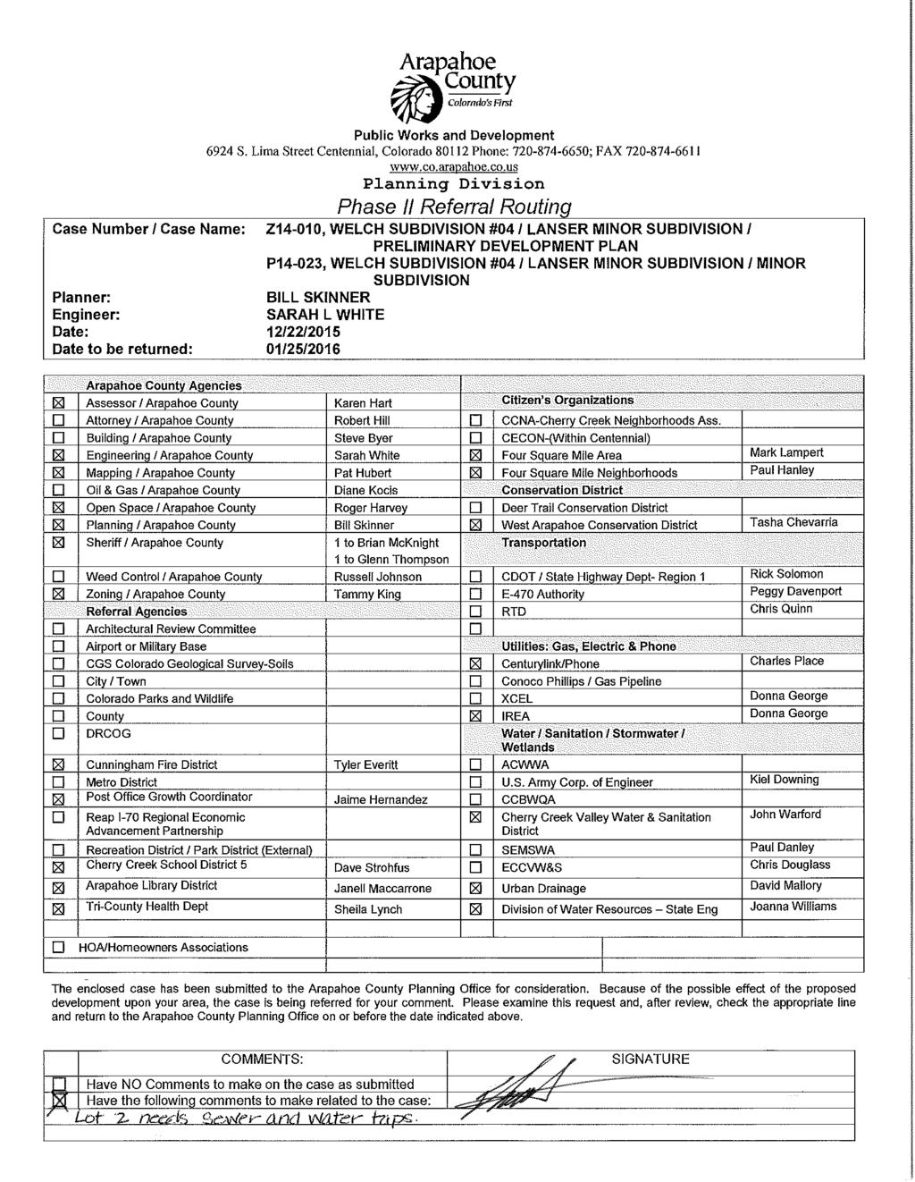
57


 boundary. A letter of commitment for service from the District was not provided.")

58 1313 Sherman Street, Room 821 Denver, CO January 4, 2015 Bill Skinner Arapahoe County Planning Division 6924 S. Lima Street Centennial, CO Transmitted via RE: Welch Subdivision Filing 11-Rezoning and Preliminary Development Plan Case nos. Z and P NW1/4, Sec. 27, T4S, R67W, 6 th P.M. Water Division 1, Water District 8 Dear Mr. Skinner: We have reviewed the information received by this office on December 22, 2015 regarding the above referenced referral. The Applicant is proposing rezone and subdivide a 0.73-acre parcel described as Lot 3, Filing 4, Welch Subdivision into two single-family residential lots. Estimated water requirements were not provided for this subdivision. In addition, no information was provided regarding a proposed water supply, however according to our records the proposed subdivision is located within the Cherry Creek Valley Water and Sanitation District ( District ) boundary. A letter of commitment for service from the District was not provided. Prior to further evaluation of the project a water supply plan must be included along with a report from the District documenting the amount of water which can be supplied to the proposed development without causing injury to existing water rights. Details of necessary information to be included in the subdivision water supply plan can be found on Attachments A and C of the Updated Memorandum Regarding Subdivisions, available online at: Since insufficient information was provided in this referral, we cannot comment on the potential for injury to existing water rights or the adequacy of the proposed water supply under the provisions of Section (1)(h)(II), C.R.S. If you or the applicant has any questions regarding this matter, please contact Ioana Comaniciu of this office. Sincerely, Joanna Williams, P.E. Water Resource Engineer cc: Subdivision File # Sherman Street, Room 821, Denver, CO P F

59 Paul J. Hanley, President Huntington Estates-Welch Homeowners Association, Inc S. Alton Way Denver, Colorado (303) Via January 25, 2016 Mr. Bill Skinner Arapahoe County Planning Re: Z14-010, WELCH SUBDIVISION #04 / LANSER MINOR SUBDIVISION / PRELIMINARY DEVELOPMENT PLAN; P14-023, WELCH SUBDIVISION #04 / LANSER MINOR SUBDIVISION / MINOR SUBDIVISION Dear Bill: On behalf of Huntington Estates Homeowners Association Inc. we oppose the abovereferenced PDP application on the basis that the lot width and lot size are incompatible with the surrounding neighborhood. This proposal involves the subdivision of a.73 acre lot in the Welch Subdivision into two lots one with an existing single family lot with.436 acres and an undeveloped lot of.296 acres. The front of this proposed irregularly shaped (trapezoidal) lot on Jewell Circle has a width of only 50 feet. The footprint for the proposed single family residence has a setback from Jewell Circle of only 25 feet. The lot width at the front building line is only approximately 61 feet. This parcel is currently zoned R-2 Residential. Section of the Land Development Code provides that the minimum lot width for R-2 Residential is 75 feet. Thus, the proposed subdivided lot fails to meeting existing minimum zoning standards for lot width by 14 feet. Section also provides for a minimum lot area of 20,000 square feet. The proposed subdivided lot would be 12,875 square feet. Accordingly, the proposed lot fails to meet existing requirements for lot width and lot size. In addition, the front setback just scrapes by with exactly the minimum 25 feet for R-2 Residential. The Welch Subdivision was initially subdivided in the 1940s with very large lots. Most of those initial large lots have been further subdivided into somewhat smaller lots, but virtually all of these subdivided lots in the Welch Subdivision meet the 75-foot lot width requirement and many meet the 20,000 square foot lot area requirement.
60 Bill Skinner Arapahoe County Planning January 25, 2016 Page 2 Most of the homes now existing in Welch were built about the time adjacent Huntington Estates was developed in the 1960s and 1970s. The combined Huntington Estates-Welch neighborhood shares typical attributes of custom single family homes built at the time on lot sizes ranging from about.35 acres to.55 acres. As a result of the size of the single family lots, much of the lot areas of the homes in the combined neighborhood consists of lawns, mature trees, and other extensive landscaping, resulting in a very classic, suburban ambiance. The single family homes adjacent and nearby the proposed new lot all meet the R-2 Residential lot width requirement of 75 feet. The adjacent parcels to the west have lot areas of.48 acres and.53 acres respectively. All nearly lots in the Welch Subdivision have lot areas of at least.35 acres, larger than the proposed lot. Quite simply, by having a minimum front set back equal to the minimum 25 feet and failing to meet the minimum lot width requirement of 75 feet and the minimum lot size of 20,000 square feet, this single lot will be out of character with the nearby and adjacent houses in the Welch Subdivision. This makes it incompatible and inconsistent with the existing neighborhood. It would also create a poor precedent for potential future subdivisions of lots in the Welch neighborhood, thus adversely affecting the existing character and existing zoning upon which current residents purchased their properties. We have conveyed these concerns to Brad Lanser. We have offered to compromise on the lot area requirements, if either (a) the minimum lot width requirement of 75 feet for R-2 zoning is met, or (b) the front setback of the lot is increased so that the front building line of the house would be located 10 feet to the south of the front building line of the existing single family home located immediately to the west, which 9420 E. Jewell Circle. We may have additional comments as the plans become more definite. Sincerely yours, Huntington Estates Homeowners Association, Inc. Paul J. Hanley, President cc: Board of Directors, Huntington Estates Homeowners Association, Inc. Four Square Mile Neighborhoods, Mark Lampert
61 Traverse PC
62 Traverse PC
63 Traverse PC

64 ARAPAHOE COUNTY PLANNING COMMISSION PUBLIC HEARING APRIL 19, :30 P.M. SUBJECT: Z16-002, WATKINS FARM REZONING Jason Reynolds, Current Planning Program Manager April 8, 2016 LOCATION: The Watkins Farm area is generally located south of Interstate 70 and east of Watkins Road, with the majority of the site located northeast of the intersection of E 6 th Avenue and N Imboden Road. Area of proposed zoning change Thunder Ranches WATKINS FARM REZONING VICINITY MAP ADJACENT SUBDIVISIONS, ZONING, AND LAND USES: North - Prosper PUD Box Elder neighborhood; zoned for up to 3 dwellings/acre East - A-1 Agricultural zoning; 35+ acre parcels South - A-1 Agricultural zoning; 35+ acre parcels West - Prosper PUD and R-A zoning (Thunder Ranches subdivision)
65 PROPOSAL: Arapahoe County staff initiated this zoning change to correct a mapping interpretation and labeling error for the zoning of property in the Watkins Farm area. The proposal would request to rezone the Watkins Farm area from R-A Residential Agricultural with a 5-acre minimum lot size to the County s standard R-A zone district, which has a 2.41-acre minimum lot size. The Board of County Commissioners has concurred with staff s request to proceed with the statutory process for this amendment to the zoning for the involved properties. STAFF RECOMMENDATION: Staff recommends that the Planning Commission forward a positive recommendation for the Watkins Farm Rezoning, based on the Findings and subject to conditions outlined in this Staff Report. I. BACKGROUND: Arapahoe County recently uncovered a mapping interpretation and labeling error in the Watkins Farm area. For years, zoning maps labeled the Watkins Farm zoning as R-A (residential agricultural) and F (flood plain). The R-A conventional zone district has a minimum lot size of 2.41 acres established in the Land Development Code; however, the 1980 zoning for the area specified R-A with a minimum lot size of 5 acres based on actions of the Planning Commission and Board of County Commissioners (BOCC) following public hearings. The zoning maps labeled the Watkins Farm area as R-A, but did not note the 5- acre lot size requirement established through a condition of approval. The following points summarize the area s zoning and subdivision history: 1980: Zoned R-A Residential Agricultural (2.41-acre lots) and F Floodplain with case #Z79-006: o Planning Commission conditioned its recommendation of approval with a minimum lot size of 5 acres. o The BOCC resolution included a condition that the rezoning of the property was subject to the conditions of the Planning Commission. 1981: Zoning corrected some of the floodplain boundaries and zoned the property R-A and F (case #Z81-013): o Accompanying Preliminary Development Plan and Final Development Plan restricted lots to minimum of 5 acres (Elder Creek Estates). o While the R-A conventional zone district would not typically require a PDP or FDP to be approved, use of this process reflected the change from the conventional lot size under the code to the special condition of minimum 5- acre lots. 1981: The County also approved a Preliminary Plat for 65 lots and a Final Plat for 26 lots (Elder Creek); all of the lots were 5 acres in area. Z PC Staff Report for April 19, 2016 Page 2 of 9

66 1982: The SIA for the Elder Creek Final Plat expired. It does not appear that the Elder Creek Final Plat was ever filed with the Clerk & Recorder to complete the subdivision process present: County zoning maps identified the area as R-A and F zoning with no mention of the 5-acre lot size requirement. Subsequent to Z81-013, the map should have been labeled as R-A PUD to establish notification of the special lot size and PDP/FDP approvals. 2001: Staff recommended approval for, and the Board of County Commissioners approved, the Watkins Farm Subdivision Final Plat with a 2.41-acre minimum lot size, despite the acre minimum zoning restriction. Given the R-A conventional zoning identified on the map rather than the R-A PUD, staff apparently did not look for special conditions or PDP/FDP. 2016: Staff researched the zoning in response to a presubmittal application on the property located east of Thunder Ranches and realized the zoning discrepancy. Much of the Watkins Farm property has already been developed under the conventional R-A lot size requirements. An applicant wishes to pursue a conventional R-A subdivision of a remaining section of the property. Z PC Staff Report for April 19, 2016 Page 3 of 9
67 Most of the proposed zone change is part of the Watkins Farm subdivision, which has an average lot size of 2.45 acres. If the proposed zoning change is not approved, those lots will all be nonconforming with the zoning, which requires a 5-acre minimum lot size. While Arapahoe County code does allow residential structures on nonconforming lots to be rebuilt after a loss, staff recommends that the zoning match the existing development pattern. II. DISCUSSION Staff s review of this application included a comparison of the project to policies and goals outlined in the Comprehensive Plan, background activity, and an analysis of referral comments. 1. The Comprehensive Plan The Comprehensive Plan designates this area as Tier 1 Planning Reserve. This proposed rezoning meets the intent of Strategy GM 7.2(c), which encourages the recognition of semi-urban development within the Planning Reserve Areas: The County will recognize parcels of 55 acres or less but without urban services in 2015 within the planning reserve areas. It will approve continued development within these parcels at non-urban densities (parcels 1 acre or larger), while supporting landowners who wish to move to a more urban category. The proposed R-A zoning meets the non-urban standard; all potential lots will be greater than 2.41 acres in area. 2. Ordinance Review and Additional Background Information Section of the Arapahoe County Land Development Code states that all rezoning applications must meet the following standards: a. Recognize the limitations of existing and planned infrastructure, by thoroughly examining the availability and capability of water, sewer, drainage, and transportation systems to serve present and future land uses. The Watkins Farm subdivision already established infrastructure, including connections to the surrounding transportation systems. Neither the Engineering Services Division of Public Works and Development nor Tri County Health department expressed concerns regarding water, sewer, or drainage infrastructure. Should any of the four parcels outside the Watkins Farm subdivision seek additional development, infrastructure needs will be assessed with the subdivision application. b. Assure compatibility between the proposed development, surrounding land uses, and the natural environment. The proposed zoning does not significantly alter the relationship with surrounding uses. Most of the property in the rezoning area has already developed as part of the Z PC Staff Report for April 19, 2016 Page 4 of 9
68 Watkins Farm subdivision. The proposed zoning matches the zoning of Thunder Ranches, located immediately to the west. c. Allow for the efficient and adequate provision of public services. Applicable public services include, but are not limited to, police, fire, school, park, and libraries. Referral agencies did not express any concerns about the proposal. If any future subdivisions occur within the proposed zoning boundary, additional public land dedication or cash in lieu fees may be required. d. Enhance convenience for the present and future residents of Arapahoe County by ensuring that appropriate supporting activities, such as employment, housing, leisure-time, and retail centers are in close proximity to one another. The property is near the Prosper development, which should eventually provide close proximity to parks, shopping, and other amenities. e. Ensure that public health and safety is adequately protected against natural and man-made hazards which include, but are not limited to, traffic noise, water pollution, airport hazards, and flooding. The rezoning does not appear to impact public health and safety. Any site development must meet engineering and building code standards, including drainage and water quality standards. f. Provide for accessibility within the proposed development, and between the development and existing adjacent uses. Adequate on-site interior traffic circulation, public transit, pedestrian avenues, parking and thoroughfare connections are all factors to be examined when determining the accessibility of a site. The Watkins Farms road network is already in place. Any proposed development will include internal vehicular circulation and parking. g. Minimize disruption to existing physiographic features, including vegetation, streams, lakes, soil types and other relevant topographical elements. Any future development will be subject to County regulations, including Grading, Erosion and Sediment Control (GESC) permits, as part of the plat review and approval. h. Ensure that the amenities provided adequately enhance the quality of life in the area, by creating a comfortable and aesthetically enjoyable environment through conventions such as, the preservation of mountain views, the creation of landscaped open areas, and the establishment of recreational activities. Z PC Staff Report for April 19, 2016 Page 5 of 9
69 The Watkins Farm subdivision preserved flood plain areas in tracts. The Cardboard Draw and Box Elder Creek flood plains will help preserve open space should other portions of the area seek subdivision approval. i. Enhance the useable open spaces in Arapahoe County, and provide sufficient unobstructed open space and recreational area to accommodate a project s residents and employees. The proposed zoning should have little impact on useable open spaces in the County. j. Ensure the application complies with the requirements of this Resolution and the Arapahoe County Comprehensive Plan. The proposal complies with the requirements of the Land Development Code and the Comprehensive Plan, as discussed above. III. REFERRAL COMMENTS AND PROPERTY OWNER NOTIFICATION: Property Owner Notification: As the rezoning application was initiated by Arapahoe County, all property owners of record within the Watkins Farm proposed rezoning boundary were mailed a post card with a map labeled Watkins Farm Rezoning: Attention Residents: Arapahoe County Public Works and Development is looking to initiate a zoning map change to correct an error in the Watkins Farm area. The notice also explained the nature of the change from 5-acre to 2.41-acre minimum lot size, the purpose of the change resulting from a mapping error, and that the proposed correction will ensure each lot conforms to the zoning code, along with a referral to the Current Major Cases web page for additional information on the Watkins Farm Rezone/Map Correction. The property was also posted with public hearing notices at the NE corner of N. Imboden Rd. and E. 6 th Ave. and at the SE corner of Eclipse St. and the E. Colfax service road. Hearing notification letters were also mailed to owners of properties adjacent to the proposed rezoning boundary. At the time of the staff report, no concerns had been received from the Watkins Farm Home Owners Association or from individual affected property owners within or adjacent to the rezoning area. A list of property owners notified is available in Planning Division records for Z Referrals: The following table summarizes responses referrals: Arapahoe County Engineering Services Division Arapahoe County Assessor Arapahoe County Attorney Arapahoe County Mapping Arapahoe County Open Space Notes that the site is outside Southeast Metro Stormwater Authority (SEMSWA) jurisdiction and is in the Box Elder Creek drainage basin. Recommends approval. No response CAO has reviewed the staff report. No comments No response Z PC Staff Report for April 19, 2016 Page 6 of 9
70 Arapahoe County Long Range Planning Arapahoe County Zoning Arapahoe County Sheriff Arapahoe Library District Bennett Fire Protection District Bennett School District CDOT Colorado Division of Water Resources Colorado Parks & Wildlife East End Advisory Committee REAP I-70 Regional Economic Advancement Partnership Tri-County Health Department Urban Drainage & Flood Control US Army Corps of Engineers W Arapahoe Conservation District Watkins Farms HOA Water/Wastewater Provider XCEL Energy The proposed rezoning is consistent with the recently amended Comprehensive Plan for Tier 1 land uses. No comments No comments Requests cash in lieu that may be required with subsequent development applications. No response No response No comments on this submittal; they would like to be part of any subsequent development requests. No response No response Hollingsworth opposes. No comments from Kroh. No responses from others. No response No comments No response No response No response No response N/A No response IV. STAFF FINDINGS: Staff has visited the site and has reviewed supporting documentation and referral comments. Based upon review of applicable policies and goals in the Arapahoe County Comprehensive Plan and analysis of referral comments, our findings include: 1. The proposed conventional rezoning generally appears to conform to the Arapahoe County Comprehensive Plan, with the property being designated as Tier 1 Planning Reserve, which allows for non-urban development. 2. The application appears to satisfy the Arapahoe County Zoning Regulations and procedures, including Section Conventional Zoning and is consistent with Z PC Staff Report for April 19, 2016 Page 7 of 9
71 Chapter 5 Rural Residential Zone Districts (which includes the R-A Residential- Agricultural Zone District) of the Land Development Code. 3. The Public Works & Development Engineering Division finds no engineering concerns and recommends the case favorably. 4. The proposed rezoning meets the criteria for rezoning as outlined in this Staff Report dated April 8, V. STAFF RECOMMENDATION: Considering the findings and other information provided herein, Staff recommends that the Planning Commission forward a positive recommendation to the Board of County Commissioners for APPROVAL of the proposed Watkins Farm Rezoning (Z16-002), subject to the following condition: 1. Minor corrections to the conventional rezoning exhibit, identified by Public Works and Development staff as necessary, must be completed prior to submittal of the final plans for County signature. VI. DRAFT MOTIONS: The following draft motions are provided by staff to assist the Planning Commission in preparing a motion at the time of the public hearing. The following motion would be consistent with the Staff Recommendation. RECOMMEND APPROVAL, WITH CONDITIONS: In the case of Z16-002, the Watkins Farm Rezoning, the Planning Commissioners have read the staff report and received testimony at the public hearing. We find ourselves in agreement with staff findings in the staff report dated April 8, 2016, including all attachments as set forth, and recommend this case favorably to the Board of County Commissioners for Approval, subject to the following condition: 1. Minor corrections to the conventional rezoning exhibit, identified by Public Works and Development staff as necessary, must be completed prior to submittal of the final plans for County signature. ALTERNATE MOTIONS If the Planning Commission wishes to recommend denial or to continue the hearing to a future date, the following motions may be used: RECOMMEND DENIAL, WITH AMENDED FINDINGS: In the case of Z16-002, the Watkins Farm Rezoning, the Planning Commissioners have read the staff report Z PC Staff Report for April 19, 2016 Page 8 of 9
72 and received testimony at the public hearing. We do not find ourselves in agreement with staff findings as set forth in the staff report dated April 8, 2016, including all attachments, and recommend the Board of County Commissioners deny this case. This recommendation is based on the following findings: Planning Commission should state new findings in support of the motion for denial. CONTINUE HEARING OR ACTION TO A FUTURE DATE: In the case of Z16-002, Watkins Farm Rezoning, I move to continue the public hearing to May 3, 2016 at 6:30 p.m. in order to receive additional information and further consider information presented during the public hearing. If continuing for the purpose of receiving additional information, the Planning Commission may want to note the information requested to be provided by the applicant or staff. Attachments Engineering Services Staff Report dated March 25, Watkins Farm Zoning History Flood Plain Map Zoning Exhibit Z PC Staff Report for April 19, 2016 Page 9 of 9
 and F (flood plain).")
73 Engineering Staff Report PHASE II REFERRAL Date: March 25, 2016 To: From: RE: Jason Reynolds, Planning Division Sue Liu, Engineering Division Z Watkins Farm Rezoning Scope/Location: Arapahoe County recently uncovered a mapping interpretation error in the Watkins Farm area. For years, county maps labeled the Watkins Farm zoning as R-A (residential agricultural) and F (flood plain). The R-A zoning has a minimum lot size of 2.41 acres; however, the 1980 zoning for the area specified R-A with a minimum lot size of 5 acres. The county s zoning maps labeled the Watkins Farm area as R-A but they did not note the 5 acre lot size requirement. Despite that 5-acre restriction, the county approved the Watkins Farm development in 2001, which had a minimum lot size of 2.41 acres. The Board of County Commissioners asked staff to update the zoning in the Watkins Farm area so that the zoning matches the way the county has treated the area for years. Proposed zoning change: from R-A (5-acre minimum lot size) to R-A, which requires a acre minimum lot size. Items included with this referral: Preliminary Development Plan Cc: Charles V. Haskins, Engineering Services Division, Division Manager Case File No. Z
74 Findings: The Arapahoe County Division of Engineering Services has reviewed this referral and has the following findings: 1. This site lies outside of the Southeast Metro Stormwater Authority (SEMSWA) service area. 2. This development is in the Box Elder Creek drainage basin. Recommendations: The Division of Engineering Services recommends this case favorable. STAFF COMMENTS Zoning Plan 1. Staff has no comments to the proposal
75 RESUBMITTAL PROCEDURE THIS SHEET MUST BE ATTACHED TO THE RESUBMITTAL TO THE CASE ENGINEER Case No. Z Case Engineer: Sue Liu In order to expedite this case in an efficient manner, the following procedure for resubmitting information to the Arapahoe County Division of Engineering Services must be followed. Incomplete resubmittal packages will not be forwarded to the case engineer for review until all of the information requested on this form has been provided. This sheet must be attached to your resubmittal with the revised documents in the quantities listed below. Please note that a minimum of three (3) weeks is necessary for Staff to review any submittal. RESUBMITTAL CHECKLIST The items checked below have been identified in the staff report as requiring revision and resubmittal. Engineering Documents Required for Resubmittal to the County Engineering # of Division A copy of this Resubmittal Checklist 1 Completed Review and Approval Form (Arapahoe County Form 581) Proposed Zoning Change 1 Traffic Impact Study Construction Plan Pavement Design Report Grading, Erosion and Sediment Control (GESC) Plans & Report Floodplain Delineation Analysis Operations & Maintenance Manual Phase I Drainage Study Engineering Cost Estimate Legal Description and Exhibit Geotechnical Study / Preliminary Soils report Collateral Letter of Intent County Redlines for: Letter of point-by-point response to Phase II Engineering Staff Report - 3 -
 and F Floodplain with case #Z79 006 o Planning Commission conditioned their recommendation of approval with a minimum lot size of 5 acres o The BOCC resolution included a condition that")
76 Watkins Farm Zoning History 1980: Zoned R A Residential Agricultural (2.41 acre lots) and F Floodplain with case #Z o Planning Commission conditioned their recommendation of approval with a minimum lot size of 5 acres o The BOCC resolution included a condition that the rezoning of the property was subject to the conditions of the Planning Commission 1981: Zoning corrected some of the floodplain boundaries and zoned the property R A and F (case #Z81 013) o Accompanying Preliminary Development Plan and Final Development Plan restricted lots to minimum of 5 acres (Elder Creek Estates) 1981: The County also approved a Preliminary Plat 65 lots and a Final Plat for 26 lots (Elder Creek); all of the lots were 5 acres in area The SIA for the Elder Creek Final Plat expired in 1982 Our zoning maps identified zoning as R A and F (no mention of lot size restriction or Preliminary Development Plan): We ve treated the zoning as R A with the standard 2.41 minimum lot size for years 2001: Staff recommended approval and BOCC approved Watkins Farm Subdivision Final Plat with a 2.41 minimum lot size, despite the 1981 zoning restriction
77 We have a developer interested in submitting an application west of the current Watkins Farm subdivision (between Thunder Ranches and Watkins Farm); the developer plans to request 2.41 acre lots on a 36.6 acre parcel Staff proposes a county initiated rezoning for everything except the Prosper PUD portion of the property to correct the mapping error the proposed zoning would match how we ve treated the Watkins Farm area for years: R A and F

78 Floodplain Map - Watkins Farm µ Feet ,300 2,600 3,900 5,200 ARAPAHOE COUNTY MAKES NO REPRESENTATION OR WARRANTY AS TO THE ACCURACY OF THIS MAP OR THE DATA THAT IT DISPLAYS. ARAPAHOE COUNTY ASSUMES NO RESPONSIBILITY OR LIABILITY TO ANY USER. THIS MAP IS NOT A LEGAL DOCUMENT. IT IS INTENDED TO SERVE AS AN AID IN GRAPHIC REPRESENTATION ONLY Map Generated On: 4/1/2016 Generated by Arapahoe County's ArapaMAP Map Location v 1.0
79 March 9, 2016 RA Zoning Page 1 of 3 See Exhibit B EXHIBIT A RA Zoning PARCEL DESCRIPTION A parcel of land lying within the south half (S1/2) and northwest quarter (NW1/4) of Section 5, and in the Northeast Quarter (NE1/4) of Section 6, all in Township 4 South, Range 64 West of the Sixth Principal Meridian, Arapahoe County, Colorado, more particularly described as follows: Commencing at the southeast corner of said Section 5, said southeast corner being the POINT OF BEGINNING; THENCE along the south line of the SE1/4 of said Section 5, North West, a distance of feet to the south quarter corner of said Section 5; THENCE along the south line of the SW1/4 of said Section 5, North West, a distance of feet to the southwest corner of said Section 5; THENCE leaving said south line, along the west line of said SW1/4 of said Section 5, North West, a distance of feet to the west quarter corner of said Section 5, being also the east quarter corner of said Section 6; THENCE leaving said west line, along the east-west mid-section line of said Section 6, North West, a distance of feet to the southeast corner of the SW1/4 of the NE1/4 of said Section 6, being also the southeast corner of Thunder Ranches Subdivision Filing No. 1 as recorded at Reception No. B of the Arapahoe County Records (A.C.R.); THENCE leaving said east-west mid-section line, along the west line of the E1/2 of the NE1/4 of said Section 6, being also the east line of said Thunder Ranches Subdivision Filing No. 1 and the northerly extension thereof, North West, a distance of feet, to the westerly most corner of a parcel of land described in Reception No. D , A.C.R.; THENCE leaving said west and east lines, South East, along the southerly line of said parcel of land described in Reception No. D , a distance of feet; THENCE South West, a distance of feet, to the east line of the NE1/4 of said Section 6, being also the west line of the NW1/4 of said Section 5; THENCE South East, along said east line of the NE1/4 quarter, a distance of feet to a point feet northerly of the west quarter corner of said Section 5, said point being also the northwest corner of Watkins Farm Subdivision Filing No. 1, as recorded at Reception No. B , A.C.R.; THENCE leaving said east line, continuing along said southerly line and along the northerly line of said Watkins Farm Subdivision Filing No. 1, South East, parallel with and 300 feet north of the eastwest mid-section line of said Section 5, a distance of feet to the north-south mid-section line of said Section 5, being also the southeast corner of said Reception No. D and the northeast corner of Tract E of said Watkins Farm Subdivision Filing No. 1;
80 March 9, 2016 RA Zoning Page 2 of 3 See Exhibit B THENCE leaving said southerly and northerly lines, along said north-south mid-section line and the easterly line of said Tract E, South East, a distance of feet to the center corner of said Section 5 and the northwest corner of a parcel of land described in Reception No. B , A.C.R.; THENCE leaving said easterly line, along said east-west mid-section line of said Section 5 and the northerly line of said B , South East, a distance of feet to the east quarter corner of said Section 5, being also the northeast corner of a parcel of land described in Reception No. D , A.C.R.; THENCE leaving said east-west mid-section line and said northerly line, along the east line of said Section 5 and the east line of said Reception No. D , South East, a distance of feet to POINT OF BEGINNING. EXCEPTING THEREFROM Tracts A, B, and C of said Watkins Farm Subdivision Filing No. 1 Containing acres, or 15,904,604 square feet of land, more or less. Subject to existing rights-of-way and easements. BASIS OF BEARING: All bearings are based on the south line of the southeast quarter of Section 5, Township 4 South, Range 64 West of the 6 th Principal Meridian as shown on Watkins Farms Subdivision Filing No. 1 as bearing North West.

81 SECTION 6 SECTION 5 INTERSTATE 70 REC. NO. D THUNDER RANCHES SUBDIVSION FILING NO. 1 REC. NO. B REC. NO. B TRACT C EXCEPTION REC. NO. B EXCEPTION TRACT B WATKINS FARM SUBDIVSION FILING NO. 1 REC. NO. B REC. NO. D E. CO. RD. 6/ E. 6TH AVE. TRACT A EXCEPTION WATKINS FARM SUBDIVSION FILING NO. 2 REC. NO. B ARAPAHOE COUNTY MAPPING DEPARTMENT EXHIBIT "B"
82 ARAPAHOE COUNTY PLANNING COMMISSIONERS PUBLIC HEARING 19 April :30 PM W Land Development Code Amendment to Chapters 4, 5 and 19 Seasonal Farm and Ranch Events Tammy King, Zoning Administrator April 8, 2016 PROPOSAL: Planning Staff proposes to update Chapters 4, 5 and 19 to better define parameters and thresholds for Seasonal Farm and Ranch Events. STAFF RECOMMENDATION: Staff recommends approval of Case Number W based on the findings outlined in this staff report and with the conditions as noted. I. BACKGROUND INFORMATION This County-initiated application to amend the Land Development Code is to update the existing Chapters 4 (Agricultural Zone Districts), 5 (Rural Residential Zone Districts) and 19 (Definitions) with new verbiage, thresholds and requirements in order to better address the range of Seasonal Farm and Ranch Events for which applications have been received in recent years. In addition to clarification on types of events that may be permitted through a Temporary Use Permit (TUP), the draft amendment provides that: Seasonal Ranch and Farm Events (commercial and non-commercial) will include rodeos; Specifies those circumstances for which such events will require a Temporary Use Permit (TUP) and those for which a TUP is not needed; and Prohibits these uses where impacts would be difficult to mitigate. In addition, the original proposal was to eliminate the definition of Rodeo, as this type of event is proposed to be included under Seasonal Ranch and Farm Events. However, on further consideration, staff is recommending the definition of Rodeo be retained and streamlined based on other changes in the code. II. DISCUSSION AND FINDINGS Staff reviewed this application for compliance with the Comprehensive Plan and Zoning Regulations and reviewed all background activity and comments from referral agencies. A summary of the analysis is as follows: 1. Comprehensive Plan and Align Arapahoe: The revisions proposed are consistent with the purpose and direction of the Comprehensive Plan in that these revisions provide additional language to guide W LDC Amend Chapters 4, 5 and 19 Seasonal Farm and Ranch Events PC Public Hearing April 19, 2016 Staff Report, page 1
83 development within the County, specifically meeting Strategy GM 2.2(a), which provides direction to amend the County s Development Regulations to Achieve Consistency with the Comprehensive Plan. These modifications to amend Chapters 4, 5 and 19 of the Land Development Code with new verbiage, thresholds and requirements are consistent with this guidance. The proposed amendment promotes the fiscal responsibility and quality of life Align Arapahoe goals by addressing uses that may be appropriate within rural areas of the county, either as permitted uses or with additional review and conditions through the Temporary Use Permit process defined in of the Land Development Code, and by prohibiting uses where impacts would be difficult to mitigate. 2. Referrals: Staff sent out referral letters to the attached list of referral agencies and individuals requesting that referral responses be submitted during the outside referral comment period, from February 12, 2016 to March 11, All comments received stated No comment on the proposed changes related to Seasonal Farm and Ranch Events. III. STAFF FINDINGS Staff has reviewed the proposal and supporting documentation and referral comments, as detailed in this report. Based on review of applicable goals and policies as stated in the Comprehensive Plan, staff finds: 1. The proposed changes to the referenced Chapters 4, 5 and 19 within the Land Development Code (LDC) are in conformance with the Arapahoe County Comprehensive Plan. 2. Arapahoe County has the authority to amend provisions of the LDC as proposed by this revision. 3. Modifications proposed comply with the applicable LDC Amendment policies and procedures as set forth in the LDC, including public notification requirements. Notice was provided in both the Villager and the I-70 Scout newspapers. 4. The proposed changes promote the public health, safety, and welfare of the unincorporated county. IV. STAFF RECOMMENDATION In the event that the Planning Commission concurs with the Staff s findings, as stated above, and wishes to forward a recommendation for Approval of the amendment to Chapters 4, 5 and 19, as proposed or with changes, Staff has recommended the following Conditions of Approval: 1. Minor modifications to the text identified as necessary are required prior to incorporation of this Amendment into the existing Land Development Code. Staff, in conjunction with the County Attorney s Office, is hereby authorized to make necessary modifications to the text. W LDC Amend Chapters 4, 5 and 19 Seasonal Farm and Ranch Events PC Public Hearing April 19, 2016 Staff Report, page 2
84 2. Modifications to Chapters 4, 5 and 19 of the Land Development Code will be effective and integrated into the existing Code upon approval by the Board of County Commissioners following a public hearing. V. DRAFT MOTIONS A. Motion for Approval as Submitted: In the case of W Land Development Code Amendment to amend Chapters 4, 5 and 19 to address Seasonal Farm and Ranch Events, the Planning Commission has read the proposed code amendment and staff report and has considered additional information presented during the public hearing. We find ourselves in agreement with Staff findings one (1) through four (4) set forth in the Staff report dated April 8, 2016, and recommend that the Board of County Commissioners approve the amendment as submitted, including retaining and modifying the definition of Rodeo, with the following two (2) conditions of approval: 1. Minor modifications to the text identified as necessary are required prior to incorporation of this Amendment into the existing Land Development Code. Staff, in conjunction with the County Attorney s Office, is hereby authorized to make necessary modifications to the text. 2. Modifications to Chapters 4, 5 and 19 of the Land Development Code will be effective and integrated into the existing Code upon approval by the Board of County Commissioners following a public hearing. B. Motion for Approval with Changes: In the case of W Land Development Code Amendment to amend Chapters 4, 5 and 19 to address Seasonal Farm and Ranch Events, the Planning Commission has read the proposed code amendment and staff report and has considered additional information presented during the public hearing. We find ourselves in agreement with Staff findings one (1) through four (4) set forth in the Staff report dated April 8, 2016, and recommend that the Board of County Commissioners approve the amendment with the following changes and with the following two (2) conditions of approval: Changes to the proposed text: 1. Changes should be read as part of the motion to approve. The Planning Commission may generally note the changes to be accomplished and direct staff to modify the text with language determined to accomplish the intended purpose prior to forwarding the recommendation to the BOCC. 2.. Conditions of Approval: Any changes to the following conditions should be stated as part of the motion. 1. Minor modifications to the text identified as necessary are required prior to incorporation of this Amendment into the existing Land Development Code. Staff, in conjunction with the County Attorney s Office, is hereby authorized to make necessary modifications to the text. W LDC Amend Chapters 4, 5 and 19 Seasonal Farm and Ranch Events PC Public Hearing April 19, 2016 Staff Report, page 3
85 2. Modifications to Chapter 4, 5 and 19 of the Land Development Code will be effective and integrated into the existing Code upon approval by the Board of County Commissioners following a public hearing. C. Motion for Denial: In the case of W Land Development Code Amendment to amend Chapters 4, 5 and 19 to address Seasonal Farm and Ranch Events, the Planning Commission has read the proposed code amendment and staff report and has considered additional information presented during the public hearing. We do not find ourselves in agreement with Staff findings set forth in the Staff report dated April 8, 2016, and therefore recommend the Board of County Commissioners deny the application based on the following findings: 1. As part of the motion, state new or amended findings to support a motion for denial. D. Motion to Continue: In the case of W Land Development Code Amendment to amend Chapters 4, 5 and 19 to address Seasonal Farm and Ranch Events, I move to continue the [public hearing for] [action on] this item to [Date, 2016], date certain, 6:30 p.m., at this same location, [to obtain additional information] [to further consider information presented during the public hearing]. Attachments Proposed text revisions to the Arapahoe County Land Development Code, Chapters 4, 5 and 19, including updated revision to the definition of Rodeo Red-lined to show changes from currently adopted text. Proposed text revisions Clean copy as proposed to be amended. W LDC Amend Chapters 4, 5 and 19 Seasonal Farm and Ranch Events PC Public Hearing April 19, 2016 Staff Report, page 4

86


87


88
89 W AMEND LAND DEVELOPMENT CODE RELATED TO SEASONAL FARM AND RANCH EVENTS PLANNING COMMISSION DRAFT APRIL 19, 2016 PUBLIC HEARING PAGE 1 Strikethrough = Verbiage Remove Underline = New Verbiage Added CHAPTER 4: AGRICULTURAL ZONE DISTRICTS A-E & A-1 Rodeo SEU SEU Seasonal Farming or Ranching Events (non-commercial) P P Seasonal Farming or Ranching Events (commercial or involving 100 or more persons in attendance TUP TUP CHAPTER 5: RURAL RESIDENTIAL ZONE DISTRICTS A-2, R-A & R-E Rodeo SEU SEU NP Seasonal Farming or Ranching Events (commercial or noncommercial) NP NP NP CHAPTER 19 DEFINITIONS RULES OF CONSTRUCTION A. The particular controls the general. B. The word "building" shall mean the word "structure. C. The word "used" shall include "arranged," "designed," "constructed," "altered," "converted," "rented," "leased," or "intended to be used." D. Additional definitions are found in this document within subsections of the Zoning Resolution DEFINITIONS RODEO. An event comprising of activities for competition, entertainment or display of skills, including, but not limited to, horseback riding, bronco riding, steer wrestling, calf roping and/or riding, bulldogging, steer tailing, horse tripping, and barrel racing. Horse racing is not considered a rodeo activity. User fees, dues, admission fees, or other compensation may be paid, but compensation is not a required element to define an event as a rodeo. Food and/or alcohol may be bought or sold on the premises, subject to meeting any State or local health and safety regulations and/or licensing requirements. Steer tailing and/or horse tripping are prohibited within unincorporated Arapahoe County.
90 W AMEND LAND DEVELOPMENT CODE RELATED TO SEASONAL FARM AND RANCH EVENTS PLANNING COMMISSION DRAFT APRIL 19, 2016 PUBLIC HEARING PAGE 2 SEASONAL FARMING OR RANCHING EVENTS (non-commercial). Events related to or occurring in the course of farming and ranching, and which may take place during, or be related to, a particular season. Uses may include but not be limited to: rodeos, ancillary sales and previewing of livestock, horse racing, and training or practice events. No user fees, dues, admission fees, or other compensation may be charged for attendance at or participation in the Event, nor may any commercial sale of food, beverages, or goods occur at the Event; otherwise, the Event shall comply with all requirements for a Temporary Use as provided in the Arapahoe County Land Development Code and a Temporary Use Permit issued in accordance with the Land Development Code shall be required for the Event is commercial and requires a temporary use permit. Further if it is anticipated that 100 or more persons will be in attendance at the Event as spectators and participants, the Event is deemed commercial and requires a Temporary Use Permit be first issued under the land Development Code. SEASONAL FARMING OR RANCHING EVENTS (commercial). Events related to or occurring in the course of farming and ranching, and which may take place during, or be related to, a particular season. Uses may include but not be limited to: rodeos, ancillary sales and previewing of livestock, horse racing, and training or practice events. User fees, dues, admission fees, or other compensation may be charged for attendance at or participation in the Event and the commercial sale of food, beverages, or goods may occur at the Event. Attendance of spectators and participants may exceed 100 or more persons. Such commercial Event shall comply with all requirements for a Temporary Use as provided in the Arapahoe County Land Development Code and a Temporary Use Permit issued in accordance with the Land Development Code shall be required for the Event. Food, beverage or alcoholic drink sales at an Event are also subject to applicable State or local health, safety, and/or licensing requirements.
91 W AMEND LAND DEVELOPMENT CODE RELATED TO SEASONAL FARM AND RANCH EVENTS PLANNING COMMISSION DRAFT APRIL 19, 2016 PUBLIC HEARING PAGE 1 CHAPTER 4: AGRICULTURAL ZONE DISTRICTS A-E & A-1 Seasonal Farming or Ranching Events (non-commercial) P P Seasonal Farming or Ranching Events (commercial or involving 100 or more persons in attendance TUP TUP CHAPTER 5: RURAL RESIDENTIAL ZONE DISTRICTS A-2, R-A & R-E Seasonal Farming or Ranching Events (commercial or noncommercial) NP NP NP CHAPTER 19: DEFINITIONS RULES OF CONSTRUCTION A. The particular controls the general. B. The word "building" shall mean the word "structure. C. The word "used" shall include "arranged," "designed," "constructed," "altered," "converted," "rented," "leased," or "intended to be used." D. Additional definitions are found in this document within subsections of the Zoning Resolution DEFINITIONS RODEO. An event comprising of activities for competition, entertainment or display of skills, including, but not limited to, horseback riding, bronco riding, steer wrestling, calf roping and/or riding, bulldogging, and barrel racing. Horse racing is not considered a rodeo activity. SEASONAL FARMING OR RANCHING EVENTS (non-commercial). Events related to or occurring in the course of farming and ranching, and which may take place during, or be related to, a particular season. Uses may include but not be limited to: rodeos, ancillary sales and previewing of livestock, horse racing, and training or practice events. No user fees, dues, admission fees, or other compensation may be charged for attendance at or participation in the Event, nor may any commercial sale of food, beverages, or goods occur at the Event; otherwise, the Event shall comply with all requirements for a Temporary Use as provided in the Arapahoe County Land Development Code and a Temporary Use Permit issued in accordance with the Land Development Code shall be required for the Event is commercial and requires a temporary
92 W AMEND LAND DEVELOPMENT CODE RELATED TO SEASONAL FARM AND RANCH EVENTS PLANNING COMMISSION DRAFT APRIL 19, 2016 PUBLIC HEARING PAGE 2 use permit. Further if it is anticipated that 100 or more persons will be in attendance at the Event as spectators and participants, the Event is deemed commercial and requires a Temporary Use Permit be first issued under the land Development Code. SEASONAL FARMING OR RANCHING EVENTS (commercial). Events related to or occurring in the course of farming and ranching, and which may take place during, or be related to, a particular season. Uses may include but not be limited to: rodeos, ancillary sales and previewing of livestock, horse racing, and training or practice events. User fees, dues, admission fees, or other compensation may be charged for attendance at or participation in the Event and the commercial sale of food, beverages, or goods may occur at the Event. Attendance of spectators and participants may exceed 100 or more persons. Such commercial Event shall comply with all requirements for a Temporary Use as provided in the Arapahoe County Land Development Code and a Temporary Use Permit issued in accordance with the Land Development Code shall be required for the Event. Food, beverage or alcoholic drink sales at an Event are also subject to applicable State or local health, safety, and/or licensing requirements.
93 ARAPAHOE COUNTY PLANNING COMMISSIONERS PUBLIC HEARING 19 April :30 PM W Land Development Code Addition of Section Septage and Sewage Regulations Tammy King, Zoning Administrator April 8, 2016 PROPOSAL: Planning Staff proposes to add Section to better define parameters and thresholds for Septage and Sewage Land Application Regulations. STAFF RECOMMENDATION: Staff recommends approval of Case Number W based on the findings outlined in this staff report and with the conditions as noted. I. BACKGROUND INFORMATION This County-initiated application is to add a new Section Septage and Sewage Land Application Regulations to Chapter 12, Specific Regulations, within the Arapahoe County Land Development Code to provide definitions, thresholds and requirements to better address the concerns we have received in recent years on land application practices involving septage and sewage, occurring primarily in the east county. Definitions may, at staff discretion, be relocated to Chapter 19 Definitions. II. DISCUSSION AND FINDINGS Staff reviewed this application for compliance with the Comprehensive Plan and Zoning Regulations and reviewed all background activity and comments from referral agencies. A summary of the analysis is as follows: 1. Comprehensive Plan and Align Arapahoe: The revisions proposed are consistent with the purpose and direction of the Comprehensive Plan in that these revisions provide additional language to guide development within the County, specifically meeting Strategy GM 2.2(a) within Growth Management Promote Coordinated Regional Planning, which provides direction to Amend the County s Development Regulations to Achieve Consistency with the Comprehensive Plan. The proposed Code revisions are also consistent with the Comprehensive Plan Goals within Natural and Cultural Resources and the Environment, NCR 1 Conserve Natural Areas and Resources and NCR 3 Conserve Water Resources and Maintain High Water Quality, and the additional goals associated with these policies, in that the proposed addition to the Land Development Code will serve to protect and maintain environmental and water quality. W LDC Addition of Section Septage and Sewage Land Application Regulations PC Public Hearing April 19, 2016 Staff Report, page 1
94 The proposed amendment promotes the quality of life Align Arapahoe goal by addressing uses that may be appropriate within the unincorporated county and by prohibiting uses where impacts would be difficult to mitigate and by working to provide a safe environment and high standard of water quality. 2. Referrals: Staff sent out referral letters to the attached list of referral agencies and other stakeholders, requesting that referral responses be submitted during the comment period from February 12, 2016 to March 11, Comments are summarized below and, unless a response of No comment was provided, are attached to this staff report. REFERRAL COMMENTS RECEIVED FOR W Tri-County Health Department Supports the proposed regulation prohibiting land application of septage while continuing to allow the application of bio-solids where a permit is issued by Colorado Dept. of Public Health and Environment (CDPHE). Cherry Creek Basin Water Reviewed for point source and non-point source Quality Authority pollutant impacts and water quality considerations in the Cherry Creek watershed. Concern that term land application may be too broad and recommends specifying that reclaimed water uses authorized under Regulation 84 (5 CCR ) are excluded from this regulation. Note: County staff has not incorporated this recommendation into the proposed regulation. Septage, East Arapahoe Advisory Planning Commission Janet Cook Douglas County Community Development Department City of Centennial Community Development Department City/County of Denver, Fire Department Town of Bennett, Fire and Rescue South Arapahoe Sanitation District (SASD) Xcel Energy Right-of-Way Natural Resource Conservation Service, USDA Arapahoe County Engineering Services Division, PWD as defined, would not include treated, reclaimed water. Supports the regulation as a good start, but has concerns about the continued allowance for bio-solids application even with a CDPHE permit and provides references for further study and evaluation. Note: County staff has not further modified the regulation related to bio-solids application. No comment, appreciates opportunity to review. No comment, appreciates opportunity to review. No reservations to the application for amendment. No comment, does not affect operations. No comment. No comment. NRCS has worked with Tri-County Health Dept. to develop an informational flyer on this topic. More information is available from TCHD. No comment on the proposed amendment. W LDC Addition of Section Septage and Sewage Land Application Regulations PC Public Hearing April 19, 2016 Staff Report, page 2
95 III. STAFF FINDINGS Staff has reviewed the proposal and supporting documentation as well as referral comments, as detailed in this report. Based on review of applicable goals and policies as stated in the Comprehensive Plan, staff finds: 1. The proposed addition of the referenced Section within the Land Development Code (LDC) appears to be in conformance with the Arapahoe County Comprehensive Plan. 2. Arapahoe County has the authority to amend provisions of the LDC as proposed by this revision. 3. Modifications proposed comply with the applicable LDC Amendment policies and procedures as set forth in the LDC including public notification requirements. Notice was provided in both the Villager and the I-70 Scout newspapers. 4. The proposed changes promote the public health, safety, and welfare of the unincorporated county. IV. STAFF RECOMMENDATION In the event that the Planning Commission concurs with the Staff s findings, as stated above, and wishes to forward a recommendation for Approval of the addition of Section , as proposed or with changes, Staff has recommended the following Conditions of Approval: 1. Minor modifications to the text identified as necessary are required prior to incorporation of this Amendment into the existing Land Development Code. Staff, in conjunction with the County Attorney s Office, is hereby authorized to make necessary modifications to the text and may relocate definitions to Chapter Modifications to Section of the Land Development Code will be effective and integrated into the existing Code upon approval by the Board of County Commissioners following a public hearing. V. DRAFT MOTIONS A. Motion for Approval as Submitted: In the case of W Land Development Code Amendment, Chapter 12 Specific Regulations, addition of Section , Septage and Sewage Land Application Regulations, the Planning Commission has read the proposed code amendment and staff report and has considered additional information presented during the public hearing. We find ourselves in agreement with Staff findings one (1) through four (4) set forth in the Staff report dated April 8, 2016, and recommend that the Board of County Commissioners approve the amendment as submitted, with the following two (2) conditions of approval: 1. Minor modifications to the text identified as necessary are required prior to incorporation of this Amendment into the existing Land Development Code. Staff, in conjunction with the County Attorney s Office, is hereby authorized to make necessary modifications to the text and may relocate definitions to Chapter 19. W LDC Addition of Section Septage and Sewage Land Application Regulations PC Public Hearing April 19, 2016 Staff Report, page 3
96 2. Modifications to Section of the Land Development Code will be effective and integrated into the existing Code upon approval by the Board of County Commissioners following a public hearing. B. Motion for Approval with Changes: In the case of W Land Development Code Amendment, Chapter 12 Specific Regulations, addition of Section , Septage and Sewage Land Application Regulations, the Planning Commission has read the proposed code amendment and staff report and has considered additional information presented during the public hearing. We find ourselves in agreement with Staff findings one (1) through four (4) set forth in the Staff report dated April 8, 2016, and recommend that the Board of County Commissioners approve the amendment with the following changes and with the following two (2) conditions of approval: Changes to the proposed text: 1. Changes to the text should be read as part of the motion to approve. The Planning Commission may note the nature of the change to be made and direct staff to finalize text prior to the hearing before the Board of County Commissioners. 2.. Conditions of Approval: 1. Minor modifications to the text identified as necessary are required prior to incorporation of this Amendment into the existing Land Development Code. Staff, in conjunction with the County Attorney s Office, is hereby authorized to make necessary modifications to the text and may relocate definitions to Chapter Modifications to Section of the Land Development Code will be effective and integrated into the existing Code upon approval by the Board of County Commissioners following a public hearing. C. Motion for Denial: In the case of W Land Development Code Amendment, Chapter 12 Specific Regulations, addition of Section , Septage and Sewage Land Application Regulations, the Planning Commission has read the proposed code amendment and staff report and has considered additional information presented during the public hearing. We do not find ourselves in agreement with Staff findings set forth in the Staff report dated April 8, 2016, and therefore recommend the Board of County Commissioners deny the application based on the following findings: 1. State new or amended findings to support a motion for denial as part of the motion. D. Motion to Continue: In the case of W Land Development Code Amendment, Chapter 12 Specific Regulations, addition of Section Septage and Sewage Land Application Regulations, I move to continue the [public hearing for] [action on] this item to [Date, W LDC Addition of Section Septage and Sewage Land Application Regulations PC Public Hearing April 19, 2016 Staff Report, page 4
97 2016], date certain, 6:30 p.m., at this same location [to obtain additional information] [to further consider information presented during the public hearing]. Attachments Proposed text revisions to the Arapahoe County Land Development Code, Section List of referral agencies contacted Referral letters received for W W LDC Addition of Section Septage and Sewage Land Application Regulations PC Public Hearing April 19, 2016 Staff Report, page 5
98 W Proposed Septage and Sewage Land Application Regulations Planning Commission Draft April 19, 2016 page 1 Strikethrough = Verbiage Remove Underline = New Verbiage Added Proposed Septage Regulations: Chapter 12 Amendment Section , Septage and Sewage Land Application Regulations Purpose The purpose and intent of this regulation is to prohibit the land application of septage or sewage in all zone districts in the unincorporated territory of Arapahoe County, while allowing the land application of biosolids when and where authorized by a current and valid permit issued by the Colorado Department of Public Health and Environment (or Chapter 19) Definitions A. Biosolids means the accumulated treated residual product resulting from a domestic wastewater treatment works. Biosolids does not include grit or screenings from a wastewater treatment works or commercial and industrial septage or on-site wastewater treatment systems regulated under Article 10 of Title 25 of the Colorado Revised Statues, as amended. Biosolids does not include any septage or sewage as defined in these regulations. Reference CRS (1.4). B. Land application means the application of septage, sewage, or biosolids to land for agricultural use as a source of macro- or micronutrients, organic matter or other beneficial properties as a soil conditioner for the facilitation of vegetative growth. C. Septage means a liquid or semisolid that includes normal household wastes, human excreta, and animal or vegetable matter in suspension or solution generated from a residential septic tank system. Reference CRS (17). Septage for purposes of the prohibition against the land application of septage specified in these Regulations also includes any residual product from commercial or industrial septic tank systems, and chemical toilets, vaults, and vehicular or trailer holding tanks. D. Septic Tank means a watertight, accessible, covered receptacle designed and constructed to receive sewage from a building sewer, settle solids from the liquid, digest organic matter, store digested solids through a period of retention, and allow the clarified liquids to discharge to other treatment units for final disposal. Reference CRS (18).
99 W Proposed Septage and Sewage Land Application Regulations Planning Commission Draft April 19, 2016 page 2 E. Sewage means a combination of liquid wastes that may include chemicals, household wastes, human excreta, animal or vegetable matter in suspension or solution, and other solids in suspension or solution, and that are discharged from a dwelling, building, or other establishment. Reference (19) Prohibition of the Land Application of Septage or Sewage A. The land application of septage or sewage is prohibited in all zone districts in the unincorporated territory of Arapahoe County. B. The land application of biosolids for agricultural use within the unincorporated territory of Arapahoe County is permitted in accordance with a current and valid permit issued by the Colorado Department of Public Health and Environment, Division of Water Quality in accordance with Regulation No. 64, Biosolids Regulations, 5 CCR Violations The County, through its Zoning Administrator, may enforce the provisions of this Article and the terms, requirements and conditions of a biosolids permit through methods included in this Code or through Colorado State Statute or such other methods lawfully adopted by resolution or ordinance Application to Existing Uses Notwithstanding any provisions of Chapter 11 of the Land Development Code (Nonconformities), the prohibition against the land application of septage and sewage contained in this Section applies to all properties within unincorporated Arapahoe County, including those properties for which septage or sewage has been applied or for which such use was in existence prior to the adoption of this Section , including any amendments thereto.

100
101

102
Board Summary Report
 Board of County Commissioners: Public Hearing Agenda, August 7, 2018 Agenda Item: # Date: July 25, 2018 To: Through: From: Subject: Board of County Commissioners Jan Yeckes, Planning Division Manager Bill
CASE # P DOVE VALLEY V, FILING #13 (REPLAT OF BLOCK 12, LOTS 1 16 AND TRACTS A, B, D) BILL SKINNER, SENIOR PLANNER JUNE 14, 2016
 BILL SKINNER, SENIOR PLANNER JUNE 14, 2016") ARAPAHOE COUNTY BOARD OF COUNTY COMMISSIONERS PUBLIC HEARING June 28, 2016 9:30 A.M. CASE # P15-010 DOVE VALLEY V, FILING #13 (REPLAT OF BLOCK 12, LOTS 1 16 AND TRACTS A, B, D) BILL SKINNER, SENIOR PLANNER
ARAPAHOE COUNTY BOARD OF COUNTY COMMISSIONERS PUBLIC HEARING June 28, 2016 9:30 A.M. CASE # P15-010 DOVE VALLEY V, FILING #13 (REPLAT OF BLOCK 12, LOTS 1 16 AND TRACTS A, B, D) BILL SKINNER, SENIOR PLANNER
Case No. P16-003, Inverness No. 61, Lot 1, Final Development Plan 4 th Amendment AT&T Logo Sign BILL SKINNER, SENIOR PLANNER MAY 25, 2016
 ARAPAHOE COUNTY PLANNING COMMISSION PUBLIC HEARING JUNE 7, 2016 6:30 P.M. Case No. P16-003, Inverness No. 61, Lot 1, Final Development Plan 4 th Amendment AT&T Logo Sign BILL SKINNER, SENIOR PLANNER MAY
Project File #: SF Project Name: Jackson Ranch Filing No. 4 Parcel Nos.: , and
 COMMISSIONERS: DARRYL GLENN (PRESIDENT) MARK WALLER (PRESIDENT PRO TEMPORE) STAN VANDERWERF LONGINOS GONZALEZ PEGGY LITTLETON PLANNING AND COMMUNITY DEVELOPMENT DEPARTMENT CRAIG DOSSEY, EXECUTIVE DIRECTOR
Guide to Combined Preliminary and Final Plats
 Guide to Combined Preliminary and Final Plats Introduction The Douglas County is committed to providing open, transparent application processes to the public. This Guide is provided to assist anyone interested
Guide to Minor Developments
 Guide to Minor Developments Introduction The Douglas County (DCD) is committed to providing open, transparent application processes to the public. This Guide is provided to assist anyone interested in
Engineering Staff Report PHASE II REFERRAL
 Engineering Staff Report PHASE II REFERRAL Date: July 18, 2016 To: From: RE: Molly Orkild-Larson, Planning Division Sue Liu, Engineering Division P17-013 P14-014 Sky Ranch SDP FP Scope/Location: The applicant,
City and County of Broomfield, Colorado
 City and County of Broomfield, Colorado CITY COUNCIL AGENDA MEMORANDUM To: From: Mayor and City Council George Di Ciero, City and County Manager Teri Malies, Principal Planner Terrance Ware, Planning Director
City of Lake Elmo Planning Commission Meeting Minutes of January 14, 2013
 City of Lake Elmo Planning Commission Meeting Minutes of January 14, 2013 Chairman Williams called to order the workshop of the Lake Elmo Planning Commission at 7:00pm COMMISSIONERS PRESENT: Fliflet, Obermueller,
DRAFT Development Application Manual
 Arapahoe County Public Works and Development DRAFT Development Application Manual Common Requirements and Procedures for All Development Applications Submittal Requirements by Type of Development Application
Guide to Replats. Step 1. Step 2. Step 3. Step 4. Step 5. Step 6. Step 7. Step 8. Step 9. Step 10
 Guide to Replats Introduction Douglas County is committed to providing open, transparent application processes to the public. This Guide is provided to assist anyone interested in the procedures and expectations
DEPARTMENT OF PLANNING SERVICES 1555 N 17 th Ave Greeley CO Phone (970) Fax (970)
 Fax (970)") DEPARTMENT OF PLANNING SERVICES 1555 N 17 th Ave Greeley CO 80631 Phone (970) 400-6100 Fax (970) 304-6498 SITE SPECIFIC DEVELOPMENT PLAN USE BY SPECIAL REVIEW PROCEDURAL GUIDE SOLID WASTE DISPOSAL SITES
DEPARTMENT OF PLANNING SERVICES 1555 N 17 th Ave Greeley CO 80631 Phone (970) 400-6100 Fax (970) 304-6498 SITE SPECIFIC DEVELOPMENT PLAN USE BY SPECIAL REVIEW PROCEDURAL GUIDE SOLID WASTE DISPOSAL SITES
BUFFALO PLANNING COMMISSION AGENDA. Meeting: Monday, March 12, 2018 Place: Buffalo City Center Time: 7:00 p.m.
 BUFFALO PLANNING COMMISSION AGENDA Meeting: Monday, March 12, 2018 Place: Buffalo City Center Time: 7:00 p.m. 1. OPEN FORUM This is the time that residents or developers can bring items before the Planning
STAFF REPORT FOR MAJOR SUBDIVISION
 STAFF REPORT FOR MAJOR SUBDIVISION FINAL PLAT CASE NO. FA-13-001 HEARING DATE: November 6, 2013 CASE NAME: Solterra Subdivision Filing No. 14 PROCEDURE: Planning Commission ADDRESS OF MAJOR SUBDIVISION
BILL SKINNER, SENIOR PLANNER SEPTEMBER 3, 2014
 ARAPAHOE BOARD OF COUNTY COMMISSIONERS PUBLIC HEARING DECEMBER 9, 2014 9:30 A.M. CASE # V13-004 PAULA DORA #12 RIGHT OF WAY VACATION BILL SKINNER, SENIOR PLANNER SEPTEMBER 3, 2014 VICINITY MAP The site
Planning Commission Hearing Date: 2/21/2017 Board of County Commissioners Hearing Date: 3/8/2017
 COMMISSIONERS: DARRYL GLENN (PRESIDENT) MARK WALLER (PRESIDENT PRO TEMPORE) STAN VANDERWERF LONGINOS GONZALEZ PEGGY LITTLETON PLANNING AND COMMUNITY DEVELOPMENT DEPARTMENT CRAIG DOSSEY, EXECUTIVE DIRECTOR
Project File #: VA Project Name: Beauperthuy Variance Parcel Nos.: , , , ,
 COMMISSIONERS: DARRYL GLENN (PRESIDENT) MARK WALLER (PRESIDENT PRO TEMPORE) STAN VANDERWERF LONGINOS GONZALEZ PEGGY LITTLETON PLANNING AND COMMUNITY DEVELOPMENT DEPARTMENT CRAIG DOSSEY, EXECUTIVE DIRECTOR
STAFF REPORT FOR ANNEXATION AND ZONING. CASE NAME: Taylor Annexation and Zoning PC DATE: August 7, 2013
 STAFF REPORT FOR ANNEATION AND ZONING ANNEATION CASE NO: A-13-001 ZONING CASE NO: RZ-13-002 REPORT DATE: July 30, 2013 CASE NAME: Taylor Annexation and Zoning PC DATE: August 7, 2013 ADDRESS OF PROPOSAL:
Guide to Preliminary Plans
 Guide to Preliminary Plans Introduction The Douglas County is committed to providing open, transparent application processes to the public. This Guide is provided to assist anyone interested in the procedures
MS MINOR SUBDIVISION TREVITHICK
 MS-02-015 341.12 MINOR SUBDIVISION TREVITHICK A request by Danny Trevithick for a one-lot Minor Subdivision on five acres. The property is zoned A-35 (Agricultural) District and is located ¼ mile south
Jim and Kathryn Latsis 1683 South Uinta Way and 8875 E. Mexico Dr. Denver, CO 80231
 August 12, 2016 Mary Oleson 1739 South Uinta Way Jim and Kathryn Latsis 1683 South Uinta Way and 8875 E. Mexico Dr. Will and Lois MacPhee 1593 South Uinta Way Re: Sub Area Plan Amendment for 1739 South
STAFF REPORT FOR MAJOR SUBDIVISION
 STAFF REPORT FOR MAJOR SUBDIVISION FINAL PLAT CASE NO. FA-14-001 HEARING DATE: January 6, 2016 CASE NAME: Solterra Subdivision Filing No. 16 PROCEDURE: Planning Commission ADDRESS OF MAJOR SUBDIVISION
Tentative Map Application Review Procedures
 FOR REFERENCE ONLY This page is not part of the application. Tentative Map Application Review Procedures The tentative map process in Churchill County is designed to provide a mechanism in order to divide
FINAL PLAT SUBMITTAL CHECKLIST
 FINAL PLAT SUBMITTAL CHECKLIST The submission requirements for a Final Plat Review are found beginning in Section 24-4-40 of the Weld County Code. The Weld County Code is available on line at www.co.weld.co.us
STAFF REPORT FOR MAJOR SUBDIVISION
 STAFF REPORT FOR MAJOR SUBDIVISION FINAL PLAT CASE NO. FA-12-003 HEARING DATE: November 6, 2013 CASE NAME: Solterra Subdivision Filing No. 13 PROCEDURE: Planning Commission ADDRESS OF MAJOR SUBDIVISION
Bethel Romanian Church - Rezone, RZ
 / Planning and Zoning Staff Report Bethel Romanian Church - Rezone, RZ2018-0023 Hearing Date: November 15, 2018 Development Services Department Owners: Bethel Romanian Church, Corp. Applicant: Viorel Botos
REPRESENTATIVE: Centerline Solutions Table Mountain Parkway Golden, CO 80403
 COMMISSIONERS: DARRYL GLENN (PRESIDENT) MARK WALLER (PRESIDENT PRO TEMPORE) STAN VANDERWERF LONGINOS GONZALEZ PEGGY LITTLETON PLANNING AND COMMUNITY DEVELOPMENT DEPARTMENT CRAIG DOSSEY, EXECUTIVE DIRECTOR
9. REZONING NO Vicinity of the northwest corner of 143 rd Street and Metcalf Avenue
 9. REZONING NO. 2002-15 Vicinity of the northwest corner of 143 rd Street and Metcalf Avenue 1. APPLICANT: Andrew Schlagel is the applicant for this request. 2. REQUESTED ACTION: The applicant is requesting
Approved: May 9, 2018 CITY OF ARDEN HILLS, MINNESOTA PLANNING COMMISSION WEDNESDAY, APRIL 4, :30 P.M. - ARDEN HILLS CITY HALL
 Approved: May 9, 2018 CITY OF ARDEN HILLS, MINNESOTA PLANNING COMMISSION WEDNESDAY, APRIL 4, 2018 6:30 P.M. - ARDEN HILLS CITY HALL CALL TO ORDER/ROLL CALL Pursuant to due call and notice thereof, Chair
Initial Subdivision Applications Shall Include the Following:
 Initial Subdivision Applications Shall Include the Following: 1) Subdivision Application Form: completely filled out (12 copies) 2) Plat: The Plat must adhere to the requirements set forth in the Town
CITY OF ALBERT LEA PLANNING COMMISSION ADVISORY BOARD
 CITY OF ALBERT LEA PLANNING COMMISSION ADVISORY BOARD 9/1/2015, 5:30 p.m. City Council Chambers AGENDA A. CALL TO ORDER AND ROLL CALL B. APPROVAL OF THE AGENDA C. APPROVAL OF MINUTES 1. PC Minutes from
SUBDIVISION REGULATIONS
 CHAPTER 14 SUBDIVISION REGULATIONS 14-100 Provisions 14-200 Preliminary Plat 14-300 Final Plat 14-400 Replat 14-500 Minor Subdivision 14-600 Administrative Replat 14-700 Vacation of Roadways, Public Easements,
MINUTE ORDER. BONNER COUNTY PLANNING and ZONING COMMISSION PUBLIC HEARING MINUTES NOVEMBER 5, 2015
 MINUTE ORDER BONNER COUNTY PLANNING and ZONING COMMISSION PUBLIC HEARING MINUTES NOVEMBER 5, 2015 CALL TO ORDER: Chair Temple called the Bonner County Planning and Zoning Commission hearing to order at
Staff Report: Date: Applicant: Property Identification: Acreage of Request: Current Zoning of Requested Area: Requested Action: Attached:
 Staff Report: Completed by Jeff Palmer Director of Planning & Zoning Date: November 7, 2018, Updated November 20, 2018 Applicant: Greg Smith, Oberer Land Developer agent for Ronald Montgomery ET AL Property
Letter of Intent May 2017 (Revised November 2017)
") THE BEACH AT WOODMOOR LETTER OF INTENT MAY 2017 (REVISED NOVEMBER 2017) OWNER/APPLICANT: CONSULTANT: Lake Woodmoor Holdings LLC N.E.S. Inc. 1755 Telstar Drive, Suite 211 619 North Cascade Avenue Colorado
THE BEACH AT WOODMOOR LETTER OF INTENT MAY 2017 (REVISED NOVEMBER 2017) OWNER/APPLICANT: CONSULTANT: Lake Woodmoor Holdings LLC N.E.S. Inc. 1755 Telstar Drive, Suite 211 619 North Cascade Avenue Colorado
City of Decatur Planning Commission. March 13, 2018 Meeting Minutes. Decatur City Hall City Commission Room 509 North McDonough Street 7:00 PM
 City of Decatur Planning Commission Meeting Decatur City Hall City Commission Room 509 North McDonough Street 7:00 PM Members Present: Burnette (Chair), Leland-Kirk, Manrow, Travis, Doyon, Ohlandt Members
PLANNING AND ZONING DEPARTMENT
 Town of Minturn Development Review Process: Guide To Planned Unit Developments (Concept Plan) This guide describes the Planned Unit Development Process. This guide should be utilized in conjunction with
Conditional Use Permit / Standard Subdivision Application
 Conditional Use Permit / Standard Subdivision Application Name of Proposed Subdivision: Total Area (Acres) Is Proposed Subdivision to be built in phases? Number of Lots If yes, how many phases? Applicant/Owner
B. The proposed parcel(s) of land shall be in compliance with the current zoning requirements.
 of land shall be in compliance with the current zoning requirements.") SECTION 14-900 SUBDIVISION EXEMPTION 14-901 INTENT To establish criteria and a review process whereby the Board of County Commissioners may grant Exemptions from the definition of the terms subdivision
SECTION 14-900 SUBDIVISION EXEMPTION 14-901 INTENT To establish criteria and a review process whereby the Board of County Commissioners may grant Exemptions from the definition of the terms subdivision
City Council Agenda Item #10A Meeting of January 23, Adopt the resolution approving the preliminary and final plat
 City Council Agenda Item #10A Meeting of January 23, 2017 Brief Description Recommendation Resolution approving preliminary and final plat of TONY S ADDITION at 9597 Sandra Lane Adopt the resolution approving
FINDINGS OF FACT. Page 1 of 8
 FINDINGS OF FACT The City/County Planning staff has prepared the Findings of Fact for the Emerald View Park Subdivision, Amended Lot 1A, Block 3. These findings are based on the preliminary plat application
City of Brooklyn Park Planning Commission Staff Report
 City of Brooklyn Park Planning Commission Staff Report Agenda Item: 6D Meeting Date: August 9, 2017 Originating Agenda Section: Public Hearing Department: Community Development Resolution: X Ordinance:
EDGERTON CITY HALL PLANNING COMMISSION MEETING REGULAR SESSION March 12, 2019
 EDGERTON CITY HALL PLANNING COMMISSION MEETING REGULAR SESSION The met in regular session with Chair John Daley calling the meeting to order at 7:00 p.m. All present participated in the Pledge of Allegiance.
LARAMIE COUNTY PLANNING & DEVELOPMENT DEPARTMENT
 LARAMIE COUNTY PLANNING & DEVELOPMENT DEPARTMENT Planning Building MEMORANDUM TO: FROM: Laramie County Planning Commission Brad Emmons, Planning Director DATE: March 22, 2018 TITLE: Review and recommendations
Project File #: SF Project Name: Meadowbrook Crossing Filing No. 1 Final Plat Parcel No.:
 COMMISSIONERS: DARRYL GLENN (PRESIDENT) MARK WALLER (PRESIDENT PRO TEMPORE) STAN VANDERWERF LONGINOS GONZALEZ PEGGY LITTLETON PLANNING AND COMMUNITY DEVELOPMENT DEPARTMENT CRAIG DOSSEY, EXECUTIVE DIRECTOR
SUBDIVISION EXEMPTION (SUBX) SUBMITTAL CHECKLIST
 SUBMITTAL CHECKLIST") APPLICATION REQUIREMENTS: SUBDIVISION EXEMPTION (SUBX) SUBMITTAL CHECKLIST The applicant shall submit the Subdivision Exemption application fee and the required application materials as follows: One original
APPLICATION REQUIREMENTS: SUBDIVISION EXEMPTION (SUBX) SUBMITTAL CHECKLIST The applicant shall submit the Subdivision Exemption application fee and the required application materials as follows: One original
ZONING BOARD OF APPEALS MINUTES AUGUST 28, Chairman Garrity described the proceedings of the Zoning Board of Appeals.
 ZONING BOARD OF APPEALS MINUTES AUGUST 28, 2012 The meeting was called to order by Chairman Rick Garrity at 7:34 p.m. Board Members Gregory Constantino, Barbara Fried, Mary Loch and Dale Siligmueller were
CHAPTER 3 PRELIMINARY PLAT
 10-3-1 10-3-3 SECTION: CHAPTER 3 PRELIMINARY PLAT 10-3-1: Consultation 10-3-2: Filing 10-3-3: Requirements 10-3-4: Approval 10-3-5: Time Limitation 10-3-6: Grading Limitation 10-3-1: CONSULTATION: Each
PLANNING & ZONING COMMISSION CITY OF PALMER, ALASKA REGULAR MEETING THURSDAY, JULY 17, :00 P.M. - COUNCIL CHAMBERS
 PLANNING & ZONING COMMISSION CITY OF PALMER, ALASKA REGULAR MEETING THURSDAY, JULY 17, 2014 7:00 P.M. - COUNCIL CHAMBERS A. CALL TO ORDER: The regular meeting of the Planning and Zoning Commission was
DEVELOPMENT DEPARTMENT STAFF REPORT THE PARK AT 5 TH
 DEVELOPMENT DEPARTMENT STAFF REPORT ARB Meeting Date: July 3, 2018 Item #: _PZ2018-293_ THE PARK AT 5 TH Request: Site Address: Project Name: Parcel Number: Applicant: Proposed Development: Current Zoning:
REPRESENTATIVE: Julie & Brad Nicodemus Black Squirrel Road Colorado Springs, CO 80809
 COMMISSIONERS: DARRYL GLENN (PRESIDENT) MARK WALLER (PRESIDENT PRO TEMPORE) STAN VANDERWERF LONGINOS GONZALEZ PEGGY LITTLETON PLANNING AND COMMUNITY DEVELOPMENT DEPARTMENT CRAIG DOSSEY, EXECUTIVE DIRECTOR
TOWN OF ELIOT PLANNING BOARD SUBDIVISION APPLICATION
 TOWN OF ELIOT PLANNING BOARD SUBDIVISION APPLICATION This application shall conform in all respects to the Land Subdivision Standards of Chapter 41 of the Planning Board of the Town of Eliot code of ordinances.
PLANNING COMMISSION MINUTES - CITY OF INVER GROVE HEIGHTS. Tuesday, May 20, :00 p.m. City Hall Chambers Barbara Avenue
 PLANNING COMMISSION MINUTES - CITY OF INVER GROVE HEIGHTS Tuesday, 7:00 p.m. City Hall Chambers - 8150 Barbara Avenue Chair Hark called the Planning Commission meeting to order at 7:00 p.m. Commissioners
Chapter 100 Planned Unit Development in Corvallis Urban Fringe
 100.100 Scope and Purpose. Chapter 100 Planned Unit Development in Corvallis Urban Fringe (1) All applications for land divisions in the Urban Residential (UR) and Flood Plain Agriculture (FPA) zones within
MINUTE ORDER. BONNER COUNTY PLANNING and ZONING COMMISSION PUBLIC HEARING MINUTES APRIL 7, 2016
 MINUTE ORDER BONNER COUNTY PLANNING and ZONING COMMISSION PUBLIC HEARING MINUTES APRIL 7, 2016 CALL TO ORDER: Acting Chair Hall called the Bonner County Planning and Zoning Commission hearing to order
PRELIMINARY PLAT CHECK LIST
 PRELIMINARY PLAT CHECK LIST Name of Proposed Subdivision: The following items must be included with the initial submittal of a Preliminary Plat: Application, filled out completely Project Narrative Pre-application
PLANNING COMMISSION Minutes
 MEETING DATE: Monday January 22, 2018 MEETING TIME: 6:00 PM MEETING LOCATION: City Council Chambers, 448 E. First Street, Suite 190, Salida, CO Present: Mandelkorn, Follet, Denning, Thomas, Farrell, Bomer,
Township of Collier 2418 Hilltop Road Presto, PA 15142
 Township of Collier 2418 Hilltop Road Presto, PA 15142 Fees: Major: 2 checks $600 + $50 per lot & $1700 Escrow) APPLICATION FOR SUBDIVISION major FINAL only Plans must be folded Rolled plans will not be
A REGULAR MEETING MINUTES PLANNING AND ZONING BOARD JANUARY 05, 2009
 A REGULAR MEETING MINUTES PLANNING AND ZONING BOARD JANUARY 05, 2009 CALL TO ORDER Vice-Chairman Jerry Carris called the meeting of the City of Winter Garden Planning and Zoning Board to order at 6:38
PRELIMINARY PLANNED AREA DEVELOPMENT APPLICATION (PAD)
") PRELIMINARY PLANNED AREA DEVELOPMENT APPLICATION (PAD) Preliminary Planned Area Development Fee: Date Paid SECTION 1.9.4.1 PRELIMINARY PAD APPLICATION A Master development plan (showing general land use
PRELIMINARY PLANNED AREA DEVELOPMENT APPLICATION (PAD) Preliminary Planned Area Development Fee: Date Paid SECTION 1.9.4.1 PRELIMINARY PAD APPLICATION A Master development plan (showing general land use
Condominium Unit Requirements.
 ARTICLE 19 CONDOMINIUM REGULATIONS Section 19.01 Purpose. The purpose of this Article is to regulate projects that divide real property under a contractual arrangement known as a condominium. New and conversion
PLANNING COMMISSION REPORT Regular Agenda - Public Hearing Item
 Z-15-00469 Item No. 6A- 1 PLANNING COMMISSION REPORT Regular Agenda - Public Hearing Item PC Staff Report 11/16/15 ITEM NO. 6A GPI, RM12, & RS40 TO RM12; 14.756 ACRES; 5200 & 5300 CLINTON PKWY (SLD) Z-15-00469:
these areas are compatible with such conditions. [Section (6) (c) C. R. S.]
![these areas are compatible with such conditions. [Section (6) (c) C. R. S.]](/thumbs/83/88180230.jpg "these areas are compatible with such conditions. [Section (6) (c) C. R. S.]") SECTION 14-200 PRELIMINARY PLAT 14-201 INTENT A Preliminary Plat is one of the first documents utilized when owners of a property wish to subdivide their property in accordance with State Statutes and
SECTION 14-200 PRELIMINARY PLAT 14-201 INTENT A Preliminary Plat is one of the first documents utilized when owners of a property wish to subdivide their property in accordance with State Statutes and
Town of Cary, North Carolina Rezoning Staff Report 14-REZ-31 Cary Park PDD Amendment (Waterford II) Town Council Meeting January 15, 2015
 Town Council Meeting January 15, 2015") Town of Cary, North Carolina Rezoning Staff Report 14-REZ-31 Cary Park PDD Amendment (Waterford II) Town Council Meeting January 15, 2015 REQUEST To amend the Town of Cary Official Zoning Map by amending
Town of Cary, North Carolina Rezoning Staff Report 14-REZ-31 Cary Park PDD Amendment (Waterford II) Town Council Meeting January 15, 2015 REQUEST To amend the Town of Cary Official Zoning Map by amending
PALM BEACH COUNTY PLANNING, ZONING AND BUILDING DEPARTMENT ZONING DIVISION
 PALM BEACH COUNTY PLANNING, ZONING AND BUILDING DEPARTMENT ZONING DIVISION Application No.: Z/CA-2013-00493 Application Name: Trails Charter School Control No.: 2013-00085 Applicant: MG3 ALF Military LLC
FINAL SPUD APPLICATION
 The Planning & Development Services Department is here to assist you with your development application pursuant to the Community Development Code (CDC). This publication outlines the Final SPUD Development
PLANNING COMMISSION STAFF REPORT
 PLANNING COMMISSION STAFF REPORT REZONING CASE: RZ-16-001 REPORT DATE: March 8, 2016 CASE NAME: Trailbreak Partners Rezoning PLANNING COMMISSION DATE: March 16, 2016 ADDRESSES OF REZONING PROPOSAL: 5501
SITE PLAN REVIEW ADMINISTRATIVE REVIEW. Please Note: Once submitted to the County, all application materials become a matter of public record.
 200 W. Oak Street, 3rd Floor Fort Collins, CO 80521 (970) 498-7683 / larimer.org/planning SITE PLAN REVIEW ADMINISTRATIVE REVIEW The submittal requirements listed in this packet are intended to collect
STAFF REPORT FOR MAJOR SUBDIVISION
 STAFF REPORT FOR MAJOR SUBDIVISION FINAL PLAT CASE NO. FA-12-002 HEARING DATE: September 5, 2012 CASE NAME: Solterra Subdivision Filing No. 12 PROCEDURE: Planning Commission ADDRESS OF MAJOR SUBDIVISION
Land Use, Transportation, and Infrastructure Committee of Denver City Council FROM: Scott Robinson, Senior City Planner DATE: December 6, 2018 RE:
 Community Planning and Development Planning Services 201 W. Colfax Ave., Dept. 205 Denver, CO 80202 p: 720.865.2915 f: 720.865.3052 www.denvergov.org/cpd TO: Land Use, Transportation, and Infrastructure
SUBDIVISION, PLANNED UNIT DEVELOPMENT, ZONING AMENDMENT, & SIDEWALK WAIVER STAFF REPORT Date: July 19, 2018
 SUBDIVISION, PLANNED UNIT DEVELOPMENT, ZONING AMENDMENT, & SIDEWALK WAIVER STAFF REPORT Date: July 19, 2018 NAME SUBDIVISION NAME LOCATION West Mobile Properties, LLC U.S. Machine Subdivision 556, 566,
NOTICE OF MEETING The City of Lake Elmo Planning Commission will conduct a meeting on Monday July 24, 2017 at 7:00 p.m. AGENDA
 3800 Laverne Avenue North Lake Elmo, MN 55042 (651) 747-3900 www.lakeelmo.org NOTICE OF MEETING The City of Lake Elmo Planning Commission will conduct a meeting on Monday July 24, 2017 at 7:00 p.m. AGENDA
when the following proceedings, among others were held and done, to-wit:
 STATE OF COLORADO ) COUNTY OF ADAMS ) At a regular meeting of the Board of County Commissioners for Adams County, Colorado, held at the Administration Building in Brighton, Colorado on the 2 nd day of
ZONING BOARD OF APPEALS MINUTES MAY 28, 2013
 ZONING BOARD OF APPEALS MINUTES MAY 28, 2013 The meeting was called to order by Acting Chairman Edward Kolar at 7:33 p.m. Board Members Gregory Constantino, Barbara Fried, Meg Maloney and John Micheli
(if more than one, give square footage for each) ANNEXATION LOT LINE Adjustments PRE/FINAL PLAT SPECIAL USE PERMIT
 ANNEXATION LOT LINE Adjustments PRE/FINAL PLAT SPECIAL USE PERMIT") Planning Commission Application Building & development office 915 Third ST. Rawlins WY ph. 307-328-4599 fax. 307-328-4590 PROJECT REVIEW: GENERAL INFORMATION Project name: OFFICE USE ONLY Site address
Planning Commission Application Building & development office 915 Third ST. Rawlins WY ph. 307-328-4599 fax. 307-328-4590 PROJECT REVIEW: GENERAL INFORMATION Project name: OFFICE USE ONLY Site address
WHEREAS, after consideration of the evidence presented at the public hearing on October 30, 2008, the Prince George's County Planning Board finds:
 R E S O L U T I O N WHEREAS, the Prince George s County Planning Board has reviewed DPLS-336, Mosaic at Turtle Creek, requesting a departure from the required number of parking spaces in accordance with
CITY PLANNING AND ZONING COMMISSION ABBREVIATED MEETING MINUTES. October 23, 2018
 CITY PLANNING AND ZONING COMMISSION ABBREVIATED MEETING MINUTES A regular meeting of the City Planning and Zoning Commission was held this date at 4:00 p.m. in the City Council Chambers, 5th Floor, City
MINUTES. August 4, 2015
 MINUTES August 4, 2015 The minutes of the Fairfield County Regional Planning Commission meeting held at the Fairfield County Courthouse, Commissioners Hearing Room, 210 East Main Street, Lancaster, Ohio.
AGENDA STATEMENT NO BUSINESS OF THE PLANNING COMMISSION City of Victoria, Minnesota STAFF REPORT. Casco Ventures (Developer)
") AGENDA STATEMENT NO. 17-1 BUSINESS OF THE PLANNING COMMISSION City of Victoria, Minnesota STAFF REPORT TO: Planning Commission PREPARED BY: Erin Smith, Senior Planner RE: Waterford Landing Project Rezoning
AGENDA STATEMENT NO. 17-1 BUSINESS OF THE PLANNING COMMISSION City of Victoria, Minnesota STAFF REPORT TO: Planning Commission PREPARED BY: Erin Smith, Senior Planner RE: Waterford Landing Project Rezoning
APPLICATION SUBMITTAL REQUIREMENTS FOR Tentative Parcel or Subdivision Maps
 CITY OF EL CERRITO Community Development Department Planning and Building Division 10890 San Pablo Avenue, El Cerrito, CA 94530 (510) 215-4330 FA (510) 233-5401 planning@ci.el-cerrito.ca.us APPLICATION
PALM BEACH COUNTY PLANNING, ZONING AND BUILDING DEPARTMENT ZONING DIVISION
 PALM BEACH COUNTY PLANNING, ZONING AND BUILDING DEPARTMENT ZONING DIVISION Application No.: Z-2014-01627 Application Name: Dazco Center Control No.: 2003-00040 Applicant: 4730 Hypoluxo LLC Owners: 4730
CLEARFIELD PLANNING COMMISSION MEETING May 3, :00 P.M. - Regular Session
 CLEARFIELD PLANNING COMMISSION MEETING May 3, 2017 7:00 P.M. - Regular Session PRESIDING: Brady Jugler Chair PRESENT: Kathryn Murray Commissioner Michael Millard Commissioner Robert Browning Commissioner
Planning Commission Hearing Minutes DATE: July 10, PC MEMBERS PC MEMBERS ABSENT STAFF PRESENT Barbara Nicklas Chair
 Planning Commission Hearing Minutes DATE: July 10, 2017 PC MEMBERS PC MEMBERS ABSENT STAFF PRESENT Barbara Nicklas Chair Arlene Perkins Vice Chair Kelly Russell Alderman & Secretary Katie Isaac Gabrielle
APPLICATION REVIEW CHECKLISTS
 APPLICATION REVIEW CHECKLISTS The following must be submitted with and are part of each application. No application is complete until all required documentation has been submitted to the Community Development
PLAINFIELD CHARTER TOWNSHIP COMMUNITY DEVELOPMENT DEPARTMENT PLANNING, ZONING & BUILDING SERVICES MEMORANDUM
 PLAINFIELD CHARTER TOWNSHIP COMMUNITY DEVELOPMENT DEPARTMENT PLANNING, ZONING & BUILDING SERVICES 6161 BELMONT AVENUE N.E. BELMONT, MI 49306 PHONE 616-364-1190 FAX: 616-364-1170 www.plainfieldchartertwp.org
MINUTES JOINT MEETING LINCOLN COUNTY and SIOUX FALLS PLANNING COMMISSIONS 7:00 pm August 10, 2011
 MINUTES JOINT MEETING LINCOLN COUNTY and SIOUX FALLS PLANNING COMMISSIONS 7:00 pm August 10, 2011 Commissioners Room - Lincoln County Court House A joint meeting of the Lincoln County and Sioux Falls Planning
AGENDA. 2. Review of Agenda by the Board and Addition of items of New Business to the Agenda for Consideration by the Board
 BOARD OF ADJUSTMENT/APPEALS REGULAR MEETING October 24, 2013 7:00 P.M. Town Board Chambers, 301 Walnut Street, Windsor, CO 80550 The Town of Windsor will make reasonable accommodations for access to Town
CHAPTER XVIII SITE PLAN REVIEW
 CHAPTER XVIII SITE PLAN REVIEW Section 18.1 Section 18.2 Description and Purpose. The purpose of this chapter is to provide standards and procedures under which applicants would submit, and the Township
ADA TOWNSHIP PLANNING COMMISSION MINUTES OF THE JUNE 15, 2017 MEETING
 ADA TOWNSHIP PLANNING COMMISSION MINUTES OF THE JUNE 15, 2017 MEETING A meeting of the was held on Thursday, June 15, 2017, 7:00 p.m. at the Ada Township Offices, 7330 Thornapple River Dr., Ada, MI. I.
EXECUTIVE SUMMARY REZONINING AND PRELIMINARY DEVELOPMENT PLAN, FINAL PLAT APPROVAL, WILDER, LANE, PLATTE CANYON PARTNERS, LLC, APPLICANT.
 ExecSummary P&Z-Jan13, 2015 EXECUTIVE SUMMARY REZONINING AND PRELIMINARY DEVELOPMENT PLAN, FINAL PLAT APPROVAL, WILDER, LANE, PLATTE CANYON PARTNERS, LLC, APPLICANT. I. Purpose and Location This is a request
TOWN OF PORTSMOUTH PLANNING BOARD 2200 East Main Road Portsmouth, RI
 TOWN OF PORTSMOUTH PLANNING BOARD 2200 East Main Road Portsmouth, RI 02871 401-683-3717 PORTSMOUTH PLANNING BOARD Continuation of the Regular Meeting of February 8, 2017 February 15, 2017 Members Present:
Rick Keeler Bonney Ramsey Melissa Ballard Jim Phillips Rodney Bell
 A regular meeting of the Planning & Zoning Commission of the City of Waxahachie was held on Tuesday, at 7:00 p.m. in the Council Chamber at 401 S. Rogers, Waxahachie, Texas. Members Present: Member Absent:
19.12 CLUSTER RESIDENTIAL DISTRICT
 Chapter 19.12 CLUSTER RESIDENTIAL DISTRICT (Adopted 12/22/2003; Ordinance #0061970). Amended 7/3/17, Ordinance #079100. Section 19.12.010 - Declaration of Intent. The Cluster Residential District provides
Staff Report: Date: Applicant: Property Identification: Acreage of Request: Current Zoning of Requested Area: Requested Action: Attached:
 Staff Report: Completed by Jeff Palmer Director of Planning & Zoning Date: November 7, 2018 Applicant: Greg Smith, Oberer Land Developer agent for Ronald Montgomery ET AL Property Identification: Frontage
City of Leavenworth DEPARTMENT OF DEVELOPMENT SERVICES MAJOR SUBDIVISION APPLICATION 1
 Proposed Name of Subdivision: City of Leavenworth DEPARTMENT OF DEVELOPMENT SERVICES MAJOR SUBDIVISION APPLICATION 1 FOR PRELIMINARY SUBDIVISION APPROVAL This application must be filled out legibly, in
CITY OF WINTER PARK Board of Adjustments. Regular Meeting October 17, 2017 City Hall, Commission Chambers
 CITY OF WINTER PARK Board of Adjustments Regular Meeting City Hall, Commission Chambers 5:00 p.m. MINUTES PRESENT Lucy Morse Chair, Aimee Hitchner, Michael Clary, Robert Trompke, Zachary Seybold, Director
COLERAIN TOWNSHIP ZONING COMMISSION Regular Meeting Tuesday, September 19, :00 p.m.
 COLERAIN TOWNSHIP ZONING COMMISSION Regular Meeting Tuesday, September 19, 2017-6:00 p.m. Colerain Township Government Complex 4200 Springdale Road - Cincinnati, OH 45251 1. Meeting called to order. Pledge
STATE OF ALABAMA SHELBY COUNTY
 STATE OF ALABAMA SHELBY COUNTY Members Present: Members Absent: Staff Present: SHELBY COUNTY PLANNING COMMISSION MINUTES Regular Meeting March 6, 2017 6:00 PM Michael O Kelley, Chairman; Jim Davis, Vice
Also present were Bill Mann, Senior Planner and Senior Secretary Amber Lehman.
 held Monday, August 26, 2013, at 7:00 P.M. in the Council Chambers, 11 North 3 rd Street, Jacksonville Beach, Florida Call to Order The meeting was called to order by Chairman Greg Sutton. Roll Call Greg
Town of Cary, North Carolina Rezoning Staff Report 12-REZ-27 Morris Branch Town Council Public Hearing January 24, 2013
 Town of Cary, North Carolina Rezoning Staff Report 12-REZ-27 Morris Branch Town Council Public Hearing January 24, 2013 REQUEST To amend the Town of Cary Official Zoning Map to rezone approximately 9.0