MARTIN COUNTY COMPREHENSIVE PLAN AMENDMENT ORIGINAL MEETING REVISION DATE
|
|
|
- Bertram Cannon
- 5 years ago
- Views:
Transcription
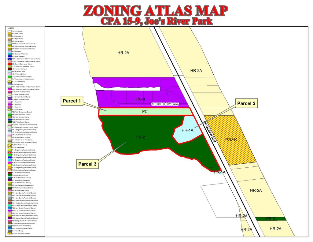
1 MARTIN COUNTY COMREHENSIVE LAN AMENDMENT REQUEST NUMBER: CA 15-9, Joe s River ark ALICANT: Martin County Board of County Commissioners RERESENTED BY: Deborah Drum Martin County Ecosystem Restoration & Management Manager LANNER-IN-CHARGE: Richard Lawton lanner II DATE: October 7, 2014 ORIGINAL MEETING REVISION DATE DATE LA MEETING: January 15, 2015 January 16, 2015 BCC TRANSMITTAL HEARING TRANSMITTAL TO DEO: ADOTION HEARING: FINAL TRANSMITTAL TO DEO: LA RECOMMENDATION: BCC TRANSMITTAL HEARING: BCC FINAL ACTION: Date January 15, 2015 The LA voted 4-0 to recommend approval of a land use change from Medium Density to Conservation on arcel 1. The LA also voted 4-0 to recommend approval of the zoning change from HR-1A to R on arcel 2 and from S-2 to C on arcel 3. SITE LOCATION: Joe s River ark is located on north Hutchinson Island, on the west side of NE Ocean Boulevard, just south of the Sailfish (Rigel s) Cove development. (See attached Location Map for location of parcel.) The site is divided into three parts, identified as: arcel 1, arcel 2, and arcel 3. ALICANT REQUEST: A request for a Future Land Use Map change, on the area identified as arcel 1, from Medium Density Residential to Institutional Conservation. And concurrent requests to change the zoning on arcel 2 from HR-1A (Single-family Residential) to R (ublic Recreation) and on arcel 3 from S-2 (ublic Service) to C (ublic Conservation). STAFF RECOMMENDATION: Staff recommends approval of the proposed future land use change from Medium Density Residential to Conservation on arcel 1. Staff also recommends approval of the requested zoning change on arcel 2 from HR-1A to R and on arcel 3 from S-2 to C. age 1 of 21
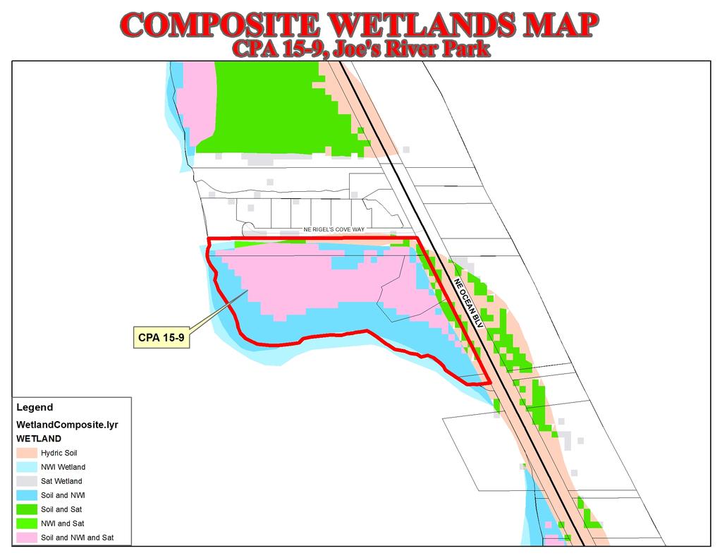
2 EXECUTIVE SUMMARY: The subject property is the county-owned Joe s River ark located on north Hutchinson Island, just south of the Sailfish (Rigel s) Cove development. The application is for a Future Land Use Map change on 2.25-acres from Medium Density Residential to Institutional Conservation. And concurrent requests to change the zoning from HR-1A (Single-family Residential) and S-2 (ublic Service), to R (ublic Recreation) and C (ublic Conservation). The portion of the property that is the subject of the zoning changes was originally acquired as part of a UD Agreement (OR Book 557, age 685) and conveyed to the County for the, sole and limited purpose that said lands shall forever be left in their natural state and used by Grantee herein only as a nature preserve and for no other purpose. The portion of the property that is the subject of the land use change was provided to the County (OR Book 606, age 1107), to be used for recreational purposes. The site is divided into three parcels which are identified as arcel 1, arcel 2, and arcel 3. arcel 1 is the subject of the land use change to Conservation. arcels 2 and 3 have zoning designations that are inconsistent with their existing land use designations. The proposal is to change the zoning on arcel 2 from HR-1A (Single-family Residential) to R (ublic Recreation) to be consistent with the existing Recreational land use on the parcel. The proposal is to change the zoning on arcel 3 from S-2 (ublic Service) to C (ublic Conservation) to be consistent with the existing Conservation land use on the parcel. The C (ublic Conservation) is the only current zoning district that implements the existing Institutional Conservation land use; and the R (ublic Recreation) is the only current zoning district that implements the existing Institutional Recreational land use. Comprehensive Growth Management policy 4.13A.11.(2) provides the Institutional Conservation land use designation for lands compatible with conservation and passive recreation and requires that environmentally sensitive lands acquired by the County be reclassified to the Institutional Conservation land use designation during the next plan amendment cycle. The only activities permitted on Conservation land are conservation of the natural features of the land and passive recreation that provides for the public's enjoyment of the property. Development is limited to conservation compatible access, maintenance, parking, and facilities such as walking trails and information booths. The site is located in a low lying coastal area and preliminary investigation suggests that there are extensive wetlands on the property. Both the Soil Survey of the Martin County Area, and the Composite Wetlands Map indicate that a substantial portion of the property is impacted by the presence of hydric soils and wetlands. The original intent of the purchase the property was the preservation of environmentally sensitive open space. The property acts as both natural habitat and as a buffer to surrounding development in storm events. Staff recommends approval of the proposed future land use change from Medium Density Residential to Institutional Conservation on arcel 1. Staff also recommends approval of the age 2 of 21
3 requested zoning change on arcel 2 from HR-1A to R (ublic Recreation) and on arcel 3 from S-2 to C (ublic Conservation). ALICATION HISTORY: October 7, 2014 The Board of County Commissioners initiated the Comprehensive lan Amendment by Resolution January 15, The LA voted 4-0 to recommend approval of a land use change from Medium Density Residential to Institutional Conservation on arcel 1. The LA also voted 4-0 to recommend approval of the zoning change from HR-1A to R on arcel 2 and from S-2 to C on arcel ROJECT/SITE SUMMARY 1.1. hysical/site Summary The parcel is within the following: lanning District: Hutchinson Island. Adjacent lanning District: North County. Commission District: District 1. Taxing District: District 1, Hutchinson Island Municipal Service Taxing Unit. 1.2 Major Roadways The subject parcel is located on the west side of NE Ocean Boulevard, just south of the Sailfish (Rigel s) Cove development. Ocean Boulevard is a major arterial that connects to NE Causeway Blvd. in Jensen Beach, and SE Ocean Blvd. in Stuart Current Amendment Requests CA 15-1, Kingsley: A request for a Future Land Use Map (FLUM) change from Rural Density to Low Density on a 5-acre parcel located on the west side of Berry Avenue in alm City. CA 15-2, Berry Retail: A request for a FLUM change from Rural Density to General Commercial on a 4.8-acre parcel located on the south side of SW Martin Highway approximately 400 feet west of Berry Avenue in alm City. CA 15-3, Sunshine Mobile Manor: A request for a FLUM change from Mobile Home to Commercial General on a 2.2-acre parcel located on the west side of US-1 a quarter-mile north of Salerno Road. CA 15-4, Davis Hobe Sound: A request for a FLUM change from Medium Density Residential to Commercial General on a 1.27-acre parcel located on the east side of US-1, just south of SE Woodland Road, in Hobe Sound. CA 15-5, DeMartini: A request for a FLUM change from Commercial Limited to Commercial General on a 2.1-acre parcel located on the east side of US-1, just north of the intersection with Cove Road. age 3 of 21
4 CA 15-6, Berry Retail-Galley: A request for a FLUM change from Rural Density to Limited Commercial on a 1.14-acre parcel located on the SW corner of SW Martin Highway and Berry Avenue in alm City. CA 15-7, Seacoast: A request for a FLUM change from Commercial Limited to Commercial General on one third of an acre located east of US-1 and on the north side of S.E. Cove Road. CA 15-8, Jensen Beach Impoundment: A request for a Future Land Use Map change from Estate Density 2UA to Conservation on a 91.8-acre parcel located on north Hutchinson Island. CA 15-9, Joe s River ark: A request for a Future Land Use Map change from Medium Density to Conservation on a 2.25-acre parcel located on north Hutchinson Island at Joe s River ark. CA 15-10, Bob Graham Beach: A request for a Future Land Use Map change from Estate Density 2UA and Medium Density to Conservation on a 5.3-acres located on north Hutchinson Island. CA 15-11, FL Oceanographic Society: A request for a Future Land Use Map change from Estate Density 2UA and Commercial General to Conservation on a 17.3-acre parcel located on north Hutchinson Island. CA 15-12, IR Water Treatment lant: A request for a Future Land Use Map change from Commercial General to Institutional General on a 7.5-acre parcel located on north Hutchinson Island. CA 15-13, River Cove: A request for a Future Land Use Map change from Commercial Waterfront to Recreational on a 5.2-acre parcel located on north Hutchinson Island. CA 15-14, Crystal Beach: A request for a Future Land Use Map change from Low Density to Conservation on a 16.2-acre parcel located on north Hutchinson Island. CA 15-15, alm Beach Heights: A request for a Future Land Use Map change from Agricultural to Conservation on a 1,432 individual parcels located in western Martin County ast Changes in Future Land Use Designations CA 06-1, Elliott Museum: A change on 16.5 acres from Institutional Recreation to Institutional General on the Elliott Museum property located on SE Ocean Boulevard on Hutchinson Island. CA 04-14, Curtis: A change on 3.01 acres from Estate Density 2UA to Institutional Conservation on the Curtis property located on NE Ocean Boulevard on Hutchinson Island. CA 04-14, Santa Lucea: A change on 10 acres from High Density Residential to Institutional Recreation on the Santa Lucea Beach property located on McArthur Boulevard on Hutchinson Island. age 4 of 21
5 CA 00-10, Muscara: A change on acres from Estate Density 2UA to Institutional Conservation on the Muscara tract property located on NE Ocean Boulevard on Hutchinson Island. CA 99-2, Hutchinson Island South: A change on acres from Estate Density 2UA to Institutional Conservation on property located on SE Ocean Boulevard on Hutchinson Island. CA 99-2, Hutchinson Island North: A change on 2.25 acres from Medium Density Residential to Institutional Conservation on property located on NE Ocean Boulevard on Hutchinson Island. CA 99-2, Dutcher II: A change on 38 acres from Estate Density 2UA to Institutional Conservation on the Dutcher property located on NE Ocean Boulevard on Hutchinson Island. CA 97-16a, Stuart Beach Addition: A change on 2.9 acres from Estate Density 2UA to Institutional Conservation on the Stuart Beach property located on NE Ocean Boulevard on Hutchinson Island. CA 94-2, Beach Walk: A change on 2.75, 2,78, and 7.41 acres from Medium and High Density Residential to Institutional Conservation on the Dubner asley parcels located on NE Ocean Boulevard on Hutchinson Island. CA 94-2, Tiger Shores: A change on 0.32 acres from Estate Density 2UA to Institutional Conservation on the South Tiger Shores property located on NE Ocean Boulevard on Hutchinson Island Adjacent Future Land Use North: Medium Density Residential. South: Conservation; Estate Density. East: Recreational. West: Water: Indian River Environmental Considerations Wetlands, soils and hydrology The Soil Survey of the Martin County Area, published by the United States Department of Agriculture (1978), lists the soil types on the subject property as follows: #30 Bessie muck. This nearly level soil is poorly drained; found in mangroves swamps along coastal areas. The soil is not suitable to cultivated crops, citrus, pasture, or pine trees. Table 9-4, Chapter 9, Conservation and Open Space, CGM, lists #30 Bessie muck, located on the property, as a soil type associated with forested saltwater wetland areas. The Composite Wetlands Map also indicates that a substantial portion of the property is impacted by the presence of hydric soils and wetlands. Martin County CGM policies 9.1G. do not allow negative impacts to wetlands. age 5 of 21
6 Wellfield protection The following is a description of the presence of existing wellfields proximate to the site and applicable wellfield protection measures. A preliminary investigation indicates that there are no public wells associated with Martin County Utilities on Hutchinson Island or near the subject property. Any new development near a public well must conform to the Martin County Wellfield rotection Ordinance and Groundwater rotection Ordinance before receiving development approval Adjacent Existing Uses Below is a summary of the existing adjacent land uses in the general vicinity of the subject property: NORTH: The Sailfish (Rigel s) Cove development. SOUTH: Conservation lands and a private boat dock. EAST: Bob Graham ark. WEST: The Indian River. 2. ANALYSIS The applicant must provide justification for the proposed amendment. The justification should examine specific changes occurring in the vicinity of the subject property, including changes in local utilities availability; thoroughfare structure; demographics; and surrounding land uses and zoning. Additionally, the existing physical characteristics of the parcel and any shifts in the local composition of the area's commercial, industrial, and/or residential character should be considered. The applicant should focus this justification on a specific, detailed analysis of the area, bearing in mind the future land use amendment approval criteria outlined in Section 1.11 of the Comprehensive Growth Management lan, Martin County Code. The Staff analysis is based on an evaluation of the amendment application materials, applicable Comprehensive Growth Management lan policies and other relevant information Criteria for a Future Land Use Amendment (Section 1-11 CGM) Four criteria in the Martin County Comprehensive Growth Management lan provide the basis for recommendations for future land use changes. In evaluating each future land use amendment, staff is directed by the Comprehensive Growth Management lan (pages 1-8) to assume that the 1982 and thus 1990 Future Land Use Maps, as amended, are an accurate representation of the Board of County Commissioners and thus the community's intent for the future of Martin County. Staff can recommend approval if any one of the four criteria are met. Staff must recommend denial if none of the criteria is met. An evaluation of these four criteria for this future land use request follows: 1. That past changes in land use designations in the general area make the proposed use logical and consistent with these uses and there is adequate availability of public services; or ast changes do not reflect a change to the area that would justify the proposed change to make it logical or consistent with the general area. Criteria number one has not been met. 2. That the growth in the area, in terms of development of vacant land, redevelopment and availability of public services, has altered the character of the area such that the proposed request is now reasonable and consistent with area land use characteristics; or age 6 of 21
7 The surrounding area has developed consistent with the FLUM. Development of the surrounding area alone is not sufficient to find that the character of the area has changed. Criteria number 2 has not been met. 3. That the proposed change would correct what would otherwise appear to be an inappropriately assigned land use designation; or The property was purchased with public funds in an effort to protect environmentally sensitive land along the coast on Hutchinson Island. olicy 4.13A.11., CGM, provides the guidelines for the correct land use for lands purchased for a public purpose. The proposed changes would correct what would otherwise appear to be an inappropriately assigned land use designation. Criteria number 3 has been met. 4. That the proposed change would meet a necessary public service need which enhances the health, safety, or general welfare of County residents. The site provides public open space and access to lands that are intended to be preserved in its natural state. The land provides coastal habitat and landward protection in storm events. Criteria number four has been met Urban Sprawl Florida Statute (3)(a)9. states that any amendment to the future land use element shall discourage the proliferation of urban sprawl and provides thirteen indicators to judge whether a future land use amendment discourages the proliferation of urban sprawl. Urban sprawl is defined as a development pattern characterized by low density, automobiledependent development with either a single use or multiple uses that are not functionally related, requiring the extension of public facilities and services in an inefficient manner, and failing to provide a clear separation between urban and rural uses. Florida Statute provides an additional eight criteria, of which four must be met, in order to judge whether an amendment can be determined to discourage the proliferation of urban sprawl. An evaluation of the thirteen indicators for urban sprawl and a determination on the eight criteria for this future land use request follows: (I) romotes, allows, or designates for development substantial areas of the jurisdiction to develop as low-intensity, low-density, or single-use development or uses. No. The site is proposed for conservation and no non-conservation development will be allowed on the site. (II) romotes, allows, or designates significant amounts of urban development to occur in rural areas at substantial distances from existing urban areas while not using undeveloped lands that are available and suitable for development. No. The site is located within the rimary Urban Service Area and intended for conservation to protect environmentally sensitive land in a low lying area. (III) romotes, allows, or designates urban development in radial, strip, isolated, or ribbon patterns generally emanating from existing urban developments. age 7 of 21
8 No. The site is proposed for conservation and no urban development will be allowed on the site. (IV) Fails to adequately protect and conserve natural resources, such as wetlands, floodplains, native vegetation, environmentally sensitive areas, natural groundwater aquifer recharge areas, lakes, rivers, shorelines, beaches, bays, estuarine systems, and other significant natural systems. No. The site has been specifically identified as environmentally sensitive land situated in a low lying coastal area. The intent is to protect the site from urban development. (V) Fails to adequately protect adjacent agricultural areas and activities, including silviculture, active agricultural and silvicultural activities, passive agricultural activities, and dormant, unique, and prime farmlands and soils. No. There is no agriculture, silviculture, or farmland in the immediate area. (VI) Fails to maximize use of existing public facilities and services. No. The parcel is located within the rimary Urban Service District where public facilities and services are planned for anticipated growth patterns. Any activity on the property would access existing public facilities and services. (VII) Fails to maximize use of future public facilities and services. No. The parcel is located within the rimary Urban Service District where public facilities and services are planned for anticipated growth patterns. Any activity on the site would access existing public facilities and services. (VIII) Allows for land use patterns or timing which disproportionately increase the cost in time, money, and energy of providing and maintaining facilities and services, including roads, potable water, sanitary sewer, stormwater management, law enforcement, education, health care, fire and emergency response, and general government. No. The subject parcel is located within the rimary Urban Service District where public services are already in place. (IX) Fails to provide a clear separation between rural and urban uses. The subject parcel is located within the rimary Urban Service District which separates rural and urban uses. (X) Discourages or inhibits infill development or the redevelopment of existing neighborhoods and communities. No. The site has been identified as environmentally sensitive land situated in a low lying coastal area. It is unlikely the site could be developed in any significant way. Any proposed development would be severely restricted because of the large amount of wetlands on the site. (XI) Fails to encourage a functional mix of uses. No. The proposed land use provides needed open space and protects environmentally sensitive land. (XII) Results in poor accessibility among linked or related land uses. age 8 of 21
9 No. The parcel is located on a major arterial. The proposed land use changes will not change the accessibility among existing land uses. (XIII) Results in the loss of significant amounts of functional open space. No. The site has been specifically identified as environmentally sensitive land situated in a low lying coastal area. The conservation designation is functional open space roliferation of Urban Sprawl In order for the application to be determined to discourage the proliferation of urban sprawl, the amendment must incorporate development patterns or urban form that achieve four or more of the following: (I) Directs or locates economic growth and associated land development to geographic areas of the community in a manner that does not have an adverse impact on and protects natural resources and ecosystems. The site is identified as environmentally sensitive land situated in a low lying coastal area. The conservation designation is intended to protect natural resources and ecosystems. This criterion has been met. (II) romotes the efficient and cost-effective provision or extension of public infrastructure and services. The parcel is located within the rimary Urban Service District where public infrastructure and services are already in place. The site would access existing public facilities and services. This criterion has been met. (III) romotes walkable and connected communities and provides for compact development and a mix of uses at densities and intensities that will support a range of housing choices and a multimodal transportation system, including pedestrian, bicycle, and transit, if available. The parcel is located near existing developments that provide a mix of densities and intensities. No change in the existing mix is contemplated by this proposal. This criterion has been met. (IV) romotes conservation of water and energy. No development of the site is proposed. The proposal is to place the property into conservation. This criterion has been met. (V) reserves agricultural areas and activities, including silviculture, and dormant, unique, and prime farmlands and soils. Not applicable. There is no agriculture, silviculture, or farmland in the immediate area. (VI) reserves open space and natural lands and provides for public open space and recreation needs. The site is identified as environmentally sensitive land situated in a low lying coastal area. The conservation designation preserves natural land and provides for public open space and passive recreation needs. This criterion has been met. age 9 of 21
10 (VII) Creates a balance of land uses based upon demands of residential population for the nonresidential needs of an area. The site is identified as environmentally sensitive land situated in a low lying coastal area. The conservation designation provides for public open space and fulfills the need for passive recreation area. This criterion has been met. (VIII) rovides uses, densities, and intensities of use and urban form that would remediate an existing or planned development pattern in the vicinity that constitutes sprawl or if it provides for an innovative development pattern such as transit-oriented developments or new towns as defined in s Not applicable. The site is environmentally sensitive land, situated in a low lying coastal area, intended for conservation. 2.3 General Land Use Issues The request is for a Future Land Use Map change from Medium Density Residential to Institutional Conservation. Comprehensive Growth Management lan, olicy 4.13A.11., states that lands acquired for public purpose must have its land use changed to the appropriate Institutional land use designation. The existing Estate Density 2UA land use designation is a residential district that allows density up to two units per acre and is generally assigned to land located on the fringe of the rimary Urban Service District that lack accessibility to a full complement of urban services. The CGM also assigns Estate Densities to selected areas near existing estate development that share similar characteristics with existing residential estates and to areas in the urban service districts that require density limitations because of unique problems of urban services. The Comprehensive Growth Management lan provides the below policies for the existing Medium Density and the proposed Institutional Conservation land uses: Medium Density Land Use: olicy 4.13A.7.(4) Medium Density Residential development. The Medium Density Residential designation is reserved for land in the core of the rimary Urban Service District and accessible to employment centers. The maximum density is eight units per gross acre. However, sites may be approved for a maximum of 10 units per gross acre (a density bonus), after demonstrating compliance with all of the following criteria: (a) The development commits to providing affordable or workforce housing to eligible households as defined by the Housing Element; (b) The site is or can be serviced by a full complement of urban services including water and wastewater service from a regional public utility; (c) The applicant provides a significant open space buffer, natural landscape (including a landscaped berm where appropriate), plant material and/or an aesthetic wall or fence to effectively shield the Residential use from any existing or potential adjacent nonresidential use or from any single-family use. In reviewing specific densities, the aim shall be to preserve the stability of established residential areas. Landscaping, screening, buffering and similar design techniques shall be used to assure a smooth transition between residential structure types and densities. age 10 of 21
11 Institutional Conservation Land Use: olicy 4.13A.11. Institutional development. The FLUM contains three separate land use categories for institutional development. Recreational, ublic Conservation and General Institutional categories allow for varying degrees of use and development. Institutional land shall be owned by public agencies or nonprofit service providers, except for investor-owner public water and sewer systems, private cemeteries and private hospitals existing as of October 26, In addition, privately owned land subject to perpetual easements as provided under Objective 4.5F may be designated Institutional ublic Conservation. (1) (2) (3) Recreational. Recreational lands are designed for activity-based and resource-based recreational uses and typically contain recreational facilities and substantial access improvements. Lands assigned to the Recreational category may be developed only as public recreation areas or used for temporary storage of dredged spoil material resulting from the construction, reconstruction or maintenance of recreation facilities. Examples include Langford ark in Jensen Beach, endarvis Cove ark in alm City and J.V. Reed ark in Hobe Sound. Lands acquired by the County for Recreational uses shall be reclassified to the Institutional-Recreation land use designation during the next plan amendment cycle. The minimum open space shall be 40 percent, maximum building coverage shall be 45 percent and maximum building height shall be 40 feet. ublic Conservation. The ublic Conservation category recognizes publicly owned areas designed for conservation uses. In addition, privately owned land subject to perpetual easements as provided under Objective 4.5F may be designated Institutional ublic Conservation. Only development compatible with conservation and passive recreation uses shall be permitted in the ublic Conservation category. This may include access, parking and other facilities that enable the management of the resource and the public's enjoyment of it. Conservation areas include the Duuis reserve in south Martin County and the Savannas in north Martin County. Environmentally sensitive lands acquired by the County shall be reclassified to the Institutional-Conservation land use designation during the next plan amendment cycle. General Institutional. The General Institutional category accommodates public and notfor-profit facilities such as schools, government buildings, civic centers, prisons, major stormwater facilities, fire and emergency operation centers, public cemeteries, hospitals, publicly owned water and sewer systems, dredge spoil management sites and airports. Investor-owned regional public water and sewer systems and private cemeteries may be allowed in General Institutional. Lands acquired by the County for General Institutional uses shall be reclassified to the Institutional-General land use designation during the next plan amendment cycle, as will lands or property rights acquired by the Florida Inland Navigation District as future dredge spoil management sites. Although Institutional use is reserved for the uses cited above, this shall not prohibit forprofit medical offices and other ancillary facilities owned by a nonprofit hospital as long as they are part of a UD. The impervious area covered by buildings and required parking for such medical offices shall not include more than 12 percent of the site. ublic and/or private development of airport property owned or managed by the County shall be subject to an Airport Zoning District or lanned Unit Development (Airport) zoning district developed to implement this policy. It shall apply only to airports owned or managed by the County. rivatized government operations shall be allowed in Institutional land use when the land is publicly owned and the private entity is acting under contract with the government that would normally provide the service. age 11 of 21
12 All Institutional development must meet all suitability and compatibility standards in the CGM. Minimum open space requirement shall be 40 percent, maximum building height shall be 40 feet and maximum building coverage shall be 45 percent Capital Facilities Impact (i.e. Concurrency Management) olicy 4.1B.2. of the Future Land Use Element states: All requests for amendments to the FLUMs shall include a general analysis of (1) the availability and adequacy of public facilities and (2) the level of services required for public facilities in the proposed land uses. This analysis shall address, at a minimum, the availability of category A and category C service facilities as defined in the Capital Improvements Element. No amendment shall be approved unless present or planned public facilities and services will be capable of meeting the adopted LOS standards of this lan for the proposed land uses. olicy 4.1B.2. Analysis of availability of public facilities, of the Future Land Use Element states, All requests for amendments to the FLUMs shall include a general analysis of (1) the availability and adequacy of public facilities and (2) the level of services [LOS] required for public facilities in the proposed land uses. This analysis shall address, at a minimum, the availability of category A and category C service facilities as defined in the Capital Improvements Element. No amendment shall be approved unless present or planned public facilities and services will be capable of meeting the adopted LOS standards of this lan for the proposed land uses. The Capital Improvements Element, or other relevant plan provisions, and the FLUMs may be amended concurrently to satisfy this criterion. The intent of this provision is to ensure that the elements of the CGM remain internally consistent Mandatory Facilities Water/Sewer Facilities The Level of Service standard for nonresidential water service is 0.1 gallons per sq. ft. The Level of Service for nonresidential wastewater service is 0.1 gallons per sq. ft. If needed, the parcel would be provided water and sewer service by Martin County Utilities. According to a memo from the Utilities Department dated October 15, 2014, the Martin County Consolidated Water System has 18.8 million gallons per day of plant capacity. The maximum day flow in the past 12 months was MGD. rojects With Service Agreements have reserved: MGD. Martin County Utilities has MGD available water supply capacity. The Martin County (North) Sanitary Sewer System has a permitted capacity of MGD. Maximum Month Average Daily Flow: MGD. rojects with service agreements: MGD. Martin County (North) Utilities has MGD of available sanitary sewer capacity. No non-conservation development is proposed for the site. The County s concern for concurrency with the water and wastewater code requirements is evaluated through Martin County s development review process and any proposed development would be required to submit an application for Development Review. A preliminary review indicates that excess capacity exists for both water and sanitary sewer service. age 12 of 21
13 Drainage Facilities There is no proposal for any development on the site at this time. The Martin County Land Development Regulations do not allow post-development discharge to exceed pre-development discharge. The post development level of service for drainage must meet or exceed level of service standards. Implementation of the following lan policies must be done during the site plan review process: Section 13.2.D.(2). All project sites shall control the timing of discharges to preclude any off-site impact for any storm event. The peak discharge rate shall not exceed the predevelopment discharge rate for the 25-year frequency, 3-day duration storm event. olicy 13.1C.3. Enforcement of level-of-service standards.: Martin County shall enforce the level of service standards in section through the Land Development Regulations. The design criteria used to reach these levels of service will be the same as those of the SFWMD for all development except single-family residential lots of less than five acres. olicy 13.1C.7. Contribution for off-site drainage improvements.: All new developments shall provide an equitable contribution for off-site drainage improvements necessitated by the development. No new development shall be allowed that reduces services below the level of service standard established for the existing off-site facilities. Section 14.1A.2.(9) Levels of service for on-site improvements, including local streets, water and sewer connection lines, stormwater management facilities and open space shall be as required of the developer in the County Land Development Regulations Transportation olicy 5.2A.1. Establish a base level of service., CGM states, The base LOS standard for all roadways is D during peak hour/peak season, except for the Florida Intrastate Highway System roadways on the Strategic Intermodal System and for facilities funded with the Transportation Regional Incentive rogram that lie outside the urbanized area where LOS C is assigned, or except where an interim level of service has been assigned as described in Section 5.3.B. The methodology for determining roadway facilities level of service shall adhere to the methodologies identified in the latest FDOTs Q/LOS Handbook. There is no proposal for any development on the site at this time. No additional traffic impact is anticipated as a result of the proposed land use change Solid Waste Facilities The required LOS in Martin County is 1.06 tons of capacity per weighted average population. The weighted average population (the average of seasonal and full time residents) in Fiscal year 2015 is 159,178 persons. The landfill has 238,767 tons of available capacity or 1.5 tons per weighted person. A contract was signed on August 23, 2002 between Martin County and age 13 of 21
14 Okeechobee Landfill Inc., a division of Waste Management Inc., for the disposal of Martin County solid waste for the next 30 years. When the municipal solid waste facility(ies) falls below the capacity levels stated above or when the remaining life of the facility(ies) reaches two years, Martin County shall immediately commence with a process to ensure no interruption in disposal activities will occur arks/recreation Facilities arks and recreation facilities are calculated on a countywide basis. The county has a weighted average population of 159,178 persons and a total population in Fiscal year 2015 of 152,000 persons. There are currently 890 acres of active parkland available in the County. The 2015 Capital Improvements lan provides the following LOS analysis for services. REQUIRED LOS ROVIDED CURRENT LOS ACTIVE ARKLAND 3 acres per 1000 residents 890 acres 5.86 acres per 1000 residents BEACH FACILITIES 9 spaces per 1000 residents 1471 spaces 9.7 spaces per 1000 residents ATHWAYS 5 linear feet per weighted 6.03 linear feet per 959,696 linear feet average resident resident Fire/ublic Safety/EMS The minimum water delivery rate for any single fire hydrant is 500 gallons per minute with a minimum pressure in any point within a water distribution system of 20 psi. Emergency Services for Martin County is calculated for the unincorporated area. The levels of service for the unincorporated area of the county are as follows: Advanced life support 8 minutes 90% of time in urban area. Advanced life support 20 minutes 90% of time in rural area. Basic life support 6 minutes 90% of time on urban area. Basic life support 15 minutes 90% of time on rural area. Fire response 6 minutes 90% of time of urban area. Fire response 15 minutes 90% of time of rural area. The existing County Fire EMS services meet or exceed the minimum level of service. FISCAL YEAR WT AVER UNIN O 1 Apr of FY REQUIRED RESONSE TIME- ALS/U REQUIRED RESONSE TIME- ALS/R REQUIRED RESONSE TIME- BLS/U REQUIRED RESONSE TIME- BLS/R REQUIRED RESONSE TIME- FIRE/U REQUIRED RESONSE TIME- FIRE/R REQUIRED LOS CURRENT LOS FY Schools No additional students are expected as a result of the assignment of the Conservation land use designation to the property. The County must coordinate with the School Board of Martin County for a LOS analysis as provided for under Section CGM. Determination of adequate school capacity for any development, pursuant to the requirements of the Comprehensive lan and Land Development Regulations, is done during the final site plan review process. age 14 of 21
15 Non-Mandatory Facilities Libraries Library level of service is calculated on a countywide basis and has a goal of 0.60 gross square feet of library space per resident; and two volumes of reading material per weighted average resident. The 2015 Capital Improvements lan shows the current gross square footage of library space is 110,026. When the square footage is divided by total population of 152,000 the result is 0.72 square feet per resident. There are currently 370,094 volumes available for a 2014 weighted average population of 159,178 resulting in 2.33 volumes per person. The current Library LOS services meets or exceeds the minimum level of service Criteria for a Zoning Change The request is for a Future Land Use Map change, on the 2.25-acres identified as arcel 1, from Medium Density Residential to Institutional Conservation. The existing zoning on arcel 1is C and is consistent with the proposed Conservation land use so no zoning change is proposed. arcels 2 and 3 have zoning designations that are inconsistent with the existing land use designations. The proposal is to change the zoning on arcel 2 from HR-1A (Single-family Residential) to R (ublic Recreation) to be consistent with the existing Recreational land use on the parcel. The proposal is to change the zoning on arcel 3 from S-2 (ublic Service) to C (ublic Conservation) to be consistent with the existing Conservation land use on the parcel. The C (ublic Conservation) is the only current zoning district that implements the proposed Institutional Conservation land use; and the R (ublic Recreation) is the only current zoning district that implements the existing Institutional Recreational land use. Staff recommends approval of the proposed future land use change from Medium Density Residential to Conservation on arcel 1. Staff also recommends approval of the requested zoning change on arcel 2 from HR-1A to R and on arcel 3 from S-2 to C ermitted Uses Below are excerpts from Article 3 of the Land Development Regulations, Martin County Code including the permitted use schedule for the various zoning districts. The following land uses in the left column below are implemented by the corresponding zoning districts in the right column. Institutional Conservation Institutional Recreational C R Lands zoned in accordance with this Division shall be limited to the uses indicated as permitted in Table A "" indicates that the use is permitted within that zoning district provided age 15 of 21
16 that the use can be developed in accordance with, the requirements set forth in Divisions 3 and 4 and all other applicable requirements of this Article and the LDR. TABLE 3.11 ERMITTED USES USE CATEGORY H R- 1 A R C S- 2 Residential Uses Accessory dwelling units Apartment hotels Mobile homes Modular homes Multifamily dwellings Single-family detached dwellings Single-family detached dwellings, if established prior to the effective date of this ordinance Townhouse dwellings Duplex dwellings Zero lot line single-family dwellings Agricultural Uses Agricultural processing, indoor Agricultural processing, outdoor Agricultural veterinary medical services Aquaculture Crop farms Dairies Exotic wildlife sanctuaries Farmer's markets Feed lots Fishing and hunting camps Orchards and groves lant nurseries and landscape services Ranches Silviculture Stables, commercial Storage of agricultural equipment, supplies and produce Wildlife rehabilitation facilities ublic and Institutional Uses Administrative services, not-for-profit age 16 of 21
17 Cemeteries, crematory operations and columbaria Community centers Correctional facilities Cultural or civic uses Dredge spoil facilities Educational institutions Electrical generating plants Fairgrounds Halfway houses Halfway houses, on lots where such use was lawfully established prior to the effective date of this ordinance Hospitals Neighborhood assisted residences with six (6) or fewer residents Neighborhood boat launches Nonsecure residential drug and alcohol rehabilitation and treatment facilities Nonsecure residential drug and alcohol rehabilitation and treatment facilities, on lots where such use was lawfully established prior to the effective date of this ordinance laces of worship ost offices rotective and emergency services ublic libraries ublic parks and recreation areas, active ublic parks and recreation areas, passive ublic vehicle storage and maintenance Recycling drop-off centers Residential care facilities Solid waste disposal areas Utilities Commercial and Business Uses Adult business Ancillary retail use Bed and breakfast inns Business and professional offices Campgrounds Commercial amusements, indoor Commercial amusements, outdoor Commercial day care Construction industry trades Construction sales and services Family day care age 17 of 21
18 Financial institutions Flea markets Funeral homes General retail sales and services Golf courses Golf driving ranges Hotels, motels, resorts and spas Kennels, commercial Limited retail sales and services Marinas, commercial Marine education and research Medical services ain management clinics arking lots and garages Recreational vehicle parks Recreational vehicle parks, limited to the number and configuration of units lawfully established prior to the effective date of this ordinance Residential storage facilities Restaurants, convenience, with drive-through facilities Restaurants, convenience, without drive-through facilities Restaurants, general Shooting ranges Shooting ranges, indoor Shooting ranges, outdoor Trades and skilled services Vehicular sales and service Vehicular service and maintenance Veterinary medical services Wholesale trades and services Transportation, Communication and Utilities Uses Airstrips Airports, general aviation Industrial Uses Composting, where such use was approved or lawfully established prior to March 1, 2003 Extensive impact industries Limited impact industries Mining Salvage yards Yard trash processing age 18 of 21
19 Yard trash processing on lots where such use was lawfully established prior to March 29, 2002 Life Science, Technology and Research (LSTAR) Uses Biomedical research Bioscience research Computer and electronic components research and assembly Computer and electronic products research and assembly Computer programming/software research Computer system design Electromedical apparatus research and assembly Electronic equipment research and assembly Laser research and assembly Lens research Management, scientific and technical services Marine Research Medical and dental labs Medical equipment assembly Optical equipment assembly Optical instruments assembly Optoelectronics assembly harmaceutical products research recision instrument assembly rofessional, scientific and technical services Reproducing magnetic and optical media Research and development laboratories and facilities, including alternative energy Scientific and technical consulting services Simulation training Technology centers Telecommunications research Testing laboratories Targeted Industries Business (TIB) Uses Aviation and aerospace manufacturing Business-to-business sales and marketing Chemical manufacturing Convention centers Credit bureaus Credit intermediation and related activities Customer care centers Customer support Data processing services age 19 of 21
20 Electrical equipment and appliance component manufacturing Electronic flight simulator manufacturing Fiber optic cable manufacturing Film, video, audio and electronic media production and postproduction Food and beverage products manufacturing Funds, trusts and other financial vehicles Furniture and related products manufacturing Health and beauty products manufacturing Information services and data processing Insurance carriers Internet service providers, web search portals Irradiation apparatus manufacturing Lens manufacturing Machinery manufacturing Management services Marine and marine related manufacturing Metal manufacturing National, international and regional headquarters Nondepository credit institutions Offices of bank holding companies On-line information services erforming arts centers lastics and rubber products manufacturing rinting and related support activities Railroad transportation Reproducing magnetic and optical media manufacturing Securities, commodity contracts Semiconductor manufacturing Simulation training Spectator sports Surgical and medical instrument manufacturing Technical support Telephonic and on-line business services Textile mills and apparel manufacturing Transportation air Transportation equipment manufacturing Transportation services Transaction processing Trucking and warehousing Wood and paper product manufacturing age 20 of 21
21 3. FIGURES/ATTACHMENTS Figure 1, Location Map Figure 2, Aerial hotograph Figure 3, Future Land Use Map Figure 4, roposed Future Land Use Map Figure 5, Zoning Map Figure 6, roposed Zoning Map Figure 7, Composite Wetlands Map age 21 of 21

22

23

24
25
26
27
28
MARTIN COUNTY COMPREHENSIVE PLAN AMENDMENT ORIGINAL MEETING REVISION DATE
 REQUEST NUMBER: CPA 15-14, Crystal Beach MARTIN COUNTY COMPREHENSIVE PLAN AMENDMENT APPLICANT: Martin County Board of County Commissioners REPRESENTED BY: Deborah Drum Martin County Ecosystem Restoration
MARTIN COUNTY COMPREHENSIVE PLAN AMENDMENT ORIGINAL MEETING REVISION DATE
 MARTIN COUNTY COMPREHENSIVE PLAN AMENDMENT REQUEST NUMBER: CPA 15-10, Bob Graham Beach APPLICANT: Martin County Board of County Commissioners REPRESENTED BY: Deborah Drum Martin County Ecosystem Restoration
TREASURE COAST REGIONAL PLANNING COUNCIL M E M O R A N D U M. To: Council Members AGENDA ITEM 9D
 TREASURE COAST REGIONAL PLANNING COUNCIL M E M O R A N D U M To: Council Members AGENDA ITEM 9D From: Date: Subject: Staff May 15, 2015 Council Meeting Local Government Comprehensive Plan Review Draft
MARTIN COUNTY COMPREHENSIVE PLAN AMENDMENT/REZONING REVIEW
 MARTIN COUNTY COMPREHENSIVE PLAN AMENDMENT/REZONING REVIEW REQUEST 15-16 EOC. MARTIN COUNTY COMPREHENSIVE PLAN AMENDMENT/REZONING REVIEW REQUEST NUMBER: #CPA 15-16, Former Emergency Operations Center APPLICANT:
FOR SALE 2275 SW MARTIN HIGHWAY, PALM CITY, FL
 FOR SALE 2275 SW MARTIN HIGHWAY, PALM CITY, FL SW BERRY Potential Development Site CRA Palm City SUBJECT SW MARTIN HWY Old Palm City Town Center LOCATION: Near I-95, the Florida Turnpike and Martin Downs
BOARD OF COUNTY COMMISSIONERS AGENDA ITEM SUMMARY
 6H BOARD OF COUNTY COMMISSIONERS AGENDA ITEM SUMMARY PLACEMENT: PUBLIC HEARINGS PRESET: TITLE: LEGISLATIVE PUBLIC HEARING TO CONSIDER TRANSMITTAL OF COMPREHENSIVE PLAN AMENDMENT 16-8, MAGGY S HAMMOCK PARK,
JL CAPITAL ONE, LLC REZONING
 { MARTIN COUNTY, FLORIDA DEVELOMENT REVIEW STAFF REORT A. Application Information JL CAITAL ONE, LLC REZONING Applicant: JL Capital One, LLC roperty Owner: JL Capital One, LLC Agent for the Applicant:
AQUARIUS LAND HOLDINGS, LLC TRACTS 3 AND 6 REZONING
 { MARTIN COUNTY, FLORIDA DEVELOPMENT REVIEW STAFF REPORT A. Application Information AQUARIUS LAND HOLDINGS, LLC TRACTS 3 AND 6 REZONING Applicant: Aquarius Land Holdings, LLC Property Owner: Aquarius Land
Nassau County Department of Planning & Economic Opportunity Nassau Place Yulee, Florida 32097
 Nassau County Department of Planning & Economic Opportunity 96161 Nassau Place Yulee, Florida 32097 APPLICATION AND INSTRUCTIONS FOR FUTURE LAND USE MAP AMENDMENT (TEN (10) ACRES OR MORE) NOTICE: Florida
FUTURE LAND USE. City of St. Augustine Comprehensive Plan EAR-Based Amendments
 FUTURE LAND USE City of St. Augustine Comprehensive Plan EAR-Based Amendments Future Land Use Element FLU Goal To create an environment within the City and adjacent areas in which its residents have the
KLOPENSTINE REZONING
 { MARTIN COUNTY, FLORIDA DEVELOPMENT REVIEW STAFF REPORT A. Application Information KLOPENSTINE REZONING Applicant: Klopenstine Geoffrey A Tr Property Owner: Klopenstine Geoffrey A Tr Agent for the Applicant:
NUVIEW IRA, INC. REZONING
 { MARTIN COUNTY, FLORIDA DEVELOMENT REVIEW STAFF REORT A. Application Information Applicant and roperty Owner Agent for the Applicant: County roject Coordinator: Growth Management Director: roject Number:
1 Chapter 4 FUTURE LAND USE ELEMENT Section 4.1. Background information. 4.1.A. Land use profile. Indiantown possesses a unique and valuable mix of ph
 1 Chapter 4 FUTURE LAND USE ELEMENT Section 4.1. Background information. 4.1.A. Land use profile. Indiantown possesses a unique and valuable mix of physical and man-made resources centered on the Okeechobee
Required and optional elements of comprehensive plan; studies and surveys.
 163.3177 Required and optional elements of comprehensive plan; studies and surveys. (1) The comprehensive plan shall provide the consist of materials in such descriptive form, written or graphic, as may
1.300 ZONING DISTRICT REGULATIONS
 1.205 VACANT LOT SPECIAL REQUIREMENTS: On lots less than 1.5 acres, only one garage allowed with a maximum size of 672 square feet in area. 1.300 ZONING DISTRICT REGULATIONS 1.301 ESTABLISHMENT OF DISTIRCTS:
(B) On lots less than 1.5 acres, accessory buildings shall have a maximum size of 672 square feet in area.
 On lots less than 1.5 acres, accessory buildings shall have a maximum size of 672 square feet in area.") Setbacks in Commercial Districts: (1) Downtown Business District: Setbacks from State Highways 70 and 155 shall be the lesser of a minimum of 100 feet or the footprint of the present principal building
Setbacks in Commercial Districts: (1) Downtown Business District: Setbacks from State Highways 70 and 155 shall be the lesser of a minimum of 100 feet or the footprint of the present principal building
ARTICLE 6 RU, RURAL ZONING DISTRICTS. RU (Rural) Zoning Districts are established to achieve the following purposes:
 Zoning Districts are established to achieve the following purposes:") ARTICLE 6 RU, RURAL ZONING DISTRICTS 601 Purpose RU (Rural) Zoning Districts are established to achieve the following purposes: 601.01 To preserve the character of areas designated as "Rural" in the Cochise
ARTICLE 6 RU, RURAL ZONING DISTRICTS 601 Purpose RU (Rural) Zoning Districts are established to achieve the following purposes: 601.01 To preserve the character of areas designated as "Rural" in the Cochise
Marion County Board of County Commissioners
 Marion County Board of County Commissioners Date: 6/4/217 P&Z: 9/25/217 BCC Transmittal: 1/17/217 BCC Adopt: TBD Amendment No: 217-L6 Type of Application Large-Scale Comp Plan Amendment Request: Change
Glades County Staff Report and Recommendation Unified Staff Report for Small Scale Plan Amendment and Rezoning
 Glades County Staff Report and Recommendation Unified Staff Report for Small Scale Plan Amendment and Rezoning CASE NUMBERS: COMP17-02 and RZ17-02 DATE of STAFF REPORT: May 1, 2017 CASE TYPE: Application
1. Future Land Use FLU6.6.8 Land uses within the Rural Service Area portion of the Wekiva Study Area shall be limited to very low and low intensity
 1. Future Land Use FLU6.6.8 Land uses within the Rural Service Area portion of the Wekiva Study Area shall be limited to very low and low intensity uses to the greatest extent possible. Existing land uses
INDIAN RIVER COUNTY, FLORIDA. The Honorable Members of the Planning and Zoning Commission DEPARTMENT HEAD CONCURRENCE
 Public Hearing Legislative INDIAN RIVER COUNTY, FLORIDA M E M O R A N D U M TO: The Honorable Members of the Planning and Zoning Commission DEPARTMENT HEAD CONCURRENCE Robert M. Keating, AICP; Community
8Land Use. The Land Use Plan consists of the following elements:
 8Land Use 1. Introduction The Land Use Plan consists of the following elements: 1. Introduction 2. Existing Conditions 3. Opportunities for Redevelopment 4. Land Use Projections 5. Future Land Use Policies
2. Second dwellings and medical hardships per Article 10.
 Article 7: Zoning Districts and Zoning Map Section 135: NON-URBAN ZONING DISTRICT (NU) A. Purpose The intent of this district is to allow agricultural, recreational, wildlife, forestry, open space, farming
Planning Department Oconee County, Georgia
 Planning Department Oconee County, Georgia STAFF REPORT REZONE CASE #: 6985 DATE: October 31, 2016 STAFF REPORT BY: Andrew C. Stern, Planner APPLICANT NAME: Williams & Associates, Land Planners PC PROPERTY
Application to Amend the Bay County Zoning Map (Please type or print clearly)
") Application to Amend the Bay County Zoning Map (Please type or print clearly) File No.: Date Received: A) Applicant Information Owners Authorized name: agent: Mailing Mailing address: address: E-mail:
Application to Amend the Bay County Zoning Map (Please type or print clearly) File No.: Date Received: A) Applicant Information Owners Authorized name: agent: Mailing Mailing address: address: E-mail:
TREASURE COAST REGIONAL PLANNING COUNCIL M E M O R A N D U M
 TREASURE COAST REGIONAL PLANNING COUNCIL M E M O R A N D U M To: Council Members AGENDA ITEM 6A From: Date: Subject: Staff May 20, 2011 Council Meeting Local Government Comprehensive Plan Review Draft
PUTNAM COUNTYCOMPREHENSIVE PLAN
 COMPREHENSIVE PLAN EXHIBIT AA COMPREHENSIVE PLAN A. Future Land Use Element Goals, Objectives, Policies This section proposed objectives and policies, which will assist Putnam County Commissioners and
Commercial and Manufacturing Districts TABLE ALLOWED USES AND PERMIT REQUIREMENTS FOR COMMERCIAL AND MANUFACTURING DISTRICTS
 TRUCKEE MUNICIAL CODE - TITLE 18, DEVELOMENT CODE TABLE 2-6 - ALLOWED USES AND ERMIT REQUIREMENTS FOR COMMERCIAL AND MANUFACTURING DISTRICTS ERMIT REQUIREMENT BY DISTRICT LAND USE (1) CN (2) CG CH CS M
This is a New Findings of Adequacy for a Recorded Plat (Plat Book 179, Page 131) LAND USE Vacant Effective Plan: Pompano Beach
 LAND USE Vacant Effective Plan: Pompano Beach") Page 1 of 11 Board of County Commissioners, Broward County, Florida Environmental Protection and Growth Management Department Planning and Development Management Division DEVELOPMENT REVIEW REPORT PROJECT
Page 1 of 11 Board of County Commissioners, Broward County, Florida Environmental Protection and Growth Management Department Planning and Development Management Division DEVELOPMENT REVIEW REPORT PROJECT
PLANNING COMMISSION REPORT Regular Agenda Public Hearing Item
 PC Staff Report 11/12/12 Item No. 2B- 1 PLANNING COMMISSION REPORT Regular Agenda Public Hearing Item ITEM NO. 2B: A TO GPI; 110 ACRES; E OF K-10 & N OF W 6 TH ST (MKM) : Consider a request to rezone approximately
Appendix A: Guide to Zoning Categories Prince George's County, Maryland
 Appendix A: Guide to Zoning Categories Prince George's County, Maryland RESIDENTIAL ZONES 1 Updated November 2010 R-O-S: Reserved Open Space - Provides for permanent maintenance of certain areas of land
LARGE- AND SMALL-SCALE COMPREHENSIVE PLAN AMENDMENT INSTRUCTIONS AND INFORMATION PACKET
 LARGE- AND SMALL-SCALE COMPREHENSIVE PLAN AMENDMENT INSTRUCTIONS AND INFORMATION PACKET MARION COUNTY GROWTH SERVICES 2710 E. Silver Springs Blvd. Ocala, FL 34470 Phone 352-438-2600 Fax 352-438-2601 http://www.marioncountyfl.org/planning.htm
SECTION 4 ZONING DISTRICTS
 SECTION 4 ZONING DISTRICTS Sec. 4-1 Establishment of Districts. In order to protect the character of existing neighborhoods, to prevent excessive density of population in areas which are not adequately
Chapter 100 Planned Unit Development in Corvallis Urban Fringe
 100.100 Scope and Purpose. Chapter 100 Planned Unit Development in Corvallis Urban Fringe (1) All applications for land divisions in the Urban Residential (UR) and Flood Plain Agriculture (FPA) zones within
THE GROVE GOLF CLUB PLAT
 { MARTIN COUNTY, FLORIDA DEVELOPMENT REVIEW STAFF REPORT A. Application Information THE GROVE GOLF CLUB PLAT Applicant: Hobe Sound Equestrian, LLC Property Owner: Becker B-14 Grove, Ltd Agent for the Applicant:
CHAPTER 3 REGULATIONS INSIDE THE COASTAL ZONE
 CHAPTER 3 REGULATIONS INSIDE THE COASTAL ZONE Organization. Chapter 3 contains the regulations which apply exclusively within the California Coastal Zone in Humboldt County and is organized as follows:
WOODLAND AREA GENERAL PLAN URBAN DEVELOPMENT POLICY
 APPENDIX A WOODLAND AREA GENERAL PLAN URBAN DEVELOPMENT POLICY The following text indicates proposed amendments to the Woodland Area General Plan Urban Development Policy currently adopted and included
CITY OF PORT ORCHARD
 CITY OF PORT ORCHARD ZONING DESIGNATIONS (Adapted from POMC Chapter 20.34 Zoning Districts, as adopted 6/13/2017) 20.34.110 Greenbelt zone (Gb). (1) Purpose. It is the purpose of the greenbelt zone to
Cover Letter with Narrative Statement
 Cover Letter with Narrative Statement March 31, 2017 rev July 27, 2017 RE: Rushton Pointe Residential Planned Unit Development Application for Public Hearing for RPUD Rezone PL2015 000 0306 Mr. Eric Johnson,
Subchapter 5 Zoning Districts and Limitations
 Subchapter 5 Zoning Districts and Limitations 35.5.1 Rural Districts Sections: 35.5.1.1 Purpose. 35.5.1.2 Permitted Uses. 35.5.1.3 General Regulations. 35.5.1.1 Purpose. The purpose of a Rural District
ZONING CLASSIFICATION SUMMARY SHEET
 Growth and Resource Management Planning and Development Services 123 West Indiana Avenue Room 202 DeLand, Florida 32720-4253 Telephone (386) 943-7059 Fax (386) 626-6570 www.volusia.org ZONING CLASSIFICATION
Town of Windham Land Use Ordinance Sec. 400 Zoning Districts SECTION 400 ZONING DISTRICTS
 Town of Windham Land Use Ordinance Sec. 400 Zoning Districts Sections SECTION 400 ZONING DISTRICTS SECTION 400 ZONING DISTRICTS 4-1 401 Districts Enumerated 4-2 402 Location of districts; Zoning Map 4-2
Residential-1 District
 Residential-1 District City of Barnum, Minnesota Zoning District Information Sheet It is the purpose of the R-1 District to encourage the establishment and the preservation of residential neighborhoods
CHAPTER 50 LAND USE ZONES ARTICLE 50 BASIC PROVISIONS
 CHAPTER 50 LAND USE ZONES ARTICLE 50 BASIC PROVISIONS 50.010 - PURPOSE The purposes of this chapter are to establish land use zones required to implement the goals and policies of the Klamath County Comprehensive
4.2 RESIDENTIAL ZONING DISTRICTS
 4.2 RESIDENTIAL ZONING DISTRICTS A. Purpose: To define regulations and standards for each residential zoning district in the City. The following sections identify uses, regulations, and performance standards
Ensure that the rural economy uses are compatible with any existing permitted residential development.
 ection 2-100 Agricultural Rural-1 The provisions of this ection apply only to the areas now zoned Agricultural Rural-1 that were added to the corporate limits of the Town of Round Hill by the Boundary
CHAPTER Committee Substitute for Committee Substitute for Senate Bill No. 2188
 CHAPTER 2004-372 Committee Substitute for Committee Substitute for Senate Bill No. 2188 An act relating to land development; amending s. 197.502, F.S.; providing for the issuance of an escheatment tax
For sale 47.6± acre country getaway Palm city, FL
 For sale 47.6± acre country getaway Palm city, FL 3500 SW CORPORATE PKWY, SUITE 202 PALM CITY, FL 34990 772 287-4690 - 772 287-9643 (Fax) PROPERTY INFORMATION LOCATION: 6180 SW Citrus Boulevard Palm City,
Article 7: Residential Land Use and Development Requirements
 Article 7: Residential Land Use and Section 701: Statement of Intent (A) (B) (C) The intent of Article 7 is to develop certain land use and development requirements for the residential uses within Cumru
Chapter 210 CONDITIONAL USES
 Chapter 210 CONDITIONAL USES 210.01 Purpose 210.02 Authorization 210.03 Process Type 210.04 Determination of Major or Minor Conditional Use Review 210.05 Approval Criteria 210.06 Conditions of Approval
301. Zoning Districts. C-D A-1 R-1 R-V B-1 I-1
 301. Zoning Districts. The Township is divided into the districts set forth by this chapter and as shown by the district boundaries on the Official Zoning District Map. The zoning districts are: C-D Conservation
Suburban Commercial Center ( CE-S ) Permitted Principal Uses and Structures
 Permitted Principal Uses and Structures") Division 12. Suburban Commercial Center ( CE-S ) 2.9.1 Purpose Suburban commercial centers provide regional commercial destinations with design and site elements compatible with suburban character. Dimensional
Division 12. Suburban Commercial Center ( CE-S ) 2.9.1 Purpose Suburban commercial centers provide regional commercial destinations with design and site elements compatible with suburban character. Dimensional
Implementation. Approved Master Plan and SMA for Henson Creek-South Potomac 103
 Implementation Approved Master Plan and SMA for Henson Creek-South Potomac 103 104 Approved Master Plan and SMA for Henson Creek-South Potomac Sectional Map Amendment The land use recommendations in the
2.110 COMMERICAL MIXED USE (CM)
") CITY OF KEIZER DEVELOPMENT BULLETIN 2.110.01 Purpose 2.110 COMMERICAL MIXED USE (CM) The Commercial Mixed Use (CM) zone is the primary commercial zone within the City. The zone is specifically designed
CITY OF KEIZER DEVELOPMENT BULLETIN 2.110.01 Purpose 2.110 COMMERICAL MIXED USE (CM) The Commercial Mixed Use (CM) zone is the primary commercial zone within the City. The zone is specifically designed
CHAPTER 7 WR WATERFRONT RESIDENTIAL DISTRICT
 SECT ION 7.01 SECT ION 7.02 SECT ION 7.03 SECT ION 7.04 CHAPTER 7 WR WATERFRONT RESIDENTIAL DISTRICT DESCRIPTION AND PURPOSE This District is intended for medium density single family residential development
Industrial Business Park Lease Space
 FOR LEASE $10.00/sf + $2.50 CAM Industrial Business ark Lease Space roperty Details Industrial Business ark Lease Space LEASE RATE LEASE SACE(S) BUILDING TYE $10.00/sf + $2.50 CAM 2,000 sf / 8,400 sf*
Glades County Staff Report and Recommendation REZONING
 Glades County Staff Report and Recommendation REZONING CASE NUMBER: RZ15-01 DATE: October 2, 2015 CASE TYPE: Application for Rezoning REQUEST: J.J. Wiggins Memorial Trust is requesting a rezoning of 22.1±
REPORT OF THE PLANNING AND DEVELOPMENT DEPARTMENT FOR APPLICATION FOR REZONING ORDINANCE TO PLANNED UNIT DEVELOPMENT SEPTEMBER 22, 2016
 BEL REPORT OF THE PLANNING AND DEVELOPMENT DEPARTMENT FOR APPLICATION FOR REZONING ORDINANCE 2016-576 TO PLANNED UNIT DEVELOPMENT SEPTEMBER 22, 2016 The Planning and Development Department hereby forwards
CCC XXX Rural Neighborhood Conservation (NC)
") CCC 33.10.XXX Rural Neighborhood Conservation (NC) Purpose: Maintain low density rural residential areas and associated uses commonly found in rural areas consistent with the local character of the distinctive
CCC 33.10.XXX Rural Neighborhood Conservation (NC) Purpose: Maintain low density rural residential areas and associated uses commonly found in rural areas consistent with the local character of the distinctive
TREASURE COAST REGIONAL PLANNING COUNCIL M E M O R A N D U M
 TREASURE COAST REGIONAL PLANNING COUNCIL M E M O R A N D U M To: Council Members AGENDA ITEM 5F From: Date: Subject: Staff July 16, 2010 Council Meeting Local Government Comprehensive Plan Review Draft
MEMORANDUM! AGENDA ITEM #IV.C
 MEMORANDUM AGENDA ITEM #IV.C DATE: DECEMBER 07, 2018 TO: FROM: COUNCIL MEMBERS STAFF SUBJECT: LOCAL GOVERNMENT COMPREHENSIVE PLAN PROPOSED AND ADOPTED AMENDMENT CONSENT AGENDA Pursuant to the 1974 Interlocal
Mohave County General Plan
 63 64 65 66 67 68 69 70 71 The Land Use Diagram is not the County's zoning map. 13 It is a guide to future land use patterns. Zoning and area plan designations may be more restrictive than the land use
STAFF REPORT. Permit Number: Lee. Kitsap County Board of Commissioners; Kitsap County Planning Commission
 STAFF REPORT Permit Number: 15 00689 Lee DATE: March 2, 2016 TO: FROM: Kitsap County Board of Commissioners; Kitsap County Planning Commission Katrina Knutson, AICP, Senior Planner, DCD and Jeff Arango,
> Electric: Shenandoah Valley. > Gas: No underground gas available; > Potential Uses: Retirement, Business Convention,
 Washington, DC Property Overview > Area: Luray, Virginia Page County > Improvements: 4,000 SF Clubhouse 2 Tennis Courts 18-Hole Golf Course > Parcel Size: 331 acres > Price: $9,000,000 > Water/Sewer: Town
ARTICLE V AGRICULTURAL PRESERVATION AND RURAL RESIDENTIAL DISTRICT
 ARTICLE V AP AGRICULTURAL PRESERVATION AND RURAL RESIDENTIAL DISTRICT Section 500. PURPOSE It is the purpose of the AP, Agricultural Preservation and Rural Residential District, to foster the preservation
FUTURE LAND USE ATLAS AMENDMENT STAFF REPORT AMENDMENT ROUND 14-1 BCC ADOPTION PUBLIC HEARING, APRIL 28, 2014
 Item: 3.A.1 FUTURE LAND USE ATLAS AMENDMENT STAFF REPORT AMENDMENT ROUND 14-1 BCC ADOPTION PUBLIC HEARING, APRIL 28, 2014 I. General Data Project Name: Burt Reynolds Ranch (LGA 2014-003) Request: Acres:
Tallahassee Land Development Code
 Tallahassee Land Development Code Sec. 10-170. Residential reservation District (a) urpose and Intent. (1) The district is characterized by existing homogeneous residential areas within the community which
2. The following Greenbelt Zones are established:
 Subdivision 1 - General 9.7.1. Purpose 1. The purposes for establishing Greenbelt Zones are listed below: a. to concentrate intensive commercial, industrial, and residential development in the Kitimat
Special Use Permit - Planned Unit Development Checklist. Property Address:
 Special Use Permit - Planned Unit Development Checklist Special Use Permit Number. Parcel Code/s #28-11- - - Property Address: Applicant: ARTICLE VIII Ordinance Reference - Section 8.1.2 Permit Procedures:
STAFF REPORT City of Ormond Beach Department of Planning
 STAFF REPORT City of Ormond Beach Department of Planning DATE: February 5, 2014 SUBJECT: 875 Sterthaus Drive, Ormond Renaissance Condominium, Comprehensive Plan Amendment over ten acres APPLICANT: Parker
HOUSING ELEMENT GOALS, OBJECTIVES, & POLICIES
 HOUSING ELEMENT GOALS, OBJECTIVES, & POLICIES GOAL H-1: ENSURE THE PROVISION OF SAFE, AFFORDABLE, AND ADEQUATE HOUSING FOR ALL CURRENT AND FUTURE RESIDENTS OF WALTON COUNTY. Objective H-1.1: Develop a
STAFF REPORT. Permit Number: Porter. Kitsap County Board of Commissioners; Kitsap County Planning Commission
 STAFF REPORT Permit Number: 15 00461 Porter DATE: November 9, 2015 TO: FROM: Kitsap County Board of Commissioners; Kitsap County Planning Commission Katrina Knutson, AICP, Senior Planner, DCD and Jeff
PROPOSED AMENDMENTS TO THE DERBY ZONING REGULATIONS AUGUST 12, 2008
 ARTICLE II Definitions and word usage 195-7. Definitions and word usage. Modify the following: HOUSING FOR THE ELDERLY OLDER PERSONS Housing in accordance with and as defined in the United States Fair
Town of Truckee. Contents. Article I - Development Code Enactment and Applicability. Chapter Purpose and Effect of Development Code...
 Town of Truckee TITLE 18 - DEVELOPMENT CODE Article I - Development Code Enactment and Applicability Chapter 18.01 - Purpose and Effect of Development Code... I-3 18.01.010 - Title... I-3 18.01.020 - Purposes
ORDINANCE NUMBER 2015-
 1 1 1 1 1 1 1 1 0 0 1 ORDINANCE NUMBER 01- AN ORDINANCE OF ESCAMBIA COUNTY, FLORIDA, AMENDING PART III OF THE ESCAMBIA COUNTY CODE OF ORDINANCES, THE LAND DEVELOPMENT CODE OF ESCAMBIA COUNTY, FLORIDA;
CHAPTER 7 LAND USE ZONING DISTRICTS COMMERCIAL DISTRICTS
 ART: ARTICLE 3 ART 2 7.3.201: urpose 7.3.202: urpose and Specific Requirements of Individual Zones 7.3.203: ermitted, Conditional and Accessory Uses 7.3.204: Development Standards 7.3.205: Additional Standards
Residential Project Convenience Facilities
 Standards for Specific Land Uses 35.42.220 E. Findings. The review authority shall approve a Land Use Permit in compliance with Subsection 35.82.110.E (Findings required for approval) or a Conditional
AGENDA ITEM SUMMARY GLADES COUNTY BOARD OF COUNTY COMMISSIONERS
 AGENDA ITEM SUMMARY GLADES COUNTY BOARD OF COUNTY COMMISSIONERS SUBJECT: Case Number COMP17-01, Legend Moto LLC This is a Legislative Hearing. DEPARTMENT REQUEST: The Community Development Department requests
Midwest City, Oklahoma Zoning Ordinance
 2010 Midwest City, Oklahoma Zoning Ordinance 9/2/2010 Table of Contents Section 1. General Provisions... 5 1.1. Citation... 5 1.2. Authority... 5 1.3. Purpose... 5 1.4. Nature and Application... 5 1.5.
EVALUATION AND APPRAISAL REPORT OF THE CITY OF FELLSMERE COMPREHENSIVE PLAN APPENDIX D HOUSING ELEMENT
 OBJECTIVE H-A-1: ALLOW AFFORDABLE HOUSING AND ADEQUATE SITES FOR VERY LOW, LOW, AND MODERATE INCOME HOUSING. The City projects the total need for very low, low, and moderate income-housing units for the
Existing Land Use. Typical densities for single-family detached residential development in Cumberland County: 1
 Existing Land Use A description of existing land use in Cumberland County is fundamental to understanding the character of the County and its development related issues. Economic factors, development trends,
10. GENERAL PROJECT DESCRIPTION SPECIFIC PROJECT DESCRIPTION
 10. GENERAL PROJECT DESCRIPTION PART 1 SPECIFIC PROJECT DESCRIPTION A. Describe and discuss in general terms all major elements of the proposed development in its completed form. Include in this discussion
Snyder County, Pennsylvania. Zoning Ordinance
 Monroe Township Snyder County, Pennsylvania Zoning Ordinance Adopted: December 28, 2004 Amended: October 23, 2007 Amended: January 29, 2008 Monroe Township, Snyder County Zoning Ordinance Districts and
City File ZM th Street North St. Petersburg, FL Central Avenue, Suite 1600 St. Petersburg, FL 33701
 Staff Report to the St. Petersburg Community Planning & Preservation Commission Prepared by the Planning & Development Services Department, Urban Planning and Historic Preservation Division For Public
BAYLEY PRODUCTS INC. REZONING
 { MARTIN COUNTY, FLORIDA DEVELOMENT REVIEW STAFF REORT A. Application Information BAYLEY RODUCTS INC. REZONING Applicant: Bayley roducts Inc. roperty Owner: Bayley roducts Inc. Agent for the Applicant:
RURAL GENERAL RG 1. PERMITTED USES DISCRETIONARY USES
 RURAL GENERAL RG PURPOSE: To protect the agricultural land base of the municipality while allowing nonagricultural developments which complement the area's economy. 1. PERMITTED USES DISCRETIONARY USES
A. Preserve natural resources as identified in the Comprehensive Plan.
 1370.08 Conservation Residential Overlay District. Subd. 1 Findings. The City finds that the lands and resources within the Conservation Residential Overlay District are a unique and valuable resource
TOOELE COUNTY LAND USE ORDINANCE CHAPTER 31 Page 1
 CHAPTER 31 PLANNED COMMUNITY ZONE (P-C) Section 31-1 Definitions. 31-2 Purpose. 31-3 Land use districts. 31-4 P-C zone area minimum requirements. 31-5 Permitted uses. 31-6 Conditional uses. 31-7 Planning
CHAPTER COMMERCIAL ZONING DISTRICTS
 CHAPTER 27.10 - COMMERCIAL ZONING DISTRICTS 27.10.010 - Purpose of Chapter This Chapter lists the land uses that may be allowed within the commercial zoning districts established by Section 27.04.020 (Zoning
3.1. OBJECTIVES FOR RESIDENTIAL LAND USE DESIGNATIONS GENERAL OBJECTIVES FOR ALL RESIDENTIAL DESIGNATIONS
 3. RESIDENTIAL LAND USE DESIGNATIONS INTRODUCTION The Residential land use designations provide for housing and other land uses that are integral to, and supportive of, a residential environment. Housing
ARTICLE FIVE FINAL DRAFT
 ARTICLE FIVE 021218 FINAL DRAFT Sec. 503.6 Open Space Preservation Option Open Space Preservation Option Open Space Preservation developments may be approved in the AR, R-1, R-2 and R-3 zoning districts,
SECTION 1 INTRODUCTION TO THE PANAMA CITY BEACH COMPREHENSIVE GROWTH DEVELOPMENT PLAN
 1. PURPOSE SECTION 1 INTRODUCTION TO THE PANAMA CITY BEACH COMPREHENSIVE GROWTH DEVELOPMENT PLAN The purpose of the City of Panama City Beach's Comprehensive Growth Development Plan is to establish goals,
Article 10. R-S Rural Single Family Residential District
 Article 10. R-S Rural Single Family Residential District Section 10.01 Purpose and Intent Section 10.02 Permitted Land Uses Section 10.03 Land Uses Permitted by Condition Section 10.04 Height, Yard, and
STAFF REPORT. City of Ormond Beach Department of Planning. Exception for Outdoor Activity
 STAFF REPORT City of Ormond Beach Department of Planning DATE: March 7, 2019 SUBJECT: Lucky s Market, 101 East Granada Boulevard: Special Exception for Outdoor Activity APPLICANT: Wendy L. Petrillo-Rundle,
WASHINGTON COUNTY DEVELOPMENT CODE
 WASHINGTON COUNTY DEVELOPMENT CODE Pursuant to MSA Ch 394, Washington County has adopted official controls for the purposes of regulating the physical development of land in the unincorporated areas of
B 4 GENERAL COMMERCIAL CLASSIFICATION
 Volusia County, Florida, Code of Ordinances >> PART II CODE OF ORDINANCES >> Chapter 72 LAND PLANNING >> ARTICLE II. ZONING >> DIVISION 7. ESTABLISHMENT OF CLASSIFICATIONS >> B 4 GENERAL COMMERCIAL CLASSIFICATION
Bylaw No , being "Official Community Plan Bylaw, 2016" Schedule "A" DRAFT
 Bylaw No. 2600-2016, being "Official Community Plan Bylaw, 2016" Schedule "A" Urban Structure + Growth Plan Urban Structure Land use and growth management are among the most powerful policy tools at the
East Side Community Meeting
 East Side Community Meeting November 29, 2017 Pam Thompson, Senior Planner Sustainable Development and Construction City of Dallas Authorized Hearing Process City Plan Commission authorized a hearing to
Gadsden County Planning Commission Agenda Report
 Gadsden County Planning Commission Agenda Report Date of Meeting: June 16, 2016 To: From: Subject: Honorable Chairperson and Members of the Planning Commission Allara Mills Gutcher, AICP, Planning & Community
CHAPTER 1: RESIDENTIAL-OPEN SPACE LAND USE TABLE
 CHAPTER 1: RESIDENTIAL-OPEN SPACE LAND USE TABLE ARTICLE 1: PURPOSE 01-01. Purpose The purpose of the Residential-Open Space Land Use Table is to designate the uses permitted within each of the following