Avanti Properties Group
|
|
|
- Robert Hodge
- 5 years ago
- Views:
Transcription

1 LARGO METRO PARCELS B & C APPROVED MULTIFAMILY SITE LARGO TOWN CENTER LARGO, MARYLAND Exclusively Presented On Behalf of Avanti Properties Group and Upshire Realty Advisors Enterprise Realty Services Post Office Box Cambridge Manor Court Potomac, Maryland The information contained herein is not guaranteed, but has been obtained from sources we believe reliable. This offering is submitted and received with the understanding that all negotiations for the acquisition of the herein described property will be conducted through Enterprise Realty Services and is subject to prior sale or lease or withdrawal from market without notice.

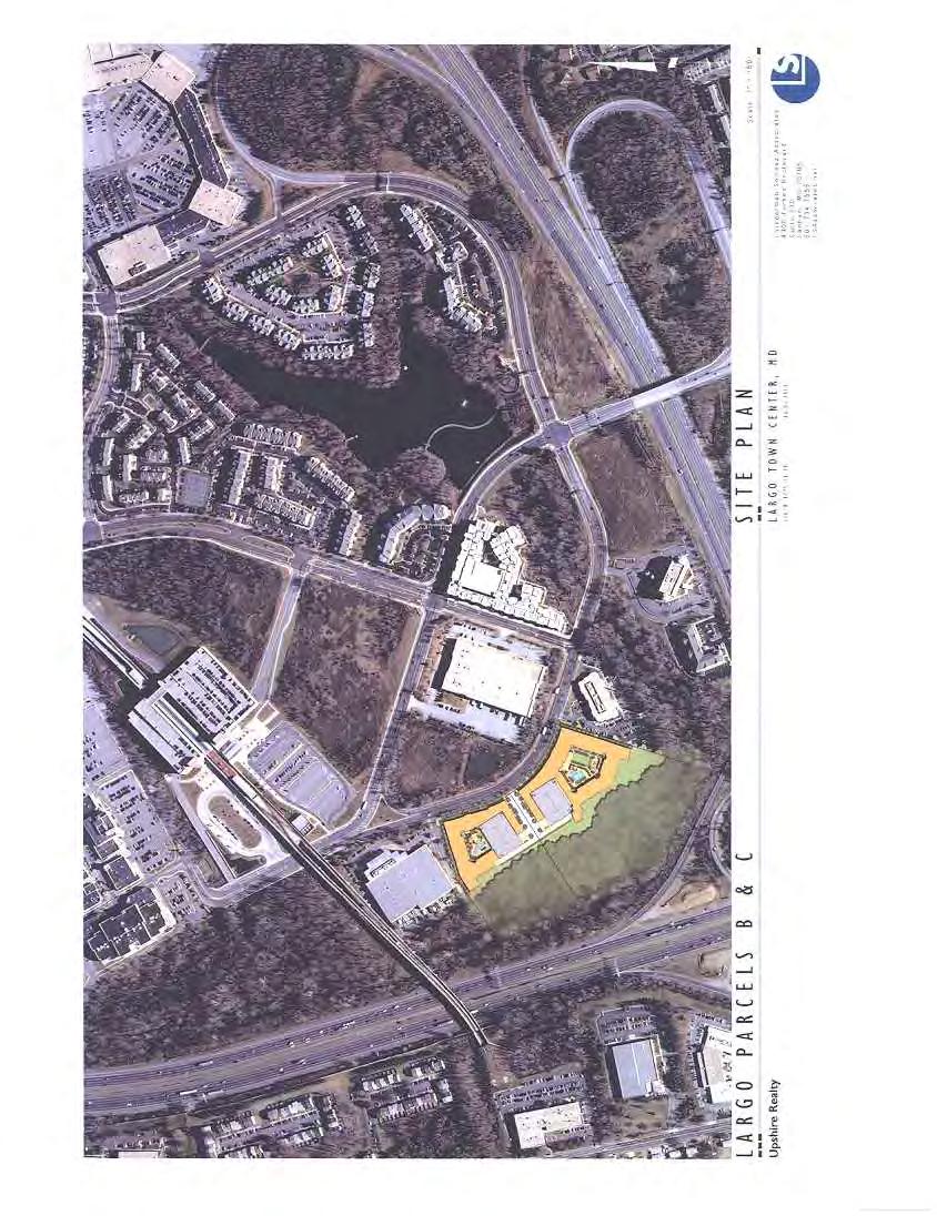
2 Aerial Context Largo Metro Parcels B&C Largo Town Center, Maryland 1


. Project Summary Net Tract Area 7.")
3 Property Description Largo Metro Parcels B & C Largo Town Center, Maryland Parcels B & C Parcels B & C Description The subject offering presents a unique opportunity to deliver new Class A rental product less than 1 block from both a major Metro Station and the planned Prince George s Hospital Center in one of the most stable and underserved rental markets in the entire Washington DC region. The new Hospital Center is a $650MM, 259 bed modern state of the art facility located adjacent to the Metro Station which will employ over 2,000 workers and scheduled to open in Parcels B&C consists of two parcels with an approved Detail Site Plan for two multifamily buildings containing a total of 532 units in type III-A Wrap design. A true transit oriented location, the property is across the street from the Largo Town Center Metro Station and is proximate to three beltway interchanges (Rt 214, Arena Drive and Rt 202). Project Summary Net Tract Area 7.29 Total Units 532 Density du/acre 73 Total GSF 632,582 Retail SF 7952 GSF Residential 624,630 NRSF 492,197 Average Unit Size 924 FAR 2.0 Parking Provided Parking Ratio 879sp 1.65sp/du Investment Highlights Site Plan Approved Wood Frame Construction Reduced Impact Fees No Affordable Units Approved SWM under old regs I Block to Largo Metro Extensive open space/buffer 2
 interchanges - 2 blocks from 500,000sqft")
4 Property Description Largo Metro Parcels B & C Largo Town Center, Maryland Location Highlights - 1 block from Largo Metro Station - 1 block from planned $650MM, 259 bed hospital center with 2,000 workers; to open in Immediate access to 3 Beltway (I ) interchanges - 2 blocks from 500,000sqft Boulevard Shops Center - ¾ mile from Largo Town Center Shopping Center (300,000sq.ft.) - Five minutes from newly opened Woodmore Towne Centre including Wegmans, Costco, Best Buy, etc. - Over 1.5 million sq.ft office in immediate Largo submarket - Excellent access to downtown Washington DC and major regional employment centers Terms: Price: Seeking $16,000,000 Brokerage: 2% of Purchase Price split 50/50 between Purchaser and Seller Legal Description: Prince George s County Tax Map 67, Parcels B and C of Largo Center West. Plat Nos (Parcel C) and (Parcel B) 9307 and 9311 West largo Drive, Largo, MD The following parcel summary is based upon the Recorded Subdivision Plat Parcel Size Floodplain Net Area SF Acres SF Acres SF Acres B C Total Zoning: Sector Plan: Mixed-Use Infill (MUI) and Designated Development District overlay Zone (DDOZ). Allows 48 units per acre pure residential or unlimited FAR with some mixed-use. The subject property lies within Subarea 5 of the Largo Town Center Metro Area and is recommended for residential/mixed use. There currently is a Largo Towne Center Sector Plan review underway that the ownership has worked closely with. The approved project has full support of the county planning task force. 3

5 Property Description Largo Metro Parcels B & C Largo Town Center, Maryland Approved Development: The subject property has received an approved Detail Site Plan for two (2) five-story wood frame multifamily buildings-wrapping an above grade parking structure totaling 532 units with 7,952sf of ground floor retail space. Parcel B West Building 216 units 3,677sf Retail Parcel C East building 316 units 4,275sf Retail Total 532 units 7,952sf Retail West Building Type No Size SF % S BR BRD BR BRD East Building Type No Size SF % S BR BRD BR BRD Total Type No Size SF % S % 1BR % 1BRD % 2BR % 2BRD % % Parking: Prince George s County Code requires: A) In projects within 1 mile of a Metro Station: 1.33 spaces per unit PLUS 0.33 space per unit for each bedroom in excess of one per unit. LESS 20% reduction for Metro proximity. 4
6 Property Description Largo Metro Parcels B & C Largo Town Center, Maryland B) All others: 2.0 spaces per unit PLUS 0.5 spaces per unit for each bedroom in excess of one per unit Parking Required: Residential 632 spaces Retail 10 spaces Parking Provided Residential 879 spaces (1.65/du) Retail 10 spaces Approval Status: Property has received Preliminary Plan, Record Plat, and Detail Site Plan approval. List of approvals as follows: Detail Site Plan DSP Preliminary Plan Erosion and Sediment Control Plan Parcels B&C Erosion and Sediment Control Plan Parcel B Storm Water Management Plan Parcel B Storm Water Management Plan Parcel C Phase I Noise Analysis Phase II Noise Analysis Affordable Units: Impact Fees: NONE Required Development of the site is subject to the following impact fees at time of building permit: Schools $ 7,510 per unit (Notes 1 & 2) Safety NONE WSSC SDC $ 2,036 per unit Total $ 9,546 per unit Note 1 This fee may be reduced to $4,381 if Property is designated as Developed Tier as the new Sector Plan Review strongly recommends. Adoption expected late Note 2 Studio units are exempt from the subject School Fee Property Taxes: Property taxes include real estate and other taxes related to the Property. Residential properties are assessed every three years in Prince George s County. Increases are phased in over the subsequent three year period. Current Real Estate Tax Rate is $1.431 per $100. The existing comparable rental properties are assessed in the range of $160,000 - $180,000 per unit for a resulting tax bill of approximately $2,300-2,600/du. 5
7 Property Description Largo Metro Parcels B & C Largo Town Center, Maryland Utilities: All available at site. 8 Sewer line is in Largo Drive W. 8 Sewer line runs through property along B&C Boundary 27 Sewer line along Beltway frontage 10 Water line in Largo Drive W. Storm Water Management: Forest Conservation: Earthwork: Schools: Storm Water Management plans have been approved for both Parcels B & C under the old (pre May 2010) regulations. As such the site may be developed employing the prior, less expensive methods without the new ESD requirements acres of off-site woodland conservation is required A preliminary earthwork analysis was done by LSA (attached) reflecting an excess of approximately 11,150 cy. Parcels B&C are served by the following public schools: School Enrollment Capacity Lake Arbor Elementary Ernest E. Just Middle Charles Flowers High 2,431 2,190 Rental Market: Attached is rental summary for competing projects. The following existing properties are considered competition to new product on Parcels B&C: 1) Camden at Largo Town Center (Camden) 2) Camden Summerfield (Camden) 3) Mosaic at Largo Station (EQR) 4) Metro Place at Town Center (Lessard) The current average rent (excluding premiums, etc.) is $1.63 per sq.ft. Excluding the older surface parked Camden at Largo Town Center (No 1) the average rents is $1.65 per sf. Average Unit size is approximately 985 sq.ft. 6
8 Property Description Largo Metro Parcels B & C Largo Town Center, Maryland Consolidated summary of the Largo Rental Market is as follows: Type No. % Size-SF Rent-$ Per SF- 1BR1BA BR1BA BR2BA TH BR2BA Total The above projects reflect older design and inferior location to Largo Parcels B & C. Considering new luxury product with structured parking and proposed smaller unit size, projected rents for Parcels B & C should be substantially higher, on the order of $1.90-$2.00/sf on average unit size of 924 sf. 7
 9701 Summit Circle, Largo, MD 20744 301-336-3661 245 units, built 1998, 97% occupancy Type 2.")

9 Existing Rental Product Largo Metro Parcels B & C Largo, Maryland 1. Camden Largo Town Center (Camden Properties) 9701 Summit Circle, Largo, MD units, built 1998, 97% occupancy Type 2. Camden Summerfield (Camden Properties) 8100 Gibbs Way, Landover, MD units, built 2009, 95% occupancy No Avg. Size- SF Avg. Rent- $ Per SF S L L Type No Avg. Size- SF Avg. Rent- $ Per SF D TH TH TH


10 Existing Rental Product Largo Metro Parcels B & C Largo, Maryland 3. Mosaic at Largo Station (EQR) 8831 Lottsford Road, Largo, MD units, built 2009, 95% occupancy Type No. Avg Size- SF Avg Rent- $ Per SF D TH MetroPlace at Town Center (Lessard) 4300 Telfair Boulevard, Camp Springs, MD units, built 2005, 92% occupancy Type No Avg. Size- SF Avg. Rent- $ Per Sf L L L
 Camden Summerfield 3) Mosaic at Largo Station 4) Metro Place at Town Center")
11 Existing Rental Comps Largo Metro Parcels B & C Largo, Maryland Largo Metro Parcels B&C 1) Camden at Largo Town Center 2) Camden Summerfield 3) Mosaic at Largo Station 4) Metro Place at Town Center 10

12 Aerial View Largo Metro Parcels B&C Largo Town Center, Maryland 11

13 Aerial View Largo Metro Parcels B & C Largo Town Center, Maryland 12

14 Regional Map Largo Metro Parcels B&C Largo, Maryland Largo Parcels B&C 13

15 Vicinity Map Largo Metro Parcels B & C Largo, Maryland Parcels B & C 14

16
17

18

19

20 LOIEDERMAN SOLTESZ ASSOC. INC. Date Prepared: 3/15/2013 Page 1 of Forbes Boulevard Lanham, Maryland Fax Project Name: Project No.: Prepared By: Largo Parcel B/C MEW Checked By: CAD File name: Ex. Surface Name: Prop. Surface name: EARTHWORK ESTIMATE Dated: Dated: Dated: CUT (sf) FILL (sf) TOTAL (sf) Disturbed Area 159, , ,000 ITEM APPROXIMATE APPROXIMATE CUT (cy) FILL (cy) TOTAL (cy) ASSUMPTIONS RAW EARTHWORK ROOT MAT (1) (2) (-) 11,391 1,963 (+) 12,441 1,963 Depth: 4 Inches TOPSOIL (3) (-) 1,963 (+) 1,963 Depth: 4 Inches BASEMENTS (+) 3,500 (-) 3,500 TOPSOIL RESPREAD (+) (-) PAVING AREA (sf) 231,000 Depth: 10 Inches PAVING SECTION (+) 7,130 (-) Paving Width: Feet SUBTOTAL 18,095 12,867 SHRINKAGE / SWELL 1,930 Shrinkage/Swell: 15% NET SUITABLE MATERIAL (A) 18,095 14,797 3,298 (+) Excess UNUSED TOPSOIL ROOT MAT HAULING (B) 3,926 (C) 3,926 11,150 EXCESS (A+B+C) Definition (+) Excess (-) Deficit NOTES: (1) Raw earthwork (cy) quantities do not include basement excavation volumes, unless noted. (2) Total root mat (cy) stripping volume is assumed to be hauled off site. (3) Consult geotechnical report for information on depth of root mat layer and depth of topsoil. (4) Earthwork takeoff quantities do not account for unusable soils. Consult geotechnical engineer for guidance. (5) Earthwork takeoff quantities do not account for excavation of footers, foundation walls, and utility construction. (6) Quantities contained hereon are based on available information at the time this estimate was prepared and should not be relied upon as precise. Loiederman Soltesz Associates, Inc. assumes no responsibility for the accuracy of such available information. C:\Users\Public\Documents\Acrobat\Largo Parcel B&C\DSP PLans, etc\copy_of_largo_earth_work_form031213_lsa
21 F4.6 F4.5 F1.2 F3.7 F4.4 F4.5 F3.6 F2.5 F3.7 F4.0 F3.2 F2.5 F0.9 F4.2 F3.6 F3.0 F2.5 F2.0 F1.2 F0.5 F3.4 F3.3 F2.0 F1.6 F1.3 F0.9 F0.3 C1.1 C1.3 F3.8 F3.1 F2.1 F0.9 F0.4 C0.1 C0.9 C1.8 C2.7 C2.3 F3.7 F3.0 F2.2 F0.7 C0.1 C1.2 C2.4 C3.5 C4.1 C4.1 C2.9 F1.4 F4.1 F3.2 F2.3 F0.9 C0.7 C1.7 C3.0 C5.0 C5.6 C5.9 C5.5 C3.8 C0.2 F1.5 F5.2 F4.6 F3.7 F2.7 F1.4 C0.1 C1.5 C2.8 C4.4 C6.2 C6.3 C6.6 C5.9 C4.6 C0.1 F2.7 F4.4 F4.0 F4.9 F4.1 F3.2 F2.1 F0.6 C1.2 C2.2 C3.1 C4.2 C5.3 C6.0 C6.3 C6.4 C3.9 C0.3 C1.0 F0.4 F1.4 F4.9 F4.3 F2.6 F2.8 F3.3 F3.3 F2.5 F1.6 F0.1 C1.4 C2.3 C3.1 C4.0 C5.0 C5.9 C6.0 C6.1 C2.4 C0.1 C0.1 F0.8 F2.6 F2.1 F3.1 F4.6 F3.9 F3.2 F3.3 F3.0 F1.7 F2.0 F2.5 F1.7 F0.7 C0.4 C1.2 C2.3 C3.2 C4.0 C5.0 C5.8 C5.8 C6.0 C0.4 C0.7 C0.5 F3.0 F4.3 F4.4 F3.6 F3.1 F2.3 F1.4 F0.6 F0.3 F0.7 F1.2 F1.1 F0.2 C0.9 C1.4 C1.7 C2.4 C3.2 C4.0 C4.7 C2.1 C0.5 C0.1 C0.2 C0.7 C0.9 F1.8 F3.8 F4.5 F3.8 F2.6 F1.6 F0.7 F0.0 C0.6 C1.0 F0.3 F0.1 F0.6 F1.0 C2.2 C2.8 C2.9 C3.1 C3.3 C0.8 F1.1 F0.7 F0.1 C0.1 C0.1 F0.4 F2.2 F4.5 F4.1 F2.5 F1.0 F0.0 C0.7 C1.1 C1.4 C1.7 C0.4 F0.1 C0.2 F0.6 F1.2 C3.4 C4.0 C4.3 F1.8 F1.6 F1.3 F0.4 F0.1 F2.0 F3.5 F4.2 F2.9 F1.4 C0.1 C1.2 C1.4 C1.8 C2.1 C2.3 C2.9 F0.5 F0.5 F0.6 F1.9 F2.1 F0.7 F1.2 F1.2 F0.3 F1.3 F2.3 F4.0 F2.9 F1.7 F0.5 C0.6 C1.4 C1.9 C2.2 C2.5 C2.7 C3.3 C1.2 F1.0 F0.7 F1.1 F0.8 F1.0 F0.6 F0.9 F2.1 F3.8 F2.9 F1.8 F0.6 C0.6 C1.3 C1.5 C2.0 C2.5 C2.7 C2.9 C3.4 C3.7 F2.8 F0.5 C0.2 F0.5 F2.7 F2.4 F3.8 F3.1 F2.1 F1.0 C0.1 C1.1 C1.5 C1.8 C2.1 C2.6 C2.8 C3.2 C3.6 F0.2 F2.2 F0.5 F2.6 F2.3 F2.5 F3.7 F3.0 F2.3 F1.4 F0.3 C0.7 C1.1 C1.5 C1.9 C2.3 C2.7 C3.0 C3.1 F3.2 F3.1 F1.5 F2.1 F3.0 F2.5 F2.1 F2.6 F3.6 F2.8 F2.0 F1.4 F0.9 C0.0 C0.9 C0.8 C1.4 C1.9 C2.4 C2.9 C0.0 F4.4 F3.5 F1.8 F0.2 C1.1 F1.3 F1.8 F2.0 F2.9 F2.6 F1.8 F1.0 F0.4 C0.1 C0.7 C0.8 C0.6 C1.0 C1.6 C2.3 F3.2 F4.7 F3.4 F0.1 F0.3 C2.2 C3.0 F1.1 F2.0 F1.7 F1.1 F0.5 C0.2 C0.7 C1.0 C0.9 C0.7 C0.8 C1.1 C1.6 F4.7 F5.2 F3.7 F1.5 F2.2 C2.1 C2.9 C0.0 F1.7 F1.0 F0.5 F0.3 C0.3 C1.1 C1.4 C1.6 C1.6 C1.4 C1.4 C1.5 F0.3 F5.2 F4.0 F2.2 C1.9 C2.6 C2.7 F2.3 F1.5 F1.0 F0.3 C0.2 C0.8 C1.4 C2.0 C2.2 C2.2 C2.1 C2.0 C2.0 F3.7 F3.6 F2.1 C3.0 F1.8 F2.0 F1.2 F0.6 F0.4 C0.3 C1.0 C1.6 C2.1 C2.5 C2.7 C2.8 C2.9 C2.6 F3.0 F1.9 F0.6 F1.7 F0.8 F0.2 F0.2 C0.1 C0.8 C1.5 C2.1 C2.9 C3.3 C3.6 C4.0 F1.4 F3.1 F1.3 C0.1 C0.7 C1.4 C2.1 C3.1 C3.8 C4.4 C4.8 F3.0 F3.1 C0.4 C3.5 C4.5 C5.1 C0.9 F2.7 F2.8 F0.4 F0.5 F1.4 F1.7 F0.7 F FENCE CHAIN LINK FENCE CHAIN LINK
22
23
24
25
26

27

28

29
30 PGCPB No File No. DSP R E S O L U T I O N WHEREAS, the Prince George's County Planning Board is charged with the approval of Detailed Site Plans pursuant to Part 3, Division 9 of the Zoning Ordinance of the Prince George's County Code; and WHEREAS, in consideration of evidence presented at a public hearing on March 21, 2013 regarding Detailed Site Plan DSP for Largo Centre West, Parcels B and C, the Planning Board finds: 1. Request: The subject application is for approval of a detailed site plan (DSP) for a mixed-use development consisting of 532 multifamily residential dwelling units and approximately 7,952 square feet of commercial/retail space on two parcels within the M-U-I/D-D-O-Z Zone in the Largo Town Center area. 2. Development Data Summary: EXISTING APPROVED Zone(s) M-U-I/D-D-O-Z M-U-I/D-D-O-Z Use(s) Vacant Residential/Retail Acreage Of which Parcel B Parcel C Commercial Gross Floor Area (sq. ft.) - 7,952 Of which on Parcel B - 3,677 on Parcel C - 4,275 Number of Multifamily Residential Units Of which on Parcel B on Parcel C OTHER DEVELOPMENT DATA REQUIRED APPROVED Total parking spaces Max. 1,057 to Min (20% reduction)* Of which Residential parking spaces Max. 1,012 to Min Commercial parking garage Max.45 to Min Handicapped spaces 18 18** Total loading spaces 5 5 Note: *See Finding 6 below for details on parking calculations as required by D-D-OZ standards.
31 PGCPB No File No. DSP Page 2 **Of which three spaces are van accessible. 3. Location: The subject property consisting of two parcels is located southwest of Largo Drive West, west of its intersection with Lottsford Road, within the Metro Core Area of Largo Town Center, in Planning Area 73, Council District 6 and in the Developing Tier of Prince George s County. 4. Surrounding Uses: The subject site is located in Subarea 5 of the Largo Town Center Metro Core Area, which includes properties that are generally within one-third of a mile of the metro station. The site is bounded on the west and south by the right-of-way (ROW) of the Capital Beltway (I-95); on the north by the ROW of Largo Drive West; and on the northwest and southeast sides by developed properties. All adjacent uses are in the M-U-I Zone, over which the D-D-O-Z has been superimposed. The Largo Metro Station is within approximately 1,000 feet of the subject site, across both Largo Drive West and Harry S Truman Drive. 5. Previous Approvals: Parcels B and C are located in an area bounded by Harry S Truman Drive, Central Avenue, the Capital Beltway and the Washington Metropolitan Area Transit Authority (WMATA) subway overpass, consisting of approximately 70 acres. This land was zoned R-R until 1978, when the property was placed in the C-O Zone by the July 1990 Approved Master Plan and Adopted Sectional Map Amendment for Largo-Lottsford, Planning Area 73. Development of an office park known as The Woodlands began. In 1988, a tract of 40 acres, including Parcels B and C, was rezoned to the E-I-A (Employment and Institutional Area) Zone pursuant to Zoning Map Amendment A The goal of the rezoning was to attract flex-tech and R and D businesses to the property. On the 70-acre assemblage, four buildings were constructed in either the C-O (Commercial Office) Zone or the E-I-A (Employment and Institutional Area) Zone, including a hotel (Parcel E-1, Largo Centre West, PB 132 Plat 34), an office building (Parcel D, Largo Centre West, PB 135 Plat 69), a paper company (Parcel M, Largo Centre West, PB 135 Plat 69) and the USBI warehouse (Parcel N, Largo Centre West Subdivision PB 180 Plat 35). The 2004 Approved Sector Plan and Sectional Map Amendment for Morgan Boulevard and Largo Town Center Metro Areas (SMA) rezoned the entire 70-acre area, including the subject site, to the M-U-I Zone and superimposed a D-D-O-Z on the subject site. The site also has an approved Stormwater Management Concept Plan , which will be valid through May 4, Design Features: The longer side of the site has frontage on Largo Drive West, which has an 80-foot-wide right-of-way (ROW) that is connected to Harry S Truman Drive at both ends. One vehicular access in the middle of the site s frontage links the site to Largo Drive West. There are streams, wetlands or 100-year floodplain on the rear half of the site. Two buildings with varied heights of five-to-six stories occupy the portions of both Parcels B and C that front on Largo Drive West. The rear portions of both parcels adjacent to the ROW of the Capital Beltway (I-95) that have environmental features are preserved in their nature states. A loop pedestrian path is shown at the rear of the two buildings.
32 PGCPB No File No. DSP Page 3 The two buildings occupy almost the entire site s frontage on Largo Drive West. The buildings are also set back feet from the face of the curb with sidewalks and landscaped strips between the buildings and the street. The first floor of the two buildings consists of commercial store fronts around the site entrance areas. The rest of the first floor and the other floors above consist of multifamily residential dwelling units and lobby areas. The two buildings are designed to enclose a parking structure and a courtyard in the middle of the building block. Amenities and recreational facilities such as a swimming pool, sitting area, pergola and trellis are provided in each courtyard to serve the future residents in the buildings. The two proposed buildings feature flat roofs and are finished with a combination of concrete masonry units, brick, metal panels and cementitious siding. Tower elements are used at the ends of each elevation and accents of vertical modules are also employed on the entire elevation to further break down the visually horizontal dominance of the long elevation. The mix of different building materials has been utilized as a way to enhance the esthetics of the elevations. Specifically, brick has been predominantly applied to stress the base section of the buildings. The arrangement of various architectural elements, the window pattern, and the combination of exterior building materials on the elevations are attractive and are also compatible with the proposed building on Parcel O that is located directly across Largo Drive West from Parcel B. Signage The signage proposed with this DSP includes numerous building-mounted signs to be located above the future storefronts in a narrow band below the sills of the second floor windows. Since the users are not known at this time, the specific sign details will provided when the spaces are leased. However, the general dimensions such as the length and width of the sign area should be provided. A condition has been included in this resolution to require the applicant to provide the general sign face area prior to certification of this DSP. Parking and Loading Requirements The parking requirements located in the Site Design Section of the 2004 Approved Sector Plan and Sectional Map Amendment for Morgan Boulevard and Largo Town Center Metro Areas offer three steps to establish both maximum and minimum numbers of off-street parking spaces for developments in the D-D-O-Z. By taking into account shared parking arrangements, which is the third component of the D-D-O-Z parking standards, off-street parking spaces are calculated for each development in the core area as follows: Parking Standards Step A The maximum number of off-street parking spaces permitted for each land use type is required to be equal to the minimum number of required off-street parking spaces in accordance with Section (a) of the Zoning Ordinance. This DSP includes multifamily residential and commercial/retail uses. The maximum number of off-street parking spaces permitted for the proposed residential use is 789, and for the retail use is 45, for a total of 834 spaces. Parking Standards Step B
33 PGCPB No File No. DSP Page 4 In accordance with D-D-O-Z parking standards, the minimum number of off-street parking spaces permitted for each land use is required to be calculated by reducing by 20 percent the maximum number of off-street parking spaces required by Section (a) of the Zoning Ordinance. The proposed development is wholly within the core area of the Largo Town Center metro station plan. The minimum number of required off-street parking spaces for the proposed residential use is 632, and 36 for the retail use, for a total of 668 spaces. The maximum number of off-street parking spaces permitted for multifamily dwellings wholly within the core area and for which the parking is substantially (at least 90 percent ) provided in the form of structured parking may be increased to 1.75 spaces per dwelling unit, plus an additional 0.33 space per bedroom in excess of one per unit. In this case, the maximum number of parking spaces for residential use is 1,012 and for retail use is 45, for a total of 1,057 spaces. Parking Standards Step C For any property under one ownership and containing two or more uses, the number of parking spaces should be computed by multiplying the minimum amount of parking required for each land use, as stated in Step B, by the appropriate percentage as shown in the shared parking requirements by time period. The number of parking spaces required for the development is then determined by adding the results in each column. The column totaling the highest number of parking spaces becomes the minimum off-street parking requirement. In this case, the highest column yields 634 parking spaces. The DSP provides a total 889 spaces, of which ten are surface parking spaces and 879 are structured parking spaces. Loading Spaces Section of the Zoning Ordinance requires one loading space for multifamily dwelling units up to 300 and one additional loading space for each additional 200 dwelling units (or fraction); for retail sales and service, one loading space for 2,000-10,000 square feet of gross floor area (GFA) is required; a total of four spaces is required. A total of five loading spaces has been provided and therefore the DSP complies with the loading requirement of the Zoning Ordinance. Private Recreational Facilities This development of 532 multifamily residential units is required to provide $448,630 worth of recreational facilities in accordance with the current recreational facility cost calculation formula. The applicant will provide a recreational facility package consisting of internal facilities within the proposed buildings and external facilities outside of the buildings with approximately $569, in total value. The proposed internal recreational facility package by itself exceeds the private recreational facility requirements. The recreational facilities proposed are broken down as follows: Within buildings and courtyards Dollar amount Swimming Pool 1 198, Swimming Pool 2 251,800.00
34 PGCPB No File No. DSP Page 5 Fitness Center 1-1,500 sq. ft. ($20 per sq. ft) 30, Fitness Center 2-1,050 sq. ft. 21, Subtotal 501, Outside buildings 6 wide trail ($35.00 per linear foot for 1,068 feet) 37, Fitness stations (6 in total) 16, Sitting area (400 sq. ft) 5, Picnic area 7, Play area (8,000 sq. ft) 3, Subtotal 68, Total value 569, Additional recreational facilities such as picnic and sitting areas, a looped pedestrian path and open play field are also provided at the rear of the two buildings, in the southwest part of the site fronting the Capital Beltway (I-95). Since the area is completely within the 65 dba Ldn noise contour line, the external facilities are not included in the recreational facility package to be counted toward the fulfillment of the private recreational facility obligation for this project. Lighting Two types of light fixtures have been proposed in this DSP including pole lights for streets and parking areas and bollard lights for pathways and sidewalks. A note has been included on the detail sheet of the landscape plan where the light fixtures are shown. The note indicates that Full cut-off optic light fixtures shall be used throughout the development and shall be directed downward to reduce glare and light intrusion. However, the pole light shown is not a full cut-off type of light fixture. A condition has been included in the resolution to require a full cut-off light along with the product specification sheet be provided prior to certification. Green Building Technologies A mixed-use project like the subject development presents many opportunities for the application of green building technologies. This application includes reuse of stormwater for on-site landscaping irrigation. Additional green technologies such as those that would improve the building s energy efficiency, daylighting (the practice of placing windows or other openings and reflective surfaces so that during the day natural light provides effective internal lighting), and other innovative environmental technologies in the building and site design should be applied in this development to the extent possible. COMPLIANCE WITH EVALUATION CRITERIA 7. The May 2004 Approved Sector Plan and Sectional Map Amendment for Morgan Boulevard and Largo Town Center Metro Areas: The sector plan and sectional map amendment amends portions of the 1993 Approved Master Plan and Sectional Map Amendment
35 PGCPB No File No. DSP Page 6 for Landover and Vicinity, the 1990 Approved Master Plan and Adopted Sectional Map Amendment for Largo-Lottsford, Planning Area 73 and the 1986 Approved Master Plan and Adopted Sectional Map Amendment for Suitland-District Heights and Vicinity, Planning Areas 72, 73 and 75A,the 2002 Prince George s County Approved General Plan, the 1992 Prince George s County Historic Sites and Districts Plan, the 1990 Approved Public Safety Facilities Master Plan, and the 1975 Countywide Trail Plan. The purpose of the sector plan is to analyze the existing situation and to set forth goals, concepts, guidelines, recommendations and design standards to achieve the development characters desired for future development at the Morgan Boulevard and Largo Town Center Metro Core Areas and the Central Avenue Corridor Node in the sector plan area, in accordance with goals and policies of the 2002 Prince George s County Approved General Plan recommendations for mixed-use, pedestrian- and transit-oriented development in centers and corridors. The sector plan contains a comprehensive rezoning element known as the Sectional Map Amendment (SMA) intended to implement the land use recommendations of the sector plan for the foreseeable future. On March 18, 2004, the Planning Board approved (PGCPB Resolution No ), the preliminary sector plan, and the proposed sectional map amendment. On May 27, 2004, the District Council, by adopting County Council Resolution CR , approved the sector plan and sectional map amendment for the Morgan Boulevard and Largo Town Center metro areas. The subject site is located in Subarea 5 of the Largo Town Center Metro Core Area. The Approved Sector Plan and Sectional Map Amendment for Morgan Boulevard and Largo Town Center Metro Areas rezoned Subarea 5 to the M-U-I Zone and further superimposed a Development District Overlay Zone (D-D-O-Z) over Subarea 5 (see below for a detailed discussion of compliance with the requirements of the M-U-I Zone and standards of the D-D-O-Z). The subject application has been reviewed for conformance with the approved sector plan and sectional map amendment and has been found to be in general compliance with the land use and development pattern concepts and recommendations. No historic sites are on the subject site or in the close vicinity of the site. The application s compliance with environmental infrastructure and transportation system concepts and recommendations has been discussed in detail in the attached memoranda from the Transportation Planning and Environmental Planning Sections, respectively. The sector plan and sectional map amendment superimpose a D-D-O-Z over designated subareas including Subarea 5 in the Largo Town Center Metro Core Areas to ensure that the development of land meets the sector plan s goals. The development district standards follow and implement the recommendations in the sector plan and sectional map amendment. The development district standards are organized into three parts, to address site design, building design and public areas for development within the district. Section (b) of the Zoning Ordinance requires that in approving the detailed site plan, the Planning Board shall find that the site plan meets applicable development district standards. In general, the subject detailed site plan meets the applicable development district standards. If the applicant intends to deviate from the development district standards, the Planning Board must
36 PGCPB No File No. DSP Page 7 find that the alternative development district standards will benefit the development and the development district, and will not substantially impair implementation of the sector plan. In this application the applicant has requested modifications of the development district standard as follows: Site Design Building Siting and Setbacks A. Buildings shall front the street edge and shall be located within an appropriate distance from the edge of the curb. Appropriate ranges for front build-to lines from the street edge are as follow: 1. In Subareas 3 and 5 of the Largo Town Center core area, and Subareas 1, 2, and 3 of the Morgan Boulevard core area, all new buildings shall be located within feet of the edge of the curb, with the exception of residential development with frontage on Morgan Boulevard (in Subarea 1), which shall be located within 20 to 35 feet of the edge of the curb The proposed DSP establishes a building setback 26 to 33 feet from the edge of the curb on Largo Drive West. Largo Drive West was platted and constructed many years ago. As currently constructed, the edge of the curb is 12 feet from the property line. The record plat then establishes a ten-foot public utility easement (PUE), which the applicant is required to maintain free of structures. Thus, the closest the building could be located to the edge of the curb is 22 feet. To allow for some construction room, the applicant has placed the building 26 feet from the face of the curb at its closest point. However, the building does not have a flat front façade. Architectural variations and offsets are provided to create visual interest, resulting in portions of the building that are set back up to 33 feet from the face of the curb. With a build-to line of feet from the face of the curb, the proposed detailed site plan does not conform to the foot build-to line D-D-O-Z standard. A modification of this standard is requested. The location of the PUE is an existing condition which cannot be altered. The applicant is still conforming to the vision of the D-D-O-Z by locating the building as close to the face of the curb as possible. However, to fully conform with the standard would mean that the building would have to be located so close to the PUE that construction would not be possible without encroaching into the PUE and no architectural variation along the front facade could be provided, which would not benefit the development or be consistent with the other building standards in the D-D-O-Z. Modifying the standard to allow a build-to line which is feet from the face of the curb will benefit the development by allowing the architectural variations along the front façade needed to provide an attractive streetscape, and will not substantially impair the implementation of the sector plan. In conclusion, the design treatment of the site is acceptable. The requested
37 PGCPB No File No. DSP Page 8 modification of the D-D-O-Z standard will benefit the development and the development district by providing an impressive street wall along the site s entire frontage of Largo Drive West and will not impair, but will in fact significantly promote the implementation of the approved sector plan. Site Design Landscaping, Buffering, and Screening F. The bufferyard requirement within the development district may be reduced to facilitate a compact form of development compatible with the recommendations of the Urban Design chapter. The minimum bufferyard requirements (landscape yard) for incompatible uses in the Landscape Manual (Section 4.7) may be reduced by 50 percent. The plant units required per 100 linear feet of property line or right-of-way may also be reduced by 50 percent. A four-foot high, opaque masonry wall or other opaque screening treatment shall be provided in conjunction with the reduced width of the bufferyard between office/retail/commercial uses and residential uses. As indicated above, the proposed mixed-use development is adjacent to an industrial building along its northern property line, and an office building along the southeastern property line. The applicant is proposing a building setback/buffer of 15 feet along each property line. For purposes of establishing the required bufferyard, the 2010 Prince George s County Landscape Manual would classify the proposed vertical mixed use buildings based on the predominant use, which is multifamily residential. The office building to the southeast would be considered a low impact use, normally requiring a 20-foot building setback and a ten-foot bufferyard, which the sector plan would then reduce by half. Reducing this requirement by 50 percent would require a ten-foot building setback and a five-foot bufferyard. This setback/bufferyard would therefore satisfy the Sector Plan requirement. However, the sector plan standard also requires a four-foot-high, opaque masonry wall or other opaque screening treatment in conjunction with the reduced width of the bufferyard. In this case, no such wall is proposed. Rather, a retaining wall is to be constructed within the bufferyard, and the building is set above the retaining wall. However, the retaining wall does not qualify as a four-foot-high opaque masonry wall as described in the standard. As such, an amendment to this requirement is requested. In this case, the wall would simply serve no purpose. It would not provide any meaningful screening for a building that is five stories high. Along the northern property line is a warehouse, which is classified as a high impact use, normally requiring a 50-foot building setback and a 40-foot-wide bufferyard. A 50 percent reduction would allow a 25-foot building setback and a 20-foot-wide bufferyard. In this case, the 15-foot-wide setback/bufferyard is less than required, and a four-foot-high masonry wall is also not provided. The applicant is requesting amendment to the Sector Plan Standard along this property line as well.
38 PGCPB No File No. DSP Page 9 Along the southeastern property line, the adjacent property is improved with an office building. The building is angled on the lot due to the encroachment of the same swath of floodplain impacting Parcels B and C. At its closest point, the building is setback about 55 feet. The space between the property line and the building is improved with drive aisles and parking. Given the topography between the properties, providing a four-foot-high wall will serve no practical function. It would not screen a parking lot on Parcels B and C, nor would it screen the building. It would also not screen any views from Parcels B and C into the adjacent property. Therefore, waiving the requirement to provide the four-foot wall will not impair implementation of the sector plan in any way. Along the northern property line, the existing building is not in conformance with the D-D-O-Z standard and is itself a candidate for future redevelopment. The property sits on Parcel M which is directly across Harry S Truman Drive from the metro station. The northern property line of Parcel B is the closest point to the metro station. Requiring a setback based on an incompatible use which will likely be redeveloped will not benefit the development or the implementation of the sector plan. The adjacent building is not tall, and the units above the first floor will largely have views over the adjacent building. In the short term, providing landscaping along the first floor level should be the focus, primarily in the area where the buildings are closest. The landscaping proposed at this location is appropriate for this purpose. Setting the building back further and/or providing a four-foot-tall masonry wall would not improve or enhance the proposed buffering. As a result, the applicant requests amendment to Bufferyard Standard F to reflect the building setbacks, buffers and landscaping proposed on the DSP. The alternative building setbacks and bufferyards proposed in this case will benefit the development and the development district and will not substantially impair implementation of the Sector Plan. Building Design Height, Scale and Massing E. The average size of all multifamily dwelling units in a development project shall be a minimum of: square feet for a 1-bedroom unit 2. 1,050 square feet for a 2-bedroom unit 3. 1,275 square feet for a 3-bedroom unit. If the unit includes a den, the average minimum size increases by 100 square feet.
39 PGCPB No File No. DSP Page 10 The DSP proposes five different room types in order to serve a broad market as shown below: Type of BR Studio 1 BR 1 BR/ w 2 BR 2 BR/w Total D D Number of Units Percentage 3.8% 42.1% 7.7% 40.8% 5.6% 100.0% Average size ,106 1,197 In accordance with Section (a)(23) of the Zoning Ordinance, in the definition of the term Bedroom, a den is categorized as another bedroom if it is intended to be a habitable room. Therefore, one-bedroom units with den are considered two-bedroom units, and two-bedroom units with den are considered three-bedroom units, according to the Zoning Ordinance. The one-bedroom and two-bedroom units in this application meet the minimum square footage of the D-D-O-Z standards, but the three-bedroom units do not meet the minimum square footage of the D-D-O-Z standards. The applicant also argues that there is no minimum size standard set up for the Studio units. An amendment request has been provided to allow the applicant to maintain the types and sizes of dwelling units proposed in this DSP. The applicant in the Statement of Justification argues that subject site is located in the metro core area of Largo Town Center. More room types than the three specified in the sector plan have been provided in this DSP in order to meet diverse demands of various segments of the population that may be attracted to a transit-oriented community like this one. Historically in Prince George s County, one-bedroom apartments and efficiency apartments have been encouraged. The bedroom percentage restrictions that apply in many zones, though not on this site, allow an unlimited number of one-bedroom and efficiency apartments and limit the number of two-bedroom or larger units to 50 percent, as stated in Section , Bedroom Percentages. In this DSP, one-bedroom and two-bedroom units account for more than 82 percent of the units. The only unit type that is smaller than 750 square feet is the Studio unit, which only accounts for 3.8 percent of all units. In addition, according to the most recent newsletter of Bozzuto Construction Company, which is a leading multifamily builder in the Washington Metropolitan area and is ranked the 11 th largest multifamily apartment builder nationwide, the average apartment size has shrunk to 866 square feet on average for the 4,100 units which Bozzuto currently has under construction, as a result of a several factors including demographic trends, unit mix, and of course, costs of construction. By providing more unit types than the D-D-O-Z standards call for with comparatively smaller unit sizes to meet various demands of the rental market, the subject application is consistent with the intent of the Largo Town Center plan. The Urban Design staff agrees with the applicant that more than 80 percent of the proposed units meet the D-D-O-Z standards, while less than 20 percent of the units have a smaller unit size that will reduce the rental cost for future residents. The alternative standards will benefit the development and the development district and will not substantially impair implementation of the sector plan.
40 PGCPB No File No. DSP Page Zoning Ordinance in the M-U-I (Mixed Use-Infill) Zone and the Development District Overlay Zone (D-D-O-Z): The M-U-I Zone was introduced in May The general purpose of the M-U-I Zone is to permit, where recommended in applicable plans, in this case the 2004 Approved Sector Plan and Sectional Map Amendment for Morgan Boulevard and Largo Town Center Metro Areas, a mix of residential and commercial uses as infill development in areas which are already substantially developed. The DSP application has been reviewed for compliance with the requirements of the M-U-I Zone of the Zoning Ordinance as follows: a. The proposed residential and commercial/retail uses are permitted uses pursuant to the 2004 Approved Sector Plan and Sectional Map Amendment for Morgan Boulevard and Largo Town Center Metro Areas (M-U-I in D-D-O-Z, Use Table). b. The proposal is also in conformance with the applicable setback requirements for the proposed uses. Section indicates that where an owner proposes a mix of residential and commercial uses on a single lot or parcel in the M-U-I Zone, the site plan as approved shall set out the regulations to be followed. For the frontages of the site along Largo Drive West, the D-D-O-Z build-to line standards govern. For Subarea 5, the D-D-O-Z build-to line range is feet from the curb edge. An amendment has been requested to allow a larger setback in the range of 26-33feet due to the public utility easement (PUE). For other setbacks, D-D-O-Z site design Standard C specifically states that: To facilitate the intent to increase development intensity near Metro stations, the side and rear yard requirements specified in Sections , and of the Zoning Ordinance, and the minimum building setbacks specified in Section 4.7 of the Landscape Manual are waived. The DSP provides a 15-foot setback from the north and south property lines and thus satisfies the alternative standards. c. Section (b) of the Zoning Ordinance requires that the Planning Board shall find that the site plan meets applicable development district standards in order to approve a detailed site plan. As discussed in Finding 7, this DSP complies with most of the applicable D-D-O-Z standards except for the three standards as amended. Staff recommends approval of the alternative development standards because they will benefit the development and the development district, and will not substantially impair implementation of the sector plan. d. The application also requires a departure from design standards (DDS) because the applicant has provided parking spaces that are 9 feet wide by 18 feet long in the garage with a 24-foot-wide drive aisle instead of the required standard space of 9.5 feet in width by 19 feet in length with a 22-foot-wide drive aisle.
41 PGCPB No File No. DSP Page 12 Section (e) of the Zoning Ordinance provides that if a use would normally require a variance or departure, separate application shall not be required, but the Planning Board shall find in its approval of the site plan that the variance or departure conforms to all applicable development district standards. In the justification statement, the applicant notes that current parking space dimensions in the Zoning Ordinance are for surface parking and do not factor in the issues unique to structured parking. The narrower parking space will enable the applicant to provide more spaces in the parking garage to better justify the expense of structured parking. The Planning Board in its previous approvals including structured parking space has several times found it acceptable to have smaller parking spaces in a parking garage as long as the dimensions of parking spaces such as the width and length of parking stall and the width of drive aisle meet the requirements of Guidelines for Parking Geometrics (by the National Parking Association). In this case the width (9 feet), length (18 feet) and drive aisle width (24 feet) are all within the permissible range of the standards. Providing structured parking is highly encouraged in the Metro Core Area in accordance with the sector plan. The departures from parking and loading standards that reduce the width of parking spaces in the parking garage from the required 9.5 feet to 9 feet, length from 19.5 feet to 18 feet, with a 24-foot drive aisle are consistent with the intent of the sector plan. The departure is also in general conformance with the applicable D-D-O-Z standards. The Planning Board approved the departure from design standards to allow smaller parking spaces in the parking garage. 9. Preliminary Plan of Subdivision and Record Plat: Preliminary Plan of Subdivision for Largo Center West covered 30.9 acres of land including Parcels B and C and was approved by the Planning Board on November 29, The final plat for Parcel B (NLP ) was approved on December 27, 1982 and for Parcel C (NLP ) was approved on November 13, Important conditions of approval attached to were carried forward as final plat notes. None of the final plat notes is specifically related to the review of this DSP. 10. Prince George s County Landscape Manual: Section (d), Development District Standards, requires that landscaping, screening, and buffering of development shall conform to the 2010 Prince George s County Landscape Manual (Landscape Manual) requirements. Specific landscaping, screening, and buffering also may be required by the development district standards. Development district standards may require specific landscaping, screening, and buffering, but only to meet the goals of the development district and the purposes of the D-D-O-Z. Landscaping, Buffering, and Screening Standards (J) (pg. 103) under the Site Design Section of the Approved Sector Plan and Sectional Map Amendment explicitly states that Sections 4.2, 4.3, 4.4, 4.6 and 4.7 of the Landscape Manual do not apply within the development district. Since the proposed uses are commercial and residential uses, the DSP is subject to Section 4.1, Residential Requirements and Section 4.9, Sustainable Landscaping Requirements of the Landscape Manual.
R E S O L U T I O N. 2. Development Data Summary:
 R E S O L U T I O N WHEREAS, the Prince George s County Planning Board has reviewed Special Permit Application No. SP-170001, Mama s Care Assisted Living Facility, requesting to expand an existing congregate
R E S O L U T I O N. Residential 384,918 sq. ft. To be demolished Floor Area Ratio (FAR) 0 0.7
 0 0.7") R E S O L U T I O N WHEREAS, the Prince George s County Planning Board has reviewed DPLS-417, Kiplinger Property, Phase I, Expedited Transit-Oriented Development Project, requesting a reduction in the
R E S O L U T I O N WHEREAS, the Prince George s County Planning Board has reviewed DPLS-417, Kiplinger Property, Phase I, Expedited Transit-Oriented Development Project, requesting a reduction in the
The Maryland-National Capital Park and Planning Commission Prince George's County Planning Department Development Review Division
 The Maryland-National Capital Park and Planning Commission Prince George's County Planning Department Development Review Division 301-952-3530 Note: Staff reports can be accessed at www.mncppc.org/pgco/planning/plan.htm.
PLANNED DEVELOPMENT DISTRICT STANDARDS. Cadence Site
 PLANNED DEVELOPMENT DISTRICT STANDARDS Cadence Site A Planned Development District 1. Statement of General Facts, Conditions and Objectives Property Size: Approximately 57.51 Acres York County Tax Map
WHEREAS, after consideration of the evidence presented at the public hearing on October 30, 2008, the Prince George's County Planning Board finds:
 R E S O L U T I O N WHEREAS, the Prince George s County Planning Board has reviewed DPLS-336, Mosaic at Turtle Creek, requesting a departure from the required number of parking spaces in accordance with
R E S O L U T I O N. 1. Request: A Departure from Parking and Loading Standards (DPLS-449) for 32 parking spaces.
 for 32 parking spaces.") R E S O L U T I O N WHEREAS, the Prince George s County Planning Board has reviewed Departure from Parking and Loading Standards No. DPLS-449 requesting a departure to allow a reduction of 32 parking spaces
R E S O L U T I O N WHEREAS, the Prince George s County Planning Board has reviewed Departure from Parking and Loading Standards No. DPLS-449 requesting a departure to allow a reduction of 32 parking spaces
VARIANCE APPLICATION. Note: Staff reports can be accessed at Project Name: New Carrollton Town Center
 The Maryland-National Capital Park and Planning Commission Prince George s County Planning Department Development Review Division 301-952-3530 Note: Staff reports can be accessed at www.mncppc.org/pgco/planning/plan.htm.
Bowie Marketplace Residential Detailed Site Plan Statement of Justification January 13, 2017 Revised February 2, 1017
 Bowie Marketplace Residential Detailed Site Plan Statement of Justification January 13, 2017 Revised February 2, 1017 Submitted on behalf of: BE Bowie LLC 5410 Edson Lane, Suite 220 Rockville, MD 20852
C O R R E C T E D R E S O L U T I O N
 C O R R E C T E D R E S O L U T I O N WHEREAS, the Prince George's County Planning Board is charged with the approval of Detailed Site Plans pursuant to Part 3, Division 9 of the Zoning Ordinance of the
The Maryland-National Capital Park and Planning Commission Prince George s County Planning Department Development Review Division
 The Maryland-National Capital Park and Planning Commission Prince George s County Planning Department Development Review Division 301-952-3530 Note: Staff reports can be accessed at www.mncppc.org/pgco/planning/plan.htm.
PLANNED UNIT DEVELOPMENT & SUBDIVISION STAFF REPORT Date: April 18, 2019
 PLANNED UNIT DEVELOPMENT & SUBDIVISION STAFF REPORT Date: April 18, 2019 DEVELOPMENT NAME SUBDIVISION NAME Springhill Village Subdivision Springhill Village Subdivision LOCATION 4350, 4354, 4356, 4358,
PLANNING COMMISSION REPORT Regular Agenda -Public Hearing Item
 PDP-13-00518 Item No. 3B- 1 PLANNING COMMISSION REPORT Regular Agenda -Public Hearing Item PC Staff Report 2/24/14 ITEM NO. 3B PRELIMINARY DEVELOPMENT PLAN FOR HERE @ KANSAS; 1101 INDIANA ST (SLD) PDP-13-00518:
Cover Letter with Narrative Statement
 Cover Letter with Narrative Statement March 31, 2017 rev July 27, 2017 RE: Rushton Pointe Residential Planned Unit Development Application for Public Hearing for RPUD Rezone PL2015 000 0306 Mr. Eric Johnson,
DEVELOPMENT DEPARTMENT STAFF REPORT THE PARK AT 5 TH
 DEVELOPMENT DEPARTMENT STAFF REPORT ARB Meeting Date: July 3, 2018 Item #: _PZ2018-293_ THE PARK AT 5 TH Request: Site Address: Project Name: Parcel Number: Applicant: Proposed Development: Current Zoning:
R E S O L U T I O N. 2. Development Data Summary:
 R E S O L U T I O N WHEREAS, the Prince George's County Planning Board is charged with the approval of Detailed Site Plans pursuant to Part 3, Division 9 of the Zoning Ordinance of the Prince George's
Community Development
 Land Use Petition RZ-16-002 Date of Staff Recommendation Preparation: April 15, 2016 (CEL) Date of Planning Commission Recommendation: May 3, 2016 PROJECT LOCATION: DISTRICT/SECTION/LANDLOT(S): ACREAGE
DEVELOPMENT DEPARTMENT STAFF REPORT STAFF REPORT PUD/DCI BAINBRIDGE MIXED-USE DEVELOPMENT
 DEVELOPMENT DEPARTMENT STAFF REPORT Meeting Date: October 12, 2017 Item #: _PZ-2017-170_ STAFF REPORT PUD/DCI BAINBRIDGE MIXED-USE DEVELOPMENT Request: Project Name: Planned Unit Development (PUD)/ Development
Appendix A: Guide to Zoning Categories Prince George's County, Maryland
 Appendix A: Guide to Zoning Categories Prince George's County, Maryland RESIDENTIAL ZONES 1 Updated November 2010 R-O-S: Reserved Open Space - Provides for permanent maintenance of certain areas of land
ZONING AMENDMENT & SUBDIVISION STAFF REPORT Date: November 3, 2016
 ZONING AMENDMENT & SUBDIVISION STAFF REPORT Date: November 3, 2016 APPLICANT NAME SUBDIVISION NAME David Shumer 5955 Airport Subdivision CITY COUNCIL DISTRICT District 6 5955 Airport Boulevard, 754 Linlen
TIMBERLAND PARK 2707 OLNEY-SANDY SPRING ROAD MEDICAL OFFICE/MIXED-USE OLNEY, MARYLAND
 TIMBERLAND PARK 2707 OLNEY-SANDY SPRING ROAD MEDICAL OFFICE/MIXED-USE OLNEY, MARYLAND Exclusively Presented by: Stevan A. Varga ENTRLTY@AOL.COM Stephan A. Varga Stephan@enterpriserealtyservices.com Enterprise
13 Sectional Map Amendment
 13 Sectional Map Amendment Introduction This chapter reviews land use and zoning policies and practices in Prince George s County and presents the proposed zoning in the sectional map amendment (SMA) to
DPLS-266 AC Note: Staff reports can be accessed at
 The Maryland-National Capital Park and Planning Commission Prince George's County Planning Department Development Review Division 301-952-3530 Note: Staff reports can be accessed at www.mncppc.org/pgco/planning/plan.htm.
Appendix1,Page1. Urban Design Guidelines. Back to Back and Stacked Townhouses. DRAFT September 2017
 Appendix1,Page1 Urban Design Guidelines DRAFT September 2017 Back to Back and Stacked Townhouses Appendix1,Page2 Table of Contents 1 Introduction 1 1.1 Purpose 1 1.2 Urban Design Objectives 1 1.3 Building
Courtyards at Kinnamon Park Sketch Plan
 Courtyards at Kinnamon Park Sketch Plan Courtyards at Kinnamon Park Sketch Plan Staff Analysis PART 1: PROJECT SUMMARY Applicant: EPCON Communities Property Owner: Johnsie M. Kinnamon Heirs, Douglas and
Staff Report: Date: Applicant: Property Identification: Acreage of Request: Current Zoning of Requested Area: Requested Action: Attached:
 Staff Report: Completed by Jeff Palmer Director of Planning & Zoning Date: November 7, 2018, Updated November 20, 2018 Applicant: Greg Smith, Oberer Land Developer agent for Ronald Montgomery ET AL Property
8.5.1 R1, Single Detached Residential District
 8.5.1 R1, Single Detached Residential District The purpose of this district is to provide for residential development in the form of single detached dwellings. Dwelling, Single Detached Home Business,
R E S O L U T I O N. 1. Request: The subject application requests the addition of a deck, patio, pool and fence to a singlefamily
 R E S O L U T I O N WHEREAS, the Prince George's County Planning Board is charged with the approval of Detailed Site Plans pursuant to Part 3, Division 9 of the Zoning Ordinance of the Prince George's
R E S O L U T I O N. a. Remove Table B from the plan.
 R E S O L U T I O N WHEREAS, Werrlein Property is the owner of a 0.3902-acre parcel of land in the 5th Election District of Prince George s County, Maryland, being zoned One-Family Detached Residential
Town of Cary, North Carolina Rezoning Staff Report 12-REZ-27 Morris Branch Town Council Public Hearing January 24, 2013
 Town of Cary, North Carolina Rezoning Staff Report 12-REZ-27 Morris Branch Town Council Public Hearing January 24, 2013 REQUEST To amend the Town of Cary Official Zoning Map to rezone approximately 9.0
DEVELOPMENT STANDARDS FOR RESIDENTIAL PROJECTS RESIDENTIAL BUILDING TYPES: APPROPRIATE ZONES AND DENSITIES 2-1
 2 DEVELOPMENT STANDARDS FOR RESIDENTIAL PROJECTS RESIDENTIAL BUILDING TYPES: APPROPRIATE ZONES AND DENSITIES 2-1 This Chapter presents the development standards for residential projects. Section 2.1 discusses
Composition of traditional residential corridors.
 Page 1 of 7 St. Petersburg, Florida, Code of Ordinances >> PART II - ST. PETERSBURG CITY CODE >> Chapter 16 - LAND DEVELOPMENT REGULATIONS >> SECTION 16.20.060. CORRIDOR RESIDENTIAL TRADITIONAL DISTRICTS
SUBDIVISION, PLANNED UNIT DEVELOPMENT, ZONING AMENDMENT, & SIDEWALK WAIVER STAFF REPORT Date: July 19, 2018
 SUBDIVISION, PLANNED UNIT DEVELOPMENT, ZONING AMENDMENT, & SIDEWALK WAIVER STAFF REPORT Date: July 19, 2018 NAME SUBDIVISION NAME LOCATION West Mobile Properties, LLC U.S. Machine Subdivision 556, 566,
DEVELOPMENT DEPARTMENT STAFF REPORT STAFF REPORT EASTSIDE CHAMBLEE LINK DCI
 DEVELOPMENT DEPARTMENT STAFF REPORT Public Hearing Date: April 12, 2018 Item #: PZ-2018-248 STAFF REPORT EASTSIDE CHAMBLEE LINK DCI Request: Development of Community Compact (DCI), ten concurrent variances,
Development Plan DP13-3 (Arlington Lofts) Planning and Zoning Meeting Date: Document Being Considered: Ordinance
 Planning and Zoning Meeting Date: Document Being Considered: Ordinance") Staff Report Development Plan DP13-3 (Arlington Lofts) Planning and Zoning Meeting Date: 6-19-13 Document Being Considered: Ordinance RECOMMENDATION Following the public hearing, consider Development Plan
Staff Report Development Plan DP13-3 (Arlington Lofts) Planning and Zoning Meeting Date: 6-19-13 Document Being Considered: Ordinance RECOMMENDATION Following the public hearing, consider Development Plan
DEVELOPMENT DEPARTMENT STAFF REPORT DRESDEN HEIGHTS PHASE II DCI
 DEVELOPMENT DEPARTMENT Meeting Date: January 10, 2019 Item #: PZ2019-393 Project Name: Applicant and Owner: Proposed Development: Requests: STAFF REPORT DRESDEN HEIGHTS PHASE II DCI Dresden Heights Phase
Subchapter 5 Zoning Districts and Limitations
 Subchapter 5 Zoning Districts and Limitations 35.5.1 Rural Districts Sections: 35.5.1.1 Purpose. 35.5.1.2 Permitted Uses. 35.5.1.3 General Regulations. 35.5.1.1 Purpose. The purpose of a Rural District
FREQUENTLY USED PLANNING & ZONING TERMS
 City Of Mustang FREQUENTLY USED PLANNING & ZONING TERMS Abut: Having property lines, street lines, or zoning district lines in common. Accessory Structure: A structure of secondary importance or function
PLANNING AND DEVELOPMENT DEPARTMENT STAFF REPORT STAFF REPORT PREMIER AUTO SERVICES, INC. VARIANCES
 PLANNING AND DEVELOPMENT DEPARTMENT STAFF REPORT Meeting Date: February 14, 2019 Item #: PZ2019-402 STAFF REPORT PREMIER AUTO SERVICES, INC. VARIANCES Project Name: Premier Auto Services, Inc. Applicant:
DEVELOPMENT DEPARTMENT STAFF REPORT STAFF REPORT DRESDEN DRIVE TOWNHOMES DCI
 DEVELOPMENT DEPARTMENT STAFF REPORT Meeting Date: September 13, 2018 Item #: PZ2018-319 STAFF REPORT DRESDEN DRIVE TOWNHOMES DCI Request: Project Name: Development of Community Compact (DCI) and six concurrent
The Maryland-National Capital Park and Planning Commission Prince George's County Planning Department Development Review Division
 The Maryland-National Capital Park and Planning Commission Prince George's County Planning Department Development Review Division 301-952-3530 Note: Staff reports can be accessed at www.mncppc.org/pgco/planning/plan.htm.
Director, Community Planning, Toronto and East York District
 STAFF REPORT September 1, 2005 To: From: Subject: Toronto and East York Community Council Director, Community Planning, Toronto and East York District Further Report Applications to amend Official Plan
4 DEVELOPMENT STANDARDS FOR
 4 DEVELOPMENT STANDARDS FOR RESIDENTIAL MIXED-USE PROJECTS This chapter presents standards for residential mixed-use projects in the Ashland-Cherryland Business District and the Castro Valley Central Business
Test Case - Site 1. Test Case Site 1 - Existing Prince George s County - Zoning Rewrite. Single-family Residential. Mentor Ave.
 Test Case - Site 1 GOAL RECOMMENDED ZONE For this study, the goal is to achieve the maximum density allowed by this zone, while mitigating steep slopes along the western edge of the study area. Single-Family
Puyallup Downtown Planned Action & Code Changes. January 10, 2017
 Puyallup Downtown Planned Action & Code Changes January 10, 2017 Purpose & Location Purpose Promote economic development and downtown revitalization Tools: Municipal Code amendments Change development
PLANNING COMMISSION REPORT Regular Agenda Public Hearing Item
 CUP-15-00474 Item No. 5-1 PC Staff Report 11/16/15 ITEM NO. 5 PLANNING COMMISSION REPORT Regular Agenda Public Hearing Item CONDITIONAL USE PERMIT FOR PUBLIC WHOLESALE WATER SUPPLY DISTRICT NO. 25; E 1300
REPORT TO THE SHELBY COUNTY PLANNING COMMISSION From the Department of Development Services Planning Services. February 4, 2019
 REPORT TO THE SHELBY COUNTY PLANNING COMMISSION From the Department of Development Services Planning Services February 4, 2019 Case No. Request for Rezoning Approval From E-1 to E-2 SD This is a request
2. The modification is consistent with the objectives of this chapter.
 DRAFT February 11, 2009 BMC 20.28 Infill Housing 20.28.010 Purpose. This chapter establishes special development regulations for a series of housing forms that are different than the traditional detached
PLANNED UNIT DEVELOPMENT & SUBDIVISION STAFF REPORT Date: November 17, 2016
 PLANNED UNIT DEVELOPMENT & SUBDIVISION STAFF REPORT Date: November 17, 2016 DEVELOPMENT NAME SUBDIVISION NAME LOCATION Autonation Ford of Mobile Autonation Ford of Mobile Subdivision 901, 909, and 925
SUBJECT: Application for Planned Unit Development and Rezoning 1725 Winnetka Road
 TO: FROM: CHAIRMAN BILL VASELOPULOS AND MEMBERS OF THE PLAN & ZONING COMMISSION STEVE GUTIERREZ DIRECTOR OF COMMUNITY DEVELOPMENT MEETING DATE: September 5, 2017 SUBJECT: Application for Planned Unit Development
th Avenue NW Early Design Guidance Meeting - SDCI # EDG Meeting
 - Proposed New Residential Construction Project (SDCI #3024352) 1 SEATTLE DESIGN REVIEW Date of EDG Meeting Early Design Guidance Meeting 1 PROJECT SUMMARY The proposed project consists of 74 residential
Town of Cary, North Carolina Rezoning Staff Report 14-REZ-20 Habitat for Humanity Evans Road Town Council Meeting October 16, 2014
 Town of Cary, North Carolina Rezoning Staff Report 14-REZ-20 Habitat for Humanity Evans Road Town Council Meeting October 16, 2014 REQUEST To amend the Town of Cary Official Zoning Map by rezoning 0.53
ARTICLE 10 SPECIAL PURPOSE DISTRICTS
 ARTICLE 10 SPECIAL PURPOSE DISTRICTS Sec. 29.1000. SPECIAL PURPOSE DISTRICTS. (1) Purpose. Each Special Purpose District will appear on the City's Zoning Map as a Base Zone. The Special Purpose Districts
Chapter Planned Residential Development Overlay
 Chapter 19.29 Planned Residential Development Overlay Sections 010 Purpose 020 Scope 030 Definitions 030 Minimum Size 040 Allowable Uses 050 Minimum Development Standards 060 Density Bonus 070 Open Space
ACCESSORY DWELLING UNITS IN THE SOUTHEAST SECTOR
 February 19, 2019 Staff Report to the Municipal Planning Board LDC2018-10020 Item #11 S U M M A R Y Applicant The City of Orlando ACCESSORY DWELLING UNITS IN THE SOUTHEAST SECTOR Applicant s Request Update
MEMORANDUM. I1 District Industrial Living Overlay District 110,703 square feet / 2.54 acres
 Department of Community Planning & Economic Development 250 South 4th Street, Room 300 Minneapolis, MN 55415-1385 MEMORANDUM To: City Planning Commission, Committee of the Whole Prepared By: Peter Crandall,
Conditional Use Permit case no. CU 14-06: Bristol Village Partners, LLC
 PLANNING AND ZONING COMMISSION STAFF REPORT August 7, 2014 Conditional Use Permit case no. CU 14-06: Bristol Village Partners, LLC CASE DESCRIPTION: LOCATION: LEGAL DESCRIPTION: EXISTING LAND USE: ZONING:
MONTGOMERY COUNTY PLANNING DEPARTMENT THE MARYLAND-NATIONAL CAPITAL PARK AND PLANNING COMMISSION
 MONTGOMERY COUNTY PLANNING DEPARTMENT THE MARYLAND-NATIONAL CAPITAL PARK AND PLANNING COMMISSION MCPB Item No. Date: 12/6/12 Limited Site Plan Amendment, 82000018D, DANAC Stiles Property, Lot 6 of Block
COUNTY COUNCIL OF PRINCE GEORGE S COUNTY, MARYLAND, SITTING AS THE DISTRICT COUNCIL FINAL DECISION APPROVAL OF DETAILED SITE PLAN
 Case No.: U.S. Business Interiors Parcel N, Largo Centre West Applicant: U.S. Business Interior Realty Holdings, Inc., c/o NAI The Michael Companies, Inc. COUNTY COUNCIL OF PRINCE GEORGE S COUNTY, MARYLAND,
LOT AREA AND FRONTAGE
 LOT AREA AND FRONTAGE Lot Area & Frontage for the R2.1 Zone Lot Area & Frontage for the R2.4 Zone Minimum Lot Minimum Lot Zone Area Width R2.1 700 sq m 18 m R2.4 600 sq m 16 m Lot Area means the total
Hamilton County Regional Planning Commission
 Hamilton County Regional Planning Commission March 1, 2012 Colerain Township Staff Report Zone Map Amendment: Case No.: ZA2012-01 Joseph Toyota Prepared By: Amy Bancroft, Land Use Planner ACTION REQUESTED:
ARLINGTON COUNTY, VIRGINIA
 ARLINGTON COUNTY, VIRGINIA County Board Agenda Item Meeting of June 16, 2012 DATE: June 7, 2012 SUBJECT: SP #397 SITE PLAN AMENDMENT to revise condition #31 to modify the retail transparency requirement
20 Edward Street Zoning Amendment Application - Preliminary Report
 STAFF REPORT ACTION REQUIRED 20 Edward Street Zoning Amendment Application - Preliminary Report Date: January 20, 2015 To: From: Wards: Reference Number: Toronto and East York Community Council Director,
Bunker Hill Part II Urban Design. Specific Plan. Case No. CPC SP TABLE OF CONTENTS
 Bunker Hill Part II Urban Design Specific Plan Case No. CPC-2011-684-SP TABLE OF CONTENTS Section 1. Section 2. Section 3. Section 4. Section 5. Section 6. Section 7. Section 8. Section 9. Section 10.
PLANNED UNIT DEVELOPMENT & SUBDIVISION STAFF REPORT August 18, 2016
 PLANNED UNIT DEVELOPMENT & SUBDIVISION STAFF REPORT August 18, 2016 DEVELOPMENT NAME SUBDIVISION NAME Mullinax Ford Subdivision Mullinax Ford Subdivision LOCATION CITY COUNCIL DISTRICT District 6 Southeast
City of Valdosta Land Development Regulations
 Chapter 206 Section 206-1 Base Zoning Districts Standards for Uses, Structures, and Property Development (B) (C) Principal Uses and Structures. Principal uses and structures permitted in each base zoning
PROPOSED AMENDMENTS TO THE DERBY ZONING REGULATIONS AUGUST 12, 2008
 ARTICLE II Definitions and word usage 195-7. Definitions and word usage. Modify the following: HOUSING FOR THE ELDERLY OLDER PERSONS Housing in accordance with and as defined in the United States Fair
ZONING AMENDMENT, PLANNED UNIT DEVELOPMENT & SUBDIVISION STAFF REPORT Date: August 8, 2013
 ZONING AMENDMENT, PLANNED UNIT DEVELOPMENT & SUBDIVISION STAFF REPORT Date: August 8, 2013 NAME SUBDIVISION NAME PV-Magnolia, LLC Twelve Trees Subdivision LOCATION 2860, 2862 and 2866 Pleasant Valley Road
DEPARTURE OF PARKING & LOADING STANDARDS DPLS-333
 The Maryland-National Capital Park and Planning Commission Prince George's County Planning Department Development Review Division 301-952-3530 Note: Staff reports can be accessed at www.mncppc.org/pgco/planning/plan.htm.
Town of Cary, North Carolina Rezoning Staff Report 13-REZ-13 An Zou Property Town Council Meeting November 21, 2013
 Town of Cary, North Carolina Rezoning Staff Report 13-REZ-13 An Zou Property Town Council Meeting November 21, 2013 REQUEST To amend the Town of Cary Official Zoning Map by rezoning 0.63 acres located
Chapter 17-2 Residential Districts
 Chapter 17-2 Residential Districts 17-2-0100 District Descriptions...2-1 17-2-0200 Allowed Uses...2-2 17-2-0300 Bulk and Density Standards...2-5 17-2-0400 Character Standards...2-18 17-2-0500 Townhouse
Goal 1 - Retain and enhance Cherry Creek North s unique physical character.
 Introduction This document summarizes the proposed new zoning for the area of roughly bordered by University Boulevard, Steele Street, 3rd Avenue, and 1st Avenue. It provides a high-level review of the
Staff Report: Date: Applicant: Property Identification: Acreage of Request: Current Zoning of Requested Area: Requested Action: Attached:
 Staff Report: Completed by Jeff Palmer Director of Planning & Zoning Date: November 7, 2018 Applicant: Greg Smith, Oberer Land Developer agent for Ronald Montgomery ET AL Property Identification: Frontage
. \. structure. portion of a. yard setback. in height. for that. above 45 ft. structure above. 20-ft. front. 2, additional.
 Z089-254(RB) E-1 REGULATIONS Front Yard YARD, LOT, AND SPACE 00. \.,, Max.-6Oft. Mm. 15 ft. maximum front yard right-of-ways other way is dedicated existing Ft. Worth ft. from Ft. Worth Ave. or rights
Introduction. General Development Standards
 Introduction The development standards will set the zoning regulations for the East Park development. This section will illustrate lot standards, approximate open space locations and road standards. The
PALM BEACH COUNTY PLANNING, ZONING AND BUILDING DEPARTMENT ZONING DIVISION
 PALM BEACH COUNTY PLANNING, ZONING AND BUILDING DEPARTMENT ZONING DIVISION Application No.: CA-2012-00688 Control No.: 2011-00552 Applicant: Garry Bernardo Owners: Garry Bernardo Agent: Frogner Consulting,
ORDINANCE NO (As Amended)
") ORDINANCE NO. 01-2015 (As Amended) To Amend the Official Zoning Map of the City of Worthington, Ohio, to Change Zoning of Certain Land from the C-3 District (Institutions and Office), AR-4.5 District (Low
ORDINANCE NO. 01-2015 (As Amended) To Amend the Official Zoning Map of the City of Worthington, Ohio, to Change Zoning of Certain Land from the C-3 District (Institutions and Office), AR-4.5 District (Low
DEVELOPMENT DEPARTMENT STAFF REPORT STAFF REPORT MCDONALD S ZONING MAP AMENDMENT AND CONCURRENT VARIANCES
 DEVELOPMENT DEPARTMENT STAFF REPORT Meeting Date: October 12, 2017 Item #: _PZ2017-172_ STAFF REPORT MCDONALD S ZONING MAP AMENDMENT AND CONCURRENT VARIANCES Request: Rezone property from MU-BC to CC,
ARTICLE 5. COMMERCIAL AND OFFICE DISTRICTS 5.1 PURPOSE STATEMENTS 5.2 USES 5.3 DIMENSIONAL STANDARDS 5.4 DESIGN STANDARDS 5.5 DK DISTRICT STANDARDS 5
 ARTICLE 5. COMMERCIAL AND OFFICE DISTRICTS 5.1 PURPOSE STATEMENTS 5.2 USES 5.3 DIMENSIONAL STANDARDS 5.4 DESIGN STANDARDS 5.5 DK DISTRICT STANDARDS 5.6 CU DISTRICT STANDARDS 5.7 SW DISTRICT STANDARDS THE
SPECIAL ZONING DISTRICTS
 SPECIAL ZONING DISTRICTS 5.01 5.99 RESERVED 5.100 PLANNED DEVELOPMENTS: Purpose: This district is intended to accommodate unified design of residential, commercial, office, professional services, retail
PLANNING COMMISSION STAFF REPORT. Merrimac PLNSUB Planned Development 38 West Merrimac November 9, Request. Staff Recommendation
 PLANNING COMMISSION STAFF REPORT Merrimac PLNSUB2011-00374 Planned Development 38 West Merrimac November 9, 2011 Planning and Zoning Division Department of Community and Economic Development Applicant:
1417, , 1427 & 1429 Yonge Street - Official Plan Amendment and Zoning Amendment Applications - Preliminary Report
 STAFF REPORT ACTION REQUIRED 1417, 1421-1425, 1427 & 1429 Yonge Street - Official Plan Amendment and Zoning Amendment Applications - Preliminary Report Date: March 24, 2015 To: From: Wards: Reference Number:
1.94 acres. Gwinnett Prado, L.P. c/o Brogdon Consulting Duluth, GA Contact: Ted Sandler
 Land Use Petition RZ-15-006 Date of Staff Recommendation Preparation: April 21, 2015 Revised to Incorporate Planning Commission Recommendations: 5/6/15 PROJECT LOCATION: 10800 Block of State Bridge Road
ARTICLE 15 - PLANNED UNIT DEVELOPMENT
 Section 15.1 - Intent. ARTICLE 15 - PLANNED UNIT DEVELOPMENT A PUD, or Planned Unit Development, is not a District per se, but rather a set of standards that may be applied to a development type. The Planned
WHEREAS, the staff of The Maryland-National Capital Park and Planning Commission recommended APPROVAL of the application with conditions; and
 R E S O L U T I O N WHEREAS, Redeemed Christian Church of God is the owner of a 2.83-acre parcel of land known as Lot 9, Lot 19, P/O Lot 1 and P/O Lot 18, Block B, Plat Book A, Plat 5, said property being
SECTION 16. "PUD" PLANNED UNIT DEVELOPMENT OVERLAY DISTRICT
 SECTION 6. "PUD" PLANNED UNIT DEVELOPMENT OVERLAY DISTRICT Subsection. Purpose. This district is established to achieve the coordinated integration of land parcels and large commercial and retail establishments
PRELIMINARY PLAT CHECK LIST
 PRELIMINARY PLAT CHECK LIST Name of Proposed Subdivision: The following items must be included with the initial submittal of a Preliminary Plat: Application, filled out completely Project Narrative Pre-application
MONTGOMERY COUNTY PLANNING DEPARTMENT THE MARYLAND-NATIONAL CAPITAL PARK AND PLANNING COMMISSION
 MONTGOMERY COUNTY PLANNING DEPARTMENT THE MARYLAND-NATIONAL CAPITAL PARK AND PLANNING COMMISSION MCPB Item No. 8 Date: 03-07-13 Sonoma, Preliminary Plan, 120130040 Melissa Williams, Senior Planner, Melissa.williams@montgomeryplanning.org,
Washington County, Minnesota Ordinances
 Washington County, Minnesota Ordinances Ordinance No. 153 Text Amendment to the Washington County Development Code - Chapter One, Section 2 and Chapter Two, Part 1, Part 2, Part 3, of the Development Code
Article Optional Method Requirements
 Article 59-6. Optional Method Requirements [DIV. 6.1. MPDU DEVELOPMENT IN RURAL RESIDENTIAL AND RESIDENTIAL ZONES Sec. 6.1.1. General Requirements... 6 2 Sec. 6.1.2. General Site and Building Type Mix...
INDIAN RIVER COUNTY, FLORIDA. The Honorable Members of the Planning and Zoning Commission DEPARTMENT HEAD CONCURRENCE
 Public Hearing Legislative INDIAN RIVER COUNTY, FLORIDA M E M O R A N D U M TO: The Honorable Members of the Planning and Zoning Commission DEPARTMENT HEAD CONCURRENCE Robert M. Keating, AICP; Community
1061 The Queensway - Official Plan and Zoning By-law Amendment Applications - Preliminary Report
 STAFF REPORT ACTION REQUIRED 1061 The Queensway - Official Plan and Zoning By-law Amendment Applications - Preliminary Report Date: January 28, 2015 To: From: Wards: Reference Number: Etobicoke York Community
Residential Major Subdivision Review Checklist
 Residential Major Subdivision Review Checklist Plan Submittal Requirements: 2 full sets of stamped plans Electric submittal - all plans contained in a single PDF 3 full sets if commercial kitchen or dining
ARTICLE FIVE FINAL DRAFT
 ARTICLE FIVE 021218 FINAL DRAFT Sec. 503.6 Open Space Preservation Option Open Space Preservation Option Open Space Preservation developments may be approved in the AR, R-1, R-2 and R-3 zoning districts,
CREEKSIDE TOWNHOMES Chevy Chase, Maryland Site Plan No Preliminary Plan No
 +1 (301) 656 5901 info@nova-habitat.com CREEKSIDE TOWNHOMES Chevy Chase, Maryland Site Plan No. 820160050 Preliminary Plan No. 120160130 Application Statement of Justification October 28, 2015 Nova-Habitat,
DISTRICT COUNCIL FOR PRINCE GEORGE'S COUNTY, MARYLAND OFFICE OF ZONING HEARING EXAMINER AMENDMENT OF CONDITIONS CSP-03006/03 DSP-07011/02 DSP-07057/01
 DISTRICT COUNCIL FOR PRINCE GEORGE'S COUNTY, MARYLAND OFFICE OF ZONING HEARING EXAMINER AMENDMENT OF CONDITIONS CSP-03006/03 DSP-07011/02 DSP-07057/01 DECISION Application: Amendment of Conditions Applicant:
WESTMINSTER PARK PLACE SUBDIVISION
 WESTMINSTER PARK PLACE SUBDIVISION Engineering Comments: FINAL PLAT COMMENTS (should be addressed prior to submitting the FINAL PLAT for review and/or signature by the City Engineer): A. Provide all of
PIN , Part 1, Plan SR-713 in Lot 2, Concession 5, Township of McKim (1096 Dublin Street, Sudbury)
") STAFF REPORT Applicant: Dalron Construction Limited Location: PIN 02124-0103, Part 1, Plan SR-713 in Lot 2, Concession 5, Township of McKim (1096 Dublin Street, Sudbury) Official Plan and Zoning By-law:
STAFF REPORT Applicant: Dalron Construction Limited Location: PIN 02124-0103, Part 1, Plan SR-713 in Lot 2, Concession 5, Township of McKim (1096 Dublin Street, Sudbury) Official Plan and Zoning By-law:
Downtown Development Focus Area: I. Existing Conditions
 Downtown Development Focus Area: I. Existing Conditions The Downtown Development Focus Area is situated along Route 1, south of the train tracks, except for the existing Unilever property. It extends west
M E M O. September 14, 2017 Agenda Item #4. Planning Commission. David Goodison, Planning Director
 September 14, 2017 Agenda Item #4 M E M O To: From: Planning Commission David Goodison, Planning Director Re: Preliminary review of an application for a mixed-use development proposed for 870 Broadway
STAFF REPORT. March 14, Toronto and East York Community Council. Director, Community Planning, South District
 STAFF REPORT March 14, 2005 To: From: Subject: Toronto and East York Community Council Director, Community Planning, South District Preliminary Report Official Plan Amendment and Rezoning Application 05