Oregon Theodore R, Kulongoski, Governor
|
|
|
- Emmeline Hannah Anthony
- 5 years ago
- Views:
Transcription
1 Oregon Theodore R, Kulongoski, Governor NOTICE OF ADOPTED AMENDMENT Department of Land Conservation and Development 635 Capitol Street NE, Suite 150 Salem, Oregon Phone: (503) First Floor/Costal Fax: (503) Second Floor/Director's Office: (503) Web Address: September 11,2006 TO: FROM: Subscribers to Notice of Adopted Plan or Land Use Regulation Amendments Mara Ulloa, Plan Amendment Program Specialist SUBJECT: City of Bend Plan Amendment DLCD File Number The Department of Land Conservation and Development (DLCD) received the attached notice of adoption. Due to the size of amended material submitted, a complete copy has not been attached. Copies of the adopted plan amendment are available for review at DLCD offices in Salem, the applicable field office, and at the local government office. Appeal Procedures* DLCD ACKNOWLEDGMENT or DEADLINE TO APPEAL: September 21,2006 This amendment was submitted to DLCD for review prior to adoption with less than the required 45- day notice. Pursuant to ORS (2)(b) only persons who participated in the local government proceedings leading to adoption of the amendment are eligible to appeal this decision to the Land Use Board of Appeals (LUBA). If you wish to appeal, you must file a notice of intent to appeal with the Land Use Board of Appeals (LUBA) no later than 21 days from the date the decision was mailed to you by the local government. If you have questions, check with the local government to determine the appeal deadline. Copies of the notice of intent to appeal must be served upon the local government and others who received written notice of the final decision from the local government. The notice of intent to appeal must be served and filed in the form and manner prescribed by LUBA, (OAR Chapter 661, Division 10). Please call LUBA at , if you have questions about appeal procedures. *NOTE: THE APPEAL DEADLINE IS BASED UPON THE DATE THE DECISION WAS MAILED BY LOCAL GOVERNMENT. A DECISION MAY HAVE BEEN MAILED TO YOU ON A DIFFERENT DATE THAN IT WAS MAILED TO DLCD. AS A RESULT YOUR APPEAL DEADLINE MAY BE EARLIER THAN THE DATE SPECIFIED ABOVE. Cc: Gloria Gardiner, DLCD Urban Planning Specialist Mark Radabaugh, DLCD Regional Representative Aaron Henson, City Of Bend <paa> ya
2 FORM 2 o S DLCD NOTICE OF ADOPTION K - a o z v! This form must be mailed to DLCD within 5 working days after the final decisitm*^ per ORS , OAR Chapter Division 18 iu j (See, reverse side for submittal requirements) ^ o UJ CO 9 Q < < Jurisdiction: C ji \f d f Rg^ Local File No.:, (If no number, use none) Date of Adoption: I b l Qfo Date Mailed: %/3l / Q 6 r * ' (Must be Med in) ' (Dat mailed or sent to DliJDJ Date the Notice of Proposed Amendment was mailed to DLCD: \0 f()g Comprehensive Plan Text.Amendment Land Use Regulation Amendment New Land Use Regulation Comprehensive Plan Map Amendment X Zoning Map Amendment Other: (Please Specify Type of Action) Summarize the adopted amendment. Do not use technical terms. Do not write see Attached.= on f kt Vi'ba* Area &t^tirc\\ Pit** Describe how the adopted amendment differs from the proposed amendment. If it is the same, write same.s If you did not give notice for the proposed amendment, write AN/A.= $ A ^ Plan Map Changed from : NO to Zone Map Changed from: p^s* to R W E-^f^de oi OS. finsy acri k of «*p} r i Ave, Location: 17- i2-zoag -HM fofa (00 % ZOO > Acres Involved: (0," Specify Density: Previous: 2,0 to 3 a^h /a^new: 1/3 fa 2[/1 u^fs/qc^e ^A/jw^e fo/ -the sukjec-r Applicable Statewide Planning Goals: prophf+y Pl^i* wt.y flffpnzved by Was an Exception Adopted? Yes: No: DLCD File No.:
3 Did the Department of Land Conservation and Development receive a notice of Proposed Amendment FORTY FIVE (45) days prior to the first evidentiary hearing? Yes: ^ No: If no, do the Statewide Planning Goals apply. Yes: No: If no, did The Emergency Circumstances Require immediate adoption. Yes: No: Affected State or Federal Agencies, Local Governments or Special Districts: jbffw Q& I PfrWf C fy PaUct % F' v e Oep*s y gew MaWc fgrjc k fat, O'Si^^cdtey Trr\ f} cii'>*h Local Contact: A\Of Area Code + Phone Number: Address: HO WftU U f ^ City: Q& Zip Code+4: ^77 pj Address: ahe^c"**? ADOPTION SUBMITTAL REQUIREMENTS This form must be mailed to DLCD within 5 working days after the final decision per ORS , OAR Chapter Division Send this Form and TWO (2) Copies of the Adopted Amendment to: ATTENTION: PLAN AMENDMENT SPECIALIST DEPARTMENT OF LAND CONSERVATION AND DEVELOPMENT 635 CAPITOL STREET NE, SUITE 150 SALEM, OREGON Submit TWO (2) copies the adopted material, if copies are bounded please submit TWO (2) complete copies of documents and maps. 3. Please Note: Adopted materials must be sent to DLCD not later than FIVE (5) working days following the date of the final decision on the amendment. 4. Submittal of this Notice of Adoption must include the text of the amendment plus adopted findings and supplementary information. 5. The deadline to appeal will not be extended if you submit this notice of adoption within five working days of the final decision. Appeals to LUBA may be filed within TWENTY-ONE (21) days of the date, the ANotice of Adoptions is sent to DLCD. 6. In addition to sending the ANotice of Adoptions to DLCD, you must notify persons who participated in the local hearing and requested notice of the final decision. 7. Need More Copies? You can copy this form on to 8-1/2x11 green paper only; or call the DLCD Office at (503) ; or Fax your request to:(503) ; or your request to Mara.Ulloa@state.or.us - ATTENTION: PLAN AMENDMENT SPECIALIST. J :\pa\paa\forms\form2 word.doc revised: 09/09/2002
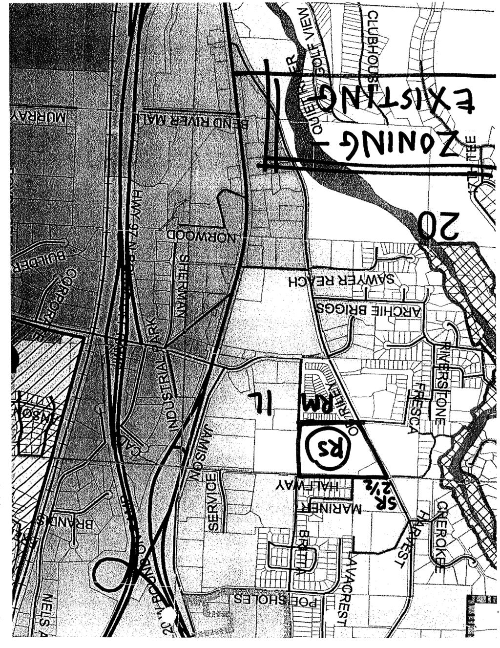
4 ORDINANCE NO. NS-2023 AN ORDINANCE AMENDING THE CITY OF BEND DEVELOPMENT CODE, ORDINNACE NO. NS-2016 (ZONING MAP), BY CHANGING THE ZONING DESIGNATION OF TWO PARCELS OF LAND FROM RS, RESIDENTIAL URBAN STANDARD DENSITY TO RM, RESIDENTIAL URBAN MEDIUM DENSITY. THE CITY OF BEND ORDAINS AS FOLLOWS Section 1. Section 2. The Bend City Council has held a public hearing, considered the Hearings Officer's findings and record, and has found that there is a public need and benefit for the proposed change. The Bend City Council adopts the Findings and Recommendations of the Hearings Officer dated July 12, 2006, file number PZ The City of Bend Zoning Map is amended by changing the designation of the property described in Exhibit A and depicted in Exhibit B from Residential Urban Standard Density (RS) to Residential Urban Medium Density (RM). Read for the first time the 2 nd day of August, 2006, Read for the second time the 16 lh day of August, Placed upon its passage the 16 th day of August, Yes: 7 No: 0 Authenticated by the Mayor the 16 th day of August, Bill Friedman, Mayor Patricia Stell, City Recorder Ordinance NS-2023 Page 1 of 3
5 EXHIBIT "A" TO ORDINANCE NO. NS The subject properly i3 described as follows: Two parcels of land containing 10.9 acres more or less, located in a portion of the Northwest One-Quarter (NW 1/4) of the Northeast One-Quarter (NE 1/4) of Section 20, Township 17 South, Range. 12 East, Willamette Meridian, City of Bend, Deschutes County, Oregon, being more particularly described as follows: PARCEL I: Tract 2 of NORWOOD ADDITION, EXCEPTING THEREFROM the following: Beginning at the Northwest comer of Tract 2, NORWOOD ADDITION, Deschutes County, Oregon; thence South 89 55'44" East for feet; thence South 00"23'28" West for50.00 feet; thence Souih 58 23'20" West for feet, more or less, to the Easterly light of way ltas of the old The Dalles-California Highway (1919 location); thence North 32 32' West for feet; thence Noxthwesteriy on a cuiyp to the right whose central angle i ' and whose radius is 1402J feet for feet to the point of beginning. PARCEL H: Beginning at the Northwest coiner of Tract Numbered 2, NORWOOD ADDITION, Deschutes County, Oregon; thence South 89 55'44" East for feet; thence South 00*23'28" West for feet; thence South '20" West for feet, more or less, to the Easteiiy light of way line of the old Dalles-California Highway (1919 location); thence North west for feet; thence North westedy on a curve to the right whose ceati al angle ls05 41* and whose radius is feet foi feet to the point of beginning. Ordinance NS-2023 p a ge 2 of 3
6 EXHIBIT "B" TO ORDINANCE NO. NS Ordinance NS-2023 Page 3 of3
7

8 mmm
9
10 ! FINDINGS, RECOMMENDATION AND DECISION OF CITY OF BEND HEARINGS OFFICER FILE NUMBERS: APPLICANT/ PROPERTYOWNER: APPLICANT'S ENGINEER: APPLICANT'S DESIGNER: APPLICANT'S ARCHITECT: APPLICANT'S ATTORNEY: REQUEST: STAFF REVIEWER: HEARING DATES: RECORD CLOSED: PZ (Zone Change) PZ (Tentative Plan, Site Plan, Conditional Use), LLC 1345 N.W. Wall Street, Suite 100 Bend, Oregon Otak, Inc. 333 S.W. Upper Terrace Drive Bend, Oregon Michael Lane 1432 Main Street St. Helena, California Barry Smith 715 S.W. Morrison Street, Suite 909 Portland, Oregon Tia M. Lewis Schwabe, Williamson & Wyatt 549 S.W. Mill View Way, Suite 100 Bend, Oregon The applicant is requesting approval of a zone change from RS to RM, and tentative plan, site plan, and conditional use approval to develop in two phases a 99-townhome PUD to be known as "" on a 10.9-acre parcel on the west side of O.B. Riley Road south of Halfway Road in Bend. Aaron Henson AICP, Senior Planner March 28 and April 20, 2006 May 18,2006 I. APPLICABLE STANDARDS AND CRITERIA: 1
11 J A. City of Bend Zoning Ordinance, Ordinance No. NS-1178, 1. Chapter 10 * Section , Urban Medium Density Residential (RM) Zone * Section , Site Plan Approval * Section , Off-Street Motor Vehicle Parking and Loading * Section , Conditional Use Permits * Section , Planned Unit Development Approval * Section , Amendments B. City of Bend Land Division Ordinance, Ordinance No. NS Article II, General Requirements, Land Divisions * Section 2.050, Land Divisions 2. Article III, Land Division - Application Procedure * Section 3.040, Phased Tentative Plan * Section 3.050, Approval of Master Development Plan * Section 3.060, Required Findings for Approval 3. Article VI, Design Standards and Improvements * Section 6.010, Compliance Required * Section 6.020, Streets, Sidewalks and Bikeways * Section 6.030, Blocks * Section 6.040, Lots: Size and Shape * Section 6.050, Lots, General Requirements * Section 6.060, General Provisions * Section 6.070, Grading of Lots and Parcels * Section 6.090, Improvement Procedures * Section 6.110, Acceptance of Improvements * Section 6.120, Park and Trail Development and Dedication * Section 6.130, Natural Features and Open Space C. City of Bend Land Use Review and Procedures Ordinance, Ordinance No. NS-1775 * Section , Introduction and Definitions * Section , Review of Land Use Action Applications * Section , Land Use Action Hearings * Section , Limitations on Approvals D. Oregon Administrative Rules Chapter , Transportation Planning Rule 2
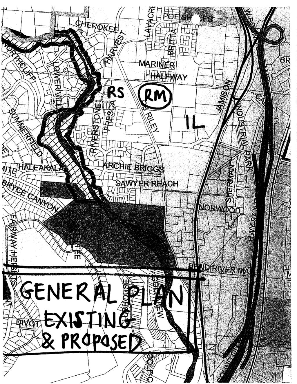
12 1. OAR , Plan and Land Use Regulation Amendments II. FINDINGS OF FACT: A. Location: The subject property is located at and O.B. Riley Road, Bend, at the southeast corner of the O.B. Riley/Halfway Road intersection. It is further identified as Tax Lots 100 and 200 on Deschutes County Assessor's Map AB. B. Zoning and Plan Designation: The subject property is zoned Standard Density Residential (RS) and designated Medium Density Residential (RM) on the Bend Area General Plan map. C. Site Description: The subject property is approximately 10.9 acres in size, roughly rectangular in shape with relatively level topography including a few scattered small rock outcrops. The property has approximately 700 feet of frontage on O.B. Riley Road and approximately 1,000 feet of frontage on Halfway Road. Britta Street is stubbed at the northeast and southeast corners of the property, and Shaeffer Drive is stubbed near the southwest corner of the property. Vegetation consists of pasture grass and mature juniper and ponderosa pine trees. The property is vacant as all previously existing structures have been removed. A short rock wall marks the boundary between the subject property and a large parcel to the east. The rest of the property is fenced with barbed wire. The record indicates the subject property has 10 acres of irrigation water rights through the Swalley Irrigation District (hereafter "Swalley"). D. Surrounding Zoning and Land Uses: Most of the abutting property to the east is zoned RS and developed with two single-family dwellings and pasture. The remaining property to the east and the property to the southeast is zoned Light Industrial (IL) and developed with large office buildings in the Empire Corporate Park. Property to the south recently was rezoned from RS to RM and is being developed with a 68-unit, zero-lot-line residential subdivision called "Empire Estates." 1 Most of the property to the north across Halfway Road is zoned RS and developed with single-family dwellings in the Westerly Subdivision. A small parcel to the northwest, at the northeast corner of the intersection of O.B. Riley and Halfway Roads, is zoned Residential Suburban Low Density (SR 2 l A) and developed with The Rock School of Bend and two single-family dwellings. Property to the west across O.B. Riley Road is zoned RS and developed with the Waldorf School and several new residential subdivisions (Veranda Glen, Prospect Pines, and Enchantment on the Deschutes). E. Procedural History: The tentative plan, site plan, and conditional use applications (PZ ) were submitted on December 30, By a letter dated January 27, 2006 the city advised the applicant that the applications were incomplete because the proposed PUD density would exceed that permitted in the RS Zone and therefore a zone change would be required. In addition, the Planning Division requested that the applicant provide information demonstrating that the proposed street layout meets the city's street design standards. In response, on February 7, 2006, the applicant submitted an application for a 1 This subdivision also is known as "Westview Villas." 3

13 zone change (PZ 06-85) and supporting supplemental burden of proof. The zone change application was accepted by the city as complete on March 9, Therefore, the 120- day period for issuance of a final local land use decision under ORS on all four applications would have expired on July 7, A public hearing on the applicant's proposal was scheduled for March 28,2006. On March 22, 2006, the applicant requested that the public hearing be continued in order to allow the applicant additional time to address street design issues raised in the city's incomplete application letter. On March 23, 2006, the applicant submitted a written agreement to toll the 120-day period during the period the hearing was continued. The initial public hearing was held on March 28, 2006 and was continued to April 20, Therefore, the 120-day period was extended from March 28 to April 20, 2006 and would have expired on July 31, On March 31, 2006, the applicant submitted a revised tentative plan reducing the number of proposed units from 100 to 99, as well as a supplemental burden of proof statement, revised drawings addressing lot coverage and setbacks, and a revised design for the intersection of O.B. Riley and Halfway Roads. The applicant did not submit a modification application under Section (8) although the change in PUD size and layout would meet the definition of "modification" under Section (2)(I). On April 20, 2006, the day of the continued public hearing, the Hearings Officer conducted a site visit to the subject property and vicinity. At the continued public hearing, the Hearings Officer disclosed her observations and impressions from the site visit, and received testimony and evidence. At the close of the hearing, staff and the applicant agreed that in light of the applicant's submission of a revised tentative plan on March 31, 2006, the 120-day period should restart on that date as though a modification application had been submitted. 3 Based on that agreement, the 120-day period would have expired on July 31, At the close of the public hearing, the Hearings Officer left the written evidentiary record open through May 18, 2006 and allowed the applicant through May 25, 2006 to submit final argument pursuant to ORS By an message on May 18, 2006 the applicant waived submission of final argument and the record closed on that date. Because the applicant agreed to extend the written record from April 20 through May 18, 2006, under Section (16(E) of the city's land use procedures ordinance the 120-day period was further extended for a period of 30 days and now expires on August 30, As of the date of this decision there remain 48 days in the 120-day period. F. Proposal: The applicant requests approval of: (1) a zone change from RS to RM; (2) tentative plan and site plan approval to develop in two phases a 99-townhome planned unit development (PUD) called "" including zero-lot-line dwellings, 3.5 acres of open space (1.6 acres of which would be common area), and a community 2 The Hearings Officer finds PUD approval is dependent on zone change approval, and therefore the 120- day period for all applications runsfromthe date the zone change application was accepted as complete. 3 Section (8)(B) the filing of a modification application restarts the 120-day period. 4
14 building, pool and spa, and a network of private streets and pedestrian paths; and (3) conditional use approval to exceed the 30-foot maximum building height limit in the RM Zone up to 6 feet (for a total 36 feet in height) for some townhome buildings. There would be 23 townhome buildings, each of which would have 2 to 8 dwelling units. Access to individual townhomes would be from a system of private streets that would connect via driveway aprons to Halfway Road on the north, Britta Street on the east, and Schaeffer Drive on the south. Townhomes and private streets would be configured to create open space and preserve existing mature trees. The applicant proposes to construct a 6-foot-tall sight-obscuring wall or fence around the entire development. The wall running along the western boundary of the PUD between O.B. Riley Road and the proposed "A" Street would have "windows" providing view corridors into the PUD's open space areas. The applicant proposes to dedicate additional right-of-way for and to improve abutting segments of existing public streets, and to extend city water and sewer facilities to serve the PUD. The applicant also proposes to transfer 6.5 acres of Swalley irrigation water rights off the subject property and retain 3.5 acres of water rights to irrigate the PUD open space and common areas. G. Public/Private Agency Notice: The Planning Division sent notice of the applicant's proposal to a number of public and private agencies and received responses from: the City of Bend Fire, Engineering, Wastewater, Building and Development Services Departments, Grading and Drainage, Traffic Engineer, Long-range Planning, ADA Coordinator, and Property Address Coordinator; Bend Metro Park and Recreation District (hereafter "park district"); Bend-La Pine School District; Deschutes County Environmental Health Division; Swalley; and PacifiCorp. These comments are set forth verbatim at pages 5-18 of the staff report, and/or are included in the record, and are addressed in the findings below. H. Public Notice and Comments: The Planning Division mailed individual written notice of the applicant's proposal and the public hearing to the owners of record of all property located within 100 feet of the subject property. In addition, notice of the public hearing was published in the Bend "Bulletin" newspaper, and the subject property was posted with a notice of proposed land use action sign. As of the date the record in this matter closed the city had received 5 letters in response to this notice. In addition, 2 members of the public testified at the public hearing. Public comments are addressed in the findings below. III. CONCLUSIONS OF LAW: ZONE CHANGE APPROVAL CRITERIA A. City of Bend Zoning Ordinance, Ordinance No. NS-I Chapter 10 5 a. Section , Amendments. This ordinance may be amended by changing the boundaries of zones or by changing any other provisions
15 thereof, whenever the public necessity and convenience and the general welfare requires such an amendment. Such a change may be proposed by the City Commission on its own motion or by motion of the Planning Commission or by petition as hereinafter set forth. (1) Application. An application for amendment by a property owner or his authorized agent shall be filed with the City Planning Director. The application shall be made on the forms provided by the City. Before taking final action on a proposed amendment, the Approval Authority shall hold a public hearing thereon. The Approval Authority shall follow the procedures set forth in the City of Bend's land use procedures for map changes. FINDINGS: The applicant proposes to develop the 10.9-acre subject property with a 99- townhome PUD for an overall density of approximately 9 dwelling units per acre. The Bend Area General Plan (hereafter "comprehensive plan") establishes the density range for the RS Zone at 2 to 7.3 dwelling units per gross acre. For this reason, the Planning Division advised the applicant that a zone change from RS to RM would be required for the proposed PUD. The record indicates the applicant submitted its zone change application on a city application form, accompanied by the required application fee and a supplemental burden of proof. Before the approved zone change becomes effective the Bend City Council will hold a public hearing. Therefore, the Hearings Officer finds the applicant's proposal satisfies this section. (2) Standards for Zone Change. The burden of proof is upon the one seeking change. The degree of that burden increases proportionately with the degree of impact of the change which is sought. The applicant shall in all cases establish: (a) That the change conforms to the Comprehensive Plan. Specifically, the change is consistent with the Plan's intent to promote an orderly pattern and sequence of growth. FINDINGS: In several previous decisions the Hearings Officer has held this approval criterion includes three elements: 1) conformance with the comprehensive plan map; 2) conformance with the comprehensive plan text; and 3) consistency with the plan's intent to promote "an orderly pattern and sequence of growth." Each of these elements is discussed separately in the findings below. 1. Conformance with Comprehensive Plan Map. The subject property is designated RM on the comprehensive plan map. Therefore, the Hearings Officer finds the proposed zone change from RS to RM is consistent with the plan map. 2. Conformance with Comprehensive Plan Text. 6
16 In several previous zone change requests, applicants have argued approval of a proposed zone change to conform to the zoning to the plan designation is required by two comprehensive plan policies ~ Residential Policies 21 and 23 - which are set forth below. Policy 21 Densities recommended on the Plan shall be recognized in order to maintain proper relationships between proposed public facilities and services and population distribution. (Bend Area General Plan, p ) Policy 23 The City shall rezone residential lands to the designated general plan densities when sewer service is available to the area. (Bend Area General Plan, p ) The Hearings Officer is aware there are a number of city hearings officers' decisions with conflicting findings concerning the significance of these two policies. I have issued several decisions holding the city's comprehensive plan policies - including Policies 21 and do not constitute mandatory approval criteria for quasi-judicial land use applications. Those holdings have been based on the following language in the preface to the general plan at page P-4: 4 At the end of each chapter [of the plan] are policies that address issues discussed in the chapter. The policies in the General Plan are statements of public policy, and are used to evaluate any proposed changes to the General Plan. Often these statements are expressed in mandatory fashion using the word "shall." These statements of policy shall be interpreted to recognize that the actual implementation of the policies will be accomplished by land use regulations such as the city's zoning ordinance, subdivision ordinance and the like. The realization of these policies is subject to the practical constraints of the city such as availability of funds and compliance of [sic] all applicable federal and state laws, rules and regulations, and constitutional limitations. (Emphasis added.) Some of this Hearings Officer's previous decisions addressing the meaning of this preface language have been appealed to the city council and have been adopted by the council through the adoption of my findings. In Awbrey Towers (02-508) I held the above-quoted plan preface language means plan policies are not mandatory approval criteria for the conditional use and site plan applications at issue in that case. The city council adopted my findings, and the council's decision was appealed to the Land Use Board of Appeals (LUBA). My interpretation of the above-quoted plan preface language was challenged before LUBA. In its decision in Save Our Skyline v. City of Bend, 48 Or LUBA 192 (2004), LUBA stated: "Simply stated.\ the hearings officer concluded that because BAGP [Bend Area General Plan] Policies were not adopted for use as approval criteria in reviewing applications for quasi-judicial land use approval, the cited BAGP Policies and 4 Some of the most recent decisions including this holding are Awbrey Towers (02-508) Shevlin Neighbors (PZ , PZ ) and Rimrock Riders (PZ , PZ ). 7
17 Goals need not be considered in reviewing Awbrey Tower's application for conditional use approval A recurring problem that local governments face in reviewing quasi-judicial permit applications is identifying the relevant approval standards, if any, in the local government's comprehensive plan. The comprehensive plan is a potential source of standards for review of a quasi-judicial land use permit application, because ORS (2)(d) expressly provides that where a local government's comprehensive plan and land use regulations have been acknowledged by LCDC [Land Conservation and Development Commission], the local government is required to 'make land use decisions and limited land use decisions in compliance with the acknowledged plan and land use regulations [.]' [Citations omitted.] Many local governments also impose a local requirement that the comprehensive plan be considered in approving a land use permit application. As far as we can tell, the fourth general conditional use criterion at BC [Bend Code] (3)(d) is such a local requirement. As intervener correctly points out, local and statutory requirements that land use decisions be consistent with the comprehensive plan do not mean that all parts of the comprehensive plan necessarily are approval standards. [Citations omitted.] Local governments and this Board have frequently considered the text and context of cited parts of comprehensive plans and concluded that the alleged comprehensive plan standard was not an applicable approval standard. [Citations omitted.] Even if the comprehensive plan includes provisions that can operate as approval standards, those standards are not necessarily relevant to all quasijudicial land use permit applications. [Citations omitted.] Moreover, even if a plan provision is a relevant standard that must be considered, the plan provision might not constitute a separate mandatory approval criterion, in the sense that it must be separately satisfied, along with any other mandatory approval criteria, before the application can be approved. Instead\ that plan provision, even if it constitutes a relevant standard, may represent a required consideration that must be balanced with other relevant considerations. [Citations omitted.] Before considering whether particular plan provisions must be applied as approval standards when considering individual land use permit applications, it is appropriate, as the hearings officer did in this case, to consider first whether the comprehensive plan itself expressly assigns a particular role to some or all of the plan's goals and policies. [Citations omitted.] We review the hearings officer's interpretation of the BAGP to determine if her interpretation is correct [Citation omitted.] As petitioners correctly note, the BAGP text cited by the hearings officer does not say that all BAGP policies are to be used exclusively in the manner suggested by the text. However, the text cited by the hearings officer, viewed in isolation, strongly supports her interpretation. The text quoted by the hearings officer appears in the section of the BAGP Preface entitled 'Format of the Plan. * There 8
18 is additional text in that same section of the BAGP Preface that appears below the text quoted by the hearings officer, which states: 'These same [BAGP] community policies serve individual property owners and private interest groups as a means of evaluating their individual decisions in light of community objectives. They are able to determine how their individual interests can best be served in a manner that is consistent with the Bend Area General Plan.' BAGP Preface.' The above text is not cited by the hearings officer or any of the parties in this appeal\ but it can be read to say the BAGP Policies might play some role in evaluating individual development decisions. However, the text refers to the decisions of 'individual property owners and private interest groups' rather than city quasi-judicial permit decisions. Given the relatively clear role the text cited by the hearings officer seems to assign to BAGP Policies, we agree with the hearing's officer's interpretation of that text to support her conclusion that the BAGP Policies do not apply as approval standards that she was obligated to consider directly in reviewing conditional use permit applications. Turning to the two BAGP Goals cited above, the hearings officer's reasoning for why BAGP Policies do not apply as approval criteria does not directly address the potential applicability of these BAGP Goals. It does not necessarily follow that if BAGP Policies are not potential conditional use approval standards, that the BAGP Goals also are not potential conditional use approval standards. However, it is relatively clear that in the hierarchy established by the BAGP the Goals operate at a higher and even more general level than the BAGP Policies. [Footnote omitted.] Having adopted text to make it clear that BAGP policies are not be viewed as potential approval criteria for applications for conditional use approval, we believe it is highly unlikely that the city could have intended that BAGP Goals operate as potential approval criteria for such applications. Moreover, even if BAGP Goals could be viewed as potential approval standards, the two BAGP Goals cited by the SOS petitioners are not worded as mandatory requirements. Rather, they are worded as 'aspirational declarations.' [Citation omitted.] For the reasons explained above, we do not agree with the SOS petitioner that the city erred in not applying the cited BAGP Goals and Policies as approval standards in this case. It may be that there are other parts of the BAGP that are implicated by BCC (3)(c), but the cited BAGP Goals and Policies are not "(Underscored text appears as italicized emphasized text in original.) The Hearings Officer found in Rimrock Riders (PZ , PZ ) that while LUBA's holding in Save Our Skyline was limited to whether the city was required to consider identified plan goals as mandatory conditional use approval criteria, the quoted dicta make clear that LUBA supported my interpretation of the language at issue in the city's Plan Preface when it 9
19 stated the preface assigned a "relatively clear role" to plan policies in general - i.e., not to constitute mandatory approval criteria for quasi-judicial land use applications. As LUBA stated in its decision in Save Our Skyline, identifying the relevant approval standards, if any, in the comprehensive plan is "a recurring problem that local governments face in reviewing quasi-judicial permit applications." Through adopting conflicting hearings officers' decisions, the city council has adopted conflicting interpretations of the meaning and application of Residential Policies 21 and 23. LUBA has upheld the interpretations that plan policies are not mandatory approval criteria. For the foregoing reasons, the Hearings Officer finds Residential Policies 21 and 23 do not require approval of the proposed zone change because they do not constitute mandatory approval criteria for the proposed zone change. At most, they express the city's intent that land within the Urban Growth Boundary (UGB) that is designated for urban-density development should be rezoned to conform to its plan designation when: (a) city sewer and water service are available; and (b) the applicant has demonstrated the proposed zone change satisfies all applicable zone change approval criteria in the city's zoning ordinance. 3. Consistency with the Plan's Intent to Promote an Orderly Pattern and Sequence of Growth. In previous zone change decisions the Hearings Officer has held the phrase "orderly pattern and sequence of growth" contemplates consideration of both the location and timing of urban development. I have concluded an orderly pattern of growth is one that promotes compatible physical relationships between zoning districts and uses, while an orderly sequence of growth promotes urban-density development concurrent with the provision of adequate urban services. I adhere to that interpretation here. a. Orderly Pattern of Growth. In several recent zone change decisions the applicants have requested approval to rezone to RS land designated RS but zoned for low-density residential use. In those decisions, the Hearings Officer has held rezoning such property would promote an orderly pattern of growth because it would foster proper relationships between zoning districts and uses, including surrounding property designated RS but zoned at lower density, and would be consistent with the type of urban-density development contemplated by the city for these RS-designated parcels, thereby promoting an orderly pattern of growth. See, e.g., Shevlin Neighbors and Rimrock Riders. In contrast, the subject property already is zoned for urban-density development and the applicant is requesting approval to rezone the property to conform to its higher-density RM plan designation. O.B. Riley Road is a designated major collector street, much of which now is located within the Bend city limits. In addition, much of the land within the city limits along both sides of O.B. Riley Road has been redesignated RS or RM and thereby was planned for urban-density residential development when city sewer service became available. The record indicates several relatively new subdivisions zoned RS and located along the east side of O.B. Riley Road have been developed and are served by city sewer. In addition, the Hearings Officer recently approved 10
20 rezoning to RS and subdivision development on the former Rimrock Riders' property on the west side of O.B. Riley Road northwest of the subject property. I find these existing subdivisions and subdivision approvals represent the establishment of a new urban-density pattern of growth along O.B. Riley Road which the applicant's proposed zone change and PUD would further. For the foregoing reasons, the Hearings Officer finds the proposed zone change from RS to RM will promote an orderly pattern of growth. b. Orderly Sequence of Growth. In numerous previous decisions, this Hearings Officer has found an orderly sequence of growth is one that promotes urban-density development concurrent with adequate urban infrastructure, including sewer, water, police and fire protection, schools and transportation facilities. Each of these facilities and services is discussed separately in the findings below. (1) Police Protection. Because the subject property is located within the Bend city limits it will be served by the Bend Police Department which did not comment on the applicant's proposal. The Hearings Officer finds this lack of comment indicates the Police Department believes it can serve urban-density development on the subject property. (2) Fire Protection. Because the subject property is located within the Bend city limits it will be served by the Bend Fire Department. Included in the record are detailed comments from the Fire Department and the Fire Marshal concerning water required for fire protection. The Fire Department's initial comments state in pertinent part: "The required water supply for fire suppression for this building shall be 1,000 gallons per minute at 20 psi residual pressure + fire sprinkler system flow demand for an approved NFPA 13 fire sprinkler system installed throughout each building. This flow requirement is based on Type VB building construction not to exceed 3,600 square feet. Fire Hydrant Spacing Oregon IFC 508 and Appendix C Fire hydrants shall be located along the route of the fire apparatus access roadway and spacing of hydrants shall not exceed 500feet and 400feet for deadend access roads. Appears not to meet this requirement; See City of Bend Fire Marshal for approval of hydrant locations and water supply to this project" (Bold emphasis in original.) A fire flow analysis indicates fire flow at the existing fire hydrant on Halfway Road is only 980 gpm with psi residual pressure and the fire flow at the existing hydrant on O.B. Riley Road is only 950 gpm with psi residual pressure. In its comments on the applicant's proposal the Engineering Division expressed concern that there may not be adequate city water available to meet fire flow and irrigation requirements without curtailment of irrigation demands on the system. However, as discussed in the Findings of Fact above, the subject property has irrigation water rights through the Swalley Irrigation District, and the applicant plans to retain 3.5 acres of irrigation water rights for irrigation of the proposed open spaces within the PUD. In addition, the 11
21 applicant proposes to provide fire sprinklers in all PUD buildings, and to install fire hydrants along the fire apparatus access route 750 instead of 500 feet apart. In response to the applicant's proposal, the Fire Marshal stated he would approve the proposed decrease in fire hydrant density in light of the applicant's proposal to install fire sprinklers in each building. The Hearings Officer finds that as a condition of approval the applicant will be required to install an approved fire sprinkler system in the clubhouse building and in each townhome unit, and to install fire hydrants in the locations and with the spacing required by the fire department. I find that with imposition of this condition of approval the applicant's proposal will promote an orderly sequence of growth considering fire protection. (2) Sewer. The applicant proposes to serve subdivision lots with city sewer service through extension of and connection to existing city sewer facilities constructed to serve other new subdivisions. The submitted preliminary utility plan (Drawing No. P5) shows the PUD lots would be served by an extension of the city's existing gravity sewer system through sewer mains extended throughout the development and connected to an existing manhole outfall in Britta Street, which in turn would direct sewage flow into the existing "Empire Estates" Subdivision sewer pump station located near the intersection of Britta Street and Ellie Lane. It its initial comments on the applicant's proposal, the Wastewater Division stated: "In reviewing the above project, which includes the addition of one hundred townhomes located at and O.B. Riley, the Wastewater Division is concerned what impact these additional flows will have on our Wastewater Collection System. Our sewer model currently shows system limitations on the eight inch gravity line located on North Highway 97, Nels Anderson Road, and Fred Meyer Road. The proposed project will only contribute to this problem and increase the likelihood of damage to private property and the environment due to potential sewage back-ups or overflows. We would like to request that this issue be considered by the client's or city engineering staff prior to project approval The Wastewater Division is currently in the process of developing a new Collection System Master Plan (CSMP). The sewer computer model being used in the master plan process shows several areas within the sewer system that are currently experiencing capacity issues. The main purpose of our original is only to make all parties involved aware of these capacity issues. " In his subsequent comments on the applicant's proposal, Michael Magee, the city's Engineering Manager, stated: "City staffprovided a map and data showing the sections of sewer main that are over capacity with the addition of the development. Based on the model results, there are sections of 8-inch main that need to be upgraded to 15-inch diameter to meet current and projectedflows.. We discussed replacing the first short section of deficient pipe (~100 If) between manholes as potential mitigation for the project" In response to Mr. Magee's comments, the applicant agreed to provide off-site sewer mitigation 12

22 by replacing approximately 110 feet of 10-inch sewer main with 15-inch sewer main between manholes near the intersection of Boyd Acres and Fred Meyer Roads and to provide a temporary pumping system to assure the 10-inch sewer main remains functional during the replacement period. The applicant submitted suggested language for a condition of approval and Mr. Magee commented that such language was acceptable to the Engineering Division. For the foregoing reasons, the Hearings Officer finds the applicant will be required as conditions of approval to submit engineered sewer plans to the Engineering Division for review and approval, to provide the city will full-width 20-foot-wide exclusive utility easements for sewer facilities, to construct all sewer facilities in accordance with the applicable city standards and specifications, and to provide the proposed off-site sewer mitigation described above. I find that with imposition of these conditions of approval the applicant's proposal will promote an orderly sequence of growth considering sewer facilities and service. (3) Water. The applicant proposes to serve subdivision lots with city water service through extension of and connection to existing city water facilities constructed to serve other new subdivisions. The water system would be looped from the existing mains in Britta Street and Halfway Road. The applicant proposes to install individual water lines and backflow devices for each dwelling unit in accordance with the city's standards and specifications. As discussed in the findings above concerning fire protection, the applicant proposes to retain 3.5 acres of irrigation water rights so city water will not be required for PUD open space irrigation. The applicant also has proposed, and will be required as a condition of approval, to install fire sprinkler systems in all PUD buildings and to install fire hydrants at the locations and with the spacing approved by the fire department and the Fire Marshal to assure adequate fire protection for all buildings. I find that with imposition of these conditions of approval the applicant's proposal will promote an orderly sequence of growth considering water facilities and service. (3) Schools. The subject property is located within the boundaries of the Bend-La Pine School District. In its comments on the applicant's proposal, the school district stated its policy is to anticipate and respond to growth in school enrollment and not to take a position either encouraging or discouraging growth in general, or in support of or opposition to particular development proposals. The district did request that the applicant construct sidewalks on both sides of the road in order to accommodate student pedestrians and that all subdivision streets be public, or if private streets are proposed that they be subject to a perpetual easement allowing the School District vehicles to travel across them. As discussed in the Findings of Fact above, the applicant proposes a system of private PUD streets that will connect with three existing public streets abutting the subject property. The applicant has proposed to install a sidewalk on one side of all PUD streets. The Hearings Officer finds the applicant will be required as a condition of approval to grant a public access easement across all private PUD streets and sidewalks. I find that with imposition of this condition of approval the applicant's proposal will promote an orderly sequence of growth considering school impacts. (4) Transportation Facilities. The applicant proposes access to the subdivision through a system of private PUD streets that will connect via driveway aprons to Halfway Road on the north, Britta Street on the east, and Schaeffer Drive on the south, and thereafter to O.B. Riley Road. The record indicates O.B. Riley Road and Britta Street are classified as collector streets, and 13
 prepared by Group Mackenzie and dated December 19, 2005, as well as supplemental traffic analysis dated March 31, 2006")
23 Halfway Road and Schaeffer Drive are classified as local streets. The applicant submitted a traffic impact analysis (hereafter "traffic study") prepared by Group Mackenzie and dated December 19, 2005, as well as supplemental traffic analysis dated March 31, 2006 addressing the O.B. Riley/Halfway Road intersection. The traffic study predicts a proposed 100-townhome PUD would generate a total of 642 average daily vehicle trips (ADT's) of which 60 would occur during the p.m. peak hour (4:00 p.m. to 6:00 p.m. weekdays). The traffic study predicted approximately 20 percent of PUD-generated traffic would use the access points from Halfway Road and 80 percent would use the access from Britta Street. The traffic study did not analyze use of the proposed access to Schaeffer Drive on the south because it was prepared before the applicant revised its proposal to include the Schaeffer Drive access. The traffic study analyzed the function of two of the three subdivision access intersections (Halfway Road and Britta Street), as well as five public street intersections predicted to be affected by PUD-generated traffic. The analyzed street intersections are: O.B. Riley Road/Empire Avenue, O.B. Riley Road/N.E. 3 rd Street (Business Highway 97), Empire Avenue/N.E. 3 rd Street, O.B. Riley/Halfway Road, and Empire Avenue/Britta Street with the addition of subdivision-generated traffic, 5 The traffic study states the city has established in its street policies acceptable levels of service for intersections based on their volume-to-capacity ratio (v/c ratio) - i.e., the intersection's capacity to handle vehicle movements on each leg of the intersection without lengthy delays - and that the maximum acceptable v/c ratio is equal to or less than 1.0. The traffic study concluded the two analyzed PUD access points (Halfway Road and Britta Street) as well as all five affected public street intersections will function at acceptable levels of service - i.e., v/c ratios of.93 or lower with the addition of PUD-generated traffic in 2006 and The applicant has proposed to dedicate additional right-of-way for and to improve to the city's standards and specifications the abutting segments of O.B. Riley Road, Halfway Road, and Britta Street. The applicant also has proposed to reconstruct the O.B. Riley/Halfway Road intersection to increase its angle from 60 to 80 degrees to meet the city's standards and specifications for intersection angles. The Hearings Officer finds the applicant will be required as a condition of approval to make these right-of-way dedications and construct these improvements. In addition to the above right-of-way and improvement requirements, the city's Traffic Engineer Robin Lewis recommended that the applicant be required as a condition of approval to execute a waiver of remonstrance to the formation of a local improvement district (LID) for improvements to O.B. Riley Road to bring it to full city collector street standards within city limits. The city suggested the waiver be in substantially the same form as the form required for the "Rimrock Riders" subdivision approved for a location on the west side of O.B. Riley Road north of the subject property. In response, the applicant's attorney stated at the public hearing that the applicant would have no objection to executing such a waiver as long as the city would agree to establish a cap on the total amount of monetary contribution for the O.B. Riley Road improvements. The Hearings Officer is aware the city has begun to require that subdivision developers pay monetary contributions to the cost of improving city streets to applicable 5 The traffic study indicates the Empire Avenue/N.E. Third Street intersection will function near its capacity in Nevertheless, in its comments on the applicant's proposal ODOT did not express any concerns regarding the function of this intersection over which it has control. 14
24 standards and specifications in order to close a gap between what the city is able to collect through street systems development charges (SDC's) assessed at the time building permits are issued for new dwellings and other available funds, and the cost of these improvements. 6 Ms. Lewis stated in her written comments that the city estimates the cost of improving the entire segment of O.B. Riley Road within the Bend city limits to the city's major collector standards is $7.1 million and the city predicts O.B. Riley Road eventually will handle 15,000 ADT's and 1,500 p.m. peak hour trips generated by both existing and future growth, including the predicted 60 p.m. peak hour trips from the proposed PUD. Therefore, dividing the total improvement cost by the 1,500 predicted p.m. peak hour trips results in a cost of $4,733 per p.m. peak hour trip. I understand from comments in the record from Ms. Lewis and Engineering Manager Michael Magee that this figure represents the "cap" on the applicant's contribution that would result from executing a waiver of remonstrance for the formation of an LID for O.B. Riley Road improvements - i.e., $4,733 x 60 p.m. peak hour trips, or $283,980. Ms. Lewis also recommended that the applicant be required as a condition of approval to make the following monetary contributions for improvements to three intersections the applicant's traffic study has identified would be affected by PUD-generated traffic, based on similar pro-rata calculations: $4,077 for the Britta/Empire intersection; $1,356 toward the city's contribution to a traffic signal at the N.E. Third Street/Empire intersection; and $448 for the Empire/O.B. Riley intersection. 7 In the Hearings Officer's previous decision in Rimrock Riders I made the following findings concerning the type of pro-rata monetary contribution city staff has recommended the applicant be required to pay as a condition of approval: "The staff report states the city's Street Policy 6 requires that, to the extent practical, the applicant should be required to make a pro-rata monetary contribution to the costs of transportation system improvements required in the future as a result of the cumulative impact the addition of subdivision-generated traffic will have on the city's overall transportation system. The staff report indicates the applicant's pro-rata share is $538 based on the following formula: 'Sum of trips from the project divided by the growth trips ( ) multiplied by the estimated cost of improvements fx 365,000) = 2688 then multiplied by.2 (20% not covered by SDC's) for a total contribution of $538.' 6 The Hearings Officer is aware the city has assessed only 80 percent of the maximum allowable street SDC's, resulting in a street funding shortfall. 7 The staff report notes this recommended monetary contribution for the Empire/O.B. Riley Road intersection should be included as part of the improvements funded through the O.B. Riley Road LID, and therefore should not be required in addition to a waiver of remonstrance to the formation of the LID. The Hearings Officer agrees and finds it will not be required. 15
25 The Hearings Officer finds that unlike recommended dedication and improvement of both sides of O.B. Riley Road, this exaction is constitutional because there is a nexus between subdivision-generated traffic and needed improvements to the city's overall transportation system, and the formula used by the city to calculate the applicant's pro-rata share assures the monetary contribution is roughly proportional to the impact from subdivision-generated traffic. Therefore, I find the applicant will be required as a condition of approval to pay this pro-rata contribution." The Hearings Officer finds there is a nexus between the cumulative traffic impacts from the applicant's proposal on O.B. Riley Road and the intersections of Empire Avenue with Britta Street and N.E. Third Street and the need for improvements to these facilities. I also find the calculations in the record show both the recommended "cap" for LID contributions for the O.B. Riley Road improvements and the recommended monetary contributions for the two intersection improvements are roughly proportional to those impacts. For the foregoing reasons, and with imposition of the conditions of approval described above, the Hearings Officer finds the applicant's proposal will promote an orderly sequence of growth considering traffic impacts. I further find the applicant's proposal will promote both an orderly pattern and sequence of growth, therefore satisfying this zone change approval criterion. (b) That the change will not interfere with existing development on, development potential, or value of other land in the vicinity of the proposed action. FINDINGS: The area surrounding the subject property is characterized by a mixture of plan designations, zoning districts, densities and uses. Until 2005 the predominant land use in this area was low-density residential development with some small-scale "hobby farms." However, with the redesignation of these parcels and rezoning to urban density, and with their subsequent redevelopment with urban-density residential subdivisions, the character of the land along both sides of O.B. Riley Road within the Bend UGB is changing. As discussed above, the abutting property to the south is zoned RM and is being developed with a 68-unit, zero-lot-line subdivision that will have a density similar to that proposed by the applicant for the subject property. In addition, the subject property and the abutting property to the south are located adjacent to light industrial zoning and development, and thus are in a transition area between non-residential development and RS-zoned land that is or will be developed with urban-density residential subdivisions. For these reasons, the Hearings Officer finds the proposed zone change from RS to RM will not interfere with existing or potential development on RS-, RM-, or ILzoned lands. I also find the proposed zone change will extend city water and sewer service between the residential subdivisions to the north and south as well as provide improvements to O.B. Riley Road. I further find the proposed zone change will encourage redevelopment of remaining RS-designated and zoned land along O.B. Riley Road. For the foregoing reasons, the Hearings Officer finds the proposed zone change will not interfere with existing or potential development, or the value of, land in the vicinity of the subject 16
26 property, therefore satisfying this criterion. (c) That the change in classification for the subject property is consistent with the purpose and intent of the proposed zone classification. FINDINGS: The purpose of the RM Zone is set forth in Section as follows: (1) Purpose. This zone is intended to provide for the development of low-density multiple-family residential structures where such buildings are reasonably spaced on the lot to provide for light, air, privacy, safety and insulation against transmission of sound in areas with community services. Each development of two or more units is subject to Site Plan approval as provided in Section 23. The Hearings Officer finds purpose statements generally do not constitute mandatory approval criteria for quasi-judicial land use applications. Rather, at most they provide some guidance in interpreting applicable approval criteria. However, I find the language in Subsection (c) of this section does establish an approval criterion requiring the applicant to demonstrate its proposal is "consistent" with the purpose statement of the proposed RM Zone. The applicant is requesting approval of a zone change from RS to RM in order to develop the subject property with a 99-townhome residential PUD with zero-lot-line lots. The subject property is located within the Bend city limits and UGB and can be served by city sewer service and public streets. The density range for the RM Zone established in the comprehensive Plan is 7.3 to 21.7 dwellings per gross acre. The applicant's proposal to develop the 10.9-acre subject property with a 99-townhome PUD would result in a density of approximately 9 units per gross acre, at the lower end of the RM Zone density range. The staff report states, and the Hearings Officer concurs, that the proposed zone change would allow the subject property to develop at higher levels of urban density thereby extending the life of the UGB and helping to meet the city's identified need for additional housing. For the foregoing reasons, the Hearings Officer finds the applicant's proposed zone change from RS to RM is consistent with the purpose of the RM Zone. (d) That the change will result in the orderly and efficient extension of provisions of public services. Also, that the change is consistent with the City of Bend policy for provision of public facilities. FINDINGS: As discussed above, the Hearings Officer has found that with imposition of conditions of approval the proposed zone change will promote an orderly sequence of growth by assuring adequate infrastructure will be provided concurrently with the proposed urban-density development. Based on those findings, incorporated by reference herein, and imposition of the conditions of approval described above, I find the applicant's proposal will satisfy this criterion. 17
27 (e) That there is proof of a change in circumstances or a mistake in the original zoning. FINDINGS: The applicant does not argue the subject property's RS zoning was a mistake. Rather, the applicant argues the proposed zone change to RM is justified by a change in circumstances consisting of the redesignation of the subject property to RM and the availability of city sewer service for the property. The staff report notes the existing RS zoning was placed on the subject property by Deschutes County prior to the city's annexation of the subject property in 1998 because at that time sewer was not available in that part of Bend. 8 The city redesignated the subject property to RM in 1998 because of its location near industrial lands and because the city could serve it with sewer. However, the city left to individual property owners the task of rezoning the property to conform to its plan designation. The applicant's zone change burden of proof and the staff report state, and the Hearings Officer concurs, that these changes in circumstances have been found to justify a number of previous proposed zone changes to urban density throughout Bend. I find the circumstances relied upon by the applicant are sufficient to demonstrate a change of circumstances justifying the proposed zone change. For the foregoing reasons, and with imposition of the conditions of approval described above, the Hearings Officer finds the applicant's proposal satisfies the zone change approval criteria in this section. B. Bend Area General Plan C. Oregon Administrative Rules, Chapter 660, Division 15, Statewide Planning Goals and Guidelines FINDINGS: The staff report includes zone change findings addressing the comprehensive plan and the statewide land use planning goals. The Hearings Officer finds neither the plan provisions nor the statewide goals apply directly to the proposed quasi-judicial zone change. The city's acknowledged comprehensive plan implements the goals, and the plan is implemented by the city's land use regulations including the zoning ordinance. Therefore, because I have found the applicant's proposed zone change satisfies the requirements of the zoning ordinance I find it also satisfies the requirements of the plan and goals. D. Oregon Administrative Rules, Chapter 660, Division 12, Transportation Planning Rule 1. OAR , Plan and Land Use Regulation Amendments (1) Amendments to functional plans, acknowledged comprehensive plans, and land use regulations which significantly affect a transportation facility shall assure that allowed land uses are consistent with the identified function, capacity, and level of service of the facility. This shall be accomplished by either: 8 The Hearings Officer is aware that in 1998 the city annexed all land located between the city limits and the UGB as they existed at that time. 18
28 (a) (b) Limiting allowed land uses to be consistent with the planned function, capacity and level of service of the transportation facility; Amending the TSP to provide transportation facilities adequate to support the proposed land uses consistent with the requirements of this division; or (c) Altering land use designations, densities, or design requirements to reduce demand for automobile travel and meet travel needs through other modes. (2) A plan or land use regulation amendment significantly affects a transportation facility if it: (a) (b) (c) (d) Changes the functional classification of an existing or planned transportation facility; Changes standards implementing a functional classification plan; Allows types or levels of land uses which would result in levels of travel or access which are inconsistent with the functional classification of a transportation facility; or Would reduce the level of service of the facility below the minimum acceptable level identified in the TSP. FINDINGS: The Hearings Officer finds the provisions of the administrative rule apply to the proposed zone change because it would require an amendment to the city's zoning map which under Section is a part of the city's zoning ordinance, and therefore the applicant is proposing an amendment to a land use regulation. The remaining issue is whether the proposed zone change from RS to RM will "significantly affect a transportation facility." As discussed in the findings above, the applicant submitted a traffic study that concluded all affected site access points and intersections will function at acceptable levels of service with the addition of PUDgenerated traffic. In addition, the applicant has proposed, and will be required as conditions of approval, to dedicate right-of-way for and to improve all PUD streets and the abutting segments of existing public streets. For these reasons, I find the proposed zone change will not change either the functional classification of, or the standards implementing such classification, for O.B. Riley Road, Halfway Road, Britta Street or Schaeffer Drive. O.B. Riley Road and Britta Street will remain designated collector streets, and Halfway Road and Schaeffer Drive will remain designated local streets, all subject to the city's standards and specifications for such streets. On the basis of the applicant's traffic study which indicates O.B. Riley Road and the affected intersections can handle subdivision-generated traffic, the Hearings Officer also finds the proposed zone change will not result in types or levels of land use that would be inconsistent 19
29 with affected streets' functional classifications. Finally, I find that because the city does not have an acknowledged transportation system plan (TSP), no minimum acceptable level of service has been established in the TSP and therefore the standard in Subsection (2)(d) is not applicable. 9 For these reasons, I find the applicant's proposed zone change will be consistent with the Transportation Planning Rule. Based on the foregoing findings, the Hearings Officer finds the applicant's proposed zone change from RS to RM satisfies all applicable zone change approval criteria. RM ZONE APPROVAL CRITERIA E. City of Bend Zoning Ordinance, Ordinance No. NS Chapter 10 a. Section , Urban Medium Density Residential Zone, or RM Zone (1) Purpose. This zone is intended to provide for the development of medium density multiple-family residential structures where such buildings are reasonably spaced on the lot to provide for light, air, privacy, safety and insulation against transmission of sound in areas with sewer and water services. Each development of two or more units is subject to Site Plan approval as provided in Section 23. (2) Permitted Uses. The following uses are permitted: (a) Two-family dwelling or duplex. it it it (c) Multiple-family dwellings, apartment houses, dwelling group, and condominiums. (3) Conditional Uses. The following conditional uses may be permitted subject to a Conditional Use permit and the provisions of Section 29. it it it (e) Planned Unit Developments subject to the provisions of Section 30. it it it 9 As noted above, the city has identified acceptable levels of service in its street policies. 20
30 (h) Buildings over 30 feet in height. AAA (k) Single-family dwelling. (4) Height Regulations. No building or structure shall be hereafter erected, enlarged or structurally altered to exceed a height of 30 feet without a Conditional Use Permit. FINDING: As discussed in the findings above, the Hearings Officer has found the proposed zone change from RS to RM will be consistent with the purpose of the RM Zone because it will allow the subject property to be developed with a 99-townhome PUD that will be served by city water and sewer. The applicant proposes zero-lot-line single-family dwellings with one dwelling unit per lot for an overall density of approximately 9 dwelling units per gross acre. The submitted elevation drawings for the proposed townhome buildings show they will have the outward appearance of multi-family dwellings with individual garages. Apparently for this reason staff considers the proposed dwellings to be permitted outright like duplexes, multifamily dwellings and condominiums rather than a conditional use like conventional single-family dwellings. I find staffs rationale for treating the proposed PUD dwelling units as permitted uses is reasonable, and therefore I find the applicant's proposed dwelling units are permitted outright in the RM Zone. The applicant also has requested conditional use approval for the proposed PUD and to exceed the 30-foot height limit for some PUD buildings. The proposal's compliance with the applicable conditional use approval criteria is discussed in the findings below. (5) Lot Requirements. The following lot requirements shall be observed: (a) Lot Area: Every lot shall have a minimum area of 2,500 square feet for the first unit plus 2,000 square feet per unit thereafter. A lot having a width of less than 50 feet, and an area of less than 2,500 square feet of record at the time of the passage of this ordinance, may be occupied by one single-family dwelling provided that all the yard requirements of this section are observed. FINDINGS: The revised tentative subdivision plan proposes that residential lots would range from 1,524 square feet to 5,567 square feet. The proposed clubhouse would be developed on an 18,691-square-foot lot, and the proposed open space tracts would range from 1,555 to 15,918 square feet in size. The applicant has requested an exception to the minimum lot area requirements in the RM Zone as part of PUD approval in order to create a large amount of open space and common areas. As discussed in the findings below concerning the proposal's compliance with the PUD approval criteria, the Hearings Officer has found the applicant has demonstrated the proposed reduction in minimum lot sizes will be adequately offset by the creation of a significant amount of open space and the preservation of the majority of mature trees on the subject property. 21
31 (b) Lot Width: Every lot shall have a minimum width of 30 feet. The lot width may be reduced to 20 feet for lots in an approved zero lot line subdivision. FINDINGS: The revised tentative subdivision plan shows several proposed lots would be only 18 feet wide and would have no side yards as the dwellings would be zero-lot-line attached dwellings. The applicant also has requested an exception to the minimum lot width in the RM Zone as part of its PUD proposal. As discussed in the findings below concerning the proposal's compliance with the PUD approval criteria, the Hearings Officer has found the applicant has demonstrated the proposed reduction in minimum lot widths will be adequately offset by the creation of a significant amount of open space and the preservation of the majority of mature trees on the subject property. (c) Front Yard: The front yard shall be a minimum of 10 feet except a garage or carport shall be a minimum of 20 feet. FINDINGS: The revised tentative subdivision plans shows the proposed zero-lot-line townhomes facing on the internal PUD streets would have a minimum front setback of 10 feet and a minimum front setback of 20 feet or greater for all garages. However, the staff report notes, and the Hearings Officer agrees, that under the definition of "lot line, front" under Section i.e., "the property line abutting a street" ~ these minimum front setbacks also apply to the lots abutting Halfway Road and Britta Street. The applicant has requested an exception to the minimum front yard setback for these lots as part of its PUD approval. As discussed in the findings below concerning the proposal's compliance with the PUD approval criteria, I have found the applicant has demonstrated the proposed reduction in minimum front yard setback for lots abutting Halfway Road and Britta Street will be adequately offset by the creation of a significant amount of open space and the preservation of the majority of mature trees on the subject property. (d) Side Yard. There shall be a minimum side yard of 5 feet and the sum of the two side yards shall be a minimum of 10 feet. The side yards shall be increased by l A foot for each foot by which the building height exceeds 15 feet. FINDINGS: Under Section l(5)(i), side yard setbacks in the RM Zone may be waived for an approved zero-lot-line subdivision or partition. However, the staff report notes this waiver applies only with respect to the interior side walls of the attached dwelling units and not for the side yards along their exterior walls. The revised tentative subdivision plan shows several proposed townhome buildings do not meet the minimum required side setback along their exterior side walls. The Hearings Officer finds these exterior side yard setbacks can be reduced as part of the applicant's PUD proposal. And as discussed in the findings below concerning the proposal's compliance with the PUD approval criteria, I have found the applicant has demonstrated the proposed reduction in minimum exterior side yard setbacks for some buildings will be adequately offset by the creation of a significant amount of open space and the 22

32 preservation of the majority of mature trees on the subject property. However, the staff report notes, and I concur, that in order to assure that the buildings for which the exterior side yard setback are reduced still comply with the requirement of the Uniform Building Code that there is at least 36 inches of clearance between lot lines and required emergency escape windows on the exterior walls, the applicant will be required as a condition of approval to maintain all side yard setbacks for the exterior walls of all structures at least 3 feet in width. (e) Rear Yard: There shall be a rear yard having a depth of not less than 5 feet. The rear yard shall be increased by Vi foot for each foot by which the building height exceeds 15 feet. FINDINGS: The revised tentative plan shows some proposed PUD buildings do not meet the minimum required rear setback and will require an exception as part of the applicant's PUD proposal. As discussed in the findings below concerning the proposal's compliance with the PUD approval criteria, the Hearings Officer has found the applicant has demonstrated the proposed reduction in minimum rear yard setbacks for some buildings will be adequately offset by the creation of a significant amount of open space and the preservation of the majority of mature trees on the subject property. However, as was the case with minimum side yard setbacks, in order to assure that the buildings for which the rear yard setbacks are reduced still comply with the requirement of the Uniform Building Code that there is at least 36 inches of clearance between lot lines and required emergency escape windows on the exterior walls, the applicant will be required as a condition of approval to maintain all rear yard setbacks for all structures at least 3 feet in width. (f) Side and rear yard setbacks for duplexes and triplexes are subject to standards in Section 23(d) and (e). FINDINGS: The staff report states, and the Hearings Officer concurs, that because several of the proposed PUD buildings would contain two or three dwelling units they are subject to the minimum side and rear yard setback standards in the site plan criteria in Section These standards require minimum side yard setbacks for duplexes and triplexes of 5 feet on one side and a total of 15 feet for both side yard setbacks for all structures up to 30 feet in height, and a minimum rear yard setback for duplexes and triplexes of 5 feet for such structures. The revised tentative plan indicates some proposed buildings do not meet these standards and therefore will require exceptions through the PUD approval. As discussed in the findings below concerning the proposal's compliance with the PUD approval criteria, the Hearings Officer has found the applicant has demonstrated the proposed reduction in minimum side and rear yard setbacks for duplex and triplex buildings will be adequately offset by the creation of a significant amount of open space and the preservation of the majority of mature trees on the subject property. However, as was the case with minimum side and rear yard setbacks discussed above, in order to assure that the buildings for which the rear yard setbacks are reduced still comply with the requirement of the Uniform Building Code that there is at least 36 inches of clearance between lot lines and required emergency escape windows on the exterior walls, the applicant will be required as a condition of approval to maintain all rear yard setbacks for all structures at least 3 feet in width. 23
33 (g) For single-family residences, the side yard shall be a minimum of five feet on one side and a total of the two side yards shall be 10 feet. The rear yard shall be a minimum of five feet. FINDINGS: The staff report states, and the Hearings Officer concurs, that because the city treats zero-lot-line lots in the same manner as duplexes, triplexes and multi-family dwellings for purposes of determining minimum setbacks this criterion is not applicable. (h) Lot Coverage: Maximum lot coverage by buildings and structures shall be 40 percent of the total lot area. FINDINGS: The applicant has requested an exception to this criterion as part of its proposed PUD approval. On March 31, 2006 the applicant submitted a revised chart showing lot coverage for each lot showing lot coverage ranging from 29.2 to 63.9 percent, with the average proposed lot coverage at 49.6 percent. As discussed in the findings below concerning the proposal's compliance with the PUD approval criteria, the Hearings Officer has found the applicant has demonstrated the proposed increase in the maximum lot coverage for some PUD buildings will be adequately offset by the creation of a significant amount of open space and the preservation of the majority of mature trees on the subject property. (i) Zero Lot Line Subdivision or Partition: Regulations for a side yard setback may be waived for an approved zero lot line subdivision or partition. FINDINGS: As discussed above, the Hearings Officer has found this section authorizes a waiver of the minimum side yard setbacks for the common (interior) walls of the proposed zero-lot-line dwellings. (j) Solar Setback: The solar setback as prescribed in Section 26A. FINDINGS: The revised tentative subdivision plan shows the proposed lots located on the northern boundary of the PUD would have north lot lines separated from other lots by the 60- foot-wide Halfway Road right-of-way, thus satisfying the city's solar setback requirements for these lots. The staff report notes the city exempts all RM lots from the solar setback requirements except where the north lot line abuts an RS, RL (Urban Low Density Residential), SR 2 l A, or UAR-10 (Urban Area Reserve) Zone. Because all interior PUD lots will abut other RM-zoned lots the Hearings Officer finds these lots are exempt from the solar setback requirements. The staff report notes this exemption is authorized through city policy that has not been adopted as part of the city's land use regulations. Accordingly staff recommends the Hearings Officer approve the exemption as part of the proposed PUD approval. I am aware city staff and hearings officers routinely have applied this solar setback exemption without requiring an application for an exception. However, I concur with staff that because such an exemption is based on policy may be vulnerable to challenge. Therefore, I find it will be permitted as part of the PUD approval, based on the above-described offset created by significant open space and the 24
34 preservation of mature trees. (6) Off-Street Parking. Off-street parking shall be provided as required in Section 24. FINDINGS: As discussed in the findings below concerning compliance with Section 24, two off-street parking spaces are required for each dwelling unit. The revised tentative subdivision plan shows at least two off-street parking spaces for each dwelling unit. (7) Special Yards and Distances Between Buildings. The following special yards and distances between buildings shall be observed: (a) An inner court providing access to double-row dwellings groups shall be a minimum of 20 feet. FINDINGS: The staff report states, and the Hearings Officer concurs, that to the extent the proposed PUD lot layout could be characterized as having inner courts serving double-row dwelling groups, this criterion is met because the width of the inner courts is greater than 20 feet. (b) The distance between principal buildings shall be at least 10 feet. This requirement shall also apply to portions of the same building separated from each other by a court or other open space. FINDINGS: The revised tentative subdivision plan shows a few places where the distance between principal buildings may be less than 10 feet and therefore a reduction in this distance must be approved as part of the PUD approval. As discussed in the findings below concerning the proposal's compliance with the PUD approval criteria, the Hearings Officer has found the applicant has demonstrated the proposed decrease in the minimum distance between principal buildings will be adequately offset by the creation of a significant amount of open space and the preservation of the majority of mature trees on the subject property. Based on the foregoing findings, and with imposition of the conditions of approval described in the findings above, the Hearings Officer finds the applicant's proposal satisfies all applicable RM Zone criteria. SUBDIVISION APPROVAL CRITERIA F. City of Bend Land Division Ordinance, Ordinance No. NS Article II, General Requirements, Land Divisions 25 a. Section 2.050, Land Divisions. Land divisions are as follows:
35 AAA 2. Subdivision A. Phased Tentative Plan i. If the applicant proposes to phase in development, he shall provide sufficient information regarding the overall development plan and phasing sequence when submitting the tentative plan. Said plan must comply with the requirements for Phased Tentative Plans as listed in Section of this Title. FINDINGS: The applicant proposes to develop the PUD in two phases and therefore this standard applies. The Hearings Officer finds the applicant's proposal includes sufficient information about each development phase and sequence to demonstrate the phased tentative plan requirements can be met. B. Zero Lot Line Subdivision. In addition to the general provisions for subdivisions set forth in this ordinance, any application for a zero lot line subdivision shall meet the following requirements: i. The tentative plan shall indicate all lot divisions, including those along the common wall of dwelling units and building envelopes. FINDINGS: The revised tentative subdivision plan shows that all 99 lots are zero-lot-line lots allow for common wall dwellings and shows all lot divisions, therefore satisfying this criterion. ii. Independent utility service shall be provided to each unit, including but not limited to water, electricity, and natural gas, unless common utilities are approved by the affected utility agency and are adequately covered by easements. FINDINGS: The applicant has proposed, and the Hearings Officer finds the applicant will be required as a condition of approval, to provide separate and individual utility services to each PUD dwelling unit and to show all required utility easements on the final subdivision plat. iii. Prior to the granting of final 26
36 approval for creation of a zero lot line subdivision, the Planning Director shall require the applicant^) to enter into a written agreement, in a form approved by the City Attorney, that establishes the rights, responsibilities, and liabilities of the parties with respect to maintenance and use of any common areas of the dwelling, such as, but not limited to, common walls, roofing, water pipes, electrical wiring. Such agreement shall be in a form suitable for recording and shall be binding upon the heirs, executors, administrators, and assigns of the parties. FINDINGS: The Hearings Officer finds the applicant will be required as a condition of approval to execute the written agreement concerning common areas of dwellings required by this paragraph, to record this agreement at the time the final plat for each phase is submitted for approval, and to include the contents of the agreement as deed restrictions on the deed for each PUD lot. iv. For all common wall zero lot line subdivisions, site plan review shall also be required prior to final plat approval. FINDINGS: The applicant has requested site plan approval as required by this paragraph. The proposal's compliance with the site plan approval criteria is discussed in the findings below. 2. Article III, Land Division - Application Procedure a. Section 3.030, Informational Requirements The following information shall be shown on the tentative plan or provided in accompanying materials. No tentative plan shall be considered complete unless all such information is provided. A A * FINDINGS: The Hearings Officer finds the applicant provided all information required by this section in the revised tentative subdivision plan, burden of proof statements, and supplemental material submitted in support of the proposed tentative plan. 27
37 b. Section 3.040, Phased Tentative Plan An overall development plan shall be submitted for all development affecting land under the same ownership for which phased development is contemplated. The Review Authority shall review a master development plan at the same time the tentative plan for the first phase of a phased subdivision is reviewed. The phased tentative plan shall include, but not be limited to the informational requirements of of this title, as well as the following elements: 1. Overall development plan, including phase or unit sequence, and the schedule for initiation of improvements and projected completion date. FINDINGS: The revised tentative plan shows the proposed PUD would be developed in two phases. The first phase would include roughly the western half of the proposed PUD with the clubhouse, pool and spa, Lots 1 through 45 and the buildings thereon, and the streets and other infrastructure serving these lots. The second phase would include Lots 46 through 99, the buildings thereon, and the streets and other infrastructure serving these lots. The staff report recommends that the applicant be required to submit the final plat for the first phase within one year of the date this decision becomes final, and to submit the final plat for the second phase within one year of the date the final plat for the first phase is recorded. The applicant has requested that it be allowed an additional year to file the final plat for the first phase because of the size of the PUD. Section of the city's land use procedures ordinance governs the duration of land use approvals and provides in pertinent part: (B) Duration of Approvals AAA 3. In the case of a land use approval authorized under applicable approval criteria to be completed in phases, each phase must be initiated within the time specified in the approval, or initiated within one (1) year of completion of the prior phase if no timetable is specified. (Emphasis added.) The Hearings Officer finds the underscored language authorizes me to establish a timetable for the "initiation" of each phase of a development. I find that authority allows me to extend for one year the time for filing the final plat for the first PUD phase. And I find such an extension is appropriate where, as here, the elements of the proposed PUD make it a more complex development than a typical subdivision. For these reasons, I find the applicant will be required as a condition of approval to submit the final plat for Phase 1 of the PUD within two years of the date this decision becomes final, and to submit the final plat for Phase 2 within one year of the date the final plat for Phase 2 is recorded, unless an extension is obtained pursuant to Section (C). In addition, as discussed in the findings below, I have found Section (6) of the 28
38 PUD approval criteria also authorizes me to extend the deadline for commencement of construction to conform to the extension of the timeline for filing the final plats. 2. Show compliance with the Bend Area General Plan and implementing land use ordinances and policies. FINDINGS: As discussed in the findings above, the Hearings Officer has found the city's comprehensive plan does not establish mandatory approval criteria for the applicant's proposal, and because the comprehensive plan is implemented through the city's land use regulations the proposal's compliance with those regulations will assure compliance with the plan. 3. Overall facility development plan, including transportation and utility facilities plans that specify the traffic pattern for motor vehicles, bicycles, and pedestrians, water system plans, sewer system plans and utility plans. FINDINGS: The revised tentative plan shows the proposed transportation facilities and vehicular, bicycle and pedestrian circulation patterns, as well as all required public facilities and utilities. The applicant's initial proposal included gated private streets within the PUD. However, in response to concerns expressed by city staff, the applicant removed the gate proposal. As discussed elsewhere in this decision, the Hearings Officer has found the applicant will be required as a condition of approval to grant a public access easement over all private PUD streets. For these reasons, I find the applicant's proposal satisfies this criterion. 4. Development plans for any common elements or facilities. FINDINGS: The revised tentative plan shows the size and location of open space and common areas. The applicant's burden of proof states ownership of and maintenance responsibility for the common areas will be transferred to a homeowners' association in accordance with recorded covenants, conditions and restrictions (CC & R's). The common areas will be developed with PUD amenities including a clubhouse building, swimming pool and spa, and associated parking spaces. The proposed open space areas located between residential buildings will be developed with landscaping, pedestrian paths and water features, as well as a 50,000-gallon underground storage tank and pump house for irrigation water for the PUD's landscaping. For these reasons, the Hearings Officer finds the applicant's proposal satisfies this criterion. 29 c. Section 3.050, Approval of a Master Development Plan As an alternative to a phased tentative plan, a master development plan may be submitted before submitting a phased tentative plan and shall be subject to the criteria set forth below. The Review Authority may approved, modify, or disapprove the master development plan and shall set forth findings for such decision. The Review Authority may also attach conditions necessary to bring the plan into compliance will all applicable land use ordinances and general plan policies. Any tentative plan submitted concurrently or subsequently
39 for the master plan area shall substantially conform to the master development plan unless approved otherwise by the City. FINDINGS: The applicant is not proposing a master plan and therefore this criterion is not applicable. d. Section 3.060, Required Findings for Approval The Review Authority shall not approve a tentative plan for a proposed subdivision or partition unless the Hearings Body finds, in addition to other requirements and standards set forth in this ordinance, that the land division as proposed or modified will satisfy the intent and requirements of this ordinance, and Bend Zoning Ordinance, and be in compliance with the Bend Area General Plan. Such findings shall include the following: 1. No application for subdivision or partition shall be approved unless the following requirements are met: A. The land division contributes to the orderly development and land use patterns in the area, and provides for the preservation of natural features and resources such as streams, lakes, natural vegetation, special terrain features, and other natural resources to the maximum degree practicable as determined by the City of Bend. FINDINGS: As discussed in the findings above concerning the proposed zone change, the Hearings Officer has found the applicant's proposed zone change from RS to RM to facilitate development of the proposed PUD will promote an orderly pattern and sequence of development. The staff report states, and I concur, that the "orderly development" zone change standard is very similar to this "orderly development" land division standard. However, I find the standard in this section includes additional elements relating to protection and preservation of natural resources. The record indicates there are no natural streams or lakes on the subject property. The topography of the subject property is relatively level with a few scattered small rock outcrops. I find these outcrops do no constitute "special terrain features" requiring preservation. As discussed in the Findings of Fact above, there are a large number of mature ponderosa pine and juniper trees on the subject property. The applicant proposes to preserve 70 percent of all trees larger than 30 inches in diameter at breast height (dbh) through the clustering of buildings and the configuration of lots, streets and open space. The Hearings Officer finds the proposed PUD design will preserve these mature trees to the maximum degree practicable considering the nature and density of the proposed development. However, to assure these trees survive during construction, I find the applicant will be required as a condition of approval to protect preserved trees during construction by use of construction fencing around each tree ~ calculated using the general rule of one foot outward from the trunk for every inch of dbh ~ and such other protection methods as are recommended by the Planning Division. 30
40 For the foregoing reasons, and with imposition of the above-described condition of approval, the Hearings Officer finds the applicant's proposal will satisfy this criterion. B. The land division will not create excessive demand on public facilities and services required to serve the development. C. The land division contributes to the orderly development of the Bend area transportation network of roads, bikeways, and pedestrian facilities and does not conflict with existing access easements within or adjacent to the land division. FINDINGS: As discussed in the findings above concerning the proposed zone change, the Hearings Officer has found the proposed zone change from RS to RM will promote an orderly pattern and sequence of growth considering necessary infrastructure and impacts on public facilities and services including transportation facilities. I find the "orderly development" standard for zone changes is essentially equivalent to the "excessive demand" and transportation network "orderly development" standards for land divisions. Therefore, for the same reasons set forth in the zone change findings above and incorporated by reference herein, and with imposition of the conditions of approval described in those findings, I find the applicant's proposal satisfies these criteria. D. Each lot or parcel is suited for the use intended or offered. FINDINGS: The proposed PUD lots will be developed with zero-lot-line single-family dwellings. The proposed open space areas and common areas will be developed with PUD amenities including a clubhouse, swimming pool and spa, landscaped areas, pedestrian paths, and necessary PUD infrastructure including irrigation facilities. As discussed elsewhere in this decision, the applicant has requested, and the Hearings Officer has approved, exceptions to several minimum area standards for the proposed PUD lots in order to cluster dwellings, create significant open space areas, and preserve existing mature trees. Based on the information in the record identifying the square footage and footprint of the proposed dwelling units, I find that even with these reductions in lot area and setbacks the proposed PUD lots will have sufficient space to accommodate the proposed dwelling units. I also find the proposed non-residential tracts within the PUD will be of adequate size to accommodate the proposed nonresidential uses. For these reasons, I find the applicant's proposal satisfies this criterion. E. An approved water rights division plan. FINDINGS: In its comments on the applicant's proposal, Swalley stated the subject property has 10 acres of irrigation water rights, of which the applicant proposes to transfer 6.5 acres off the subject property and retain 3.5 acres on the property for irrigating landscaping in the proposed open space areas. The Hearings Officer finds the applicant will be required as a condition of approval to include a statement of water rights and the signature of a Swalley representative on 31
41 the final plat. F. If the land division adjoins an SM or SMR zone, the existence and location of such zone shall be entered on the deed for the lots or parcels created by the land division. FINDINGS: The Hearings Officer finds this criterion is not applicable because the subject property does not adjoin an SM or SMR Zone. G. The tentative plan for the proposed subdivision meets the requirements of ORS FINDINGS: The Hearings Officer finds the provisions of ORS Chapter 92 are implemented through the city's land division ordinance. Therefore, if the proposed PUD satisfies the requirements of the ordinance it will also satisfy the requirements of the statute. As discussed in the findings above and below, I have found the applicant's proposal satisfies, or with conditions of approval will satisfy, all requirements of the land division ordinance. H. If the tentative plan is approved with phasing, the final plat for each phase shall be filed in accordance with the applicable provisions of Article IV of this ordinance. FINDINGS: The applicant proposes to develop the PUD in two phases. As discussed in the findings above, the Hearings Officer has found the applicant will be required to file the final plat for Phase 1 within two years of the date this decision becomes final, and to file the final plat for Phase 2 within one year of the date of recording the final plat for Phase Article VI, Design Standards and Improvements a. Section 6.010, Compliance Required All land divisions shall be in compliance with the design standards set forth in this article and Appendix "A". FINDINGS: As discussed in detail in the findings below, the Hearings Officer has found the proposed PUD satisfies, or with imposition of conditions of approval or exceptions granted as part of PUD approval will satisfy, all applicable design standards in this article. 32 b. Section 6.020, Streets, Sidewalks, and Bikeways 1. General. Facilities providing safe and convenient motor vehicle, pedestrian and bicycle access shall be provided within new subdivisions, partitions, and planned unit developments. Where appropriate and reasonable such facilities may be required from new subdivisions, partitions, and planned unit

42 to nearby residential areas, transit stops, and neighborhood activity centers such as parks, schools, and shopping. FINDINGS: The proposed PUD lots would be served by a system of internal private streets that would connect to adjacent public streets on the north, east and south, which in turn connect to O.B. Riley Road, a designated major collector street, on the west. The applicant proposes, and will be required as a condition of approval, to construct a 5-foot-wide sidewalk on one side of each private street and on the abutting side of all public streets. As noted above, the applicant has withdrawn its original proposal to gate the private streets, and the applicant will be required as a condition of approval to grant a public access easement over all private PUD streets. In their comments on the applicants' proposal, opponents who reside in the "Westerly" Subdivision across Halfway Road to the north expressed concern that most PUD-generated traffic would use Halfway Road to access O.B. Riley Road, thereby creating safety hazards for neighboring residents. In response to these concerns, the applicant revised its proposal to include another street connection with Schaeffer Drive to the south, providing a total of four points of access to the PUD. The Hearings Officer finds that with the addition of this connection, PUD traffic will be better dispersed, thus reducing the impacts on any individual access point or public street. In addition, the applicant will be required as a condition of approval to dedicate right-of-way for and to improve all private PUD and abutting public streets to the city's applicable standards and specifications. In its comments on the applicant's proposal, the Engineering Division expressed concerns about the transition between the private PUD streets and the public streets, in particular that they did not include standard driveway aprons and that two of them are excessively wide - 60 feet rather than the 24 feet specified in Section (5)(e). The revised tentative subdivision plan shows that two of the driveway entrances are much wider than the standard width because of the location of mature trees the applicant proposes to preserve. The staff report questions whether the Hearings Officer has authority to grant an exception to the driveway apron width standard as part of the PUD process, and recommended the applicant be required to redesign these entrances - presumably including removing the trees. However, Engineering Manager Michael Magee commented that the proposed private/public street transitions would satisfy his concerns if they include appropriate directions such as "Keep Right" signs and/or striping to assure that motorists enter and exit the PUD in the appropriate lane. The Hearings Officer understands staffs concerns about the proposed wide driveway aprons divided by trees. I also question whether trees in these locations in fact can survive. However, I have found the PUD provisions discussed in detail in the findings below authorize me to approve exceptions to the street standards requiring sidewalks on both sides of private PUD streets, and therefore I find I also may grant an exception to the street standards for driveway widths as long as they can be justified by offsetting public benefits. As discussed throughout this decision, I have found the proposed PUD's benefits amply justify the proposed exceptions. Therefore, I find the applicant's proposed 60-foot-wide driveway aprons at the western Halfway Road entrance and the Britta Street entrance can be approved, subject to a condition of approval requiring the applicant to install and maintain "Keep Right" signs and/or to stripe the lanes on these driveway entrances. 33

43 The Hearings Officer finds that with imposition of the above-described conditions of approval the applicant's proposed streets and sidewalks will provide safe and convenient vehicle, bicycle and pedestrian circulation for residents of the PUD and adjacent residential areas, thus satisfying this criterion. 2. New Streets. The location, width, and grade of streets shall be considered in their relation to existing and planned streets, topographical conditions, public convenience and safety, and the proposed use of land to be served by the streets. The street system shall assure an adequate traffic circulation system with intersection angles, grades, tangents, and curves appropriate for the traffic to be carried considering the terrain. The subdivision shall provide for the continuation of the streets existing in the adjoining subdivision or of their proper projection. Where, in the opinion of the Review Authority, topographic conditions or other physical constraints make such continuation or conformity impractical, exception may be made. In cases where the City has adopted a plan or plat of a neighborhood or area of which the subdivision is a part, the subdivision shall conform to such adopted neighborhood or area plan. All streets shall be improved to City standards with curbs, paving, drainage facilities and medians if required. FINDINGS: The applicant proposes to create five private internal PUD streets (labeled "A" through "E" on the tentative plan). The street cross-section drawings included with the revised tentative plan show the private PUD streets would have 20 feet of paved surface, a 4-foot-wide sidewalk on one side and a gravel shoulder on the other side. As discussed elsewhere in this decision, the applicant will be required as a condition of approval to install 5-foot-wide sidewalks. The staff report states, and the Hearings Officer concurs, that the subject property's topography will not create significant restrictions on the location, width, or grade of new streets. However, because the proposed streets will be only 20 feet wide there will not be sufficient room for on-street parking, and the applicant will be required as a condition of approval to post "No Parking" signs on both sides of the private PUD streets. As discussed in the findings below concerning the proposal's compliance with the off-street parking requirements, I have found that because the applicant proposes to locate four parallel parking spaces on the segment of "B" Street adjacent to Lots 3 and 20, the applicant will be required as a condition of approval to improve that street segment with 29 feet of pavement to assure at least 20 feet of travel lane pavement width and 9 feet of parking space width. The staff report notes that the existing block lengths on O.B. Riley Road, Halfway Road and Britta Street in the vicinity of the subject property all exceed the 600-foot maximum length prescribed in the land division ordinance. However, the proposed PUD street connections effectively reduce these block lengths to less than 600 feet except for those on O.B. Riley Road. As discussed in detail in the findings below concerning block lengths, the staff report recommends, and the Hearings Officer has found, that an exception to the 600-foot maximum block length for O.B. Riley Road is justified because it is a designated major collector and the 34
44 city's Traffic Engineer recommended against a direct street connection between O.B. Riley Road and the PUD. For the foregoing reasons, I find the applicant's proposal satisfies this criterion. 3. Street Layout and Cul-de-sacs. The street layout shall be generally in a rectangular grid pattern to provide or continue a network of inter-connecting streets. The subdivision streets shall be oriented on an east/west axis to the greatest extent possible to ensure solar access for lots within the subdivision. The grid pattern may be modified as is physically proper to adapt to topography, natural conditions, or to afford scenic views. Cul-de-sac and dead end streets shall only be permitted when the following conditions are met: A. One or more of the following conditions prevent a required street connection: * natural slopes of 18% or more where it is not practical to construct streets with grades of 12%; or * presence of a wetland or water body which cannot be crossed; or * existing development on adjacent property prevents a street connection; and B. A street which either meets standards for connections and spacing or requires less deviation from standards is not possible; and C. Access Corridors are provided consistent with the standards for such corridors; and D. The cul-de-sac(s) shall be as short as possible and shall not exceed 600 feet in length between the center of the cul-de-sac bulb and the centerline of a through street. FINDINGS: The Hearings Officer finds the configuration of the proposed PUD streets generally creates a rectangular grid pattern to the extent possible while clustering buildings and preserving existing mature trees. The tentative subdivision plan shows two short dead-end streets at the northern PUD boundary adjacent to Halfway Road, and both include pedestrian access corridors to Halfway Road. For these reasons, I find the applicant's proposal satisfies this criterion Existing Streets. Wherever streets, adjacent to or within a tract, are of inadequate width to accommodate the increased traffic expected for the subdivision or the City's transportation policies, additional right-of-way shall be provided at the time
45 of the land division by the applicant. During consideration of the tentative plan for the subdivision or partition, the Subdivision Committee shall determine whether improvements to existing streets, adjacent to or within the tract, are required. If so determined, such improvements to adjacent streets shall be required where traffic on said streets shall be directly affected by the proposed subdivision. FINDINGS: As discussed above, the proposed PUD will abut three existing public streets - O.B, Riley Road on the west, Halfway Road on the north, and Britta Street on the east. O.B. Riley Road. The revised tentative plan shows there are 60 feet of existing right-of-way and 43 feet of existing pavement with gravel shoulders and no curbs or sidewalks on the segment of the road abutting the subject property. The Hearings Officer finds the applicant will be required as a condition of approval to make the following right-of-way dedications and improvements for O.B. Riley Road: dedicate sufficient additional right-of-way for 40 feet of right-of-way from the centerline along the western boundary of the subject property; and improve the abutting street segment to the city's standards and specifications for collector streets, including 26 feet of pavement from the centerline, and a curb, striped bike lane, planter strip and 5-foot-wide sidewalk on the abutting (east) side of the street. 10 Halfway Road. The revised tentative plan shows there are approximately 35 feet of existing right-of-way and approximately 24 feet of existing pavement with gravel shoulders and no curbs or sidewalks on the segment of the road abutting the subject property. In addition, the existing intersection with O.B. Riley Road is at a 60-degree angle. The Hearings Officer finds the applicant will be required as a condition of approval to make the following right-of-way dedications and improvements for Halfway Road: dedicate sufficient additional right-of-way for 30 feet of right-of-way from the centerline on the northern property boundary; improve the abutting street segment to the city's standards and specifications for local streets, including 36 feet of pavement, and a curb and sidewalk on the abutting (south) side; and reconstruct the intersection with O.B. Riley Road to increase the angle from 60 to Traffic Engineer Robin Lewis recommended that the applicant be required as a condition of approval to stripe a southbound left turn lane and install a landscaped median in O.B. Riley Road. These improvements were not identified by the applicant's traffic engineer as needed to address the impacts of PUD-generated traffic. Therefore, the Hearings Officer finds these improvements should be included in the improvements covered by an LID. As discussed in the findings above, the applicant will be required as a condition of approval to execute a waiver of remonstrance to the formation of an LID for O.B. Riley Road improvements. 36
46 degrees as depicted on the revised drawings submitted on March 31, Britta Street. The revised tentative plan shows there is approximately 30 feet of existing right-ofway for the abutting segment of Britta Street located on the abutting property to the southeast and extending only approximately 120 feet north from the southern property boundary. However, the revised tentative plan shows the centerline of the Britta Street right-of-way angles to the northeast at approximately the point where the existing right-of-way ends so that more than half of the necessary right-of-way for this entire street segment would be located on the abutting property to the east. As a result, while the applicant can dedicate 30 feet of right-of-way for this street at its southern end, it can only dedicate approximately 10 feet of right-of-way at its northern end. For this reason, with the exception of a sidewalk which the applicant proposes to construct along the entire eastern boundary of the subject property, the applicant has proposed to improve only the most southerly portion of the street to the point where it connects with the proposed private "E" Street - approximately 270 lineal feet north from the subject property's southeast corner. The Engineering Division did not object to the applicant's proposal. Therefore, the Hearings Officer finds the applicant will be required as a condition of approval to make the following right-of-way dedications and improvements: dedicate right-of-way as depicted on the revised tentative plan (Drawing P2); and improve the abutting street segment to the city's standards and specifications for collector streets as depicted on the revised tentative plan (Drawing P2). Other Streets and Intersections. As discussed in the findings above, the Hearings Officer has found the applicant will be required as a condition of approval to execute a waiver of remonstrance to the formation of a LID for improvements to O.B. Riley Road, and to pay monetary contributions for the applicant's pro-rata share of costs for improving two intersections. For the foregoing reasons, and with imposition of the conditions of approval described above, the Hearings Officer finds the applicant's proposal will satisfy this criterion. 5. Intersection Angles. Street intersections shall be as near right angles as possible except where topography requires a lesser angle, but in no case shall the acute angle be less than 80 degrees. FINDINGS: The Hearings Officer finds all proposed PUD streets will have intersections at right angles or at no less than 80 degrees. As discussed above, the applicant has proposed and will be required as a condition of approval to reconstruct the O.B. Riley/Halfway Road intersection to increase its angle from 60 to 80 degrees, thereby bringing it into compliance with the above criterion. For these reasons, and with imposition of this condition of approval, I find the applicant's proposal satisfies or will satisfy this criterion Alignment. Staggered street alignment shall, whenever practicable, leave a maximum of 200 feet distance between the
47 centerlines of the streets, but in no case be less than 125 feet. FINDINGS: The revised tentative plan shows two staggered street alignments - one created by "A" Street with respect to Lavacrest Street across Halfway Road that leaves just over 125 feet between the centerlines of these two streets, and one created by "D" Street with respect to Schaeffer Drive that leaves less than 125 feet between the centerlines of these two streets. The staff report recommends, and the Hearings Officer concurs, that an exception to this standard through the PUD approval is appropriate inasmuch as these streets are expected to have low traffic volumes. 7. Minimum Right of Way and Roadway Width. The street right of way and roadway surfacing widths shall be in conformance with the standards and specifications set forth in Appendix "A", "B" and "C". FINDINGS: The tentative subdivision plan shows all private PUD streets will have the required minimum 20 feet of pavement width, except for the segment of "B" Street adjacent to Lots 3 and 20 which the Hearings Officer has held must be improved to a minimum width of 29 feet to assure 20 feet of travel lane pavement width and 9 feet of parallel parking space width. In addition, the revised tentative plan shows only 4-foot-wide sidewalks rather than the required 5- foot-wide sidewalks. In its comments on the applicant's proposal the Engineering Division argued no exception to the 5-foot sidewalk requirement should be granted as part of the PUD approval because 5 feet is the minimum width necessary to allow two-way pedestrian traffic. At the public hearing, the applicant's attorney testified the applicant would be willing to increase the width of the sidewalks to 5 feet. For these reasons, and with the conditions of approval described above, I find the applicant's proposal will satisfy this criterion. 8. Reserve Strips. Reserve strips controlling access to streets shall be required when deemed necessary by the Hearings Body. Deeds to the City for reserve strips shall be filed with the final plat. Reserve strips shall be numbered in sequence beginning with Lot "A". FINDINGS: The applicant does not propose reserve strips and the Hearings Officer finds none is required. The staff report recommends, and the Hearings Officer concurs, that the applicant be required as a condition of approval to include a notation on the final plat prohibiting direct PUD access to O.B. Riley Road and Britta Street since they are designated collectors streets with limited access. 9. Future Extension of Streets. When necessary to give access to or permit a satisfactory future division of adjoining land, streets shall be extended to the boundary of the subdivision or partition and the resulting dead end streets less than 150 feet in length may be approved without a permanent turnaround. FINDINGS: The proposed private PUD streets will not constitute extensions of public streets. 38
48 However, as discussed above, the applicant will be required as a condition of approval to dedicate right-of-way for and to improve a portion of Britta Street on the subject property's eastern boundary that will provide access fortitle future development of the adjoining land to the east and southeast. In addition, the applicant will be required to dedicate right-of-way for and to improve the abutting segment of Halfway Road that will provide access for future development of the adjoining land to the northwest. Finally, the applicant will be required as a condition of approval to dedicate right-of-way for and to improve the abutting segment of O.B. Riley Road that will provide access for the future development of land to the west. The Hearing Officer finds that with imposition of these conditions of approval the applicant's proposal will satisfy this criterion. 10. Frontage Roads. If a land division abuts or contains an existing or proposed collector or arterial street, the Hearings Body may require frontage roads, reverse frontage lots with suitable depth, screen planting contained in a non-access reservation along the rear or side property line, or other treatment necessary for adequate protection of residential properties and to afford separation of through and local traffic. Provision may be made for emergency access. All frontage roads shall comply with appropriate local road standards. FINDINGS: The proposed PUD abuts two collector streets - O.B. Riley Road and Britta Street. The Hearings Officer finds the proposed private PUD street labeled "A" Street will function as a frontage road for Lots 1 through 15 on the west side of the PUD, and Lots and on the east side of the PUD. I find these lots will constitute reverse frontage lots that will have suitable depth for the proposed residential development. The applicant proposes to provide screen plantings and ornamental walls or fencing along both abutting collector streets. For these reasons, I find the applicant's proposal will satisfy this criterion Streets Adjacent to Railroads, Freeways and Parkways. When the area to be subdivided adjoins or contains a railroad, freeway, or parkway, provision may be required for a street approximately parallel to and on each side of such right of way at a distance suitable for use of the land between the street and railroad, freeway, or parkway. In the case of a railroad, there shall be a land strip of not less than 25 feet in width adjacent and along the railroad right of way for screen planting between the railroad right of way and residential property. If the intervening property between such parallel streets and a freeway or a parkway is less than 80 feet in width, such intervening property shall be dedicated to park or thoroughfare use. The intersections of such parallel streets, where they intersect with streets that cross a railroad, shall be determined with due consideration at cross streets of a minimum distance required for approach grades to a future grade separation and right of way widths of the cross street.
49 FINDINGS: The Hearings Officer finds this criterion is not applicable because the subject property does not adjoin or contain a railroad, freeway, or parkway. 12. Continuation of Streets. Subdivision streets, which constitute the continuation of streets in contiguous territory, shall be aligned so that their centerlines coincide. Where straight-line continuations are not possible, such centerlines shall be continued as curves. These streets or the continuation of streets in contiguous territory may be required by the Hearings Body where such continuation is necessary to maintain the function of the street or desirable existing pattern of development of streets and blocks in the surrounding area. Where solar orientation would not be possible if the street area continued, a new pattern may be started that is solar oriented. FINDINGS: As discussed in the findings above, the Hearings Officer has found none of the proposed private PUD streets technically constitutes a "continuation" of existing streets in contiguous territory, and therefore this criterion is not applicable. However, the proposed "A" Street will facilitate a connection with Schaeffer Drive to the south through a "T" intersection rather than an intersection that aligns the street centerlines in a straight line or a curve. Even assuming for purposes of discussion that "A" Street constitutes a "continuation" of Schaeffer Drive, I find a straight line or curve continuation of Schaeffer Drive is not necessary to maintain its function. To the contrary, the staff report notes, and I concur, that the "T" alignment is in fact necessary to maintain Schaeffer Drive's function. It will allow it to function as a frontage road in the "Empire Estates" Subdivision with respect to O.B. Riley Road, and to create a maximum block length of no more than 600 feet. For these reasons, I find the applicant's proposal satisfies this criterion to the extent it is applicable. 13. Street Names. Except for extension of existing streets, no street name shall be used which will duplicate or be confused with the name of an existing street in a nearby city or in the County. Street names and numbers shall conform to the established pattern in the City and shall be subject to the approval of the Fire Department. FINDINGS: As discussed above, none of the proposed private PUD streets constitutes a continuation of an existing street. The Hearings Officer finds the applicant will be required as a condition of approval to coordinate the selection of names for the new private PUD streets with the Deschutes County and City of Bend Property Address Coordinators. In addition, prior to submitting for approval the final plat for Phase 1 of the PUD the applicant will be required as a condition of approval to submit to the Planning Division written documentation from the Property Address Coordinators that the proposed street names shown on the final plat have been approved. I find that with imposition of these conditions of approval the applicant's proposal will comply with this criterion Sidewalks. Sidewalks shall be installed at the property line.
50 The Review Authority may allow a sidewalk to meander between the property line and street curb to avoid rock outcroppings, trees, steep side slopes or to provide variety where there is a wide planter strip, or to connect with adjoining sidewalks. Sidewalks are required to be installed on both sides of a public street and in any special pedestrian way within the subdivision except that in the case of collectors, arterial, cul-de-sacs, industrial districts, or in steep terrain, the Hearings Body may approve a subdivision with a sidewalk on one side only. When reasonable and appropriate the Hearings Body shall consider alternate pedestrian facilities or access corridors. The construction of off-site sidewalks may be required along routes to existing school and parks sites. FINDINGS: The applicant proposed, and will be required as a condition of approval, to install 5-foot-wide property-line-tight sidewalks along the subject property's entire frontage on O.B. Riley Road, Halfway Road, and Britta Street as well as on one side of all private PUD streets. The Hearings Officer finds these sidewalks may meander between the property line and the curb in order to allow existing trees to be preserved. 15. Bikeways. If appropriate to the extension of a system of bikeways, existing or planned, the Review Authority may require the installation of separate bicycle lanes within local streets and/or separate bikeways in addition to the requirements of Tables "A", "B" and "C". FINDINGS: The record indicates there are existing bike lanes on O.B. Riley Road and planned bike lanes on Britta Street. The Hearings Officer finds the applicant will be required as a condition of approval to include a striped bike lane on the abutting segment of O.B. Riley Road. As discussed in the findings above, because of the offset location of the Britta Street right-ofway relative to the eastern boundary of the subject property, only a portion of the abutting segment of Britta Street will be dedicated and improved in conjunction with the proposed PUD. Therefore, I find the applicant will not be required to stripe a bike lane on Britta Street. The proposed streets within the subdivision are identified as local streets and therefore are not required to have striped bike lanes. c. Section 6.030, Blocks 1. General. The length, width, and shape of blocks shall accommodate the need for adequate building site size and street width and shall be compatible with the limitations of the topography. FINDINGS: The Hearings Officer finds the proposed length, width, and shape of the PUD blocks will accommodate lots of adequate size to accommodate the proposed zero-lot-line townhomes. However, the proposed block layout does not provide sufficient room for the 41
51 installation of sidewalks on both sides of the proposed private PUD streets as required by Table "B" of the land division ordinance, and therefore the applicant has proposed to install sidewalks on only one site of each private street. The staff report recommends, and I find, that an exception to this sidewalk requirement can be approved as part of the PUD approval because it will be adequately offset by the creation of a significant amount of open space and the preservation of the majority of mature trees on the subject property. 2. Size. No block shall be longer than 1,200 feet between the centerline of through cross streets except in residential subdivisions where no block shall be longer than 600 feet between centerline of through cross streets and where street location is restricted by natural topography, wetlands or other bodies of water. FINDINGS: The Hearings Officer finds that with the exception of the existing block length on O.B. Riley Road between Ellie Lane and Halfway Road, all proposed block lengths are 600 feet or less in length. The revised tentative plan does not include a new PUD street connection to O.B. Riley Road that would shorten the one block that is longer than 600 feet because city staff recommended no such connections be created on this designated major collector street. The revised tentative plan does include a pedestrian access corridor between "A" Street and O.B. Riley Road at the south end of the proposed clubhouse parking area. The staff report recommends, and I concur, that an exception to the maximum residential block length for O.B. Riley Road should be allowed as part of the PUD approval. As discussed in the findings below concerning the proposal's compliance with the PUD approval criteria, I have found this exception will be adequately offset by the creation of a significant amount of open space and the preservation of the majority of mature trees on the subject property Connecting access corridors. Where appropriate at cul-de-sacs, dead end streets, or along blocks more than 600 feet in length, pedestrian and bicycle access corridors shall be provided to minimize travel distance between subdivisions, parks, schools and collector and arterial streets. Access corridors shall be located to provide a reasonably direct connection between likely pedestrian destinations. A reasonably direct connection is a route, which minimizes out of direction travel for people likely to use the connection considering terrain, safety and likely destination. The Hearings Body may determine based on evidence in the record that construction of a separate access corridor is inappropriate or impracticable. Such evidence may include but is not limited to: A. When the nature of abutting existing development makes construction of an Access Corridor impracticable. B. When the access corridor would cross a natural area
52 with significant natural habitat and construction would be incompatible with protection of natural values. C. When the access corridor would cross topography where slopes exceed 30% or where path grades would exceed 18% slope; or D. When a cul-de-sac or dead end street abuts rural resource land at the urban growth boundary except where the adjoining land is designated as an urban reserve area. FINDINGS: The revised tentative plan shows pedestrian access corridors between the two dead end streets at the north end of the PUD and Halfway Road and another between "A" Street and O.B. Riley Road near the proposed clubhouse. The Hearings Officer finds these access corridors satisfy the criteria in this section. 4. Easements. A. Utility Easements. When necessary, easements shall be provided along property lines for the placement of utilities. Such utilities may include but are not limited to electric power, communication facilities, street lighting, k it."k FINDINGS: The revised tentative plan indicates the location of utility easements throughout the PUD. The Hearings Officer finds that as a condition of approval the applicant will be required to install all utilities underground and to show all required utility easements on the final plat for each phase of the PUD. d. Section 6.040, Lots: Size and Shape The size, width, and orientation of lots shall be appropriate for the location of the land division and for the type of development and use contemplated, and shall be consistent with the lot size provisions of the zoning ordinance, with the following requirements: 1. In areas not to be served by a public sewer, minimum lot and parcel sizes shall permit compliance with the requirements of the Department of Environmental Quality and County Sanitarian, and shall be sufficient to permit adequate sewage disposal. Any problems posed by soil structure and water table as related to sewage disposal by septic tank shall be addressed and resolved in the applicant's initial plan. FINDINGS: The Hearings Officer finds this criterion is not applicable because the subject 43
53 property will be served by city sewer. 2. Where property is zoned and planned for business or industrial use, other widths and areas may be permitted by Hearings Body. Depth and width of properties reserved or laid out for commercial and industrial purposes shall be adequate to provide for the off-street service and parking facilities required by the type of use and development contemplated. FINDINGS: The Hearings Officer finds this criterion is not applicable because the subject property is neither zoned nor planned for business or industrial use. 3. In steep terrain, increased lot sizes may be required to avoid excessive cuts, fills, and steep driveways. FINDINGS: The Hearings Officer finds this criterion is not applicable because the subject property does not have steep terrain. 4. On tracts containing water courses or rock outcroppings, increased lot or parcel sizes may be required to allow adequate room for development and protection of the topographical feature. FINDINGS: The record indicates the subject property does not have any natural water courses and has a few scattered small rock outcrops. As discussed above, the proposed PUD layout clusters the lots and building sites in order to protect existing natural features, particularly mature existing trees. Therefore, the Hearings Officer finds that to the extent this criterion is applicable the applicant's proposal satisfies it. e. Section 6.050, Lots, General Requirements 1. Frontage. Each lot shall abut upon a street or an officially approved way other than an alley for a minimum width required for lots or parcels in the zone, except for lots or parcels fronting on the bulb of a cul-de-sac, where the minimum frontage shall be 30 feet, and for lots in a zero lotline subdivision, where the minimum frontage shall be 20 feet. In zones where a minimum width is not specified, the minimum frontage requirement shall be 50 feet. FINDINGS: As discussed in the findings above, some of the proposed PUD lots are only 18 feet wide and therefore have only 18 feet of street frontage. The staff report recommends, and the Hearings Officer finds, that this minor exception to the minimum street frontage requirement be approved as part of the PUD approval. As discussed in the findings below concerning the proposal's compliance with the PUD approval criteria, I have found this exception will be adequately offset by the creation of a significant amount of open space and the preservation of 44
54 the majority of mature trees on the subject property. 2. All side lot or parcel lines shall be at right angles to street lines or radial to curved streets wherever practical. FINDINGS: The revised tentative plan shows all side lot lines are at right angles to street lines or radial to curved streets wherever practicable, therefore satisfying this criterion. 3. Through lots or parcels shall be avoided except where they are essential to provide separation of residential development from major street or adjacent nonresidential activities, or to overcome specific disadvantages of topography and orientation. A planting screen easement of at least 10 feet in width and across which there shall be no right of access may be required along the lines of lots abutting such traffic artery or other incompatible use. FINDINGS: The revised tentative plan shows through lots are proposed along Britta Street. The staff report suggests, and the Hearings Officer concurs, that through lots at this location are necessary to provide adequate separation between residential development and this planned major collector street. The applicant proposes to install a planting screen along Britta Street in conjunction with these double frontage lots near the southeast corner of the PUD. In addition, the tentative subdivision plan shows the proposed location and alignment of "A" Street along the southern PUD boundary will effectively create several through lots in the adjacent "Empire Estates" Subdivision. However, the record indicates the applicant and the developer of "Empire Estates" have agreed the applicant will install a 6-foot-tall sight-obscuring wall along the southern boundary of the PUD to assure adequate separation between this street and the rear yards of the lots at the north end of the "Empire Estates" Subdivision. I find construction of this wall will be required as a condition of approval. For these reasons, and with imposition of this condition of approval, I find the applicant's proposal will satisfy this criterion. 4. Corner lots or parcels shall be five feet more in width than the minimum lot width allowed in the underlying zone. FINDINGS: The revised tentative plan shows all proposed corner lots are at least 25 feet wide and therefore will be at least five feet wider than the interior zero-lot-line lots, thus satisfying this criterion. 5. Solar Access Performance Standard. As much solar access as feasible shall be provided each lot or parcel in every new subdivision, considering topography, development pattern, and existing vegetation. FINDINGS: The tentative subdivision plan orients most PUD lots along north-south streets. This street configuration is dictated in part by the configuration of abutting streets and surrounding parcels, and in part by the applicant's design to cluster residential buildings to create 45
55 significant open space and to preserve existing mature trees. As a result, the proposed PUD dwellings will not have as much solar access as they would if they were built on east-west axis streets. Nevertheless, the Hearings Officer finds the proposed orientation will provide solar access to the maximum extent practical considering existing natural features and the proposed layout designed to preserve them. I find compliance with the solar access performance standards will be verified at the time of building permit issuance. 6. Underground Utilities. All permanent utility service to lots in a subdivision shall be provided from underground facilities. The subdivider or partitioner shall be responsible for complying with requirements of this section,... FINDINGS: The applicant will be required as a condition of approval to install all utilities underground. f. Section 6.060, General Provisions 1. Lighting. The subdivider or partitioner shall install streetlights, including underground wiring and a base for any proposed ornamental streetlights, in accordance with the City street light plan. Locations of the wiring and any base shall be approved by the City in coordination with the affected utility company. FINDINGS: The staff report recommends, and the Hearings Officer finds, that as a condition of approval the applicant will be required to install street lights in accordance with applicable city standards and specifications at all intersections and at locations approved by the city in cooperation with PacifiCorp which the record indicates is the electric service provider for the subject property. 2. Fire Hazards. Wherever possible, a minimum of two points of access to the subdivision shall be provided to provide assured access for emergency vehicles and ease resident evacuation. FINDINGS: The tentative subdivision plan shows the proposed PUD will have four points of access, two of which will be created in each phase, therefore satisfying this criterion. 3. Street Tree Planting. Street tree planting plans, if proposed, shall be in accordance with the street tree planting standards listed in Section of the City of Bend Zoning Ordinance No. NS FINDINGS: The submitted planting plans show new street trees will be planted along all abutting public street segments and along all proposed private PUD streets. The applicant will be required as a condition of approval to install street trees in the locations and of the species specified in Section , discussed in the findings below. 46
56 4. Water/Sewer. All subdivisions shall provide water and sewer lines constructed to City standards and specifications approved by the City Engineer. All lots shall be served from the City of Bend water system or by water systems acceptable to the City. Water mains and services lines shall be installed prior to the curbing and paving of new streets in all new subdivisions. FINDINGS: As discussed in the findings above, the applicant proposes, and will be required as a condition of approval, to extend city water and sewer service to each PUD lot and to provide a separate water and sewer service line to each dwelling unit. As discussed elsewhere in this decision, the applicant also will be required to provide off-site sewer system improvements and to provide fire sprinkler systems in all PUD buildings to assure adequate fire protection. For these reasons, the Hearings Officer finds the applicant's proposal will satisfy this criterion. g. Section 6.070, Grading of Lots and Parcels Grading of lots and parcels shall conform to the following standards unless physical conditions demonstrate the practicality of other standards. Such grading shall be in conformance with the applicable provisions of the Uniform Building Code, Chapter 33, and any other City of Bend provisions pertaining to grading. 1. Cut slope ratios shall not exceed one foot vertically to one-half foot horizontally. 2. Fill slope ratios shall not exceed one foot vertically to two feet horizontally. 3. The composition of soil or fill and the characteristics of lots and parcels made usable by fill shall be suitable for the purpose intended. 4. When filling or grading is contemplated by the subdivider, or petitioner, he shall submit plans showing existing and finished grades for the approval of the City Engineer and Building Official. In reviewing these plans, the City Engineer and Building Official shall consider the need for drainage and the effect of filling on adjacent property. Grading shall be finished in such a manner as not to create steep banks or unsightly areas to adjacent property. FINDINGS: The submitted tentative plan includes a grading plan (Drawing P4). The Hearings Officer finds the applicant will be required as a condition of approval to note on the final plat for each PUD phase if there are lots that will include fill material. The applicant also will be required as a condition of approval to conform all grading and clearing activities to the applicable provisions of the city's Grading/Clearing Ordinance (Ordinance No. NS-1879). With imposition 47
57 of these conditions of approval I find the applicant's proposal will satisfy this criterion. h. Section 6.090, Improvement Procedures In addition to other requirements, improvements to be installed by the applicant, either as a requirement of this ordinance or other applicable regulations or at his own option, shall conform to the requirements of this article. 1. Plan Review and Approval. Improvement work shall not commence until plans have been reviewed and approved by the Review Authority. To the extent necessary for evaluation of a proposed development, such improvement plans may be required before approval of the tentative plan or preliminary map or drawing. FINDINGS: The applicant will be required as a condition of approval to submit to the Engineering Division improvement plans for all public improvements prior to submitting the final plat for the first PUD phase for approval. i. Section 6.100, Improvements in Partitions The same improvements may be required to be installed to serve each parcel within a partition as are required in a subdivision. FINDINGS: The Hearings Officer finds this criterion is not applicable because the applicant is proposing a subdivision and not a partition. j. Section 6.110, Acceptance of Improvements Public facilities shall be considered for acceptance after release of the maintenance bond for the improvement. FINDINGS: The Hearings Officer finds this section imposes a requirement on the city rather than on the applicant. 48 k. Section 6.120, Park and Trail Development and Dedication 1. All lots or parcels that are developed with residential structures shall pay an applicable system development charge for park development as provided for under Bend Code Sections and ORS The amount of the system development charge shall be pursuant to a City of Bend Resolution adopted under the aforementioned Code. The system development charge shall be payable at the time of issuance of the building permit.
58 FINDINGS: The Hearings Officer finds the applicable park systems development charges (SDC's) are imposed and collected at the time of building permit application. 2. No subdivision or partition of land lying within the Bend Urban Growth Boundary, but outside the boundaries of the Bend Metro Park and District, shall be approved unless the landowner has signed an annexation agreement with the Bend Metro Parks and Recreation District. FINDINGS: The Hearings Officer finds this criterion is not applicable because the record indicates the subject property is located within the boundaries of the Bend Metro Park and Recreation District Trails. Applicants for a land division may be required to dedicate either right-of-way or an access easement to the public for a primary or connector trail as condition of a land division to the extent allowed by law as outlined below. 4. Primary Trails. All applicants for a land division on lands having a trial alignment designated on the City of Bend Urban Area Bicycle and Primary Trail System Plan are required, to the extent allowed by law, to dedicate public right-of-way or grant a public access easement for a primary trial. Such trails shall be in the alignment shown on the Plan to the greatest degree practicable unless, with consideration of recommendations from the Bend Metro Park and Recreation District, an alternate alignment is deemed acceptable and approved by the City of Bend through the tentative plan review process. 5. Connector Trails. AH applicants for a land division shall, to the extent provided by law, dedicate public right-of-way or grant a public access easement for bicycle and pedestrian corridors from sidewalks, streets and other bicycle and pedestrian amenities, both public and private, to Primary Trails pursuant to Section (3). 6. Primary and Connector Trail Dedication and Construction. To the extent allowed by law, Primary and Connector Trail alignments shall be dedicated and constructed by the developer to the standards listed below: A. Primary Trails shall have a minimum public right-ofway or public access easement width of 10 feet and a minimum improved trail width of 10 feet, unless, with consideration of recommendations from the Bend
59 Metro Park and Recreation District, an alternate width is deemed acceptable and approved by the City of Bend through the tentative plan review process. Primary Trails shall be improved as depicted on the Bend Urban Area Trail System Surface Plan Map in conjunction with the land division, unless, with consideration of recommendations from the Bend Metro Park and Recreation District, an alternate construction standard and construction phasing schedule is deemed acceptable and approved by the City of Bend through the tentative plan review process. B. Connector Trails shall have a minimum right-of-way width of 10 feet and a minimum improved trail width of 5 feet. Connector Trials shall be improved with an allweather, impervious surface such as concrete, asphalt, etc. Improvement of Connector Trails to a lesser standard shall be at the discretion of the City of Bend and shall be approved through the tentative plan review process. FINDINGS: In its comments on the applicant's proposal, the park district stated there are no planned trails on the subject property or trail issues associated with the proposed PUD. Therefore, the Hearings Officer finds these criteria are not applicable. 7. Neighborhood Parks. The following standards will be used to evaluate a proposed subdivision to determine if the property includes an area that is suitable for a neighborhood park. Upon meeting these standards, the developer shall enter into negotiations with the Bend Metro Park and Recreation District regarding district purchase of land within the property proposed for subdivision for development of a neighborhood park. FINDINGS: In its comments on the applicant's proposal the park district stated there are no parks planned for the subject property or park issues associated with the proposed PUD. Therefore, the Hearings Officer finds this criterion is not applicable. 50 I. Section 6.130, Natural Features and Open Space In order to promote livability through the preservation of natural features and vegetation, and the development of public or private open spaces, no subdivisions shall be approved unless the following requirements are met: 1. Areas of Special Interest as identified on the Bend Urban Area
60 General Plan Map shall be preserved to the maximum extent practicable so as to maintain the integrity of the feature. Such areas shall be incorporated as open space within the subdivision. FINDINGS: The Hearings Officer finds this criterion is not applicable because the record indicates no Areas of Special Interest are identified on the subject property. 2. As a means of retaining the natural character and visual quality of the community, significant rock outcrops, stands of native trees or other permanent natural features shall be maintained to the maximum extent practicable. 3. Natural tree cover shall be preserved along streets, both within and along the dedicated street right-of-way, to the maximum extent practicable. Streets, sidewalks and other public services and utilities constructed within the rights-of-way may meander within the rights-of-way to allow preservation of trees as deemed appropriate by the City of Bend Engineer. FINDINGS: As discussed above, the Hearings Officer has found there are no significant rock outcrops on the subject property. However, there are a number of mature ponderosa pine and juniper trees, and the design of the proposed PUD would preserve the majority of these trees that are larger than 30 inches dbh. The Hearings Officer finds that as a condition of approval the applicant will be required to preserve all trees identified for preservation on the planting plan (Drawing PI) and to protect preserved trees during construction through the use of construction fencing around the tree calculated using the general rule of one foot outward from the trunk for every inch of dbh - and such other protection methods as are recommended by the Planning Division. With imposition of these conditions of approval I find the applicant's proposal will satisfy these criteria. Based on the foregoing findings, and with imposition of the conditions of approval described in the findings above, the Hearings Officer finds the applicant's proposal will satisfy all applicable subdivision approval criteria. PUD APPROVAL CRITERIA G. City of Bend Zoning Ordinance, Ordinance No. NS Chapter Section , Planned Unit Development Approval The purpose of Planned Unit Development Approval is to allow and to make possible greater variety and diversification in the relationships between buildings and open spaces in planned building groups, while
61 insuring compliance with the purposes and objectives of the various zoning regulations and the intent and purpose of this ordinance. A A A (3) Minimum Size for Planned Unit Developments. No application shall be made for an area of less than 5 acres in any "R" Zone, or for an area of less than 4 acres in any other zone. FINDINGS: The record indicates the subject property is approximately 10.9 acres in size, therefore satisfying this criterion. (4) Limitation on Application. No application shall be accepted for a use which will require a change of zone unless accompanied by an application for a zoning amendment as set forth in Section 33. FINDINGS: The applicant has submitted a zone change application in conjunction with the proposed PUD in order to develop the PUD at an approximate density of 9 dwelling units per gross acre. (5) Plan Required. All applications shall be accompanied by a general development plan drawn to scale showing the use or uses, dimensions and locations of proposed structures and of areas to be reserved for vehicular and pedestrian circulation, parking, public uses, landscaping and other open spaces, and drawings and sketches demonstrating the design and character of the proposed uses and the physical relationships of the uses. Such other pertinent information shall be included as may be considered necessary by the Approval Authority to make a determination that the contemplated arrangement or use makes it necessary and desirable to apply regulations and requirements differing from those ordinarily applicable under this ordinance and the Subdivision Ordinance. FINDINGS: The applicant submitted an original and revised tentative subdivision plans, burden of proof statements, and supplemental materials for the proposed PUD showing the proposed uses and the relationships of the uses, locations of the proposed townhomes, and areas to be reserved for vehicular and pedestrian circulation, parking, public uses, landscaping and open spaces, together with building elevations for the proposed townhomes demonstrating the design and character of the proposed townhomes and clubhouse. The submitted planting plan (Drawing PI) shows 70 percent of existing trees that are larger than 30 inches dbh will be preserved. In addition, the applicant proposes to create 3.5 acres of open space. The Hearings Officer finds the information submitted by the applicant provides a sufficient basis for me to approve a variety of exceptions to standards established in the zoning and land division ordinances, discussed in detail in the findings below. 52
62 (6) Standards for Approval. In granting approval for Planned Unit Developments the Approval Authority shall be guided by the following: (a) The applicant has, through investigation, planning and programming, demonstrated the soundness of his proposal and his ability to carry out the project as proposed, and that the construction shall begin within six months of the conclusion of any necessary action by the City, or within such longer period of time as may be established by the Hearings Body. FINDINGS: As discussed above, the applicant proposes to develop the PUD in two phases. The applicant has requested, and the Hearings Officer has approved, an extension of the time for submitting the final plat for the first phase from one to two years. The first phase will include approximately the west half of the proposed PUD and the second phase will include the remaining land. I also find this paragraph authorizes me to extend the time for commencing construction from six months to two years to conform to the approved extension of the time for filing the final plat for the first phase of the PUD. Based on the information submitted by the applicant, I find the applicant has demonstrated the soundness of its revised proposal and its ability to carry out the project. Therefore I find the applicant's proposal satisfies this criterion. (b) The proposal conforms to the general plans of the City in terms of location and general development standards. FINDINGS: As discussed above, the applicant has requested, and the Hearings Officer has granted, approval of a zone change from RS to RM to allow the applicant to develop the subject property at an approximate density of 9 dwelling units per gross acre, at the low end of the density range established for the RM zone in the comprehensive plan. The proposed PUD will be served by city water and sewer service, and private and public streets that will be dedicated and improved to the city's applicable standards and specifications. For these reasons, I find the applicant's proposal satisfies this criterion. (c) The project will accrue benefits to the City and the general public in terms of need, convenience, service and appearance sufficient to justify any necessary exceptions to the regulations of the Zoning and Subdivision Ordinance. FINDINGS: As discussed above, the applicant has requested approval of a number of exceptions to the minimum development standards established in the zoning and land division ordinances. These include exceptions to: minimum lot area; 53
63 minimum lot width; minimum front, side and rear yard setbacks; solar access standards for interior lots; maximum lot coverage; minimum distance between principal buildings; required sidewalks; buffering of clubhouse parking spaces; backing vehicles from off-street parking spaces directly onto private PUD streets; and maximum driveway apron width. The applicant argues these exceptions will be adequately offset by the benefits the proposed PUD will provide, including the creation of a significant amount of open space with natural and introduced landscaping and other amenities of the 10.9 acres on the subject property - the preservation of significant natural features including 70 percent of the existing trees that are larger than 30 inches dbh, and the creation of 99 needed dwelling units. The Hearings Officer finds these benefits, together with right-of-way dedication and improvements, as well as improvements to the city's water and sewer facilities, amply justify the requested exceptions. I further find these exceptions will create an aesthetically pleasing development that will provide an effective transition area between adjacent light industrial development and RS- and SR 2 density residential development in the surrounding area. For these reasons, I find the applicant's proposal satisfies this criterion. (d) The project will satisfactorily take care of the traffic it generates by means of adequate offstreet parking, access points and additional street right-of-way and improvements and any other traffic facilities required. FINDINGS: As discussed in detail in the findings above, incorporated by reference herein, the Hearings Officer has found based on the applicant's traffic study that traffic predicted to be generated by the proposed PUD will not exceed the capacity of affected streets and intersections with the right-of-way dedications and improvements the applicant will be required to provide through conditions of approval. For these same reasons, I find the proposed PUD also will satisfactorily take care of its traffic, and provide adequate off-street parking and access, therefore satisfying this criterion. (e) The project will be compatible with adjacent developments and will not adversely affect the character of the area. FINDINGS: As discussed in the findings above concerning the proposed zone change from RS to RM, the Hearings Officer has found the applicant's proposal to develop the subject property with a residential PUD at the low end of the RM density range will promote an orderly pattern and sequence of development and will not interfere with the value or development of adjacent land. For these same reasons, I find the proposed PUD will be compatible with adjacent developments and will not adversely affect the character of the neighborhood. 54
64 (f) The project will satisfactorily take care of sewer and water needs consistent with City policy and plans. FINDINGS: The applicant proposes to extend city water and sewer service to serve the proposed PUD and to provide a separate water and sewer connection for each dwelling unit. In addition, as discussed in the findings above, the applicant has proposed and will be required as a condition of approval to provide off-site sewer system improvements and to install fire sprinkler systems in each PUD building to provide adequate fire protection. The Hearings Officer has found that with imposition of conditions of approval requiring the applicant to design and install water and sewer facilities in accordance with the city's standards and specifications the proposed PUD will satisfy the zone change and subdivision approval criteria discussed above. For the same reasons, I find the applicant's proposal also will satisfy this PUD approval criterion. (g) A Planned Unit Development shall not be approved in any "R" Zone if the housing density of the proposed development will result in an intensity of land use greater than permitted by the Comprehensive Plan. FINDING: As discussed above, the applicant requested and the Hearings Officer has granted approval of a zone change from RS to RM to allow development of the proposed PUD at an approximately density of 9 dwelling units per gross acre, well within the RM Zone density range established in the comprehensive plan. Therefore, I find the applicant's proposal satisfies this criterion. (6) Standards and Requirements. Approval of a request for a Planned Unit Development is dependent upon the submission of an acceptable plan and satisfactory assurance that it will be carried out. The following minimum standards and requirements shall apply: (a) A dwelling use permitted in any zone may be permitted in a PUD. FINDINGS: The applicant proposes to develop the PUD with zero-lot-line single-family dwellings, a use permitted outright in the RM Zone. (b) A mobile home may be permitted in a PUD. However, mobile home parks shall not be allowed in any commercial or industrial zone. FINDINGS: The applicant does not propose any mobile homes in the PUD. (c) Developments which either provide for or contemplate private streets and ways and 55
65 common areas which will be or are proposed to be maintained by the owners of the units or lots within a development must organize and maintain an owner's association. The owner's association shall consist of all the owners of units or lots within the development and membership in the association must be required of all owners; adopt and record bylaws as provided by ORS ; adopt bylaws that contain the provisions required by ORS ; and have the power to create a lien upon the unit or lot for services, labor or material lawfully chargeable as common expenses as provided in ORS The association's power to create such a lien shall exist whether or not the property is submitted to the Oregon Unit Ownership Law (ORS ). (d) If the property is not submitted to the Unit Ownership Law the association shall also create by contract the right to claim a lien upon any unit or lot for services, labor or material chargeable as common expenses. This lien may be created by covenants between the association and the property owners and shall supplement the lien created by (c) above, be approved by the City and require all owners of units or lots within the development to consent to and pay the reasonable value of services, labor or material expended by the City for common expenses where such City expenditures are made because the owners or the owner's association does not provide the necessary services, labor or material for common expenses. FINDINGS: The proposed PUD includes private streets, open space and common areas with PUD amenities including a clubhouse, pool and spa, and landscaped areas. The applicant proposes to create a homeowners' association and to record CC & R's governing the PUD and maintenance of the private streets, common areas and PUD amenities by the homeowners' association. In his comments on the applicant's proposal, Engineering Manager Michael Magee expressed concern about the approval of private streets because there is no guarantee the homeowners' association will maintain the streets, potentially making public access to them difficult or impossible. The Hearings Officer understands Mr. Magee's concerns. Nevertheless, the zoning and land division ordinances expressly allow private streets, and these PUD criteria require the creation of a homeowners' association to maintain them. I find that prior to submitting for approval the final plat for the first phase of the PUD, the applicant will be 56
66 required as a condition of approval to record the CC & R's that satisfy the requirements of this section and applicable provisions in ORS Chapter 91, and to provide copies of the recorded CC & R's and homeowners' association bylaws to the Planning Division. I find that with imposition of these conditions of approval the applicant's proposal will satisfy this criterion. (e) Streets and roads in PUD designated development shall be public roads and ways developed to City standards or be private roads of a minimum 14 feet wide paved surface for one-way traffic; minimum 20 feet paved surface for two-way traffic; parallel parking as permitted shall require minimum additional 8 feet of width for each side of parking; if pedestrian walkways or bikeways are included in the road an additional 5 feet of pavement width on each side of the roadway shall be provided and striped to separate such use from motor vehicle traffic and parking. In addition to these requirements the hearings body may specify other requirements including but not limited to increased or decreased pavement width. FINDINGS: The revised tentative subdivision plan shows the internal PUD streets will be private and will connect to adjacent public streets. As discussed in the findings above, the Hearings Officer has found the applicant will be required as a condition of approval to improve the private streets to the applicable city standards and specifications for such streets, with the exception that as part of the PUD approval the applicant will be required to install sidewalks on only one side of the private streets. I also have found the applicant will be required as a condition of approval to dedicate right-of-way for and to improve the abutting segments of public streets to the applicable city standards and specifications. I find that with imposition of these conditions of approval the applicant's proposal will satisfy this criterion. (f) Pedestrian walkways and bikeways shall be provided for adequate internal pedestrian and bicycle traffic and shall connect to any adjacent existing or planned sidewalks, bikeways, access corridors, or public trails. Off-street pedestrian walkways and bikeways shall be at least 10 feet in width to accommodate two way traffic and shall be constructed with Portland cement or asphaltic concrete to City standards except as varied by the provisions of this section or by the Approval Authority. FINDINGS: The revised tentative plan proposes 4-footwide sidewalks along one side of the private PUD streets. As discussed in the findings above, the Hearings Officer has found the 57
67 applicant will be required to construct 5-foot-wide sidewalks on one side of all private streets, and on the abutting sides of all abutting public streets. The applicant also proposes to construct concrete paths through the open space areas. The staff report concludes, and I agree, that it is not necessary for the applicant to install 10-foot-wide off-street pedestrian walkways or bikeways given the relatively small size of the proposed PUD. Finally, as discussed above, I have found the applicant will be required as a condition of approval to grant public access easements over all proposed private streets and sidewalks. I find that with imposition of these conditions of approval the applicant's proposal will satisfy this criterion. (g) All utility facilities shall be installed underground and in accordance with City Standards. FINDINGS: The Hearings Officer has found the applicant will be required as a condition of approval to install all utilities underground. (h) The design of all PUD projects shall provide direct access for all units and lots to open space areas and facilities. Open space areas and facilities include such things as landscaped areas, natural areas, golf courses and other recreational facilities but do not include streets, sidewalks, bikeways, access corridors, or trails. FINDINGS: The revised tentative plan shows all PUD lots will have direct access to all common and open space areas via pedestrian corridors and sidewalks, therefore satisfying this criterion. (i) A statement relative to the solar access to be provided by the Planned Unit Development. FINDINGS: As discussed in the findings above, most of the proposed PUD lots are located on north-south axis streets and therefore do not have maximum solar access. However, the Hearings Officer has found the proposed street and lot configuration has been largely dictated by surrounding streets as well as the applicant's desire to cluster buildings in order to create significant open space and preserve the majority of existing mature trees. In addition, as also discussed above, city policy exempts interior lots - the majority of PUD lots - from the solar access requirements, and I have found such an exemption is appropriate as part of the PUD approval. 58 (j) Notwithstanding Section 30(4) or the requirements of the underlying zone, a facility providing services in support of approved residential or commercial uses within a Planned Unit Development may be permitted in either commercial or residential zones within the same
68 Planned Unit Development. Services in support of residential or commercial uses include such services as housekeeping, landscape maintenance, security, meeting rooms, clubhouses, swimming pools, tennis courts, catered food service facilities, parking, offices, and related facilities for staff, administrators, owners associations, and owners and their guests. Provisions should be made to buffer these uses from incompatible uses or adjoining properties. FINDINGS: The applicant's burden of proof states services in support of the proposed PUD will include the proposed clubhouse, swimming pool and spa, the landscaped common areas and open space that will include water features and pathways, and the irrigation facilities including an underground irrigation water storage tank and a pump house. The revised tentative plan shows these areas and amenities will be located primarily in the interior of the PUD and will be buffered and screened by landscaping and other PUD features. However, the staff report notes that not all of the parking spaces for the proposed clubhouse and pool are buffered from O.B. Riley Road by the required 10-foot-wide landscaped buffer along the front property line. The staff report recommends, and the Hearings Officer concurs, that an exception to this requirement for these few parking spaces is appropriate as part of the PUD approval and is offset by the significant benefits that will be conferred by the PUD. In its comments on the applicant's proposal, the Deschutes County Environmental Health Division stated the applicant will be required to obtain an Environmental Health Pool Plan Review for the pool and spa prior to beginning their construction, obtain an approved opening inspection for these facilities, and secure a pool license from the Environmental Health Division prior to opening these facilities for patron use. The Hearings Officer finds the applicant will be required as a condition of approval to satisfy these public health requirements. I find that with imposition of this condition of approval the applicant's proposal will satisfy this criterion. Based on the foregoing findings, and with imposition of the conditions of approval described in the findings above, the Hearings Officer finds the applicant's proposal will satisfy all applicable PUD approval criteria. SITE PLAN APPROVAL CRITERIA H. City of Bend Zoning Ordinance, Ordinance No. NS Chapter a. Section , Site Plan Approval (1) Purpose. The purpose of Site Plan Approval is to ensure compliance with the objectives of this ordinance and the

69 Comprehensive Plan where development may cause a conflict between uses in the same or adjoining zones by creating unsightly, unhealthful or unsafe conditions and thereby adversely affect the public health, safety, and general welfare. The purpose shall also be to avoid creating undue burdens on public facilities and services. In considering a site plan the committee shall take into account the impact of the proposed development on nearby properties, on the capacity of the street system, on land values and development potential of the area, and on the appearance of the street and community. FINDINGS: As discussed in the findings above, the Hearings Officer has found that purpose statements generally do not constitute mandatory approval criteria for quasi-judicial land use applications. Rather, at most they provide some guidance in interpreting applicable approval criteria. However, I find the third sentence of this site plan purpose statement does establish an approval criterion requiring me to "take into account" the proposed PUD's impacts on development on nearby properties, street capacity, land values, and development potential in the area, and community appearance. As discussed in detail in the findings above concerning the proposal's compliance with the zone change, subdivision and PUD approval criteria, I have found the applicant's proposal will be compatible with existing and future development on surrounding properties, and will not exceed the capacity of affected streets and intersections with the right-of-way dedications and improvements required in this decision. For the reasons set forth in those findings, incorporated by reference herein, I find the proposed PUD will not have a negative impact on the value or development potential of surrounding property or the affected street system. With respect to the impact of the proposed PUD on the appearance of the street and community, as discussed in detail in the findings below I have found the design, layout and scale of the applicant's proposal will create an aesthetically pleasing development that will enhance the appearance of the area. (3) Site Plan Requirements. In all zones, except for a single family unit on one lot, all new uses, buildings, outdoor storage or sales areas and parking lots or alterations thereof shall be subject to the provisions of this section. Site plan approval shall not be required where a proposed alteration of an existing building does not exceed 25% of the original structure unless the Planning Director finds the original structure or proposed alteration does not meet the requirements of this ordinance or other ordinances of the City of Bend. In the RM and RH Zones, duplexes and triplexes may undergo a Type I review process if they meet minimum standards as set forth in Section (11). FINDINGS: The Hearings Officer finds the applicant's proposed PUD is subject to site plan review because it constitutes a new use with new buildings and parking lots. 60 (5) Procedure.
70 (c) The Site Plan Committee shall approve, approve with conditions, or disapprove the site plan. In approving the plan, the committee shall find that all provisions of this ordinance are complied with and that all buildings and facilities, access points, parking and loading facilities, lighting, and wails or fences are so arranged that traffic congestion is avoided and pedestrian and vehicular safety and welfare are protected, and there will be minimal adverse effect on surrounding property. The decision of the committee shall be final unless appealed in accordance with the City of Bend's land use procedures. FINDINGS: As discussed in the findings below, the Hearings Officer has found that with imposition of conditions of approval described throughout this decision the applicant's proposed PUD will satisfy all applicable site plan requirements. With respect to "traffic congestion" and "pedestrian and vehicular safety and welfare," as discussed in detail in the findings above I have found based on the applicant's traffic study that traffic predicted to be generated by the proposed PUD (60 new p.m. peak hour trips and 642 ADT's) will not exceed the capacity of affected streets and intersections. In addition, the applicant has proposed, and will be required as conditions of approval, to improve the proposed private PUD streets to the city's standards and specifications for such streets, and to dedicate right-of-way for and to improve the abutting segments of public streets to the city's standards and specifications. And as discussed above the applicant has proposed to reconstruct the O.B. Riley/Halfway Road intersection to increase its angle from 60 to 80 degrees to comply with the city's requirements for intersection alignment. As also discussed above, the applicant proposes to provide sidewalks on one side of all private PUD streets and on the abutting side of all public streets. For these reasons, and with imposition of the above-described conditions of approval, I find the applicant's proposal will satisfy the requirements in this criterion. (8) Site Plan Criteria. Approval of a site plan shall be based on the following criteria: (a) Safety and Privacy. Residential site plans shall be designed to provide a safe living environment, while offering appropriate opportunities for privacy and transitions from public to private spaces. FINDINGS: The revised tentative plan shows all PUD dwellings will be served by a system of private and public streets and sidewalks that will meet the city's standards and specifications and will provide safe vehicle, bicycle and pedestrian circulation. The proposed PUD layout shows large open space and common areas throughout the PUD that will provide opportunities for privacy and transitions from public to private spaces. As discussed above, the applicant and the developer of the "Empire Estates" Subdivision to the south have agreed the applicant will install 61
71 a 6-foot-tall sight-obscuring wall at the southern boundary of the PUD to provide privacy for residents of lots on the northern end of the "Empire Estates" Subdivision. For these reasons, the Hearings Officer finds the applicant's proposal satisfies this criterion. (b) Special Needs of Handicapped. When deemed appropriate the site plan shall provide for the special needs of handicapped persons, such as ramps for wheelchairs, drop curbs, and handicap parking stalls. FINDINGS: The Hearings Officer finds compliance with the applicable provisions of the Americans With Disabilities Act (ADA) will be verified at the time of building permit application for all PUD buildings. (c) Preservation of Natural Landscape. The landscape and existing grade shall be preserved to the maximum practical degree, considering development constraints and suitability of the landscape or grade to serve the applicant's functions. Preserved trees and shrubs shall be protected during construction. FINDINGS: The staff report states, and the Hearings Officer agrees, that to a considerable extent the proposed PUD has been designed in a manner that minimizes the amount of grading and clearing necessary for development. The applicant has submitted a grading plan (Drawing P4), and the applicant will be required as a condition of approval to note on the final plat for each PUD phase which lots, if any, require fill. In addition, the applicant has proposed, and will be required as a condition of approval, to preserve 70 percent of existing trees on the subject property that are larger than 30 inches dbh, and to protect preserved trees during construction by installation of a construction fence around the tree - calculated using the rule of one foot outward from the trunk for every inch dbh - and such other methods as the Planning Division may recommend. For these reasons, and with imposition of the conditions of approval described above, I find the applicant's proposal will satisfy this criterion, (d) Pedestrian and Vehicular Circulation and Parking. The location and number of points of access to the site, the interior circulation patterns, designs of parking areas, and the separation between pedestrians and moving and parked vehicles shall be designed to promote safety and avoid congestion on adjacent streets. FINDINGS: The revised tentative plan proposes four points of access to the PUD - two from Halfway Road on the north, one from Britta Street on the east, and one connecting to Schaeffer Drive on the south. As discussed above, the applicant has withdrawn its original proposal to install gates on all private PUD streets, and the Hearings Officer has found the applicant will be required as a condition of approval to grant a public access easement over all private PUD streets and sidewalks. As also discussed above, the applicant proposes to create three pedestrian access corridors - two onto Halfway Road from the north end of the dead-end segments of "C" and "A" 62

72 Streets, and one onto O.B. Riley Road from the parking area for the clubhouse. I find the applicant's proposed private PUD street configuration and connections to public streets will provide safe and adequate vehicle and bicycle circulation. I also find the applicant's proposal to provide sidewalks on one side of all private PUD streets and the abutting sides of the adjacent public streets, coupled with the proposed pedestrian paths throughout the PUD, will provide safe and adequate pedestrian circulation. However, I have found that as a condition of approval the applicant will be required to increase the width of the sidewalks on the private PUD streets from 4 to 5 feet. As discussed in the findings above, because the proposed streets will be only 20 feet wide there will not be sufficient room for on-street parking, and therefore I have found the applicant will be required as a condition of approval to post "No Parking" signs on both sides of the private PUD streets. For the foregoing reasons, and with imposition of the conditions of approval described above, the Hearings Officer finds the applicant's proposal will satisfy this criterion. (e) Buffering and Screening. Area, structures and facilities for storage, machinery and equipment, services (mail, refuse, utility wires, and the like), loading and parking, and similar accessory areas and structures shall be designed, located, buffered, or screened to minimize adverse impacts on the site and neighboring properties. FINDINGS: The revised tentative plan shows all proposed facilities for storage, services, utilities, and some of the parking areas, have been designed, located, buffered and screened to minimize adverse impacts to neighboring properties and the site, as demonstrated by the submitted plans. However, as noted in the findings above, not all of the proposed parking spaces for the clubhouse and swimming pool meet the requirement that they have a 10-foot-wide landscaped buffer between them and the front property line and within the minimum 10-foot front yard setback in the RM Zone. The applicant has requested an exception to these requirements as part of the PUD approval on the basis that the clubhouse is a community amenity that will be privately owned and operated by the PUD homeowners' association, and that will not be open to the public, so therefore the parking needs for this facility would be less than those for a public facility. The applicant argues the location of the proposed clubhouse parking spaces has been designed to screen them from adjacent properties and roads. The Hearings Officer agrees with the applicant that minimal off-street parking will be required for the proposed private clubhouse and swimming pool. Moreover, I find from the revised tentative plan that only the two most southerly clubhouse parking spaces appear to encroach in the 10-footwide landscape buffer and setback. While these two parking spaces could be eliminated in order to meet the buffering and yard setback requirements, I concur with staff and the applicant that this minimal encroachment easily is offset by the benefits of the proposed PUD described above, and therefore the applicant's requested exception is appropriate. For these reasons, I find that with this exception the applicant's proposal will satisfy this criterion. (f) Utilities. All utility installations above ground, if such are allowed, shall be located so as to minimize adverse impacts on the site and neighboring properties. 63
Department of Land Conservation and Development 635 Capitol Street, Suite 150 Salem, OR Theodore R. Kulongoski, Governor (503)
") Oregon Department of Land Conservation and Development 635 Capitol Street, Suite 150 Salem, OR 97301-2540 Theodore R. Kulongoski, Governor (503) 373-0050 AMENDED NOTICE OF ADOPTED AMENDMENT November 2,
Oregon Department of Land Conservation and Development 635 Capitol Street, Suite 150 Salem, OR 97301-2540 Theodore R. Kulongoski, Governor (503) 373-0050 AMENDED NOTICE OF ADOPTED AMENDMENT November 2,
Oregon Theodore R. Kulongoski, Governor
 Oregon Theodore R. Kulongoski, Governor Department of Land Conservation and Development 635 Capitol Street NE, Suite 150 Salem, Oregon 97301-2524 Phone: (503) 373-0050 First Floor/Coastal Fax: (503) 378-6033
NOTICE OF ADOPTED CHANGE TO A COMPREHENSIVE PLAN OR LAND USE REGULATION
 NOTICE OF ADOPTED CHANGE TO A COMPREHENSIVE PLAN OR LAND USE REGULATION Date: Jurisdiction: Local file no.: DLCD file no.: May 17, 2016 City of Lebanon 16-02-09 002-16 The Department of Land Conservation
Oregon Theodore R KjibngDski, Governor
 Oregon Theodore R KjibngDski, Governor Department of Land Conservation and Development 635 Capitol Street, Suite 150 Salem, OR 97301-2540 (503) 373-0050 Fax (503) 378-5518 www. lcd.state.or.us NOTICE OF
DLCD ACKNOWLEDGMENT or DEADLINE TO APPEAL: Friday. January
 Oregon Theodora El KibngDski,Governor Department of Land Conservation and Development 635 Capitol Street, Suite 50 Salem, OR 9730-2540 (503) 373-0050 Fax (503) 373-553 www.lcd.state.or. us NOTICE OF ADOPTED
STAFF REPORT. Community Development Director PO Box 4755 Beaverton, OR 97076
 STAFF REPORT HEARING DATE: July 7, 2010 TO: Planning Commission STAFF: Jana Fox, Assistant Planner PROPOSAL: Southeast Beaverton Office Commercial Zoning Map Amendment (ZMA2010-0006) LOCATION: The subject
II. What Type of Development Requires Site Plan Review? There are five situations where a site plan review is required:
 I. What is a Site Plan Review? Site Plan Review is a process where the construction of new buildings, new additions, and certain types of canopies and/or tax-exempt institutions are reviewed by the City
9. REZONING NO Vicinity of the northwest corner of 143 rd Street and Metcalf Avenue
 9. REZONING NO. 2002-15 Vicinity of the northwest corner of 143 rd Street and Metcalf Avenue 1. APPLICANT: Andrew Schlagel is the applicant for this request. 2. REQUESTED ACTION: The applicant is requesting
Section Preliminary Plat Checklist and Application Forms
 Section 201 - Preliminary Plat Checklist and Application Forms PRELIMINARY SUBDIVISION PLAT REVIEW PROCESS CHART PRELIMINARY SUBDIVISION PLAT APPLICATION PRELIMINARY PLAT REVIEW CHECKLIST CITY OF NAMPA
WRITTEN DECISION OF THE HAYDEN CITY COUNCIL REGARDING MAPLE GROVE PRELIMINARY SUBDIVISION APPLICATION (SUB-0013) HAYDEN SIGNATURE, LLC
 HAYDEN SIGNATURE, LLC") WRITTEN DECISION OF THE HAYDEN CITY COUNCIL REGARDING MAPLE GROVE PRELIMINARY SUBDIVISION APPLICATION (SUB-0013) HAYDEN SIGNATURE, LLC Application of Hayden Signature, LLC, an Idaho limited liability company,
WRITTEN DECISION OF THE HAYDEN CITY COUNCIL REGARDING MAPLE GROVE PRELIMINARY SUBDIVISION APPLICATION (SUB-0013) HAYDEN SIGNATURE, LLC Application of Hayden Signature, LLC, an Idaho limited liability company,
Community Development Department 333 Broadalbin Street SW, P.O. Box 490 Albany, OR 97321
 SUMMARY Community Development Department 333 Broadalbin Street SW, P.O. Box 490 Albany, OR 97321 STAFF REPORT Application for Tentative Partition Plat Review Planning File PA-06-17 Phone: 541-917-7550
ARTICLE 24 SITE PLAN REVIEW
 ARTICLE 24 SITE PLAN REVIEW 24.1 PURPOSE: The intent of these Ordinance provisions is to provide for consultation and cooperation between the land developer and the Township Planning Commission in order
ELK RAPIDS TOWNSHIP ANTRIM COUNTY, MICHIGAN ORDINANCE NO
 ELK RAPIDS TOWNSHIP ANTRIM COUNTY, MICHIGAN ORDINANCE NO. 3-2011 AN ORDINANCE TO REPLACE THE SUBDIVISION CONTROL ORDINANCE WITH A NEW SUBDIVISION DEVELOPMENT ORDINANCE, IN ACCORD WITH THE LAND DIVISION
Subchapter 16 Subdivisions.
 Subchapter 16 Subdivisions. Sections: 35.16.1 Authority. 35.16.2 Purpose. 35.16.3 Jurisdiction. 35.16.4 Application. 35.16.5 Compliance and Enforcement. 35.16.6 Approval of Plat Required. 35.16.7 Lots,
RIVER VALE MASTER PLAN PZ CITY COUNCIL PUBLIC HEARING JULY 19, 2017 CITY OF BEND
 RIVER VALE MASTER PLAN PZ-16-0954 CITY COUNCIL PUBLIC HEARING JULY 19, 2017 RIVER VALE MASTER PLAN Master Plan process Required for developments over 20 acres Application submitted under old Master Plan
Subject: Ordinance 1657, Annexation of 3.55 acres of land at 3015 and 3001 Parker Road.
 Agenda Report 2016-12-12-09 Date: December 8, 2016 To: From: Russ Axelrod, Mayor Members, West Linn City Council Jennifer Arnold, Planning Department Through: John Boyd, Interim Community Development Director
TENTATIVE MAP APPLICATION GUIDE (BCC 20-1)( 20-2 to )( to 20-91)( to )
( 20-2 to )( to 20-91)( to )") Butte County Department of Development Services PERMIT CENTER 7 County Center Drive, Oroville, CA 95965 Planning Division Phone 530.552.3701 Fax 530.538.7785 Email dsplanning@buttecounty.net FORM NO PLG-05
Butte County Department of Development Services PERMIT CENTER 7 County Center Drive, Oroville, CA 95965 Planning Division Phone 530.552.3701 Fax 530.538.7785 Email dsplanning@buttecounty.net FORM NO PLG-05
SUBJECT: Application for Planned Unit Development and Rezoning 1725 Winnetka Road
 TO: FROM: CHAIRMAN BILL VASELOPULOS AND MEMBERS OF THE PLAN & ZONING COMMISSION STEVE GUTIERREZ DIRECTOR OF COMMUNITY DEVELOPMENT MEETING DATE: September 5, 2017 SUBJECT: Application for Planned Unit Development
ARTICLE 24 PRIVATE ROAD, SHARED PRIVATE DRIVEWAY AND ACCESS EASEMENT STANDARDS
 ARTICLE 24 PRIVATE ROAD, SHARED PRIVATE DRIVEWAY AND ACCESS EASEMENT STANDARDS SECTION 24.00 INTENT AND PURPOSE The standards of this Article provide for the design, construction and maintenance of private
BEFORE THE LAND USE HEARINGS OFFICER OF CLACKAMAS COUNTY, OREGON
 BEFORE THE LAND USE HEARINGS OFFICER OF CLACKAMAS COUNTY, OREGON Regarding an Application for a Conditional Use ) Case File No. Permit to Establish a New Headquarters and ) Demonstration Center. ) (Soils
DLCD ACKNOWLEDGMENT or DEADLINE TO APPEAL: Friday, January 28, 2011
 Department of Land Conservation and Development 635 Capitol Street, Suite 150 Salem, O R 9730 1-2540 (503) 373-0050 Fax (503) 378-5518 w w w. lc d. s tat e. or. us NOTICE OF ADOPTED AMENDMENT 01/13/2011
31, Township 29 South, Range 25 East, Polk County, Florida, as depicted by the Land Use Plan attached
 ORDINANCE NO. 2013-04 AN ORDINANCE AMENDING THE ZONING MAP OF THE CITY OF BARTOW, FLORIDA, REZONING APPROXIMATELY 2. 2 ACRES OF LAND OWNED BY BALA3I OF POLK COUNTY, LLC AND LOCATED IN SECTION 31, TOWNSHIP
610 LAND DIVISIONS AND PROPERTY LINE ADJUSTMENTS OUTSIDE A UGB
 ARTICLE VI: LAND DIVISIONS AND PROPERTY LINE ADJUSTMENTS VI-21 610 LAND DIVISIONS AND PROPERTY LINE ADJUSTMENTS OUTSIDE A UGB 610-1 Property Line Adjustments (Property Line Relocation) A property line
DLCD ACKNOWLEDGMENT or DEADLINE TO APPEAL: Wednesday, December 09, 2009
 Oregon Theodore R KjibngDski, Governor Department of Land Conservation and Development 635 Capitol Street, Suite 150 Salem, OR 97301-2540 (503) 373-0050 Fax (503) 378-5518 www. lc d. s tat e. or. us NOTICE
78th OREGON LEGISLATIVE ASSEMBLY Regular Session. House Bill 2510 SUMMARY
 th OREGON LEGISLATIVE ASSEMBLY--0 Regular Session Sponsored by Representative CLEM (Presession filed.) House Bill 0 SUMMARY The following summary is not prepared by the sponsors of the measure and is not
DLCD ACKNOWLEDGMENT or DEADLINE TO APPEAL: Thursday, July 21, 2011
 Department of Land Conservation and Development 635 Capitol Street, Suite 150 Salem, OR 9730 1-2540 (503) 373-0050 Fax (503) 378-5518 www. lc d. s tat e. or. us NOTICE OF ADOPTED AMENDMENT ÄeA 07/11/2011
ARTICLE 1 GENERAL PROVISIONS
 ARTICLE 1 GENERAL PROVISIONS SECTION 100 TITLE This Ordinance shall be known and cited as the "Rice Township Subdivision and Land Development Ordinance." SECTION 101 AUTHORITY Rice Township is empowered
CONCEPT PLAN SUBMISSION REQUIREMENTS:
 STAFF STRONGLY RECOMMENDS A PRE-DEVELOPMENT MEETING BEFORE THE SUBMITTAL OF ANY APPLICATION FOR ZONING, REZONING, CONDITIONAL USE PERMIT (CUP), OR FOR A TEXT AMENDMENT TO A PROVISION(S) OF THE ZONING ORDINANCE.
LISA ANDERSON-OGILVIE, AICP, DEPUTY COMMUNITY DEVELOPMENT DIRECTOR AND PLANNING ADMINISTRATOR
 FOR THE MEETING OF: December 20, 2017 CASE NO.: CU-ZC17-14 TO: FROM: HEARINGS OFFICER LISA ANDERSON-OGILVIE, AICP, DEPUTY COMMUNITY DEVELOPMENT DIRECTOR AND PLANNING ADMINISTRATOR SUBJECT: CONDITIONAL
City of Grande Prairie Development Services Department
 City of Grande Prairie Development Services Department COUNTRYSIDE SOUTH OUTLINE PLAN Prepared by: GPEC Consulting Ltd. #202, 10712-100th Street Grande Prairie, AB Council Resolution of August 20, 2001
SUBDIVISION APPLICATION CHECKLIST SKETCH PLAN PRELIMINARY PLAT FINAL PLAT
 RECEIVED STAMP SUBDIVISION APPLICATION CHECKLIST SKETCH PLAN PRELIMINARY PLAT FINAL PLAT A checklist of background information and submission requirements for processing of a sketch plan, preliminary plat
DLCD ACKNOWLEDGMENT or DEADLINE TO APPEAL: Wednesday, June 15, 2011
 Department of Land Conservation and Development 635 Capitol Street, Suite 150 Salem, OR 9730 1-2540 (503) 373-0050 Fax (503) 378-5518 www. Icd.state.or.us NOTICE OF ADOPTED AMENDMENT 06/02/2011 TO: FROM:
Chapter 100 Planned Unit Development in Corvallis Urban Fringe
 100.100 Scope and Purpose. Chapter 100 Planned Unit Development in Corvallis Urban Fringe (1) All applications for land divisions in the Urban Residential (UR) and Flood Plain Agriculture (FPA) zones within
Oregon Theodore R. Kulongoski, Governor
 Oregon Theodore R. Kulongoski, Governor NOTICE OF ADOPTED AMENDMENT Department of Land Conservation and Development 635 Capitol Street NE, Suite 150 Salem, Oregon 97301-2524 Phone: (503) 373-0050 First
-MENDOCINO COUNTY PLANNING AND BUILDING SERVICES- DIVISION OF LAND REGULATIONS TITLE 17
 ARTICLE VI -- GENERAL REGULATIONS AND PROVISIONS Sec. 17-50. Sec. 17-51 General Plan. Sec. 17-52 Lot and Block Design and Configuration. Sec. 17-53 Lot Access. Sec. 17-54 Private Roads. Sec. 17-55 Water
Zoning Variances. Overview of
 Overview of Zoning Variances City of Bishop Planning Department Purpose: Each zoning classification indicates specific development standards such as setbacks or parking requirements. There are occasions,
ARTICLE IV: DEVELOPMENT STANDARDS
 ARTICLE IV: DEVELOPMENT STANDARDS IV-53 409 PRIVATE STREETS A private street means any way that provides ingress to, or egress from, property by means of vehicles or other means, or that provides travel
ARTICLE VII. NONCONFORMITIES. Section 700. Purpose.
 ARTICLE VII. NONCONFORMITIES. Section 700. Purpose. The purpose of this chapter is to regulate and limit the development and continued existence of legal uses, structures, lots, and signs established either
The following regulations shall apply in the R-E District:
 "R-E" RESIDENTIAL ESTATE DISTRICT (8/06) The following regulations shall apply in the R-E District: 1. Uses Permitted: The following uses are permitted. A Zoning Certificate may be required as provided
ARTICLE XI CONDITIONAL USE PERMITS
 ARTICLE XI CONDITIONAL USE PERMITS 11.1 Purpose. The City of Hailey recognizes that certain uses possess unique and special characteristics with respect to their location, design, size, method of operation,
STAFF REPORT FOR ANNEXATION AND ZONING. CASE NAME: Taylor Annexation and Zoning PC DATE: August 7, 2013
 STAFF REPORT FOR ANNEATION AND ZONING ANNEATION CASE NO: A-13-001 ZONING CASE NO: RZ-13-002 REPORT DATE: July 30, 2013 CASE NAME: Taylor Annexation and Zoning PC DATE: August 7, 2013 ADDRESS OF PROPOSAL:
Chapter CONCURRENCY
 Chapter 20.180 CONCURRENCY Sections: 20.180.001 Purpose. 20.180.002 Authority. 20.180.003 Definitions 20.180.004 Exempt development. 20.180.005 Capacity evaluation required for a change in use. 20.180.006
CHAPTER 14 SPECIAL DEVELOPMENTS
 10-14-1 10-14-1 CHAPTER 14 SPECIAL DEVELOPMENTS SECTION: 10-14-1: Cluster and Inner Block Development 10-14-2: Planned Unit Development 10-14-1: CLUSTER AND INNER BLOCK DEVELOPMENT: A. Land Use: Cluster
APPLICANT NAME SUBDIVISION NAME DEVELOPMENT NAME LOCATION. CITY COUNCIL DISTRICT Council District 4 PRESENT ZONING PROPOSED ZONING
 SUBDIVISION, PLANNED UNIT DEVELOPMENT, PLANNING APPROVAL, ZONING AMENDMENT, & SIDEWALK WAIVER REQUEST STAFF REPORT Date: February 17, 2010 APPLICANT NAME SUBDIVISION NAME DEVELOPMENT NAME LOCATION David
ORDINANCE NO. Z REZONING NO
 ORDINANCE NO. Z- 3960 REZONING NO. 2018-00014 AN ORDINANCE RELATING TO ZONING: AMENDING CERTAIN ZONING REGULATIONS SHOWN ON SHEET NO. 15 OF THE ZONING DISTRICT MAP INCORPORATED BY REFERENCE BY OVERLAND
ARTICLE 23 CONDOMINIUM STANDARDS
 ARTICLE 23 CONDOMINIUM STANDARDS Section 23.01 Intent. The intent of this Article is to provide regulatory standards for condominiums and site condominiums similar to those required for projects developed
AAAA. Planning and Zoning Staff Report Lake Shore Land Holdings, LLC CU-PH Analysis
 AAAA Planning and Zoning Staff Report Lake Shore Land Holdings, LLC CU-PH2016-28 Hearing Date: April 21, 2016 Development Services Department Applicant: BRS Architects/Cindy Huebert Staff: Kyle McCormick,
INDIAN RIVER COUNTY, FLORIDA. The Honorable Members of the Planning and Zoning Commission DEPARTMENT HEAD CONCURRENCE
 Public Hearing Legislative INDIAN RIVER COUNTY, FLORIDA M E M O R A N D U M TO: The Honorable Members of the Planning and Zoning Commission DEPARTMENT HEAD CONCURRENCE Robert M. Keating, AICP; Community
CHAPTER 22 SUBDIVISION AND LAND DEVELOPMENT
 CHAPTER 22 SUBDIVISION AND LAND DEVELOPMENT 22-101. Title 22-102. Legislative Intent Part 1 General Provisions 22-201. Development Permits Part 2 Administration 22-301. Fee Schedule Part 3 Fee Schedule
4-1 TITLE 6 MOBILE HOME AND RECREATIONAL VEHICLE PARKS 4-3
 4-1 TITLE 6 MOBILE HOME AND RECREATIONAL VEHICLE PARKS 4-3 Chapter 4 RECREATIONAL VEHICLE PARKS Sec. 4-1: Sec. 4-2: Sec. 4-3: Sec. 4-4: Sec. 4-5: Sec. 4-6: Sec. 4-7: Sec. 4-8: Sec. 4-9: Sec. 4-10: Sec.
1 2 Exhibit "1" RESOLUTION NO A RESOLUTION OF THE PLANNING AND ZONING BOARD OF THE CITY OF BOCA RATON CONSIDERING A S
 1 2 Exhibit "1" RESOLUTION NO. 2015-019 3 4 5 6 7 8 9 10 11 12 A RESOLUTION OF THE PLANNING AND ZONING BOARD OF THE CITY OF BOCA RATON CONSIDERING A SITE PLAN TO CONSTRUCT AN 8-UNIT MULTIFAMILY RESIDENTIAL
ARTICLE 3 DEFINITIONS
 Sections: 3-1 Rules of Construction 3-2 Definitions ARTICLE 3 DEFINITIONS SECTION 3-1 RULES OF CONSTRUCTION 3-101. a. The language set forth in these regulations shall be interpreted in accordance with
BRIDGETON SUBDIVISION APPLICATION CHECKLIST
 APPLICATION NAME AND # CHECKLIST COMPLETED BY: DATE: Signature and printed name BRIDGETON SUBDIVISION APPLICATION CHECKLIST TO SUBDIVISION APPLICANTS: The attached checklist is to assist you in the submission
HB-S RM8-S RS9 RM18 HB-S RS9 DOCKET #: W2872. PROPOSED ZONING: RM8-S (Child Day Care Center) EXISTING ZONING: RS9 and RM8-S
 EXISTING ZONING: RS9 and RM8-S") 150' 80' RS9 UNIVERSITY PW STANLEYVILLE DR HB-S LB 123' 70' PROPOSED BELTWAY!( RM8-S S 289' NOEL DR 202' NITA AV MILL CREEK DOCKET #: W2872 PROPOSED ZONING: RM8-S (Child Day Care Center) EXISTING ZONING:
150' 80' RS9 UNIVERSITY PW STANLEYVILLE DR HB-S LB 123' 70' PROPOSED BELTWAY!( RM8-S S 289' NOEL DR 202' NITA AV MILL CREEK DOCKET #: W2872 PROPOSED ZONING: RM8-S (Child Day Care Center) EXISTING ZONING:
ARTICLE III GENERAL PROCEDURES, MINOR PLANS AND FEE SCHEDULES
 ARTICLE III GENERAL PROCEDURES, MINOR PLANS AND FEE SCHEDULES 301. Prior to Submission a. Copies of this Ordinance shall be available on request, at cost, for the use of any person who desires information
City and County of Broomfield, Colorado
 City and County of Broomfield, Colorado CITY COUNCIL AGENDA MEMORANDUM To: From: Mayor and City Council George Di Ciero, City and County Manager Teri Malies, Principal Planner Terrance Ware, Planning Director
BEFORE THE LAND USE HEARINGS OFFICER OF CLACKAMAS COUNTY, OREGON
 BEFORE THE LAND USE HEARINGS OFFICER OF CLACKAMAS COUNTY, OREGON Regarding an Application for a Conditional Use ) Case File No. Permit to Establish a Home Occupation to Host ) Events. ) (Countryside Pavilion)
Article 7: Residential Land Use and Development Requirements
 Article 7: Residential Land Use and Section 701: Statement of Intent (A) (B) (C) The intent of Article 7 is to develop certain land use and development requirements for the residential uses within Cumru
WASCO COUNTY PRELIMINARY SUBDIVISION APPLICATION
 WASCO COUNTY PRELIMINARY SUBDIVISION APPLICATION DETAILED SPECIFIC WRITTEN REQUEST File Number: SDV- Number of Proposed Lots & their Dimensions: PRELIMINARY SUBDIVISION PLAN REQUIREMENTS The approval of
E X E C U T I V E S U M M A R Y
 E X E C U T I V E S U M M A R Y CASE PLANNER: Aaron Wilson & Janet Rhoades VINE REVIEWED AND APPROVED BY: Mary McCrea BROADWAY INTERSTATE 90 INTERSTATE 90 PUBLIC HEARINGS: CC: August 22, 2011 AGENDA ITEM:
Glades County Staff Report and Recommendation Unified Staff Report for Small Scale Plan Amendment and Rezoning
 Glades County Staff Report and Recommendation Unified Staff Report for Small Scale Plan Amendment and Rezoning CASE NUMBERS: COMP17-02 and RZ17-02 DATE of STAFF REPORT: May 1, 2017 CASE TYPE: Application
COMMUNITY DEVELOPMENT. Staff Report. Site Plan Review. SP June 19, 2018
 COMMUNITY DEVELOPMENT 333 Broadalbin Street SW, PO Box 490, Albany, Oregon 97321-0144 BUILDING 541-917-7553 PLANNING 541-917-7550 Staff Report Site Plan Review SP-18-18 June 19, 2018 Summary On May 1,
SUBDIVISION, PLANNING APPROVAL, & REZONING STAFF REPORT Date: June 4, 2015
 SUBDIVISION, PLANNING APPROVAL, & REZONING STAFF REPORT Date: June 4, 2015 APPLICANT NAME SUBDIVISION NAME DEVELOPMENT NAME LOCATION Board of Water & Sewer Commissioners of the City of Mobile MAWSS MLK
to St. Louis County by deed recorded in Book 7954, Page 235 in the St. Louis County, Missouri
 Recommendation of Planning Commission BILL NO. 4032 ORDINANCE NO. 2015-3971 AN ORDINANCE ENACTING A CONDITIONAL USE PERMIT FOR AN ELECTRICAL SUBSTATION AT 11520 DORSETT ROAD Petition of Ameren Missouri)
CONDITIONAL USE PERMIT APPLICATION FOR AN EXCAVATION/BORROW PIT INSTRUCTIONS
 City of Chesapeake Department of Planning Post Office Box 15225 Chesapeake, Virginia 23328-5225 (757) 382-6176 FAX (757) 382-6406 CONDITIONAL USE PERMIT APPLICATION FOR AN EXCAVATION/BORROW PIT INSTRUCTIONS
IN THE COURT OF APPEALS OF THE STATE OF OREGON
 No. 408 August 23, 2017 383 IN THE COURT OF APPEALS OF THE STATE OF OREGON McKenzie BOWERMAN and Bowerman Family LLC, Respondents, v. LANE COUNTY, Respondent, and Verne EGGE, Petitioner. Land Use Board
ORDINANCE NO. 41. PRIVATE ROAD ORDINANCE As Amended Through April 10, 2008
 ORDINANCE NO. 41 PRIVATE ROAD ORDINANCE As Amended Through April 10, 2008 An Ordinance to protect the health, safety, and general welfare of the inhabitants of Port Sheldon Township. The Township of Port
ADMINISTRATIVE HEARING STAFF REPORT Country Club Acres Second Amended Subdivision Amendment PLNSUB E Parkway Avenue December 12, 2013
 ADMINISTRATIVE HEARING STAFF REPORT Country Club Acres Second Amended Subdivision Amendment PLNSUB2013-00925 2167 E Parkway Avenue December 12, 2013 Planning Division Department of Community & Economic
PROCEDURE. Chapter 12: Subdivision Regulations
 SECTION 14-600 ADMINISTRATIVE REPLAT PROCEDURE 14-601 INTENT These procedures are to provide an abbreviated process for Replat applications that demonstrate compliance with the criteria contained herein.
For Office Use Only. Permit No. Fee: $ $ per proposed lot (AN ADDITIONAL 10% CODE COMPLIANCE FEE WILL BE CHARGED)
") For Office Use Only Permit No. Fee: $1600 + $560.00 per proposed lot (AN ADDITIONAL 10% CODE COMPLIANCE FEE WILL BE CHARGED) LAND PARTITION FOREST (Conditional Use) Crook County Planning Department 300
For Office Use Only Permit No. Fee: $1600 + $560.00 per proposed lot (AN ADDITIONAL 10% CODE COMPLIANCE FEE WILL BE CHARGED) LAND PARTITION FOREST (Conditional Use) Crook County Planning Department 300
PALM BEACH COUNTY PLANNING, ZONING AND BUILDING DEPARTMENT ZONING DIVISION
 PALM BEACH COUNTY PLANNING, ZONING AND BUILDING DEPARTMENT ZONING DIVISION Application No.: CA-2012-00688 Control No.: 2011-00552 Applicant: Garry Bernardo Owners: Garry Bernardo Agent: Frogner Consulting,
Department of Land Conservation and Development 635 Capitol Street, Suite 150 Salem, OR Theodore R. Kulongoski, Governor (503)
") regon Departent of Land Conservation and Developent 635 Capitol Street, Suite 150 Sale, R 97301-2540 Theodore R. Kulongoski, Governor (503) 373-0050 NTICE F ADPTED AMENDMENT March 17, 2008 Fax (503) 378-5518
regon Departent of Land Conservation and Developent 635 Capitol Street, Suite 150 Sale, R 97301-2540 Theodore R. Kulongoski, Governor (503) 373-0050 NTICE F ADPTED AMENDMENT March 17, 2008 Fax (503) 378-5518
AN ORDINANCE TO AMEND SECTION OF THE RAPID CITY MUNICIPAL CODE TO ALLOW FOR ADMINISTRATIVE DISSOLUTION OF PLANNED DEVELOPMENTS
 Ordinance No. 6231 AN ORDINANCE TO AMEND SECTION 17.50.050 OF THE RAPID CITY MUNICIPAL CODE TO ALLOW FOR ADMINISTRATIVE DISSOLUTION OF PLANNED DEVELOPMENTS WHEREAS, the City of Rapid City has adopted a
Medical Marijuana Special Exception Use Information
 Medical Marijuana Special Exception Use Information The Special Exception Use information below is a modified version of the Unified Development Code. It clarifies the current section 5:104 Special Exceptions
RESOLUTION NO CITY OF MAPLE GROVE
 RESOLUTION NO. 18-122 CITY OF MAPLE GROVE RESOLUTION GRANTING PLANNED UNIT DEVELOPMENT CONCEPT STAGE PLAN, PLANNED UNIT DEVELOPMENT - DEVELOPMENT STAGE PLAN, AND PRELIMINARY PLAT FOR TERRITORIAL GREENS
Department of Planning Services Division of Planning SARAH E. KEIFER, AICP Phone: 302/ Director of Planning Services FAX: 302/
 Kent County Department of Planning Services Division of Planning SARAH E. KEIFER, AICP Phone: 302/744-2471 Director of Planning Services FAX: 302/736-2128 KRISTOPHER S. CONNELLY, AICP Assistant Director
COUNCIL COMMUNICATION
 Meeting Date: October 24, 2017 COUNCIL COMMUNICATION Agenda Item: Agenda Location: Public Hearings Work Plan # Legal Review: X 1 st Reading 2 nd Reading Subject: A public hearing regarding Zoning and a
MIDWAY CITY Municipal Code
 MIDWAY CITY Municipal Code TITLE 9 ANNEXATION CHAPTER 9.01 PURPOSE CHAPTER 9.02 GENERAL REQUIREMENTS CHAPTER 9.03 PROPERTY OWNER INITIATION OF ANNEXATION CHAPTER 9.04 PROCEDURES FOR CONSIDERATION OF PETITION
EXHIBIT B FINDINGS OF FACT BEND DEVELOPMENT CODE (BDC) UPDATE AMENDMENT PZ
 UPDATE AMENDMENT PZ") EXHIBIT B FINDINGS OF FACT BEND DEVELOPMENT CODE (BDC) UPDATE AMENDMENT PZ 18-0524 Procedural Findings Notice of the proposed amendments was provided to the Department of Land Conservation and Development
EXHIBIT B FINDINGS OF FACT BEND DEVELOPMENT CODE (BDC) UPDATE AMENDMENT PZ 18-0524 Procedural Findings Notice of the proposed amendments was provided to the Department of Land Conservation and Development
ZONING AMENDMENT, PLANNED UNIT DEVELOPMENT & SUBDIVISION STAFF REPORT Date: September 15, 2011
 ZONING AMENDMENT, PLANNED UNIT DEVELOPMENT & SUBDIVISION STAFF REPORT Date: September 15, 2011 NAME SUBDIVISION NAME LOCATION Stratford, L.L.C. Grelot Office Park Subdivision North side of Grelot Road,
Transportation - Corridor Management. Intent and Purpose
 CHAPTER 900. SECTION 90 DEVELOPMENT STANDARDS TRANSPORTATION 90 Transportation - Corridor Management A. Intent and Purpose 3. 4. The intent of this section is to coordinate the full development of roads
Site Plan Application
 Site Plan Application City of St. Pete Beach Community Development Department 155 Corey Avenue St. Pete Beach, Florida 33706 (727) 367-2735 www.stpetebeach.org Case Number: PROPERTY OWNER: Name: Address:
Operating Standards Attachment to Development Application
 Planning & Development Services 2255 W Berry Ave. Littleton, CO 80120 Phone: 303-795-3748 Mon-Fri: 8am-5pm www.littletongov.org Operating Standards Attachment to Development Application 1 PLANNED DEVELOPMENT
A. Appropriate agency responsible for transportation review for the subject property.
 7.8.10 Procedure Any person desiring to create a minor subdivision shall submit to the Commission for approval an application on forms provided by the Division, and a record plat in conformance with the
Tentative Map Application Review Procedures
 FOR REFERENCE ONLY This page is not part of the application. Tentative Map Application Review Procedures The tentative map process in Churchill County is designed to provide a mechanism in order to divide
STAFF REPORT MARYHILL PLAZA APARTMENTS
 STAFF REPORT MARYHILL PLAZA APARTMENTS TO: Douglas County Hearing Examiner FROM: Douglas County Land Services Staff RE: Selland Construction, DATE: July 19, 2018 I. GENERAL INFORMATION Requested Action:
DRAFT PARK COUNTY US HIGHWAY 89 SOUTH EAST RIVER ROAD OLD YELLOWSTONE TRAIL ZONING DISTRICT REGULATIONS
 Formatting: Changes recommended by the Board and accepted by the County Commission are formatted in RED: Changes made by the Park County Commission are formatted in YELLOW highlight: and changes made by
M-43 CORRIDOR OVERLAY ZONE
 ARTICLE 26.00 M-43 CORRIDOR OVERLAY ZONE Section 26.01 Findings A primary function of the M-43 state highway is to move traffic through the Township and to points beyond. As the primary east-west arterial
13-2 SUBDIVISION PLANS AND PLATS REQUIRED EXCEPTIONS Subdivision Plats Required To be Recorded
 ARTICLE XIII SUBDIVISIONS 13-1 INTENT AND PURPOSE 13-1-1 Intent: It is the intent of the County Commission through the adoption of this Article to more fully avail itself of the power granted under 17-27-601
(if more than one, give square footage for each) ANNEXATION LOT LINE Adjustments PRE/FINAL PLAT SPECIAL USE PERMIT
 ANNEXATION LOT LINE Adjustments PRE/FINAL PLAT SPECIAL USE PERMIT") Planning Commission Application Building & development office 915 Third ST. Rawlins WY ph. 307-328-4599 fax. 307-328-4590 PROJECT REVIEW: GENERAL INFORMATION Project name: OFFICE USE ONLY Site address
Planning Commission Application Building & development office 915 Third ST. Rawlins WY ph. 307-328-4599 fax. 307-328-4590 PROJECT REVIEW: GENERAL INFORMATION Project name: OFFICE USE ONLY Site address
APPLICATION PROCEDURE
 ANTRIM PLANNING BOARD P. O. Box 517 Antrim, New Hampshire 03440 Phone: 603-588-6785 FAX: 603-588-2969 APPLICATION FORM AND CHECKLIST FOR MINOR OR MAJOR SITE PLAN REVIEW File Date Received By APPLICATION
THE COUNTY BOARD OF SUPERVISORS OF THE COUNTY OF DOUGLAS DOES ORDAIN AS FOLLOWS:
 8.1 SUBDIVISION CONTROL ORDINANCE THE COUNTY BOARD OF SUPERVISORS OF THE COUNTY OF DOUGLAS DOES ORDAIN AS FOLLOWS: SECTION I. GENERAL INTERPRETATION This ordinance shall not repeal, impair or modify private
PLANNED UNIT DEVELOPMENT & SUBDIVISION STAFF REPORT August 18, 2016
 PLANNED UNIT DEVELOPMENT & SUBDIVISION STAFF REPORT August 18, 2016 DEVELOPMENT NAME SUBDIVISION NAME Mullinax Ford Subdivision Mullinax Ford Subdivision LOCATION CITY COUNCIL DISTRICT District 6 Southeast
8/17/16 PC Meeting 1
 1 GENERAL INFORMATION OWNER/APPLICANT: Thomas Corff & Terry Moberly (1943 13 th St.) 19328 Towercrest Dr. Oregon City, OR 97045 Michael & Jill Parker (1983 13 th St.) 1708 Oak St. Lake Oswego, OR 97034
SUBDIVISION DESIGN PRINCIPLES AND STANDARDS
 SECTION 15-200 SUBDIVISION DESIGN PRINCIPLES AND STANDARDS 15-201 STREET DESIGN PRINCIPLES 15-201.01 Streets shall generally conform to the collector and major street plan adopted by the Planning Commission
SOS / Waiver of Subdivision Standards / John Cashin
 SOS15-00012 / Waiver of Subdivision Standards / John Cashin Summary John Cashin requests a Waiver of Subdivision Standards in the Boise Development Code that requires construction of new sidewalk for approval
CHAPTER 5. Subdivisions Regulations
 CHAPTER 5 Subdivisions Regulations 10-5-1 Introduction and Purpose 10-5-2 Definitions 10-5-3 General Provisions 10-5-4 Procedure for Submitting Subdivisions 10-5-5 Design Standards; Streets and Lots 10-5-6
APPLICATION FOR CONDITIONAL USE PERMIT
 Receipt No. Fee Date Date Permit Issued: Certificate of Compliance: Date DOOR COUNTY LAND USE SERVICES 421 Nebraska Street Door County Government Center Sturgeon Bay, Wisconsin 54235 (920) 746-2323 - FAX
JOINT PLANNING BOARD APPLICATION FORM
 JOINT PLANNING BOARD APPLICATION FORM TOWNSHIP OF RIVER VALE 406 RIVERVALE ROAD RIVER VALE, NJ 07675 The application, with supporting documentation, must be filed with the Administrative Officer to the
Request for Action form is also defined as an application to be considered by the Planning Commission.
 CITY OF NORTH RIDGEVILLE INSTRUCTIONS FOR FILING REQUEST FOR ACTION APPLICATIONS WITH THE PLANNING COMMISSION (Please read the full instruction as it will help in providing a full complete application)