LONDONDERRY, NH PLANNING BOARD MINUTES OF THE MEETING OF January 4, 2012 AT THE MOOSE HILL COUNCIL CHAMBERS
|
|
|
- Lizbeth Watson
- 5 years ago
- Views:
Transcription
1 Planning Board Meeting Wednesday01/04/12-DRAFT Page 1 of LONDONDERRY, NH PLANNING BOARD MINUTES OF THE MEETING OF January 4, 2012 AT THE MOOSE HILL COUNCIL CHAMBERS Members Present: Art Rugg; Mary Soares; Lynn Wiles; Laura El-Azem; Chris Davies; Rick Brideau, CNHA, Ex-Officio; Scott Benson, alternate member; Leitha Reilly, alternate member; Maria Newman, alternate member Also Present: André Garron, AICP; Cynthia May, ASLA; John Trottier, P.E.; Libby Canuel, Community Development Secretary A. Rugg called the meeting to order at 7 PM and appointed S. Benson to vote for D. Coons Administrative Board Work A. Plans to Sign Chinburg Builders, Inc. Street Discontinuance, Map 16 Lots 38 & 60-3 J. Trottier explained that when the conservation subdivision related to Map 16, Lots 38 & 60-3 was in the design review process, it was discovered that Scobie Pond Road had been discontinued, subject to gates and bars, at the 1932 Town Meeting. In 2011, the Town Council was petitioned to completely discontinue and relinquish all public interests on an approximate 450-foot section of the road and to convey by deed, without covenants, any interests the Town might have in any portion of that roadway. He reported that the conditions of Resolution have been fulfilled and therefore recommend signing of the plan. M. Soares made a motion to authorize the Chair and Secretary to sign the plans. L. Wiles seconded the motion. No discussion. Vote on the motion: A. Rugg said the plans will be signed at the conclusion of the meeting B. Plans to Sign Chinburg Builders, Inc. Lot Line Adjustment Plan, Map 16 Lots 38 & 60-3 J. Trottier said all precedent conditions for approval have been met and the staff recommends signing the plans. M. Soares made a motion to authorize the Chair and Secretary to sign the plans. L. Wiles seconded the motion. No discussion. Vote on the motion: A. Rugg said the plans will be signed at the conclusion of the meeting. C. Minor Site Plan Reviews 116 Rockingham Road (Angus Insurance Group): J. Trottier stated that the site plan for this project was signed in July of Phase I of the
2 Planning Board Meeting Wednesday01/04/12-DRAFT Page 2 of project involves the conversion of one side of the duplex on Map 16, Lot 85 to an insurance office while Phase II will convert the entire building to a commercial use. The owner has approached staff to build a permanent 12x16 shed on the property for storage of personal and business property. No changes will take place to the residence. J. Trottier said that staff feels the proposal does not fall under the Minor Site Plan criteria and recommends that the proposed change be handled administratively by staff. The consensus of the Board was to allow staff to handle the issue administratively. Derry Plaza, 10 Nashua Road: J. Trottier stated that the owner of this property on map 10, Lot 139 approached staff about the construction of a 32x32 addition onto the existing vacant spot on the north side of the plaza to be used by a prospective tenant for storage. Although the addition is planned for the rear side of the plaza, J. Trottier said it will not encroach on the fire lane located there. He said that this proposal falls within the Minor Site Plan criteria and that staff intends to utilize the Administrative Review Committee (ARC) as authorized by the Planning Board, unless the Planning Board prefers a full site plan review. The consensus of the Board was to allow staff to handle the issue through the ARC. D. Approval and Signing of Minutes December 7, 2011 and December 14, 2011 M. Soares made a motion to approve and sign the minutes from the December 7, 2011 meeting. L. Wiles seconded the motion. No discussion. Vote on the motion: (L. Wiles abstained because he was absent from the December 7, 2011 meeting). M. Soares made a motion to approve and sign the minutes from the December 14, 2011 meeting. L. Wiles seconded the motion. No discussion. Vote on the motion: (C. Davies and S. Benson abstained because they were absent from the December 14, 2011 meeting). Minutes for December 7, 2011 and December 14, 2011 were approved and will be signed at the conclusion of the meeting. E. The Planning Board will publically open and record proposals for 3 rd Party Planning and Engineering Review Services per RSA 676:4b for the proposed Woodmont Commons Planned Unit Development (PUD) Master Plan as part of a quality-based selection process. A. Garron explained that the Request for Proposals for a third party review was advertised beginning December 14, 2011 and that today was the deadline. The notice was posted in the Boston Globe and Manchester Union Leader along with the websites of The American Planners Association, The Northern New England American Planners Association, The NH Local Government Center, The NH Office of Energy and Planning, and upon the suggestion of the applicant, the websites of The Congress for New Urbanism and The Urban Land Institute. A subcommittee of the Planning Board established to review the proposals
3 Planning Board Meeting Wednesday01/04/12-DRAFT Page 3 of includes M. Soares, L. Reilly, R. Brideau, and S. Benson. Ten proposals were received. A. Garron proceeded to open the proposals and identify the associated firms: 1. Fougere Planning & Development Inc. (Milford, NH); Seven hard copies, a digital copy, and the cost proposal in a separate envelope. 2. Hawk Planning Resources LLC (Concord, NH); Seven hard copies, a digital copy, and the cost proposal in a separate envelope. 3. Howard/Stein-Hudson Associates Inc. (Boston, MA); Seven hard copies, a digital copy, and the cost proposal in a separate envelope. 4. Brown Walker Planners Inc. (Newburyport MA); Seven hard copies, a digital copy, and the cost proposal in a separate envelope. 5. Resource Systems Group, (RSG) (Concord, NH); Seven hard copies, a digital copy, and the cost proposal in a separate envelope. 6. Nitsch Engineering (Boston, MA); Seven hard copies, a digital copy, and the cost proposal in a separate envelope. 7. Shook Kelley (Charlotte, NC); Seven hard copies, a digital copy, and the cost proposal in a separate envelope. 8. Provan & Lorber (Contoocook, NH); Seven hard copies and a digital copy along with the cost proposal in a separate envelope. 9. Stantec Consulting Services Inc. (Auburn, NH); Seven hard copies, a digital copy, and the cost proposal in a separate envelope. 10. Devine Millimet & Branch, Professional Association (Manchester, NH); Seven hard copies, a digital copy, and the cost proposal in a separate envelope. A. Garron continued by reviewing a draft of the weighted Proposal Evaluation sheet and associated criteria which has been used in the past for similar RFP reviews (see Attachment #1). This will aid the Sub-Committee and staff in narrowing down the list (to a number to be determined by the RFP Sub- Committee). The Sub-Committee will meet on January 10 at 4:00 PM to make their recommendations which will be reviewed by the Planning Board on January 11. The categories and their respective weightings are as follows: 1. Experience & Personnel (40%) 2. Project Approach (15%) 3. Knowledge of Innovative Land Use Technique (25%) 4. Proposal Format & Quality (10%) 5. Responsiveness to the RFP (10%)
4 Planning Board Meeting Wednesday01/04/12-DRAFT Page 4 of Ari Pollack of Gallagher, Callahan and Gartrell, attorney for the applicant, stated that any conflicts of interest on the applicant s part with the firms who submitted proposals will be brought to the attention of the Board and staff. A. Garron announced that meeting dates, along with the times and locations, will be posted on the Town s website along with electronic versions of the proposals. F. Discussions with Town Staff Update on the Master Plan A. Garron stated that through the selection process of the Master Plan RFP Sub-Committee, five candidates were interviewed to act as consultant to the 2012 Master Plan Comprehensive update. The Sub-Committee then made their final recommendation to the Master Plan Steering Committee on December 28 which was accepted by a unanimous vote. Town Planning and Urban Design Collaborative of Tennessee (with an office in Maine) was selected as the consultant to the Master Plan. A. Garron thanked the Chair of the Sub-Committee, L. Reilly, for her efforts. L. Wiles asked for an update on the questions from the public that were posted on the Town website in April of 2011 but which to date have not been answered. A. Garron replied that at the time, the Board had decided that questions directed to the Planning Board should be answered, but that the majority of the questions which were directed to the applicant must be addressed by them specifically. In addition, only those questions pertaining to the general process could be answered with any certainty, yet most were of a more technical nature. As nothing on that level had been submitted at the time, those answers were not available. A. Rugg asked that the remaining questions be reviewed again to determine whether any more can be addressed. A. Garron suggested that the questions can be reviewed in an ongoing fashion as the specifics of the plan become known. A discussion ensued amongst the Board about organization of the questions, who should be responsible for that organization between the Board, those who asked the questions, and staff, whether the responses from the Board can be culled from meeting minutes or whether they should be responded to on the website where they were first presented. M. Soares read one of the questions on page 23 of that posted document and asked Board members if they had all read all the questions and comments submitted to date. They had, with the exception of newer member M. Newman who said she will review them. M. Soares posed the next question in the document to the Board, asking Does every member of the Planning Board understand the requirements of the PUD ordinance that was enacted by the Town last January? A. Rugg said that those who were on the Board during the development of that ordinance are certainly familiar with it. The final question addressed was Has each member of the Planning Board conducted research on PUD laws, existing PUDs themselves, and the effects, both positive and negative, on towns that have enacted such laws and allowed PUDs to be built? Was research done before passing the Londonderry PUD law? While A. Rugg and M. Soares replied that some
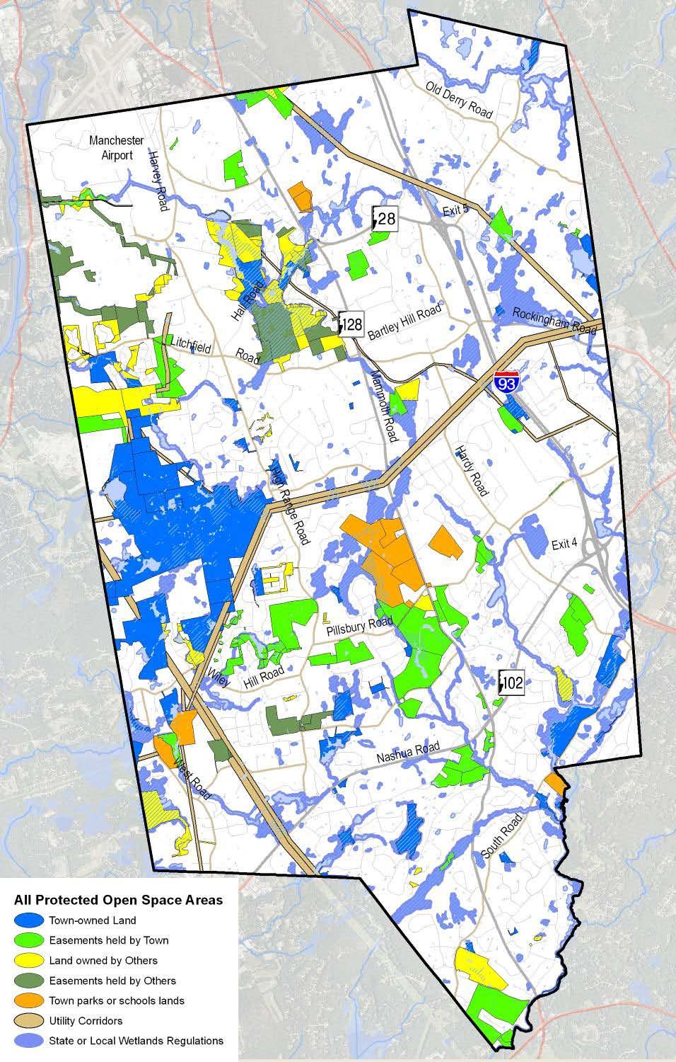
5 Planning Board Meeting Wednesday01/04/12-DRAFT Page 5 of members have done some of their own research, it is not the role of the Board to do that in-depth examination. Staff and hired experts do that research on behalf of the Board. Remaining questions posted on the website will be answered as the information is obtained. New Plans There were no new plans to present. Other Business A. Presentation to the Planning Board of the Open Space Task Force Findings Mike Speltz, Chairman of the Open Space Task Force (OSTF), reviewed a PowerPoint presentation with the Board to summarize the work and resulting findings/recommendations of the Task Force (see Attachment #2). His intent was to inform the Board of those recommendations that would specifically fall under their jurisdiction. He added that the Task Force results will support the development of the 2012 Master Plan Comprehensive update. The full Final Report was been posted on the Conservation Commission page of the Town website when it was completed and M. Speltz urged the Board to review the details of what he presented tonight. The Open Space Task Force was charged by the Town Council with reviewing the Open Space Plan as is required every five years. They were asked specifically to address the economic viability of the plan, i.e. how much more needed to be done to complete the plan and how much of that the Town can afford. They were also asked to focus on natural services to determine which of those need direct protection to ensure their long term benefits to the community and how that can be done in the most fiscally efficient way. Development of a stewardship plan was also a goal of the OSTF in order to address the management of the 1,693 acres owned by the Town and the 1,104 acres under Town held easements. Like stewardship, the concept of connectivity between conserved areas became a focal point for this Task Force as it was not addressed by previous ones. Based on a Delphi scoring process of various natural resources, a map was generated identifying the most resource rich open spaces in town. This map was then translated beyond the natural boundaries to those established within the Town s tax maps. Parcels eight acres in size or more were singled out, then buffered and linked together. Those 210 parcels were ranked by a combination of the threat of their development, the cost of their conservation, and their contribution in terms of resource value. Sixty two of those are either commercial or industrial lots that are viewed by the Town as potential tax positive zones, so a conscious decision was made to preserve the natural values found there solely through the use of land use regulations. M. Newman asked if any of those 210 parcels are for sale at this time. M. Speltz said he knew of one that was but added that all owners will be made aware of the Town s interest in their land should they be inclined towards a transaction. M.
6 Planning Board Meeting Wednesday01/04/12-DRAFT Page 6 of Soares asked if the land slated for the Woodmont Commons development was part of the 210 priority parcels. M. Speltz said it was and that some level of protection is still a possibility as those plans go through the Town s development process. The next step for the Task Force was a SWOT (Strengths, Weaknesses, Opportunities, and Threats) analysis, followed by a public opinion survey. A Steady-State funding approach was developed as a result, whereby the current spending level of 2.7% of the Town budget would continue for open space protection. Since most of that 2.7% goes to bond payments, level funding would allow for more bonds to be purchased as those previous bonds are paid down. Projected funding through 2027 is estimated at $12,800,000, while the highest and best use valuation of the priority parcels totals $36,912,632. M. Speltz reviewed the factors, however, that could enable the Town to protect the land without having to address the entire $24,112,632 shortfall. Ultimately, seven conclusions were derived from the work of the Task Force, each with a set of recommendations for various Boards and Commissions. J. Vogl noted the timeliness of these recommendations with the 2012 Master Plan update in progress. The recommendations addressed to the Planning Board and their respective timelines were: (In conjunction with the Conservation Commission) Update the 1990 Water Resources Management Plan (Mid Term); (In conjunction with the Conservation Commission) Revise the land use regulations to ensure that no additional development occurs in the 500-year floodplains and does not add to cumulative flooding (Mid Term); Investigate approaches to a no net increase policy for impervious surfaces (Mid Term); (In conjunction with the Conservation Commission) Review mapping of no cut zones and develop materials to present to property owners to inform and educate them on the obligations within these areas (Mid Term); Investigate a Transfer of Development Rights (TDR) ordinance to preserve sensitive areas while allowing higher densities in other receiving zones (Mid Term); Make Design Review Committee comments more accessible to the public; provide for a Committee representation during Planning Board consideration of projects (Short Term); Support/encourage applicants to use the Planned Unit Development and Conservation Subdivision Ordinances for large development projects to preserve natural resources (Short Term) Create an aquifer protection zone as an overlay district (Short Term) Keep the Conservation, Route 102 and Route 128 Overlay Districts, as well as appropriate sections of the site and subdivision regulation. Consider enhancing these ordinances and regulations to support the other recommendations of this report (Short Term)
7 Planning Board Meeting Wednesday01/04/12-DRAFT Page 7 of M. Speltz suggested that the implementation of the Open Space Plan could be a combined effort between a Steering Committee comprised of OSTF members, staff and the Planning Board. A. Garron confirmed that staff will play a significant role in this execution. He added that information provided by the Open Space Plan will be used in the update of the Master Plan and will eventually help develop the tools (e.g. ordinances) that will address the recommendations of the OSTF. Martin Srugis, 17 Wimbledon Lane and another OSTF member, stated his preference to see the Town Council delegate the tasks associated with implementation to the appropriate Boards and Commissions, as opposed to development of a steering committee. M. Speltz responded that it might be prudent to approach the Town Council to act as the steering committee. J. Vogl recommended that the Board and others investigate the Final Report to find the Task Force s responses to such issues as easement purchase vs. the outright purchase of land and the process of how land transactions with the Town. B. M. Soares inquired about cars being parked in front of the Herrington Catalogue building near the Coca Cola plant and whether they can be asked to use the parking lot across the street. J. Trottier replied that they cannot since that is State owned property. L. Wiles noted that it was a short term occurrence related to the Christmas season. Adjournment: M. Soares made a motion to adjourn the meeting. L. Wiles seconded the motion. Vote on the motion: Meeting adjourned at 9:22 PM. These minutes prepared by Jaye Trottier and Libby Canuel, Community Development Department Secretaries. Respectfully Submitted, Lynn Wiles, Secretary
8 WOODMONT COMMONS REVIEW PROPOSAL EVALUATIONS 1/4/2012 PROPOSAL TEAM Experience & Personnel (40%) Project Approach (15%) Knowledge of Innovative Land Use Techniques (25%) Proposal Format and Quality (10%) Responsiveness to the RFP (10%) Total Score Rank Example *Rank each proposal utilizing the 5 criteria above using a scale of 1-10 (10 being the best) with a scale of 1-10 (10 being the best)
9 PROPOSAL REVIEW CRITERIA Experience and Personnel 40% 1. Complete Team w/expertise in Critical Areas per the Diciplines listed in the RFP, Section III - Scope of Services 2. Single Project Contact/Lead 3. Commitment of Key Personnel over Project Duration 4. Knowledge of NH Land Use Statutes and Practices 5. Effective Communication Skills 6. Municipal Land Use Review Experience 7. Ability to Assess the Impacts and Benefits of the Proposal to the Community Project Approach 15% 1. Format & Organization 2. Commitment to Organize and Guide the Review 3. Commitment to Multiple Meetings 4. Commitment to Project Schedule Knowledge of Innovative Land Use Techniques 25% 1. PUD Experience 2. Knowledge of New Urbanism and Traditional Neighborhood Design Concepts 3. Knowledge of Preservation and Resource Protection 4. Familiarity with Wholistic Planning Principles Proposal Format and Quality 10% 1. Organization, Clarity, Comprehensiveness 2. Graphics that Explain and Support Text Responsiveness to the RFP 10% 1. Complete and Comprehensive 2. Community and Regional 'Knowledge'


10 Londonderry, NH Open Space Task Force Presentation to the Planning Board January 4, 2012
11 Caveat This briefing summarizes the Open Space Task Force Report. It is NOT the actual report. The report contains the complete set of data, analysis, and conclusions of the Open Space Task Force. See:
 Work in prescribed phases Support development of an updated Master Plan in 2011 Confirm the economic viability of the Open Space Plan Focus on")
12 Open Space Task Force 3: Mission The Londonderry Open Space Taskforce shall develop a plan to fulfill the Master Plan mandate to protect the natural resources needed to sustain a livable Londonderry (Chapter 4, Introduction, emphasis added) Work in prescribed phases Support development of an updated Master Plan in 2011 Confirm the economic viability of the Open Space Plan Focus on natural services
13 Fundamentals The key concerns: How open space much is enough? When will we be done? Can we afford to finish? The key assumptions: We protect open space because it provides benefits and value to humans We want to sustain the benefits over the long term We want the most benefits at the least cost

14 Task Force Phase I, Inventory 4,047 acres (15% of Town) Permanently Protected 4,205 acres (15.6% of Town) Temporarily Protected
15 Sources of Protection Land Owned by Town 21% Town Parks or School Lands 5% Easement held by Town 13% Land Owned by Others 9% Easement held by others 6% Utility Corridors 9% State or Local Wetlands Regulations 37%
 Sources of Town-held Open Space")
16 $15M invested to protect open spaces since 1978 (purchase of land or easements) 1,976 acres of land preserved as open space An additional 821 acres protected at no direct cost to the town (development mitigation/conditions, gifts, tax liens) Sources of Town-held Open Space 14%

17 26. Estey Easements 25. Sales $6,500 $0 $1,028,600 $0 Using Other People s Money 24. Cooper $1,015,000 $0 23. George $1,747,100 $75, Tanager Way HbP $150,000 $0 21. Merrill $1,090,254 $239, Plummer 2005 $550,000 $75, R&M Burchell $1,248,045 $0 18. West Road CA $85,000 $215, Sunnycrest Farm 3 $188,440 $247, Sunnycrest Farm 2 $510,540 $210, Sunnycrest Farm 1 $129,000 $21, SPNHF-Ingersoll Addition $1,081,998 $898, AES Faucher Rd $540,000 $0 12. Higgins $199,928 $400, Lorden Land $180,000 $0 10. Moose Hill Orchards (4) $0 $480, Moose Hill Orchards (3) $142,500 $342, Moose Hill Orchards (2) $0 $280, Moose Hill Orchards (1) 6. Saw mill Brook 5. Ralston 4. Plummer Easement $92,500 $90,000 $0 $5,200 $0 $25,000 $292,500 $425, Kimball Parcel $80,000 $0 Tow n Dollars 2. Laycock Parcel $40,000 $40,000 Matching Dollars (Total) 1. Musquash CA $400,000 $400,000 $2,500,000 $2,000,000 $1,500,000 $1,000,000 $500,000 $0

18 Stewardship The Town is responsible for managing 1,693 acres it owns and for monitoring/enforcing 1,104 acres of easements. Responsibilities are shared among the: Conservation Commission assisted by Londonderry Trailways and others: town-owned conservation lands and town-held conservation easements. Town Manager, advised by Londonderry Historical Society, Conservation and Heritage Commissions: Town Common and Historic District. Recreation Department: Nelson and West Road fields. School District: school athletic fields and forested school property. Rockingham County Conservation District, which holds the conservation easements on the Mack, Sunnycrest, and Merrill farms. Land owners must manage their own lands under conservation easement, following easement terms (no development)

19 Stewardship expenses since 1998 include roughly $20,000 $10,402 (RCCD / UNH for monitoring) $9,658 (Restoration / Materials / Maps / Loosestrife removal) Stewardship funding comes from annual appropriation to the Conservation Commission: $3,300 in FY 2012 Most stewardship work is done by volunteers at no cost to the town.


20 Questions on Our Current Situation?
21 What We Want From Our Open Spaces: Natural Services Task Force Phase II: Develop detailed information on the town s needs for natural services
22 Needs = How Much is Enough? Indicators of how much is enough: Provides the services we want, now and at build-out Protect the best of each resource that still is available, using GIS metrics Can be sustained over the long term Provide buffers and connectivity, a Green Infrastructure Is reasonably equitable for all residents Distribute some assets to each part of town, especially recreation

23 Drinking Water Quality and Quantity Aquifers Wetlands/Ponds Streams Community wells

24 Drinking Water Quality and Quantity Flood Storage

25 Drinking Water Quality and Quantity Flood Storage Preserving local agricultural land

26 Drinking Water Quality and Quantity Flood Storage Preserving local agricultural land Keep natural views in their present form

27 Drinking Water Quality and Quantity Flood Storage Preserving local agricultural land Keep natural views in their present form Support outdoor Recreation in a natural setting Preserving large, contiguous forest blocks

28 Drinking Water Quality and Quantity Flood Storage Preserving local agricultural land Keep natural views in their present form Support outdoor Recreation in a natural setting Preserving large, contiguous forest blocks Plant and animal habitat and connections between habitat patches


29 Drinking Water Quality and Quantity Flood Storage Preserving local agricultural land Keep natural views in their present form Support outdoor Recreation in a natural setting Plant and animal habitat and connections between habitat patches Preserving large, contiguous forest blocks Maintaining historic structures in their appropriate context

30 Drinking Water Quality and Quantity Flood Storage Preserving local agricultural land Keep natural views in their present form Support outdoor Recreation in a natural setting Plant and animal habitat and connections between habitat patches Preserving large, contiguous forest blocks Maintaining historic structures in their appropriate context Preserve habitat for endangered species

31 Where to Find What We Want Task Force members weighted each natural service against all the others Each acre of land in Londonderry was examined to see whether it contributed to these services Insert the summary Delphi table and frog in a blender here All land is not created equal
32 The most resource rich open spaces, based on the Task Force weighting

33 Parcels > 8 acres were identified that contained the land providing the most services These lands were buffered and linked together 210 parcels; 6,556 total acres Prioritized by threat, cost, and resource value Use Land Use regs/zoning in tax positive zones
34 Getting from Nature s Bounds to Parcel Bounds 10,000 parcels in Londonderry 2,543 parcels in the Green Infrastructure 366 parcels greater than 8 acres 210 unprotected, undeveloped parcels High Cost Low Cost Dev t Pending High Threat Medium Threat Low Threat
35 Getting from Nature s Bounds to Parcel Bounds (in acres) 26,945 acres in Londonderry 16,851 acres in the Green Infrastructure 12,839 acres in parcels greater than 8 acres High Cost Low Cost Dev t Pending High Threat Medium Threat Low Threat 1, , ,


36 Questions on Nature s Benefits and Value?
37 Phase III: Strengths, Weaknesses, Opportunities and Threats Strengths Geography Existing Conservation Resources Community Support Town Government Resources Land Use Protections Opportunities Geography Communication Weaknesses Geography Economy Community Opposition Stewardship External Influences Threats Geography External Influences Economic/Development Priorities Changing Community Expectations


38 The Threat from Impervious Surface Water quality starts to be impaired when impervious surface in a watershed exceeds 10%


39 Phase IV: Public Opinion Survey Internet survey, not a random sample: 236 complete survey Awareness of existing open space areas Several overlooked, e.g. Bockes/Ingersoll Location of non-protected recreation areas Town center trails/gas line, Presbyterian church, own backyard, Woodmont orchard, rail trail Support for various conservation objectives Overwhelming support for conservation goals with the exception of adding staff Top goals: limit development on sensitive habitats, develop trails/access, promote locations & uses. By a 2-1 margin, respondents disagreed with stopping conservation purchase Over 50% of respondents disagreed or somewhat disagreed with adding staff for stewardship Felt need to commit town resources (all types) Water quality/quantity, 74% rated it very important Preserving land to store storm water and prevent flooding Aside from historic structures, a super majority of respondents rated all categories somewhat or very important.
40 Is enough being done to maintain conservation lands in Londonderry? Roughly even split: 34% Yes, 29% No, 37% Don t Know Are you willing to pay more in taxes to support future conservation purchases? 42% Yes, 39% No, 18.1% Don t Know Are you willing to pay more in taxes to support increased stewardship of existing conservation land? 35% Yes, 43% No, 22% Don t Know Currently, the Town spends 2.7% of it s budget on conservation. What percentage would you be willing to see it spend? More than 2.7% got the highest number of write-ins but average of write-ins was 2.7!
41 Financial Plan A Steady-State approach to funding: Londonderry currently dedicates 2.7% of its budget to open space protection, mostly bond payments The survey disclosed the average resident feels this is appropriate Goal is to tweak bond issues to maintain a steady 2.7% rate
42 An Illustration of Level Funding Assumptions: Keep bond payments below $900,000 (2011 payments are $925,000) 4% interest rate on new 10-year bonds All dollars are current year dollars Level Open Space Funding through ,000, , , , , Existing Obligation Level Funded Effort
43 Steady state approach at < $900,000 annually allows for $7 million in new funding over the next 15 years Bond Funding Available under a $900,000 Level of Effort 4,500,000 4,000,000 3,500,000 3,000,000 2,500,000 2,000,000 1,500,000 1,000, ,

44 Projected Funding, New bonding authority: $ 7,000,000 Land Use Change Tax: $ 3,240,000 Subtotal $10,240,000 Donations, bargain sales, $ 2,560,000 Total estimated funding, : $12,800,000 Assessed valuation of priority parcels: $36,912,632 Apparent funding shortfall: $24,112,632
45 Factors Reducing the Funding Requirement $8 million is for parcels between 8 and 20 acres; most can be protected by education for good management. Parts of some parcels do not fall within the green infrastructure; the town need not protect the entire parcel. The funding plan assumes build out in 15 years, the town may have additional time and thus funding. Some land may be protected by other agencies. Some of the land will be developed before it can be protected.

46 Questions on the Survey, SWOT Analysis, or Funding? Survey SWOT Level Open Space Funding through ,000, , , , , Existing Obligation Level Funded Effort Bond Funding Available under a $900,000 Level of Effort 4,500,000 4,000,000 3,500,000 3,000,000 2,500,000 2,000,000 1,500,000 1,000, ,
47 Conclusions & Recommendations Education/outreach Protection of water resources Recreation on town-owned land Comprehensive stewardship plan Land use regulations/policies Continuing to protect open space Funding
48 Conclusion 1, Continuing to protect open spaces 60% of the key acreage and 68% of the key resource values have either permanent or at least temporary protection. Preserving the remaining acreage and working with willing landowners of smaller parcels will tie this somewhat fragmented set of open spaces into a secure, resilient, and connected green infrastructure that will be able to withstand future disturbances and will be able to co-exist with Londonderry s built infrastructure. Recommendations: Interest landowners with small or partial parcels in the green infrastructure in participating in the good stewardship of their land. Develop a Partners in Conservation program with these landowners to support and assist them in stewarding their land. Party responsible: Cons. Comm. / Staff Timeline: Ongoing Acquire, from willing sellers, fee ownership or conservation easements on the priorit parcels identified in this report. Create a competitive market by inviting offers from all these landowners. Equal weight should be given to adding to existing areas and opening new areas for public preservation and enjoyment. Purchases should be prioritized by: o Total resource value of the parcel o Dollar cost per resource value o Resource value per acre Party responsible: Cons. Comm. / Town Council Timeline: Ongoing Refine procedures for open space property transactions to provide for earlier and closer involvement of the Town Council in the process. Party responsible: Town Council / Town Manager/Cons. Comm. Timeline: Short Term
49 Conclusion 2, Developing a comprehensive stewardship plan for all town-owned land There is no integrated, comprehensive, town-wide stewardship plan, much less a method of funding, that could exploit the synergy from the various categories of town owned land and town held-easements. Recommendations: Develop a comprehensive stewardship plan to define what services the town desires from each property individually and as an integrated network of open spaces, and identify concrete recommendations to enhance natural resource protection and maintain and/or expand recreational opportunities. Include direct costs and responsible parties. Party responsible: Cons. Comm. / Town Council Timeline: Short Term Integrate the town-wide trails plan the town-wide stewardship plan. Provide for connectivity between conservation areas and points of interest in Londonderry and to inform priorities for developing trails in recreation areas. Party responsible: Trailways / Cons. Comm. Timeline: Short Term Teach volunteer residents how to monitor conservation easements and serve as land stewards; name a volunteer coordinator. Party responsible: Cons. Comm. Timeline: Ongoing Work with Beautify Londonderry to clean open space properties from dumping. Party Responsible: Solid Waste Advisory Committee Timeline: Short Term
50 Conclusion 3, Protection of water resources. Rapid development, sprawl, flooding, and increased impervious surface have made the protection and control of the town s water resources, both in quality and quantity, the town s most pressing open space task. Recommendations: Update the 1990 Water Resources Management Plan. Party responsible: Planning Board / Cons. Comm. Timeline: Mid Term Revise land use regulations to ensure that no additional development occur in the 500-year floodplains and does not add to cumulative flooding. Party responsible: Planning Board /Cons. Comm. Timeline: Mid Term Monitor the town s surface and ground waters for nitrogen, phosphorus, biological oxygen demand, ph and sediment. Party responsible: EBSC/Public Health/Cons. Comm. Timeline: Mid Term Educates residents about vegetated buffers to surface waters. Party responsible: Cons. Comm. Timeline: Short Term Investigate approaches to a no net increase policy for impervious surface Party responsible: Planning Board Timeline: Mid Term
51 Conclusion 4, Education/Outreach. Many, if not most, of the town s residents are unaware of the services provided by the town s open spaces, how open space benefits them individually, how to take advantage of the open space, and how and why open space is acquired and protected. Recommendations: Initiate a comprehensive outreach and education effort regarding the open space program Party responsible: Cons. Comm./Recreation Dept./Heritage Comm. Timeline: Short Term Use social media tools to carry out informal, organized events; inform residents of the recreational opportunities in Town. Party responsible: Trailways/ Recreation Comm. Timeline: Short Term Review mapping of no cut zones and develop materials to present to property owners to inform and educate them on the obligations within these areas. Party responsible: Cons. Comm. / Planning Board Timeline: Mid Term
52 Conclusion 5, Recreation on town owned land Maximize the recreational benefits residents get from their open space. Recommendations: Work with partners to expand recreational potential. Party responsible: Town Council / Rec. Comm. / Timeline: Ongoing Cons. Comm / Trailways Partner to maintain and improve the recreational trails in the Bockes/Ingersoll Fores Party responsible: Cons. Comm. / Trailways Timeline: Short Term Consider a local hockey program and using the West Road Fields. Party responsible: Recreation Comm. Timeline: Mid Term Partner with private outfitters/educators/clubs to provide training. Party responsible: Trailways /ALERT/ Recreation Comm. Timeline: Mid Term Support cold weather sports with trail maintenance, clearing and grooming. Party responsible: Recreation Dept. Timeline: Ongoing Support Londonderry Trailways to improve the Rail Trail and connect it to a regional trail network. Expand their town-wide trail plan. Party responsible: Planning Dept./Town Council Timeline: Short Term
53 Conclusion 6, Land Use regulations/policies Protecting the benefits provided by the town s open spaces through land use regulations and policies establishes a rational nexus between use limitations and public benefit. Recommendations: Investigate a Transfer of Development Rights (TDR) ordinance to preserve sensitive areas while allowing higher densities in other receiving zones. Party responsible: Planning Board Timeline: Mid Term Make Design Review Committee comments more accessible to the public; provide fo Committee representation during Planning Board consideration of projects. Party responsible: Planning Board Timeline: Short Term Support/encourage applicants to use the Planned Unit Development and Conservation Subdivision Ordinances for large development projects to preserve natural resources. Party responsible: Planning Board / Staff Timeline: Short Term Create an aquifer protection zone as an overlay district Party responsible: Planning Board / Staff Timeline: Short Term Pursue controls on impervious surfaces as recommended under Conclusion 2, above. Keep the Conservation, Route 102 and Route 28 Overlay Districts, as well as appropriate sections of the site and subdivision regulations. Consider enhancing these ordinances and regulations to support the other recommendations of this report. Party responsible: Planning Board Timeline: Short Term
54 Conclusion 7, Funding Residents are generally comfortable with the current level of 2.7% of the town budget, and a general desire to continue to protect open space. There is significant resistance to adding to that level of burden. Based on the time until Londonderry reaches buildout (~20 years), the current assessed value, expected non-town funding, continuation of the land use change tax receipts, and a 2.7% level of effort, the protection of the green infrastructure appears to be financially feasible. Recommendations: Implement = a consistent level of effort of 2.7% of the town budget to fund protectio of the priority parcels as properties become available. Create a dedicated source of funding for stewardship activities by allocating the first increment of funding from the Land Use Change Tax to a non-lapsing stewardship fund The amount of this allocation should be determined by the requirements identified in th comprehensive stewardship plan recommended under conclusion 4. The remainder of the Land Use Change Tax should continue to be allocated to the Conservation Fund as a self-regulating counter balance against development and to supplement the recommended bond funding, thereby hastening the implementation and reducing the cost of the Open Space Plan. Party responsible: Cons. Comm. Timeline: Ongoing Create a budget line within the Community Development Department budget that wi fund the outreach and education efforts described in Conclusion 1. Party Responsible: Town Council Timeline: Short Term

55 How Should We Manage the Implementation of the Open Space Plan? A Steering Committee like the 2012 Master Plan? An Implementation Matrix prepared and managed by Town Staff like the 2004 Master Plan? On whose back is The Monkey?
LONDONDERRY, NH PLANNING BOARD MINUTES OF THE MEETING OF JULY 14, 2010 AT THE MOOSE HILL COUNCIL CHAMBERS
 Wednesday 0//0-FINAL Page of 0 0 0 0 LONDONDERRY, NH PLANNING BOARD MINUTES OF THE MEETING OF JULY, 00 AT THE MOOSE HILL COUNCIL CHAMBERS :00 PM: Members Present: Art Rugg; Mary Soares; Charles Tilgner,
Present: Deb Lievens, Gene Harrington, Paul Nickerson, Ben LaBrecque, Truda Bloom, and Mike Speltz
 Page 1 of 8 1 2 3 4 5 6 7 8 9 10 11 12 13 14 15 16 17 18 19 20 21 22 23 24 25 26 27 28 29 30 31 32 33 34 35 36 37 Present: Deb Lievens, Gene Harrington, Paul Nickerson, Ben LaBrecque, Truda Bloom, and
SPECIFIC RESPONSES TO AREA COMMISSION OPPOSITION :
 SPECIFIC RESPONSES TO AREA COMMISSION OPPOSITION 3-14-19: Area Commission reasons for opposition in black APPLICANT S RESPONSE IN RED. The comprehensive planning and design of stream restoration efforts
2011 AICP Review Course
 2011 AICP Review Course March 2011 Alex Dambach, AICP, PP Director of Policy, Planning, and Development City of East Orange Exam Content A. Strategic planning/visioning B. Goal setting C. Research methods
Conservation Easement Stewardship
 Conservation Easements are effective tools to preserve significant natural, historical or cultural resources. Conservation Easement Stewardship Level of Service Standards March 2013 The mission of the
Town of Falmouth s Four Step Design Process for Subdivisions in the Resource Conservation Zoning Overlay District
 Town of Falmouth s Four Step Design Process for Subdivisions in the Resource Conservation Zoning Overlay District All subdivisions shall be designed in accordance with the following four-step process.
COMMUNITY PRESERVATION ACT Town of Hatfield OPEN SPACE PROJECT GUIDELINES
 COMMUNITY PRESERVATION ACT Town of Hatfield OPEN SPACE PROJECT GUIDELINES CPA Open Space Projects: The Act requires that a participating community shall spend, or set aside for later spending, not less
General Development Plan Background Report on Agricultural Land Preservation
 General Development Plan 2008 Background Report on Agricultural Land Preservation February 2008 I. Introduction Anne Arundel County has been an agricultural community for over 350 years, beginning with
MIDWAY CITY Municipal Code
 MIDWAY CITY Municipal Code TITLE 9 ANNEXATION CHAPTER 9.01 PURPOSE CHAPTER 9.02 GENERAL REQUIREMENTS CHAPTER 9.03 PROPERTY OWNER INITIATION OF ANNEXATION CHAPTER 9.04 PROCEDURES FOR CONSIDERATION OF PETITION
UNOFFICIAL COPY OF HOUSE BILL 1272 A BILL ENTITLED
 UNOFFICIAL COPY OF HOUSE BILL 1272 M4 6lr0525 By: Delegates Smigiel, Kelley, Rosenberg, and Sossi Introduced and read first time: February 10, 2006 Assigned to: Environmental Matters 1 AN ACT concerning
APPENDIX B. Fee Simple v. Conservation Easement Acquisitions NTCOG Water Quality Greenprint - Training Workshops
 APPENDIX B Fee Simple v. Conservation Easement Acquisitions NTCOG Water Quality Greenprint - Training Workshops Lake Arlington Watershed and Lewisville Lake East Watershed June 21, 2011 Presenter Talking
Working Together to Conserve Land
 Working Together to Conserve Land A Resource for Landowners Protecting land for future generations About Loon Echo was formed as a 501(c)(3)nonprofit organization in 1987 to preserve land in the northern
DRAFT FOR PUBLIC HEARING (rev. March, 2016)
") Chapter 200. ZONING Article VI. Conservation/Cluster Subdivisions 200-45. Intent and Purpose These provisions are intended to: A. Guide the future growth and development of the community consistent with
Chapter 200. ZONING Article VI. Conservation/Cluster Subdivisions 200-45. Intent and Purpose These provisions are intended to: A. Guide the future growth and development of the community consistent with
NANTUCKET ISLANDS LAND BANK AFFORDABLE HOUSING POLICY Adopted by the vote of the Land Bank Commission on November 10, 2015
 NANTUCKET ISLANDS LAND BANK AFFORDABLE HOUSING POLICY Adopted by the vote of the Land Bank Commission on November 10, 2015 In recent history, the island of Nantucket has experienced a shortage of affordable,
PROJECT SCORING GUIDANCE. Introduction: National Proiect Selection:
 FOREST LEGACY PROGRAM PROJECT SCORING GUIDANCE Introduction: This document provides guidance to the National Review Panel on how to score individual Forest Legacy Program (FLP) projects, including additional
TOWN OF PELHAM, NEW HAMPSHIRE
 TOWN OF PELHAM, NEW HAMPSHIRE BUILDOUT ANALYSIS Prepared for the PELHAM CONSERVATION COMMISSION with the assistance of the NASHUA REGIONAL PLANNING COMMISSION TABLE OF CONTENTS I. INTRODUCTION...1 II.
LIVING LANDS BIODIVERSITY GRANTS: INFORMATION AND APPLICATION. Due: January 16, 2009
 LIVING LANDS BIODIVERSITY GRANTS: INFORMATION AND APPLICATION Due: January 16, 2009 PURPOSE OF LIVING LANDS PROJECT Defenders of Wildlife s Living Lands project provides financial, technical and educational
OPEN SPACE & RECREATION PLAN
 OPEN SPACE & RECREATION PLAN HOPEWELL TOWNSHIP Cumberland County, New Jersey Prepared by: Hopewell Township Environmental Commission Final October 2011 (THIS PAGE INTENTIONALLY LEFT BLANK) PUBLIC MEETINGS
Innovative Local Government Land Conservation Techniques
 Innovative Local Government Land Conservation Techniques Three new successful land conservation programs used in Maryland by Baltimore and Carroll Counties are worthy of further examination. Baltimore
Kent Land Trust Strategic Reassessment Project Final Report
 Kent Land Trust Strategic Reassessment Project Final Report Prepared For: Connecticut Institute for Resilience and Climate Adaptation (CIRCA) Prepared by: Michael A. Benjamin, Land Steward, Kent Land Trust
Housing Commission Report
 Housing Commission Report To: From: Subject: Housing Commission Meeting: July 21, 2016 Agenda Item: 4-B Chair and Housing Commission Barbara Collins, Housing Manager Draft Request for Proposals for Mountain
PART ONE - GENERAL INFORMATION
 Corrected Date: Page 7 Date of Submittal Changed to Coincide with Submittal Date on Page 5 PART ONE - GENERAL INFORMATION A. INTRODUCTION B. Background Miami Shores Village is soliciting responses to this
Chapter 100 Planned Unit Development in Corvallis Urban Fringe
 100.100 Scope and Purpose. Chapter 100 Planned Unit Development in Corvallis Urban Fringe (1) All applications for land divisions in the Urban Residential (UR) and Flood Plain Agriculture (FPA) zones within
Chapter XX Purchase of Development Rights Program
 Chapter XX Purchase of Development Rights Program Short Title. This ordinance is to be known and may be cited as the Purchase of Development Rights ( PDR ) Program. Purpose Pursuant to the authority granted
Town of Saratoga Plan Commission
 1 April 11, 2012 Members Present Town of Saratoga Plan Commission Public Present Dan Forbes, Chairperson Gordon Wipperfurth, Vice Chairperson Tom Grygo, Secretary Dave Barth Terry Hoffman Lisa Klein Sarajane
TRANSFER OF DEVELOPMENT RIGHTS
 STEPS IN ESTABLISHING A TDR PROGRAM Adopting TDR legislation is but one small piece of the effort required to put an effective TDR program in place. The success of a TDR program depends ultimately on the
Village of Perry Zoning Ordinance Update Draft Diagnostic Report
 Village of Perry Zoning Ordinance Update Draft Diagnostic Report Background The Village of Perry began work on a new comprehensive plan in 2014. After a year of committee meetings and public outreach,
SANTA CLARA COUNTY RHNA SUBREGION TASK FORCE GUIDING PRINCIPLES - May 2018
 SANTA CLARA COUNTY RHNA SUBREGION TASK FORCE GUIDING PRINCIPLES - May 2018 Attachment A Vision For Santa Clara County and its cities to work collaboratively to produce more housing in the Region. have
Sample Baseline Documentation Report (BDR) Annotated Template for Environmentally Important Land
 Annotated Template for Environmentally Important Land") Sample Baseline Documentation Report (BDR) Annotated Template for Environmentally Important Land The baseline documentation report (BDR) provides a snap shot of the biophysical condition of a property
Sample Baseline Documentation Report (BDR) Annotated Template for Environmentally Important Land The baseline documentation report (BDR) provides a snap shot of the biophysical condition of a property
Land Use. Existing Land Use
 8 Land Use 8.1 Land Use Chapter Purpose and Contents This element includes a brief summary of existing land use conditions and trends followed by a series of goals, objectives, and recommendations to guide
Open Space. Introduction. Vision. Defining Open Space. Midway City 2017 General Plan
 Open Space Midway City 2017 General Plan Introduction The importance of preserving open space to meet the goals and objectives of the General Plan cannot be overstated. Indeed, references to preserving
Torch Lake Township Antrim County, Michigan
 Torch Lake Township Antrim County, Michigan Farmland and Open Space Development Rights Ordinance Ordinance No. 04-01 Effective September 3, 2004 AN ORDINANCE creating a farmland and open space protection
MITIGATION POLICY FOR DISTRICT-PROTECTED LANDS
 MITIGATION POLICY FOR DISTRICT-PROTECTED LANDS Approved by the District Board of Directors on July 18, 2017 The following Mitigation Policy is intended to inform the evaluation of environmental mitigation-related
Introduction to INRMP Implementation Options
 El Dorado County Integrated Natural Resources Management Plan Introduction to INRMP Implementation Options 1 Our approach to the options evaluation is based on the INRMP components as they are currently
CHAPTER Committee Substitute for Committee Substitute for Senate Bill No. 2188
 CHAPTER 2004-372 Committee Substitute for Committee Substitute for Senate Bill No. 2188 An act relating to land development; amending s. 197.502, F.S.; providing for the issuance of an escheatment tax
Application Training / Overview Questions and Answers July 10, 2018
 Application Training / Overview Questions and Answers July 10, 2018 1. Does community outreach of 500 feet need to be done before the application submittal? A. The City encourages that community outreach,
OPEN SPACE PRESERVATION. Reflections on the Value of Acquiring Property for Preservation Purposes
 OPEN SPACE PRESERVATION Reflections on the Value of Acquiring Property for Preservation Purposes What is open space and what does it do? The Town Plan of Conservation and Development defines it as follows:
( ) Ordinance. Environmental Resources Management
 Ordinance. Environmental Resources Management") PALM BEACH COUNTY BOARD OF COUNTY COMMISSIONERS AGENDA ITEM SUMMARY Agenda Item #:5 I/" 3 Meeting Date: April 1,2008 ( ) Consent Department Submitted By: Submitted For: ( ) Ordinance Environmental Resources
PALM BEACH COUNTY BOARD OF COUNTY COMMISSIONERS AGENDA ITEM SUMMARY Agenda Item #:5 I/" 3 Meeting Date: April 1,2008 ( ) Consent Department Submitted By: Submitted For: ( ) Ordinance Environmental Resources
BY BOARD OF COUNTY COMMISSIONERS AN ACT TO BE ENTITLED
 BY BOARD OF COUNTY COMMISSIONERS ORDINANCE NO. AN ACT TO BE ENTITLED AN ORDINANCE AMENDING THE PASCO COUNTY LAND DEVELOPMENT CODE, ARTICLE 700, BY REPEALING EXISTING SECTION 702, ENVIRONMENTALLY SENSITIVE
ISSUES MOBILIZATION GUIDANCE DOCUMENT
 ISSUES MOBILIZATION GUIDANCE DOCUMENT PURPOSE OF GRANTS Issues Mobilization Grants provide financial support to state and local REALTOR Associations to enable them to organize and manage effective campaigns
PLANNING BOARD MEETING MINUTES APRIL 4, 2002
 Chairman Christian Jensen called the Planning Board meeting of April 4, 2002 to order at 8:00 p.m. announcing that this meeting had been duly advertised according the Chapter 231, Open Public Meetings
ALREADY SUBMITTED FOR HIGHLANDS COUNCIL PRE
 Highlands Preservation Area Approval Application Checklist Items Block 15901 Lot 1, West Milford See Highlands Council Review at: http://www.highlands.state.nj.us/njhighlands/projectreview/ **For advisory
KINGWOOD TOWNSHIP BOARD OF ADJUSTMENT. MINUTES May 11, :30 PM
 KINGWOOD TOWNSHIP BOARD OF ADJUSTMENT MINUTES May 11, 2016 7:30 PM CALL TO ORDER The meeting was called to order by M.L. Haring at 7:31 PM. PRESENT: T. Ciacciarelli ABSENT: L. Frank M.L. Haring J. Laudenbach
City of Lake Elmo Planning Commission Meeting Minutes of January 14, 2013
 City of Lake Elmo Planning Commission Meeting Minutes of January 14, 2013 Chairman Williams called to order the workshop of the Lake Elmo Planning Commission at 7:00pm COMMISSIONERS PRESENT: Fliflet, Obermueller,
(a) Administrator: "Administrator" means the county employee assigned to administer the provisions of this subtitle.
 Administrator: Administrator means the county employee assigned to administer the provisions of this subtitle.") Howard County, Maryland Subtitle 5. Agricultural Land Preservation Sec. 15.500. Short Title; Findings; Purpose. (a) Short Title: This subtitle may be known as the Howard County Agricultural Land Preservation
Howard County, Maryland Subtitle 5. Agricultural Land Preservation Sec. 15.500. Short Title; Findings; Purpose. (a) Short Title: This subtitle may be known as the Howard County Agricultural Land Preservation
How to Read a Real Estate Appraisal Report
 How to Read a Real Estate Appraisal Report Much of the private, corporate and public wealth of the world consists of real estate. The magnitude of this fundamental resource creates a need for informed
Lessard Sams Outdoor Heritage Council
 Lessard Sams Outdoor Heritage Council MEMO: Agenda Item # 10 DATE: December 11, 2014 SUBJECT: PRESENTER: 2015 Legislative Appropriation Recommendation Bill Heather Koop, LSOHC staff Background: On October
If projects are received at the counter to be submitted without prior draft review, the project will be deferred to the next meeting.
 5400 Butternut Drive East Syracuse, NY13057-8509 Phone: 315.446.3910 x3 Fax: 315.449.0620 Edward M.Michalenko, PhD. Supervisor Planning & Zoning Samuel C. Gordon, MLA, Director Welcome to the Town of DeWitt
CHAPTER 12. BE IT ENACTED by the Senate and General Assembly of the State of New Jersey:
 CHAPTER 12 AN ACT concerning the constitutional dedication of corporation business tax revenues for certain environmental purposes, supplementing Title 13 of the Revised Statutes, and amending P.L.1999,
550 North 800 West West Bountiful, Utah Phone (801) FAX (801) PLANNING COMMISSION MEETING
 FAX (801) PLANNING COMMISSION MEETING") Mayor Kenneth Romney City Council James Ahlstrom James Bruhn Kelly Enquist Debbie McKean Mark Preece WEST BOUNTIFUL CITY 550 North 800 West West Bountiful, Utah 84087 Phone (801) 292-4486 FAX (801) 292-6355
Mayor Kenneth Romney City Council James Ahlstrom James Bruhn Kelly Enquist Debbie McKean Mark Preece WEST BOUNTIFUL CITY 550 North 800 West West Bountiful, Utah 84087 Phone (801) 292-4486 FAX (801) 292-6355
MINUTES February 16, :00 p.m.
 Adopted March 27, 2012 Pinelands Development Credit Bank Board 15C Springfield Road New Lisbon, NJ 08064 MINUTES February 16, 2012 2:00 p.m. Board Members Present: Christopher Hughes, Dept. of Banking
SECTION 1 INTRODUCTION TO THE PANAMA CITY BEACH COMPREHENSIVE GROWTH DEVELOPMENT PLAN
 1. PURPOSE SECTION 1 INTRODUCTION TO THE PANAMA CITY BEACH COMPREHENSIVE GROWTH DEVELOPMENT PLAN The purpose of the City of Panama City Beach's Comprehensive Growth Development Plan is to establish goals,
Title 5: ADMINISTRATIVE PROCEDURES AND SERVICES
 Title 5: ADMINISTRATIVE PROCEDURES AND SERVICES Chapter 353: LAND FOR MAINE'S FUTURE Table of Contents Part 15-A. LAND FOR MAINE'S FUTURE... Section 6200. FINDINGS... 3 Section 6201. DEFINITIONS... 3 Section
IRS FORM 8283 SUPPLEMENTAL STATEMENT DONATION OF CONSERVATION EASEMENT
 Name(s) shown on income tax return Identifying Number Robert T. Landowner 021-34-1234 Susan B. Landowner 083-23-5555 IRS FORM 8283 SUPPLEMENTAL STATEMENT DONATION OF CONSERVATION EASEMENT On November 12,
Absent: Major Chris Hanson, Volk Field John Ross, Jackson County Emergency Management; Paul Wydeven, Wisconsin Department of Transportation
 Monroe County/Fort McCoy Joint Land Use Study (JLUS) Technical Advisory Group (TAG) December 8, 2011, 2:00 4:00 p.m. Angelo Town Hall, 14123 Co. Hwy. I, Sparta, WI Meeting Minutes Attendance: Bryan Law,
PENINSULA TOWNSHIP PLANNING COMMISSION MINUTES Center Road Traverse City, MI (Township Hall) February 27, :30 pm - amended time
 February 27, :30 pm - amended time") Meeting called to order at 5:30 pm by Couture. PENINSULA TOWNSHIP PLANNING COMMISSION MINUTES 13235 Center Road Traverse City, MI 49686 (Township Hall) February 27, 2017 5:30 pm - amended time Present:
Meeting called to order at 5:30 pm by Couture. PENINSULA TOWNSHIP PLANNING COMMISSION MINUTES 13235 Center Road Traverse City, MI 49686 (Township Hall) February 27, 2017 5:30 pm - amended time Present:
TOWN OF BROOKLINE, NEW HAMPSHIRE
 TOWN OF BROOKLINE, NEW HAMPSHIRE BUILDOUT ANALYSIS DECEMBER, 2003 Prepared by the Nashua Regional Planning Commission TABLE OF CONTENTS Introduction... 1 I. Methodology... 1 A. PARCEL REVIEW... 1 B. DEVELOPMENT
CHAUTAUQUA COUNTY LAND BANK CORPORATION
 EXHIBIT H CHAUTAUQUA COUNTY LAND BANK CORPORATION LAND ACQUISITION AND DISPOSITION POLICIES AND PRIORITIES November 14, 2012 *This document is intended to provide guidance to the Chautauqua County Land
Sample Renewal Additional Information Request
 Sample Renewal Additional Information Request February 25, 2015 Jim Smith Green Acres Land Trust 123 Main Street Anywhere, NY 12345 Dear Jim: Thank you for submitting your organization s application for
ADMINISTRATIVE GUIDANCE
 11 ADMINISTRATIVE GUIDANCE ON CONTAMINATED SITES Effective date: April 1, 2013 Version 1.1 May 2013 Expectations and Requirements for Contaminant Migration Introduction This guidance focusses on the ministry
FUTURE LAND USE. City of St. Augustine Comprehensive Plan EAR-Based Amendments
 FUTURE LAND USE City of St. Augustine Comprehensive Plan EAR-Based Amendments Future Land Use Element FLU Goal To create an environment within the City and adjacent areas in which its residents have the
ARTICLE FIVE FINAL DRAFT
 ARTICLE FIVE 021218 FINAL DRAFT Sec. 503.6 Open Space Preservation Option Open Space Preservation Option Open Space Preservation developments may be approved in the AR, R-1, R-2 and R-3 zoning districts,
A TDR Program for Naples. May 11, 2007
 ATTACHMENT G A TDR Program for Naples May 11, 2007 Introduction This paper is intended to supplement and expand upon the Draft TDR Program Framework authored by Solimar in February 2007. 1 The Framework
Amendment 1 Sponsor Committee Water and Land Conservation Amendment (850)
") ! Amendment 1 Text Amendment 1 Sponsor Committee Water and Land Conservation Amendment (850) 629-4656 emailus@floridawaterlandlegacy.org www.floridawaterlandlegacy.org TITLE: Water and Land Conservation
! Amendment 1 Text Amendment 1 Sponsor Committee Water and Land Conservation Amendment (850) 629-4656 emailus@floridawaterlandlegacy.org www.floridawaterlandlegacy.org TITLE: Water and Land Conservation
Central Pennsylvania Conservancy Project Selection Criteria Form
 Central Pennsylvania Conservancy Project Selection Criteria Form The following criteria guide the actions of the Central Pennsylvania Conservancy s Land Protection Committee and Board of Directors in selecting
Midway City Council 4 December 2018 Regular Meeting. Ordinance / General Plan Amendment
 Midway City Council 4 December 2018 Regular Meeting Ordinance 2018-23 / General Plan Amendment CITY COUNCIL MEETING STAFF REPORT DATE OF MEETING: December 4, 2018 DOCUMENT: NAME OF APPLICANT: AGENDA ITEM:
1.3. The Policy is based on the City of London governing principles:
 Real Property Acquisition Policy Policy Name: Real Property Acquisition Policy Legislative History: Enacted September 19, 2017 (By-law No. CPOL.-188-440); Amended July 24, 2018 (By-law No. CPOL.-188(a)-447)
CHAIRMAN WOLPERT AND MEMBERS OF THE HOUSE LOCAL AND MUNICIPAL GOVERNMENT AND URBAN REVITALIZATION COMMITTEE
 TO: FROM: SUBJECT: CHAIRMAN WOLPERT AND MEMBERS OF THE HOUSE LOCAL AND MUNICIPAL GOVERNMENT AND URBAN REVITALIZATION COMMITTEE LARRY LONG, EXECUTIVE DIRECTOR COUNTY COMMISSIONERS ASSOCIATION OF OHIO (CCAO)
Midway City Council 16 October 2018 Work Meeting. Ordinance / General Plan Amendment
 Midway City Council 16 October 2018 Work Meeting Ordinance 2018-23 / General Plan Amendment CITY COUNCIL MEETING STAFF REPORT DATE OF MEETING: October 16, 2018 DOCUMENT: NAME OF APPLICANT: AGENDA ITEM:
PLANNING COMMISSION MINUTES - CITY OF INVER GROVE HEIGHTS. Tuesday, May 20, :00 p.m. City Hall Chambers Barbara Avenue
 PLANNING COMMISSION MINUTES - CITY OF INVER GROVE HEIGHTS Tuesday, 7:00 p.m. City Hall Chambers - 8150 Barbara Avenue Chair Hark called the Planning Commission meeting to order at 7:00 p.m. Commissioners
Mr. Hanson called the meeting to order at 12:00 p.m.
 DORCHESTER COUNTY PLANNING COMMISSION MINUTES June 6, 2018 The Dorchester County Planning Commission held their regular meeting on June 6, 2018 at 12:00 pm in the County Office Building, Room 110 in Cambridge
CITY OF WINTER PARK Planning & Zoning Board. Regular Meeting September 6, 2016 City Hall, Commission Chambers MINUTES
 CITY OF WINTER PARK Planning & Zoning Board Regular Meeting September 6, 2016 City Hall, Commission Chambers 6:00 p.m. MINUTES Chairman James Johnston called the meeting to order at 6:00 p.m. in the Commission
THE MANADA CONSERVANCY
 THE MANADA CONSERVANCY Description of a Land Trust What is a land trust? Land Trusts are non-profit organizations which work hand-in-hand with landowners to protect open spaces increasingly threatened
Dakota County Farmland and Natural Areas Program. Lake Pepin TMDL May 31, 2007
 Dakota County Farmland and Natural Areas Program Lake Pepin TMDL May 31, 2007 Presentation Overview County Context FNAP Planning Process FNAP Implementation Integrating Conservation Efforts Parcel Development
Comprehensive Plan /24/01
 IV The is a central component of the Comprehensive Plan. It is an extension of the general goals and policies of the community, as well as a reflection of previous development decisions and the physical
A Guide to the Municipal Planning Process in Saskatchewan
 A Guide to the Municipal Planning Process in Saskatchewan A look at the municipal development permit and the subdivision approval process in Saskatchewan May 2008 Prepared By: Community Planning Branch
Using Easements to Conserve Biodiversity. Jeff Lerner Defenders of Wildlife
 Using Easements to Conserve Biodiversity Jeff Lerner Defenders of Wildlife jlerner@defenders.org Northeast LTA June 10, 2006 Defenders of Wildlife Mission: to protect native wild animals and plants in
BOARD MEETING MINUTES WEDNESDAY OCTOBER 17, :00 P.M. COEUR D ALENE PUBLIC LIBRARY COMMUNITY ROOM
 BOARD MEETING MINUTES WEDNESDAY OCTOBER 17, 2018 4:00 P.M. COEUR D ALENE PUBLIC LIBRARY COMMUNITY ROOM 1. CALL TO ORDER Chairman Hoskins called the ignite cda board meeting to order at 4:00 p.m. ignite
Transfer of Development Rights
 Ordinance Transfer of Development Rights King County s (WA) 2008 ordinance establishes a transfer of development rights program. The ordinance: Sets eligibility criteria for sending and receiving sites
Kent/MSU Extension Attn: Stacy Byers 775 Ball Ave NE Grand Rapids, MI Tel: (616)
") 2017 KENT COUNTY PURCHASE OF DEVELOPMENT RIGHTS (PDR) PROGRAM Kent/MSU Extension Attn: Stacy Byers 775 Ball Ave NE Grand Rapids, MI 49503 Email: stacy@sheridanland.com Tel: (616) 632-7878 FOR OFFICIAL
2017 KENT COUNTY PURCHASE OF DEVELOPMENT RIGHTS (PDR) PROGRAM Kent/MSU Extension Attn: Stacy Byers 775 Ball Ave NE Grand Rapids, MI 49503 Email: stacy@sheridanland.com Tel: (616) 632-7878 FOR OFFICIAL
CITY OF MANHATTAN BEACH [DRAFT] PLANNING COMMISION MINUTES OF REGULAR MEETING JANUARY 28, 2015
![CITY OF MANHATTAN BEACH [DRAFT] PLANNING COMMISION MINUTES OF REGULAR MEETING JANUARY 28, 2015](/thumbs/94/121103169.jpg "CITY OF MANHATTAN BEACH [DRAFT] PLANNING COMMISION MINUTES OF REGULAR MEETING JANUARY 28, 2015") CITY OF MANHATTAN BEACH [DRAFT] PLANNING COMMISION MINUTES OF REGULAR MEETING JANUARY 28, 2015 A Regular Meeting of the Planning Commission of the City of Manhattan Beach, California, was held on the 28
CITY OF MANHATTAN BEACH [DRAFT] PLANNING COMMISION MINUTES OF REGULAR MEETING JANUARY 28, 2015 A Regular Meeting of the Planning Commission of the City of Manhattan Beach, California, was held on the 28
A. Approval / Disapproval of Resolution No : Adopting a Fair Housing Policy.
 APPROVAL OF CONSENT AGENDA - Note: All matters listed under Item 11, Approval of Consent Agenda, are considered to be routine by the Town Council and will be enacted by one motion in the form listed below.
KENT COUNTY STORMWATER MAINTENANCE DISTRICT
 KENT COUNTY STORMWATER MAINTENANCE DISTRICT 2015 VUSP Stormwater Symposium Villanova, Pennsylvania David Athey, PE, CPSWQ, CMS4S AECOM (previously with Duffield Associates) Sarah Keifer, AICP Kent County,
WESTERLY MUNICIPAL LAND TRUST RULES AND REGULATIONS
 Trustees; Les Crandall, Chairman James Federico III Giorgio Gencarelli Gail Mallard, Secretary Nancy Martin Lise Mayers Richard Silva WESTERLY MUNICIPAL LAND TRUST WESTERLY MUNICIPAL LAND TRUST RULES AND
DESIGN PUBLIC HEARING JULY 7, 2016 CITY COUNCIL HEARING ROOM, FIRST FLOOR ONE GOVERNMENT CENTER FALL RIVER, MASSACHUSETTS 6:30 PM FOR THE PROPOSED
 DESIGN PUBLIC HEARING JULY 7, 2016 AT CITY COUNCIL HEARING ROOM, FIRST FLOOR ONE GOVERNMENT CENTER FALL RIVER, MASSACHUSETTS 6:30 PM FOR THE PROPOSED AIRPORT ROAD OVER ROUTE 24, BRIDGE DECK REPLACEMENT
MISSISSIPPI VALLEY CONSERVATION AUTHORITY. Mississippi Valley Conservation Centre MINUTES March 18, 2015 Carleton Place
 MISSISSIPPI VALLEY CONSERVATION AUTHORITY Mississippi Valley Conservation Centre MINUTES Carleton Place MEMBERS PRESENT: MEMBERS ABSENT: INVITED MEMBERS PRESENT: STAFF PRESENT: J. Karau, Chair; D. Abbott,
MAPLE GROVE PLANNING COMMISSION May 26, 2015
 MAPLE GROVE PLANNING COMMISSION CALL TO ORDER A meeting of the Maple Grove Planning Commission was held at 7:00 p.m. on at the Maple Grove City Hall, Hennepin County, Minnesota. Chair Colson called the
Texas Parks and Wildlife Foundation Buffer Lands Program Program Description and Application
 Texas Parks and Wildlife Foundation Texas Parks and Wildlife Foundation s mission is to provide private support to Texas Parks and Wildlife Department to manage and conserve the natural and cultural resources
RULES OF THE TENNESSEE DEPARTMENT OF ENVIRONMENT AND CONSERVATION DIVISION OF WATER RESOURCES ABANDONED MINE LANDS RECLAMATION PROGRAM
 RULES OF THE TENNESSEE DEPARTMENT OF ENVIRONMENT AND CONSERVATION DIVISION OF WATER RESOURCES 0400-44-01 ABANDONED MINE LANDS RECLAMATION PROGRAM TABLE OF CONTENTS 0400-44-01-.01 Scope 0400-44-01-.09 Methods
Title 6 - Local Government Provisions Applicable to Special Purpose Districts and Other Political Subdivisions
 Title 6 - Local Government Provisions Applicable to Special Purpose Districts and Other Political Subdivisions CHAPTER 29. SOUTH CAROLINA LOCAL GOVERNMENT COMPREHENSIVE PLANNING ENABLING ACT OF 1994 1994
Siskiyou Land Trust. Strategic Plan Update
 Siskiyou Land Trust Strategic Plan Update 2018-2023 Issued by the Board of Directors of Siskiyou Land Trust, May 2018 Our Mission: The Siskiyou Land Trust is dedicated to long-term stewardship of agricultural,
RE: Request for Comments on the Exposure Draft The Valuation of Forests dated November 16, 2012
 200 W. Madison St. T 312-335-4100 Suite 1500 F 312-335-4400 Chicago, IL 60606 www.appraisalinstitute.org Mr. Steven J. Sherman, Chairman Standards Board International Valuation Standards Council 41 Moorgate
Town of Yucca Valley GENERAL PLAN 1
 Town of Yucca Valley GENERAL PLAN 1 This page intentionally left blank. 3 HOUSING ELEMENT The Housing Element is intended to guide residential development and preservation consistent with the overall values
Financial Impact Statement There are no immediate financial impacts associated with the adoption of this report.
 STAFF REPORT Planning and Development Department Subject: Application by RYC Property to rezone a portion of lands on John Murray Dr. and Megan Lynn Dr. from R2 to R3 and to enter into a Development Agreement
PLANNING COMMISSION CITY OF SONORA OCTOBER 9, :30 P.M.
 PLANNING COMMISSION CITY OF SONORA OCTOBER 9, 2018 5:30 P.M. A regular meeting of the Planning Commission of the City of Sonora was scheduled on this date at 5:30 p.m. in the Sonora City Hall Council Chambers.
Thurston County Planning Department BOARD OF COUNTY COMMISSIONERS PUBLIC HEARING DRAFT AMENDMENTS TO THE CRITICAL AREAS REGULATIONS. Chapter 24.
 Thurston County Planning Department BOARD OF COUNTY COMMISSIONERS PUBLIC HEARING DRAFT AMENDMENTS TO THE CRITICAL AREAS REGULATIONS Chapter 24.01 GENERAL PROVISIONS Chapter 24.01 6/4/2012 GENERAL PROVISIONS
NOTICE OF MEETING. The City of Lake Elmo Planning Commission will conduct a meeting on Wednesday, November 14, 2012 at 7:00 p.m.
 3800 Laverne Avenue North Lake Elmo, MN 55042 (651) 777-5510 www.lakeelmo.org NOTICE OF MEETING The City of Lake Elmo Planning Commission will conduct a meeting on Wednesday, November 14, 2012 at 7:00
Conomo Point A Bulletized Overview
 Conomo Point A Bulletized Overview Introduction My intention in producing this Bulletized Overview of Conono Point is as an interested resident to provide a top-level summary of the current Master Plan
COMMUNITY COLLEGE SYSTEM OF NEW HAMPSHIRE
 COMMUNITY COLLEGE SYSTEM OF NEW HAMPSHIRE Section: BOT 500 Facilities and Capital Budget Date Approved: December 20, 2007 Effective Date: January 1, 2008 Amended Date: December 9, 2010 510 Campus Planning
Land Use. Land Use Categories. Chart 5.1. Nepeuskun Existing Land Use Inventory. Overview
 Land Use State Comprehensive Planning Requirements for this Chapter A compilation of objectives, policies, goals, maps and programs to guide the future development and redevelopment of public and private