City Council Workshop Agenda Item #1. at 10 and 20 Executive Drive
|
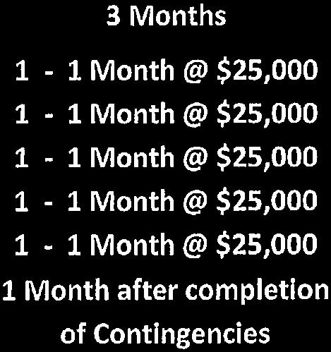
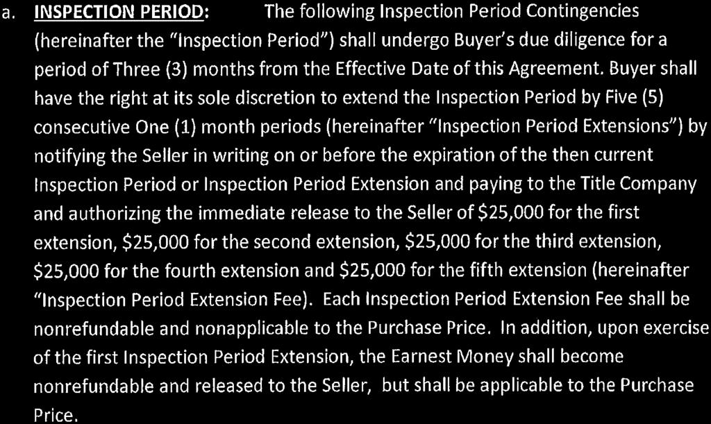
|
|
- Bethany Merryl Sanders
- 5 years ago
- Views:
Transcription
1 City Council Workshop Agenda Item #1 January 5, 2015 Zone map change from CCRT to CS at 10 and 20 Executive Drive Cameron General Contractors are requesting to rezone two parcels of property it owns located at 10 and 20 Executive Drive and shown on the Assessor s Tax Maps, as Map 73, Lots 11B and 11C. The parcels are part of the Running Hill Road Executive Office Park subdivision, which was approved in Map 73, Lot 11B consists of 4.29 acres (185,872 sf) and Lot 11C consists of 5.42 acres (236,095 sf). The current zoning is Transitional Central and Regional Commercial District (CCRT) and the request is change the zoning to Suburban Commercial (CS). The purpose is to allow the development of a congregate care housing facility. This type of development is allowed as a special permitted use in the CS District. The building would consist of 130- units and have amenities for the residents such as exercise areas, a cinema, and a common dining area. The Suburban Commercial (CS) District allows the following uses per Sections (permitted), (special permitted) and (special exceptions): Section (Uses on tracts or parcels of land under five (5) acres in size existing on or before September 21, 1987). Financial services, not including branch banks or facilities for drive through customer transactions; Business services that function professional offices or office complexes; Research and development laboratories and offices; Medical offices; Accessory buildings and uses related to above uses; and, Personal Services. Section (Uses must be developed in accordance with the requirements of Section ). Any one use listed in Section on a tract or parcel of five (5) acres or more in size or two (2) or ore such uses on any size tract or parcel; Residential uses at densities not less than seventeen (17) nor more than twenty-five (25) dwelling units per net residential acre, subject to the parcelwide residential density maximum set forth in Section ; Congregate housing and congregate care facilities a densities not less than seventeen (17) nor more than forty (40) private apartments per net residential density maximum set forth in Section ; Hospitals and associated medical facilities;
2 Nursing homes; Hotels and motels with a minimum of four above the ground surface; Membership, sports, or recreation clubs; Restaurants with no drive-in, takeout or fast-food and limited hours of operation; Retail Trade, business services, personal services; Child, adult, or combination of day care centers related to the special permitted uses; Accessory building and uses relating to above special permitted uses. Section Public utilities buildings; Government building and uses other than professional offices and office complexes; Child, adult, or combined day care centers; Accessory building and uses related above special exception use; Telecommunication tower; Farmer s markets. A third parcel, owned by the City, is also included in the zone map change, although not as part of the new development. It is shown as Map 69, Lot 5 and consists of.86 acres (37,461 sf). The Planning Board held a public hearing on December 9, 2014 and recommended approval of the zoning map change for Assessor s Maps 73, Lots 11A, 11C and Map 65, Lot 5, from the Transitional Central and Regional Commercial District (CCRT) to Suburban Commercial (CS) District. This recommendation is based on the determination that the change of zoning designation is consistent with City s Comprehensive Plan. I have included a copy of the Planning Board report. Tex Haeuser will be at Monday s workshop to answer any questions. City Manager
3 MEMORANDUM To: From: City Council Planning Board Date: January 2, 2015 Subject: Zoning Map Change Rezoning 2 parcels from CCRT to CS - Cameron General Contractors Meeting of December 9, 2014 INTRODUCTION Cameron General Contractors had requested a land use recommendation to the City Council regarding the rezoning of their parcels Map 73 Lots 11B and 11C located at 10 and 20 Executive Drive. TheThe applicant is requesting a land use recommendation to rezone of their parcels Map 73 Lots 11B and 11C located at 10 and 20 Executive Drive. The applicant proposal for a zoning map change to their properties from Transitional Central and Regional Commercial District (CCRT) to Suburban Commercial (CS) will allow the development of a congregate care housing facility. A third parcel, which is owned by City, will also be included in the zoning map change proposal, but not within the development. The parcel is further identified as Assessor s Map 73 & 69 Lot 11B & 11C; 05 located within the Transitional Central and Regional Commercial District (CCRT). Legal advertisements regarding this request appeared in the Portland Press Herald on November 27 and December 3, A public notice regarding the proposed zoning map change was posted in the City Hall and mailed on November 25, The public notice was mailed to 16 property owners within 500 of the lots under consideration, to the applicant, and via the Conservation Commission, the Planning Board, and the City Council. The submission was reviewed under Chapter 27 Article II Zoning, Article VII Transitional Central and Regional Commercial (CCRT) District, and the Comprehensive Plan. ZONING RECOMMENDATION FROM THE PLANNING BOARD By a vote of 7-0, the Planning Board recommends to the City Council to approve of the zoning map change for Assessor s Maps 73 and 69 Lots 11A, 11C, and 5 from the Transitional Central and Regional Commercial District (CCRT) to Suburban Commercial (CS) District. This recommendation is based on the determination that the change of zoning designation is consistent with City s Comprehensive Plan.: PARCELS SUMMARY Owner: Cameron General Contractors and the City of South Portland Assessor's Maps and Lots: Map 73, Lot 11B & 11C; Map 69 Lot 05 Land combined area: acre (460,429 SF) Map 69 Lot 05: 0.86 acre (37,461 SF) Map 73 Lot 11B 4.29 acre (186,872 SF) Map 73 Lot 11C 5.42 acre (236,095 SF) Zoning Map Change Rezoning 2 parcels from CCRT to CS Cameron General Contractors Page 1
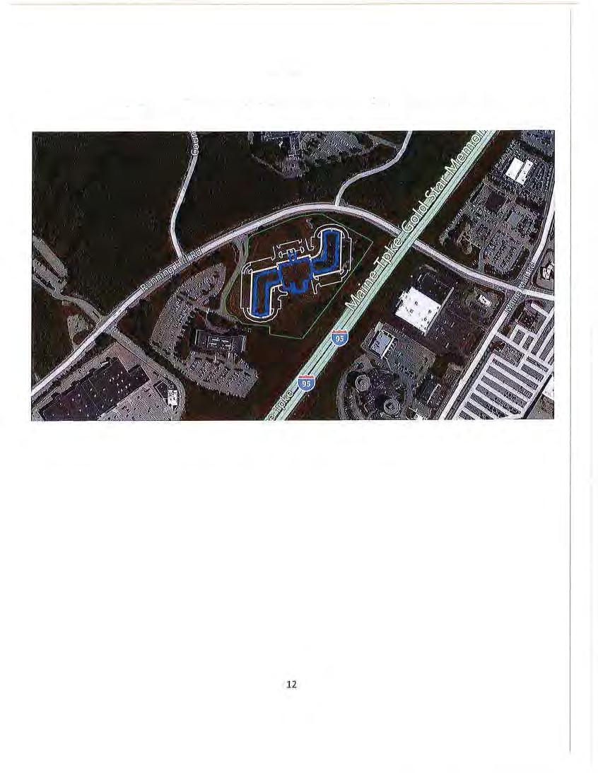
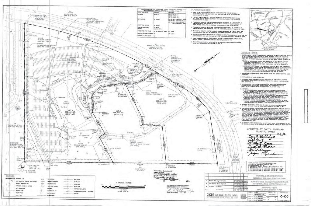
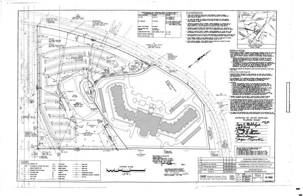
4 ANALYSIS OF ZONING MAP CHANGE REQUEST 1. Existing and Proposed Land Uses The existing parcels have a combined total of 422,983 SF in size and included small parcel owned by the City of 37,461 SF in size. The properties are identified as Assessor s Tax Map 73 Lots 11B and 11C are two (2) of the three (3) parcels of the Running Hill Road Executive Office Park subdivision, which was approved in The two subject parcels have a combined 620-feet of street frontage along the private road know as Executive Drive. The City-owned property is identified as Assessor s Tax Map 69 Lot 05 (see Attachment #2 Staff Comments Letter; Planning Director comments), which vacant property abutting the Running Hill Road Bridge over the Maine Turnpike (I-95). The two (2) parcels under consideration abuts the Maine Turnpike Authority ROW is currently vacant. The third lot of the Executive Park subdivision has been developed with an office building and associated parking areas for Fairchild Semiconductor Corporation. The applicant s zoning map change request includes two (2) parcels from the CCRT to CS is to allow the development of a congregate care housing facilities. The proposal is to develop a 130- unit facility with associate amenities in the proposed building for the residents such as exercise areas, a cinema, and a common dining area. The current zoning designation of the CCRT does not permit congregate care facilities, but is allowed as a special permitted use in the CS District. The applicant is proposing to seek an amended subdivision and site plan approval to construct a 3-story 180,000 SF building with a 160 space parking facilities (see Attachment #1 Application) To the west of the properties, are properties of various types of commercial use, from office structures to retail and restaurant uses along Running Hill Road to the Cumming Road intersection. These properties are located in the Transitional Central and Regional Commercial (CCRT) District. To the east of the properties along Running Hill Road in the overpass bridge connecting with Gorham Road and the Maine Mall Road. This area of the City is where the lots are in the Central and Regional Commercial (CCR) district and is one of the state s major retail and commercial activity center. To the north of the properties, and directly across Running Hill Road, is the Sable Oaks Business Park and recreation area. These properties located in the Professional Office (PO) District. To the south of the properties, and abutting the properties, is the Maine Mall Turnpike Authority highway right of way (ROW). The applicant proposes to change to the Suburban Commercial (CS) District. This change would allow the following permitted uses per Section (Uses on tracts or parcels of land under five (5) acres in size existing on or before September 21, 1987); Professional offices and office complexes; Financial services, not including branch banks or facilities for drive through customer transactions; Business services that function professional offices or office complexes; Research and development laboratories and offices; Medical offices; Accessory buildings and uses related to above uses; and, Personal Services. Zoning Map Change Rezoning 2 parcels from CCRT to CS Cameron General Contractors Page 2
5 The applicant proposes to change to the Suburban Commercial (CS) District. This change would allow the following special permitted uses per Section (Uses must be developed in accordance with the requirements of Section ); Any one use listed in Section on a tract or parcel of five (5) acres or more in size or two (2) or ore such uses on any size tract or parcel; Residential uses at densities not less than seventeen (17) nor more than twenty-five (25) dwelling units per net residential acre, subject to the parcel-wide residential density maximum set forth in Section ; Congregate housing and congregate care facilities a densities not less than seventeen (17) nor more than forty (40) private apartments per net residential density maximum set forth in Section ; Hospitals and associated medical facilities; Nursing homes; Hotels and motels with a minimum of four above the ground surface; Membership, sports, or recreation clubs; Restaurants with no drive-in, takeout or fast-food and limited hours of operation; Retail Trade, business services, personal services; Child, adult, or combination of day care centers related to the special permitted uses; Accessory building and uses relating to above special permitted uses. The applicant proposes to change to the Suburban Commercial (CS) District. This change would allow the following special exception uses per Section : Public utilities buildings; Government building and uses other than professional offices and office complexes; Child, adult, or combined day care centers; Accessory building and uses related above special exception use; Telecommunication tower; Farmer s markets. Since the zoning runs with the property, a future owner of the property may choose to install any of the permitted uses, special permitted uses, or apply for a special exception use. 2. Existing and Proposed Zoning The properties under consideration are entirely in the CCRT District. The District extends between the Running Hill Road and the Maine Turnpike Authority ROW and westerly to the Scarborough town line, adjacent to the Cumming Road intersection The purpose of the CCRT zone is...[i]s to create a transitional zoning district similar to the Central and Regional Commercial CCR District. However, in order to provide more compatibility with neighboring office, residential, or other impact-sensitive non-retail property, the CCRT district employs development performance standards similar to those used in the Professional Office and Light Industrial zoning districts and is more selective in terms if the types of retail uses permitted. Development within the district should be encouraged in centers that are planned as a unit. In addition, uses within the district should be planned to minimize visual degradation of the district Zoning Map Change Rezoning 2 parcels from CCRT to CS Cameron General Contractors Page 3
6 and the surrounding area and to ensure a high standard in site layout, design, landscaping, and buffering so that highway frontage does not present a poor image to the community. The purpose of the CS zone is...to provide areas for professional offices, urban residential to provide certain low-intensity commercial, personal services, and recreational uses primarily to serve those persons living, working, or transacting business within the district and to encourage planned developments which will promote and preserve the integration of these uses. These land uses complement each other in that goods and services are made readily available to district workers and residents, who in turn present a captive market to the providers of such goods and services. This functional and physical integration of uses, a common characteristic of an urban core or center, permits the achievement of certain economies of scale and cost saving associated with reduced space requirements and increased opportunity for sharing of costs. This article establishes standard which will (1) ensure high quality site development, compatible integration of allowed uses, preservation if open and landscapes open space, and limitation of strip commercial development; (2) encourage development of apartment buildings, congregate care facilities; and, (3) minimize potential conflict among uses in the district. The nature of development in this district contemplates structures having three (3) to five (5) stories. 3. Compliance with the Comprehensive Plan The Board will need to determine if the proposed zoning map change complies with the City's existing comprehensive plan. Maine Mall Area Land Use Designation Sable Oaks Area Existing Character (Figure 6.9): West of the Turnpike, current utilization of the area includes a retail center between the Turnpike and Running Hill Road.and the Sable Oaks office hotel, golf course development between Running Hill Road and Westbrook line. With the Maine Mall area, there are limited opportunities of green field development but there is significant long-term potential for redevelopment and the more intense use of existing developed properties. Future Land Use (Figure 6.10): The properties are located in a designation Growth Area. These are areas where the City wants growth and development to occur. The City s hope is that the Growth Areas will be, over the next ten (10) years, the locations where most residential and nonresidential developments occur. The Growth Area has limited areas with undeveloped land that are appropriate for development and developed areas where redevelopment of significant intensification of use is wanted (Comprehensive Plan page 6-50). The Sable Oaks Area is listed in Section B Mixed-use Land Use Designations, as shown in figure 6.9. The Comprehensive Plan addresses in a number of sections which could support the zoning map change request. Chapter 5: Community Goals and Policies A. Population and Demographic State goal: To encourage orderly growth and development in appropriate areas of each community, while protecting the State s rural character, making efficient use of public services and preventing development sprawl. (Growth Management Act) Zoning Map Change Rezoning 2 parcels from CCRT to CS Cameron General Contractors Page 4
7 2. The City s land use regulations should continue to allow for the construction of both single-family and multi-family housing in variety of locations at densities that are appropriate for the type of housing and the location. The [City s] Future Land Plan in Chapter 6 outlines these areas (Comprehensive Plan Page 5-2). The applicant believes the zoning map change request and future congregate care facilities development is supported in the Maine Mall Area goal as a premier retail destination while encouraging further diversification of uses in the area (see Attachment #1 Application). F. Housing State goal: To encourage and promote affordable, decent housing opportunities for all Maine citizens. (Growth Management Act) Local Objectives: To provide a diversity of housing to meet the needs of a wide range of residents (Comprehensive Plan Page 5-14). 2. The City should continue to provide for the construction of both single-family and multifamily housing in variety of locations at densities that are appropriate for the type of housing and the location. The [City s] Future Land Plan in Chapter 6 outlines these areas (Comprehensive Plan Page 5-14). The applicant believes the zoning map change request and future congregate care facilities development is supported in the Maine Mall Area goal as a premier retail destination while encouraging further diversification of uses in the area (see Attachment #1 Application). J. Fiscal Capacity State goal: To plan for finance and develop an efficient system of public facilities and services to accommodate anticipated growth and economic development. (Growth Management Act) Local Objectives: To provide the public facilities needed to accommodate desired types of growth (Comprehensive Plan Page 5-19). 1. The City should continue to pursue economic growth expands the City s tax base provided that it is compatible with the overall Vision for the future of the City (Comprehensive Plan Page 5-19). The subject properties are two (2) undeveloped lots located with the Running Hill Road Executive Office Park, which is located on the west side of the Maine Turnpike with the Maine Mall growth area. The proposed development would allow for 130 congregate care housing units. The applicant states that the development would add to tax base and only a minimum of impact on public services. The proposed development will maintain the City desire to retain the status of premier destination while diversifying the uses within the area (see Attachment #1 Application). Zoning Map Change Rezoning 2 parcels from CCRT to CS Cameron General Contractors Page 5
8 Chapter 6: Land use Goals and Policies A. Land Use Objectives 1. Encourage development and redevelopment that expands the City s property tax base in a manner that consistent with the City s other objectives (Page 6-1). The applicant believes that the proposed housing project will increase the tax base with minimum impacts on the public services and infrastructure. 7. Enhance the role of the Maine Mall Area as the state s premier retail destination while encouraging further diversification of uses in that area (Page 6-2). The applicant believes the zoning map change request and future congregate care facilities development is supported in the Maine Mall Area goals as a premier retail destination while encouraging further diversification of uses in the area by encourage a residential development. B. Key Land Use Policies 7.A. The Maine Mall Area, Broad Vision: 2. The of uses in the Maine Mall area will increase both within the overall area and within the currently single use area to create much more of a mixed use environment. This could include the addition of additional residential uses in the area (Page 6-35). The applicant believes the proposal will increase the diversification of use into a mix-use area of the City. 7.B. The Maine Mall Area, Land Use: The Sable Oaks Are and adjacent areas on the Turnpike side of the Running Hill Road should continue to be designated as office-recreational-residential area that provides a high quality office park environment. The current area is a mixed use area with destination shopping, office and service development with minimal residential units. The proposed congregate care facility will add to the diversification of the land. 4. Zone Change Issues Intensification of Land Use The proposed zoning designation change from CCRT to CS will maintains similar permitted and special exception uses. The CS zoning permitted a special permitted uses which adds residential developments including congregate housing facilities that the CCRT district does not permit. The special permitted uses are required to be developed under the special performance and master planning standards. The purpose of the additional performance standards is to: 1) To promote the efficient use land to facilitate a more economic arrangement of buildings and land uses in the district; 2) To promote orderly development of selected mixed uses in a urban living and working environment; and, 3) To encourage the preservation of open space in a manner consistent with the goal of selected mixed land use development. The CS district allows for more intensive land use, Zoning Map Change Rezoning 2 parcels from CCRT to CS Cameron General Contractors Page 6
9 but requires a more involved planning process with special performance standards to approve a high quality development. The special performance standards are required to direct development to meet the goals of the CS district. Parcels under Consideration Map and Lot Square Footage Use Found on Parcel 73-11A & 11C 422,968 SF Vacant and undeveloped ,461 SF Vacant and undeveloped Proximity to the Suburban Commercial (CS) District The CS District is located with the Maine Mall area, between Foden and Gorham Roads. Building Suitability With the rezoning, the applicant will receive, as a special permitted use, the potential to develop a congregate care housing facility on the two (2) parcels. The site is currently serviced by the public utilities and infrastructure. The two (2) parcels are fronting on the existing Running Hill Executive Office Park access from the existing private drive. In 2002, the parcel 73-11A was improved with a 3-story office building and associated parking facility which is access via the existing drive. The subdivision has a Maine Department of Environmental Protection Site Location of Development permit and the site has been developed with a portion of the drainage infrastructure and utility plans implemented. Agenda Item #3. Zoning Map Change Rezoning 2 parcels from CCRT to CS 10 & 20 Executive Drive Cameron General Contractors Cameron General Contractors are requesting a land use recommendation to the City Council regarding the rezoning of their parcels Map 73 Lots 11B and 11C located at 10 and 20 Executive Drive. The applicant is requesting a land use recommendation to rezone of their parcels Map 73 Lots 11B and 11C located at 10 and 20 Executive Drive. The applicant proposal for a zoning map change to their properties from Transitional Central and Regional Commercial District (CCRT) to Suburban Commercial (CS) will allow the development of a congregate care housing facility. A third parcel, which is owned by City, will also be included in the zoning map change proposal, but not within the development. The property is further identified in mention is Assessor s Map 73 & 69, Lot 11B & 11C; 05, located within the Transitional Central and Regional Commercial District (CCRT). Legal advertisements regarding this request appeared in the Portland Press Herald on November 27 and December 3, A public notice regarding the proposed zoning map change was posted in the City Hall and mailed on November 25, The public notice was mailed to 16 property owners within 500 of the lots under consideration, to the applicant, and via the Conservation Commission, the Planning Board, and the City Council. T. Haeuser; Reviewed the agenda item and showed the relationship between this parcel and other parcels in the area on a map. He explained that the rezoning is of two parcels plus a third, smaller city-owned parcel. The city-owned land wasn t in the original application but the Planning & Development staff are recommending it s included because it will otherwise be stranded. He reviewed the history of the area, the zoning, and noted that the applicant isn t asking to create a Zoning Map Change Rezoning 2 parcels from CCRT to CS Cameron General Contractors Page 7
10 new zone and isn t asking for a conditional zone they are asking for a regular zone that seems to be a good fit for proposed congregate housing. Tex showed a more detailed map of the proposed zoning and pointed out the location of the city-owned land. L. Boudreau: Asked what zone Applebee s and Target is in. S. Puleo: Said it s CCRT. T. Haeuser: Read the purpose of the CS zone as outlined in the memo:...to provide areas for professional offices, urban residential to provide certain low-intensity commercial, personal services, and recreational uses primarily to serve those persons living, working, or transacting business within the district and to encourage planned developments which will promote and preserve the integration of these uses. These land uses complement each other in that goods and services are made readily available to district workers and residents, who in turn present a captive market to the providers of such goods and services. This functional and physical integration of uses, a common characteristic of an urban core or center, permits the achievement of certain economies of scale and cost saving associated with reduced space requirements and increased opportunity for sharing of costs. This article establishes standard which will (1) ensure high quality site development, compatible integration of allowed uses, preservation if open and landscapes open space, and limitation of strip commercial development; (2) encourage development of apartment buildings, congregate care facilities; and, (3) minimize potential conflict among uses in the district. The nature of development in this district contemplates structures having three (3) to five (5) stories. He noted that in regard to (1), this is in keeping with an area across from professional office and (2) notes congregate care facilities, which is what the applicant is creating. He reviewed the permitted uses per Section and the inclusion of special permitted uses per Section , developed in accordance with the requirements of Section , and Section He stated that we are looking at congregate housing and congregate care facilities at densities not less than seventeen (17) or more than forty (40) private apartments per net residential density maximum set forth in Section He explained the need for a master plan process before final approval, in addition to site plan approval, because this falls under special permitted uses. He also reviewed the space and bulk regulations (calculates to 24 units per acre) and performance standards, including landscaping. He stated that architectural renderings and signage will be available at a later date. T. Haeuser stated that he hasn t heard comments from anyone. He called Anne Littlefield from Dead River (they own the property that Fairchild is leasing next door) and she said they don t have any problems with the zone change. PUBLIC SESSION OPEN Josh Thornton, VP of Development, Cameron General Contractors: Provided an overview of Cameron General Contractors, their work in senior/congregate housing, and the communities they have around the country, including 14/15 in development. He stated they have been actively pursuing a site in this vicinity for over two years and they are looking forward to bringing a project Zoning Map Change Rezoning 2 parcels from CCRT to CS Cameron General Contractors Page 8
11 to this community. He reviewed the specifics of their projects, including that they are 55+ but the average age of residents is around 83. Rent is all-inclusive and on a month-to-month lease. Healthcare is facilitated through third parties. The communities include a 150-seat movie theater, barber shop/salon, game room, pharmacy, sundry shop, 24-hour dining room. The communities are designed to create a high-quality lifestyle. Sean Frank, Sebago Technics: Stated that they and city staff have looked at appropriate zoning for this area. The permitted uses are similar to CCRT but allows for a residential-type environment. He reviewed that congregate care is a special use within the zone with an architectural review, landscaping, etc., and that moving from CCRT to CS isn t losing anything but adding allowed uses with additional review criteria. He noted they have reviewed the staff s comprehensive plan and believes it supports the proposed zone change adding diversification to the Maine Mall area without impacting it as prime retail and also adding to the tax base/adding residential with minimal impact to the city. He looked at traffic and said it would be limited, offpeak and noted the community has a shuttle bus. He showed a map of the original subdivision that was approved (where Fairchild is), showing two large, undeveloped lots. He noted the land is ready to go from a development standpoint. He also showed a rough concept, with sole access from Executive Drive, a 60,000 sq. ft. building, three stories, for a total of 180,000 sq. ft., with 130 residential units (mixed from studios to three bedroom) and 160 parking spaces (some garaged). He noted it will be an attractive building, seen from the turnpike. In the lower left-hand corner of the map there are wetlands where runoff is directed and he noted that this is in the Long Creek watershed, so it will need to be revisited by the DEP and city. He said after reviewing the comprehensive plan, he thinks this project fits in well. T. Haeuser: Noted that Sean mentioned the comprehensive plan and wanted to revisit this. He reiterated that the future land use map and comprehensive plan divides all land in the city into three areas: growth, limited growth, restricted areas. He reviewed the definition of each. This is in a growth area/mixed use category (between residential and industrial). The specific name is Sable Oaks area. The comprehensive plan supports some kind of development here. C. Hendry: Had a question for staff/steve Puleo. On page 2 of the memo it states:...this change would allow the following permitted uses per Section (Uses on tracts or parcels of land under five (5) acres in size existing on or before September 21, 1987), while on page 3 it states: special exception uses per Section She asked if this is a difference standard because the former states Any one use listed in Section on a tract or parcel of five (5) acres or more in size or two (2) or ore such uses on any size tract or parcel. She asked what the difference is between less than five acres and more than five acres. T. Haeuser: The more than five acres, has to have master plan process. C. Hendry: Asked if we would be looking at this under the special permitted uses. S. Puleo: Yes, under Section , which is performance standards for special permitted uses. T. Haesuer: Noted that this is really the only zoning that does that. Zoning Map Change Rezoning 2 parcels from CCRT to CS Cameron General Contractors Page 9
12 C. Hendry: Asked for clarification for where it states 17 units and not more than 40 and asked if it s different for congregate. T. Haeuser: Said that they had to go back and forth, not having had any proposals for this zone, and where it came down was under space and bulk, looking at maximum density. Under this calculation, congregate care facilities count as.625 dwelling units, meaning 24 per acre, essentially not withstanding several other places in the zone where it talks about densities. C. Hendry: Asked if 130 falls under that calculation. Sean Frank: Yes, 9.5 acres in the site, proposing 130 units. He noted that should be well below the maximum for this density. C. Hendry: Wanted clarification from Josh Thornton this facility is not like a Piper Shores or Ocean View, where there s continuing care. Josh Thornton: Said it s technically classified as freestanding independent living. Staff does not provide services to the residents. This allows certificates of need they need certification of occupancy, food handling, and anything medical is facilitated by licensed medical professionals. C. Hendry: Asked if doctors and nurses/aides would impact the traffic in the neighborhood. Josh Thornton: Said that traffic is minimal and that projects like his actually reduce the traffic impact. With the average resident around 83 years old, many join with a car in transition to another family member. The shuttle busses are heavily utilized and general traffic is very nominal sometimes agencies actually rent space within the community. He noted that they have done a traffic survey on the entire portfolio of properties and there is an average of 150 trips per day, substantially less than what would be seen with other commercial real estate. C. Hendry: Asked if units are affordable. Josh Thornton: Stated they tried to design something affordable with a higher standard of living. They are not affordable in the sense that they re subsidized but they fall within standard costs of living in the target market. C. Hendry: Noted that there s nothing around here like this and that it s not a pedestrian friendly neighborhood. Josh Thornton: Stated that she s correct residents have spendable income and that proximity to shops is a great amenity. C. Hendry: Noted that the mall is a great place to exercise and walk. She also said there s a real need for this housing as the population ages. L. Boudreau: Asked for clarification: this is identified as congregate care. Is it really just congregate housing for 50 and over? Zoning Map Change Rezoning 2 parcels from CCRT to CS Cameron General Contractors Page 10
13 Sean Frank: Said yes, congregate care is the description but these residents don t need specific healthcare it s not like Piper Shores. It is independent living with amenities and potential for hiring third party nursing staff. L. Boudreau: Stated that is what anyone in any apartment could do that and asked for clarification if this is a for profit business. Sean Frank and Josh Thornton: Replied yes. L. Boudreau: Stated that the congregate care terminology threw her. The zone change seems like a transition to the transitional zone with not a lot of conflict, making it difficult to say no to the change. Thinking of potential uses and the comprehensive plan, visions for the mall congregate care doesn t expand retail. She spoke about the comprehensive plan and call for diversification. She said she thinks the project will blend aesthetically and this is something we haven t seen before, and she doesn t have huge concerns. She s looking forward to seeing how it develops once zoning is approved and they re back for site plan. Sean Frank: Noted that, to residents, a day out might be to the mall or restaurant and that fits in well. Josh Thornton: Spoke about their full-time activities coordinator. He noted this demographic likes to go to physical retail versus shopping online. Part of the activities coordinator s job is to go into the community and find things for residents to do. Residents typically want to go out and be part of the community. He revisited the fact that these residents have spendable income and find it s a high demand for residents to live near retail, which is why they look for retail opportunities in close proximity. There was discussion between C. Hendry and Sean Frank about the 160 parking spaces. Sean stated there will be some enclosed, common garages. 160 covers one space per unit plus staff, visitors, etc. There is also valet. C. Hendry noted the amount of asphalt and the master plan calling for open space, pathways. Sean Frank stated it s in line with ordinance requirements. There will be nice landscaping included, open space and walkways. He said that a 160,000 sq. ft. could have much greater parking requirements. 160 for this type of facility on 9.5 acres of land is much less than any type of similar operation. C. Hendry noted it s healthier to be surrounded by green and Sean said they will address those concerns, but they can t dig underground for parking. A discussion of the land and surrounding land followed. T. Haeuser: Noted that Sean and Josh should look into the pedestrian aspect, although he s not sure how far residents can walk or want to walk. Sidewalks in the area can be problematic. Sean Frank: Said pedestrian connectivity is important and they will take a look at it. Josh Thornton: Spoke to that being a marketing standpoint. C. Hendry: Asked if some of the younger residents still work. Zoning Map Change Rezoning 2 parcels from CCRT to CS Cameron General Contractors Page 11
14 Josh Thornton: 55+ is what they need to constitute as a senior, but an average resident is about 83 years old. They don t see a lot of residents in the 55/60 category. Some people do work, but it s more of a choice to stay out and active versus needs-based employment. C. Hendry: Asked how many people they employ. Josh Thornton: Said about 35/40 in the dining room, 24-hour concierge, shuttle bus driver, valet, live-in managers, etc. C. Hendry: Asked about gardens. Josh Thornton: There s not a rooftop garden but there are skylights and an atrium. W. Laidley: Noted Camden General Contractors has an impressive website with photos of other developments. L. Boudreau: Mentioned they may be interested in acquiring the strip of land owned by the city to make a complete site, to maintain things like upkeep, etc. Josh Thornton: Said they have thought about that. As they develop site plan and landscaping plan, they have included outdoor amenities in other developments based on resident interest: gardens for residents, have had putting greens, bocce courts. They will give consideration and thought to that and, as they are developing it, maybe there s a way to maintain and utilize it and beautify it. Based on the grade, don t foresee any use for that property as there is a significant drop off. T. Neff: Asked if they ve thought of noise in the location, with residential so close to highway. Josh Thornton: Replied they have given that thought. They can do things architecturally and in landscaping to buffer. W. Laidley: Noted that this will increase the demand for fire and emergency services. He noted the city will have to look at its resources at the area and that the council will look at this more closely. The board noted this was a good point. L. Boudreau: Said we are at a maximum with fire and rescue services. She stated the demand is high in all senior housing buildings and without their own resources, they are relying on city services. Sean Frank: Noted there is a newer fire station in closer proximity. From tax base standpoint, there may be a way to add another bay or ambulance. T. Haeuser: Stated that got response from fire department and, like the police department, they had no comments or concerns at this time. The group discussed this point further. E.Giles asked if there has ever been an application denial based on lack of fire resources. T. Haeuser said it s rare. Zoning Map Change Rezoning 2 parcels from CCRT to CS Cameron General Contractors Page 12
15 PUBLIC SESSION CLOSED K. Phillips recommend to the City Council to approve of the zoning map change for Assessor s Maps 73 and 69 Lots 11A, 11C, and 5 from the Transitional Central and Regional Commercial District (CCRT) to Suburban Commercial (CS) District. This recommendation is based on the determination that the change of zoning designation is consistent with City s Comprehensive Plan. L. Boudreau seconded; (7-0) L. Boudreau: Inquired about a timeframe. Josh Thornton: Said they would like to break ground in the 2 nd quarter of Construction takes between months Zoning Map Change Rezoning 2 parcels from CCRT to CS Cameron General Contractors Page 13
16 RECOMMENDATION The Planning Board voted 7-0 recommends to the City Council to approve of the zoning map change for Assessor s Maps 73 and 69 Lots 11A, 11C, and 5 from the Transitional Central and Regional Commercial District (CCRT) to Suburban Commercial (CS) District. This recommendation is based on the determination that the change of zoning designation is consistent with City s Comprehensive Plan. Attachments: 1. Application 2. Staff Comments Letter 3. Applicant s Response Letter 4. Draft Zoning Map Change 5. Aerial Map of the Subject Properties Zoning Map Change Rezoning 2 parcels from CCRT to CS Cameron General Contractors Page 14

17 Zone Map Change Application to the City of South Portland for Property Located at 10 & 20 Executive Drive Tax Map 73, Lots 11B & 11C on behalf of Cameron General Contractors 8040 Eiger Drive Lincoln, Nebraska November, John Roberts Road Suite 1A, South Portland, ME
18 November 20, Stephen Puleo, Community Planner City of South Portland P.O. Box 9422 South Portland, ME Zone Map Change Application, Cameron General Contractors Property Located at 10 & 20 Executive Drive Tax Map 73, Lots 11B & 11C Dear Steve: On behalf of Cameron General Contractors, we are pleased to submit the enclosed application for a Zone Map Change for the two lots located at 10 and 20 Executive Drive off from Running Hill Road. This property is identified as Lots 11B and 11C on the City of South Portland Tax Map 73 and is located in South Portland s CCRT District. The property consists of two lots from the three lot subdivision titled Running Hill Executive Office Park which was approved by the Planning Board in November, The two lots are approximately 9.7 acres in size with over 620 feet of frontage on Executive Drive. One of the lots, Lot A of the subdivision, as well as the private access road named Executive Drive, was previously developed into an office building with associated parking areas for Fairchild Semiconductor Corporation. A location plan showing tax map parcels and zoning in the area is attached as an exhibit to this application. The applicant is requesting a Zoning Map Change to the two lots from the current CCRT District to the CS District. The applicant is a national developer and operator of congregate care housing facilities and would like to develop a 130-unit facility with associated amenities interior to the building for the residents such as exercise areas, a cinema and a common dining area. The CCRT District does not permit residential units while congregate housing and care facilities are allowed as special permitted uses in the CS District Proposed Map Change A conceptual site plan of the proposed 130-unit congregate care housing facility with associated parking areas is included as an exhibit to this application. Please note that easterly of the site is the Maine Turnpike and northerly is Running Hill Road. The direct abutting neighbor on Executive Drive is an office building and across Running Hill Road is the Sable Oaks 75 John Roberts Road Suite 1A, South Portland, ME Fax:
19 Mr. Puleo -2- November 20, business park. The majority of the surrounding property has been previously developed such that little future development is anticipated. The proposed use should have minimal negative impacts and the congregate care units should be compatible with the developed neighborhood. Comprehensive Plan Support Support for requested map change from the CCRT District to the CS District is found in several sections of the Comprehensive Plan. Chapter 5: Community Goals and Policies A. Population and Demographics F. Housing 2. The City s land use regulations should continue to allow for the construction of both single-family and multi-family housing in variety of locations at densities that are appropriate for the type of housing and the location. The Future Land Use Plan in Chapter 6 outlines these areas. Within Figure 6-10, the location of the subject site is classified as a Growth Area with Mixed-Use Land Designation, which the City envisions enhancing the role of the Maine Mall area as the State s premier retail destination while encouraging further diversification of uses in that area. 2. The City should continue to provide for the construction of both single-family and multi-family housing in variety of locations at densities that are appropriate for the type of housing and the location. The Future Land Use Plan in Chapter 6 outlines these areas. As stated above, within Figure 6-10, the location of the subject site is classified as a Growth Area with Mixed-Use Land Designation, which the City envisions enhancing the role of the Maine Mall area as the State s premier retail destination while encouraging further diversification of uses in that area. J. Fiscal Capacity 1. The City should continue to pursue economic growth that expands the City s tax base provided that it is compatible with the overall Vision for the future of the City. The subject site is two undeveloped lots located within the Running Hill Executive Office Park, which is located on the west side of the Maine Turnpike from the Maine Mall Area. The proposed zone map change and corresponding development plan would allow for 130 congregate care housing units, which would expand upon City s tax base with a minimum of impact on public services. As described within the City s Comprehensive 75 John Roberts Road Suite 1A, South Portland, ME Fax:
20 Mr. Puleo -3- November 20, Plan, the City desires the Maine Mall area to retain the status of a premier destination while diversifying the uses within the area. Chapter 6: Land Use Goals and Policies A. Land Use Objectives 1. Encourage development and redevelopment that expands the City s property tax base in a manner that is consistent with the City s other objectives As stated above, the proposed zone map change and corresponding development plan would allow for 130 congregate care housing units, which would expand upon City s tax base with a minimal impact on public services. As described within the City s Comprehensive Plan, the City desires the Maine Mall area to retain the status of a premier destination while diversifying the uses within the area. 7. Enhance the role of the Maine Mall area as the State s premier retail destination while encouraging further diversification of uses in that area. Pursuant to the City s Comprehensive Plan, the City should encourage additional office, service, high-tech and even residential development to diversify the uses in that area of the City and further expand the tax base. B. Key Land Use Policies 7.A. The Maine Mall Area, Broad Vision 2. The diversity of uses in the Maine Mall area will increase both within the overall area and within the currently single-use area to create much more of a mixed-use environment. This could include the addition of additional residential uses in the area. Currently, the Maine Mall area west of the Maine Turnpike is a mixed use area with destination shopping, offices and service developments. A proposed congregate care housing facility would provide for further diversification of use within the Sable Oaks corridor of the Maine Mall area while maintaining the City s future land use visions. 7.B The Maine Mall Area, Land use: The Sable Oaks area and adjacent areas on the Turnpike side of Running Hill Road should continue to be designated as an officerecreational-residential area that provides a high-quality office park environment. Currently, the Maine Mall area west of the Turnpike is a mixed use area with destination shopping, office and service developments with minimal residential units. The proposed congregate care housing facility provides further diversification of land use within the Sable Oaks corridor of the Maine Mall area while maintaining the City s future land use visions. 75 John Roberts Road Suite 1A, South Portland, ME Fax:
21 Mr. Puleo -4- November 20, D. Future Land Use Plan The location of the subject site is classified in Figure 6-10 as a Growth Area with Mixed- Use Land Designation. Conclusion We have enclosed an application for Zone Map Change with the required attachments including location plans, tax maps, and documentation of Title, Right, and Interest. We look forward to discussing this project in more detail with you and the Planning Board at their next regularly scheduled meeting. Please contact me if you have any questions or need additional information. Thank you for your consideration. Sincerely SEBAGO TECHNICS, INC Shawn M. Frank, P.E. Senior Project Manager SMF:pdo/llg Enc. CC: Cameron General Contractors 75 John Roberts Road Suite 1A, South Portland, ME Fax:
22 Table of Contents Application Form Exhibit 1 Exhibit 2 Exhibit 3 Exhibit 4 Exhibit 5 Exhibit 6 Exhibit 7 Exhibit 8 Tax Map Corporate Status Applicant s Right, Title and Interest Existing Deed Abutters Existing and Proposed Zone Map Recorded Subdivision Plan Conceptual Site Layout Plan Zone Map Change Application 14428
23 Application Form Zone Map Change Application 14428
24
25 PLANNING BOARD APPLICATION Application for Zoning Map Change with or without Proposed Accompanying Construction (Items 1-5 to be completed by all applicants) 1. PROPOSAL DESCRIPTION A. Explain the reason for the zoning map change request The proposal is to change the existing zoning from CCRT to CS to allow for the potential development of the two lots into a 130-unit congregate care housing facility with associated amenities. B. Attach as EXHIBIT #1 the appropriate section of the City of South Portland Tax Assessor's Map(s) with the following information: a. abutting property within one thousand feet of all boundaries of the total property proposed to be rezoned b. outline of total property proposed to be rezoned c. zoning district(s) of abutting properties (This location map may be included as part of the site plan drawings.) C. Proposal Details - for all properties located within the area proposed for rezoning 1. Name and approval date of subdivision property is in (if applicable) Running Hill Executive Office Park: 11/12/02 Subdivision lot numbers (if applicable) Lots B & C 2. Street address(es) of property to be rezoned 10 Executive Drive and 20 Executive Drive, South Portland, ME Existing zone of property CCRT Shoreland Protection District yes X no Areas of Special Flood Hazard yes X no 4. Proposed zone of property CS 5. Book and page number(s) of recorded deed(s) Bk: 31644, Pg.: Assessor's Map number(s) 73 Lot number(s) 11B & 11C Rev:( ) Page 2 of 12 City of South Portland, Maine (Zone Map Change)
26 PLANNING BOARD APPLICATION 7. Total land area for each lot proposed to be rezoned 4.29 Ac. (Lot 11B) & 5.42 Ac. (Lot 11C) Total land area of each lot proposed to be rezoned that is within Areas of Special Flood Hazard and/or Shoreland Protection District(s) N/A 8. Street frontage dimension for each lot proposed to be rezoned (Lot 11B) & (Lot 11C on Executive Drive) 9. Assessed value for each lot proposed to be rezoned (from records in Assessor's office) $1,808,000 (Lot 11B) & $2,284,100 (Lot 11C) D. Existing conditions - for all properties located within the area proposed for rezoning 1. Existing use of property (please be specific) Undeveloped lots, currently field 2. Total floor area of each existing building in square feet: N/A 3. Footprint of each existing building in square feet: N/A E. Proposed use 1. Proposed use(s) of land - for all properties located within the area proposed for rezoning (please be specific) 130 unit senior independent living facility including supporting amenities 2. Does the proposal include new construction? X * yes no * Not at this time Rev:( ) Page 3 of 12 City of South Portland, Maine (Zone Map Change)
27 PLANNING BOARD APPLICATION 2. RIGHT, TITLE, OR INTEREST A. Attach as EXHIBIT #2 evidence of corporate or partnership status, if applicant is not an individual. For corporations, the evidence shall be a certificate from the Maine Secretary of State that the applicant is registered to do business in the State of Maine and is in good standing. For limited partnerships, the evidence shall be a certificate from the Maine Secretary of State that the applicant is registered in the State of Maine. For other partnerships, the evidence shall be a certificate from the municipal clerk that the applicant is a registered mercantile partnership in that municipality or a copy of the partnership agreement. B. Attach as EXHIBIT #3 evidence of applicant's right, title, or interest in the site. A complete copy of the document must be provided; financial information may be deleted. C. Attach as EXHIBIT #4 a copy of the current owner's existing deed for the site. 3. CONSISTENCY WITH COMPREHENSIVE PLAN A. A zoning map change must be pursuant to and consistent with the City's existing Comprehensive Plan. What section(s) of the Comprehensive Plan support the requested zoning map change? Chapter 5: Community Goals and Policies 4. SURVEY Chapter 6: Land Use Goals and Policies If your proposal is not supported by the Comprehensive Plan, please consult with the Department of Planning and Development. A. If your proposal does not include new construction, please submit a Mortgage Loan Inspection Survey of the property proposed to be rezoned. 5. LIST OF ADJACENT PROPERTIES A. Attach as EXHIBIT #5 an accurate, current list of the Assessor's map(s) and lot numbers of all properties located within 500 feet of the boundaries of the area proposed for rezoning. Rev:( ) Page 4 of 12 City of South Portland, Maine (Zone Map Change)
28 PLANNING BOARD APPLICATION If new construction is proposed in conjunction with the zoning map change, please provide the following information 6. NEW CONSTRUCTION PROPOSAL A. Proposed conditions 1. Total floor area of each proposed building in square feet: Approximately 180,000 gross sq. ft. 2. Footprint of each proposed building in square feet: Approximately 60,000 gross sq. ft. 3. Height of proposed building(s) feet 3 stories 4. Total number of proposed parking spaces approximately Number of proposed handicap parking spaces B. Construction sequence 1. Estimated time of start of construction 2 nd Quarter 2015 Estimated time of completion of construction 4 th Quarter Is this to be a phased construction? yes X no 7. FINANCIAL CAPACITY A. Estimated cost of the project (including land purchase and development costs) $30,000, B. If you are proposing new construction in conjunction with the zoning map change request, you must submit a performance bond in an amount equal to at least 25% of the estimated cost of the development, provided that this amount shall not exceed fifty thousand dollars, $50, (Ord. Sec (f)). 8. SITE PLAN DRAWINGS, MAPS A. Site plan drawings (Initial submission - 11 copies) a. paper should be no larger than 24" x 36" b. bound into sets, stapled, and folded to a size no larger than 14" x 10", with project name shown on front face of folded plan c. number and date drawings, with space for revision dates d. scale of the drawings shall be between 1"=20' and 1"=40' e. show the entire extent of contiguous property owned by the applicant(s), plus off-site easements that benefit the property, even if the total property is not part of the rezoning request Rev:( ) Page 5 of 12 City of South Portland, Maine (Zone Map Change)
29 PLANNING BOARD APPLICATION B. Title block shall include: a. identification of plan as "Site Plan for Zone Change Request" b. name and address (including city) of project c. name(s) and address(es) of site owner and of applicant d. name and address of plan designer(s) e. area to record submittal date(s) and purpose (revision block) C. Location map (scale not over 1"=400') shall include the appropriate section of the City of South Portland Tax Assessor's Map(s) with the following information: (if not already provided on separate sheet) a. abutting property within one thousand feet of all boundaries of the total property proposed to be rezoned b. outline of property proposed to be rezoned c. zoning district(s) of abutting properties D. North arrow and scale E. General plan notes shall include: a. proposed zoning district and list of applicable space and bulk regulations, comparing the required and proposed b. proposed number of units c. required and proposed number of regular and handicap parking spaces d. total square footage of existing and proposed buildings e. square footage of proposed building footprint f. total square footage for each proposed use, if applicable F. Name, location, width, of existing and proposed streets. G. A Boundary Survey, Category 1, Condition 2, showing boundaries of all property proposed to be rezoned H. Setbacks as required by proposed zoning ordinance; zone line if site is transected by a zone line or if zone line is within 50 feet of the boundaries of the site I. Buildings, structures, and signs a. locations, dimensions, entrances of existing and proposed buildings and structures b. locations, dimensions, and materials of existing and proposed signs J. Names of abutting property owners (see Introduction) K. Locations of existing and proposed parking areas, loading and unloading facilities, driveways, access points. L. Locations of existing and proposed pedestrian access ways. Rev:( ) Page 6 of 12 City of South Portland, Maine (Zone Map Change)
30 PLANNING BOARD APPLICATION M. Location and size of existing and proposed utilities, both on-site and in adjoining public ways. N. Locations and type of exterior and building-mounted lighting. O. Location and description of existing natural features, such as wetlands, water courses, marshes, rock outcroppings, stands of trees. Natural features to be preserved must be identified on plan. P. Existing and proposed landscaping, fencing, screening. Include locations, types, and sizes of plantings. Q. If project is within Areas of Special Flood Hazard, extent of floodway, floodway fringe, and/or Floodplain, please refer to Section C. R. If project is within Shoreland Area, show required setbacks, please refer to Section A. Rev:( ) Page 7 of 12 City of South Portland, Maine (Zone Map Change)
31 Exhibit 1 Tax Map Zone Map Change Application 14428


32 City of South Portland November 19, _Zoning Map Property Information Property ID 073*0000*011C Location 10 EXECUTIVE DR Owner AFFORDABLE MID COAST HOUS 1000 ft. Abutters MAP FOR REFERENCE ONLY NOT A LEGAL DOCUMENT The Town makes no claims and no warranties, expressed or implied, concerning the validity or accuracy of the GIS data presented on this map. Parcels updated April 1, " = 400 ft
33 Base Map & Zoning Legends Major Roads General Zoning Easement Railroad Jetport Parcels Buildings Roads Hydrography Water Bodies Federal and State Conserved Lands
34 Exhibit 2 Corporate Status Zone Map Change Application 14428
35
36 Exhibit 3 Applicant s Right, Title and Interest Zone Map Change Application 14428


37


38

39
40

41

42


43

44
45


46


47
48
49 Exhibit 4 Existing Deed Zone Map Change Application 14428
50
51
52
53 Exhibit 5 Abutters Zone Map Change Application 14428
54 ABUTTERS LIST Within 500 Feet 10 & 20 Executive Drive (MAP 73, LOTS 11B &11C) Map Block Lot Owner Name/Mailing Address 68 5D CAR SUM SPORT, LLC C/O BERLIN CITY 191 RIVERSIDE STREET PORTLAND, ME & 5 SOUTH PORTLAND PO BOX 9422 SOUTH PORTLAND, ME OPROCK PORTLAND 303 FEE, LLC 1000 MARKET STREET PORTSMOUTH, NH OPROCK PORTLAND 200 FEE, LLC 1000 MARKET STREET PORTSMOUTH, NH RUNNING HILL SP LLC ONE WELLS AVENUE NEWTON, MA A DEAD RIVER 82 RUNNING HILL, LLC 82 RUNNING HILL ROAD, SUITE 400 SOUTH PORTLAND, ME SABOAK DEVELOPMENT, LLC ATTN: DIANA DIPIETRO 1000 MARKET STREET PORTSMOUTH, NH RUNNING HILL REAL ESTATE DEV. LLC BUILDING 1, SUITE 300 PORTSMOUTH, NH VANEASTLAND, LLC 363 MAINE MALL ROAD SOUTH PORTLAND, ME A TRU 2005 RE I, LLC ONE GEOFFREY WAY WAYNE, NJ B MAINE AMA REALTY VENTURES, LLC 1461 VFW PARKWAY WEST ROXBURY, MA VANPARCEL, LLC C/O CRACKER BARREL PROPERTY MANAGEMENT PO BOX 787 LEBANON, TN List of Abutters Page 1 of
55 ABUTTERS LIST Within 500 Feet 10 & 20 Executive Drive (MAP 73, LOTS 11B &11C) Map Block Lot Owner Name/Mailing Address CBOCS INC DBA CRACKER BARREL PROPERTY MANAGEMENT PO BOX 787 LEBANON, TN VANPARCEL, LLC 3108 S SCHILLER STREET TAMPA, FL CHIPOTLE MEXICAN GRILL OF COLORADO LLC 1401 WYNKOOP STREET SUITE 500 DENVER, CO MAIN MALL RD COMM CONDO 363 MAINE MALL ROAD SOUTH PORTLAND, ME List of Abutters Page 2 of


56 City of South Portland November 19, _Abutters Map Feet Property Information Property ID 073*0000*011C Location 10 EXECUTIVE DR Owner AFFORDABLE MID COAST HOUS 500 ft. Abutters MAP FOR REFERENCE ONLY NOT A LEGAL DOCUMENT The Town makes no claims and no warranties, expressed or implied, concerning the validity or accuracy of the GIS data presented on this map. Parcels updated April 1, " = 250 ft
57 Exhibit 6 Existing and Proposed Zone Map Zone Map Change Application 14428
58 Professional Office PO Sable Oaks Dr Rural Residential RF q Country Club Dr PROJECT SITE MAP 73 LOTS 11B & 11C I-95 Running Hill Rd Transitional Central and Regional Commercial District CCRT Interstate 95 I-95 Central and Regional Commercial District CCR Maine Mall Rd Maine Mall Rd MTA Approach Rd 75 John Rob erts Rd. - Suite 1A 250 Goddard Rd. - Suite B South Portland, ME Lewiston, ME Tel Tel GIS-EZ.mxd EXISTING ZONING MAP OF 10 EXECUTIVE DRIVE LOCATION: 10 EXECUTIVE DRIVE SOUTH PORTLAND, MAINE SCALE: INFORMATION: IMAGERY ACQUIRED SPRING 2012 GIS DATA FROM THE CITY OF SOUTH PORTLAND 1 " = 300 ' DATE: 11/19/14


59 Professional Office PO Sable Oaks Dr Rural Residential RF q Country Club Dr PROJECT SITE SUBURBAN COMMERCIAL CS DISTRICT I-95 Running Hill Rd Transitional Central and Regional Commercial District CCRT Interstate 95 I-95 Central and Regional Commercial District CCR Maine Mall Rd Maine Mall Rd MTA Approach Rd 75 John Rob erts Rd. - Suite 1A 250 Goddard Rd. - Suite B South Portland, ME Lewiston, ME Tel Tel GIS-PZ.mxd REVISED ZONING MAP OF 10 EXECUTIVE DRIVE LOCATION: 10 EXECUTIVE DRIVE SOUTH PORTLAND, MAINE SCALE: 1 " = 300 ' DATE: 11/19/14 INFORMATION: IMAGERY ACQUIRED SPRING 2012 GIS DATA FROM THE CITY OF SOUTH PORTLAND
60 Exhibit 7 Recorded Subdivision Plan Zone Map Change Application 14428
61
62 Exhibit 8 Conceptual Site Layout Plan Zone Map Change Application 14428
63

64 December 2, 2014 Mr. Shawn Frank, P.E. Sebago Technics, Inc. 75 John Roberts Road, Suite 1A South Portland, ME RE: Zoning Map Change Cameron General Contractors Rezoning 2 parcels from CCRT to CS 10 & 20 Executive Drive Dear Mr. Frank: Following are all the staff comments that have been received to date on your request for the Zoning Map Change application review. Engineering No comments at this time. Parks, Recreation, and Waterfront Director No comments or concerns at this time. Water Resource Protection Patrick Cloutier, Director: I talked with Shawn Frank about this project. My concern is the sewer capacity that the project will discharge to. It s a private line all the way to Maine Mall Road and there has been a number of new connections to the line. We ve had problems in the past with the sewer being maintained properly. So my discussion with Shawn was about sewer line capacity and he thought that Sebago had done a calculation during the Target project that verified adequate capacity. He s looking into it and we ll get some numbers on capacity. It might be early in the process but I wanted to bring this to his attention. Dave Thomes, Collection System Manager: I have reviewed Cameron General Contractors request for a zoning map change. I have no concerns with this request. Fred Dillon, Stormwater Coorindator: According to the NWI data, there s about half an acre of wetlands located on the parcel at 20 Executive Drive. Is there any way the applicant can rejigger the building footprint to minimize wetlands impacts. Corporation Counsel I don t see any issues with the proposed zoning map change application. It seems appropriate to include the small City-owned parcel at the intersection of Running Hill Road and I-95 in the map change request even though that parcel is not part of the proposed development project. Code Enforcement No advesre comments.
65 Mr. Frank Page 2 Public Works Director No comment at this time. Police Chief No comments or concerns at this time. Fire Department No comments or concerns at this time. Planning Director I recommend including the sliver of City land Map 69, Lot 5 and bringing the CS zone out to the middle of Running Hill Road. Community Planner No comment at this time. Transportation Director If there could be an easement for a bus shelter that would be beneficial to the bus stop that is located at the entrance/exit on the left ( Fairchilds). Your application is tentatively scheduled for review at the December 9, 2014 Planning Board meeting. Please respond to the staff comments in writing and provided all requested submittals (such as revised and updated plan sets, documentation, etc.) to the planning office one week prior (12/2/2014) to your scheduled hearing. The Planning Board requires nine (9) full size planset (if needed) and one original response letter and copy of supplemental documentation. If possible, please provide PDF files of the planset, response letter, and documentation. It is your responsibility to stay in touch with the Planning and Development office during this period. Your attendance will be required; the Planning Board meeting begins at 7:00 PM in the Council Chambers of the South Portland City Hall, located at 25 Cottage Road. Please feel free to contact me at with any questions or concerns. Sincerely, Steve Puleo Community Planner

66 December 3, Stephen Puleo, Community Planner City of South Portland P.O. Box 9422 South Portland, ME Zone Map Change Application, 10 and 20 Executive Drive Tax Map 75, Lots 11B & 11C, Cameron General Contractors Dear Steve: We are in receipt of the City Staff review comments dated December 2, 2014 regarding the above referenced Zone Map Change Application. The following response is provided to the Water Resource Protection Director s comments contained within that letter: The applicant is aware that the existing sewer main which services this area is currently a privately owned line crossing the Maine Turnpike and connecting to the municipal system in Maine Mall Road. It is the applicant s understanding that during the original permitting of the Running Hill Executive Park through the City of South Portland and the Maine Department of Environmental Protection in the 1980 s that access to this sewer was obtained. It is also our understanding that a capacity analysis of this line was performed in association with the Target retail development complex, and that adequate capacity was available for the proposed development. We appreciate the Director bringing these issues to our attention, and understand that we will have to provide information to the City as part of the Site Plan review process to prove rights of access to the main and that adequate capacity exists to accept the proposed flows. In regards to the comment from the Stormwater Coordinator, the applicant will coordinate the site design with Staff to design the project to provide the required improvements while minimizing the proposed wetland impacts. The following response is provided to the Corporation Counsel and Planning Director s comment: As the applicant has no right, title or interest in the City owned parcel identified on Tax Map 69 as Lot 5, this property was not included in the original application; however, the applicant has no issue with the parcel being included within the requested Zone Map Change. The following response is provided to the Transportation Director s comment: The applicant will coordinate with the City regarding a potential easement location for the City to place a bus shelter; however, as the applicant has no right, title, or interest in the Fairchild parcel, we cannot make any assurances to the location requested. 75 John Roberts Road Suite 1A, South Portland, ME Fax:
67 Mr. Puleo 2 December 3, We are hopeful that we have adequately addressed the review comments such that the applications may be reviewed by the Planning Board at their meeting on December 9 th. Upon your review of this letter and the enclosed information, however, please call with any questions or if you require additional information. Thank you for your consideration. Sincerely, SEBAGO TECHNICS, INC. Shawn M. Frank, PE Senior Project Manager SMF/llg Enc. 75 John Roberts Road Suite 1A, South Portland, ME Fax:
 Residential District (AA) Residential District (A) Residential District (G) Village Residential District")
 Suburban Commercial District (CS) General Commercial District (CG) Professional Office District (PO) Transitional Central & Regional Commercial District (CCRT) Central and")
68 E VC RUNNING HILL RD PO CS Parcels to be rezoned from CCRT to CS A ST VC OCEAN ST C ANCHORAGE PL VR SPRAGUE ST G-4 PINE ST B ST 150' C ST MUSSEY ST HARRIET ST TAYLOR ST A CHASE ST CCRT I-95 I-95 I-95 RF PRI VATE DRIVE IL ZONING DISTRICTS Residential Districts Rural Residential District (RF) Residential District (AA) Residential District (A) Residential District (G) Village Residential District (VR) Transitional Residential District (RT) Mixed Use/Commercial Districts Limited Business District (LB) Village Commercial District (VC) GANNETT DR Village Commercial-Willard District (VCW) Spring Point District (SP) Suburban Commercial District (CS) General Commercial District (CG) Professional Office District (PO) Transitional Central & Regional Commercial District (CCRT) Central and Regional Commercial District (CCR) Commercial District (C) Main Street Community Commercial (MSCC) Industrial Districts Light Industrial District (IL) Shipyard District (S) Industrial District (I) Non-Residential Industrial District (INR) Residential Conditional/Contract Districts Conditional Residential District (A-1) Conditional Shipyard District (S-1) Conditional Residential District (G-1) Conditional Residential District (G-2) Conditional Residential & Limited Commercial Use District (G-3) Conditional Residential District (G-4) Mixed Use, Commerical, Industrial Conditional/Contract Districts Conditional Armory Zone District (CAZ) Conditional Clark's Pond Central and Regional Commercial District (CPCCR) SCOTT DR CUMMINGS RD RUNNING HILL RD PO SABLE OAKS DR Conditional Non-Residential Industrial Municipal Solid Waste Transfer District (INR-MSW-1) CCRT I-95 RUNNING HILL RD COUNTRY CLUB DR RF CS I-95 G A MAINE MALL RD SCARBOROUGH DR WESTBROOK ST I-95 PHILBROOK AVE BRAEBURN AVE MAINE MALL RD CCR ASPEN AVE µ GORHAM RD CORNELL ST CCR MT APPROACH RD I-295 CG CG JOHN ROBERTS RD THIRLMERE AVE 150' THORNTON AVE I ' WESTERN AVE DARLING AVE IL MSCC FODEN RD GORHAM RD CG IL CCR POSTAL SERVICE WAY KESWICK RD GERRY AVE CARIGNAN AVE MAIN ST MCLEAN ST CCR JETPORT PLAZA ROAD CG JETPORT BLVD CCRT G CCR CS CG CPCCR WILSON ST JETPORT RUNWAY SCA RBOROUGH CONNECTOR Miles Kilometers LB A G A C NEW YORK AVE WAINRIGHT CIR W AUGUSTA ST JETPORT RUNWAY LB BERW MASSACHUSETTS AVE ALBANY ST PINE HAVEN TER POWERS RD WAINRIGHT CIR CG CS BROADWAY BALSAM RD SETTLER R D CONCORD ST ICK ST PENNSYLVANIA AVE NEW YORK AVE BOSTON ST ELIOT ST CS WERMUTH RD DEVEREAUX CIR BRIARWOOD RD CANNON RD LB SOKOKIS ST SANDY HILL RD BAIRD CIR DELAWARE AVE PENNSYLVANIA AVE ALBANY ST EXT COLIN KELLY RD COLONY LN MASSACHUSETTS AVE ALBANY ST PINE HAVEN TER RHODE ISLAND AVE 300' DYKE FARM RD WESTBROOK ST IL CG G-3 LB COACH RD GRANBY RD MEADOW WAY SPRINGWOOD RD LB L ANDRY CIR RF G MTA APPROACH RD RT MAIN ST PADDOCK PL MARCELLE AVE INR PRIDES RD FILLMORE AVE BURWELL AVE RT WALLACE AVE LINTON ST LB G G WESCOTT RD A MSCC INR INR-MSW-1 NOYES ST LYDIA LN HOBART ST I-295 WALLACE AVE HALL ST BRAEBURN AVE MEMORY LN RUNWAY RD FELLOWS ST KESWICK RD WYTHBURN RD FROSWICK AVE MCLEAN ST BRIGHAM ST ARDSLEY AVE GERRY AVE G MAIN ST DAWSON ST CROSS ST A IEW AVE GRA NDV KENNETH HEREFORD AVE G SUNSET AVE RD SCOTT RD JAMESTOWN CT ROTHAY AVE BLUE STAR MEMORIAL HWY C RUMERY ST C LB A SKILLINGS ST KATA NA DR VETERANS MEMORIAL BRIDGE HOLDEN ST LUBEC ST DUCK PO ND DR B MAIN ST CASH ST DARTMOUTH ST CENTR AL AVE ILLY VAC H ON DR HARDING ST HASKELL AVE SOUTHEAST RD CALAIS ST HEMCO ST J ACKS ON ST GATE LY ST HUNTRESS AVE THADEUS ST RIDGELAND AVE RT I G-1 AA A-1 G-2 HUNNEWELL RD PLEASANT AVE LB CARVER BLVD STROUT ST KINGSTON RD HIGHLAND AVE BODGE ST WHITEHALL AVE PEPPERBUSH CIR E ST CENTRAL AVE CURTIS ST W LAWN AVE DRACUT AVENUE T A MARA CK DR INDIN G WAY CHURCH ST SNOWBERRY DR LINCOLN ST PARK AVE CHAMBERS AVE JESSICA LANE APPLETREE DRIVE WATERMAN DR ELDERBERRY DR LB BARNSTA BLE TRANSF ER CITY SE RVICE RD RD ELIZABETH TAYLOR LN STATION RD C OLCH E STE R DR BOYSENBERRY DR VR C LB BONNYBRIAR RD BONNYBANK TER C R ESTVIEW DR CARLISLE RD GEORGE ST LED VISTA DR CARDIFF WAY ROMANO RD GEFIELD CIR LOMBARD ST HILL ST CUMBERLAND RD CLEVELAND CIR DRE S SE E ST PAMELA DR BURHNAM ST R RD EDWIN ST MINOTT ST JE NNIES CT LATHAM ST ALFRED ST MCKINLEY ST DUNPHE DR HILLCREST AVE Q ST D ST COLE ST LB C G N KELSEY ST LB WASHING TON AVE FICKETT ST NUTTER RD EVANS ST WHISPERING PINES CANDLEBROOK LANE ACORN BALLARD ST ATLANTIC AVE FOREST AVE ELM ST HOYT ST MOUNTAINVIEW RD LANE EVANS ST EXT COTTAGE RD E ST C PEARL ST CHAPEL ST LB S KELSEY ST CARTER ST G-5 AA DIMAR DR VR ASHBOURNE CT F ST KELLEY ST J ULIA ST KARY MORSE ST GROVE AVE NEL DR INR A HAMILTON ST PILGRIM RD BENNETT ST OSBORNE AVE T L EDGE DR HIGGINS LN ELMWOOD AVE HARBOR VIEW AVE ARTUBUS AVE A STILLM AN ST INR C B ST C ST VR LB ANTHOINE ST E ST JESSICA LANE WATERMAN DR SYLVAN RD SCAMMAN ST A ST Q ST VR MARKET ST ANCHOR RD PLYMOUTH RD GLENDALE RD E ST WHITWORTH DR RICHARDS ST CHURCHILL RD D ST DERBY RD STANLEY ST WILD ROSE AVE SIMMONS RD SAWYER ST ADELBERT ST VC VR HINC KLE Y DR OCEAN ST GREELEY ST 300' LB LB CLIFFORD ST PARKSIDE TER BE LLAIRE RD PRIVATE DRIVE BOOTHBY AVE FESSENDEN ST KALER RD HIGHLAND AVE SPEAR AVE COLCHESTER DR C HIGH ST LB JORDAN AVE LAWRENCE ST BEAUFORT ST HEAT PARROTT ST CRESTVIEW DR WALNUT ST 2ND ST HARRIET ST LB S RICHLAND ST PITT ST PROVIDENCE AVE HAVEN RD CORMIER RD HER RD SPURWINK AVE OAK ST 2ND ST 3RD ST ROGER RD CLEMONS ST VISTA DR CARDIFF WAY MARGARET ST FRONT ST N MARRINER ST ONEIL ST WALNUT ST PINE ST LB LB LB MUSSEY ST SPRAGUE ST M ARS H RD DYER ST MOSHER ST LB G-4 6TH ST COTTAGE RD S HILL COBB ST IDE AVE FREE ST MAPLE ST MARRINER ST OLIVE RD KENT RD PINE ST VIVIAN ST SAWYER ST CARROLL ST OFFICIAL ZONING MAP OF THE CITY SOUTH PORTLAND SAWYER ST EDMUND S MUSKIE ST SCHOOL ST STANFORD ST KINCAID ST BARSTOW ST BEVERLY ST S S-1 VINCENT ST CHASE ST CEDAR ST MITCHELL RD EDWARDS ST ARLINGTON RD SOMERSET ST JEFFERSON ST Prepared by the Planning and Development Department using GIS Mapping and Analysis Adopted by the City Council on October 4, 2010 Amended by the City Council on July 6, 2011 Amended by the City Council on June 4, 2012 Amended by the City Council on March 23, 2014 Amended by the City Council on May 19, 2014 The official copy of the Zoning Map shall be the map that bears the certification that it is true and correct and the attested or conformed signature of the City Clerk. AA September 8, 2010 STERLING AVE SUMMIT TER PREBLE ST BOWERS ST FLORENCE ST GRAND ST SPRIN G ST SUMMIT ST BEL LEVUE AVE RT DAVIS ST GRAND ST LOWELL ST GOUDY ST MADISON ST THOMPSON ST EVERETT AVE OCEAN VIEW AVE BAYVIEW AVE CLINTON ST CURTIS LN CUSHING CT G VCW LB LB SMITH ST PREBLE ST DAY ST PILLSBURY ST LAHAVE ST PHILIPPIS RD ALDER ST ELSMERE AVE SP FERN LN ANGELL AVE BE ACH ST COV E LN VICTORY AVE FORT RD VO C ATI O FRANKLIN TER WILLOW ST BROOKSIDE AVE COOLIDGE AVE BOYD RD NAL DR WILLARD ST HENRY ST LOVEITT ST BIRCH RD DEAKE ST POND RD GOULD ST AA DANFORTH RD DREW RD BAY RD CLOYSTER RD


69 City of South Portland December 5, " = 290 ft Property Information Property ID 069*0000*005* Location 80 RUNNING HILL RD Owner SOUTH PORTLAND MAP FOR REFERENCE ONLY NOT A LEGAL DOCUMENT The Town makes no claims and no warranties, expressed or implied, concerning the validity or accuracy of the GIS data presented on this map. Parcels updated April 1, 2013
Land Use. Land Use Categories. Chart 5.1. Nepeuskun Existing Land Use Inventory. Overview
 Land Use State Comprehensive Planning Requirements for this Chapter A compilation of objectives, policies, goals, maps and programs to guide the future development and redevelopment of public and private
Conditional Use Permit case no. CU 14-06: Bristol Village Partners, LLC
 PLANNING AND ZONING COMMISSION STAFF REPORT August 7, 2014 Conditional Use Permit case no. CU 14-06: Bristol Village Partners, LLC CASE DESCRIPTION: LOCATION: LEGAL DESCRIPTION: EXISTING LAND USE: ZONING:
PIN , Part 1, Plan SR-713 in Lot 2, Concession 5, Township of McKim (1096 Dublin Street, Sudbury)
") STAFF REPORT Applicant: Dalron Construction Limited Location: PIN 02124-0103, Part 1, Plan SR-713 in Lot 2, Concession 5, Township of McKim (1096 Dublin Street, Sudbury) Official Plan and Zoning By-law:
STAFF REPORT Applicant: Dalron Construction Limited Location: PIN 02124-0103, Part 1, Plan SR-713 in Lot 2, Concession 5, Township of McKim (1096 Dublin Street, Sudbury) Official Plan and Zoning By-law:
PROPOSED AMENDMENTS TO THE DERBY ZONING REGULATIONS AUGUST 12, 2008
 ARTICLE II Definitions and word usage 195-7. Definitions and word usage. Modify the following: HOUSING FOR THE ELDERLY OLDER PERSONS Housing in accordance with and as defined in the United States Fair
PLANNING COMMISSION REPORT Regular Agenda Public Hearing Item
 PC Staff Report 11/12/12 Item No. 2B- 1 PLANNING COMMISSION REPORT Regular Agenda Public Hearing Item ITEM NO. 2B: A TO GPI; 110 ACRES; E OF K-10 & N OF W 6 TH ST (MKM) : Consider a request to rezone approximately
PLANNING ANALYSIS ZONING CASE 18-TOD-Z-026 NAK S CROSSING PUD AMENDMENT. GC-3-A (General Commercial) GC-3-A (General Commercial)
 GC-3-A (General Commercial)") PLANNING ANALYSIS ZONING CASE 18-TOD-Z-026 NAK S CROSSING PUD AMENDMENT GENERAL INFORMATION Applicant/Owner: Current Zoning: Bruce Nakfoor PUD/TOD (Planned Unit Development/Transit Oriented Development
PLANNING ANALYSIS ZONING CASE 18-TOD-Z-026 NAK S CROSSING PUD AMENDMENT GENERAL INFORMATION Applicant/Owner: Current Zoning: Bruce Nakfoor PUD/TOD (Planned Unit Development/Transit Oriented Development
Technology Park Planned Unit Development Technology Park PUD-IP
 Technology Park Planned Unit Development Technology Park PUD-IP Rob Anderson Community Development Director Planned Unit Development Background 2 Planned Unit Development (PUD) means a mixed use redevelopment
ARTICLE 10 SPECIAL PURPOSE DISTRICTS
 ARTICLE 10 SPECIAL PURPOSE DISTRICTS Sec. 29.1000. SPECIAL PURPOSE DISTRICTS. (1) Purpose. Each Special Purpose District will appear on the City's Zoning Map as a Base Zone. The Special Purpose Districts
CITY OF SANTA ROSA COMMUNITY DEVELOPMENT DEPARTMENT STAFF REPORT FOR PLANNING COMMISSION SEPTEMBER 10, 2015 APPLICANT FILE NUMBER MJP
 ITEM NO. 9 CITY OF SANTA ROSA COMMUNITY DEVELOPMENT DEPARTMENT STAFF REPORT FOR PLANNING COMMISSION SEPTEMBER 10, 2015 PROJECT TITLE Yogurt Time Center ADDRESS/LOCATION 3093 Marlow Road ASSESSOR S PARCEL
ARTICLE 3: Zone Districts
 ARTICLE 3: Zone Districts... 3-1 17.3.1: General...3-1 17.3.1.1: Purpose and Intent... 3-1 17.3.2: Districts and Maps...3-1 17.3.2.1: Applicability... 3-1 17.3.2.2: Creation of Districts... 3-1 17.3.2.3:
ZONING CLASSIFICATION SUMMARY SHEET
 Growth and Resource Management Planning and Development Services 123 West Indiana Avenue Room 202 DeLand, Florida 32720-4253 Telephone (386) 943-7059 Fax (386) 626-6570 www.volusia.org ZONING CLASSIFICATION
O-I (Office-Institutional) and AG-1(Agricultural)
 and AG-1(Agricultural)") PROPERTY INFORMATION ADDRESS 3503 and 3505 Bethany Bend DISTRICT, LAND LOTS 2/1 973 and 974 OVERLAY DISTRICT State Route 9 PETITION NUMBERS EXISTING ZONING O-I (Office-Institutional) and AG-1(Agricultural)
PROPERTY INFORMATION ADDRESS 3503 and 3505 Bethany Bend DISTRICT, LAND LOTS 2/1 973 and 974 OVERLAY DISTRICT State Route 9 PETITION NUMBERS EXISTING ZONING O-I (Office-Institutional) and AG-1(Agricultural)
Jasper 115 Street DC2 Urban Design Brief
 Jasper 115 Street DC2 Urban Design Brief Greenlong Construction Ltd. Stantec Consulting Ltd. 2017 Overview The proposed rezoning application supports the development of two mixed-use high-rise buildings
PLAINFIELD CHARTER TOWNSHIP COMMUNITY DEVELOPMENT DEPARTMENT PLANNING, ZONING & BUILDING SERVICES MEMORANDUM
 PLAINFIELD CHARTER TOWNSHIP COMMUNITY DEVELOPMENT DEPARTMENT PLANNING, ZONING & BUILDING SERVICES 6161 BELMONT AVENUE N.E. BELMONT, MI 49306 PHONE 616-364-1190 FAX: 616-364-1170 www.plainfieldchartertwp.org
Comprehensive Plan /24/01
 IV The is a central component of the Comprehensive Plan. It is an extension of the general goals and policies of the community, as well as a reflection of previous development decisions and the physical
Appendix A: Guide to Zoning Categories Prince George's County, Maryland
 Appendix A: Guide to Zoning Categories Prince George's County, Maryland RESIDENTIAL ZONES 1 Updated November 2010 R-O-S: Reserved Open Space - Provides for permanent maintenance of certain areas of land
For Vintages of Four Mile Creek Town of Niagara on the Lake, Ontario
 Planning Impact Analysis For Vintages of Four Mile Creek Town of Niagara on the Lake, Ontario Prepared by: Upper Canada Consultants 261 Martindale Road Unit #1 St. Catharines, Ontario L2W 1A1 Prepared
COUNTY OF LINCOLN, NORTH CAROLINA
 COUNTY OF LINCOLN, NORTH CAROLINA 302 NORTH ACADEMY STREET, SUITE A, LINCOLNTON, NORTH CAROLINA 28092 PLANNING AND INSPECTIONS DEPARTMENT 704-736-8440 OFFICE 704-732-9010 FAX To: George Wood, county manager
Planning Department Oconee County, Georgia
 Planning Department Oconee County, Georgia STAFF REPORT REZONE CASE #: 6985 DATE: October 31, 2016 STAFF REPORT BY: Andrew C. Stern, Planner APPLICANT NAME: Williams & Associates, Land Planners PC PROPERTY
STAFF REPORT. Permit Number: Unlimited. Kitsap County Board of Commissioners; Kitsap County Planning Commission
 STAFF REPORT Permit Number: 15 00550 Unlimited DATE: March 2, 2016 TO: FROM: Kitsap County Board of Commissioners; Kitsap County Planning Commission Katrina Knutson, AICP, Senior Planner, DCD and Jeff
Glades County Staff Report and Recommendation Unified Staff Report for Small Scale Plan Amendment and Rezoning
 Glades County Staff Report and Recommendation Unified Staff Report for Small Scale Plan Amendment and Rezoning CASE NUMBERS: COMP17-02 and RZ17-02 DATE of STAFF REPORT: May 1, 2017 CASE TYPE: Application
PLANNING COMMISSION STAFF REPORT
 PLANNING COMMISSION STAFF REPORT REZONING CASE: RZ-15-002 REPORT DATE: January 26, 2016 CASE NAME: Thursday Lunch Club Rezoning PLANNING COMMISSION DATE: February 17, 2016 ADDRESS OF REZONING PROPOSAL:
ANOKA PLANNING COMMISSION REGULAR MEETING ANOKA CITY HALL TUESDAY, MAY 16, :00 P.M.
 ANOKA PLANNING COMMISSION REGULAR MEETING ANOKA CITY HALL TUESDAY, MAY 16, 2017 7:00 P.M. CALL TO ORDER: The regular meeting of the Anoka Planning Commission was called to order at 7:00 p.m. ROLL CALL:
8Land Use. The Land Use Plan consists of the following elements:
 8Land Use 1. Introduction The Land Use Plan consists of the following elements: 1. Introduction 2. Existing Conditions 3. Opportunities for Redevelopment 4. Land Use Projections 5. Future Land Use Policies
Financial Impact Statement There are no immediate financial impacts associated with the adoption of this report.
 STAFF REPORT Planning and Development Department Subject: Application by RYC Property to rezone a portion of lands on John Murray Dr. and Megan Lynn Dr. from R2 to R3 and to enter into a Development Agreement
Bylaw No , being "Official Community Plan Bylaw, 2016" Schedule "A" DRAFT
 Bylaw No. 2600-2016, being "Official Community Plan Bylaw, 2016" Schedule "A" Urban Structure + Growth Plan Urban Structure Land use and growth management are among the most powerful policy tools at the
MINUTES CITY OF NORTH LAS VEGAS SPECIAL PLANNING COMMISSION STUDY SESSION
 MINUTES CITY OF NORTH LAS VEGAS SPECIAL PLANNING COMMISSION STUDY SESSION CALL TO ORDER: ROLL CALL: STAFF PRESENT: VERIFICATION: Wednesday, May 31, 2006 at 6:00 P.M. Aliante Library Meeting Room 2400 Deer
COUNTY OF ALBEMARLE PLANNING STAFF REPORT SUMMARY
 COUNTY OF ALBEMARLE PLANNING STAFF REPORT SUMMARY Project Name: ZMA 2011-00006, Albemarle Health and Rehab Center and SP 2011-00014, Albemarle Health and Rehab Center Planning Commission Public Hearing:
GOALS, OBJECTIVES, AND STRATEGIES
 GOALS, OBJECTIVES, AND STRATEGIES What follows is a series of goals, recommendations and actions that reflect the themes outlined in the Mineral Springs Vision Plan (incorporated into this document as
CASE SUMMARY Conditional District Zoning Modification Planning Commission January 9, 2013 CD M1212
 CASE SUMMARY Conditional District Zoning Modification Planning Commission January 9, 2013 CD-3-109-M1212 Jim Diepenbrock, Associate Planner jim.diepenbrock@wilmingtonnc.gov 910-341-3257 Staff recommendation
 Planning Report INTRODUCTION Sycamore Developers, LLC (hereafter Sycamore) is an affiliate of Premier Development, a leader in the construction and management of residential communities and affordable
Tuss and Lisa Taylor. Agriculture
 ZONE CHANGE STAFF REPORT CCPC City-County Planning Commission warrenpc.org (270) 842-1953 1141 State Street Bowling Green, KY 42101 DOCKET/CASE/APPLICATION NUMBER 2018-29-Z-CO PUBLIC HEARING DATE July
Place Type Descriptions Vision 2037 Comprehensive Plan
 Place Type Descriptions Vision 2037 Comprehensive Plan The Vision 2037 Comprehensive Plan establishes a range of place types for Oxford, ranging from low intensity (limited development) Rural and Natural
RE: 6. GILL/GREEN COMPREHENSIVE PLAN AMENDMENT, REZONING AND PRELIMINARY PLAT
 commission memo DATE: Thursday - August 9, 2018 TO: Marion Planning & Zoning Commission FROM: David N. Hockett, AICP Principal Planner RE: 6. GILL/GREEN COMPREHENSIVE PLAN AMENDMENT, REZONING AND PRELIMINARY
Chapter 5: Testing the Vision. Where is residential growth most likely to occur in the District? Chapter 5: Testing the Vision
 Chapter 5: Testing the Vision The East Anchorage Vision, and the subsequent strategies and actions set forth by the Plan are not merely conceptual. They are based on critical analyses that considered how
CITY OF WEST PARK PROPOSED TRANSIT ORIENTED CORRIDOR (TOC) EXPANSION WORKSHOP JUNE 15, 2016 FREQUENTLY ASKED QUESTIONS (FAQ)
 EXPANSION WORKSHOP JUNE 15, 2016 FREQUENTLY ASKED QUESTIONS (FAQ)") CITY OF WEST PARK PROPOSED TRANSIT ORIENTED CORRIDOR (TOC) EXPANSION WORKSHOP JUNE 15, 2016 FREQUENTLY ASKED QUESTIONS (FAQ) Q: Have you considered that people here love driving their cars and trucks,
CITY OF WEST PARK PROPOSED TRANSIT ORIENTED CORRIDOR (TOC) EXPANSION WORKSHOP JUNE 15, 2016 FREQUENTLY ASKED QUESTIONS (FAQ) Q: Have you considered that people here love driving their cars and trucks,
Ann Arbor Downtown Zoning Evaluation
 Ann Arbor Downtown Zoning Evaluation Options Workbook ENP & Associates in cooperation with the City of Ann Arbor September, 2013 Photo Courtesy of Andrew Horne, February 9, 2013 Introduction Thank you
159 Cottage Road, LLC Request to Purchase City-owned Property
 City Council Workshop Agenda Item #1 June 24, 2013 159 Cottage Road, LLC Request to Purchase City-owned Property 159 Cottage Rd, LLC is requesting to purchase City-owned property adjacent to its property
MEMORANDUM. DATE: November 9, 2016 PC Agenda Item 3.B. Planning Commission Chair Thompson and Commissioners
 MEMORANDUM DATE: November 9, 2016 PC Agenda Item 3.B TO: FROM: SUBJECT: Planning Commission Chair Thompson and Commissioners Matthew Bachler, Senior Planner Planning Case #16-028 Public Hearing Required
January 7, Sarah Smith Community Development Director City of Mound 5341 Maywood Road Mound, MN Dear Ms. Smith,
 January 7, 2019 Sarah Smith Community Development Director City of Mound 5341 Maywood Road Mound, MN 55364 Dear Ms. Smith, We are pleased to present the enclosed concept plan and requisite attachments
PLANNING COMMISSION STAFF REPORT
 PLANNING COMMISSION STAFF REPORT West Capitol Hill Zoning Map Amendment Petition No. PLNPCM2011-00665 Located approximately at 548 W 300 North Street, 543 W 400 North Street, and 375 N 500 West Street
TASK 2 INITIAL REVIEW AND ANALYSIS U.S. 301/GALL BOULEVARD CORRIDOR FORM-BASED CODE
 TASK 2 INITIAL REVIEW AND ANALYSIS U.S. 301/GALL BOULEVARD CORRIDOR FORM-BASED CODE INTRODUCTION Using the framework established by the U.S. 301/Gall Boulevard Corridor Regulating Plan (Regulating Plan),
NYE COUNTY, NV PAHRUMP REGIONAL PLANNING COMMISSION REGULAR MEETING DECEMBER 14, 2016
 NYE COUNTY, NV PAHRUMP REGIONAL PLANNING COMMISSION REGULAR MEETING DECEMBER 14, 2016 Staff Report Agenda Item No. 14 CASE DESCRIPTION(S): LOCATION: For possible action ZC-2016-000011: Public hearing,
City and County of Broomfield, Colorado
 City and County of Broomfield, Colorado CITY COUNCIL AGENDA MEMORANDUM To: From: Mayor and City Council George Di Ciero, City and County Manager Teri Malies, Principal Planner Terrance Ware, Planning Director
ARTICLE III District Regulations. A map entitled "Franklin Zoning Map" is hereby adopted as part of this chapter 1.
 ARTICLE III District Regulations ~ 305-8. Adoption of Zoning Map. A map entitled "Franklin Zoning Map" is hereby adopted as part of this chapter 1. ~ 305-9. Official Zoning Map; amendments. Regardless
RM18 RS9 RM12 RS9 !( S DOCKET #: W3120 PROPOSED ZONING: GB-L EXISTING ZONING: HB-S. PETITIONER: Bank of North Carolina for property owned by Same
 DELANE DR DOCKET #: W3120 RM18 BARRY ST PROPOSED ZONING: GB-L RS9 EXISTING ZONING: HB-S IP OLD GREENSBORO RD WALES ST DENVER ST GEORGE BIG REDD CT LOUISE WILSON LN RM12!(DS MOSES LUCAS CT 585' 627' HB-S
Implementation. Approved Master Plan and SMA for Henson Creek-South Potomac 103
 Implementation Approved Master Plan and SMA for Henson Creek-South Potomac 103 104 Approved Master Plan and SMA for Henson Creek-South Potomac Sectional Map Amendment The land use recommendations in the
DRAFT Plan Incentives. Part A: Basic Discount
 DRAFT 2030 Plan Incentives July 26, 2006 Part A: Basic Discount In order for a development to be eligible for any 2030 Land Resource Management Plan Discounts it must be located in the Urban Corridor and
Glades County Staff Report and Recommendation REZONING
 Glades County Staff Report and Recommendation REZONING CASE NUMBER: RZ15-01 DATE: October 2, 2015 CASE TYPE: Application for Rezoning REQUEST: J.J. Wiggins Memorial Trust is requesting a rezoning of 22.1±
We contacted all RNOs in the area to come to their meetings and personally explain the draft, and take questions. Four RNOs took us up on the offer,
 1 2 3 At the last TTF meeting at the end of April, the TTF reached a consensus recommendation on the draft zoning and directed staff to put it out in a draft for public review and feedback. I m going to
WHEREAS, the staff of The Maryland-National Capital Park and Planning Commission recommended APPROVAL of the application with conditions; and
 R E S O L U T I O N WHEREAS, Redeemed Christian Church of God is the owner of a 2.83-acre parcel of land known as Lot 9, Lot 19, P/O Lot 1 and P/O Lot 18, Block B, Plat Book A, Plat 5, said property being
Staff Report. Planning Commission Public Hearing: October 17, 2007 Staff Recommendation: Denial
 COUNTY OF PRINCE WILLIAM 5 County Complex Court, Prince William, Virginia 22192-9201 PLANNING (703) 792-6830 Metro 631-1703, Ext. 6830 FAX (703) 792-4401 OFFICE Internet www.pwcgov.org Stephen K. Griffin,
Table of Contents. Concept Plan Overview. Statement of Compliance with Design Guidelines. Statement of Compliance with Comprehensive Plan
 Table of Contents Concept Plan Overview Statement of Compliance with Design Guidelines Statement of Compliance with Comprehensive Plan Developer s Program Market Objective Benefit to Local Businesses Benefit
Charlottesville Planning Commission, Neighborhood Associations & News Media
 CITY OF CHARLOTTESVILLE A World Class City Department of Neighborhood Development Services City Hall Post Office Box 911 Charlottesville, Virginia 22902 Telephone 434-970-3182 Fax 434-970-3359 www.charlottesville.org
P. H. Robinson Consulting Urban Planning, Consulting and Project Management
 PLANNING RATIONALE REPORT FOR SITE PLAN AND DRAFT PLAN OF CONDOMINIUM APPLICATIONS 73-75 HARVEY STREET CITY OF OTTAWA PREPARED BY: P H ROBINSON CONSULTING AUGUST 2012 1 This report has been prepared on
Staff Report & Recommendation Rezoning Case RZ Date of Report: June 6, 2014 Report by: Doug Stacks
 Staff Report & Recommendation Rezoning Case RZ-2014-02 Date of Report: June 6, 2014 Report by: Doug Stacks Hearing Dates: Planning Commission June 26, 2014 Mayor and Council July 14, 2014 GENERAL INFORMATION
REGULAR MEETING OF THE PLANNING COMMISSION Dearborn, Michigan. June 12, 2017
 REGULAR MEETING OF THE PLANNING COMMISSION Dearborn, Michigan June 12, 2017 The regular meeting was called to order at 7:08 P.M. by Chairperson Siwik. Upon roll call, the following members were present:
PLANNING REPORT Gordon Street City of Guelph. Prepared on behalf of Ontario Inc. March 17, Project No. 1507
 PLANNING REPORT 1131 Gordon Street City of Guelph Prepared on behalf of 1876698 Ontario Inc. March 17, 2016 Project No. 1507 423 Woolwich Street, Suite 201, Guelph, Ontario, N1H 3X3 Phone (519) 836-7526
PLANNING COMMISSION WILLIAMSBURG, VIRGINIA WORK SESSION AGENDA Wednesday, May 23, 2012
 PLANNING COMMISSION WILLIAMSBURG, VIRGINIA WORK SESSION AGENDA Wednesday, May 23, 2012 The meeting will be called to order in the third floor Conference Room (Room 310), Williamsburg Municipal Building,
Rezone property from RR(T)D3, D1(T)D3, and RR(T)D15 to D3 and D15 along North Douglas Highway.
D3, D1(T)D3, and RR(T)D15 to D3 and D15 along North Douglas Highway.") DATE: TO: FROM: Planning Commission Chrissy McNally, Planner Community Development Department FILE NO.: AME2013 0016 PROPOSAL: Rezone property from RR(T)D3, D1(T)D3, and RR(T)D15 to D3 and D15 along North
DATE: TO: FROM: Planning Commission Chrissy McNally, Planner Community Development Department FILE NO.: AME2013 0016 PROPOSAL: Rezone property from RR(T)D3, D1(T)D3, and RR(T)D15 to D3 and D15 along North
Cover Letter with Narrative Statement
 Cover Letter with Narrative Statement March 31, 2017 rev July 27, 2017 RE: Rushton Pointe Residential Planned Unit Development Application for Public Hearing for RPUD Rezone PL2015 000 0306 Mr. Eric Johnson,
Requests Conditional Use Permits (Craft Brewery & Open-Air Market) Staff Recommendations Approval of Craft Brewery Denial of Open-Air Market
 Staff Recommendations Approval of Craft Brewery Denial of Open-Air Market") Applicant Property Owner ACT Partners Public Hearing February 8, 2017 City Council Election District Lynnhaven Agenda Item 1 Requests Conditional Use Permits (Craft Brewery & Open-Air Market) Staff Recommendations
Applicant Property Owner ACT Partners Public Hearing February 8, 2017 City Council Election District Lynnhaven Agenda Item 1 Requests Conditional Use Permits (Craft Brewery & Open-Air Market) Staff Recommendations
Town of Jamestown Planning Board Zoning Staff Report June 14, 2010
 Town of Jamestown Planning Board Zoning Staff Report June 14, 2010 The information provided in this staff report has been included for the purpose of reviewing proposed zoning changes. Since the zoning
4 LAND USE 4.1 OBJECTIVES
 4 LAND USE The Land Use Element of the Specific Plan establishes objectives, policies, and standards for the distribution, location and extent of land uses to be permitted in the Central Larkspur Specific
Georgetown Planning Department Staff Report
 Georgetown Planning Department Staff Report Report Date: October 14, 2016 File No: REZ-2016-026 Project Planner: Matt Synatschk, Historic Planner Item Details Project Name: Enterprise Pipeline Rezoning
H6 Residential Terrace Housing and Apartment Buildings Zone
 H6. Residential Terrace Housing and Apartment Buildings Zone [CIV-2016-404-002333: Franco Belgiorno-Nettis]-Note: The properties affected by this appeal are identified on the Auckland Unitary Plan viewer.
SUBJECT: Official Plan and Zoning By-law Amendment Applications for 4853 Thomas Alton Boulevard
 Page 1 of Report PB-100-16 SUBJECT: Official Plan and Zoning By-law Amendment Applications for 4853 Thomas Alton Boulevard TO: FROM: Development and Infrastructure Committee Planning and Building Department
Special Use Permit #SUP , Youssef Home Fitness Studio Occoquan Magisterial District
 COUNTY OF PRINCE WILLIAM 5 County Complex Court, Prince William, Virginia 22192-9201 PLANNING (703) 792-7615 FAX (703) 792-4401 OFFICE Internet www.pwcgov.org Christopher M. Price, AICP Acting Director
STAFF REPORT. Financial Impact Statement There are no immediate financial impacts associated with the adoption of this report.
 STAFF REPORT Planning and Development Department Subject: Cottage Country Unsubstantial Amendment to Development Agreement To: CAO for Planning Advisory Committee, December 13, 2016 Date Prepared: December
From Policy to Reality
 From Policy to Reality Updated ^ Model Ordinances for Sustainable Development 2000 Environmental Quality Board 2008 Minnesota Pollution Control Agency Funded by a Minnesota Pollution Control Agency Sustainable
Wilson Bridge Corridor Zoning. Department of Planning & Building
 Wilson Bridge Corridor Zoning Department of Planning & Building Background: Wilson Bridge Road Corridor Study The City conducted a strategic study of one of the community s primary economic centers, the
3. What is the requested zoning for the property (including intensity designator)? RM1-45 Residential (Multi-Dwelling).
? RM1-45 Residential (Multi-Dwelling).") B. SUBJECT PROPERTY INFORMATION General location of subject property and address (if address has been assigned): Northside- 819 Stoddard St. Missoula, MT 59802 Legal Description - complete and unabbreviated:
B. SUBJECT PROPERTY INFORMATION General location of subject property and address (if address has been assigned): Northside- 819 Stoddard St. Missoula, MT 59802 Legal Description - complete and unabbreviated:
Missing Middle Housing Types Showcasing examples in Springfield, Oregon
 Missing Middle Housing Types Showcasing examples in Springfield, Oregon MissingMiddleHousing.com is powered by Opticos Design Illustration 2015 Opticos Design, Inc. Missing Middle Housing Study Prepared
Community Development
 Land Use Petition RZ-16-002 Date of Staff Recommendation Preparation: April 15, 2016 (CEL) Date of Planning Commission Recommendation: May 3, 2016 PROJECT LOCATION: DISTRICT/SECTION/LANDLOT(S): ACREAGE
MOUNT PLEASANT CENTER COMMUNITY WORKSHOP SUMMARY. Workshop Date: April 18, 2016
 MOUNT PLEASANT CENTER COMMUNITY WORKSHOP SUMMARY Workshop Date: April 18, 2016 Summary Date: April 28, 2016 1 OVERVIEW On April 18, 2016 more than 50 members of the greater Mount Pleasant community (approximately
Chapter CC COMMUNITY COMMERCIAL ZONES REGULATIONS
 Effective April 14, 2011 Chapter 17.35 CC COMMUNITY COMMERCIAL ZONES REGULATIONS SECTIONS: 17.35.010 Title, Intent, and Description 17.35.020 Required Design Review Process 17.35.030 Permitted and Conditionally
AGENDA PLANNING COMMISSION Tuesday, April 18, :00 PM City Council Chambers 125 East Avenue B, Hutchinson, Kansas
 AGENDA PLANNING COMMISSION Tuesday, April 18, 2017 5:00 PM City Council Chambers 125 East Avenue B, Hutchinson, Kansas 1. ROLL CALL Macklin Woleslagel Bisbee (Chair) Hamilton Peirce Vacant Carr Hornbeck
Members present: Burchill, Yacoub, Yoerg, Potter, Rhoades and Casanova
 PLAN COMMISSION Members present: Burchill, Yacoub, Yoerg, Potter, Rhoades and Casanova Others present: Richard Stout, Tim and Betty Caruso, Jim Zeller, Jennifer O Neill, Matt Frisbie, Alan Catchpool, Jeff
Multi-family dwellings (including assisted living facilities), Public buildings, facility or land; and,
, Public buildings, facility or land; and,") 607. General Residential District (GR) Intent. It is the intent of this section that the General Residential District be established for medium-to-high density residential purposes. These areas need to
607. General Residential District (GR) Intent. It is the intent of this section that the General Residential District be established for medium-to-high density residential purposes. These areas need to
Board of Zoning and Planning Members. Justin A. Milam, AICP, Planning Officer. Positive recommendation of a rezoning to City Council.
 To: From: Board of Zoning and Planning Members Justin A. Milam, AICP, Planning Officer Prepared for Meeting Dated: Tuesday, February 19, 2013 Subject: Action Requested: Master Plan Objective: BZAP review
International Village By-law No (Being a By-law to Amend By-law 3575, being the Zoning and Development By-law)
") Zoning and Development By-law Community Services, 453 W. 12th Ave Vancouver, BC V5Y 1V4 F 604.873.7344 fax 604.873.7060 planning@vancouver.ca CD-1 (265) International Village By-law No. 6747 (Being a By-law
Zoning and Development By-law Community Services, 453 W. 12th Ave Vancouver, BC V5Y 1V4 F 604.873.7344 fax 604.873.7060 planning@vancouver.ca CD-1 (265) International Village By-law No. 6747 (Being a By-law
Montrose, Colorado. Commercial Property Information Packet. John Renfrow * Joey Huskey Renfrow Realty
 1595 E Oak Grove Rd. Commercial Property Information Packet John Renfrow * Joey Huskey Renfrow Realty Member of: www.rmcbrokers.com Page 1 Executive Summary LOCATION! LOCATION! 1595 E Oak Grove Rd. $499,888
Section 7.22: Multifamily Assisted Housing in AA-30 Residential Zone (MAHZ) [Note: an additional line will be added to the Table in Article 3, 3.1.
 [Note: an additional line will be added to the Table in Article 3, 3.1.") Section 7.22: Multifamily Assisted Housing in AA-30 Residential Zone (MAHZ) [Note: an additional line will be added to the Table in Article 3, 3.1.1A] 7.22.1 Purpose The purpose of this Special Regulation
Section 7.22: Multifamily Assisted Housing in AA-30 Residential Zone (MAHZ) [Note: an additional line will be added to the Table in Article 3, 3.1.1A] 7.22.1 Purpose The purpose of this Special Regulation
REZONING APPLICATION INSTRUCTIONS
 REZONING APPLICATION INSTRUCTIONS All required information, as stated on the Rezoning Application Checklist, must be included to qualify as a complete application. Upon receipt, staff will review the application
Nassau County Department of Planning & Economic Opportunity Nassau Place Yulee, Florida 32097
 Nassau County Department of Planning & Economic Opportunity 96161 Nassau Place Yulee, Florida 32097 APPLICATION AND INSTRUCTIONS FOR FUTURE LAND USE MAP AMENDMENT (TEN (10) ACRES OR MORE) NOTICE: Florida
Planned Residence District (PR) To review a plan to construct 11 single family homes on approximately 4.01 acres.
 To review a plan to construct 11 single family homes on approximately 4.01 acres.") STAFF REPORT PLANNING & ZONING COMMISSION Village Green Municipal Building, Council Chambers 47 Hall Street Wednesday, March 13, 2019 7:00 P.M. 1. FINAL DEVELOPMENT PLAN REVIEW Applicant: Romanelli and
STAFF REPORT PLANNING & ZONING COMMISSION Village Green Municipal Building, Council Chambers 47 Hall Street Wednesday, March 13, 2019 7:00 P.M. 1. FINAL DEVELOPMENT PLAN REVIEW Applicant: Romanelli and
LOCAL PLANNING AGENCY MEETING Martin County Commissioner Chambers 2401 S.E. Monterey Road Stuart, Florida MEETING MINUTES- November 5, 2015
 LOCAL PLANNING AGENCY MEETING Martin County Commissioner Chambers 2401 S.E. Monterey Road Stuart, Florida 34996 MEETING MINUTES- November 5, 2015 Present: Chairman Jim Moir Vice Chairperson Crystal Lucas
STAFF REPORT City of Ormond Beach Department of Planning
 STAFF REPORT City of Ormond Beach Department of Planning DATE: February 5, 2014 SUBJECT: 875 Sterthaus Drive, Ormond Renaissance Condominium, Comprehensive Plan Amendment over ten acres APPLICANT: Parker
ARTICLE XI CONDITIONAL USE PERMITS
 ARTICLE XI CONDITIONAL USE PERMITS 11.1 Purpose. The City of Hailey recognizes that certain uses possess unique and special characteristics with respect to their location, design, size, method of operation,
ADA TOWNSHIP PLANNING COMMISSION MINUTES OF THE JUNE 15, 2017 MEETING
 ADA TOWNSHIP PLANNING COMMISSION MINUTES OF THE JUNE 15, 2017 MEETING A meeting of the was held on Thursday, June 15, 2017, 7:00 p.m. at the Ada Township Offices, 7330 Thornapple River Dr., Ada, MI. I.
STATE OF RHODE ISLAND AND PROVIDENCE PLANTATIONS CITY OF EAST PROVIDENCE CHAPTER
 STATE OF RHODE ISLAND AND PROVIDENCE PLANTATIONS CITY OF EAST PROVIDENCE CHAPTER AN ORDINANCE IN AMENDMENT OF CHAPTER 19 OF THE REVISED ORDINANCES OF THE CITY OF EAST PROVIDENCE, RHODE ISLAND 1998, AS
Members of the Public in attendance are asked to be recognized by the Mayor before participating in any discussions of the Town Board AGENDA
 TOWN BOARD WORK SESSION August 27, 2018 // 5:30 p.m. // First floor conference room 301 Walnut Street, Windsor, CO 80550 GOAL of this Work Session is to have the Town Board receive information on topics
The Student Housing Conundrum Balancing Need with Community Implications
 The Student Housing Conundrum Balancing Need with Community Implications Georgia Planning Association Fall Conference 2018 September 6, 2018, 2:00 3:15 PM Moderator: Dana Johnson, Director Cobb County
HB-S RM8-S RS9 RM18 HB-S RS9 DOCKET #: W2872. PROPOSED ZONING: RM8-S (Child Day Care Center) EXISTING ZONING: RS9 and RM8-S
 EXISTING ZONING: RS9 and RM8-S") 150' 80' RS9 UNIVERSITY PW STANLEYVILLE DR HB-S LB 123' 70' PROPOSED BELTWAY!( RM8-S S 289' NOEL DR 202' NITA AV MILL CREEK DOCKET #: W2872 PROPOSED ZONING: RM8-S (Child Day Care Center) EXISTING ZONING:
150' 80' RS9 UNIVERSITY PW STANLEYVILLE DR HB-S LB 123' 70' PROPOSED BELTWAY!( RM8-S S 289' NOEL DR 202' NITA AV MILL CREEK DOCKET #: W2872 PROPOSED ZONING: RM8-S (Child Day Care Center) EXISTING ZONING:
LINCOLN COUNTY PLANNING & INSPECTIONS DEPARTMENT
 LINCOLN COUNTY PLANNING & INSPECTIONS DEPARTMENT 302 NORTH ACADEMY STREET, SUITE A, LINCOLNTON, NORTH CAROLINA 28092 704-736-8440 OFFICE 704-736-8434 INSPECTION REQUEST LINE 704-732-9010 FAX To: Board
Marcel Williams, MPC Project Planner
 TO: FROM: The Planning Commission MPC Staff DATE: SUBJECT: Petition to Rezone Property Heath Shelton, Owner Jay Maupin, Agent 2026 Habersham Street Aldermanic District: 2, Bill Durrence County Commission
PLANNING COMMISSION REPORT Regular Agenda Public Hearing Item
 PC Staff Report 06/21/10 Item No. 4-1 PLANNING COMMISSION REPORT Regular Agenda Public Hearing Item ITEM NO. 4: PD-[TANGER PCD-1] TO CS; 1025 N. 3 rd STREET (SLD) : Consider a request to rezone approximately
PHASE 1 AMENDMENT TO THE STATION AREA REDEVELOPMENT PLAN BOROUGH OF NETCONG, MORRIS COUNTY, NEW JERSEY
 PHASE 1 AMENDMENT TO THE STATION AREA REDEVELOPMENT PLAN BOROUGH OF NETCONG, MORRIS COUNTY, NEW JERSEY PREPARED BY PHILLIPS PREISS GRYGIEL LLC PLANNING & REAL ESTATE CONSULTANTS AUGUST 2016 Adopted October
Planned Unit Development (PUD). Sections:
. Sections:") Chapter 19.07. Planned Unit Development (PUD). Sections: 19.07.01. Purpose. 19.07.02. PUD Definition and Design Compatibility. 19.07.03. General PUD Standards. 19.07.04. Underlying Zones. 19.07.05. Permitted
Chapter 19.07. Planned Unit Development (PUD). Sections: 19.07.01. Purpose. 19.07.02. PUD Definition and Design Compatibility. 19.07.03. General PUD Standards. 19.07.04. Underlying Zones. 19.07.05. Permitted
Planning and Zoning Commission STAFF REPORT REQUEST. DSA : Zone Change from R-3 (Multi-Family Residential) to B-4 (Community Services).
 to B-4 (Community Services).") Planning and Zoning Commission STAFF REPORT AGENDA # TO: FROM: PLANNING AND ZONING COMMISSION Joseph Horn, City Planner MEETING DATES: August 4, 2016 SUBJECT: Gino Tarantini zone change requests REQUEST
Planning and Zoning Commission STAFF REPORT AGENDA # TO: FROM: PLANNING AND ZONING COMMISSION Joseph Horn, City Planner MEETING DATES: August 4, 2016 SUBJECT: Gino Tarantini zone change requests REQUEST