Statement of Vision. Statement of Values
|
|
|
- Christopher Stevenson
- 5 years ago
- Views:
Transcription

1 Statement of Vision Lafayette s panoramic view of the Rocky Mountains inspires our view into the future. We value our heritage, our unique neighborhoods, a vibrant economy and active lifestyles. We envision a future that mixes small-town livability with balanced growth and superior city services. Statement of Values We foresee a strong economy that is diverse and sustainable, attracts innovators, encourages a balance of big and small businesses, and meets the community s needs. We intend to shape the future through strengthening our voice on environmental stewardship and social issues, taking an active role in sustainability and strategically planned development, and facilitating leadership development and fresh thinking. We strive to be a connected community that encourages cooperative relationships and inclusivity, expects accessibility and communication, nurtures resiliency, appreciates multiculturalism, and humanizes physical and social interactions within the City. We support placemaking endeavors that stimulate historic preservation and the arts, encourage open space stewardship and networking of neighborhoods, and promote comprehensive planning and livability. June 5, 2018 AGENDA 6:30 PM CITY COUNCIL MEETING I. OPENING OF REGULARLY SCHEDULED MEETING Call to Order Pledge of Allegiance Roll Call II. III. IV. LIQUOR AUTHORITY A. Resolution No / Approving a Transfer of a Hotel and Restaurant Liquor License / Si Senor Real Mexican Food LLC dba Si Senor to SOPAW LLC dba Doswapos / 1389 Forest Park Circle #102 (noticed 5/23/18 Colorado Hometown Weekly after 5:30 pm) PRESENTATION B. Opportunity Zone (10 min) PUBLIC INPUT (AFTER 6:30 PM)
2 V. PUBLIC HEARINGS C. Replat Lot 3, Carbone 4 th Filing / Cannon Trail Subdivision (noticed 5/23/18 Colorado Hometown Weekly after 6:30 pm 1. Final Plan/PUD 2. First Reading / Ordinance No. 18, Series 2018 /Rezoning Property from R2 to OTR 3. Resolution No / Growth Management Permit Allocation 4. Site Plan / Architectural Review D. First Reading / Ordinance No. 17, Series 2018 / New Review Procedures for Sketch and Preliminary Plans (noticed 5/9/18 Colorado Hometown Weekly after 6:30 pm) VI. CONSENT AGENDA E. Minutes of the May 15, 2018 City Council Meeting F. Contract / Sales Tax Software / MUNIrevs G. Lot 6, Trailhead Business Park Replat A / D & G Builders 1. PUD 2. Site Plan Architectural Review H. Lot 1, Community Medical Center Subdivision / Boulder Community Health Medical Office / Site Plan & Architectural Review I. Purchase Orders and Amendments VII. VIII. IX. COUNCIL APPOINTMENT J. Cultural Arts Commission and Public Arts Commission STAFF REPORTS K. City Attorney s Report L. City Administrator s Report 1. Arbordale Acres / Residents Concerns COUNCIL REPORTS / DISCUSSIONS X. ADJOURN

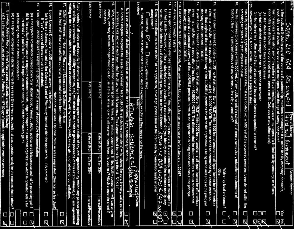
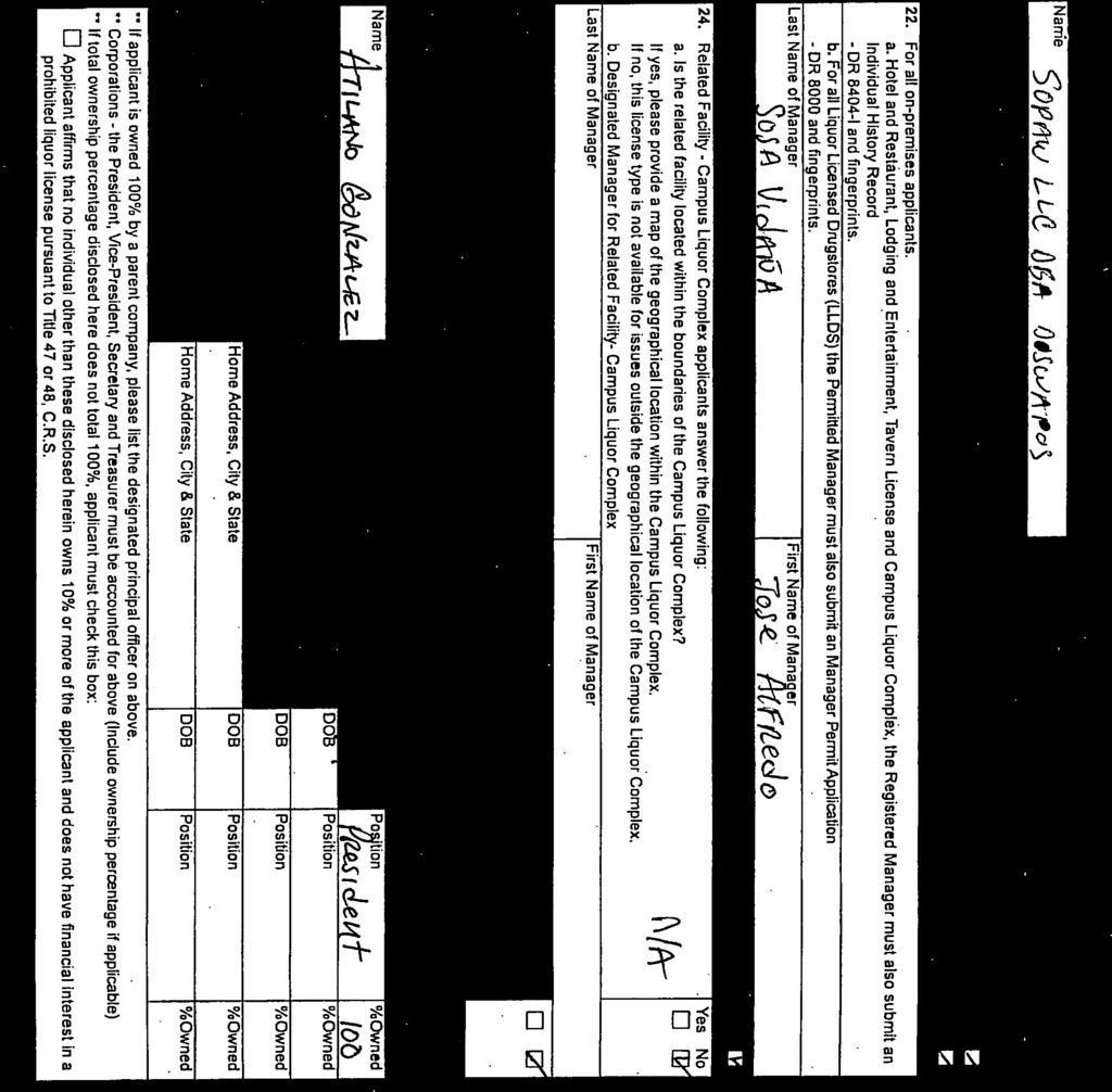
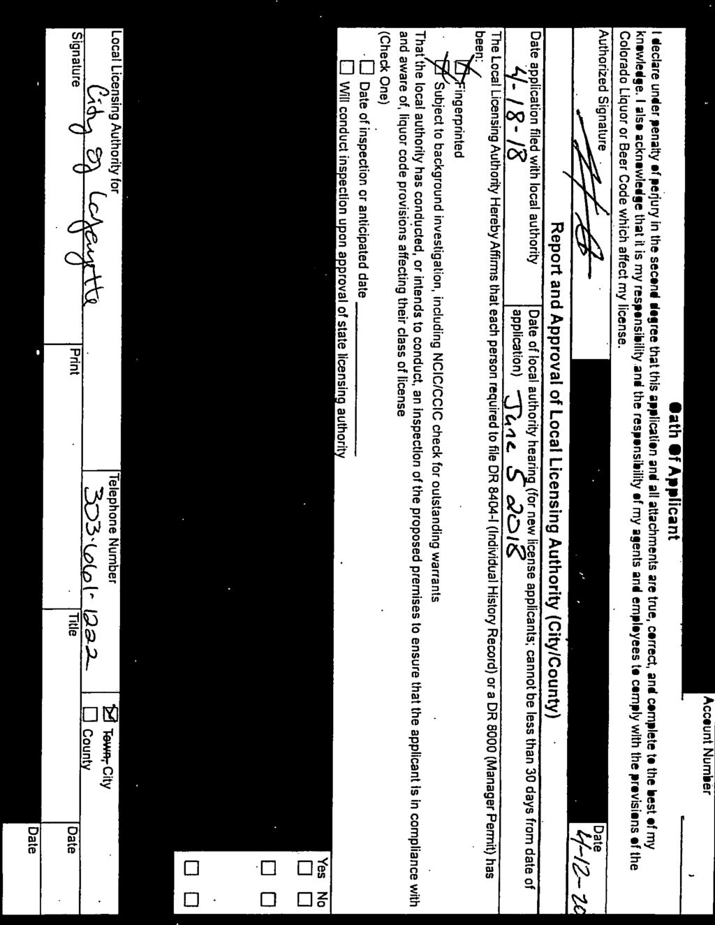
3 STAFF REPORT To: Gary Klaphake, City Administrator From: Susan Barker, Deputy City Clerk Date: May 30, 2018 Subject: Resolution No / Granting a Transfer of a Hotel and Restaurant License from Si Senor Real Mexican Food Inc. dba Si Senor to SOPAW LLC dba Doswapos, 1389 Forest Park Circle #102, Lafayette, CO Recommendation: Council motion to approve Resolution No / Granting a Transfer of a Hotel and Restaurant License from Si Senor Real Mexican Food Inc. dba Si Senor to SOPAW LLC dba Doswapos, 1389 Forest Park Circle #102, Lafayette, CO Background: A complete Hotel and Restaurant Liquor License application was received from SOPAW LLC on April 18, The applicant is the successor in interest to Si Senor Real Mexican Food, Inc. (Tenant) and 95 LLC (Landlord), the term ending June 30, A diagram of the proposed licensed premise provides for liquor service in the interior of the building and on an exterior patio. The transfer of a liquor license does not require a public hearing or a survey of the needs and desires of the neighborhood. Owner Atilano Gonzalez and Manager Jose Sosa have been fingerprinted and the Lafayette Police Department has conducted a background check and found no disqualifying information. Criminal history investigations by CBI and FBI are pending and Resolution No conditions approval of the application subject to final clearance. The premises were posted on May 21, 2018 in accordance with the 10-day posting requirement and the hearing for this application was noticed in the Colorado Hometown Weekly on May 23, Preliminary findings by the City Clerk support the approval of the transfer and staff recommends Authority approval. A Temporary Permit was issued on April 23, The Temporary Permit allows the applicant to conduct business while the Local and State Authorities review the application. The Temporary Permit is valid for 120 days with a possible extension of 60 days. Fiscal Impact: Local Fees collected: $ Attachments: Resolution No License Application (application attachments are available for Council review in the City Clerk s office) 1290 S. Public Road Lafayette, Colorado cityoflafayette.com
4 CITY OF LAFAYETTE RESOLUTION No RESOLUTION OF THE CITY COUNCIL OF THE CITY OF LAFAYETTE, COLORADO, GRANTING A TRANSFER OF A HOTEL AND RESTAURANT LIQUOR LICENSE FROM SI SENOR REAL MEXICAN FOOD INC. dba SI SENOR TO SOPAW LLC dba DOSWAPOS WHEREAS, the City has received an application for a transfer of a Hotel and Restaurant Liquor License, on April 18, 2018, and said application was verified complete; and WHEREAS, the applicant has paid the required application and license fees; and WHEREAS, the Lafayette City Council, sitting as the Local Licensing Authority, considered the transfer application on June 5, 2018 NOW, THEREFORE, the City Council of the City of Lafayette finds as follows: 1. The applicant is entitled to possession of the premises for which application is made as a successor in interest to Si Senor Real Mexican Food, Inc. (Tenant) and 95 LLC (Landlord). The term of which expires June 30, The applicant has filed a floor plan for the interior and exterior area of the building. The Council approved said floor plan with no exceptions. 3. The sale of liquor for consumption on the premises is permitted at the location for which the license is sought under the applicable zoning ordinances of the City of Lafayette. 4. The party shown by the application as having a financial interest in the business for which the license is requested is Atilano Gonzalez. 5. The Lafayette Police Department, in conjunction with the Colorado Bureau of Investigation is conducting a records check on Atilano Gonzalez. 6. The Council, subject to final CBI/FBI clearance, finds that his character is such to permit SOPAW LLC to hold a liquor license.
5 Resolution Page 2 of 2 NOW, THEREFORE, BE IT FURTHER RESOLVED by the City Council of the City of Lafayette, Colorado, as follows: 1. The application of SOPAW LLC dba Doswapos is hereby approved subject to final criminal clearance from FBI and CBI, which will be reported to the City Clerk through the Police Department. 2. Upon approval of the Hotel and Restaurant License by the State Licensing Authority, the City Clerk is hereby authorized to issue the license to the applicant. 3. This Resolution shall be effective upon its approval by the City Council. RESOLVED AND PASSED THIS 5TH DAY OF JUNE, CITY OF LAFAYETTE, COLORADO ATTEST: Christine Berg, Mayor Susan Koster, CMC, City Clerk APPROVED AS TO FORM: David S. Williamson, City Attorney


6


7

8


9

10


11


12
13 To: From: Gary Klaphake, City Administrator Greg Thompson, Senior Planner Date: May 30, 2018 Subject: MEMO Replat Lot 3, Carbone 4 th Filing/Cannon Trail Subdivision; 1. Final Plan/Planned Unit Development, 2. First Reading Ordinance No. 17, Series 2018 Rezoning Property from R2 to OTR, 3. Resolution No. 24, Series Growth Management Permit Allocation 4. Site Plan/Architectural Review Recommendation: Approval of a Final Plan/Planned Unit Development, Rezoning, Growth Management Permit Allocation and Site Plan/Architectural Review subject to the 10 conditions as recommended by the Planning Commission. Background: On August 23, 2017, the Planning Commission approved the Preliminary Plan/Planned Unit Development and recommended approval of the Rezoning, Growth Management Permit Allocation and Site Plan/Architectural Review applications for Lot 3 Carbone Subdivision Filing No. 4. The request is to create 25 lots and 1 tract. Fifteen of the lots would be split and have duplex units on them and would face Cannon Trail, the 9 lots west of S. Foote would have single family homes, the 3 lots facing E. Cleveland would have the possibility of an accessory dwelling unit, and one lot already has a house on it, as does the tract. The property is an 8.34 acre parcel. A.45 acre detention pond would be located adjacent to S. Burlington, while a.2 acre HOA maintained park would be located near the center of the property. The property is zoned both R-2 (Single and Two-Family Residential) and OTR (Old Town Residential). The rezoning portion of the proposal moves the existing zone line demarcating the R-2 and OTR to follow proposed lot lines rather than splitting lots. For the Preliminary Plan/Planned Unit Development code modifications, the applicants proposed having a revised road section for Cannon Trail which includes parking and a sidewalk on the north side only, HOA maintained streetscape along Cannon Trail, street frontage for lots 4-8, the side onstreet setback for Lot 10, and 0 lot line for the lot lines splitting each duplex. The Planning Commission recommended approval of the PUD with one condition of approval, finding the PUD meets the review criteria of Section and the Preliminary Plan complies with the submittal requirements of The rezoning would only occur in the northwest portion of the lot where a.28 acre portion of the property would be zoned from R-2 to OTR. This allows 3 proposed lots to have one zone district on the lots, rather than having two. Planning Commission found the zoning criteria in section (a) (b) and (c) was met and recommend approval with one condition. From a growth management perspective, the applicant has requested 16 units in 2018 and 23 in 2019 with the expectation market conditions will support the request. Permits are available for that request. Planning Commission found the request was compliant with review criteria of Section 6.10 and Sections
14 In regards to the site plan/architectural review application, the duplex buildings would be oriented to Cannon Trail and have 4 potential floor plans. The single-family lots would be semi-custom homes, with materials, colors, and finishes similar to the duplex units. The Planning Commission recommended approval subject to 3 conditions, finding the application complied with the review criteria of Section and the submittal requirements of Section Fiscal Impact: Normal fees and charges will apply where applicable. Attachments: Planning Commission Notices of Decision dated August 23, 2017 Planning Commission Staff Report from August 23, 2017 meeting Final Plan application o PUD o Site Plan-Architectural o Landscape o Plat o Narrative o Drainage o Construction Docs Development Agreement Resolution No. 24, Series 2018 Ordinance 18, Series 2018 Cannon Trail Subdivision Page 2 of 2


15


16

17

18 MEMO To: Planning Commission From: Greg Thompson, Senior Planner Date: August 16, 2017 Subject: Cannon Trail Preliminary Plan/PUD, Rezoning, Growth Management Permit Allocation, and Site Plan/Architectural Review Applicant/Owner: Location: Land Use Designation: Current Zoning: Proposed Zoning: Total Area: Diverge Homes / Joseph A and Donna Jean Carbone South of East Cleveland Street at South Foote Avenue, west of South Burlington Avenue, and north of the alley behind East Chester Street. High Density Residential R-2 (Single- and Two-Family Residential) and OTR (Old Town Residential) R-2 (Single- and Two-Family Residential) and OTR (Old Town Residential) 8.34 Acres Vicinity Map BACKGROUND In May 2017, the Planning Commission approved a Sketch Plan for a 25-lot duplex residential development (50 total units) on the approximately 8.34 acres of land. Two existing single-family units exist adjacent to East Cleveland. This area is not planned for further development at this time,
19 although a 2.2 acre parcel will remain with one house, and a.46 acre lot would be formed around the other house. The Planning Commission approved the application with eight (8) conditions of approval. (see attached) Proposal: This is a request by Diverge Homes, LLC for approval of; Rezoning, Preliminary Plan, Planned Unit Development, and Site Plan and Architectural Review applications for the 8.34 acre property. The rezoning portion of this application covers about.28 acres (12,358 sf) in the northwest portion of the site. Three lots in that area would have had two different zone categories on the property which is difficult to administer from the City s perspective. Instead, the applicants have proposed these three lots add to the OTR zoning already on the lots to make the entirely of Lots 1-3 be OTR. The proposal is to rezone the.28 acre portion of the property from R-2 to OTR with Preliminary Plan/PUD applications to develop a subdivision with 26 proposed lots, two of which already have houses on them. Of the remaining 25 lots, the fifteen lots facing Cannon Trail would be duplexes. The 9 lots west of S. Foote would be single-family. The 3 lots facing E. Cleveland would have the possibility of an accessory dwelling unit. A.45 acre detention pond would be located adjacent to S. Burlington. While a.2 acre park would be located in the center of the property. The proposed gross density of the subdivision as a whole is 4.9 dwelling units per acre. Excluding the 2.2 acre parcel which is anticipated to be developed further in the future, increases the gross density on the developing portion of the site to 6.36 acres. The R2 zone allows up to 10 du/acre. Prior Agreements: Other than the Sketch Plan approved in May, 2017, no known agreements exist. It should be noted the mineral estate has been severed from the surface estate. Public Notification and Comment: Per the requirements of Section (c) of the Municipal Code, a neighborhood meeting was held on July 17, Twenty-four members of the adjacent neighborhood attended the meeting and signed the sign-in form. A copy of the comments from attendees is attached to this report. Per the public notification requirements, letters to property owners within 750 feet of the subject property have been mailed, a public notice has been advertised in the Colorado Hometown News, and public hearing signs have been posted on the property. To date, staff has received no comments from adjacent property owners. Procedure: Using the criteria set forth in the Code of Ordinances and the Comprehensive Plan, the Planning Commission is charged with approving, approving with conditions, or denying the applications. In approving a Preliminary Plan/PUD, the Commission may impose any reasonable conditions to ensure that the proposal satisfies the established criteria. If the applicant fails to submit a final plan conforming to the approved Preliminary Plan/PUD to staff within 90 days, the plan shall be deemed withdrawn. Upon determining that the final plan complies with all conditions of the Planning Commission approval, staff will forward the final plan to City Council for consideration. The Planning Commission is charged with making a recommendation to City Council regarding the Cannon Trail Preliminary Plan/PUD, Rezone, Site Plan/Arch Page 2 of 17
20 Rezoning application. The Commission may recommend approval of the application, approval with modifications, or may recommend denial of the application based upon applicable code criteria. For the Site Plan/Architectural Review, the Planning Commission is charged with making a recommendation to City Council regarding this application. The commission may recommend approval of the application, approval with modifications, or may recommend denial of the application based upon applicable code criteria. PRELIMINARY PLAN REVIEW/PLANNED UNIT DEVELOPMENT General: The Comprehensive Plan Land Use designation for the subject property is High Density Residential which is appropriate for residential development greater than 6 dwelling units per acre. The plan also includes a proposed new public street connection across the property for S. Foote which is stubbed to the property on the south and partially built in the north, although no right-of-way exists. Additionally, the alley north of East Chester would be converted to a street, with two lanes of traffic, and a sidewalk as well as parking on the north side. Sidewalks would also be added adjacent to East Cleveland, South Burlington, and on both sides of South Foote. The west side sidewalk along Foote would diverge from the ROW to go on the west side of the park in that area. A privately maintained alley would be put in place in behind lots 1-8, and adjacent to lot 9. All lots will be larger than the 7,000 square foot minimum required in the R2 and OTR zoning districts. Lot sizes for undeveloped lots will vary from 7,004 square feet to 7,958 square feet. The two lots with homes already constructed on them are 20,206 sf and 2.2 acres. Outlot A (19,756 sf) is located along South Burlington Avenue at the eastern edge of the subdivision and will provide detention for the property. Outlot B (8,708 sf) is also known as Crescent Park and will provide a recreational amenity for the development. Outlot C (12,102 sf) is the alley on the western edge of Cannon Trail Preliminary Plan/PUD, Rezone, Site Plan/Arch Page 3 of 17
21 the site which serves lots 1-9. While shown on the plat, this area is not identified on the PUD plan and calculations. The applicant has proposed naming the repurposed alley Cannon Trail. PUD (Planned Unit Development): A PUD is required for all residential development that does not qualify as a minor subdivision. The intent of the PUD requirement is to promote the most beneficial and creative development of the land. A PUD permits greater flexibility in design by having the effect of overlaying the existing zoning district and thereby adding to and modifying the existing zoning regulations. A PUD may modify any measurable standard of Lafayette s Development and Zoning Code, except those specified in Section PUD s also must follow Resolution that outlines mandatory and aspirational standards that all residential PUDs shall adhere to. Some of these aspirational standards include that the applicant provide recreational amenities, pedestrian and bike connections, access to nearby open or public space, heavily landscaped streetscapes, RTD options and enhancements within or adjacent to the development, and that healthy trees and landscaping be preserved. The approved sketch plan included 8 conditions of approval: 1. Sidewalks shall be added in all appropriate locations on-site, including north of proposed Lot 26, the east side of S. Foote, along Cannon Trail on the north side, and adjacent to S. Burlington. Staff Comment: Sidewalks have been added, but should be increased in size to 5 wide to provide a better pedestrian experience. 2. Provide appropriate easements for dry utilities and facilities. Staff Comment: Generally speaking this has been provided, but instead of an area that is Width Varies the dry utility easement on the rear of lots needs to be 8 consistently. 3. A visitability plan shall be provided as part of any Preliminary Plan submittal. Staff Comment: The location of these lots and the number of lots shows complies with the Code. 4. Prior to submittal of any Preliminary Plan, the applicants shall confer with the Fire Marshal and Public Works to determine the best location for fire hydrants. Staff Comment: The concerns raised about fire hydrant locations have been alleviated. 5. Garages shall be set back a minimum of 19 from the alley so a second parking space can be provided in the driveway. Staff Comment: For the most part, this has been addressed, however, the illustrative site plan (Sheet A1.0) show Lot 9 having difficulty meeting the rear setback (20 feet) and the 19 setback for the garage. When designed, this lot will need to be compliant with setbacks. 6. Identify existing healthy street trees on Lots 26 and 27, place them on plans and retain as many as possible. Staff Comment: The applicants have identified one street tree to be retained. On the east side of S. Foote, another tree or two may be able to be preserved. 7. Lot sizes shall be increased in size to conform to the R2 zone requirement of 7,000 sf minimum. Staff Comment: All proposed lots are greater than 7,000 sf. 8. Lot coverage shall be increased to conform to the R2 zone requirement of 30% maximum. Staff comment: The applicants have indicated the typical site plans will conform to this requirement. Cannon Trail Preliminary Plan/PUD, Rezone, Site Plan/Arch Page 4 of 17
22 The preliminary plan includes a request for four (4) Code modifications for the project. These modifications are listed below with an analysis of each to follow: Proposed PUD Modifications A revised road section for Cannon Trail which includes parking and a sidewalk on the north side only. Streetscape Street Frontage Administratively Subdivide Duplex Lots Reduced Lot Size and 0 Lot Line Cannon Trail Road Section: The 32 wide road section includes the existing 20 wide existing alley and 12 of additional right-ofway provided by the applicant. The cross-section includes a sidewalk and on-street parking on the north side. This street will be accessed by Lots of this development and already developed lots south of the street which front on E. Chester. The existing lots on Chester are already served by a sidewalk on Chester and having one in their alley is atypical. While a typical cross-section would include sidewalks and parking on both sides, providing sidewalks in front of lots of this development seems like a reasonable compromise which is supported by Public Works. Streetscape: The applicants have proposed not including street trees adjacent to Lots 25 and 26. Both of these lots have single-family homes already built on them. While Lot 26 is anticipated to be developed further in the future, Lot 25, at 20,206 sf, is already developed and not anticipated to be developed further. Including street trees now on lot 25, since it s already developed makes sense. Street Frontage: Lots 4-7 do not have any street frontage. Instead, the design proposed has those lots fronting on Crescent Park. While there is a code requirement to have all lots with frontage, vehicular access is accommodated to these lots by the alley in the rear. Pedestrians are accommodated by the S. Foote Street sidewalk which is detached adjacent to Crescent Park. Administratively Subdivide Duplex Lots: In the future as the duplex lots (Lots 10-24) are developed, the applicant would like the opportunity to subdivide those lots to sell each half of the duplex. This has become relatively common practice in the Old Town area. The applicant has requested that no application be required for these plats and that there be no hearing. The Code requires a minor subdivision to split the lots, however that would most likely be processed administratively. Reduced Lot Size and 0 Lot Line: As part of future applications to divide duplex lots in half, the applicant would like the size of those future lots to be less than the typical code requirement of 7,000 sf. No additional units would be allowed to be added because of this potential future subdivision. As part of this, the applicants would like any future lot line which splits a duplex to be allowed to create a 0 lot line on the newly created lot. In other words, the duplex would be split by the new lot line. PUD Criteria: The following PUD criteria apply to all PUD s and has been analyzed as follows: Cannon Trail Preliminary Plan/PUD, Rezone, Site Plan/Arch Page 5 of 17
23 1. The City finds the project is unique and/or necessary for economic development of the City. This project is unique and necessary in that it provides improvements on a predominantly vacant portion of Old Town and provides an appropriate infill project within Lafayette. 2. The development is in the best interest of the City. This infill development, adjacent to established neighborhoods, will create the contiguous residential developed area envisioned in the Comprehensive Plan. The architecture of the homes, including front porches, rear patios, and high quality building materials will fit well with surrounding development. The landscaping, street connections, pedestrian connections, variety of housing options, and appropriate density infill of the project create a project that is in the best interest of the City. 3. The modifications to the Code by the PUD are in the best interest of the City and the neighborhood in which the development is occurring. The housing demand for a variety of housing options in Lafayette is extraordinarily high. The Code modifications requested by the applicant will provide the best development of the property that targets a variety of residential development. The modifications and related conditions of approval will ensure the finished streetscape on the subject property. Staff finds subject to staff recommended conditions of approval, that the modifications to the Code are complimentary and compatible with the surrounding subdivisions and will provide a cohesive design throughout the development. Streets and Traffic: Development of the property will include construction of S. Foote between E. Chester and E. Cleveland. The applicants have proposed building the majority of this street to City standards with a 41 ROW. The only portion of the site which varies is when the sidewalk detaches and follows the western boundary of Crescent Park. This is a less direct route, but a more attractive pedestrian experience. Staff is supportive of this adjustment. The only lot which is anticipated to access this street directly is Lot 25, which already has access to where S. Foote would be located. Cannon Trail would provide direct access for the duplex lots (10-24) and provide a 33 ROW. Cannon Trail would be paved, have two-way traffic, parking and curb, gutter, and a sidewalk on the north side. While a modified cross-section, staff is supportive of the proposal for this street Lots 1-9 would receive vehicular access from a new alley that would be located behind those lots. This would be a private alley which would be maintained by the HOA. The surface of the alley would be paved. Lot 26: Lot 26 already has a single-family home built on it, is 2.2 acres, and is anticipated to be developed further in the future. Since this area is anticipated to be developed further, it makes sense to call it a tract, rather than a lot. This stands to reason in line with the applicant s interest in not counting this property for PLD requirements. If slated for further development, the PLD requirement could be fulfilled in the future when that lot develops. Vehicular Access: Vehicular access to this site is provided by E. Cleveland, S. Burlington, and E. Chester which are all paved city streets. Cannon Trail Preliminary Plan/PUD, Rezone, Site Plan/Arch Page 6 of 17
24 Public Transportation: The nearest RTD stop is approximately 6 blocks west of the site at Chester and S. Public Road. Routes served include 225D, 225E, 225, JUMP, DASH, and L. Pedestrian and Bicycle Access: Pedestrians would be accommodated throughout the site. The applicants have proposed an alternative to the typical sidewalk along the west side of S. Foote. The sidewalk would detach and go on the west side of Crescent Park. Cannon Trail would have an attached sidewalk along the north side only. Sidewalks are now included adjacent to lots 25 and 26. Parking: Parking will be provided for each dwelling within the single car garage on each half of the duplex as well as a tandem space behind it. On-street parking is available adjacent to S. Foote, E. Cleveland, and the north side of Cannon Trail. Single-family lots are planned to have two-car garages. Any ADUs provided on Lots 1-3 will need to meet parking requirements for that use as well. Engineering/Utilities: Xcel reports that electric and gas facilities are on the property and need to be accommodated and the property can be served. Xcel requests that utility easements be clearly identified on the final plat and has indicated the applicant should contact them prior to any work within the easement area to acquire the necessary permits. The City Engineer has reviewed the plan and the comments provided include additional information required for drainage, utilities, civil drawings, streets, and general issues. The City Engineer memo dated July 27, 2017 is attached to this report. Water and Wastewater: The City has the capacity to provide water and water reclamation service to the subject property. Water mains and sanitary sewer mains are already installed in the area. Drainage: Storm water drainage will be accommodated on-site with a detention and water quality pond located in the southeast corner of the subdivision in Outlot A. The proposed improvements and formal drainage analysis and plan were submitted with the preliminary plan and has been reviewed by the City Engineer. His comments are attached in the City Engineer memo dated July 27, Water Rights: The Municipal Code requires developments over 5 acre-feet of water to dedicate Colorado Big Thompson (CBT) shares to the City. The City anticipates that through the Development Agreement that water rights will be paid on a building permit by building permit basis concurrently with payment of the building permit at the then-current rate. The applicant will also have the option to provide CBT shares or pay cash-in-lieu at the time the building permit is issued. The applicant will be required to dedicate all necessary water rights for the homes and landscaping, and pay all required NISP fees for dedicated water at the time of final platting. Single-family dwelling residential water right requirements are.50 acre-feet per unit. The Cannon Trail Subdivision has 26 lots and three outlots. Public Land Dedication: The Lafayette Open Space Advisory Committee (LOSAC) responded to the referral request and indicated that they support a cash in-lieu payment due at the recording of the subdivision rather than real land dedication requirement. The applicant would like the City to reconsider including Crescent Park, but LOSAC has already made their decision and for a variety of reasons, staff supports that choice. Cannon Trail Preliminary Plan/PUD, Rezone, Site Plan/Arch Page 7 of 17
25 Open Area/Recreation: The preliminary plan includes 8,708 square foot Outlot B that serves as an open area and community amenity. A detention pond area identified on the plan as Outlot A will look and feel like a detention pond. The sidewalk associated with Cannon Trail will connect this site with open space areas on the east side of S. Burlington. The parks department has indicated they have a bridge which may fit across the ditch on the east side of S. Burlington and the applicant may use the bridge. Landscaping: The applicant has submitted a complete landscape plan for the Subdivision. The plan indicates 28,464 square feet of landscaped area including 59 total new trees to be planted with 49 street trees within the subdivision. The plan also identifies 77 total new shrubs to be planted onsite and dispersed accordingly throughout the property. The plan includes the required street trees along S. Burlington. Additional street trees are required adjacent to Lot 25 along E. Cleveland and S. Foote. There is one existing street tree adjacent to S. Foote that is not shown on the landscape plan but should be preserved if possible. The applicant has proposed a native walk on the north side of Cannon Trail which will be maintained by the HOA and provide a consistent landscaping appearance. The landscape plan includes Outlot A along S. Burlington with deciduous and evergreen trees located on top of the pond edge. The majority of the pond is covered with a wetland seed mix. Staff is supportive of the general plan for this area, but believes a top dressing continuation of the native walk landscaping adjacent to Cannon Trail shall be provided to S. Burlington. Outlot A will be owned and maintained by the Home Owners Association. Outlot B is also known as Crescent Park which would be maintained by the HOA. It has turf grass and a variety of trees which provide shade and a small open area to play in. No irrigation plan was provided, so it s unclear if the water use calculation are within the Code parameters. With the recommended condition of approval on the nature walk extension into Outlot A, an updated landscape and irrigation plan that incorporates the Outlot A change should be provided. Plat: The submitted preliminary subdivision plat had a variety of issues which need to be adjusted including: 1. The Title, 2. Certificates, 3. Vicinity Map, 4. Readability of the Plat, 5. Designation of Lot 26, 6. Inconsistent Easement Widths for Dry Utilities, 7. Unlabeled Easements, 8. Extraneous Information, 9. Outlot B as blanket Utility Easement. Cannon Trail Preliminary Plan/PUD, Rezone, Site Plan/Arch Page 8 of 17
26 As additional information is provided, and the plat improved, additional comments may arise. Staff believes the issues identified above are correctable and have included conditions of approval to address them and will need to be addressed prior to submittal of a final plan. Fence: The applicant has indicated rear and side yards would include privacy and semi-private fencing. Front yards will be low picket fencing and follow the Design Resource Book and Municipal Code. Visitability: This project is subject to the Visitability regulations adopted by the City Council in September The Visitability ordinance states that a minimum of 25% of the dwelling units within the development shall comply with the Visitability criteria, which includes a zero step entry, wider hallways and a ground level bathroom that can accommodate a wheelchair. The applicant has identified that Lots 3, 4, 8, 10, 11, 14, 15, 18, 19, and 22 will be visitable. These 10 lots meet the 25% requirement of the Code. Staff recommends that these lots be identified on the Final Plan. Public Safety: Staff referred the Sketch Plan and Preliminary Plan to both the Police Department and Fire Marshall. The Fire Marshal requirement from the Sketch Plan submittal to clarify the fire hydrant location has been fulfilled with the Preliminary Plan submittal. Schools: The Boulder Valley School District (BVSD) has indicated that the proposed development would be served by Sanchez Elementary, Angevine Middle School and Centaurus High School. The following student numbers are expected to be generated from the new lots and development being proposed in the development: Elementary School 10 Middle School 5 High School 6 TOTAL 21 The School District has indicated that this development can be served at the elementary, middle school and high school levels within existing capacity. Developer s Ability to Complete the Project: The applicant has worked on projects in a variety of other states. They have not developed within the City previously. This project is the largest one they have worked on. While the Sketch Plan submittal had some issues to be addressed, staff believes the applicant has a team of local consultants that can make the project be successful should it be approved. Homeowner s Association: A Home Owners Association will be established for the subdivision. The applicant submitted the Homeowners Association documents with the application for staff review. Staff has no concerns with the proposed Home Owners Association documents. Goal Fulfillment: This project complies with a number of policies listed in the City s Comprehensive Plan: Cannon Trail Preliminary Plan/PUD, Rezone, Site Plan/Arch Page 9 of 17
27 Policy B.2.2: Policy C.1.1: Policy C.1.5: Policy C.3.2: Policy C.3.8: Policy D.1.1: Policy E.1.1 Policy G.3.1: Policy G.3.3: Encourage compact and clustered development to facilitate more efficient provision of utility, drainage, and transportation infrastructure; community services; and, community facilities. Ensure that proposed development and redevelopment projects conform to the Land Use Map s designations. Enhance Lafayette's pedestrian, small-town character by targeting future medium and high-density residential development to infill development locations that are readily accessible to and otherwise integrated with potential employment centers, commercial shopping areas and transit service routes. Encourage street connections between proposed and existing residential neighborhoods. Impacts on existing neighborhoods will be considered and mitigated through the use of multiple access connections, traffic calming devices and/or street design standards that avoid long, straight, uninterrupted routes. Such techniques will be employed to minimize cut through traffic. Ensure that new residential development provide pedestrian connections to adjacent development and whenever feasible to existing and proposed trail systems as indicated on the PROST plan. Ensure that both scale and appearance of proposed development and redevelopment responds appropriately to adjacent development and provide a compatible transition to existing neighborhoods. Encourage residential development that supports the spectrum of housing needs in the community, including seniors, first time home buyers and entrylevel to mid-level employees through the provision of a variety of housing types, prices, styles, and sizes. Ensure that pedestrian and bicycle routes, which include trails, paths, sidewalks, and street bike lanes, are planned and built to allow users access to key city destinations, and are integrated with and strengthen the City s alternative transit system. Ensure that proposed development and redevelopment provides an adequate system of sidewalks and trail facilities that meet City standards to promote walking and bicycling throughout the City. Connect new sidewalks and trails to existing sidewalks and trails. Policy H.3.10: Consider requiring new development, especially residential developments, to dedicate land for neighborhood parks to the development s owner s association rather than dedicating such land to the City, in order to manage the City s ongoing parks and public lands maintenance costs. Policy I.1.2: Encourage infill development over green-field development. City s Financial Ability to Serve: The City is currently providing municipal services to development adjacent to the subject property. The City should be able to accommodate this development at current municipal service levels. Cannon Trail Preliminary Plan/PUD, Rezone, Site Plan/Arch Page 10 of 17

28 GROWTH MANAGEMENT Priority Classification: A component for the Planning Commission to consider when allocating residential permits is the project s growth management status (Exempt or Non-exempt). All developments receiving Preliminary Plan approval after November 2013 are classified as Nonexempt for purposes of allocating residential permits. Cannon Trail Subdivision is classified as nonexempt. Permit Allocation: The annual allotment of dwelling unit permits is a component of the PUD criteria and is required to be included in the consideration of a Preliminary Plan. Growth management requires the City provide a development with an annual allocation with sufficient numbers to build out the development. Currently there are 915 permits allocated of the 1,200 permits available from January 2013 through December Based on the applicants analysis staff recommends a building permit allocation of 0 permits in 2017, 42 permits in 2018, which includes the potential accessory dwelling units. Permits requested after 2018 will require a new analysis. Year Annual Allocation permits permits permits Any permit requested after 2018 will require a new analysis. The applicant is requesting forty-two (42) residential permits believing that current market conditions will support that request. Staff believes this is reasonable and that permits will be available to accommodate this request. REZONING Comprehensive Plan/Land Use Designation: The Comprehensive Plan Land Use designation for the subject property is High Density Residential which is appropriate for residential development over six (6) dwelling units per acre. The Cannon Trail proposal includes 39 additional units (41 total) on 8.34 acres for a total of 4.91 dwelling units per acre. Staff is more comfortable with excluding the 2.2 acre property that is anticipated to have further development in the future and the one house on that parcel. That changes the density to 6.51 units per acre. Comprehensive Land Use Plan Cannon Trail Preliminary Plan/PUD, Rezone, Site Plan/Arch Page 11 of 17

29 Zoning: The northwest corner of the property has a small half acre area which is zoned OTR. Having 3 proposed lots with different zone categories makes development and code enforcement difficult. Rezoning the property to a singular zone district is logical. The applicants have proposed changing the area of R-2 on the 3 lots to be OTR. This will afford greater flexibility in residential products available on this site. OTR zoned properties can have accessory dwelling units (ADUs). Zoning Map Density: The R2 zone district allows a residential density of over six dwelling units per acre. The proposed Cannon Trail Subdivision has a density of 6.51 per acre. The OTR zone allows up to 13 units per acre. The proposed density is appropriate in either zone category. Code Section states that the zoning district map may be amended with respect to the uses allowed within a certain area of land if one (1) or more of the following criteria are met: a) The land to be rezoned was initially zoned in error or the rezoning is of technical or corrective nature in order to conform zoning district boundaries with lot lines; b) Because of changed or changing conditions in a particular area or in the city generally, it is in the public interest and reasonably necessary in promotion of the public health, safety or welfare to rezone a property to encourage development or redevelopment; c) The rezoning is necessary to conform to the Lafayette Comprehensive Plan; or d) The rezoning is necessary to provide land for a community related use that was not anticipated at the time of adoption of the Lafayette Comprehensive Plan, but which use is generally consistent with the policies and goals of said plan, is in the public interest and is reasonably necessary for the promotion of the public health, safety or welfare. Staff finds the proposed rezoning request for.28 acres (12,358 sf) from R2 to OTR complies with the zoning criteria found in Section (a)(b) and (c). At the time the area was zoned as shown, the zone boundary followed lot lines. Over time, those lot lines have changed, leaving the situation as shown. Concurrently with the review of a preliminary and final plan, and applicant submitting a rezone request that complies with the Comprehensive Plan s land use designations and the new, proposed lot lines makes sense. Staff believes that the rezoning should continue to establish and Cannon Trail Preliminary Plan/PUD, Rezone, Site Plan/Arch Page 12 of 17

 - The applicant has submitted plans for the duplex lots.")
30 maintain sound, stable and desirable development within the City. It is in the public interest and necessary to rezone the property to encourage smart and successful residential development. The rezoning is necessary for the project to move forward and will enhance the overall appeal of the City and should attract residents to the City and provide needed additional housing options within this development. Staff recommends approval of the rezoning from R2 to OTR for the.28 acre (12,358 sf) area with the condition the final plan gets approved and recorded. SITE PLAN AND ARCHITECURAL Duplex Lots (10-24) - The applicant has submitted plans for the duplex lots. Duplexes: For the duplex lots, the applicants have proposed 4 different floor plans, which each have 5 or 6 elevation options. All units are 21 feet wide. o Sunflower Has a total of 2,335 sf with a main floor of 1,188 sf. The unit is either 1.5 or 2 stories. o Coneflower Has 2,615 sf with a 1,105 sf main floor and is 2 stories. o Arnica Has 2,125 total sf, a 990 sf main floor, and is 1.5 or 2 stories. o Aster Has 2,465 sf, a 780 sf main floor and is 2 stories. The proposed duplex pairings and applicants plan to allow the lot owners to choose from a variety of elevations may work out fine, or there may be some unintended consequences. For example, there is no requirement the same elevation can t be used on the same building, or next door, or across the street. This type of provision would help ensure the variety the applicant seeks and the City desires. It would be appropriate that the standards put forth in potential new Old Town Overlay area be applicable to structures built within this development. Single Family Lots (1-9) The applicant does not have specific home model plans to review for the single-family lots. They desire to construct semi-custom homes on the lots. All exterior materials, colors, and finishes will be applied and designed using only those applications and styles as approved for the Duplex Homes. Elevations will also be selected in accordance with the styles shown in the Architectural Drawings. This allows the applicant to offer the highest diversity in exterior elevations and interior styles without creating new conditions for review and approval by staff. Staff has included a brief analysis of the proposed architecture below. Exterior Finish: Painted composite panel siding, horizontal lap siding, vertical board and batten, and stucco are prevalent materials. Roofs are predominantly 40-year rated dimensional asphalt shingles, but may include accents of metal roofing. Cannon Trail Preliminary Plan/PUD, Rezone, Site Plan/Arch Page 13 of 17
31 Colors: The final color schemes and their application are chosen via the developer through a design professional. The outcome results in a varied scheme for home differentiation while maintaining a compatible streetscape. Staff notes this is different than with most PUDs and suggests having City review and sign off of the proposed colors would be appropriate since it has not been provided at this point and time. Porches / Decks: Each duplex unit and single-family lot will have a 32.5 sf front porch and a 116 sf rear patio. Garages: Single-car garages will be attached to each side of a duplex as shown on the attached building elevations. Entries: The duplex plans show 3 of them with proposed entry s on the front and one on the sideyard. The Sunflower would have an entry that would be fairly difficult to find. Having the primary entry of each unit facing the primary street frontage is appropriate. Overall, subject to staff recommended conditions of approval, staff is supportive of the architectural plans for Cannon Trail Subdivision. The size, massing, and design of the homes are roughly comparable in respect to the homes within the surrounding development. Lighting: The exterior wall mounted lighting on the homes will need to be full cut-off fixtures. The will need to be minimal off-site light spillage at all property lines with readings at or near zero at the property line. Staff recommends that final lighting fixtures be approved by staff with the Final Plan. SUMMARY This is a request by Diverge Homes LLC for approval of; Rezoning, Preliminary Plan, Planned Unit Development, and Site Plan and Architectural Review applications for a 8.34 acre property located South of East Cleveland Street at South Foote Avenue, west of South Burlington Avenue, and north of the alley behind East Chester Street. The property is primarily undeveloped, with 2 single-family residences currently located on it. The applicant is proposing to rezone.28 acres of the property from R2 (Single- and Two-Family Residential) designation to OTR (Old Town Residential) with Preliminary Plan/PUD applications to develop a subdivision with 26 single-family residential lots and three (3) outlots. The proposed gross density of the subdivision is 4.9 dwelling units per acre. The proposed code modifications include: A revised road section for Cannon Trail which includes parking and a sidewalk on the north side only, streetscape, street frontage, administrative review of future duplex subdivisions, reduced lot size, and 0 interior lot line. The size, massing, and design of the duplexes are generally larger than most of the surrounding properties, although the applicants have provided good options. As part of the application, a rezoning of the property is required to rezone the property from R2 (Single- and Two-Family Residential) to OTR (Old Town Residential) to allow for the accessory dwelling units. The Code modifications and rezoning requested by the applicant will provide for appropriate development that targets medium density development in an infill area. Subject to staff s recommended conditions, the site, architecture, and landscape plans comply with Code requirements. The scale is appropriate to the site and function of the project; the duplexes Cannon Trail Preliminary Plan/PUD, Rezone, Site Plan/Arch Page 14 of 17
32 and custom home design will provide variation of detail and form and the landscape of exterior spaces enhances the quality of the project. RECOMMENDATIONS 1. Preliminary Plan and PUD Staff recommends approval of the Cannon Trail Preliminary Plan and PUD subject to the recommended conditions believing the plan complies with the criteria of Section , the goals and policies of the Comprehensive Plan and the submittal requirements of Section Furthermore, staff believes the plan is in the best interest of the City; and the Code modifications are in the best interest of the City and the neighborhood. 2. Growth Management The proposed growth permit allocation and classification status request complies with the review criteria of Section 6.10 and Section Staff recommends approval of the building permit allocation for Cannon Trail shall be 42 permits in Permits requested after 2018 will require a new analysis. 3. Rezoning The proposed rezoning request for Cannon Trail from R2 (Single- and Two-Family Residential) to OTR (Old Town Residential) complies with the zoning criteria found in Section (a), (b), and (c). Staff recommends approval of the rezoning. 4. Site and Architectural Plan Review Subject to the recommended conditions, the proposed Site Plan/Architectural Review complies with the review criteria of Section and the submittal requirements of Section Staff recommends approval of this Site Plan/Architectural Review subject to the recommended conditions. PROPOSED CONDITIONS OF APPROVAL A. Preliminary Plan / Planned Unit Development 1. Provisions that requires the garage to be used only for the parking of vehicles and for the HOA to have the ability to enforce this parking only requirement verbiage shall be added to the CC&R s; 2. An updated landscape plan that incorporates the changes to Outlot A shall be submitted. The updated landscape plan shall include an irrigation plan; 3. The visitable lots be identified on the Final Plan. 4. Rename Lot 26 a tract since it s expected to be developed further in the future. 5. Landscaping shall be adjusted by the following: a. Work with staff to identify existing healthy trees on the east side of proposed S. Foote which appear to be out of the street alignment and may be able to be preserved. b. Add street trees adjacent to Lot 25. c. Continue the native walk along the southern edge of Outlot A to S. Burlington. d. Provide the required irrigation plans which comply with the Code. e. Provide the required stamped Landscape Plans. Cannon Trail Preliminary Plan/PUD, Rezone, Site Plan/Arch Page 15 of 17
33 6. Prior to submittal of any final applications, the following issues shall be addressed on the Preliminary Plat: a. The Title, b. Certificates, c. Vicinity Map, d. Readability of the Plat, e. Designation of Lot 26, f. Inconsistent Easement Widths for Dry Utilities, g. Unlabeled Easements, h. Extraneous Information, i. Outlot B as Blanket Utility Easement. B. Rezoning 1. Is subject to approval of and recording of the final plan. C. Site Plan / Architectural Review 1. As part of any building permit application, the applicant shall provide a color scheme for the proposed buildings which shall be reviewed and approved by City staff. 2. The primary entry of each unit shall face the primary street frontage. 3. The same building elevation shall not be used on the same duplex, next door, or across the street. MOTIONS: 1. Preliminary Plan/PUD Proposed Motion for Approval: The Planning Commission approves the Preliminary Plan/PUD, subject to staff s recommended conditions, finding that the proposal complies with the requirements for preliminary plan submittal; complies with the PUD criteria; and, complies with the Comprehensive Plan s goals and policies, and land use map. The plan is in the best interest of the City; and the Code modifications are in the best interest of the City and the neighborhood. Proposed Motion for Denial: The Planning Commission denies this request for Preliminary Plan/PUD approval finding that the proposal does not comply with preliminary plan requirements; does not meet the PUD criteria; does not comply with the Comprehensive Plan s goals and policies or land use map. 2. Rezoning Proposed Motion for Approval: The Planning Commission recommends approval of this rezoning request from R2 to OTR, finding the rezoning of the 12,358 sf area is necessary to conform to the Lafayette Comprehensive Plan with the condition the zoning won t be changed until the final plan is approved. Proposed Motion for Denial of Rezoning Request: The Planning Commission recommends denial of this request for rezoning finding that the proposal does not comply with the rezoning criteria and is not necessary to conform to the Lafayette Comprehensive Plan. Cannon Trail Preliminary Plan/PUD, Rezone, Site Plan/Arch Page 16 of 17
34 3. Site Plan/Architectural Review Proposed Motion for Approval: The Planning Commission recommends approval of the Site Plan/Architectural Review, subject to the recommended conditions, finding that the plan complies with the criteria of Section , the submittal requirements of Section have been met; the architecture promotes a transition in scale and character of the proposed building to surrounding land uses, the quality and overall design is compatible with the location and proposed use, and colors, including accents, are harmonious and compatible. Proposed Motion for Denial: The Planning Commission recommends denial of the Site Plan/Architectural Review finding that the plan does not comply with the criteria of Section , the submittal requirements of Section have not been met, and the design is incompatible with the location and proposed use. 4. Growth Management Proposed Motion for Approval: The Planning Commission recommends approval of the proposed growth permit allocation and classification status finding the request complies with the review criteria of Section 6.10 and Sections The Planning Commission recommends approval of the building permit allocation for Cannon Trail as 42 permits in Permits requested after 2018 will require a new analysis. Proposed Motion for Denial: The Planning Commission recommends denial of the growth permit allocation and classification status finding that the plan does not comply with the criteria of Section 6.10 and the request is not reasonable and that permits will not be available to accommodate this request. Attachments: 1. Applicant s narrative 2. Preliminary Plat 3. Architectural 4. Landscape Plan 5. City Engineer memo dated July 27, Zoning Info Cannon Trail Preliminary Plan/PUD, Rezone, Site Plan/Arch Page 17 of 17
35 RESIDENTIAL Cannon Trail Narrative on Final Plan April 9 th, 2018 Thank you for the opportunity to present this narrative on final plan comments for Cannon Trail. Below are the Applicant s/developer s responses to the letter issued by Greg Thompson, Planner for the City of Lafayette, on February 28 th, Irrigation plan provides more than 15 gallons per season which is code is shown. Applicant Response: Confirmed and corrected in irrigation plan drawings. 2. Final Plat line work between lots 1 and 2 needs to go all the way to the alley. Applicant Response: Confirmed and corrected in plat drawings. 3. Check Side setback adjacent to Foote was not approved at preliminary to be 10! OTR zone allows it to be 10, but not R-2. Applicant Response: See attached letter. 4. Sheet c.03 a. To reduce future confusion, show location of new OTR zone area, and not how it exists today. Applicant Response: Confirmed and corrected. b. Note #1, restate to Portions of Lots 1,2, and 3 are rezoned to exclusively be OTR zone. Applicant Response: Confirmed and corrected. c. Note #2 isn t needed since the OTR zone allows ADUs. Remove Applicant Response: Confirmed and corrected. d. Note #4; remove the word West. Also, not on C3.0, but is on C3.1 and C3.2. Applicant Response: Confirmed and removed.. e. Note #5 seems redundant as well It s already allowed since it s in the Old Town Overlay. Remove. Applicant Response: Confirmed and removed. f. Note #7 seems redundant to Old Town Overlay requirements, but does not have same restrictions as the Overlay. What is your intent with this note? Why not just follow what the Old Town Overlay has? I say remove this note Cannon Trail Planned Unit Development 1
36 RESIDENTIAL Cannon Trail Narrative on Final Plan April 9 th, 2018 Applicant Response: Confirmed and corrected. g. What s the purpose of note #10? Applicant Response: Note #10 was removed. h. Lot Type Schedule seems kind of squirrelly since the duplex lots are now being subdivided Also, Lot 25 needs to be included in this schedule. Applicant Response: Schedule was updated to reflect fee simple rights of the duplex homeowners. Lot 25 and Tract A were also included. i. Change Visitability Plan note to state, At least twenty-five percent (25%) of the proposed units shall be visitable per Lafayette code chapter 30 Article XV. Units marked with a V on this site plan shall be visitable. Applicant Response: Confirmed and corrected. j. Under Bulk Standards, City Standard for rear yard setback is 5 not N/A for accessory dwelling. Also, side on street setback is 10 in the OTR zone. Side on street in R1 and R-2 zones is 20 Applicant Response: See attached letter. 5. Some places (plat) call the alley public. Others (sheet c.03) calls the alley private. Be consistent on the plans. Which is desired? Applicant Response: The alley is dedicated to the City and the City will maintain same. The sheets are now corrected to reflect same. 6. Sheet C0.0, a. Land Use Summary: i. Says city will maintain the west alley that s supposed to be the HOA. Applicant Response: The alley is dedicated to the City and the City will maintain same. In the event that the Cannon Trail HOA intends to conduct snow plowing on the alley or Cannon Trail, they will apply for the right to do so and follow the standard requirements in place by the City of Lafayette at the time of such application. ii. Lists public open space, but there isn t any. Remove that from the list. Applicant Response: Confirmed and removed Cannon Trail Planned Unit Development 2
37 RESIDENTIAL Cannon Trail Narrative on Final Plan April 9 th, 2018 iii. Isn t the HOA maintaining the front 10 strip on Lots 10-24? Maintenance column suggests otherwise. Applicant Response: The HOA will maintain the front 10 (approx.., varies in size) strip and the homeowner will maintain all other areas of the front yard. b. Change Description of Subject Land to include the acreage for Lot 25. Applicant Response: Confirmed and changed. c. Open Space and Street Dedication HOA to maintain alley Applicant Response: The alley is dedicated to the City and the City will maintain same. In the event that the Cannon Trail HOA intends to conduct snow plowing on the alley or Cannon Trail, they will apply for the right to do so and follow the standard requirements in place by the City of Lafayette at the time of such application. d. Density Summary: i. Change to incorporate 13 DU for OTR area ii. Include Lot 25 in the developed density summary iii. Net Density isn t needed. Please remove. Applicant Response: All three items in this section have been corrected and/or removed. e. Open Space Summary is mislabeled. The areas shown are not open space. Applicant Response: Corrected and removed. f. Should the Contact List show Diverge Homes or Cannon Trail LLC as the Applicant? Applicant Response: Diverge Homes is the Developer and will remain on the contact list. 7. Need information on the bridge style, location, variety, material, cost, etc. Applicant Response: The City of Lafayette Public Engineer, Aaron Asquith, has approved the construction of a culvert in the drainage ditch, which will be covered and capable of pedestrian travel per the standards shown on the construction drawings Cannon Trail Planned Unit Development 3
38 8. Sheet L1.0 doesn t have a key for what the landscaping is. RESIDENTIAL Cannon Trail Narrative on Final Plan April 9 th, 2018 Applicant Response: The key is located on the following page. Due to the large number of plantings and many different species of plants, there was not enough room on the front page to include the key/legend. a. Street trees required every 40. i. One more needed north of lots 1, 2, and 3. ii. One more needed on east side of Lot Provide updated title work Applicant Response: Both items in this section were corrected and trees were added. Applicant Response: See attached updated title commitment. 10. On plat: a. change dates to 2018 Applicant Response: Confirmed, all dates changed. b. include alleys in the dedication Applicant Response: Confirmed. Alleys are now included in dedication. c. Provide evidence that note 7, sheet 1 of 3 is acceptable to public service. Applicant Response: Confirmed. Please see attached from Xcel. d. Either provide the Attorney s Certificate or the Title Company Certificate but not both. Applicant Response: Confirmed. Attorney certificate was removed. e. Sheet 2 i. Why is Outlot B being characterized as a private park. I realize it s not to be public, but that will likely be used to keep people out. Can it just be called a park? Applicant Response: Outlot B is a private outlot owned by the HOA because the City of Lafayette has declined dedication of same. The language identifier was modified to exclude the word private in the label Cannon Trail Planned Unit Development 4
39 RESIDENTIAL Cannon Trail Narrative on Final Plan April 9 th, 2018 ii. Some setbacks do not work with the size of the lots 1. R-2 zone requires a 20 side on street setback. Lot 10A won t fit one of the units. The PUD says the side on street setback is 10, but that wasn t approved as part of the preliminary. Applicant Response: See attached letter. 2. With 15 minimum between units, Lot 17B and 18A don t quite fit with the 21 wide units. Applicant Response: The Site Plan Architectural Review documents submitted on December 22, 2017, show a smaller version of one duplex unit. This smaller unit, the Arnica, is 20 ft. in width and therefore will accommodate the required distance 15 ft. distance between units. iii. Please provide leaders coming off of Cannon Trail so it s clear that existing alley and the additional ROW are all Cannon Trail. Applicant Response: Confirmed. The identification of Cannon Trail now identifies the existing alley ROW and the additional area of land dedication, as well as the combined total area encompassing Cannon Trail. f. Sheet 3 i. Please provide leaders coming off of Cannon Trail so it s clear that existing alley and the additional ROW are all Cannon Trail. Applicant Response: Confirmed. The identification of Cannon Trail now identifies the existing alley ROW and the additional area of land dedication, as well as the combined total area encompassing Cannon Trail. ii. The area in the NW corner of the detention pond is not defined well. I assume this is a utility easement, but should be clarified on the plat. Applicant Response: The entire detention pond is now also identified as a utility easement. In addition, easements for utilities along the northern boundary are more clearly identified. 11. Parcel description states, the surface only I have never seen that used in a description before. Why is this phrase proposed? Applicant Response: This language has been removed Cannon Trail Planned Unit Development 5
40 RESIDENTIAL Cannon Trail Narrative on Final Plan April 9 th, The proposed blue spruce in the bottom of the detention pond needs to be above the 100 year flood level. Applicant Response: Confirmed. The blue spruce has been removed, moving it above the 100 year flood level may cause encroachment on the neighbor s property when the blue spruce is fully grown. 13. Per Section (b)(5) of the municipal code they need to add 25% to the public improvements cost estimate to establish the letter of credit or escrow amount. The 25% includes 15% for contingencies and 10% for engineering. Applicant Response: Confirmed. The engineer s cost estimate document has been updated to reflect this requirement Cannon Trail Planned Unit Development 6
41
42 CANNON TRAIL SUBDIVISON DEVELOPMENT AGREEMENT This Cannon Trail Subdivision Development Agreement ( Agreement ) is hereby made and entered into this day of, 20, by and between the City of Lafayette, Colorado, a municipal corporation, hereinafter called the City and Joseph A and Donna Carbone hereinafter called the Owners, and Cannon Trail LLC, a Colorado limited liability corporation, hereinafter called the Developer. W I T N E S S E T H Whereas, the Developer and the City desire to provide for the orderly development of the property which is legally described on attached Exhibit A, incorporated herein (the Property ), which Property contains 8.34 acres, more or less; and and Whereas, Joseph A and Donna Carbone own fee title to all the land within the Subdivision; Whereas, Joseph A and Donna Carbone desire to sell Cannon Trail Subdivision and PUD to Cannon Trail LLC (Developer); and Whereas, Cannon Trail LLC desires to purchase Cannon Trail Subdivision and PUD; and Whereas, Cannon Trail LLC desires to develop Cannon Trail Subdivision and PUD; and Whereas, the Cannon Trail Subdivision and PUD was reviewed and conditionally approved for development by the City s Planning Commission on August 23, 2017; and Whereas, the Cannon Trail Subdivision Final Plat (the Subdivision ) and PUD was reviewed and approved for development by the City Council on, 20 ; and Whereas, the City Council held a public hearing on a rezoning ordinance, Ordinance No xx, on, 2018 and approved the final reading of the rezoning ordinance on, 20 ; and Whereas, the City represents it currently has the capability to provide usual municipal services to the Property; and Whereas, the parties desire in this Agreement to provide for certain public and private improvements to be made with respect to development of the Property as described below. NOW, THEREFORE, in consideration of the mutual covenants and promises herein contained, it is agreed as follows: 1. If the Developer develops the Property, the Developer shall develop the Property in accordance with all provisions of this Agreement. Cannon Trail Dev Ag 1
43 2. If the Developer develops the Property, the Developer shall develop the Property in accordance with the Cannon Trail Subdivision Final Plat and P.U.D., the recording information for which is attached as Exhibit B to this agreement, and any final construction plans approved by the City. 3. The Property is zoned R2/PUD (Single & Two-Family Residential/Planned Unit Development), and OTR/PUD (Old Town Residential/Planned Unit Development). The R2/PUD zoned property may be developed for single family and two-family residential. The OTR/PUD zoned property may be developed with single-family or single-family residential plus accessory dwelling unit residential as permitted in the City s Development and Zoning Code. The aforementioned zoned property may be developed as approved in the Cannon Trail Subdivision PUD Final Plan, and as permitted in the City s Development and Zoning Code, as amended from time to time. 4. As part of the submittal of the final plan, and prior to any construction being performed for the Property, including overlot grading, fill or excavation being commenced upon the Property or individual lot development, the Developer shall submit the following detailed design and construction plans (both preliminary and final designs) and the following reports, all of which shall require approval by the City pursuant to applicable ordinances and regulations of the City, to-wit: (a) (b) (c) (d) (e) (f) (g) (h) (i) (j) street and driveway system. waterworks system and fire hydrants. sanitary sewer system. storm sewer, channel, drainage ditch and detention basin drainage systems. surface and subsurface drainage report. walkway system. street lighting. landscape plans. electric and gas service system. any and all plans not mentioned above which typically may be reasonably required by the City or any other controlling agency including, but not limited to, soils reports. 5. Upon approval of the plans described in paragraph 4 above, the City shall provide to the Developer a set of stamped, approved final construction plans. 6. Within 2 years of the date of this Agreement the Developer shall install and construct, at the Developer s sole cost and expense, public improvements such as concrete curb and gutter, concrete sidewalk and asphalt streets and lanes, water and sanitary sewer mains as required for development, storm drainage improvements, including subsurface drainage improvements if required for development, traffic control devices, and public right-of-way landscaping, and which are described in greater detail in Exhibit C, in compliance with the City s current public improvement standards and the plans approved as provided above, within and adjacent to the Property (the Public Improvements ), with the exception of the final one and one-half inch (1.5 ) top lift of asphalt paving, which shall be installed in accordance with Section of the Lafayette Municipal Code. Cannon Trail Dev Ag 2
44 If the Developer has not completed the installation of the Public Improvements within the above specified timeframe then the City has the right to either extend the above timeframe, or draw upon the Guaranty as referenced in this Agreement. In the event that no lots or tracts have been sold to private individuals and no work has commenced on the Public Improvements within the specified time, the City may elect to void the recorded subdivision final plat and final PUD and return the Guaranty to the Developer rather than drawing upon it and constructing the Public Improvements. 7. The Developer shall be responsible for the costs of design, installation, materials and testing of all Public Improvements, including without limitation, street and street related improvements, water mains and service lines, sanitary sewer mains and service lines, subsurface drains and storm drainage improvements, and for the extension of each within and beyond the Property and for the connection of subsurface utility lines to existing lines prior to any street, curb, gutter, sidewalk, and landscaping construction. Water and sanitary sewer services lines will be stubbed to their respective lots prior to final paving of streets and construction of sidewalks, curb and gutter. The Developer shall promptly make payments of all amounts due to persons supplying labor, materials or services in connection with the work provided for in this Agreement, and to any persons who may otherwise be entitled to assert a lien upon the property by virtue of Section , et seq., C.R.S. In the event that any person asserts a claim against the City by reason of labor, materials or services provided in connection with the work, or asserts a lien upon the property by virtue of Section , et seq., C.R.S., Developer will indemnify and defend the City with respect to the claim and claimed lien, and shall further immediately take any and all steps as are necessary to remove lien from any property dedicated to the City regardless of the merits of the claim or claimant of the lien. 8. The Developer of any lot, tract or outlot, including any double-fronted lot, tract or outlot, within the Property shall be solely responsible for the maintenance in good condition of all landscaping within areas existing between the edge of concrete gutter in the City streets and the property line of a lot. 9. Developer hereby warrants that all Public Improvements installed by Developer shall be in accordance with generally accepted professional practices and the level of competency presently maintained by others in the same or similar type of work, and in compliance with the approved plans, with City ordinances, specifications, rules, regulations, and standards in effect at the time of construction and shall be accomplished under the regulatory supervision of the City. 10. Developer hereby warrants that all equipment and materials used in the design, construction and installation of the Public Improvements, and made a part of the Public Improvements, or placed permanently in the Public Improvements, shall be new unless otherwise specified, of good quality, and free of defects, and in conformity with the City s specifications. 11. The City shall pay for additional costs for the oversizing of any public waterlines, sewer lines, or storm sewer lines if the City shall require said oversizing. Oversizing shall be defined as an increase in pipe dimension required by pipe capacity in excess of the capacity Cannon Trail Dev Ag 3
45 calculated as necessary to serve the Subdivision. The cost of oversizing shall be determined as the difference between the documented costs of material for the basic utility extension as compared to the documented cost of material for the desired oversizing. 12. The cost of all utility lines (water, sanitary sewer, and storm sewer lines) shall include all necessary valves, fittings, fire hydrants, manholes, and other accessories and appurtenances as required by applicable City requirements, codes, and ordinances. 13. In addition to the above-mentioned costs of design, material, installation, testing and construction, the Developer shall pay for the actual cost of all right-of-way engineering, right-ofway acquisition, and City engineering inspection costs required as a result of the development of the Property. 14. All Public Improvements made upon City property or City rights-of-way or City easements shall, after final acceptance by the City made pursuant to Section of the Code of Ordinances, City of Lafayette, be and remain the sole and exclusive property of the City, free and clear from any and all claims by the Developer or others. 15. All easements necessary for the Public Improvements shall be obtained and dedicated to the City by the Developer prior to commencement of any construction within the Property. 16. Developer shall warrant and guarantee all Public Improvements for a period of three years from the date of initial acceptance of the Public Improvements by the City, in accordance with Section of the Code of Ordinances, City of Lafayette. Under this warranty, Developer agrees to repair or replace, at the its own cost and expense and under the direction of the City, any Public Improvements or potions thereof which fail or is defective, unsound, or unsatisfactory because of materials or workmanship, or which is not in conformity with the Cannon Trail Subdivision Final Plat and P.U.D, final approved constructions plans, or City specifications. If Developer fails to perform any such work within the warranty period after thirty days from the mailing of a written request by the City, then the City may make the same at the Developer's expense either by bid or negotiated price. In case of emergency, such written notice is waived. The Developer s liability to the City for repair or replacement of the Public Improvements shall not be relieved by reason of the actions of the Developer s agents, contractors, or subcontractors. Any repairs to or replacements of Public Improvements made by the Developer at the end of the three-year warranty period, including but not limited to repairs or replacements necessitated by damage due to construction traffic or activities, shall themselves be warranted for a period of three (3) years from the date of repair or replacement. The expiration of the warranty period shall in no way limit the City s legal or equitable remedies, or the period in which such remedies may be asserted, for work negligently or defectively performed. 17. The City will not issue certificates of occupancy for the building improvements to be placed upon the Property unless (1) the Public and Private Improvements as required to serve each lot or the particular phase upon which building improvements have been constructed, are substantially completed, except for minor punch list items, and placed in service, or (2) the progress, in the sole opinion of the City, on the Public and Private Improvements required for the Property or building is satisfactory to the City, and the Developer is proceeding therewith in good Cannon Trail Dev Ag 4
46 faith and in accordance with an acceptable time schedule, as approved by the City, and all terms of this Agreement have been otherwise faithfully complied with by the Developer in all material respects. 18. The Developer has established the Cannon Trail Homeowners Assoc., Inc.as the owner s association (the Association ) for the Subdivision. The Developer shall ensure that the Association shall be responsible for the maintenance of all outlots platted of record as part of the Subdivision except such outlots as may be dedicated to the City on the recorded Final plats. The Developer shall ensure that the Association shall maintain the required landscaping in the Developed Area abutting the City owned street right-of-way. 19. The Developer shall, at its sole cost and expense, pay for materials and installation of all street lights, street name signs and traffic control devices for the streets within the subdivision. 20. During the period of construction and prior to the paving of the streets or private property within and without the Property, the Developer shall be responsible for using proper dust and erosion control in accordance with State Health Department standards and further be responsible for maintaining the streets in such a manner that they may be traveled upon with safety in accordance with State of Colorado Health Department standards and regulations. 21. The Developer shall follow the procedures below regarding the inspection of installation of Public Improvements: (a) (b) (c) (d) (e) The Developer will contact the City Engineer two weeks in advance of the beginning of construction of any Public Improvements by the Developer. The Developer will describe the type of Public or Private Improvement to be made and give a time schedule as to how the improvement will be installed and completed. If the City Engineer finds fault with the installation, he may, at his discretion, stop work until corrections are made. The City shall be contacted immediately if the Developer encounters unforeseen conditions or circumstances that will delay completion of the improvements. The City will inspect the site, as necessary, to keep familiar with the progress of the project. The City understands that poor weather conditions may cause unforeseen delays and warrant special consideration regarding scheduling of inspections and installation. 22. In order to secure the performance and completion of the Public Improvements to be accomplished by the Developer, the Developer shall, prior to constructing the Public Improvements, furnish the City, at the Developer's expense, with a good and sufficient performance guarantee described herein. The performance guarantee shall be in the form of a performance bond, Letter of Credit, or other form of financial guaranty, which shall be subject to Cannon Trail Dev Ag 5
47 review and approval of the City (the Guaranty ). If the Guaranty is a performance bond, the entity issuing any such bond shall have at least an A rating from Moody s or an equivalent rating as designated by a nationally recognized rating firm, and shall additionally be included in the most recent listing of companies holding Certificates of Authority as Acceptable Sureties on Federal Bonds and as Acceptable Reinsuring Companies, Department of Treasury, Circular 570. The Guaranty shall be issued in the amount of the Engineer s Estimate (a copy of which estimate is attached hereto as Exhibit D which exhibit is incorporated herein by this reference) plus administrative costs ensuring the satisfactory completion of the Public Improvements to be accomplished by the Developer within and without the Property. The Guaranty will be provided to the City prior to recording the Cannon Trail Subdivision Final Plat and PUD, and shall be kept in full force and effect until the Developer completes the work, and the City has granted initial written acceptance of the Public Improvements for the Property. In the event that, prior to completion of all obligations of the Developer under this Agreement, the entity issuing a Guaranty elects not to renew the Guaranty pursuant to the Guaranty automatic renewal provisions, the Developer will provide the City a good and adequate, as determined solely by the City, substitutional contract performance guarantee. The failure to provide such substitutional guaranty within 30 days of the entity s Notice of Non-Renewal shall constitute a material breach of this Agreement for which the City may draw upon the Guaranty in the full amount. In no event shall the City issue a building permit for any buildings in the Property until a Guaranty acceptable to the City for the Property has been provided to the City by the Developer. Upon issuance of initial written acceptance by the City, the Guaranty for the Property shall be reduced to 10% of the Engineer s Estimate of the total cost of Public Improvements for the Property. During the warranty period of three years from the date of initial acceptance, the City shall retain a performance bond or other form of financial guaranty equal to 10% of the total cost of Public Improvements for the Property. After three years have passed and after a final inspection and written acceptance by the City and remedial repairs made, if any, the performance bond or other form of financial guaranty shall be released for the Property. In the event, however, that the Public Improvements are not satisfactorily accomplished and/or completed, and/or requested repairs are not made during the three-year period after initial acceptance, the performance bond or other form of financial guaranty shall remain in full force and effect and the City shall have the right to demand payment of all amounts remaining on the performance bond or other form of financial guaranty to be used to complete such Public Improvements and/or to repair such Public Improvements. Prior to the acceptance of all the Public Improvements, the Developer may request a reduction in the amount of the Guaranty with respect to any portion of the Public Improvements that (a) have been completed, and (b) constitute a distinct system (e.g. water or sewer lines) or otherwise are reasonably ready to be placed into service independently (e.g. a roadway in a particular area). Such request shall be made by written notice from the Developer to the City, accompanied by a statement of the construction costs for such improvement. If such improvement completed by the Developer is satisfactory, the City shall reduce the Guaranty by 85% of the value of such improvement, provided that sufficient surety remains (as determined in the sole discretion of the City) to guaranty the remaining obligations of the Developer under this Agreement. Such reductions in the Guaranty shall not constitute construction acceptance. Correction of any unsatisfactory conditions shall be handled as provided above in paragraph 20. Cannon Trail Dev Ag 6
48 23. The water dedication requirement pursuant to Chapter 120, Article IV of the City Code of Ordinances, as amended, has been determined to be acre feet of water for the development of 39 new residential units and associated outlots in the Subdivision. The Developer and City have agreed to have the Developer pay a cash-in-lieu for the water rights and the Windy Gap / NISP fee, at the then current rate, for each residential unit at the time of payment of the building permit and pay a cash-in-lieu fee and the Windy Gap / NISP fee, at the then current rate for the landscaping with the payment of the water tap for each irrigated outlot as more particularly described in the attached Exhibit E. 24. For subdivisions designed with future phases that require final platting in order to replat tracts into lots for the purpose of obtaining building permits, the Developer shall dedicate and/or pay to the City all applicable and required water dedications shares or fees at the then current rate. 25. The Developer shall pay the Storm Water Utility Enterprise Fee for the Cannon Trail Subdivision in the amount of $5, per developed acre of property being platted into lots, outlots, and right-of-way ( the Developed Area ). The total acreage for the Developed Area is 6.14 acres, for a total fee of $34, This payment shall be due prior to recording of the final plat. For subdivisions designed with future phases that require final platting in order to replat tracts into lots for the purpose of obtaining building permits, the Developers shall pay to the City the Storm Water Enterprise Fee at the then current rate at the time of platting the future phases. 26. Public land dedication for this Subdivision, pursuant to City Code Sections and , has been met with a cash in lieu fee of $148, which is calculated by taking 15% of the Developed Area (6.14 acres=267,458.4 sf x.15 = 40, sf) x the fair market value of the required land area calculated at $3.70 per sf. 27. The Developer shall pay to the City all applicable and required water and water reclamation tap fees, storm drainage fee, service expansion fee, parks and recreation fee, building permit fee, public art fee, and other associated and required fees at the then current rate in accordance with City Code, at the time of issuance of any building permit for construction of any improvements on the Property. 28. The Developer agrees to save, defend and hold the City harmless from any claims brought by any third party against the City which is attributable to any act or omission of the Developer, its employees, agents, contractors, subcontractors, and consultants with respect to the property or this Agreement. The Developer shall bear all reasonable costs of investigation and litigation, including reasonable attorney fees, incurred by the City in defending such claim. This indemnification does not extend to claims of willful misconduct or negligence brought by any third party against the City which is attributable to any act or omission of the City. The Developer shall indemnify and hold the City harmless from any loss or liability, including damages for inverse condemnation, the City may have or suffer on account of any change in the direction, nature, quality, or quantity of historical drainage flow resulting from the Cannon Trail Dev Ag 7
49 development of the Property or from the construction of streets and/or storm sewers on the Property. 29. The City and the Developer agree that: (a) (b) (c) (d) (e) (f) A pedestrian bridge, in the form of a culvert, shall be provided across the ditch east of S. Burlington Avenue, which shall be installed by the Developer. The locations of Post Office required mailboxes shall be approved by the City. No private signs are allowed on property owned by the City. All signs require a sign permit prior to placement in accordance with the City s Development and Zoning Code. Any structure over 120 sq. ft. in size built in the common open area outlots shall receive architectural approval from the City prior to construction. All trails, public and private, shall be designed and constructed by the Developer to City standards. 30. This Agreement shall be recorded with the Boulder County Clerk and Recorder concurrently with the Cannon Trail Subdivision Final Plat and PUD. 31. The Developer and City agree that the issuance of Building Permits for construction on the Property shall be only in accordance with the provisions of Chapter 30, Article XI of the City Code as amended from time to time, and Charter Section 6.10, except that the parties agree that said code and charter provisions shall not impair the parties respective obligations under any agreement between the parties existing as of the effective date of the code and/or charter provisions. The Cannon Trail Subdivision and Final PUD, as per Resolution 2018-, has a growth management priority status of non-exempt. The following table illustrates the number of residential unit building permits that are anticipated to be available for issuance until build-out for the Cannon Trail Subdivision, subject to Charter Section 6.10 and Article XI of Chapter 30 of the Lafayette Code of Ordinances provided that the City makes no commitment to issue permits in such quantities: Year Annual Allocation This Agreement, when executed and when effective, shall run with the Property and inure to the benefit of and be binding upon the successors in interest and/or the legal representative of the respective parties hereto, including all purchasers, lessors, and subsequent Developers of all or any part of the Property described herein. 33. In the event that it is necessary to initiate legal proceedings to enforce the provisions of this Agreement, the party in default shall be responsible for all reasonable legal expenses and costs incurred by the non-defaulting party. Venue for any such proceedings shall be in the Boulder County District Court. Cannon Trail Dev Ag 8
50 In addition to any of the remedies the City may have upon the failure of the Developer to comply with any of the terms contained herein the City shall have the right to request a court of proper jurisdiction to enter a mandatory injunction against the Developer requiring compliance with any or all terms contained within this Agreement. The parties hereto agree that this Agreement is subject to specific performance. Further, the City shall have as an additional remedy the right to refuse to issue any building permit(s), certificates of occupancy, and/or water and sewer taps, during any time in which the Developer is in default of any of the terms of this Agreement. 34. This Agreement shall not become effective, even if executed by all parties, until there is attached hereto all mentioned exhibits. THE REST OF THIS PAGE IS LEFT BLANK INTENTIONALLY Cannon Trail Dev Ag 9
51 CITY OF LAFAYETTE, COLORADO, a municipal corporation BY: Christine Berg, Mayor ATTEST: Susan Koster, City Clerk APPROVED AS TO FORM: David S.Williamson, City Attorney STATE OF COLORADO) ) ss. COUNTY OF BOULDER) Subscribed before me this day of, 2017, by Christine Berg as Mayor of the City of Lafayette, Colorado, a municipal corporation. Notary Public My commission expires: THE REST OF THIS PAGE IS LEFT BLANK INTENTIONALLY Cannon Trail Dev Ag 10
52 OWNER BY: Owner, Joseph A and Donna Carbone STATE OF ) ) ss. COUNTY OF ) Subscribed before me this day of, 20, by. Notary Public My commission expires: DEVELOPER BY: Developer, Cannon Trail LLC STATE OF ) ) ss. COUNTY OF ) Subscribed before me this day of, 20, by, as of Cannon Trail LLC Notary Public My commission expires: Cannon Trail Dev Ag 11
53 Exhibit A LEGAL DESCRIPTION (attached to and made a part of the Cannon Trail Subdivision Development Agreement) Lot 3, Carbone Subdivision Fourth Filing, According to the plat recorded as Reception No , City of Lafayette, County of Boulder, State of Colorado THE REST OF THIS PAGE IS LEFT BLANK INTENTIONALLY Cannon Trail Dev Ag 12
54 Exhibit B RECORDING INFORMATION FOR FINAL PLAT AND P.U.D., AMENDMENT The Cannon Trail Subdivision Final Plat and PUD have been recorded concurrently with this Development Agreement with the Boulder County Clerk and Recorder. (attached to and made a part of the Cannon Trail Subdivision Development Agreement) THE REST OF THIS PAGE IS LEFT BLANK INTENTIONALLY Cannon Trail Dev Ag 13
55 Exhibit C ENGINEER S ESTIMATE The Engineer s Estimate, dated, 2018 as prepared by Akamai for the Public Improvements is attached hereto and by this reference incorporated herein. Total of 1 page for Cannon Trail Subdivision (attached to and made a part of the Cannon Trail Subdivision Development Agreement) THE REST OF THIS PAGE IS LEFT BLANK INTENTIONALLY Cannon Trail Dev Ag 14
56 Exhibit D PERFORMANCE GUARANTY Cannon Trail Dev Ag 15
57 Exhibit E WATER RIGHTS Cannon Trail Subdivision at full development contemplates 39 residential units and associated outlots requiring a water dedication of acre feet of water. A cash in lieu fee of $18,900 per acre-foot is required of the developer to fulfill this requirement. A total of acre feet of water is required for full development of the Cannon Trail Subdivision Final Plat acre feet of water requires a total Windy Gap/NISP fee payment of $77, in lieu of actual dedication of CBT shares at $5,021 per acre-foot. (attached to and made a part of the Cannon Trail Subdivision Development Agreement) THE REST OF THIS PAGE IS LEFT BLANK INTENTIONALLY Cannon Trail Dev Ag 16
58 Exhibit F Payment of Stormwater Utility Enterprise Fee 6.14 Acres of platted property x $5,663 = $34, The required payment of the Stormwater Utility Enterprise Fee for 6.14 platted acres has been met by the payment of $34, COPY OF RECEIPT (attached to and made a part of the Cannon Trail Subdivision Development Agreement) Cannon Trail Dev Ag 17
59 CITY OF LAFAYETTE RESOLUTION NO A RESOLUTION OF THE CITY COUNCIL OF THE CITY OF LAFAYETTE, COLORADO DETERMINING EXEMPT OR NON- EXEMPT STATUS UNDER GROWTH MANAGEMENT FOR CANNON TRAIL SUBDIVISION WHEREAS, the people of the City of Lafayette, Colorado amended Section 6.10 of the City of Lafayette home Rule Charter in the November 6, 2012 election to provide that the total number of new dwelling units permitted between January 1, 2013, and January 1, 2019, shall not exceed one thousand two hundred (1,200), but exempting those developments that were assigned a priority classification and building permit allocation prior to November 6, 2012, as well as those properties that were eligible to be categorized as otherwise entitled to priority by reason of commitments made by the City that existed prior to May 23, 1995; and WHEREAS, City Council adopted Ordinance No on May 21, 2013, codifying the criteria to be used in allocating new non-exempt dwelling unit permits under Section 6.10 of the Charter; and WHEREAS, Section (d)(1) of the Lafayette Code of Ordinances states If such total allocation requirements can be fulfilled, the Planning Director will assign to the development in conjunction with the preliminary plan approval a proposed development s annual allocation and schedule for dwelling unit building permits in sufficient numbers to achieve the proposed buildout of the development. The proposed development annual allocation and schedule shall be subject to approval by City Council in conjunction with the development s final plan; and WHEREAS, an application for a Preliminary Plan and PUD for Cannon Trail Subdivision was approved by the Lafayette Planning Commission on August 23, 2018, which included a request for 39 dwelling units; and WHEREAS, the Lafayette Planning Commission recommended approval of the Site Plan Architectural Review Plan with a condition that the subdivision have an allocation of: 39 dwelling units; and WHEREAS, the Lafayette City Council approved Site Plan Architectural Review for Cannon Trail Subdivision on June 5, THEREFORE, BE IT RESOLVED BY THE CITY COUNCIL OF THE CITY OF LAFAYETTE, COLORADO, AS FOLLOWS: 1. The City Council hereby determines Cannon Trail Subdivision, which includes 39 dwelling units, does not meet the definition of Exempt per by Section of the Lafayette Code or Ordinances, and is hereby determined to be Non-Exempt. 2. The City Council hereby assigns an allocation for Cannon Trail Subdivision, of: 16 dwelling units in 2018 and 23 dwelling units in Any permits requested after 2019 will require a new analysis.
60 3. Subject to Section of the Lafayette Code of Ordinances. Exhibit A, attached, lists all non-exempt dwelling unit allocations for 2013 through PASSED and RESOLVED the 5 day of June, CITY OF LAFAYETTE, COLORADO Christine Berg, Mayor ATTEST: APPROVED AS TO FORM: Susan Koster, CMC City Clerk Dave Williamson, City Attorney 2
61 Exhibit A Name of Subdivision / PUD No. of Dwelling Units Permit Allocation Forest Park, Lot 12, Block 10 2 Year No. Permits Annually, thereafter 2 Trails at Coal Creek Any unused permits to complete build out Jerado Minor Subdivision Lot 2 Josephine Commons Subdivision Lots 1-7 Coal Creek Village Filing No. 10 Lafayette City Center Subdivision Replat B Annually, 1 thereafter until build out Annually, Thereafter Until build-out Annually, 12 thereafter until build out Any unused permits annually thereafter until build out Village Cove Annually, thereafter until build out Baseline Apartments Minor Subdivision / P.U.D Annually, thereafter until build out Spring Creek Filing No Annually, thereafter until build out Indian Peaks Filing No. 2 Replat B Annually, thereafter until build out 3
62 SoLa Subdivision Filing No. 5, Replat B permanently affordable permanently affordable Silo Subdivision Annually thereafter until buildout Trail Ridge West Any unused permits to complete build out 2020 Any unused permits to complete build out Cannon Trail
63 ORDINANCE NO. 18, Series 2018 INTRODUCED BY: COUNCILOR AN ORDINANCE OF THE CITY COUNCIL OF THE CITY OF LAFAYETTE REZONING A PORTION OF THE CANNON TRAIL SUBDIVISION FROM R2 (SINGLE AND TWO FAMILY RESIDENTIAL) TO OTR/PUD (OLD TOWN RESIDENTIAL/PLANNED UNIT DEVELOPMENT) ZONE DISTRICT WHEREAS, the City Council of the City of Lafayette, Colorado finds that a proper application for rezoning certain land within the Cannon Trail Subdivision as more fully described and depicted on Exhibit A, (the Property ) has been submitted by the applicant to the City; and and WHEREAS, the Subject Property is currently zoned R2 (Single and Two Family Residential); WHEREAS, the owner of the Property has filed an application to re-zone the Property to the OTR/PUD (Old Town Residential/Planned Unit Development) district; and WHEREAS, the Planning Commission, after a Public Hearing on August 23, 2017 and careful consideration of all relevant facts, has recommended approval of the requested rezoning to the City Council; and WHEREAS, the City Council has held a public hearing concerning the rezoning request in conformance with the Lafayette Code of Ordinance; and WHEREAS, the City Council of the City of Lafayette finds that the rezoning is necessary to conform to the Comprehensive Plan, that the rezoning is in the public interest, and that it is reasonably necessary to rezone the subject property to OTR (Old Town Residential/Planned Unit Development); and WHEREAS, the City Council of the City of Lafayette finds and declares that all officers, boards, and the City Council have complied with all applicable provisions of the City Charter, City Ordinances and state statutes. NOW, THEREFORE, BE IT ORDAINED BY THE CITY COUNCIL OF THE CITY OF LAFAYETTE, COLORADO: SECTION 1. That the land described and depicted on Exhibit A, shall be rezoned from R2 (Single and Two Family Residential) to OTR/PUD (Old Town Residential/Planned Unit Development). SECTION 2. That the City Council certifies a change in the Zoning Map zoning the property described herein to City of Lafayette OTR/PUD (Old Town Residential/Planned Unit Development). SECTION 3. That the City Council directs that a certified copy of this Ordinance be filed with the City Clerk and further, that the City Clerk index, file and make the Ordinance available to the public. SECTION 4. If any article, section, paragraph, sentence, clause or phrase of this ordinance is held to be unconstitutional or invalid for any reason, such decision shall not affect the validity or
64 constitutionality of the remaining portions of this ordinance. The City Council hereby declares that it would have passed this ordinance and each part or parts hereof irrespective of the fact that any one part or parts be declared unconstitutional or invalid. SECTION 5. All other ordinances or portions thereof inconsistent or conflicting with this ordinance or any portion hereof is hereby repealed to the extent of such inconsistency or conflict. SECTION 6. The repeal or modification of any provision of the Code of Ordinances of Lafayette, Colorado by this ordinance shall not release, extinguish, alter, modify or change in whole or in part any penalty, forfeiture or liability, either civil or criminal, which shall have been incurred under such provision. Each provision shall be treated and held as still remaining in force for the purpose of sustaining any and all proper actions, suits, proceedings and prosecutions for enforcement of the penalty, forfeiture or liability, as well as for the purpose of sustaining any judgment, decree or order which can or may be rendered, entered or made in such actions, suits, proceedings or prosecutions. SECTION 7. This ordinance is deemed necessary for the protection of the health, welfare and safety of the community. SECTION 8. This ordinance shall become effective upon the latter of the 10 th day following enactment, or the day following final publication of the ordinance. INTRODUCED, PASSED ON FIRST READING AND PUBLIC NOTICE ORDERED THIS 5TH DAY OF JUNE, PASSED ON SECOND AND FINAL READING AND PUBLIC NOTICE ORDERED THIS DAY OF JUNE, ATTEST: CITY OF LAFAYETTE, COLORADO Susan Koster, City Clerk CMC Christine Berg, Mayor APPROVED AS TO FORM: David S. Williamson, City Attorney City of Lafayette Ordinance No. 18, Series 2018 Page 2
65 To: Gary Klaphake, City Administrator From: Paul Rayl, Planning & Building Director Date: May 30, 2018 Subject: First Reading / Ordinance No. 17, Series 2018 / Amending Chapter 26 of the Code of Ordinances of Lafayette / New Review Procedures for Sketch and Preliminary Plans Recommendation: Motion to approve on first reading Ordinance No. 17, Series Background: The Planning Commission held a public hearing on May 23, 2018 to review the proposed changes to the review procedures for both Sketch and Preliminary Plan applications to the City. The Planning Commission found the proposed changes to Sections , , & of the Lafayette Code of Ordinances were appropriate and necessary to address the concerns with the current process. Based on Planning Commission s recommendation, Ordinance No. 17, Series 2018 has been drafted for your consideration. The proposed changes highlighted in the Ordinance should allow for more opportunity for the public to weigh in on proposed projects early in the process prior to formal submittal of an application. The new review procedures will also allow the developer to receive feedback from the public and staff in order to help shape the direction of the sketch or preliminary plan. Another important change to note is that Planning staff will now be attending neighborhood meetings in order to address questions regarding the review process, the Municipal Code and Comprehensive Plan. Staff recommends approval on First Reading of Ordinance No. 17, Series Fiscal Impact: There does not appear to be any budgetary impacts associated with enactment of this Ordinance. Attachments: Link to Planning Commission Staff Report dated, May 17, 2018 Planning Commission Notice of Decision dated, May 23, 2018 Ordinance No. 17, Series 2018
66 Planning & Building Department Planning Commission Notice Of Decision Date: Type of Project: Code Amendment Development Review Process File Number: M-4-18 Project Name: Code Amendments Application and Review Procedures for Sketch and Preliminary Plan Reviews Project Summary: Code Amendments to the development review process for the application and review procedures for sketch and preliminary plan reviews. Applicant/Owner: City of Lafayette Site Location: City wide Action Taken: Planning Commission recommended the City Council amend Chapter 26 of the Lafayette Code of Ordinances modifying Sections , , and pertaining to review procedures for sketch and preliminary plans. Planning Commission Vote: 5 in favor, 2 absent Appeal Process: Planning Commission action is a recommendation to City Council. Item will be forwarded on to City Council for a decision. ***************************************************************** Distribution: x File x City Attorney Building Official Applicant Plans Analyst x City Council Public Works x Planning Commission x Public Information Officer Other ***************************************************************** 1290 S. Public Rd. Lafayette, Colorado (303) Fax (303)
67 ORDINANCE NO. 17, Series 2018 INTRODUCED BY: COUNCILOR AN ORDINANCE OF THE CITY COUNCIL OF THE CITY OF LAFAYETTE, COLORADO, AMENDING SECTIONS AND OF THE CODE OF ORDINANCES OF LAFAYETTE, COLORADO, ALL PERTAINING TO AMENDING THE DEVELOPMENT REVIEW PROCEDURES FOR SKETCH AND PRELIMINARY PLAN APPLICATIONS, AND PUD APPROVAL FOR CERTAIN PROJECTS IN THE LAFAYETTE URBAN RENEWAL AREA WHEREAS, City Council directed staff to review and revise the development review process for certain to include a more robust public input process and review process; and WHEREAS, the Planning Commission, after a Public Hearing on May 23, 2018, and careful consideration of all relevant facts, has recommended amending Section , Section (b) and Section of the Code of Ordinances, City of Lafayette (the Code ) to the City Council; and WHEREAS, the City Council held a public hearing on June 5, 2018 concerning the Planning Commission s recommendation regarding the amendments to Sections , (b) and Section of the Code; and WHEREAS, Lafayette City Council wishes to amend the Code to revise the review process for Sketch and Preliminary Plans to afford more opportunity for public input and an enhanced review process and allow staff review of certain application in the Lafayette Urban Renewal Area; and WHEREAS, the City Council of the City of Lafayette finds and declares that all officers, boards, and the City Council have complied with all applicable provisions of the City Charter, City Ordinances and State Statues. NOW, THEREFORE, BE IT ORDAINED BY THE CITY COUNCIL OF THE CITY OF LAFAYETTE, COLORADO: Section 1. Sub-sections (c), (f) and (h) of Section of the Code of Ordinances of Lafayette, Colorado, entitled Required process, are amended to read as follows:* (a) (b) (c) PUD. A planned unit development shall be processed concurrently with the subdivision, in accordance with sections , and of this chapter., except that if the expedited review exemption in sections (b) or (c) can be met, the procedure outlined in section of this chapter may be followed. (d) (e) (f) Subdivision. A subdivision shall be processed in accordance with sections , and of this chapter, unless otherwise specified. (g)
68 City of Lafayette Ordinance No. xx, Series 2018 Review Process Page 2 (h) Review of TDR/PUD. Review and approval of any matter pursuant to the "Intergovernmental Agreement for City of Lafayette-Boulder County TDR Comprehensive Development Plan," such as the identification of sending and receiving sites, and the approval of any transferred development rights planned unit development within the plan area governed by said intergovernmental agreement, shall be processed as a PUD, in accordance with sections , , (b)(1), and of this chapter; except that the provisions of section (e)(2) shall not apply to the approval of a TDR/PUD. Any matter pursuant to said intergovernmental agreement shall be referred to in this chapter as a "TDR/PUD." (* Additions to the current text of the Code are indicated by underlining, and deletions are indicated by strikethrough.) Section 2. Section of the Code of Ordinances of Lafayette, Colorado, entitled Review Procedures, is amended to be entitled Pre-application conference and neighborhood meeting excluding Sketch Plan and Preliminary Plan Applications and to add the following new sub-section (a), with the remaining subsection being renumbered accordingly: (a) This section shall not apply to applications for either sketch plan or preliminary plan applications, both of which are addressed in Section Section 3. Section (b) of the Code of Ordinances of Lafayette, Colorado, entitle Sketch plans and preliminary plans-review procedure, is hereby amended to read as follows:* (b) Review procedure. (1) Pre-application Conferences. Prior to submitting a formal application for either sketch plan approval or preliminary plan approval, the applicant shall schedule preapplication conferences with the Community Development Director or the director's representative in order to obtain information and guidance. The purpose of the first pre-application conference is to familiarize the applicant with the city's requirements, procedures and comprehensive plan before substantial time and financial commitments are made in the preparation of plans, surveys, and other studies. At this pre-application conference, the Community Development Director will furnish the applicant with a predevelopment questionnaire. Completion of the predevelopment questionnaire by the applicant shall be a prerequisite to filing a formal application. Following the first pre-application conference and prior to holding a second preapplication meeting, the applicant shall the complete Intent to Develop Notification requirement specified in Section (b) (2). The purpose of a second pre-application conference is to allow city staff an opportunity to review the applicant s application package in order to verify compliance with the submittal requirements. The requirement for a second pre-application conference may be waived by the Community Development Director. (2) Intent to Develop. Prior to holding a second pre-application meeting the applicant shall:
69 City of Lafayette Ordinance No. xx, Series 2018 Review Process Page 3 (i) Schedule and facilitate a consecutive 10 day public online comment forum to be hosted on the City s website. The applicant shall provide an illustrative plan of the proposed development, in a digital format as requested by the City, 20 days prior to the start of the online public comment. The online public comment period shall begin at least 15 days prior to a second pre-application meeting. (ii) Mail, by regular mail, notice of the public online comment forum to all property owners within the distance from the subject property specified in Section The notice shall include the city s website address at which the illustrative plan and comment opportunity may be accessed, as well as city contact information to allow one to obtain a physical copy of the illustrative plan and provide comment and inquiry. (iii) Post the subject property with a at least one sign with a minimum size of 18 by 24, which is to be visible from the nearest roadway, with the words Intent to Develop and the relevant city website and contact information. (3) Neighborhood Meeting. Within 15 days following the submittal of a complete formal application, the city shall hold a neighborhood meeting/open house with residents in adjacent neighborhoods regarding the proposed development. Such neighborhood meeting will allow the applicant to present the proposed development to the adjacent neighborhoods; will allow members of the adjacent neighborhoods to provide input regarding the proposed development; and will allow the applicant the ability to propose strategies to address the neighborhood's input as part of a revised submittal. The neighborhood meeting/open house also provides an opportunity for staff to address the development process and other Code requirements. The location and time of the neighborhood meeting/open house shall be reasonably convenient to the neighbors and shall be approved by the City at the pre-application conferences. The applicant shall notify all property owners within the distance specified in section from the subject property by regular mail of the date, time and place of the neighborhood meeting/open house, and shall prominently post at least one sign on the subject property with a minimum size of 18" x 24", which is to be visible from the nearest roadway, that provides notice of the time and location of such neighborhood meeting/open house and reference the nature of the development application and how or where the development application may be reviewed.. Such notifications shall be mailed and placed on the subject property ten (10) days prior to the date of the neighborhood meeting/open house with a copy being sent to the planning and building department of the City of Lafayette. Copies of sign-in sheets and comments received by the applicant at the neighborhood meeting shall be submitted as part of the formal application. (14) Technical review committee. Upon receipt of a complete application, the Community Development Director shall refer the application to the representatives of various departments and agencies assigned to the technical review committee.
70 City of Lafayette Ordinance No. xx, Series 2018 Review Process Page 4 Copies of the application may be mailed to other agencies or utility companies. Within forty-five fifteen (45) (15) days following the filing deadlines submittal of a complete application, the technical review committee shall meet to review the application, or, in lieu of a meeting, the Community Development Department shall compile the written comments of the technical review committee. The applicant may attend the technical review meeting, if a formal meeting is scheduled. If any deficiencies in the application warrant additional work modifications by the applicant or require further discussion by the technical review committee and the developer, or if additional information from the developer is received too late to be adequately processed and reviewed, the Community Development Director may defer processing the application sending the matter to the planning commission until the applicant has adequately addressed all issues, to enable the technical review committee to review the application. Based upon the comments of the technical review committee, the Community Development Director shall provide a summary of all comments to the applicant within 10 days of the Technical Review Committee meeting, or if no meeting is conducted, the date of the Community Development s compilation of comments. then prepare a report and recommendation to the planning commission. (5) Revised Plans. Based on comments received from the Director, the applicant may revise and re-submit the application to address the comments/concerns of the technical review committee. Prior to re-submittal the applicant shall schedule a resubmittal pre-application conference. If the applicant elects to not revise the application, the application will be forwarded to the planning commission in accordance with sub-section (7) below, with an appropriate recommendation from the staff. (6) Technical review committee. Upon receipt of a complete revised application, the Community Development Director shall refer the application to the representatives of various departments and agencies assigned to the technical review committee. Copies of the application may be mailed to other agencies or utility companies. Within twenty (20) days following the submittal of a complete revised application, the technical review committee shall meet to review the application, or, in lieu of a meeting, the Community Development Department shall compile the written comments of the technical review committee. If any deficiencies in the revised application warrant additional modification by the applicant or require further discussion by the technical review committee and the developer, or if additional information from the developer is received too late to be adequately processed and reviewed, the Community Development Director may defer sending the matter to the planning commission until the applicant has addressed all issues, to enable the technical/policy review committee to review the application. Based upon the comments of the technical review committee, the Community Development Director shall then prepare a report and recommendations to the planning commission. (7) (2) Planning commission action. The planning commission, at its next regular meeting, that is scheduled to take place a minimum of thirty (30) days after the Community Development provides the applicant with the technical review
71 City of Lafayette Ordinance No. xx, Series 2018 Review Process Page 5 committee comments, or, if the applicant has elected to submit a revised application in response to the technical review committee comments, at its next regular meeting that is scheduled to take place a minimum of thirty (30) days after the filing of the complete revised application, shall hold a public hearing on the application and consider the recommendations of the planning staff and the merits of the proposed application. Using the criteria set forth in this chapter, the comprehensive plan, and the Code of Ordinances, the planning commission may approve the application as submitted, approve it with modifications, deny the application, or refer the matter back to the applicant for further study. In approving any application, the planning commission may impose any reasonable conditions to ensure that the proposal satisfies the criteria set forth in this chapter, the comprehensive plan, and the Code of Ordinances. A written notice of the planning commission action shall be submitted to the city council. (8) (3) Appeal to city council. (i) Decisions by the planning commission may be appealed to the city council by the applicant, or by any property owner entitled to notice. Any such appeal shall be filed with the Community Development Department of Planning and Building, in writing, within fourteen (14) days following the planning commission decision and shall include the following information: name of the person submitting the appeal; date of the appeal; a statement regarding the grounds for the appeal; and a statement as to the desired modifications being requested. (ii) All costs associates with the public hearing for an appeal shall be at the expense of the appellant. Such cost shall be limited to the cost of mailing public hearing notices to adjacent property owners and the publication of a public notice. (9) (4) City Council initiated review. (i) Decisions by the planning commission may also be called-up and reviewed by initiation of the city council upon the request of three (3) city council members. In the case of a call-up, the call-up shall be initiated by city council at a regularly scheduled city council meeting occurring no later than the second regularly scheduled city council meeting after the planning commission decision. (10) (5) For those matters appealed to the city council, the city council shall, after giving ten (10) days' written notice to applicant and appellant, review the request planning commission s decision at a public hearing meeting at which the applicant and/or appellant shall be entitled to present argument. The written notice to the applicant and appellant shall include a copy of any document filed to initiate an appeal; however, any stated grounds for the appeal shall not limit the scope of review by the City Council. Using criteria set forth in this chapter, the comprehensive plan, and the Code of Ordinances, and based on the record before the planning commission, the city council shall approve the application as submitted, approve it with modifications, or deny the application. In approving any application, the city council may impose any reasonable conditions to ensure that the proposal
72 City of Lafayette Ordinance No. xx, Series 2018 Review Process Page 6 satisfies the criteria set forth in this chapter, the comprehensive plan, and the Code of Ordinances. (* Additions to the current text of the Code are indicated by underlining, and deletions are indicated by strikethrough.) Section 4. Section of the Code of Ordinances of Lafayette, Colorado, entitle Approval is amended to add a new sub-section (c), to read as follows: (c) In any designated Lafayette urban renewal area, commercial or industrial projects of less than one hundred thousand (100,000) square feet of floor area, residential developments of fewer than twenty (20) units or lots, and mixed-use building complex projects, provided that and such project or development is less than or five (5) acres in size may, be approved through the procedures defined in section Section 5. If any article, section, paragraph, sentence, clause or phrase of this ordinance is held to be unconstitutional or invalid for any reason, such decision shall not affect the validity or constitutionality of the remaining portions of this ordinance. The City Council hereby declares that it would have passed this ordinance and each part or parts hereof irrespective of the fact that any one part or parts be declared unconstitutional or invalid. Section 6. All other ordinances or portions thereof inconsistent or conflicting with this ordinance or any portion hereof is hereby repealed to the extent of such inconsistency or conflict. Section 7. The repeal or modification of any provision of the Code of Ordinances of Lafayette, Colorado, by this ordinance shall not release, extinguish, alter, modify or change in whole or in part any penalty, forfeiture or liability, either civil or criminal, which shall have been incurred under such provision. Each provision shall be treated and held as still remaining in force for the purpose of sustaining any and all proper actions, suits, proceedings and prosecutions for enforcement of the penalty, forfeiture or liability, as well as for the purpose of sustaining any judgment, decree or order which can or may be rendered, entered or made in such actions, suits, proceedings or prosecutions. Section 8. This ordinance is deemed necessary for the protection of the health, welfare and safety of the community. Section 9. Violations of this ordinance shall be punishable in accordance with Section 1-10 of the Municipal Code of the City of Lafayette, Colorado. Section 10. This ordinance shall become effective upon the latter of the 10 th day following enactment, or the day following final publication of the ordinance. INTRODUCED, PASSED ON FIRST READING AND PUBLIC NOTICE ORDERED THIS DAY OF, PASSED ON SECOND AND FINAL READING AND PUBLIC NOTICE ORDERED THIS DAY OF, 2018.
73 City of Lafayette Ordinance No. xx, Series 2018 Review Process Page 7 CITY OF LAFAYETTE, COLORADO ATTEST: Christine Berg, Mayor Susan Koster, CMC, City Clerk APPROVED AS TO FORM: David S. Williamson, City Attorney PUBLISHED: Colorado Hometown News
74 R E C O R D O F P R O C E E D I N G S CITY OF LAFAYETTE CITY COUNCIL MEETING May 15, 2018 Call to Order The May 15, 2018, City Council Meeting began at 6:05 p.m. in the Council Chambers at Lafayette City Hall located at 1290 South Public Road in Lafayette, Colorado. Roll Call Those in attendance included Mayor Christine Berg, Mayor Pro Tem Gustavo Reyna, and Councilors Jamie Harkins, Stephanie Walton, Chelsea Behanna, Merrily Mazza, and Alexandra Lynch. Also present were City Administrator Gary Klaphake, Fire Chief Dave Friedel, City Attorney Dave Williamson, City Clerk Susan Koster, Public Information Officer Debbie Wilmot, Planning & Building Director Paul Rayl, and Parks, Recreation, Open Space, and Golf Director Monte Stevenson. Presentations The Boulder County Farmers Market will operate in a new location this year. Their representative Elyse Wood described the event, which will now be held on East Simpson Street from South Iowa Avenue to South Michigan Avenue. Stephanie Ball, a graduate student UCD s Master of Urban and Regional Planning Program, presented a Multimodal Assessment for Lafayette which she completed as a Capstone project. Open Space Advisory Committee Chair Dave Belin and Vice-Chair Erin Frazier presented the board s 2018 accomplishments and goals for the coming year. Public Input The following individuals, all residents of Arbordale Acres mobile home park, spoke about the management practices of Kingsley Management Company including removal of fences without notification, requiring tenants to remove dead trees, and unnecessarily towing cars: Christy Walsh, Emanuel Carvagel, Scott D. Olson, Roberta Holseiau, CC Leigh, Michael Howard, Brooke Dryden, Sandra Matteney, and Tom MaCurdy. Beth Ewaskowitz spoke about elevated benzene levels in her son s blood which she believes to be caused by oil and gas drilling near his school. Bob Jencks, Chair of the Lafayette Historic Preservation Board, talked about the board s view to the future. Vicki Uhland voiced several complaints about Republic Trash Service. Public Hearing Planning & Building Director Rayl said owners of the Boulder Valley Unitarian Universalist Church located at 1241 Ceres Drive wish to expand from 6,130 sf to 15,000 sf in order to
75 Lafayette City Council Meeting May 15, 2018 Page 2 accommodate a new chapel and an education wing. He said the Planning Commission recommends approval of the Special Use Review and Site Plan/Architectural Review. Architect/Applicant Rich Kellman described the project in detail and requested that Council change a requirement for a 5-foot wide sidewalk (adjacent to Caria Drive) to a 3-foot wide sidewalk. Pastor Lydia Boseberry talked about the history of the fellowship and its mission. Congregant David Burrows talked about the Good Neighbor Program that will keep the neighbors informed as the project proceeds. Mayor Berg opened a public hearing at 8:51 p.m. and asked interested persons to come forward. Kevin Muller and Robert Nichols spoke in favor of the expansion. Melissa McGuire spoke in opposition to the project, citing traffic congestion and lighting as major concerns. Mayor Berg closed the hearing at 9:10 p.m. Councilors discussed the project and questioned the applicants. A motion was made by Mayor Pro Tem Reyna and seconded by Councilor Behanna to approve the Special Use Review and the Site Plan / Architectural Review for 1241 Ceres Drive subject to 8 conditions of approval recommended by the Planning Commission with the exception that the 5-foot wide sidewalk requirement be reduced 3 feet. The motion passed unanimously. Proclamations Moms Demand Action representative Charla Nicholas read a proclamation recognizing June 1, 2018 as National Gun Violence Awareness Day in Lafayette. A motion was made by Mayor Pro Tem Reyna and seconded by Councilor Behanna to approve the proclamation as read. The motion passed unanimously. Councilor Behanna read a proclamation designating May as Historic Preservation Month in Lafayette. A motion was made by Councilor Behanna and seconded by Councilor Mazza to approve the proclamation as read. The motion passed unanimously. Councilor Walton read a proclamation designating May 20-26, 2018 as Public Works Week in Lafayette. A motion was made by Councilor Walton and seconded by Councilor Lynch to approve the proclamation as read. The motion passed unanimously. Councilor Behanna read a proclamation designating May 19, 2018 as Kids to Parks Day in Lafayette. A motion was made by Councilor Behanna and seconded by Mayor Pro Tem Reyna to approve the proclamation as read. The motion passed unanimously. Consent Agenda Mayor Berg read the Consent Agenda: J. Minutes of the May 1 City Council Meeting K. Amendment to the City Administrator s Employment Agreement L. Resolution No / Street Closure for Lafayette Farmers Market M. Resolution No / Street Closure for Run for the Sun 5K Race N. Resolution No / Street Closure for Brew Fest (Relocation to Festival Plaza) O. Settlement Agreement / Liability Claim for Sewer Backup P. Contract / Roadmap for Greenhouse Gas Emissions / Optony Inc. Q. Purchase Orders and Amendments
76 Lafayette City Council Meeting May 15, 2018 Page 3 Item M was pulled from the Consent Agenda for further discussion. A motion was made by Mayor Pro Tem Reyna and seconded by Councilor Walton to approve the remainder of the Consent Agenda. The motion was approved unanimously. Item M. A motion was made by Councilor Walton and seconded by Councilor Mazza to approve Resolution No / Street Closure for Run for the Sun 5K Race. The motion passed unanimously. Council Appointments A motion was made by Councilor Lynch and seconded by Mayor Pro Tem Reyna to appoint Ed Knight as an alternate member on the Lafayette Public Library Board for a three-year term (May 2018-May 2021). The motion was approved unanimously. A motion was made by Councilor Behanna and seconded by Councilor Lynch to reappoint Amanda Downes as a full board member to the Historic Preservation Board to fill a term ending on June 1, 2022; to appoint Nicholas Bernhard as a full board member for a term ending on January 1, 2019; and to appoint Doug Conarroe as a full member of the board for a term ending June 1, The motion was approved unanimously. City Attorney Report City Attorney Williamson referenced a draft ordinance that he sent to Council regarding the extension of affirmative defenses language to parts of the code dealing with trespass, tampering, and criminal mischief and tying affirmative defenses to the Climate Bill of Rights. Council directed staff to put it on the agenda for first reading at a future meeting. Mr. Williamson reported on research he conducted pertaining to licensing and regulation of private security firms. A motion was made by Councilor Lynch and seconded by Councilor Walton to direct staff, including the Police Chief and the City Administrator, to ensure that in the event oil and gas activities take place in the City of Lafayette, local law enforcement will control the site and will not allow inappropriate behavior on the part of private security firms, The motion passed unanimously. Mr. Klaphake said he would ask the Police Chief to write a letter to the Sheriff affirming this approach. City Administrator Report City Administrator Klaphake said staff is ready to bring proposed revisions of Lafayette s oil and gas regulations to Council and he asked them to respond to a Doodle poll to determine their availability at the June and July meetings. City Attorney Williamson said they must have the second reading no later than the first meeting in August. Mr. Klaphake provided some background on the City s interactions with the Kingsley Management Company over the past 20 years. He asked the City Attorney to update a memo that he sent to previous Councils outlining what the City can and cannot do when dealing with mobile home parks. He said, once he has it in hand, he and the Police Chief will do everything in their power to address issues that are within the purview of the City. Council asked that they address the fence removal as a priority.
77 Lafayette City Council Meeting May 15, 2018 Page 4 Council Reports Councilors agreed to invite Republic Services of Denver to the next meeting to address concerns that residents have with their trash removal and recycling services. Councilor Harkins asked other Councilors if there is an interest in putting a question on this fall s ballot that would tax oil and gas operations based upon the volume extracted, and valued according to the impact on health, infrastructure, natural resources, and air quality. There was consensus in pursuing this issue. Councilor Behanna proposed that the City Attorney review Boulder s recently enacted ban on the sale and possession of assault weapons with an eye toward following suit. Adjourn The meeting adjourned at 10:20 p.m. CITY OF LAFAYETTE, COLORADO ATTEST Christine Berg, Mayor Susan Koster, City Clerk The minutes herein are a summary of the business conducted at this meeting, not a verbatim transcription. Only the actions taken and the text appearing in quotation marks are verbatim.
78 To: Gary Klaphake, City Administrator From: Steve McFarland, Finance Director Date: June 5th, 2018 Subject: MUNIRevs Sales Tax software agreement Recommendation: Staff recommends approval of accepting the contract for MUNIRevs sales tax software. Background Staff recommends engaging MUNIRevs, a well-referenced, cloud-based sales tax software system. This online program will improve efficiencies in the following areas: Vendors will be able to pay online. MUNIRevs will track accuracy and promptness of payments, billing late notices when appropriate. Incorporating MUNIrevs will free up significant time for Mandy Staley, our staff accountant, so that she can provide increased assistance to Cheryl Thompson, our lead accountant. MUNIRevs will provide a significant upgrade in the City s reporting efforts. The program will be usable by key staff (Administration, Economic Development) to data mine timely, relevant sales tax data and trends. The agreement has been reviewed/modified by City Attorney Hayashi and is acceptable to MUNIRevs. Fiscal Impact: A $50,000 sales tax software upgrade was approved in the 2018 Budget under line This inaugural agreement of $26,400/year plus a $6,000 implementation fee represents an initial (first year) savings of $17,600. Attachment: None
79 To: From: Gary Klaphake, City Administrator Greg Thompson, Senior Planner Date: May 29, 2018 Subject: MEMO Lot 6 Trailhead Business Park Replat A / D & G Builders 1. PUD 2. Site Plan/Architectural Review Recommendation: Approval of a Planned Unit Development and Site Plan/Architectural Review subject to the 11 conditions as recommended by the Planning Commission. Background: On May 22, 2018, the Planning Commission recommended approval of the Planned Unit Development and Site Plan/Architectural Review applications for Lot 6 Trailhead Business Park Replat A (1495 Overlook Drive). The request is to allow construction of two identical 18,240 sf multiuse, twostory buildings, on the 1.7 acre site, which would house D & G Construction. They would use the first floors of the buildings for showroom/warehouse space, and the second floor of the buildings would be office space. The site would have approximately 15,600 sf of office space and 13,560 sf of showroom/warehouse space. The site would also have 28% landscaping. The property is zoned M-1 (Industrial) and was replatted in For the Planned Unit Development code modifications, the applicants proposed having 2 principal buildings on one lot, and having less parking than required. The parking request is based on how the building company would use the site, part of it is based on waiving 10 spaces, and 13 spaces would be deferred by being shown on the site plan but not installed until needed. The Planning Commission recommended approval of the PUD with one condition of approval, finding the PUD meets the review criteria of Section In regards to the site plan/architectural review application, the buildings would be oriented to the west and have building elevations which are primarily metal and glass with weathered barn wood. The site would be landscaped 28% and have two vehicular access points from Overlook Drive. The Planning Commission recommended approval subject to 11 conditions, finding the application complied with the review criteria of Section and the submittal requirements of Section Fiscal Impact: Normal fees and charges will apply where applicable. Attachments: Planning Commission Notices of Decision dated May 22, 2018 Planning Commission Staff Report from May 22, 2018 meeting
80 Planning & Building Department Planning Commission Notice Of Decision Date: Type of Project: PUD and Site Plan/Architectural Review File Number: PUD-5-18, AR-8-18 Project Name: Trailhead Business Park Replat A, Lot 6 - PUD and Site Plan/ Architectural Review Project Summary: The request is for a PUD and Site Plan/Architectural Review for the development of two multi-use buildings. The buildings would be identical and 18,240 sq. ft. in size. The buildings would primarily be used for office and showroom/warehouse uses for a building company. The PUD consists of two requests: Having two principal buildings on one lot and a reduction in parking. The site is located on the north of Overlook Driver and south of Horizon Avenue. The property is zoned M1 (Industrial). Applicant/Owner: Gina Palomino and Darren Dinkel (D & G Builders) Site Location: North of Overlook Drive, south of Horizon Avenue Action Taken: Planning Commission recommended approval of the Trailhead Business Park Replat A, Lot 6, PUD with no conditions. Planning Commission recommended approval of the Trailhead Business Park Replat A, Lot 6, Site Plan/Architectural Review subject to the conditions of approval listed below. Planning Commission Vote: PUD Vote: 5 in favor, 2 absent Site Plan/Architectural Review Vote: 5 in favor, 2 absent Appeal Process: Planning Commission action is a recommendation to City Council. Items will be forwarded on to the City Council for a decision. Site Plan/Architectural Review Conditions of Approval: 1. Prior to submitting a building permit application, the applicant shall submit an amended set of plans to be reviewed and approved by staff that includes the following: a) A bike rack in an appropriate location near the building entrance. b) Provide a site plan which demonstrates 13 additional parking spaces which would be deferred until the uses of the site require them to be provided. c) Provide a sidewalk connection from the northern parking lot to the Horizon Avenue sidewalk. d) Work with the City Engineer to provide information needed from his letter of May 2, e) Provide retaining walls which have architectural interest and are screened by landscaping. f) The landscaping plan shall be revised to incorporate the comments made earlier in the report, including the following: 1. Provide shade trees 2. Provide screening of parking lot from adjacent properties and street rights-of-way. 3. Provide street trees adjacent to Horizon Avenue. 4. No fruit bearing trees for street trees shall be permitted. Change the street trees adjacent to Overlook Dr. 5. Cedar-Hawthorne Rust issues shall be addressed 1290 S. Public Rd. Lafayette, Colorado (303) Fax (303)
81 Trailhead Business Park Replat A, Lot 6, PUD and Site Plan/Architectural Review Planning Commission Notice of Decision Page 2 of 2 6. Winter King Hawthornes need to be spaced apart 7. A tree canopy is not provided at paved areas and needs to be 8. Loading area is not screened from adjacent property 9. Parking lot is not screened from adjacent property or ROW 10. Identify what fence material is proposed 11. Landscaping is not integrated with itself on the site and needs to be. 12. Provide the appropriate number of trees and shrubs 13. Larger evergreens as shown on rendering g) Provide a plan showing where the hydrozones are proposed. h) Provide an irrigation plan. i) House side shields will be used to keep parking lot light from spilling off-site. j) Prior to the release of the certificate of occupancy, the applicant and staff shall meet onsite to determine the lights do not shine off-site. k) The code modifications shall be approved to allow: 1. Two principal buildings to be built on the same lot, parking spaces to be constructed at this time, with 13 spaces deferred and 10 spaces waived. ***************************************************************** Distribution: x File x City Attorney x Building Official x Applicant LURA x City Council x Public Works x Planning Commission x Public Information Officer Other ***************************************************************** Enclosed are two copies of the Notice of Decision. Please return one signed copy to the City in the enclosed envelope and keep the other copy for your records. I accept the decision as described above. Signed: (Owner)
82 To: From: Gary Klaphake, City Administrator Jon Hoffman, Planner Date: May 30, 2018 Subject: Lot 1, Community Medical Center Subdivision / Boulder Community Health Medical Offices / Site Plan & Architectural Review Recommendation: Approval of the Site Plan and Architectural Review for Lot 1, Community Medical Center Subdivsion subject to the three (3) Planning Commission recommended conditions of approval. Background: On May 23, 2018 Planning Commission recommended approval of the Site Plan and Architectural Review application for the development of the a 29,494 square foot Boulder Community Health building on a acre lot. The building will complement the existing Boulder Community Health building on the adjacent lot to the west and complete the medical office campus originally intended for this site. The building will be a maximum of 30 feet in height with elevator shaft extending an additional 10 feet above the roofline. In addition to the building, the site improvements include 27,721 square feet of landscaped area (28% of lot), and 111 parking spaces including 2 electric vehicle charging station spaces and 4 ADA parking spaces. The design of the building is both modern in look and will complement the existing Boulder Community Medical Center building located on Lot 2. The inclined angle roofline makes for a visually interesting building and creates a great opportunity for a solar photovoltaic array system. The proposed building will use a similar architecture and colors to tie the buildings together as a cohesive campus. The applicant is using existing CMU colors, complimentary materials, and simulating the window bay pattern and accents of the existing building. The building design combines layers of multiple planes that create shadow lines on all sides of the building. Building materials include split-face, ground face, and smooth face CMU block, cast in place concrete and metal panels accents on the building. The scale of the building is appropriate and a good transition in relation to the existing Boulder Community Health office building to the east and Lafayette Professional Plaza office building to the west. Planning Commission unanimously recommended approval of the request with three (3) conditions of approval finding that the plan complies with the Code criteria, The scale of the building is appropriate and a good transition in relation to the existing office buildings is the area, and the building materials complement the existing medical campus building. Fiscal Impact: Normal fees and charges will apply where applicable. Attachments: 1. Planning Commission May 23, 2018 Notice of Decision 2. Planning Commission Staff Report dated May 17, Plans 4. Narrative
83 Planning & Building Department Planning Commission Notice Of Decision Date: Type of Project: Site Plan/Architectural Review File Number: AR Project Name: Community Medical Center Subdivision, Lot 1 - Site Plan/ Architectural Review Project Summary: The request is for a Site Plan/Architectural Review for the development of the development of a 29,494 square foot Boulder Community Health building on the acre lot. The building will complement the existing Boulder Community Health building on the adjacent lot to the east and complete the medical office campus originally intended for this site. The proposed building is two-story with a building footprint of 14,747 square feet. The building will be a maximum of thirty (30) feet in height with an elevator shaft extending an additional ten (10) feet above the roofline. The property is zoned B1/PUD (Community Services Business / Planned Unit Development) M1 (Industrial). Applicant/Owner: Boulder Community Health Site Location: 1110 West South Boulder Road, west of US Highway 287 on the south side of West South Boulder Road Action Taken: Planning Commission recommended approval of the Community Medical Center Subdivision, Lot 1, Site Plan/Architectural Review subject to the conditions of approval listed below. Planning Commission Vote: Site Plan/Architectural Review Vote: 5 in favor, 2 absent Appeal Process: Planning Commission action is a recommendation to City Council. Items will be forwarded on to the City Council for a decision. Site Plan/Architectural Review Conditions of Approval: Prior to submitting a building permit application, the applicant shall submit an amended set of plans to be reviewed and approved by staff that includes the following: 1. The applicant shall address all issued identified in the City Engineer s memo dated May 15, 2018 and any other engineering and utility issues identified prior to building permit submittal. 2. The applicant shall provide copies of the recorded parking and access agreement prior to issuance of the building permit. 3. The applicant shall explore all opportunities to install the solar array system with initial construction of the building. ***************************************************************** Distribution: x File x City Attorney x Building Official x Applicant LURA x City Council x Public Works x Planning Commission x Public Information Officer Other ***************************************************************** 1290 S. Public Rd. Lafayette, Colorado (303) Fax (303)
84 Community Medical Center Subdivision, Lot 1, Site Plan/Architectural Review Planning Commission Notice of Decision Page 2 of 2 Enclosed are two copies of the Notice of Decision. Please return one signed copy to the City in the enclosed envelope and keep the other copy for your records. I accept the decision as described above. Signed: (Owner)

85

86 20 April 2018 To: City of Lafayette Planning Division 1290 S. Public Rd. Lafayette, CO ATTN: Paul Rayl Planning & Building Director RE: Site Plan / Architectural Review for Community Medical Center MOB2 Dear Mr. Rayl, The proposed building use will comply with the allowed uses provided in Table 26-A of the Lafayette, CO Code of Ordinances. There will not be any negative impacts caused by the proposed project. The proposed project is a similar use to MOB1 located on Lot 2 of the Boulder Community Hospital Subdivision. The traffic study indicates our use complies with the initial study, see the traffic study for further detail. The proposed building will use a similar building language to tie the two building together as a cohesive campus. This will be accomplished by using a selection of the existing CMU colors, mimicking the window bay pattern and integrating metal to compliment the accents of the existing building. We are showing a PV array on the south sloping roof, while we are designing the roof and electrical systems to accommodate the PV array this may be a future addition. Please don t hesitate to contact me with any questions or if there is any additional information required for the site plan / architectural review of Community Medical Center MOB2. Sincerely, Jordan Goss, AIA Boulder Associates, Inc. Boulder Associates, Inc Pearl Street Suite 300 Boulder, Colorado BOULDER SACRAMENTO ORANGE COUNTY SAN FRANCISCO DALLAS
87 Expenditures for Approval June 5, 2018 POG Rush Medium Duty Truck Center 2019 F-350 Irrigation Truck $43,157.00

88 STAFF REPORT To: From: Gary Klaphake, City Administrator Susan Booker, Arts & Cultural Resources Director Date: May 29, 2018 Subject: Appointment/Lafayette Cultural Arts Commission and Public Art Committee Recommendation: Motion to appoint Heidi Mallon to serve a three year term to the Lafayette Cultural Arts Commission; and to appoint Heidi Mallon to serve as a member/liaison to the Public Art Committee. Background: At the May 22, 2018 meeting, the Lafayette Cultural Arts Commission voted to appoint Heidi Mallon to serve a three year term, ending in May, At the May 9, 2018 meeting, the Public Art Committee voted to appoint Heidi Mallon to serve a three year term as a member, also ending in May, Fiscal Impact: Attachments: None None
RESIDENTIAL Site Plan Architecture Review Cannon Trail Project Narrative
 RESIDENTIAL Site Plan Architecture Review Cannon Trail Project Narrative Thank you for the opportunity to present the architecture planned for Cannon Trail. The challenge Diverge Homes faced when creating
Site Plan/Architectural Review
 MEMO To: Planning Commission From: Paul Rayl, Senior Planner Date: August 20, 2015 Subject: Lafayette City Center Preliminary Plan/PUD, Growth Management Permit Allocation, Vacation of Right-of-Way, Site
Staff Report: Date: Applicant: Property Identification: Acreage of Request: Current Zoning of Requested Area: Requested Action: Attached:
 Staff Report: Completed by Jeff Palmer Director of Planning & Zoning Date: November 7, 2018, Updated November 20, 2018 Applicant: Greg Smith, Oberer Land Developer agent for Ronald Montgomery ET AL Property
AN ORDINANCE TO AMEND SECTION OF THE RAPID CITY MUNICIPAL CODE TO ALLOW FOR ADMINISTRATIVE DISSOLUTION OF PLANNED DEVELOPMENTS
 Ordinance No. 6231 AN ORDINANCE TO AMEND SECTION 17.50.050 OF THE RAPID CITY MUNICIPAL CODE TO ALLOW FOR ADMINISTRATIVE DISSOLUTION OF PLANNED DEVELOPMENTS WHEREAS, the City of Rapid City has adopted a
CITY COUNCIL STUDY SESSION MEMORANDUM
 City and County of Broomfield, Colorado To: From: Prepared by: Owner Applicant Property Size Property Location: CITY COUNCIL STUDY SESSION MEMORANDUM Mayor and City Council Charles Ozaki, City and County
Staff Report: Date: Applicant: Property Identification: Acreage of Request: Current Zoning of Requested Area: Requested Action: Attached:
 Staff Report: Completed by Jeff Palmer Director of Planning & Zoning Date: November 7, 2018 Applicant: Greg Smith, Oberer Land Developer agent for Ronald Montgomery ET AL Property Identification: Frontage
SUBDIVISION, PLANNED UNIT DEVELOPMENT, ZONING AMENDMENT, & SIDEWALK WAIVER STAFF REPORT Date: July 19, 2018
 SUBDIVISION, PLANNED UNIT DEVELOPMENT, ZONING AMENDMENT, & SIDEWALK WAIVER STAFF REPORT Date: July 19, 2018 NAME SUBDIVISION NAME LOCATION West Mobile Properties, LLC U.S. Machine Subdivision 556, 566,
M E M O R A N D U M. Meeting Date: October 23, Item No. F-1. Planning and Zoning Commission. Daniel Turner, Planner I
 M E M O R A N D U M Meeting Date: October 23, 2017 Item No. F-1 To: From: Subject: Planning and Zoning Commission Daniel Turner, Planner I PUBLIC HEARING: Consider a recommendation of a of Planned Development
Planning Department Oconee County, Georgia
 Planning Department Oconee County, Georgia STAFF REPORT REZONE CASE #: 6985 DATE: October 31, 2016 STAFF REPORT BY: Andrew C. Stern, Planner APPLICANT NAME: Williams & Associates, Land Planners PC PROPERTY
DEVELOPMENT DEPARTMENT STAFF REPORT THE PARK AT 5 TH
 DEVELOPMENT DEPARTMENT STAFF REPORT ARB Meeting Date: July 3, 2018 Item #: _PZ2018-293_ THE PARK AT 5 TH Request: Site Address: Project Name: Parcel Number: Applicant: Proposed Development: Current Zoning:
ARTICLE 15 - PLANNED UNIT DEVELOPMENT
 Section 15.1 - Intent. ARTICLE 15 - PLANNED UNIT DEVELOPMENT A PUD, or Planned Unit Development, is not a District per se, but rather a set of standards that may be applied to a development type. The Planned
STAFF REPORT FOR MAJOR SUBDIVISION
 STAFF REPORT FOR MAJOR SUBDIVISION FINAL PLAT CASE NO. FA-13-001 HEARING DATE: November 6, 2013 CASE NAME: Solterra Subdivision Filing No. 14 PROCEDURE: Planning Commission ADDRESS OF MAJOR SUBDIVISION
ZONING AMENDMENT & SUBDIVISION STAFF REPORT Date: November 3, 2016
 ZONING AMENDMENT & SUBDIVISION STAFF REPORT Date: November 3, 2016 APPLICANT NAME SUBDIVISION NAME David Shumer 5955 Airport Subdivision CITY COUNCIL DISTRICT District 6 5955 Airport Boulevard, 754 Linlen
PLANNING AND ZONING DEPARTMENT
 Town of Minturn Development Review Process: Guide To Planned Unit Developments (Concept Plan) This guide describes the Planned Unit Development Process. This guide should be utilized in conjunction with
City and County of Broomfield, Colorado
 City and County of Broomfield, Colorado CITY COUNCIL AGENDA MEMORANDUM To: From: Mayor and City Council George Di Ciero, City and County Manager Teri Malies, Principal Planner Terrance Ware, Planning Director
STAFF REPORT FOR MAJOR SUBDIVISION
 STAFF REPORT FOR MAJOR SUBDIVISION FINAL PLAT CASE NO. FA-12-003 HEARING DATE: November 6, 2013 CASE NAME: Solterra Subdivision Filing No. 13 PROCEDURE: Planning Commission ADDRESS OF MAJOR SUBDIVISION
City of Fayetteville, Arkansas Page 1 of 3
 City of Fayetteville, Arkansas 113 West Mountain Street Fayetteville, AR 72701 (479) 575-8323 Legislation Text File #: 2018-0144, Version: 1 ADM 18-6094 (AMEND UDC 164.19/ACCESSORY DWELLING UNITS): AN
 To: From: Gary Klaphake, City Administrator Jana Easley, Planning Manager Date: October 10, 2018 Subject: STAFF REPORT Sundar Apartments Subdivision 1. Final Plan/PUD - Final Plat 2. First Reading / Ordinance
STAFF REPORT FOR MAJOR SUBDIVISION
 STAFF REPORT FOR MAJOR SUBDIVISION FINAL PLAT CASE NO. FA-14-001 HEARING DATE: January 6, 2016 CASE NAME: Solterra Subdivision Filing No. 16 PROCEDURE: Planning Commission ADDRESS OF MAJOR SUBDIVISION
Watertown City Council
 City of Watertown Watertown City Council 2/14/2017 Agenda Item: Riverpointe Subdivision 2 nd Replat Request for Action: Sketch Plan Department: Planning Request for Action Request: Paxmar, LLC (Applicant)
CITY OF ROHNERT PARK CITY COUNCIL AGENDA REPORT
 Mission Statement We Care for Our Residents by Working Together to Build a Better Community for Today and Tomorrow. CITY OF ROHNERT PARK CITY COUNCIL AGENDA REPORT ITEM NO. 12 Meeting Date: February 14,
SPECIAL ZONING DISTRICTS
 SPECIAL ZONING DISTRICTS 5.01 5.99 RESERVED 5.100 PLANNED DEVELOPMENTS: Purpose: This district is intended to accommodate unified design of residential, commercial, office, professional services, retail
3.1. OBJECTIVES FOR RESIDENTIAL LAND USE DESIGNATIONS GENERAL OBJECTIVES FOR ALL RESIDENTIAL DESIGNATIONS
 3. RESIDENTIAL LAND USE DESIGNATIONS INTRODUCTION The Residential land use designations provide for housing and other land uses that are integral to, and supportive of, a residential environment. Housing
PLANNED UNIT DEVELOPMENTS (Ordinance No.: 3036, 12/3/07; Repealed & Replaced by Ordinance No.: 4166, 10/15/12)
") 159.62 PLANNED UNIT DEVELOPMENTS (Ordinance No.: 3036, 12/3/07; Repealed & Replaced by Ordinance No.: 4166, 10/15/12) A. PURPOSE 1. General. The Planned Unit Development (PUD) approach provides the flexibility
159.62 PLANNED UNIT DEVELOPMENTS (Ordinance No.: 3036, 12/3/07; Repealed & Replaced by Ordinance No.: 4166, 10/15/12) A. PURPOSE 1. General. The Planned Unit Development (PUD) approach provides the flexibility
Chapter Planned Residential Development Overlay
 Chapter 19.29 Planned Residential Development Overlay Sections 010 Purpose 020 Scope 030 Definitions 030 Minimum Size 040 Allowable Uses 050 Minimum Development Standards 060 Density Bonus 070 Open Space
COUNCIL COMMUNICATION
 Meeting Date: October 24, 2017 COUNCIL COMMUNICATION Agenda Item: Agenda Location: Public Hearings Work Plan # Legal Review: X 1 st Reading 2 nd Reading Subject: A public hearing regarding Zoning and a
PLANNED UNIT DEVELOPMENT & SUBDIVISION STAFF REPORT Date: April 18, 2019
 PLANNED UNIT DEVELOPMENT & SUBDIVISION STAFF REPORT Date: April 18, 2019 DEVELOPMENT NAME SUBDIVISION NAME Springhill Village Subdivision Springhill Village Subdivision LOCATION 4350, 4354, 4356, 4358,
PLANNED DEVELOPMENT DISTRICT STANDARDS. Cadence Site
 PLANNED DEVELOPMENT DISTRICT STANDARDS Cadence Site A Planned Development District 1. Statement of General Facts, Conditions and Objectives Property Size: Approximately 57.51 Acres York County Tax Map
Action Recommendation: Budget Impact:
 City of Fayetteville Staff Review Form Garner Stoll Submitted By 2018-0144 Legistar File ID 4/17/2018 City Council Meeting Date - Agenda Item Only N/A for Non-Agenda Item 3/22/2018 Submitted Date Action
MEMO. Proposed Zoning: R4/PUD (High Density Residential) Vicinity Map
 Vicinity Map") MEMO To: Planning Commission From: Paul Rayl, Planning Manager Date: February 22, 2018 Subject: Sundar Apartments Sketch Plan Review Applicant/Owner: Milestone Development Group Applicant Stevenson Land
MEMO To: Planning Commission From: Paul Rayl, Planning Manager Date: February 22, 2018 Subject: Sundar Apartments Sketch Plan Review Applicant/Owner: Milestone Development Group Applicant Stevenson Land
Town of Cary, North Carolina Rezoning Staff Report 12-REZ-27 Morris Branch Town Council Public Hearing January 24, 2013
 Town of Cary, North Carolina Rezoning Staff Report 12-REZ-27 Morris Branch Town Council Public Hearing January 24, 2013 REQUEST To amend the Town of Cary Official Zoning Map to rezone approximately 9.0
Re: Case # ZP Preplanning Application for 8 townhomes at 1526 Ingalls Street in Lakewood, CO.
 Planning Department Civic Center North 480 South Allison Parkway Lakewood, Colorado 80226-3127 303.987.7505 303.987.7057 TTY/TDD Lakewood.org/Planning February 27, 2017 Nathan Taylor 601 S Jason Street
FINAL SPUD APPLICATION
 The Planning & Development Services Department is here to assist you with your development application pursuant to the Community Development Code (CDC). This publication outlines the Final SPUD Development
Parkland-Spanaway-Midland LUAC - Agenda
 1. 6:30 P.M. Parkland-Spanaway-Midland LUAC - Agenda Documents: 8 2 17 PSMAC Agenda.pdf 2. Parkland-Spanaway-Midland LUAC Initial Project Review Documents: Lincoln Court PP IPR PSMAC-RJ.pdf Department
Guide to Replats. Step 1. Step 2. Step 3. Step 4. Step 5. Step 6. Step 7. Step 8. Step 9. Step 10
 Guide to Replats Introduction Douglas County is committed to providing open, transparent application processes to the public. This Guide is provided to assist anyone interested in the procedures and expectations
Cover Letter with Narrative Statement
 Cover Letter with Narrative Statement March 31, 2017 rev July 27, 2017 RE: Rushton Pointe Residential Planned Unit Development Application for Public Hearing for RPUD Rezone PL2015 000 0306 Mr. Eric Johnson,
CHAPTER34 PRUD - PLANNED RESIDENTIAL UNIT DEVELOPMENT
 CHAPTER34 PRUD - PLANNED RESIDENTIAL UNIT DEVELOPMENT 17-34-1 17-34-2 17-34-3 17-34-4 17-34-5 17-34-6 17-34-7 17-34-8 17-34-9 Purpose Planned Residential Unit Development Defined Planned Residential Unit
PLANNING AND ZONING COMMISSION AGENDA MEMORANDUM
 City and County of Broomfield, Colorado PLANNING AND ZONING COMMISSION AGENDA MEMORANDUM To: Planning and Zoning Commission From: John Hilgers, Planning Director Anna Bertanzetti, Principal Planner Meeting
ZONING AMENDMENT, PLANNED UNIT DEVELOPMENT & SUBDIVISION STAFF REPORT Date: August 8, 2013
 ZONING AMENDMENT, PLANNED UNIT DEVELOPMENT & SUBDIVISION STAFF REPORT Date: August 8, 2013 NAME SUBDIVISION NAME PV-Magnolia, LLC Twelve Trees Subdivision LOCATION 2860, 2862 and 2866 Pleasant Valley Road
CITY OF MERCED SMALL LOT SINGLE-FAMILY HOME DESIGN GUIDELINES
 CITY OF MERCED SMALL LOT SINGLE-FAMILY HOME DESIGN GUIDELINES Development Services Department Planning and Permitting Adopted August 15, 2005 SMALL LOT SINGLE FAMILY HOME GUIDELINES A. Purpose and Applicability.
Letter of Intent May 2017 (Revised November 2017)
") THE BEACH AT WOODMOOR LETTER OF INTENT MAY 2017 (REVISED NOVEMBER 2017) OWNER/APPLICANT: CONSULTANT: Lake Woodmoor Holdings LLC N.E.S. Inc. 1755 Telstar Drive, Suite 211 619 North Cascade Avenue Colorado
THE BEACH AT WOODMOOR LETTER OF INTENT MAY 2017 (REVISED NOVEMBER 2017) OWNER/APPLICANT: CONSULTANT: Lake Woodmoor Holdings LLC N.E.S. Inc. 1755 Telstar Drive, Suite 211 619 North Cascade Avenue Colorado
ARTICLE 14 PLANNED UNIT DEVELOPMENT (PUD) DISTRICT
 DISTRICT") ARTICLE 14 PLANNED UNIT DEVELOPMENT (PUD) DISTRICT Section 14.01 Intent. It is the intent of this Article to allow the use of the planned unit development (PUD) process, as authorized by the Michigan Zoning
ARTICLE 14 PLANNED UNIT DEVELOPMENT (PUD) DISTRICT Section 14.01 Intent. It is the intent of this Article to allow the use of the planned unit development (PUD) process, as authorized by the Michigan Zoning
2. Rezone a portion of the lot from R2 (Small Lot Residential) to RD2 (Duplex: Housing Lane).
 to RD2 (Duplex: Housing Lane).") Public Notice September 6, 2018 Subject Property Subject Property: 337 Hastings Ave Lot 24, District Lot 1, Group 7, Similkameen Division Yale (Formerly Yale-Lytton) District, Plan 932 Application: The
Public Notice September 6, 2018 Subject Property Subject Property: 337 Hastings Ave Lot 24, District Lot 1, Group 7, Similkameen Division Yale (Formerly Yale-Lytton) District, Plan 932 Application: The
Medical Marijuana Special Exception Use Information
 Medical Marijuana Special Exception Use Information The Special Exception Use information below is a modified version of the Unified Development Code. It clarifies the current section 5:104 Special Exceptions
CITY COUNCIL AGENDA MEMORANDUM
 City and County of Broomfield, Colorado CITY COUNCIL AGENDA MEMORANDUM To: Mayor and City Council From: Charles Ozaki, City and County Manager Prepared by: Anna Bertanzetti, Principal Planner David Shinneman,
APPLICANT NAME SUBDIVISION NAME DEVELOPMENT NAME LOCATION. CITY COUNCIL DISTRICT Council District 4 PRESENT ZONING PROPOSED ZONING
 SUBDIVISION, PLANNED UNIT DEVELOPMENT, PLANNING APPROVAL, ZONING AMENDMENT, & SIDEWALK WAIVER REQUEST STAFF REPORT Date: February 17, 2010 APPLICANT NAME SUBDIVISION NAME DEVELOPMENT NAME LOCATION David
Condominium Unit Requirements.
 ARTICLE 19 CONDOMINIUM REGULATIONS Section 19.01 Purpose. The purpose of this Article is to regulate projects that divide real property under a contractual arrangement known as a condominium. New and conversion
Article 7: Residential Land Use and Development Requirements
 Article 7: Residential Land Use and Section 701: Statement of Intent (A) (B) (C) The intent of Article 7 is to develop certain land use and development requirements for the residential uses within Cumru
PLANNED UNIT DEVELOPMENT (PUD)
") SECTION 38.01. ARTICLE 38 PLANNED UNIT DEVELOPMENT (PUD) Purpose The purpose of this Article is to implement the provisions of the Michigan Zoning Enabling Act, Public Act 110 of 2006, as amended, authorizing
SECTION 38.01. ARTICLE 38 PLANNED UNIT DEVELOPMENT (PUD) Purpose The purpose of this Article is to implement the provisions of the Michigan Zoning Enabling Act, Public Act 110 of 2006, as amended, authorizing
CANNON TRAIL SUBDIVISION
 W S. FOOTE Simpson Mine Park Marles Park (OTR) annon Trail Subdivision EAST LEELAND STREET Jefferson Ave. Louisville, O 8007 0. 665. 6668 SOUTH FINH AENUE Paved Alley Adjacent OTR 5 6 7 8 9 S. FOOTE 5
ZONING AMENDMENT, PLANNED UNIT DEVELOPMENT & SUBDIVISION STAFF REPORT Date: September 15, 2011
 ZONING AMENDMENT, PLANNED UNIT DEVELOPMENT & SUBDIVISION STAFF REPORT Date: September 15, 2011 NAME SUBDIVISION NAME LOCATION Stratford, L.L.C. Grelot Office Park Subdivision North side of Grelot Road,
SUBDIVISION, PLANNED UNIT DEVELOPMENT, PLANNING APPROVAL, ZONING AMENDMENT, & SIDEWALK WAIVER REQUEST STAFF REPORT Date: February 17, 2010
 SUBDIVISION, PLANNED UNIT DEVELOPMENT, PLANNING APPROVAL, ZONING AMENDMENT, & SIDEWALK WAIVER REQUEST STAFF REPORT Date: February 17, 2010 APPLICANT NAME SUBDIVISION NAME DEVELOPMENT NAME LOCATION David
EDGEWATER PLANNING AND ZONING COMMISSION RESOLUTION NO. PC
 EDGEWATER PLANNING AND ZONING COMMISSION RESOLUTION NO. PC 2019-02 A RESOLUTION CONDITIONALLY APPROVING A PRELIMINARY PLAT OF PARCELS A, B, C, D, E AND F, IN THE SOUTHEAST ¼ OF THE SOUTHWEST ¼ OF SECTION
Exhibit A-1. Piney Creek Bend Planned Development
 Exhibit A-1 Piney Creek Bend Planned Development A. Purpose and Intent The Piney Creek Bend PD is composed of approximately 90.91 acres, as described in Exhibit D (Field Notes). The development of this
PROPOSED AMENDMENTS TO THE DERBY ZONING REGULATIONS AUGUST 12, 2008
 ARTICLE II Definitions and word usage 195-7. Definitions and word usage. Modify the following: HOUSING FOR THE ELDERLY OLDER PERSONS Housing in accordance with and as defined in the United States Fair
City of Coral Gables Planning and Zoning Staff Report
 City of Coral Gables Planning and Zoning Staff Report Applicant: Application: Public Hearing: Date & Time: Location: City of Coral Gables Zoning Code Text Amendment Giralda Plaza Overlay District Planning
Appendix J - Planned Unit Development (PUD)
") Appendix J - Planned Unit Development (PUD) Intent and Purpose The purpose of the PUD is: 1. To provide development that is consistent with the Comprehensive Land Use Plan and promote the goals and objectives
Appendix J - Planned Unit Development (PUD) Intent and Purpose The purpose of the PUD is: 1. To provide development that is consistent with the Comprehensive Land Use Plan and promote the goals and objectives
RESOLUTION NO. B. The proposed amendment would not be detrimental to the public interest, health, safety, convenience, or welfare of the City; and
 RESOLUTION NO. RESOLUTION OF THE PLANNING COMMISSION OF THE CITY OF SANTA ROSA RECOMMENDING TO CITY COUNCIL REZONING TO MODIFY THE EXISTING POLICY STATEMENT AND ADOPT THE BAY VILLAGE HOMES DEVELOPMENT
ARTICLE 15. RULES, REGULATIONS AND DEFINITIONS
 ARTICLE 15. RULES, REGULATIONS AND DEFINITIONS Section 1. Interpretation and Construction: The following rules and regulations regarding interpretation and construction of the Ulysses-Grant County, Kansas,
VARIANCE PROCESS APPLICATION
 The Department is here to assist you with your development application pursuant to the Community Development Code (CDC). This publication outlines the Variance Process Development Application process of
Indian Peaks Filing No. 2 Replat B Page 2 Sketch Plan Review
 MEMO To: Planning Commission From: Paul Rayl, Planning Manager Date: February 18, 2016 Subject: Indian Peaks Filing No. 2, Replat B Sketch Plan Review Applicant/Owner: McStain Neighborhoods, Applicant
NOTICE OF MEETING AND AGENDA FOR THE PLANNING COMMISSION OF SPRINGVILLE, UTAH... JANUARY 23, 2018
 NOTICE OF MEETING AND AGENDA FOR THE PLANNING COMMISSION OF SPRINGVILLE, UTAH............................ JANUARY 23, 2018 Notice is hereby given that the Planning Commission will hold a public meeting
MIXED USE DEVELOPMENT AGREEMENT
 MIXED USE DEVELOPMENT AGREEMENT THIS MIXED USE DEVELOPMENT AGREEMENT (hereinafter "Agreement") made and entered into this day of, 2007, pursuant to Section 205-30 of the Zoning Ordinances of the City of
Staff Report for Council Public Meeting
 Agenda Item 3.3 Staff Report for Council Public Meeting Date of Meeting: September 27, 2017 Report Number: SRPRS.17.134 Department: Division: Subject: Planning and Regulatory Services Development Planning
Exhibit D. Tallow Ridge PUD. Written Description. Date: January 5, E. City Development Number:
 Exhibit D Tallow Ridge PUD Written Description Date: January 5, 2016 I. SUMMARY DESCRIPTION OF THE PROPERTY A. Current Land Use Designation: RR B. Current Zoning District: PUD C. Requested Zoning District:
(a) Commercial uses on Laurel Avenue, abutting the TRO District to the
 Commercial uses on Laurel Avenue, abutting the TRO District to the") 32X Zoning Code 150.36 TRANSITIONAL RESIDENTIAL OVERLAY DISTRICT. (A) Intent and purpose. (1) It is the intent of the Transitional Residential Overlay District (hereinafter referred to as the "TRO District")
32X Zoning Code 150.36 TRANSITIONAL RESIDENTIAL OVERLAY DISTRICT. (A) Intent and purpose. (1) It is the intent of the Transitional Residential Overlay District (hereinafter referred to as the "TRO District")
Enclosed are amended PUD documents for The Grove at Shoal Creek Proposed by
 Enclosed are amended PUD documents for The Grove at Shoal Creek Proposed by The Bull Creek Road Coalition (BCRC) was formed in 2012 and is made up of residents in the six neighborhoods surrounding the
PLANNING COMMISSION STAFF REPORT
 PLANNING COMMISSION STAFF REPORT REZONING CASE: RZ-15-002 REPORT DATE: January 26, 2016 CASE NAME: Thursday Lunch Club Rezoning PLANNING COMMISSION DATE: February 17, 2016 ADDRESS OF REZONING PROPOSAL:
Chapter 100 Planned Unit Development in Corvallis Urban Fringe
 100.100 Scope and Purpose. Chapter 100 Planned Unit Development in Corvallis Urban Fringe (1) All applications for land divisions in the Urban Residential (UR) and Flood Plain Agriculture (FPA) zones within
PLANNING COMMISSION STAFF REPORT
 PLANNING COMMISSION STAFF REPORT West Capitol Hill Zoning Map Amendment Petition No. PLNPCM2011-00665 Located approximately at 548 W 300 North Street, 543 W 400 North Street, and 375 N 500 West Street
Attachment 4. Planning Commission Staff Report. June 26, 2017
 Planning Commission Staff Report June 26, 2017 Agenda #: Regular Agenda - 2 Title: Applicant: Request: Location: Existing Zoning: Proposed Use: Staff Planner: The Brands and The Brands West Eagle Crossing
Chapter SPECIAL USE ZONING DISTRICTS
 Chapter 20.20 Sections: 20.20.010 Urban Transition (U-T) Zoning District 20.20.020 Planned Development (P-D) Zoning Districts 20.20.010 Urban Transition (U-T) Zoning District A. Purpose. The purpose of
County of Sonoma Agenda Item Summary Report
 County of Sonoma Agenda Item Summary Report Agenda Item Number: 36 (This Section for use by Clerk of the Board Only.) Clerk of the Board 575 Administration Drive Santa Rosa, CA 95403 To: Board of Supervisors
O-I (Office-Institutional) and AG-1(Agricultural)
 and AG-1(Agricultural)") PROPERTY INFORMATION ADDRESS 3503 and 3505 Bethany Bend DISTRICT, LAND LOTS 2/1 973 and 974 OVERLAY DISTRICT State Route 9 PETITION NUMBERS EXISTING ZONING O-I (Office-Institutional) and AG-1(Agricultural)
PROPERTY INFORMATION ADDRESS 3503 and 3505 Bethany Bend DISTRICT, LAND LOTS 2/1 973 and 974 OVERLAY DISTRICT State Route 9 PETITION NUMBERS EXISTING ZONING O-I (Office-Institutional) and AG-1(Agricultural)
Article 6: Planned Unit Developments
 LUDC 2013 GARFIELD COUNTY, COLORADO Article 6: Planned Unit Developments ARTICLE 6 PLANNED UNIT DEVELOPMENTS TABLE OF CONTENTS DIVISION 1. GENERAL.... 1 6-101. GENERAL PROVISIONS.... 1 A. Purpose....
EXECUTIVE SUMMARY 04/06/2017
 AGENDA ITEM #22 EXECUTIVE SUMMARY 04/06/2017 COUNCIL AGENDA SUBJECT: Discuss and consider the Second Reading of an Ordinance regarding 16-OR-006a amending the Leander Code of Ordinances, Chapter 14, Zoning,
BY THE CITY COMMISSION ORDINANCE NO.:
 BY THE CITY COMMISSION ORDINANCE NO.: 2005-0868 AN ORDINANCE BY THE CITY COMMISSION OF THE CITY OF DADE CITY, FLORIDA CREATING A DEVELOPMENT REVIEW PROCEDURES ORDINANCE; PROVIDING FOR INTENT, PURPOSE,
Ordinance No. 04 Series of 2013 RECITALS
 AN ORDINANCE OF THE TOWN COUNCIL OF THE TOWN OF BASALT, COLORADO, APPROVING AMENDMENTS TO PORTIONS OF CHAPTER 16, ZONING, OF THE MUNICIPAL CODE OF THE TOWN OF BASALT, COLORADO, CREATING A NEW R-4 MIXED
ARTICLE 3 DEFINITIONS
 Sections: 3-1 Rules of Construction 3-2 Definitions ARTICLE 3 DEFINITIONS SECTION 3-1 RULES OF CONSTRUCTION 3-101. a. The language set forth in these regulations shall be interpreted in accordance with
For Vintages of Four Mile Creek Town of Niagara on the Lake, Ontario
 Planning Impact Analysis For Vintages of Four Mile Creek Town of Niagara on the Lake, Ontario Prepared by: Upper Canada Consultants 261 Martindale Road Unit #1 St. Catharines, Ontario L2W 1A1 Prepared
Town of Cary, North Carolina Rezoning Staff Report 14-REZ-31 Cary Park PDD Amendment (Waterford II) Town Council Meeting January 15, 2015
 Town Council Meeting January 15, 2015") Town of Cary, North Carolina Rezoning Staff Report 14-REZ-31 Cary Park PDD Amendment (Waterford II) Town Council Meeting January 15, 2015 REQUEST To amend the Town of Cary Official Zoning Map by amending
Town of Cary, North Carolina Rezoning Staff Report 14-REZ-31 Cary Park PDD Amendment (Waterford II) Town Council Meeting January 15, 2015 REQUEST To amend the Town of Cary Official Zoning Map by amending
SUBJECT: Application for Planned Unit Development and Rezoning 1725 Winnetka Road
 TO: FROM: CHAIRMAN BILL VASELOPULOS AND MEMBERS OF THE PLAN & ZONING COMMISSION STEVE GUTIERREZ DIRECTOR OF COMMUNITY DEVELOPMENT MEETING DATE: September 5, 2017 SUBJECT: Application for Planned Unit Development
CITY OF SARATOGA SPRINGS ZONING ORDINANCE
 Appendix C: 8. The Village At Saratoga Planned Unit Development (formerly 241.8) Chapter 241.8 AN ORDINANCE PROVIDING FOR THE ESTABLISHMENT OF A PLANNED UNIT DEVELOPMENT DISTRICT TO BE KNOWN AS "THE VILLAGE
ORDINANCE NO (As Amended)
") ORDINANCE NO. 01-2015 (As Amended) To Amend the Official Zoning Map of the City of Worthington, Ohio, to Change Zoning of Certain Land from the C-3 District (Institutions and Office), AR-4.5 District (Low
ORDINANCE NO. 01-2015 (As Amended) To Amend the Official Zoning Map of the City of Worthington, Ohio, to Change Zoning of Certain Land from the C-3 District (Institutions and Office), AR-4.5 District (Low
25 Leonard Avenue - Official Plan Amendment and Zoning Amendment Applications - Preliminary Report
 STAFF REPORT ACTION REQUIRED 25 Leonard Avenue - Official Plan Amendment and Zoning Amendment Applications - Preliminary Report Date: March 8, 2017 To: From: Wards: Reference Number: Toronto and East York
ARTICLE 3: Zone Districts
 ARTICLE 3: Zone Districts... 3-1 17.3.1: General...3-1 17.3.1.1: Purpose and Intent... 3-1 17.3.2: Districts and Maps...3-1 17.3.2.1: Applicability... 3-1 17.3.2.2: Creation of Districts... 3-1 17.3.2.3:
ORDINANCE NO. 208 BE IT ORDAINED BY THE CITY COUNCIL OF THE CITY OF UNIVERSITY HEIGHTS, JOHNSON COUNTY, IOWA:
 ORDINANCE NO. 208 AN ORDINANCE AMENDING ORDINANCE NO. 79 (ZONING) TO CREATE A COMMERCIAL HOTEL ZONE AND PERMIT DEVELOPMENT PURSUANT TO A COMMERCIAL HOTEL PUD BE IT ORDAINED BY THE CITY COUNCIL OF THE CITY
Planned Residence District (PR) To review a plan to construct 11 single family homes on approximately 4.01 acres.
 To review a plan to construct 11 single family homes on approximately 4.01 acres.") STAFF REPORT PLANNING & ZONING COMMISSION Village Green Municipal Building, Council Chambers 47 Hall Street Wednesday, March 13, 2019 7:00 P.M. 1. FINAL DEVELOPMENT PLAN REVIEW Applicant: Romanelli and
STAFF REPORT PLANNING & ZONING COMMISSION Village Green Municipal Building, Council Chambers 47 Hall Street Wednesday, March 13, 2019 7:00 P.M. 1. FINAL DEVELOPMENT PLAN REVIEW Applicant: Romanelli and
ARTICLE IV: DEVELOPMENT STANDARDS
 ARTICLE IV: DEVELOPMENT STANDARDS IV-53 409 PRIVATE STREETS A private street means any way that provides ingress to, or egress from, property by means of vehicles or other means, or that provides travel
Accessory Dwelling Units (ADUs)
") Community Development Department Planning Division 14177 Frederick Street PO Box 8805 Moreno Valley, CA 92552-0805 (951) 413-3206 Fax (951) 413-3210 Accessory Dwelling Units (ADUs) Completed Project Application
Community Development Department Planning Division 14177 Frederick Street PO Box 8805 Moreno Valley, CA 92552-0805 (951) 413-3206 Fax (951) 413-3210 Accessory Dwelling Units (ADUs) Completed Project Application
EXHIBIT D. WRITTEN DESCRIPTION For. TOWNSEND VILLAGE PUD December 23, 2015 (Revised)
") I. PROJECT DESCRIPTION EXHIBIT D WRITTEN DESCRIPTION For TOWNSEND VILLAGE PUD December 23, 2015 (Revised) A. This 7.2 acre single-family residential project is located on the East side of Townsend Boulevard,
I. PROJECT DESCRIPTION EXHIBIT D WRITTEN DESCRIPTION For TOWNSEND VILLAGE PUD December 23, 2015 (Revised) A. This 7.2 acre single-family residential project is located on the East side of Townsend Boulevard,
STAFF REPORT FOR MAJOR SUBDIVISION
 STAFF REPORT FOR MAJOR SUBDIVISION FINAL PLAT CASE NO. FA-12-002 HEARING DATE: September 5, 2012 CASE NAME: Solterra Subdivision Filing No. 12 PROCEDURE: Planning Commission ADDRESS OF MAJOR SUBDIVISION
CITY OF EAU CLAIRE, WISCONSIN. SPECIAL ASSESSMENT POLICY (Dated: November 8, 2016)
") CITY OF EAU CLAIRE, WISCONSIN SPECIAL ASSESSMENT POLICY (Dated: November 8, 2016) (Adopted by reference by Ordinance No. 7207 adopted November 8, 2016) PURPOSE The purpose of this Policy is to assure fair
CITY OF EAU CLAIRE, WISCONSIN SPECIAL ASSESSMENT POLICY (Dated: November 8, 2016) (Adopted by reference by Ordinance No. 7207 adopted November 8, 2016) PURPOSE The purpose of this Policy is to assure fair
Indicates Council-recommended changes Introduced by: Mr. Tackett Date of introduction: June 14, 2016 SUBSTITUTE NO. 1 TO ORDINANCE NO.
 Indicates Council-recommended changes Introduced by: Mr. Tackett Date of introduction: June 14, 2016 SUBSTITUTE NO. 1 TO ORDINANCE NO. 16-067 TO AMEND NEW CASTLE COUNTY CODE CHAPTER 40 (ALSO KNOWN AS THE
This is a conditional use permit request to establish a commercial wind energy conversion system.
 Public Works 600 Scott Boulevard South Hutchinson, Kansas 67505 620-694-2976 Road & Bridge Planning & Zoning Noxious Weed Utilities Date: March 28, 2019 To: From: Reno County Planning Commission Russ Ewy,
"ARTICLE - VINE STREET TRANSITIONAL (VST) DISTRICT
 DISTRICT") ORDINANCE NO. 1899 AN ORDINANCE AMENDING SECTIONS 129-551,129-552,129-553 AND 129-416 OF THE CITY CODE ALL INVOLVING THE ADDITION OF THE VINE STREET TRANSITIONAL DISTRICT ZONING CLASSIFICATION TO THE ZONING
ORDINANCE NO. 1899 AN ORDINANCE AMENDING SECTIONS 129-551,129-552,129-553 AND 129-416 OF THE CITY CODE ALL INVOLVING THE ADDITION OF THE VINE STREET TRANSITIONAL DISTRICT ZONING CLASSIFICATION TO THE ZONING
CITY OF KAMLOOPS BYLAW NO A BYLAW TO AMEND THE ZONING BYLAW OF THE CITY OF KAMLOOPS
 67 68 CITY OF KAMLOOPS BYLAW NO. 5-1-2796 A BYLAW TO AMEND THE ZONING BYLAW OF THE CITY OF KAMLOOPS The Municipal Council of the City of Kamloops, in open meeting assembled, enacts as follows: 1. This
3390, 3392, 3394, 3396 and 3398 Bayview Avenue - Official Plan Amendment, Zoning By-law Amendment Application - Preliminary Report
 STAFF REPORT ACTION REQUIRED 3390, 3392, 3394, 3396 and 3398 Bayview Avenue - Official Plan Amendment, Zoning By-law Amendment Application - Preliminary Report Date: March 14, 2016 To: From: Wards: Reference
Guide to Preliminary Plans
 Guide to Preliminary Plans Introduction The Douglas County is committed to providing open, transparent application processes to the public. This Guide is provided to assist anyone interested in the procedures
ARTICLE I ZONE BASED REGULATIONS
 ARTICLE I ZONE BASED REGULATIONS RZC 21.08 RESIDENTIAL REGULATIONS 21.08.290 Cottage Housing Developments A. Purpose. The purpose of the cottage housing requirements is to: 1. Provide a housing type that